military applications of augmented reality - apps.dtic.mil · research efforts in augmented reality...
TRANSCRIPT
Military Applications of Augmented Reality
Mark A. Livingston, Lawrence J. Rosenblum, Dennis G. Brown, Gregory S.Schmidt, Simon J. Julier, Yohan Baillot, J. Edward Swan II, Zhuming Ai, and PaulMaassel
1 Introduction
This chapter reviews military benefits and requirements that have led to a series ofresearch efforts in augmented reality (AR) and related systems over the past fewdecades, beginning with the DARPA-funded research of Ivan Sutherland that initi-ated the field of interactive computer graphics. We will briefly highlight a few ofthe research projects that have advanced the field over the past five decades. Wewill then examine in detail the Battlefield Augmented Reality System at the NavalResearch Laboratory, which was the first system developed to meet the needs of thedismounted warfighter. Developing this system has required advances, in particularin the user interface (UI) and human factors. We summarize our research and placeit in the context of the field.
Military operations are becoming increasingly diverse in their nature. To copewith new and more demanding tasks, the military has researched new tools for useduring operations and during training for these operations. There have been numer-ous goals driving this research over the past several decades. Many of the militaryrequirements and capabilities have specifically driven development of AR systems.Thus we begin this chapter by discussing some military needs and challenges forwhich AR has been proposed to help. The following sections review some specificmilitary applications of AR and examine some of the critical issues limiting theincorporation of AR in military applications. We conclude with a discussion of im-plications for the field of AR.
Situation Awareness
The environments in which military operations occur have always been complex,and modern operations have only served to increase this complexity. Dynamic sce-
Naval Research Laboratory, Washington, DC, e-mail: [email protected]
1

Report Documentation Page Form ApprovedOMB No. 0704-0188
Public reporting burden for the collection of information is estimated to average 1 hour per response, including the time for reviewing instructions, searching existing data sources, gathering andmaintaining the data needed, and completing and reviewing the collection of information. Send comments regarding this burden estimate or any other aspect of this collection of information,including suggestions for reducing this burden, to Washington Headquarters Services, Directorate for Information Operations and Reports, 1215 Jefferson Davis Highway, Suite 1204, ArlingtonVA 22202-4302. Respondents should be aware that notwithstanding any other provision of law, no person shall be subject to a penalty for failing to comply with a collection of information if itdoes not display a currently valid OMB control number.
1. REPORT DATE 2011 2. REPORT TYPE
3. DATES COVERED 00-00-2011 to 00-00-2011
4. TITLE AND SUBTITLE Military Applications of Augmented Reality
5a. CONTRACT NUMBER
5b. GRANT NUMBER
5c. PROGRAM ELEMENT NUMBER
6. AUTHOR(S) 5d. PROJECT NUMBER
5e. TASK NUMBER
5f. WORK UNIT NUMBER
7. PERFORMING ORGANIZATION NAME(S) AND ADDRESS(ES) Naval Research Laboratory,4555 Overlook Avenue SW,Washington,DC,20375
8. PERFORMING ORGANIZATIONREPORT NUMBER
9. SPONSORING/MONITORING AGENCY NAME(S) AND ADDRESS(ES) 10. SPONSOR/MONITOR’S ACRONYM(S)
11. SPONSOR/MONITOR’S REPORT NUMBER(S)
12. DISTRIBUTION/AVAILABILITY STATEMENT Approved for public release; distribution unlimited
13. SUPPLEMENTARY NOTES book chapter in Handbook of Augmented Reality, 2011.
14. ABSTRACT
15. SUBJECT TERMS
16. SECURITY CLASSIFICATION OF: 17. LIMITATION OF ABSTRACT Same as
Report (SAR)
18. NUMBEROF PAGES
36
19a. NAME OFRESPONSIBLE PERSON
a. REPORT unclassified
b. ABSTRACT unclassified
c. THIS PAGE unclassified
Standard Form 298 (Rev. 8-98) Prescribed by ANSI Std Z39-18
2 Livingston et al.
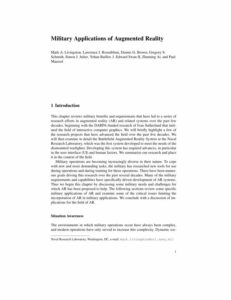
Fig. 1 This concept sketch shows information important for military personnel to establish andmaintain SA: building and street labels, friendly (light rectangles) and enemy (dark square) icons,and a compass.
narios help create the “fog of war,” according to the oft-quoted phrase. It is difficultto keep track of the many friendly and opposing forces operating in an environment.Keeping track of the past, present, and future during such a military operation hasbeen termed situation awareness (SA) [Bolstad and Endsley(2002)]. The time scaleconsidered to be part of SA varies, but the three categorical times remain. Evenkeeping track of basic information such as the locations of friendly forces, buildingand street names or identifiers, and orientation with respect to a global coordinatesystem become challenging, but critical, tasks. Early designs in our human-centeredresearch process attempted to show multiple layers of geometric and human terrainthat might be of interest to dismounted personnel (Fig. 1).
The Marine Corps Combat Development Command Concepts Division once de-scribed the issue as follows
Units moving in or between zones must be able to navigate effectively, and to coordinatetheir activities with units in other zones, as well as with units moving outside the city. Thisnavigation and coordination capability must be resident at the very-small-unit level, perhapseven with the individual Marine [Van Riper(1997)].
On top of this, recent trends towards asymmetric conflicts have witnessed civiliansgetting caught in the midst of battles – or worse, purposefully used as human shieldsby terrorists who do not operate under conventional rules of engagement. Theseasymmetric battles have become much more common in recent conflicts, and thistrend is expected to continue. Increasingly, such battles are fought in dense urbanenvironments, which are inherently more challenging to understand. The nature ofbattles in 3D urban structures and involving combined air-ground forces furtherstresses the cognitive load of the individual infantryman, pilot, or sailor, whetherin command of some portion of the forces or reporting up the chain of command.With the ability of AR to augment one’s view without obscuring that environment,AR became a natural paradigm in which to present military information. Head-up 3D visualization within urban structures was considered a key benefit over 2D
Military Applications of AR 3
map visualizations. This is similar in spirit to the insertion of the first-down linein broadcasts of (American) football; seeing the line as play unfolds gives viewersmuch greater awareness of the meaning of the play.
Information Overload
The counter-point to having myriad bits of information that give one a completepicture of the past history, current status, and potential consequences of actions inthe environment is having too much information to process. Military commandersoften compare information processing in the battlespace to attempting to sip waterfrom a fire hose. The condition of information overload occurs when one is unableto process the information presented into coherent SA. With the rapidly expandingability to collect data in (near) real-time about many locations and provide dataabstractions to the warfighter at levels from the command center to individual fieldpersonnel, the danger of information overload has grown significantly.
The nature of AR is (generally) to add information to the user’s view of an en-vironment; clearly, the issue of information overload requires that this be done ina careful manner so as not to impede the user’s ability to achieve or maintain SA.One corollary to this requirement is that the information presented to each user mustbe appropriate for that user’s role in the team’s mission. A commander may needto understand the global situation and how the various teams are expected to movethrough an environment, whereas a private on patrol may only be concerned witha very limited area of the environment. Similarly, a medic may need health recordsand a route to an injured soldier, whereas a forward observer may need a few days’worth of reconnaisance information in order to detect unusual or unexpected en-emy actions. Ideally, an AR system (or any information delivery system) would beaware of these various tasks, the mission plans (including any contingencies), andthe current roles any particular user may be fulfilling at a given time.
It should also be evident at this point that an AR system for military applicationsbridges two somewhat disparate fields. SA implies the introduction of visual repre-sentations of data. This type of data abstraction is in itself a major sub-field withinthe field of computer graphics. Overlaying information is a fundamental character-istic of AR, and this sensory integration can both limit the types of abstractionsthat make sense for a given application and push the application designer to createnew methods of understanding perceptual or cognitive cues that go beyond typicalhuman sensory experiences.
Training
When conceiving of virtual training, most people immediately think of immersivevirtual environment systems, rather than AR and its overlaying of information onthe real world. One research thrust that is gaining interest is the use of wearablevirtual reality systems for embedded training. For example, a warfighter en route
4 Livingston et al.
to a deployment may wear a system like the Land Warrior system [Army(2001)]containing a wearable computer and head-mounted display designed for the displayof SA information. But the system could load a virtual training application to betteruse this travel time. Systems of this type include VICTER [Barham et al(2002)],DAGGERS and ExpeditionDI R©[Quantum3D(2010)], Virtual Warrior [GD(2010)],Nett Warrior [Gould(2010)], and COMBATREDI R©[Cubic(2011)].
AR offers some practical advantages over virtual environments. Embedding vir-tual training applications in existing live-action training facilities can reduce mod-eling (and rendering) requirements and other infrastructure costs. Modeling an ac-curate virtual environment and the unknown fidelity requirements of such a modelmake this an expensive need for immersive virtual environments. Furthermore, thisAR facility would maintain the natural haptic cues one gets from walls and otherreal objects. Virtual environments often require unnatural (e.g. joystick-based) nav-igation methods; AR eliminates this and allows the user to walk normally, albeitby requiring a large tracking range. Given that AR may one day be an operationaltool, using it for training follows the goal for the military to “train as you fight.” ARallows for more realistic interaction among multiple trainees, since they see eachother through their natural vision (as opposed to an avatar representing a particularperson). Finally, instead of using personnel resources to take the roles of potentialadversaries or having trainees learn against empty space, a warfighter could trainagainst avatars.
A projection-display based version of mixed reality (MR) training was imple-mented in the Future Immersive Training Environment Joint Capability TechnologyDemonstration [Muller(2010)]. In the first implementation, avatars appear on pro-jection screens within a real training environment, technology that is often knownas spatial AR. This limits flexibility in the location of avatars, but still supportseffective training. The ability to reduce the number of personnel required for effec-tive training (by substituting avatars for real actors to play opposing forces) trans-lates into cost savings. One advantage of the use of AR for this training is that theamount of infrastructure that must be changed from a live-action training facility issmall compared to that required by an immersive virtual environment training facil-ity. An improved version of the system used video-based, head-worn AR displaysthat incorporated a computer vision-based tracking system to reduce the errors inregistration of the avatars to the real environment. Registration error could causeavatars to be improperly occluded by the real environment or appear to float abovethe ground. One limitation of this system is that it currently allows only small unitsto train together, either a fire team (four people) or squad (thirteen). Another limita-tion is the size, weight, and power requirements of the head-worn apparatus.
In general, the disadvantages of AR for training are that, like virtual environ-ments, AR systems are not easy to implement, and the technology has struggled tomeet some of the minimal requirements in order to be a useful system. Several ongo-ing research projects are aimed at improving the displays and tracking systems thatare critical components for an AR system. Some aspects of AR technology, such asthe display, have more stringent requirements than immersive training simulations.
Military Applications of AR 5
So while AR clearly has powerful potential as a training tool, whether it is best fora particular application is not so clear.
A related concept to the planning or rehearsal of a mission is the analysis of acompleted mission for future training. In the military, such an analysis is knownas after-action review (AAR). Both virtual environments and AR generate data thatmay be used for this type of training. In the same way that AR could reduce themodeling costs associated with virtual training, AR might help reduce the expenseof setting up a formal AAR.
Another possible use in training is for specific skills that are basic to numerousmilitary roles. Patrols use particular search patterns to maintain awareness of po-tential threats. While actors could be trained to approach from specific directions, itcan be a more repeatable and cost-effective system to implement virtual avatars fortraining such a fundamental skill. In this way, basic requirements in military trainingcan be met in an individual instructional phase, allowing each trainee to progress athis or her own pace. It also affords the instructor the ability to test specific difficul-ties a trainee has had in the past in a repeatable fashion.
Quick-reaction Forces
Another increasing emphasis for military operations is the faster pace at which de-cisions must be made, while the cost of poor decisions can be catastrophically high.If an AR system can present exactly the right pieces of information, better and fasterdecisions can be made and turned into correct actions. This operates at multiple lev-els: an individual on an operation might make a better decision about whether anapproaching vehicle is a threat, a squad might be able to come to the aid of anotherunit that is under fire, or a battalion can take advantage of a quickly-configurableAR training facility and be ready to respond to an opportunity that is available foronly a brief time. Without such information, perhaps the advantage of pro-activemanuevers will be lost, an operation would be too high a risk to undertake, or de-cisions have a lower probability of positive outcomes (e.g. a higher rate of losses).Because AR can theoretically present training scenarios with low configuration costin terms of the scenario (if not the AR infrastructure with current technology), itoffers hope for the future of quick-reaction forces.
2 AR Projects for the Military
The concept of a display system indistinguishable from reality was introduced byIvan Sutherland [Sutherland(1965)]; a preliminary realization of this “Ultimate Dis-play” for the visual sense was described subsequently [Sutherland(1968)]. The sys-tem included not only the head-worn display (HWD), but also an image generationsubsystem and a tracking subsystem for the user’s head and one of the user’s hands.Thus it marked the starting point for both virtual environments and AR research.
6 Livingston et al.
It is interesting to note that this first HWD was an AR display, not a completelyimmersive display suitable for immersive virtual environments.
The system required other novel hardware, notably a “clipping divider” thatcould properly render perspective views (well before commodity graphics cards be-came standard) and two position tracking systems (mechanical arm and ultrasonic).One important difficulty noted in early tests of the system was the ambiguous natureof the 3D images. Users visualized a cyclo-hexane molecule; those familiar with theshape had no trouble recognizing it, but other users misinterpreted the shape. Thisfoundational work foreshadowed the difficulties faced by later systems being ap-plied to military applications.
2.1 The “Super Cockpit”
The first specific application of AR technology was for fighter pilots. The SuperCockpit was the forerunner of the modern head-up display still used now by fighterpilots and available in some passenger cars. The original implementations used bothvirtual environment and see-through display metaphors, to enable the pilot to usethe system at night. The system was developed at Wright-Patterson Air Force Basebeginning in the late 1960s [Furness(1969)].
Visibility out of a cockpit is limited, and airborne tasks such as low-altitude nav-igation, target acquisition, and weapons delivery require pilots to reference land-marks on the terrain. However, sensors mounted on the aircraft can create visibilityin areas that are occluded by the aircraft structure, or in conditions such as low lightthat prevent the pilot from seeing the real world. The system superimposed flight andtarget data into the pilot’s visual field and provided sound cues to assist localization.
The key feature of this system was providing spatial awareness for the pilot to un-derstand and incorporate into his course of action a variety of incoming data streams.The horizon became visible through the cockpit window, rather than being conveyedon an indicator on the instrument panel. Targets, navigation waypoints, and threatscould similarly be registered to their 3D locations. The concept was that such aview would improve upon using a dashboard display, leaving the pilot to mentallymerge the virtual map with his visual field. This is not an easy task and would haverequired the pilot to take his eyes off the real environment many times in order toalign the virtual information. Another feature provided a rear-view mirror, similarto the standard mechanism in a car.
Early versions of the system pointed out the need for study of the human fac-tors of such systems. Spatial reasoning is a complex task, even more so under thephysical duress of flight and the emotional intensity of combat. An intuitive inter-face could take advantage of the natural abilities of many people to reason in threedimensions, rather than have them reason in two dimensions and try to apply that tothe real environment. This 3D spatial reasoning is also not a trivial task, but pilotsare screened for high spatial reasoning ability, so it seems natural to supply themwith an inherently 3D view.
Military Applications of AR 7
2.2 Aspen Movie Map
One long-standing goal of military training is for forces to know the environment inwhich an operation will take place, enabling them to navigate and make decisionsmuch faster than if they had to focus on a possibly inaccurate mental map and con-sider the choices available to them. The interactive movie map was an early attemptto provide this “mechanism for pre-experiencing an unfamiliar locale that allows theacquisition of spatial knowledge to take place in a meaningful, natural, and accurateway.” [Mohl(1981)] The Aspen Movie Map [Naimark(1979)] was the first of thesesystems, building on the newly-available optical video disc technology of the 1970sto enable interactive computer control of the display of video frames. In this regard,the movie map shares many characteristics with video-based AR systems; the majordifference being the spatial and temporal separation of the user from the displayedenvironment. However, as this was intended to investigate training applications forthe military, it sparked much research in virtual environments and AR, includingsome of the systems discussed below.
The goal of this system was to convey a sense of being in Aspen, CO to the user,such that the user would know how to navigate in the town without ever havingbeen there. Thus the UI and the controls offered were important components ofthe system. Most relevant to our discussion of AR and MR was the overview mapmode, in which the user could trace the route taken or specify a route for the systemto follow; these graphics were merged with aerial overviews. Speed and directionwere controlled through a scrollbar-like widget on the touch-screen display. Theuser could zoom in on the map view, change the season through a toggle switch, orengage a slide show about a specific building from the map.
In an informal user evaluation, subjects who experienced Aspen through the in-teractive movie map were found to sketch similar maps of Aspen as residents made.Similarity was judged in terms of the number of errors, degree of uncertainty, andlevel of detail (especially along the main street). It appeared that the movie mapusers composed their maps based more on linear paths than on areas. This was per-haps a consequence of the linear, grid-like street system of the town, which gave theonly available travel routes in the movie map. These users were more likely to beunsure about distances from the movie map, and even when using the system, noteduncertainty about distance traveled along the real terrain and the number of degreesturned, even to the point of some being unsure whether they had turned 90◦ or 180◦.One user sketched an extremely accurate map from the movie map, so at least thepotential for learning the space seemed to be a feature.
2.3 Battlefield Augmented Reality System
The overall goal of the Battlefield Augmented Reality SystemTM(BARS) was todo for the dismounted warfighter what the Super Cockpit and its successors haddone for the pilot. Initial funding came from the Office of Naval Research. The
8 Livingston et al.
challenges associated with urban environments were a particular concern: complex3D environment, dynamic situation, and loss of line-of-sight contact of team mem-bers [Livingston et al(2002)]. Unambiguously referencing landmarks in the terrainand integrating unmanned systems into an operation can also be difficult for dis-tributed users[Livingston et al(2006a), Livingston et al(2006b)]. All of these exam-ples show the impairment of SA in urban operations [Van Riper(1997)]. The beliefwas that the equivalent of a head-up display (such as in the Super Cockpit) wouldhelp solve these. By networking the mobile users together and with a commandcenter, BARS could assist in establishing collaborative SA by a dispersed team.
This raises numerous issues in system configuration. BARS includes an infor-mation database, which can be updated by any user. Sharing information across thearea of operation is a critical component of team SA. We designed an informationdistribution system [Brown et al(2004b)] so that updates would be sent across thenetwork. We enabled BARS to communicate with semi-automated forces (SAF)software [Brown et al(2004a)] to address the training issues discussed above. Wechose to use commercially-available hardware components so that we could easilyupgrade BARS as improved hardware became available. We built UI componentsso that routes could be drawn on the terrain in the command center applicationand assigned to mobile users, or drawn by mobile users and suggested to the com-mander or directly to other mobile users. Typical AR system issues like calibra-tion [Baillot et al(2003)] were investigated.
The BARS research program helped spawn ongoing efforts in both opera-tions [DARPA(2010)] and training [ONR(2010)]. Land Warrior [Cox(2008)] sharessome capabilities of team SA and has been praised for eliminating confusion intime-sensitive target missions and stopping fratricides in terrain that prevents squadelements from seeing each other. Specific research efforts within BARS for the UIand human factors aspects are the focus of the next section.
2.4 C-130 Loadmaster Training
Flight simulators have become standard tools for training pilots, but other aspectsof military flights were also considered to have the potential to benefit from vir-tual training systems. The USAF Air Education and Training Command conducteda project to determine if AR was an effective tool for training C-130 loadmasternormal and emergency procedures. A C-130 is a military transport aircraft typicallyused in cargo and resupply operations by numerous countries. The loadmaster is acargo handler and rigging expert that delivers cargo by airdropping equipment andpersonnel out of the back of the C-130 [Gardley et al(2008)]. Current training forthis job uses ground-based fuselages mounted in a hangar without wings or tail, butwith the appropriate working interior. However, the number of training devices andthe fidelity of existing devices was judged insufficient to meet the training objec-tives.
Military Applications of AR 9
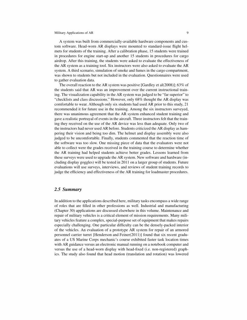
A system was built from commercially-available hardware components and cus-tom software. Head-worn AR displays were mounted to standard-issue flight hel-mets for students of the training. After a calibration phase, 15 students were trainedin procedures for engine start-up and another 15 students in procedures for cargoairdrop. After this training, the students were asked to evaluate the effectiveness ofthe AR system as a training tool. Six instructors were also asked to evaluate the ARsystem. A third scenario, simulation of smoke and fumes in the cargo compartment,was shown to students but not included in the evaluation. Questionnaires were usedto gather evaluation data.
The overall reaction to the AR system was positive [Gardley et al(2008)]; 63% ofthe students said that AR was an improvement over the current instructional train-ing. The visualization capability in the AR system was judged to be “far superior” to“checklists and class discussions.” However, only 68% thought the AR display wascomfortable to wear. Although only six students had used AR prior to this study, 21recommended it for future use in the training. Among the six instructors surveyed,there was unanimous agreement that the AR system enhanced student training andgave a realistic portrayal of events in the aircraft. Three instructors felt that the train-ing they received on the use of the AR device was less than adequate. Only two ofthe instructors had never used AR before. Students criticized the AR display as ham-pering their vision and being too dim. The helmet and display assembly were alsojudged to be uncomfortable. Finally, students commented that the reaction time ofthe software was too slow. One missing piece of data that the evaluators were notable to collect were the grades received in the training course to determine whetherthe AR training had helped students achieve better grades. Lessons learned fromthese surveys were used to upgrade the AR system. New software and hardware (in-cluding display goggles) will be tested in 2011 on a larger group of students. Futureevaluations will use surveys, interviews, and reviews of student training records tojudge the efficiency and effectiveness of the AR training for loadmaster procedures.
2.5 Summary
In addition to the applications described here, military tasks encompass a wide rangeof roles that are filled in other professions as well. Industrial and manufacturing(Chapter 30) applications are discussed elsewhere in this volume. Maintenance andrepair of military vehicles is a critical element of mission requirements. Many mili-tary vehicles feature a complex, special-purpose set of equipment that makes repairsespecially challenging. One particular difficulty can be the densely-packed interiorof the vehicles. An evaluation of a prototype AR system for repair of an armoredpersonnel carrier turret [Henderson and Feiner(2011)] found that six recent gradu-ates of a US Marine Corps mechanic’s course exhibited faster task location timeswith AR guidance versus an electronic manual running on a notebook computer andversus the use of a head-worn display with head-fixed (i.e. non-registered) graph-ics. The study also found that head motion (translation and rotation) was lowered
10 Livingston et al.
with the AR system versus the electronic manual. The head-worn display may haveinduced the users to move less than they would have otherwise, so the cause-and-effect relationship must be investigated further. Medical applications (Chapters 27and 28) are another field in which military interest in AR technology has a longhistory. The Ultrasound Augmented Reality project [State et al(1996)] is one note-worthy example of a project supported by military research funding.
The remainder of this chapter will describe the multi-faceted BARS program’spoints of emphasis. The next section discusses case studies of how BARS has beenor could be instantiated. The following section describes a number of research ef-forts in the UI and human factors aspects of the BARS system instantiations. Thesewere motivated by difficulties encountered in implementing the prototype appli-cations and were viewed as critical problems to solve in order to transition theseapplications out of the lab and into the hands of real users.
3 BARS Case Studies
BARS was originally envisioned as a system for operations, but it became clear thatthere was great benefit in taking some of the concepts into the training domain aswell. These are two vast areas of military applications. As noted above, the militaryhas long supported AR efforts in medicine, maintenance and repair, and other areasthat are of interest but not exclusive to the military. In this section, we present fourexamples of applications built from the BARS software and infrastructure. Thesediscussions will discuss hardware as appropriate, mostly from the point of view ofthe requirements or benefits of certain technologies. Since some of these applica-tions were pursued for a finite period of time which has long since passed, somespecific hardware would now seem to be an anachronism and will thus be omittedfrom the discussion.
3.1 Dismounted Warfighter Operations
Military operations in urban terrain (MOUT) present many unique and challengingconditions for the warfighter. The environment is extremely complex and inherently3D. Above street level, buildings serve varying purposes (such as hospitals or com-munication stations). They can harbor many risks, such as snipers or explosives,which can be located on different floors. Below street level, there can be an elabo-rate network of sewers and tunnels. The environment can be cluttered and dynamic.Narrow streets restrict line of sight and make it difficult to plan and coordinate groupactivities. Threats, such as snipers, can continuously move and the structure of theenvironment itself can change. For example, a damaged building can fill a street withrubble, making a once-safe route impassable. Such difficulties are compounded bythe need to minimize civilian casualties and damage to civilian targets.
Military Applications of AR 11
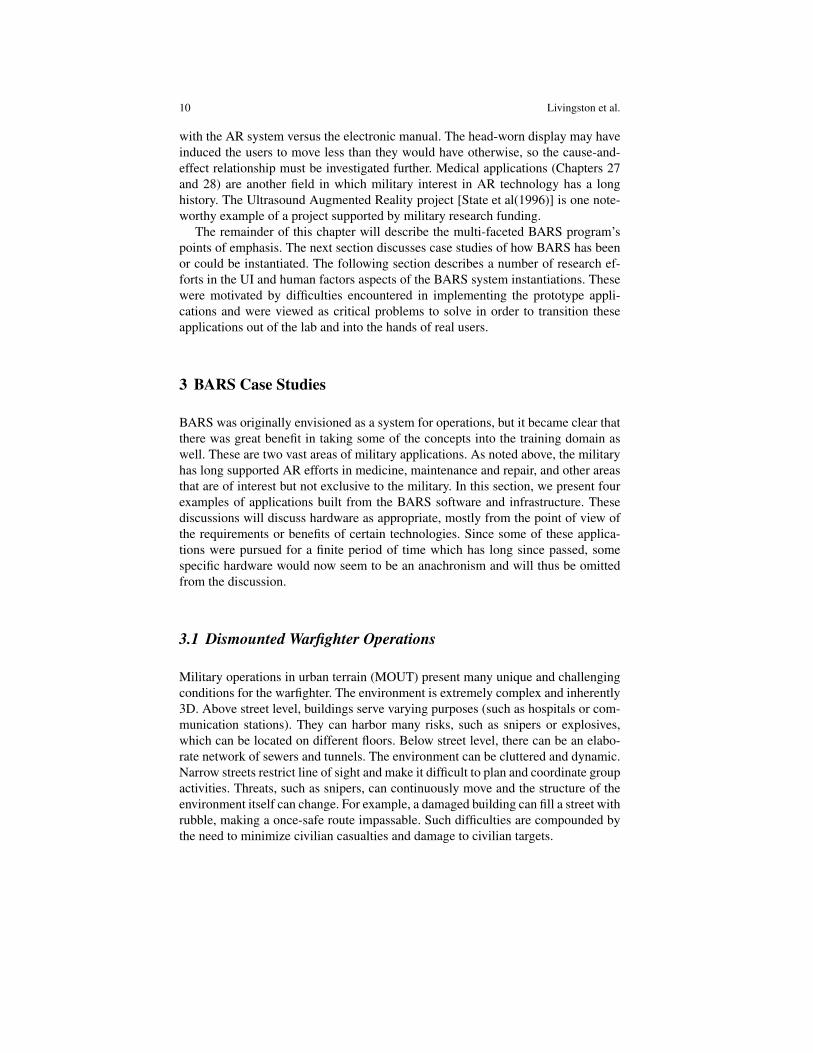
Fig. 2 We built this early prototype of our wearable AR system from commercial components.This and similar realizations were used in the research described later in this chapter.
A number of research programs have explored the means by which navigationand coordinated information can be delivered to dismounted warfighters. Many ofthese approaches are based on handheld maps or opaque head-mounted displays(HMDs). For example, Land Warrior introduced a head-worn display that combineda map and a “rolling compass” [Gumm et al(1998)]. Unfortunately, these methodshave a number of limitations. They obscure the user’s field of view and do not trulyrepresent the 3D nature of the environment. Moreover they require the user to inte-grate the graphical display within the environment to make sense of it. This work issometimes difficult and distracting from the current task. We believe a mobile ARsystem best meets the needs of the dismounted warfighter [Livingston et al(2002)];we began assembling hardware and writing software to build prototype wearablesystems (Fig. 2).
Through the ability to present direct information overlays, integrated into theuser’s environment, AR has the potential to provide significant benefits in many ap-plication areas. Many of these benefits arise from the fact that the virtual cues pre-sented by an AR system can go beyond what is physically visible. Visuals includetextual annotations, directions, instructions, or “X-ray vision,” which shows objectsthat are physically present, but occluded from view. One important design consid-eration was not to limit the perceptual capabilities of the warfighter, so we choseoptical see-through displays and worked with display manufacturers to reduce the

12 Livingston et al.
loss of peripheral vision around the display. However, optical systems require sig-nificant range of brightness in order to be effective in the wide range of outdoorlighting conditions (day or night).
3.2 Mounted Warfighter Operations
Military vehicles are also increasingly operated in complex urban environments,forcing vehicle operators to face many of the same SA challenges as dismountedtroops. Vehicle commanders are trained to maintain SA by cross-referencing two-dimensional map products, both digital and paper, to the live tactical environmentoutside the vehicle. Even for experienced operators, this process can be time-consuming and error-prone in the urban environment. AR systems are designed tomerge the relevant aspects of the spatial data in the digital map environment intoa view of the live tactical environment. A well-designed AR system will displayspatial data intuitively with the real world. In a military vehicle, AR systems canenhance the SA of commander, driver, or gunners.
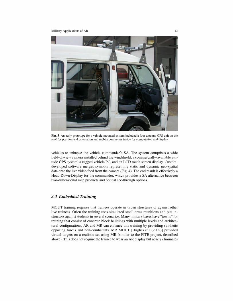
Vehicles are particularly well-suited for AR systems. Typically, the limitationsof power, size, and weight that constrain wearable systems are less critical in thevehicle-mounted AR system. In addition, advanced military vehicles may alreadyprovide key components such as high-performance GPS and inertial navigation sys-tems, external imaging sensors, digital computers, and video display screens. Anearly prototype of our vehicle-borne AR implementation is shown in Fig. 3.
Optical see-through AR systems must overcome some unique challenges to beeffective in vehicle-mounted systems. The most obvious solution is a “head-up dis-play” as previously discussed in reference to military aircraft. The display devicecould be mounted in the windshield in front of a vehicle commander. The pri-mary issue with this approach is maintaining alignment of the symbols with thereal world, since motion of the operator’s head will create significant errors in reg-istration caused by parallax. Fighter aircraft overcome this issue by constrainingthe pilot’s position using an adjustable seat and a harness or placing the display inthe fighter’s helmet, which is in turn tightly worn on the head. Registration can beaccomplished dynamically by tracking the operator’s head with a tracking systemand combining that information with the vehicle position and attitude to create thevisual overlay. This approach adds complexity to the overall system and limits theoperator view to a narrow window. Another solution involves having the user wearoptical see-through displays inside the vehicle and then tracking the operator’s headmovements. This approach is currently being utilized by several military aircraftplatforms, including the USMC AH-1Z and the Joint Strike Fighter. The approachis highly effective for providing real-time SA but the high costs to develop, pur-chase, and maintain such systems prevent it from being used in most land vehicles.
Video AR applications can provide similar functionality with less cost and com-plexity. The Meissa project at the Naval Research Laboratory looked to developa simple AR system that could be installed in USMC and US Army HMMWV
Military Applications of AR 13
Fig. 3 An early prototype for a vehicle-mounted system included a four-antenna GPS unit on theroof for position and orientation and mobile computers inside for computation and display.
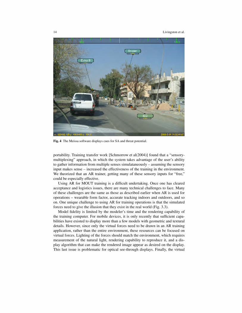
vehicles to enhance the vehicle commander’s SA. The system comprises a widefield-of-view camera installed behind the windshield, a commercially-available atti-tude GPS system, a rugged vehicle PC, and an LCD touch screen display. Custom-developed software merges symbols representing static and dynamic geo-spatialdata onto the live video feed from the camera (Fig. 4). The end result is effectively aHead-Down-Display for the commander, which provides a SA alternative betweentwo-dimensional map products and optical see-through options.
3.3 Embedded Training
MOUT training requires that trainees operate in urban structures or against otherlive trainees. Often the training uses simulated small-arms munitions and pits in-structors against students in several scenarios. Many military bases have “towns” fortraining that consist of concrete block buildings with multiple levels and architec-tural configurations. AR and MR can enhance this training by providing syntheticopposing forces and non-combatants. MR MOUT [Hughes et al(2002)] providedvirtual targets on a realistic set using MR (similar to the FITE project, describedabove). This does not require the trainee to wear an AR display but nearly eliminates
14 Livingston et al.
Fig. 4 The Meissa software displays cues for SA and threat potential.
portability. Training transfer work [Schmorrow et al(2004)] found that a “sensory-multiplexing” approach, in which the system takes advantage of the user’s abilityto gather information from multiple senses simulataneously – assuming the sensoryinput makes sense – increased the effectiveness of the training in the environment.We theorized that an AR trainer, getting many of these sensory inputs for “free,”could be especially effective.
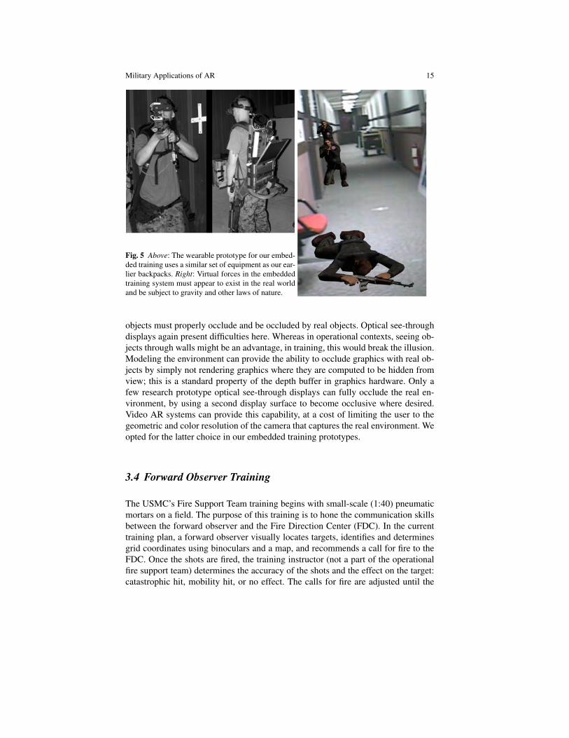
Using AR for MOUT training is a difficult undertaking. Once one has clearedacceptance and logistics issues, there are many technical challenges to face. Manyof these challenges are the same as those as described earlier when AR is used foroperations – wearable form factor, accurate tracking indoors and outdoors, and soon. One unique challenge to using AR for training operations is that the simulatedforces need to give the illusion that they exist in the real world (Fig. 3.3).
Model fidelity is limited by the modeler’s time and the rendering capability ofthe training computer. For mobile devices, it is only recently that sufficient capa-bilities have existed to display more than a few models with geometric and texturaldetails. However, since only the virtual forces need to be drawn in an AR trainingapplication, rather than the entire environment, these resources can be focused onvirtual forces. Lighting of the forces should match the environment, which requiresmeasurement of the natural light, rendering capability to reproduce it, and a dis-play algorithm that can make the rendered image appear as desired on the display.This last issue is problematic for optical see-through displays. Finally, the virtual
Military Applications of AR 15
Fig. 5 Above: The wearable prototype for our embed-ded training uses a similar set of equipment as our ear-lier backpacks. Right: Virtual forces in the embeddedtraining system must appear to exist in the real worldand be subject to gravity and other laws of nature.
objects must properly occlude and be occluded by real objects. Optical see-throughdisplays again present difficulties here. Whereas in operational contexts, seeing ob-jects through walls might be an advantage, in training, this would break the illusion.Modeling the environment can provide the ability to occlude graphics with real ob-jects by simply not rendering graphics where they are computed to be hidden fromview; this is a standard property of the depth buffer in graphics hardware. Only afew research prototype optical see-through displays can fully occlude the real en-vironment, by using a second display surface to become occlusive where desired.Video AR systems can provide this capability, at a cost of limiting the user to thegeometric and color resolution of the camera that captures the real environment. Weopted for the latter choice in our embedded training prototypes.
3.4 Forward Observer Training
The USMC’s Fire Support Team training begins with small-scale (1:40) pneumaticmortars on a field. The purpose of this training is to hone the communication skillsbetween the forward observer and the Fire Direction Center (FDC). In the currenttraining plan, a forward observer visually locates targets, identifies and determinesgrid coordinates using binoculars and a map, and recommends a call for fire to theFDC. Once the shots are fired, the training instructor (not a part of the operationalfire support team) determines the accuracy of the shots and the effect on the target:catastrophic hit, mobility hit, or no effect. The calls for fire are adjusted until the
16 Livingston et al.
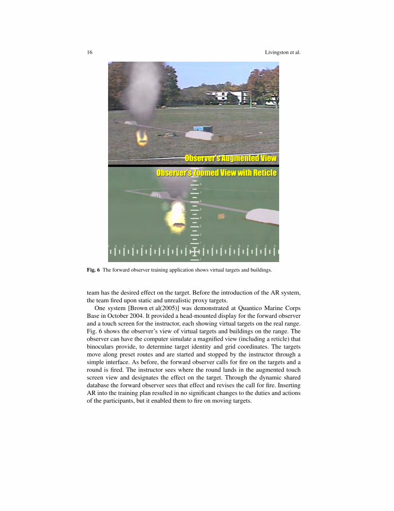
Fig. 6 The forward observer training application shows virtual targets and buildings.
team has the desired effect on the target. Before the introduction of the AR system,the team fired upon static and unrealistic proxy targets.
One system [Brown et al(2005)] was demonstrated at Quantico Marine CorpsBase in October 2004. It provided a head-mounted display for the forward observerand a touch screen for the instructor, each showing virtual targets on the real range.Fig. 6 shows the observer’s view of virtual targets and buildings on the range. Theobserver can have the computer simulate a magnified view (including a reticle) thatbinoculars provide, to determine target identity and grid coordinates. The targetsmove along preset routes and are started and stopped by the instructor through asimple interface. As before, the forward observer calls for fire on the targets and around is fired. The instructor sees where the round lands in the augmented touchscreen view and designates the effect on the target. Through the dynamic shareddatabase the forward observer sees that effect and revises the call for fire. InsertingAR into the training plan resulted in no significant changes to the duties and actionsof the participants, but it enabled them to fire on moving targets.
Military Applications of AR 17
The virtual targets for training were received well by trainees and instructors atQuantico; however, rigorous studies and measurements of effectiveness are yet tobe done. The system can also insert virtual terrain and control measures into thedisplay, and both capabilities were preliminarily tested at Quantico.
4 Human-Centered Research
As with the Super Cockpit [Furness(1986)] and Aspen Movie Map [Mohl(1981)],we found that BARS could not succeed in the applications described above withoutinnovation in the UI and human factors of the hardware and software. For BARSresearch, we followed a user-centered approach [Livingston et al(2004)]; thus, weconducted a domain analysis [Livingston et al(2006b)]. In this section, we summa-rize a number of research thrusts in these arenas, with references to papers for read-ers interested in further details. These efforts were motivated by difficulties faced inthe applications, as noted in the discussions below.
4.1 Depth Perception and Occlusion Representation
Among the things our initial domain analysis [Gabbard et al(2002)] indicated as apotential advantage for AR for dismounted troops was the ability to show wheredistributed troops were in an urban area of operations. Later, client interest includedthe ability to communicate points of interest in the environment to distributed teammembers (without the benefit of line-of-sight contact between team members). Bothof these goals require the AR system to identify objects that are occluded from theuser. This became a central focus of the BARS research program.
The metaphor of “Superman’s X-ray vision” has long been applied to the capabil-ity of AR to depict a graphical object that is occluded by real objects [Stix(1992)].There are three aspects to the problem of displaying cues that correspond to oc-cluded virtual objects. First, the alignment or registration of the graphics on thedisplay must be accurate. This is a defining aspect of AR [Azuma(1997)]. Second,the ordinal depth between the real and virtual objects must be conveyed correctlyto the user. Because we selected optical see-through HWD for operational reasons,we needed to replace the natural occlusion cue for depth ordering. Third, the metricdistance of the virtual object must be understood to within a sufficient accuracy thatthe user can accomplish the task. This requires the cues that are provided to be suf-ficiently accurate to estimate distance. Further, each successive aspect depends onthe previous ones.
We began our investigation with a study that identified graphical cues that helpedconvey the ordinal depth of graphical objects [Livingston et al(2003)]. We foundthat changing the drawing style, decreasing the opacity with increasing distance,and decreasing intensity with increasing distance helped users properly order graph-
18 Livingston et al.
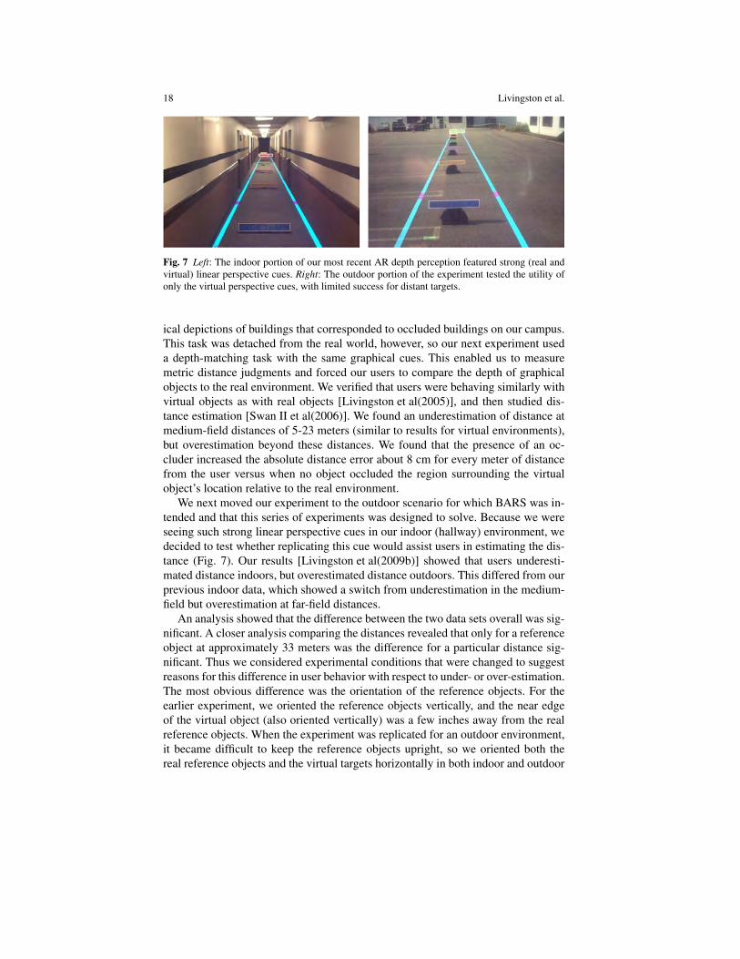
Fig. 7 Left: The indoor portion of our most recent AR depth perception featured strong (real andvirtual) linear perspective cues. Right: The outdoor portion of the experiment tested the utility ofonly the virtual perspective cues, with limited success for distant targets.
ical depictions of buildings that corresponded to occluded buildings on our campus.This task was detached from the real world, however, so our next experiment useda depth-matching task with the same graphical cues. This enabled us to measuremetric distance judgments and forced our users to compare the depth of graphicalobjects to the real environment. We verified that users were behaving similarly withvirtual objects as with real objects [Livingston et al(2005)], and then studied dis-tance estimation [Swan II et al(2006)]. We found an underestimation of distance atmedium-field distances of 5-23 meters (similar to results for virtual environments),but overestimation beyond these distances. We found that the presence of an oc-cluder increased the absolute distance error about 8 cm for every meter of distancefrom the user versus when no object occluded the region surrounding the virtualobject’s location relative to the real environment.
We next moved our experiment to the outdoor scenario for which BARS was in-tended and that this series of experiments was designed to solve. Because we wereseeing such strong linear perspective cues in our indoor (hallway) environment, wedecided to test whether replicating this cue would assist users in estimating the dis-tance (Fig. 7). Our results [Livingston et al(2009b)] showed that users underesti-mated distance indoors, but overestimated distance outdoors. This differed from ourprevious indoor data, which showed a switch from underestimation in the medium-field but overestimation at far-field distances.
An analysis showed that the difference between the two data sets overall was sig-nificant. A closer analysis comparing the distances revealed that only for a referenceobject at approximately 33 meters was the difference for a particular distance sig-nificant. Thus we considered experimental conditions that were changed to suggestreasons for this difference in user behavior with respect to under- or over-estimation.The most obvious difference was the orientation of the reference objects. For theearlier experiment, we oriented the reference objects vertically, and the near edgeof the virtual object (also oriented vertically) was a few inches away from the realreference objects. When the experiment was replicated for an outdoor environment,it became difficult to keep the reference objects upright, so we oriented both thereal reference objects and the virtual targets horizontally in both indoor and outdoor
Military Applications of AR 19
environments. This separated the real and virtual objects by a couple of feet (as seenin Fig. 7). It is also true that for the second experiment, we compressed the distancesslightly to fit into a smaller experimental space. One of these changes appeared tocause the difference in the indoor data.
The more important result from this experiment, however, was that the linear per-spective cues caused users to reduce their estimation of the distance of the virtualobject for only the most distant reference objects. In the outdoor environment, thisimproved the performance, since users were overestimating the distance. However,for the indoor environment, this increased the error, since users were consistentlyunder-estimating the distance already. At distances of under 25 m, the linear per-spective cues seemed to make no significant difference in the users’ performance.
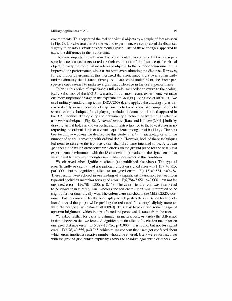
To bring this series of experiments full circle, we needed to return to the ecolog-ically valid task of the MOUT scenario. In our most recent experiment, we madeone more important change in the experimental design [Livingston et al(2011)]. Weused military standard map icons [DISA(2008)], and applied the drawing styles dis-covered early in our sequence of experiments to these icons. We compared this toseveral other techniques for displaying occluded information that had appeared inthe AR literature. The opacity and drawing style techniques were not as effectiveas newer techniques (Fig. 8). A virtual tunnel [Bane and Hollerer(2004)] built bydrawing virtual holes in known occluding infrastructure led to the lowest error in in-terpreting the ordinal depth of a virtual squad icon amongst real buildings. The nextbest technique was one we devised for this study, a virtual wall metaphor with thenumber of edges increasing with ordinal depth. However, both of these techniquesled users to perceive the icons as closer than they were intended to be. A groundgrid technique which drew concentric circles on the ground plane (of the nearly flatexperimental environment with the 18 cm deviation) resulted in the signed error thatwas closest to zero, even though users made more errors in this condition.
We observed other significant effects (not published elsewhere). The type oficon (friendly or enemy) had a significant effect on signed error – F(1,13)=43.935,p=0.000 – but no significant effect on unsigned error – F(1,13)=0.584, p=0.458.These results were echoed in our finding of a significant interaction between icontype and occlusion metaphor for signed error – F(6,78)=7.651, p=0.000 – but not forunsigned error – F(6,78)=1.536, p=0.178. The cyan friendly icon was interpretedto be closer than it really was, whereas the red enemy icon was interpreted to beslightly farther than it really was. The colors were matched to the MilStd2525c doc-ument, but not corrected for the AR display, which pushes the cyan (used for friendlyicons) toward the purple while pushing the red (used for enemy) slightly more to-ward the orange [Livingston et al(2009c)]. This may have caused some change ofapparent brightness, which in turn affected the perceived distance from the user.
We asked further for users to estimate (in meters, feet, or yards) the differencein depth between the two icons. A significant main effect of occlusion metaphor onunsigned distance error – F(6,78)=13.426, p=0.000 – was found, but not for signederror – F(6,78)=0.555, p=0.765, which raises concern that users got confused aboutwhich order implied a negative number should be entered. Users were most accuratewith the ground grid, which explicitly shows the absolute egocentric distances. We
20 Livingston et al.
Fig. 8 The new techniques for displaying personnel locations occluded from line-of-sight contactperformed well. The top row shows the virtual tunnel (left), virtual wall (center), and ground grid(right) techniques. The graph shows the performance by users in our study. Negative signed errorindicates users thought the objects were closer than they were.
also saw a main effect of occlusion metaphor on response time – F(6,78)=2.660,p=0.021. Users were fastest with the empty design (mean response of 2.70 sec),closely followed by the virtual tunnel (2.78 sec). The ground grid (3.71 sec) andvirtual wall (3.73 sec) were slower than all methods except an overlaid edge map(which inspired the virtual wall). We did not sub-divide response time into the sub-tasks of depth for each icon and the distance estimation task, and it is possible thatusers conceived all three answers before entering any responses for a trial. Finally,we noted a standard practice effect: users were faster with successive blocks oftrials (where blocks had a constant occlusion metaphor). We recorded subjectiveworkload responses, but did not find a significant main effect. We did see someslight evidence – F(6,78)=1.832, p=0.104 – for users to feel that (in this order) thevirtual tunnel, virtual wall, and ground plane had the lowest workload (measured byNASA TLX [Hart and Staveland(1988)]).
To summarize this discussion, we found good designs for display the informationthat can help dismounted personnel meet some of their SA needs. This line of re-search represents how an interesting ecological problem suggested by subject matterexperts can spark an interesting scientific question, which can be pursued indepen-dently or in the context of that specific application. While even the most recent test
Military Applications of AR 21
Fig. 9 Left: Showing all information and labels in the database can overwhelm the user and preventa Marine from achieving SA. Right: Our information filter uses semantic keys and the concept ofarea of operations to limit the information shown, which enables the user in this case to discern thelocation of enemy tanks – spotted by another user – much more easily.
did not provide a final answer, it gave us great insight into directions for how thescientific and ecological questions inform the design of military AR applications.
4.2 Information Filtering
The issue of information overload, as noted above, can become a primary difficultyin MOUT. The physical environment is complex, 3D, and dynamic, with peopleand vehicles moving throughout. In addition, these entities may be hostile, neutral,or friendly to troops – and even these relationships may change depending on therecent course of events. Thus one may think that more information would be ofobvious assistance to the military personnel engaged in such operations. But theamount of information can become too much to process in the dynamic pace ofmilitary operations, to the point where it inhibits the ability of personnel to completetheir assigned tasks. We have thus developed algorithms for restricting informationthat is displayed to users.
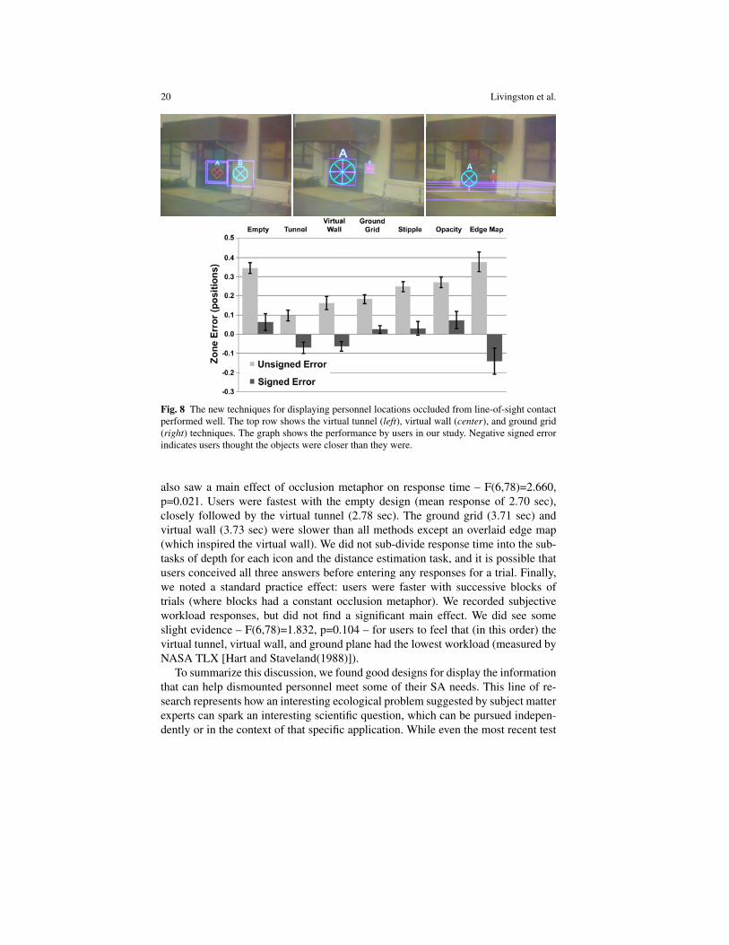
Based on interviews with subject matter experts over the extended course of theproject, our filtering algorithm evolved from a region-based filter [Julier et al(2002)]to a hybrid of the spatial model of interaction [Benford and Fahlen(1993)], rule-based filtering, and the military concept of an area of operations. The resulting al-gorithm [Livingston et al(2011)] enables sufficient flexibility to update the area ofoperations, the user’s area of interest, the area in which a threat has potential im-pact, and of course the user’s position and orientation in the environment. Objectsare displayed when their impact can be felt within the user’s area of interest (a spatialcalculation) or the rule-based filter determines that the information is vital (Fig. 9).
Compounding the difficulty of having too much information is the issue of howwell registered the annotating graphics are to their proper location. As noted above,this underlies the presentation of depth, but it also supports the filtering operation. If
22 Livingston et al.
graphics can be properly aligned, then the cognitive load to understand the graphics’meaning or information content is reduced, enabling the user to understand andintegrate the merged real and virtual image. Thus more information can be shown(assuming a consistent level of registration). We studied techniques to compensatefor improper registration [MacIntyre et al(2002)] and how much mis-registrationmight be acceptable in certain military tasks [Livingston and Ai(2008)].
In the UI architecture, we had to determine how to merge the sometimes compet-ing directives from the components. We began with a simple architecture, proposeda complicated mediation architecture [Julier et al(2003)], but then settled back to asimple pipeline architecture, assisted by incorporating the occlusion representationinto the information filter [Livingston et al(2011)].
4.3 Object Selection
In order to query, manipulate, or act upon objects, the user must first select theseobjects. BARS allows a user to select objects by combining gaze direction (usingtracking of the head) with relative pointing within the field of view using a 2D or3D mouse or eye tracker. The complex nature of the selection operation makes itsusceptible to equipment error, scene ambiguities, and user error. Equipment errorincludes tracking noise, drift, latency, and insufficient resolution for the desired pre-cision. Scene ambiguities arise from the geometric environment, such as when ob-jects overlap in their projections to the current viewpoint. In BARS, with the “X-rayvision” paradigm, these occlusion relationships complicate matters more than manyapplications. Human error includes imprecision due to lack of experience, poor mo-tor control skills needed for fine-grain selections, and fatigue developed during asession. All these errors lead to selections that were not intended.
To mitigate these errors, we designed a multimodal (speech and gesture) prob-abilistic selection algorithm [Schmidt et al(2006)]. This algorithm incorporates anobject hierarchy (e.g., in the BARS object database, a door is a child of a wall,which is a child of a building, and so on), several gaze and pointing algorithms,and speech recognition. The pointing algorithms rank the objects by distance to thepointing vector, a weighting scheme combining size and distance to the pointingvector, and a weighting scheme combining distance to the view plane and pointingvector. For each pointing selection, the user issues a voice command including thetype of object to be selected. The speech recognizer returns a ranked list of candidateobjects that it interpreted as what the user intends to select. The object hierarchy, inconjunction with the voice commands, reduces the search space for which objectis being selected. The algorithms are combined using a weighted voting scheme todisambiguate any remaining selection discrepancies. We estimated best weightingassignments by evaluating the algorithms through a series of user experiments.
Military Applications of AR 23
4.4 Collaboration Techniques
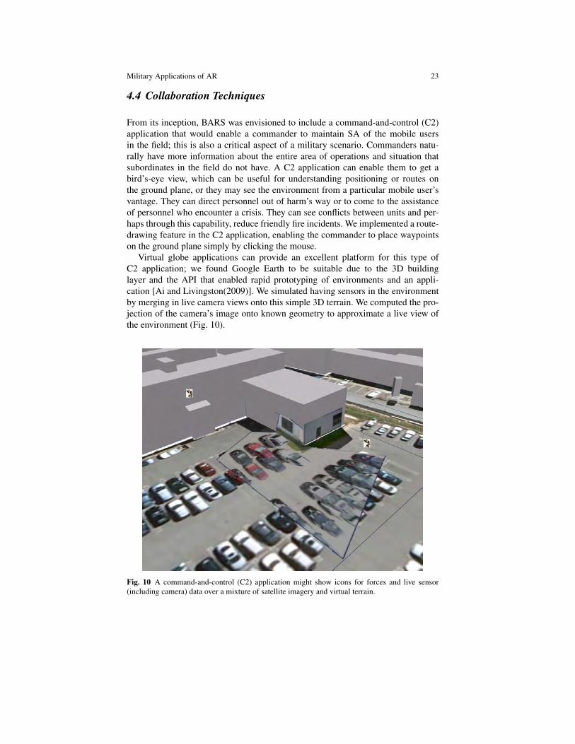
From its inception, BARS was envisioned to include a command-and-control (C2)application that would enable a commander to maintain SA of the mobile usersin the field; this is also a critical aspect of a military scenario. Commanders natu-rally have more information about the entire area of operations and situation thatsubordinates in the field do not have. A C2 application can enable them to get abird’s-eye view, which can be useful for understanding positioning or routes onthe ground plane, or they may see the environment from a particular mobile user’svantage. They can direct personnel out of harm’s way or to come to the assistanceof personnel who encounter a crisis. They can see conflicts between units and per-haps through this capability, reduce friendly fire incidents. We implemented a route-drawing feature in the C2 application, enabling the commander to place waypointson the ground plane simply by clicking the mouse.
Virtual globe applications can provide an excellent platform for this type ofC2 application; we found Google Earth to be suitable due to the 3D buildinglayer and the API that enabled rapid prototyping of environments and an appli-cation [Ai and Livingston(2009)]. We simulated having sensors in the environmentby merging in live camera views onto this simple 3D terrain. We computed the pro-jection of the camera’s image onto known geometry to approximate a live view ofthe environment (Fig. 10).
Fig. 10 A command-and-control (C2) application might show icons for forces and live sensor(including camera) data over a mixture of satellite imagery and virtual terrain.
24 Livingston et al.
Mobile users also need to collaborate directly with each other. From our inter-views with domain experts, we learned how military personnel often draw maps inthe dirt in order to coordinate a new plan of action. We decided to extend the mapview mode of our mobile AR system to incorporate this paradigm. The map view hasalways been a popular feature of our and others’ AR software [Feiner et al(1997)].Technically, this breaks the first-person paradigm that is often considered a fun-damental aspect of AR; we give an essentially 2D view of the world by raising thevirtual viewpoint high, directly over the user’s position. We then extended the route-drawing feature of the C2 application into the mobile application’s map mode, andgave users the ability to communicate these objects through the data distributionsystem. As with all objects, routes are subject to the filter parameters and rules. Wethen found that our domain experts reacted more positively to viewing the filter re-sults in map mode than in the head-up AR view. This became a good way to previewthe filter results.
4.5 Evaluation of Vehicle AR for IED Awareness
Several important results were identified during the development, testing, anddemonstration of the Meissa system. Testing showed that in a moving vehicle envi-ronment, the AR display should be considered an enhancement, not a replacement,for the map display. The two-dimensional map provided excellent SA at greaterdistances. The AR display was most effective at closer distances where the cameracould see clearly. Meissa was designed to allow the user to toggle between usingthe map or AR display as a primary display with a smaller window visible for thealternate view. Also, a significant effort was made to ensure that symbols were con-sistent between the two views, to allow the operator to switch quickly between viewswithout losing SA.
A somewhat surprising result identified during the operational demonstrationswas the enthusiasm the operators had for the Meissa mission recording capability.Operators appreciated the real-time SA, but they were often more interested in theMeissa system’s ability to record video, geospatial data, events, and audio anno-tations. These features allowed for much more effective AAR using the AR tech-nology to overlay aspects of the recorded mission. The geo-registered video alsoenabled much more accurate extraction of valuable intelligence from missions thanthe hand-written notes and human recollection used in most military patrols. Themission recording capability of Meissa was not an initial focus of the research anddevelopment effort, but based on user feedback this technology became a focus ofsubsequent development efforts.
Military Applications of AR 25
4.6 Urban Skills Evaluations
To determine the suitability for mobile AR for urban skills training, we conductedtwo evaluations. The first evaluation considered the training transfer to teams ofnovices for the task of clearing multiple rooms [Brown et al(2006)]. The second,expert evaluation, designed using lessons learned from the first, looked at skills im-provement of experienced warfighters, Corporals and Lance Corporals with combatexperience. Room clearing [USMC(1998)] is a task in which a four-person fire teammethodically enters a room and engages any threats in that room. Each member ofthe team enters the room a certain way (cross, hook, etc) and has a particular areaof responsibility within the room.
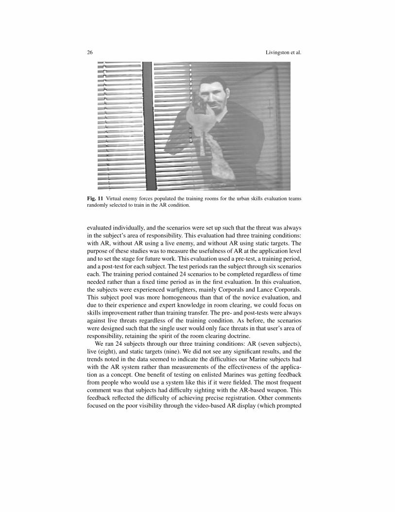
The novice evaluation used two-person teams; scenarios were designed such thatthe missing team members would have had no responsiblities in the small rooms inthe experiment. The primary independent variable was the training mode: with ARor without AR. Eight teams participated, receiving their training through a video,demonstration of techniques by a subject matter expert, and then practice in theirassigned training mode. All participants wore the AR backpack, but only teams as-signed to AR training practiced against virtual forces (Fig. 11); the other teams prac-ticed against empty rooms. Teams were encouraged to perform several repetitionsof the task in the fifteen minutes allocated to practice. After the instructional periodended, the subjects moved to another part of the test site to be evaluated. Here, par-ticipants performed six room-clearing scenarios against real people. Each scenariohad enemy and neutral forces in different positions. The subjects and the peopleplaying the enemy and neutral forces traded fire using “laser-tag-style” weapons.This weapon system counts the number of hits on the subjects and on the enemyand neutral forces. The participants wore the AR backpacks solely for tracking andlogging the users’ actions.
While there were no main effects on objective or subjective performance mea-sures designed by our subject matter expert, we did find an interesting interactionbetween training method and the number of trials performed. The dependent mea-sure that showed this interaction was visual sweep. Visual sweep is a compositeof both speed and effectiveness in the participant’s initial entry into the room, andwas created based upon recommendations from our SME. It is the angular rota-tion (based upon the head tracking data) of the participants during their initial 3.5seconds in each room. The brevity of this time period was enough to capture thesubjects’ first sweep of the room, but eliminated all motions that they made afterfinishing their initial sweep, when the subjects would turn and discuss the situation,or turn completely around and leave the room. A test of simple main effects revealedthat on trial 1, the AR group had a significantly smaller room sweep compared to thenon-AR group. However, on the last trial, the AR group’s room sweep was signifi-cantly larger than that of the non-AR group. In essence, novice subjects who trainedagainst AR-generated forces were learning to look at more of the room to be clearedthan novice subjects who trained against empty rooms.
We simplified the expert evaluation to allow us to collect more detailed dataand to make practical the task of performing the evaluation off-site. Subjects were
26 Livingston et al.
Fig. 11 Virtual enemy forces populated the training rooms for the urban skills evaluation teamsrandomly selected to train in the AR condition.
evaluated individually, and the scenarios were set up such that the threat was alwaysin the subject’s area of responsibility. This evaluation had three training conditions:with AR, without AR using a live enemy, and without AR using static targets. Thepurpose of these studies was to measure the usefulness of AR at the application leveland to set the stage for future work. This evaluation used a pre-test, a training period,and a post-test for each subject. The test periods ran the subject through six scenarioseach. The training period contained 24 scenarios to be completed regardless of timeneeded rather than a fixed time period as in the first evaluation. In this evaluation,the subjects were experienced warfighters, mainly Corporals and Lance Corporals.This subject pool was more homogeneous than that of the novice evaluation, anddue to their experience and expert knowledge in room clearing, we could focus onskills improvement rather than training transfer. The pre- and post-tests were alwaysagainst live threats regardless of the training condition. As before, the scenarioswere designed such that the single user would only face threats in that user’s area ofresponsibility, retaining the spirit of the room clearing doctrine.
We ran 24 subjects through our three training conditions: AR (seven subjects),live (eight), and static targets (nine). We did not see any significant results, and thetrends noted in the data seemed to indicate the difficulties our Marine subjects hadwith the AR system rather than measurements of the effectiveness of the applica-tion as a concept. One benefit of testing on enlisted Marines was getting feedbackfrom people who would use a system like this if it were fielded. The most frequentcomment was that subjects had difficulty sighting with the AR-based weapon. Thisfeedback reflected the difficulty of achieving precise registration. Other commentsfocused on the poor visibility through the video-based AR display (which prompted
Military Applications of AR 27
the basic perception experiments described in Section 4.7) and on ergonomic issues.But subjects liked the concept, and the manpower savings that could be realized byreplacing human actors with virtual enemy forces in training could be significant.As noted above, this aspect of the BARS project has been carried forward into otherprograms, currently sponsored by the Office of Naval Research.
4.7 Basic Perception
One of the problems encountered by users in our urban skills evaluation was an ex-treme difficulty in seeing clearly through the video AR display we selected in orderto overcome the occlusion issue noted in Section 3.3. This prompted an investigationinto exactly how well users could see through the AR displays. We began to con-sider several aspects of basic perception in AR displays: contrast sensitivity, colorperception, and stereo perception. (Users also noted problems with depth percep-tion, an issue addressed in Section 4.1.) It should be noted that these issues occurredin a controlled laboratory setting, whereas military operations may occur at anytime of day or night and will likely involve both indoor and outdoor settings. Thisincreases the range of background lighting conditions under which good visibilityof both the real and virtual portions of the AR scene must be maintained.
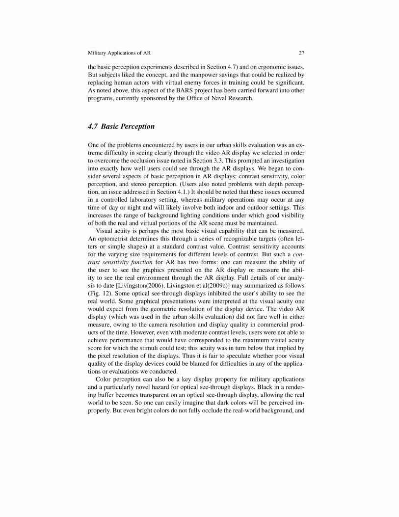
Visual acuity is perhaps the most basic visual capability that can be measured.An optometrist determines this through a series of recognizable targets (often let-ters or simple shapes) at a standard contrast value. Contrast sensitivity accountsfor the varying size requirements for different levels of contrast. But such a con-trast sensitivity function for AR has two forms: one can measure the ability ofthe user to see the graphics presented on the AR display or measure the abil-ity to see the real environment through the AR display. Full details of our analy-sis to date [Livingston(2006), Livingston et al(2009c)] may summarized as follows(Fig. 12). Some optical see-through displays inhibited the user’s ability to see thereal world. Some graphical presentations were interpreted at the visual acuity onewould expect from the geometric resolution of the display device. The video ARdisplay (which was used in the urban skills evaluation) did not fare well in eithermeasure, owing to the camera resolution and display quality in commercial prod-ucts of the time. However, even with moderate contrast levels, users were not able toachieve performance that would have corresponded to the maximum visual acuityscore for which the stimuli could test; this acuity was in turn below that implied bythe pixel resolution of the displays. Thus it is fair to speculate whether poor visualquality of the display devices could be blamed for difficulties in any of the applica-tions or evaluations we conducted.
Color perception can also be a key display property for military applicationsand a particularly novel hazard for optical see-through displays. Black in a render-ing buffer becomes transparent on an optical see-through display, allowing the realworld to be seen. So one can easily imagine that dark colors will be perceived im-properly. But even bright colors do not fully occlude the real-world background, and
28 Livingston et al.
Fig. 12 The measured contrast sensitivity function (CSF) shows that AR displays severely reduceusers’ visual capabilities relative to their natural vision. The inset next to the legend shows thecanonical form of the CSF we have sampled.
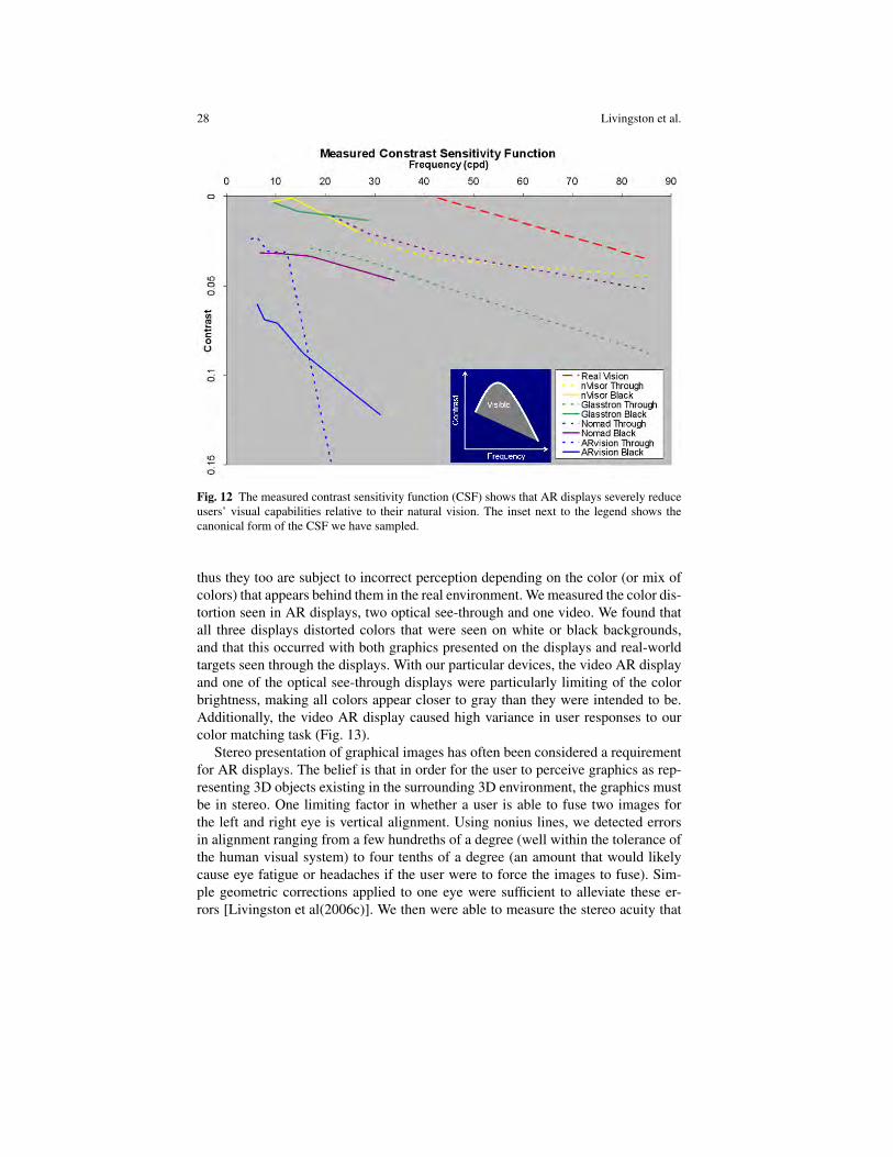
thus they too are subject to incorrect perception depending on the color (or mix ofcolors) that appears behind them in the real environment. We measured the color dis-tortion seen in AR displays, two optical see-through and one video. We found thatall three displays distorted colors that were seen on white or black backgrounds,and that this occurred with both graphics presented on the displays and real-worldtargets seen through the displays. With our particular devices, the video AR displayand one of the optical see-through displays were particularly limiting of the colorbrightness, making all colors appear closer to gray than they were intended to be.Additionally, the video AR display caused high variance in user responses to ourcolor matching task (Fig. 13).
Stereo presentation of graphical images has often been considered a requirementfor AR displays. The belief is that in order for the user to perceive graphics as rep-resenting 3D objects existing in the surrounding 3D environment, the graphics mustbe in stereo. One limiting factor in whether a user is able to fuse two images forthe left and right eye is vertical alignment. Using nonius lines, we detected errorsin alignment ranging from a few hundreths of a degree (well within the tolerance ofthe human visual system) to four tenths of a degree (an amount that would likelycause eye fatigue or headaches if the user were to force the images to fuse). Sim-ple geometric corrections applied to one eye were sufficient to alleviate these er-rors [Livingston et al(2006c)]. We then were able to measure the stereo acuity that
Military Applications of AR 29
Fig. 13 The perceived color gamut for three AR displays shows the distortion that optical see-through displays nVisorST (left) and Glasstron (center) as well as video-overlay display ARvision(right) cause in the perception of colors, both of the graphical overlays and of real-world objects.
users experience with AR displays, again finding that the differences in depth that auser could detect between real and graphical imagery were well above thresholds innormal human vision of real objects [Livingston et al(2009a)]. This gave us furtherevidence of the limitations relative to normal human vision caused by a commercialAR display.
5 Challenges of Designing Military AR Applications
We begin our summary of applications of AR to the military with a discussion of theaspects of military operations and personnel that make designing AR applications achallenging problem.
5.1 Mobility
Among the greatest technical challenges for BARS was mobility; this also makesBARS somewhat unique from several other military applications of AR. A pilot orboat captain moves or turns his or her head in a constrained domain. Dismountedand vehicle-mounted personnel have a much freer range of movement relative tofixed infrastructure that is central to their tasks. This requires the tracking system tobe usable nearly anywhere on the globe, in theory. To achieve the kind of accuracyin tracking that will lead to proper registration over this range is of course a heavyrequirement. In the BARS program, we tested technologies including GPS, mag-netic systems, inertial systems, video-metric systems, and hybrids of these withoutfinding a solution that we felt was robust and accurate enough to achieve the kindof results we could get in a laboratory setting; these in turn were barely sufficient toperform controlled versions of the tasks we envisioned as being of potential value tomilitary users of AR. Note that pilots are in particular known for having a high dy-
30 Livingston et al.
namic range in their head orientation; we expect dismounted personnel on a patrolcould exhibit similarly sudden movements, further stressing the tracking system.
Another crucial difficulty created by the need for mobility was finding a suitabledisplay device. We tested numerous head-worn displays. As noted above, opticalsee-through devices have the obvious advantage of permitting the user to take advan-tage of peripheral vision around the display and natural vision where the graphicsare not present. Video overlay displays were judged to be advantageous for trainingsystems because we could completely control the occlusion relationships betweenreal and virtual entities. But to use either type of display outdoors requires that thebrightness of the display be sufficiently high to be visible in bright sunlight. At thesame time, a display must be usable at night without being visible to a third-partyobserver who may be hostile to the user; any light emitted by the display becomes adanger to the user. And, as we found, these displays reduce human visual capabili-ties in several ways.
Another consideration of the mobility requirement is the size, weight, and powerrequirements of the AR system components. While these metrics have been rapidlyimproving thanks to the efforts of hardware designers and manufacturers, reducingthe amounts of each of these required to drive the AR system will always be aworthy goal for mobile AR. Within the BARS research program, we focused ourefforts on other aspects than the hardware requirements, preferring to communicateour requirements to hardware vendors who were interested.
5.2 User Profiles
One challenge that heavily affected our research – especially on the UI for BARS –was the array of tasks and experience that BARS users were expected to have. Evenwhen focusing on a dismounted task of maintaining SA, the type of role the userplays in the organization may differ significantly enough to warrant very differentinformation being presented. A fire team leader (with three subordinates) may needdifferent information about neighboring units than a company commander (typi-cally responsible for approximately 125 subordinates). A medic, supply specialist,forward observer, or interpreter might need a very different set of information aboutthe surrounding environment, people encountered, or the plans for the immediatefuture (the third aspect of SA).
Another consideration is the background or previous experience with computergraphics that the user is likely to have. There is a significant difference between de-signing for a dismounted Marine private (typically a male of age 18-20 years) and afield commander with 15 or more years of experience in the military. The private islikely to have grown up with computers and be a frequent player of video games, es-pecially the first-person shooter games that are often similar to training tools for ba-sic strategy and techniques. He is more likely to be comfortable with novel computerinterfaces and will be familiar with the standard voice and gesture commands thatare used to communicate with friendly forces in the battlefield. Field commanders
Military Applications of AR 31
are more likely to be an experienced leaders and military strategists. Most served asfield officers but (for the time being) are less likely to have grown up using com-puters and mobile electronic devices on a regular basis. They integrate reports fromforces in the field, and they resolve conflicts between pieces of information (whichcan be reasonably easy) and between evaluations of the situation (which were shownto be harder to resolve for pilots and air traffic controllers [Orasanu(2005)]). Theymay be less comfortable using even traditional computer interfaces but will havefamiliarity with standard protocols for voice communication with field officers andwith superior officers in the C2 center.
5.3 Task Context
One overriding concern for operational applications for military AR systems is thatthe users will be working in a high-stress environment. This argues for having asimple UI that does not distract the user’s attention from the task at hand. By this, wemean that the physical actions required to perform functions in the UI and the easeof understanding the presentation of information must be as simple and intuitiveas possible. For the functions, we focused on using the metaphors and commands(voice and gesture) that military personnel currently use to build the UI for BARS.For the understanding, we eventually settled on building on the standard militaryicons in our most recent implementations, and conducting human factors evaluationsas an integral part of the research and development process.
One issue in the UI was that dismounted military personnel generally need theirhands free to perform existing military tasks or protocols. While gestural commandsmay be incorporated as commands to the AR system, interacting with the AR systemshould intrude on military protocols as little as possible. However, the higher thelevel of a commander, the less likely that his hands will be occupied with suchtasks. Thus, it becomes reasonable that the UI could include more commands thatrequire hands-on operation of the AR system for such personnel.
5.4 Collaboration between Distributed Users
As noted above, one of the most important tasks that was identified as a potentialarea for BARS to improve the team’s SA was to highlight the locations of userswho were not within line-of-sight contact. This is a frequently-occuring challengefor MOUT, which are themselves a more frequently-occurring aspect of militaryoperations. Thus we constructed an information database and distribution systemand focused the UI visualizations on troop locations and routes. We also built aUI for reporting new or changing information, such as the sighting of an enemy orconflicts between the urban terrain database and the real environment. While this
32 Livingston et al.
action required a more complicated UI than would be advisable for certain tasks, itis appropriate for forward observers and other personnel.
This dynamic aspect leads to another type of collaboration, that of synchronizingmovements and routes. This is also an important aspect of MOUT. Routes and linesof fire for one unit should not intersect those for friendly units without careful con-sideration of the timing and danger that this implies for both units. During MOUT,available routes can change dramatically and quickly, increasing the difficulty ofkeeping movements synchronized. Since the dynamic nature of military operationsmeans that it is nearly inevitable that the initial plan will need to be adapted to thesituation on the ground, keeping SA of troop locations and movements is a chal-lenging task. AR has the potential to assist dismounted or mounted personnel withthis aspect of SA. An important, connected issue to this is length of routes. In onestudy [Bowman et al(2006)], routes and directions communicated during an opera-tion were generally short, with close contact between units encouraged. When teamsmust refrain from communications, the duration and distance potentially grow, com-plicating the task of avoiding conflicts between movements. Control measures suchas phase lines, and the progress of other units towards these points of synchroniza-tion along respective routes, are another potentially useful visualization that adds tothe collaboration between distributed users.
6 Summary
The field of AR has a long and rich history of applications specific to military tasks,dating back to the beginning of the field. In addition, the military has helped topush the technology forward in numerous application areas from medicine to main-tenance and repair. AR technology has been demonstrated to have the potential tobenefit military applications. However, the military problems are difficult and, formobile AR systems, more complex than civilian applications. Hard AR research andsystems research challenges remain to produce useful prototypes.
It is true that – as with many other applications of AR – military applicationshave often been limited by the hardware available to system designers and builders.But just as critical to the success of these applications has been the user interfaceand human subject evaluations (which often reveal limitations of the hardware).BARS focused much effort on these two aspects of AR design and implementation,while trying to shape the interests of hardware vendors to coincide with the demandsof the envisioned military applications. One can see similar threads in the othermilitary-specific AR applications discussed here. Indeed, one of the most famousAR applications (at least within the research community) failed not for primarilytechnical reasons, but for lack of user acceptance [Curtis et al(1998)]. The physicaland psychological stress inherent to military tasks increases the importance of theseaspects of the AR system.
With all the efforts underway, there is reason to believe that AR will one day finda place in the standard gear of military personnel. It remains to be seen whether AR
Military Applications of AR 33
equipment can make itself critical enough to the individual soldier or Marine to beissued to all personnel, or whether only a unit leader (fire team, squad, company, orbattalion) needs to see the augmented common operating picture through the lens ofaugmented reality.
Acknowledgments
A complex system such as BARS cannot be constructed by even a modest-sizedteam such as the author list of this text. Numerous employees, interns, and uni-versity collaborators have been an integral part of the research over the past decade:Marco Lanzagorta, Doug Maxwell, Steven Feiner, Blaine Bell, Deborah Hix, JosephL. Gabbard, Tobias Hollerer, Blair MacIntyre, Enylton Coelho, Ulrich Neumann,Suya You, Reinhold Behringer, Catherine Zanbaka, Aaron Kotranza, Robert Dick-erson, Jane Barrow, Evan Suma, Brent Daugherty, Dennis Lin, Bryan Hurley, ElliotCooper-Balis, Adam Lederer, Jason Jerald, Erik Tomlin, Eric Burns, Donald Char-ity, Joshua Eliason, Jesus Arango, and Scott Frees. In addition, the authors wouldlike to thank Henry Fuchs, Pete Muller, Steven Feiner, and Randy Mayberry forassistance in the preparation of this manuscript.
Current affiliations for the authors no longer affiliated with the Naval ResearchLaboratory are: Lawrence J. Rosenblum, National Science Foundation; Simon J.Julier, University College London; Dennis G. Brown, USAF Materiel Command,Warner Robins Air Logistics Center; Gregory S. Schmidt, SPADAC, Inc.; YohanBaillot, Simulation3D, LLC; J. Edward Swan II, Mississippi State University; PaulMaassel, Reallaer, LLC. Interested readers may contact Mark A. Livingston for fur-ther information.
References
[Ai and Livingston(2009)] Ai Z, Livingston MA (2009) Integration of georegistered informationon a virtual globe. In: IEEE International Symposium on Mixed and Augmented Reality 2009(Poster Session)
[Azuma(1997)] Azuma RT (1997) A survey of augmented reality. Presence: Teleoperators andVirtual Environments 6(4):355–385
[Baillot et al(2003)] Baillot Y, Julier SJ, Brown D, Livingston MA (2003) A tracker alignmentframework for augmented reality. In: IEEE International Symposium on Mixed and Aug-mented Reality, pp 142–150
[Bane and Hollerer(2004)] Bane R, Hollerer T (2004) Interactive tools for virtual x-ray vision inmobile augmented reality. In: International Symposium on Mixed and Augmented Reality, pp231–239
[Barham et al(2002)] Barham P, Plamondon B, Dumanoir P, Garrity P (2002) VICTER: An em-bedded virtual simulation system for land warrior. In: 23rd Army Science Conference
[Benford and Fahlen(1993)] Benford S, Fahlen L (1993) A spatial model of interaction in largevirtual environments. In: Third European Conference on Computer-Supported CooperativeWork, pp 109–124

34 Livingston et al.
[Bolstad and Endsley(2002)] Bolstad CA, Endsley MR (2002) Tools for supporting team sa andcollaboration in army operations. Tech. rep., SA Technologies
[Bowman et al(2006)] Bowman E, Cosenzo K, Hill SG, Grynovicki J, Branscome TA, BrelsfordM, Savage-Knepshield P (2006) C4ISR on-the-move testbed 2005 experiment: Human fac-tors analysis. Tech. rep., Army Research Laboratory, Human Research and Engineering Di-rectorate
[Brown et al(2004a)] Brown DG, Baillot Y, Julier SJ, Maassel P, Armoza D, Livingston MA,Rosenblum LJ (2004a) Building a mobile augmented reality system for embedded training:Lessons learned. In: Interservice/Industry Training, Simulation, and Education Conference
[Brown et al(2004b)] Brown DG, Julier SJ, Baillot Y, Livingston MA, Rosenblum LJ (2004b)Event-based data distribution for mobile augmented reality and virtual environments. Pres-ence: Teleoperators and Virtual Environments 13(2):211–221
[Brown et al(2005)] Brown DG, Baillot Y, Bailey MP, Pfluger KC, Maassel P, Thomas J, Julier SJ(2005) Using augmented reality to enhance fire support team training. In: Interservice/IndustryTraining, Simulation, and Education Conference
[Brown et al(2006)] Brown DG, Stripling R, Coyne JT (2006) Augmented reality for urban skillstraining. In: IEEE Virtual Reality Conference
[Cox(2008)] Cox M (2008) Land Warrior: Now or later? Army Times Retrieved from http://www.armytimes.com/news/2008/10/army_landwarrior_101308w/, 22 De-cember 2010
[Cubic(2011)] Cubic Corp (2011) COMBATREDI R©. Retrieved 12 January 2011 fromhttp://www.cubic.com/cda1/prod_&_serv/defense/training_products/virtual_training/combatredi.html
[Curtis et al(1998)] Curtis D, Mizell D, Gruenbaum P, Janin A (1998) Several devils in the details:Making and AR application work in the airplane factory. In: Augmented Reality: Placing Arti-ficial Objects in Real Scenes (Proceedings of the First International Workshop on AugmentedReality
[DARPA(2010)] Defense Advanced Research Projects Agency (2010) Urban leader tacticalresponse, awareness and visualization. http://www.darpa.mil/i2o/programs/uvis/uvis.asp, retrieved 22 December 2010
[Army(2001)] Department of the Army (2001) Operational requirements document (revised) forland warrior
[DISA(2008)] DISA Standards Management Branch (2008) Depart-ment of Defense interface standard: Common warfighting symbology.http://assist.daps.dla.mil/quicksearch/basic profile.cfm?ident number=114934
[USMC(1998)] Marine Corps Doctrine Division (1998) Military operations on urbanized terrain(MOUT). Marine Corps Warfighting Publication No. MCWP 3-35.3
[Feiner et al(1997)] Feiner S, MacIntyre B, Hollerer T, Webster A (1997) A touring machine:Prototyping 3D mobile augmented reality systems for exploring the urban environment. In:First International Symposium on Wearable Computing (ISWC), pp 74–81
[Furness(1969)] Furness LT TA (1969) The application of head-mounted displays to airborne re-connaissance and weapon delivery. Tech. Rep. TR-69-241, U.S. Air Force Avionics Labora-tory, Wright-Patterson AFB
[Furness(1986)] Furness TA (1986) The super cockpit and its human factors challenges. In: Pro-ceedings of the Human Factors Society 30th Annual Meeting, Human Factors and ErgonomicsSociety, pp 48–52
[Gabbard et al(2002)] Gabbard JL, Swan II JE, Hix D, Lanzagorta M, Livingston MA, BrownD, Julier S (2002) Usability engineering: Domain analysis activities for augmented realitysystems. In: Woods AJ, Bolas MT, Merritt JO, Benton SA (eds) Proceedings of SPIE: Stereo-scopic Displays and Virtual Reality Systems IX, Vol. 4660, pp 445–457
[Gardley et al(2008)] Gardley M, Bishop L, McCollon B, Clemons L, Mayberry R, Kohler T(2008) Loadmaster training utilizing augmented reality. Tech. rep., Air Education and TrainingCommand, Randolph AFB

Military Applications of AR 35
[GD(2010)] General Dynamics Corp (2010) Virtual warrior. Retrieved 02 Decem-ber 2010 from http://www.gdc4s.com/content/detail.cfm?item=d3ae855e-74ab-4af0-8c56-abad8be8ea0f&page=1&ParentPageID=177d49b8-73c6-479f-94e8-f79826e1d422
[Gould(2010)] Gould J (2010) Infantry battalion tests nett warrior. ArmyTimes Retrieved from http://www.armytimes.com/news/2010/10/infantry-battalion-tests-nett-warrior-103010w/, 22 December 2010
[Gumm et al(1998)] Gumm M, Marshakm W, Branscome T, McWesler M, Patton D, Mullins L(1998) A comparison of solider performance using current land navigation equipment with in-formation integrated on a helmet-mounted display. Tech. Rep. ARL-TR-1604, Army ResearchLaboratory, Aberdeen Proving Ground
[Hart and Staveland(1988)] Hart SG, Staveland LE (1988) Development of NASA-TLX (TaskLoad Index): Results of Empirical and Theoretical Research, North Holland Press, pp 239–250
[Henderson and Feiner(2011)] Henderson SJ, Feiner S (2011) Exploring the benefits of aug-mented reality documentation for maintenance and repair. To appear in IEEE Transactions onVisualization and Computer Graphics DOI \url{http://doi.ieeecomputersociety.org/10.1109/TVCG.2010.245}
[Hughes et al(2002)] Hughes CE, Stapleton CB, Moshell JM, Micikevicius P (2002) Challengesand opportunities simulating future combat systems via mixed reality. In: 23rd Army ScienceConference
[Julier et al(2002)] Julier S, Lanzagorta M, Baillot Y, Brown D (2002) Projects in VR: Informationfiltering for mobile augmented reality. IEEE Computer Graphics & Applications 22(5):12–15
[Julier et al(2003)] Julier S, Livingston MA, Swan II JE, Baillot Y, Brown D (2003) Adaptiveuser interfaces in augmented reality. In: Proceedings of Workshop on Software Technologyfor Augmented Reality Systems at IEEE International Symposium on Mixed and AugmentedReality
[Livingston(2006)] Livingston MA (2006) Quantification of visual capabilities using augmentedreality displays. In: IEEE International Symposium on Mixed and Augmented Reality, pp 3–12
[Livingston and Ai(2008)] Livingston MA, Ai Z (2008) The effect of registration error on trackingdistant augmented objects. In: International Symposium on Mixed and Augmented Reality
[Livingston et al(2002)] Livingston MA, Rosenblum LJ, Julier SJ, Brown D, Baillot Y, Swan IIJE, Gabbard JL, Hix D (2002) An augmented reality system for military operations in urbanterrain. In: Interservice/Industry Training, Simulation, and Education Conference
[Livingston et al(2003)] Livingston MA, Swan II JE, Gabbard JL, Hollerer TH, Hix D, Julier SJ,Baillot Y, Brown D (2003) Resolving multiple occluded layers in augmented reality. In: IEEEInternational Symposium on Mixed and Augmented Reality, pp 56–65
[Livingston et al(2004)] Livingston MA, Swan II JE, Julier SJ, Baillot Y, Brown D, RosenblumLJ, Gabbard JL, Hollerer TH, Hix D (2004) Evaluating system capabilities and user perfor-mance in the battlefield augmented reality system. In: Performance Metrics for IntelligentSystems Workshop (PerMIS), National Institute of Standards and Technology
[Livingston et al(2005)] Livingston MA, Zanbaka C, Swan II JE, Smallman HS (2005) Objectivemeasures for the effectiveness of augmented reality. In: IEEE Virtual Reality, pp 287–288
[Livingston et al(2006a)] Livingston MA, Brown D, Julier SJ, Schmidt GS (2006a) Mobile aug-mented reality: Applications and human factors evaluations. In: Virtual Media for MilitaryApplications (RTO Meeting Proceedings No. RTO-MP-HFM-136), Research and TechnologyOrganisation, Neuilly-sur-Seine, France, pp 25–1—25–16
[Livingston et al(2006b)] Livingston MA, Julier SJ, Brown D (2006b) Situation awareness forteams of dismounted warfighters and unmanned vehicles. In: Verly JG, Guell JJ (eds) Pro-ceedings of SPIE: Enhanced and Synthetic Vision, Vol. 6266, pp 62,260F.1–62,660F.12
[Livingston et al(2006c)] Livingston MA, Lederer A, Ellis SR, White SM, Feiner SK (2006c)Vertical vergence calibration for augmented reality displays. In: IEEE Virtual Reality (PosterSession)

36 Livingston et al.
[Livingston et al(2009a)] Livingston MA, Ai Z, Decker J (2009a) A user study towards under-standing stereo perception in head-worn augmented reality displays. In: IEEE InternationalSymposium on Mixed and Augmented Reality, pp 53–56
[Livingston et al(2009b)] Livingston MA, Ai Z, Swan II JE, Smallman HS (2009b) Indoor vs.outdoor depth perception for mobile augmented reality. In: IEEE Virtual Reality
[Livingston et al(2009c)] Livingston MA, Barrow JH, Sibley CM (2009c) Quantification of con-trast sensitivity and color perception using head-worn augmented reality displays. In: IEEEVirtual Reality
[Livingston et al(2011)] Livingston MA, Ai Z, Karsch K, Gibson, MSC, USN LT GO (2011) Userinterface design for military ar applications. Virtual Reality (UK)
[MacIntyre et al(2002)] MacIntyre B, Coelho EM, Julier S (2002) Estimating and adapting toregistration errors in augmented reality systems. In: IEEE Virtual Reality, pp 73–80
[Mohl(1981)] Mohl R (1981) Cognitive space in the interactive movie map: An investigation ofspatial learning in virtual environments. PhD thesis, Massachusetts Institute of Technology
[Muller(2010)] Muller P (2010) The future immersive training environment (FITE) JCTD: Im-proving readiness through innovation. In: Interservice/Industry Training, Simulation, and Ed-ucation Conference
[Naimark(1979)] Naimark M (1979) Spatial correspondence – a study in environmental media.Master’s thesis, Massachusetts Institute of Technology
[ONR(2010)] Office of Naval Research (2010) Human performance training and educationthrust. http://www.onr.navy.mil/Science-Technology/Departments/Code-30/All-Programs/Human-Performance-Training.aspx, retrieved 22December 2010
[Orasanu(2005)] Orasanu J (2005) What neeeds to be shared in shared situation models? In: DoDHuman Factors Engineering Technical Advisory Group Meeting 54
[Quantum3D(2010)] Quantum3D, Inc (2010) Expeditiondi R©. Retrieved 02 December 2010from http://www.quantum3d.com/solutions/immersive/expedition_di.html
[Schmidt et al(2006)] Schmidt GS, Brown DG, Tomlin EB, Swan II JE, Baillot Y (2006) Prob-abilistic algorithms, integration, and empirical evaluation for disambiguating multiple selec-tions in frustum-based pointing. Journal of Multimedia 1(3):1–12
[Schmorrow et al(2004)] Schmorrow C, Cohn L, Stripling R, Kruse A (2004) Enhancing virtualenvironments using sensory-multiplexing. In: Interservice/Industry Training, Simulation, andEducation Conference
[State et al(1996)] State A, Livingston MA, Hirota G, Garrett WF, Whitton MC, Pisano ED, FuchsH (1996) Technologies for augmented reality systems: Realizing ultrasound-guided needlebiopsies. In: SIGGRAPH ’96: Proceedings of the 23rd Annual Conference on ComputerGraphics and Interactive Techniques, pp 439–446
[Stix(1992)] Stix G (1992) See-through view: Virtual reality may guide physician’s hands. Scien-tific American 267(3):166
[Sutherland(1965)] Sutherland IE (1965) The ultimate display. In: Proceedings of the IFIP Con-ference, pp 506–508
[Sutherland(1968)] Sutherland IE (1968) A head-mounted three-dimensional display. In:AFIPS’68: Fall Joint Computer Conference, pp 757–764
[Swan II et al(2006)] Swan II JE, Livingston MA, Smallman HS, Brown D, Baillot Y, GabbardJL, Hix D (2006) A perceptual matching technique for depth judgments in optical, see-throughaugmented reality. In: IEEE Virtual Reality, pp 19–26
[Van Riper(1997)] Van Riper PK (1997) A concept for future military operations on urbanized ter-rain. Available from http://www.globalsecurity.org/military/library/policy/usmc/mout.pdf