min o x 2o qja)r le, new mexico and arizona by d. h ... · compilation of more than 600 mineral...
TRANSCRIPT
DEPARTMF T OF THE INTERIOR TNITI·,D Sl A IS (1EOLOGICAL SURVEY
MIN QJA)R
By D. H.
I EPO IT MAP OF THE SILVER CITY 1 o x 2o LE, NEW MEXICO AND ARIZONA
ichter and V. A. Lawrence
MISCELLANEOUS INVESTIGATIONS SERIES Published by the U.S. Geological Survey, 1983
tv til 0 0 0 0

DEPARTMENT OF THE INTERIOR UNITED STATES GEOLOGICAL SURVEY
TO ACCOMPANY MAP 1-1310-B
MINERAL DEPOSIT MAP OF THE SILVER CITY l 0 X2° QUADRANGLE, NEW MEXICO-ARIZONA
By D. H. Richter and V. A. Lawrence
This pamphlet, which accompanies map 1-1310-B, Is a descriptive compilation of more than 600 mineral deposits In the Sliver City 1° x 2° quadrangle. It Includes both metallic and nonmetallic deposits, but excludes such commodities as sand and gravel, rock, and most other low cost per unit volume construction materials. The compilation is generally restricted to deposits that have been described In the lltei:c#ure, although data for a few deposits are from unpublished sources.
Individual descriptions of deposits are grouped under the 10 regional areas shown on the accompanying map, plus an Intervening general basin area, and are numerically keyed to each area on the map. The followIng Information for each deposit, or group of deposits, Is provided:
Name-Most commonly used name; other known names are shown In parentheses. No attempt Is made to categorize name; name may refer to a mine, prospect, claim, claim group, or specific mine workIng, such as a shaft, adlt, or tunnel. Leaders Indicate deposits whose names are unknown.
Location-All locations are given by section, township, and range, generally to within a quarter section.
Geology-Brief description of deposit, Including Information on the age and nature of the host rocks, where known. Leaders Indicate no Information available.
1
Ore minerals-List of ore minerals known to occur In deposit with Important ore minerals, If known or appropriate, underlined. Leaders Indicate no Information available.
History and development-Brief history of deposit and description of physical workings. Tonnage and grade figures are given, If data are available.
Production-Where data are available the quantity of metal or commodity produced Is given. If only monetary values have been reported, they are shown in time-of-production dollars.
References-Principal sources of Information for preceding data. References are keyed numerically to the reference list in back of pamphlet. Where no references are shown, Information Is from unpublished data gathered by the authors.
All weights and measures used In the descriptions are In the metric system. Conversion factors relating to gold and sliver quantities and grades are as follows:
metric ton x 1.1 = short ton
kilogram x 32.15 = troy ounce
gram/metric ton (g/t) x 0.029 = troy ounce/short ton

MAP NO.
GILA AND NORTHERN PELONCILLO MOUNTAINS AREA (includes Ash Peak and Lone Star mining districts)
HYDROTHERMAL DEPOSITS
Porphyry Cu (Mo) Deposits
The porphyry copper and closely associated copper vein deposits in the Lone Star mining district are genetically related to a group of small, chiefly granodiorite plutons and silicic to intermediate hypabyssal rocks of Late Cretaceous to early--Tertiary age (67-52 m.y.) emplaced along wide ENE-trending shear zones in Late Cretaceous (70 m.y.) andesite flows and breccias.
Copper minerals were discovered in the Lone Star district about 1886 and between then and the early 1940's exploration and mining activity was focused on the high grade copper vein deposits. With the exception of the San Juan mine (map no. 2), data on -mining activity and production are virtually non-existent for the many small mines that operated dut'ing that period. The porphyry copper potential of the district was recognized in the late 1940's.
NAME
Dos Pobres (Phelps Dodge-Safford)
San Juan (Peacock Mine)
Safford Kennecott
Horseshoe
LOCATION
Sec. 27 T. 5 S., R. 26 E.
Sec. 35 T. 5 S., R. 26 E.
Sec. 5 T. 6 S., R. 27 E.
NW1/4sec. T. 6 s., R. 27 E.
17
GEOLOGY
Sulfide veins and disseminations in fragmented quartz monzonite porphyry dikes (52 m.y.) and host andesite volcanics at apex of granodiorite pluton localized at intersection of ENE shear zone and NE-trending drag fold. Supergene enrichment minor
Secondary copper minerals in veins and disseminations in quartz monzonite porphyry pluton (58 m. y.) and its granodiorite porphyry border zone, breccia pipes, and host andesite volcanics. Pluton intrudes ENE shear zone. Supergene enrichment minor
Sulfide veins and disseminations in swarm of silicic to in termed tate dikes and andesite volcanics in ENE shear zone north of Lone Star grano-
· diorite pluton (58 m.y.). Sericite from alteration halo dated at 53 m.y. Extensive oxidized zone but minor supergene enrichment. Ore body covered by as much as 240 m of middle Tertiary volcanic rocks
Secondary copper minerals in veins and disseminations in quartz mon-zonite porphyry and host andesite volcanics
ORE MINERALS
Primary pyrite, denite. gene colla, copper, covellite
minerals--chalcobornite, niolybOxide and superminerals--chrysocuprite, native
chalcocite,
Oxide and supergene minerals--chrysocolla, brochantite, malachite, -azur::ite, cuprite, chalcocite
Primary minerals--chalco-~. bornite, molyb-denite. Oxide and super-gene minerals--chryso-colla, malachite, brochan-tite, chalcocite, covel-lite
-Oxide minerals--chryso-colla, malachite, brochan-tite
HISTORY AND DEVELOPMENT
Discovered in 1957 and being developed in 1980 for modified underground block caving. Deposit contains 363 million metric tons of 0.72% Cu with values in MoS 2 , Au, and Ag
Discovered about 1886 and worked as underground mine probably between 1905 and 1920. Developed for surface in situ leaching in 1960's. Present ( 1980) leaching operations producing about 7 metric tons of Cu daily. Deposit contains 18 million metric tons of 0. 5% Cu in oxide ore
Discovered in 1955 and subsequently d-eveloped for underground solution mining. Inactive in 1980. Deposit contains 1,800 million metric tons of 0.41% Cu in mixed oxide--sulfide ore with values in MoS2, Au, and Ag
Developed by 2 shafts and adit prior to 1920 for high grade oxidized ore in shear zones and along porphyry--volcanic contact. Inactive in 1980. Deposit contains estimated 70,000 metric tons of 1.0% Cu to depth of 15m
PRODUCTION
None
Minimum of 340 metric tons of Cu produced prior to 1920. Estimated 10,000 metric tons Cu from leaching operations
None
None
REFERENCES
109, 131, 155, 160, 190, 191, 209
10, 35, LOO, 160, 190, 191, 193
2, 19, 33, 43, 130, 190

MAP NO.
6
10
NAME
Sanchez (Safford Inspiration)
SOL
LOCATION
NE1/4sec. 26 T. 6 S., R. 27 E.
Sees. 23, 24, 25, 26 T. 7 S., R. 27 E.
GEOLOGY
Secondary copper minerals in veins and disseminations in quartz monzonite porphyry pluton and host andesite volcanics
Sulfide system in monzonite pluton and host andesite volcanics overlain by as much as 200 m of Quaternary and Tertiary lacustrine and alluvial deposits
ORE MINERALS
Oxide minerals--chrysocolla, brochant1te ---
Primary minerals--chalcopyrite(?) ---
Cu Vein Deposits
HISTORY AND DEVELOPMENT
Old shaft indicates considerable early underground development. In 1970's developed for leaching operation. Inactive in 1980. Deposit contains 72 million metric tons of 0.18% Cu in oxide ore
Discovered in 1970's by geophysical and geochemical surveys. Extensively drilled. Inactive in 1980. Deposit contains 3-15% sulfides
PRODUCTION
About tons Cu
None
metric
REFERENCES
100, 190, 191.
210
Same geologic environment as the porphyry copper deposits. Early activity in the Lone Star mining district was restricted chiefly to exploration and mining of these high grade oxidized veins that are localized in shear zones generally peripheral to the known porphyry deposits. Only a few of the many vein deposits in the district are described below.
Ben Hur N1/2sec. 36 T. 5 s •• R. 26 E.
Au NE1/4sec. 8 T. 6 s •• R. 27 E.
group of 5 prospects SE1/4sec. 8, SW1/4sec. 9, NW1/4sec. 16 NE1/4sec. 17 T. 6 s •• R. 27 E.
Lone Star C sec. 7 T. 6 s •• R. 27 E.
Secondary copper minerals and quartz in 0.5 m-wide shear zone (N75°E, 85°s) along contact of brecciated felsic dike and Late Cretaceous andesite volcanics
Secondary copper minerals and thin quartz stringers in shear zone (N65°E, vert) in Late Cretaceous an-desite volcanics
Secondary copper and iron minerals and quartz ·tn thin (<1 m) shear zones trending between N7 5°E and F.-W in Late Cretaceous andesite volcanics
Secondary copper and iron minerals, quart>'!, and jarosite in shear zones in Late Cretaceous andesite volcan-ics
Chrysocolla
Chrysocol1a
Chrysocolla
Chrysocolla
Old shallow shaft and trenches. - - - - - - - - -Inactive in 1980
Old shaft, >10 m deep, and trench. --- -- - - - -Inactive in 1980
Old shafts, adits, and pits. Inac- -- ---- - - -ttve in 1980
Old shafts and pits. 1980
Inactive in Possibly as much 100 as 15,000 metric tons Cu, 170 kg Ag, and 11 kg Au. Figures may include production from other mines in district

MAP NO.
11
12
13
14
15
16
NAME LOCATION GEOLOGY ORE MINERALS HISTORY AND DEVELOPMENT PRODUCTION REFERENCES
Ag (Au) Vein Deposits
Veins restricted to sequence of amygdaloidal andesite and basaltic andesite of middle Tertiary age. Early (1900-1936) mining activity and production record virtually .unknown.
Ash Peak (Shamrock and
Commerce Shafts)
Compensation
SE1/4sec. 3, NW1/4sec. 11 T. 8 S., R. 30 E.
N1/2sec. T. 8 S., R. 30 E.
Quartz- and calcite-filled fissure Argentite vein, as wide as 6 m, along 3 km
Discovered about- 1900. By 1919 had been developed by 2 shafts and more than 2000 m of underground workings. Apparently inactive 1920-1936. Reopened in 1936 with major production between 1936 and 1939, closed in 1940. Grade of 59,000 metric tons of ore (1938) was 377 g/t Ag, and 0. 87 g/t Au. In 1979 mill under construction to treat 20,000 metric tons of old mill tailings reportedly averaging about 116 g/t Ag
length of major fault zone trending N60"w and dipping 80°S in middle Tertiary volcanic rocks. Vein lo-cally brecciated
Quartz fissure vein as wide as 5 m north of and subparallel to vein of the Ash Peak mines
Argentite?, secondary cop- Located 1975. In I 980 under de vel-per minerals opment
Mn Vein Deposits
Probably more than 97,000 kg Ag and 403 kg Au, with some Cu and Pb
None
35, 100, 122, 135
With exception of Gila Hot Springs deposit (map no. 13), veins are spatially related to Ash Peak Ag (Au) veins and occur as fissure fillings in amygdaloidal andesite and basaltic andesite of middle Tertiary age and as fracture fillings in massive rhyolite flows ( 23 m. y.) that both overlie and are contemporaneous with the amygdaloidal flows.
Gila Hot Springs (Hult pyrolusite
deposit)
Thurston and Hardy (Godfrey)
Wilba (PBC, Black King)
Crow
N1/2sec. 26 T. 5 S., R. 29 E
NE1/4sec. 34 NW1/4sec. 35 T. 7 S., R. 30 E.
NW1/4sec. 12 T. 8 S., R. 30 E
SE1/4sec. 14 T. 8 S., R. 30 E.
Lenses of manganese oxides with cal- Wad, pyrolusite cite and barite in NNW trending fault zone in Gila Conglomerate
Brecciated fissure filling along two Psilomelane, pyrolusite prominent fault zones trending N70°W and N55°W in amygdaloidal andesite
Fracture zone trending E-W in Psilomelane, pyrolusite amygdaloidal andesite
Fracture zones trending N and N50°W Ps ilomelane in rhyolite
Located in 1938. Developed by open- A few tons of 48, 191 cut and adit. Inactive in 1980 hand-sorted ore
averaging 40% Mn produced in 1955
Mine active 1918-19, 1942, and 1952- 1704 metric tons 55. Developed by opencuts trenches, of 39-45% Mn and shafts. Inactive in 1980
Located in JR90's as An, Ag prospect. Old shaft. Inactive in 1980
5.6 metric tons of 19.3'; Mn
Located in 1951. tive in 1980
Opencuts. Inac- 77 metric tons of about 25% Mn
28, 48, 93, 100, 190, 205
48, 190
48, 190

MAP NO.
17
18
19
20
21
22
NAME
A-1
Paradise, SPW
Black Beauty
Dorothy B. (Neel)
Gila River
Clifton-Morenci (Smuggler)
Gila Valley Block Co.
LOCATION
SWl/4sec. 13 T. 8 S., R. 30 E.
NEl/4sec. 23 T. 8 S., R. 30 E.
SE1/4sec. 11 T. 8 S., R. 30 E.
Nl/2sec. 28 T. 6 S., R. 28 E.
Sees. 21, 22, and 28 T. 6 S., R. 28 E.
Chiefly in sees. 14 and 15 T. 5 S., R. 29 E.
sm/4sec. 28 T. 6 S., R. 29 E.
GEOLOGY ORE MINERALS
Fracture zone trending NW in rhyo- Psilomelane, pyrolusite lite
Fracture zone trendi'Tlg N in rhyolite Psilomelane
Fracture zone trending N in rhyolite Psilomelane
SEDIMENTARY DEPOSITS
Gold associated with boulders and cobbles of massive hemat ite-1l!agnetite and black sand in older allu-
Au Placer Deposits
vial deposits of the Gila and "San Native gold Francisco R1 vers deposited chiefly on Gila Conglomerate. Source of gold is probably the Clifton-Morenci area
VOLCANIC DEPOSITS
Pumice and Cinder Deposits
Pyroclastic deposits of white rhyo- - - - - - -lite pumice and red basaltic ande-site cinder of middle Tertiary age
HISTORY AND DEVELOPMENT PRODUCTION REFERENCES
Located in 1952. 4 m deep shaft and opencuts. Inactive in 1980
Located in 1952. Opencuts. Inac-tive in 1980
Located in 1952. Opencut. Inactive in 1980
New mining and milling facility, designed for large scale operation, constructed in 1980
6.5 metric tons of 41% Mn
None
33 metric tons of 21.2% Mn
Production before 1980 very minor
48
48,
48,
203
Many small deposits known since Production before early 1900's and worked intermit- 1980 very minor tently until 1970's
203
Many small deposits known since 1900's and worked intermittently prior to 1970's
Quarry. Active in 1980
About $30,000 203 (1910-1949) mostly · from deposits north of quadrangle
Hundreds of metric tons
190
190

MAP NO.
SUMMIT MOUNTAINS AND BLACK MOUNTAIN AREA (includes the Cap Rock, Duncan, and Steeple Rock mining districts)
HYDROTHERMAL DEPOSITS
Au-Ag Base Metal Vein Deposits
The precious and base metal ores of the Steeple Rock mining district are epithermal fissure fillings chiefly along brecciated NW- and WNW- trending faults that cut a variety of middle Tertiary volcanic rocks. Quartz and pyrite the dominant gangue, and the ore minerals form ore shoots in silicified breccia zones generally at fault intersections or at abrupt changes in the strike or dip of a fault. Gold and silver values decrease with depth in the mines concomitant with an increase in base metal values.
"nle presence of precious metals in the Steeple Rock district was known as early as 1860 and the Carlisle mine may have produced ore prior to 1880. Most of the known mines were active between 1880 and 1920, but records of mining activity and production for that period are very limited. In 1932 mining revived and since then the district has been intermittently productive up to the present (1980). Value of total production is probably about $6,800,000.
NAME
Twin Peaks
Fraser Brothers
Norman King (includes Bilali,
Hoover Tunnel)
Bank
Summit (includes Apex)
Laura
Carlisle
LOCATION
NW1/4sec. T. 16 s .• R. 21 W
E1/2sec. 17 T. 16 S •. , R. 21 W.
S1/2sec. 26 T. 16 S., R. 21 W.
NE1/4sec. 35 T. 16 S., R. 21 W.
W1/2sec. 36 T. 16 S., R. 21 W.
SW1/4sec. T. 17 S., R. 21 W.
SW1/4sec. T. 17 S., R. 21 W.
GEOLOGY
Vein (N35°W, vert.) in breccia zone in andesite
Vein and silicified fault zone
ORE MINERALS
Gold- and silver-bearing minerals, malachite
Gold- and ail ver-bearing minerals
Silicified breccia zone along the - - - - - - - - - - - - -East Camp fault (N35°-50°W)
Vein along fault southwest and subparallel to East Camp fault
Silicified breccia zone along East Camp fault
Quartz vein along Laura fault
Wide breccia zone or pipe at pronounced bend in E-W trending Carlisle fault. Gold and silver values decrease, and base metal values increase with depth
Chalcopyrite, galena
sphalerite,
Native gold, galena, sphalerite, chalcopyrite
HISTORY AND DEVELOPMENT
Shaft, 150 m deep
4 shafts, as deep as 200 m, worked as late as 1958
Shaft 150 m deep, with extensive drifts, last worked in 1940. Ore averaged 21.6 g/t Au and 1,475 g/t Ag (1919-1921) and 6.2 g/t Au and 365 g/t Ag (1936-1940). Largest mine in Bitter Creek area
Shaft. Workings being rehabilitated in 1979
PRODUCTION
-------
---------
More than $63,200. chiefly in Au and Ag
Some; unknown
amount
REFERENCES
56, 78
56, 78
56, 80
56
Tunnels and drifts. in 1978
Rehabilitated Production in· 56, 81
Developed between 1914 and 1942 to depth of 214 m. Rehabilitated in 1978
Largest mine in district; operated as early as 1880 and intermittently up to 1946. Shaft and winze, 218 m deep with 3050 m of workings on 6 levels. Ore below 60 m averaged 45% Pb, 5.7% Zn, 1% Cu, and a trace of Au
1979, some ear-lier, amount un-known
Production in 1979, some earlier, amount unknown.
Total about 93,000 kg Ag, 4,000 kg Au and 3,600 metric tons of Cu, Pb, Zn valued at about $5 million
56, 81
9, 56, 62, 81, 121

MAP NO. NAME LOCATION
8 Center, Pennsylvania SE1/4sec 1, NE1/4sec 12 T. 17 s .• R. 21 W.
Ontario NW1/4sec. T. 17 s .• R. 20 W
10 Carnation NE1/4sec. T. 17 s .• R. 20 W.
1i Goldenrod C Sec 7 T. 17 s .• R. 20 W.
12 East Camp SE1/4sec.
13
14
15
16
17
(includes McDonald Tunnel) T. 17 S., R. 20 W.
Davenport (includes Thanksgiving)
Golden Nugget
Bluebird
New Year's Gift
Smuggler
Alabama
Jim Crow, Imperial
SE1/4sec. T. 17 S., R. 20 W
NW1/4sec. T. 17 s.; R. 20 w
NW1/4sec. T. 17 s .• R. 20 w.
SW1/4sec. T. 17 s .• R. 21 w.
SE1/4sec. T. 17 s .• R. 21 w.
NW1/4sec. T. 17 s .• R. 21 w.
NE1/4sec. T. 17 s .• R. 21 W.
10
11
14
23
GEOLOGY
Breccia zones at bends in Carlisle taul t < N7 sOW>
ORE MINERAI.S
Native gold, galena, sphaleritP., chalcopyrtte, argentite
Vein or breccia along east end of - - - -- - - - - - - - - -Carlisle fault (E-W, 70°S)
Vein (N55°W) subparallel to East Camp fault
Silicified and brecciated zone along - - - - - - - - - - - - -!!lue Goose fault
Brecciated and vuggy zones along the East Camp fault (N700W, Steep SW)
Vein (N60°W) northeast, .anrl_ subpar-allel to, the F.ast Camp fault
Vein (N40°W) on northwest eKtens.ion of Steeple Rock f::tult
Quartz vein along l.aur::t fault
Silicified and brecciated zone along N-trending fault coextensive with rhyolite dike
Silicified and brecciated zones along Steeple Rock fault which strikes N15°-20°W (Imperial) and N45°-60°W (Jim Crow)
!'lative gold, argentite, native silver, cerargy-rite, secondary copper minerals. Chalcopyrite, galena, sphalertte .at depth
Secondary copper minerals
-------------
-------- - - - .... -
---------- - - - -
-------------
RISTORY AND DEVELOPMENT
Shafts and e>ttensive underground workings to depths of 116 m. Mined intel'lllittent ly from late 1800's to 1980
PRODUCTION
About 200 kg Ag and 240 kg Au
REFERENCES
9, 56, 62, 81, 191
Inclined shaft 49 m deep. Some ore Some; amount un- 57, 81 assayed as much as $200 per metric known ton
Old shaft and pits. and 1960
Drilled 1959 - - - - - - - - -
Shaft
Worked in e::trly 1900's from a number of shafts, tunnel<J, and e>ttensive drifts. Ore mined over a length of 1,350 m along fault. Ore mined in 1943-1944 averaged 8% combined Pb, Zn, C11, and 68.6 g/t Ag and 0.34 g/t Au
Shaft 100 m deep
Shaft 75 m deep
- - - - ____ ...;_ - - ------
Shaft 92 m deep and prospect pits
Several shafts, as deep as 92 m. Mined prior to 1914 up to 1936. Average grade about 2.7 g/t Au and 272 g/t Ag
About 31,000 kg Ag and 930 kg Au valued at $1.4 million (1934-1942)
---------
---------
---------
---------
About $98,000
57. 81
56
9, 54, 60, 79
56, 81
56, 81
81
56, 81
56, 81

MAP NO.
18
19
20
21
22
00
23
24
25
26
27
NAME LOCATION GEOLOGY
Mount Royal SE1/4sec. 23 Vein along T. 17 S., (N450W)
Steeple Rock
R. 21 W.
ORE MINERALS
fault
Cu Vein Deposits
HISTORY AND DEVELOPMENT PRODUCTION REFERENCES
Shaft 100 m deep. 1939
Last worked in Some; amount un- 56 known
Deposits consist chiefly of copper-bearing mineral:s with quartz and pyrite in small veins and fracture fillings in middle Tertiary volcanic rocks at the northwest end of the zone of precious and base metal veins.
Yellowjacket
Commerce-Mayflower
Copper Basin (Lotty-Independence)
Wampoo
Sl/2sec. 28 T. 15 S., R. 21 W.
Sees 8 and T. 6 S., R. 32 E.
Fracture fillings in basaltic ande- Chrysocolla, pyrite, chal- Adit site flows copyrite
Veinlets along c N55°-6o<>w, 7 51>w)
Commerce fault Chalcocite, chalcopyrite, native copper, chrysocolla
Numerous shallow shafts and surface - - - - - - - - -workings
NEl/ 4sec. 10 Vein along fault (N35°W) T. 6 S.,
Chalcopyrite, azurite
malachite, Shaft and numerous surface workings
R. 32 E.
C sec. 15 T. 6 S., R. 32 E.
Secondary copper minerals along Chrysocolla, azurite, mal- Shaft, trench, and drill holes fault (N15°W,70I>w) achite
Fluorite Vein Deposits
78
78
78
78
The fluorite veins in the Duncan mining district are epithermal deposits formed at shallow depth and occur chiefly as fracture fillings and small stockworks mostly along NWtrending faults that cut middle Tertiary volcanic rocks. Vein minerals consist chiefly of quartz, intimately mixed with fluorite, calcite locally coated with manganese oxides, and locally pyrite. Distribution of the fluorite veins peripheral to the precious and base metal vein deposits is suggestive of regional zonation in a large hydrothermal system.
Leta Lynn NE1/4sec. 19 Silicified fault breccia (N35°W, Fluorite, manganese oxides Discovered in 1971. Shaft and shal- 3 metric tons 9, 78, 125 T. 16 S., 80I>w) as wide as 6 m low surface workings R. 21 W.
Powell (Fork) SW1/4sec. 20 Stockwork, as wide as 4 m, in fault Fluorite, manganese oxides Trench, pits and drill holes. Mined 115 metric tons of 9, 78, 125, T. 16 S., breccia of Bitter Creek fault ( N80°- 1942-1943 59% eaF2 162, 190, 201 R. 21 W. 85°W)
Black Willow SE1/4sec. 22 Fracture fillings and disseminations Fluorite, manganese ox- Shaft, 20 m deep, mined for gold and Some production of 9, 56, 78, T. 16 S., along silicified and brecciated ides, native gold, argen- silver in 1920's. Numerous prospect Au and Ag 125, 190, 191 R. 21 W. fault (N60°W) ~. pits are from more recent develop-
ment for fluorite
Mohawk NW1/4sec. 26 Silicified and brecciated zone at Fluorite 4 shafts to 60 m deep with drifts. About 5,900 metric 9, 56, 62, 80, (Bitter Creek) T. 16 S., northwest end of East Camp fault Last operated in 1972 tons of 65-70% 125, 163 J 201
R. 21 W. (N150W) CaF2
Daniels camp NE1/4sec. Fracture fillings along faults Fluorite, manganese oxides Shaft and prospect pits Some; amount un- 9, 79, 127 J
T. 7 S., (N12°E and N50W) known 190, 191 R. 32 E.
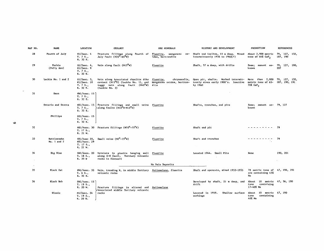
MAP NO. NAME
28 Fourth of July
29 Forbis (Polly Ann)
30 Luckie No. 1 and 2
31 Dean
Ontario and Stotts
Phillips
32
33 Rattlesnake No. 1 and 2
34 Big Nine
35 Black Cat
36 Black Bob
Winnie
LOCATION
Nl/2sec. 4 T. 7 S., R. 32 E.
S1/2sec. 4, Nl/2sec. 9 T. 7 S., R. 32 E.
Sl/2sec. 3, Nl/2sec. 10 T. 7 S., R. 32 E.
NW1/4sec. 15 T. 7 S., R. 32 E.
NE1/4sec. 15 T. 7 s .• R. 32 E.
SE1/4sec. 15 T. 7 S., R. 32 E.
NE1/4sec. 30 T. 17 s .• R. 21 W.
GEOLOGY
Fracture fill1.ngs along Fourth of July fault (N35°-6S<>w)
Vein along fault (N15°W)
Vein along brecciated rhyolite dike contact (N15°E) (Luckie No.1), and vuggy vein along fault (N40°W) (Luckie No. 2)
Fracture fillings and small along faults (N10°W-N10°E)
veins
Fracture fill1.ngs (N70°-75°E)
SE1/4sec 20, Small veins (N2°-15°W) NE1/4sec. 29 T. 17 S., R. 21 W.
SW1/4sec. 20 T. 1~ S., R. 20 W
Vein lets in granite hanging wall along E-W fault. Tertiary volcanic rocks in footwall
ORE MINERALS
Fluorite, manganese ides, bertrandite
ox-
Fluorite
Fluorite, chrysocolla, manganese oxides, bertrandi~e
Fluorlte
Mn Vein Deposits
NW1/4sec. 33 Vein, trending N, in middle Tertiary Psilomelane, fluorite T. 6 S. , volcanic rocks R. 32 E.
SW1/4sec. 131 T. 19 S., R. 20 W. Fracture fillings in altered and
brecciated middle Tertiary volcanic Nl/2sec. 24 rocks T. 19 S., R. 20 W.
Psi lome lane
HISTORY AND DEVELOPMENT
Shaft and incline, 45 m deep. Mined intermittently 1936 to 1960(?)
Shaft, 57 m deep, with drifts
Open pit, shafts. Worked intermittently since early 1900's. Inactive by 1960
Shafts, trenches, and pits
Shaft and pit
Shaft and trenches
Located 1944. Small Pits
Shaft and opencuts, mined 1953-1955
Developed by shaft, 21 m deep, and drift
Located in 1959. workings
Shallow surface
PRODUCTION
About 2, 900 metric tons of 64% CaF 2
Some; amount un-known
More than 2, 000 metric tons of 65-70% CaF2
REFERENCES
79, 127. 132, 187. 190
79, 127. 190, 207
79, 127, 132, 187, 190, 191
Some; amount un- 79, 127 known
79
79
None 190, 201
78 metric tons of 47, 190, 191 ore containing 43% Mn
About 10 metric 47. 56, 190 tons containing 17-40% Mn
About 10 metric 47, 190 tons containing 40% Mn

MAP NO.
37
38
39
40
NAME
Consolation No. 1 (Black Diamond)
Cliff Roy
Ward
Consolation No. 2
Saddle back Mountain
Goat Camp Canyon
LOCATION
SW1/4sec. 20 T. 19 S., R. 19 W.
SW1/4sec. 33 T. 19 s~, R. 19 W.
NW1/4sec. 33 T. 19 S., R. 19 W.
SE1/4sec 32, SW1/4sec. 33 T. 19 S., R. 19 W.
Sees. 28 and 29 T. 16 S. 0 R. 21 W.
Sec. 18 T. 17 S., R. 21 W.
GEOLOGY
Lenticular mass in fault zone (N400W ,S0°NE) in middle Tertiary basaltic flows and breccias
Veins along faults in middle Tertiary basaltic breccias and epiclastic deposits. Travertine in veins at Cliff Roy mine
ORE MINERALS
Ps ilomelane
Ps ilomelane
Other Hydrothermal Deposits
Altered tuffaceous sandstone of mid.;. Alunite dle Tertiary age containing up to 30% alunite
Altered porphyry abundant alunite
middle Tertiary andesite and · rhyolite containing kaolinite and locally
Alunite
HISTORY AND DEVELOPMENT
Probably located during WWI. Operated chiefly 1951-1957 from shaf~,
30 m deep, and large opencut
Deposits located during WWI. During WWII known as Owl or Fuller group but production unknown. Principal development 1951-1959. Deposits mined to depths of 25 m by shafts and open pits. Grade of 10,000 metric tons mined from Consolation No. 1 and 2 averaged 8-10% Mn
No development
No development
PRODUCTION
Included with production from Consolation No. 2 (map no. 38)
About 4,300 metric tons of concentrate and handpicked ore containing about 33% Mn
None; resource ag much as 55xl0 metric tons
None
REFERENCES
47, 56
39, 190
47,
64, 78
79
56,

MAP NO;
--
BIG BURRO AND LITTLE BURRO MOUNTAINS AREA (includes the Blackhawk, Bound Ranch, Gold Hill, Malone, Telegraph, Tyrone, and White Signal mining districts)
HYDROTHERMAL DEPOSITS
Porphyry Cu (Mo) Deposits
The porphyry copper deposit at Tyrone (map no. 1) is the major producing mine in the Burro Mountains. The deposit includes a number of older underground mines that exploited high grade oxidized copper ore along a series of broad northeast-trending fracture zones in a quartz monzonite stock of early Tertiary age (56.2 m.y.). Smaller disseminated deposits localized along fracture and fault zones, both within the quartz monzonite and in the peripheral Precambrian granite host rock, occur outside the main Tyrone workings but only the Liberty Bell-Copper Mountain deposit (map no. 2) is listed here as a porphyry copper deposit. The others (map nos. 10 and 12) are included with the Cu vein deposits that are described separately.
The White Signal-Saddle Mountain deposit (map no. 3) is a buried sulfide sy11tem that may represent a potentially significant porphyry copper or porphyry molybdenum deposit. Data concerning the deposit are mostly proprietary.
NAME
Tyrone (includes a number
of older underground mines: Gettysburg, Copper Gulf, Rocket,
Niagara, Mohawk, Sampson, McKinley, St. Louis, Boston,
Virginia, Klondike, Valencia, Emerald)
Liberty BellCopper Mountain
White SignalSaddle Mountain
LOCATION
Sees. 14 and 15, 22, 23, 24, 25, 26, and 27 T. 19 S., R. 15 W.
SE1/4sec. 21, N1/2sec 28 T. 19 S., R. 15 W.
Probably sec. 23 and 24 T. 20 S., R. 15 W.
GEOLOGY
Deposit covers about 15 km2 at the northeast end of Tyrone stock. Ore minerals occur as fracture-fillings, disseminations, and replacements in shattered and hydrothermally altered quartz monzonite and locally the peripheral Precambrian granite. High grade ores are localized along 4 broad NE-trending zones of intense shearing and shattering. A supergene-enriched blanket, 60 to 90 m thick, dipping 5° NE forms bulk of ore. The supergene zone grades downward into primary sulfides and is capped by an oxidized zone that is locally barren
ORE MINERALS
Primary minerals--chalcopyrite, molybdenite, sphalerite. Supergene minerals--chalcocite. Oxide minerals--chrysocolla, malachite, azurite, cuprite, native copper, turquoise
Fracture-fillings and coatings in Chrysocolla, azurite, chalshattered and altered Tyrone stock cocite in zone as wide as 30 m along Burro Chief fault (N50°-55°E, 40°-600SE) where intersected by two shear-fracture zones of the Tyrone deposit
Buried sulfide system at intersection of NNW and ENE-trending fault systems. Apparently genetically related to early Tertiary rhyolite intrusions of Saddle MountainThree Sisters-Tullock Peak
Chalcopyrite(?), denite(?)
molyb-
HISTORY AND DEVELOPMENT
Discovered about 1879 and many individual veins mined from extensive underground workings prior to 1920. Leaching operations intermittent between 1921 and 1950. No production between 1950 and 1969 when large scale open-pit mining started. Prior to open-pit mining, deposit contained about 360 million metric tons of 0.8% Cu, with values in MoS2 and Au
Worked in 1800's to depths of about 30 m from shafts and adits. Later mined by leaching. Drilling in 1961 to depths of 63 m indicated ore averaging 1-1.2% Cu
Extensively drilled in late 1970's
PRODUCTION
Prior to 1979 about 806,400 metric tons of Cu plus significant amounts of Mos2 and Au
Considerable; amount unknown
None
REFERENCES
34, 70, 155, 189, 208, 211
56, 66

MAP NO.
6
...... N
10
Cu Vein Deposits
nte copper vein deposits along with the turquoise vein deposits described separately below (map nos. 16-18), are spatially related to the Tyrone porphyry copper deposit (map no. 1). "nle deposits consist of veins, fracture fillings, and local disseminations of primary and secondary copper minerals, with occasional pyrite and molybdenite, chiefly in prominent NE-t rending shear zones in Precambrian granite peripheral to the early Tertiary (56. 2 m. y.) Tyrone quartz monzonite stock.
NAME
Beaseley (includes National and
Mayflower Shafts)
National Copper Company
Ohio
'Little Rock
Two-Best-in-Three
Nellie Bly
Copper King
Bolton and Alexander
Tall Pine
Tullock
LOCATION
N1/2sec. 18 T. 19 S., R. 15 W.
SW1/4sec. 17. SE1/4sec. 18 T. 19 s .• R. 15 w.
SE1/4sec. 17 T. 19 s .• R. 15 w.
E1/2sec. 17' T • 19 s •• R. 15 w.
W1/2sec. 16 T. 19 s .• R. 15 w.
SW1/4sec. 16 T. 19 s .• R. 15 w.
W1/2sec. 15 T. 19 s .• R. 15 w.
SE1/4sec. 13, NE1/4sec. 24 T. 19 s .• R. 16 w.
SE1/4sec. 24 T. 19 s.' R. 16 w.
NE1/4sec. 13 T. 19 s .• R. 15 w.
GEOLOGY ORE MINERALS
Veins along Beaumont fault (N70°S) Chalcocite, azurite, molyband subsidiary fractures in Pre- denite cambrian granite
Fractured shear zone, trending NE in Precambrian granite. Probably NE extension of Austin-Amazon fault zone
Vein between faults (N20°-30°E, 45°E) in Precambrian granite
Vein parallels quartz monzonite dike (E-W,50°S) in Precambrian granite; smaller veins (N70°E)
Chalcopyrite, azurite, chrysocolla
Copper carbonates, chryso-colla, fluorite
Ch rysocolla, chalcopyrite
chalcocite,
Fractured shear zone (N70°E) par- Copper carbonates, chrysoallel to quartz monzonite porphyry colla dike in Precambrian granite
Vein (E-W) in Precambrian granite
HISTORY AND DEVELOPMENT PRODUCTION
shafts, 48 and 34 m deep, sunk Some; amount unprior to 1911, and a shaft, 15 m known deep, sunk in 1956. Ore shipped in 1956 averaged 9% Cu
REFERENCES
56, 66, 144
Mined between 1910 and 1926; some Some; amount un- 56, 144 surface exploration in 1950's. known Shaft, 60 m deep, and adit, 110 m long with deep winze. Ore from adit averaged 2% Cu and 3.4 g/t Au
Mined about 1900 from shaft 104 m Some; amount un- 56, 66 deep and extensive underground work- known ings. In 1969-1970 leaching opera-tions in open pit. Ore averaged as high as 8% Cu
Mined about 1900 principally from an Some; amount un- 56, 66 inclined and vertical shaft. Ore known contained 4-5% Cu
Mined in 1880's from ad it, 115 m long, and underground workings. Ore contained as much as 15% Cu and a trace of gold
Old ad it, 30 m long
About 270 m tons Cu
56, 66
Some; amount un- 56, 66 known
Fracture zone (N55°E) in Precam- Chrysocolla, copper carbon- Shaft, more than 125 m deep 66 brian granite ates
Fracture fillings in Precambrian granite parallel early Tertiary rhyolite and quartz monzonite porphyry dikes
Chalcopyrite, copper carbonates, chalcocite, molybdenite
Last worked in 1920's from shallow Some; amount un-shafts and pits known
Veins in Precambrian granite along Copper carbonates and sul- Pits NE-trending Austin-Amazon fault fides
Veins (N70°E) in early Tertiary Copper carbonates "nlree shallow shafts quartz monzonite porphyry that is probably part of Tyrone stock
56, 167
56
56
66, 144,

MAP NO.
11
12
13
..... w
14
15
16
NAME
Bostonian
Montezuma
Austin-Amazon (includes High
Point Extension)
Boone, Oquaqua
Emma, Surprise
Indian Hill and unnamed prospects
Azure, New Azure
Parker
Porterfield (Maroney)
LOCATION
NW1/4sec. 18 T. 19 S., R. 14 w.; NE1/4sec. 13 T. 19 S., R. 15 W.
NW1/4sec. 19 T. 19 S., R. 14 W.
NE1/4sec. 35 T. 19 S., R. 17 W.
SE1/4sec. 27 T. 19 S., R. 15 W •
SW1/4sec. 25, NW1/4sec. 36 T. 19 S., R. 15 W.
C and SW1/4 sec. 4 T. 20 S., R. 15 W.
NW1/4sec. 15 T. 19 S., R. 15 W.
C sec. 15 T. 19 S., R. 15 W.
SW1 I 4sec. 15 T. 19 S., R. 15 W.
GEOLOGY ORE MINERALS
Veins in highly altered early Ter- Secondary copper minerals tiary quartz monzonite stock. De-posit has features characteristic of porphyry copper-type minerali-zation
Veins in monzonite covered by Tyrone pit
early stock
dump
Tertiary quartz now largely
material from
Veinlets and fracture fillings in wide (as wide as 30 m) shear zone along Austin-Amazon fault zone (N50 -55°E) in Precamb~ian granite. Deposit has features characteristic of porphyry copper-type mineralization
Secondary copper minerals
Chalcopyrite, chalcocite, born! te, molybdenite, azu rite, malachite, cuprite, native copper, tenorite
Veins (E-W) in early Tertiary Chalcop_rrite quartz monzonite stock
Veins in Precambrian granite. Copper minerals also present in Tertiary conglomerate (see map no. 145)
Veins and fractures in faults at NE end of Sprouse-Copeland fault zone in early Tertiary quartz monzonite stock
Chrysocolla, malachite, azurite, .cuprite, chalcocite
Chalcopyrite, azurite, malachite
Turquoise Vein Deposits
Fracture fillings in fracture- Turquoise shear zone (N55°-60°E) in Pre-cambrian granite near contact with early Tertiary quartz monzonite stock
Fracture fillings trending NE in Turquoise both Precambrian granite and early Tertiary quartz monzonite stock
Fracture fillings in Precambrian Turquoise granite
HISTORY AND DEVELOPMENT PRODUCTION REFERENCES
Extensive, old underground workings Some; amount un- 56 to depth of 105 m known
Old workings
Originally opened in 1800's probably More than 22 metfor gold. Extensive underground de- ric tons Cu velopment (750 m) and some mining 1914-1921. As many as 200 carloads of ore containing as much as 17% Cu mined. In 1956-1957, 1300 metric tons of 0. 88% Cu and a few tons of higher grade ore were mined from surface workings
56
56, 73
Old shaft 90 m deep and drifts. Ore Some; amount un- 121, 144 contained up to 5% Cu known
Old workings. In 1960 9 met ric tons of 7.3% Cu mined
Old shaft and more recent extensive surface exploration
Probably more than 1 metric ton Cu
56
56
Mined by Indians and probably Probably several 56, 121, 183, Spanish prior to 1870. Rediscovered million dollars 211 about 1880 and mined chiefly between 1890 and 1910 from both underground workings and large open pits
Mined by Indians and site of ot"igi- Significant; nal turquoise discovery in 1875. amount unknown Mined up to 1910 from two large open pits
56, 66, 211
Old shafts and tunnel Some; amount un- 56, 66 known

MAP NO.
17
18
19
.... ~ 20
21
22
23
24
25
NAME
Turquoise
Red Hill
LOCATION
NE1/4sec. 16 T. 19 S., R. 15 W.
NW1/4sec. 16 T. 20 S., R. 15. W.
GEOLOGY ORE MINERALS HISTORY AND DEVELOPMENT PRODUCTION REFERENCES
Vein along fault (N65°E) in Pre- Turquoise, copper carbon- 66 cambrian granite ates
Fracture fillings in zone (N30°W) in Turquoise, radioactive Operated as, late as 1961 from open Some; amount un- 56, 73 Precambrian quartz-biotite schist minerals(?) pit near old shaft and adit known
Au-Ag-Base Metal Vein Deposits
Two groups of precious and base metal vein deposits occur in the area. The northern group (map nos. 19-25) consists of a variety of small veins and mineralized breccia zones in Precambrian and Cretaceous rocks· containing chiefly galena and silver minerals. The second and larger group of deposits (map nos. 26-46) occurs in a broad irregular belt peripheral to the Tyrone quartz monzonite stock. ntis belt, which includes a number of fluorite vein deposits, may represent the outer limits of a large zoned hydrothermal system centered roughly around the porphyry copper and copper vein deposits at Tyrone. The deposits are chiefly quartz veins, along NE-t rending faults and shear zones in Precambrian rocks that contain pyrite, base metal sulfides, and locally bismuth minerals (map nos. 29, 30, 42). Most of the deposits were originally mined for gold (especially map nos. 29, 30, 35, 39, 40, 42); silver was the principal commodity from deposits of map nos. 31, 32, 36, 37, and 38.
Telegraph SW1/4sec. 32 Vein along fault (N28°E, 65°SE) cut- Silver minerals, fluorite, Discovered 1881 and mined intermit- Some; amount un- 56 T. 17 s., ting Precambrian granite and Creta- manganese oxides tently until 1903. Shaft and two known R. 17 w. ceous Beartooth Quartzite near major adits, up to 60 m long
NW-trending fault
Lead Mountain SE1/4sec. 36 Vein in shear zone (N30°-35°E, Galena, fluorite, chryso- Two caved adits --------- 56, 85 T. 17 s., 58°-65°SE) in Precambrian granite colla, manganese oxides R. 18 w.
Slate Creek SW1/4sec. 36 Mineralized breccia zone along fault Galena, sphalerite, chal- Shaft and adit. Limited mining in Some; amount un- 56, 85 T. 17 s., ( N62°E, 68°NW) in Cretaceous Bear- copyrite, bornite 1960 known R. 18 w. tooth Quartzite
Foxtail Creek SW1/4sec. 31 Probably small veins near major Silver minerals(?) Numerous shallow shafts None 49 T. 17 s., faults (E-W) that juxtapose Tertiary R. 17 w. volcanic rocks against Cretaceous
rocks
Hard Pan (German) NW1/4sec. 15 Vein along Tertiary andesite por- Galena, sphalerite, chal- Worked prior to 1900 and again in Some; amount un- 56, 76, 85 T. 18 s., phyry dike (E-W) in Precambrian copyrite late 1930's and early 1940's. De- known R. 17 w. granite and gneiss veloped by 3 adits and winze
Jennie NE1/4sec. 24 Veinlets and coatings in fault brec- Malachite, chrysocolla Ad it None 56, 75, 85 T. 18 s., cia in Precambrian granite and dia-R. 18 w. base
-------- SW1/4sec. 17 Vein (N-S) in Precambrian granite Malachite, azurite Two pits None 76 T. 18 s., R. 17 w.

..... (1'1
HAP NO.
26
27
28
29
30
31
32
33
34
NAME
Live Oak
Astrologer
!'body
Osmer G:>ld (Shamrock)
Foster Zinc
Bismuth Lode
Beaumont
Full Moon
Contact Group (includes Contact
and Copper Sulfide Shafts, Virtue Tunnel, and Contact Manganese)
Afternoon
LOCATION
NE1/4sec. 19 T. 19 S., R. 16 W.
SW1/4sec. 20 T. 19 S., R. 16 W.
N1/2sec. 8 T. 20 S., R. 16 W.
Sec. 22, 23 T. 19 S., R. 16 W.
~OLOGl ORE MINERALS
Vein (NW-trending) granite
in Precambrian Galena, sphalerite, chalcopyrite
Subparallel veins (HE-trending) in Chalcopyrite, Precambrian granite chalcocite
Veins (N60°E) in Precambrian diabase near Tertiary rhyollte dikes
Vein about 2,000 m long along Osmer fault (N60°~) in Precambrian granite. Fault gone intruded by early Tertiary rhyolite and quaru mongon~te porphyry dikes
Hematite, malachite, chalcopyrite
Gold, hematite, bismutite, copper minerals, galena
NW1/4sec. T. 19 S., R. 16 W.
NE1/4sec. T. 19 S., R. 15 W.
26) l ~l~=~e~!!~, o:~;:;erous n:_ Vein along Bismuth-Foster fault --(N700-550E,750NW) in Precambrian granite and intruded by early Ter-tiary rhyolite dike
27 Bismutite, native bismuth, secondary copper minerals, gold
E1/4sec. 13 T. 19 S., R. 16 W.
NW1/4sec. T. 19 S., R. 15 W.
W1/2sec. 2 T. 19 S., R. 15 W.
SE1/4sec. T. 19 S., R. 15 W.
Vein along Beaumont fault (N70°E, 60°S) in Precambrian granite. Fault is part of major NE-trending fault gone that includes the Osmer and Bismuth-Foster faults
Veins along faults (N40°E,85°SE, and N25°E,65°SE) in Precambrian granite. Latter vein is northern extension of Casino vein-fault system
Fissure-filled subparallel veins, tn part along faults that cut a11d juxtapose Precambrian granite, Colorado Formation, and Tertiary andesite. Veins from west to east are: Casino (N20°E), Wyman (N12°-15°E,75°SE), and Contact (N15°-20°E)
Vein along fault (N35°E) in Late Cretaceous-early Tertiary andesite
Argentite, native silver, argentiferous galena, molybdenite
Galena, sphalerite
Galena, sphalerite, ~ gyrite, chalcopyrite, py~
rolusite, psitomelane, wad
Sphalerite, galena, chalcopyrite
HISTORY AND DEVELOPMENT PRODUc:riON
Two shal tow shafts
Mined for silver, gold, and lead Some; amount un-probably around 1900. Two shafts known and drifts
Two shafts, one sunk since 1950
Mined intermittently from early 1880's to 1930's from at least 5 shafts as deep as 30 m and extensive drifts
Originally developed for precious metals prior to 1900. Sphalerite recogniged in 1940 and mined in 1950. Shaft 24 m deep and drifts
Originally developed for gold. Bismuth mined in 1920's. Shaft 21 m deep and drifts
Mined in 1880's for silver. Developed by shaft 105 m deep and shallow surface workings
Developed in late 1800's; last mined in 1942. Two shafts and drifts. Some ore averaged up to 30% Pb and Zn, and 340 g/t Ag
Mined intermittently from 1880's to 1944. Developed to depths of more than 30 m from shafts and ad its. 19f>O metric tons of ore from Contact vein averaged 6-7% Pb and Zn, 68 g/t Ag and 8.5 g/t Au; 55 metric tons of ore from Casino Vein averaged 4.4% Pb, 4% Zn, 0.31% Cu, and 42 g/t Ag and 0.3 g/t Au. Mined in 1942, 1943, and 1953 for manganese
Probably mined in 1R80' s. Shaft st least 45 m deep with drifts. Ore on dump averaged 14% Zn, 12.6% Pb, 1.33% Cu, and 51 g/t Ag and 0.3 g/t Au
Significant; amount unknown
About 12.6 metric tons Zn (1950)
More than 1 metric ton Bi
Some; amount unknown
Considerable; amount unknown
Considerable base and precious metal ore; amount unknown. 940 metric tons of 18-39% Mn
Some; amount unknown
REFERENCES
56, 76, 85
56, 76, 85
56, 76
56
56, 66
56, 66
56, 167
56
47. 56, 164
56, 71

MAP NO.
35
36
37
38
39
...... 40 0"1
41
42
43
44
NAME
Silver King-Mystery
Silver Dollar
Lone Pine
John Malone, Lost Frenchman 'funnel
Barnett, Wild Irishman No. 5
Russell, Uncle Jimmy Thwaits
Summit (Wes Williams)
Neglected
Hop Williams (Pocahontas)
Joy (includes Sprouse,
Copeland)
LOCATION
Nl/2sec. 11 T. 19 S., R. 15 W.
NE1/4sec. 33 T. 19 S., R. 16 W.
NW1/4sec. T. 20 S., R. 16 W.
NE1/4sec. 16 T. 20 S., R. 16 W.
Nl/2sec. 26 T. 20 S., R. 16 W.
C and El/2 Sec 26 T. 20 S., R. 16 W.
NE1/4sec. 23 T. 20 S., R. 16 W.
NE1/4sec. 25 T. 20 S., R. 16 W.
NE1/4sec. 19 T. 20 S., R. 15 W.
El/2sec. 8, SW1/4sec. 4 T. 20 S., R. 15 W.
GEOLOGY ORE MINERALS
Vein along fracture (NS0°E) in Late Gold, malachite Cretaceous-early Tertiary andesite
Vein on southwest extension of Spar Silver, gold, galena Hill fault (NS5°-60°E) in Precam-brian granite
HISTORY AND DEVELOPMENT PRODUCTION REFERENCES
Probably mined in 1800's from shaft Some; amount un- 56, 70 and adit known
Worked in 1908 and again in 1946- Some; amount un-1947 from shaft, 48 m · deep and known drifts on two levels. Ore (1946-47) averaged $9 .SO/ton, mostly in Ag
56
Vein (N20°E) in Precambrian granite Galena, cerussite, bornite Shaft, 24 m deep, sunk in 1950-1951 56
At John Malone, vein (N35°E, 70°SE) in Precambrian granite at basic dike contact. Frenchman 'funnel intersects NE-t rending vein
Argentite, secondary copper minerals
Worked prior to 1900. Shaft more than 24 m deep and adit 12 m long
Some; amount unknown
56
Veins along southwest end of Gold, chalcopyrite, Sprouse-Copeland fault (N85°E) in bernite
tor- Three shafts as much as 30 m deep. Some; amount un- 56 Some ore averaged 3% Cu and 409 g/t known
Precambrian granite
At Russell, vein (NSS0 E) is along Gold contact of early Tertiary rhyolite dike and Precambrian granite. Stringers in granite at Uncle Jimmy Thwaits deposit
Vein along contact of basic dike and Galena, chalcopyrite, ra-Precambrian granite (N45°E,70°SE) · dioactive minerals(?)
Vein (N87°E,75°S) along contact of early Tertiary rhyolite dike and Precambrian granite in SprouseCopeland fault zone
Quartz vein (N7 5°E, vert) along early Tertiary rhyolite dike in Precambrian gran! te
Quartz lenses and fillings in wide shattered zone along complex Sprouse
Copeland fault (N35°-S0°E,65°-850SE) that juxtaposes early Tertiary quartz monzonite porphyry and Precambrian granite. Mineralized zone more than 1 km long
Chalcopyrite, born! te, gold, covel lite, galena, sphalerite, bismutite
Secondary copper minerals, galena
Chalcopyrite, tenorite, galena, sphalerite, molybdeni te, malachite, azurite
Au and 269 g/t Ag
Shaft and ad it. Ore from Russell deposit in 1915-1916 contained 98 g/t Au; high grade ore from Uncle Jimmy Thwaits averaged as much as 92,000 g/t Au
Shaft 25 m deep, sunk in 1920-1922 for gold and copper
Discovered prior to 1900 and worked intermittently from 1900 to 1964. Developed by 3 shafts an adit and numerous pits to depths of 45 m
Developed in 1916-1917 by shaft 29 m deep and adit 34 m long., Assays from drill hole averaged 1.5% Pb, 0.5% Cu, and traces of Au and Ag
Developed about 1900 for copper by shafts up to 36 m deep. Intermittant activity between 1930 and 1960, including extensive drilling
Some; amount unknown
56
56, 73
56, 73, 121
56
56

MAP NO.
45
46
47
48
49
NAME
Malone Mines (includes Malone,
Hillcrest, Patanka, Barranca, and many smaller deposits)
Hogback Lode
LOCATION
SW1/4sec. 20 NW1/4sec 29 T. 20 S., R. 16 W.
Sl/2sec. 31 T. 22 S., R. 15 W.
GEOLOGY
Quartz fissure fillings chiefly in footwall of Malone fault (Nl0°-20Dw, 70°E) in Precambrian granite near contact with overlying middle Tertiary volcanic rocks. Veins trend E-W with exception of Patanka, that trends NE-SW
ORE MINERALS
Gold, chalcopyrite, galena,-sphalerite
Vein with travertine and sulfides Chalcopyrite along fault (N350W) in Precambrian granite
Au ( Cu-Bi-U) Vein Deposits
HISTORY AND DEVELOPMENT
Discovered in 1884; major production prior to 1900. Interest in area revived in 1930, but inactive by 1961. Deposits worked by numerous shallow shafts ( <30 m deep), drifts, and stopes. Vein and ore samples from Patanka in 1947 assayed 24-27 g/t Au and 646-894 g/t Ag, and from Barranca 1 g/t Au and 94 g/t Ag
Small pit
PRODUCTION
About $250,000 in gold and a little silver prior to 1900 and $50,000 after 1925
None
REFERENCES
56, 77
68
Numerous and generally small quartz-pyrite, or locally quartz-specularite, veins locally containing gold, copper, uranium and bismuth minerals occur throughout the White Signal mining district and are spatially and probably genetically related to the early Tertiary rhyolite intrusions of Three Sisters-Saddle Mountain. The veins are chiefly simple fillings in fractures and in brecciated fault zones in Precambrian granite or along early Tertiary rhyolite dike-granite contacts. Uranium minerals tend to be concentrated where veins, or faults, cut NW-trending Precambrian diabase dikes in granite. Expioitable deposits of gold, copper, and to a much lesser degree, uranium have only been found in the oxidized parts of the veins, generally less than 30 m deep. Primary minerals encountered in a few deeper mines and in drilling have been too low in grade to warrant mining.
Most of the deposits were discovered between 1880 and the early 1900's and worked for gold; but data on activity and production for this early period are nonexistent. The recognition of uranium minerals in 1919 led to a radium boom that lasted until the late 1920's. Renewed interest in uranium for nuclear energy resulted in extensive exploration between the late 1940's and about 1955, but the results were discouraging. Drilling in l!lte 1970's has apparently led to the discovery of a sulfide system at depth (see map no. 3).
Apache Trail
Golden Eagle
Alhambra-Bluebell No. 2
Floyd Collins
NE1/4sec. T. 20 S., R. 15 W.
NE1/4sec. 14 T. 20 S., R. 15 W.
Vein along fault (N80°W,65°-70°N) locally associated with diabase dike, in granite
Secondary copper minerals, gold, hematite, bismuth minerals, torbernite
Vein along intersection of two small Gold, secondary faults, (N70°E and N10°-150W) in minerals
copper
granite
NE1/4sec. 14 Small veins T. 20 S., R. 15 W.
NE1/4sec. 31 T. 20 S., R. 15 W.
NE1/4sec. 21 NW1/4sec. 22 T. 20 S., R. 15 W.
Fracture fillings in shattered dia- Torbernite base dike (N280W) in granite
Fracture and vug-fillings in faulted diabase dike (N200W)
Torbernite, autunite
Located about 1890 and mined intermittently up to 1920's for copper. Developed by 60 m shaft with two levels and numerous surface workings. Ore (1915-1920) averaged 5% Cu and 170 g/t Ag
9 metric tons of Cu and 30 kg Ag (1915-1920). Some Bi in 1920
Operated about 1905 for gold and Some; amount un-copper. Shaft about 25 m deep known
56, 124
56, 74
Located in 1880's, some work in Some; amount un- 56, 74 1930's. Shafts and surface pits. known Ore averaged up to 400 g/t Au
Two shallow shafts
Mined in 1920's for uranium. Intermittently mined from 1954 to 1959. Developed by two inclined shafts, 24 m deep, with drifts and surface workings. Ore averaged O.l-0.2% U308
56
56, 74, 192

MAP NO.
50
51
52
53
54
55
56
NAME
Merry Widow
Acme, Utah, California
Paymaster
Bisbee
Blue Jay, Banner
Red Bird
Shamrock
Combination
Copper Glance
Paddy Ford
Calamity
LOCATION
C Sec. 22 T. 20 S., R. 15 W.
SE1/4sec. 22 T. 20 S., R. 15 W.
NW1/4sec. 28 SW1/4sec. 21 T. 20 S., R. 15 W.
GEOLOGY
Fracture fillings where fault (E-W) cuts two diabase dikes; vein along fault
Fracture fillings where faults cut NW-trending diabase dikes in granite
Two subparalled veins (N85°E and N80°E) along rhyolite and quartz monzonite porphyry dikes in granite
ORE MINERALS
Gold, torbernite, autunite, bismite, bismutite, chalcopyrite, hematite
HISTORY AND DEVELOPMENT
Located in 1880's for gold. Uranium discovered in 1919; mined until late 1920's for radium salts. Shaft 45 m deep with extensive workings on 4 levels
PRODUCTION
Gold production unknown; largest uranium producer in district, amount unknown
Torberni te, oxides
hydrous iron Numerous shallow shafts (-< 12 m - - - - - - - - -deep) and pits
Gold, lead, silver and copper minerals, radioactive minerals
Mined in 1900's for gold. shafts and prospect pits
Two
SW1/4sec. 27 Vein (N65°-85°E, Vert) in granite T. 20 S.,
(',old, radtoactf.ve miner- Mined between 1895 and 1910. Two - - - - - - - - -liiS(?) shafts 27 m deep and ad it 30 m long
R. 15 W.
NW1/4sec. 26 T. 20 S., R. 15 W.
SW1/4sec. 23 T. 20 S., R. 15 W.
SW1/ 4sec. 23 T. 20 S., R. 15 W.
NE1/4sec. 23 T. 20 S., R. 15 W.
NE1/ 4sec. 23 T. 20 S., R. 15 W.
SEl/ 4sec. 23 T. 20 S., R. 15 W.
SE1/4sec. 23 T. 20 S., R. 15 W.
Veinlets along ENE-trending fault zone that is intruded by rhyolite and diabase dikes
Torbernite, pitchblende
autunite,
Vein (S75°E,80°S) along contact of Radioactive minerals(?) rhyolite dike and granite
Mineralized rock at intersection of Gold, copper and uranium diabase dikes (N400W); NE-t rending minerals veins
Series of parallel veins (N45°E) in Gold, copper minerals, granite radioactive minerals?
Vein (N45°E) in granite
Vein (N85°E) in granite associated with rhyolite and diabase dikes
Vein (N7 5°E ,85°S) diabase dike
in granite and
Gold, chalcopyrite chalcocite, radioactive minerals(?)
Gold, copper minerals, secondary uranium minerals
Gold, secondary copper minerals, radioactive minerals(?)
Old shaft on Banner property, trenches and pits on Blue Jay
Worked prior to 1905. deep
Shaft 60 m - - - - - - - - -
Pits, trenches, and shafts
Mined intermittently 1910 to 1950's. 3 shafts, one 30 m deep, and numerous surface workings. Some ore averaged 340-410 g/t Au (1910-1915)
Mined in early 1890's and in 1920's. Shaft 26 m ~eep and opencut
Located in 1900's and worked intermittently up to early 1930's. Shaft 36 m deep with drifts. In 1914 ore averaged 16.8% Cu, 340 g/t Au and 270-340 g/t Ag
Located about 1900 and worked intermittently up to 1917. Extensive exploration for uranium in 1955. Shaft 30 m deep, and surface workings
9,000 metric tons (1931-1943) of gold-silver ore
Some; amount unknown
Some; amount unknown
Some; amount unknown
REFERENCES
54, 56, 61, 124
56, 73
56
56, 121
54, 124
56
56,
56, 74
56
56,74
56, 74
56
60,
74,

MAP NO.
57
58
59
60
61
62
63
64
65
NAME
Inez
Hummer (Good Luck)
Eugenie
Tunnel Site No. 1
Bouncing Bet
Tullock
Gold Lake
Chapman
New Years Gift
Black Tom
LOCATION
SW1/4sec. 24 T. 20 S., R. 15 W.
SW1/4sec. 24 T. 20 S., R. 15 W.
NE1/4sec. 26 T. 20 S., R. 15 W.
NE1/4sec. 26 T. 20 S., R. 15 W.
SE1/4sec. 24 T. 20 S., R. 15 W.
SW1/4sec. 25 T. 20 S., R. 15 W.
Sl/2sec. 20 T. 20 S., R. 14 W.
El/2sec. 25 T. 20 S., R. 15 W.
Sl/2sec. 22 T. 20 S., R. 15 W.
C Sec 2 T. 20 S., R. 15 W.
Sl/2sec. 22 T. 20 S., R. 14 W.
GEOLOGY ORE MINERALS
Vein (N75°E) cutting diabase dike in Torbernite, gold granite at uranium prospect and vein (N5°W), along basic dike in granite at old workings
Vein along rhyolite dike (N70°E, Gold vert) in granite
Vein (N55°E, vert) in granite near diabase dike
Gold, chalcocite, torbernite
Veins along granite-rhyolite dike contact (N30°E)
Subparallel veins and rhyolite dikes ( N25°-30°E) in granite
Limonite, radioactive minerals(?)
Gold, malachite, active minerals(?)
radio-
Veins (N70°W, N45°W, and N5°W) in Gold, chalcocite, azurite, granite. N450W vein cuts diabase torbernite dikes and is radioactive
Numerous veinlets in granite and Gold placer deposits (see map no. 167)
Two veins (N62°E and N53°E) in early Tertiary rhyolite of Saddle Mo_untain
Turquoise, secondary copper minerals, radioactive minerals(?)
Two parallel veins (E-W) in granite Gold, copper minerals, and diabase bismutite, torbernite
Vein (N33°W) in granite Hematite, magnetite
Fracture fillings in granite Manganese oxides
HISTORY AND DEVELOPMENT
Discovered in 1951 and mined in 1954 by adit and pits. About 236 metric tons of ore averaged 0.16% u3o8 • Older workings, 150 m north, mined for gold
Located about 1900. m deep
Shaft about 30
Located about 1913 and mined intermittently up to 1925. Shaft 24 m deep, and drifts. Grade of ore in 1913-1914 averaged 29.6% Cu, 418 g/t Au and 476 g/t Ag
Developed by adit 75 m long, with two winzes, and shallow shaft
Known in 1890's. Mined about 1900. Shafts and surface workings
Old shaft, 78 m deep, sunk prior to 1900 with drifts, on N70°W vein. Shaft, 9 m deep, sunk 1959 on N5°W vein. Ore averaged 9% Cu
PRODUCTION
Two carloads of ore (1913-1914) and 225 kg torbernite (1920's)
None
Some; amount unknown
About metric tons of Cu mined in 1959
Lode deposits explored but not eco- None nomical
Turquoise mined from glory hole between two veins between 1890 and 1900
Located in 1884 and worked intermittently until early 1930's. Two shafts, 37 and 25 m deep. Ore aver-
~~~~-l~%14 Cu and 5j0-680 g/t Au in
Shaft and pit
Pit
Some; amount unknown
$8,000 in Au prior to 1913. After 1913 8.4 kg Au, 1. 9 metric tons Cu
REFERENCES
56, 74
56, 74
56, 74
124
56
56, 74
56
56, 211
56
74
74

MAP NO.
66
67
68
69
70
71
72
73
74
75
NAME
Monarch No.
LOCATION
SE1/4sec. 19 T. 20 S., R. 15 W.
GEOLOGY ORE MINERALS
Vein along Tertiary rhyolite dike Autunite, limonite (N45°E) in granite. Probably NE ex-tension of Moneymaker fluorite vein (map no. 116)
Ag-Pb (Cu-Bi-U) Vein Deposits
HISTORY AND DEVELOPMENT PRODUCTION REFERENCES
Pit None 124
Deposits similar and closely related to the quartz-pyrite Au (Cu-Bi-U) veins of the White Signal district, but contain lead and silver minerals rather than gold. They occur east of the area of quartz-pyrite veins in Precambrian granite and are generally small veins containing chiefly secondary silver minerals and galena. Most were worked between the 1880's and WWI; data on mining activity and production are lacking.
Edmonds
Red Dodson
Uncle Sam
Sellers
Tullock Silver and deposits to west
Tiouner
Blackman
Jersey Lily
Snowflake
Hose Triouner
C Sec 34 T. 20 S., R. 15 W.
El/2sec. 14 T. 20 S., R. 15 W.
NEl/ 4sec. 32 T. 20 S., R. 14 W.
Vein (N85°1~, vert) in granite
Mineralized fault zone (N45°W) about 1,200 m long in granite
Mineralized fault zone (N45°W) about 1,200 m long in granite
Galena, sphalerite(?)
Cerargyrite, argentiferous galena, bismuthinite
Cerargyrite, galena, argentite, wulfenite, radioactive minerals
Shaft sunk in late 1930's.. Mined - - - - - - - - -for silver
Mined about 1910 from adit 10 m long and shaft 21 m deep. Ore averaged up to $300/ton Ag
Mined in early 1900's and reactivated briefly in 1940. Developed by a number of shafts, pits, and ad its to depth of 30 m
About 27 metric tons ore (1910)
One ore produced in Ag
pocket $20,000
56, 73
56, 74
56, 74, 124
SWl I 4sec. 30 Vein in granite T. 20 S.,
Cerargyrite, copper min- Old workings erals
56
R. 14 W.
Wl/2sec. 32 T. 20 S.,
Vein along fault (N30°-35°W) in Cerargyrite, barite granite
R. 14 W.
SE1/4sec. 15 Veins (N87°E and N55°E) in granite T. 20 S., R. 14 W.
NE1/4sec. 26 T. 20 S., R. 14 W.
NW1/4sec. 34 T. 18 S., R. 15 W.
C Sec 34 T. 18 S., R. 15 W.
NEll 4sec. 21 T. 21 S., R. 14 W.
Vein along fault (N85°E ,85°S) in granite
Fissure veins (N15°E) in granite
Vein along fault (N65°-70°E) granite
Barite-quartz vein 75°-80°N) in granite
in
Cerargyrite, argentite
Argentite, cerargyrite, galena, pyrite
}
Cerargyrite, torbernite
argentite,
Argentiferous galena
Operated in 1885-1886 from 2 shafts Some; amount un- 56 and several pits. Ore from deposits known to west averaged 2,380 g/t Ag
Worked in 1890's from 2 shafts more - - - - - - - - -than 15 m deep
Worked about 1910 from numerous pits and shallow shafts
56
56, 74
Both deposits mined in 1907 and the Jersey Lily again in 1930. Shafts and ad its. Ore in 1907 averaged as high as 24,000 g/t Ag; in 1930 1,700-2,040 g/t Ag
More than $40,000 [56
in silver
56, 66
Developed during WWI or before. Two Some; amount unshaf ts, one more than 60 m deep, and known trenches
56, 71

MAP NO.
76
77
78
79
80
81
82
83
84
85
NAME LOCATION GEOLOGY ORE MINERALS HISTORY AND DEVELOPMENT PRODUCfiON REFERENCES
Au (Base Metal) Vein Deposits
Chiefly low-grade and oxidized, gold-bearing quartz-pyrite veins in the Gold Rill district. Silver occurs in a few deposits (map nos. 82, 83, and 90) in the east and south parts of the district. The veins occur as simple fracture fillings in Precambrian granite .or commonly along Precambrian hornblende gneiss-granite contacts. Mineralization is probably Late Cretaceous or early Tertiary in age.
Deposits were discovered in 1884 and many small mines were active up to about 1900 when the shallow oxidized ores were mined out. Data on production and activity during this period are virtually nonexistent. Minor intermittent activity between 1920 and 1960 resulted in production of at least 29 kg of gold.
Minneapolis
Yankey Girl
Monarch Canyon
Reservation (includes Gold
Bullion)
Bruff
Ruby Silver
Co-op (Goodluck)
Gold Tunnel (Content ion, Ro boken)
NW1/4sec. 23 T. 21 S., R. 17 W.
C Sec 19 T. 21 S., R. 16 W.
Quartz vein granite
Vein in granite
in Galena Two old shafts and several pits
Gold Extensive underground workings
69
Some; amount un- 56 known
NE1/4sec. 20 Quartz vein (N20°-25°W) in granite T. 21 S.,
Galena, sphalerite, chal- Old adit copyrite, covellite
69
R. 16 W.
NE1/4sec. 26 T. 21 S., R. 17 W.
NWI/4sec. 30 T. 21 S., R. 16 W.
SE1/4sec. 30 T. 21 S., R. 16 W.
W1/2sec. 29 T. 21 S., R. 16 W.
El/2sec. 29 T. 21 S., R. 16 W.
NWI/4sec. 36 T. 21 S., R. 17 W.
W1/2sec. 31 T. 21 S., R. 16 W.
SE1/4sec. 36 T. 21 S., R. 17 W.
Massive quartz vein (N80°-85°E) as Galena thick as 24 m in granite
Quartz .vein (N45°-55°E, 60°-80°SE) Gold, galena, sphalerite in hornblende gneiss and migmatite
Quartz vein along fault (N70°-80°E) Gold in granite
Veins in fault zone (N70°-80°E) in Galena, ruby silver granite and hornblende gneiss
Veins at intersection of Co-op fault (N60°-75°E) and N-trending fault in granite
Small quartz veins (N80°-85°E) in hornblende gneiss and granite
Veins trending E and NE in hornblende gneiss
Quartz veins in hornblende gneiss. One vein along fault (N200W)
Native silver, galena, cerussite, sphalerite
Galena, gold
Gold
Old adit
Old adits and shafts along 600 m of Considerable; vein. One of principal mines in amount unknown Gold Hill area
Shaft 60 m deep and pits. worked in 1940
Last
Old shaft 20 m deep and many pits
Mined in 1920's from 2 inclined adits and m.onerous levels
Adit and shallow shaft
Old adit and shafts
Old adit
More than $100,000 in Ag
69
56, 69
56, 69
56, 69
56, 69, 118
69
56, 69
69

MAP NO. NAME
86 Mill
Golden Chief
Standard (includes California)
87 Crescent (Homestead)
Nancy Lee
1'1,) 1'1,)
88 Bluebird
--------
89 --------
90 Climax
91 Never Fail (Connie Lynn)
LOCATION
NE1/4sec. T. 22 S., R. 17 W.
W1/2sec. 6 T. 22 S., R. 16 W.
W1/2sec. 6 T. 22. S., R. 16 W.
NW1/4sec. T. 22 S., R. 16 W.
NE1/4sec. T. 22 S., R. 16 W.
NW1/4sec. T. 22 S., R. 16 W.
SE1/4sec. T. 22 S., R. 17 W.
S1/2sec. 12, N1/2sec. 13 T. 22 S., R. 17 W.
E1/2sec. 18 T. 22 S., R. 16 W.
SE1/4sec. 17 NE1/4sec. 20 T. 22 S., R. 16 W.
GEOLOGY ORE MINERALS
Quartz vein at contact of hornblende Gold gneiss and migmatite near Gold Hill fault
Vein at contact of hornblende gneiss Gold and migmatite
Quartz vein trending WNW at contact Gold of hornblende gneiss and migmatite
Quartz vein (N60°W,40°SW) in horn- Go.M blende gneiss
Quartz vein trending NW in • horn- Gold blende gneiss
Quartz veins (N40°-70°W) in. horn- Galena, gold, scheelite, blende gneiss wolframite
Brecciated quartz vein (N40°-50°W) Gold at contact of hornblende gneiss and migmatite
Quartz vein (N-S) along fault in Gold hornblende gneiss
Quartz veins (N30°-45°W, dip SW) in Argentiferous galena, gold granite and hornblende gneiss
Quartz vein (N65°-75°W, 35°-40°SW) Galena, gold along fault contact between granite and hornblende gneiss
HISTORY AND DEVEI;OPMENT PRODUCTION
Original discovery in Gold Hill dis- - - - - - - - - -trict in 1884. Adit with drifts
Largest mine in Gold Hill dis- Considerable; trict. Mined out prior to 1900. amount unknown Old adits
Inclined shaft
Two vertical shafts
REFERENCES
69
56
56, 69, 121
56, 69
56, 69
Mined prior to 1900 from several Several hundred 24, 56, 69 shafts and pits. Rehabilitated in tons Au ore 1954 during exploration for tungsten
Several old ad its, as long as 21 m
Three old shafts
Old adit and shafts
Old deposit reopened in 1956-1959. Vein explored for 600 m by shafts as deep as 30 m and pits. Vein assayed 8-9% Pb and 120 g/t Au and 645 g/t Ag in 1956, but no ore shipped
69
69
56, 69
56, 69

MAP NO.
92
93
94
1\) (A)
95
96
97
98
Ni-Co-Ag (U) Vein Deposits
Deposits are fissure veins along faults and fractures, trending N to NNE and NE to E, mainly in Precambrian quartz diorite gneiss and granite near the southeast margin of the Twin Peaks monzonite porphyry stock of Late Cretaceous age (72 m.y.). Lead-uranium isotope data indicate mineralization is Laramide in age, probably related to Twin Peaks stock. Ore minerals occur in gangue composed chiefly of carbonate minerals (calcite, dolomite, siderite, ankerite), and minor pyrite, barite, quartz and rhodochrosite.
Deposits discovered in 1881 and extensively mined between then and 1893. Some activity in 1917, 1949-1960 and at present (1980). Total production of silver from all mines is estimated about 40,000 kg, valued between 1 and 1.5 million dollars.
NAME
Black Hawk I (includes Black Hawk No. 1 and No. 2
Shafts and Hunecke Shaft)
Copper Vein
Alhambra
Rose
Osmer Silver
Midnight
Silver King (Hobson)
Good Hope
Missouri Girl
Eccles
LOCATION
E1/2sec. 21 T. 18 S., R. 16 W.
SWl/4sec. 21 T. 18 S., R. 16 W.
NE1/4sec. 29 T. 18 s .• R. 16 w.
SE1/4sec. 29 T. 18 s .• R. 16 w.
W1/2sec. 28 T. 18 s .• R. 16 w.
NE1/4sec. 21 T. 18 s .• R. 16 w.
W1/2sec. 21 T. 18 s .• R. 16 w.
NE1/4sec. 21 T. 18 s .• R. 16 w.
SE1/4sec. T. 19 s .• R. 16 w.
GEOLOGY
!Fissure fillings along the Black Hawk vein, which consists of a series of imbricate subparallel fractures, (N70°E,60°-70°NW) in quartz diorite gneiss
Vein (N50°E,80°-85°NW) about 60 m north of Black Hawk vein
Vein in porphyritic quartz diorite gneiss near E-trending monzonite porphyry dike
Two intersecting veins (N35°E and N85°E to N7 sOW) in granite, quartz diorite gneiss and monzonite porphy-ry
Vein (N60°E,80°S)
Vein trending NE and dipping 80°SE in granite and quartz diorite gneiss
Vein (N50° -65°E, 65°NW) in quartz diorite gneiss within few tens of meters of Twin Peaks monzonite por-phyry stock
Vein between Black Hawk and Alhambra mines (N65°-75°E) in quartz diorite gneiss and granite
Vein in quartz diorite. gneiss and granite
Vein in hornblende gneiss and granite gneiss
ORE MINERALS
Native silver, argentite, galena, chalcopyrite, sphalerite, niccolite, smaltite, nickel skut-terudite, pitchblende
Pitchblende
Native silver, argentite, niccolite, skutterudite, nickel skut te rudite, pitchblende, sphalerite, galena, millerite
Native silver, argentite, cerargyrite, nickel and cobalt minerals, pyargyr-ite, proustite, pitch-blende
Native silver, ar~entite,
pitchblende
Native silver, nickel, co-halt, and uranium minerals
Argentite, native silver
Native silver, radioactive minerals
Native silver
-------------
HISTORY AND DEVELOPMENT
Mined 1881-1893 from 3 shafts to depth of 150 m and about 900 m of drifts from 8 levels. Reopened in 1917, and diamond drilled in 1952. Inactive in 1980
Trenches and shallow shafts
PRODUCTION
About 14,000 kg Ag
Original discovery. Mined 1881-1893 About 13,000 kg Ag and 1957-1960 from 4 shafts to depth (1881-1893) of 105 m
Shaft 60 m deep and 2 adits. Closed About 4, 300 kg Ag in 1889 and reopened in 1979
Shaft 12 m deep sunk 1950-1960. ---------Inactive in 1980
Shaft 24 m deep ---------
Inclined shaft and 9Q-m-long adit About 1, 300 kg Ag
Shaft 37 m deep ---------
Shaft 27 m deep ---------
Shaft > 30 m deep sunk in 1800's for ---------silver
REFERENCES
56, 58, 121, 124
56
66,
56, 58, 76, 94, 121, 124
56, 58, 76, 121, 124
56·, 76
56, 76
56, 58, 121
56, 58, 121
56, 66
56

MAP NO.
99
100
101
1\J ~
102
103
104
Fluorite Vein Deposits
Three groups of fluorite vein deposits occur in the area. The northernmost group of deposits (map nos. 99-107) consists of small veins and breccia zones in Precambrian granite generally associated with early(?) Tertiary rhyolite dikes. The largest and most economically significant group of deposits (map nos. 108-120) is veins and breccia zones along faults chiefly in Precambrian granite peripheral to the Tyrone quartz monzonite stock. Many of the veins are associated with the early(?) Tertiary rhyolite or quartz monzonite porphyry dikes, and one deposit (map no. 110) is entirely within an early(?) Tertiary rhyolite dome complex. The third group of deposits (map nos. 121-131) is southeast of Gold Hill in the Bound Ranch district and consists of small veins and breccia zones generally along faults in. Precambrian rocks. Manganese minerals, pyrite, galena, gold, scheelite, and uranium minerals are locally associated with the fluorite. Total production of the area has been about 175,000 metric tons of 60% CaF
2, most of
which is from the Burro Chief (map no. 109) and Shrine (map no. 110) mines.
NAME LOCATION GEOLOGY ORE MINERALS HISTORY AND DEVELOPMENT PRODUCTION REFERENCES
Purple Heart SE1/4sec. Two subgarallel breccia veins Fluorite, manganese oxides Discovered 1947. worked intermit- About 1275 metric 51, 56, 85, T. 18 s .• (N470W,65 NE and N40<>w, vert) in tently until 1958 by 2 shafts, to tons of 80-85% 190, 201 R. 17 w. granite. Veins as much as 3 m wide depth of 32 m, and drifts CaF2
and 7 50 m long
Blaclanoor SW1/4sec. Vein, trending N and dipping vert- Fluorite Pit 3 m deep -------- 51, 56, 85, (Clover Leaf) T. 18 s .• ically in granite 190, 201
R. 17 w.
Reed N1/2sec. 2 Vein (N60°W, 7 5°SW) Fluorite Located 1951, worked 1953 and 1954 About 180 metric 56, 125, 189, T. 18 s •• by two inclined shafts 15 m deep and tons of 60-75% 201 R. 17 w. opencuts CaF2
Rambling Ruby SW1/4sec. 36 Vein (N15°W) in granite Fluorite Shallow pit ------ 56 T. 18 s .• R. 17 w.
Great Eagle SW1/4sec. 23 Veins in brecciated shear zone Fluorite Located in 1911, worked intermit- 13,800 metric tons 56, 75, 85, T. 18 s •• (N30°-400W) in granite. Ore zone as tently until 1945. Developed by of 53-92% CaF 2 91, 125, 163, R. 18 w. long as 240 m shaft 33 m deep and ad it and nu- 201
merous surface workings. Explora-tion in mid 1970's incl.uded an adit and drilling
Hope SE1/4sec. 23 Vein (N15°W ,40°SW) in granite Fluorite Old prospect relocated in 1955. De- 67 metric tons 56, 85, 125, T. 18 s •• veloped by 7-m-long pit 190, 201 R. 18 w.
-------- NW1/4sec. 23 Fault breccia in Tertiary rhyolite Fluorite Trench --------- 75 T. 18 s .• dike R. 18 w.
Purple Rock NE1/4sec. 22 Veins along contact of Tertiary Fluorite, uranophane( ?) Extensive surface workings --------- 3, 56, 85, 190 T. 18 s •• rhyolite dikes, trending NW, and R. 18 w. granite
Blue Eagle NE1/4sec. 21 Veinlets in shattered zone (N20°W, Fluorite Located 1944. Shallow trench None 190, 191, 201 T. 18 s .• steep SW) in granite R. 18 w.

HAP NO.
105
106
107
108
109
110
111
112
113
114
115
116
NAME
Hummingbird
Jackpot
Harper
California Gulch
Burro Olief
Shrine
Spar Rill (includes Pine
Canyon)
Long Lost Brother
Gardner
Al.:e High
oak Grove
Moneymaker
LOCATION GEOLOGY ORE MINERALS
NE1/4sec. 32 T. 18 S.,
Three N-trending and intersecting Fluorite veins in granite
R. 17 W.
C Sec Vein (N-trending) in granite T. 18 S., R. 18 W.
NW1/4sec. 16 Vein (NE-trending) in granite T. 18 S., R. 18 W.
Fluorite, psilomelane
Fluorite
HISTORY AND DEVELOPMENT
Developed 1947-1953 by adit, with about 80 m of drifts and surface workings
Shallow pits
Shallow pit
PRODUCTION
About 560 metric tons
None
None
REFERENCES
76, 125, 190, 201
56, 190, 201
190, 201
NE1/4sec. 17 Breccia zones and veins in granite T. 19 S.,
Fluorite, secondary copper Numerous shallow surface workings Some; amount un- 51, 56, 190,
R. 15 W.
SE1/4sec. 15 T. 19 S., R. 15 W.
NW1/4sec. 13 T. 19 S, R. 16 W.
S1/2sec. 27 T. 19 S., R. 16 W.
NE1/4sec. 23 T. 19 S., R. 17 W.
C Sec 26 T. 19 S., R. 16 W.
E1/2sec. 28 T. 18 S., R. 15 W.
E1/2sec. 36 T. 19 S., R. 15 W.
SW1/4sec. 19 T. 20 S., R. 15 W.
minerals, hematite and an old adit known 191, 201
Breccia zone in foot wall of NNEtrending fault in granite, intruded by Late Cretaceous-early Tertiary quartz monzonite porphyry dikes. Ore zone 3-30 m wide and more than 120 m long
Fluorite, manganese ox~ secondary copper minerals, hematite
Breccia zones along fault (N75°W, Fluorite 46°-68°S) in Tertiary rhyolite porphyry dome flow complex. Ore shoots up to 3 m wide and 150 m long
Breccia zone along fault (N60°E, Fluorite 70°NW) in granite intruded by Ter-tiary rhyolite dikes
Veins along two subparallel faults Fluorite, manganese oxides (N45°-65°E) in schist and granite
Veinlets (N60°E) in granite Fluorite
Vein (trending NW) in granite Fluorite
Vein (N70°E, 60°N) in granite Fluorite
Vein (N80°-85°E, 70°-7 5°S) in brecci- Fluorite, galena ated contact zone between Tertiary rhyolite dike and granite
Mined intermittently from 1880 to 1950. Extensive underground workings on 4 levels from shaft 210 m deep
Discovered in 1936 and mined intermittently until 1952. Inclined shaft 130 m deep and 7 levels
More than 90,000 metric tons averaging 60% CaF 2 • Ore still present in lowermost levels
About 65,000 metric tons
51, 56, 66, 91, 175, 190, 201
51, 53, 163, 190
56,
Discovered(?) in 1941 and worked About 1100 metric 51, 56, 163, 1942-1944. Developed by 15-m in- tons 190, 201 clined shaft and 21-111-long drift, and surface workings
Developed 1943-1945 by shaft 5 m About 425 metric deep and shallow surface workings tons
Explored in 1948 by shallow pits
Pit 3 m deep
Worked intermittently 1939-1952. Numerous shallow surface workings
None
None
370 metric tons averaging 50% CaF2
51, 56, 76, 85, 163, 190, 201
51, 190, 201
51, 56, 190, 191, 201
51, 201
51, 56, 73, 163, 190, 201

MAP NO. NAME LOCATION GEOLOGY ORE MINERALS HISTORY AND DEVELOPMENT PRODUCTION REFERENCES
117 Rustler Canyon SW1/4sec. 10 Small veinlets in granite Fluorite ------------- None 51, 190, 201 T. 20 S., R. 16 w.
118 Accident SE1/4sec. 22 Small veinlets in granite Fluorite ------------------ None 51, 190, 201 T. 20 S., R. 16 w.
119 Malpais Tanks E1/2sec. 26 Small vein in granite Fluorite ------------------ None 51, 201 T. 20 S., R. 14 w.
120 Knight Peak C Sec 29 Small vein (N85°E,35°S) in Tertiary Fluorite Shallow pits --------- 51, 190, 201 T. 20 S., rhyolite R. 16 w.
121 Kelley NE1/4sec. 20 Fractures (N50°W) in granite Fluorite Shallow surface workings None 69 T. 21 S., R. 16 w.
122 Bluebird SW1/4sec. 14 Breccia and sheeted zones along Fluorite Worked intermittently 1944-1949. About 2, 700 metric 56, 72, 91, (Friday) NE1/4sec. 22 faults, (N65°E and N85W, dipping N) Numerous surface workings and shal- tons averaging 50% 163, 190, 201
N NW1/4sec. 23 in granite. Ore zone 615 m long low stopes CaF2 0'\ T. 21 S., R. 16 w.
123 Fence Une NW1/4sec. 8 Vein along fault (N5°W) ,in granite Fluorite Shallow shafts and numerous surface About 110 metric 56, 72, 190, T. 22 S., workings tons 201 R. 15 w.
Grant County NW1/4sec. 8 Veins along two parallel faults Fluorite Known before 1928. Shaft 20 m deep About metric 51, 56, 72, 91 T. 22 S., (N150W) in granite and surface workings tons R. 15 w.
124 Double Strike SE1/ 4sec. 4 Breccia zones along faults (N5°-10°E Fluorite, gold(?) Valley Spar located in 1918 for About 18 metric 56, 72, 190, (Rocky Trail and T. 22 s .• and N200W) gold. Fluorite mined in early tons 201
probably Valley Spar) R. 15 w. 1940's. Two shafts and numerous surface workings
125 Windmill NE1/4sec. 9 Small breccia zones along fault Fluorite Small trench and pit --------- 51, 56, 72, T. 22 S., (N60°W) in granite 190, 201 R. 15 w.
126 Grandview or Grandrow SE1/ 4sec. 13 Breccia zones along fault (N25°E) Fluorite Shaft and surface workings About metric 56, 72, 190, (Bounds No. 7) NE1/4sec. 24 and veins along fault (N850W) in tons 201
T. 22 S., granite R. 16 w.

MAP NO.
127
128
129
130
131
132
133
NAME
--------
American
Bounds
Langford
Continental
JAP (JPB?) Ranch
Hines (Werney)
LOCATION GEOLOGY ORE MINERALS HISTORY AND DEVELOPMENT PRODUCTION REFERENCES
SE1/4sec. 13 Fault (N70°E) in granite Fluorite Small pit 72 T. 22 S., R. 16 w.
SW1/4sec. 15 Veins and breccias, as wide as 1 m, Fluorite, gold(?) T. 22 s .• along faults ~N25°E, N150W and
Explored for gold in 1920's and About 91 metric 51, 56, 72, 1930's. Relocated in 1943 for fluor- tons 190, 191, 201
R. 15 w. Nl0°E) in granite i te; minor production 1953. Devel-oped by old shaft 30 m deep and surface workings
NW1/4sec. 22 Vein along fault (N10°E) in granite Fluorite Small pit 72 T. 22 S., R. 15 W.
SE1/4sec. 20 Vein (N5°E) in granite T. 22 S.,
Fluorite, manganese oxides Two shafts, 12 and 15 m deep, and - - - - - - - - -short adits and pits
51, 56, 183, 190, 191
R. 15 W.
S1/2sec. 25 Breccia .zones along fault (N35°W) in Fluorite, autunite T. 22 s .• granite R. 16 w.
El/2sec. 27 Breccia zones along faults Fluorite T. 22 s .• (N5°-15°E) in granite. Mineraliza-R. 15 w. tion sporadic over length of 900 m
SW1/4sec. 26 Veinlets (N20°E, 70°-80°E) in granite Fluorite T. 22 S., R. 15 W.
NE1/4sec. 34 T. 21 S., R. 14 W.
Breccia zones along fractures (N85°E Fluor! te, autunite, scheeand N500W) in Precambrian or cam- ~ brian quartzite
Mn Vein Deposits
Small pits --------- 56, 68, 125, 190
Shafts and numerous surface work- 3 metric tons in 51, 56, 67. ings. Mined intermittently from be- 1952 190, 191, 201 fore World War II to 1952
Small pits 51, 56, 67. 190
Located 1951. Shaft 15 m deep and 51, 56, 124 surfa::e workings
Deposits are shallow epithermal fracture and fissure fillings chiefly in volcAnic and volcaniclastic rocks of middle Tertiary age. Coarsely crystalline pink to black calcite and locally quartz are associated with the manganese oxides. The Cora Miller deposit (map no. 135) which was apparently mined for silver is included in this deposit type solely on the basis of the presence of manganese oxides and its association with middle Tertiary volcanic rocks. Most of the larger deposits were located originally during World War I and the remainder during or shortly after World War II, with peak activity between 1950 and 1957. All deposits inactive by 1960.
Black Tower
Hillside
NW1/4sec. 22 T. 16 S., R. 17 W.
SW1/4sec. 22 T. 16 S., R. 17 W.
Fracture filling (N20°E, 7 5°SE) in Pyrolusite, psilomelane Tertiary rhyolite
Lenticular body in fracture, trend- Pyrolusite ing NW, in Tertiary volcanic rocks
Located in early 1950's and mined 1954-1957 from 22-m inclined shaft and 55-m-long adit
Located in 1952 and mined from surface cut in 1952 and 1953
About 200 metric tons of 41% Mn
15 metric tons of 25% Mn
47, 56, 190
47. 190

1\J 00
MAP NO. NAME LOCATION
134 Old Smokey Sec. 12 (Lone Wolf) T. 17 S.,
R. 17 W.
135 Cora Miller SW1/4sec. T. 17 S., R. 16 W.
136 Black Eagle SW1/ 4sec. (Black Jack) T. 18 S.,
R. 18 W.
137 Simpson SW1/4sec. 14 T. 18 S., R. 18 W.
138 Burris SE1/4sec. T. 19 S., R. 14 W.
GEOLOGY ORE MINERALS
Fractures in broad zone as wide as Manganese oxides 60 m 'in Tertiary rhyolite
Vein filled fissure (N70°-75°E) in Silver(?), Tertiary ash-flow tuff oxides
manganese
Vein in major fault (N15°-25°W, 70°SW) with Precambrian granite foot wall and Tertiary volcanic-rock hanging wall
Psilomelane, wad, fluorite
pyrolusite,
Vein in granite Manganese oxides
Irregular fractures and seams in Pyrolusite, wad Tertiary volcanic conglomerate
U Vein Deposits
HISTORY AND DEVELOPMENT PRODUCTION REFERENCES
Discovered in early 1940's; some About 20 metric 47, 190 mining in 1955 tons of 27.5% Mn
Apparently worked for silver in 1880's and abandoned since. Inclined shaft 53 m deep and 3 adits
Located in 1942. Developed by open cut, 54 m long, and shaft
Mined in 1954
Probably considerable Ag ore
About 450 metric tons of 20-25% Mn
56, 121
47, 190
56,
56, 85
About 18 metric 47, 190 tons of 32.9% Mn
85,
Chiefly small fracture fillings of secondary uranium minerals in Cretaceous Beartooth Quartzite and shale of the Colorado Formation and probably Tertiary volcanic rocks. Minor
139
140
141
142
143
production recorded from deposit at map no. 141; the others are probably not economically significant.
Prince Albert No. 1
Oil Center Tool Co.
Sec. 1 (?) T. 18 S., R. 17 W.
Fractures in Cretaceous Colorado - - - - - - - - - - - - -Shale
NW1/ 4sec. 11 Small vein in Cretaceous Beartooth Torberni te(?) T. 18 S., Quartzite R. 17 W.
Sec. 21 (?) T. 18 S., R. 15 W.
Sec 27,28,34 T. 18 S., R. 15 W.
Fractures in middle Tertiary - - - - - - - - - - - - -volcanic rocks
Fractures in Precambrian granite and Torbernite and other sec-Cretaceous Beartooth Quartzite ondary uranium minerals
Other Hydrothermal Deposits
Chiefly vein and replacement deposits not readily classified in types described above.
Smith Canyon Magnesite
N1/2sec. 17 T. 18 S., R. 18 W.
Veinlets and masses replacing dolo- Magnesite mf.tic xenoliths(?) in Precambrian granite
Known in 1950's, some activity 1975- - - - - - - - - -1976. Samples contain between 0.1 and 0.01% u3o8
Discovered in 1955. 1957-1958
Drilled in None
Apparently the deposit that produced 14 kg of u3o8 35 metric tons of 0.04% u
3o8
Explored in early 1950's by shallow - - - - - - - - -trenches and drilling
Known in early 1920's. Explored by None a few pits
16
56
16
56
56

MAP NO.
144
145
146
NAME
Southern Star
north of Surprise shaft (map no. 14)
LOCATION
NW1/4sec. 16 T. 19 S., R. 15 W.
SW1/4sec. 25 T. 19 S., R. 15 W.
GEOLOGY ORE MINERALS
Secondary copper and manganese minerals replacing(?) matrix of Tertiary conglomerate
Chrysocolla, credneri te
Secondary copper and manganese min- Chrysocolla, erals replacing(?) matrix of Terti- malachite ary conglomerate. Zone 60 m long by 15 m wide and as thick as 6 m
crednerite,
HYDROTHERMAL AND MAGMATIC DEPOSITS
W Vein and Pegmatite Deposits
HISTORY AND DEVELOPMENT PRODUCTION REFERENCES
Explored in early 1900's by 56, 66 ad its. Rehabilitated 1959-60 to prepare for leaching
Trenches. Samples contain as much 56 as 4.4% Cu
Segregations, pods, and disseminations of scheelite occur chiefly in quartz veins and simple pegmatites generally associated with hornblende gneiss pendants enclosed in Precambrian granite of Burro Mountain. With the exception of deposits at map nos. 156 and 157 all occur in a NE-trending zone 13 km long by 6 km wide, east of Bullard Peak. The deposits were discovered in 1935 and in middle 1950's produced about 1. 8 met ric tons of 68% wo3 and 865 metric tons of > 1% wo3 • Probably all deposits inactive since 1961.
Zelma SW1/4sec. 33 Quartz vein (N30°W,l5°NW) in granite Scheelite, bismuth miner- Original discovery in 1935. De vel- About 0.4 metric 24, 56 NE1/4sec. 32 (sec 33) and pegmatite segregations als oped by 7 .5-m-deep shaft and 60-m tons of 62% wo3 T. 18 s .• in mica schist and hornblende gneiss ad it (sec 33). and numerous surface and 180 metric R. 16 w. (sec 32) cuts (sec 32) tons of 2% wo3
147 Morning Star SW1/4sec. 28 Scheelite in quartz-rich pegmatites in schist and along a fault (N55°E,
Scheelite Developed by 7-m-deep inclined shaft About o. 7 metric 56 T. 18 s .• and numerous surface cuts tons of 71% wo3 • R. 16 w. 45°NW) in gabbro
148 Greenrock SE1/4sec. 29 Pegmatite dikes trending NW in Scheelite Developed by 2 shallow shafts and About 4.5 metric 24, 56, 86 NE1/4sec. 32 hornblende gneiss numerous surface cuts tons of 2.7% WO T. 18 s .• plus some hig6 R. 16 w. grade hand-sorted
ore
149 Giant SE1/4sec. Quartz fracture fillings in horn- Scheelite Discovered in 1954 or 1955. De vel- ------- 56 T. 19 s .• blende gneiss oped by 7. 5-m-deep shaft and surface R. 16 w. cuts
150 Evening Star NE1/4sec. 26 Quartz-rich pegmatite or vein Scheelite, bismuth miner- Discovered in 1954. Explored by a None 24, 56 T. 18 s .• (N25°E,75°NW) in granite and quartz als few pits and diamond drill holes R. 16 w. diorite gneiss
151 Rice-Graves NW1/4sec. 24 Quartz-mica-epidote vein trending Scheelite Discovered in 1955. Developed by None 24, 56, 76, 85 (Moneatta No. 2) T. 19 s .• ENE in hornblende gneiss 12-m-deep shaft and numerous surface
R. 17 w. cuts
152 Pacemaker SE1/4sec. 35 Quartz-rich pegmatites and quartz Scheelite, molybdenite Discovered in 1954. Developed by 2 About o. 7 metric 24, 56, 167 (Reed Tungsten) T. 18 s .• fracture fillings in granite shafts (12-15 m deep) with 27 m of tons of 62% wo3
R. 16 w. drifts and numerous surface cuts

w 0
MAP NO.
153
154
155
156
157
158
159
160
161
162
163
NAME LOCATION GEOLOGY ORE MINERALS
Harper NW1/4sec. 32 Quartz vein (N5°-32°W) in hornblende Scheelite T. 18 s., gneiss R. 16 w.
-------- NW1/4sec. Quartz-epidote vein in hornblende Scheelite T. 19 s., gneiss R. 16 w.
-------- NE1/4sec. 31 Quartz vein trending N in hornblende Scheelite T. 18 s., gneiss R. 16 w.
Alpha NW1/4sec. 27 Quartz veins (N80° -85°W) along con- Scheeli~, chalcopyrite (Sunday, Great T. 22 S., tact of amphibolite with gneissic
Republic 1 and 2) R. 15 w. granite
Hillside SE1/4sec. 26 Quartz veins in granite Scheelite, wolframite, (Myers) T. 22 S., gold(?), silver(?)
R. 16 w.
RE-Pegmatite Deposits
Chiefly zoned, simple pegmatites in Precambrian granite. There has been no recorded p.roduction.
White Rock
South and North Pegmatites
Whitetop Hill
SE1/4sec. T. 20 S., R. 15 W.
NW1/4sec. NW1/4sec. T. 20 S., R. 15 W.
171 28 29
SW1/4sec. 30 T. 20 S., R. 14 W.
SE1/4sec. 13 T. 21 S., R. 17 W.
NE1/4sec. 29 T. 21 S., R. 16 W.
Wl/2sec. 27 T. 21 S., R. 16 W.
Quartz-muscovite-microcline pegma-tite in granite
Two pegmatites in granite
Two zoned pegmatites in granite
Two zoned pegmatites aligned N40°W in granite
Three pipe-like zoned pegmatites in granite
Euxenite, allanite, samarskite
Euxenite, samarskite, cyrtolite
Beryl, columbi te-tanta-lite, rare-earth minerals
HISTORY AND DEVELOPMENT PRODUCTION REFERENCES
Explored by adit and shaft ------- 76, 85
Explored by adit and shaft --------- 76
Trench --------- 76
Shafts as deep as 11 m and small About 90 metric 24, 56, 68 pits tons of 1.0% wo3
Prior to 1941 reportedly worked for About 590 metric 24, 56, 68 gold and silver. Wolframite dis- tons of hand-covered in 1941. Three shafts 25 m sorted ore deep and drifts
Shallow pits None 56, 73
Opencuts None 74
Opencuts None 74
Opencuts None 12, 56, 69
Small pits None 56, 72, 128

MAP NO. NAME
164 Ricolite deposits
165 Magnetite deposits
166 Gold Gulch
167 Gold Lake t.<J ......
168 Foster
169 Wallace Ranch
170 McDonald Ranch
171 Thompson canyon (Brock)
LOCATION
SW1/4sec. 9, NW1/4sec. 16 NE1/4sec. 17 T. 18 S., R. 18 W.
SE1/4sec. 9 T. 18 S., R. 18 W.
Sl/2sec. 21 T. 20 S., R. 16 W.
S1/2sec. 20 T. 20 S., R. 14 W.
NE1/2sec. 31 T. 21 S., R. 16 W.
Nl/2sec. 30 SE1/4sec. 19 T. 16 s .• R. 18 w.
NE1/4sec. 13 T. 22 s .• R. 15 W.; NE1/4sec 19 sec 18 T. 22 S., R. 14 w.
Sec 18 T. 20 s .• R. 16 w.
METAMORPHIC DEPOSITS
GEOLOGY ORE MINERALS
Xenoliths of thermally metamorphased Talc-serpentinite dolomitic rocks in Precambrian gran-ite
Magnetite-rich bands in serpentinite Magnetite in xenoliths of thermally metamor-phosed rock in Precambrian gran-ite. Magnetite locally constitutes 90% of rock
SEDIMENTARY DEPOSITS
Au Placer Deposits
Holocene alluvial gravels on Terti- Native gold ary Gila Conglomerate
Holocene gravels below gold-bearing quartz veins in knob of Precambrian granite (sec map no. 61)
Native gold, native bismuth, pyrope garnet
Holocene gravels in Gold Hill canyon Native gold
VOLCANIC DEPOSITS
Perlite Deposits
Vitrophyre in middle Tertiary rhyo- Perlite lite
Vitrophyre in middle Tertiary rhyo- Perlite lite
Vitrophyre in middle Tertiary rhyo- Perlite lite dome
HISTORY AND DEVELOPMENT
Quarried in limited quantity between 1880's and 1940's for ornamental stone
PRODUCTION
Some; amount unknown
None
REFERENCES
75, 85
56, 65
Operated before 1884 and intermit- Some; amount un- 56, 94 tently up to 1950 known
Mined intermittently between and 1932
Opened in 1958 and mined up to
1900
1960 from 3 open pits. High-quality perlite
Mined from a number of open pits in 1950
Undeveloped
About 53 kg Au and 4.5 kg garnet in 1931-1932
More than 180 metric tons
About 2, 700 metric tons
None
56
69
56
7. 56, 71, 90
7. 56

CENTRAL MINING REGION AREA (includes the Central, Chloride Flat, Fierro-Hanover, Fierro Manganese, Fleming, Georgetown, Lone Mountain, Pinos Altos, Santa Rita, and Silver City mining districts)
HYDROTHERMAL DEPOSITS
Porphyry Cu (Mo) Deposits
Two major copper deposits in the Central mining region, the Santa Rita and Hanover Mountain deposits, classified here as porphyry copper deposits are complex porphyryreplacement deposits genetically related to two Laramide intrusives, the Santa Rita quartz monzonite porphyry stock ( 56-63 m. y.) and the Fierro-Hanover granodiorite stock (58-70 m.y.). Both deposits appear to be localized at the intersection of NE-trending fault zones with NW-trending fractures (Santa Rita) or N- and E-trending fractures (Hanover Mountain).
Data on early mining activity are incomplete. Both deposits were known to the Spanish; recorded production at Santa Rita began in 1801.
MAP NO. NAME
Santa Rita (Chino) (includes Flux, Keystone
Shaft, and Wildcat)
Hanover Mountain (includes Gilchrist
Tunnel, Hanover Tunnel, and part of Hanover Shaft)
LOCATION
Sees. 26, 27, 34, 35 T. 17 S., R. 12 W.
SW1/4sec. 3, SE1/4sec. 4 T. 17 S., R. 12 W.
GEOLOGY
The ore bodies at Santa Rita are a complex of typical porphyry type veins and disseminated ores that have been secondarily enriched, and limestone replacement deposits exhibiting little or no enrichment, in and around the pervasively altered and intensely shattered Santa Rita stock. The supergene enriched zone, which provided much of the earlymined ore, occurred chiefly in the stock and peripheral Upper Cretaceous sedimentary rocks and quartz diorite sills where locally it is more than 200 m thick. The limestone replacement deposits which presently account for much of the ore mined, occur in Pennsylvanian Magdalena Group limestones along the north and northwest border of the stock
A zone of supergene-enriched copper minerals in the Cretaceous Colorado Formation in the hanging wall of the Barringer fault at the extreme- north end of the Fierro-Hanover stock is associated with complex vein, disseminated, and replacement deposits
ORE MINERALS
Supergene minerals--chalcocite, covellite, native copper, chrysocolla, cuprite, malachite, azurite. Primary minerals (replacement deposits)--chalcopyrite, magnetite. ---prf:" mary minerals (porphyry)-chalcopyri te, bornite, molybdenite
Supergene minerals--chalcocite. Primary mineralsCuPriferous pyrite
HISTORY AND DEVELOPMENT
Native copper mined by Indians prior to 1800. Underground mining of high grade oxidized ores and rich chalcocite ores in veins and masses occurred intermittently between 1801 and 1911. Since 1911, mine has produced continuously from large-scale openpit operation; dump leaching, initiated in 1940's, accounts for about one third of copper produced. Average grade of 207 million metric tons of ore mined (1911-1962) was 0.93% Cu, with values in Mo,- Ag and Au. Grade of primary ore below enriched zone probably averages about 0.1% Cu
High grade vein and replacement deposits mined intermittently between 1858 and 1910 from Hanover Shaft (see also U. v. Industries No. 3 Shaft, map no. 24). Supergene chalcocite blanket, which contains about 9.5 million metric tons of 0.6% copper, has not been mined
Fe, Zn, Cu-Zn-Fe, and Zn-Pb Replacement Deposits
PRODUCTION
Prior to 1977 about 3 million metric tons Cu, 15,000 metric tons Mos 2 and some Ag and Au
450 metric tons Cu (1858-1861)
REFERENCES
34, 94, 105, 129, 166, 178, 189, 190
65, 94, 102, 121, 165, 178
Massive sulfide and oxide replacement deposits in the Central mining region are spatially and genetically related to four Laramide stocks: the Fierro-Hanover granodiorite st~ck (58-70 m.y.), the Santa Rita quartz monzonite porphyry stock (56-63 m.y.), the Pinos Altos quartz monzonite stock (57-80 m.y.), and the Copper Flat quartz latite porphyry stock (Late Cretaceous-early Tertiary). Four types of deposits, each with a characteristic suite of ore minerals, are recognized: Fe replacement (magnetite), Zn replacement (sphalerite), Cu-Zn-Fe replacement (chalcopyrite, sphalerite, magnetite) and Zn-Pb replacement (sphalerite, galena). Gradations between types occur. The deposits also exhibit a crude zonation outward from the stock--the Fe and Zn replacement deposits being closest to the stock, the Cu-Zn-Fe replacement deposits in an intermediate position, and the Zn-Pb replacement deposits farthest from the stock. With the exception of some of the Zn-Pb replacement deposits all types occur in Paleozoic carbonate rocks and are generally associated with contact-metasomatic skarn minerals (chiefly garnet, epidote, ilvaite and salite).

Fe replacement deposits
MAP NO.
6
Massive magnetite replacement deposits occur chiefly around the north lobe of the Fierro-Hanover stock and to a lesser extent around the Santa Rita and Copper Flat stocks. The deposits are controlled by both the chemical composition (magnesian limestones preferred} and permeability of the host carbonate rocks. Variable amounts of chalcopyrite and sphalerite may occur with the magnetite.
The deposits were probably mined as early as the 1800's, chiefly for flux, but production figures are very incomplete until 1899 when significant mining of iron ore began. Mining was continuous until 1931, and was intermittent and minor up to 1944. Total recorded production, including ore from the Cu-Zn-Fe replacement deposits, is about 5,000,000 metric tons averaging 53% Fe.
NAME
Republic, Union Hill
Jim Fair (includes Nonpareil)
Eighty-six
Hmnboldt
Snowflake
El Paso
Maggie Bell, Copper Bottom
Queen
LOCATION GEOLOGY ORE MINERALS
SE1/4sec. 9, NE1/4sec. 16 T. 17 S.,
Replacement of steeply dipping Ordovici_an and Silurian El Paso Limestone and Montoya and Fusselman Dolomites along west side of FierroHanover stock. Ore bodies as long as 300 m and 6-24 m thick
Magnetite, hematite, chalcopyrite, sphalerite
R. 12 W.
NW1/4sec. T. 17 S., R. 12 W.
NW1/4sec. T. 17 S., R. 12 W.
10) {Magnetite, Replacement of Ordovician El Paso Nonpareil Limestone along east side of Fierro-Hanover stock. Ore bodies as thick
10 as 12 m Magnetite
SW1/4sec. 10 Probably replacement of Ordovician Magnetite T. 17 S., El Paso Limestone R. 12 W.
S1/2sec. 10, Replacement of Ordovician El Paso Ma~netite,
N1/2sec. 15 Limestone along east side of Fierro-T. 17 s .• Hanover stock. Ore bodies as thick R. 12 w. as 9 m
chalcopyrite
N1/2sec. 22 Replacement of Mississippian Lake Magnetite, hematite T. 17 s .• Valley Limestone along east side of R. 12 w. Fierro-Hanover stock
NW1/4sec. 22 Replacement of Pennsylvanian Oswaldo Magnetite T. 17 s .• Limestone along east side of Fierro-R. 12 w. Hanover stock
S1/2sec. 15 Replacement of Paleozoic limestone Magnetite T. 17 s .• along east side of Fierro-Hanover R. 12 w. stock
at}
HISTORY AND DEVELOPMENT
Mined to depth of 100 m by extensive underground workings and opencuts
Mined to tensive opencuts
depth of about 100 m by exunderground workings and
Mined principally by opencut
Mined principally by opencut
Mined by benches and opencuts
Mined from opencuts in 1913
PRODUCTION
2.3 million metric tons of about 42.4% Fe (1916-1931)
0. 72 million metric tons of about 54% Fe (1909-1924)
0.31 million metric tons of about 51% Fe (1909-1913)
REFERENCES
4, 65, 102, 121, 142, 166
4, 65, 102, 121, 142, 166
65, 103
65, 102
0.26 million met- 65, 102 ric tons of about 50% Fe (1913-1918)
0.09 million met- 65, 102, 166 ric tons of about 56% Fe (1937-1945)
About 1,000 metric 65, 102 tons
65

MAP NO.
8
10
23
11
12
13
NAME
Ironhead
Robert E. Lee, Santa Fe No. 1
Lone Star, Copper Pilla
Magnetite
Cupola
Philadelphia
Continental, Anson S
Nugent, Booth
Copper Flat
Hamlett
LOCATION GEOLOGY ORE MINERALS HISTORY AND DEVELOPMENT PRODUCTION REFERENCES
SW1/4sec. T. 17 S., R. 12 W.
Replacement of Pennsylvanian Oswaldo Magnetite, sphalerite Limestone in footwall of Barringer
Mined to depth of 90 m from Pearson - - - - - - -and Barnes Shafts and from opencuts
65, 97. 102
fault west of Fierro-Hanover stock. Ore bodies as thick as 30 m
N1/2sec. 21 ) T. 17 S., R. 12 W. Replacement of Pennsylvanian Oswaldo
Limestone along southwest side of Fierro-Hanover stock
SE1/4sec. 16 T. 17 S., R. 12 W.
SE1/4sec. 16 T. 17 S., R. 12 W.
E1/2sec. 21 T. 17 S., R. 12 W.
W1/2sec. 22 T. 17 S., R. 12 W.
Replacement of Pennsylvanian Oswaldo Limestone along east side of FierroHanover stock. ()re bodies less than 1 m .thick
-) Replacement of Pennsylvanian Oswaldo Limestone along south side of Fierro-Hanover stock. At Cupola Mine ore bodies as thick as 6 m
Magnet.ite
Magnetite, hematite
Magnetite, chalcopyrite
SW1/4sec. T. 17 S., R. 12 W.
Ore bodies as thick as 37 m rep lac- Magnetite, limonite ing Ordovician El Paso Limestone (Continental) and Ordovician Montoya Dolomite and Silurian Fusselman Do-lomite (Anson S) in the footwall zone of Barringer fault along north-west side of Fierro-Hanover stock
prior to 1946
Mined from drift and opencuts
M.ined chiefly from shafts, as deep as 90 m. Workings within present U. V. Industries Continental pit
S1/2sec. 22 T. 17 S.,
Replacement of Pennsylvanian Oswaldo Magnetite, hematite Mined from shallow opencuts
R. 12 W.
S1/2sec. 19 T. 17 S., R. 12 W.
NW1/4sec. T. 17 S., R. 12 W.
Limestone along north side of Santa Rita stock
Replacement of Pennsylvanian Oswaldo Hematite, magnetite, pyro- Mined from open pit 65 m long and Limestone along northwest side of lusite 20 m wide Copper Flat stock
Replacement of Pennsylvanian Magdalena Group limestones along fractures
Magnetit.e, _hematite, manganese oxides
Explored by many shallow pits and trenches
0.03 million metric tons of about 57% Fe
0.03 million metric tons of about 58% Fe (1916-1930)
Production included with that of Union Hill and Republic mines
65, 102
65, 102
102
65, 102
142, 170
65, 102, 190, 191, 194
0.05 million met- 65, 102, 121 ric tons of about 55% Fe (1943-1944)
0.01 million met- 65, 102 ric tons (1931-1937)
47, 65, 190

MAP NO. NAME LOCATION GEOLOGY ORE MINERALS HISTORY AND DEVELOPUENT
Zn replacement deposits
Massive sphalerite replacement deposits are concentrated around the south lobe of the Fierro-Hanover stock and the Copper Flat stock. part of the Mississippian Lake Valley Limestone beneath the "parting shale" of the Pennsylvanian Oswaldo Formation and are further granodiorite porphyry dikes. Magnetite and minor chalcopyrite and galena are generally associated with the sphalerite.
Mining of the zinc deposits began in the 1890's but production records prior to about 1911 are incomplete. Principal mines operated with 1971.
14 Empire Zinc mines at SW1/4sec. 16 N1/2sec. 21 r. 17 s.,
Blanket-like masses as thick as 40 m and upright tubular bodies as much as 300 m long, 36 m high, and 9 m in width, along granodiorite dikes, replacing Lake Valley Limestone around southwest margin of Fierro-Hanover stock
Sphalerite, hydrozincite, cerussite
smithsonite galena,
Oxidized ores mined 1902-1918. Extensive underground workings and open pit. Mines closed in 1971. Sphalerite ore averaged 15% Zn
15
16
17
18
19
Hanover (includes U.s. Adit, u.s. Tunnel, Mason
Tunnel, Strike Tunnel, and Republic (after 1920)
Pewabic
Kearney
Oswaldo
Oswaldo No.2
Republic
Thundercloud
R. 12 W.
NW1/4sec. 22 T. 17 S., R. 12 W.
NW1/4sec. 27 r. 11 s., R. 12 W.
SE1/4sec. 21 r. 11 s., R. 12 W.
NE1/4sec. 27 r. 17 s., R. 12 W.
Ore bodies are horizontal pod-like forms as much as 12 m in tiiameter and 180 m long enclosed in l..ake Valley Limestone and further cont~:olled by vertical fissures and thrust faults at southeast margin of Fierro-Hanover stock
Ore bodies replace Lake Valley Limestone at sonthea'!t ma~:gin of FierroHanover stock along two steeplydipping faults and beneath thick diorite sill
Sphalerite, magneti.te, chalcopyri.te, pyrrhotite
Sphalerite, galena, chalcopyrtte, magnetite
Replacement of T..ake Valley Limestone Sphalerite at southeast margin of Fierro-Hanover stock
Ore body replaces Lake Valley Lime- Sphalerite, galena stone along crest of assymetrical anticline and adjacent to granodio-rite porphyry dike at north margin of Santa Rita stock
SE1/4sec. T. 17 S., R. 12 W.
SE1/4sec. T. 17 S., R. 12 W.
21! {Sphalerite Replacement of Lake Valley Limestone at southeast margin of Fierro-
22 Hanover stock Sphalerite, galena, smithsonite, hydrozincite
Extensive underground workings. Mine closeti in 1953
Magnetite mined probably in 1930's. Zinc mining started in 1943 and continued with brief interruptions until 1967. Main shaft 187 m deep. Grade of ore mined ranges from 5.3 to 15.7% Zn and 0.35 to 1.5% Pb
Developed as zinc producer in 1942 and continued in operation until 1971
Probably operated at same time as Oswaldo mine
In 1920 acquired by Empire Zinc Co. Probably major producer prior to 1920
Part of Empire Zinc Co. operation.s
PRODUCTION REFERENCES
The deposits are mostly in the upper structurally controlled by folds and
some interruption (mid-1930's), until
About 2.50,000 metric tons Zn, 1800 metric tons Pb
About 136,000 metric tons of Zn, valued at $20-25 million
About 100,000 metric tons Zn and 3, 000 met ric tons Pb
Production greater than 22,000 metric tons Zn
---------
---------
4, 97, 179
4, 65, 102, 117, 137, 170, 171
4, 181
4, 97
97
4, 97
121

MAP NO. NAME
20 Grant County
21 Princess
22 Copper Flat
Cu-Zn-Fe replacement deposits
LOCATION
NEl/4sec. 22 T. 17 S., R. 12 W.
C sec. 28 T. 17 S., R. 12 W.
NEl/ 4sec. 30 T. 17 S., R. 12 W.
GEOLOGY
Ore bodies replace Pennsylvanian Syrena Formation near a granodiorite dike about 1. 5 !an east of FierroHanover stock
Replacement of Pennsylvanian Oswaldo Limestone and Syrena Formation south of Fierro-Hanover s toe~
Replacement of Pennsylvanian Oswaldo Limestone around. the south and east margin of the Copper Flat stock
ORE MINERALS
Sphalerite
Sphalerite
Sphalerite, magnetite
HISTORY AND DEVELOPMENT
Mined 1928-1951. Grade of ore averaged 9. 44% Zn
Shaft
First prospected for copper about 1900 when 4 shafts were sunk. Zinc mining began 1942 and continued until 194 7, when mine was closed
PRODUCTION
About 4, 900 metric tons Zn
About 25,000 metric tons Zn
REFERENCES
97
97. 179
137
Massive mixed oxide-sulfide replacement deposits and some vein deposits associated with the Fierro-Hanover, Pinos Altos, and Santa Rita stocks. At the Fierro-Hanover stock the deposits occur in the footwall of the Barringer Fault, a major NE-trending structure that is slightly older than the stock.
The deposits at Hanover Mountain (map no.24) were producing copper as early as 1858 and may have been worked much earlier by the Spanish. Some deposits mined for iron prior to 1930, but major production of copper and to a less-er extent iron and zinc did not begin until 1950's.
23 u.v. Industries Continental pit
(includes the Continental, Modoc, Anson S, and Zuniga)
24 U. V. Industries D3 Shaft (includes part of Hanover
Mountain, Hugo, and Gibhart Prospects)
25 Emma
26
(includes Davidson Tunnel, Dewey Tunnel, and Bluebell Tunnel)
Lady Katherine
C sec. 9 T. 17 S., R. 12 W.
NE1/4sec. T. 17 S., R. 12 W.
Wl/2sec. 3 T. 17 S., R. 12 W.
NW1/4sec. 36 T. 16 S., R. 14 W.
Replacement of Pennsylvanian Magdalena Group and Mississippian Lake Valley Limestone in the footwall of the NE-trending Barringer Fault along the northwest side of the Fierro-Hanover stock. Also includes vein and supergene deposits in Cretaceous Colorado Formation in hanging wall of fault zone (see map no. 2)
Chalcopyrite, sphalerite, molybdenite
magnetite, chalcocite,
Replacement of Mississippian Lake Chalcopyrite, magnetite Valley Limestone in footwall of Bar-ringer Fault zone
Veins in Pennsylvanian Magdalena Group limestones intruded by diorite porphyry in zone of complex NNE and NE faulting 1.6 !an west of Pinos Altos stock
Chalcopyrite, sphalerite, bismuthinite
Mined for iron from extensive under- About 0.22 million ground workings prior to 1931. Be- metric tons Cu and tween 1954 and 1968 considerable some Fe copper ore mined from Continental mine and leaching operations in Zun-iga mine. In 1968 open-pit mining started. Deposit contains (1979) about 15-20 million metric tons of 0. 88% Cu and values in Ag
Hanover Shaft produced copper as Probably more than early as 1858, with intermittent 0.3 million metric product ion up to 1980. U. V. In- tons of Cu dustries underground operations be-gan in 1968. Deposit contains (1979) about 17 million metric tons of 1.96% Cu
Trench and adit
Some, amount unknown
Some; amount unknown
191, 194
191, 194
179

CAl -...J
MAP NO. NAME
27 Exxon
28 Treasure Vault
LOCATION
SE1/4sec. 25 T. 16 S., R. 14 W; W1/2sec. 30 T. 16 S., R. 13 W.
SW1/4sec. 27 T. 17 S., R. 12 W.
GEOLOGY
Replacement of Pennsylvanian Magdalena Group and Mississippian Lake Valley Limestone along northwest margin of Pinos Altos stock. Deposits covered with as much as 510 m of postmineral volcanic and sedimentary rocks
Replacement of Pennsylvanian Magdalena Group limestones along northwest margin of Santa Rita stock
ORE MINERALS
Chalcopyrite, sphalerite, magnetite, hematite, galena, stromeyerite, tetrahedrite-tennantite
Chalcopyrite, sphalerite
magnetite,
HISTORY AND DEVELOPMENT
Discovered in 1973 by deep drilling through Cretaceous and Tertiary cover. Exploration and development continue to present (1980)
PRODUCTION REFERENCES
None 49, 126
97
Zn-Pb replacement deposits
29
30
31
32
33
Massive sphalerite and galena replacement deposits generally containing silver and minor gold occur in outermost minerali:l:ed aureole around the Fierro-Hanover and Pinos Altos stocks. Some deposits (map no's. 31 and 35) are associated with skarn minerals; most others occur in carbonate beds that were altered only by chloritization or silicification. The Blackhawk and Hobo mines are at the northern extremity of a major NE fault system, southwest of the Fierro-Hanover stock.
Data on mining activity and production incomplete; no mines operating since about 1953.
Cleveland (includes Atlas
No. 1 and 2)
Houston-Thomas
Shingle Canyon (includes Maggie Shaft and Barringer Incline)
Mountain Home and North Star
Three Brothers
NW1/4sec. T. 17 S., R. 14 W; SW1/4sec. 36 T. 16 S., R. 14 W.
SE1/4sec. 35 SW1/4sec. 36 T. 16 S., R. 14 W.
SE1/4sec. 34 SW1/4sec. 35 T. 16 S., R. 12 W.
SE1/4sec. 17 T. 17 S., R. 12 W.
NW1/4sec. 31 T. 17 S., R. 12 W.
Irregular to flat-lying replacement bodies, as much as 60 m long, 15 m wide, and 4 m thick in Pennsylvanian Magdalena Group limestones intruded by diorite porphyry in zone of complex NNE-NE faulting west of Pinos Altos stock
Replacement of limy mudstone and limestone-pebble conglomerate in Permian Abo Formation in footwall of Barringer fault, northeast of Fierro-Hanover stock
Replacement of limy beds at the base of the Pennsylvanian Syrena Formation where cut by NE-trending fractures about 1.5 km west of FierroHanover stock
Replacement bodies and fissure fillings in the Pennsylvanian Syrena Formation along a NE-trending fault system
Sphalerite, galena, chalcopyrite. Bismuth minerals at Houston-Thomas mine
Sphalerite, galena, chalcopyrite
Smithsonite, cerussite. Primary ore contained sphalerite, galena, tungsten minerals
Sphalerite, galena, oxide minerals
Prior to 1913 shallow oxide ore mined. From 1915 to 1947, 121,000 metric tons of sulfide ore contained 9-15% Zn, 1-2% Fb, 0.2-1% Cu, and 68-137 g/t Ag. Mine closed by 1952
About 6, 500 met ric tons of oxide ore mined up to 1943. From 1943 to 1947 3,400 metric tons of sulfide ore containing 6-10% Zn, 1-3% Pb, 0.1-0.5% Cu, and 103-206 g/t Ag
14,250 metric tons Zn, 153 metric tons Pb, 37 metric tons Cu, 1147 kg Ag and 28 kg Au
287 metric tons Zn, 79 metric tons Pb, 11 metric tons Cu and 527 kg Ag
Extensive underground workings Considerable; amount unknown
Oxide ores mined from a number of About 4, 500 metric shafts and adits between 1909 and tons 1917. Inactive in 1980
Mined to depth of 48 m mostly in About 45 metric 1920's and 1930's. Average grade of tons of oxide and about 150 metric tons of sulfide sulfide ore ore: 24% Zn, 13.5% Pb, 0.3% Cu, 0.7 g/t Au and 68 g/t Ag
23, 82, 121, 178
4, 126, 178
97
24, 97 J 168
97. 113

w 00
MAP NO.
34
35
36
37
38
NAME
Blackhawk (Combination)
Hobo
LOCATION
NE1/4sec. 29 T. 17 S., R. 12 W.
SE1/4sec. 29 T. 17 S., R. 12 W.
GEOLOGY
Vertical replacement bodies in the Mississippian Lake Valley Limestone and Pennsylvanian Oswaldo Formation at fault intersections in the hanging wall of the Mirror fault about 2 km southwest of the Fierro-Hanover stock
Replacement bodies in the Pennsylvanian Oswaldo Formation along the north end of the Hobo fault
ORE MINERALS
Sphalerite, galena, chalcopyrite
Ag (Pb-Mn) Vein and Replacement Deposits
HISTORY AND DEVELOPMENT
Major production started in 1919 and continued intermittently until 1953. Blackhawk mine developed to depth of at least 200 m. Average grade of ore until 1930: 12% Zn, 2.5% Pb, 0.5% Cu, 68 g/t Ag
PRODUCTION
11,250 metric tons Zn and 2,250 met-ric tons Pb (1938-1946)
REFERENCES
[
4, 97, 171
97
168,
Oxidized deposits of silver, generally associated with lead and manganese minerals, have been mined in a number of districts in the Central mining region. In the Georgetown, Lone Mountain and Chloride Flat mining districts the deposits are localized among fractures, joints, and bedding plains chiefly in the Silurian Fusselman Dolomite immediately below the Devonian Percha Shale; the carbonate rocks are silicified but otherwise show no evidence of calc-silicate skarn development. The deposits at Fleming Camp occur as irregular pockets in Cretaceous Beartooth Quartzite and Precambrian granite.
Data on mining activity and production are practically nonexistent. The deposits were discovered in the 1870's and most were mined out by 1893.
Georgetown (includes Naiad Queen,
Commercial Cramer,· MacGregor, McNulty,
and Satisfaction)
Lone Mountain Mines (includes Monarch, Home Ticket, New York, and
Eighty-four)
SW1/4sec. 6, N1/2sec. 7 T. 17 S., R. 11 W.
Nl/2sec. 27 T. 18 S., R. 13 W.
C sec. 35 T. 18 S., R. 13 W.
Irregular oxidized bodies in Fusselman Dolomite, some localized near contacts with granodiorite porphyry dikes
Cerargyrite, native silver, argentite, cerussite. Primary ore probably argentiferous galena
Veins up to 2 m thick, following _Cerargyrite, native sil-vertical cross-cutting fractures ~· argentite, galena throughout the Fusselman Dolomite
Fractures in Mississippian Lake Val- Cerargyrite(?), Mn oxides ley Limes tone
Discovered in 1866, with major production between 1873-1893. Underground workings generally less than 60 m deep; at Naiad Queen, workings to depth of 180 m
Discovered in 1871; virtually mined out by 1884. Numerous shallow shafts probably no deeper than 30 m. Ore averaged 1,372-2,401 g/t Ag in Monarch mine
About 120,000 kg Ag valued at $3.5 million
Considerable; amount unknown
4, 118, 121
121, 157
Discovered in 1920. Worked inter- Some; amount un- 157 mittently by shafts and open pits known until late 1940's
39 Chloride Flat Mines E1/2sec. 32, SW1/4sec. 33 T. 17 S.,
Supergene enriched replacement bodies 15-75 m long and 9-18 m wide in Fusselman Dolomite along a N-trending fracture zone 600 m long
Cerargyrite, argentite, native silver, embolite, pyrolusite, limonite, hematite. Primary ore probably argentiferous galena and mesitite (ferroanmanganoan magnesite)
Discovered in 1871 with major production between 1873-1893 and some production until 1937. Manganiferous .iron ore mined in 1916 and in the early 1940's
About 124,000 kg Ag valued at $3.3 million and 3,300 metric tons containing 12-17% Mn and 34-38% Fe
102, 121
40
41
(includes Baltic, Bell, Providencia, Seventy-six, Silver Cross, and Bremen)
Fleming Camp (Old Man)
Pauline
R. 14 w.; E1/2sec. 5, W1/2sec. 4 T. 18 S., R. 14 W.
S1/2sec. 27, N1/2sec. 34 T. 17 S., R. 15 W.
N1/2sec. 27 T. 17 S., R. 15 W.
Irregular oxidized bodies in Cretaceous Beartooth Quartzite
Quartz fissure vein in Precambrian granite
Cerargyrite, native ver, and argentite
sil- Discovered in 1882, mined until about 1893. Mine developed to depth of 90 m by inclined shaft, but ore mostly above 25 m
Mined pr.ior to 1910
About 9, 300 kg Ag valued at $300,000
121
121

Mn (Fe) Replacement Deposits
Similar to above Ag (Pb-Mn) vein and replacement deposits but generally lack silver and lead minerals. At Boston Rill, deposits occur in Ordovician and Silurian dolomites; other deposits occur in Mississippian and Pennsylvanian limestones.
Most deposits worked during WWI, WWII, and the 1950's; only the deposits at Boston Hill are presently being mined.
MAP NO. NAME
42 Boston Hill mines (includes Comanche, Raven,
North Pit, Silver Pick, Second Value, and
Fierro No. 1)
43 Boston Rill East mines (includes Silver Spot,
Legal Tender, Iron Spike, Adonis, California, Atlas,
and Luck Manganese)
44 Lost Treasure, Gold Quartz
(Fierro Manganese)
45 Old Claim
46
47 Bear Mountain Group (Nineteen Sixteen Mine)
48 Tom Lyons
49
(Includes Corliss, El Campo, Sweet Home,
Hilltop, and Joe No. 1 and No. 2)
Causland (Mineral Mountain Group)
LOCATION
N/1/2sec. 9, SE1/4sec. 4 T. 18 s .• R. 14 w.
W1/2sec. 10, SW1/4sec. T. 18 s .• R. 14 w.
S1/2sec. 35 T. 16 s .• R. 12 w.
NE1/4sec 35·, NW1/4sec. 36 T. 16 S., R. 12 W.
GEOLOGY
Supergene enriched replacement bodies along fractures, in brecciated rocks and in permeable beds in Ordovician Montoya and El Paso Dolomites (Boston Hill) and Silurian Fusselman Dolomite (Boston Hill east) cut by NE-tr.ending faults along west side of Silver City stock. Ore bodies occur only above the water table which is generally less than 60 m deep
Replacement bodies and lenticular fissure fElings in Pennsylvanian Magdalena Group limestones along two subparallel faults striking N55°-600E
Irregular replacement (?) bodit!S along fault (vein) striking N50°E in Pennsylvanian Magdalena Group limestones near junction of Barringer and Mimbres fault zones
ORE MINERALS
Hematite, limonite, pyrolusite. Primary ore conta:Lns hematite, magnetite, mes itite (ferroan-manganoan magnesite) and minor base-metal sulfides
Pyrolusite, wad, iron ~ ides
Manganese oxides, iron oxides, galena, sphalerite
NE1/4sec. 17 Replacement bodies in Pennsylvanian Manganese oxides T. 17 S. , Oswaldo Format ion R. 12 W.
NE1/4sec. 13 T. 17 s .• R. 15 w.; NW1/4sec. 18 T. 17 s .• R. 14 w.
S1/2sec. 20 T. 18 s .• R. 13 w.
NW1/4sec 29, NE1/4sec. 30 T. 18 S., R. 13 W.
Irregular replacement bodies in Pennsylvanian Oswaldo Formation in fracture zone (N25°E).
Irregular replacement bodies as much as 2 m wide and 20 m long, in Mississippian Lake Valley Limestone along N-trending fracture zones
Irregular replacement bodies in area of highly fractured Mississippian Lake Valley Limestone
!7rolusite, wad, iron ox-ides
!7rolusite, wad, iron ox-ides
!7rolusite, hematite
HISTORY AND DEVELOPMENT
Explored in late 1800's for silver, with some production as early as 1883. Principal production began in 1916 and has continued with some interniptions to present (1980). Ore has been mined from hundreds of open pits, trenches, and shallow underground workings in a 2 1/2 km2
area. Since 1937 all mining has been from open pits
Mined during WWI, WWII, and the early 1950's from open-cuts and underground to depths of 24 m
Mined from open-cuts during 1950's
Mined during WWI, WWII and intermit-tently from 1953-1959 from 2 shafts, 20 m deep, and several opencuts
Probably developed for silver in 1880's. Mined for manganese during WWI, probably during WWII and inter-mittently from 195Q-1955
Mined from opencuts and shallow shafts during WWI and WWII
PRODUCTION REFERENCES
Approximately 2!44, 47, 102 million metric tons containing 3Q-40% Fe and 10-13% Mn
27, 44, 47, 102, 177
About 600 metric tons containing 19-26% Mn
72 metric tons containing 21.4% Mn
None
About 1, 850 metric tons of 30% Mn
About 900 metric tons of 29-40% Mn
About 200 metric tons of 35% Fe and 15% Mn
47, 92, 190
47. 190
97
27. 47. 92, 190, 191
47. 190
47. 190, 199

MAP NO.
50
51
52
Zn-Pb (Cu-Ag-Au) Vein and Replacement Deposits
Vein fissure fillings and, locally at depth, massive sulfide re,Placements along a series of subparallel and branching NE-trending faults in a zone 7 km long and 2 km wide (Bayard zone) that terminates 1-2 km southwest of the south end of the Fierro-Hanover stock. The ore consists of mixtures of gold and silver-bearing sphalerite, galena, and pyrite, with occasional chalcopyrite in a gangue of quartz and calcite. All deposits show some degree of oxidation and most early mining was devoted to supergene carbonate and sulfide ores. Gold placer deposits, derived from weathering of supergene ores, were common and generally present downslope below veins. Two periods of hypogene mineralization are recognized: early quartz-pyrite veins and later mixed sulfide veins and replacements. The latter appear to be genetically related to a series of granodiorite porphyry dikes of Late Cretaceous to early Tertiary age, probably representing a late stage of the Fierro-Hanover intrusive activity, that were implaced along the fault system prior to main period of mineralization. Oeposits tend to be richer in gold and leaner in base metals at southwest end of zone (map nos. 56-59).
Data on early mining activity and production incomplete. The San Jose mine was producing prior to 1869 and most of the deposits were known by the 1870's and worked intermittently until about 1905. Major recorded production was from 1940 to 1953, when most mines closed. The Groundhog is the only mine active in 1980.
NAME
Ground Hog (includes San Jose,
Denver, Lucky Bill, and e.G. Bell)
Bull-Frog (Owl)
Ivanhoe, Ninety
Copper Glance
LOCATION
N1/2 and W1/2sec. 5 T. 18 S., R. 12 W.
SE1/4sec. 31 T. 17 S., R. 12 W.
W1/2sec. 33 T. 17 S., R. 12 W.
SE1/4sec. 32 T. 17 S., R. 12 W.
GEOLOGY
Vein along NE-trending Ground HogIvanhoe fault and dike system with ore localized at junctions of subsidiary faults, along reopened walls of dikes, and in intensely fractured rocks. Below 360 m ore occurs as replacement bodies in upper Paleozoic strata generally in favorable limestone beds at the intersection of faults and hornblende granodiorite porphyry dikes. Oxidation and supergene enrichment to depths of 120 m
Veins along Owl-Hobo fault and in Cretaceous quartz diorite sill in hanging wall of fault, associated with granodiorite porphyry dike
Veins along splayed northeast end of Groundhog-Ivanhoe fault and dike system. Veins chiefly between granodiorite porphyry dike (hanging wall) and Cretaceous Colorado Formation and quartz diorite sill (footwall)
Veins along southwest end of Lovers Lane fault. Vein (N70°E, 80°SE) forms contact between Cretaceous quartz diorite sill (hanging wall) and Cretaceous Colorado Formation (footwall)
ORE MINERALS
Cerussite, chalcocite, azurite, mal~ chr~ colla, smithsonite, endlichite (T.ucky Bill mine), wulfenite. Primary ore-cha lcopyr!E_e_, galena, sphal~ite
HISTORY AL~D DEVELOPMENT
Worked sporadically up to 1928 and almost continuously since then. More than 11,000 m of underground workings by 1933 and by 1980 mine reached depth of 700 m. Average grade of ore up to 1933: 14% Zn, 9.5% Pb, 5.0% Cu and 343 g/t Ag
Sphalerite, galena, wul- Mined prior to 1905, idle 1905-1940, fenite and then major producer between 1940
Cerussite, chalcocite. Primary ore--galena, sphalerite, chalcopyrite
Probably similar to that at Ivanhoe
and 1947. Inactive in 1980. Extensive underground workings. Main vein ore contained 1-5% Zn, 0.5-6% Pb and a trace to 20.6 g/t Ag
Rich supergene ores mined prior to 1904, some mining of sulfide ores to depth of 115m up to 1907. Idle (?) since 1907
Mined to depth of 105 m. Underground workings connect with Ivanhoe mine. Mined prior to 1905
PRODUCTION
21,600 metric tons Pb, 15,200 metric tons Zn, 7,100 metric tons Cu, 55,800 kg Ag and 12.7 kg Au, valued at about $6.8 million (1906-1932). Production since 1932 included in totals of Central mining region
45,000 metric tons Zn and 6,600 metric tons Pb valued at about $15 million (1943-1947)
Considerable; amount unknown
Considerable; amount unknown
REFERENCES
45, 97, 111, 113, 115, 117, 150, 167, 169, 179
4, 30, 97, 113, 121, 167
113, 117, 121, 179
113

MAP NO. NAME LOCATION
53
54
55
Slate, Uon No. 2, and Uon (Rapp No. 2)
Betty Jo, Silver King
Vigil
S1/2sec. 31 T. 17 S., R. 12 W.; NW1/4sec. T. 18 S., R. 12 w.; NE1/4sec. T. 18 S., R. 13 W.
NE1/4sec. T. 18 S., R. 13 W.
NE1/4sec. 31 T. 17 S., R. 12 W.
56 Lost Mine, Gold Spot W1/2sec.
57
58
59
60
(Corn Shaft, Spanish 'funnel) T. 18 s., R. 12 W.
St. Helena, Eighty-eight
Peerless No. 2
Texas
Manhattan, Pleasant View
W1/2sec. T. 18 S., R. 13 W.
SW1/4sec. 36 T. 17 S., R. 13 W.
NW1/4sec. T. 18 s .• R. 13 w.
NW1/4sec. T. 18 s .• R. 13 w.
GEOLOGY
Veins along the Slate fault, a foot wall spur of the Owl-Hobo fault, that trends ENE and dips 70°SE cutting Colorado Formation and the Cretaceous quartz diorite sill
Veins along and between two splays of the NNE-trending Apollo fault chiefly in the Cretaceous quartz diorite sill
ORE MINERALS
Cerussite, smithsonite hydrozincite, wulfenite, cuprodescloizite, endlichite. Primary ore-galena, sphalerite
Cerussite. Primary ore-Galena, sphalerite, chalcopyrite
Vein along the south end of NE- - - - - - - - - - - - - -trending Mirror fault between Colorado Formation and the Cretaceous quartz diorite sill
Veins along splays at the southwest Native gold, galena, wulend of the Owl-Hobo fault, chiefly fenite between Colorado Formation and Cre-taceous quartz diorite sill
Veins along the NNW-trending St. Helena vein system in Cretaceous quartz diorite sill
Veins along north end of St. Helena vein system in Cretaceous quartz diorite sill
Vein trending ENE in Cretaceous quartz diorite sill
Vein along fault striking N30°E in quartz diorite. Vein 1-2 m wide
Auriferous pyrite, galena
Auriferous pyrite, sphalerite, galena, chalcopyrite, smithsonite
Auriferous (?) pyrite, galena, sphalerite
Sphalerite, galena, cerussite, pyrolu~war-
HISTORY AND DEVELOPMENT
Mined prior to 1930 chiefly for carbonate ores to depths of about 30 m
Mined prior to 1930 chiefly for gold and silver-bearing lead carbonate ores to depths of about 60 m. 116 metric tons of sulfide ore (Betty Jo) averaged: 16.2% Pb, 7.9% Zn, 0.6% Cu, 148 g/t Ag, and 0.7 g/t Au. 486 metric tons of carbonate ore (Silver King) averaged 15% Pb, 68 g/t Ag and 7 g/t Au
Abundant old workings, apparently known to early Spanish. Supergene ores mined to depths of 30 m. Gold averages about 2. 7 g/t
Discovered in 1887 and mined intermittently until 1935 to depths of 60 m. Some ore yielded as much as 274 g/t Au; average about 17 g/t
Developed in late 1800's, probably for gold. Major production 1937-1945
Shaft 120 m deep
Claims patented in 1903 and mined for zinc and lead until WWII, when developed for manganese
PRODUCTION
Probably not more than a few thousand metric tons of carbonate ore
Probably not more than a few thousand metric tons
Probably less than $15,000
2, 500 met ric tons Zn, 1,900 metric tons Pb, 35 metric tons Cu, 1,395 kg Ag and 19 kg Au (1937-1945)
Some Ag and Au
About 135 metric tons containing 16-21% Mn. Zn-Pb production unknown
REFERENCES
113
113
113
113
113
4, 113, 176
113
47. 190

MAP NO.
61
62
63
64
65
66
67
Au-Ag (Base !·1etal) Vein Deposits
Deposits restricted to the Pinos Altos mining district where they occur as fissure-fillings along a NNE-trending fracture system that cuts the quartz monzonite Pinos Altos stock of Late Cretaceous to early Tertiary age (57-80 m. y.) and .tts country rock of complex intrusive diorite porphyries and andes! te breccias of probable late Cretaceous age. The veins are typically banded with alternating ore and gangue, chiefly quartz, pyrite, calcite, rhodochrosite, and locally barite.
Data on mining activity and production are incomplete. The deposits were discovered in 1860 shortly after placer gold was found in the area. Peak mining occurred between 1867 and 1908; by 1910 virtually all activity had ceased. Total production was about $2,000,000, chiefly in gold and silver.
NAME
Pacific (Hearst, Thayer and
Gillette Shafts, and Manhattan Adit)
Tampico
Aztec, Asiatic
Mountain Key
Little Key
Ohio
Mina Grande, Mogul, and Kept Woman
Gopher (Golden Giant)
Black Diamond
LOCATION
SE1/4sec. T. 17 S., R. 14 W.
S1/2sec. 1 T. 17 S., R. 14 W.
E1/2sec. 1 T. 17 S., R. 14 W.
NE1/4sec. T. 17 S., R. 14 W.; NW1/4sec. · 6 T. 17 S., R. 13 W.
NE1/4sec. T. 17 S., R. 14 W.
NE1/4sec. T. 17 S., R. 14 W.
C sec. 6 T. 17 S., R. 13 W.
E1/2sec. 6 T. 17 S., R. 13 W.
SE1/4sec. 32 T. 16 S., R. 13 W.
GEOLOGY
Vein (N25°-46°E, steep NW) in diorite porphyry to north and andesite breccias to south. Vein about 1200 m long
Vein about 100 m west of Pacif.tc vein in andesite breccias
Northern extension of Pacific vein (N15°-20°E,610W) in diorite porphyry
Vein trending NE and dipping 50°NW, in hornblende quartz monzonite porphyry
Vein parallel to, and 30 m west of, the Mountain Key vein in hornblende quartz monzonite porphyry
Vein (N44°E) south of Mountain Key vein in andesite breccia
Vein (N13°-15°E, 70°W) in hornblende quartz monzonite porphyry
ORE MINERALS
Chalcopyrite, galena, sphalerite, argentite
Sphalerite, chalcopyrite
Sphalerite, galena
chalcopyrite,
Native gold, galena, sphalerite, chalcopyrite
Chalcopyrite, galena
sphalerite,
Vein (N30°E, 70°W) in hornblende - - - - - - - - - - - - -quartz monzonite porphyry
Vein trending NNE quartz monzonite andesite breccia
in hcrnblende porphyry and
HISTORY AND DEVELOPMENT
First deposit mined in area. Developed to depths of 180 m with extensive workings on 9 levels. Ore ranged from $22 to $10 per ton in Au and Ag; on lower levels as much as 2.5% Cu
Shaft 90 m deep
Shaft more than 90 m deep
PRODUCTION
More than $1,000,000 by 1905
Developed to depth of 225 m on 7 $500,000 by 1905 levels. Grade of ore in 1905 ap-proximately 27-48 g/t Au, 377 g/t Ag, and 3.5% Cu
Shaft 60 m deep. Ore averaged $25/ ton in Au, Ag, Cu, and Zn
Some; amount unknown
REFERENCES
98, 121, 145
121, 145
145
94, 121, 145
145
Tunnels, ad its, and surface work- Some, amount un- 145 ings. Ore averaged 8.6 g/t Au, 238 known g/t Ag, 8% Zn, 1.5% Cu
3 shafts, deepest 150 m with about Some, amount un-500 m of underground workings. Ore known averaged about $10/ton
121, 145
Shaft 155 m deep with 5 levels. Ore Some; amount un- 145 averaged about 34 g/t Au and locally known as much as 100 g/t Ag
Ad its 98

MAP NO.
68
69
70
71
72
73
74
75
76
77
NAME
Deep Down-Atlantic
Silver Cell
Maounoth
Langston
Arizona
Gila
Portland
Cottonwood Canyon
San Cristabel
Ash Spring Canyon
LOCATION
SW1/4sec. 33 T. 16 S., R. 13 W.
SE1/4sec. 7, SW1/4sec. 8 T. 17 S., R. 13 W.
NE1/4sec. T. 16 s .• R. 13 w.
NE1/4sec. T. 17 s .• R. 14 w.
NE1/4sec. T. 17 s .• R. 14 w.
SE1/4sec. T. 16 s .• R. 13 w.
Sec. 6 T. 17 S., R. 13 W.
Sec. 7 T. 17 S., R. 15 W.
31
12
12
30
W1/2sec. 21 T. 17 S., R. 15 W.
N1/2sec. 23 T. 17 S., R. 15 W.
GEOLOGY
Vein (N6°E,60°E) in andesite breccia
ORE MINERALS
Sphalerite, galena, chalcopyrite
HISTORY AND DEVELOPMENT
Shaft 210 m deep. Some ore avei"aged 8.6 g/t Au, 26-240 g/t Ag, 15% Zn .and 2% Cu
PRODUCTION
Some; amount unknown
REFERENCES
121, 145
Vein trending N and dipping 75°E in diorite porphyry
Native silver, rite, argentite
cerargy- Discovered 1891. Developed by in- About $100,000 by 1903
94, 121, 145
Veins (N45°-55°E) in hornblende quartz monzonite porphyry
Vein trending N and dipping 61°W in andesite breccia
Sphalerite, chalcopyrite
clined shaft 120 m deep and 300 m of workings
Shaft 7 5 m deep
Developed to depth of about 50 m
More than $30,000 145
Some; amount un- 4, 145 known
Vein (N12°E, dips W) about 120 m Sphalerite, galena, chal- Shaft 75 m deep. Ore averaged $15- More than $40,000 145 east of Langston vein in andestte copyrite $16 per ton breccia
Veins in hornblende quartz monzonite Secondary copper minerals, Old shafts. Reopened and worked in- Some; amount un- 193 porphyry chalcopyrite, galena, termittently from 1936-1955 known
Vein trending NE in hornblende quartz monzonite porphyry
sphalerite
Sphalerite, galena:, chalcopyrite, molybdenite
Fluorite Vein Deposits
Fissure-filled vein (N7 5°W, 80°S) in Fluorite Paleozoic limestone
Veins as long as 750 m in Precambri- Fluorite an granite and pegmatite
Fracture-filling and breccia coat- Fluorite ings in fault (N65°E) in Paleozoic limestone
Other Hydrothermal Deposits
Explored by opencut and 15-m-long About 9 metric adit tons of 52% CaF2
Property located in 1951; produced 110 metric tons in 1953. Developed by opencuts and 2 shafts, 9 m deep
167
91, 183, 190, 191, 201
190, 201
Deposit known prior to 1944. Devel- About 90 metric 163, 190, 191, oped by 50-m adit, raise, and numer- tons 201 ous pits and opencuts
Includes a number of vein deposits in Fierro-Hanover grandiorite stock (58-70 m.y.) and other deposits and hydrothermally altered areas in the Central mining region that are not readily classified in the deposit types listed above.
Honey Comb } "'""""'•-lik• q~r<•-PY"'• veins sphalerite, Explored by shaft 36 m deep --------- 121
{ SW1/4ooo. 10 in granodiorite Chalcop~rite,
T. 17 S., molybdenite
Tourmaline R. 12 W. E-trending quartz-pyrite veins in Cha1cop~rite Explored by shaft 70 m deep --------- 121
· granodiorite

MAP NO.
78
79
80
81
82
83
84
NAME
Mabel
Three Brothers
Woodlawn (Juniper Hill-
Walnut Creek area)
Bear Creek area
Bear Creek-Juniper Hill Meerschaum deposits
Eighty Mountain area
LOCATION
SW1/4sec. 15 T. 17 S., R. 12 W.
C sec. 26 T. 16 S., R. 12 W.
S1 /2sec. 25 T. 16 S., R. 15 W.
SE1/4sec. 13 T. 16 S., R. 15 W.
S1 /2sec. 14 T. 16 S., R. 15 W.
S1/2sec. 9, N1/2sec. 16 T. 17 S., R. 14 W.
GEOLOGY ORE MINERALS
Sheeted zone in granodiorite Sphalerite
Quartz veins in breccia zone at in- Galena, .sphalerite tersection of two NE-trending faults in Paleozoic limestones in hanging wall of NW-trending Mimbres fault
Small pods and segregations of sul- Galena, argentite(?) fide minerals in Mississippian Lake Valley Limestone intruded by Late Cretaceous or early Tertiary quartz monzonite. Anomalous Ag, Pb, Zn and Mo in stream sediments
Argillic alteration and pyrite in mid-Tertiary quartz latite, Bear Creek stock, and intrusive breccia
Fracture fillings and balls in Ordovician El Paso Dolomite in hanging wall of N-trending major fault
Chalcopyrite(?)
Sepiolite
Hematitic alteration along contact Hematite, scheelite(?) zone (fault?) between Pennsylvanian Oswaldo Formation and Cretaceous Beartooth Quartzite. Anomalous Be and W in stream sediments suggests some skarn-type mineralization pos-sibly related to Tertiary Eighty Mountain stock
SEDIMENTARY DEPOSITS
Fe Deposits
HISTORY AND OEVELOPHENT
Explored by shaft 40 m deep
Developed by shaft
Explored by a number of old adits and trenches
Geochemical and geophysical surveys. No underground workings
Mined prior to WWI from shallow workings
Numerous shallow shafts and pits
PRODUCTION
Probably some; amount unknown
None
About 1, 000 metric tons (includes production from Sapillo Creek deposits outside of quadrangle)
None
REFERENCES
97, 121
136
49, 197
188
15, 148, 180
49' 197
Oolitic hematite beds occur locally at or near the base of the Cambrian Bliss Formation, which outcrops extensively in the Silver City Range and Pinos Altos Mountains in the Central mining region.
Sycamore Canyon Nl/2sec. 13 T. 16 S., R. 15 W.; W1/2sec. 18 T. 16 S., R. 14 W.
Sandy oolitic hematite occurs in at Hematite least 4 separate beds, as much as 1.2 m thick, in the basal part of the Bliss Formation
Not developed None 65, 102, 103

MAP NO.
85
NAME
Ash Spring Canyon
LOCATION
Nl/2, El/2 Sec. 23 T. 17 S., R. 15 W.
GEOLOGY ORE MINERALS
0.6-m-thick bed of oolitic hematite Hematite near base of Bliss Formation
Au Placer Deposits
HISTORY AND DEVELOPMENT PRODUCTION REFERENCES
Not developed None 65, 102, 103
Placer gold deposits have been worked in the Pinos Altos and Central mining districts. At Pinos Altos placer gold was discovered in 1860 near the Mountain Key mine {map no. 64), and was mined intermittently in a 2-km-square area up to about 1905 (references 114, 146). In the Central mining district placer gold was present in almost every stream draining area of veins--the most productive ground being downslope from the Copper Glance vein (map no. 52) and the Owl-Dutch Uncle-Tin Box-Lost Mine vein system (between map nos. 51 and 52) (reference 113).

MAP NO. NAME
Red Bird (Gold Coin)
Golden Rule (includes Old Terrible,
Golden Eagle, Santa Lucia)
Ligier
DRAGOON MOUNTAINS AND RED BIRD HILLS AREA (includes the Dragoon and Cochise mining districts)
HYDROTHERMAL DEPOSITS
Au-Ag (Base Metal) Vein Deposits
LOCATION GEOLOGY ORE MINERALS HISTORY AND DEVELOPMENT
S1/2sec. 11, Mineralized fault breccia in Creta- Gold- and silver-bearing Shaft N1/2sec. 14 ceous Bisbee Group minerals T. 15 S., R. 23 E.
C sec. 23 T. 16 S., R. 23 E.
Vuggy quartz-calcite fissure veins in Cambrian Abrigo Limestone cut by Tertiary silicic intrusives
Cerussite, anglesite, ~ lena, secondary zinc minerals
METAMORPHIC DEPOSITS
Marble Deposits
SE1/4sec 10, Metamorphosed upper Paleozoic lime- - - - - - - - -N1/2sec. 27, stone N1/2sec. 35 T. 16 S., R. 23 E.
Located in late 1870's. Developed by shaft and underground workings. Mined intermittently 1883-1957
Quarries
PRODUCTION REFERENCES
About 68 metric 20, 99 tons of ore ( 1930-1932)
260.4 kg Au, 145 metric tons Pb (1883-1929) valued at $225,000
20, 35, 99, 134, 202, 206
Some dimension 14, 20, 99 stone and crushed marble

MAP NO.
8
NAME
Junction and Shamrock (Graham)
Black Rock (Vickers)
Stoney Peak
Golondrina
Best
--------
Twilight, Grey
LOCATION
SW1/4sec. 13 T. 11 S., R. 26 E.
N1/2sec. 31 T. 11 S., R. 27 E.
PINALENO MOUNTAINS AREA
HYDROTHERMAL DEPOSITS
GEOLOGY
Thin seams and veinlets trending NW, in Precambrian granite
Brecciated shear zones (N20°W,75°E, and N500W, steep SW) as wide as 2 m in Precambrian granite
Mn Vein Deposits
ORE MINERALS
Ps ilomelane
Psi lome lane, pyrolusite
U Vein Deposits
HISTORY AND DEVELOPMENT
Located in 1951 and 1953. Developed by shallow shafts and opencuts
Located during WWI and relocated 1938 and 1952. Developed by a number of shafts as deep as 15 m and opencuts. Assay across 1.5 m contained 15.4% Mn
PRODUCTION
None
Small amount of ore produced during WWI
REFERENCES
48, 190
48, 190
Sec. 21 T. 10 S., R. 25 E.
Fractures in Precambrian granite Autunite, uranophane, flu- Shallow pits. Samples contained Possibly a few 154
SE1/4sec. 13. Quartz-filled cavities and fractures T. 11 S., in Tertiary volcanic breccia R. 25 E.
SE1/4sec. 16 T. 10 S., R. 25 E.
Radioactive NW-trending shears in Precambrian granite near contact with middle Tertiary granitic pluton
~ 0.14 and 0.27% u 3o11 hundred tons of ore
Radioact 1 ve pyromorphite, secondary copper minerals
Radioactive minerals
Shallow pits. Samples contained as much as 0.26% eu3o8
Shallow pits. l)rilled in 1979
None
None
Other .Hydrpthermal Deposits
SE1/4sec.20, NE1/4sec. 29 T. 9 S., R. 24. E.
SW1/4sec. 20 T. 11 s. J
R. 25 E.
Sec. 10 T. 9 S., R. 23 E.
Small quartz fractures in gneiss
veins and Mn-stained Precambrian granite
Altered middle Tertiary volcanic rocks
Be
Pegmatite in Precambrian schist
Secondary copper minerals
MAGMATIC DEPOSITS
Pegmatite Deposits
Beryl
Numerous shallow shafts and adits probably explored for gold
Shaft 10 m deep
Ad it and opencuts. Sample assayed 0.27% BeO
---------
None
154
184
184
184
127 J 132

MAP NO.
4
DOS CABEZAS AND CHIRICAHUA MOUNTAINS AREA (includes the California, Dos Cabezas, and Teviston mining districts)
HYDROTHERMAL DEPOSITS
Au-Ag-Base Metal Vein and Replacement Deposits
The base and precious metal vein and replacement deposits (map nos. 1-13, 19-37) and some related tungsten vein deposits (map nos. 17, 18) of the Dos Cabezas and Chiricahua Mountains are relatively small, scattered occurrences in a terrane of complexly folded and faulted Precambrian granite and schist, Paleozoic to Mesozoic sedimentary rocks, and late Mesozoic or early Cenozoic volcanic rocks intruded by small granite plutons of both Laramide (56-62 m.y.) and middle Tertiary (28-34 m.y.) age. Some of the deposits are genetically related to Laramide plutonic activity; others appear to be associated with the younger, middle Tertiary plutonic event, but the data are equivocal.
The gold, silver, and base metal deposits consist chiefly of sulfide-bearing quartz veins along faults and shear zones and spotty, small replacement deposits in upper. Paleozoic limestone. Skarn minerals occur in deposits at map nos. 1, 4, and 8. Many deposits were known prior to 1870 but mining did not start until about 1878 and by 1950 most of the mines were idle. Data on grades, tonnage, and early mining activity are largely unavailable.
NAME
Silver Camp
Casey Copper
Elma (Central)
Mascot (includes Central Copper, Iron Tower, Mascot No. 1,
Consolidated Tunnel, Bachelder group)
Silver Strike (Devonian)
Clair
LOCATION
NW1/4sec. 12 T. 14 S., R. 26 E.
NE1/4sec. 13 T. 14 S., R. 26 E.
C sec. 9 T. 14 S., R. 27 E.
S1/2sec. 16, NE1/4sec. 21 T. 14 S., R. 27 E.
Sl/2sec. 28, N1/2sec. 33 T. 14 S., R. 28 E.
SE1/4sec. 36 T. 15 S., R. 29 E.
GEOLOGY
Small replacement deposits in contact metasomatized Paleozoic limestone and quartz veins in quartz monzonite stock (62 m.y.). Limestone occurs as fault block within Cretaceous or Tertiary volcanic rocks
Small replacement deposits in Paleozoic limestone in fault block within Cretaceous or Tertiary volcanic rocks
ORE MINERALS
Secondary copper minerals, chalcocite, chalcopyrite
Chalcopyrite
Pipe-like body with massive sul- Chalcopyrite fides, along shear zone cutting Paleozoic limestone and Cretaceous or Tertiary volcanic rocks
Veins, replacement deposits, and disseminations in fault blocks of contact-metasomatized Paleozoic limestone in Cretaceous or Tertiary volcanic rocks intruded by Laramide granite plutons
Fissure vein (N62°E,80°SE) and associated quartz masses, containing spotty sulfides and scheelite, cutting Paleozoic and Cretaceous sedimentary rocks near Cretaceous or Tertiary granite plutons
Chalcopyrite, bornite, galena, beryllium minerals
Argentiferous chalcopyrite, scheelite
galena, sphalerite,
Mineralized shear zone in upper Galena, chalcopyrite Paleozoic limestone intruded by Tertiary dikes
HISTORY AND DEVELOPMENT
First claims in Dos Cabezas mining district (1860's) with production in late 1880's from as much as 1000 m of underground workings. Some activity in 1930's
Shallow surface workings
PRODUCTION
About 450 metric tons of ore
REFERENCES
29, 99
29
Shaft and underground workings mined About 7200 metric 20, . 99 intermittently from late 1910's to tons of ore late 1960's
Extensive underground workings mined intermittently from early 1910's to mid-1950's
Located about 1890 and mined until 1919 from shaft 24 m deep and more than 200 m of underground workings. Explored for tungsten in 1942
Ad it. Mined 1909-1910
1575 metric tons Cu and 40 kg Au (1908-1928). About 54,000 metric tons of ore mined 1910-1955
A few hundred metric tons of Pb-Ag ore
Less than 100 metric tons of ore
20, 35, 127. 135
25, 29, 99
99
99,

MAP NO.
8
10
11
12
13
14
15
16
NAME
King of Lead
Hilltop Extension
Willie Rose
Rabbit Group
Ajax
Blue Mountain
Harris Mountain (includes the Blue
Ribbon, Rimski, Harris, and Mala
chite groups)
LOCATION
NE1/4sec 18, NW1/4sec. 17 T. 16 S., R. 30 E.
SE1/4sec. 28 T. 16 S., R. 30 E.
Wl/2sec. 26 T. 15 S., R. 30 E.
C sec. 14 T. 15 S., R. 30 E.
Nl/2sec. 30 T. 16. S., R. 31 E.
Sl/2sec. 20 T. 16 S., R. 31 E.
SE1/4sec 29, SW1/4sec. 28 T. 16 S., R. 31 E.
GEOLOGY
Mineralized faults and disseminations in Permian limestone intruded by Tertiary dikes
ORE MINERALS
Galena, sphalerite, ondary copper and minerals
seclead
Quartz veins and replacement depos- Galena, sphalerite, chalits in silicified Paleozoic lime- copyrite, secondary copper stone cut by Cretaceous or Tertiary minerals intrusions
Small replacement deposits if! Permian limestone along contact with Cretaceous granite pluton
Chalcocite, sphalerite, copper minerals
bornite, secondary
Spotty copper oxide minerals in Per- Secondary copper minerals mian limestone and Cretaceous quart-zite cut by Tertiary dikes
Veins and disseminations in Late Primary and secondary base Cretaceous to Tertiary volcanic con- metal minerals glomerates cut by Tertiary silicic porphyry dikes
Ad it. 1940
Adit. 1940
Shaft. 1953
HISTORY AND DEVELOPMENT
Mined intermittently 1923-
Mined intermittently 1923-
Mined intermittently 1913-
PRODUCTION
About 320 metric tons of ore
About 360 metric tons of ore
About 135 metric tons of ore
REFERENCES
29, 99
99
99
Shaft and surface workings. Worked Some; amount un- 99 in late 1800's known
Shaft and ad it. Mined intermittent- About 90 metric 99 ly ·t909-1918 tons of ore
Small replacement deposits in folded Secondary lead and copper Shallow shafts and adits About 45 metric 99 tons of ore layer of Mississippian limestone minerals
Small replacement deposits and vein (N70°E) in folded Mississippian and Pennsylvanian limes tones
Chalcopyrite, sphalerite, azurite
W Vein Deposits
galena, malachite,
Numerous shafts and adits. intermittently 1913-1949
Mined About 90 metric tons of ore
29, 99
Chiefly scheelite-bearing quartz veins in Precambrian rocks and Paleozoic limestone. Deposits 17 and 18 apparently related to Au-Ag-base metal vein and replacement deposits but classified here under W vein deposits because of their scheelite content; other deposits may have different genesis.
Comstock Lode El/2sec. 22 (Cohen) T. 13 s.,
R. 26 E.
Rough Sec. 36 T. 13 s., R. 27 E.
Ram El/2sec. 21 T. 14 s., R. 28 E.
Quartz vein and veinlets, trending east and dipping south in the quartz diorite-monzonite Cowboy pluton (59 m.y.)
Narrow streaks and disseminations in Precambrian amphibole schist
Quartz lenses along foliation in Precambrian schist cut by felsite dikes
Scheelite
Scheelite
Scheelite
Discovered in 1944 and explored spo- - - - - - - - - -radically up to 1956. Shafts, ad-its, and surface workings
Discovered in early 1940's and - - - - - - - - -explored by a few surface workings. Select ore on dump assayed 1. 3% wo3
Discovered in 1956 and explored by - - - - - - - - -shallow surface workings. Sample across 1 m assayed 0. 79% wo3
20, 25, 99
25
99

MAP NO.
17
18
19 (.11 0
20
21
22
23
24
25
NAME
Austin
Silver Bell (Ella Shaft)
Epidote Vein (part of Devonian
group)
LOCATION
NEl/4sec. 30 T. 14 S., R. 28 E.
NWl/4sec. 29 T. 14 S., R, 28 E.
SWl/4sec. 28 T. 14 S., R. 28 E.
GEOLOGY
Quartz vein (E-W) and veinlets along fault separating Paleozoic limestones on south, from Precambrian schists. Mineralization concentrated at limestone-quartz vein contact
Quartz vein (N72°-82°E, vert) contact metasomatized limestone
in
Epidote vein (N20°E,20°-30°W) in Precambrian schist with mineralized zone 10 to 45 em thick
ORE MINERALS
Scheelite, galena, sphalerite, chalcopyrite
Scheelite
Scheelite
Au (Ag-Base Metal) Vein Deposits
HISTORY AND DEVELOPMENT
Located in 1900 for gold, and developed by shaft 26 m deep and adit 67 m long. Scheelite discovered in 1943. Samples from contact zone assayed 0.95-3.24% wo3 over widths of 5-60 em
Located in 1910 or 1911 for gold and explored by shaft 50 m deep and adit. Sample across l m assayed 0. 09% wo3
Explored by 10-m inclined shaft and trench. Mine-run ore averaged 1.3% wo3
PRODUCTION REFERENCES
20, 25
20, 25
25
Chiefly small quartz-filled fissure veins containing lenses and spotty concentrations of auriferous pyrite and base metal sulfides and locally native gold. Deposits are concentrated along the complex Apache Pass fault zone, northeast of the town of Dos cabezas, where they occur chiefly in metamorphosed Cretaceous sedimentary rocks and Precambrian granite and schist.
Prospected. in 1860's, but mining did not begin until about 1878 and by 1950 most mines were idle. Data on grade, tonnage, and early mining activity are largely nonexistent.
Golden Eagle
Cowboy
Speaks
Mineral Park (Gold Slope, Maria)
Gold Farm
Buckeye Apache
Sunrise
NWl/4sec. 20 T, 13 S., R. 26 E.
Irregular quartz veins in Precambrian schist with spotty oxidized base metal sulfides
Secondary base-metal minerals
NW1/4sec, 29 Irregular quartz veins in Precambri- Base metal sulfides T. 13 s., an schist R. 26 E.
S1/2sec. 29, N1/2sec. 32 T. 13 S., R. 26 E.
NEl/4sec. T. 14 S,, R. 27 E.
SEl/4sec. T, 14 S., R. 27 E.
SE1/4sec. 4 T. 14 S., R. 27 E.
C sec. 3 T. 14 S., R, 27 E.
Irregular quartz veins in Precambrian schist with spotty mineralization
Quartz veins in propylitized Cretaceous or Tertiary volcanic rocks
Quartz veins (N90°W and N10°E) in Precambrian granite near Tertiary dike
Secondary base metal minerals and base metal sulfides
Native gold, pyrite, chalcopyrite, secondary copper minerals
~.galena
Quartz veins in Precambrian granite Pyrite, galena
Quartz vein in Precambrian granite
Adit. Mined 1937-1939 About 117 metric tons of ore
99
Shallow surface workings, mined in- About 63 metric 99 termittently 1931-1940 tons of ore
Shallow surface workings. 1933-1934
Mined
Numerous shallow workings developed in 1880's, with some production until 1935
Shallow workings
About 45 metric tons of ore
A few hundred metric tons of ore
99
20, 29, 99
20, 29
Adit, Mined intermittently from About 3600 metric 20, 29, 99 late 1800's to late 1940's tons of ore
20

MAP NO.
26
27
28
0'1 29 ......
30
31
32
NAME
Dos Cabezas Queen
Honey Dew group
Dives
Gold Ridge (Casey)
Ewell Spring
Philadelphia
Arizona Klondike
Gold Prince
LeRoy group (includes Black Hawk,
Climax, Comet, Oneida, Gold Queen, Jack Dempsey,
Standard, Lost Hope, War Eagle)
Howard group (includes Adriatic,
Double Springs, Atlantic, Pacific)
LOCATION
NE1/4sec 19, SE1/4sec. 18 T. 14 S., R. 27 E.
C sec. 20 T.14 S., R. 27 E.
SW1/4sec. 21 T. 14 S., R. 27 E.
SE1/4sec 20, SW1/4sec. 21 T. 14 S., R. 27 E.
SW1/4sec. 21 T. 14 S., R. 27 E.
SE1/4sec. 21 T. 14 S., R. 27 E.
SW1/4sec. 22 T. 14 S., R. 27 E.
S1/2sec. 22, N1/2sec. 27 T. 14 S., R. 27 E.
SW1/4sec 27, NE1/4sec 33, NW1/4sec. 34 T. 14 S., R. 27 E.
SW1/4sec. 23 T. 14 S., R. 27 E.
GEOLOGY ORE MINERALS
Quartz-calcite fissure vein in Pyrite, base metal sul-metamorphosed Cretaceous shale fides
Quartz veins and veinlets along Base metal sulfides fault zone in metamorphosed Creta-ceous shale
Quartz vein (N68°-87°W,vert) along fault separating metamorphosed Cretaceous shale from Precambrian granite
Galena, pyrite, sphal-erite, chalcopyrite
Quartz veins along fault separating Galena, pyrite, chalcopyCretaceous shale and Paleozoic lime- rite stone from Precambrian granite
Quartz vein along fault in Creta- Pyrite, galena, base-metal ceous slate sulfides
Irregular quartz vein along fault in Base-metal sulfides Precambrian granite, associated with diabase dike
Irregular quartz vein along fault in Cretaceous metamorphic rocks and manganese replacement bodies in limy beds
Lenticular quartz bodies 65°S) along major fault taceous metamorphic rocks
Pyrfte, base-metal sulfides, wad, pyrolusite
Galena, pyrite,
Quartz veins trending NE and dipping Pyrite, galena, sphaler-650SE with sulfide masses and ~. chalcopyrite disseminations along faults and shears in Precambrian granite in-truded by diabase dikes
Lensing quartz stringers with sulfides in shear zones in Cretaceous metamorphic rocks
Base-metal sulfides
HISTORY AND DEVELOPMENT
Adit. Some mining in early 1900's
PRODUCTION
Some; amount unknown
Numerous shallow shafts and adits. About 500 metric Mined intermittently from late tons of ore 1880's to 1 941
Inclined shaft 30 m deep, 2 ad its and more than 1,000 m of underground workings. Mined intermittently 1882-1940
Located in 1878. Numerous shafts and adits mined intermittently between 1880's and 1936
About 9,000 metric tons of ore valued at more than $45,000
More than 900 met-ric tons of ore
Adit. Gold ore mined in 1880's and More than 45 met-in 1935 ric tons of ore
Adit. Gold ore mined in 1880's and More than 45 met-in 1935 ric tons of ore
Shaft and surface workings. Intermittently mined for gold 1884-1933
Located in 1878 as Murphy mine. adits and more than 1000 m of underground workings. Major gold producer in Dos Cabezas district, mined intermittently from early 1880's to 1950
Two inclined shafts, 100 m deep, and 700 m of underground workings. Mined intermittently 1880's to 1950
Shallow workings. Mined intermit-tently from late 1880's to 1932
A few hundred metric tons of ore
More than 9,000 metric tons of ore
As much as 5, 000 metric tons of ore containing about 470 metric tons of Pb, 62 kg Au and 9,300 kg Ag
A few hundred metric tons of ore
REFERENCES
99
99
20, 35, 206
20, 35, 206
29, 99
99
20, 190
48,
20, 99, 206
20, 35, 135, 206
29, 99
99,
99,
99,
99,

MAP NO.
33
34
35
36
37
38
39
40
41
NAME
First Chance
Howell
Cottonwood
Hillside
Apache Pass (includes Gold Belle,
Helen Dome, and Quillan groups, and Lula, Gold
Nugget, New Year)
Uranium Hill
Valley View
Spike-E Hills
LOCATION GEOLOGY ORE MINERALS
NW1/4sec. 26 T. 14 S.,
Quartz vein along fault in metamor- Pyrite, base"'"'IJletal phosed Cretaceous limy shale fides
R. 27 E.
W1/2sec. 11 T. 14 S., R. 27 E.
SE1/4sec. T. 15 S., R. 28 E.
Vein in Precambrian granite
Quartz veins in Precambrian granite
NE1/4sec. 35 Quartz veins in Precambrian schist T. 14 S., R. 28 E.
SE1/4sec. 4, NE1/4sec. 9, N1/2sec. 10, NE1/4sec. 11 T. 15 S., R. 28 E.
Irregular quartz veins in Precambrian granite
Pyrite, galena
Native gold(?), galena
Base"'"'llletal sulfides(?)
Base-metal sulfides
sul-
HISTORY AND DEVELOPMENT
Shallow surface workings. Mined intermittently from 1880's to 1937
PRODUCTION
A few hundred metric tons of ore
REFERENCES
20, 99
20, 29
Shaft. Mined intermittently from About 450 metric 20, 29, 99 1880's to 1934 tons of ore
Adit and shaft. Mined in 1908
Numerous scattered shafts, adits, and surface workings. Intermittent production since 1870's
About 70 metric ~9
tons of ore
About 540 metric tons of ore
29, 99
N1/2sec. 2 T. 16 S., R. 29 E.
Quartz vein in shear zone Pyrite, secondary copper Shafts (N50W, 65°NE) in Late Cretaceous or minerals
29
NW1/4sec. 32 T. 14 S., R. 28 E.
SE1/4sec. 22 T. 13 S., R. 26 E.
Sec. 17 T. 13 S., R. 25 E.
Sees. 32, 33, 34 T. 14 S., R. 29 E.
early Tertiary granite
U Vein Deposits
Radioactive quartz-fluorite veins in Unknown radioactive miner-Precambrian granite als
Radioactive quartz vein in Precambrian granite
Base-metal sulfides
Other Hydrothermal Deposits
Pyri tized Precambrian schist exposed Chalcopyrite(?) in Spike-E Hills. A porphyry copper deposit may be present in extension of sulfide system beneath basin-fill sediments
Weakly pyritized Precambrian granite - - - - - - - - - - - - -covered by basin-fill gravel deposits. Geophysical studies sug-gest extensive sulfide system at depth
Surface workings and diamond drill holes. Core samples assayed 0. 3 and 1.09% u3o8
Surface workings. 0.04-1.09% u3o8
~)ample assayed
Extensively drilled in 1970's. No data available on mineralogy, grade, or tonnage
None
None
Resource estimated at 228,000 metric tons of Cu
Drilled in 1970's, no data available - - - - - - - - -
20, 100
100
100, 101
32

MAP NO.
42
43
44
45
46
NAME
Pat Hills
Beryl Hill, Live Oak
LOCATION
Sec. 33 T. 16 S., R. 27 E.
Sec. 23 T. 14 S., R. 28 E.
GEOLOGY
Pyritized middle Tertiary andesitic flows intruded by quartz monzonite pluton (29.2 m.y.)
ORE MINERALS
HYDROTHERMAL AND MAGMATIC DEPOSITS
Be Pegmat ites
Quartz pegmatite masses in Precam- Beryl brian granite dikes in Precambrian gneiss and fracture coatings along gneiss-granite contact
METAMORPHIC DEPOSil'S
Marble
HISTORY AND DEVELOPMENT
Some drilling in 1970's
Surface workings developed in late 1950's
PRODUCTION REFERENCES
None 29
Some; amount un- 99, 127, 132 known
Occurrences of marble are known at a number of scattered localities in the Chiricahua Mountains (references 14 and 143}, but only the deposit listed below has had any known production
Paronazzo, Pentelicus
Gold Gulch (Teviston, Inspiration)
Dos Cabezas
El/2sec. 20 T. 15 S., R. 29 E.
El/2sec. 35, Wl/2sec. 36 T. lJ S., R. 26 E.
Chiefly in Sees. 27, 28, 29, 32, 33 T. 14 S., R. 27 E.
Metamorphosed Pennsylvanian Horquil- Marble la Limes tone
SEDIMENTARY DEPOSITS
Au Placer Deposits
Shallow alluvium and gravel in moun- Native gold tain basin on north flank of the Dos Cabezas
Alluvium in small streams draining Native gold area of Au (Ag-base metal) vein de-posits along southwest flank of Dos Cabezas
Quarries operated in early 1900's
Chiefly a dry placer that has oper-a ted intermittently from early 1900's jo 1947, with more than 15,000 m of gravel treated
Discovered in 1901 and operated chiefly as dry placers until about 1947
Some; amount un- 14, 99, 143 known
About 15.5 kg Au 99, 203 (1934-1947)
About 4.03 kg Au 203 (1906-1914, 1934-1936)

MAP NO.
CENTRAL PELONCILLO MOUNTAINS AREA (includes Steins Pass and San Simon mining districts)
HYDROTHERMAL DEPOSITS
Ag (Au) Vein Deposits
Deposits are restricted to the Volcano vein (more than 3,000 m long), the Beck vein (900 m long), and a few shorter veins that occur along intensely silicified and brecciated fault zones in volcanic rocks of middle Tertiary age (31-34 m.y.). Faults may be on ring fractures related to cauldron subsidence. Quartz, the dominant gangue, and the ore minerals occur as open-space filling generally cementing brecciated fragments of wall rock.
Data on mining activity and production are very incomplete. Area known by 1875, major production ended by 1905. Intermittent activity up to 1980. Total production probably less than $500,000.
NAME
Volcano
Wyman
Coyle
Sixty-six
El Oro (Federal)
Saddle and Silver
Beck (National, Hattie Lee)
Ester
LOCATION
W1/2sec. 17 T. 23 S., R. 21 W.
GEOLOGY
Volcano vein (N35°W,60°-75°E), as much as 15 m wide with rhyolite tuff footwall and andesite hanging wall
SE1/4sec. 17 On Volcano vein. south of Volcano T. 23 S., mine R. 21 W.
SE1/4sec. T. 23 S., R. 21 W.
NE1/4sec. T. 23 S., R. 21 W.
171 20
SW1/4sec 16, NW1/4sec. 21 T. 23 S., R. 21 W.
N1/2sec. 17, S1/2sec. 8 T. 23 S., R. 21 W.
C sec. 31 T. 23 S., R. 21 W.
NW1/4sec. 6 T. 24 S., R. 21 W.
West splay of Volcano vein ( N-S, 70°E) in ash-flow tuff (foot wall) and andesite (hanging wall)
East of Volcano vein, striking N5°W, chiefly in andesite
On Volcano vein, 750 m north of Volcano mine, in rhyolite sill (hanging wall) and andesite (footwall)
Vein as much as 900 m long, trending WNW and dipping 50°-60°N in middle Tertiary volcanic rocks
Vein (N67°E,80°SE) in middle Tertiary andesite and dacite flows
ORE MINERALS
Cerargyrite. Below about 30 m, unoxidized ore contained pyrite and argentite(?)
Native gold, argentite(?), vanadinite(?)
Cerargyrite, argentite, sphalerite, galena, chalcopyrite, bornite, chalcocite
Secondary copper and iron minerals
HISTORY AND DEVELOPMENT
In production by 1883. Developed by 100-111 inclined shaft (1922) and i rregular stopes off 3 levels. Mine being rehabilitated in 1980. Grade of ore in 1942-1943 was 514.5 g/t Ag and 1.4 g/t Au
Probably worked in 1880's. Shaft
before 1893. shafts
Number
{
Worked
Worked intermittently up to 1940
of
Some development by 1905. Extensive diamond drilling in 1980
Developed by adit and 2 shafts
Intermittently worked from 90-111 inclined shaft until 1936. Under develop!llent for cyanide leaching in 1980
Staked in 1956. Explored by trenches, adit, and shaft. Inactive 1980
PRODUCTION
Largest producer in Steins Pass district, with several hundred thousand dollars produced before 1905. More than 4,000 metric tons mined 1909-1947
391 kg Ag and 1.6 kg Au (1934-1935)
Considerable; amount unknown
None
REFERENCES
121
38
38
38
121
38
38. 121
38

MAP NO.
8
10
11
12
13
Au-Ag-Base Metal Vein and Replacement Deposits
Principal deposits are base-metal contact-metasomatic deposits replacing Paleozoic and Mesozoic limestone proximal to middle Tertiary (31.6 m.y.) granite porphyry dikes and sills and younger (26-27 m.y.) felsic intrusives. Garnet, epidote, and wollastonite are the chief skarn minerals. The less important vein deposits occur as fissure fillings, generally along faults, in Paleozoic limestone and Cenozoic volcanic rocks away from the middle Tertiary hypabyssal intrusives.
Data on mining activity and production are incomplete. Principal activity was prior to 1920, with intermittent production up to 1967 (map no. 16).
NAME
Mineral Mountain
Red Snake
Silver King
Charles
Lizzie Paul
Duke
Silver Bell
North Star
Carbonate Rill (McGhee)
LOCATION
Sl/2sec. 17, Nl/2sec. 20 T. 24 S., R. 21 W.
GEOLOGY ORE MINERALS
Small veins trending ENE in Creta- Galena, malachite, smith-ceous or Tertiary voicanic rocks sonite
R. 21 W. Probably on ENE veins, east of Min- -- - - - - - - - - -- -
SW1/4sec. 161 T. 24 S.,
eral Mountain veins Sl/2sec. 16 T. 24 S., R. 21 W.
NE1/4sec. 21 T. 24 S., R. 21 W.
Sl/2sec. 20 T. 24 S., R. 21 W.
SE1/4sec. 33 T. 24 S., R. 21 W.; NE1/4sec. T. 25 S., R. 21 W.
NE1/4sec. T. 25 S., R. 21 W.
Vein along fault (N45°E, vert.) in Galena, chalcopyrite Cretaceous or Tertiary volcanic rocks
Fractures (N55°E,85°SE) in altered Chrysocolla, chalcocite volcanic rocks
Minor replacement deposits in the Pennsylvanian Rorquilla Limestone
Chalcopyrite, galena
sphalerite,
Veins(?) in Cretaceous Bisbee Group - - - - - - - - - - - - -cut by Tertiary rhyolite intrusile rocks
SE1/4sec. 27 Vein in Cretaceous or Tertiary vol- - - - - - - - - - - - - -T. 24 S. , canic rocks R. 21 W.
SE1/4sec. 34 T. 24 S., R. 21 W.
Replacement of Cretaceous Carbonate Galena, sphalerite Rill Limestone along middle Tertiary felsic dike in complex north-trepd-ing fault zone
Carbonate Rill Extension NW1/4sec. Replacement of Pennsylvanian Ror- Galena, sphalerite quills Limestone along a middle Ter-T. 25 S.,
R. 21 W. tiary granite porphyry sill
HISTORY AND DEVELOPMENT
Mines closed by 1904. Developed by main shaft 60 · m deep and numerous other shafts and surface workings. Ore contained as much as 686 g/t Ag
PRODUCTION
Some; amount unknown
REFERENCES
38, 55, 121
38
Worked intermittently from 1927 to Some; amount un-1956; inactive, 1980. Developed by known
55
30-m-deep shaft
Numerous prospects and shafts. active in 1980
In-
121
55
Shaft and prospect pits. Inactive - - - - - - - - - 38 in 1980
Adit. Inactive in 1980
Discovered in 1894 and operated intermittently until 1956. Developed by 150-m-deep shaft and extensive underground workings. Grade of ore about 6% Pb, 5% Zn, and 68.6 g/t Ag
30 m adit and drifts
Total estimated at more than 5,440 metric tons Pb, 4,540 metric tons Zn, and 6,200 kg Ag for total value exceeding $1.5 million
55
5, 55
Some; probably in- 55 eluded with Carbonate Rill mine

MAP NO.
14
15
16
17
18
19
NAME
Silver Hill
Happy Promise No. 2
Johnny Bull
Stella Maris No. 1
Crystal
Granite Gap (Veseley, Montgomery)
Sunrise (Hilltop Group)
LOCATION
NW1/4sec. T. 25 S., R. 21 W.
NW1/4sec. T. 25 S., R. 21 W.
SW1/4sec. T. 25 S., R. 21 W.
Wl/2sec. 3 T. 25 S., R. 21 W.
31
NW1/4sec. 19 T. 25 S., R. 20 W.
SE1/4sec. 34 T. 25 S., R. 21 W.; Nl/2sec. 3 T. 26 S., R. 21 W.
SE1/4sec. 35 T. 25 S., R. 21 W.
NE1/4sec. 35 T. 25 S., R. 21 W.
GEOLOGY
Replacement of Pennsylvanian Horquilla Limestone in masses up to 2 x 7 m along fissures near contact of middle Tertiary granite porphyry sill
ORE MINERALS
Galena, sphalerite, chalcopyrite
HISTORY AND DEVELOPMENT
Discovered in 1877 and operated intermittently until 1953. Developed by 60-m inclined shaft and 4 levels. Grade of ore mined 1949-1952 averaged 11.5% Pb, 5.2% Zn and 114 g/t Ag
Replacement deposits in Pennsylvani- - - - - - - - - - - - - -an Horquilla limestone
Ad it
Replacement deposits in Pennsylvanian Horquilla limestone adjacent to NW-trending Johnny Bull fault
Vein (N20°E, vert) in Mississippian Escabrosa limestone within a few tens of meters of a granite porphyry intrusive
Irregular masses and stringers of oxidized ore minerals in highly fractured Pennsylvanian Horquilla Limestone and Mississippian Escabrosa Limestone near dikes of granite porphyry
Mineralized fault zone separating granite and Ordovician El Paso limestone
Veins and replacement deposits in Ordovician El Paso limestone near Granite Gap fault
Chalcopyrite, bornite, lena l
Operat:ed intermittently, chiefly for copper, from before 1905 to 1920.
ga- Developed by 2 inclined shafts to depth of 45 m
20-m-deep shaft
Galena, sphalerite, chalcopyrite
Cerussite, galena, secondary copper and zinc minerals. Unoxidized ore probably galena and tetrahedrite
Secondary copper minerals, galena, sphalerite
Scheeli te, galena
Operated intermittently 1950-1967, inactive 1980. Developed by 15-m deep shaft and 60-m-long adit
Discovered about 1880. Extensively mined between 1897 and 1915 with intermittent production until 1926. Developed by many shafts and extensive underground workings
Small pit
Shafts and extensive surface workings. Originally worked for lead and silver. Scheelite found in 1941. Inactive by 1956
PRODUCTION
Probably several thousand tons
Considerable; amount unknown
Some; amount unknown
Probably less than 900 metric tons ore
About $1.2 million in silver and lead
None
270 metric tons of o.5% wo3
REFERENCES
55
38
55, 121
55, 121
17' 55
5, 38, 55, 121
55
24, 55

MAP NO.
20
01 21 -....J
22
23
24
NAME LOCATION GEOLOGY ORE MINERALS HISTORY AND DEVELOPMENT PRODUCTION REFERENCES
W Replacement Deposits
Scheelite occurs sparingly in contact11etasomatic skarn zones in Paleozoic limestones along the Preacher Mountain fault zone. Skarn minerals are chiefly andradite garnet, tremolite, quartz' and calcite; no sulfide minerals are present.
Ward (Baker-Standard
Tungsten)
Buck Deer
Blue Hill
Scheelite
Black Face (Princess Pat)
NE1/4sec. 26 T. 25 S., R. 21 W.
SW1/4sec 23, NW1/4sec. 26 T. 25 S., R. 21 W.
SE1/ 4sec. 23 T. 25 S., R. 21 W.
NW1/4sec. 27 T. 25 S., R. 21 W.
Nl/2sec. 21 T. 25 S., R. 21 W.
S1/2sec. 7 T. 23 S., R. 21 W.
Skarn in Pennsylvanian Horquilla Scheelite Umestone along fault
Skarn in Pennsylvanian Horquilla Scheelite Umestone
Skarn along fracture zones in Penn- Scheelite sylvanian Horquilla Umestone
Skarn in pendant of limestone-cobble Scheelite conglomerate in Tertiary granite
Fluorite Vein Deposits
Fissure-filling veins along NW- Fluorite trending brecciated fault in Permian Earp Formation
Mn Vein Deposits
Fracture-fillings in middle Tertiary Psilomelane volcanic flows
Mined from 1511-deep shaft and small Probably a few 24, 55 pits in 1954 and 1955. Ore averaged hundred metric 0.1-0.2% wo3 • Older workings tons of ore produced ore up to 3-4% wo3
Pits and trenches. Ore reported to None contain 1. 2% wo3
Pits and trenches
Located in 1952. Adit 7 m long and - - - - - - - - -open cut
Small pits None
24
55
24, 55
55
Active during WWII. trenches
Shallow 9-18 metric tons 47, 190 of ore

MAP NO.
PYRAMID MOUNTAINS AREA (includes Lordsburg and Animas mining districts)
HYDROTHERMAL DEPOSITS
Cu-Ag-Au (Pb-Zn) Vein Deposits
The base and precious metal deposits of the Lordsburg mining district occur as fissure-fillings along NE- and E-trending sets of fracture and fault zones that transect the contact zone of a porphyritic grlinodiorite pluton (56-59 m.y.) intrusive into a sequence of propylitized andesite flows and breccias of Late Cretaceous age. The vein deposits, which are gen~tically related to the emplacement of the pluton, consist principally of quartz and pyrite with lesser amounts of base metal sulfides, chiefly chalcopyrite; tourmaline is a characteristic gangue mineral. In the Pyramid sub-district (map nos. 13,14,15) the vein deposits are restricted ·to the I,ate Cretaceous andesite and contained higher Ag values due largely to supergene enrichment.
The district was first prospected about 1870, and the greatest activity began about 1880. The numerous mines operated under various ownership until 1975, when all mining in district ceased; mines in Pyramid sub-district closed in 1931.
NAME
Eighty-five (includes Superior,
Dundee, and Jim Crow)
Bonney (Banner)
Misers Chest (Lena)
Nellie Gray
Last Chance
Anita
LOCATION
S1/2sec. 12, NW1/4sec. 13 T. 23 S., R. 19 W.
SE1/4sec 14, NE1/4sec. 23 T; 23 S., R. 19 W.
C sec. 14 T. 23 S., R. 19 W.
GEOLOGY
Emerald vein (N33°.,.65°E, SE) longest and most productive in district. Vein more than 1, 500 m long cuts both granodiorite and andesite
Bonney vein, probably second largest producer in district, strikes N50°E and dips steeply NW. Vein is more than 750 m long and is in andesite about 300 m from grandiorite contact
The Misers Chest vein, about 350 m SE of Bonney vein, trends NE and dips steeply NW. Vein is more than 600 m long entirely in andesite
SE1/4sec. 14 Small vein trending ENE in granodi-T. 23 s., orite R. 19 W.
SW1/4sec. 13 Small vein trending E in andesite T. 23 S., R. 19 W.
E1/2sec. 11 T. 23 S., R. 19 W.
Linked vein system along granodtorite-andesite contact trending E, but changing to NE toward east end
ORE MINERALS
Chalcopyrite, gal~na
Chalcopyrite, galena
Chalcopyrite, galena
sphalerite,
sphalerite,
sphalerite,
HISTORY AND DEVELOPMENT
Located in 1885, major production 1904-1931, closed in 1931. Mined from Henry Clay mine 1959-1975. Extensively developed and mined to depth of 675 m by 2 shafts and 16 levels (1.931). Average grade of ore (1904-1931) 2.8% Cu, 42.2 g/t Ag, 3.8 g/t Au
Located in 1881 or 1882. Major producer 1905-1948. Extensively d!!veloped to depth of 450 m by 4 shafts (1936). Average grade of ore from Bonney and Misers Chest mines (1935-1954): 3.3% Cu, 106 g/t Ag, 3.1 g/t Au
Located in 1879. Intermittent production until 1975; major producer aft-er 1945, when acquired by Banner Mine. Shaft with 8 levels (1951)
Acquired by Banner Mine after 1936
Part of Banner Mine
Intermittent production 1927-1931. Acquired by Banner Mine 1941, production until 1961. Extensive development to depth of 240 m (1931). Ave. grade of ore (1930?) 2.6% Cu, 343 g/t Ag, 2.7 g/t Au
PRODUCTION
Production not available for individual mines due to lack of early data and combining of production fig-ures since about 1953. Total pro-duction for the 8 principal mines (chiefly map nos. 1-4): Au 8,060 kg, Ag 225,122 kg, Cu 104,200 m
REFERENCES
18, 121
95, 114,
4, 18, 50, 114, 19Q
18, 114, 121
tons, 50, 114 Pb 3,060 m tons, Zn 740 m tons; total value greater than $60 13 million
4, 18, 114

MAP NO.
$
10
NAME
Atwood
Henry Clay
Ada Etta (Mikesell Group)
Clementine
Goodsight (Bonnie Jean)
Hobson
Waldo
General Jerry Boyle
Century
} Battleship
Cobra Negra
Francis Kay (Atlantic, Aberdeen Camp)
LOCATION
W1/2sec. 7 T. 23 S., R. 18 W.
E1/2sec. 12 T. 23 S., R. 19 W.
NE1/4sec 10, NW1/4sec. 11 T. 23 S., R. 19 W.
SW1/4sec. 11 T. 23 S., R. 19 W.
N1/2sec. 12 T. 23 S., R. 19 w.
C sec. 12 T. 23 S., R. 19 w. .. ,, .. ,. ') T. 23 S., R. 18 W.
C sec. 7 T. 23 S., R. 18 W.
GEOLOGY ORE MINERALS
Atwood vein consists of two closely) spaced E-trending veins in andesite
Chalcopyrite, galena
Junction of E-trending Atwood vein and NE-trending Emerald vein in an-desite
On NE veins linking 2 strands of the E-trending Lee Peak vein along granodiorite-andesite contact
On small veins at west end of Anita
sphalerite,
vein in granodiorite - - - - - - - - - - - - -
On east end of E-trending Lee Peak vein in andesite
On short NE-trending vein off the Atwood vein in andesite
On Waldo vein, a major E-trending Chalcopyrite, sphaierite vein in andesite
!On short ENE-trending veins between Emerald and Atwood veins at contact
SW1/4sec. 12 of granodiorite and andesite T. 23 S., R. 19 W.
Near junction of Emerald and Atwood veins in andesite
Cerussite, wulfenite, limonite
W1/2sec. 14 T. 23 S., R. 19 W.
NW1/4sec. 24 T. 23 S., R. 19 W.
On vein trending NE, just north of Malachite SW end of Emerald vein in andesite
On short E-trending vein in andesite
HISTORY AND DEVELOPMENT PRODUCTION REFERENCES
[
Extensive workings to depth of 195 m (1931). Major producer (with Henry Clay mine) 1943-1970.
Located 1878. Minor producer up to 1931, major producer 1955-1970. Extensive workings on 5 levels to depth of 240 m ( 1962)
- - - - - - - - - - - - - - - - - - Some; amount unknown
Main shaft 150 m deep; more than 700 Significant; m of underground workings amount unknown.
OXidized ore mined prior to 1905 Some; amount unknown
Production 1933-1939; amount unknown
18, 88, 121
18, 114
114
18
18, 114
114
{
18, 114
114
121
4, 114
OXidized ore mined prior to 1931. Some; amount un- ll4, 121 Developed by 2 shafts, 80 and 45 m known deep (1910)
Atlantic mine caved in 1905 95, 121
114,

0\ 0
MAP NO.
11
12
13
14
NAME
Owl (Part of Aberdeen Camp)
Ruth
Gamco (Rosa)
Green King (White Cloud)
Bluebird
Homes take-Needmore
Big Three
Horn Silver (Eldorado)
Copper Reef
Leitendorf (Viola, Venus)
Last Chance
Nellie Bly, Robert E. Lee
Susie
LOCATION
C sec. 24 T. 23 S., R. 19 W.
E1/2sec. 24 T. 23 S., R. 19 W.
S1/2sec. 24 T. 23 S., R. 19 W.
SW1/4sec. 19 T. 23 s .• R. 18 w.
NW1/4sec. 30 T. 23. s, R. 18 w.
SW1/4sec. 19 T. 23 s .• R. 18 w.
NE1/4sec. 25 T. 23 s .•. R. 19 w.
GEOLOGY
On short E-trending vein, 350 m south of Francis Kay vein, in andesite
ORE MINERALS
Chalcopyrite, sphalerite
galena,
On short ENE-trending vein in ande- - - - - - - - - - - - - -site
On short E-trending vein in andesite - - - - - - - - - - - - -
-----------------
-----------------
On NE-trending vein in andesite
On NE-t rending vein, probably con-tinuation of Homestake-Needmore vein in andesite
C sec. 13 T. 23 S., R. 19 W.
NE1/4sec. T. 23 S., R. 19 W. I
Veins in andesite 13
C sec. 1 T. 24 S., R. 19 W.
E1/2sec. 1 T. 24 S., R. 19 W.
Vein system (N40°E) in andesite. Supergene enriched
Vein (N60°E) about 300 m SE of Le"itendorf vein, in andesite. Supergene enriched
Cerargyrite, argentite, native silver, chalcopyrite, galena
NE1/4sec. 2, Vein trending NE and dipping SE in Chalcopyrite, bornite(?) NW1/4sec. 1 andesite T. 24 S., R. 19 W.
SE1/4sec. T. 24 S., R. 19 W.
Vein trending ENE in andesite
HISTORY AND DEVELOPMENT
Shaft and mill in operation prior to 1905
In operation 1942
Diswvered in 1880. Intermittently mined until 1931. Extensive underground workings to depth of 90 m. Average grade for some ore: 411 g/ t Ag, 1.03 g/t Au, O. 75% Cu, 2.0% Pb
PRODUCTION REFERENCES
114, 121
Production sign!- 4, 18 ficant; amount un-known
18
Some; amount un- 18, 114 known
---------
Probably more than $1 million, chiefly in Ag
95
18
18
{
18, 95
18
{
114, 121
18, 114, 121
Workings developed to depth of more Greater than 18, 114, 121 than 60 m $130,000 in Ag and
Cu
18

MAP NO.
15
16
17
18
19
20
21
NAME
spver Bell
LOCATION
SE1/4sec. T. 24 S., R. 19 W.
GEOLOGY ORE MINERALS
Fluorite Vein Deposits
HISTORY AND DEVELOPMENT PRODUCTION REFERENCES
Developed by shaft 18
Map nos. 16-18 occur as fluorite-quartz fissure-fillings in both porphyritic granodiorite (56-59 m.y.) and host propylitized andesite flows of early Tertiary age. Map no. 19 is a fluorite-quartz-calcite fissure-filling in volcanic flows of middle Tertiary age. All deposits are probably middle Tertiary in age.
Lone Star
Fluorite group (Kneyer)
Campbell
Animas
Silver Tree
Allen
Pyramid Mountains
S1/2sec. 25 T. 23 S., R. 19 W.
SE1/4sec 34, SW1/4sec. 35 T. 23 S., R. 19 W.; N1/2sec. 2, NE1/4sec. 3 T. 24 S., R. 19 W.
W1/2sec. 2 T. 24 S., R. 19 W.
SE1/4sec. 15 T. 25 S., R. 19 W.
NE1/4sec. T. 25 S., R. 18 W.
SW1/4sec. T. 25 S., R. 18 W.
SW1/4sec. 1, NE1/4sec 11, SW1/4sec. 12 T. 24 S., R. 19 W.
Veins trending E, as wide as 1 m, in Fluorite granodiorite
Short discontinuous veins as wide as Fluorite 1 m trending NW (sec. 2) and NE (sec. 34) in andesite
Vein in andesite
Vein (N21°W,80°SW) as wide as 3 m, in pyroxene andesite
Other Hydrothermal Deposits
Veins in volcanic rocks of middle Tertiary age
Perlite glass in layered silicic volcanic rocks of middle Tertiary age
Galena (Silver Tree), stibnite (Allen)
VOLCANIC DEPOSITS
Perlite Deposits
Developed by 2 shafts as deep as 5 m and pits. Active during WWII. Inactive since 1946
Developed by 2 shafts, as deep as 20 m, many pits and 25 m of drifts. Active intermittently during WWII
Developed by shaft
A few metric tons
About 364 metric tons of 60% CaF 2
Developed on 3 levels by shaft 90 m 8,300 metric tons deep. Mining ceased in 1943 of beneficiated
ore
Developed by a number of prospect pits. History unknown. Inactive in 1980
41
Deposits probably developed in early Some; amount un-1950's. Active quarrying in 1953 known and 1954. Inactive in 1980
163, 190
50, 163, 190
114
50, 125, 163, 190, 201
50, 90

MAP NO.
VICTORIO MOUNTAINS AREA (Victorio mining district)
HYDROTHERMAL DEPOSITS
Pb-Ag (Cu-Zn-Au) Vein Deposits
The oxidized lead-silver ores of the Victorio mining district occur in replacement veins as wide as 7 m in Fusselman Dolomite of Silurian age. Most productive veins strike N30°-65°E and dip steeply NW parallel to NE trending faults that show both pre- and post-ore movement; smaller, less productive, veins strike N-S and dip steeply east. Ores are thoroughly oxidized to depth of mining, probably about 100 m deep. Mineralization apparently related to intrusion of rhyolite and quartz latite porphyry dikes, sills and plugs of middle Tertiary age (25 m. y.).
Information on mining activity incomplete during period of 1800-1904 when most of the rich oxidized ore bodies were mined out. District has had minor and intermittent production since 1904, with last known activity in 1966.
NAME
Chance, Jesse
Burke
Rambler, Excess, Helen, Rover
Parole
Virginia
LOCATION
NW1/4sec. 33 T. 24 S., R. 12 E.
NW1/4sec. 33 T. 24 s .• R. 12 E.
NE1/4sec. 32 T. 24 S., R. 12 E.
NW1/4sec. 33 T. 24 s .• R. 12. E.
NE1/4sec. 33 T. 24 S., R. 12. E.
NW1/4sec. 28 T. 24 s .• R. 12 E.
GEOLOGY
Closely spaced veins (N50°E, steeply NW) in dolomite
Vein (N50°-60°E) in dolomite
At intersection of NE- and N-trend-ing veins in dolomite
Vein (N50°-55°E) in dolomite
Vein
Small veins
ORE MINERALS
Cerussite, anglesite, smithsonite, galena
Cerussite, smithsonite
anglesite,
Cerussite, ariglesite, smithsonite. At Excess mine disseminated pyrite and chalcopyrite occurs in rhyolite dike
Oxidized lead minerals
Lead and copper minerals
HISTORY AND DEVELOPMENT
Largest and most productive mines in district with 3 shafts and development on 3 levels to depth of about 100 m along 300 m of strike length. Grade for 19,515 tons mined 1904-1929 averaged 12.25% Pb, 257 g/t Ag and 4.8 g/t Au
Adit with 100 m of workings
3 shafts and extensive underground workings to depth of 100 m
Shaft and many pits and trenches
Numerous small prospect pits
PRODUCTION
18,087 kg Ag. 7, 942 metric tons Pb, 377 kg Au, 26 metric tons Zn, and 14 metric tons Cu; total value $1.72 million (1880-1957)
REFERENCES
63, 94, 121
63, 121
63. 121
63
Lead ore shipped 121 prior to 1905
- - - - - - - - - 63

MAP NO.
4
W-Be Vein and Replacement Deposits
Tungsten and beryllium minerals occur in quartz veins and numerous small tactite lenses consisting principally of grossularite, tremolite, pyroxene, idocrase, and phlogopite. The deposits cut and replace El Paso Limestone and Montoya Dolomite of Ordovician age. The veins and tactite lenses are spatially and genetically rel~ted to many small rhyolite and quartz latite porphyry intrusives of middle Tertiary age (25 m.y.).
NAME
Irish Rose (Morlock-Eloi)
Ogre-Bogle claim group (Tedford's)
Tungsten Hill Shaft
LOCATION
SW1/4sec. 29 T, 24 S., R. 12 E.
GEOLOGY ORE MINERALS
Quartz vein, 150 m ~ong and as much Wolframite, beryl as 1 m wide, trends N and dips 50°-700 E in El Paso Limestone
HISTORY AND DEVELOPMENT
Mine active prior to 1905 and during WWII. Developed by inclined shaft 48 m deep. Inactive in 1980. Average grade of vein: 0.1% wo3 , 0.06% BeO
SW1/4sec 29, Tactite in Montoya Dolomite SE1/4sec. 30
Helvite, scheeltte, ga- Shallow pits. Inactive in 1980
T. 24 S., R, 12 E.
C sec. 29 T. 24 S., R. 12 E.
lena, sphalerite
Shaft 30m deep. Inactive in 1980
PRODUCTION
Estimated 1, 000 metric ton.s of 1% wo3
None
REFERENCES
63, 87
24, 196
63, 87, 1~6

MAP NO.
BASIN AREAS
SEDIMENTARY DEPOSITS
U De osits
Minor occurrences of secondary uranium minerals coating fractures and bedding planes in Pliocene lacustrine beds on the north flank of Dry Mountain. Area has been extensively prospected by pits, trenches, and probably drill holes.
NAME
Flat Tire
Last Chance
Pluto
canuk
Royal John
Safford Well
Willcox playa
LOCATION
Sec. 22,27 T. 8 S., R. 28 E.
S1/2sec. 21 T. 8 S., R. 28 E.
SW1/4sec. 22 T. 8 S., R. 28 E.
SE1/4sec. 23 T. 8 S., R. 28 E.
S1/2sec. 22 T. 8 S., R. 28 E.
Sec. 22 T. 7 S., R. 25 E.
Sec. 4 T. 15 S., R. 24 E.
GEOLOGY
Secondary uranium minerals coating fractures and bedding planes in clay, tuff, and opalite beds
ORE MINERALS
carnotite-type uranophane
Brine Deposits
Water containing 120,000 ppm dis- - - - - - - - -solved solids (Na and Cl) from depth of 375 m in Pliocene lacustrine beds
Water containing 106,000 ppm dis- - - - - - - - - - - - - -solved solids (Na, Cl, so4 ) • from depth of 2 m in Willcox playa
Zeolite Deposits
HISTORY AND DEVELOPMENT
Probably prospected in 1950's. Select samples contained as much as 1.38% eu3o8 (Flat Tire group); other deposits, 0.01-0.08% eu3o8
Water well
Auger hole
PRODUCTION
3. 6 metric tons of 0.02% eu3o8 produced from Flat Tire group
None
None
REFERENCES
154
153
153
Zeolite minerals are common throughout the quadrangle, occurring chiefly as alteration products of ·'!ilicic pyroclastic ash-flow and ash-fall deposits of middle and late Tertiary age. The Bowie deposit of Pliocene age is the only presently known economically significant deposit.
Bowie Chiefly sec. 11,12,13 TllS,R28E; sec. 17 ,18, 21,27,28,34 T. 11 S., R. 29 E.; sec. 2,3 T. 12 S., R. 29 E.
Altered lacustrine volcanic ash bed
of Pliocene age, 1 Q-t020abocmut t1h2ickmk~ presently restricfed
in San Simon Valley
Chabazite, analcime, clinoptilolite, erionite
Discovered in 1870's and rediscovered in late 1950's. Mining started from a number of pits in 1961 and has continued intermittently to 1980. Pit-run ore generally con-tains more than 90% zeolites
About 10,000 metric tons valued at about $30 million
46, 173, 174

MAP NO. NAME
Dry Mountain
LOCATION
Sec. 22,26-28,33-35 T. 8 S., R. 28 E.
GEOLOGY
Diatomaceous material within Pliocene lacllstrine beds on north and northeast flanks of Dry Mountain
ORE MINERALS HISTORY AND DEVELOPMENT PRODUCTION REFERENCES
Diatomite deposits
Shallow prospect pits and trenches None 152

REFERENCES CITED 1. Aldrich, M. J., 1974, Structural development of the Hanover
Reno pluton, southwestern New Mexico: Geological Society
of America Bulletin, v. 85, p. 963-968. 2. Anderson, C. A., 1%9, Copper, ln Mineral and water resources
of Arizona: U.S. 90th Congress, 2d Session, Senate Committee on Interior and Insular Affairs, p. 117-156.
3. Anderson, E. C., 1955, Occurrences of uranium ores in New Mexico: New Mexico Bureau of Mines and Mineral Resources Circular 29, 27 p.
4. ___ 1957, The metal resources of New Mexico and their economic features through 1954: New Mexico Bureau of Mines and Mineral Resources Bulletin 39, 183 p.
5. Armstrong, A. K., Silberman, M. L., Todd, V. R., Hoggatt, W. C., and Carten, R. B., 1978, Geology of central Peloncillo Mountains, Hidalgo County, New Mexico: New Mexico Bureau of Mines and Mineral Resources Circular 158, 19 p.
6. Ballman, 'D. L., 1956, The geology of the southwest 1/4 of the Red Rock quadrangle, New Mexico: Illinois University, M.S. thesis, 29 p.
7. 1960, Geology ofthe Knight Peak area, Grant County, New Mexico: New Mexico Institute of Mining Technology, State Bureau of Mines and Mineral Resources Bulletin 70, 39 p.
8. Belt, C. B., Jr., 1960, Intrusion and ore deposition in New Mexico: Economic Geology, v. 55, p. 1244-1271.
9. Biggerstaff, B. P., 1974, Geology and ore deposits of the Steeple Rock-Twin Peaks area, Grant County, New Mexico: El Paso, Univesity of Texas, M.S. thesis, 102 p.
10. Blake, D. W., 1971, Geology, alteration, and mineralization of the San Juan mine area, Graham County, Arizona: Tucson, Univesity of Arizona, M.S. thesis, 85 p.
11. Bornhorst, T. J., Erb, E. E., and Elston, W. E., 1976, Reconnaissance geologic map of the Mogollon-Datil volcanic province and preliminary tectonic map of Mogollon-Datil volcanic province: New Mexico Geological Society Special Publication No. 5, scale 1:350,000.
12. Boyd, F. S., Jr., and Wolfe, H. D., 1953, Recent investigations of radioactive occurrences in Sierra, Dona Ana, and Hidalgo Counties, New Mexico: New Mexico Geological Survey Guidebook, 4th Field Conference, p. 141-142.
13. Bromfield, C. S., and Wrucke, C. T., 1961, Reconnaissance geologic map of the Cedar Mountains, Grant and Luna Counties, New Mexico: U.S. Geological Survey Mineral Investigations field Studies Map MF-159, scale 1:62,500.
14. Burchard, E. F., 1914, Stone-Arizona, ln Part 2 of Mineral Resources of the United States [1913]: U.S. Geological Survey, p. 1338-1346.
15. Bush, F. V., 1915, Meerschaum deposits of New Mexico: Engineering and Mining Journal, v. 99, p. 941-943.
16. Butler, A. P., Jr., Finch, W. 1., and Twenhofel, W. S., 1962, Epigenetic uranium deposits in the United States, exclusive of Alaska and Hawaii: U.S. Geological Survey Mineral Investigations Resource Map MR-21, scale 1:3,168,000.
17. Cargo, D. N., 1959, Mineral deposits of the Granite Gap area, Hidalgo County, New Mexico: Albuquerque, New Mexico University, M.S. thesis, 70 p.
18. Clark, K. F., 1970, Zoning, paragenesis, and temperature formation in the Lordsburg district: New Mexico Geological Society Guidebook, 21st Field Conference, p. 107-113.
66
19. Cook, Annan, and Robinson, R. F., 1962, Geology of Kennecott Copper Corporation's Safford copper deposit: New Mexico Geological Society Guidebook, 13th Field Conference, p. 143-148.
20. Cooper, J. R., 1960, Reconnaissance map ofthe Willcox, FISher Hllls, Cochise and Dos Cabezas quadrangles, Cochise and Graham Counties, Arizona: U.S. Geological Survey Mineral Investigations Field Studies Map MF-231, scale 1:62,500.
· 21. 1%2, Bismuth in the United States, exclusive of Alaska and Hawaii: U.S. Geological Survey Mineral Investigations Resource Map MR-22, scale 1:3,168,000.
22. Corbitt, L. L., Nlals, F. L., and V~ell, R. J., 1977, Structure of Brockman HUts, southwestern New Mexico: The American Association of Petroleum Geologists Bulletin 61, no. 4, p. 601-615.
23. Cunningham, J. E., 1974, Geologic map and sections of Silver Ctty quadrangle, New Mexico: New Mexico Bureau of Mines and Mineral Resources Geologic Map 30, scale 1:24,000.
24. Dale, V. B., and McKinney, W. A., 1959, Tungsten deposits of New Mexico: U.S. Bureau of Mines Report of Investigations 5517, 72 p.
25. Dale, V. B., Stewart, L. A., and McKinney, W. A., 1960, Tungsten deposits of Cochise, Pima, and Santa Cruz Counties, Arizona: U.S. Bureau of Mines Report of l~vestigations RI-5650, 132 p.
26. Darton, N.H., 1916, Geology and underground water of Luna County, New Mexico: U.S. Geological Survey Bulletin 618, 188 p.
27. Dorr, J. V. N., 1965, Manganese, ln Mineral and water resources of New Mexico: U.S. 89th Congress, 1st Session, Senate Committee on Interior and Insular Affairs, p. 183-195.
28. 1969, Manganese, ln Mineral and water resources of Arizona: U.S. 90th Congress, 2nd Session, Senate Committee on Interior and Insular Affairs, p. 211-225.
29. Drewes; Harald, U.S. Geological Survey unpublished data, 1977-1980.
30. Duriez, L. H., and Newman, J. V.,Jr., 1948, Geology and minIng practice Society of America Bulletin, v. 29, no. 502, p.
31.
32.
33.
34.
35.
36.
37.
38.
559-561. . Dutton, C. E., and Carr, M.S., 1947, Iron ore deposits of the
Western United States: U.S. Geological Survey Mineral Investigations Preliminary Report 3-212.
Eastern Arizona Courier and Graham County Guardian, 1978, Kennecott Safford ore body called massive by geologist: Safford, Arizona, v. 83, no. 1, p. 1.
Eaton, G. P., 1970, Altered (pyritized) rocks in San Simon Valley, southeastern Arizona, ln Geological Survey Research 1970: U.S. Geological Survey Professional Paper 700-A, p. A37.
Ellis, R. W., 1929, New Mexico mineral deposits except fuels: New Mexico University Bulletin 167, Geological Series, v. 4, no. 2, 148 p.
Elsing, M. J., and Heineman, R. E. S., 1936, Arizona metal production: Arizona Bureau of Mines Economic Series 19, Bulletin 140, 112 p.
Elston, W. E., 1957, Geology and mineral resources of the Dwyer quadrangle, Grant, Luna, and Sierra Counties, New Mexico: New Mexico Bureau of Mines and Mineral Resources Bulletin 38, 86 p.
___ 1960, Reconnaissance geologic map of Virden thirty minute quadrangle: New Mexico Bureau of Mines and Mineral Resources Geologic Map 15, scale 1:125,000.
___ 1963, Geology and mineral resources of Hidalgo County, New Mexico: New Mexico Bureau of Mines and Mineral Resources Open-File Report, 781 p.

39. 1965, Mining districts of Hidalgo County, New Mexico: New Mexico Geological Society Guidebook, 16th Aeld Con-ference, p. 210-214.
40. 1965, Volcanic rocks of the Mimbres and upper Gila drainages, New Mexico: New Mexico Geological Society Guidebook, 16th Field Conference, p. 167-174.
41. Elston, W. E., Erb, E. E., and Deal, E. G., 1979, Tertiary geology of Hidalgo County, New Mexico: New Mexico Geology, v. 1, no. 1, p. 1.
42. Engineering and Mining Journal, 1981, Turquoise In southwestern New Mexico: Engineering and Mining Journal, v... 51, no. 25, p. 719.
43. 1975, Kennecott Investigates solution mining potential of deep copper deposit: Engineering and Mining Journal, v. 176, no. 9, p. 37.
44. Entwistle, L. P., 1944, Manganiferous Iron ore deposits near Silver City, New Mexico: New Mexico Bureau of Mines and Mineral Resources Bulletin 19, 70 p.
45. 1975, Geology and mineralization at the Ground Hog mine, New Mexico, in Base metal and precious metal districts of New Mexico and Arizona: New Mexico and Arizona Geological Society Symposium, May 21-24, 1975.
46. Eyde, T. H., 1978, Bowie zeolite, an Arizona industrial mineral, in Field notes: Arizona Bureau of Geology and Mineral Technology: v. 8, no. 4, p. 1-5.
47. Farnham, L. L., 1961, Manganese deposits of New Mexico: U.S. Bureau of Mines Information Circular 8030, 176 p.
48. Farnham, L. L., Stewart, L. A., and De~ong, C. W., 1961, Manganese deposits of eastern Arizona: U.S. Bureau of Mines Information of Circular 7990, 178 p.
49. Finnell, T. L., U.S. Geological Survey unpublished data, 1976-1980.
50. Aege, R. F., 1959, Geology of Lordsburg quadrangle, Hidalgo County, New Mexico: New Mexico Bureau-of Mines and Mineral Resources Bulletin 62, 36 p.
51. Glllerman, Elliot, 1952, Auorspar deposits of Burro Mountains and vicinity, New Mexico: U.S. Geological Survey Bulletin 973-F, p. 261-289.
52. 1953, Search for and geology of uranium In sandstone type deposits, White Signal-Black Hawk districts, New Mex-leo, in Search for and geology of radioactive deposits, se-mlannual progress report: U.S. Geological Survey TEI-330, p. 111-113, Issued by U.S. Atomic Energy Commission Technical Information Service, Oak Ridge, Tennessee.
53. 1953, Auorite deposits of Burro Mountains and vicini-ty: New Mexico Geological Society Guidebook, 4th Field Conference, p. 137-138.
54. 1953, White Signal uranium deposits: New Mexico Geological Society Guidebook, 4th Field Conference, p. 133-137.
55. 1958, Geology of the central Peloncillo Mountains, Hidalgo County, New Mexico and Cochise County, Arizona: New Mexico Bureau of Mines and Mineral Resources Bulletin 57, 152 p.
56. 1964, Mineral deposits of western Grant County, New Mexico: New Mexico Bureau of Mines and Mineral Resources Bulletin 83, 213, p.
57. 1970, Mineral deposits and structural pattern of the Big Burro Mountains, New Mexico: New Mexico Geological Society Guidebook, 21st Field Conference, p. 115-121.
58. Guillerman, Elliot, and Whitebread, D. H., 1956, Uranium-bearing nickel, cobalt, native silver deposits, Black Hawk district, Grant County, New Mexico: U.S. Geological Survey Bulletin 1009-K, p. 283-313
59. Graf, D. L., and"Kerr, P. F., 1950, Trace-element studies, Santa Rita, New Mexico: Geological Society of America Bulletin, v. 61, p. 1023-1052.
60.
61.
62.
63.
64.
65.
66.
67.
68.
69.
70.
71.
72.
73.
74.
75.
76.
77.
78.
79.
80.
67
Granger, H. C., and Bauer, H. L., Jr., 1951, Results of diamond drilling, Merry Widow claim, White Signal district, Grant County, New Mexico: U.S. Geological Survey TEM-146A, 11 p., Issued by U.S. Atomic Energy Commission Technical Information Service, Oak Ridge, Tenn.
___ 1952, Uranium occurrences on Merry Widow claim, White Signal district, Grant County, New Mexico: U.S. Geological Survey Circular 189, 16 p.
Griggs, R. L., and Wagner, H. C., 1966, Geology and ore deposits of the Steeple Rock mining district, Grant County, New MexIco: U.S. Geological Survey Bulletin 1222-E,. 29 p.
Griswold, G. B., 1961, Mineral deposits of Luna County, New Mexico: New Mexico Bureau of Mines and Mineral Resources Bulletin 72, 157 p.
Hall, R. B., 1978, World nonbauxlte aluminum resourcesalunite: U.S. Geological Survey Professional Paper 1076-A, 35 p.
Harrer, C. M., and Kelly, F. J., 1963, Reconnaissance of Iron resources In New Mexico: U.S. Bureau of Mines Information Circular 8190, 112 p.
Hedlund, D. C., 1978, Geologic map of the Wind Mountain quadrangle, Grant County, New Mexico: U.S. Geological Survey Miscellaneous Field Studies Map MF-1031, scale 1:24,000
___ 1978, Geologic map of the Soldiers Farewell Hill quadrangle, Grant County, New Mexico: U.S. Geological Survey Miscellaneous Field Studies Map MF-1033, scale: 1:24,000.
___ 1978, Geologic map of the Ninety-six Ranch quadrangle, Grant County, New Mexico: U.S. Geological Survey Miscellaneous Aeld Studies Map MF-1034, scale 1:24,000.
___ 1978, Geologic map of the Gold HID quadrangle, Grant County, New Mexico: U.S. Geological Survey Miscellaneous Field Studies Map MF-1035, scale 1:24,000.
___ 1978, Geologic map of the Tyrone quadrangle, Grant County, New Mexico: U.S. Geological Survey Miscellaneous Field Studies Map MF-1037, scale 1:24,000.
___ 1978, Geologic map of the Werney Hill quadrangle, Grant County, New Mexico: U.S. Geological Survey Miscellaneous Field Studies Map MF-1038, scale 1:24,000.
___ 1978, Geologic map of the C-Bar Ranch quadrangle, Grant County, New Mexico: U.S. Geological Survey Miscellaneous Aeld Studies Map MF-1039, scale 1:24,000.
___ 1978, Geologic map of the Burro Peak quadrangle, Grant County,. New Mexico: U.S. Geological Survey Miscellaneous Aeld Studies Map MF-1040, scale 1:24,000.
___ 1978, Geologic map of the White Signal quadrangle, Grant County, New Mexico: U.S. Geological Survey Miscellaneous Field Studies Map MF-1041, scale 1:24,000.
___ 1980, Geologic map of the Redrock NW quadrangle, Grant County, New Mexico: U.S. Geological Survey Miscellaneous Aeld Studies Map MF-1263, scale 1:24,000.
___ 1980, Geologic map of the Redrock NE" quadrangle, Grant County, New Mexico: U.S. Geological Survey MiScellaneous Aeld Studies Map MF-1264, scale 1:24,000.
___ 1980, Geologic map of the Redrock SE quadrangle, Grant County, New Mexico: U.S. Geological Survey Miscellaneous Field Studies Map MF-1265, scale 1:24,000.
___ U.S. Geological Survey unpublished data In the York Valley NE quadrangle, Grant County, New Mexico, and Greenl~e County, Arizona, 1979-1980.
___ U.S. Geological Survey unpublished data In the York Valley SE quadrangle, Grant and Hidalgo Counties, New Mexico, and Greenlee County, Arizona, 1979-1980.
___ U.S. Geological Survey unpublished data In the Steeple Rock NW quadrangle, Grant County, New Mexico, 1979-1980. .

81. U.S. Geological Survey unpublished data In the Stee-ple Rock SW quadrangle, Grant and Hidalgo Counties, New Mexico, 1979-1980.
82. Hernon, R. M., compiler, 1949, Geology and ore depslts of Silver City region, New Mexico: West Texas Geological Society and Southwestern New Mexico Section, AIME Guidebook, Field Trip 3, 45 p.
83. 1953, Summary of smaller mining districts In Silver Ci-ty region: New Mexico Geological Society Guidebook, 4th Conference, p. 138-142.
84. Hewett, D. F., and Fleischer, Michael, 1960, Deposits of manganese oxides: Economic Geology, v. 55, no. 1, p. 1-55.
85. Hewitt, C. H., 1959, Geology and mineral deposits of the northem Big Burro Mountains-Redrock area, Grant County, New Mexico: New Mexico Bureau of Mines and Mineral Resources Bulletin 60, 151 p.
86. Heyl, A. V., and Bozion, C. N., 1962, Oxidized zinc deposits of the United States: U.S. Geological Survey Bulletin 1135-A, 49 p.
87. Holser, W. T., 1953, Beryllium minerals In the Victorio Mountains, Luna County, New Mexico: American Mineralogist, v. 38, p. 599-611.
88. Huntington, M. G., 1947, Atwood Copper group, Lordsburg district, Hidalgo County, New Mexico: U.S. Bureau of Mines Report of Investigations 4029, 9 p.
89. Jahns, R. H., Kottlowski, F. E., and Kuellmer, F. J., 1955, Volcanic rocks of south-central New Mexico: New Mexico Geological Society, 6th Field Conference Guidebook, p. 92-95.
90. Jaster, M. C., 1956, Perlite resources of the United States: U.S. Geological Survey Bulletin 1027-1, p. 375-404.
91. Johnston, W. D., Jr., Fluorspar In New Mexico: New Mexico Bureau of Mines and Mineral Resources Bulletin 4, 128 p.
92. Jones, E. L., Jr., 1919, Deposits of manganese ore In New MexIco: U.S. Geological Survey Bulletin 710, p. 37-60.
93. Jones, E. L., Jr., and Ransome, F. L., 1920, Deposits of manganese ore In Arizona: U.S. Geological Survey Bulletin 710-D, p. 93-184.
94. Jones, F. A., 1904, New Mexico Mines and Minerals: Santa Fe, New Mexico Printing Company, 349 p.
95. 1907, The Lordsburg mining region, New Mexico: Engineering and Mining Journal, v. 84, p. 444-445.
96. Jones, W. R., 1956, The Central mining district, Grant County: U.S. Geological Survey Open-File Report.
97. Jones, W. R., and Hernon, R. M., 1973, Ore deposits and rock alteration of the Santa Rita quadrangle, Grant County, New Mexico: U.S. Department of Commerce, National Technical Information Service PB 214, 371, 102 p.
98. Jones, W. R., Moore, S. L., Pratt, W. P., 1970, Geologic map of the Fort Bayard quadrangle, Grant County, New MexIco: U.S. Geological Survey Geologic Quadrangle Map GQ-865, scale 1:24,000.
99. Keith, S. B., 1973, Index of mining properties In Cochise County, Arizona: Arizona Bureau of Mines Bulletin 187, 98 p.
100. Keith, S. B., Arizona Bureau of Geology and Mineral Technology unpublished data, 1978-1979.
101. Keith, S. B., and Wilt, J. C., 1978, Supplemental road log no. 3, Tucson to Lordsburg via Interstate 10, In Land of Cochise: New Mexico Geological Society, 29th Field Conference, Guidebook, p. 112-114.
102. Kelley, V. C., 1949, Geology and economics of New Mexico Ironore deposits: New Mexico University Publications in Geology Series, no. 2, 246 p.
103. 1951, Oolitic Iron deposits of New Mexico: American Association of Petroleum Geologists Bulletin, v. 35, no. 10, p. 2199-2228.
68
104. 1952, Molybdenum-Occurrence, properties, utilization: New Mexico Miner, v. 14, no. 9, p. 8-13.
105. Kennecott Copper Corporation annual reports, 1963-1977. 106. King, R. U., 1969, Molybdenum and rhenium, In Mineral and
water resources of Arizona: U.S. 90th Congress, 2nd Session, Senate Committee on Interior and Insular Affairs, p. 230-238.
107. Kolessar, Joseph, 1970, Geology and copper deposits of the Tyrone district: New Mexico Geological Society Guidebook, 21st Field Conference, p. 127-132.
108. Krohn, D. H., 1976, Gravity survey o' the Mogollon Plateau volcanic province, southwestern New Mexico, In Cenozoic volcanism In southwestern New Mexico: New Mexico Geological Society Special Publication 5, p. 113-116.
109. Langton, J. M., and Williams, S. A., (In press), Structural, petrologic, and mineralogic controls for the Dos Pobres ore body, Safford Valley, Graham County, Arizona, In Titley, S., ed., Advances In geology of the porphyry copper deposits, southewestem North America: Tucson, Univeslty of Arizona Press.
110. Larsh, P. A., 1913, Lucky Bill lead-vanadium mine: EngineerIng and Mining Journal, v. 96, p. 1105.
111. Lasky, S. G., 1930, Geology and ore deposits ofthe Groundhog mine, Central district, Grant County, New Mexico: New Mexico Bureau of Mines and Mineral Resources Circular 2, 14 p.
112. 1953, The Lordsburg district, New Mexico, In Copper resources of the world: Washington, D.C., International Geological Congress, 16th, 1933, p. 337-341.
113. 1936, Geology and ore deposits of the Bayard area, Central mining district, New Mexico: U.S. Geological Survey Bulletin 870, 144 p.
114. 1939, Geology and ore deposits ofthe Lordsburg min-ing district, Hidalgo County, New Mexico: U.S. Geological Survey Bulletin 885, 62 p.
115. 1942, Groundhog Mine, Central district, New Mexico, in Newhouse, W. H., ed., Ore deposits as related to structural features: Princeton University Press, p. 244.
116. 1947, Geology and ore deposits of the Little Hatchet Mountains, Hidalgo and Grant Counties, New Mexico: U.S. Geological Survey Professional Paper 208, 101 p.
117. Lasky,.S. G., and Hoagla.nd, A. D., 1948, Central mining district, New Mexico, In Symposium on geology, paragenesis, and reserves of ores of lead and zinc: London, International Geological Congress, 18th, 1948, p. 86-97.
118. Lasky, S. G., and Wootton, T. P., 1933, The metal resources of New Mexico and their economic features: New Mexico Bureau of Mines and Mineral Resources Bulletin 7, 178 p.
119. Leroy, P. G., 1951, Geology of the southern margin of the Santa Rita copper pit: New York, Columbia University, M.A. thesis.
120. 1954, Correlation of copper mineralization with hydrothermal alteration In the Santa Rita porphyry copper deposit, New Mexico: Geological Society of America Bulletin, v. 65, p. 739-767.
121. Lindgren, Waldemar, Graton, L. C., and Gordon, C. H., 1910, The ore deposits of New Mexico: U.S. Geological Survey Professional Paper 68, 361 p.
122. Lines, H. L., 1940, Mining and milling methods and costs at the Ash Peak mine of the Veta Mines Incorporated, Duncan, Arizona: U.S. Bureau of Mines Information Circular IC-7119, 26 p.
123. Lovering, T. G., 1952, Geology of the western portion of the Santa Rita quadrangle, Grant County, New Mexico: U.S. Geological Survey Open-File Report 163, 44 p.
124. 1956, Radioactive deposits In New Mexico: U.S. Geological Survey Bulletin 1009-L, p. 315-390.

125. McAnulty, W. N., 1978, Fluorspar In New Mexico: New Mexico Bureau of Mines and Mineral Resources, Memoir 34, 64 p.
126. McKnight, J. F., and Fellows, M. L., 1978, Silicate mineral assemblages and their relationship to sulfide mineralization, Pinos Altos mineral deposit: Arizona Geological Society Digest, v. 11, p. 1-8.
127. Meeves, H. C., 1966, Nonpegmatltlc beryllium occurrences In Arizona, Colorado, New Mexico, Utah, and four adjacent states: U.S. Burea "f Mines Report of Investigations Rl-6828, 68 p.
128. Meeves. H. C., Harrer, C. M., Salsbury, M. H., Konselman, A. S., and Shannon, S. S., Jr., 1966, Reconnaissance of beryllium-bearing pegmatite deposits In six western states, Arizona, Colorado, New Mexico, South Dakota, Utah, Wyoming: U.S. Bureau of Mines Information Circular 8298, 34 p.
129. Mining Engineering, 1966, The Development of Chino: Mining Engineering v. 18, no. 1, p. 54-60.
130. Mining World, 1960, Kennecott sinks shaft to develop Safford copper deposits: Mining World v. 22, no. 10, p. 29.
131. 1961, Phelps Dodge pays $3,500,000 for 299 Arizona copper claims: Mining World v. 23, no. 2, p. 19.
132. Moore, R. T., 1969, Beryllium, In Mineral and Water Resources of Arizona: U.S. 90th Congress, 2nd Session, Senate Committee on Interior and Insular Affairs, p. 102-113.
133. 1969, Gold, In Mineral and Water Resources of Arizona: U.S. 90th Congress, 2nd Session, Senate Committee on Interior and Insular Affairs, p. 156-167.
134. 1969, Lead and zinc In Mineral and Water Resources of Arizona: U.S. 90th Congress, 2nd Session, Senate Committee on Interior and Insular Affairs, p. 182-205.
135. Moore, R. T., and Roseveare, G. H., 1969, Silver, In Mineral and Water Resources of Arizona: U.S. 90th Congress, 2nd Session, Senate Committee on Interior and Insular Affairs, p. 251-270.
136. Moore, S. L., U.S. Geological Survey unpublished data, 1956. 137. Mullen, D. H., and Storms, W. R., 1948, Copper Flat zinc
deposits, Central mining district, Grant County, New MexIco: U.S. Bureau of Mines Report of Investigations 4228, 8 p.
138. Neilsen, R. L., 1968, Hypogene texture and mineral zoning In a copper-bearing granodiorite porphyry stock, Santa Rita, New Mexico: Economic Geology, v. 63, p. 37-50.
139. 1970, Mineralization and alteration In calcareous rocks near the Santa Rita stock, New Mexico: New Mexico Geological Society Guidebook, 21st Field Conference, p. 133-139.
140. Northrop·, S. A., 1959, Minerals of New Mexico (revised ed.): Albuquerque, University of New Mexico Press, 665 p.
141. O'Sullivan, R. B., 1953, Geology and mineralogy of the FlerroHanover district, Grant County, New Mexico: New Mexico University, M.S. thesis, 76 p.
142. Paige, Sidney, 1908, The Hanover Iron-ore deposits, New MexIco, In Iron and Manganese: U.S. Geological Survey Bulletin 380-E, p. 199-214.
143. 1909, Marble prospects In the Chirlcahua Mountains, Arizona, In Building Stones: U.S. Geological Survey Bulletin 380-1, p. 299-311.
144. 1911, Metalliferous ore deposits near the Burro Moun-tains, Grant County, New Mexico, in Copper: U.S. Geological Survey Bulletin 470-C, p. 131-150.
145. 1911, The ore deposits near Pinos Altos, New Mexico, In Gold and Silver: U.S. Geological Survey Bulletin 470-B, p. 109-125.
146. 1912, The geologic and structural relations at Santa Rita (Chino), New Mexico: Economic Geology, v. 7, p. 547-559.
147. 1912, The origin of turquoise In the Burro Mountains, New Mexico: Economic Geology, v. 7, p. 383-392.
69
148. 1916, Description of the Silver City quadrangle, New Mexico: U.S. Geological Survey Geologic Atlas, Silver City Folio 199, 19 p.
149. 1922, Copper deposits of the Tyrone district, New Mex-ico: U.S. Geological Survey Professional Paper 122, 53 p.
150. 1932, The region around Santa Rita and Hanover, New Mexico: 16th International Geological Congress U.S., 1933, Guidebook 14, Excursion C-1, p. 23-40.
151. 1935, Santa Rita and Tyrone, New Mexico, In Copper resources of the world: Washington, D.C., 16th International Congress, p. 327-335.
152. Peirce, H. W., 1969a, Diatomite, in Mineral and Water Resources of Arizona: U.S. 90th Congress, 2nd Session, Senate Committee on Interior and Insular Affairs, p. 337-342.
153. 1969b, Salines, In Mineral and Water Resources of Arizona: U.S. 90th Congress, 2nd Session, Senate Committee on Interior and Insular Affairs, p. 417-424.
154. Peirce, H. W., Keith, S. B., and Wilt, J. C., 1970, Coal, oil, natural gas, helium and uranium In Arizona: Arizona Bureau of Mines Bulletin 182, p. 103-146.
155. Phelps Dodge Corporation Annual Reports, 1969-1977. 156. Powers, R. S., l976, Geology of the Summit Mountains and vicini
ty, Grant County, New Mexico, and Greenlee County, Arizona: University of Houston, M.S. thesis, 107 p.
157. Pratt, W. P., 1967, Geology ofthe Hurley West quadrangle, Grant County, New Mexico: U.S. Geological Survey Bulletin 1241E, 91 p.
158. Raup, R. B., Jr., 1953, Reconnaissance for uranium In the United States, southwestern district (Tyrone district), In Geologic Investigations of radioactive deposits, semiannual progress report, June 1 to November 30: U.S. Geological Survey TEI-390, p. 209-212.
159. 1954, Reconnaissance for uranium In the United States, southwestern district (Tyrone district), in Geologic Investigations of radioactive deposits, semiannual progress report, December 1 to May 31: U.S. Geological Survey TEl 440, p. 180-182.
160. Robinson, R. F., and Cook, Annan, 1966, The Safford copper deposit, Lone Star mining district, Graham County, Arizona, In Titley, S. R., and Hicks, C. L., eds., Geology ofthe porphyry copper deposits, southwestern North America: Tucson, University of Arizona Press, p. 251-266.
161. Rose, A. W., and Baltosser, W. W., 1966, The porphyry copper deposit at Santa Rita, New Mexico, in Titley, S. E., and Hicks, C. L., eds., Geology of the porphyry copper deposits, southwestern North America: Tucson, University of Arizona Press, p. 205-221.
162. Roseveare, G. H., 1969, Antimony and other minor metals, In
Minerals and Water Resources of Arizona: U.S. 90th Congress, 2nd Session, Senate Committee on Interior and Insular Affairs, p. 93-102.
163. Rothrock, H. E., Johnson, C. H., and Hahn, A. D., 1946, Fluorspar resources of New Mexico: New Mexico Bureau of Mines and Mineral Resources Bulletin 21, 245 p.
164. Russell, P. L., 1946, Exploration of Contact manganese mine, Grant County, New Mexico: U.S. Bureau of Mines Report of Investigations 3969, 5 p.
165. 1947, Gila fluorspar district, Grant County, New Mex-Ico: U.S. Bureau of Mines Report of Investigations 4020, 5 p.
166. 1947, Exploration of Fluorite Ridge fluorspar district, Luna County, New Mexico: U.S. Bureau of Mines Report of Investigations 3987', 7 p.
167. Schilling, J. H., 1964, Molybdenum resources of New Mexico: New Mexico Bureau of Mines Bulletin 76, 74 p.
168. Schmitt, H. A., 1935, The Central mining district, ~ew Mexico: American Institute of Mining and Metallurgical Engineers Transactions, v. 115, p. 187-208.

169. 1939a, Outcrops of ore shoots: Economic Geology, v. 34, p. 654-673.
170. 1939b, The Pewabic mine: Geological Society of America Bulletin 50, p. 777-818.
171. 1942, Certain ore deposits In the Southwest, central min-Ing district, New Mexico, in Newhouse, W. H., ed., Ore deposits as related to structural features: Princeton University Press, p. 73-79.
172. Sheffer, H. W., 1963, An Investigation of some germanium occurrences In southwestern New Mexico: Socorro, New-MexIco Institute of Mining and Technology, M.S. thesis, 68 p.
173. Sheppard, R. A., 1969, Zeolites, in Mineral and Water resources of Arizona: U.S. 90th Congress, 2nd Session, Senate Committee on Interior and Insular Affairs, p. 464-467.
174. Sheppard, R. A., Gude, A. J., 3d, and Edson, G. M., 1978, Bowie zeolite deposit, Cochise and Graham Counties, Arizona, in Sand, L. B., and Mumpton, F. A., eds., Natural zeolites-Occurrence, properties, and use: Oxford and New York, Pergamon Press, p. 319-328.
175. Somers, R. E., 1916, Geology of the Burro Mountains copper district, New Mexico: American Institute of Mining Engineers Transactions, v. 52, p. 604-644.
176. Soule, J. H., 1947, Peerless lead-zinc mine, Grant County, New Mexico: U.S. Bureau of Mines Report of Investigations 4044, 8 p.
177. 1948a, SUver Spot manganese-Iron-zinc deposits, Grant County, New Mexico: U.S. Bureau of Mines Report of Investigations 4217, 5 p.
178. 1948b, West Pinos Altos Zn-Pb deposits, Grant Coun-ty, New Mexico: U.S. Bureau of Mines Report of ln~estigatlons 4237, 8 p.
179. Spencer, A. C., and Paige, Sidney, 1935, Geology of the Santa Rita mining area, New Mexico: U.S. Geological Survey Bulletin 859, 78 p.
180. Sterrett, D. B., 1907, Meerschaum In New Mexico, in Hayes, C. W., and Lindgren, Waldermar, eds., Contributions to Economic Geology: U.S. Geological Survey Bulletin 340, p. 466-473.
181. Storms, W. R., and Faust, J. W., 1949, Mining methods and costs at the Kearney zinc-lead mine: U.S. Bureau of Mines Information Circular 7507, 11 p.
182. Strongln, 0., 1953, Reconnaissance of the geology and ore deposits of the Apache Hills and Sierra Rica, New Mexico: Columbia University, M.A. thesis, 38 p.
183. Talmage, S. B., and Wootton, T. P., 1937, The non-metalllc mineral resources of New Mexico and their economic features (exclusive of fuels): New Mexico Bureau of Mines and Mineral Resources Bulletin 12, 159 p.
184. Thorman, C. H., U.S. Geological Survey unpublished data, 1977-1979.
185. Thorman, C. H., and Drewes, Harald, 1978, Geologic map of the Gary and Lordsburg quadrangles, Hidalgo County, New Mexico: U.S. Geological Survey Miscellaneous Investigations Series Map 1-1151, scale 1:24,000.
186. Tourtelot, E. B., and Meier, A. L., 1976, Lithium In the Gila conglomerate, southwestern New Mexico in Vine, J. D., ed., Lithium resources and requirements by the year 2000: U.S. Geological Survey Professional Paper 1005, p. 123-127.
187. Trace, R. D., 1947, The Fourth of July and Luckie No. 1 and No. 2 fluorspar veins, Greenlee County, Arizona: U.S. Geological Survey Mineral . Investigations Preliminary Strategic Map Report 3-207, 6 p.
70
188. Turner, D. L., 1978, Geology and economic geology of the Juniper HUI-Syca'l'oore Creek area, Reading Mountain quadrangle, Grant County, New Mexico: Golden, Colorado School of Mines, M.S. thesis, 152 p.
189. U.S. Bureau of Mines, Minerals Yearbooks 1969 and 1970. 190. Mineral Inventory Location System, U.S. Bureau of
Mines computer data bank, 1978a. 191. . Minerals AvaUabUity System, U.S. Bureau of Mines com-
puter data bank, 1979. 192. U.S. Department of Energy written commun., 1978. 193. U.S. Geological Survey unpublished DMEA reports. 194. U.V. Industries Annual Report, 1974. 195. Van Alstine, R. E., and Moore, R. T., 1969; Fluorspar, in Mineral
and Water Resources of Arizona: U.S. 90th Congress, 2nd Session, Senate Committee on Interior and Insular Affairs, p. 348-357.
196. Warner, L.A., Holser, W. T., Wilmarth, V. R., and Cameron, E. N., 1959, Occurrence of non pegmatite beryllium In the United States: U.S. Geological Survey Professional P~per 318, 198 p.
197. Watts, K. C., U.S. Geological Survey unpublished data, 1977-1979.
198. Weber, R. H., and Kottlowski, F. E., 1960, Gypsum resources of New Mexico: New Mexico Institute of Mining Technology, State Bureau of Mines and Mineral Resources Bulletin 68, 68 p.
199. Wells, E. H., 1918, Manganese in New Mexico: Socorro, New Mexico -School of Mines, Bulletin 2, 85 p.
200. Wells, E. H., and Wootton, T. P., 1940, Gold mining and gold deposits In New Mexico (revised ed.): New Mexico Bureau of Mines and Mineral Resources Circular 5, 25 p.
201. Williams, F. E., 1966, Fluorspar deposits of New Mexico: U.S. Bureau of Mines Information Circular 8307, 143 p.
202. Wilson, E. D., 1951, Dragoon Mountains, in part 2 of Arizona zinc and lead deposits: Arizona Bureau of Mines Bulletin 158, p. 10-29.
203. 1961, Arizona gold placers, in part 1 of Gold placers and placering In Arizona: Arizona Bureau of Mines Bulletin 168, p. 1-86.
204. 1962, a resume of the geology of Arizona: Arizona Bureau of Mines Bulletin 171, 140 p.
205. Wilson, E. D., and Butler, G. M., 1930, Manganese ore deposits In Arizona: Tucson, University of Arizona Bulletin 127, 104 p.
206. Wilson, E. D., Cunningham, J. B., and Butler, G. M., 1934, Arizona lode gold mines and gold mining: Arizona Bureau of Mines Bulletin 137, 261 p.
207. Wilson, E. D., and Roseveare, G. H., 1949, Arizona nonmetalllcs: A summary of past production and present operations, 2nd ed., (revised): Arizona Bureau of Mines Mineral Technology Series 42, Bulletin no. 155, 60 p.
208. World Mining, 1970, Phelps Dodge unveils Tyrone; Newest southwest copper mine: World Mining, v. 6, no. 1, p. 18-23.
209. 1974, Phelps Dodge accelerates Safford underground development: World Mining, v. 27, no. 5, p. 76.
210. Wynn, J. C., and Zonge, K. L., 1975, EM coupling, Its Intrinsic value, Its removal, and the cultural coupling problem: Geophysics, v. 40, no. 5, p. 831-850.
211. Zalinskl, E. R., 1907, Turquoise In the Burro Mountains, New Mexico: Economic Geology, v. 2, no. 5, p. 464-492.