mineral exploration - saskatchewan mining associationsaskmining.ca/ckfinder/userfiles/files/bmp...
TRANSCRIPT
2016 Page 1
Mineral Exploration Guidelines for Saskatchewan
Saskatchewan Mineral Exploration and Government Advisory Committee
2016
2016 Page 2
INTRODUCTION
The Saskatchewan Mineral Exploration and Government Advisory Committee (SMEGAC) has developed the Mineral Exploration Guidelines for Saskatchewan to assist government and industry in the application and approval process for activities on land administered by the Ministry of Environment.
The following guide provides information to assist in the planning, initiation and completion of a mineral exploration program in a fashion that will help minimize environmental impacts and meet relevant legislative requirements.
SMEGAC consists of representatives from the Province of Saskatchewan, including the Ministry of Environment, Ministry of Economy and Ministry of Government Relations as well as Fisheries and Oceans Canada, and various mineral exploration companies active in the province. This guideline was circulated and reviewed by various provincial and federal government agencies and the mineral exploration industry during the course of its development.
The Mineral Exploration Guidelines for Saskatchewan is a living document and will be revised to reflect improvements and changes to new field procedures or legislation requirements. SMEGAC will be the lead in gathering and evaluating revisions to this document.
We encourage stakeholders to provide suggestions for improving these guidelines. Comments and suggestions may be addressed to any SMEGAC representative or to:
Ministry of Environment
ATTN: SMEGAC Representative
#1-101 Railway Place
Meadow Lake, Saskatchewan S9X 1X6
Phone (306) 236-7685
Fax (306) 236-7677
2016 Page 3
CONTENTS
Introduction .................................................................................................................................................. 2
Ministry of Environment Contacts.............................................................................................................. 10
Application Guidelines ................................................................................................................................ 13
Required Application Information .............................................................................................................. 14
Best Management Practice (BMP) 001: Grassroots Exploration ................................................................ 20
General Introduction ............................................................................................................................... 20
Background .............................................................................................................................................. 20
Authority .................................................................................................................................................. 21
Requirements .......................................................................................................................................... 21
Contacts ................................................................................................................................................... 23
Best Management Practice (BMP) 002: Forest Clearing/Harvesting Operations ....................................... 24
General Introduction ............................................................................................................................... 24
Background .............................................................................................................................................. 24
Scaling of Timber ................................................................................................................................. 24
Salvaging of Timber ............................................................................................................................. 24
Dues and Fees ..................................................................................................................................... 25
Royalties/Dues .................................................................................................................................... 26
Fees ..................................................................................................................................................... 26
Authority .................................................................................................................................................. 27
Requirements .......................................................................................................................................... 27
Contacts ................................................................................................................................................... 27
Company Name .......................................................................................................................................... 29
Contact Name ............................................................................................................................................. 29
Phone Number ........................................................................................................................................... 29
Email ........................................................................................................................................................... 29
Best Management Practice (BMP) 003: Temporary Work Camps ............................................................. 31
General Introduction ............................................................................................................................... 31
2016 Page 4
Background .............................................................................................................................................. 31
Authority .................................................................................................................................................. 32
General Camp Requirements ................................................................................................................... 33
Potable Water Requirements .................................................................................................................. 34
Recommendations .............................................................................................................................. 34
Domestic Waste Disposal Requirements ................................................................................................. 35
Liquid Waste (Sewage and Grey Water) ............................................................................................. 35
Solid Waste (Refuse, Food Waste, Other) ........................................................................................... 37
Application Requirements ....................................................................................................................... 37
Dealing With Wildlife On Site .................................................................................................................. 37
Food Storage & Waste Disposal .......................................................................................................... 38
Interacting with Wildlife ..................................................................................................................... 38
Scare Permits & Disposal Authorization ............................................................................................. 39
Risk Assessment & Training ................................................................................................................ 39
Monitoring & Reporting ...................................................................................................................... 39
Communicable Disease Reporting ...................................................................................................... 39
Contacts ................................................................................................................................................... 40
Best Management Practice (BMP) 004: Hazardous Substances and Waste Dangerous Goods ................. 41
General Introduction ............................................................................................................................... 41
Background .............................................................................................................................................. 41
Authority .................................................................................................................................................. 42
Requirements .......................................................................................................................................... 42
HSWDG Management ......................................................................................................................... 42
Spill Contingency Planning .................................................................................................................. 44
Contacts ................................................................................................................................................... 46
Best Management Practice (BMP) 005: Fire Prevention and Control ........................................................ 47
General Introduction ............................................................................................................................... 47
Background .............................................................................................................................................. 47
2016 Page 5
Authority .................................................................................................................................................. 47
Contacts ................................................................................................................................................... 52
Best Management Practice (BMP) 006: Access .......................................................................................... 54
General Introduction ............................................................................................................................... 54
Background .............................................................................................................................................. 54
Areas to be Avoided if Possible: .......................................................................................................... 54
Authority .................................................................................................................................................. 55
Requirements .......................................................................................................................................... 55
Contacts ................................................................................................................................................... 56
Best Management Practice (BMP) 007: Water Crossings .......................................................................... 57
General Introduction ............................................................................................................................... 57
Definitions................................................................................................................................................ 57
Background .............................................................................................................................................. 58
Authority .................................................................................................................................................. 59
Requirements .......................................................................................................................................... 60
Contacts ................................................................................................................................................... 63
Best Management Practice (BMP) 008: Exploration Trenching and Hydraulic Stripping ........................... 65
General Introduction ............................................................................................................................... 65
Background .............................................................................................................................................. 65
Authority .................................................................................................................................................. 65
Requirements .......................................................................................................................................... 66
Exploration Trenching ......................................................................................................................... 66
Hydraulic Stripping .............................................................................................................................. 67
Contacts ................................................................................................................................................... 67
Best Management Practice (BMP) 009: Drilling on Land ........................................................................... 68
General Introduction ............................................................................................................................... 68
Background .............................................................................................................................................. 68
Authority .................................................................................................................................................. 68
Requirements .......................................................................................................................................... 68

2016 Page 6
Contacts ................................................................................................................................................... 71
Best Management Practice (BMP) 010: Drilling on Ice ............................................................................... 72
General Introduction ............................................................................................................................... 72
Background .............................................................................................................................................. 72
Description of a Diamond Drill ............................................................................................................ 72
Setting Up ........................................................................................................................................... 72
Drilling ................................................................................................................................................. 73
Tearing Down ...................................................................................................................................... 77
Authority .................................................................................................................................................. 77
Requirements .......................................................................................................................................... 77
Contacts ................................................................................................................................................... 80
Best Management Practice (BMP) 011: Core Storage ................................................................................ 81
General Introduction ............................................................................................................................... 81
Background .............................................................................................................................................. 81
Authority .................................................................................................................................................. 81
Requirements .......................................................................................................................................... 81
Distance from Water Bodies ............................................................................................................... 81
Long Term Storage – On Site............................................................................................................... 81
Long Term Storage – Off Site .............................................................................................................. 82
Time of Assuming Responsibility ........................................................................................................ 83
Salvage of Core ................................................................................................................................... 83
Location of Core .................................................................................................................................. 83
Radiation in Long Term Storage .......................................................................................................... 83
Contacts ................................................................................................................................................... 83
Best Management Practice (BMP) 012: Restoration .................................................................................. 85
General Introduction ............................................................................................................................... 85
Background .............................................................................................................................................. 85
Authority .................................................................................................................................................. 86
2016 Page 7
Requirements .......................................................................................................................................... 86
Reclamation ........................................................................................................................................ 86
Re-vegetation ...................................................................................................................................... 87
Interim Reclamation ........................................................................................................................... 88
Abandonment ..................................................................................................................................... 88
Reclamation Works In or Near Fish Habitat ........................................................................................ 88
Contacts ................................................................................................................................................... 89
Best Management Practice (BMP) 013: First Nations and Métis Community Engagement ...................... 90
General Introduction ............................................................................................................................... 90
Contacts ................................................................................................................................................... 90
Best Management Practice (BMP) 014: Mineral Exploration In Southern Saskatchewan ......................... 92
General Introduction ............................................................................................................................... 92
Obtaining Mineral Rights – Saskatchewan Ministry of Economy ............................................................ 92
Restrictions And Administrating Agencies ............................................................................................... 93
Ministry of Parks, Culture and Sport (PCS) ......................................................................................... 93
Ministry of Highways and Infrastructure (HI) ..................................................................................... 94
Ministry of Municipal Affairs (MA) ..................................................................................................... 94
Ministry of Economy ........................................................................................................................... 96
Ministry of Environment ..................................................................................................................... 97
Saskatchewan Ministry of Agriculture (AG) ...................................................................................... 101
Ministry of Labour Relations and Workplace Safety ......................................................................... 103
Authorities And Additional Information ................................................................................................ 103
Seismic Exploration ................................................................................................................................ 104
Saskatchewan Ministry of Economy ................................................................................................. 104
General Guidelines For Mineral Exploration In Southern Saskatchewan .............................................. 105
Mineral Rights ................................................................................................................................... 105
Surface Rights ................................................................................................................................... 105
Access Processes ............................................................................................................................... 105
2016 Page 8
Environmental Reviews..................................................................................................................... 106
Permits and Reviews ......................................................................................................................... 106
Other Advice ..................................................................................................................................... 106
Best Management Practice (BMP) 015: Borehole Decommissioning ....................................................... 107
General Introduction ............................................................................................................................. 107
Authority ................................................................................................................................................ 107
Background ............................................................................................................................................ 107
Recommendations And Considerations ................................................................................................ 108
Subsurface Information..................................................................................................................... 109
Borehole Size..................................................................................................................................... 109
Location and Geologic Setting ........................................................................................................... 109
Precambrian Shield and Athabasca Basin ......................................................................................... 110
Phanerozoic Basin ............................................................................................................................. 110
Multiple Aquifers .............................................................................................................................. 111
Decommissioning Cased Boreholes .................................................................................................. 111
Cementing/Grouting/Backfilling ....................................................................................................... 112
Backfill Binder Mixture Preparation – Large Diameter Holes ................................................................ 112
Cement/Backfill Borehole Introduction – Large Diameter Boreholes ............................................... 113
Surface Settlement ............................................................................................................................ 113
Flowing Aquifer ................................................................................................................................. 113
Drilling Fluid Containment ................................................................................................................ 113
Uranium Mineralization .................................................................................................................... 114
Remediation in Areas of Existing or Future Development ................................................................ 114
Contacts ................................................................................................................................................. 115
APPENDIX A: REQUIREMENTS FOR SEISMIC EXPLORATION UNDER THE SEISMIC EXPLORATION REGULATIONS, 1999 ................................................................................................................................. 119
Ministry of Parks, Culture, and Sport................................................................................................. 120
Ministry of Environment and Ministry of Agriculture ........................................................................ 121
APPENDIX B: CLOSURE REPORT ................................................................................................................ 124

2016 Page 9
APPENDIX C: RELATED MINISTRY OF ENVIRONMENT LEGISLATION AND GUIDELINES FOR SURFACE MINERAL EXPLORATION ........................................................................................................................... 125
APPENDIX D: OTHER REGULATORY REQUIREMENTS AND WEBLINKS ...................................................... 127
APPENDIX E: EXPLORATION CAMP LOCATION CONTACT INFORMATION FORM ..................................... 132
APPENDIX F: NORTHERN FUR CONSERVATION AREAS (NFCA) ................................................................. 133
APPENDIX G: WILDFIRE PREVENTION AND PREPAREDNESS PLAN ........................................................... 134
2016 Page 10
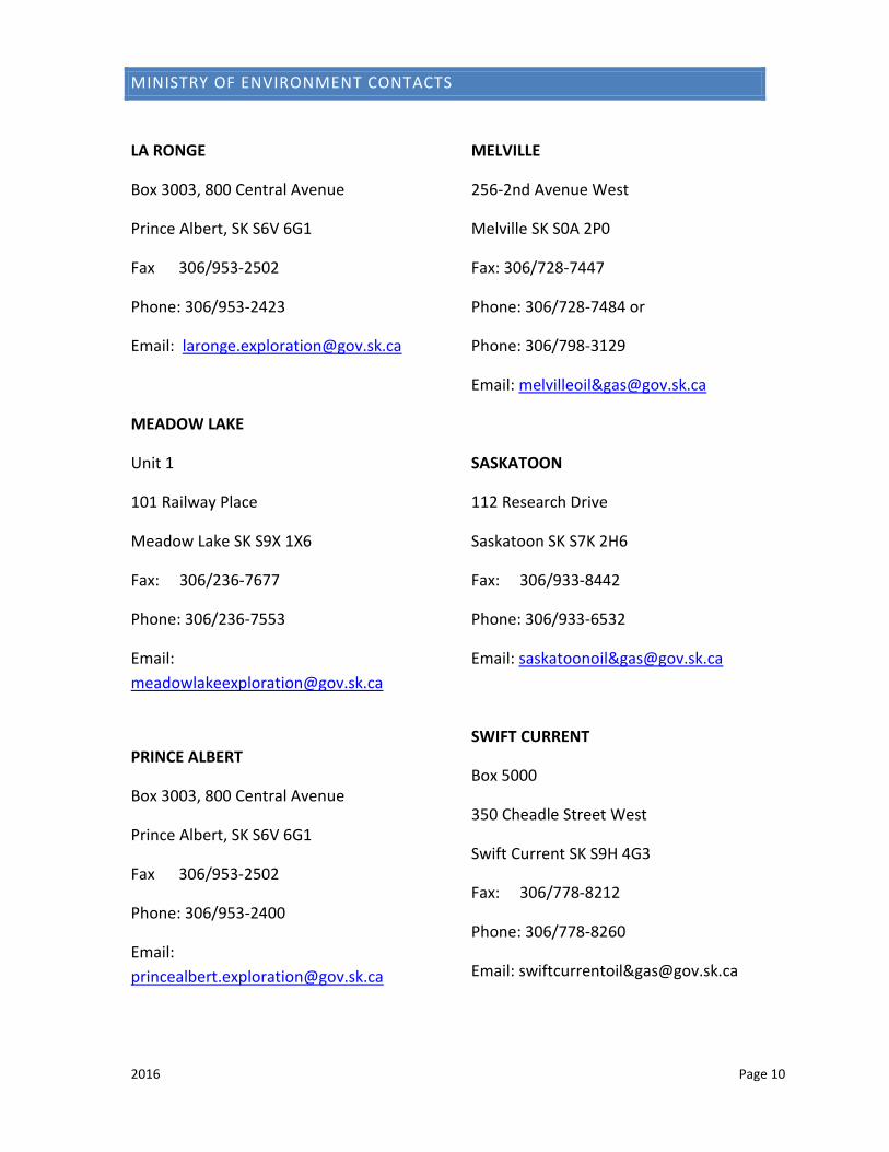
MINISTRY OF ENVIRONMENT CONTACTS
LA RONGE
Box 3003, 800 Central Avenue
Prince Albert, SK S6V 6G1
Fax 306/953-2502
Phone: 306/953-2423
Email: [email protected]
MEADOW LAKE
Unit 1
101 Railway Place
Meadow Lake SK S9X 1X6
Fax: 306/236-7677
Phone: 306/236-7553
Email: [email protected]
PRINCE ALBERT
Box 3003, 800 Central Avenue
Prince Albert, SK S6V 6G1
Fax 306/953-2502
Phone: 306/953-2400
Email: [email protected]
MELVILLE
256-2nd Avenue West
Melville SK S0A 2P0
Fax: 306/728-7447
Phone: 306/728-7484 or
Phone: 306/798-3129
Email: melvilleoil&[email protected]
SASKATOON
112 Research Drive
Saskatoon SK S7K 2H6
Fax: 306/933-8442
Phone: 306/933-6532
Email: saskatoonoil&[email protected]
SWIFT CURRENT
Box 5000
350 Cheadle Street West
Swift Current SK S9H 4G3
Fax: 306/778-8212
Phone: 306/778-8260
Email: swiftcurrentoil&[email protected]
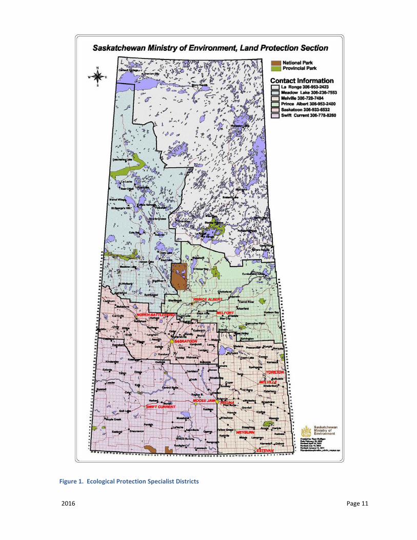
2016 Page 11
Figure 1. Ecological Protection Specialist Districts
2016 Page 12
BizPal
Information on obtaining and the requirements for business permits and licenses in the province of Saskatchewan: www.bizpal.gov.sk.ca
Fire Watch Line
Contact for reporting a wildfire: 1-800-667-9660
Daily wildfire information available at saskatchewan.ca/fire
Regional Health Authority
Information on services and procedures while operating in remote locations: www.health.gov.sk.ca
Spill Report Line
Contact for reportable spills under The Environmental Code Chapter B.1.1, Discharge and Discovery Reporting: 1-800-667-7525
TIP (Turn in Poachers)
Contact for reporting hunting, fishing, and other environment related violations: 1-800-667-7561
2016 Page 13
APPLICATION GUIDELINES
In order to conduct mineral exploration activities on Crown land within Saskatchewan, surface disturbance permits are required from the Ministry of Environment before any work can be started. The permits vary depending on the program may include, but are not limited to: Forest Product, Aquatic Habitat Protection, Work Authorization and/or Temporary Work Camp permits.
In order to obtain the appropriate permits, an application must be submitted to a Ministry of Environment Ecological Protection Specialist.
Drilling programs will normally also require a Temporary Water Rights License for Industrial Water Use obtained through the Water Security Agency. A Notification Form may be required to be completed and submitted to the Department of Fisheries and Oceans Canada.
Listed on the following page are general guidelines for the information that should be included on the application. For more detail regarding the content of each section the proponent should refer to the applicable Best Management Practice (BMP).
The Ministry of Environment Ecological Protection Specialists’ administration boundaries and contact phone numbers are outlined on the map on page 11 of this document.
Please keep in mind that the application may be sent to outside agencies for the purpose of application review and consultation with First Nations and Métis communities. If there is information included in your application that is proprietary, please ensure that you advise the Ecological Protection Specialist and that you submit a separate proposal that can be sent to outside agencies.
2016 Page 14
REQUIRED APPLICATION INFORMATION
Any application submitted need only address those information elements in the program application outline that are pertinent to the actual mineral exploration program. In addition to the information listed below, all BMPs include required application information and should be referred to when creating project proposals.
CONTACT INFORMATION
• List the applicant’s name and full mailing address. If the applicant is a corporation, and has not provided Ministry of Environment with a recent Corporate Profile Report, ensure that a copy of the Corporate Profile Report is included to show that the corporation is registered in Saskatchewan. This report can be obtained by contacting the Corporate Registry at 1-306-787-2962 or at www.isc.ca/CorporateRegistry.
• Provide a list of all of the main contacts for this project. This should include any companies and contractors associated with this exploration program. Include field staff contact information as the exploration field staff may have to be contacted during an emergency (e.g. forest fire).
ABSTRACT/EXECUTIVE SUMMARY
• Provide a condensed version or summary of the proposal.
PROGRAM DESCRIPTION
• State the mineral commodity being explored. • Outline the duration of the operation, complete with start and stop dates. • An emergency response plan
MAPS
• Include maps that clearly delineate the areas in which work will occur, as well as camp locations and existing and new access locations. Indicate which existing trails/roads will be used, any trails/roads that will be improved, and proposed new trails/roads.
• Maps should include labels for lakes, roads, and include legend and scale.
2016 Page 15
• Proponents are strongly encouraged to include shapefiles in applications. • 1:50,000(for details) and 1:250,000(for overview) NTS maps should be used.
GRASSROOTS EXPLORATION
In addition to application requirements listed in BMP 001, include the following information:
Till sampling
• Methods and materials, e.g. hand-shovel, augers, excavators, portable drills) • Number of samples to be taken • Approximate sampling locations • Size of samples (in kilograms or litres) • Depth of samples
Linecutting/geophysics
• Length, width, and location of cutlines • If using low-impact avoidance techniques, describe those.
Aerial surveys
• No permits are required
CLEARING OPERATIONS
In addition to application requirements listed in BMP 002, include the following information:
• Description of required clearing, including: new trails/roads, widening of existing trails work camps, sumps, drill pads, etc. including clearing methods.
• Indicate what will be done with any merchantable and non-merchantable timber that may be harvested.
TEMPORARY WORK CAMPS
• Indicate if staff will be staying in private accommodations or in a work camp on Crown Land.
2016 Page 16
• If a camp will be established on Crown Land, a Temporary Work Camp Permit will be required.
The temporary work camp application must include all requirements listed in BMP 003, and the following information:
• the location of the camp, area (in hectares) to be used, number of occupants, length of camp life and details of intended facilities.
• If clearing is necessary, the size of area to be cleared to accommodate the work camp; method of clearing; any planned earthworks; explain how soils and woody debris are to be stored for later reclamation.
FUEL AND HAZARDOUS MATERIALS STORAGE
Refer to BMP 005
FIRE PREVENTION
Refer to BMP 006
ACCESS
Refer to BMP 007
WATER CROSSING
In addition to application requirements listed in BMP 008, include the following information:
• Indicate on a map all known water crossings; if unknown at time of application, delineate general area in which water crossings could occur (i.e. draw a polygon around potential work area) and describe how each crossing will be established and reclaimed.
TRENCHING AND HYDRAULIC STRIPPING
2016 Page 17
In addition to application requirements listed in BMP 009, include the following information:
• Any trenching or sites for stripping must be identified. • Trenches should be sketched to show as close as possible the locations of each
and the dimension.
DRILLING ON LAND
In addition to application requirements listed in BMP 010, include the following information:
• The area in which drilling will occur must be indicated on a map, preferably a 1:250,000 or 1:50,000 NTS topographic map. A polygon may be drawn around work area; individual drill collar locations are not required until the closure report is submitted.
• Size of each drill pad and total number of pads. • Indicate the number of drill holes planned on land.
DRILLING ON ICE
In addition to application requirements listed in BMP 011, include the following information:
• Indicate the number of drill holes planned on ice and shore. To avoid impacting fish spawning, drilling is not allowed in depths of 2m or less, including ice thickness, unless otherwise approved.
RESTORATION/RECLAMATION
In addition to application requirements listed in BMP 012, include the following information:
• Outline how all newly disturbed locations (roads, trails, drill pads, sumps and camp sites) will be restored.
FIRST NATION AND MÉTIS COMMUNITY ENGAGEMENT
2016 Page 18
In addition to application requirements listed in BMP 013, include the following information:
• List any contact that may have already been made with the First Nation or Métis communities that may be impacted by this application.
• Indicated whether any future contact is planned and if so in what form (written, oral, in person, etc.) and when.
• Provide dates and a list of individuals that were contacted and any concerns expressed by the First Nations or Métis persons.
• Provide the estimated total number of hectares of surface disturbance (i.e. clearing) to result from the project, and explain any limitation of access to the project area including the location and the duration of that limitation, and the timeline for the project including start and stop dates.
• The length of the consultation process will vary according to the potential impact of the project on the exercise of Treaty and Aboriginal rights (i.e. hunting, fishing, and trapping for food and the carrying out of traditional practices). Minimum timelines for consultation can be found in Figure 1 (Consultation Matrix) of the Government of Saskatchewan First Nation and Métis Consultation Policy Framework, June 2010.
STAKEHOLDER CONTACTS
In addition to application requirements listed in BMP 003, include the following information:
• Upon submission of a completed application and depending on the area of operations, the Ministry of Environment may provide a list of impacted stakeholders to contact.
• If the proposed project is within an existing Forest Management Agreement (FMA) area or a Timber Supply License Area (TSL), the proponent will have to contact the FMA holder and make satisfactory arrangements for road user agreements, use of merchantable timber and compensation (relevant details must be included in the application).
• List any contacts with other stakeholders, who may include, but is not limited to: outfitters, trappers, towns, and rural municipalities, etc. if any.
RARE AND ENDANGERED SPECIES
• A check with the Conservation Data Center (CDC) must be completed in order to identify sites where rare or endangered species may be found.

2016 Page 19
• The CDC contact information is as follows; phone (306) 787-7196 and fax (306) 787-3913. The CDC will have to be contacted to obtain a password to access the website:
http://gisweb1.serm.gov.sk.ca/wildlifelogin/form.asp
• A copy of the map must accompany the application. • CDC findings must be outlined in the application even if there will be no impact
on any rare and endangered species. • If studies to document the presence of rare and/or endangered species have
been undertaken at the exploration site provide a summary of the results of these studies.
• If rare or endangered species with a rating of S1 or S2 will be impacted, provide mitigating measures that will be implemented to ensure that the impact will be minimized.
• If the species impacted is rated as a S1 (or some S2s) this may trigger section 2(d) of The Environmental Assessment Act and the project could be considered a “development”. If deemed a “development”, the proponent would be required to conduct an environmental impact assessment and submit an environmental impact statement to the Ministry of Environment’s Environmental Assessment Branch.
ARCHAEOLOGICAL CONSIDERATIONS
• The proponent must submit their application to the Heritage Branch of the Ministry of Parks, Culture and Sport and indicate in the proposal that they have done so. The contact information for the Heritage Branch is as follows; http://www.pcs.gov.sk.ca/SensitiveLocations or phone (306) 787-8157, fax (306) 787-0069.
• Further details are available in BMP-015 (Mineral Exploration in Southern Saskatchewan); note that sections of this BMP are also relevant for northern Saskatchewan
OTHER REGULATORY REQUIREMENTS
• List any contacts with other agencies such as the Water Security Agency, and the Department of Fisheries and Oceans Canada.
• The contact information for most other agencies is listed at the back of this document.
2016 Page 20
BEST MANAGEMENT PRACTICE (BMP) 001: GRASSROOTS EXPLORATION
GENERAL INTRODUCTION
Many types of exploration activities carried out by mineral exploration companies require permits. The company should contact the Ministry of Environment to see if any permits are required to carry out their requested activity.
BACKGROUND
AIRBORNE GEOPHYSICAL SURVEYS
Different types of mineralization can have physical properties such as radioactivity that can be sensed by instruments. The airborne surveys typically measure magnetism, electrical conductivity and radioactivity over broad areas. Typically an instrument package is housed in the aircraft itself or in a "bird" trailed behind the aircraft on a cable. The aircraft can fly at elevations of a hundred meters to several thousands of meters depending on the type of survey being conducted.
PROPERTY EVALUATIONS OR PROSPECTING
Grassroots prospecting includes activities such as examining core storage areas, conducting regional geological mapping, or surface prospecting. These activities are conducted to help plan further exploration programs.
LINE CUTTING
Lines are cut to provide a grid reference for a variety of surveys including: lease boundaries, geochemical, geological and geophysical surveys.
GEOLOGICAL, GEOCHEMICAL AND GEOPHYSICAL SURVEYS
Geological mapping generally involves stripping small areas of moss or lichen and taking small hand-sized samples in order to determine the rock types present, mineralization and structural features.
Geochemical surveys can be done on several levels of intensity, from taking samples of leaf debris to digging trenches. Impacts on the environment vary depending on the level of sampling done.
2016 Page 21
Geophysical surveys test the physical properties of the rocks. These tests can include magnetism, electrical conductivity or resistivity and radioactivity. In the majority of cases this involves taking readings with instruments in a non-destructive manner. A seismic survey, although rarely done, uses explosives vibration generating equipment to create seismic waves. Geo-phones detect the seismic waves that respond to subsurface geologic structures.
AUTHORITY
Seismic Regulations
The Engineering and Geoscience Professions Act
The Provincial Lands Act
The Forest Resources Management Act
REQUIREMENTS
AIRBORNE SURVEYS
Airborne Geophysical Surveys with no surface land use do not require a permit. However, it is advised that persons undertaking airborne survey activity get in touch with the Ministry of Environment contact to discuss potential program issues (e.g. colonial bird nesting periods, calving periods, fires, outfitters, trappers, other forest users, etc.).
It is the responsibility of the applicant to ensure that there are no flight restrictions in the areas intended to be surveyed. Contact Transport Canada for any potential restrictions.
PROSPECTING
A Work Authorization may be required to access Crown Land for the purpose of prospecting.
2016 Page 22
LINE CUTTING
The proponent is responsible for receiving authorization from the Ministry of Environment before proceeding with work.
All lines are to be hand cut (i.e. hand tools and chain saws).
Low impact/avoidance cutting techniques shall be used. This would include removing branches from trees rather than cutting the tree, avoiding the cutting of merchantable trees where possible, etc.
When not accessing by foot, low impact equipment (e.g. all-terrain vehicles or snow machines) shall be used and identified in the application.
Baselines and lease boundaries shall not exceed 2.0 meters in width and cross lines shall not exceed 1.0 meter in width. Line width and land surface disturbance shall be minimized.
Line widths should not exceed 1.0 meter within 100 meters of any canoe route, trail, road, cut block, water body or water course (refer to BMP-008 Water Crossing). Natural features should be used to conceal visual sight of the line where possible.
No damage should occur to the standing timber.
All leaning trees are to be removed from standing timber.
Slash is to be laid flat.
There should be minimal vegetation disturbance at those locations where any line cutting enters or exits any lake or stream.
Felling and yarding of trees should be away from any water body. No cut brush or trees should be left on any water body during a project.
GEOLOGICAL, GEOCHEMICAL AND GEOPHYSICAL SURVEYS
Notification of the Ministry of Environment is required.
Depending on the magnitude of the project, an authorization from the Ministry of Environment may be required as well the Duty to Consult may have to be undertaken.
2016 Page 23
SEISMIC SURVEYS
Conducting a seismic survey also requires additional permits from the Ministry of Economy. It is recommended that the proponent contact the Ministry of Economy to determine the regulatory requirements for the survey.
CONTACTS
Ministry of Economy
Ministry of Environment
2016 Page 24
BEST MANAGEMENT PRACTICE (BMP) 002: FOREST CLEARING/HARVESTING OPERATIONS
GENERAL INTRODUCTION
To ensure sustainable use and development of the provincial forest, care must be taken in the harvest and handling of the forest products during mineral exploration activities. Assistance in planning exploration harvest activities can be provided by contacting the Ministry of Environment.
Examples of typical forest clearing activities include line cutting for geophysical surveys, development of trails/roads, work camps, and pads for drill holes and helicopters.
BACKGROUND
Legislation requires forest users to practice sustainable forest management. This requires proper planning to minimize potential impacts on forest ecosystems, ensuring that forest users comply with desired forest management practices, and ensuring optimum forest resource utilization for all forest users to reduce the impact on productive forest land. Section 13(1) of The Forest Resources Management Regulations requires a Forest Product Permit for any mineral exploration activity where the removal or disturbance of forest products is incidental to that activity.
The following salvage practices and standards apply under The Forest Resources Management Regulations:
SCALING OF TIMBER
A licensed scaler is only required where there is greater than 250 m3 of timber harvested. This is equivalent to 1000 - 2000 trees from the Shield area, or 5 tandem truckloads.
Where applicable, an estimate of timber harvested will be required, as dues (royalties) and fees are payable. The Ministry of Environment will provide a formula to assist in calculating an estimate of the volume of harvested timber.
SALVAGING OF TIMBER
FMA & TRUST FUND AREAS: An exploration company must contact the appropriate forest company to discuss operations and wood salvage.
2016 Page 25
NON-FMA & TRUST FUND AREAS: Timber will only be required to be salvaged if there is an available purchaser, and if a certain amount of wood is harvested. A suggested benchmark is 60 m3, which would be equivalent to 25 - 30 cords of wood in a 100 m x 100 m area.
If above a minimum harvest level, the licensee (exploration company) with the assistance from the Ministry of Environment shall determine if a market for the wood is available. If a market is not present, salvage requirements may be waived.
Methods of disposing of non-salvaged wood will be identified in the permit.
It is the permittee’s responsibility to complete, date and sign the Forest Product Permit and return it to the Ministry of Environment at the completion of the program or within 30 days of the expiry date of the permit. This may be attached to the Program Closure Report submitted to the ministry.
The Ministry of Environment is to be advised of the quantity and locations of salvaged timber as soon as timber harvesting is complete.
DUES AND FEES
Dues are equivalent to royalties; also referred to as stumpage fees.
Fees include permit fees and forest management fees (reforestation, planning related).
Dues and fees are paid on Merchantable Timber.
Merchantable Timber: all trees capable of making at least one 5 meter piece to an 8 centimeter top diameter, inside bark. For the purposes of calculating dues and fees, merchantable timber is categorized as:
S1 - Softwood (spruce, pine, etc.) greater than 15 centimeters in diameter; S2 - Softwood less than 15 centimeters in diameter; H1 - All hardwood species greater than 10 centimeters in diameter; H2 - All hardwood species less than or equal to 10 centimeters in diameter;
Dues and Forest Management Fees must be paid on merchantable timber that is cut, damaged or destroyed as a result of the mineral exploration operation. Dues may be waived for certain circumstances at the discretion of the Forest Service Branch, Ministry of Environment; forest management fees cannot be waived.
2016 Page 26
ROYALTIES/DUES
FMA & TRUST FUND AREAS: Dues are paid to the Crown in the amount defined in the regulations.
NON-FMA & TRUST FUND AREAS: Dues are paid to the Crown in the amount defined in the regulations.
WHERE A LICENSEE CONDUCTS RENEWAL PRACTICES TO A HIGHER STANDARD THAN IS REQUIRED PURSUANT TO THE TERMS OF THE LICENSE, TIMBER DUES MAY BE REDUCED OR WAIVED.
FEES
FMA & TRUST FUND AREAS: Forest management fees are set out in the FMA Agreement. The fees are submitted to the Crown (Ministry of Environment) and deposited into a Trust Fund.
NON-FMA & TRUST FUND AREAS: The forest management fee is set out by regulation. The regulations currently provide no exceptions to paying the forest management fee. Fees are submitted to the Crown (Ministry of Environment).
The regulations provide for two practical instances where royalties can be waived or reduced:
Timber that is burned, dry, dead, down, diseased or otherwise damaged. This wood may have a salvage value in the first few years after a burn or infestation.
Where the licensee is prepared to conduct renewal/reforestation activities beyond what is required in the license/permit.
Section 76.1 of The Forest Resources Management Regulations states that the Minister may waive dues and fees if:
The licensee harvests the forest products outside a licence area for which a forest management trust agreement has been established; and

2016 Page 27
AUTHORITY
The Forest Resources Management Act and Regulations
REQUIREMENTS
Line cutting exploration requirements are captured in BMP-002 (Grassroots Exploration).
Unless otherwise approved, hand clearing must be done:
• within 100 meters of any water body or water course, unless it is a licensed facility; • through steep or unstable terrain; or • within areas as directed by the Ministry of Environment (e.g. through protected
areas, specially designated areas, etc.)
The approach to any water body or water course will be doglegged within 30 metres of shore and be no wider than approved by the Ministry of Environment.
Any clearing of vegetation should be kept to a minimum.
To minimize soil disturbance, clearing with heavy machinery should be limited to frozen or dry and stable ground conditions unless low impact equipment is utilized as authorized by the Ministry of Environment.
When clearing, the organic mat should be preserved where possible. Mineral soils should not be exposed if stripping is not required for the program.
To limit the number of trees cut, utilize existing roads, trails and cut lines. Where possible, avoid areas covered by standing timber, and regeneration areas.
Leaning trees should be cut and removed.
Existing trails are not to be blocked.
If required for future reclamation purposes, slash and un-salvaged timber is to be properly managed. See BMP-007 (Reclamation).
CONTACTS
Ministry of Environment
2016 Page 28
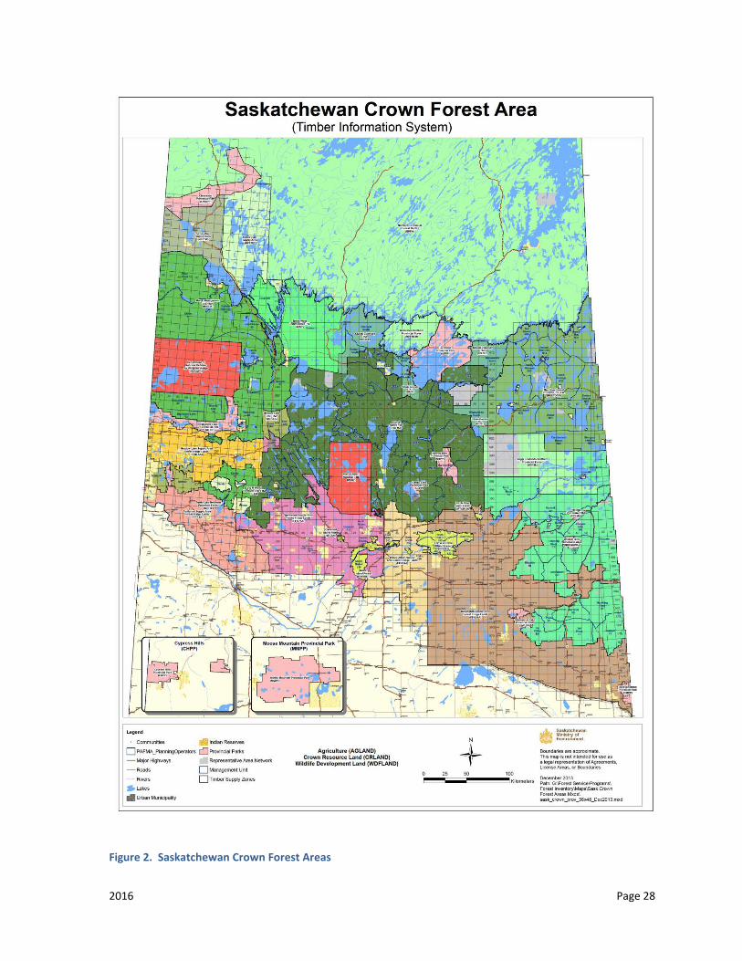
Figure 2. Saskatchewan Crown Forest Areas
2016 Page 29
Table 1. Saskatchewan Crown Forest Areas Contact Information
Company Name Contact Name Phone Number
Mistik Roger Nesdoly 306-236-7165 [email protected]
Meadow Lake OSB
Michelle Young, Woodlands Manager
306-922-0318 306-314-0687
L & M Zane Delainey, General Manager
306-342-2080 [email protected]
North West Communities
Bobby Woods 306-235-7644
Sakâw Askiy Management Inc. (Prince Albert FMA)
Ian MacIver, General Manager
306-961-2057 [email protected]
Kitsaki-Zelensky Brian Zelensky, Zelensky Brothers Forest Products
Russell Roberts, CEO Kitsaki Management Limited Partnership
306-425-2239 306-961-9039
306-425-2600
Weyerhaeuser/ Edgewood (Pasquia Porcupine FMA)
Mel Cadrain, Timberlands Operations Manager, Weyerhaeuser
John Daisley, Lead Planner, Weyerhaeuser
Howard Gray, Project Manager, Edgewood
306-865-1726
306-865-1700
780-438-5989

2016 Page 30
Mee-Toos Forest Products
Trevor Ives
Bob Wasylyk
306-953-4410
306-278-7765
*Supply Area – FMA – Forest Management Agreement
TSL – Term Supply License
2016 Page 31
BEST MANAGEMENT PRACTICE (BMP) 003: TEMPORARY WORK CAMPS
GENERAL INTRODUCTION
Temporary work camps are a necessary part of mineral exploration. Camps are to be established in an environmentally friendly manner with consideration given to the health and safety of the workers and the protection of natural resources. For the purposes of this BMP, it is assumed that the temporary work camp does not provide accommodation to the public. Should an exploration company decide to operate a camp open to the public they should contact the local health region to confirm the requirements that will apply to the facility.
BACKGROUND
Temporary work camps should utilize previously cleared areas or natural openings, in order to limit the amount of new clearing.
At the immediate access point to the camp, a sign must be erected showing the company name and giving a contact number. Size, additional information and design of the sign are left up to the company, but it should be easily visible to people accessing the camp.
Typically, temporary work camps will not be authorized in the following locations:
• archeological, historical, vertebrate paleontological or other heritage property sites as defined in The Heritage Property Act except by approval of the ministry responsible for the administration of the Act;
• areas of scientific concern or potential environmentally sensitive areas, such as nesting sites of endangered species or locations supporting unique vegetation;
• locations on ice covered waters, and • areas that are restricted under other ministry policies, land use plans or
municipal zoning.
To minimize land-use conflicts, the Ministry of Environment will need to provide additional approval for camps located within the following areas:
2016 Page 32
• 1.6 kilometers from the center line of designated canoe routes; • 1.6 kilometers from any settlement, surface dispositions or titled property; • 1.6 kilometers from waterfalls, rapids or other designated areas; • 1.6 kilometers from sandy beaches over 20 meters long with public
development potential; and • 100 meters from the centerline of an existing public road or the high water
mark of any water body or water course.
Temporary work camps that have been in place for three years, and will continue to operate, may be switched to industrial permits or leases. The rates per hectare are reduced, but the permits are open to municipal taxation.
AUTHORITY
The Provincial Lands Act and Regulations
The Forest Resources Management Act and Regulations
The Heritage Property Act
The Hazardous Substances and Waste Dangerous Goods Regulations
The Mineral Industry Environmental Protection Regulations
The Wildfire Act
The Environmental Management and Protection (Saskatchewan Environmental Code Adoption) Regulations
The Saskatchewan Employment Act & Occupational Health and Safety Regulations
The Public Health Act, 1994 and Regulations
The Health Hazard Regulations
Guideline for Construction and Approval of Public Water Systems Regulated Under the Health Hazard Regulations, March 2012
The Food Safety Regulations
The Plumbing Regulations

2016 Page 33
The Disease Control Regulations
National Fire Code of Canada
GENERAL CAMP REQUIREMENTS
1. A temporary work camp cannot be established without authorization from the Ministry of Environment.
2. Unless otherwise approved, the temporary work camp is to be situated no closer than 100 meters from a water body or water course.
3. A site plan indicating location of buildings, water source and sewage disposal should be included. A copy of the application to the Ministry of Environment should also be provided to the Regional Health Authority (Public Health).
4. The application must include the location of the camp, area to be used, number of occupants, and length of camp life and details of intended facilities.
5. The method used to service the camp must be included in the application (see BMP-006 Access). Permits from the Ministry of Environment are required for docks. Dock designs that involve infilling below the high water mark (e.g., crib docks) or that harmfully alter the shoreline or lakebed must be sent to Fisheries and Oceans Canada for their review.
6. A temporary work camp shall at all times be kept in a safe, neat, and sanitary condition.
7. For the storage and handling of hazardous substances see BMP-004 (Storage and Handling of Hazardous Substances).
8. Temporary Work Camp Permit holders are responsible for the actions of their contractors, subcontractors, agents and employees.
9. The establishment and operation of a temporary work camp shall minimize surface disturbance and environmental impacts (see BMP-002 Clearing Operations).
10. All camp buildings must have chemical fire extinguishers and smoke detectors.
11. A temporary work camp shall be so situated and operated that it will not pollute surface water or groundwater.
12. When camps are being decommissioned, all structures/improvements must be removed from the site, including septic systems and latrines. All pits are to be filled in at the completion of the program.
2016 Page 34
13. All water wells must be approved, capped and decommissioned on the authority of the Saskatchewan Water Security Agency.
14. The campsite must be reclaimed according to the BMP-012 (Restoration). 15. Burning of paper, cardboard, wood products and food wastes in a burning
barrel in camp may be approved under special permission from the Ministry of Environment (A burn notification number is required during the fire season). See BMP-005).
POTABLE WATER REQUIREMENTS
1. Domestic water supply sources and methods of withdrawal must be identified in the application.
2. Water used for drinking, cooking, washing vegetables, and brushing teeth must be potable; also recommend that water used for showering and cleaning also be potable.
3. Potable water will be supplied either through a dedicated treatment system or transported to site.
4. Ensure the tanks used for hauling and storing the water are regularly cleaned and disinfected. Guidance on water tank disinfection and water chlorination is available on the Saskatchewan Ministry of Health’s Fact Sheet “Disinfection Guideline for Bulk Water Haulers”.
5. Taps with non-potable water must be marked as such.
RECOMMENDATIONS
It is suggested that the following practices be adopted to ensure a safe water supply.
• Regular sampling of both potable and hygienic water for bacteria • Regular sampling for heavy metals, including health and toxicity metals,
especially if using a well. • Take preventative measures to protect the source water from possible
contamination (i.e. safe separation distances between source water and fuel storage, seepage pits, ice drilling rigs, etc. [with source water preferably located uphill of all else]).
• Water for showering, cleaning and other similar needs may be treated to reduce risk to personnel by following one or more of the following steps:
2016 Page 35
o removal of protozoa (giardia and cryptosporidium cysts) that can be achieved by: filtration to 1 micron absolute (or smaller) with a NSF 53 filter, or boiling water (a rolling boil) for at least 1 minute,
o adding sodium hypochlorite, or equivalent, to disinfect the water and prevent re-growth of bacteria
o using a chlorine tester to verify chlorine levels; strive to maintain free chlorine of 0.1 mg/L or total chlorine of 0.5 mg/L coming out of all taps.
• Ensure the tanks used for hauling and/or storing the water are kept clean and are of a type that is appropriate for potable water. Tanks used to store water should have sufficient capacity or baffling to provide adequate chlorine contact time.
DOMESTIC WASTE DISPOSAL REQUIREMENTS
If using existing solid waste or liquid waste licensed facilities, authorization should be obtained from the local jurisdiction.
LIQUID WASTE (SEWAGE AND GREY WATER)
Disposal of liquid waste arising from food preparation, laundry, bath and latrines must not pollute groundwater or surface water. Disposal methods will depend on: type of waste; volume of waste; soil characteristics; water table depth; distance from water wells, water bodies or watercourses, and other
dwellings or facilities; remoteness of the work camp; and seasonal considerations (e.g. frozen ground).
The preferred method of liquid waste disposal is to use the services of a licensed
septic waste hauler for transport to an approved septic/sewage disposal site. For camps in remote areas or small, short-term camps, pit latrines and seepage pits/sumps may be used for disposal of liquid waste. The disposal method must be identified in the application.
2016 Page 36
Pit latrines for sewage must (unless otherwise approved):
be maintained in a clean and sanitary condition and in good working order; be protected so that insects, rodents or other animals do not have access to
the contents; be constructed so as to prevent the entrance of either rain or surface water
into the pit; be located more than 7.5 metres from a well or camp facilities (e.g.
residence, kitchen, etc.); be located more than 100 metres from any river, stream, creek, lake, spring
or other body of surface water; be located as far as possible but at least 15 metres from a water well or other
supply. A 30 metre setback is recommended for water supplies other than a properly constructed drilled water well;
include a 1.5 metre separation from the bottom of the pit to a water table if the soil is clay. For sandy soils, a 7.6 metre separation is recommended;
have setbacks to other features and structures so as to not create a health hazard; and
only be used for human waste.
Seepage pits/sumps for grey water (waste water from showers, laundry and kitchens) must (unless otherwise approved): be maintained in a clean and sanitary condition and in good working order; be protected so that insects, rodents or other animals do not have access to
the contents; be located more than 100 metres from any river, stream, creek, lake, spring
or other body of surface water; be located more than 30 metres from a properly constructed, drilled water
well or any other type of water well or water supply; include a 1.5 metre separation from the bottom of the seepage pit to a water
table if the soil is clay or a 7.6 metres separation if the soil is sand; be located so as to contain grey water within the seepage pit; be located such that surface runoff and overland flooding does not enter the
seepage pit; be filled with rocks/gravel or have a cover capable of holding the weight of
an adult male (103 kg); and be constructed and located so as to not pose a physical hazard.

2016 Page 37
Any liquid waste containing heavy metals, toxic materials, flammable, explosive or radioactive substances must not be discharged to domestic liquid waste systems. Such wastes must comply with the applicable regulations, including The Hazardous Substances and Waste Dangerous Goods Regulations and The Mineral Industry Environmental Protection Regulations, 1996.
SOLID WASTE (REFUSE, FOOD WASTE, OTHER)
The proponent is responsible to remove all solid wastes, from the camp to an approved waste disposal site.
No burying of wastes is permitted. In remote or isolated areas only, the burning of wood, paper products and food
wastes may be approved by the Ministry of Environment.. All burning must be done in a controlled manner and supervised (see BMP-005 Fire Prevention and Control).
Large non-combustible objects, including discarded equipment and empty fuel containers must be removed to an authorized disposal site.
For storage, locate solid waste in covered, leak proof containers. Food waste should be kept in covered, fly/animal proof containers (e.g. bear proof
garbage can) until removed to an approved waste disposal site.
APPLICATION REQUIREMENTS
Submit application, including the following requirements, to the Ministry of Environment, with a copy to the Regional Health Authority (cc via email).
The application must include the location of the camp, area to be used, number of occupants, and length of camp life and details of intended facilities.
Domestic water supply sources and methods of withdrawal must be identified in the application.
Disposal method of liquid waste (sewage and grey water) must be identified in the application.
DEALING WITH WILDLIFE ON SITE
Wildlife is attracted to camps by food and chemical smells associated with cooking, industrial activity, waste products and garbage dumps. They may also be attracted by

2016 Page 38
the presence of prey, and by suitable denning or nesting habitat. Wildlife may become habituated to humans occupying their territories. Conflict between humans and habituated wildlife may arise when sensitive habitat, food sources, or when humans or wildlife are threatened, injured or destroyed. Every attempt should be made to prevent wildlife from becoming habituated to humans on site.
FOOD STORAGE & WASTE DISPOSAL
All waste disposal containers must be wildlife proof. Waste bins and cans must be able to keep bears, wolves and ravens, etc. out even where people are not present to scare them away.
Food waste should be removed to an acceptable landfill as quickly as possible. Lingering food sources on site will greatly increase the chance of wildlife breaching containers, reinforcing the habituation process.
Surplus food supplies should be stored in wildlife proof buildings or containers, for the shortest time necessary.
INTERACTING WITH WILDLIFE
No wild animal should be fed. All species quickly learn to associate people with food. No wild animal should be allowed to interfere with routine human activity at camp.
Wildlife that disrupt traffic flow, approach or chase people at any time, and/or approach or enter vehicles and/or buildings on a regular basis (once a week or more, etc.) should be subjected to controlled harassment by designated staff. Part of conditioning wildlife to avoid sites is to make them feel uncomfortable around people no matter what the activity. Scare Permits are required to undertake controlled harassment activities.
No wild animal should be allowed to threaten people on or adjacent to camp. Animals such as bears, wolves and coyotes that threaten and are capable of harming people, as well as wildlife exhibiting symptoms of a contagious disease (e.g. rabies, West Nile virus, etc.) may need to be dispatched under permit from the Ministry of Environment, after investigation by a Conservation Officer. If an emergency arises that requires the dispatch of wildlife, a Conservation Officer is to be notified of the circumstances immediately after the occurrence.
People must not attract, chase, harass or otherwise harm wildlife. Interaction between people and wildlife at camp should be kept to a minimum.
2016 Page 39
Consideration must be given when bringing domestic animals into camp. It should be noted that dogs may actually attract wolves into the camp. Each company will need to assess the liabilities associated with such an activity.
SCARE PERMITS & DISPOSAL AUTHORIZATION
No wild animal should be allowed to feed peacefully on site or at garbage dumps. Controlled harassment by approved means (Scare Permits issued by the Ministry of Environment) will help to prevent wildlife from becoming habituated to humans on site.
Designated staff at camp should be the only people carrying out controlled harassment (under a Scare Permit issued by the Ministry of Environment).
RISK ASSESSMENT & TRAINING
People visiting, working or residing at the camp should be given training and education about local wildlife. It is important to become aware of what wildlife species might be encountered, what kind of behavior to expect from each, and the level of risk to people. It is also important to understand the kinds of human actions and activities that can place wildlife at risk on and adjacent to site. Finally, it is important for people to be aware what is being done to reduce or eliminate conflict between people and wildlife.
MONITORING & REPORTING
Camp management should establish a reporting protocol. The Ministry of Environment and camp management should collectively establish a process for determining when, and under what circumstances wildlife problems would be reported to the Ministry of Environment.
For further information there are pamphlets on dealing with bears, cougars and wolves available at Ministry of Environment offices, through the Ecological Protection Specialist or on the Ministry of Environment’s website as listed in Appendix “D”.
COMMUNICABLE DISEASE REPORTING

2016 Page 40
The Public Health Act, 1994 and The Disease Control Regulations require reporting of clusters of suspect communicable disease. If you suspect a cluster of food or water borne disease cases in association with a temporary work camp operation please contact the Regional Health Authority (Public Health).
It is recommended that employees working in the kitchen have at minimum Food Safe Level 1 certification. To reduce risk of communicable disease, it recommended that adequate ventilation be provided in the sleeping units and the operator takes appropriate measures to reduce the potential risk of Hantavirus transmission. Humans may become infected with Hantaviruses through contact with rodent urine, saliva, or feces.
CONTACTS
Ministry of Environment
Department of Fisheries and Oceans Canada
Regional Health Authorities

2016 Page 41
BEST MANAGEMENT PRACTICE (BMP) 004: HAZARDOUS SUBSTANCES AND WASTE DANGEROUS GOODS
GENERAL INTRODUCTION
Planning the proper storage and handling of Hazardous Substances and Waste Dangerous Goods (HSWDG) products and spill mitigation plans will assist the applicant in avoiding potential environmental issues that may occur during the program.
BACKGROUND
This BMP does not include the handling of solid and liquid domestic waste. For handling of these materials, please see BMP-003 (Temporary Work Camps). Radioactive materials are regulated pursuant to The Nuclear Safety and Control Act (Canada).
The following are examples of materials as characterized under different headings in the HSWDG Regulations.
Non-hazardous Substances Tires, culverts, core boxes, untreated wood, Portland cement, biodegradable drill muds.
Industrial Hazardous Substances Petroleum products, petroleum containers and filters, pesticides, paint, acids and bases, inorganic substances such as ammonia and fertilizers, metals such as lead, copper sulfate, sodium chlorite
Acute Hazardous Substances Chlorine, fluorine, and potassium. Environmentally Persistent or Chronic Hazardous Substances
Substances such as mercury, some drilling additives, lead, arsenic and cyanide.
Waste Dangerous Goods Used oil, used oil filters, and waste antifreeze
Storage tanks– are receptacles of greater than 205 liters capacity
Containers – are receptacles of 205 liters or less capacity
For locations of recycling and disposal depots, the proponent may contact the Ministry of Environment or check the Saskatchewan Waste Reduction Website located in Appendix D.
The applicant should be familiar with the requirements under the Transportation of Dangerous Goods Act. For information sheets on hazardous materials, check the MSDS website located in Appendix D.
2016 Page 42
AUTHORITY
Transportation of Dangerous Goods Act
Hazardous Substances and Waste Dangerous Goods Regulations
Environmental Code Chapter B.1.1: Discharge and Discovery Reporting
Environmental Management Protection Act, 2010
Environmental Emergency Regulations
National Fire Code of Canada
REQUIREMENTS
HSWDG MANAGEMENT
The applicant must indicate:
• all HSWDG receptacles stored on site; • the type of product stored; • the volume of each type of product stored; • the location of each storage site.; • whether the tanks are portable (skids, trailer, etc.) or fixed.
There may be requirements under HSWDG regulations to register and approve the storage facility based on the volumes, products and storage receptacles.
Applicants should follow the storage and handling procedures listed below for all volumes to minimize environmental risks and meet HSWDG regulation requirements.
• The soil type, terrain, ground water table, surface water and water wells in the storage area(s) must be identified and assessed prior to site selection in order to limit the extent of contamination from any possible spills
• Locate all tanks (including slip tanks, mobile, and permanent tanks) away from traffic-congested areas. HSWDG storage must be located a minimum of 100 meters from any water body or watercourse, unless otherwise approved. Occupational Health & Safety (OH&S) legislation requires that fuel must be stored a minimum of 6 meters from any building and there must be a 30-meter
2016 Page 43
minimum clearance from the fuel dock to sleeping accommodations. The Fire Commissioners Office and National Fire Code requires at least two 2A-10BC fire extinguishers to be on site at fueling areas
• Inspect and maintain all storage tanks. There should be no signs of corrosion and tanks must be painted, if applicable
• Each fuel storage tank should have two shut-off valves, one of which may be the handle
• Unless otherwise approved, secondary containment of all HSWDG materials is required (e.g. an enviro-tank, a dike lined with an impermeable membrane resistant to the product being stored, and spill containment trays). Construction requirements for secondary containment are available from the Ministry of Environment contacts
• For each storage area, secondary containment is required. For a storage area containing a single drum, containment must consist of 110 per cent of the volume. For a storage area containing multiple drums, containment must consist of 10 per cent of the cumulative volume plus 100 per cent of the volume of the largest container
• Use drip pans and/or nozzle holders to contain drips or spills. Nozzles should be mounted above the drip catchments
• Ensure slip tanks (tidy tanks) are secured into the vehicle. The intent is that in the event of a roll over, a full slip tank will stay secured in the truck
• Inspect fuel pumps and other equipment for worn hoses and leaks. Repair equipment when required;
• Companies are required to have spill kits on site (number depends on the program, i.e. work camp, drill site, pump shacks). A large spill kit has an absorbent capacity of approximately 120 liters and a small spill kit has an absorbent capacity of approximately 20 liters;
• Any water intake equipment must have secondary containment/spill kits for both the pump and pump fuel supply;
• Refueling on ice or water, or within 100 meters of water, is permitted provided secondary containment of the tank and spill kits are used. HSWDGs are to be stored 100 meters from a water body or watercourse when not required for fueling equipment;
• Toxic chemicals must be stored securely; • Neutralizing materials must be stored adjacent to acids; and • Lubricants and oily substances should be removed and properly disposed of,
prior to sump water disposal. • New oil containers must be taken to a receiver and not discarded in landfills.
2016 Page 44
• Oil filters are a waste dangerous good and must not be discarded in landfills. Place in a drum and transport to an approved receiving site. Used oil consignees will generally also take filters and oil containers.
• Batteries and any waste dangerous goods other than waste oil or antifreeze may be stored on site up to 100 kilograms combined aggregate.
• Used oil or waste antifreeze may be stored on site in containers (up to aggregate capacity of 500 liters). Disposal must be to an approved receiver.
• Any use of, storage of, or transportation of explosives requires a provincial permit and may also require federal approval.
SPILL CONTINGENCY PLANNING
• The applicant is required to have appropriate equipment/absorbent material on hand for the cleanup, containment and storage of contaminated materials and this equipment/absorbent material shall be readily available in areas where spills could potentially occur.
• The Ministry of Environment requires all spills of HWSDG products greater than 5 liters or any spills within 100 meters of a water body or watercourse are reported to the appropriate Ministry of Environment contact within 24 hours and included in the Closure Report. If you are operating on a land disposition issued by the Ministry of Environment, the reporting requirements specified in Environmental Code Chapter B.1.1 – Discharge and Discovery Reporting take precedence.
• According to the Saskatchewan Environmental Code Chapter B.1.1 Discharge and Discovery Reporting, all reportable spills must be reported to the Ministry of Environment as soon as possible. The applicant must follow any clean up instructions received. Within seven days of being reported to the spill line, a written report must be submitted to the Ministry of Environment containing information about the spill and remedial action taken. The 24-hour emergency telephone number is: 1-800-667-7525. This system automatically notifies Environment Canada if the spill has occurred in a waterbody or watercourse or spills that trigger the Environmental Emergency Regulations.
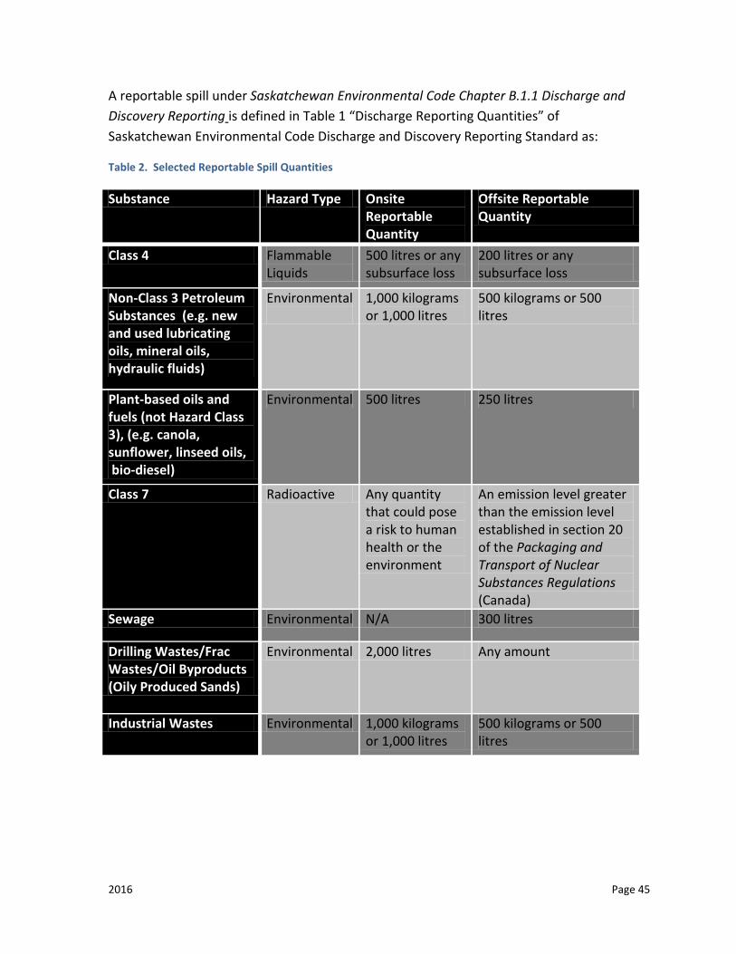
2016 Page 45
A reportable spill under Saskatchewan Environmental Code Chapter B.1.1 Discharge and Discovery Reporting is defined in Table 1 “Discharge Reporting Quantities” of Saskatchewan Environmental Code Discharge and Discovery Reporting Standard as:
Table 2. Selected Reportable Spill Quantities
Substance Hazard Type Onsite Reportable Quantity
Offsite Reportable Quantity
Class 4 Flammable Liquids
500 litres or any subsurface loss
200 litres or any subsurface loss
Non-Class 3 Petroleum Substances (e.g. new and used lubricating oils, mineral oils, hydraulic fluids)
Environmental
1,000 kilograms or 1,000 litres
500 kilograms or 500 litres
Plant-based oils and fuels (not Hazard Class 3), (e.g. canola, sunflower, linseed oils, bio-diesel)
Environmental 500 litres 250 litres
Class 7 Radioactive Any quantity that could pose a risk to human health or the environment
An emission level greater than the emission level established in section 20 of the Packaging and Transport of Nuclear Substances Regulations (Canada)
Sewage Environmental N/A 300 litres
Drilling Wastes/Frac Wastes/Oil Byproducts (Oily Produced Sands)
Environmental 2,000 litres Any amount
Industrial Wastes Environmental 1,000 kilograms or 1,000 litres
500 kilograms or 500 litres
2016 Page 46
Information on Environmental Emergency Regulations can be found in Appendix D
1. If a spill occurs, company personnel must take the following steps when safe to do so:
a. prevent further spillage;
b. contain the spilled materials;
c. minimize the effects of the spill; and
d. restore the area affected as near as possible to its previous condition.
2. The Ministry of Environment may request soil samples from the contaminated site and analysis of the samples following cleanup activities.
3. HSWDG contaminated soils and clean up materials must be properly stored on site and then sent to an appropriate or approved disposal facility.
4. All spills of any quantity are to be documented in the Closure Report by recording the date, location, type of spill, reason for spill, and cleanup action taken.
5. It is important to note that in all instances of spills or in the discharge of pollutants Saskatchewan Environmental Code Chapter B.1.1 Discharge and Discovery Reporting and/or The Environmental Management and Protection Act, 2010 are the applicable legislation, whether or not HSWDG regulations apply.
CONTACTS
Ministry of Environment
Ministry of Labour Relations and Workplace Safety
Transport Canada
Environment Canada
2016 Page 47
BEST MANAGEMENT PRACTICE (BMP) 005: FIRE PREVENTION AND CONTROL
GENERAL INTRODUCTION
Mineral exploration, as with any activity in the bush, has the potential to start a forest fire or have program operations affected by a forest fire or fire suppression activities. To reduce potential liability concerns, the mineral industry must take every precaution to prevent a forest fire or to suppress a fire if one originates from their activities.
BACKGROUND
Saskatchewan has an active wildfire regime, averaging 435 fires per year with more than 572,500 hectares burnt on an annual basis. Approximately half of all provincial wildfires are human-caused, with the industrial/commercial sector responsible for six per cent of the total number of human caused wildfires.
Natural, lightning caused wildfires, regularly impact industrial and commercial operations within the province. Regardless of the cause, wildfires can and occasionally do result in operational disruptions and direct loss to industrial and commercial operations.
Information provided to Wildfire Management Branch, in the Summer Work Location and Contact Information Form serves to help the ministry protect industrial and commercial operations within the provincial forest.
Information in the Wildfire Prevention and Preparedness Plan is a requirement under The Wildfire Act and The Wildfire Regulations, and serves to assist industrial and commercial operations in protecting their operations within the provincial forest and in designated parks.
AUTHORITY
The Wildfire Act and The Wildfire Regulations provide the legislative requirements for industrial and commercial operators. Some of these requirements include how to manage their use of fire, their ability to respond to fire, and to ensure they are prepared for wildfire.
Listed below are some key portions of the Act and Regulations that are applicable to this document. Clients are encouraged to view the full version of the Act and Regulations.
An electronic copy of each can be accessed at: publications.gov.sk.ca/details.cfm?p=71013&cl=5
2016 Page 48
1. Section 2(h) of the Act defines designated land (the area where a wildfire prevention and preparedness plan for Industrial and Commercial operations is required):
a. In a provincial forest; and b. Any park land or part or category of park land that is designated in the
regulations.
2. Section 2 (l) of the Act defines Industrial and Commercial Operations as:
a. An activity carried on in connection with forestry operations, mining, oil and gas operations, mineral exploration, road construction and maintenance, the operation of public utilities, outfitting, peat moss operations, the operation of institutional camps and railway operations; and
b. Any activity or development, other than one mentioned in sub clause (i) that is prescribed in the regulations or the code
3. Section 2 (g) of the Act defines wildfire management areas as:
a. A provincial forest, including a provincial forest within the boundaries of a rural municipality or the Northern Saskatchewan Administration District;
b. park land; c. vacant Crown land; and every quarter section of land lying wholly or
partly within 4.5 kilometres of the boundaries of a provincial forest
4. Section 17(1) of the Act indicates that no person shall start a fire during the wildfire season unless they have a burn notification number in the following locations:
a. In a provincial forest b. In a quarter section of land lying wholly or partly within 4.5 kilometres of
the boundaries of a provincial forest; Or c. In park land.
5. Section 5(1) of The Wildfire Regulations defines the period commencing on April
1 and ending on October 31 in each year as the wildfire season for the purposes of the Act.
6. Section 7 of The Wildfire Regulations describes what information is required to obtain a burn notification number. Required information includes:
2016 Page 49
a. The name, address and telephone number, or other means of immediate contact, of the person who proposes to start the fire;
b. The location of the proposed burn area, including a legal description or geo-referenced position of the land on which the proposed burn area is situated and the total size of the area to be burned;
c. The purpose of the proposed fire; d. Any other information relating to the proposed fire that the minister
requires. Information on burn notification numbers can be found at www.environment.sk.ca/fire
7. Section 19 of the Act defines the responsibility for fire suppression for industrial and commercial operations.
a. The Operator is the person who conducts the Industrial or Commercial operation.
b. Every operator shall comply with the requirements set out in the regulations in carrying out the industrial or commercial operation.
c. When a fire is burning within a part of designated lands on which an industrial or commercial operation is actively being conducted or is located, the operator is responsible, without compensation, for initially controlling and extinguishing the fire.
d. Subject to any fire control agreement entered into pursuant to section 76, the operator shall pay all costs associated with controlling and extinguishing the fire mentioned in subsection (3).
8. The Operator shall:
a. Immediately notify a ministry officer of the fire; and b. If it is safe in the operators opinion given the circumstances and
conditions applicable to the fire, commence fighting the fire until: i. Relieved by a ministry officer; or
ii. The fire is extinguished
9. If a wildfire was started as a direct or indirect result of the activities of an industrial or commercial operation or if those activities contributed to the spread of a wildfire or interfered with or impeded the ability to suppress a wildfire, the operator is liable to the Crown for any costs incurred by the minister in controlling and extinguishing the wildfire and for any damage to the Crown as a result of the wildfire.

2016 Page 50
10. Section 20 of the Act identifies the requirement for wildfire prevention and preparedness plans for industrial or commercial operations:
a. The operator of an industrial or commercial operation on designated lands shall prepare and submit to the minister for consideration a wildfire prevention and preparedness plan
b. Before the start of a wildfire season; or c. If the industrial or commercial operation commences after the start of a
wildfire season, before beginning to conduct the industrial or commercial operation.
11. Section 23 of the Act provides for designation of high fire risk activities and additional fire prevention measures;
12. Section 24 of the Act provides information related to industrial or commercial burning;
13. The Canadian Aviation Regulations provide legislation related to the use of aircraft around fires that are important to be aware of. If your company uses aircraft as part of your operations it is important to be aware of this legislation.
a. It is important to understand that the existence of a wildfire invokes automatic airspace restrictions under The Canadian Aviation Regulations; regardless of the presence or absence of suppression aircraft. When suppression aircraft are working on a wildfire they can be contacted on 122.85 Mhz AM.
b. Section 601.15 provides direction related to Forest Fire Aircraft Operating Restrictions: no person shall operate an aircraft
c. over a forest fire area, or over any area that is located within five nautical miles of a forest fire area, at an altitude of less than 3000 feet above ground level, or
d. in any airspace that is described in a NOTAM (Notice To Airman) issued pursuant to section 601.16
e. Section 601.16 relates to the Issuance of NOTAM for Forest Fire Operations. The Minister may issue a NOTAM that relates to restrictions on the operation of aircraft in the case of a forest fire and that describes:
i. the location and dimensions of the forest fire area, and ii. the airspace in which forest fire control operations are being
conducted f. Section 601.15 offers some exception where section 601.15 does not
apply. Section 601.15 does not apply to: i. persons who are operating an aircraft at the request of an
appropriate fire control authority. If an Industrial or Commercial Operation has access to their own aircraft to carry out wildfire
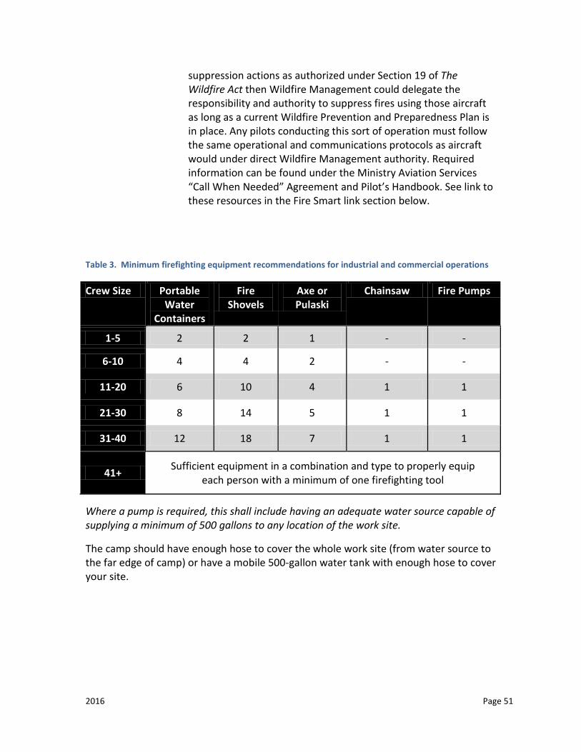
2016 Page 51
suppression actions as authorized under Section 19 of The Wildfire Act then Wildfire Management could delegate the responsibility and authority to suppress fires using those aircraft as long as a current Wildfire Prevention and Preparedness Plan is in place. Any pilots conducting this sort of operation must follow the same operational and communications protocols as aircraft would under direct Wildfire Management authority. Required information can be found under the Ministry Aviation Services “Call When Needed” Agreement and Pilot’s Handbook. See link to these resources in the Fire Smart link section below.
Table 3. Minimum firefighting equipment recommendations for industrial and commercial operations
Crew Size Portable Water
Containers
Fire Shovels
Axe or Pulaski
Chainsaw Fire Pumps
1-5 2 2 1 - -
6-10 4 4 2 - -
11-20 6 10 4 1 1
21-30 8 14 5 1 1
31-40 12 18 7 1 1
41+ Sufficient equipment in a combination and type to properly equip each person with a minimum of one firefighting tool
Where a pump is required, this shall include having an adequate water source capable of supplying a minimum of 500 gallons to any location of the work site.
The camp should have enough hose to cover the whole work site (from water source to the far edge of camp) or have a mobile 500-gallon water tank with enough hose to cover your site.
2016 Page 52
CONTACTS
• For more information or assistance contact your local Forest Protection Officer. To determine the forest protection officer in your area, visit: www.environment.gov.sk.ca, click on “Maps” under the “Features” heading, and under “Wildfire,” click on “Fire Centre and Forest Protection Areas:” http://www.environment.gov.sk.ca/Default.aspx?DN=b08d8f5c-39c2-4575-ad0d-a612560dd51c
• To Report a Wildfire: Toll Free Wildfire Hotline: 1-800-667-9660 or dial 911 • Wildfire Management Website: For daily fire weather updates, active forest fire
reports, fire ban advisories, Fire Smart information, and more visit: saskatchewan.ca/fire
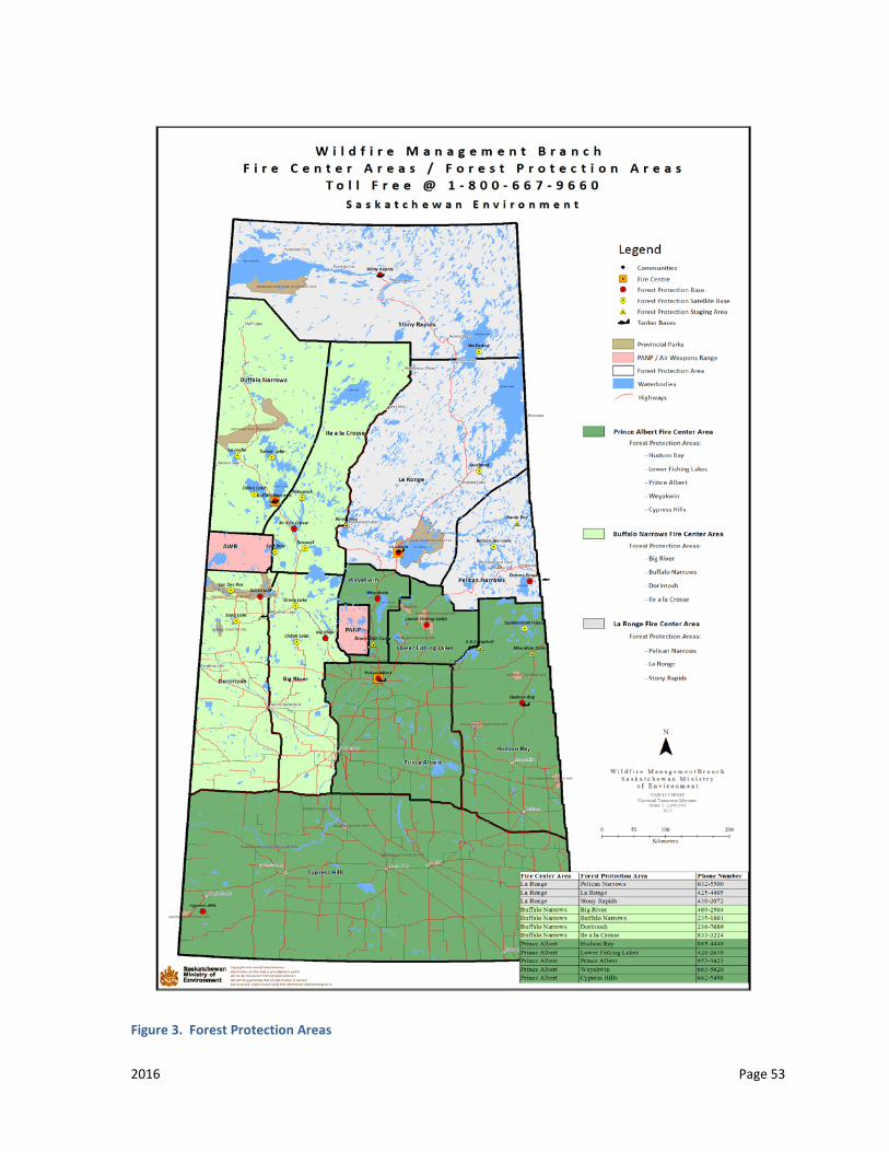
2016 Page 53
Figure 3. Forest Protection Areas
2016 Page 54
BEST MANAGEMENT PRACTICE (BMP) 006: ACCESS
GENERAL INTRODUCTION
Roads and trails are one of the most visible impacts of exploration activities. They open up areas to other resource users that may not have been accessible previously.
BACKGROUND
Trails and roads create more controversy than other mineral exploration activities. Exploration companies must be allowed to access their claim areas. It is the Ministry of Environment’s responsibility to ensure that the creation of the access is done in an environmentally sound manner.
All potential routes are to be considered and proposed during route selection. Each route will be assessed according to its ability to meet the goals and objectives of both the applicant and the Ministry of Environment. Applicants should review options and consider future operations to avoid development of a network of access trails.
The applicant should consider the impact on wildlife populations from access into an area (program timing to protect critical wildlife breeding, nesting or survival periods, the destruction or fragmentation of wildlife habitat, etc.).
New access development may be prohibited where reasonable access already exists.
Where applicable, the applicant should consider access utilizing frozen water bodies or water courses in order to minimize the impacts on terrestrial environments.
Discretion in development of the road or trail may be allowed as long as the development addresses the concerns of the sensitive nature for the area.
AREAS TO BE AVOIDED IF POSSIBLE:
• areas of critical or sensitive wildlife habitat (e.g. riparian zones); • areas where activities will result in unstable soil or erosion problems; • sites of religious, archeological, historic, aesthetic, paleontological, natural or
cultural significance; and • legislated protected areas (game preserves, Provincial Parks and protected
areas,
2016 Page 55
Representative Area Network lands, land use planning areas, wildlife lands, ecological reserves,
etc.).
AUTHORITY
The Provincial Lands Act
The Forest Resources Management Act and Regulations
REQUIREMENTS
1. For clearing operations, refer to BMP-002 (Clearing Operations).
2. The applicant will identify potential constraints to trail development, such as: construction practices, land use planning, seasonal timing, community issues, etc.
3. Areas requiring access restrictions will require specific mitigation actions such as: gates, berms, barricades, roll back, etc.
4. Closure or reclamation of roads and trails must be part of the reclamation plan. See BMP-012 (Restoration).
5. The construction schedule must be provided prior to route selection. Seasonal restrictions may apply.
6. The applicant must identify other known resource users who may be accessing the trail or are impacted by trail development.
7. Life expectancy of all access routes should be identified in the application to allow for better access management for the area.
8. Fills and cuts resulting in damage to the ground surface should be kept to a minimum.
9. For winter access, the applicant should consider snow/ice in lieu of soil for cuts and fills.
10. If fill materials (sand, gravel, till, etc.) are required for trail improvement, a separate authorization is required from the Ministry of Environment.
11. Vehicles and equipment must be confined to the identified access right of way unless otherwise approved.
12. Trail centerlines should be flagged prior to trail construction to avoid unforeseen problems.
2016 Page 56
13. Activities should occur on dry, stable, or frozen ground conditions. While using undeveloped access routes during wet conditions, all efforts must be made to minimize rutting of the ground surface. Rutting is defined as an area 5 meters in length and 10 centimeters in depth.
14. For access using water bodies or watercourses, see BMP-007 (Water Crossings).
15. When crossing bogs, muskegs or possible wet areas, the ground must be frozen sufficiently to support equipment. If frozen ground conditions do not exist, alternate and approved methods, by the Ministry of Environment contact, must be used to prevent rutting of the ground surface (e.g. matting, corduroy, planks, etc.).
16. Access trail routes and widths must be identified in the application and will be limited to:
a. the equipment size;
b. method of construction;
c. the intended purpose of the trail; and
d. Ministry of Environment approval.
17. Unless otherwise approved, clearing of vegetation within 100 meters of any watercourse or water body must be hand cleared. Within 30 meters of the shore of any water body or watercourse, the trails must be doglegged and be no wider than approved by the Ministry of Environment.
18. An easement application or lease application must be submitted and approved for any long-term development of a roadway. Exclusive use dispositions will not be granted for mineral exploration activities.
19. When sand or gravel is required for upgrades to a road or trail, a permit will be required. The mineral exploration coordinator can deal with small quantities permits.
20. When access onto a Provincial Road or Highway is required, construction of an approach must be approved by the Ministry of Highways and Infrastructure.
21. Any roads/trails that were re-opened to access the proposed work area(s) must be closed in the same manner at the conclusion of the program unless otherwise authorized.
CONTACTS
Ministry of Environment
Ministry of Highways and Infrastructure

2016 Page 57
BEST MANAGEMENT PRACTICE (BMP) 007: WATER CROSSINGS
GENERAL INTRODUCTION
The constructions of water crossings and of water body access points are activities that may have significant impacts on aquatic environments. Water crossings are commonly used by the mineral exploration industry to efficiently access program work sites. Temporary water crossings are employed for short term access and are not intended for prolonged use. The impacts associated with water crossing construction will depend on the type of structure used at the crossing, timing of the proposed work and on how the crossings are constructed, maintained and operated.
The Department of Fisheries and Oceans Canada (DFO) is responsible for protecting fish and fish habitat in all water bodies and watercourses across Canada. As per the Fisheries Act no one may carry out work that will cause or has the potential to cause the harmful alteration, disruption or destruction to fish habitat without prior approval from DFO. The impacts associated with the construction of access points will depend on the access location selected (i.e. type and amount of shoreline/bank vegetation, shoreline/bank slope at the land/water interface, degree of disturbance required to construct the access point, soil type, type/amount of aquatic vegetation, etc.), timing of construction, type of heavy equipment used, required width of access, etc.
The program impacts may include:
The harmful alteration, disruption or destruction of fish or aquatic habitat through the infilling of watercourses or water bodies or the alteration of shoreline areas;
The blockage of fish movements; Dewatering of small streams during water withdrawal activities; The entrainment or impingement of small fish into water intakes; and The introduction of deleterious substances, such as fine sediments, into a water
body or watercourse.
The potential impacts on fish habitat and the surrounding land may be minimized through careful planning of the routes of the access trails and roads and the selection of appropriate crossing sites, crossing structures and water body access points that will have minimal impacts on the aquatic environment.
DEFINITIONS
“Water body” includes a lake, slough, marsh, wetland or muskeg in which the water exists permanently or intermittently (Definition is under The Environmental Management Protection Act, 2010).
2016 Page 58
“Watercourse” includes a stream, creek, river, gully, valley floor, drainage ditch or any other channel, including any artificial channel, in which water flows either permanently or intermittently (Definition from The Environmental Management and Protection (Saskatchewan Environmental Code Adoption Regulations, Chapter E-10.22 Reg 2)
“Wetlands” is land that is saturated with water long enough to promote wetland or aquatic processes as indicated by poorly drained soils, hydrophytic (water-tolerant) vegetation, and various kinds of biological activity which are adapted to a wet environment” All wetlands have three basic characteristics in common – water, water-saturated soils, and water-tolerant plants. (Definition from Wetlands of Canada, by the National Wetlands Working Group).
“Fish” includes parts of fish, shellfish, crustaceans, marine animals, and the eggs, sperm, spawn, spat, larvae and juvenile stages of fish, shellfish, crustaceans and marine animals (Definition from the Fisheries Act).
“Fish Habitat” refers to the spawning grounds and nursery, rearing, food supply and migration areas on which fish depend directly or indirectly in order to carry out their life processes (Definition from the Fisheries Act).
“High Water Mark” refers to the usual or average level to which a body of water rises at its highest point and remains for sufficient time so as to change the characteristics of the land (Definition from Fisheries and Oceans Canada – Operational Statements).
BACKGROUND
Impacts to the bed, bank, and boundary of any water body or watercourse should be minimized. All mineral exploration activities should be planned and conducted in a manner that minimizes the disturbance to fish and fish habitat.
In spawning areas, extra precautions may be required. The eggs of fall spawning species will be present on the spawning grounds until they hatch in the spring. Larvae are present in these areas for a while after hatching. Care must be taken to ensure eggs and larvae are not killed or destroyed.
For all species, the preferred spawning areas are generally shallower portions of water bodies, river mouths, gravel bars and bays.
2016 Page 59
Properly planned water crossings and use of frozen water bodies for travel can reduce potential impacts on terrestrial and aquatic ecosystems. Types of structures used to cross waters may include steel or wooden bridges, culverts, ice/snow bridges or ramps.
If practical, water crossings should be located:
near the headwaters of watercourses;
away from water body inlets and outlets;
upstream from natural, permanent barriers to fish passage, such as waterfalls and steep gradients;
away from important fish habitat (such as riffle area, rapids, and areas with
gravel/cobble substrates);
where the approaches to the crossing are on a flat, stable slope;
in areas with minimal or no floodplain habitat adjacent to the active channel;
perpendicular to the watercourse;
at the location where the watercourse is narrowest (these areas may have fast
moving water, thin ice, and may not be the best place to create a crossing); or
where they will accommodate peak flows.
For open water crossings, clear span structures that do not involve any infilling of the watercourse below the high water mark are the preferred type of structure. Infilling of the watercourse below the high water mark is considered a loss of habitat and may require formal authorization from DFO under Section 35(2) of the Fisheries Act and acceptable offsets to meet DFO’s requirements to mitigate or offset harm to fish and fish habitat .
Ice/snow bridges are the preferred type of crossing for winter exploration programs.
AUTHORITY
The Environmental Management and Protection Act, 2010
The Environmental Management and Protection (Saskatchewan Environmental Code Adoption) Regulations, Chapter E-10.22 Reg 2
Fisheries Act(Federal)
2016 Page 60
Navigation Protection Act
The Water Security Agency Act, Chapter W-8.1
REQUIREMENTS
1) If alterations are required to any bed, bank or boundary of a watercourse or water body, the Ministry of Environment is to be contacted prior to work commencing.
2) Applicants must send their project proposals to DFO if the project has the potential to negatively impact fish or fish habitat, unless the proponent has completed DFO’s self-assessment accordance and can demonstrate that series harm will be avoided. Although no longer available, on-line, DFO’s Saskatchewan’s Operational Statements (e.g., Operational Statements for clear-span bridges or ice bridges) are a useful guide to determine mitigation measures that should be employed when installing clear span bridges. To facilitate review by DFO, only submit relevant information that pertains to potential impacts to fish and fish habitat..
3) Applications to the Navigable Waters Protection Program which is administered by Transport Canada are only required for programs that have the potential to impact navigable waters (e.g., permanent or temporary bridges) at water crossings that are determined to be navigable by NWPP. Temporary ice and snow bridges will NOT require an application to NWPP.
4) Any program requiring water from a different source for building a crossing requires approval from the Water Security Agency and the Ministry of Environment.
5) Crossing construction details required in the application should include at minimum the following information:
a) the locations (UTM Co-ordinates and Datum) of any water crossing and/or water body access point that will be utilized during the exploration program;
b) the type of crossing structure that will be used at each of the locations;
c) the type of equipment, that will be used for the construction, placement, and decommissioning of the crossings;
d) the timeframe for the construction and removal of the crossing;
e) the length and width of any crossing structures (outside of snow or ice bridges) that will be utilized. If required to facilitate the placement of any crossing structures, the area that will be covered by fill material (i.e. floodplain and below top of bank), along with the type and source of fill material, needs to be identified;
2016 Page 61
f) any modifications of the bed, banks, or boundary at the water crossings or access points;
g) if constructing ice bridges and/or ice roads, the approximate volume of the pump per minute and the source of the water need to be identified;
h) a brief description of the riparian zone and watercourse or water body is to be provided. This description should include the following information:
i) the area (km2) of the watershed upstream from the crossing,
ii) the bank full width and depth of the watercourse at each crossing site,
iii) the types of vegetation (grass, shrubs) that are present on the bank and boundary at each water crossing or access point,
iv) a description of the slope and stability of the bank at each water crossing or access point,
v) the presence and associated width of any floodplain habitat at the proposed crossing sites,
vi) photographs of the bank and boundary of the water body or watercourse and upstream and downstream views of the watercourse at each of the crossings locations, and
vii) the mitigation measures that will be employed to stabilize, re-vegetate and reclaim any disturbed areas resulting from planned crossing activities (see BMP 012 Restoration).
i) During unfrozen conditions, the applicant needs to take steps to reduce surface impacts for crossings over wetlands, soft ground, etc. Specialized low impact equipment, corduroy bridging, or other acceptable and approved methods may be required.
j) Unless otherwise directed, any vegetation cleared to facilitate the crossing is to be removed away from the water body or watercourse and stored above the high water mark (See BMP-002 Forest Clearing/Harvesting Operations).
k) Crossings that require installation of culverts in watercourses with large bodied, migratory fish species and that will remain in place during the spring and/or fall spawning seasons will have to be designed to allow for fish passage. These crossings will also need to be designed by a qualified engineer. Culvert installations/replacements in fish habitat typically require formal review by DFO prior to installation. Be sure to complete DFO’s self-assessment before determining whether DFO review is required.
2016 Page 62
l) Ice/snow bridging is permitted provided all material is clean and free of debris. Once the ice/snow bridge is no longer required, it shall be breached for at least 10 per cent of the bank full width to allow the watercourse to flow naturally during spring thaw.
m) Equipment operating near any waters shall be properly maintained, in sound mechanical condition and free of any fuel, oil, hydraulic fluid, or coolant leaks.
n) No cleaning or servicing of equipment is permitted within 100 meters of a water body or watercourse. Fueling may take place within this buffer area provided secondary containment of the tank and spill kits are on site (see BMP-004 HSWDG).
o) If required, flooding is permitted to build up ice to a desired thickness provided the intake for the pump is screened, the water source is the same, and the fuel source for the pump has secondary containment (see BMP-004 HSWDG).
p) Any water intake used in fish bearing waters is to have a fish screen that meets DFO’s 1995 “Freshwater End-of-Pipe Fish Screen Guideline” to prevent the impingement or entrainment of fish during pumping activities. Information on these guidelines can be found in Appendix D.
i) The screening material used for water intakes in fish bearing waters is to have a maximum design opening of 2.5 millimeters. The approach velocity at the face of the fish screen(s) should not exceed 3.8 cm/s (0.038 m/s) if any anguilliform species are present (e.g. northern pike, burbot ) or 11 cm/s (0.11m/s) if only subcarangiform species are present (e.g. sucker, walleye).
Note: To determine the size of the screen to be placed around the water intake, the formula is as follows (taken from Page 6 of the Freshwater Intake End-of-Pipe Fish screen Guideline.):
Effective Screen Area = Open Screen Area / (Per Cent Open Area/100).
The Effective Screen Area is the total size (area) of the screen placed around the water intake.
The Open Screen Area is the area of all open spaces on the screen available for the free flow of water. The open screen area required is based on the maximum pump capacity and the type of swimming mode of the fish found in the water body where the pumping is to take place. This open screen area can be determined by referring to Table 2 of the Freshwater Intake End-of-Pipe Fish Screen Guideline.
Open Screen area is the area of all open spaces on the screen available for the free flow of water.

2016 Page 63
The Per Cent Open Area is determined by the size and type of material used to construct the screen and can be found in Table 3 of the Freshwater Intake End-of-Pipe Fish Screen Guideline.
q) The screen and water intake are to be placed a minimum of 12 inches off the bottom of the water body so that they do not disturb the sediments.
r) Applicants that plan on constructing clear span bridges or ice bridges and can follow DFO’s Operational Statements for Clear Span Bridges or Ice Bridges (if available) and also complete a self assessment, if there is the potential to harm to fish or fish habitat..
s) All in-water and shoreline works are to take place outside of DFO’s Saskatchewan In-Water Closed Construction Timing Windows unless otherwise approved by DFO. The time of year that a particular water body may be closed to in-water or shoreline work will depend on the fish species present in that water body. DFO should be consulted if there is a need to undertake any in-water or shoreline works during the Saskatchewan In-Water Closed Construction Timing Window prior to undertaking the activity.
t) Whenever possible, large water bodies rather than small creeks should be used for water sources to avoid potentially dewatering the small creeks and impacting fish and fish habitat during the water withdrawal process. No more than 10 per cent of the instantaneous flow may be cumulatively removed from any water body during water withdrawal activities.
Notes:
Additional information may be necessary for any work where culverts are proposed.
For crossings involving the construction of clear span bridges, ice/snow bridges, or water body access points using ice and snow, habitat information may be collected in the field, as the crossings are being constructed and included in the closure report. However, for projects that will involve the installation of structures or materials (i.e. fill) below the high water mark (including active floodplain areas), the information will have to be provided and the work approved prior to construction. Photographs (including something to show scale) of the channel banks and upstream and downstream views of the streams at each of the crossings are essential for reviewing the project.
CONTACTS
Department of Fisheries and Oceans Canada

2016 Page 64
Ministry of Environment
Navigable Waters Protection Program (Coast Guard – Transport Canada)
Water Security Agency
2016 Page 65
BEST MANAGEMENT PRACTICE (BMP) 008: EXPLORATION TRENCHING AND HYDRAULIC STRIPPING
GENERAL INTRODUCTION
Trenching and hydraulic stripping are the most definitive methods for surface exploration, but can cause significant environmental disturbances, with the potential for contamination of soil and water through exposure of mineral substances.
BACKGROUND
Environmental impacts can be reduced or avoided with the proper safeguards.
Hydraulic stripping is rarely used as a primary exploration tool, but could be used in conjunction with other exploration activities (e.g. trenching, diamond drilling).
There are two types of trenches.
1. Overburden trenches are made to check and map the type of bedrock below the overburden. These are very common if heavy equipment (i.e. back hoe) is available.
2. Bedrock trenches are made to follow up on bedrock mineralization. These require blasting with dynamite and are far less common. While the former are usually backfilled immediately, the latter are usually left open.
The Ministry of Economy accepts trenches (by volume removed) as evidence of assessment work, which is one of the reasons they are not backfilled. Most of the overburden trenches are dug where the ongoing operations require them and the location is not something known in advance.
AUTHORITY
Mineral Industry Environmental Protection Regulations
The Forest Resources Management Act and Regulations
The Provincial Lands Act and Regulations
2016 Page 66
REQUIREMENTS
EXPLORATION TRENCHING
1. The Ministry of Environment must approve all trenching activities. Details of the trenching activities must include the dimensions of the trenches and the method of construction. If clearing of forest vegetation is required, see BMP-002 (Clearing).
2. Unless authorized, a minimum 100-meter buffer of undisturbed vegetation must be maintained between the trenches and all water bodies and watercourses.
3. Unless otherwise approved, all areas stripped of topsoil must be back filled and restored to as near the original contour as possible.
4. The development of an exploration trench must take into consideration the safety risks associated with entrapment. Trenches must be dug in a manner that allows for easy escape, for both humans and wildlife and the trenches must comply with Ministry of Labour Relations and Workplace Safety requirements.
5. For the use of explosives, see BMP-004 (Hazardous Substances and Waste Dangerous Goods).
6. Topsoil, if present, and material removed from trenches must be stockpiled separately and utilized for site restoration unless otherwise approved.
7. Material excavated from overburden trenching must be backfilled with the topsoil replaced last.
8. In the case of uranium exploration, following backfilling, a radiometric survey must be conducted to ensure that the gamma levels (measured at 1 meter from the surface) are reduced to less than 1.0µSv/hr. When material is found to exceed background levels, then the Ministry of Environment must be contacted for review and approval of the handling procedures.
9. Applicant liabilities, future reclamation costs and future planning should be considered by the applicant when requesting trenches be left open. Note BMP-012 (Restoration).
10. Trenches are required to be backfilled to the point where there is no safety risk. With adequate justification to the Ministry of Environment (safety, scientific, reclamation, etc.), exploration trenches may be allowed to remain in an excavated form once exploration has been completed.
11. Applicants are to supply GPS coordinates for all trenches in their Closure Report or identified in a figure which clearly shows the location of the trench and has a suitable scale.
2016 Page 67
HYDRAULIC STRIPPING
1. All hydraulic stripping operations must be approved prior to initiation. Contact the Ministry of Environment contact regarding projects using hydraulic stripping. Restoration options should be discussed with the mineral exploration contact. Refer to BMP-012 (Restoration). If clearing of forest vegetation is required see BMP-002 (Clearing).
2. All hydraulic stripping operations must be approved prior to initiation. Details of the stripping activities must include the dimensions of the area to be affected. If clearing of forest vegetation is required, see BMP-002 (Clearing).
3. Unless otherwise authorized, a minimum 100-meter buffer of undisturbed vegetation must be maintained between stripping operations and any water body or watercourse.
4. Restoration options should be discussed with the mineral exploration contact - refer to BMP-012 (Restoration).
CONTACTS
Ministry of Environment
Ministry of Labour Relations and Workplace Safety
Transport Canada
Natural Resources Canada
2016 Page 68
BEST MANAGEMENT PRACTICE (BMP) 009: DRILLING ON LAND
GENERAL INTRODUCTION
Drilling is one of the most definitive and common methods for surface exploration.
BACKGROUND
A properly planned and managed drilling program reduces the risk of impacting the environment.
The following requirements apply to shield areas of the province. Drilling in the Western Sedimentary Basin requires additional precautions because of the potential of encountering oil and gas concentrations.
Clearing for drilling is dependent on the size and type of drill rig used.
AUTHORITY
Mineral Industry Environmental Protection Regulations
Forest Resources Management Act and Regulations
The Oil and Gas Conservation Regulations, 2012
Note: Before drilling in Saskatchewan, companies need to contact the Ministry of Labour Relations and Workplace Safety to ensure the drilling equipment used is legal for use in Saskatchewan as some equipment is banned for occupational health and safety reasons.
REQUIREMENTS
1. If drilling is required on ice-covered waters, see BMP-010 (Drilling on Ice).
2. The number of drill holes, approximate locations, and drilling program details must be identified in the application.
3. Applicants wishing to conduct activities within 100 meters of a water body or watercourse may wish to also the Department of Fisheries and Oceans Canada for their review if the activities have the potential to cause series harm. Proponents should complete DFO’s self-assessment to determine if an application should be sent to DFO.
4. Any program requiring water for drilling activities (except water from municipal or private sources) requires approval from the Water Security Agency and Ministry of Environment. See BMP-007 (Water Crossings).

2016 Page 69
5. Clearing should be kept to a minimum size and constructed to facilitate drilling operations. A standard drill pad should not exceed 20 meters by 20 meters (or 400 square meters) unless otherwise approved. See BMP-002 (Clearing) for further clearing requirements.
6. A minimum of 100 meters must be maintained between the drill pad and any water body or watercourse unless previously authorized by the Ministry of Environment. For drilling activities within 100 meters of a water body or watercourse the applicant may have to follow additional procedures outlined in BMP-010 (Drilling on Ice).
7. For drill sites that are not level, the first consideration should be given to leveling methods other than soil stripping (blocking, ice pads, etc.) and site relocation. If not possible, soil stripping should be minimized.
8. If soil stripping is required, soil horizons are to be removed and stored separately at the edge of the clearing.
9. Slash material is to be stockpiled at the edge of the clearing and utilized for reclamation of the site. See BMP-012 (Restoration).
10. For HQ (<2.5 inches or <63.5 millimeters) and smaller diameter drill holes in remote locations drilling effluent shall be contained, in sumps, containers, or natural depressions located as close to the drill site as possible, unless otherwise approved.
11. For larger diameter holes (> 2.5 inches or > 63.5millimeters) or areas of road access the Ministry of Environment may require sumps or tanks.
12. Where possible all efforts shall be used to prevent drill mud, return water, and cuttings (sludge) from running uncontrolled from the site or to within 100 meters of a water body or watercourse. Appropriate sediment and erosion control measures may need to be implemented to prevent deleterious substances from entering fish habitat.
13. The applicant must identify in the application any drilling additives that will be used in the program.
14. Wherever possible biodegradable mud and non-toxic additives should be used.
15. An adequate closed circuit system must be utilized for potentially harmful drilling mud and other additives.
2016 Page 70
16. Drill mud solids or cuttings with a uranium concentration greater than 0.05 per cent are to be collected and then disposed of down the drill hole and sealed, or temporarily placed in secure containment and then disposed of at a licensed facility, such as an existing uranium tailings management facility.
17. Noise abatement devices including mufflers and shrouding are to be used near populated areas.
18. Upon completion of the program, exposed drill casings are to be removed or cut off at or below the surface of the ground, unless otherwise approved.
19. Any drill hole that encounters mineralization with a uranium content greater than 1.0 per cent over a length > 1 meter, and with a meter-percent concentration > 5.0, will be sealed by grouting over the entire length of the mineralization zone and not less than 10 meters above and below each mineralization zone.
20. All artesian drill holes must be reported to the Ministry of Environment contact within 30 days of its discovery. All artesian drill holes must be sealed to prevent discharge to the environment.
21. Reclamation of the drill site must follow procedures outlined in BMP-012 (Restoration).
22. Appropriate precautions are to be undertaken to ensure that deleterious substances do not enter any watercourse.
23. The proponent is responsible for effective sediment and erosion control:
a. All spoil materials should be disposed of above the high water level, and located and stabilized so that they do not re-enter any watercourse
b. The proponent is responsible for erosion control on the approaches to ice/snow bridge watercourse crossings all year round. This includes sediment from winter roads entering watercourses during the ice-free seasons;
c. During construction and until re-vegetation is sufficient to control sediment erosion, the proponent should ensure that effective sediment and erosion control measures are in place and that they are functioning properly and are maintained and/or upgraded as required to prevent sediment from entering fish habitat.
2016 Page 71
24. Companies wishing to drill in the Western Canada Sedimentary Basin are required to contact the Mines Branch of the Ministry of Economy prior to drilling. That ministry will advise on any precautions that are required.
CONTACTS
Ministry of Environment
Department of Fisheries and Oceans Canada
Water Security Agency
Mines Branch, Ministry of Economy
Ministry of Labour Relations and Workplace Safety
2016 Page 72
BEST MANAGEMENT PRACTICE (BMP) 010: DRILLING ON ICE
GENERAL INTRODUCTION
Many exploration programs involve drilling on ice in the search for mineral deposits. Because potential risks increase from drilling on ice, special attention is given to all drilling phases to prevent or minimize adverse impacts to the environment. Operations may vary between drill rigs or even between holes as situations demand; however, decisions must reflect the requirements outlined in this guideline to reduce potential impacts to the aquatic ecosystem. Some aspects of this Best Management Practice may apply to land-based drilling programs if drilling within 100 meters of a water body or water course (see BMP-009).
BACKGROUND
The following information is provided to describe the various precautionary steps taken to protect the environment when drilling on ice.
DESCRIPTION OF A DIAMOND DRILL
Diamond drills come in a variety of shapes and sizes. Although there are a number of different sizes, manufacturers, and types of drills they generally adhere to a few simple rules. Diamond drills are almost always primarily powered by a diesel engine. All drills have at least some secondary drive mechanisms that are hydraulic. Typically drill rigs are small, about the size of a small recreational vehicle. The drill is transported to the site on a low bed tractor-trailer and is moved around the site using a dozer/skidder. The drill pipe or “rod” will have a diameter of anywhere from five inches to as small as two inches. Drills are capable of drilling to 300 meters or more, depending on the size of the drill and drill rod string used.
Drilling on ice goes through three basic phases: setting up, drilling, and tearing down. All three of these operations are outlined in detail below:
SETTING UP
There must be sufficient ice to support the weight of the drill rig and associated equipment during transportation to the drilling location and when operating on the drill site. If insufficient ice is present, the ice is commonly built up with a series of local floods. Flooding is generally approved by the Ministry of Environment as long as all proper screening is in place as set out in BMP-007 (Water Crossings). The drill is

2016 Page 73
supported on untreated timbers to distribute its weight over the ice and to help level the rig. Some drills are relatively light and need to be stabilized by using ice screws or freezing in anchors. Associated drilling equipment, which includes: drill rods, pumps, mixing tanks, and mechanical support equipment, is brought to the site and usually stored on sleds. Fuel and petroleum products necessary for maintenance and operation are temporarily brought to the drill site when required.
DRILLING
The first step in drilling is “casing” the hole. This means sealing the hole from bedrock to surface using a large diameter pipe or “rod”. This is a necessary step to ensure that the hole can be located again if any subsequent drill rods need to be removed during the operation. When casing the hole, one factor to contend with may be the depth of the water, or the distance between the drill and something solid. If the water is deep, the drillers will drop their largest rods first (rod size referred to as HW in Figure 4). The HW rod will be pushed and turned as far as it will go into the lake bottom manually and then anchored to the drill. Some disturbance of lake bottom sediments will result from this initial stage, however it is minimal and localized. If the lake bottom is bedrock there will be virtually no disturbance at all. If however consolidated sediments exist then some disturbance to organic matter at the bottom of the lake should be expected.
If the HW encounters bedrock then the next smallest size casing referred to as NW will be lowered inside the HW. The NW rod will be drilled into the rock to form a seal between the rock at the bottom of the lake and the drill at the surface. Once the NW rod is in place the next smaller “NQ” rods can be lowered into the hole. Refer to Figure 4 for a graphical representation of the process.
If the NW rod doesn’t hit bedrock when it is initially lowered into the hole, it will commence hollow core drilling through the lake sediment or “overburden”. If the overburden is deep, or the drilling is difficult, then the drillers will probably switch to a type of drill bit called a tricone. Tricones do not hollow core drill; instead they simply grind their way through everything they encounter. Triconing produces a lot of sand and silt and this abrasive material must be removed from the bottom of the hole or it will plug up the tricone and stop the drilling. Because this material is very coarse and heavy, drillers will commonly add a substance called bentonite to the drilling water to float the coarse sand away from the tricone and out the top of the hole. Mixing bentonite with water forms thick slurry that is able to float out the coarse sand produced by the tricone, when pumped down with enough pressure. This drilling mixture is pumped down through the rods, out through the tricone, back up the outside of the hole into the
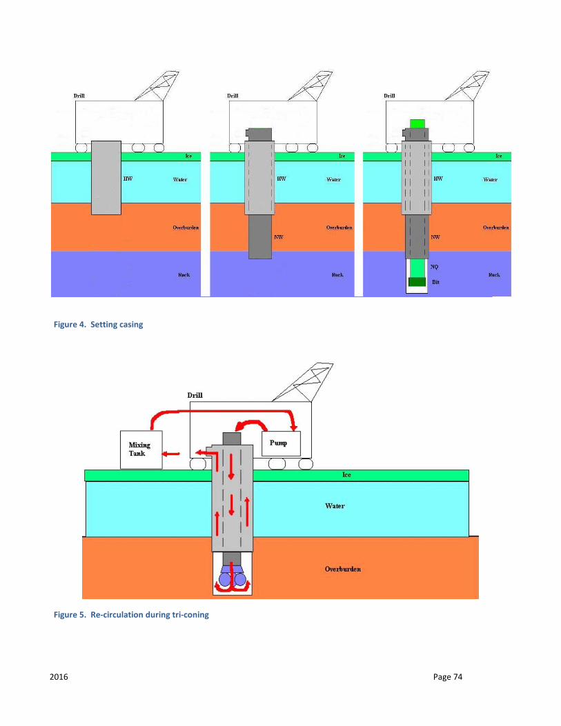
2016 Page 74
Figure 4. Setting casing
Figure 5. Re-circulation during tri-coning
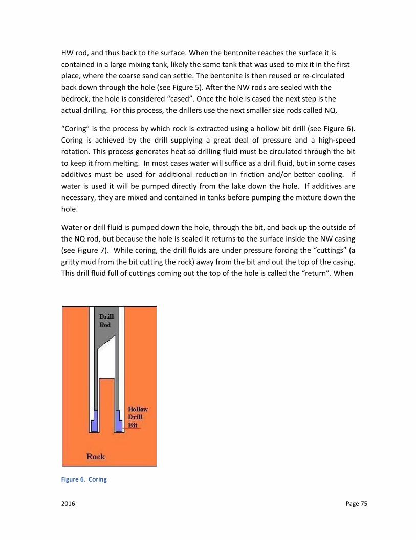
2016 Page 75
HW rod, and thus back to the surface. When the bentonite reaches the surface it is contained in a large mixing tank, likely the same tank that was used to mix it in the first place, where the coarse sand can settle. The bentonite is then reused or re-circulated back down through the hole (see Figure 5). After the NW rods are sealed with the bedrock, the hole is considered “cased”. Once the hole is cased the next step is the actual drilling. For this process, the drillers use the next smaller size rods called NQ.
“Coring” is the process by which rock is extracted using a hollow bit drill (see Figure 6). Coring is achieved by the drill supplying a great deal of pressure and a high-speed rotation. This process generates heat so drilling fluid must be circulated through the bit to keep it from melting. In most cases water will suffice as a drill fluid, but in some cases additives must be used for additional reduction in friction and/or better cooling. If water is used it will be pumped directly from the lake down the hole. If additives are necessary, they are mixed and contained in tanks before pumping the mixture down the hole.
Water or drill fluid is pumped down the hole, through the bit, and back up the outside of the NQ rod, but because the hole is sealed it returns to the surface inside the NW casing (see Figure 7). While coring, the drill fluids are under pressure forcing the “cuttings” (a gritty mud from the bit cutting the rock) away from the bit and out the top of the casing. This drill fluid full of cuttings coming out the top of the hole is called the “return”. When
Figure 6. Coring

2016 Page 76
Figure 7. Circulation of drill fluids
Figure 8. Recirculating drill fluids
2016 Page 77
this return fluid reaches the surface it is run through a filter called a Polydrill filter. This filter separates out the cuttings and packs them in a cylindrical bag for disposal. The drill fluids are then pumped back down the hole or re-circulated (see Figure 8). In some cases, the rock is very porous and the return dissipates before reaching the surface.
TEARING DOWN
Once drilling has been completed, clean water is circulated through the hole to remove any drill additives and remaining cuttings. The hole is then sealed as per requirements to prevent any of the lake water from being inadvertently drained into any aquifer or mine workings (past or future) and to prevent any impure water (salty, mineralized) from entering the lake through underground sources. The hole is sealed for cementing by pumping down a properly sized safety plug and a cement mixture which includes regular Portland cement is pumped down the hole to form a watertight seal.
As the hole is being cemented, all the rods are extracted from the hole in the reverse order they went in. As they are withdrawn any remaining cement will settle to the bottom of the hole. The amount of cement deposited on the lake bottom will be minor as the drillers follow a formula to determine the exact amount of cement they will require to seal a hole. All drill and support equipment is then removed from the lake. The goal is to leave the ice surface in the same condition as it was prior to moving onto the site.
AUTHORITY
Fisheries Act
Mineral Industry Environmental Protection Regulations
The Oil and Gas Conservation Regulations, 2012
REQUIREMENTS
1. Applicants conducting activities on or near a waterbody or watercourse may wish to also contact Fisheries and Oceans Canada for their review if there is the possibility that there may be series harm to fish or fish habitat. Proponents should complete DFO’s self-assessment guide to determine the potential for serious harm.
2. Any program requiring water for drilling activities (except water from municipal or private sources) requires approval from the Water Security Agency and the Ministry of Environment, which must be identified in the original application. See BMP-009 (Drilling on Land).
2016 Page 78
3. All access routes onto the water body must follow the requirements outlined in BMP-007 (Water Crossings).
4. The ice needs to be of sufficient thickness to support the drill and associated equipment both during transportation and drill setup.
5. Flooding is permitted to build the ice up to sufficient thickness if required. If the water body is fish bearing the intake for the pump must be screened to meet DFO’s Freshwater Intake End-of-Pipe Fish Screen Guideline and the fuel source for the pump must have secondary containment. See BMP-007 (Water Crossings).
6. Unless otherwise approved, drilling shall occur in water depth greater than 2 meters, including ice thickness. Additional site assessment and mitigation information will be required if the applicant plans to drill in a water depth less than 2 meters, in fish-bearing water bodies. Contact DFO and the Ministry of Environment for information requirements.
7. Untreated timber or local cut timber can be used to support the drill. If local timber is used, a Forest Products permit authorizing this use is required before any timber harvesting is permitted. All timbers must be removed away from the water body upon completion of drilling operations.
8. The use of ice screws or freezing in anchors is permitted but must be removed once the drilling operation is completed.
9. Fuel shall be stored at a shore cache a minimum 100 meters from the high water mark, unless otherwise approved. A limited supply of fuel can be temporarily brought to the site to support the drill. Fuel stored on site must be stored in a secondary containment system; either a large tray or an ice/snow bermed containment area lined with an impervious liner to the product being stored.
10. Absorbent matting or drip trays must be used where accidental spills may occur during fueling. Contaminated material is to be removed from the site for proper disposal immediately after cleanup has been completed. Refer to BMP-004 (HSWDG) for further requirements regarding fuel handling, storage and spills.
11. The drilling crew is to be trained to respond to a spill should the need arise. All drill rigs must be equipped with a spill kit.
12. External pumps or motorized equipment used in the drill operation and sitting on the ice shall have secondary containment (e.g. impermeable liner resistant to the product being used, plastic drip trays, etc).
13. Any water intake used in fish bearing waters is to have a fish screen that meets DFO’s 1995 Freshwater End-of-Pipe Fish Screen Guideline to prevent the
2016 Page 79
impingement or entrainment of fish during pumping activities. See BMP-007 (Water Crossings).
14. Noise abatement devices including mufflers and shrouding are to be used near populated areas.
15. The applicant must identify in the application any drilling additives that will be used down the hole during drilling. All drilling additives must be biodegradable, where available, and accompanied by an MSDS sheet. Drill additives should only be used if required and in minimal amounts.
16. If mixing tanks for drill muds are being used, they must be placed on an impervious liner and any spills are to be cleaned up with absorbent material and contained.
17. All drilling operations shall use a “closed loop” recycling system with no discharge to the water or ice. In some cases, approval may be given to allow the return fluid to be pumped back to shore and into a natural or constructed sump located 100 meters or greater from the water (in these cases re-circulating drill fluids would not be required).
18. Drill cuttings must be collected through a filter system and disposed of in a Ministry of Environment approved landfill or alternatively the drill mud, return fluid and cuttings can be disposed of in a land-based sump placed 100 meters above the high water mark. Any requirements in BMP-009 (Drilling) addressing operation and handling of the land-based sump must be followed.
19. The drill area is to be kept orderly and any garbage is to be removed daily from the area to an approved disposal site. The ice surface is to be kept clean at all times. Once drilling is complete, all material is to be removed from the ice and the site left in a safe and clean state.
20. Once drilling is completed, clean water must be circulated through the hole to remove any remaining drill fluids and cuttings.
21. Drill holes must have all rods and casing removed prior to abandoning the hole. 22. Drill mud solids or cuttings with a uranium concentration greater than 0.05 % are to
be disposed of down the drill hole and sealed. 23. Any drill hole that encounters uranium mineralization with a content greater than
1.0 per cent over a length of more than 1 meter with a meter-percent concentration greater than 5.0 will be sealed by cementing (grouting) over the entire length of the mineralization zone and not less than 10 meters above or below each mineralization zone.
24. Drill holes are to be sealed by cementing (grouting) the upper 30 meters of bedrock or the entire depth of the hole, whichever is less.
2016 Page 80
25. Companies wishing to drill in the Western Canada Sedimentary Basin are required to contact the Mines Branch of the Ministry of Economy prior to drilling. The Ministry of Economy will advise of any precautions that are required.
26. The Closure Report must provide site assessment, drilling operation, and abandonment information for each drill hole. See the “Closure Report” document for further information.
CONTACTS
Ministry of Environment
Department of Fisheries and Oceans Canada
Water Security Agency
Ministry of Economy, Mines Branch

2016 Page 81
BEST MANAGEMENT PRACTICE (BMP) 011: CORE STORAGE
GENERAL INTRODUCTION
Exploration companies use drilling to test for mineral commodities or geological structures. Commodity prices or geological models change with time and as a result, core is commonly re-sampled and re-logged. Utilization of core drilled in the past is a prospecting tool that is a cost-effective means of re-exploring the site. When core is properly boxed and stored, the potential usefulness of core will be maintained for 25 years or more. The mineral industry and the Ministry of Economy utilize core for geological mapping, research and special studies. The Ministry of Economy is the regulating agency
BACKGROUND
Diamond drilling is one of the most widely used tools in mineral exploration. Core is a cylindrical section of rock usually 1.4 to 3.4 inches (35 millimeters to 85 millimeters) in diameter and up to many meters in length and is brought to the surface for geological examination or laboratory analysis. It is commonly stored in wooden boxes. The study of drill cores assists in the three-dimensional reconstruction and interpretation of bedrock geology and is normally environmentally safe and non-hazardous.
AUTHORITY
The Mineral Industry Environmental Protection Regulations, 1996
REQUIREMENTS
DISTANCE FROM WATER BODIES
Unless otherwise approved, storage areas must be located a minimum of 100 meters from the high waterline of all water bodies.
LONG TERM STORAGE – ON SITE
Before an applicant is “released” from their responsibility associated with all applicable permits, all core remaining on site must be stored in standard core boxes. Each box will be identified with aluminum labels securely attached, indicating the hole number and core interval represented.
2016 Page 82
There are three acceptable ways to store the core, which can be used individually or in combination.
CROSS STACKING
The core boxes could be cross-stacked on top of one another (each layer being stacked perpendicular to the layer above and below it) on a well-drained site. It is recommended that a gap be left between individual boxes in a layer to enhance ventilation.
The bottom layer of boxes should be approximately 15-45 centimeters off the ground and supported by solid footings.
The stacked boxes should be stable Each box on the top layer of the stack should be sealed with a standard core box
lid. Each stack should have a simple covering to provide shelter from the elements. Suggestions include, but are not limited to: well ventilated tarpaulin covers;
another layer of empty core boxes attached perpendicular to the top layer; a layer of plywood that extends beyond the edge of the core boxes.
CORE RACKS
The permit holder may be allowed to leave the core in core storage racks that are provided with a simple covering, which extends beyond the end of the core boxes. More elaborate structures that have an element of permanence are not prohibited, but may be subject to additional permitting.
TRANSPORTATION TO MINISTRY OF ENERGY AND RESOURCES STORAGE FACILITY
Approval can be granted, if the applicant agrees, to transport either all core or representative sections of core to the Ministry of Economy core storage facility in La Ronge.
LONG TERM STORAGE – OFF SITE
The applicant may be released from permit obligations if the operator stores the core in a long-term storage facility not located on the property, with the permission of the Ministry of Economy (Director of the Northern Geological Survey).
2016 Page 83
TIME OF ASSUMING RESPONSIBILITY
The operator is responsible for all core drilled on a property from the date they acquired the property. If the property is sold or reassigned the new operator is responsible for all core.
SALVAGE OF CORE
An applicant working on a claim is encouraged to take all reasonable actions to salvage (if possible) or upgrade any core racks that pre-date their involvement.
LOCATION OF CORE
The applicant should note the location of core with their work permit applications and assessment reports submitted to Ministry of Economy. Any subsequent change in location shall be communicated to the Ministry of Economy. Core locations shall also be documented in the Closure Report submitted to the Ministry of Environment.
RADIATION IN LONG TERM STORAGE
Gamma radiation levels of a core storage area must meet the decommissioning requirements outlined by the Ministry of Environment. That is, average gamma levels measured at 1 meter from surface of a storage area should be reduced to 1.0 μSv/hr.
At the discretion of the claim holder, a radioactive warning sign may be posted on the perimeter of the core storage area. Mineralized core with radioactivity exceeding 1 Bq/g (approximately 80 ppm U) is considered a dangerous good, the transportation of which must be compliant with the Packaging and Transport of Nuclear Substances Regulations.
Laboratories receiving radioactive materials must be authorized by the Canadian Nuclear Safety Commission through the issuance of a license. The average radiation level (at 1 meter from surface of the storage area) of any core left on site that has gamma radiation levels that exceed background, shall be reported on the relevant assessment file along with the core storage location.
CONTACTS
Ministry of Economy
Northern Geological Survey

2016 Page 84
Ministry of Environment
Department of Fisheries and Oceans Canada
Canadian Nuclear Safety Commission
2016 Page 85
BEST MANAGEMENT PRACTICE (BMP) 012: RESTORATION
GENERAL INTRODUCTION
Reclamation must be recognized as an integral part of exploration, and therefore must be included in the pre-exploration planning. Proper planning will assist the applicant in returning disturbed areas to an acceptable natural and productive state.
It is impossible to define every situation because exploration activities and environmental conditions are variable, so flexibility must be built into the permitting process.
BACKGROUND
Reclamation: Planning should include minimizing impacts and avoiding surface disturbance to assist in reducing reclamation requirements and costs for the program.
Re-vegetation: The purpose in rehabilitating disturbed areas is to encourage the progressive establishment of natural vegetation consistent with pre-exploration conditions.
The need to actively re-vegetate a site depends on the nature of the area and the disturbances created by the work. If proper planning is done to minimize surface disturbance, natural regeneration of the site should take place without the need for additional reclamation work. If surface disturbance is created, the site may need to be actively stabilized and re-vegetated. Actively re-vegetating a site as soon as possible following re-contouring is the best way to stabilize slopes, control weeds and exotic plants, minimize erosion, and encourage the establishment of native plant communities. The Ministry of Environment must approve the proposed re-vegetation prior to work commencing.
Interim Reclamation: It may be beneficial to conduct interim reclamation on a site where future exploration plans include returning to the site in subsequent years to do more work. This is typical of sites used for access and core drilling where soil stripping may occur. To avoid soil mixing and reduced soil quality from continuous soil handling practices, the Ministry of Environment may approve interim reclamation. Financial assurances may be requested to ensure future site reclamation.
Abandonment: The work area should undergo a final inspection performed by the Ministry of Environment contact. Permit expiry does not exempt the applicant from future liability.
2016 Page 86
AUTHORITY
Forest Resources Management Act and Regulations
Provincial Lands Act and Regulations
Mineral Industry Environmental Protection Regulations, 1996
The Seeds Act (Canada)
The Noxious Weeds Act
REQUIREMENTS
RECLAMATION
As part of the exploration application, reclamation measures must be indicated.
The Ministry of Environment must approve all reclamation measures and trail/road closures.
All infrastructure and waste must be removed from the site at conclusion of the program.
Approval from the Ministry of Environment is required for the long term storage on Crown resource land managed by the Ministry of Environment, except for core storage as covered under BMP-012.
Water works, intakes, culverts, docks, bridges (includes snow/ice bridges) and any other structures installed in conjunction with waters are to be removed, unless otherwise authorized by the Ministry of Environment. Fisheries and Oceans Canada and/or Transport Canada may be involved in any permitting and decommissioning.
Unless otherwise approved, surface disturbances are to be re-contoured as close as possible to their original state.
Soil horizons are to be replaced over the disturbed site in the same manner they were stripped and stored.
In a location where there is a reasonable chance that erosion will occur due to soil type or grade, slash material is to be spread evenly over the disturbed area
2016 Page 87
and worked into the surface. If slash is not available, other approved sediment and erosion control options may be considered.
RE-VEGETATION
If active re-vegetation is required by the Ministry of Environment (e.g. large cleared areas, creek crossings, access points on to lakes, steep slopes) the following guidelines will apply:
o Suitable native plant species are to be encouraged so the eventual plant community will comprise only native species. Seeding of a native plant species or use of plant materials in reclamation are to be approved by the Ministry of Environment.
o All native seeds require a certificate of seed analysis to be submitted to the Ministry of Environment for approval. Contact the Ministry of Environment representative for potential seed or seed mixtures and appropriate seeding rates, or reference the relevant documents listed in Appendix “D” at the end of this document (Native Species Recommended for Site Restoration within the Mid-Boreal Upland, Mid-Boreal Lowland and Boreal Transition Eco-regions of Saskatchewan).
o For best results, seeding of native species should occur in early spring or dormant seeded in late fall.
o Other plant species used for cover crops or soil stability may be considered on a site-by-site basis.
o Applicants must ensure that any plant material used for reclamation is free of noxious weeds as specified under The Seeds Act (Canada) and The Weed Control Act (Saskatchewan).
Soil quality in a reclaimed area must be capable of sustaining a native plant community.
The Ministry of Environment may approve the use of mulches, soil stabilizers, and fertilizers to establish plant growth and reduce erosion. Such assistance should not be carried to the extent that the vegetation would depend on these inputs for their survival or that these inputs allowed non-native species to dominate and exclude native species from the area.
In Forest Management Agreement (FMA) areas where forest management fees are collected, the establishment of tree species is the responsibility of the FMA holder. The applicant is responsible only for the establishment of the ground
2016 Page 88
cover. If required by the Ministry of Environment, the applicant may be responsible for the establishment of trees outside the FMA areas.
Reclamation sites located within active grazing areas should be fenced unless otherwise approved.
INTERIM RECLAMATION
Disturbed areas (temporary work camps, etc.) not reclaimed at the time of the program closure must continue to be covered by a valid permit or surface disposition.
All soils must be stabilized to prevent erosion (e.g. by wind, water, etc.).
Topsoil storage piles must not exceed one meter in depth and may require seeding of an approved plant species.
ABANDONMENT
All required restoration work and road closures must be completed prior to abandonment
The applicant must notify the Ministry of Environment contact of the estimated completion date of the program.
Notification must be done as soon as the applicant is aware of the completion date, preferably a minimum of two weeks prior to the date.
For sites not accessible by road, applicants must arrange transportation to the site for the inspecting Ministry of Environment contact.
RECLAMATION WORKS IN OR NEAR FISH HABITAT
Silt and other fine sediments are considered a deleterious substance under the federal Fisheries Act if they enter fish habitat at any time during a project. Therefore, it is the responsibility of the proponent to implement appropriate sediment and erosion control measures as required to prevent silt and other deleterious substances from entering fish habitat.
All spoil materials should be disposed of above the high water level and located and stabilized so that they do not re-enter any watercourse or water body.
2016 Page 89
The proponent is responsible for year round erosion control on all approaches leading to any water crossings (e.g. clear span bridges, ice/snow bridges, culvert crossings, etc.) or access trails/roads onto lakes, even during the ice-free seasons.
During construction and until re-vegetation is sufficient to control sediment erosion, the proponent should ensure that effective sediment and erosion control measures are in place and that they are functioning properly and are maintained and upgraded as required to prevent sediment from entering fish habitat.
CONTACTS
Ministry of Environment
Department of Fisheries and Oceans Canada
Transport Canada
2016 Page 90
BEST MANAGEMENT PRACTICE (BMP) 013: FIRST NATIONS AND MÉTIS COMMUNITY ENGAGEMENT
GENERAL INTRODUCTION
Both public and private sectors realize that engaging First Nations and Métis communities early in a project development process can enhance project planning. For proponents, the outcome of early engagement can provide information that contributes to the development of a more comprehensive project proposal, facilitating project review.
Mineral exploration project proposals, submitted to government that have the potential to adversely impact Treaty and Aboriginal rights and traditional uses, will trigger government’s duty to consult.
The Government of Saskatchewan has a duty to consult with First Nations and Métis communities when contemplating decisions or actions that have the potential to adversely impact the exercise of: Treaty and Aboriginal rights, such as the right to hunt, fish and trap for food on unoccupied Crown lands and other lands to which First Nations and Métis have a right of access for these purposes; and Traditional uses of lands and resources, such as the gathering of plants for food and medicinal purposes and/or the carrying out of ceremonial and spiritual observances and practices on unoccupied Crown lands and other lands to which First Nations and Métis have a right of access for these purposes.
Government’s commitment to consultation is explained in the First Nation and Métis Consultation Policy Framework (CPF) available at:
http://www.saskatchewan.ca/residents/first-nations-citizens/duty-to-consult-first-nations-and-metis-communities#duty-to-consult
Mineral exploration companies are encouraged to review the Proponent Handbook – Voluntary Engagement with First Nations and Métis Communities to Inform Government’s Duty to Consult Process that describes what projects have the potential to trigger government’s duty to consult, what information is relevant to government’s duty to consult, and how to document information in a way that is useful. The
2016 Page 91
Handbook also provides guidance on building relationships and facilitating productive meetings with First Nations and Métis communities. The Proponent Handbook is available at:
http://publications.gov.sk.ca/documents/313/94455-Proponent_Handbook.pdf
CONTACTS
Proponents are encouraged to contact the responsible ministry, agency or Crown corporation as early as possible in the project development process. Proponents may also contact the Aboriginal Consultation Unit, Ministry of Government Relations for general inquiries relating to the CPF or the Proponent Handbook at:
Lands and Consultation Branch Ministry of Government Relations
710 - 1855 Victoria Avenue
Regina, SK S4P 3T2
Toll free: 1-877-879-7099
Email: [email protected]
2016 Page 92
BEST MANAGEMENT PRACTICE (BMP) 014: MINERAL EXPLORATION IN SOUTHERN SASKATCHEWAN
GENERAL INTRODUCTION
Conducting mineral exploration in southern Saskatchewan is more complex than northern Saskatchewan, due to the larger number of competing land users, the higher percentage of privately owned lands and the administration of rural municipalities. The following is modified from a series of documents prepared for oil and gas development. It should also be noted that conditions and terms applied in the north in BMP 1 to 15 will also apply in the south.
NOTE: “MINERAL” DOES NOT INCLUDE OIL AND GAS.
OBTAINING MINERAL RIGHTS – SASKATCHEWAN MINISTRY OF ECONOMY
In Saskatchewan, Crown mineral rights are administered by the Ministry of Economy under The Crown Minerals Act. Regulations under the Act have been established by government for specific commodities or groups of commodities.
Mineral Disposition Regulations, 1986, (see BMP-01).
The Alkali Mining Regulations, (primarily sodium sulphate)
The Coal Disposition Regulations, 1988
The Subsurface Mineral Regulations, 1960 (Potash/Salt)
The Quarrying Regulations, 1957, (Silica Sand, Dimension Stone)
Land south of the Northern Administrative District is obtained via map based processes. See individual regulations for details. Unlike northern Saskatchewan, there are a high percentage of both private surface and mineral rights owners in southern Saskatchewan. Access to private mineral rights must be negotiated with the owner of the mineral rights. In all cases, it is important that the party interested in the mineral rights be aware of any surface restrictions. Treaty Land Entitlement and Indian land claims may also be a factor in obtaining both surface and mineral rights.
2016 Page 93
RESTRICTIONS AND ADMINISTRATING AGENCIES
MINISTRY OF PARKS, CULTURE AND SPORT (PCS)
Archaeological, paleontological and historic resources in Saskatchewan are protected under The Heritage Property Act (1980). A ‘Heritage Property’ (more commonly referred to as a ‘heritage resource’) is defined in the act as “property that is of interest for its architectural, historical, cultural, environmental, archaeological, paleontological, aesthetic, or scientific values.”
To ensure that development does not negatively impact heritage resources, developers are required to submit locations and development details to the Ministry of Parks, Culture and Sport. The Ministry of Parks, Culture and Sport reviews this information to determine the potential impact to heritage resources.
Impact is assessed based on:
• the presence of previously recorded heritage sites; • the area's overall heritage resource potential, the extent of previous land
disturbance; and • the scope of proposed new land development.
The review generally takes up to 20 business days to complete. Where the potential is low for heritage resources, developers are notified that there are no heritage concerns. Where the potential for heritage resources is higher, a heritage resource impact assessment (HRIA) may be required. To complete an HRIA, the proponent is required to hire a qualified archaeologist to do a field assessment, under an investigation permit issued by the Ministry of Parks, Culture and Sport. There is no fee for the investigation permit, but the proponent is responsible for the cost of hiring the qualified archaeologist.
The Ministry of Parks, Culture and Sport have also pre-screened a portion of the province in the southeast and along the Alberta border. The Land Developers’ Screening Tool is an online self-screening tool where developers can check for heritage restrictions on the pre-screened areas.
Where heritage resources are in conflict with the proposed development, there are several courses of action, generally referred to as mitigation. The preferred course of action for mitigation is always avoidance of the site. Where avoidance is not possible,
2016 Page 94
the proponent may be responsible for further conservation, protection, or emergency salvage work that may be deemed appropriate.
The heritage resource impact assessment process should be completed with the Ministry of Parks, Culture and Sport prior to applying for a well drilling license from the Ministry of Economy and prior to any surface alterations.
More information, forms and a list of qualified archaeologists may be found in the Ministry of Parks, Culture and Sport website located in Appendix D
MINISTRY OF HIGHWAYS AND INFRASTRUCTURE (HI)
WINTER ROAD RESTRICTIONS
If the Minister considers it necessary to protect a public highway, the Minister may issue an order restricting vehicle weight during the winter weight season for specific highways and for specific periods of time. The winter weight season is defined as commencing on November 16 each year and ending March 14 of the following year.
SPRING ROAD RESTRICTIONS
Spring road restrictions are dependent on weather. Typically restrictions start in the second week of March and remain in place for up to six weeks. Restrictions may change with 48 hours’ notice. If a prolonged cold spell occurs during the restriction season, the restriction may be removed until conditions warrant their implementation again. Over weight permits can be obtained in some circumstances. For more information, visit the Ministry of Highways website located in Appendix “E”.
The Rural Municipality is responsible for all municipal roads in the municipality, and issue over weight permits within their own boundaries. Some do not participate in the spring weight restriction programs, while others may also set weight restrictions lower than those published for Saskatchewan highways.
MINISTRY OF MUNICIPAL AFFAIRS (MA)
The Ministry of Municipal Affairs works in partnership with communities to support local governance provide financial and professional support and develop legislation, regulations, and other policies to assist municipalities in fulfilling their obligation to their residents. Key legislation includes The Municipalities Act, 2005, The Cities Act, 2004, and The Planning and Development Act, 2007.
2016 Page 95
ZONING
In Saskatchewan, the primary responsibility for managing community planning, local development issues, land use and municipal services rests with the local municipalities. To manage these interests, municipalities have the authority through The Planning and Development Act, 2007 to carry out planning, establish zoning controls, require development permits, require servicing agreements and other such authorities to manage land use and development issues.
In both urban and rural municipalities, where a zoning bylaw exists, any proposed development will likely be required to obtain a local development permit from the municipality and comply with development standards or conditions established within the bylaws.
To expedite consideration of any local municipal requirements and to avoid conflict with other land uses in the vicinity, early contact with the appropriate municipal office should be undertaken. Incorporating municipal contact into a company’s standard operating and planning procedures is recommended.
For additional information on municipal planning bylaws, please see Appendix D for the Ministry of Government Relations Planning Bylaws.
SUBDIVISION
Subdivision as defined by The Planning and Development Act, 2007, “means a division of land, and includes a division of a quarter section into legal subdivisions as described in the regulations made pursuant to The Land Surveys Act, 2000.
The Ministry of Government Relations is responsible for the subdivision process. In order for a subdivision to take place, the developer must submit an application to subdivide to the Community Planning Branch. For more information, contact the Community Planning Branch or check The Ministry of Government Relations website located in Appendix D.
MUNICIPAL TAXATION
In certain circumstances, some property, such as temporary buildings including trailers that are on site for longer than 30 days, may be taxable under The Rural Municipality Act, 1989. This applies to facilities on private or Crown land. It is also possible for the rural municipalities to pass an exemption or negotiate separate agreements. For more information, contact the Municipal Relations Division by email: [email protected].
2016 Page 96
MINISTRY OF ECONOMY
The Ministry of Economy is responsible for managing the province’s mineral resources. The ministry also regulates the drilling, completion, production, and abandonment of subsurface (e.g., potash, salt) exploration wells through:
The Oil and Gas Conservation Act, 2012; and
The Oil and Gas conservation Regulations, 2012.
NOTE: THESE REGULATIONS CURRENTLY DO NOT EXTEND TO OTHER MINERAL COMMODITIES SUCH AS DIAMONDS OR GOLD. THE ORIGINAL APPLICATION TO POTASH ORIGINATES IN THE DRILLING OF WELLS THROUGH PETROLEUM BEARING STRATA.
In accordance with The Oil and Gas Conservation Regulations, 2012, a company wishing to drill a well must, prior to the commencement of those operations, submit to the Petroleum Development Branch of the Ministry of Economy, two copies each of the application for a well licence, the certified survey plan, and all consents required under the regulations.
The survey plan must show the exact location of the proposed drill site in relation to the boundaries of the section, water covered areas, mines, existing wells, roadways, road allowances, railways, pipelines, power lines, aircraft runways, and structures of any kind. The issuance of a well licence by the Ministry of Economy does not grant right of entry to the surface of the land. Prior to commencing drilling operations, the company must negotiate surface access with the individual private landowner(s) or in the case of Crown lands, obtain a surface lease agreement from the agency responsible for managing the lands [Saskatchewan Ministry of Agriculture or Saskatchewan Ministry of Environment]. Structural test holes (to be discussed further).
It should be noted that the company should locate any pipelines or other subsurface assets prior to drilling and notify the operator.
2016 Page 97
MINISTRY OF ENVIRONMENT
SCREENING PROCESS (APPLIES TO ALL CROWN LAND AND MAY APPLY TO SOME PRIVATELY OWNED LAND):
The Ministry of Environment is responsible for administering The Environmental Assessment Act. Under the act, any project considered a “development” must be formally reviewed by the Ministry of Environment and approved by the Minister. The Minister may attach any terms and conditions deemed necessary to protect the environment. The act is of general application, applying to any type of project on any type of land and to any proponent, including the Crown.
The Environmental Assessment Act defines “development” as “…any project or activity, or any alteration, or expansion of any project, operation, or activity, which is likely to:
• have an effect on any unique, rare or endangered feature or the environment; • substantially use any provincial resource and in doing so, pre-empt the use, or
potential use, of that resource for any other purpose; • cause the emission of any pollutants or create by-products, residual, or waste
products which require handling and disposal in a manner that is not regulated by any other act or regulation;
• cause widespread public concern because of potential environmental changes; • involve a new technology that is concerned with resource use and that may
induce significant environmental change; or • have a significant impact on the environment or necessitate a further
development which is likely to have a significant impact on the environment.”
Any project that is likely to meet one of more of these criteria must undergo a full Environmental Impact Assessment (EIA) and receive Ministerial approval before it may proceed. The environmental assessment and screening process described below provides an opportunity for the developer to demonstrate an awareness of environmental concerns and to present plans demonstrating that the conflicts have been resolved, thereby avoiding the need for more extensive environmental review and ministerial approval.
The Ministry also reviews mineral projects under the following acts:
• The Wildlife Habitat Protection Act;
• The Fisheries Act;
• The Forest Resources Management Act;
2016 Page 98
• The Provincial Lands Act;
• The Environmental Management and Protection Act; and
• The Wildlife Act.
The environmental assessment screening and approval process begins when the company submits a Project Proposal. This simplifies the ministries’ review process and provides a “local window” for the company. The Project Proposal is used to determine if the project is, or is not, a “development.” Another objective of the proposal is to determine if there are any site-specific environmental concerns with the project and whether plans to deal with those concerns are acceptable.
Note: The Ministry of Environment requests a Project Proposal for all development projects on Crown land, and may require one for projects on private land where there is some likelihood of an environmental conflict, (e.g., where the project is close to a water body, endangered species or some other public resource.) See the section on Accessing Private Land and Appendix “A”.
If a project is deemed not to be a “development”, the project may proceed when all other regulatory permits and licenses have been obtained.
If the Ministry of Environment office determines that the project has significant environmental concerns, it will be referred to the Environmental Assessment Branch (EAB) in Regina. Projects with significant concerns will proceed to a more comprehensive formal review [Environmental Protection Plan (EPP) or for a very significant impact, an EIA], under The Environmental Assessment Act.
Note: Areas where EPPs or EIA’s are required are usually high-profile areas of well-known environmental sensitivity where there is a significant public concern regarding industrial development (e.g., Great Sand Hills, Cypress Hills, northern forest). Projects in these areas can readily meet a number of potential triggers in The Environmental Assessment Act.
The Ministry of Environment has prepared revised Guidelines for Preparation of an EPP for Oil and Gas Projects. This guideline details the review process and describes the types of information to be included in an EPP, which can be found in the Ministry of Environment website located in Appendix D.

2016 Page 99
At the minimum, a Project Proposal submitted to the ministry office should include:
1. Project Description: a. Describes the physical characteristics of the project such as access roads,
well sites, and other key features of the project. The project description should include:
b. three copies of maps/photographs that detail locations of project components (e.g., access roads, power lines, temporary work camps, and extra working space requirements);
c. the rationale for choosing the proposed route/site selection; d. pre-development plans for well sites; and e. description of proposed and alternate access (if applicable).
2. Legal survey of well sites
3. Project evaluation that describes how the development may impact any
environmental consideration in the area (e.g. wildlife habitat).
4. A development and restoration plan comprising: a. a site assessment with a description on the general landscape, soil type,
and vegetation cover; and b. proposed measures to minimize surface disturbance, to safeguard any
unique landscape features, and to reclaim the land when the lease expires.
c. A waste management plan for this project if waste management plans are not consistent with guidelines.
5. The company’s environmental monitoring commitment (what will be monitored, who will do the monitoring, and the frequency of monitoring).
Note: The Project Proposal must incorporate the requirements of the Ministry of Agriculture’s restoration guidelines and should also be provided to the Ministry of Agriculture’s regional office when agriculture managed lands are involved.
If the Ministry of Environment determines that some crucial information is lacking from the Project Proposal, it will request that information be provided before making any decision. Developers should include information on the socio-economic characteristics of the area(s) which will be affected by the project, where applicable (e.g., distance to nearest residences or communities).
2016 Page 100
ACCESSING MINISTRY OF ENVIRONMENT ADMINISTERED LAND
The Ministry of Environment is responsible for the administration of the surface of lands held by the Crown in most of northern Saskatchewan and various other “islands” of Crown surface lands in southern Saskatchewan (e.g. provincial parks, Wildlife Development Fund Land, and recreational sites).
The Ministry of Environment does not generally administer lands under The Wildlife Habitat Protection Act (WHPA), with a few exceptions. WHPA lands are almost all Crown lands administered by the Ministry of Agriculture. WHPA provides some restrictions of the use of those lands so as to protect habitat and provides the Minister of Environment with authority to require restoration of habitat if damages occur in the course of other land uses. The Ministry’s approach is to work with land users to prevent damage rather than attempt the much more difficult and costly process of restoring damage after it has occurred.
In order to access Ministry of Environment administered land for drilling, the company must:
obtain survey authorization; prepare the site subject to the conditions listed in the approval (conditions on
the approval reflect concerns and the developer’s environmental protection commitments identified in the project proposal information previously provided to the Ministry of Environment– see above).
This process is followed except where the Ministry of Environment office identifies environmental concerns that require that project to proceed to a more formal review process (e.g. EPP or EIA).
The process of gaining access to the Ministry of Environment administered land requires that outstanding environmental concerns be resolved to the ministry’s satisfaction prior to work beginning. The same process is used in all cases – the difference is the degree to which concerns exist with the project and the level of planning and commitment by the proponents to ensure that the project proceeds with an acceptable level of impact. If an EPP or EIA is required, right-of-entry will be withheld until the concerns that formed the basis for the requirement are resolved.
ACCESSING PRIVATE LAND
Drilling and other development activity do not require approval from Ministry of Environment unless there is a direct conflict with a public resource (e.g. a rare species, a
2016 Page 101
stream or water body). The Ministry of Environment has developed a Private Land Checklist (Appendix “A”), for companies to self-screen their development projects on privately owned land and to determine if they require review.
If there is conflict with a public resource, a company must provide information to the Ministry of Environment on the specific conflict and how the company plans to resolve it, using the Project Proposal process described above. If a significant environmental concern is identified, a company may be required to submit an EPP, following the same process as it would for a well drilled on Crown land.
SASKATCHEWAN MINISTRY OF AGRICULTURE (AG)
The petroleum and gas surface lease policy reflects the ministry's support for the development of petroleum and gas deposits lying under agricultural Crown land by using a simple procedural framework.
The impact of petroleum and gas development on agricultural lessees is recognized through one-time cash payments when a new surface lease is issued or additional wells are drilled on an existing surface lease. Agricultural lessees receive an annual rent reduction for as long as the surface lease is active.
Protection of the environment and the productivity of the land are of paramount importance. Partnerships with other governmental ministries and agencies are used to safeguard the land. All those involved with petroleum and gas development on agricultural Crown lands are expected to respect the land and those who make their living from it.
The Ministry of Agriculture has jurisdiction over Crown agriculture surface lands by the authority under The Provincial Lands Act. In order for a company to conduct any mineral drilling on Crown agriculture lands, it must obtain a Surface Lease from the Ministry of Agriculture. The surface lease grants approval for the company to enter onto the land on which it wishes to conduct the drilling. The lease agreement provides tenure for twenty-one years.
2016 Page 102
ACCESSING CROWN AGRICULTURE LAND ADMINISTERED BY THE MINISTRY OF AGRICULTURE
In order for a company to access these lands, it must:
contact the regional office of the Ministry of Agriculture’s Lands Branch to determine if there are any restrictions on the land and to determine whether or not it is leased or vacant;
contact the lessee (if the land is under lease) to discuss the proposed sites and to get the lessee’s permission to enter the property. If the lessee refuses to grant entry to the company, the ministry will identify any legitimate concerns of the lessee and mediate with the company to resolve these concerns;
contact the Ministry of Agriculture district land agrologist if the land is vacant; the company must have written authorization from the Ministry of Agriculture
before entering the property and is responsible for determining other registered interests in or on the lands and remains liable for damages;
prepare a survey plan, which identifies the lands under lease, as well as, the intended location of all drilling, construction, roadways, and other development activities to be carried out pursuant to the lease;
submit a Project Proposal/Restoration Plan to the Ministry of Agriculture and the Ministry of Environment offices as per assessment/screening and approval process. The company must send one copy of the above information to Agriculture, and two copies to the environment office; and
have addressed restoration issues with other provincial ministries such as the Ministry of Environment and the Ministry of Parks, Culture and Sport.
Note: The Restoration Plan incorporates the same information as the Project Proposal to be provided to the Ministry of Environment office. A single planning report satisfies both ministries’ requirements.
THE MINISTRY OF AGRICULTURE AND THE MINISTRY OF ENVIRONMENT’S ROLE IN THE APPROVAL PROCESS
The Ministry of Environment offices have twenty working days from reviewing the initial application to:
complete their screening process and provide clearance under The Environmental Assessment Act;
decide if the new project requires any further review; and

2016 Page 103
advise the Ministry of Agriculture of any environmental concerns that they may have and provide the Ministry of Agriculture with specific environmental terms and conditions that will form part of the ministry’s surface lease.
The Ministry of Agriculture’s Lands Branch conducts a review to establish its own management and environmental conditions. The Ministry will issue a “right-of-entry”, or a surface lease, which incorporates the specific terms and conditions within ten working days of receiving the Ministry of Environment’s conditions.
Note: The ministry reviews are done in parallel (using the same documentation); however, the Ministry of Agriculture will not issue the surface lease before reviewing the Ministry of Environment clearance and list of conditions.
Lease preparation or other construction/drilling cannot begin until all necessary permits have been received.
MINISTRY OF LABOUR RELATIONS AND WORKPLACE SAFETY
Workplace safety in Saskatchewan is regulated under The Saskatchewan Employment Act.
Oil exploration sites are inspected by the Safety Operations Unit of the Occupational Health and Safety Division of the Ministry of Labour Relations and Workplace Safety.
Exploration for other minerals is regulated by the Mines Safety Unit.
Either group can be contacted at 1-800-567-7233.
AUTHORITIES AND ADDITIONAL INFORMATION
The Saskatchewan Petroleum Industry Government Environmental Committee (SPIGEC) has been active in the last six years producing a number of guides for the petroleum industry. Although developed for the petroleum industry, they have application to mineral exploration.
Documents of particular interest to the mineral industry include:
Petroleum and Gas Surface Lease Policy Crown Land conditions: seismic exploration; Crown Land conditions: surface leases; EIA process;
2016 Page 104
seismic activity on agricultural land; restoration of well sites and associated facilities on cultivated land; petroleum and gas development on agricultural Crown land; restoration of Saskatchewan’s agricultural Crown land; Oil and Gas Exploration and Development on Saskatchewan Agricultural Crown
Lands Fact Sheet The Environmental Assessment Act.
Ministry of Economy
Surface Rights Board of Arbitration (SRB) Box 1597, 113-2nd Ave. E.
KINDERSLEY SK S0L 1S0 Phone: (306) 463-5447 Fax: (306) 463-5449
The Surface Rights Board is governed by The Surface Rights Acquisition and Compensation Act. It is an arbitration board used as a last resort when a landowner or occupant and an oil/gas or potash operator are unable to reach an agreement.
Note: SRB only applies to petroleum and also potash operations, but does not apply to other mineral commodities.
SEISMIC EXPLORATION
Seismic exploration is a surface activity that requires the land owner’s approval (whether on Crown or freehold land) before any work can begin. However, provincial approval guidelines must be followed regardless of who owns the land.
SASKATCHEWAN MINISTRY OF ECONOMY
The ministry is responsible for the following legislation and regulation, which apply to seismic exploration:
The Mineral Resources Act, 1985; and
The Seismic Exploration Regulations, 1999.
The Seismic Exploration Regulations, 1999, define seismic exploration as “…the use of artificially generated seismic waves for any of the following purposes:
2016 Page 105
searching for minerals, oil or gas; defining geological formations; and conducting engineering studies for the purpose of obtaining geological data. A company wishing to conduct seismic exploration should obtain a copy of The
Seismic Exploration Regulations, 1999 and a copy of the Guidelines for Conducting Seismic Programs in Saskatchewan.
GENERAL GUIDELINES FOR MINERAL EXPLORATION IN SOUTHERN SASKATCHEWAN
MINERAL RIGHTS
Crown mineral rights are obtained through The Crown Minerals Act and associated regulations.
Private mineral rights must be negotiated directly with the holder of those rights.
SURFACE RIGHTS
The ownership of the surface rights should be determined. This information can be determined through the Information Services Corporation Land Titles system.
If the land is determined to be Crown land, the Ministry of Agriculture website can be used to determine who the agricultural lessee is and other land restrictions.
ACCESS PROCESSES
The access process is determined by the ownership of the surface rights.
Private surface access must be negotiated with the holder of those surface rights.
In the case of potash rights, if no agreement can be reached, the Surface Rights Board of Arbitration can mediate an agreement.
The Ministry of Environment controlled Crown lands require a surface permit. The Ministry of Agriculture controlled Crown lands require a surface permit. If the Ministry of Agriculture has issued other permits, the applicant will be
required to negotiate with the other permit holders. If the lands are under Treaty Land Entitlement a Band Council Resolution (BCR) is
required.
2016 Page 106
ENVIRONMENTAL REVIEWS
A review of the impacts of the project must be conducted for all Crown lands by the Ministry of Environment.
In some cases, an environmental review is required on privately owned lands.
PERMITS AND REVIEWS
For drilling a potash test hole, a well license is required. For operating in a Rural Municipality that is operating under The Planning and
Development Act, 2007, a development permit is required. A review and permit is required by PCS to ensure the protection of heritage
resources. A permit may be required at some times of the year during weight restrictions to
use overweight vehicles on some Saskatchewan roads. Seismic programs require a permit from the Ministry of Energy and Resources. For operating in a municipality, a development permit may be required pursuant
to a municipal zoning bylaw. Where the land is required to be subdivided, subdivision review and approval
should be obtained from the Ministry of Municipal Affairs.
OTHER ADVICE
Contact rural municipalities to provide notification of company’s activity in an area.
If on Crown land for which no permits are active, the explorationist is advised to contact nearby Aboriginal communities who may use the land for hunting and trapping.
For drill programs, the proponent is advised to take appropriate precautions to deal with natural gas or over pressured aquifers.
2016 Page 107
BEST MANAGEMENT PRACTICE (BMP) 015: BOREHOLE DECOMMISSIONING
GENERAL INTRODUCTION
Borehole decommissioning is recognized as an integral part of exploration reclamation activities and consideration must be given to minimizing water contamination and surface settlement.
AUTHORITY
Drilling and borehole decommissioning for potash, salt, and hydrocarbons is regulated through application of: The Oil and Gas Conservation Act and The Oil and Gas Conservation Regulations, 2012. Coal test holes are covered in The Coal Disposition Regulations, 1988. In addition, the Water Security Agency provides direction for decommissioning abandoned water wells. This BMP is intended to provide best practice guidelines for boreholes that fall outside the previously states regulatory frameworks. The procedures listed in this BMP are considered guidelines for procedure unless otherwise approved by the regulatory body that oversees the activity.
Environmental Management Protection Act, 2010
The Water Regulations, 2002
The Forest Resources Management Act and Regulations
Fisheries Act (Saskatchewan), 1994
Navigation Protection Act
The Mineral Industry Environmental Protection Regulations, 1996
The Oil and Gas Conservation Regulations, 2012
The Coal Disposition Regulations, 1988
BACKGROUND
The techniques used for decommissioning of boreholes are based on ensuring safe drilling methods, understanding the geologic setting in which the drilling will occur, and control of the borehole environment. Therefore, proper planning and identification of potential concerns must be included in the pre-exploration planning. This will assist the applicant in:
1. Implementation of a proper decommissioning procedure that ensures physical separation of groundwater regimes of different nature (quantity and quality of chemical and
2016 Page 108
physical composition) within the borehole to prevent aquifer contamination;
2. Preparations both prior to, and during, drilling to minimize occurrences of uncontrolled gas to surface and water to surface, both of which create situations where proper completion of the borehole is significantly more difficult and costly;
3. For large diameter boreholes, best reasonable efforts to backfill the borehole completely so that long term natural slumping, settling, and compaction of the fill does not create potentially hazardous depressions at surface; and
4. Surface reclamation of drilling programs must include minimizing surface disturbance (refer to Best Management Practice (BMP-007) – Restoration).
RECOMMENDATIONS AND CONSIDERATIONS
An exploration drill hole must be sealed in such a way as to permanently prevent the vertical movement of ground waters between permeable, water-bearing zones and to prevent aquifer contamination from surface water by use of mechanical plugs and bentonitic or cement
backfill/grouting1. Planning and methods for decommissioning of boreholes are based on several factors including: proximity to known subsurface information, occurrence of artesian flow, size of borehole, geologic setting, and use of casing. Borehole decommissioning scenarios are summarized in Tables 2 and 3.
Regardless of which factors apply to the drilling program, the Saskatchewan Ministry of the Environment (MOE) must approve all decommissioning and surface reclamation measures, and the timeframe indicated for completion of the reclamations, on any Crown Land. In addition, the applicant is required to notify MOE of the completion of borehole decommissioning activities and all reclamation efforts must be made within two weeks, or upon a timeframe approved in the proposal. Other methods or procedures for reclamation may be otherwise approved by MOE.
If at any point a company wishes to leave casing in the ground for future re-entry or downhole surveying, the company must seek approval from MOE. In this case, the casing must be clearly marked and a temporary plug or casing cap must be used to ensure any artesian flow is prevented. In addition, a Miscellaneous Use permit must be submitted to ensure a record of the casing is maintained and permission is granted by MOE.
2016 Page 109
The following factors must be considered:
SUBSURFACE INFORMATION
In areas with proximal, documented, subsurface geological information, a detailed plan of all borehole decommissioning measures, based on this information, must be indicated in the exploration permit application.
In areas lacking information on subsurface geology and potential aquifer conditions, proposed drill holes are considered wildcat holes and are subject to maximum precautions for safety and protection of groundwater. In these areas, it must be assumed that different quifers of varying gas and groundwater character exist at depth. All gas to surface encountered must be notified to Saskatchewan Ministry of the Economy (ECON). Additional abandonment requirements may be prescribed by ECON.
BOREHOLE SIZE
The size of the borehole significantly affects the type of decommissioning. Small diameter boreholes are defined as less than 127 mm (effectively PQ core size) or 5 inches across and large diameter boreholes are greater than 127 mm across (Table 1).
Small diameter boreholes will either be cemented/grouted bottom to top or will have a mechanical plugs installed and the hole cemented/grouted to ensure aquifers are segregated and the borehole does not become a conduit for fluids that may impact the surface environment. An additional benefit of plugging the borehole is that it should not impact future sub-surface mineral development projects.
Large diameter boreholes should have some combination of mechanical rubber-flanged plugs and bentonite-fortified grout/cement to isolate regimes of ground water followed by backfilling to surface. Due to the nature of the larger volumes required, additional remediation steps are often required.
LOCATION AND GEOLOGIC SETTING
The northern limit of Phanerozoic-aged sedimentary units was chosen as a natural boundary dividing different styles of borehole decommissioning, particularly for small diameter boreholes. This boundary follows the edge of exposed Precambrian shield.
In very general terms, hard crystalline rocks of the Precambrian Shield are found near surface north of the boundary, and sedimentary rocks and sediments of the Phanerozoic Basin are found near surface south of the boundary.
2016 Page 110
Both areas may host a covering of up to 250 metres of variably sandy, silty, and clayey layers of glacial till. Most ground water utilized in the southern part of the Province comes from sandy aquifers located within this glacial till.
PRECAMBRIAN SHIELD AND ATHABASCA BASIN
Most crystalline igneous and metamorphic rocks of the Shield are hard and small diameter boreholes are common. In most areas, ground water is hosted in fractures and faults, and typically not utilized as a source of potable water.
Drill holes within the Precambrian Shield must be reclaimed by setting a mechanical plug in competent ground a minimum of 10 m depth below the overburden or surface contact and cement /grout placed in the borehole from the plug to the contact.
In addition, plugging of the borehole will minimize potential dangers and liabilities to future sub-surface mineral development projects. Additional remediation is deemed unnecessary with the exception of holes that are drilled below water courses (e.g., lakes, rivers, or wetlands), that have encountered either artesian discharge to surface, or have encountered uranium mineralization (any zones of >1 meter of 1.0% U3O8).
In these cases, boreholes must be decommissioned following MOE regulations (refer to Section 24 of The Mineral Industry Environmental Protection Regulations, 1996).
In the case when drill casing is irretrievable, the casing must be cut off at or below surface and capped/plugged. If there is evidence of water seepage around the outside of casing that remains in the ground, the casing should be secured by placing cement above and around annulus of casing to a depth of two metres to prevent groundwater from seeping vertically around the outside of the casing.
PHANEROZOIC BASIN
The major groups of geologic strata in the Phanerozoic Basin tend to have substantially different hydrologic regimes, and are likely to be encountered during mineral commodity exploration in the central and south Saskatchewan areas. Familiarity of expected stratigraphy must be attained for drilling and decommission exercises.
All small diameter boreholes located in the Phanerozoic basin must be cemented throughout the Phanerozoic section from bottom to top with appropriate cement or cement/bentonite mix, if possible.
In the case of drill holes that are drilled into crystalline pre-Cambrian rocks below the
2016 Page 111
Phanerozoic unconformity, the hole may be plugged at the top of the competent crystalline basement and the hole cemented above that point. In cases where, due to expense or other hole conditions, cementing the entire borehole is not feasible, individual aquifers and the glacial overburden must be plugged and cemented off unless otherwise approved by MOE. If some part of the drill string becomes irretrievably stuck in the borehole, small diameter holes should be cemented from bottom to top by tremieing the cement mix to the top of the stuck rods.
Large diameter drill holes located in the Phanerozoic Basin, and potentially in the Athabasca Basin, must be decommissioned utilizing some suitable combination of mechanical rubber-flanged plugs, bentonite-fortified grout/cement, and backfill composed of down-hole material that was sequestered by type during excavation of the hole.
The use of mechanical plugs will be determined by the stratigraphy of the downhole sequence, as well as presence and number of aquifers.
MULTIPLE AQUIFERS
Ideally, boreholes intersecting multiple aquifer horizons should be fully plugged to restrict vertical ground water flow between horizons and then backfilled to surface.
For large diameter boreholes, this is expensive and often impractical given the need to alternate installation of plugs and cement by the rig with backfilling by heavy equipment. Consequently, many large diameter boreholes are plugged just below the base of glacial till, or at the base of an upper sand package followed by backfilling to surface in order to protect the near-surface potable ground water regimes.
DECOMMISSIONING CASED BOREHOLES
Cased exploration boreholes have potential to expose an aquifer to contamination through vertical migration of fluids either within, or along the outer diameter, of the casing.
All reasonable efforts must be made to remove borehole casings during decommissioning. If casing of any size is abandoned in the upper part of the borehole, it should be cut-off at or preferably below surface level, and capped to prevent artesian flow to surface.
If there is evidence of water seepage around the outside of casing that remains in the ground, the casing should be secured by placing bentonite-fortified cement above and around annulus of casing to a depth of two metres. The top of casing should then be buried during standard drill site reclamation procedures.
If at any point a company wishes to leave casing in the ground for future re-entry or downhole
2016 Page 112
surveying, the company must seek approval from MOE. In this case, the casing must be clearly marked and a temporary plug or casing cap must be used to ensure any artesian flow is prevented. In addition, a Miscellaneous Use permit must be submitted to ensure a record of the casing is maintained and permission is granted by MOE.
If a borehole location must be marked for historical or surveying purposed, the marker should be flexible or able to break away to avoid injury upon collision.
CEMENTING/GROUTING/BACKFILLING
Problems with effective cementing and backfilling may be encountered and these may require discussion and advance planning with MOE, the drilling contractor, and other operators.
This is particularly the case for large diameter boreholes. Some examples of issues to address are described under the following headings.
BACKFILL BINDER MIXTURE PREPARATION – LARGE DIAMETER HOLES
Excavated material from the borehole must be sequestered by type (glacial till, clays, fine sand, limestone, etc.) to facilitate proper backfilling procedures. During backfilling, take care to match as best as possible the type of backfill with the strata penetrated by the borehole.
A record of volume of backfilled material should be kept in order to estimate whether the borehole was fully filled, or if bridging of material occurred at depth.
The use of excavated material to backfill the borehole is recommended, although additives such as binders (bentonite, grout/cement, and rarely, clay) and aggregates (clean sand or gravel that is free of lumps) may be required to bind the material and to make up volume lost to sampling and entrainment in drilling fluids.
Acceptable low permeable materials (binders) to be used for borehole decommissioning include bentonite pellets and chips, clay and high solids grout, and neat cement grout. For boreholes requiring a backfill binder mix, several issues with bentonite may arise. To address these issues, It is suggested that bentonite (in either powder or pellet form) be thoroughly pre-mixed with wet backfill to form a thick slurry before it is introduced to the borehole so that it more readily binds.
In addition, it is advisable to pump out the borehole as much as possible before backfilling.
2016 Page 113
CEMENT/BACKFILL BOREHOLE INTRODUCTION – LARGE DIAMETER BOREHOLES
Ideally, the cement or backfill binder mix should be introduced to the bottom of the borehole using a tremie system and cement pump, unless pressure grouting is being utilized.
For large diameter boreholes, this method may not be practical, and backfill material should be introduced to the borehole in a steady stream such that it will be continually pushed downward. If the borehole does become bridged with material long before the hole could reasonably have been filled, the operation must be suspended until the bridge gives way.
This may take a few hours or several days before backfilling can be resumed.
SURFACE SETTLEMENT
Ground settling and slumping may occur at surface as the materials used to backfill the drill holes consolidates and compacts. Slumping may cause large depressions that create hazards for surface activities. Care must be taken to ensure proper and complete backfilling of the borehole.
Additional precautions include surrounding the borehole area with sturdy fencing and/or building a mound of backfill material over the borehole that will accommodate settling or collapse.
Decommissioning is not considered complete until settling of the backfill has stabilized and surface reclamation is finished. Unless otherwise approved, all sites must be returned as near as possible to pre-disturbance states.
All work on the site must be reported to MOE.
FLOWING AQUIFER
Any flowing gas or water conditions from the borehole must be rectified before, or as part of, implementation of the borehole decommissioning and surface reclamation. As indicated previously, boreholes must be decommissioned following the Mineral Industry Environmental Protection Regulations, 1996 and if there is any possibility that the artesian discharge will impact on a surface water course, MOE must be contacted immediately.
DRILLING FLUID CONTAINMENT
Fluids displaced from the borehole during grouting and backfilling procedures must be collected in the drilling mud sump or other containment and must be disposed of in the authorized and
2016 Page 114
agreed manner. Permit conditions from MOE require that no drilling fluid additives or downhole decommissioning materials can be used that may have an adverse effect on the subsurface or surface environment. Decommissioning methods for the drill site surface, including disposal of drilling fluids, must be approved by MOE.
URANIUM MINERALIZATION
Regardless of factors, location, or hole conditions, any borehole encountering uranium mineralization (any zones measured or suspected to be >1 meter of 1.0% U3O8) must have the mineralization sealed off.
It is the requirement of the company to use any tools available to ascertain the presence of uranium mineralization including, but not limited to, handheld scintillometer or downhole radio metrics probes to determine whether potentially economic uranium mineralization is present over a one meter width in the borehole. In these cases, boreholes must follow MOE regulations (refer to Section 24 of The Mineral Industry Environmental Protection Regulations, 1996) in addition to these Best Practices.
Boreholes must be cemented/grouted over an interval from 10 metres above to 10 metres below the intersected mineralization in addition to the other decommissioning requirements outlined previously.
REMEDIATION IN AREAS OF EXISTING OR FUTURE DEVELOPMENT
This best practice primarily outlines procedures applied to remediate boreholes to protect groundwater and surface environments from damage. In many cases additional procedures are required to remediate boreholes to protect existing or future underground mining infrastructure.
Due to all the varied factors that come into play when designing mines and infrastructure, it is beyond the scope of this document to recommend procedures in this case. It is strongly recommended that all small diameter boreholes be completely cemented/grouted and tested for proper cement setting in areas of existing and future development.
Depending on mine development and design, this should also apply to large diameter boreholes in many situations.
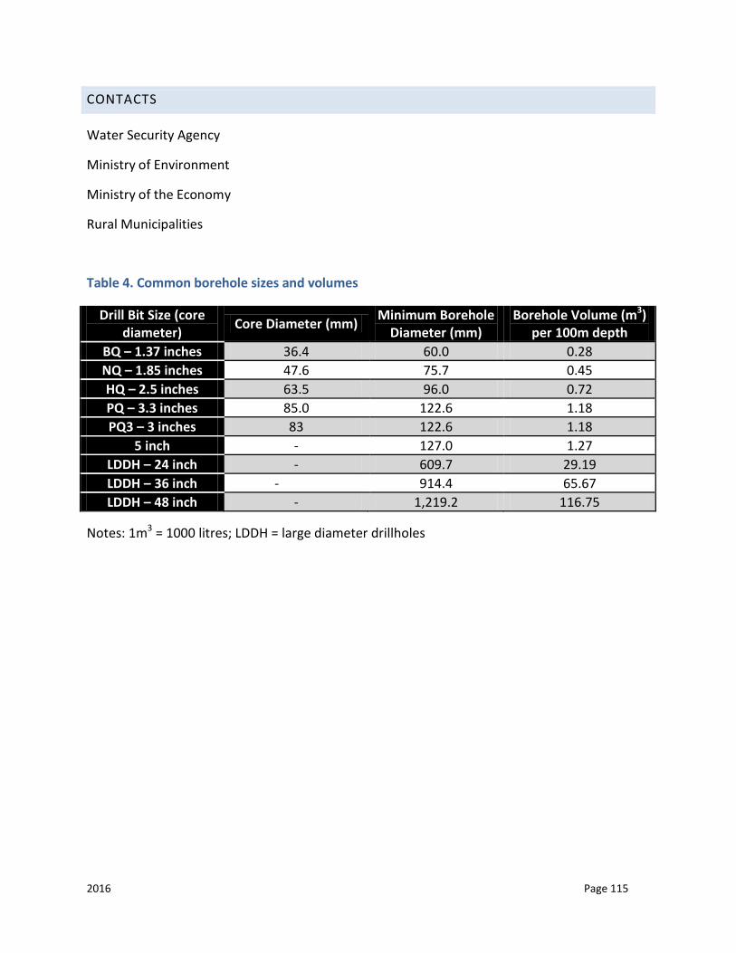
2016 Page 115
CONTACTS
Water Security Agency
Ministry of Environment
Ministry of the Economy
Rural Municipalities
Table 4. Common borehole sizes and volumes
Drill Bit Size (core diameter) Core Diameter (mm) Minimum Borehole
Diameter (mm) Borehole Volume (m3)
per 100m depth BQ – 1.37 inches 36.4 60.0 0.28 NQ – 1.85 inches 47.6 75.7 0.45 HQ – 2.5 inches 63.5 96.0 0.72 PQ – 3.3 inches 85.0 122.6 1.18 PQ3 – 3 inches 83 122.6 1.18
5 inch - 127.0 1.27 LDDH – 24 inch - 609.7 29.19 LDDH – 36 inch - 914.4 65.67 LDDH – 48 inch - 1,219.2 116.75
Notes: 1m3 = 1000 litres; LDDH = large diameter drillholes
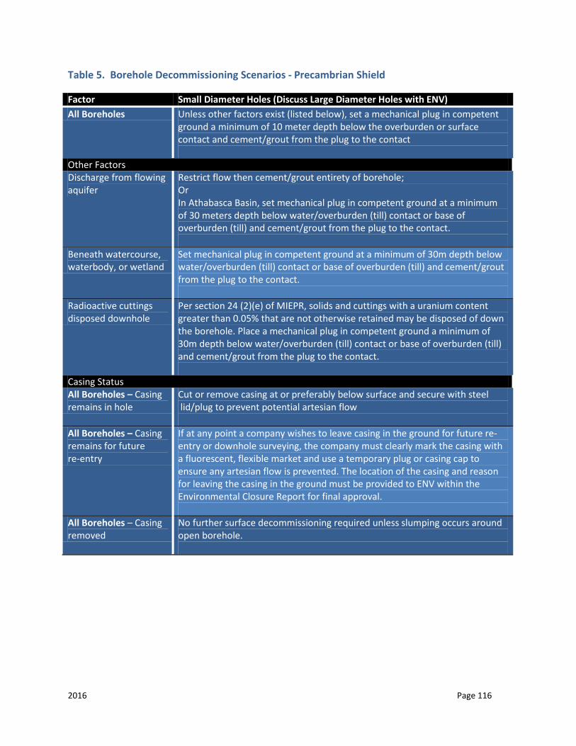
2016 Page 116
Table 5. Borehole Decommissioning Scenarios - Precambrian Shield
Factor Small Diameter Holes (Discuss Large Diameter Holes with ENV) All Boreholes Unless other factors exist (listed below), set a mechanical plug in competent
ground a minimum of 10 meter depth below the overburden or surface contact and cement/grout from the plug to the contact
Other Factors Discharge from flowing aquifer
Restrict flow then cement/grout entirety of borehole; Or In Athabasca Basin, set mechanical plug in competent ground at a minimum of 30 meters depth below water/overburden (till) contact or base of overburden (till) and cement/grout from the plug to the contact.
Beneath watercourse, waterbody, or wetland
Set mechanical plug in competent ground at a minimum of 30m depth below water/overburden (till) contact or base of overburden (till) and cement/grout from the plug to the contact.
Radioactive cuttings disposed downhole
Per section 24 (2)(e) of MIEPR, solids and cuttings with a uranium content greater than 0.05% that are not otherwise retained may be disposed of down the borehole. Place a mechanical plug in competent ground a minimum of 30m depth below water/overburden (till) contact or base of overburden (till) and cement/grout from the plug to the contact.
Casing Status All Boreholes – Casing remains in hole
Cut or remove casing at or preferably below surface and secure with steel lid/plug to prevent potential artesian flow
All Boreholes – Casing remains for future re-entry
If at any point a company wishes to leave casing in the ground for future re-entry or downhole surveying, the company must clearly mark the casing with a fluorescent, flexible market and use a temporary plug or casing cap to ensure any artesian flow is prevented. The location of the casing and reason for leaving the casing in the ground must be provided to ENV within the Environmental Closure Report for final approval.
All Boreholes – Casing removed
No further surface decommissioning required unless slumping occurs around open borehole.
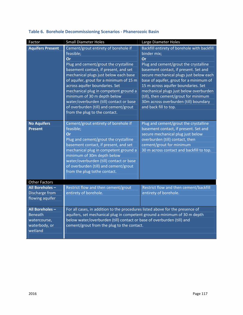
2016 Page 117
Table 6. Borehole Decommissioning Scenarios - Phanerozoic Basin
Factor Small Diameter Holes Large Diameter Holes Aquifers Present Cement/grout entirety of borehole if
feasible; Or Plug and cement/grout the crystalline basement contact, if present, and set mechanical plugs just below each base of aquifer, grout for a minimum of 15 m across aquifer boundaries. Set mechanical plug in competent ground a minimum of 30 m depth below water/overburden (till) contact or base of overburden (till) and cement/grout from the plug to the contact.
Backfill entirety of borehole with backfill binder mix; Or Plug and cement/grout the crystalline basement contact, if present. Set and secure mechanical plugs just below each base of aquifer, grout for a minimum of 15 m across aquifer boundaries. Set mechanical plugs just below overburden (till), then cement/grout for minimum 30m across overburden (till) boundary and back fill to top.
No Aquifers Present
Cement/grout entirety of borehole if feasible; Or Plug and cement/grout the crystalline basement contact, if present, and set mechanical plug in competent ground a minimum of 30m depth below water/overburden (till) contact or base of overburden (till) and cement/grout from the plug tothe contact.
Plug and cement/grout the crystalline basement contact, if present. Set and secure mechanical plug just below overburden (till) contact, then cement/grout for minimum 30 m across contact and backfill to top.
Other Factors All Boreholes – Discharge from flowing aquifer
Restrict flow and then cement/grout entirety of borehole.
Restrict flow and then cement/backfill entirety of borehole.
All Boreholes – Beneath watercourse, waterbody, or wetland
For all cases, in addition to the procedures listed above for the presence of aquifers, set mechanical plug in competent ground a minimum of 30 m depth below water/overburden (till) contact or base of overburden (till) and cement/grout from the plug to the contact.

2016 Page 118
Table 6 (cont’d). Borehole Decommissioning Scenarios - Phanerozoic Basin
Factor Small Diameter Holes Large Diameter Holes Casing Status All Boreholes – Casing remains for future re-entry
If a company wishes to leave casing in the ground for future re-entry or downhole surveying, the company must clearly mark the casing with a fluorescent, flexible market and use a temporary plug or casing cap to ensure any artesian flow is prevented. The location of the casing and reason for leaving the casing in the ground must be provided to ENV within the Environmental Closure Report for final approval.
If a company wishes to leave casing in the ground for future re-entry or downhole surveying, the company must seek approval from ENV.
All Boreholes – Casing remains in hole
For all cases, cut casing down to below surface and secure with steel lid. Cement/grout above and around annulus of casing down to 2 metres.
All Boreholes – Casing removed
No further surface decommissioning required unless slumping occurs around open borehole.
2016 Page 119
APPENDIX A: REQUIREMENTS FOR SEISMIC EXPLORATION UNDER THE SEISMIC EXPLORATION REGULATIONS, 1999
Once every five years, a seismic company must submit for approval to the Petroleum Development Branch of the Ministry of Economy a “Licence Application to Conduct Seismic Exploration” and for each employee who will handle, load, or detonate explosives in the course of their field operations an “Application for an Explosive Permit”.
The Seismic Exploration Regulations, 1999, defines “Field Operations” as “…any or all of the following activities carried out for the purposes of seismic exploration: surveying, drilling, blasting, operating vibrator equipment, and recording results.”
Prior to commencing field operations, the holder of a seismic exploration licence must:
Submit for approval to the Sedimentary Geo-data Unit of the Ministry of Economy a “Preliminary Plan” form, along with the original copy of a 1:50,000 scale map, for the proposed program. The preliminary plan must be submitted two weeks before commencing field operations and must include:
the name of the licence holder submitting the preliminary plan; the licence holder’s exploration licence number; the name and telephone number of the office contact; the program name; the expected number of line kilometers; the location of the program with references to
sections, townships, ranges, and meridians; the method of seismic exploration and the location and the justification of any shot
holes; and the location and justification for any charge to be placed more than 30 meters deep, or
on or above the surface. Notify, in writing, the Ministry of Economy and the applicable rural municipality of the
seismic field contractor, their exploration licence number, office contact, and telephone number (if not on the original plan submission).
If the preliminary plans are denied, address issues pointed out by the Ministry of Economy and re-submit the plans.
If the preliminary plans have been approved, submit a “Notice of Intent”, along with a copy of a 1:50,000 scale map, to all the agencies* that the Ministry of Economy identifies on the preliminary plans for their signature. The map must clearly indicate the location of the proposed seismic exploration, the proposed survey lines, the program
2016 Page 120
name, and the location of any shot holes. The company must also negotiate with private landowners for the right to access their land.
*These agencies include: SaskTel; TransGas Ltd.; TransCanada PipeLines; Foothills PipeLines; SaskEnergy; SaskPower; the Ministries of Highways and Infrastructure, Environment and Agriculture; applicable rural/urban municipalities; and First Nations.
After the agency has signed the “Notice of Intent”, the exploration licence holder must send one copy to the Ministry of Economy to be placed on the program file.
Field operations cannot commence until all notices have been signed and copies submitted to the Ministry of Economy. However, these agencies may have placed restrictions on the seismic program, and could direct the company to contact additional agencies at their discretion.
Deal with any land restrictions, and resolve any conflicts with the above agencies. The other three provincial regulators for seismic exploration (Ministries of Government Relations, Environment and Agriculture) have their own conditions, which companies wishing to conduct seismic exploration must follow. These are explained next.
MINISTRY OF PARKS, CULTURE, AND SPORT
The ministry is responsible for administering The Heritage Property Act, and in so doing, reviews seismic projects to determine their potential effects on heritage sties. The Ministry of Parks, Culture and Sport may require a heritage resource impact assessment to assess a project’s potential impact, and may require a proponent to carry our any further conservation, protection, or emergency salvage work that may be deemed appropriate.
The studies must be carried out by qualified heritage contractors under an investigation permit issued by the ministry. There is no fee for this permit. Once the Ministry of Parks, Culture and Sport is satisfied with the result of the assessment, they will advise the company, in writing, that there are no further heritage issues, and that the company may proceed with the exploration project.
The seismic company must submit a 1:50,000 National Topographic Series (NTS) series map and a “Notice of Intent” to the RM. The company can be required to pay for any damage to a road or to pay for any clean-up after the operation. A bond may also be required of the company by the RM to ensure that any remedial work will be done.

2016 Page 121
MINISTRY OF ENVIRONMENT AND MINISTRY OF AGRICULTURE
Notices of Intent for all seismic projects are submitted to the Ministry of Environment offices. All seismic programs should be submitted to the Ministry of Agriculture’s regional offices who will determine if Crown lands are involved.
The Ministry of Environment will review the proposal under:
• The Environmental Assessment Act; • The Wildlife Habitat Protection Act; • The Fisheries Act; • The Forest Resources Management Act; • The Provincial Lands Act; • The Environmental Management and Protection Act; and • The Wildlife Act.
If the project falls on land administered by the Ministry of Agriculture, it is reviewed under The Provincial Lands Act.
The offices of the Ministry of Environment and where applicable, the Ministry of Agriculture, review the “Notice of Intent.” If the work is proposed within a sensitive area or is extensive, or otherwise raises significant environmental concerns, the Ministry of Environment may request additional information such as a Project Proposal or an EPP.
The Ministry of Environment conducts an environmental review of the Notice of Intent. If more detailed review is not required, the ministry follows one of three processes:
On Ministry of Environment administered land, a permit for seismic exploration with appropriate conditions is issued.
On private land, the Ministry of Environment issues a letter outlining their environmental concerns (if any).
On Ministry of Agriculture administered land, the Ministry of Environment provides the Ministry of Agriculture with a list of conditions to be included in the authorization of the project.
The Ministry of Environment’s turnaround time for a permit (Environment administered land), a letter (private land), or notification to the appropriate Ministry of Agriculture regional office, is twenty working days; however, the average is less than five working days.
If the proposal involves the Ministry of Agriculture administered land, the company must get approval from the Ministry of Agriculture to proceed. Ministerial reviews happen

2016 Page 122
simultaneously and the Ministry of Agriculture’s approval includes the Ministry of Environment’s conditions regarding wildlife habitat and other environmental issues.
If the Crown land administered by the Ministry of Agriculture is under a lease or sale agreement, companies conducting seismic work must also negotiate compensation for right of entry, adverse effects, nuisance, and productivity loss with the lessee.
If the land is not under lease or sale agreement, companies conducting seismic work must obtain approval from the Ministry of Agriculture prior to entry.
Once the company has dealt with all the agencies and the program has been approved, the company may:
Cancel the seismic program and submit a “Notice of Cancellation” to the rural municipalities and the Ministry of Energy and Resources. The notice will inform of the cancellation date, the program number, and name, the seismic contractor, and the exploration licence number.
Make revisions to the seismic program. Any revisions which occur after the program
has been approved must be submitted along with a new program map to Ministry of Energy and Resources for approval. The company must show the revision number, the approved program name and number, and the new or deleted lines highlighted on the map.
If the revisions are approved, the company must also notify all the agencies previously
listed on the approved Preliminary Plan of the revisions. The company must also inform private land owner or Crown lessees, as well as any additional agencies which may be identified as a result of the revisions.
If the revisions are denied, the company may address any issues identified by the Ministry of Economy and re-submit its revisions to Ministry of Economy for approval.
Commence field operations.
Once the company has completed its field operations it submits:
A “Notice of Completion of Seismic Operations” must be submitted to the rural municipality within 72 hours of completion of field operations. The form has to be signed by the administrator of the municipality. The exploration licence holder will forward a copy to the Ministry of Energy and Resources to place on the program file.
A “Final Report of Seismic Exploration” must be submitted, along with one copy of the
final shot point map and ground elevations, to Ministry of Energy and Resources within 60 days of completion of field operations. The seismic contractor who performed the field operations is responsible for submitting the final report. If the Ministry of Energy and Resources has not received a final report by April 1 of the year following the one in

2016 Page 123
which the program was approved, no further plans will be approved under that exploration licence until the delinquent “Final Plans” have been received and approved.
A final report is also submitted to the Ministry of Agriculture or the Ministry of
Environment (depending on who manages the land) within 60 days of competition of the project.
2016 Page 124
APPENDIX B: CLOSURE REPORT
The Ministry of Environment may require a Closure Report at the conclusion of a permitted mineral exploration program. This information is an invaluable tool for historical and potential future site uses by the Ministry of Environment and related departments.
A Closure Report identifies any exceptions or deviations from the proposed plans. The Closure Report should contain sufficient detail so as to give department staff an understanding of actual and potential environmental and surface impacts that occurred during the permitted mineral exploration program.
Format for the Closure Report is up to the applicant, but should include the following information:
A general summary of the operational activities that have occurred. Photographs of the activities (i.e. Temporary Work Camps, reclaimed drill pads, etc.); Maps of activities and the locations; Issues and their remedies, during the exploration program.
o identify implemented changes in the program. o identify authorization for changes.
Public interactions, concerns and resolutions. Report on special requirements identified in the permit.
o wildlife sightings of significant concern; and o potential heritage sites identified.
Reclamation and remediation activities and their status at program completion. Outstanding issues pertinent to the program or site. Sites of all core storage and improvements. It must be noted that any radioactive core
storage sites must be discussed with the Ministry of Environment. Future program improvement recommendations. Schedule of future site activities if known.
The Closure Report must be sent to the Ministry of Environment within 30 days of the expiry of the permit or as specified in the applicable permit. When the Closure Report is sent to the Ministry of Environment, a final inspection may be scheduled with the applicant.
For programs that require water withdrawal (i.e. drilling), the proponent must submit the water usage information to the Water Security Agency.
2016 Page 125
APPENDIX C: RELATED MINISTRY OF ENVIRONMENT LEGISLATION AND GUIDELINES FOR SURFACE MINERAL EXPLORATION
Copies of provincial acts and regulations can be obtained online at: www.qp.gov.sk.ca/
The Clean Air Act and Regulations
The Environmental Assessment Act
The Environmental Management and Protection Act, 2010
The Hazardous Substances and Waste Dangerous Goods Regulations
The Mineral Industry Environmental Protection Regulations, 1996
Municipal Refuse Management Regulations
Used Oil Collection Regulations
The Fisheries Act and Regulations
The Forest Resources Management Act and Regulations
The Government Organization Act
The Department of Environment Regulations
The Heritage Property Act
The Litter Control Act
The Parks Act and Regulations
The Provincial Lands Act
The Resource Lands Regulations, 1989
The Wildlife Act and Regulations
The Wildlife Habitat Protection Act
The Wildlife Habitat Lands Disposition and Alteration Regulations
The Wildfire Act
The Conservation Easement Act and Regulations
2016 Page 126
The Ecological Reserves Act
The Provincial Ecological Reserves Regulations
The Representative Area Ecological Reserves Regulations
The Public Health Act, 1994
The Occupational Health and Safety Regulations, 1996
GUIDELINES AND REFERENCE MATERIAL
Native Species Recommended for Site Restoration within the Mid-Boreal Upland, Mid-Boreal Lowland and Boreal Transition Ecoregions of Saskatchewan
Species of Concern List. Ministry of Environment
Freshwater Intake End-of-Pipe Fish Screen Guideline. Communications Directorate. DFO. 1995. A copy of this document may be obtained online at: freshwater_intake.pdf
Location Conversion site www.mapquest.ca/
2016 Page 127
APPENDIX D: OTHER REGULATORY REQUIREMENTS AND WEBLINKS
The following is a list of regulatory agencies that may need to be contacted for program approvals:
MINISTRY OF ENVIRONMENT
www.saskatchewan.ca/environment
Conservation Data Centre http://www.biodiversity.sk.ca To access the logon page for the CDC check
http://gisweb1.serm.gov.sk.ca/wildlifelogin/form.asp Recycling and disposal depot locations: http://www.saskwastereduction.ca
Guidelines for Preparation of an EPP for Oil and Gas Projects: http://www.environment.gov.sk.ca/EPP Guidelines
Government of Saskatchewan First Nation and Métis Consultation Policy Framework http://www.saskatchewan.ca/residents/first-nations-citizens/duty-to-consult-first-
nations-and-metis-communities#duty-to-consult Proponent Handbook http://www.saskatchewan.ca/residents/first-nations-citizens/duty-to-consult-first-
nations-and-metis-communities#proponents-and-the-duty-to-consult
MINISTRY OF ECONOMY
www.saskatchewan.ca/economy
Assessment Geologist (For drilling in the Western Canada Sedimentary Basin) (Regina): (306) 787-2564
List of Publications: http://www.publications.gov.sk.ca/Energy and Resources
2016 Page 128
MINISTRY OF PARKS, CULTURE AND SPORT
www.saskatchewan.ca/pcs
Provincial Heritage Resources Branch contact information: Phone: (306) 787-8157 Fax: (306) 787- 0069 The Land Developers Screening Tool: http://www.pcs.gov.sk.ca/landsearch List of Archaeological Consultants: http://www.tpcs.gov.sk.ca/consultantslist
MINISTRY OF LABOUR RELATIONS AND WORKPLACE SAFETY
https://www.saskatchewan.ca/government/government-structure/ministries/labour-relations-and-workplace-safety
Phone: 1-800-667-5023
MINISTRY OF AGRICULTURE
www.saskatchewan.ca/agriculture
Petroleum and Gas Development on Agriculture Crown Land: www.saskatchewan.ca/business/agriculture-natural-resources-and-industry/oil-and-gas
MINISTRY OF HEALTH
www.saskatchewan.ca/health
Contact the Public Health Inspector for any work camp requirements or approvals.
La Ronge (306) 425-8523
Meadow Lake (306) 236-1576
Buffalo Narrows (306) 235-5811
Prince Albert (306) 765-6605
2016 Page 129
MINISTRY OF GOVERNMENT RELATIONS
www.saskatchewan.ca/government/municipal-administration
Zoning Districts and Bylaws: http://www.saskatchewan.ca/government/municipal-administration/community-planning-land-use-and-development/zoning-districts-and-bylaws
Subdivision zoning and use: http://www.saskatchewan.ca/government/municipal-
administration/community-planning-land-use-and-development/subdivision-zoning-and-land-use
MINISTRY OF HIGHWAYS AND INFRASTRUCTURE
www.highways.gov.sk.ca
Phone: (306) 787-5307 For online information sheets on hazardous materials:
http://www.msdssearch.com/DBLinksN.htm
MINISTRY OF JUSTICE AND ATTORNEY GENERAL
www.saskatchewan.ca/justice
Phone: (306) 787-2962
INFORMATION SERVICES CORPORATION – CORPORATE REGISTRY
www.isc.ca/corporateregistry
WATER SECURITY AGENCY
www.wsask.ca
Nipawin Regional Services Office o Phone: (306) 862-1750 o Fax: (306) 862-1771
2016 Page 130
North Battleford Regional Services
o Phone: (306) 446-7450 o Fax: (306) 446-7461
Application forms: https://www.wsask.ca/Permits-and-Approvals/
FISHERIES AND OCEANS CANADA
www.dfo-mpo.gc.ca
Requirements for projects near water: http://www.dfo-mpo.gc.ca/pnw-ppe/index-eng.html
Measures to Avoid Causing Harm to Fish and Fish Habitat: http://www.dfo-mpo.gc.ca/pnw-ppe/measures-mesures/measures-mesures-eng.html
Freshwater Intake End-of-Pipe Fish Screen Guidelines: http://www.dfo-mpo.gc.ca/habitat/role/141/1415/14155/pipe/index-eng.asp
ENVIRONMENT CANADA
www.ec.gc.ca
Species at Risk Act: http://www.sararegistry.gc.ca/default_e.cfm Spills in water bodies, watercourses on federal lands, or with interprovincial
implications: Environmental Emergency Regulations can be found at:
http://canadagazette.gc.ca or http://www.ec.gc.ca/lcpe-cepa/
NATURAL RESOURCES CANADA
www.nrcan.gc.ca
Main contact information: Phone: (403) 292-4766
2016 Page 131
Administers The Explosives Act and Regulations. They issue licences, certificates and permits to ensure the safety of the public and workers associated with the explosives industry:
http://www.nrcan.gc.ca/acts and regulations Mining Information Kit for Aboriginal Communities: http://www.nrcan-
rncan.gc.ca/mms-smm/abor-auto/htm/kit-toc/kit-res-eng.htm
TRANSPORT CANADA
www.tc.gc.ca
Transport Canada/Natural Resources Canada jointly control and enforce Transportation of Dangerous Goods Acts and Regulations, which is federal legislation.
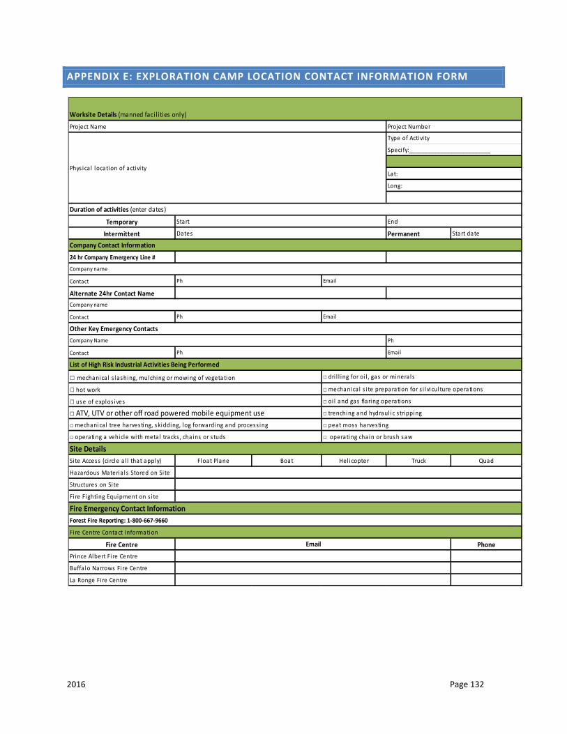
2016 Page 132
APPENDIX E: EXPLORATION CAMP LOCATION CONTACT INFORMATION FORM
Temporary
Intermittent Permanent Start date
24 hr Company Emergency Line #
Contact
Alternate 24hr Contact Name
Contact
Contact
Si te Access (ci rcle a l l that apply) Float Plane Boat Hel icopter Truck Quad
Hazardous Materia ls Stored on Si te
Structures on Si te
Fi re Fighting Equipment on s i te
Fire Centre PhonePrince Albert Fi re Centre
Buffa lo Narrows Fi re Centre
La Ronge Fi re Centre
Fire Emergency Contact InformationForest Fire Reporting: 1-800-667-9660
Fi re Centre Contact Information
□ operating a vehicle with meta l tracks , cha ins or s tuds □ operating chain or brush saw
Site Details
□ use of explos ives □ oi l and gas flaring operations
□ ATV, UTV or other off road powered mobile equipment use □ trenching and hydraul ic s tripping
□ mechanica l tree harvesting, skidding, log forwarding and process ing □ peat moss harvesting
Ph Email
List of High Risk Industrial Activities Being Performed
□ mechanica l s lashing, mulching or mowing of vegetation □ dri l l ing for oi l , gas or minera ls
□ hot work □ mechanica l s i te preparation for s i lvicul ture operations
Company name
Ph Email
Other Key Emergency ContactsCompany Name Ph
Company name
Ph Email
Duration of activities (enter dates)
Start End
Dates
Company Contact Information
Worksite Details (manned facil ities only)
Project Name Project Number
Phys ica l location of activi ty
Type of Activi ty
Speci fy:__________________________
Lat:
Long:
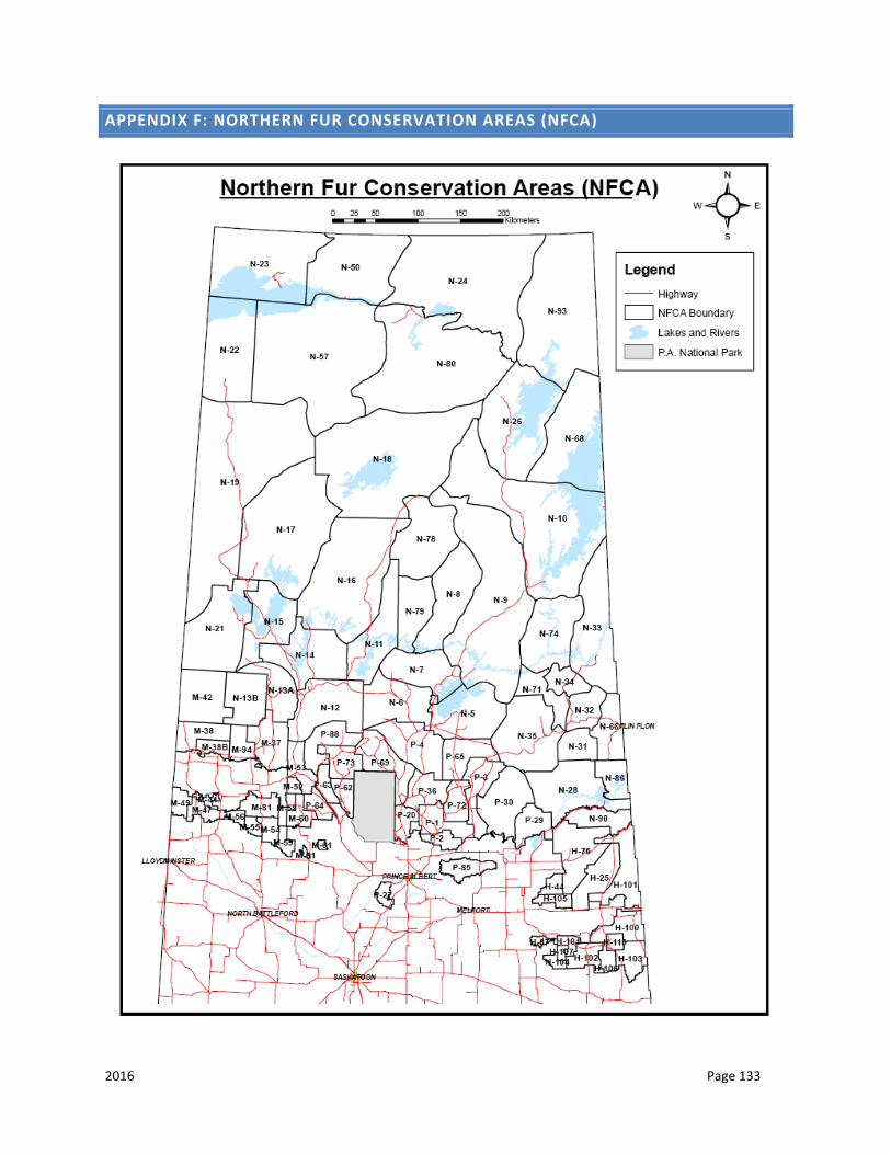
2016 Page 133
APPENDIX F: NORTHERN FUR CONSERVATION AREAS (NFCA)
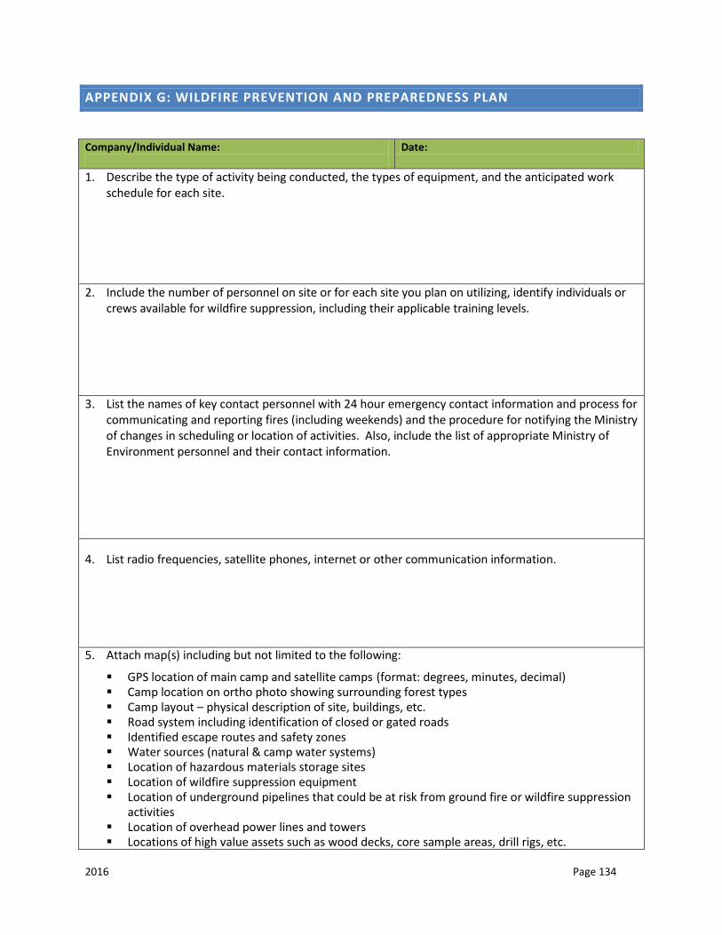
2016 Page 134
APPENDIX G: WILDFIRE PREVENTION AND PREPAREDNESS PLAN
Company/Individual Name:
Date:
1. Describe the type of activity being conducted, the types of equipment, and the anticipated work schedule for each site.
2. Include the number of personnel on site or for each site you plan on utilizing, identify individuals or
crews available for wildfire suppression, including their applicable training levels. 3. List the names of key contact personnel with 24 hour emergency contact information and process for
communicating and reporting fires (including weekends) and the procedure for notifying the Ministry of changes in scheduling or location of activities. Also, include the list of appropriate Ministry of Environment personnel and their contact information.
4. List radio frequencies, satellite phones, internet or other communication information.
5. Attach map(s) including but not limited to the following: GPS location of main camp and satellite camps (format: degrees, minutes, decimal) Camp location on ortho photo showing surrounding forest types Camp layout – physical description of site, buildings, etc. Road system including identification of closed or gated roads Identified escape routes and safety zones Water sources (natural & camp water systems) Location of hazardous materials storage sites Location of wildfire suppression equipment Location of underground pipelines that could be at risk from ground fire or wildfire suppression
activities Location of overhead power lines and towers Locations of high value assets such as wood decks, core sample areas, drill rigs, etc.
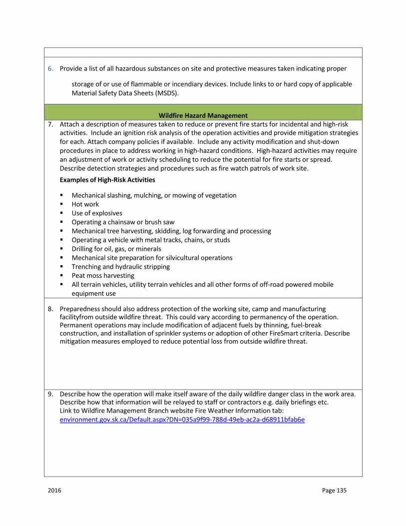
2016 Page 135
6. Provide a list of all hazardous substances on site and protective measures taken indicating proper
storage of or use of flammable or incendiary devices. Include links to or hard copy of applicable Material Safety Data Sheets (MSDS).
Wildfire Hazard Management 7. Attach a description of measures taken to reduce or prevent fire starts for incidental and high-risk
activities. Include an ignition risk analysis of the operation activities and provide mitigation strategies for each. Attach company policies if available. Include any activity modification and shut-down procedures in place to address working in high-hazard conditions. High-hazard activities may require an adjustment of work or activity scheduling to reduce the potential for fire starts or spread. Describe detection strategies and procedures such as fire watch patrols of work site. Examples of High-Risk Activities
Mechanical slashing, mulching, or mowing of vegetation Hot work Use of explosives Operating a chainsaw or brush saw Mechanical tree harvesting, skidding, log forwarding and processing Operating a vehicle with metal tracks, chains, or studs Drilling for oil, gas, or minerals Mechanical site preparation for silvicultural operations Trenching and hydraulic stripping Peat moss harvesting All terrain vehicles, utility terrain vehicles and all other forms of off-road powered mobile
equipment use
8. Preparedness should also address protection of the working site, camp and manufacturing facilityfrom outside wildfire threat. This could vary according to permanency of the operation. Permanent operations may include modification of adjacent fuels by thinning, fuel-break construction, and installation of sprinkler systems or adoption of other FireSmart criteria. Describe mitigation measures employed to reduce potential loss from outside wildfire threat.
9. Describe how the operation will make itself aware of the daily wildfire danger class in the work area.
Describe how that information will be relayed to staff or contractors e.g. daily briefings etc. Link to Wildfire Management Branch website Fire Weather Information tab: environment.gov.sk.ca/Default.aspx?DN=035a9f99-788d-49eb-ac2a-d68911bfab6e
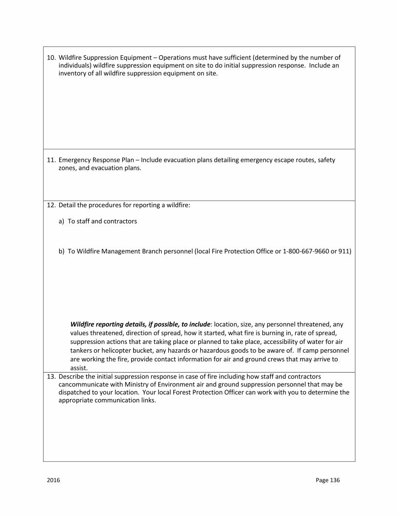
2016 Page 136
10. Wildfire Suppression Equipment – Operations must have sufficient (determined by the number of individuals) wildfire suppression equipment on site to do initial suppression response. Include an inventory of all wildfire suppression equipment on site.
11. Emergency Response Plan – Include evacuation plans detailing emergency escape routes, safety zones, and evacuation plans.
12. Detail the procedures for reporting a wildfire:
a) To staff and contractors
b) To Wildfire Management Branch personnel (local Fire Protection Office or 1-800-667-9660 or 911)
Wildfire reporting details, if possible, to include: location, size, any personnel threatened, any values threatened, direction of spread, how it started, what fire is burning in, rate of spread, suppression actions that are taking place or planned to take place, accessibility of water for air tankers or helicopter bucket, any hazards or hazardous goods to be aware of. If camp personnel are working the fire, provide contact information for air and ground crews that may arrive to assist.
13. Describe the initial suppression response in case of fire including how staff and contractors cancommunicate with Ministry of Environment air and ground suppression personnel that may be dispatched to your location. Your local Forest Protection Officer can work with you to determine the appropriate communication links.

2016 Page 137
14. Provide a description of the personnel resources available for wildfire suppression, the training standards and requirements to be met by those personnel and an inventory of fire suppression equipment available.
Other Conditions Any burning during the wildfire season from April 1-October 31 within the wildfire management area will require a burn notification number. Burning of debris/slash may require a resource management burn plan. Contact the local Forest Protection Officer to determine if one is required. A Forest Protection Officer may describe additional precautions or special conditions pertaining to any given situation.
Date Received: ________________________________________________________________