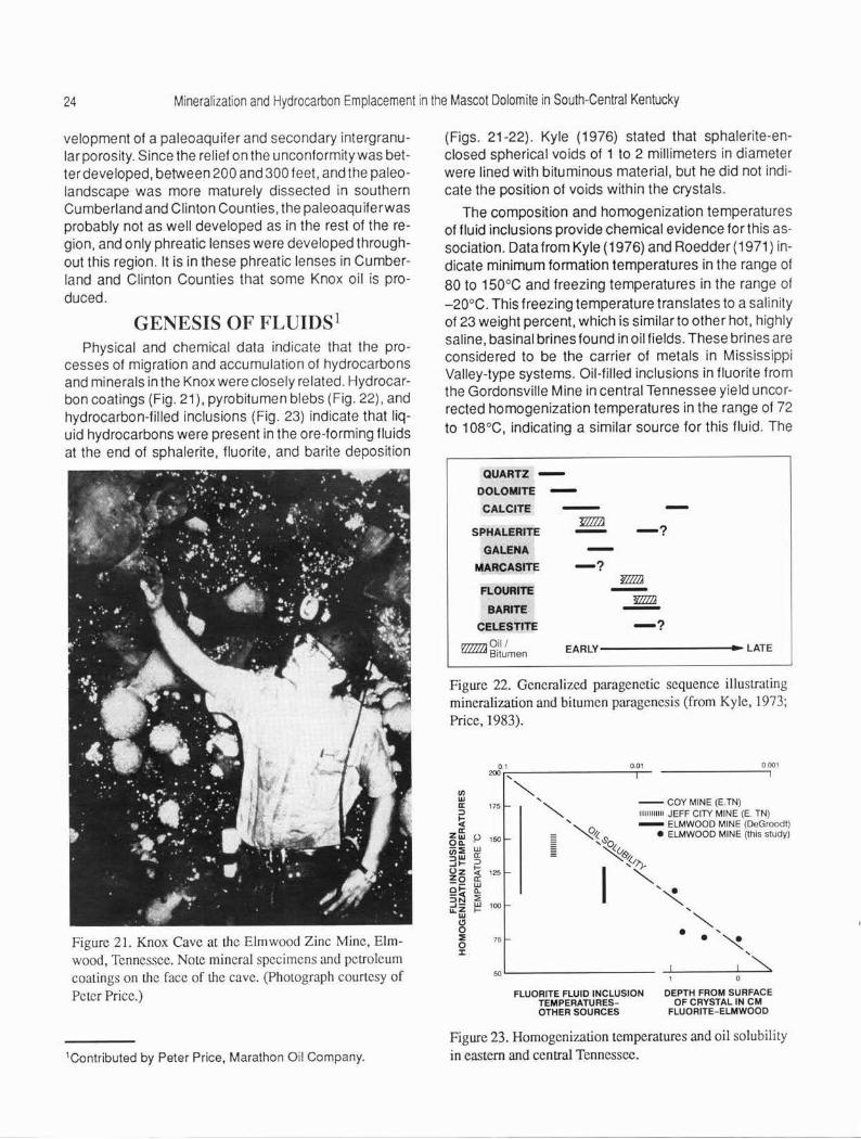
mineralization and hydrocarbon emplacement in the cambrian
TRANSCRIPT

University of KentuckyUKnowledge
Kentucky Geological Survey Report ofInvestigations Kentucky Geological Survey
1991
Mineralization and Hydrocarbon Emplacement inthe Cambrian-Ordovician Mascot Dolomite of theKnox Group in South-Central KentuckyWarren H. AndersonUniversity of Kentucky
Right click to open a feedback form in a new tab to let us know how this document benefits you.
Follow this and additional works at: https://uknowledge.uky.edu/kgs_ri
Part of the Geology Commons
This Report is brought to you for free and open access by the Kentucky Geological Survey at UKnowledge. It has been accepted for inclusion inKentucky Geological Survey Report of Investigations by an authorized administrator of UKnowledge. For more information, please [email protected].
Repository CitationAnderson, Warren H., "Mineralization and Hydrocarbon Emplacement in the Cambrian-Ordovician Mascot Dolomite of the KnoxGroup in South-Central Kentucky" (1991). Kentucky Geological Survey Report of Investigations. 44.https://uknowledge.uky.edu/kgs_ri/44
KENTUCKY GEOLOGICAL SURVEY Donald C. Haney, State Geologist and Director
UNIVERSITY OF KENTUCKY, Lexington
ISSN 0075-5591
MINERALIZATION AND HYDROCARBON EMPLACEMENT IN THE CAMBRIAN-ORDOVICIAN MASCOT DOLOMITE OF THE KNOX GROUP IN SOUTH-CENTRAL KENTUCKY
REPORT OF INVESTIGATIONS 4 Series XI, 1991
Warren H. Anderson with contributions by Peter Pr ice
https://doi.org/10.13023/kgs.ri04.11
KENTUCKY GEOLOGICAL SURVEY Donald C. Haney, State Geologist and Director
UNIVERSITY OF KENTUCKY Lexington, Kentucky
MINERALIZATION AND HYDROCARBON EMPLACEMENT IN THE CAMBRIANORDOVICIAN MASCOT DOLOMITE OF THE KNOX GROUP IN SOUTH-CENTRAL KENTUCKY
REPORT OF INVESTIGATIONS 4 Series XI, 1991
Warren H. Anderson with contributions by Peter Price
ISSN 0075-5591 https://doi.org/10.13023/kgs.ri04.11

UNIVERSITY OF KENTUCKY Charles T. Wethington. Jr., President Leonard K. Peters. Acting Vice President for Re
search and Graduate Studies Jack Supplee, Director. Fiscal Affairs and Sponsored
Project Administration
KENTUCKY GEOLOGICAL SURVEY ADVISORY BOARD Steve Cawood, Chairman, Pineville John Berry, Jr., Turners Station Larry R. Finley, Henderson Hugh B. Gabbard, Winchester Kenneth Gibson, Madisonville Wallace W. Hagan, Lexington Phil M. Miles. Lexington W. A. Mossbarger, Lex;ngton Henry A Spalding, Hazard Ralph N. Thomas, Owensboro George H. Warren, Jr., Owensboro David A. Zegeer, Lexington
KENTUCKY GEOLOGICAL SURVEY Donald C. Haney, State Geologist and Director John 0. Kiefer. Assistant State Geologist for Adminis
tration James C. Cobb, Assistant State Geologist for Re-
search
ADMINISTRATIVE DIVISION
Personnel and Finance Section: James L. Hamilton, Administrative Staff Officer II Margaret A. Fernandez, Account Clerk V
Clerical Section: Marilyn J. Wooten , Staff Assistant VII Jody L. Fox, Staff Assistant VI Shirley D. Dawson. Staff Assistant V Eugenia E. Kelley, Staff Assistant V Juanita G. Smith, Staff Assistant V, Henderson Office
Publlcatlons Section: Donald W. Hutcheson, Head Margaret Luther Smath, Geologic Editor Ill Terry D. Hounshell, Chief Cartographic Illustrator Richard A. Smath, Geologist Ill, ESIC Coordinator Robert C. Holladay, Principal Drafting Technician Michael L. Murphy, Drafting Technician William A. Briscoe, Ill, Publication Sales Supervisor Roger S. Banks, Account Clerk II Kenneth Otis, Stores Worker
GEOLOGICAL DIVISION
Coal and Minerals Section: James C. Cobb, Head Garland R. Dever, Jr., Geologist VII Eugene J. Amaral, Geologist V Donald R. Chesnut, Jr .. Geologist V Cortland F. Eble, Geologist V David A. Williams, Geologist V. Henderson Office Warren H. Anderson, Geologist IV 0 . Barton Davidson, Geologist Ill Stephen F. Greb, Geologist Ill
Petroleum and Stratigraphy Section: James A . Drahovzal, Head Martin C. Noger, Geologist VI Terence Hamilton-Smith, Geologist V Patrick J. Gooding, Geologist IV David Harris, Geologist IV Brandon C. Nuttall, Geologist IV Dan Walker, Post-Doctoral Scholar Robert R. Daniel , Laboratory Technician B David E. McFadden, Senior Laboratory Assistant Frances Benson, Staff Assistant IV Luanne Davis, Staff Assistant IV
Theola Evans. Staff Assistant IV
Water Resources Section: James S. Dinger, Head Daniel I. Carey, Hydrologist IV James A. Kipp, Geologist IV Alex Fogle , Hydro logist IV James C. Currens. Geologist IV David R. Wunsch, Geologist Ill Philip G. Conrad, Geologist II Dwayne Keagy, Geologist II Shelley Minns, Research Analyst
Computer and Laboratory Services Section: Steven J. Cordiviola, Head Richard E. Sergeant, Geologist V Joseph B. Dixon, Systems Programmer Henry E. Francis, Associate Scientist Zhalet Baharestan, Senior Research Analyst Xenia Culbertson, Research Analyst Leonor Lopez-Froedge, Research Analyst Samir Najm, Research Analyst Edward H. Heeg, Senior Laboratory Technician Steven Mock, Senior Laboratory Technician Mark F. Thompson, Senior Laboratory Technician

CONTENTS
Page
Abstract
Introduction . . . . . . . . . . . . . . . . . . . . . . . . . . . . . . . . . . . . . . . . . . . . . . . . . . . . . . . . . . . . . . . . . 1
Regional Geology and Structure . . . . . . . . . . . . . . . . . . . . . . . . . . . . . . . . . . . . . . . . . . . . . . . . . 3
Stratigraphy . . . . . . . . . . . . . . . . . . . . . . . . . . . . . . . . . . . . . . . . . . . . . . . . . . . . . . . . . . . . . . . . . 4
Petrography . . . . . . . . . . . . . . . . . . . . . . . . . . . . . . . . . . . . . . . . . . . . . . . . . . . . . . . . . . . . . . . . . 8
Unconformity, Paleotopography, and Brecciation . .. . . . . . .. . . .. .... ..... .. ... . . . .. . ... 11
Remote Sensing . . . . . . . . . . . . . . . . . . . . . . . . . . . . . . . . . . . . . . . . . . . . . . . . . . . . . . . . . . . . . 14
Diagenesis and Paleoenvironmental History . . . . . . . . . . . . . . . . . . . . . . . . . . . . . . . . . . . . . . . 18
Economic Geology . . . . . . . . . . . . . . . . . . . . . . . . . . . . . . . . . . . . . . . . . . . . . . . . . . . . . . . . . . . 20
Minerals . . . . . . . . . . . . . . . . . . . . . . . . . . . . . . . . . . . . . . . . . . . . . . . . . . . . . . . . . . . . . . . . . 20
Burkesville Deposit . . . . . . . . . . . . . . . . . . . . . . . . . . . . . . . . . . . . . . . . . . . . . . . . . . . . . . 21
Fountain Run Deposit . . . . . . . . . . . . . . . . . . . . . . . . . . . . . . . . . . . . . . . . . . . . . . . . . . . . 22
Fluid Migration . . . . . . . . . . . . . . . . . . . . . . . . . . . . . . . . . . . . . . . . . . . . . . . . . . . . . . . . . . 22
Spectrography . . . . . . . . . . . . . . . . . . . . . . . . . . . . . . . . . . . . . . . . . . . . . . . . . . . . . . . . . . 22
Petroleum . . . . . . . . . . . . . . . . . . . . . . . . . . . . . . . . . . . . . . . . . . . . . . . . . . . . . . . . . . . . . . . 23
Genesis of Fluids . . . . . . . . . . . . . . . . . . . . . . . . . . . . . . . . . . . . . . . . . . . . . . . . . . . . . . . . . . . . 24
Conclusions . . . . . . . . . . . . . . . . . . . . . . . . . . . . . . . . . . . . . . . . . . . . . . . . . . . . . . . . . . . . . . . . 25
Acknowledgments . . . . . . . . . . . . . . . . . . . . . . . . . . . . . . . . . . . . . . . . . . . . . . . . . . . . . . . . . . . 27
References Cited . . . . . . . . . . . . . . . . . . . . . . . . . . . . . . . . . . . . . . . . . . . . . . . . . . . . . . . . . . . . 27
Appendix A: Description of Coastal Mining Company Core D-11, Clinton County, Kentucky . . 30

ILLUSTRATIONS
Plate
1. Stratigraphic cross section of Mascot Dolomite, upper Knox Group, Monroe, Cumberland, and Clinton Counties, Kentucky ............................. In Pocket
2. Paleotopographic map on top of the Knox Dolomite in Cumberland, Clinton, and Monroe Counties, Kentucky ... . ....................................... In Pocket
Fi~re h~ 1. Location of study area and tectonic map of Kentucky . . . . . . . . . . . . . . . . . . . . . . . . . . . . . 2 2. Study area, major zinc deposits, and location of cross section and limestone-dolomite
interface for this study . . . . . . . . . . . . . . . . . . . . . . . . . . . . . . . . . . . . . . . . . . . . . . . . . . . . . 2 3. Photomicrograph of Mascot Dolomite . . . . . . . . . . . . . . . . . . . . . . . . . . . . . . . . . . . . . . . . . 4 4. Photograph of color-infrared imagery of the study area . . . . . . . . . . . . . . . . . . . . . . . . . . . 5 5. Paleolineament map of the top of the Knox in south-central Kentucky . . . . . . . . . . . . . . . . 6 6. Generalized columnar section of the Knox Group and adjacent units in south-central
Kentucky ...... . .. ............... ........................................ 7 7. Location of northeast cross section, showing correlation of marker beds with the
Gradyville Oil Field in Adair County . . . . . . . . . . . . . . . . . . . . . . . . . . . . . . . . . . . . . . . . . . . 8 8. Mine face in the Burkesville exploration shaft . . . . . . . . . . . . . . . . . . . . . . . . . . . . . . . . . . . 9 9. Stromatolites at Shark Bay, Australia . . . . . . . . . . . . . . . . . . . . . . . . . . . . . . . . . . . . . . . . . 10
1 O. Photomicrograph of the Mascot Dolomite . . . . . . . . . . . . . . . . . . . . . . . . . . . . . . . . . . . . . 1 O 11 . Photomicrograph of the Mascot Dolomite .. .. . ........ . ........................ 11
12. Photomicrograph of the Mascot Dolomite . . . . . . . . . . . . . . . . . . . . . . . . . . . . . . . . . . . . . 12 13. Photomicrograph of the Mascot Dolomite . . . . . . . . . . . . . . . . . . . . . . . . . . . . . . . . . . . . . 13 14. Photomicrograph of the Mascot Dolomite .... . ................................ 14 15. Breccia systems in the Knox . . . . . . . . . . . . . . . . . . . . . . . . . . . . . . . . . . . . . . . . . . . . . . . 15 16. Core slab of Mascot Dolomite . . . . . . . . . . . . . . . . . . . . . . . . . . . . . . . . . . . . . . . . . . . . . . 15 17. Regional lineament analysis showing location of oil fields and the Cominco American, Inc.,
exploration shaft . . . . . . . . . . . . . . . . . . . . . . . . . . . . . . . . . . . . . . . . . . . . . . . . . . . . . . . . . 16 18. Local lineament analysis of the Burkesville, Kentucky, area . . . . . . . . . . . . . . . . . . . . . . . 17 19. Mascot Dolomite with sphalerite and sand grains in a finely crystalline dolomite . . . . . . . 20 20. Schematic cross section of major ore horizons in the Knox Group in central and eastern
Tennessee and south- central Kentucky . . . . . . . . . . . . . . . . . . . . . . . . . . . . . . . . . . . . . . 21 21. Knox Cave at the Elmwood Zinc Mine, Elmwood, Tennessee . . . . . . . . . . . . . . . . . . . . . . 24 22. Generalized paragenetic sequence . . . . . . . . . . . . . . . . . . . . . . . . . . . . . . . . . . . . . . . . . . 24 23. Homogenization temperatures and oil solubility in eastern and central Tennessee . . . . . . 24
TABLES
Table Page
1 . Paleochronology of the Knox Dolomite . . . . . . . . . . . . . . . . . . . . . . . . . . . . . . . . . . . . . . . 19 2. Trace-Element Analysis of Sphalerite from the Knox in South-Central Kentucky . . . . . . . 22
MINERALIZATION AND HYDROCARBON EMPLACEMENT IN THE CAMBRIAN-ORDOVICIAN
MASCOT DOLOMITE OF THE KNOX GROUP IN SOUTH-CENTRAL KENTUCKY
Warren H. Anderson with contributions by
Peter Price
ABSTRACT
The Mascot Dolomite, the upper unit of the Cambrian-Ordovician Knox Group, is a major host for Mississippi Valley-type ore deposits and petroleum in south-central Kentucky. The Mascot was deposited on a broad, shallow platform that exhibited unusually uniform conditions of deposition, ranging from supratidal to shallow subtidal environments. The formation has a complex diagenetic history, including several stages of dolomitization, silicification, solution, and brecciation. Diagenesis and, to some extent, deposition were influenced by Early Ordovician tectonic activity. Tectonic activity influenced development of a regional unconformity during Middle Ordovician time. Evidence of this tectonic activity includes up to 300 feet of erosional relief on the Mascot surface and thinning in the interval between the internal marker beds across the Cincinnati and Waverly Arches.
The development of an erosional unconformity at the top of the Knox Group and its resulting paleoaquifer and karst system created diagenetic changes, migration avenues, and solution-collapse breccias that controlled subsequent fluid migration and accumulations of base metals and hydrocarbons. The location of breccia-hosted ores was influenced by major and minor structural features and paleotopography. Breccia development is related to the presence and subsequent dissolution of limestone (now represented by dolomite) and a dolomite-limestone transition zone. Base-metal mineralization (dominantly sphalerite) is associated with late-stage brecciation and stromatolitic units, which commonly are silicified.
Several oil pools produce from Knox paleotopographic highs, and production seems to be related to the presence of fractures and diagenetically enhanced porosity. A distinct positive relationship exists between ore and petroleum accumulation. Locations of ore deposits are related to circular features that can be recognized on remotely sensed Landsat imagery, and areas of petroleum accumulation appear to be related to paleolinear trends.
INTRODUCTION The carbonate rocks of the Cambrian-Ordovician
Knox Group in south-central Kentucky are a host for Mississippi Valley-type ore deposits and petroleum. Since the discovery of the Gradyville Oil Field in Adair County, Kentucky, in 1962, and the Elmwood Zinc Deposit in central Tennessee in 1967, mining and oil companies have conducted extensive exploratory drilling for zinc and petroleum in the Knox of south-central Kentucky (Figs. 1-2). During the past two decades, two major zinc deposits and several oil fields have been discovered in
the Knox. In 1976, Cominco American, Inc. , American Smelting and Refining Company (ASARCO), and National Lead Industries jointly opened an exploration shaft near Burkesville in Cumberland County, Kentucky, to examine the potential for mining one of the zinc deposits. A combination of economic conditions and mining problems forced the closing of the shaft in 1979. Because of economic factors, zinc exploration activity is sporadic, but exploration for oil continues in south-central Kentucky. As this publication goes to press, Cypress Metals Company is exploring in southern Kentucky.

2 Mineralization and Hydrocarbon Emplacement in the Mascot Dolomite in South-Central Kentucky
Figure 1. Location of study area and tectonic map of Kentucky.
ALLEN ~
_ _! !!!.!_UCK Y v TENNEssF~r -----r-----
/ / ~ "/ <P ~ ~
IJ/ CLAY / @~ ~@ L PICKETT o,""\]
I
I l I MACON ~ ~ \ ... --~ , ,,FEP.NATL~ MEA_,L~ ~ -.:;z.,~ I ~ -=~~:..._~~~~~~~-'-~:.!...!..-''---'-'~~=::.i~
I \ IQ -..... EXPLANATION
{ fJ / \. I • Core hole or well sample
'\7 HARTSVILLE "> /\(UGA }_. Vl tJ JACl,(SON CREEK I -- Limestone-dolomite
ROUS ALE,,,. / & / interface
6 Major zinc deposit
lf!ii!J Major oil field
' \ / '\7 '"""',. / \ SMITH ~./VGAINESBORO l
1
\ \ ~ . r' € ~ '\ CARTHAGE / \,; r
~ ", v ; / ' - ,r"\J,..J
...___'\7ELMWOOD 0 5 10 Miles V'
I • sclLE • I \/GORDONSVILLE PUTNAM
WELL LIST
1. St. Joe Minerals Co. core 70Ky8 2. St. Joe Minerals Co. core Cu-1, C-284 3. Murley No.1 Ellis well sample 4. Asarco core BV- 128 5. Asarco core MT 42 6. Coastal Mining Co. core D- 11 7. Cominco American core CA229
Figure 2. Study area, major zinc deposits, and location of cross section (Plate 1) and limestone-dolomite interface for Lhis study.
Introduction 3
This investigation examines the relationships between the stratigraphy, structure, diagenesis, geochemistry, and paleotopography of the Mascot Dolomite and the zinc mineralization and petroleum accumulation in south-central Kentucky. Major processes that have made the Mascot suitable for both mineral and petroleum accumulation include multiple episodes of dolomitization, the dissolution of evaporites and resultant incipient brecciation, and the occurrence of a regional unconformity and subsequent development of more brecciation and karst features (channels, conduits, and open spaces), which served as migration routes and sites for mineralization.
Interpretations in this report are based mainly on:
1. Detailed lithostratigraphic descriptions and study of 1 O cores and well sample sets , and several hundred geophysical and drillers' logs.
A. Construction of two cross sections of the Mascot.
B. Construction of a contour map on top of the Knox for the study area.
2. Petrographic analysis of 14 thin sections from 3 cores.
3. Lineament analysis from high-altitude, remotely sensed imagery.
4. Nine samples from Cominco American core CA-229 in Cumberland County for spectrographic analysis.
5. Additional information obtained from unpublished core descriptions, Geologs, electric logs, and well-sample descriptions, and from communications with mining-company geologists.
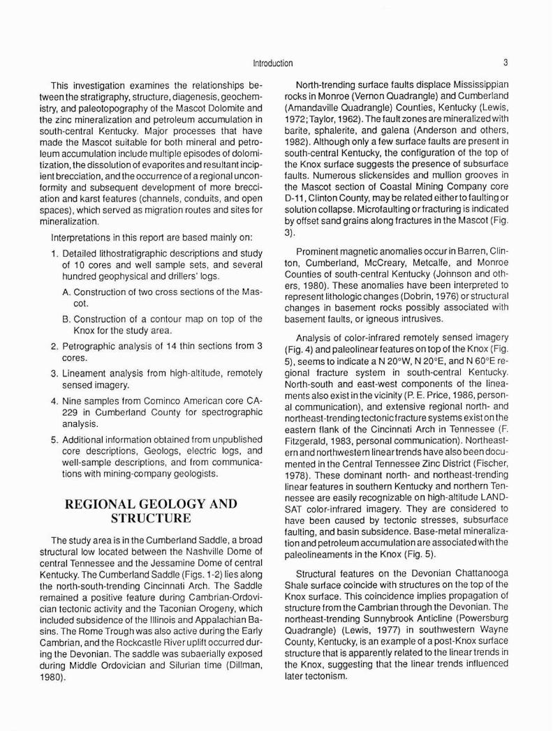
REGIONAL GEOLOGY AND STRUCTURE
The study area is in the Cumberland Saddle, a broad structural low located between the Nashville Dome of central Tennessee and the Jessamine Dome of central Kentucky. The Cumberland Saddle (Figs. 1-2) lies along the north-south-trending Cincinnati Arch. The Saddle remained a positive feature during Cambrian-Ordovician tectonic activity and the Taconian Orogeny, which included subsidence of the Illinois and Appalachian Basins. The Rome Trough was also active during the Early Cambrian, and the Rockcastle River uplift occurred during the Devonian. The saddle was subaerially exposed during Middle Ordovician and Silurian time (Dillman, 1980).
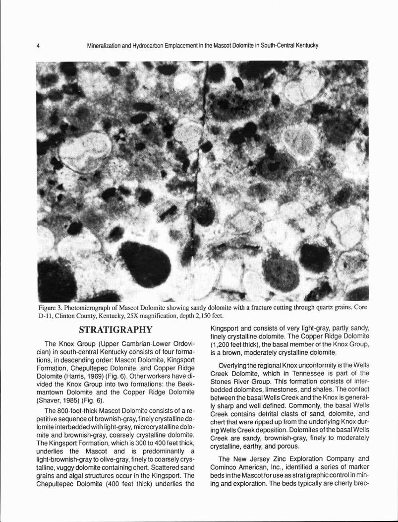
North-trending surface faults displace Mississippian rocks in Monroe (Vernon Quadrangle) and Cumberland (Amandaville Quadrangle) Counties, Kentucky (Lewis, 1972; Taylor, 1962). The fault zones are mineralized with barite, sphalerite. and galena (Anderson and others, 1982). Although only a few surface fau Its are present in south-central Kentucky, the configuration of the top of the Knox surface suggests the presence of subsurface faults. Numerous slickensides and mullion grooves in the Mascot section of Coastal Mining Company core D-11, Clinton County, may be related either to faulting or solution collapse. Microfaulting or fracturing is indicated by offset sand grains along fractures in the Mascot (Fig . 3).
Prominent magnetic anomalies occur in Barren, Clinton, Cumberland, McCreary, Metcalfe, and Monroe Counties of south-central Kentucky (Johnson and others, 1980). These anomalies have been interpreted to represent lithologic changes (Dobrin, 1976) or structural changes in basement rocks possibly associated with basement faults, or igneous intrusives.
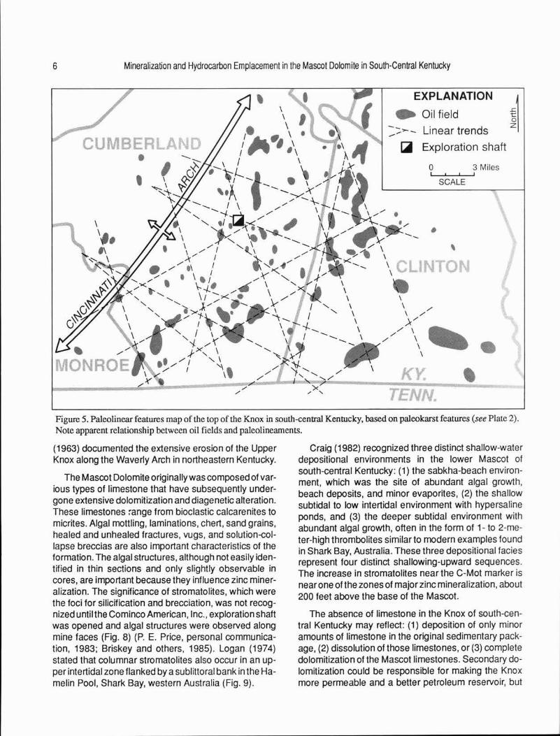
Analysis of color-infrared remotely sensed imagery (Fig. 4) and paleolinear features on top of the Knox (Fig. 5), seems to indicate a N 20°W, N 20°E, and N 60°E regional fracture system in south-central Kentucky. North-south and east-west components of the lineaments also exist in the vicinity (P. E. Price, 1986, personal communication), and extensive regional north- and northeast-trending tectonic fracture systems exist on the eastern flank of the Cincinnati Arch in Tennessee (F. Fitzgerald, 1983, personal communication). Northeastern and northwestern linear trends have also been documented in the Central Tennessee Zinc District (Fischer, 1978). These dominant north- and northeast-trending linear features in southern Kentucky and northern Tennessee are easily recognizable on high-altitude LANDSAT color-infrared imagery. They are considered to have been caused by tectonic stresses, subsurface faulting, and basin subsidence. Base-metal mineralization and petroleum accumulation are associated with the paleolineaments in the Knox (Fig. 5) .
Structural features on the Devonian Chattanooga Shale surface coincide with structures on the top of the Knox surface. This coincidence implies propagat ion of structure from the Cambrian through the Devonian. The northeast-trending Sunnybrook Anticline (Powersburg Quadrangle) (Lewis, 1977) in southwestern Wayne County, Kentucky, is an example of a post-Knox surface structure that is apparently related to the linear trends in the Knox, suggesting that the linear trends influenced later tectonism.
4 Mineralization and Hydrocarbon Emplacement in the Mascot Dolomite in South-Central Kentucky
Figure 3. Photomicrograph of Mascot Dolomite showing sandy dolomite with a fracture cutting through quartz grains. Core D-11, Clinton County, Kentucky, 25X magnification, depth 2,150 feet.
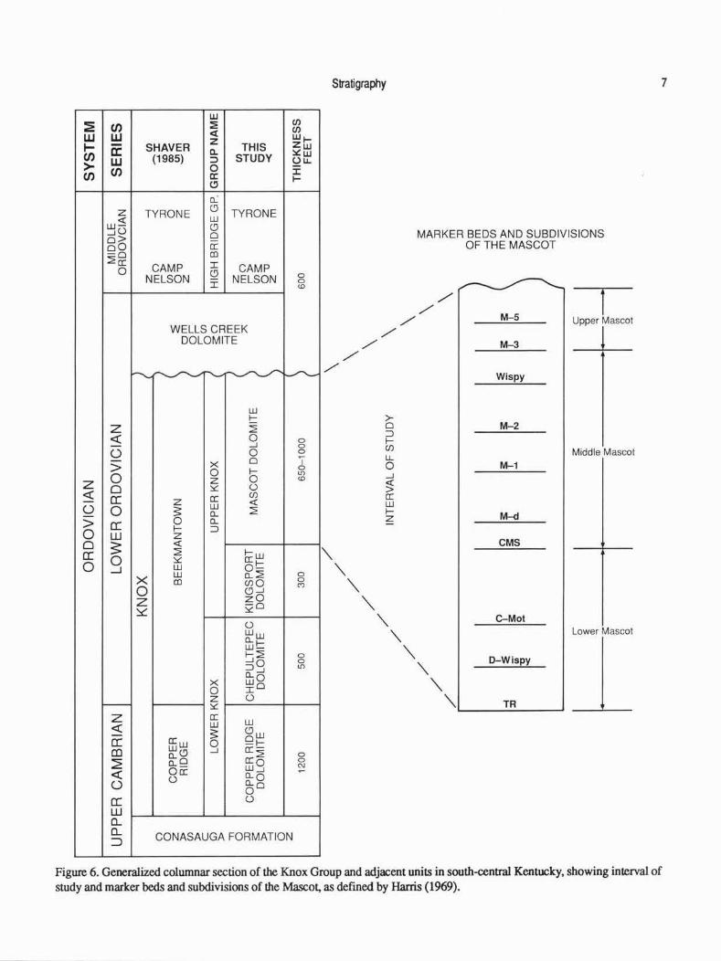
STRATIGRAPHY The Knox Group (Upper Cambrian-Lower Ordovi
cian) in south-central Kentucky consists of four formations, in descending order: Mascot Dolomite, Kingsport Formation, Chepultepec Dolomite, and Copper Ridge Dolomite (Harris, 1969) (Fig. 6) . Other workers have divided the Knox Group into two formations : the Beekmantown Dolomite and the Copper Ridge Dolomite (Shaver, 1985) (Fig. 6).
The 800-foot-thick Mascot Dolomite consists of a repetitive sequence of brownish-gray, finely crystalline dolomite interbedded with fight-gray, microcrystalline dolomite and brownish-gray, coarsely crystalline dolomite. The Kingsport Formation, which is 300 to 400 feet thick, underlies the Mascot and is predominantly a light-brownish-gray to olive-gray, finely to coarsely crystalline, vuggy dolomite containing chert. Scattered sand grains and algal structures occur in the Kingsport. The Chepultepec Dolomite (400 feet thick) underlies the
Kingsport and consists of very light-gray, partly sandy, finely crystalline dolomite. The Copper Ridge Dolomite (1,200 feet thick), the basal member of the Knox Group, is a brown, moderately crystalline dolomite.
Overlying the regional Knox unconformity is the Wells Creek Dolomite, which in Tennessee is part of the Stones River Group. This formation consists of interbedded dolomites, limestones, and shales. The contact between the basal Wells Creek and the Knox is generally sharp and well defined. Commonly, the basal Wells Creek contains detrital clasts of sand, dolomite. and chert that were ripped up from the underlying Knox during Wells Creek deposition. Dolomites of the basal Wells Creek are sandy, brownish-gray, finely to moderately crystalline, earthy, and porous.
The New Jersey Zinc Exploration Company and Cominco American, Inc., identified a series of marl<er beds in the Mascot for use as stratigraphic control in mining and exploration. The beds typically are cherty brec-

Stratigraphy 5
Figure 4. Photograph of color-infrared imagery of the study area.
cias, dolomites containing abundant sand grains, Matrix marker bed downward to the TR marker bed at mottled dolomites. and shales. General characteristics the top of the Kingsport Formation. of marker beds and lithologies of the Mascot are given in Appendix A and Plate 1.
The Mascot Dolomite, as defined by Harris (1969), extends from the unconformity at the top of the Knox Group, to the TR marker bed at the top of the Kingsport Formation, an interval approximately 650 to 1,000 feet thick in south-central Kentucky (Fig . 6, Plate 1) . Staggs and Fischer (1970) subdivided the Mascot of central Tennessee into three members based on several prominent marker beds (Fig. 6 , Appendix A) . Staggs and Fischer's (1970) Upper Mascot Member extends from the unconformity downward to the M-3 marker bed. It ranges from 150 to 250 feet in thickness because of erosional relief on the unconformity. The Middle Mascot Member, about 300 feet thick, extends from the M-3 marker bed downward to the Chert Matrix marker bed. The Lower Mascot Member, about 300 feet thick, extends from the Chert
An east-west stratigraphic cross section, from western Monroe County to Clinton County, Kentucky, shows thinning in some intervals between the marker beds across the Cincinnati Arch, indicating that the arch was a positive feature during Mascot deposition (Plate 1 ). The thickness between the M-5 and TR markers ranges from 621 to 701 feet in cores from the arch; the interval thickens to 800 feet in Clinton County and 726 in Monroe County on the flanks of the arch. The interval between marker beds also thins northeastward from western Cumberland County to southeastern Adair County (Fig. 7). This thinning reflects uplift on the southern part of the Jessamine Dome. Additional evidence of uplift on the Jessamine Dome during Cambrian time is the erosion of the Mascot in central Kentucky. The Knox in central Kentucky consists only of the basal Mascot and Kingsport Dolomite. Woodward (1961) and McGuire and Howell
6 Mineralization and Hydrocarbon Emplacement in the Mascot Dolomite in South-Central Kentucky
I
EXPLANATION
• Oilfield -,-""',_ - Linear trends
~ Exploration shaft
0 3 Miles
SCALE
Figure 5. Paleolinear features map of the top of the Knox in south-central Kentucky, based on paleokarst features (see Plate 2). Note apparent relationship between oil fields and paleolineaments.
(1963) documented the extensive erosion of the Upper Knox along the Waverly Arch in northeastern Kentucky.
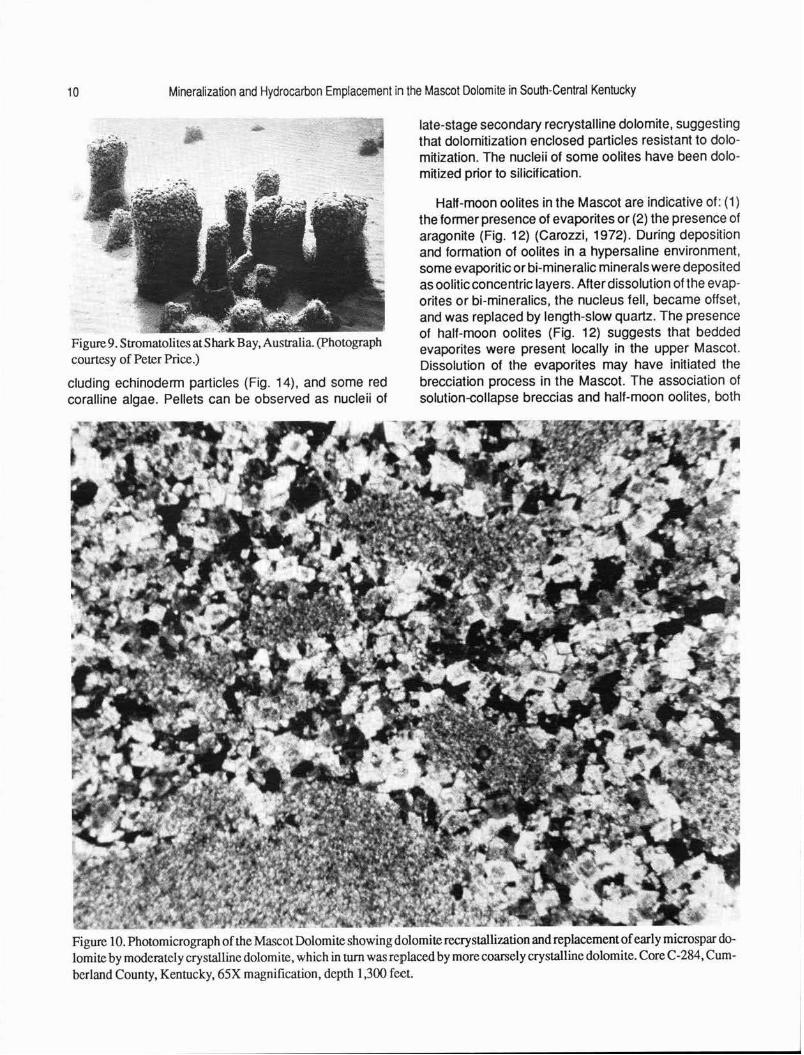
The Mascot Dolomite originally was composed of various types of l imestone that have subsequently undergone extensive dolomitization and diagenetic alteration. These limestones ~ange from bioclastic calcarenites to micrites. Algal mottling, laminations, chert, sand grains, healed and unhealed fractures, vugs, and solution-collapse breccias are also important characteristics of the formation. The algal structures, although not easily identified in thin sections and only slightly observable in cores, are important because they influence zinc mineralization. The significance of stromatolites, which were the foci for silicification and brecciation, was not recognized until the Cominco American, Inc., exploration shaft was opened and algal structures were observed along mine faces (Fig. 8) (P. E. Price, personal communication, 1983; Briskey and others, 1985). Logan (1974) stated that columnar stromatolites also occur in an upper intertidal zone flanked by a sublittoral bank in the Hamelin Pool, Shark Bay, western Australia (Fig. 9).
Craig (1982) recognized three distinct shallow-water depositional environments in the lower Mascot of south-central Kentucky: (1) the sabkha-beach environment, which was the site of abundant algal growth, beach deposits, and minor evaporites, (2) the shallow subtidal to low intertidal environment with hypersaline ponds, and (3) the deeper subtidal environment with abundant algal growth, often in the form of 1- to 2-meter-high thrombolites similar to modern examples found in Shark Bay, Australia. These three depositional facies represent four distinct shallowing-upward sequences. The increase in stromatolites near the C-Mot marker is near one of the zones of major zinc mineralization, about 200 feet above the base of the Mascot.
The absence of limestone in the Knox of south-central Kentucky may reflect: (1) deposition of only minor amounts of limestone in the original sedimentary package, (2) dissolution of those limestones, or (3) complete dolomitization of the Mascot limestones. Secondary dolomitization could be responsible for making the Knox more permeable and a better petroleum reservoir, but
w (/) :1E CJ) :E
<I: (/)
w w z Wt-.... a: SHAVER c.. THIS z w CJ) (1985) STUDY ~w
w :::, (..) u. > CJ) 0 :i: CJ) a: I-
(.!)
a.: z TYRONE
(!) TYRONE
<( w w- (!) ...10 0 o> oO a: -o en ~a:
CAMP I CAMP 0 NELSON Q NELSON 0
I 0 <D
WELLS CREEK DOLOMITE
r""""-~----~ ~
w I-
z ~ <( 0 0
...J 0
0 0 0
> x 0 ' 0 I- 0
0 LO
z z 0 <D
0 ~ 0 <( cc a: (/)
z <( 0 0 ~
w ~ a..
> cc 0 a.. 0
I- ::> w z 0 3: <(
cc ~ 1-w
0 0 ~ a: I-_J UJ 0-
x w a..~ 0 en Cl)Q 0
(")
0 (!) ...J
z zO ~
~o 0 WW a.. .... UJ-~~ 0
::iO 0 LO a.. ...J
x wO 0 IO z 0 - ~
z a: w <( w ~ <!Jw
cc a:w 0 91-co w<!J ...J a:-
a:~ 0
~ a..o 0 a.._ w9 C\J
<( Oa: ~
<.) a..o 0 a..o
0 a: 0
w 0.... 0.... CONASAUGA FORMATION :J
Stratigraphy
/ /
'\ '\
"'
/
"'
/
>-0 ::> IC/)
lL 0 ...J
~ a: w 1-z
'\
MARKER BEDS AND SUBDIVISIONS OF THE MASCOT
/ /
/ M-5
M-3
Wispy
M-2
M-1
M--d
CMS
l Upper Mascot
Middle Mascot
'\ :::~ :1 "' '\ "' "' TA I ......_ __ _
7
Figure 6. Generalized columnar section of the Knox Group and adjacent units in south-central Kentucky, showing interval of study and marker beds and subdivisions of the Mascot. as defined by Harris (1969).

8 Mineralization and Hydrocarbon Emplacement in the Mascot Dolomite in South-Central Kentucky
MARKER BED CORRELATION GRADYVILLE FIELD
WITH GRADYVILLE OIL FIELD MONITOR PET. N0.1 CORBIN
C-284
-TOP OF KNOX
M-5
c-2~1~ _ _;:.;.{ ~~ ~-278 ~ T~ 1632'
-- ? ' ~-- '-;~ ~
-WISPY BLU MOT-
FORMER MASCOT-KING SPORT
CONTACT
IL CHERT MATRIX SAND~ (CMS)
404 ' TD 2 0 5
TD 2357' MILES TD 2360'
Figure 7. Location of northeast cross section. showing correlation of marker beds with the Gradyville Oil Field in Adair County.
less receptive to chemically precipitated deposits. Cal- influenced dolomitization. This implies that two episodes cium-rich host rocks are apparently more reactive to of dolomitization or dolomite recrystallization occurred mineralization than dolomite-magnesium rich host (Figs. 10-11). rocks. The trend of the limestone-dolomite interface shown in Figure 2 represents the approximate position of the transition from an all-dolomite Mascot to a Mascot dominantly of dolomite with some limestone. This interface coincides with the northeastern trend of the largest zinc deposits, suggesting that any zinc deposits located away from the interface, in a predominantly dolomitic terrain, may be in areas of less intense brecciation or lower chemical activity and may contain more marginal-grade ore.
PETROGRAPHY
Microscopic examination of the Mascot in south-central Kentucky indicates that the parental sediments were composed of different lithologies. Bioclastic-oolitic calcarenites, algal-mottled micrites, and oopelsparites are typical parental sediments and are similar to those found in the Mascot of central Tennessee. The sediments contained other bioskeletal debris and quartz-sand grains. Half-moon oolites and algal features were also observed in thin sections. Dolomitization of the carbonate sediments in south-central Kentucky produced finely to moderately crystalline dolomite. Thin sections of samples from cores C-284, Cumberland County, and D-11 , Clinton County, show that the Mascot Dolomite is composed of euhedral and mosaic crystals with both idiotopic (isolated grains) and xenotopic (clusters of grains) fabrics, which indicates that two separate diagenetic processes
Although dolomite can form in a variety of environments, massive dolomites such as the Mascot originate at the sediment-seawater interface where the extensive circulation and pumping mechanisms that are required for massive dolomitization occur (Land, 1985). Dolomitization of Knox carbonate rocks was more extensive in south-central Kentucky than in central Tennessee, where the Knox consists of interbedded dolomites and limestones (Kyle, 1976). Mascot limestones in central Tennessee consist of pelmicrites, intrasparudites, intramicrudites, and oosparites, and contain abundant algal features (Gorody, 1981). In south-central Kentucky, the Mascot is primarily dolomite, but relict fabrics of oopelmicrites and oosparites were observed in this investigation; Craig (1982) also recognized many of the same constituents.
The earliest dolomites in the Mascot of south-central Kentucky were eogenetic, or early diagenetic, meaning they formed after deposition of calcareous sediments, but prior to their lithification. The early dolomite microspar has been recrystallized into a more coarsely crystalline dolomite with some incipient brecciation. Later, introduction of silica into the sediments temporarily halted dolomitization. The silica partially replaced the remaining calcareous sediments and preserved the depositional textures and component particles. Thin sections of dolomite and chert samples taken from cores C-284 (Cumberland County) and D-11 (Clinton County) show oolites (Fig. 12), relict pellets (Fig. 13), bioskeletal debris, in-
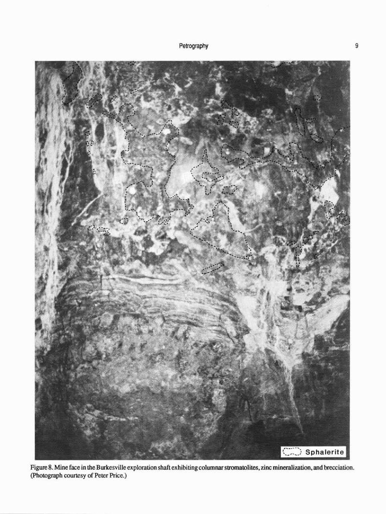
Petrography
Figure 8. Mine face in the Burkesville exploration shaft exhibiting columnar sttomatolites, zinc mineralization, and brecciation. (Photograph courtesy of Peter Price.)
9
10 Mineralization and Hydrocarbon Emplacement in the Mascot Dolomite in South-Central Kentucky
-
Figure 9. Stromatolites atS hark Bay, Australia (Photograph courtesy of Peter Price.)
eluding echinoderm particles (Fig. 14), and some red coralline algae. Pellets can be observed as nucleii of
late-stage secondary recrystalline dolomite, suggesting that dolomitization enclosed particles resistant to dolomitization. The nucleii of some oolites have been dolomitized prior to silicification.
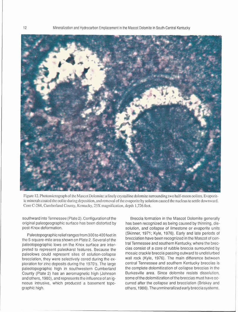
Half-moon oolites in the Mascot are indicative of: (1) the former presence of evaporites or (2) the presence of aragonite (Fig. 12) (Carozzi, 1972). During deposition and formation of oolites in a hypersaline environment, some evaporitic or bi-mineralic minerals were deposited as oolitic concentric layers. After dissolution of the evaporites or bi-mineralics, the nucleus fell, became offset , and was replaced by length-slow quartz. The presence of half-moon oolites (Fig. 12) suggests that bedded evaporites were present locally in the upper Mascot. Dissolution of the evaporites may have initiated the brecciation process in the Mascot. The association of solution-collapse breccias and half-moon oolites, both
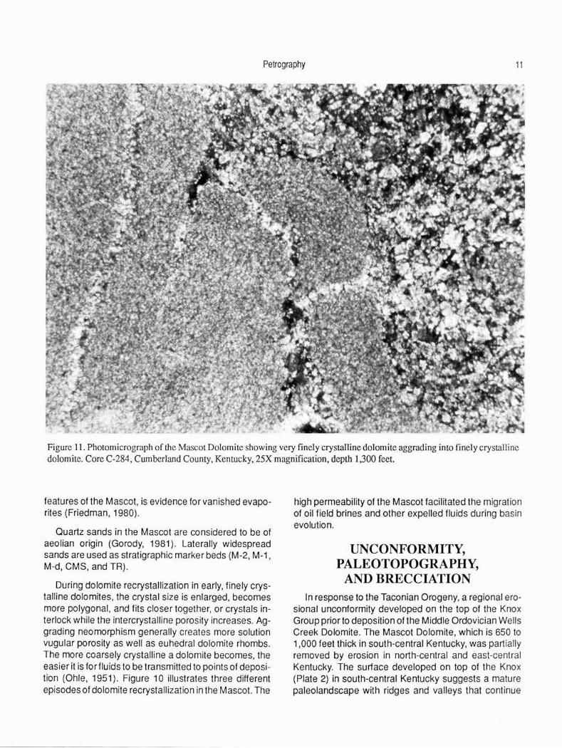
Figure 10. Photomicrograph of the Mascot Dolomite showing dolomite recrystallization and replacement of early microspar dolomite by moderately crystalline dolomite, which in tum was replaced by more coarsely crystalline dolomite. Core C-284, Cumberland County, Kentucky, 65X magnification, depth 1,300 feet.
Petrography 11
Figure 11. Photomicrograph of the Mascot Dolomite showing very finely crystalline dolomite aggrading into finely crystalline dolomite. Core C-284, Cumberland County, Kentucky, 25X magnification, depth 1,300 feet.
features of the Mascot, is evidence for vanished evaporites (Friedman, 1980).
Quartz sands in the Mascot are considered to be of aeolian origin (Gorody, 1981). Laterally widespread sands are used as stratigraphic marker beds (M-2, M-1 , M-d, CMS, and TR).
During dolomite recrystallization in early, finely crystalline dolomites, the crystal size is enlarged. becomes more polygonal, and fits closer together, or crystals interlock while the intercrystalline porosity increases. Aggrading neomorphism generally creates more solution vugular porosity as well as euhedral dolomite rhombs. The more coarsely crystalline a dolomite becomes. the easier it is for fluids to be transmitted to points of deposition (Ohle, 1951). Figure 10 illustrates three different episodes of dolomite recrystallization in the Mascot. The
high permeability of the Mascot facilitated the migration of oil field brines and other expelled fluids during basin evolution.
UNCONFORMITY, PALEOTOPOGRAPHY,
AND BRECCIATION In response to the Taconian Orogeny, a regional ero
sional unconformity developed on the top of the Knox Group prior to deposition of the Middle Ordovician Wells Creek Dolomite. The Mascot Dolomite, which is 650 to 1,000 feet thick in south-central Kentucky, was partially removed by erosion in north-central and east-central Kentucky. The surface developed on top of the Knox (Plate 2) in south-central Kentucky suggests a mature paleolandscape with ridges and valleys that continue

12 Mineralization and Hydrocarbon Emplacement in the Mascot Dolomite in South-Central Kentucky
Figure 12. Photomicrograph of the Mascot Dolomite: a finely crystalline dolomite surrounding two half-moon oolites. Evaporitic minerals coated the oolite during deposi Lion, and removal of the evaporite by solution caused the nucleus to settle downward. Core C-284, Cumberland County, Kentucky, 25X magnification, depth 1,726 feet.
southward into Tennessee ( Plate 2). Configuration of the original paleogeographic surface has been distorted by post-Knox deformation.
Paleotopographic relief ranges from 300 to 400feet in the 5-square-mile area shown on Plate 2. Several of the paleotopographic lows on the Knox surface are interpreted to represent paleokarst features. Because the paleolows could represent sites of solution-collapse brecciation, they were selectively cored during the exploration for zinc deposits during the 1970's. The large paleotopographic high in southwestern Cumberland County (Plate 2) has an aeromagnetic high (Johnson and others. 1980), and represents the influence of an igneous intrusive, which produced a basement topographic high.
Breccia formation in the Mascot Dolomite generally has been recognized as being caused by thinning, dissolution, and collapse of limestone or evaporite units (Skinner, 1971: Kyle, 1976). Early and late periods of brecciation have been recognized in the Mascot of central Tennessee and southern Kentucky, where the breccias consist of a core of rubble breccia surrounded by mosaic crackle breccia passing outward to undisturbed wall rock (Kyle, 1976). The main difference between central Tennessee and southern Kentucky breccias is the complete dolomitization of collapse breccias in the Burkesville area. Since dolomite resists dissolution, some of the dolomitization of the breccias must have occurred after the collapse and brecciation (Briskey and others, 1986). The unmineralized early breccia systems,
12 Mineralization and Hydrocarbon Emplacement in the Mascot Dolomite in South-Central Kentucky
Figure 12. Photomicrograph of I.he Mascot Dolomite: a finely crystalline dolomite surrounding two half-moon oolites. Evaporitic minerals coated theoolite during deposition, and removal of tJ1e evaporite by solution caused me nucleus to settle downward. Core C-284, Cumberland County, Kentucky, 25X rnagnificalion, deptJ, 1,726 feet.
southward into Tennessee (Plate 2). Configuration of the original paleogeographic suriace has been distorted by post-Knox deformation.
Paleotopographic relief ranges from300 to 400 feet in the 5-square-mile area shown on Plate 2. Several of the paleotopographic lows on the Knox surface are interpreted to represent paleokarst features. Because the paleolows could represent sites of solution-collapse brecciation, they were selectively cored during the exploration for zinc deposits during the 1970's. The large paleotopographic high in southwestern Cumberland County (Plate 2) has an aeromagnetic high (Johnson and others, 1980), and represents the influence of an igneous intrusive, which produced a basement topographic high.
Breccia formation in the Mascot Dolomite generally has been recognized as being caused by thinning, dissolution, and collapse of limestone or evaporite units (Skinner, 1971; Kyle, 1976). Early and late periods of brecciation have been recognized in the Mascot of cen· tral Tennessee and southern Kentucky, where the breccias consist of a core of rubble breccia surrounded by mosaic crackle breccia passing outward to undisturbed wall rock (Kyle, 1976). The main difference between central Tennessee and southern Kentucky breccias is the complete dolomitization of collapse breccias in the Burkesville area. Since dolomite resists dissolution, some of the dolomitization of the breccias must have occurred after the collapse and brecciation (Briskey and others, 1986). The unmineralized early breccia systems,

Unconformity, Paleotopography, and Brecciation 13
Figure 13. Photomicrograph of the Mascot Dolomite showing sandy, bioskeletal dolomite with sand grains, pellets, and micrite-enveloped echinoid spines. Coastal Mining Core D-11, Clinton County, Kentucky, 25X magnification, depth 2,175 feet.
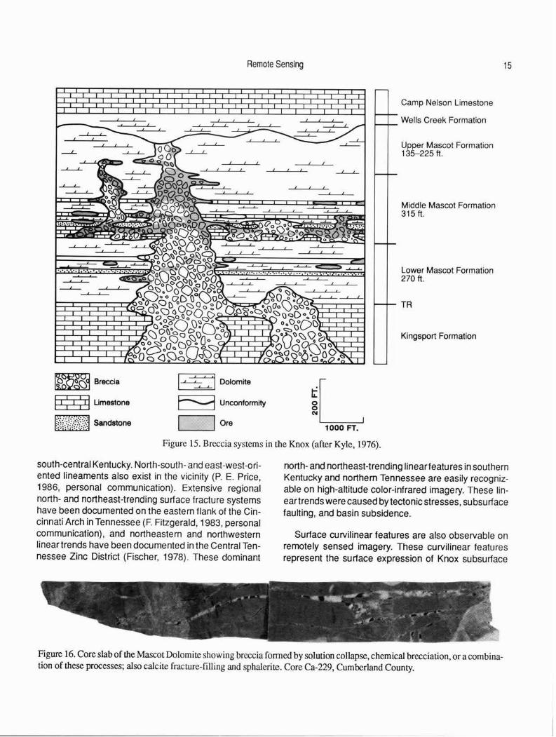
which consist of fine-grained rock-matrix breccia, were post-diagenetic, and probably telegenetic relative to secondary dolomitization, dissolution, and the formation of the Knox unconformity. The late-stage breccias have a more coarse-grained rock-matrix breccia and are usually associated with the early breccias (Kyle, 1976). Sphalerite mineralization occurred after the development of the unconformity in secondary porosity zones in the late-stage breccias during the late Paleozoic. These breccia bodies extend vertically and laterally within the Mascot (Fig. 15).
The term "chemical brecciation" was introduced and defined by Sawkins (1969) as the physical process of expansive cracking caused by the release of stress within the rock. Crackle breccias in Mexico and breccia bodies in Tennessee are considered to have been formed by
this process. Ohle ( 1980) also recognized that chemical brecciation was partly responsible for breccia development in Mississippi Valley-type ore deposits. Breccias observed in cores during this investigation apparently were formed by brecciation resulting from stress release related to solution collapse (Fig. 16). Rock bursts and exploding rocks are a common response in deep underground mines to the release of lithostatic pressure as rock is removed during mining. An example of these responses can be seen at the Lexington Quarry Company underground limestone mine in central Kentucky, where zinc has been produced for several years in a vein deposit. The vein is 4 feet wide, and about 250 feet below the surface. Following mining of the vein, expansive lithostatic pressure in the enclosing limestone caused the mine walls to pinch to halftheiroriginal size. This particu-

14 Mineralization and Hydrocarbon Emplacement in the Mascot Dolomite in South-Central Kentucky
Figure 14. Photomicrograph of the Mascot Dolomite showing half-moon oolites, bioskeletal debris, pellets, and echinoderm plates. The oblate oolite's nucleus was replaced by dolomite prior to silicification. Core C-284, Cumberland County, Kentucky, 25X magnification, depth 1,726 feet.
lar stress phenomenon cou ld also have occurred during regional erosion of the Knox, and would also have reduced lithostatic pressure. Although only 300 to 400 feet of erosion occurred in south-central Kentucky, this rapid unloading of lithostatic pressure could have caused additional fracturing and brecciation along lines of preexisting weakness such as paleojoints and paleolinear features.
REMOTE SENSING
Regional (scale: 1 :500,000) and local (scale: 1 :58,000) lineament analyses were conducted over the study area to determine the relationship between linear trends, mineralization, and petroleum accumulation. High-altitude color-infrared imagery at scales of 1 :500,000, along with high-resolution color-infrared imagery with high-density contrast at scale of 1 :58,000 (Fig. 4) , delineated numerous curvilinear features (Fig. 17) in the region. A regional, northeast-trending fracture
system and a northwest-trending antithetic fracture system can also be observed.
Regional surface linear features trend northwest and northeast (Figs. 17, 18), and approximately 50 percent of the oil fields lie along these surface linear trends. A paleolinear features map constructed on the paleotopographic Knox map (Fig. 5) demonstrates the alignment of Knox linear trends and existing oil fields. The northwest-northeast orientation of paleolineartrends is associated with Paleozoic tectonics and the uplift of the Cincinnati Arch. Approximately 60 percent of the linear trends occur along a northeast trend , about 30 percent trend northwest, and the remainder are multidirectional. Approximately 70 percent of the oil fields occur along these paleotrends.
Analysis of paleolinear features on top of the Knox (Fig. 5), using the al ignment of paleokarst features and paleotopographic highs and lows shown on Plate 2, seems to indicate that a N 20°W, N 20°E, and N 60°E regional fracture system exists in the upper Mascot in
Remote Sensing 15
!~Dolomite
E::-:i Unconformity
,...._ _ ____.! Ore
Camp Nelson Limestone
Wells Creek Formation
-'-- Upper Mascot Formation
1000 FT.
135-225 ft.
Middle Mascot Formation 315 ft.
Lower Mascot Formation 270 ft.
TR
Kingsport Formation
Figure 15. Breccia systems in the Knox (after Kyle, 1976).
south-central Kentucky. North-south- and east-west-oriented lineaments also exist in the vicinity (P. E. Price, 1986, personal communication). Extensive regional north- and northeast-trending surface fracture systems have been documented on the eastern flank of the Cincinnati Arch in Tennessee (F. Fitzgerald, 1983, personal communication) , and northeastern and northwestern linear trends have been documented in the Central Tennessee Zinc District (Fischer, 1978). These dominant
north- and northeast-trending linear features in southern Kentucky and northern Tennessee are easily recognizable on high-altitude color-infrared imagery. These lineartrends were caused by tectonic stresses. subsurface faulting, and basin subsidence.
Surface curvilinear features are also observable on remotely sensed imagery. These curvilinear features represent the surface expression of Knox subsurface
Figure 16. Core slab of the Mascot Dolomite showing breccia fonned by solution collapse, chemical brecciation, or a combination of these processes; also calcite fracture-fLUing and sphalerite. Core Ca-229, Cumberland County.

16
( I I I I
I /
Mineralization and Hydrocarbon Emplacement in the Mascot Dolomite in South-Central Kentucky
Limit of imagery .. ' . .
FOUNTAIN RUN I -- ---------------/ I I I I
I I I I I I I I I
I I I
' \ \
\
\ \
\ \
\
\
\ \
\ \
\ I I I
---- - -,,', ' '
---
b--------l ._-.;
0
l (l
0 5 10 15 20 Miles
SCALE
_, ,- '
I
'
' ' \ '
' ' '
I . . '· t , I
~ •' -• • /, I>' I
I I
.-· I I I
I I I I
I I
I ,' I I
I I
Limit of imagery
' \
I
\
I
' ,,
EXPLANATION - Oil field
------ Lineament
I I
I
'
Figure 17. Regional lineament analysis showing location of oil fields and the Cominco American, Inc., exploration shaft (indicated by arrow). This lineament analysis is based on imagery in Figure 4.

; ~
0 z
-
0
SCALE
Remote Sensing
--
I
I \ I
\_ ___ _J 2 Miles
Figure 18. Local lineament analysis of the Burkesville,Kentucky, area. showing the curvilinear features of the Knox ore body at the Cominco American exploration shafL
17
18 Mineralization and Hydrocarbon Emplacement in the Mascot Dolomite in South-Central Kentucky
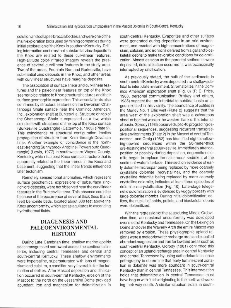
solution and collapse breccia bodies and were one of the main exploration toots used by mining companies during initial exploration of the Knox in southern Kentucky. Drilling information confirms that substantial zinc deposits in the Knox are related to these curvilinear features. High-altitude color-infrared imagery reveals the presence of several curvilinear features in the study area. Two of the areas, Fountain Run and Burkesville, have substantial zinc deposits in the Knox, and other areas with curvilinear structures have marginal deposits.
The association of surface linear and curvilinear features and the paleolinear features on top of the Knox seems to be related to Knox structural features and their surface geomorphic expression. This association is also confirmed by structural features on the Devonian Chattanooga Shale surface near the Cominco American, Inc., exploration shaft at Burkesville. Structure on top of the Chattanooga Shale is expressed as a low, which coincides with structures on the top of the Knox surface (Burkesville Quadrangle) (Cattermole, 1963) (Plate 2). This coincidence of structural configuration implies propagation of structure from Knox through Devonian time. Another example of coincidence is the northeast-trending Sunnybrook Anticline (Powersburg Quadrangle) (Lewis, 1977) in southwestern Wayne County, Kentucky, which is a post-Knox surface structure that is apparently related to the linear trends in the Knox and basement, suggesting that the linear trends influenced later tectonism.
Remotely sensed tonal anomalies, which represent surface geochemical expressions of subsurface zincrich ore deposits, were not observed near the curvilinear features in the Burkesville area. This absence could be because of the occurrence of several thick (less than 2 feet) bentonite beds, located about 600 feet above the Knox unconformity, which act as aquitards to ascending hydrothermal fluids.
DIAGENESIS AND PALEOENVIRONMENTAL
HISTORY
During Late Cambrian time, shallow marine epeiric seas transgressed northward across the continental interior, including central Tennessee and central and south-central Kentucky. These shallow environments were hypersaline, supersaturated with ions of magnesium and calcium, a condition very favorable for the formation of oolites. After Mascot deposition and lithification occurred in south-central Kentucky, erosion of the Mascot to the north on the Jessamine Dome provided abundant iron and magnesium for dolomitizalion in
south-central Kentucky. Evaporites and other sulfates were generated during deposition in an arid environment, and reacted with high concentrations of magnesium, calcium, and iron ions derived from algal and bioskeletal debris to make favorable conditions for dolomitization. Almost as soon as the parental sediments were deposited, dolomitization occurred; it was occasionally interrupted by silicification.
As previously stated, the bulk of the sediments in south-central Kentucky were deposited in a shallow subtidal to intertidal environment. Stromatolites in the Cominco American exploration shaft (Fig. 8) (P. E. Price, 1983, personal communication; Briskey and others, 1985) suggest that an intertidal to subtidal basin or lagoon existed in this vicinity. The abundance of oolites in the Murley No. 1 Ellis well (Plate 2) suggests that the area west of the exploration shaft was a calcareous shoal or bar that was on the western flank of this intert idal basin. Gorody ( 1981) observed up to 40 prograding depositional sequences, suggesting recurrent transgressive environments (Plate 2) in the Mascot of central Tennessee, and Craig (1982) has identified eight shallowing-upward sequences within the 50-meter-thick ore-hosting interval at Burkesville. Immediately after deposition or possibly during deposition, eogenetic dolomite began to replace the calcareous sediment at the sediment-water interface. Thin-section evidence of early dolomite microspar being replaced by more coarsely crystalline dolomite (recrystalline), and the coarsely crystalline dolomite being replaced by more coarsely crystalline dolomite, indicates at least three episodes of dolomite recrystallization (Fig. 10). Late-stage telegenetic dolomitization is evidenced by vuggy porosity with large dolomite rhombs. During initial dolomitization, oolites, the nucleii of ooids, pellets, and bioskeletal debris were dolomitized.
With the regression of the seas during Middle Ordovician time, an erosional unconformity was developed over most of Kentucky and Tennessee. On the Lexington Dome and over the Waverly Arch the entire Mascot was removed by erosion. These physiographic upland regions were a meteoric water recharge area and supplied abundant magnesium and iron for lowland areas such as south-central Kentucky. Gorody (1981) confirmed this concept of an upland recharge area in central Kentucky and central Tennessee by using cathode luminescence petrography to determine that early luminescent zonation in dolomite was more abundant in south-central Kentucky than in central Tennessee. This interpretation holds that dolomitization in central Tennessee must have begun with fluids originating to the north and working their way south . A similar situation exists in south-
Diagenesis and Paleoenvironmental History 19
western Virginia, where. according to Harris ( 1971). several hundred feet of Knox have been eroded in an upland area that provided magnesium and iron to dolomitize a Knox lowland area in southwestern Virginia and eastern Tennessee. Central and south-central Kentucky are similar in that numerous sinkholes and depressions were developed in the lowland areas. These uplands and lowlands along the Cincinnati Arch were structurally high in relation to the subsiding Illinois and Appalachian Basins, as demonstrated by the cross section (Plate 1), which shows depositional thinning over the Cincinnati Arch. This thinning of sediments, hypersaline conditions during deposition, upland erosion in central Kentucky, and the abundance of magnesium and iron favored dolomitization of the Mascot in south-central Kentucky. Figure 2 shows the location of major zinc deposits in south-central Kentucky and north-central Tennessee. A northeastern linear trend along these deposits coincides with the approximate location of a limestone-dolomite lithof acies contact (Fig. 2). Since more dolomitization occurred in south-central Kentucky than in central Tennessee, perhaps an intertidal basin flanked on the west by a coalescing oolitic shoal or bar existed periodically during deposition of the Mascot.
During the exposure and development of the unconformity in the Middle Ordovician, a regional paleoaquifer was developed over central and south-central Kentucky and northern Tennessee (Harris, 1971 ). A map drawn on top of the Knox Dolomite (Plate 2) depicts the unconformable surface as a mature paleolandscape. Numerous ridges and valleys attest to the erosional nature of the unconformity. Sinkholes developed on the Knox paleosurface indicate a karstic paleotopography. The karst system was not developed during Knox deposition: based on the dolomitic lithology and presence of half-moon oolites and length-slow chalcedony in thin sections, the climate during the Early Ordovician in south-central Kentucky was arid, similar to that of the present-day Bahamas or northern Australia. With the regression of the Ordovician seas and development of the unconformity, climatic changes probably occurred. These climatic changes added more meteoric water to the hydrologic system and facilitated development of karst features. These karstic features are the result of Mascot subsurface drainage systems that were localized by regional fracture systems, and whose growth was accelerated during the development of the unconformity. Chemical brecciation and dissolution of evaporites probably initiated solution and brecciation. Sinkholes and breccias soon developed over the existing dissolution features, creating breccia bodies. The develop-
ment of the breccias provided a host for zinc mineralization. The porosity and permeability in the upper Knox resulting from the paleoaquifer system played an important part in the development of a petroleum reservoir in parts of south-central Kentucky.
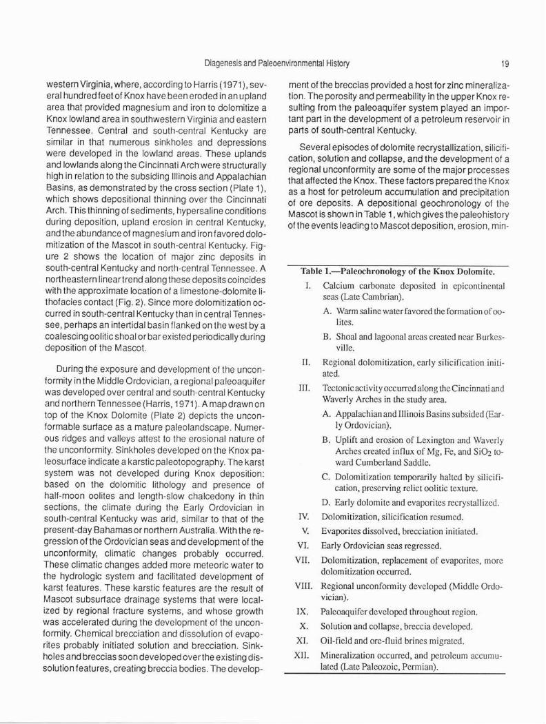
Several episodes of dolomite recrystallization, silicification, solution and collapse, and the development of a regional unconformity are some of the major processes that affected the Knox . These factors prepared the Knox as a host for petroleum accumulation and precipitation of ore deposits. A depositional geochronology of the Mascot is shown in Table 1, which gives the paleohistory of the events leadir.g to Mascot deposition, erosion, min-
Table 1.-Paleochronology of the Kuox Dolomite.
I. Calcium carbonate deposited in epicontinental seas (Late Cambrian).
A. Wann saline water favored the formation of oolites.
B. Shoal and lagoonal areas created near Burkesville.
II. Regional dolomitization, early silicification initiated.
III. Tectonic activity occurred along the Cincinnati and Waverly Arches in the study area.
A. Appalachian and Illinois Basins subsided (Early Ordovician).
B. Uplift and erosion of Lexington and Waverly Arches created innux of Mg, Fe, and Si02 toward Cumberland Saddle.
C. Dolomitization temporarily halted by silicification, preserving relict oolitic texture.
D. Early dolomite and evaporites recrystallized.
IV. Dolomitization, silicification resumed.
V. Evaporites dissolved, brecciation initiated.
VI. Early Ordovician seas regressed.
VII. Dolomitization, replacement of evaporites, more dolomitization occurred.
VIII. Regional unconfonnity developed (Middle Ordovician).
IX. Paleoaquifer developed throughout region.
X. Solution and collapse, breccia developed.
XL Oil-field and ore-fluid brines migrated.
XII. Mineralization occurred, and petroleum accumulated (Late Paleozoic, Permian).

20 Mineralization and Hydrocarbon Emplacement in the Mascot Dolomite in South-Central Kentucky
eralization, and petroleum accumulation in south-central Kentucky.
ECONOMIC GEOLOGY
Minerals
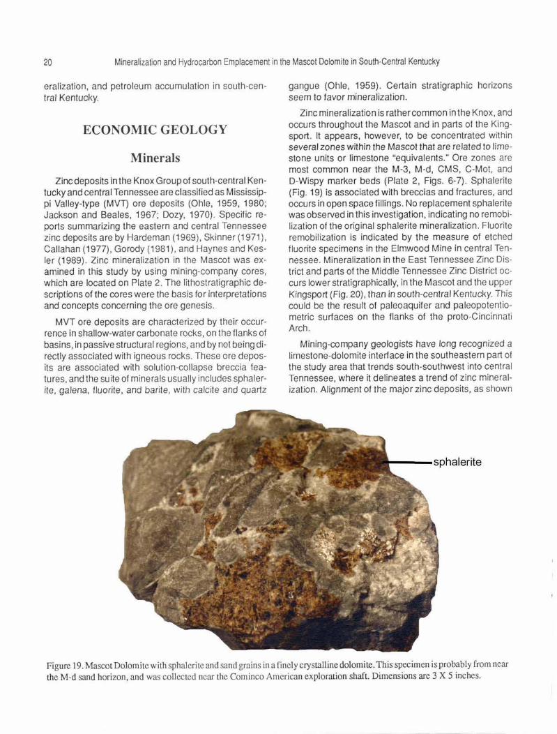
Zinc deposits in the Knox Group of south-central Kentucky and central Tennessee are classified as Mississippi Valley-type (MVT) ore deposits (Ohle, 1959, 1980; Jackson and Beales, 1967; Dozy, 1970). Specific reports summarizing the eastern and central Tennessee zinc deposits are by Hardeman (1969), Skinner (1971 ), Callahan (1977). Gorody (1981), and Haynes and Kesler (1989) . Zinc mineralization in the Mascot was examined in this study by using mining-company cores, which are located on Plate 2. The lithostratigraphic descriptions of the cores were the basis for interpretations and concepts concerning the ore genesis.
MVT ore deposits are characterized by their occurrence in shallow-water carbonate rocks, on the flanks of basins, in passive structural regions, and by not being directly associated with igneous rocks. These ore deposits are associated with solution-collapse breccia features, and the suite of minerals usually includes sphalerite, galena, fluorite, and barite, with calcite and quartz
-- .... ---.. , ',\ __ __ __ ) Sphalerite
gangue (Ohle, 1959). Certain stratigraphic horizons seem to favor mineralization.
Zinc mineralization is rather common in the Knox, and occurs throughout the Mascot and in parts of the Kingsport. It appears, however, to be concentrated within several zones within the Mascot that are related to limestone units or limestone "equivalents." Ore zones are most common near the M-3, M-d, CMS, C-Mot. and D-Wispy marker beds (Plate 2, Figs. 6-7). Sphalerite (Fig. 19) is associated with breccias and fractures, and occurs in open space fillings. No replacement sphalerite was observed in this investigation, indicating no remobi· lization of the original sphalerite mineralization. Fluorite remobilization is indicated by the measure of etched fluorite specimens in the Elmwood Mine in central Tennessee. Mineralization in the East Tennessee Zinc District and parts of the Middle Tennessee Zinc District oc· curs lower stratigraphically, in the Mascot and the upper Kingsport (Fig. 20), than in south-central Kentucky. This could be the result of paleoaquifer and paleopotentiometric surfaces on the flanks of the proto-Cincinnati Arch.
Mining-company geologists have long recognized a limestone-dolomite interface in the southeastern part of the study area that trends south-southwest into central Tennessee, where it delineates a trend of zinc mineralization. Alignment of the major zinc deposits. as shown
Figure 19. Mascot Dolomite with sphaleri tc and sand grains in a fin cl y crystalline dolomite. This specimen is probably from near the M-d sand horizon, and was collected near the Cominco American exploration shaft. Dimensions are 3 X 5 inches.
20 Mineralization and Hydrocarbon Emplacement in the Mascot Dolomite in South-Central Kentucky
eralization, and petroleum accumulation in south-central Kentucky.
ECONOMIC GEOLOGY
Minerals
Zinc deposits in the Knox Group of south-central Kentucky and central Tennessee are classified as Mississippi Valley-type (MVT) ore deposits (Ohle, 1959, 1980; Jackson and Beales, 1967; Dozy, 1970). Specific reports summarizing the eastern and central Tennessee zinc deposits are by Hardeman (1969), Skinner (1971). Callahan (1977), Gorody (1981 ). and Haynes and Kesler (1989). Zinc mineralization in the Mascot was examined in this study by using mining-company cores, which are located on Plate 2. The lithostratigraphic descriptions of the cores were the basis for interpretations and concepts concerning the ore genesis.
MVT ore deposits are characterized by their occurrence in shallow-water carbonate rocks, on the flanks of basins, in passive structural regions, and by not being directly associated with igneous rocks. These ore deposits are associated with solution-collapse breccia features, and the suite of minerals usually includes sphalerite, galena, fluorite. and barite, with calcite and quartz
gangue (Ohle, 1959). Certain stratigraphic horizons seem to favor mineralization.
Zinc mineralization is rather common in the Knox. and occurs throughout the Mascot and in parts of the Kingsport. It appears. however, to be concentrated within several zones within the Mascot that are related to limestone units or limestone "equivalents." Ore zones are most common near the M-3, M-d, CMS, C-Mot. and 0-Wispy marker beds (Plate 2, Figs. 6-7). Sphalerite (Fig. 19) is associated with breccias and fractures, and occurs in open space fillings. No replacement sphalerite was observed in this investigation. indicating no remobilization of the original sphalerite mineralization. Fluorite remobilization is indicated by the measure of etched fluorite specimens in the Elmwood Mine in central Tennessee. Mineralization in the East Tennessee Zinc District and parts of the Middle Tennessee Zinc District occurs lower stratigraphically, in the Mascot and the upper Kingsport (Fig. 20), than in south-central Kentucky. This could be the result of paleoaquifer and paleopotentiometric surfaces on the flanks of the proto -C incinnati Arch.
Mining-company geologists have long recognized a limestone-dolomite interface in the southeastern part of the study area that trends south-southwest into central Tennessee, where it delineates a trend of zinc mineralization. Alignment of the major zinc deposits, as shown
P"---sphalerite
Figure 19. Mascot Dolomite with sphaJerite and sand grains in a finely crystalline dolomite. This specimen is probably from near the M-d sand horizon, and was collected near the Cominco American exploration shaft. Dimensions are 3 X 5 inches.

Economic Geology 21
on Figure 2, indicates the general trend of ore deposits related to this limestone-dolomite facies contact. This depositional-diagenetic facies contact is not as important in the Upper Cumberland Saddle region, where the entire Mascot has been dolomitized. The development of breccias and stromatolites is a principal factor contrib· uting to the Burkesville mineralization. The lack of limestone in south-central Kentucky may mean that optimal conditions for brecciation and mineralization did not occur.
Kentucky's two major zinc deposits are located near Burkesville in Cumberland County and near Fountain Run in Monroe County. Extensive core drilling has de· fined the ore bodies, and a 2,000-foot exploration shaft was opened by Cominco American, Inc., ASARCO, and N. L. Industries on the Burkesville deposit.
Burkesville Deposit Major mineralization in the Burkesville deposit is lo
cated near the C-Mot marker bed (Fig. 6, Plate 1) in the lower Mascot. The rocks are dolomite grainstones with abundant primary porosity that was enhanced by several episodes of dolomitization and silicification. The algae-rich subtidal environment created abundant primary interparticle porosity. Other zones of high porosity such as tidal and submarine channels are located adjacent to the stromatolites and were influential in making the rocks a host for zinc mineralization (J. A. Briskey, 1984, personal communication; Dingess, 1989, personal communication) . These tidal-channel grainstones generally cut the stromatolite mounds and are composed of echinoderms, brachiopods, and lithoclasts of pebble conglomerates or reworked tidal-flat sediments. Some of the channels are composed of crossbedded sandstone and oolitic grainstone. Chert and chert breccias are locally abundant (J. A. Briskey, 1984, personal communication). Collapse breccias in the Burkesville area are completely dolomitized and are related to breccia development in the underlying Kingsport Formation (Briskey and others, 1986). Sphalerite occurs in both the primary and secondary porosity zones in the stromatolites, tidal channels , and collapse breccias.
As shown on Plate 2, the minor structural high near the Burkesville ore body in cores MT-42 and CA-229 indicates that structural control also had an influence on zinc mineralization. The structural high coincided with a paleotopographic low on the karst su rt ace; the M-5 to TR thickness is 621 feet, the thinnest of all intervals described, indicating that uplift had begun during Mascot deposition. An alternative interpretation is that the thinning was the result of limestone dissolution w ithin the Mascot or underlying Kingsport. The paleotopographic
low, which lies along a N 20°E trend of paleosinkholes (Plate 2), apparently reflects concentrated fracturing, solution, and breccia development. The local structural high influenced the movement of the ascending hydrothermal basinal brine, which migrated into the C-Mot horizon where the zinc was deposited.
The top of the Knox map (Plate 2) and cross section (Plate 1) show a large topographic low in the Knox along a north-northeast trend in Cumberland County, where Cominco American, Inc., constructed an exploration shaft. Local structural features in ASARCO cores BV-128, CA-229. and MT-42 indicate an excellent environment for hydrothermal mineralization. Core MT-42 (Plate 1) is structurally higher than adjacent cores; core CA-229 and the Burkesville exploration shaft are on the western flank of the structural high. This suggests that this region was elevated, which would facilitate the western migration of basinal hydrothermal fluids. A structural low shown in core BV-128 may have acted as a barrier to western-migrating basinal fluids, further facilitating zinc mineralization. Major mineralization exists in this vicinity, and Cominco American, Inc., opened an exploration shaft 4 miles northeast of core BV-128. This structural low also lies along a N 20°E trend of paleosinkholes on the Knox surface (Plate 2).
The paleotopographic low would be conducive to dissolution and subsurface brecciation, and the structural high would be a positive structure for migration of hydrothermal fluids and a good host for mineralization. It was in this region of favorable structural and paleotopographic features that Cominco American, Inc., opened an exploration shaft in 1978.
Zinc mineralization in the Knox in south-central Kentucky occurs as open space fillings and in solution collapse breccia bodies associated with the erosional un-
MASCOT
KINGSPORT
Figure 20. Schematic cross section of major ore horizons in the Knox Group in central and eastern Tennessee and south-central Kentucky.
22 Mineralization and Hydrocarbon Emplacement in the Mascot Dolomite in South-Central Kentucky
conformity. The mineralization favors primary porosity such as stromatotactus zones between algal structures. The facies contact between limestone and dolomite and the vugular porosity of the stromatolites acted as conduits for migrating basinal fluids in the study area. A limestone-dolomite facies contact where limestone depositional thinning has resulted from dissolution and collapse to form secondary porosity zones in breccia bodies is also an important host for mineralization. At St. Joe Minerals Corporation's Carthage Zinc Mine in central Tennessee, the zinc mineralization occurs in dolomite along the limestone-dolomite interface.
Fountain Run Deposit Detailed structural data are not available for the
Fountain Run ore body in Monroe County, but an aeromagnetic survey (Joh11son and others, 1980) shows a magnetic high below the ore body. This aeromagnetic high may represent a basement intrusive or linear features associated with crustal discontinuities. Data on mineralization in the St. Joe Minerals core 70-KY-8, Monroe County, indicates substantial zinc mineralization as well as some barite and fluorite. The occurrence of fluorite also indicates the influence of basement or magmatic fluids. Algal structures in the core indicate the presence of stromatolites. Numerous breccias and different types of silica in the form of sand, chert. and druse are also noted in this core . These data indicate that the Fountain Run ore body is geologically similar to the Burkesville deposit, except the Fountain Run ore occurs lower stratigraphically, near the base of the Mascot and top of the Kingsport . Paleotopography on the top of the Knox in western Monroe County, as shown on Plate 2, is very generalized because of the limited amount of available subsurface data.
Fluid Migration More attention is being given lately to oil-field brines
and metalliferous brines migrating along the same flow regimes during expulsion of basinal waters and brines during basin evolution (Hitchen, 1977; Neglia, 1979; Sverjensky, 1984). These flow regimes cou ld be expressed as paleoaquifers or fluid flow along structural or linear trends. W. H. Dennen (1984, personal communication) has proposed fluid flow migrating out of the Appalachian Basin to the Cumberland Saddle along western-plunging structural noses in the Knox. Other avenues of fluid flow would be along linear features such as subsurface joints, faults, and fractures. The Rome Trough may also affect fluid flow. Hitchen (1977) and Sverjensky (1984) presented evidence such as analysis of oil-field brines, water-rock interactions, pH, and metal sulfide solubilities to demonstrate that oil-field brines
could be responsible for ore deposits. Hitchen ( 1977) also stated that no mineralization occurs in the Devonian of Alberta, Canada, without the presence of crude oil or bitumens. Zinc and lead mineralization has been found lining production pipes and pumps in the Raleigh Oil Field in Mississippi (Carpender and others, 1974).
The migration of ore fluids and oil-field brines is pertinent to south-central Kentucky, where the occurrences of zinc ore bodies and numerous petroleum reservoirs are interrelated. Baird and Dennen (1984) suggested that mineralization and petroleum accumulation were related to Alleghenian tectonics, but Haynes and Kesler (1989) indicated that mineralization and petroleum accumulation in the East Tennessee Zinc District is pre-Alleghenian. Although variations exist from one deposit to another. based on structural and stratigraphic data, Late Mississippian to Pennsylvanian is the most precise date of mineralization and petroleum accumulation that can be determined (see the following section on "Genesis of Fluids").
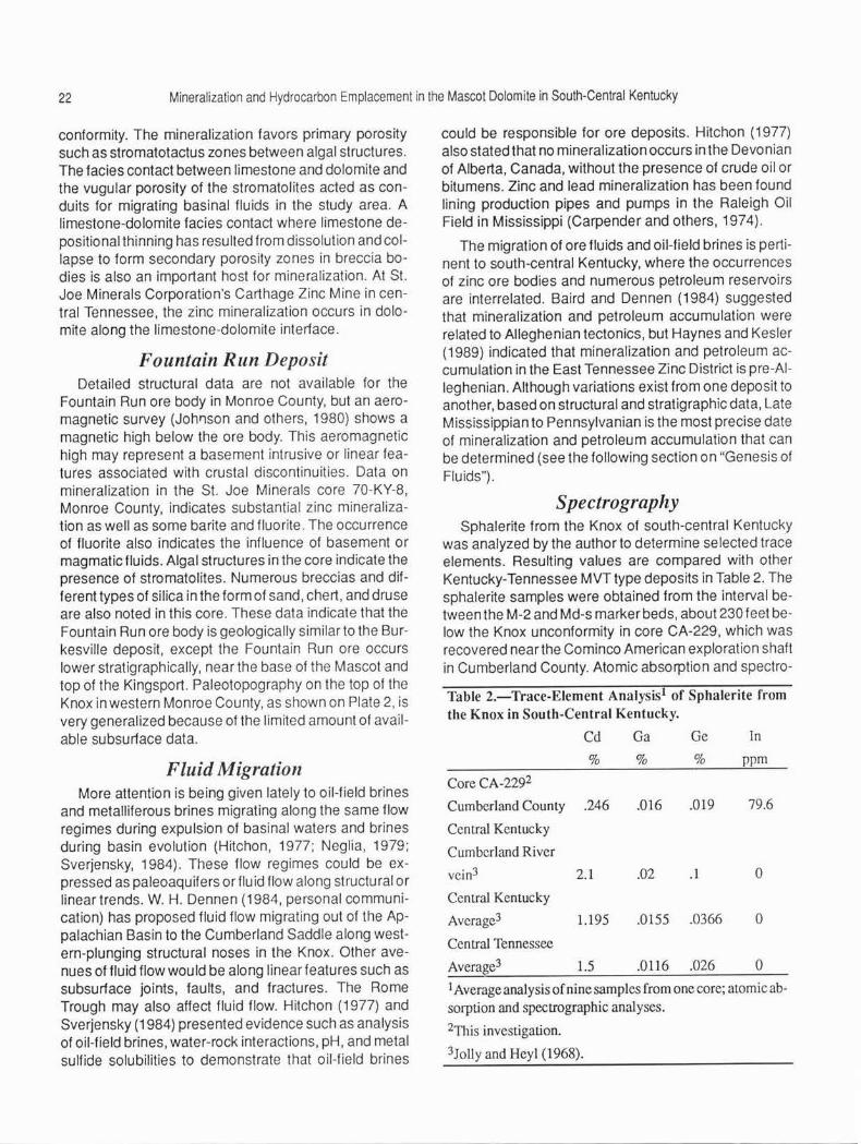
Spectrography Sphalerite from the Knox of south-central Kentucky
was analyzed by the author to determine selected trace elements. Resulting values are compared with other Kentucky-Tennessee MVT type deposits in Table 2. The sphalerite samples were obtained from the interval between the M-2 and Md-s marker beds, about 230 feet below the Knox unconformity in core CA-229, which was recovered near the Cominco American exploration shaft in Cumberland County. Atomic absorption and spectro-
Table 2.-l'race-Element Analysis1 of Sphalerite from the Knox in South-Central Kentucky.
Cd Ga Ge In
% % % ppm
Core CA-2292
Cumberland Counly .246 .016 .019 79.6
Central Kenlucky
Cumberland River
vein3 2.1 .02 .I 0
Central Kentucky
Average3 1.195 .0155 .0366 0
Central Tennessee
Average3 1.5 .0116 .026 0
I Average analysis of nine samples from one core; aLOmic ab-sorption and specLTOgraphic analyses.
2This invesligation.
3Jolly and Heyl (1968).

Economic Geology 23
graphic analysis were both used to determine trace-element values.
The sphalerites observed in this investigation were yellow, yellowish orange, orange, and ruby, but no black sphalerite was observed. There was no relation between sphalerite color and trace-element content. Cadmium, gallium, and germanium values are compared in Table 2; the results suggest that trace-element content of south-central Kentucky sphalerites is similar to that of other MVT-type deposits (Jolly and Heyl, 1968), except that cadmium was rather low, while indium values were higher or at least measurable. The cadmium-indium relationship is reciprocal , based on the similar electroaffinities and ionic radii. Indium and cadmium both compete for available spaces in the sphalerite crystal structure. The occurrence of indium could be economically significant. These values are consistent with other high trace-element values for Kentucky and Tennessee sphalerites. Recovery of these trace elements as by-products of zinc smelting could increase the value of a marginal-grade zinc deposit.
Petroleum
Petroleum in the Knox occurs in two types of reservoirs, characterized by: (1) tectonically controlled fractures and linear features, usually associated with erosional remnants , and (2) structurally controlled stratigraphic reservoirs with good secondary intercrystalline porosity. Porosity in the Knox is both vuggy intercrystalline and secondary fracture. The intercrystalline porosity is related to the development of an erosional unconformity and associated paleoaquifer.
Paleotopographic highs apparently influence the accumulation of hydrocarbons, but structure, facies, and diagenetic trends are also important factors. Fracture production in the upper Knox is probably related to exposure and erosion on the unconformity, where preexisting tectonic fractures were enlarged and developed by weathering. The Knox has numerous fractures, in part healed with calcite and dolomite and in part open (Fig. 16). Some of the major Knox oil fields, the Gradyville Field in Adair County, the Ashlock Field (Hippie lease) in Cumberland County, and the Lee's Chapel Consolidated in Clinton County, have produced thousands of barrels of oil from reservoirs with fracture, vuggy, and intergranular porosity. The Gradyville Field is a combination structural-stratigraphic trap, the Ashlock is vuggy, and the Lee's Chapel fields are mostly tectonically controlled fractures and linear features.
The accumulation of hydrocarbons was partly controlled by the M-5 marker bed of the Mascot because of
its lithology and relationship to the paleoaquif er. The M-5 marker, an impermeable cherty unit except where fractured, could have acted as an aquitard to perch the aquifer which was developed during development of the Knox unconformity. A similar situation exists in the karst terrain of southern west-central Kentucky, where the Mississippian Lost River Chert Bed, a relatively impermeable unit, occurs at the base of an aquifer (Quinlan and others, 1983). The M-5 marker bed is generally an algal, oolitic, brecciated, bluish-gray chert overlain by an olive-gray dolomite; the marker bed may have had good primary porosity. The lithology of the marker bed was later diagenetically enhanced by abundant secondary, intergranular, vuggy porosity. Numerous oil shows occur within and above the M-5 marker bed in several cores examined in this study. The M-5 is interpreted to have been at the base of a paleoaquifer in parts of south-central Kentucky, which created secondary intergranular, vuggy porosity.
The M-5 marker bed was correlated with St. Joe Minerals Corporation core C-278, Adair County, and projected to the Monitor Petroleum Corporation No. 1 Charles Corbin well in the Gradyville East oil field (Fig. 7). The base of Perkins' ( 1970) "A" horizon is dominantly a cherty dolomite, and is probably the base of the M-5 chert marker bed. This correlation suggests that the M-5 marker is associated with the producing horizons in Adair County (Perkins, 1970). Perkins (1970) identified marker beds A through Din the Knox-producing Gradyville Field in Adair County. The A horizon (Fig. 7) was subdivided into A-1 through A-4. This producing horizon correlates with the M-5 marker horizon (Fig. 2). Peter Price (1985, personal communication) stated that the Ashlock Field (Hippie lease) in Cumberland County also produces from a vuggy, silicified interval above the M-5 interval. Additional reservoirs associated with the paleoaquif er near the M-5 marker bed may be found in Adair, Russell, Metcalfe, and Green Counties. Further, the M-5 paleoaquifer was probably better developed in Adair and western Cumberland County creating a better reservoir, and less developed in eastern and southern Cumberland County, where extensive sinkholes have developed in an apparent breach of the supposedly impermeable M-5 horizon. Subtle facies and diagenetic effects may have also influenced the quality of reservoirs in these areas.
Paleotopographic data on top of the Knox show that the erosional unconformity did not cut as deeply into the Knox in Adair and Russell Counties; therefore, it would have less relief than in Cumberland County (approximately 150 to 200 feet) and more broad topographic highs and lows, which would be more suitable for the de-
24 Mineralization and Hydrocarbon Emplacement in the Mascot Dolomite in South-Central Kentucky
velopment of a paleoaquifer and secondary intergranu· lar porosity. Since the relief on the unconformity was better developed, between 200 and 300 feet, and the paleo landscape was more maturely dissected in southern Cumberland and Clinton Counties, the paleoaquiferwas probably not as well developed as in the rest of the region, and only phreatic lenses were developed throughout this region. It is in these phreatic lenses in Cumberland and Clinton Counties that some Knox oil is produced.
GENESIS OF FLUIDS1
Physical and chemical data indicate that the processes of migration and accumulation of hydrocarbons and minerals in the Knox were closely related. Hydrocarbon coatings (Fig. 21), pyrobitumen blebs (Fig. 22) , and hydrocarbon-filled inclusions (Fig. 23) indicate that liquid hydrocarbons were present in the ore-forming fluids at the end of sphalerite, fluorite, and barite deposition
Figure 21. Knox Cave al the Elmwood Zinc Mine, Elmwood, Tennessee. Note mineral specimens and petroleum coatings on the face of the cave. (Photograph courtesy of Pe ter Price.)
1Contributed by Pater Price, Marathon Oil Company.
(Figs. 21-22). Kyle (1976) stated that sphalerite-enclosed spherical voids of 1 to 2 millimeters in diameter were lined with bituminous material, but he did not indicate the position of voids within the crystals.
The composition and homogenization temperatures of fluid inclusions provide chemical evidence for this association. Data from Kyle (1976) and Roedder ( 1971) indicate minimum formation temperatures in the range of 80 to 150°C and freezing temperatures in the range of -20°C. This freezing temperature translates to a salinity of 23 weight percent. which is similar to other hot, highly saline, basinal brines found in oil fields. These brines are considered to be the carrier of metals in Mississippi Valley-type systems. Oil-filled inclusions in fluorite from the Gordonsville Mine in central Tennessee yield uncorrected homogenization temperatures in the range of 72 to 108°C, indicating a similar source for this fluid. The
QUARTZ -
DOLOMITE -CALCITE
:wl2l -? SPHALERITE
GALENA
MARCASITE -? flllZ!
FLOURITE WlZll
BARITE
CELESTITE -? Oil/
Ylll2ZI Bitumen EARLY LATE
Figure 22. Generalized paragenelic sequence illustrating mineralization and bitumen paragenesis (from Kyle, 1973; Price, 1983).
~·~~~~~~~~--'OT.o'---1 ~ ~~~~--,0001
"' w a: ::> ~
175
zffi p t50 Oa. ~! ~ ..JI- ::, Oz $ 125 zo ul ci~ a. 5N :t ii!~ I!! 100
c> 0
75
"" - COY MINE (E.TN) 111111111111 JEFF CITY MINE (E. TN) - ELMWOOD MINE (DeGroodl)
• ELMWOOD MINE (this study)
. . ' "-{ :I: 0 :i::
50'--~~~~~~~~ ~ '--~~-'-'-''::--.~ 0
FLUORITE FLUID INCLUSION TEMPERATURESOTHER SOURCES
DEPTH FROM SURFACE OF CRYSTAL IN CM
FLUORITE-ELMWOOD
Figure 23. Homogenization temperatures and oil solubility in eastern and central Tennessee.

Genesis of Fluids 25
lower temperatures in the oil-field inclusions may be a clue to the occurrence of the hydrocarbons. Lower temperatures would permit greater amounts of hydrocarbons to be exsolved from the brine and to be trapped as liquids in the inclusions. The periodic coating or inclusion of hydrocarbons within ore minerals indicates that hydrocarbons were exsolving from episodically introduced ore fluids of variable composition or that they were episodically introduced into an exsolving ore fluid. Finally, there appears to be a systematic decrease in maximum temperature of homogenization from eastern Tennessee to central Tennessee and Kentucky, adding evidence to Hoagland's (1976) hypothesis of an Appalachian Basin source for the fluids.
Isotopic analyses provide additional information about these ore fluids. Ore minerals generally reflect the isotopic compositions of ore-forming fluids. Grant and Bliss (1983) found that 87 Sr/86 Sr ratios from calcite, dolomite, fluorite, and barite from the Knox in the Elmwood-Gordonsville deposits indicates that two fluids mixed to produce the ores. Grant and Bliss (1983) could not determine, however, whether the metals and sulfur traveled together, or which fluid was heated. An oxygen isotope study of the gangue calcite, initiated by R. F. Ehinger (1980, personal communication) of Cominco American, Inc., and continued by Peter Price, indicates that the Cumberland Saddle may have been a "hot spot" or the focus of fluid flow from the basin. Oxygen isotope (D 18 0) values as light as-160/oo(PDB)wereobserved in the Burkesville area, while calcites north and south of Burkesville are considerably more enriched (- 8 to -10 °100). A substantial difference in temperature, with the temperature of the Cumberland Saddle calcite being the hottest, is the most reasonable explanation for this difference. This explanation implies that the Cumberland Saddle was a hot spot or discharge center for the western-migrating Appalachian Basin hydrothermal fluids.
CONCLUSIONS
The Mascot Dolomite is a finely to coarsely crystalline dolomite that originally consisted of shallow-water oolitic and calcarenitic limestones. The Mascot Dolomite is approximately 800 feet thick and contains abundant chert, both tripolitic and dolornoldic, and scattered sand, and is in part vuggy, laminated, mottled, and brecciated. The shallow-marine depositional environment facilitated algal growth and development of stromatolites. Subsequent diagenesis and subareal exposure created channels, conduits, breccias, and open spaces, which served as migration routes and sites for mineralization. Dissolu-
tion of the evaporites may have initiated the brecciation process in the Mascot. The porosity and permeability in the upper Knox resulting from the paleoaquifer system played an important part in the development of a petroleum reservoir in parts of south-central Kentucky. The high permeability of the Mascot Dolomite facilitated the migration of oil-field brines and other expelled fluids during basin evolution.
Dolomitization of Knox carbonate rocks was more extensive in south-central Kentucky than in central Tennessee, where the Knox consists of interbedded dolomites and limestones at the St. Joe Minerals Corporation Carthage Zinc Mine and the Jersey Minere Elmwood Zinc Mine.
Since more dolomitization occurred in south-central Kentucky than in central Tennessee, and based on the abundance of ooids in the Murley No. 1 Ellis, an intertidal basin flanked on the west by a coalescing oolitic shoal or bar is suggested to have existed periodically during deposition of the Mascot in central Cumberland County.
The presence of half-moon oolites suggests that bedded evaporites were present locally in the upper Mascot. Immediately after deposition, or possibly during deposition, eogenetic dolomite began to replace the calcareous sediment at the sediment-water interface. During initial dolomitization, oolites, the nucleus of ooids, pellets, and bioskeletal debris were dolomitized. Secondary dolomitization could be responsible for making the Knox more permeable and a better petroleum reservoir, but less receptive for chemically precipitated deposits. Several episodes of dolomite recrystallization and silicification occurred in the Mascot. These hypersaline conditions during deposition, upland erosion in central Kentucky, and the abundance of magnesium and iron favored total dolomitization of the Mascot in south-central Kentucky.
The Taconian Orogeny and downwarping of the Appalachian Basin created: (1) northwest-trending stresses, which caused exposure and erosion of the Mascot during the end of Knox time, and (2) western migration of basinal fluids that were expelled during basin subsidence. These basinalfluids were rich in metals and hydrocarbons.
With the development of the unconformity, climatic changes probably occurred, which added more water to the hydrologic system and facilitated development of karst features. The development of karst features caused channeling, solution of limestone, and the resultant brecciation, which are major processes that made the Mascot suitable for mineral accumulation.
Relief on the unconformity varies from 150 to 200 feet in Adair and Russell Counties to 300 to 400 feet in Cum-
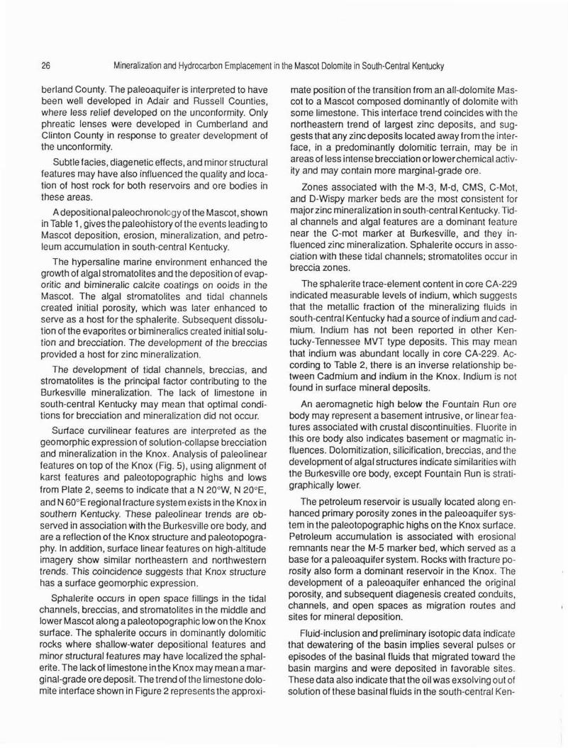
26 Mineralization and Hydrocarbon Emplacement in the Mascot Dolomite in South-Central Kentucky
berland County. The paleoaquifer is interpreted to have been well developed in Adair and Russell Counties, where less relief developed on the unconformity. Only phreatic lenses were developed in Cumberland and Clinton County in response to greater development of the unconformity.
Subtle facies, diagenetic effects, and minor structural features may have also influenced the quality and location of host rock for both reservoirs and ore bodies in these areas.
A depositional paleochronology of the Mascot, shown in Table 1, gives the paleohistory of the events leading to Mascot deposition, erosion, mineralization, and petroleum accumulation in south-central Kentucky.
The hypersaline marine environment enhanced the growth of algal stromatolites and the deposition of evaporitic and bimineralic calcite coatings on ooids in the Mascot. The algal stromatolites and tidal channels created initial porosity, which was later enhanced to serve as a host for the sphalerite. Subsequent dissolution of the evaporites or bimineralics created initial solution and brecciation. The development of the breccias provided a host for zinc mineralization.
The development of tidal channels, breccias, and stromatolites is the principal factor contributing to the Burkesville mineralization. The lack of limestone in south-central Kentucky may mean that optimal conditions for brecciation and mineralization did not occur.
Surface curvilinear features are interpreted as the geomorphic expression of solution-collapse brecciation and mineralization in the Knox. Analysis of paleolinear features on top of the Knox (Fig . 5) , using alignment of karst features and paleotopographic highs and lows from Plate 2, seems to indicate that a N 20°w, N 20°E, and N 60°E regional fracture system exists in the Knox in southern Kentucky. These paleolinear trends are observed in association with the Burkesville ore body, and are a reflection of the Knox structure and paleotopography. In addition. surface linear features on high-altitude imagery show similar northeastern and northwestern trends. This coincidence suggests that Knox structure has a surface geomorphic expression.
Sphalerite occurs in open space fillings in the tidal channels, breccias, and stromatolites in the middle and lower Mascot along a paleotopographic low on the Knox surface. The sphalerite occurs in dominantly dolomitic rocks where shallow-water depositional features and minor structural features may have localized the sphalerite. The lack of limestone in the Knox may mean a marginal-grade ore deposit. The trend of the limestone dolomite interface shown in Figure 2 represents the approxi-
mate position of the transition from an all-dolomite Mascot to a Mascot composed dominantly of dolomite with some limestone. This interface trend coincides with the northeastern trend of largest zinc deposits, and suggests that any zinc deposits located away from the interface, in a predominantly dolomitic terrain , may be in areas of less intense brecciation or lower chemical activity and may contain more marginal-grade ore.
Zones associated with the M-3, M-d, CMS, C-Mot, and 0-Wispy marker beds are the most consistent for major zinc mineralization in south-central Kentucky. Tidal channels and algal features are a dominant feature near the C-mot marker at Burkesville, and they influenced zinc mineralization. Sphalerite occurs in association with these tidal channels; stromatolites occur in breccia zones.
The sphalerite trace-element content in core CA-229 indicated measurable levels of indium, which suggests that the metallic fraction of the mineralizing fluids in south-central Kentucky had a source of indium and cadmium. Indium has not been reported in other Kentucky-Tennessee MVT type deposits. This may mean that indium was abundant locally in core CA-229. According to Table 2, there is an inverse relationship between Cadmium and indium in the Knox. Indium is not found in surface mineral deposits.
An aeromagnetic high below the Fountain Run ore body may represent a basement intrusive, or linear features associated with crustal discontinuities. Fluorite in this ore body also indicates basement or magmatic influences. Dolomitization, silicification, breccias, and the development of algal structures indicate similarities with the Burkesville ore body, except Fountain Run is stratigraphically lower.
The petroleum reservoir is usually located along enhanced primary porosity zones in the paleoaquifer system in the paleotopographic highs on the Knox surface. Petroleum accumulation is associated with erosional remnants near the M-5 marker bed, which served as a base for a paleoaquifer system. Rocks with fracture porosity also form a dominant reservoir in the Knox. The development of a paleoaquifer enhanced the original porosity, and subsequent diagenesis created conduits, channels, and open spaces as migration routes and sites for mineral deposition.
Fluid-inclusion and preliminary isotopic data indicate that dewatering of the basin implies several pulses or episodes of the basinal fluids that migrated toward the basin margins and were deposited in favorable sites. These data also indicate that the oil was exsolving out of solution of these basinal fluids in the south-central Ken-
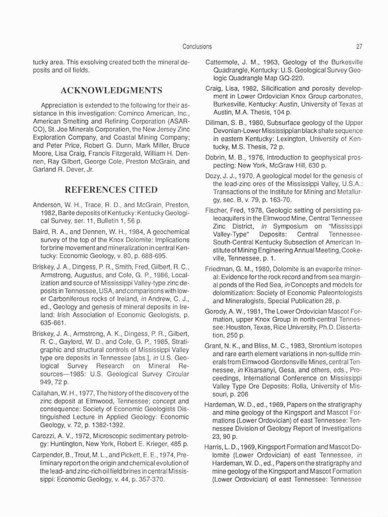
Conclusions 27
tucky area. This exsolving created both the mineral deposits and oil fields.
ACKNOWLEDGMENTS
Appreciation is extended to the following for their assistance in this investigation: Cominco American, Inc., American Smelting and Refining Corporation (ASARCO), St. Joe Minerals Corporation, the New Jersey Zinc Exploration Company, and Coastal Mining Company; and Peter Price, Robert G. Dunn, Mark Miller, Bruce Moore, Lisa Craig, Francis Fitzgerald, William H. Dennen, Ray Gilbert, George Cole, Preston McGrain, and Garland R. Dever, Jr.
REFERENCES CITED
Anderson. W. H., Trace. R. D .. and McGrain. Preston, 1982, Barite deposits of Kentucky : Kentucky Geological Survey, ser. 11, Bulletin 1, 56 p.
Baird, R. A., and Dennen, W. H., 1984, A geochemical survey of the top of the Knox Dolomite: Implications for brine movement and mineralization in central Kentucky: Economic Geology, v. 80, p. 688-695.
Briskey, J. A., Dingess. P.R., Smith , Fred, Gilbert. R. C., Armstrong, Augustus, and Cole, G . P., 1986, Localization and source of Mississippi Valley-type zinc deposits in Tennessee, USA, and comparisons with lower Carboniferous rocks of Ireland, in Andrew, C. J., ed., Geology and genesis of mineral deposits in Ireland: Irish Association of Economic Geologists, p. 635-661.
Briskey, J. A., Armstrong, A. K., Dingess, P.R., Gilbert, R. C., Gaylord, W. D., and Cole, G. P., 1985, Stratigraphic and structural controls of Mississippi Valley type ore deposits in Tennessee [abs.]. in U.S. Geological Survey Research on Mineral Resources-1985: U.S. Geological Survey Circular 949, 72 p.
Callahan, W. H., 1977, The history of the discovery of the zinc deposit at Elmwood, Tennessee; concept and consequence: Society of Economic Geologists Distinguished Lecture in Applied Geology: Economic Geology, v. 72, p. 1382-1392.
Carozzi, A. V., 1972, Microscopic sedimentary petrology: Huntington, New York, Robert E. Krieger. 485 p.
Carpender, 8., Trout, M. L., and Pickett, E. E., 1974, Preliminary report on the origin and chemical evolution of the lead- and zinc-rich oil field brines in central Missis· sippi: Economic Geology, v. 44, p. 357-370.
Cattermole, J. M., 1963, Geology of the Burkesville Quadrangle, Kentucky: U.S. Geological Survey Geologic Quadrangle Map GQ-220.
Craig, Lisa, 1982, Silicification and porosity development in Lower Ordovician Knox Group carbonates, Burkesville, Kentucky: Austin, University of Texas at Austin, M.A. Thesis, 104 p.
Dillman, S. B., 1980, Subsurface geology of the Upper Devonian-Lower Mississippian black shale sequence in eastern Kentucky: Lexington, University of Kentucky, M.S. Thesis, 72 p.
Dobrin. M. B .• 1976, Introduction to geophysical prospecting: New York, McGraw Hill, 630 p.
Dozy, J. J., 1970, A geological model for the genesis of the lead-zinc ores of the Mississippi Valley, U.S.A.: Transactions of the Institute for Mining and Metallurgy, sec. B, v. 79, p. 163-70.
Fischer, Fred, 1978, Geologic setting of persisting paleoaquifers in the Elmwood Mine, Central Tennessee Zinc District, in Symposium on "Mississippi Valley-Type" Deposits: Central TennesseeSouth-Central Kentucky Subsection of American Institute of Mining Engineering Annual Meeting, Cooke· ville, Tennessee, p. 1.
Friedman, G. M., 1980, Dolomite is an evaporite mineral: Evidence for the rock record and from sea marginal ponds of the Red Sea, in Concepts and models for dolomitization: Society of Economic Paleontologists and Mineralogists, Special Publication 28, p.
Gorody, A. W., 1981 , The Lower Ordovician Mascot Formation, upper Knox Group in north-central Tennessee: Houston, Texas, Rice University, Ph.D. Dissertation, 250 p.
Grant, N. K., and Bliss, M. C., 1983, Strontium isotopes and rare earth element variations in non-sulfide minerals from Elmwood-Gordonsville Mines, central Tennessee, in Kisarsanyi, Gesa, and others, eds ., Proceedings, International Conference on Mississippi Valley Type Ore Deposits: Rolla, University of Missouri, p. 206
Hardeman, W. D., ed., 1969, Papers on the stratigraphy and mine geology of the Kingsport and Mascot Formations (Lower Ordovician) of east Tennessee: Tennessee Division of Geology Report of Investigations 23, 90 p.
Harris, L. D., 1969, Kingsport Formation and Mascot Dolomite (Lower Ordovician) of east Tennessee, in Hardeman, W. D., ed., Papers on the stratigraphy and mine geology of the Kingsport and Mascot Formation (Lower Ordovician) of east Tennessee: Tennessee

28 Mineralization and Hydrocarbon Emplacement in the Mascot Dolomite in South-Central Kentucky
Division of Geology Report of Investigations 23, p. 1-22.
Harris, L. D., 1971, A lower paleoaquifer- The Kingsport Formation and Mascot Dolomite of Tennessee and southwest Virginia: Economic Geology, v. 66, p. 735-743.
Haynes, F. M., and Kesler, S. E. , 1989, Pre-Alleghenian (Pennsylvanian-Permian) hydrocarbon emplacement along Ordovician Knox unconformity, eastern Tennessee: American Association of Petroleum Geologists Bulletin, v. 73, no. 3, p. 289-297.
Hitchen, B., 1977, Geochemical links between oil fields and ore deposits in sedimentary rocks: Proceedings, Forum on Oil and Ore in Sediments, Imperial College, London, p. 2-34.
Hoagland, A. D., 1976, Appalachian zinc-lead deposits, in Wolf, D., ed., Handbook of strata bound and stratiform ore deposits: Amsterdam, Elsevier, v. 6, p. 495-534.
Jackson, S. A .. and Beales, F. W., 1967, An aspect of sedimentary basin evolution: The concentration of Mississippi Valley type ores during late stages of diagenesis: Bulletin of Canadian Petroleum Geology, v. 15, no.4, p. 383-433.
Johnson, R. W., Jr., Haywood, C. , and Kunselman, P. M., 1980, Residual total intensity aeromagnetic map of Kentucky: Central sheet: Kentucky Geological Survey, ser. 11, Scale 1 :250,000.
Jolly, J. L., and Heyl, A. V., 1968, Mercury and other trace elements in sphalerite and wallrocks from central Kentucky, Tennessee, and Appalachian zinc districts: U.S. Geological Survey Bulletin 1252-F, 29 p.
Kyle, J. R., 1973, Preliminary investigation of brecciation, alteration, and mineralization in the upper Knox Group of Smith and Trousdale Counties, Tennessee: Knoxville, UniversttyofTennessee, M.S. Thesis, 105 p.
Kyle, J. R., 1976, Brecciation, alteration, and mineralization in the Central Tennessee Zinc District: Economic Geology, v. 71, p. 892-903.
Land, L. S., 1985, The origin of massive dolomite: Journal of Geology, v. 33, p. 112.
Lewis, R. Q., 1972, Geologic map of the Vernon Quadrangle and part of the Celina Quadrangle, Monroe and Cumberland Counties, Kentucky: U.S. Geological Survey Geologic Quadrangle Map GQ-966.
Lewis, A. Q., Sr., 1977, Geologic map of the Powersburg Quadrangle, Wayne and Clinton Counties, Kentucky:
U.S. Geological Survey Geologic Quadrangle Map GQ-1377.
Logan, B. W., 197 4 , Evolution and diagenesis of Quaternary carbonate sequences, Shark Bay, western Australia: American Association of Petroleum Geologists Memoir 22, p. 141-150.
McGuire, W. H., and Howell, Paul, 1963, Oil and gas possibilities of the Cambrian and Lower Ordovician in Kentucky: Lexington, Kentucky, Spindletop Research, 100 p.
Neglia, S., 1979, Migration of fluids in sedimentary basins: American Association of Petroleum Geologists Bulletin , v. 63, no. 4, p. 573-597.
Ohle, E. L., 1951 , The influence of permeability on ore distributions in limestone and dolomite: Economic Geology, v. 46, pt. 1, p.467-707; pt. 2, p. 871-908.
Ohle, E. L., 1959, Some considerations in determining the origin of deposits of the Mississippi Valley type: Economic Geology, v. 54, no. 5, p. 769-789.
Ohle, E. L., 1980, Some considerations in determining the origin of deposits of the Mississippi Valley typePart II: Economic Geology, v. 75, no. 2, p. 161 -172.
Perkins, J. H., 1970, Geology and economics of Knox Dolomite oil production in Gradyville East Field, Adair County, Kentucky, in Hutcheson, D. W., ed., Proceedings of the Technical Sessions, Kentucky Oil and Gas Association, 34th and 35th Annual Meetings, 1970 and 1971: Kentucky Geological Survey, ser. 10, Special Publication 21, p. 10-25.
Quinlan, J. F., Ewers, R. 0 ., and Ray, J. A., 1983, Ground water hydrology and geomorphology of the Mammoth Cave region, Kentucky : Geological Society of Kentucky Field Trip, 1983: Richmond, Eastern Kentucky University Chapter of Sigma Gamma Epsilon, 85 p.
Roedder, Edwin, 1971, Fluid inclusion evidence of the environment of formation of mineral deposits of the southern Appalachian Valley : Economic Geology, v. 66, p. 777-791.
Sawkins, F. J., 1969, Chemical brecciation; an unrecognized mechanism for breccia formation: Economic Geology, v. 64, no. 6, p. 613-617.
Shaver, R. H., coordinator, 1985. Correlation of Stratigraphic Units of North America (COSUNA) Project: Midwestern Basin and Arches Region: American Association of Petroleum Geologists, Sheet MBA
Skinner, B. J., 1971, A paleoaquifer and its relation to economic mineral deposits: The Lower Ordovician Kingsport Formation and Mascot Dolomite of east

References Cited 29
Tennessee: A symposium: Economic Geology, v. 66, no. 5, p. 735-743.
Staggs, A. K., and Fischer, F. T. , 1970, Upper Knox stratigraphy of middle Tennessee [abs.]: Geological Society of America, Abstracts with Programs, v. 2, no. 7, p. 693.
Sverjensky, D. A , 1984, Oil field brines as ore forming solutions: Economic Geology, v. 79, p. 23-37.
Taylor, A. A., 1962, Geology of the Amandaville Quadrangle, Kentucky: U.S. Geological Survey Geologic Quadrangle Map GQ-186.
Woodward, H.P., 1961, Preliminary subsurface study of southeastern Appalachian Interior Plateau : American Association of Petroleum Geologists Bulletin, v. 45, no. 10,p. 1634-1655.

30 Mineralization and Hydrocarbon Emplacement in the Mascot Dolomite in South-Central Kentucky
APPENDIX A: DESCRIPTION OF COASTAL MINING COMPANY CORE D-11, CLINTON COUNTY, KENTUCKY
Described By:
Carter Coordinate Location:
Elevation:
Kentucky Geological Survey Call No.:
Interval Described:
Description Completed:
Depth Description
Top of core- High Bridge Group.
1705.00-1722.00 Camp Nelson Limestone. Limestone, medium- to darkgray, finely crystalline; inter-
1722.00-1790. 75
1790.75-1849.50
1849.50-1994.00
bedded with 1/4- to 1/2-inchthick black partings to 1722.00 feet. Wells Creek Formation. Limestone, olive-gray, finely crystalline, with occasional shale laminae: stylolites; interbedded with greenish-gray, finely crystalline dolomite with some distinct shale zones; lower 1 O feet argillaceous to shaly, speckled-mottled. porous dolomite; lower 3 feet rip-up breccia containing Knox clasts in green shaly matrix. Top of Knox Group. Mascot Dolomite. Dolomite, light-brownish-gray to brownish· olive-gray, very finely to finely crystalline, limy, fractured; contains dolomite and calcite, green and black shale with traces of pyrite; brecciated; some slickensides at 1800.33 feet; leached brecciated zone at 1801 feet ; iron staining; some porcellaneous chert ; M-5 marker bed is brecciated st raticulite underlain by chert nodules at base. Dolomite. light· to olive-gray, finely crystalline; in part slight col-or laminations; shaly, also with distinct shale partings; in part argillaceous; in part speckledmottled; pyrite concentrated along fractures: becomes more brownish-gray with oolitic chert and trace of sand from 1868. 00 to
Warren H. Anderson
17-0-53
820 feet
No call no. issued at press time
1,705-2,645 feet
June 1982
Depth
1994.83-2163.00
Description
1868.75 feet; limy from 1875.00 to 1879.00 feet; brecciated with calcite matrix from 1875.00 to 1877.00 feet; becomes porous, more argillaceous with pyrite specks; green and black shale at 1913.75 feet underlain by 3 feet of sand (M-3 marker bed): scat· tered yellow sphalerite at 1897.00, 1915.50, 1968.00-1970.00 feet; wispy marker bed at 1967.00 feet; mottled with pyritic and argillaceous material; some slickensides along shale partings. Dolomite, light- to medium-gray, finely crystalline, argillaceous, with some bluish-green, shaly coloring (BLU MOT marker) and some distinct shale partings; algal mottling with trace of yellow sphalerite at 1997.66 feet ; becomes more olive to brownish-gray, slightly laminated, with secondary porosity and sand at 2000.75 feet; in part brecciated, dark-gray to brownish-gray dolomite. Black, disturbed, argillaceous partings from 2012.66 to 2016.00 feet, underlain by light-olive-gray, fine ly crystalline, porous, partly granular, laminated, banded dolomite; scattered green shale partings; scattered pyrite-marcasite and sand from 2005.00 to 2036.00 feet (M-2 marker bed) and 1 foot of sand at 2131.00 feet overlain by mottled dolomite (M-1 marker bed ; abundant vuggy chert at

Appendix A
Depth Description
2080.00 feet; scattered sand zones with some oolitic chert.
2163.00-2212.83 Dolomite, medium-gray to light-brownish-gray, finely crystalline; cherty, with porcelaneous and tripolitic chert with dolomoldic texture; in part limy, cherty, with relict oolitic texture; in part coarsely crystalline; scattered sand; fractured, brecciated; some shale partings; in part slightly vuggy; calcite, dolomite fractures; speckled-mottled unit underlain by breccia with light-brown dolomite clasts in white tripolitic chert matrix, and relict bioclastic-oolitic textured chert from 2183.00 to 2184.00 feet; in part siliceous with some light-blue porcelaneous chert; brecciated chert matrix and at base (CMS marker).
2212.83-2340.00 Dolomite. light- to medium-gray, moderately crystalline; sandy from 2215.75-2216. 75, 2224.00-2225.00, 2260.00 feet ; speckledmottled with some tripolitic chert, including some scattered tripolitic chert breccia cemented with gray siliceous clay from 2223.00-2229.00; in part coarsely crystalline and recrystalline at 2230.00 feet, underlain by green, shaly, fractured dolomite; in part moderately crystalline, brown, mottled dolomite. trace yellow sphalerite at 2230.00 feet; oolitic chert and sand, laminated and mottled, with chert matrix sand at 2273.00 feet.
2340.00-2382.00 Dolomite. medium-gray to lightbrownish-gray, finely to moderately crystalline; in part limy; in part speckled-mottled with cal-
Depth
2382.00-2382.66
2383 .66-2603.33
2603 .33-2645. 00
31
Description cite fractures and dolomite pods; sand at 2351.00 feet; chert at 2354.00 feet, underlain with speckled-mottled dolomite with occasional shale partings; chert-nodule zone at 2360.00 feet; becomes earthy, argillaceous, laminated dolomite with sand at 2362.00, 2366.00 feet (K-1 marker bed); fractures at 2371.00 and at 2380.00 feet; sandy and chert matrix sand at 2373.00 feet. Chert, white, porcelaneous, vuggy, with quartz druse and some dolomite and green shale at base. Dolomite, light-gray to lightolive-gray, finely crystalline; in part cherty, laminated, brecciated, with white dolomite mottling (C-Mot marker) and with scattered sand zones, fractured; shale at 2445.00 feet; abundant sand at 2448.00 feet (K-d marker bed), underlain by tripolitic chert breccia, some porcelaneous chert with relict pisolitic texture; chert breccia and dolomite breccia with speckled-mottled dolomite (D-Wispy marker) near base; slickensides. Dolomite, light-gray, moderately to coarsely crystalline, with 6 inches green shale at top; TR marker bed at top of unit ; brecciated, mottled with 2 inches of dolomite and chert breccia clasts in argillaceous, dolomitic, coarsely grained matrix; in part limy, with several argillaceous and shaly partings, some chert matrix sand at 2636.00 feet.