mini map front - usda
TRANSCRIPT
America’s Great Outdoors
HoosierNational Forest
Forest ServiceForest ServiceUnited States Department of Agriculture
for more information:Hoosier National Forest811 Constitution Avenue
Bedford, IN 47421812-275-5987
www.fs.fed.us/r9/hoosier
Hoosier National ForestTell City District248 15th Street
Tell City, IN 47586812-547-7051
Federal relay system for the deaf and hearing impaired: 1-800-877-8339
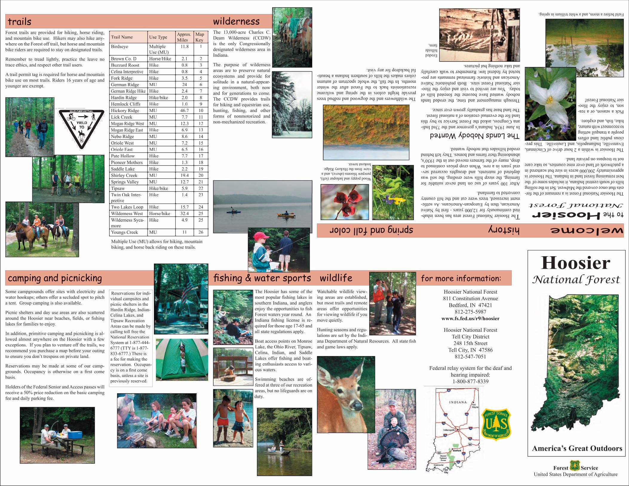
trailsForest trails are provided for hiking, horse riding, and mountain bike use. Hikers may also hike any-where on the Forest off trail, but horse and mountain bike riders are required to stay on designated trails.
Remember to tread lightly, practice the leave no trace ethics, and respect other trail users.
A trail permit tag is required for horse and mountain bike use on most trails. Riders 16 years of age and younger are exempt.
Trail Name Use Type Approx.Miles
Map Key
Birdseye Multiple Use (MU)
11.8 1
Brown Co. D Horse/Hike 2.1 2Buzzard Roost Hike 0.8 3Celina Interpretive Hike 0.8 4Fork Ridge Hike 3.5 5German Ridge MU 24 6German Ridge Hike Hike 2.4 7Hardin Ridge Hike/bike 2.0 8Hemlock Cliffs Hike 1.0 9Hickory Ridge MU 46.7 10Lick Creek MU 7.7 11Mogan Ridge West MU 12.3 12Mogan Ridge East Hike 6.9 13Nebo Ridge MU 8.6 14Oriole West MU 7.2 15Oriole East MU 6.5 16Pate Hollow Hike 7.7 17Pioneer Mothers Hike 1.3 18Saddle Lake Hike 2.2 19Shirley Creek MU 19.4 20Springs Valley MU 12.7 21Tipsaw Hike/bike 5.9 22Twin Oak Inter-pretive
Hike 1.4 23
Two Lakes Loop Hike 15.7 24Wilderness West Horse/hike 32.4 25Wilderness Syca-more
Hike 4.9 25
Youngs Creek MU 11 26
Multiple Use (MU) allows for hiking, mountain biking, and horse back riding on these trails.
camping and picnickingSome campgrounds offer sites with electricity and water hookups; others offer a secluded spot to pitch a tent. Group camping is also available.
Picnic shelters and day use areas are also scattered around the Hoosier near beaches, fi elds, or fi shing lakes for families to enjoy.
In addition, primitive camping and picnicking is al-lowed almost anywhere on the Hoosier with a few exceptions. If you plan to venture off the trails, we recommend you purchase a map before your outing to ensure you don’t trespass on private land.
Reservations may be made at some of our camp-grounds. Occupancy is otherwise on a fi rst come basis.
Holders of the Federal Senior and Access passes will receive a 50% price reduction on the basic camping fee and daily parking fee.
fi shing & water sports
welcometo the HoosierNational Forest
The Hoosier National Forest is a remnant of the for-ests that once covered the Midwest. Set in the rolling hills of south central Indiana, it includes some of the best remaining forest land in Indiana. The Hoosier is approximately 200,000 acres in size but scattered in a patchwork of land over nine counties, so take care not to trespass on private land.
The Hoosier is within a 2 hour drive of Cincinnati, Evansville, Indianapolis, and Louisville. This pre-cious public land offers people a tranquil setting to reconnect with nature, hike, fi sh, and explore.
Pick a season, or a rea-son, to enjoy the Hoo-sier National Forest!
historyThe Hoosier National Forest area has been inhab-ited continuously for 12,000 years - fi rst by Native American, then by European-Americans. As settle-ment increased, trees were cut and the hill country converted to farmland.
After 100 years of use on land never suitable for farming, the steep hills were eroding, the soil was depleted of nutrients, and droughts occurred sev-eral years in a row. When crop prices continued to drop, many of the farmers moved out in the 1930’s, abandoning their farms and homes. They left behind eroded hillsides that nobody wanted.
The Lands Nobody WantedIn June 1934, Indiana’s governor and the 73rd Indi-ana Congress, asked the Forest Service to buy this land for the eventual creation of a national forest.The land base has gradually grown ever since.
Through management and time, the eroded lands nobody wanted have become the forested hills of today. You are invited to visit and enjoy the Hoo-sier National Forest sites. Both prehistoric Native American and historic farmstead remnants are pro-tected by federal law. Remember to walk carefully and take nothing but pictures.
Field before a storm, and a white trillium in spring.
wildernessThe 13,000-acre Charles C. Deam Wilderness (CCDW) is the only Congressionally designated wilderness area in Indiana.
The purpose of wilderness areas are to preserve natural ecosystems and provide for solitude in a natural-appear-ing environment, both now and for generations to come. The CCDW provides trails for hiking and equestrian use, hunting, fi shing, and other forms of nonmotorized and non-mechanized recreation.
wildlifeWatchable wildlife view-ing areas are established, but most trails and remote areas offer opportunities for viewing wildlife if you move quietly.
Hunting seasons and regu-lations are set by the Indi-ana Department of Natural Resources. All state fi sh and game laws apply.
The Hoosier has some of the most popular fi shing lakes in southern Indiana, and anglers enjoy the opportunities to fi sh Forest waters year round. An Indiana fi shing license is re-quired for those age 17-65 and all state regulations apply.
Boat access points on Monroe Lake, the Ohio River, Tipsaw, Celina, Indian, and Saddle Lakes offer fi shing and boat-ing enthusiasts access to vari-ous waters.
Swimming beaches are of-fered at three of our recreation areas, but no lifeguards are on duty.
The wildfl owers and the dogwood and redbud trees provide bright colors in the spring and welcome recreationists back to the Forest after the winter months. In the fall, the whole spectrum of autumn colors makes the hills of southern Indiana a beauti-ful backdrop for any visit.
Wood poppy and larkspur (left), pawpaw blooms (above), and a view from the Hickory Ridge lookout tower.
Eroded hillside farm.
spring and fall color
Reservations for indi-vidual campsites and picnic shelters in the Hardin Ridge, Indian-Celina Lakes, and Tipsaw Recreation Areas can be made by calling toll free the National Reservation System at 1-877-444-6777 (TTY is 1-877-833-6777.) There is a fee for making the reservation. Occupan-cy is on a fi rst come basis, unless a site is previously reserved.
U.S. Department of AgricultureForest Service
Hoosier National ForestINDIANA
2007
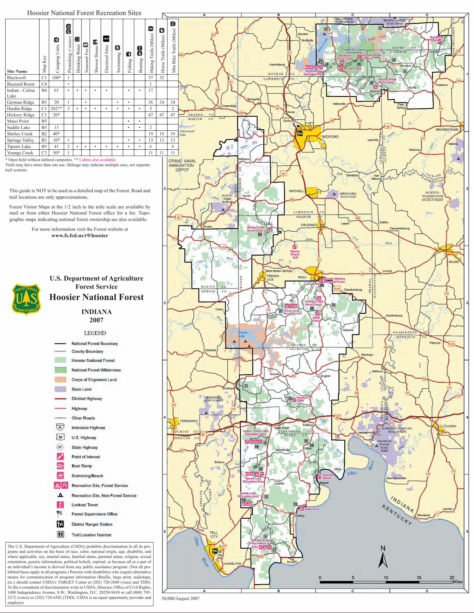
Hoosier National Forest Recreation Sites
* Open fi eld without defi ned campsites. ** Cabins also availableTrails may have more than one use. Mileage may indicate multiple uses, not separate trail systems.
This guide is NOT to be used as a detailed map of the Forest. Road and trail locations are only approximations.
Forest Visitor Maps at the 1/2 inch to the mile scale are available by mail or from either Hoosier National Forest offi ce for a fee. Topo-graphic maps indicating national forest ownership are also available.
For more information visit the Forest website at www.fs.fed.us/r9/hoosier
The U.S. Department of Agriculture (USDA) prohibits discrimination in all its pro-grams and activities on the basis of race, color, national origin, age, disability, and where applicable, sex, marital status, familial status, parental status, religion, sexual orientation, genetic information, political beliefs, reprisal, or because all or a part of an individual’s income is derived from any public assistance program. (Not all pro-hibited bases apply to all programs.) Persons with disabilities who require alternative means for communication of program information (Braille, large print, audiotape, etc.) should contact USDA’s TARGET Center at (202) 720-2600 (voice and TDD). To fi le a complaint of discrimination write to USDA, Director, Offi ce of Civil Rights, 1400 Independence Avenue, S.W., Washington, D.C. 20250-9410 or call (800) 795-3272 (voice) or (202) 720-6382 (TDD). USDA is an equal opportunity provider and employer.
Site Name Map
Key
Cam
ping
Uni
ts a
Picn
icki
ng (#
shelt
ers)
cç
Drin
king
Wat
er f
Seas
onal
Fee
e
Show
er H
ouse
F
Elec
trica
l Site
s
Swim
min
g m
Fish
ing
j
Boa
ting
B
oatin
g kLkL
Hik
ing
Trai
ls (M
iles)
w
Hor
se T
rails
(Mile
s) 6
Mtn
Bik
e Tr
ails
(Mile
s) -
Blackwell C1 100* 1 37 32Buzzard Roost C4 • 1Indian - Celina Lake
B4 63 • • • • • • • 17
German Ridge B5 20 1 • • • 26 24 24Hardin Ridge C1 202** 3 • • • • • • • 3 2Hickory Ridge C1 20* 47 47 47Mano Point B5 • •Saddle Lake B5 13 • • 2Shirley Creek B2 40* 19 19 19Springs Valley B3 10* • • • 13 13 13Tipsaw Lake B5 41 2 • • • • • • • 6 6Youngs Creek C3 50* 1 11 11 11
50,000/August 2007