ministerial understanding on the development of the...
TRANSCRIPT
MINISTERIAL UNDERSTANDINGON THE DEVELOPMENT OF
THE ASEAN HIGHWAY NETWORK PROJECT
WE the undersigned, attending the Fifth ASEAN Transport Ministers Meeting heldin Hanoi, Vietnam on 15-16 September 1999;
RECALLING the following policy directives enunciated by the ASEAN Heads ofState and Government:
1. Manila Declaration of 1987 signed on 15 December 1987, which provided thatthe existing transportation system shall be strengthened to ultimately form anoverall ASEAN transportation network;
2. ASEAN Vision 2020 adopted in Kuala Lumpur, Malaysia on 15 December1997, which resolved, inter alia, the development of an integrated andharmonized trans-ASEAN transportation network;
3. Hanoi Plan of Action adopted on 15 December 1998, which provided forintensifying cooperation in the development of the trans-ASEAN transportationnetwork as the trunkline or main corridor for the movement of goods and peoplein ASEAN, consisting of major road (interstate highway) networks, amongothers, and the development and implementation of the ASEAN HighwayNetwork Project; and
4. Hanoi Declaration of 1998 signed on 16 December 1998, which called for thedevelopment and strengthening of ASEAN regional infrastructure through theexpansion of transport links and the provision of efficient and qualityinfrastructure.
RECALLING FURTHER our resolve under the Ministerial Understanding onASEAN Cooperation in Transportation signed in Bali, Indonesia on 18 March 1996,to establish and develop a harmonized and integrated regional transportation system,promote interconnectivity and interoperability of national networks and accessthereto, and strengthen and enhance existing cooperation efforts in the developmentof transport infrastructure;
NOTING the steady progress of the ongoing cooperation activities of the ASEANHighway Experts and the Senior Transport Officials Meeting in the development ofthe ASEAN Highway Network Project;
REAFFIRMING our commitment at the Second ASEAN Transport MinistersMeeting held in Chiang Mai, Thailand on 28 February 1997, to jointly develop acomplete system of highway network to link ASEAN Member Countries togetherand where technical standards of design and road traffic safety are compatible; and
RECOGNIZING that the ASEAN Highway Network Project is a criticalinfrastructural support facility necessary for the greater and closer integration of theASEAN region, as well as in the facilitation of regional trade, investment andtourism opportunities;
DO HEREBY AGREE THAT :
Article 1
OBJECTIVES
The objectives of this Ministerial Understanding on the Development of the ASEANHighway Network Project are :
(a) To provide the institutional mechanism to formalize the strategic routeconfiguration and the uniform technical design standards of the ASEANHighway Network, being the major road (interstate highway) componentof the overall trans-ASEAN transportation network;
(b) To formulate the ASEAN Highway Infrastructure Development Planconsisting of priority highway projects of regional significance, forfunding and implementation through Official Development Assistance(ODA), project financing by the private sector or by joint public-privatesector arrangement, or by the individual ASEAN Member Countries, asmay be necessary;
(c) To promote cooperation with other international and regionalorganizations, so as to ensure technical compatibility of ASEAN's roadstandards and road safety requirements and create stronger road transportlinks and connections within ASEAN and those with neighboring oradjoining regions; and

(d) To intensity cooperation in the facilitation of international road trafficthroughout the ASEAN region.
Article 2
ASEAN HIGHWAY ROUTE CONFIGURATION ANDTECHNICAL REQUIREMENTS
(1) Member Countries shall adhere to the route configuration of the ASEANHighway Network, the network details and designations of which aredescribed in Annex "A", which forms an integral part of this MinisterialUnderstanding, for the coordinated improvement and upgrading of theirnational road (interstate highway) routes of the ASEAN Highway Network.
(2) Member Countries shall conform to the recommended technical designstandards and requirements set out in Annex "B", which forms an integral partof this Ministerial Understanding.
Article 3
DEVELOPMENT STRATEGY FOR THEIMPLEMENTATION OF THE
ASEAN HIGHWAY NETWORK PROJECT
To foster the integrated and coordinated development and implementation of theASEAN Highway Network Project, Member Countries shall intensify cooperativearrangements at the national, subregional and regional-levels through bettermanagement and optimum use of existing road transport infrastructure. Equalemphasis shall be accorded to adopting measures to improve the operationalefficiency and reliability of international road transport. In this regard, MemberCountries shall be guided by the following implementation arrangement.
(a) Member Countries shall endeavour to improve or upgrade their designatednational road (interstate highway) networks, in line with the phaseddevelopment timeframe, as follows :
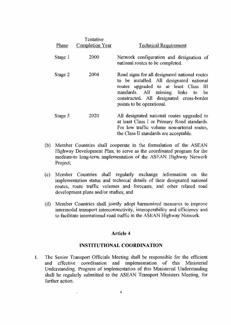
TentativePhase Completion Year Technical Requirement
Stage 1 2000 Network configuration and designation ofnational routes to be completed.
Stage 2 2004 Road signs for all designated national routesto be installed. All designated nationalroutes upgraded to at least Class IIIstandards. All missing links to beconstructed. All designated cross-borderpoints to be operational.
Stage 3 2020 All designated national routes upgraded toat least Class I or Primary Road standards.For low traffic volume non-arterial routes,the Class II standards are acceptable.
(b) Member Countries shall cooperate in the formulation of the ASEANHighway Development Plan, to serve as the coordinated program for themedium-to long-term implementation of the ASEAN Highway NetworkProject;
(c) Member Countries shall regularly exchange information on theimplementation status and technical details of their designated nationalroutes, route traffic volumes and forecasts, and other related roaddevelopment plans and/or studies; and
(d) Member Countries shall jointly adopt harmonized measures to improveintermodal transport interconnectivity, interoperability and efficiency andto facilitate international road traffic in the ASEAN Highway Network.
Article 4
INSTITUTIONAL COORDINATION
The Senior Transport Officials Meeting shall be responsible for the efficientand effective coordination and implementation of this MinisterialUnderstanding, Progress of implementation of this Ministerial Understandingshall be regularly submitted to the ASEAN Transport Ministers Meeting, forfurther action.

2. The Senior Transport Officials Meeting shall also be responsible for providingthe necessary institutional mechanism to encourage greater participation of theprivate sector, ASEAN dialogue partners, international and multilateralorganizations, etc., to ensure the successful development and implementation ofthe ASEAN Highway Network Project.
3. The ASEAN Secretariat shall assist the Senior Transport Officials Meeting inthe discharge of the above responsibilities, including technical support in themanagement, coordination, review and monitoring of cooperation programs andactivities which may arise from the implementation of this MinisterialAgreement.
Article 5
FINAL PROVISIONS
1. This Ministerial Understanding shall enter into force on the date of signature.
2. This Ministerial Understanding may be amended by consent of all the ASEANMember Countries.
3. This Ministerial Understanding shall be deposited with the Secretary-Generalof ASEAN who shall promptly furnish a certified copy thereof to each ASEANMember Country.
DONE at Hanoi, Vietnam, this 15th day of September 1999, in a single copy in theEnglish language.
PEHINMinister of Commumcl
Brunei Darussalam
KHY TAINGL]Minister of Public Workshd Transport
Kingdom of Cambodia

ANWAR SUPRIJADISecretary General
Ministry of CommunicationsRepublic of Indonesia
PHAO BOUNNAPHOLMinister of Communication, Transport, Post and Construction
Lao People's Democratic Republic
DATO' SERI DR.LJS& LIONG SIKMinis4ert5fTransport
Malaysia
MAJ. G^THLA MYINT SWEMinister of TransportUnion of Myanmar
VICENTE CTRIVERA, JR.Secretary of Transportation and Communications
Republic of the Philippines
;o CHEOW*Minister for Communications and In^bmfotion Technology
Republic of Singapore
SUTHEP THAUGSUBANMinister of Transport and Communications
Kingdom of Thailant
LE NGOC HO ANMinister of Transport
Socialist Republic of Vietnam
Annex A
ASEAN Highway Network
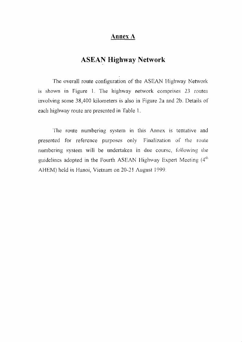
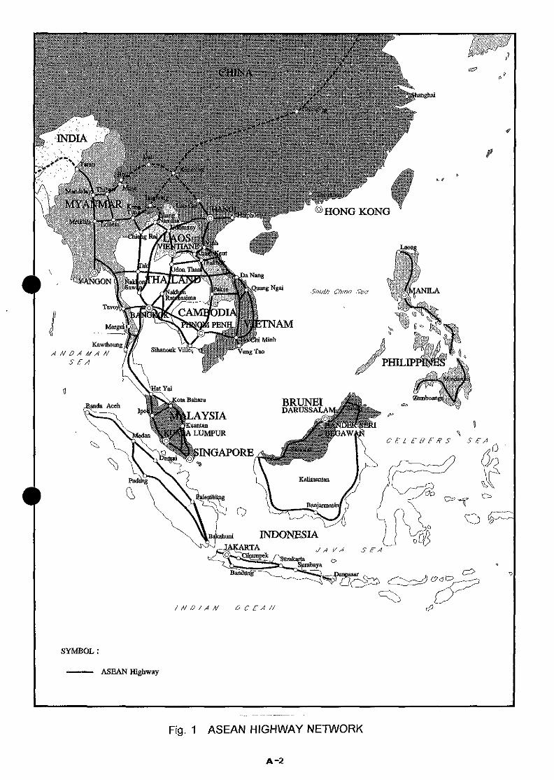
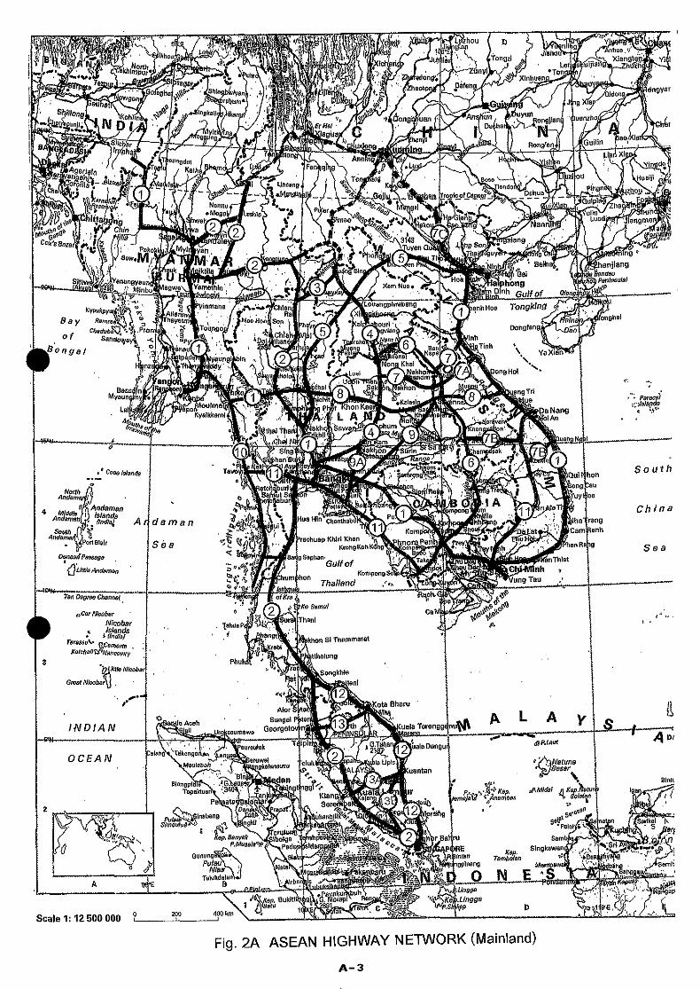
The overall route configuration of the ASEAN Highway Network
is shown in Figure 1. The highway network comprises 23 routes
involving some 38,400 kilometers is also in Figure 2a and 2b. Details of
each highway route are presented in Table 1.
The route numbering system in this Annex is tentative and
presented for reference purposes only Finalization of the route
numbering system will be undertaken in due course, following the
guidelines adopted in the Fourth ASEAN Highway Expert Meeting (4U
AHEM) held in Hanoi, Vietnam on 20-21 August 1999.
KawthoungANDAMAN
S £ A
INDONESIATA JAVA
Fig. 1 ASEAN HIGHWAY NETWORK
A-2
JL/ >-*JUWBeir- % *TonSP
f aunetiv V^/7 ,4 jshWongr \^i ^L>
Mo00i7jushlA ~-A \yy*'
/^TjianhHoa Tongking
^,^^SS^^KIK^f . '\\ x->L*J Ahi>X^,^1 /ffl>—' JC^-fi_... ^Tli V
oCarNluoberNteobar
t ishnds* (India/
Scale 1:12 500 000
Fig. 2A ASEAN HIGHWAY NETWORK (Mainland)
A-3
Scale 1:19 000 0000 200 400 km
Fig. 2B ASEAN HIGHWAY NETWORK (islands)
A-4
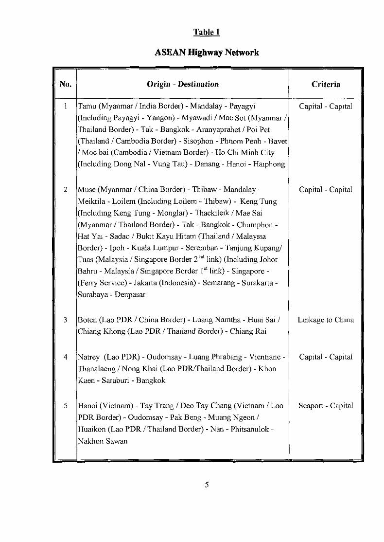
Table 1
ASEAN Highway Network
No. Origin - Destination Criteria
Tamu (Myanmar / India Border) - Mandalay - Payagyi(Including Payagyi - Yangon) - Myawadi / Mae Sot (Myanmar /Thailand Border) - Tak - Bangkok - Aranyaprahet / Poi Pet(Thailand / Cambodia Border) - Sisophon - Phnom Penh - Bavet/ Moc bai (Cambodia / Vietnam Border) - Ho Chi Minh City(Including Dong Nal - Vung Tau) - Danang - Hanoi - Haiphong
Muse (Myanmar / China Border) - Thibaw - Mandalay -Meiktila - Loilem (Including Loilem - Thibaw) - Keng Tung(Including Keng Tung - Monglar) - Thackileik / Mae Sai(Myanmar / Thailand Border) - Tak - Bangkok - Chumphon -Hat Yai - Sadao / Bukit Kayu Hitam (Thailand / MalaysiaBorder) - Ipoh - Kuala Lumpur - Seremban - Tanjung Kupang/Tuas (Malaysia / Singapore Border 2nd link) (Including JohorBahru - Malaysia / Singapore Border 1st link) - Singapore -(Ferry Service) - Jakarta (Indonesia) - Semarang - Surakarta -Surabaya - Denpasar
Boten (Lao PDR / China Border) - Luang Namtha - Huai Sai /Chiang Khong (Lao PDR / Thailand Border) - Chiang Rat
Natrey (Lao PDR) - Oudomsay - Luang Phrabang - Vientiane -Thanalaeng / Nong Khai (Lao PDR/Thailand Border) - KhonKaen - Saraburi - Bangkok
Hanoi (Vietnam) - Tay Trang / Deo Tay Chang (Vietnam / Lao,PDR Border) - Oudomsay - Pak Beng - Muang Ngeon /Huaikon (Lao PDR / Thailand Border) - Nan - Phitsanulok -Nakhon Sawan
Capital - Capital
Capital - Capital
Linkage to China
Capital - Capital
Seaport - Capital
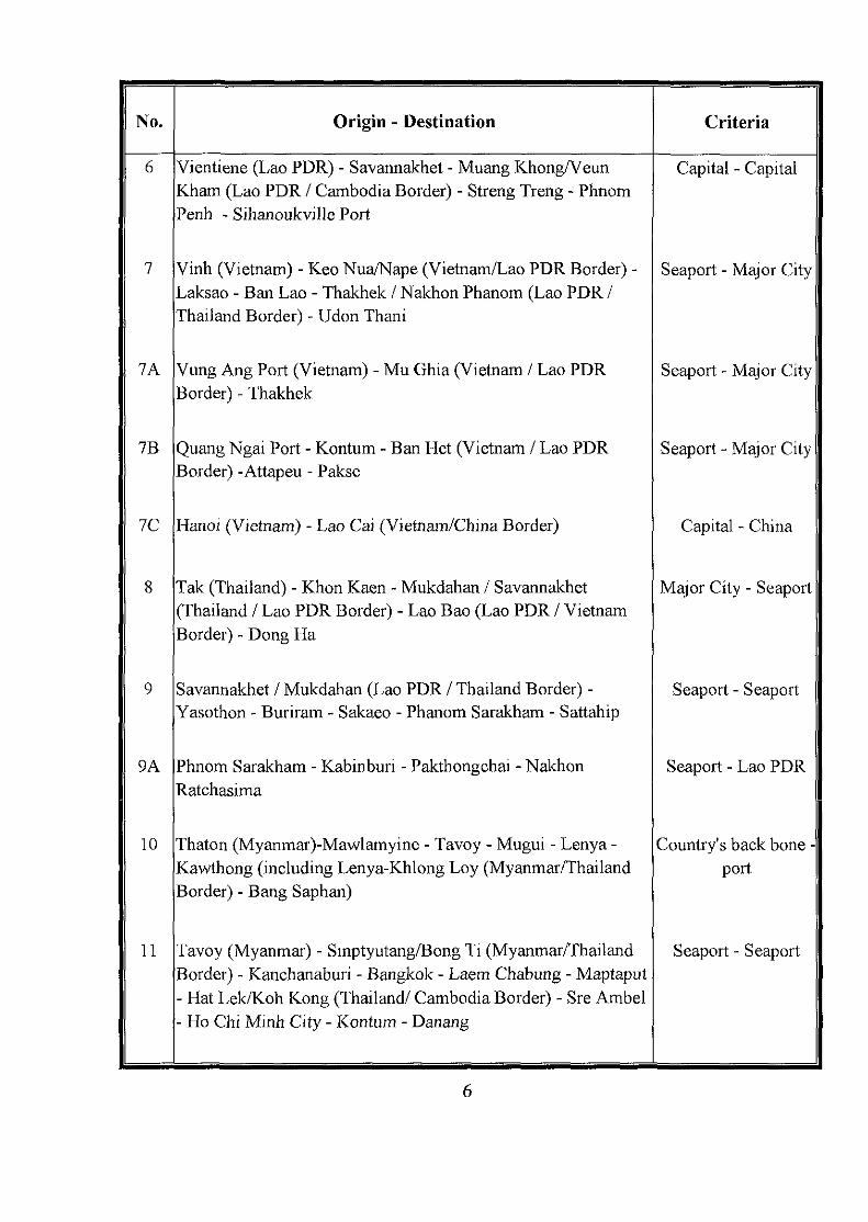
No. Origin - Destination Criteria
7A
7B
1C
9A
10
11
Vientiene (Lao PDR) - Savannakhet - Muang Khong/VeunKham (Lao PDR / Cambodia Border) - Streng Treng - PhnomPenh - Sihanoukville Port
Vinh (Vietnam) - Keo Nua/Nape (Vietnam/Lao PDR Border) -Laksao - Ban Lao - Thakhek / Nakhon Phanom (Lao PDR /Thailand Border) - Udon Thani
Vung Ang Port (Vietnam) - Mu Ghia (Vietnam / Lao PDRBorder) - Thakhek
Quang Ngai Port - Kontum - Ban Het (Vietnam / Lao PDRBorder) -Attapeu - Pakse
Hanoi (Vietnam) - Lao Cai (Vietnam/China Border)
Tak (Thailand) - Khon Kaen - Mukdahan / Savannakhet(Thailand / Lao PDR Border) - Lao Bao (Lao PDR / VietnamBorder) - Dong Ha
Savannakhet / Mukdahan (Lao PDR / Thailand Border) -Yasothon - Buriram - Sakaeo - Phanom Sarakham - Sattahip
Phnom Sarakham - Kabinburi - Pakthongchai - NakhonRatchasima
Thaton (Myanmar)-Mawlamyine - Tavoy - Mugui - Lenya -Kawthong (including Lenya-Khlong Loy (Myanmar/ThailandBorder) - Bang Saphan)
Tavoy (Myanmar) - Smptyutang/Bong Ti (Myanmar/ThailandBorder) - Kanchanaburi - Bangkok - Laem Chabung - Maptaput- Hat Lek/Koh Kong (Thailand/ Cambodia Border) - Sre Ambel- Ho Chi Minh City - Kontum - Danang
Capital - Capital
Seaport - Major City
Seaport - Major City
Seaport - Major City
Capital - China
Major City - Seaport
Seaport - Seaport
Seaport - Lao PDR
Country's back boneport
Seaport - Seaport
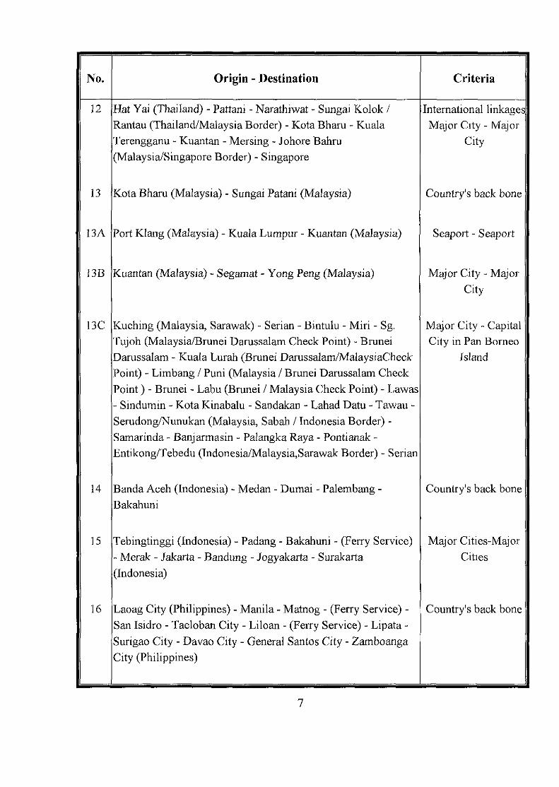
No. Origin - Destination Criteria
12
13
13A
13B
13C
14
15
16
Hat Yai (Thailand) - Pattani - Narathiwat - Sungai Kolok /Rantau (Thailand/Malaysia Border) - Kota Bharu - KualaTerengganu - Kuantan - Mersing - Johore Bahru(Malaysia/Singapore Border) - Singapore
Kota Bharu (Malaysia) - Sungai Patani (Malaysia)
Port Klang (Malaysia) - Kuala Lumpur - Kuantan (Malaysia)
Kuantan (Malaysia) - Segamat - Yong Peng (Malaysia)
Kuching (Malaysia, Sarawak) - Serian - Bintulu - Miri - Sg.Tujoh (Malaysia/Brunei Darussalam Check Point) - BruneiDarussalam - Kuala Lurah (Brunei Darussalam/MalaysiaCheckPoint) - Limbang / Puni (Malaysia / Brunei Darussalam CheckPoint) - Brunei - Labu (Brunei / Malaysia Check Point) - Lawas- Sindumin - Kota Kinabalu - Sandakan - Lahad Datu - Tawau -Serudong/Nunukan (Malaysia, Sabah / Indonesia Border) -Samarinda - Banjarmasin - Palangka Raya - Pontianak -Entikong/Tebedu (Indonesia/Malaysia,Sarawak Border) - Serian
Banda Aceh (Indonesia) - Medan - Dumai - Palembang -Bakahuni
Tebingtinggi (Indonesia) - Padang - Bakahuni - (Ferry Service)- Merak - Jakarta - Bandung - Jogyakarta - Surakarta(Indonesia)
Laoag City (Philippines) - Manila - Matnog - (Ferry Service) -San Isidro - Taeloban City - Liloan - (Ferry Service) - Lipata -Surigao City - Davao City - General Santos City - ZamboangaCity (Philippines)
International linkagesMajor City - Major
City
Country's back bone
Seaport - Seaport
Major City -MajorCity
Major City - CapitalCity in Pan Borneo
Island
Country's back bone
Major Cities-MajorCities
Country's back bone
7
ANNEX B
ASEAN HIGHWAY STANDARDS
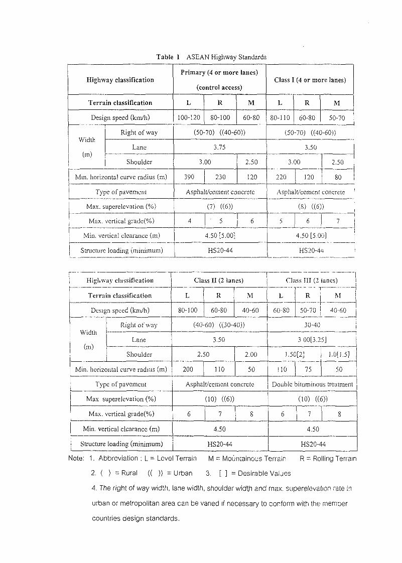
Table I ASEAN Highway Standards
Highway classification
Terrain classification
Design speed (km/h)
Width
(m)
Right of way
Lane
Shoulder
Mm. horizontal curve radius (m)
Type of pavement
Max. superelevation (%)
'l Max.vertical gradc(%)
Min, vertical clearance (m)
Structure loading (minimum)
Hi«l tv»
Primary (4 or more lanes)
(control access)
L R
100-120 80-100
M
60-80
(50-70) ((40-60))
3.75
3.00
390 230
2.50
120
Asphalt/cement concrete
(7) ((6))
4 5 6
4.50 [5.00]
HS20--44
av classification Class II (2 lam:s)
Class I (4 or more lanes)
L R M
80-110 60-80 50-70
(50-70) ((40-60))
3.50
3.00 2.50
220 120 80
Asphalt/cement concrete [
(8) U6)) ;5 6 7
4,50 [5,00]
HS20-44
Clns.s III (2 lanes),
Terrain classification
Design speed (km/h)
Width
(m)
Right of way
Lane
Shoulder
Min. horizontal curve radius (m)
Type of pavement
Max. superelevation (%)
Max. vertical grade(%)
Min. vertical clearance (m)
Structure* loading (minimum)
L
80-100
R
60-80
M
40-60
(40-60) ((30-40))
3.50
2,50
200 110
2.00
50
Asphalt/cement concrete
(10) ((6))
6 7 8
4.50
HS20-44
L
60-80
r jR M
50-70 40-60
30-40 ji
3 00[3.25j
].50[2] I 1.0[].5]
i i O 75 50
Double bituminous treatment
(10) ((6))
6 ' •4.50
HS20-44
Note: 1. Abbreviation ; L - Level Terrain M = Mountainous Terrain R ~ Rolling Terrain
2. ( ) = Rural (( )) = Urban 3. [ ] = Desirable Values
4. The right of way width, lane width, shoulder width and max. superelevation rate in
urban or metropolitan area can be varied if necessary to conform with the member
countries design standards.
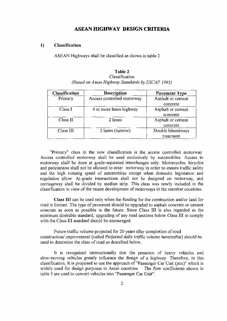
ASEAN HIGHWAY DESIGN CRITERIA
1) Classification
ASEAN Highways shall be classified as shown in table 2
Table 2Classification
(Based on Asian Highway Standards by ESCAP 1995)
ClassificationPrimary
Class I
Class II
Class III
DescriptionAccess controlled motorway
4 or more lanes highway
2 lanes
2 lanes (narrow)
Pavement TypeAsphalt or cement
concreteAsphalt or cement
concreteAsphalt or cement
concreteDouble bituminous
treatment
"Primary" class in the new classification is the access controlled motorwayAccess controlled motorway shall be used exclusively by automobiles. Access tomotorway shall be done at grade-separated interchanges only. Motorcycles, bicyclesand pedestrians shall not be allowed to enter motorway in order to ensure traffic safetyand the high running speed of automobiles except when domestic legislation andregulation allow At-grade intersections shall not be designed on motorway, andcarriageway shall be divided by median strip. This class was newly included in theclassification in view of the recent development of motorways in the member countries.
Class III can be used only when the funding for the construction and/or land forroad is limited. The type of pavement should be upgraded to asphalt concrete or cementconcrete as soon as possible in the future. Since Class III is also regarded as theminimum desirable standard, upgrading of any road sections below Class III to complywith the Class III standard should be encouraged.
Future traffic volume projected for 20 years after completion of roadconstruction/ improvement (called Projected daily traffic volume hereinafter) should beused to determine the class of road as described below.
It is recognized internationally that the presence of heavy vehicles andslow-moving vehicles greatly influence the design of a highway. Therefore, in thisclassification, It is proposed to use the approach of "Passenger Car Unit (pcu)" which iswidely used for design purposes in Asian countries. The flow coefficients shown intable 3 are used to convert vehicles into "Passenger Car Unit":
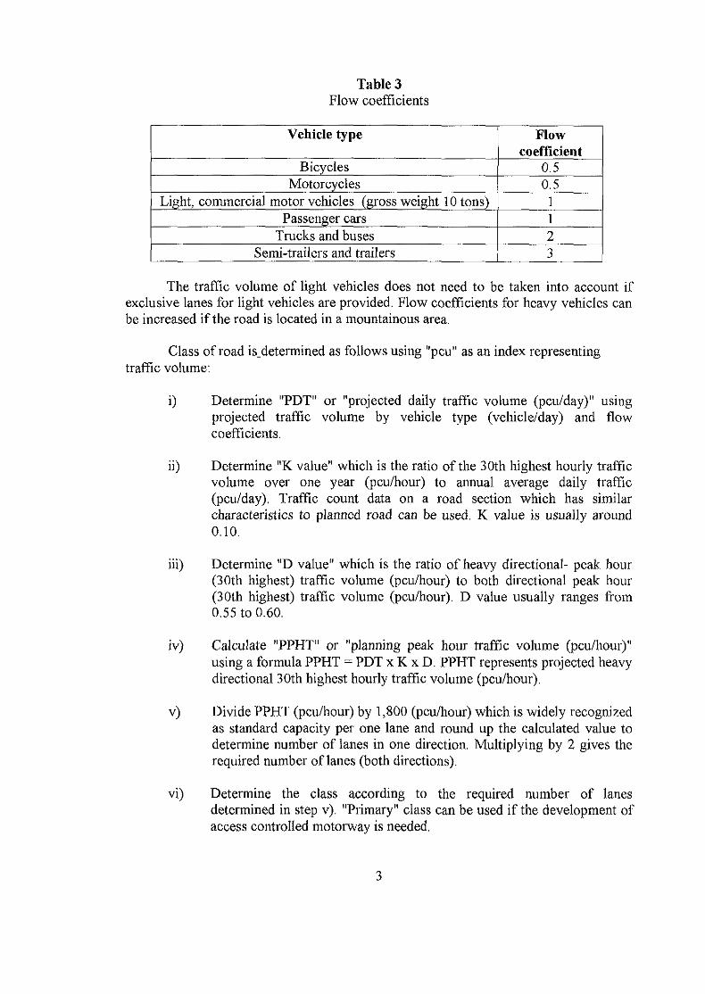
Table 3Flow coefficients
Vehicle type
BicyclesMotorcycles
Light, commercial motor vehicles (gross weight 10 tons)Passenger cars
Trucks and busesSemi-trailers and trailers
Flowcoefficient
0.50.51123
The traffic volume of light vehicles does not need to be taken into account ifexclusive lanes for light vehicles are provided. Flow coefficients for heavy vehicles canbe increased if the road is located in a mountainous area.
Class of road is_determined as follows using "pcu" as an index representingtraffic volume:
i) Determine "PDT" or "projected daily traffic volume (pcu/day)" usingprojected traffic volume by vehicle type (vehicle/day) and flowcoefficients.
ii) Determine "K value" which is the ratio of the 30th highest hourly trafficvolume over one year (pcu/hour) to annual average daily traffic(pcu/day). Traffic count data on a road section which has similarcharacteristics to planned road can be used. K value is usually around0.10.
iii) Determine "D value" which is the ratio of heavy directional- peak hour(30th highest) traffic volume (pcu/hour) to both directional peak hour(30th highest) traffic volume (pcu/hour). D value usually ranges from0.55 to 0.60.
iv) Calculate "PPHT" or "planning peak hour traffic volume (pcu/hour)"using a formula PPHT = PDT x K x D. PPHT represents projected heavydirectional 30th highest hourly traffic volume (pcu/hour).
v) Divide PPHT (pcu/hour) by 1,800 (pcu/hour) which is widely recognizedas standard capacity per one lane and round up the calculated value todetermine number of lanes in one direction. Multiplying by 2 gives therequired number of lanes (both directions).
vi) Determine the class according to the required number of lanesdetermined in step v). "Primary" class can be used if the development ofaccess controlled motorway is needed.
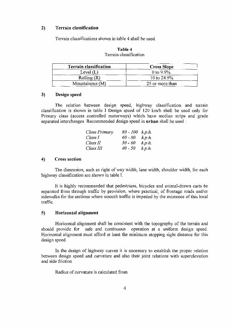
2) Terrain classification
Terrain classifications shown in table 4 shall be used.
Table 4Terrain classification
Terrain classificationLevel (L)
Rolling (R)Mountainous (M)
Cross Slope0 to 9.9%.
10 to 24.9%25 or more than
3) Design speed
The relation between design speed, highway classification and terrainclassification is shown in table I Design speed of 120 km/h shall be used only forPrimary class (access controlled motorways) which have median strips and gradeseparated interchanges. Recommended design speed in urban shall be used :
Class Primary 80 - 100 k.p.h.Class I 60-80 k.p.h.Class II 50-60 k.p.h.Class UI 40-50 k.p.h.
4) Cross section
The dimension, such as right of way width, lane width, shoulder width, for eachhighway classification are shown in table I.
It is highly recommended that pedestrians, bicycles and animal-drawn carts beseparated from through traffic by provision, where practical, of frontage roads and/orsidewalks for the sections where smooth traffic is impeded by the existence of this localtraffic.
5) Horizontal alignment
Horizontal alignment shall be consistent with the topography of the terrain andshould provide for safe and continuous operation at a uniform design speed.Horizontal alignment must afford at least the minimum stopping sight distance for thisdesign speed.
In the design of highway curves it is necessary to establish the proper relationbetween design speed and curvature and also their joint relations with superelevationand side friction
Radius of curvature is calculated from

127.5 ( e + f)
Where v = Design speed (Kph.)e = Rate of roadway superelevation m / mf — Side friction factorR- Radius of curve ( m. )
Table 5Recommended side friction factor
Design speed( Kph. )
Side frictionfactor
40
0.16
50
0.16
60
0.15
70
0.15
80
0.14
90
0.13
100
0.13
110
0.12
120
0.11
The minimum curve radius is a limiting value of curvature for a given designspeed and is determined from the formula above using the maximum superelevationrate suggested and the related side friction factor. Minimum curve radius shall beapplied only when necessary and shall be used in conjunction with transition curvewhich is also recommended for longer curve, the values larger by so to 100 percentshould be considered as the design normal curve radius.
The widening along the horizontal curves should be provided which is based onthe design speed, the pavement width the radius of curve and the dimension of thestandard truck.
Minimum horizontal curve radius in Urban recommended:
Class PrimaryClass IClass IIClass III
230 m.120 m,75 m.50 m.
6) Vertical Alignment
The vertical alignment of any highway shall be as smooth as it is economicallypossible, that is, there shall be a balance of cutting and filling to eliminate the rollingnature of land. In the use of the maximum vertical gradient, it shall be kept clear in themind of the designer that, once constructed to a given vertical grade, the highwaycannot be upgraded to a lesser gradient without the loss of the entire initial investment.The maximum vertical grade shown in table I shall be used. The minimum verticalcurve length shall be based on the algebraic difference in grades , the design speed andthe minimum stopping sight distance.
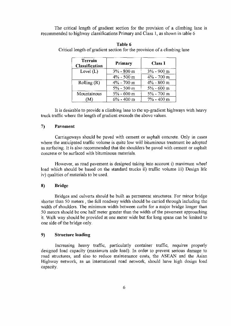
The critical length of gradient section for the provision of a climbing lane isrecommended to highway classifications Primary and Class 1, as shown in table 6
Table 6Critical length of gradient section for the provision of a climbing lane
TerrainClassification
Level (L)
Rolling (R)
Mountainous(M)
Primary
3% - 800 m4% - 500 m4% - 700 m5% - 500 m5% - 600 m -6% - 400 m
Class I
3% - 900 m4% - 700 m4% - 800 m5% - 600 m5% - 700 m7% - 400 m
It is desirable to provide a climbing lane to the up-gradient highways with heavytruck traffic where the length of gradient exceeds the above values.
7) Pavement
Carriageways should be paved with cement or asphalt concrete. Only in caseswhere the anticipated traffic volume is quite low will bituminous treatment be adoptedas surfacing. It is also recommended that the shoulders be paved with cement or asphaltconcrete or be surfaced with bituminous materials.
However, as road pavement is designed taking into account i) maximum wheelload which should be based on the standard trucks ii) traffic volume iii) Design lifeiv) qualities of materials to be used.
8) Bridge
Bridges and culverts should be built as permanent structures. For minor bridgeshorter than 50 meters , the full roadway width should be carried through including thewidth of shoulders. The minimum width between curbs for a major bridge longer than50 meters should be one half meter greater than the width of the pavement approachingit. Walk way should be provided at one meter wide but for long spans can be limited toone side of the bridge only.
9) Structure loading
Increasing heavy traffic, particularly container traffic, requires properlydesigned load capacity (maximum axle load). In order to prevent serious damage toroad structures, and also to reduce maintenance costs, the ASEAN and the AsianHighway network, as an international road network, should have high design loadcapacity.

<n -' ^ . ,:The minimum design loading of HS20-44, which is the internaftorijal standard
corresponding to full-size trailer loading, shall therefore be used f^r Resign ofstructures. *-*/';: ;vWr
10) Vertical clearance
Minimum vertical clearance shall be 4.5 m, which is the requirement for safepassage of standard ISO containers. However, in cases where sufficient clearancecannot be secured because of the high cost of rebuilding existing structures such asbridges, goose - neck trailers with low vehicle bed clearance could be used. Generallythe desirable vertical clearance should be 5.00 m,