ministry of public works and housing...
TRANSCRIPT
MINISTRY OF PUBLIC WORKS AND HOUSING
DIRECTORATE GENERAL OF HUMAN SETTLEMENT
THE NATIONAL URBAN SLUM UPGRADING PROGRAM
ENVIRONMENTAL AND SOCIAL MANAGEMENT FRAMEWORK
FEBRUARY 2016
SFG1748 REV

2
TABLE OF CONTENTS
LIST OF TABLES 3
LIST OF FIGURES 3
LIST OF ANNEXES 3
LIST OF ABBREVIATIONS 5
I. PROJECT DESCRIPTION 7
A. Background 7
B. Project Objective 8
C. Project Design 8
D. Project Components 11
E. Institutional Arrangements 14
II. THE ENVIRONMENTAL AND SOCIAL MANAGEMENT FRAMEWORK 15
A. Objective 15
B. Environmental and Social Safeguards Policies and Regulations 15
C. Gap Analysis 21
D. Land Acquisition and Resettlement Policy Framework (LARPF) 30
E. Voluntary Land Donation Protocol 38
F. Voluntary Community-based Land Consolidation Protocol 40
G. Indigenous Peoples Planning Framework (IPPF) 42
III. SAFEGUARDS PREPARATION, APPROVAL AND IMPLEMENTATION 46
A. Safeguard Screening and Mitigation: Process, Approaches and Instruments 46
B. Component 1, 2 and 4: Policy Development, Studies and Institutional Strengthening, and Project
Management 47
C. Subprojects under Component 3.1 at the City Government Level 48
D. Subprojects under component 3.2 at the community level 65
IV. INSTITUTIONAL ARRANGEMENTS AND CAPACITY BUILDING 68
V. GRIEVANCE REDRESS MECHANISMS 72
VI. FINANCING 72
3
List of Tables
Table 1: Gap Analysis for Environmental and Social Safeguards
Table 2: Project Affected Persons
Table 3: Criteria for Subprojects with Instrument for Environmental Management
Table 4: Measures to Mainstream DRM in NSUP
Table 5: Scale of Land Acquisition and Instrument for Land Acquisition and Resettlement
Table 6: Criteria of Activity to Determine Instruments for IPP
Table 7: Main Roles of Stakeholders Participating in the Project in Safeguards Management
Table 8: Training and Socialization Activities of Which Include Safeguards
List of Figures
Figure 1: Project Management Structure
Figure 2: Preparation Stage
Figure 3: Implementation Stage
Figure 4: Flowchart on Determining Project which requires AMDAL or UKL-UPL
Figure 5: Clauses in the Contract Agreement Related to Environmental Safeguard
Figure 6: Process of Environmental and Social Management at City Level
Figure 7: Process of Environmental and Social Management at Community Level
List of Annexes
Annex 1 NSUP List of Eligible Cities
Annex 2 NSUP Project Cycle
Annex 3 Results of Stakeholder Consultation
Annex 4 WBG Environmental Health and Safety Guidelines
Annex 4a WBG Environmental Health and Safety Guidelines for Water and Sanitation
Annex 4b WBG Environmental Health and Safety Guidelines for Waste Management Facility
Annex 5 Identified Indigenous Peoples in the NSUP Participating Provinces
Annex 6 Definition and Criteria for Protected and Other Sensitive Areas
Annex 7 General ESMF Checklist
Annex 8 Environmental and Social Field Appraisal Forms
Annex 9 Report on Environmental Screening
Annex 10 Format of Environmental Management Plan and Environmental Monitoring Plan (UKL/UPL)
Annex 11 Format of Statement of Assurance for UKL/UPL Implementation
Annex 12 SOP for Environmental Management
Annex 13 Format of the “Statement of Commitment to Implement Environmental Management and Monitoring” (SPPL)
Annex 14 Typical Subproject Impacts and Mitigation Measures
Annex 15 Chance Find Procedure
Annex 16 Instrument for Disaster Risk Reduction Measures
Annex 17 Format of the Statement Letter on Land Donation
Annex 18 Format of the Statement on Permit for Land Use
Annex 19 Format of the Statement on Permit for Land Easement
Annex 20 Sample Outline of LCIP
Annex 21 Format of Full and Abbreviated LARAP

4
Annex 22 Sample Outline of LARAP
Annex 23 Format of Inventory List of Land & Assets on the Land
Annex 24 Minutes of Public Consultation on Land Acquisition
Annex 25 Minutes of Negotiation on Land and Assets
Annex 26 Table of Compilation of PAPs and the Values of Assets
Annex 27 Table of Compilation List of PAPs, their Assets, and Compensation Values based on Negotiation
Annex 28 Note on Free, Prior, and Informed Consultations
Annex 29 Social Assessments of IPs
Annex 30 Format of Indigenous Peoples Plan (IPP)
Annex 31 Minutes of Consultation Meeting with IPs
Annex 32 Monitoring and Reporting Guidelines
Annex 33 Grievance Redress Mechanisms

5
LIST OF ABBREVIATIONS
ADB Asian Development Bank
APBD Local Government Annual Budget / Local Budget
APBN National Government Annual Budget / Central Budget
AMDAL Analisis Mengenai Dampak Lingkungan (Environmental Impact Assessment)
B3 Bahan Beracun Berbahaya (hazardous and toxic waste material)
BAPPENAS Badan Perencanaan Pembangunan Nasional (National Development Planning Board)
BAPPEDA Badan Perencanaan Pembangunan Daerah (Local Development Planning Agency)
BKM or LKM Badan/Lembaga Keswadayaan Masyarakat (Community Board of Trustees)
BPBD Badan Penanggulangan Bencana Daerah (Local Disaster Management Agency)
BPN Badan Pertanahan National (National Land Bureau)
BPS Badan Pusat Statistik (National Statistical Bureau)
Bupati Head of Regency
CDD Community-driven development
CHS Complaint Handling System
CSP Community Settlement Plan
DAK Dana Alokasi Khusus (Special Allocation Fund)
DED Detailed Engineering Design
DG Directorate General
DRM Disaster Risk Management
EA Environmental Assessment
EMP Environmental Management Plan
ESIA Environmental and Social Impact Assessment
ESMF Environment and Social Management Framework
ESMP Environment and Social Management Plan
GOI Government of Indonesia
GRM Grievance Redress Mechanism
IBRD International Bank for Reconstruction and Development
IDB Islamic Development Bank
IUIDP Integrated Urban Infrastructure Development Program
IPs Indigenous Peoples
IPP Indigenous Peoples Plan
IPPF Indigenous Peoples Planning Framework
ISA Indonesian Society of Appraisers
KAT Kelompok Adat Terasing (Isolated Indigenous Community)
Kecamatan Sub-District
Kelurahan Urban Ward
Keppres Keputusan Presiden (Presidential Decree)
KSM Kelompok Swadaya Masyarakat (Community Self-help Group)
LARAP Land Acquisition and Resettlement Action Plan
LARPF Land Acquisition and Involuntary Settlement Policy Framework
LC Land Consolidation

6
LCIP Land Consolidation Implementation Plan
LG Local Government
LGDP Local Government Development Program
M&E Monitoring and Evaluation
MHA Masyarakat Hukum Adat (Customary Law Community)
MIS Management Information System
MOHA Ministry of Home Affairs
MPWH Ministry of Public Works and Housing
ND Neighborhood Development
NGO Non-government Organization
NMC National Management Consultant
NSUP National Urban Slum Upgrading Program
NUWSP National Urban Water and Sanitation Program
OP Operational Procedure
OSP Oversight Service Provider
PAD Project Appraisal Document
PAMSIMAS Third Water and Sanitation Project for Low Income Communities
PAP Project Affected People
PCR Physical Cultural Resources
PDO Project Development Objective
PIU Project Implementation Unit
PMU Project Management Unit
PNPM Urban National Program for Community Empowerment in Urban Areas
Pokja PKP Task Force for Housing and Settlements
REKOMPAK Community-based Rehabilitation and Reconstruction of Settlement Progran
RPJMN Rencana Pembangunan Jangka Menengah Nasional (National Medium-Term Development Plan)
ESA Environmental and Social Assessment
SA Social Assessment
SIAP Slum Improvement Action Plan
SMS Short-text Messaging Services
SOP Standard Operational Procedure
SPPL Surat Pernyataan Kesanggupan Pengelolaan dan Pemantauan Lingkungan (Letter of Environmental Management and Monitoring)
TA Technical Assistance
TMC Technical Management Consultant
TOR Terms of Reference
UKL/UPL Upaya Pengelolaan Lingkungan/ Upaya Pemantauan Lingkungan (Environmental Management and
Monitoring Plan)
UUD Undang-undang Dasar (Law)
UUP3H Prevention and Alleviation of Deforestation Law
Walikota Mayor
VLD Voluntary Land Donation
WBG World Bank Group

7
I. PROJECT DESCRIPTION
A. Background
1. About 22% of Indonesia’s urban population (approximately 29 million) is estimated to be
living in slums with low levels of access to basic services. More than 50% of the poor live in the slum
areas. In 2014, the Government of Indonesia (GOI) identified approximately 38,000 hectares of slum
areas based on the Ministry of Public Works and Housing (MPWH) area-based definition of slums as
dense neighborhoods lacking in access to infrastructure and with irregular buildings. These slums are
spread across more than 3,500 urban wards and are generally characterized by substandard housing,
inadequate access to basic urban infrastructure and services (water, sanitation, roads, etc.), poor health,
vulnerability to disaster risks and, in larger cities, overcrowding. It is estimated that in 2014, 30% of
slum dwellers (approximately 9 million) resided in units that lacked safe water and 37% of slum
dwellers (approximately 11 million) with inadequate sanitation. In addition, about 30% of the roads
and 50% of the drainage are considered to be in poor quality. Due to inadequate infrastructure and
utility services, slum dwellers pay disproportionately more than other urban residents. While a large
proportion of households in Indonesian slums have secure tenure, some slums are informal settlements
situated on illegally occupied land; however, current urban policy and planning does not address this
issue.
2. Under the National Medium-Term Development Plan (RPJMN) 2015-2019, GoI has
committed to an ambitious target of eliminating slums and providing universal access to safe water
and sanitation by 2019 (popularly known as the 100-0-100 program1). In order to meet these targets,
the government has launched multiple sectorial platforms of service delivery in the areas of urban and
rural water, sanitation and slum upgrading. GOI has established a National Slum Upgrading Program
(NSUP) as a national platform financed by multiple sources, including central and local governments,
the private sector, communities, as well as multi-lateral donors. The World Bank, the Asian
Development Bank (ADB) and the Islamic Development Bank (IDB) will each work on a subset of
NSUP cities. This project forms a part of the Bank’s coordinated response to support the 100-0-100
program, along with the Bank’s National Urban Water Supply Program (NUWSP) and the community-
based rural water supply and sanitation program (PAMSIMAS).
3. Platform for Slum Upgrading. NSUP aims to establish an integrated system for slum
upgrading interventions (including improvement of primary and secondary infrastructure and
construction of tertiary infrastructure and services), with local governments enabled to lead the design
and implementation of activities. A platform of coordination is being established to leverage all
resources (organizational and financial) available from national, provincial and local government
programs, alongside donor financing. This project will support GOI in its critical role of implementing
the overall program by strengthening collaboration between national, provincial and local
governments, communities and other stakeholders by promoting participatory approaches to planning
1 The ‘100-0-100’ target refers to 100% household access to water supply; zero slums; and 100% household access
to sanitation.

8
and implementation. It will also provide advisory support to GOI to examine options for policy reforms
required for the sustainability of slum alleviation efforts. In order to facilitate a nation-wide, scalable
upgrading approach, infrastructure investments (improvement of primary, secondary and tertiary) will
be designed to address the context-specific needs of each city. Slum prevention will focus on building
the capacity of local governments and communities to maintain infrastructure in upgraded slums, as
well as in areas identified as emerging slums to prevent these areas from degenerating into fully-
fledged slums. Slum prevention activities will include: (a) control and monitoring at kelurahan2 level,
including regular maintenance and checks on building permits and technical standards; (b) community
empowerment on livelihoods and opening access to information; and (c) community-level investment
for basic infrastructure where gaps are identified.
B. Project Objective
4. The overall project development objective is to improve access to basic urban services in
targeted slums in Indonesia.
C. Project Design
5. Slum characteristics. In the 154 targeted cities, a total area of about 13,000 ha has been
identified as slums, of which 5% falls into category of heavy, 72% medium, and 23% light slums.
These slums are home to about 12.7 million people, accounting for about 22% of the total urban
population (57.9 million). Among these slum dwellers, 2.1 million people are poor, which is about
55% of the total urban poor (3.7 million) in the targeted cities. Overall there is a lack of access of
improved water supply and proper sanitation facilities. For example, 60% population has less than 60
liter/per capita/day water supply; 75% are without adequate solid waste removal (i.e., twice a week at
a minimum); 75% live in housing that does not meet building codes, and 25% live in housing space
less than standard of 7 m2/person.
6. Beneficiaries. The project is expected to directly and indirectly benefit 9.7 million slum
dwellers living in 154 cities, of which 4.85 million are expected to be women. Slum dwellers are likely
to experience significant betterment of living conditions due to improvements in access to and quality
of basic services. The project will cover access to the following infrastructure and basic services: (1)
building regularity; (2) water; (3) sanitation; (4) roads; 5) drainage; 6) solid waste; (7) individual sub-
standard house improvement; and (8) fire safety. The project will not finance new housing
development.
7. Geographical distribution. Within the context of NSUP roll out, infrastructure investments
under the proposed project will focus on 154 cities in the central and eastern parts of Indonesia; the
Islamic Development Bank (IDB) is expected to support about 110 cities in the western part of
Indonesia, and the Asian Development Bank (ADB) is expected to support 20 cities nationally. Tertiary
2 Lowest administrative unit in city/district

9
infrastructure investments and institutional capacity building support will be provided in all 154 project
cities. However, construction of small or limited scale connecting infrastructure as well as the
improvement of primary and secondary infrastructure in the vicinity of slums will only take place in a
subset of 50 cities.
8. The subset of 50 cities (out of a long list 65 cities eligible for primary and secondary
infrastructure presented in Annex 1) will be selected in first year of project implementation, based on:
(a) population characteristics, including population density and percentage of urban population; (b)
area of the city with slum status, slums are generally geographically scattered in the city; (c) gaps in
access to infrastructures and services; and (d) commitment of local government to implement NSUP.
9. Phasing of project implementation. The project implementation will follow a phased
approach that will ensure local government and community buy-in as well as institutional capacity
development. The initial phase of planning and capacity building, to be financed by Component 2, will
start simultaneously in all cities.
a. At the city level, the city governments will prepare or finalize their Slum Improvement Action
Plans (SIAPs). It is expected that towards the end of 2016, 20 cities of the subset 50 cities will have
final SIAPs, identified priority slum areas for intervention, and will have final detailed engineering
designs (DEDs) for first priority infrastructure subprojects. Construction related activities for these
first priority subprojects, to be financed by Component 3.1 will be undertaken in 2017. DEDs for
the second priority subprojects as identified by the SIAPs will be completed in 2018 and their
construction will take place in 2018. This cycle will continue for the remaining priority subprojects
until 2021. Simultaneously during 2016, the remaining 30 cities from the subset of 50 cities will
start preparing their SIAPs which will be final in 2017 and have DEDs for selected priority
infrastructure subprojects completed in end of 2017. Construction of these subprojects will start in
2018. The cycle will continue for the next priority subprojects in the following years. Gradually
all of the subset of 50 cities will complete their DEDs for all identified priority infrastructure
subprojects in 2018 onwards, and their construction to be financed by the project is expected to be
completed in 2021. In summary, during the project period, there will be simultaneous activities
across the 154 participating cities with different levels of progress, i.e. SIAP preparation, DED
preparation, construction, and operations and maintenance for the completed subprojects.
At appraisal stage, the 50 participating cities that will receive financing under Component 3.1 will
be confirmed, however, the sites of the secondary and primary infrastructure to be improved and
connecting infrastructure to be constructed will only be defined after the SIAPs and associated
CSPs and detailed engineering designs are completed. The initial phase of planning and capacity
building will start simultaneously in all cities, ensuring that by the end of Year 1 (2016), SIAPs
will be available for the 20 cities of the sub-set 50 cities. Simple interventions will be carried out
first, with the more complicated being tackled later in the project cycle. In 2016, the project will
support: (i) tertiary infrastructure development in 200 ND sites in cities where CSPs and SIAPs
have already been completed; and (ii) the preparation or review of the draft SIAPs. It is expected

10
that the entire support system, including consultants for this activity will be in place by June 2016.
The existing PNPM Urban support system will provide a bridge until the new consultants are in
place.
Based on the readiness (progress) of SIAPs and preparation of local regulations as well as MPWH’s
top priority of cities to receive immediate intervention, 20 cities of the sub-set 50 cities have been
recommended as priority cities for project implementation in 2016. These cities, which will be
further confirmed during appraisal, include: Surabaya, Malang, Yogyakarta, Samarinda,
Gorontalo, Kabupaten Sidoarjo, Mataram, Kendari, Palu, Kupang, Jayapura, Surakarta, Semarang,
Banjarmasin, Ternate, Manado, Makasar, Ambon, and Sorong. SIAPs of this first batch of 20 cities
will be reviewed during the early stage of project implementation in 2016. This will be followed
by identification of priority slum areas requiring investments in each of these 20 cities, preparation
of detail assessment and design for the improvement of the secondary and primary infrastructure
and connecting infrastructure, and estimated costs of the package, which are all to be completed in
the end of 2016. Construction is therefore expected to begin in 2017.
The project expects that the remaining second batch of 30 cities (out of the 50 cities receiving
financing from Component 3.1) will finalize their SIAPs and technical documents in the end of
2017, followed by construction started in 2018.
b. At the kelurahan level, where priority slum areas as defined in the completed SIAPs are located,
the kelurahan community (LKM or BKM) will prepare or finalize their Community Settlement
Plans (CSPs). In 2016, the project is planning to support construction of small scale tertiary
infrastructure in 200 priority slum area sites for kelurahans that have completed their CSPs and
proposals for priority subprojects prepared by community self-help groups (KSMs) have been
approved. As the approved proposals will include DEDs for priority subprojects and estimated
costs, construction of these subprojects will start in the same year. Simultaneously, other
kelurahans as identified by the city governments that have completed SIAPs, will prepare or review
and finalize their CSPs, followed by the completion of KSMs’ proposals and construction in 2017
onwards. In summary, during the project period, there will be simultaneous activities in kelurahans
in the 154 participating cities with different level of progress, i.e. CSP preparation, KSMs’
proposals preparation, construction of tertiary infrastructure subprojects, and operations and
maintenance of the completed tertiary infrastructure. During the project period, about 6,400
kelurahans would receive financing for tertiary infrastructure including 700 kelurahans that have
ongoing and new ND program.
The project will continue support the CDD approach slum improvement that has been piloted in
780 kelurahans in 167 cities under the National Community Empowerment Program in Urban
Areas/Neighborhood Development (PNPM-Urban/ND). CSPs of these kelurahans are being or
will be reviewed and revised as needed. Kelurahans that have not had CSPs prepared under PNPM-
Urban/ND will prepare CSPs to receive support under Component 2. The project has allocated
budget in 2016 to support tertiary infrastructure construction in existing 200 ND sites where CSPs
11
and SIAPs or their revisions have been completed. Ultimately the project will support 6,400
kelurahans including the targeted 700 ND in the 154 cities that have been participated in the
ongoing PNPM-Urban/ND.
10. A summary of project cycle is presented in Annex 2.
11. Status of planning documents. Slum Improvement Actions Plans (SIAPs) are being prepared
in over 100 cities in 2015 with support from the MPWH under the ongoing PNPM-Urban/ND support,
including those of the subset of 50 cities and now they are progressing in different stages. As explained
above, among these cities, 20 cities are expected to have their SIAPs ready for finalization during the
first year of project implementation (2016). With the support of the ongoing PNPM-Urban/ND, 500
kelurahans already have CSPs which will be updated, while more kelurahans are planning to prepare
new CSPs. Under the ND, CSPs have been regularly updated and this practice will continue in the
project.
D. Project Components
12. The project has five components that together will enable the achievement of the PDO, as
summarized below:
a. Component 1: Institutional and Policy Development (Cost US$7 million, of which IBRD Loan
US$2 million). This component will support institutional strengthening and capacity building of
central government agencies (e.g., BAPPENAS, MPWH) responsible for the management of the
national slum upgrading program (see Figure A3.1 in Annex 3 of the PAD) and will include:
institutional analysis at the national level as well as for a sample of municipal governments to
identify the nature of support needed to facilitate inter-agency coordination during preparation,
implementation and supervision stages; strategic national upstream policy level studies to facilitate
the development of government policy to support the sustainability of slum upgrading and
prevention efforts, including land administration policy reform, policies towards informal
settlements and security of land tenure, and synchronization of slum definitions used by MPWH
and National Statistical Bureau (BPS).
b. Component 2: Integrated Planning Support and Capacity Building for Local Government and
Communities (Cost US$95 million, of which IBRD Loan US$89 million). This component will
finance the costs of (200) urban planners and (3,000) community facilitators throughout the project
cycle to support capacity building (including training, workshops, and knowledge exchange events
between cities as well as urban sub-districts) of local governments and communities in 154 cities
to design and implement slum improvements, including the development of Slum Improvement
Action Plans (SIAPs) at the city level and Community Settlement Plans (CSPs) at the community
level.
12
c. Component 3: Urban Infrastructure and Services in Selected Cities (Cost US$1578 million, of
which IBRD Loan US$310 million). This component includes two sub-components as summarized
below.
Sub-component 3.1: Support for Primary and Secondary Infrastructure and Site Development
in 50 selected cities will mainly consist of improvements identified in SIAPs for area level-
small scale sanitation, water and drainage systems (together with strengthening connectivity to
tertiary and household-level systems) as well as construction of secondary roads. Based on a
survey of SIAPs that are in the advanced stages of completion, the maximum cost for a single
subproject under Sub-component 3.1 will be up to US$2,000,000 (and the average cost will be
considerably less). On average, each city would receive US$20 million during the project
period (five years).
Subprojects that will be financed by Component 3.1 include improvement of existing small or
limited scale secondary and primary infrastructure and small or limited scale connecting
infrastructure that connect slum areas with the secondary and primary infrastructures. It would
include possible improvements to roads, drainage, water supply, and sanitation. This will create
an integrated service for the slums with their neighboring areas. The exact nature of subprojects
will be known once the SIAPs are finalized, which for the subset of 20 cities will completed in
the first year of project implementation (2016). Learning from the LGDP (DAK) project,
improvement, rehabilitation and maintenance of existing secondary and primary infrastructure
(e.g. city roads) have increased the service capacity of the infrastructure. Road improvement
includes widening, straightening and/or surfacing/upgrade surface quality of existing roads, as
well as wall lining to protect erosion. Road rehabilitation involves holes patching, sidewalk
fixing, and maintenance includes resurfacing, cleaning up road shoulders, fixing broken and
cleaning up drainage. In LGDP, contract size of these works is relatively small. For instance,
in East Java, in 2014 average contract size for road improvement was US$87,000 and for road
maintenance was US$88,000. In West Sulawesi, the figures were US$111,000 and US$81,000
for road improvement and maintenance, respectively. In Central Kalimantan, contract amounts
were USD 300,000 and USD 184,000 for road improvement and maintenance, respectively.
Connecting infrastructure, for example, can be installation of collector pipes that connect the
underutilized existing waste water treatment plant to the slum area (Margasari) as has been the
case of Balikpapan.
Sub-component 3.2: Support for Tertiary Infrastructure Upgrading in the project cohort of 154
cities based on a community-driven approach and will include, inter alia, small-scale water
supply, drainage, sanitation, footpaths, fire safety, site improvements, etc. Support will also be
provided for strengthening community-based livelihoods through the construction of
livelihood-enabling facilities and services at the tertiary level that are identified in CSPs as
important for slum prevention. It is estimated that on average, each ND kelurahan would
receive US$150-250 K during the project period.

13
Similar to the ongoing PNPM-Urban/ND, Component 3.2 will finance small-scale, community
infrastructure including new or improvement or rehabilitation of existing facilities such as
community roads, footpaths, small bridges, drainage, water supply, communal and individual
toilets, solid waste management, sub-standard housing, and community parks and greenings.
The project will continue support the CDD approach slum improvement through ND that has
been piloted in 780 kelurahans in 167 cities under the PNPM-Urban/ND. Subprojects are
small. For instance, during 2012-2014, median costs of roads, drainage, public toilets,
sanitation channels, and greening were US$27,000; US$13,000; US$5,000; US$6,000; and
US$3,800 respectively. Under this project, GOI will focus when needed on in-situ slum
upgrading which will avoid or minimize involuntary resettlement unless absolutely needed for
local infrastructure improvement and connect the upgraded slums with the city infrastructure
services.
d. Component 4: Implementation Support and Technical Assistance (Cost US$63 million, of which
IBRD Loan US$32 million). This component will finance the costs of: National Management
Consultants (NMCs), Technical Management Consultants (TMCs) and Oversight Service
Providers (OSPs) to strengthen the capacity of the Project Management Unit (PMU) to oversee
implementation of the program at national, provincial and city levels; and monitoring and
evaluation, making substantial use of participatory techniques, especially at the tertiary level.
e. Component 5: Contingency for Disaster Response (US$0). This component would finance
preparedness and rapid response measures to address disaster, emergency and/or catastrophic
events, as needed, through sub-projects and/or using the project implementation arrangements. Due
to the high risk of catastrophic natural disasters in Indonesia, a provisional zero dollar component
is included in the project to allow for rapid reallocation of loan funds in the event of a natural
disaster.
13. Subproject eligibility. The project funds cannot be used to finance (a) purchase of land; (b)
economic activities involving revolving funds; (c) Category A sub-project activities with significant,
sensitive, complex, irreversible and unprecedented potential adverse environmental and social impacts
that may affect an area broader than the sites or facilities subject to physical work requiring a full
environmental assessment to manage and mitigate such impacts in accordance with World Bank OP
4.01, Ministry of Environment Regulation No. 5, 2012 and activities with the scale beyond those
specified in the Ministry of Public Works and Housing Regulation No. 10, 2008; and (d) a subproject
with cost above USD 2,000,000. Sub-projects with significant ancillary3 and related activities will not
be eligible if they are considered as Category A sub-projects. This includes sub-projects that would
require expansion of water treatment facilities, wastewater facilities, solid waste disposal facilities and
road expansion beyond connecting a slum area. Eligible sub-projects to be financed by this project are
Category B sub-projects with impacts that are site specific, few if any are irreversible, and in most
cases mitigation measures can be readily designed.
3 Ancillary facilities are facilities that are necessary to support the functioning of a subproject, regardless of financing
sources.

14
E. Institutional Arrangements
14. The Executing Agency of this project is the DG of Human Settlements of the MPWH, who has
been the Executing Agency of the PNPM-Urban/ND. The current PMU of the PNPM-Urban/ND
established under the Executing Agency, will be in in charge for the NSUP. The PMU is responsible
for the overall coordination and policy development to implement the project. Key stakeholders for
this project are project management staff, consists of Project Management Unit (PMU), National and
Provincial Project Managers, City Governments Project Managers, Community Board of Trustees
(BKMs/LKMs) and community self-help group (KSMs) at the kelurahan level. In addition, there are
Consultant Management Team (NMC) at national level, Oversight Service Providers (OSPs) and
Technical Management Consultants (TMCs) as Regional Management Consultant at provincial level,
City Coordinator Teams and facilitators at kelurahan level.
Figure 1: Project Management Structure
National Housing & Settlement
Ministry of Public Work
Taskforce
and Housing
DG of Human Settlement
Directorate of Settlement Development
PMU
Central Project Implementation Unit
Advisory Team
National Management Consultant
Evaluation Team
OSP for Capacity Building
Provincial Housing & Settlement Taskforce
Governor
Mayor
Head of District
Head of Kelurahan / Village
Urban Planner Team Hired for Community
Provincial Project Implementation Unit
City / Regency Project Implementation Unit
BKM
KSM Volunteer
Oversight Service Providers and TMCs
City Coordinator Team
National Level
Provincial Level
City Level
District Level
Kelurahan / Village Level
Facilitator Team
Command line Coordination line
COLABORATING & COORDINATING LINE
EXECUTING & IMPLEMENTING LINE SUPPORTING LINE
Technical Volunteer
CCMU
City Housing & Settlement Taskforce
15
II. THE ENVIRONMENTAL AND SOCIAL MANAGEMENT FRAMEWORK
A. Objective
15. The objective of the Environmental and Social Management Framework (ESMF) is to provide
reference and guidance for the project management staff at national, provincial, district/city, and
kelurahan levels, consultants, facilitators, city governments, and community groups participating in
the National Urban Slum Upgrading Program (NSUP) on a set of principles, rules, procedures and
institutional arrangements to screen, assess, manage and monitor the mitigation measures of
environmental and social impacts of subproject investments whose exact location and dimension,
hence area of influence, are not known at appraisal stage.
16. The purpose of issuance of this ESMF is to ensure that all stakeholders involved in the project
comply with the requirements, procedures and regulations related to environmental management, land
acquisition and resettlement, and Indigenous Peoples in accordance to prevailing Government of
Indonesia regulations and supplemental provisions in compliance with relevant World Bank Safeguard
Policies.
17. This ESMF will be elaborated in an Environmental and Social Safeguards Technical
Guidelines as an operational tool to be used during project implementation. This ESMF is a revision
of the National Community Empowerment Program in Urban Areas/Neighborhood Development
(PNPM-Urban/ND)’s Environmental and Social Safeguards Framework. It has incorporated the
lessons learned from the series of the PNPM-Urban/ND projects, and from other projects such as
PAMSIMAS, REKOMPAK, and the Local Government and Decentralization Project (LGDP/DAK)
and it is in compliance with relevant GOI’s laws and regulations on environmental management, land
acquisition and Indigenous Peoples and is in compliance with the World Bank Policies on
Environmental Assessment (OP 4.01), Indigenous Peoples (OP 4.10), Physical Cultural resources (OP
4.11) and Involuntary resettlement (OP 4.12).
18. This ESMF has incorporated relevant suggestions obtained during the stakeholders
consultation held in January 18, 2016 (refer to Annex 3 for details). This draft ESMF (in English and
Bahasa Indonesia) was disclosed in the project’s website (www.p2kp.org) on February 9, 2016 and in
the Infoshop on February 3, 2016.
B. Environmental and Social Safeguards Policies and Regulations
19. Any activity funded by NSUP must be implemented in reference to the principles of sustainable
development, including environmental, social, cultural, and economic considerations, as already
governed in prevailing laws and regulations. This ESMF adopted the Government of Indonesia’s laws
and regulations to the extent that they are in compliance with the World Bank Policies on
Environmental Assessment OP 4.01), Involuntary Resettlement (OP 4.12), Indigenous Peoples (OP

16
4.10) and Physical Cultural Resources (OP 4.11). Specific provisions have been included in this ESMF
to address any aspect of the Bank policies that are not fully addressed through GoI laws and regulations.
a. In the case of environmental and social management, any subproject in infrastructure sectors
funded by NSUP must refer to Law (UU) No. 32/2009 concerning Environmental Management
and Protection, and Government Regulation (PP) No. 27/2012 concerning Environmental Permit,
Regulation of the Minister of Environment No. 16/2012 concerning Guidelines for Preparing
Environmental Documents (AMDAL, UKL/UPL, and SPPL), Law No. 1/2011 concerning
Housing, Law No. 11/2010 concerning Cultural Resources, Law No. 18/2008 concerning Solid
Waste Management, Law No. 26/2007 concerning Spatial Planning, Law No. 38/2008 concerning
Road, Ministry of Environment Regulation No. 5/2012 on the Types of Activities requiring
AMDAL and Regulation of the Ministry of Public Work No. 10/PRT/M/2008 concerning the Type
of Business and/or Project Activity under Public Works which require Environmental Management
Plan (UKL) and Environmental Monitoring Plan (UPL) documents, the Guidelines for
Environmental Management No.08, 09, 10 and 11 of 2009 issued by DG of Bina Marga, Ministry
of Public Works and Housing.
b. In the case of land acquisition for the development of infrastructure for public purposes, any
subproject funded by NSUP should refer to Law No.2/2012 concerning Land Acquisition for
Project Activity for Public Interest, Presidential Regulation No. 71/2012 on Land Acquisition and
its Amendments, and Regulation of the Head of BPN RI No. 5/2012 concerning Technical
Guidelines on the Implementation of the Land Acquisition.
c. As construction of infrastructure to be funded by NSUP will take place in almost all regions in
Indonesia, in the case IPs are presence and affected by the project, the project should provide
benefit to and manage adverse impacts on the Indigenous Peoples (IPs)4. Government of
Indonesia’s Policy on Indigenous Peoples includes: (1) Presidential Decree (Keppres) No.
111/1999 concerning Development of Isolated Indigenous Community (KAT) which provides a
broad definition of Indigenous Peoples and the need for government assistance; and (2) Law No.
41/1999 concerning Forestry Law which defines customary forest5. Other Law and regulations
related to IPs are:
4 In NSUP, identification of IPs follows the Bank’s criteria: a) self-identification as members of a distinct indigenous
cultural groups and recognition of this identity by others; b) collective attachment to geographically distinct habitats
or ancestral territories in the project area and to the natural resources in these habitats and territories; c) customary
cultural, economic, social, or political institutions that are separate from those of the dominant society and culture;
and d) indigenous language, often different from the official language of the country or region. Identification of IPs
will also meet the criteria of “Masyarakat Hukum Adat”-MHA- summarized from Indonesian Regulations and local
values, as well as additional information gathered from respective cities. 5 One fundamental change is related to Indigenous Peoples is the issuance of Constitutional Court Decision No.
35/PUU-X/2012 which changed Article 1 point 6 of Law No. 41/1999 on Forestry, which has now become “customary
forest is a forest located within the area of an indigenous community”. Before, there was a word of “state” in the
article. With elimination of the word “state” from the definition, now it is understood that customary forests is now
no longer a state forest.
17
i. UUD 1945 (Amendment) Chapter 18, clause #2 and Chapter 281 clause # 3;
ii. Law No. 41 on Forestry (plus Constitutional Court Decision No. 35/PUU-X/2012—see
Footnote 4);
iii. MOHA Regulation No. 52/2014 on the Guidelines on the Recognition and Protection of
MHA;
iv. Ministerial Regulation of MOH No. P.62/2013 (adjustment of Ministerial Regulation No.
P.44/2012) on the Establishment of Forest Area;
v. Joint Regulation of MOHA, Ministry of Forest, Ministry of Public Works and Land
Agency No. 79/2014 on Procedures to Settle Land Ownership Conflict in Forest Area;
vi. Regulation of the Minister of Land Agency and Spatial development No. 9/2015 on the
Procedures to Establish the Land Communal rights on the MHA Land and Community
Living in the Special Area;
vii. Law No. 6 / 2014 on Village; and
viii. Law No. 18/2013 on Prevention and Alleviation of Deforestation (UUP3H).
20. Applicable World Bank Policies. Given the nature of the project, potential environmental and
social safeguards issues are covered by the following World Bank Policies:
a. OP 4.01 Environmental Assessment. Under project Component 3, the project will focus on (a)
construction of small and limited scale tertiary infrastructure including roads, clean water,
sanitation, electricity, solid waste, drainage, and fire safety, (b) construction of small and limited
scale connecting infrastructure from the slum areas to the existing city network, and limited
improvement of the existing secondary and primary infrastructure to which the slum areas will be
connected. The subprojects will have a contract size up to US$2,000,000. Eligible subprojects are
category subprojects with impacts that are site specific, few if any are irreversible, and in most
cases mitigation measures can be readily designed. As explained in the project description,
subprojects eligible for financing should not include Category A subproject activities with
significant, sensitive, complex, irreversible and unprecedented potential adverse environmental
and social impacts that may affect an area broader than the sites of facilities subject to physical
work requiring a full environmental assessment to manage and mitigate such impacts in accordance
with World Bank OP 4.01, Ministry of Environment Regulation No. 5, 2012 and activities with
scales beyond those as specified in the Ministry of Public Works and Housing Regulation No. 10,
2008.
Potential adverse environmental and social impacts from the project are likely from physical
construction of tertiary infrastructure in slums areas and improvement of existing secondary and
primary infrastructure as well as construction of connecting infrastructure from the slum areas to
the existing secondary and primary infrastructure. Because of the small and limited scale of the
subprojects, these impacts will be low to moderate in magnitude and numbers, local in extent, and
not significant/sensitive, irreversible, or unprecedented. A subproject will require either an
environmental and social management plan (ESMP) or impacts can be managed mostly by good
engineering design and best construction management practices. In some cases an EA, SA or ESA

18
commensurate to potential impacts may also be required. Each subproject will be screened to
determine the type of safeguards instrument required.
As explained in the project description, finalization of SIAPs and CSPs will be completed during
project implementation, and therefore the sites of improvement of secondary and primary
infrastructure, construction of connecting infrastructure, as well as tertiary infrastructure in the
slum areas cannot be defined at appraisal stage.
Assessment of potential environmental and social impacts will be determined at two stages. During
the preparation of SIAPs, the environmental and social issues likely to arise in the city will be
identified. This planning stage will also be the ideal time to consider potential cumulative impacts
that could result from implementation of multiple CSPs. Site-specific assessments and
development of impact management instruments will be undertaken during or after the completion
of the Detailed Engineering Designs (DEDs). The ESMF is proposed to be the safeguards
instrument for this project as specific environmental and social impacts and their magnitude in the
possible construction sites at specific targeted slum areas and their surroundings cannot be
determined prior to appraisal as subprojects are only identified during implementation.
Environmental and social impacts screening, impact assessments for subprojects as well as
measures to manage impacts will be defined during project implementation based upon the ESMF.
The potential social impacts of the project covered by OP 4.01 other than land acquisition and
resettlement are important given the projects urban setting. Social assessments will be conducted
during the community self-mapping to better understand of community needs, especially to prevent
adverse impact for the poor and vulnerable people (including gender aspect) and to also prevent
elite capture and community tension during sub projects selection. Means to improve livelihood
and better community participation shall also be covered in the assessment.
As Components 1, 2 and 4 include upstream policy development advices and institutional
strengthening as well as TA for project management affecting capacity to implement both
environmental and social impacts of investments, this ESMF includes screening, identification and
measures to manage any potential impacts that may result from the activities supported by these
three components. TOR for Technical Assistance will be developed at the beginning of the project
implementation and submitted to the Bank for review and clearance.
b. OP 4.10 Indigenous Peoples. Based on the World Bank IP Screening Study (2010), IPs are present
in five areas where the project may be active: the Districts of Sumba Barat (East Nusa Tenggara),
Toli-Toli (Central Sulawesi), Gorontalo (Gorontalo Province), and Manokwari (West Papua), and
the City of Palopo (South Sulawesi). The complete list of identified indigenous peoples in the
NSUP participating provinces is available in Annex 5. The confirmation of the IPs presence and
potential impacts both positive and adverse on them as well as measures to manage such impacts
will be carried out during the preparation of the SIAPs and CSPs. Confirmation on IPs presence
will be done in accordance with the requirements specified in the IPPF/ESMF. The ongoing

19
PNPM-Urban/ND reported that no IPs were the beneficiaries, involved or affected, although the
project had identified potential IPs presence in some urban areas. In the case that a subproject
financed under Component 3.1 affect IPs community, city government will have to prepare an SA
and IPP as part of the SIAP. Similarly, in the case that a subproject financed under Component 3.2
affect IPs community, the LKM/kelurahan will have to prepare an IPP as part of the CSP. The
preparation of IPP will have to meet the requirements of the IPPF which is part of this ESMF.
c. OP 4.11 Physical Cultural Resources (PCR). Some possible urban slum improvement areas
might be in the location of PCR sites, or the slum improvement might involve activities to better
manage the PCR sites/structures. The ESMF adopts the existing Environmental Guidelines of
PNPM-Urban/ND that has covered the requirements for the preparation of PCR Management Plans
(PMP) that will be prepared for this project and contained in the ESMF and ESMP as needed. PMP
along with CSP will be prepared by the community group for subproject which is designed towards
supporting the management or conservation of cultural heritage assets.
d. OP 4.12 Involuntary Resettlement. Component 1 will support upstream institutional and policy
development. One of the activities would be undertaking strategic policy studies to facilitate the
development of policy frameworks to support the sustainability of slum upgrading and prevention
efforts, including land administration policy reform, approaches to address informal settlements,
and security of land tenure.
While Component 2 will support the cities in preparing SIAPs and the communities at kelurahans
level in preparing the CSPs. Potential environmental and social impacts may entail from the
products or downstream activities. However, the type, scope and locations of downstream activities
or investments resulting from these activities cannot be identified at this stage. The ESMF and
LARPF provide guidance to screen, assess potential environmental and social impacts that may
emerge from the downstream activities and provide guidance to define and prepare safeguards
instruments.
Subprojects financed by Component 3.1 involve improvement of existing secondary and primary
infrastructure and connecting infrastructure to the slum areas. As explained in the project
description, subprojects will be small and of limited scale. Some land acquisition or involuntary
resettlement might take place for the connecting infrastructure, and is less likely the case for the
improvement of existing secondary and primary infrastructure. Furthermore, GOI will have in-situ
slum upgrading, and land acquisition or involuntary resettlement will be limited. However, social
issues will occur during construction, such as temporary disturbance of access to land plots due to
the installation of pipes or road improvement, disruption of businesses that lead to temporary loss
of income, and the need to set back the structures in some cases where there is road widening. The
location and dimension of potential land acquisition and involuntary resettlement and potential
social issues can only be identified during the project implementation, particularly during the SIAP
preparation, and will have to be confirmed during the preparation or after the completion of DED.
20
21. This ESMF provides to the cities on the process, procedures, requirements and institutional
arrangements to prepare a Social Assessment (SA) and Land Acquisition and Resettlement Action Plan
(full or abbreviated LARAP) which are all specified in the Land Acquisition and Resettlement Policy
Framework (LARPF). The LARPF also includes among others: resettlement principles, policies,
procedures and requirements, assessment for linked projects, eligibility for compensation and
assistance, entitlements, applicable laws and regulations, organizational arrangements and funding,
GRM, and monitoring and evaluation. LARAPs will be developed by cities in the case that
infrastructure improvements and/or connecting infrastructure involves involuntary resettlement. The
Draft LARAPs will be prepared along with and part of the SIAPs.
22. Activities financed under Component 3.2 involve investment in slum areas, to be implemented
with CDD Neighborhood Development (ND) approach, comprising of construction of new and/or
improvement of tertiary basic infrastructure such as water supply, drainage, sanitation, footpaths, fire
safety, site improvements, sub-standard house, greenings, measures to disaster risks management, etc.
Targeted priority slum areas in 154 cities to receive support from the project will be defined during the
SIAP preparation and types, size and the location of tertiary infrastructure subprojects will be
determined in the CSPs. Confirmation of the sitting of the subprojects will be defined by the DEDs.
As has been the case of PNPM-Urban/ND, each kelurahan will receive about USD 150-250K during
the project period and this amount will finance various priority subprojects as identified in the CSPs.
23. Although the ESMF and LARPF also apply to Component 3.2, it is anticipated that land
donation may be predominant. A VLD Protocol has thus been prepared as part of this ESMF and
LARPF. Subprojects are small or limited scale. Social impacts of these subprojects are not considered
for the part significant and site-specific and manageable by the community beneficiaries. In the case
of the ongoing PNPM Urban/ND, new tertiary infrastructure was usually built on land voluntarily
donated by the beneficiaries (60 %) and by the kelurahans (36.4%). This common practice will likely
continue to take place in this project as the land needed for the tertiary subprojects, which are
community-based, is small in size and provides direct benefit for the land owners. In-situ slum
improvement may involve small scale voluntary community land consolidation, VLD, and limited land
acquisition or involuntary resettlement with relocation within the same area.
24. The current VLD Protocol covering principles, procedures and documentation for voluntary
land donations under PNPM Urban/ND has been updated and adapted for the upcoming project for
community infrastructure. Documentation of the voluntary land donation (VLD) will be part of the
community’s proposals in line with requirements sets in the VLD Protocol. The update of the protocol
also includes the follow-up on the legal status of the donated and remaining land that should be
processed by the local government.
25. Land involved in in-situ slum upgrading will be indicated in the CSPs. In the case that slum
upgrading involves small-scale voluntary community land consolidation, the city government together
with the LKM in the kelurahan will prepare a Land Consolidation Implementation Plan (LCIP) as
described in the Voluntary Land Consolidation Protocol and LARPF. In cases that involuntary
21
resettlement is unavoidable and of limited scale, the city government together with the LKM will
prepare a LARAP (full or abbreviated).
26. The project has revised and adapted the current PNPM-Urban/ND’s ESMF including the Land
Acquisition and Resettlement Policy Framework (LARPF) and the IPP Framework for PNPM
Urban/ND. The ESMF and LARPF includes a Voluntary Land Consolidation Protocol for
implementing small and limited scale land consolidation in compliance with OP 4.12 and the GOI’s
regulations on land consolidation. The updated ESMF including LARPF has been based on the
experiences and lessons learned from the ongoing PNPM Urban/ND (particularly for the voluntary
land donation) and from other World Bank’s supported project on land acquisition and resettlement.
The substance and structure of the LARPF follow OP 4.12, and entitlement matrix and GRM are part
of it. The LARPF will also adopt GOI’s laws and regulations pertaining Land Acquisition for the
Development for Public Purpose.
27. Component 1 will support institutional and policy development. One of the activities would be
undertaking upstream strategic studies to facilitate the development of policy to support the
sustainability of slum upgrading and prevention policies, including land administration policy reform,
approaches to address informal settlements, and security of land tenure. TORs for activities (studies,
training and project management) financed by Component 1 will be shared with the Bank for review
and clearance to ensure that safeguards issues are addressed in accordance with the approved ESMF.
C. Gap Analysis
28. Table 1 below presents the comparison of key features between the GOI’s Laws and
Regulations pertaining Environmental, Land Acquisition and Resettlement and IPs.

Table 1: Gap Analysis for Environmental and Social Safeguards
Scope/Topic Bank Policy Government of Indonesia Regulation Gaps Identified Addressed in the ESMF
OP 4.01 Environmental Analysis
Reference to legal
and administrative
framework such as
international
environmental
treaties, agreement,
international
standard policies etc.
OP 4.01 paragraph 3
OP 4.01 (Annex B)
EA takes into account
obligations of the country,
pertaining to project activities
under relevant international
treaties or agreement.
Ministry of Environment Regulation No.
16/2010 section G.5 and B.4.a,
stipulated that other data and
information required in reporting UKL-
UPL shall be incorporated including
reference to other requirements.
Lack of reference to legal and
administrative framework such
as international environmental
treaties, agreement, international
standard policies etc. The
current regulation only refers to
“other data and information”.
The subproject EMP and UKL-
UPL when required will cover this
shortage.
Project Area of
Influence.
OP 4.01 paragraph 2
OP 4.01 (Annex B)
EA evaluates a project’s potential environmental risks
and impacts in its area of
influence, identifies ways of
improving project selection
and sitting etc.
Ministry of Environment Regulation No.
16/2010 section B.4.c, requested project
proponent to provide information in detail on this aspect with “map, scale of
operation and activities component” that
could be used to determine the project
area of influence, availability of ancillary
facilities and associated facilities during
UKL UPL preparation as good practice.
However it does not state about the
project’s area of influence outside the
project’s footprints.
Lack of analysis about project
area of influence, ancillary
facilities, induced impacts and site selection analysis for
activities require UKL-UPL.
The subproject EMP and UKL-
UPL when required will cover the
project area of influence.
Environmental
Impact Screening
OP 4.01 paragraph 8
OP 4.01 (Annex C)
Environmental screening of each proposed project to
determine the appropriate
extent and type of EA.
Ministry of Environment Regulation No.
16/2010 section 4.C regulates the
requirement to evaluate all possible impacts from the project and prepare
mitigation measures to tackle those
issues.
Ministry of Public Works Regulation
No. 18/PRT/M/2007 about Water
Supply System Development- Appendix
2 about Guidelines for Feasibility Study
Preparation.
Environmental screening based
on technical thresholds only will
result in inappropriate extent and type of EA.
The subproject EMP and UKL-
UPL when required will include
the environmental impact screening and scooping as stipulated at
Section III of the ESMF.

23
Scope/Topic Bank Policy Government of Indonesia Regulation Gaps Identified Addressed in the ESMF
However, further screening based on
significant environmental impact
evaluation is not clearly stated.
Environmental
Monitoring Data
OP 4.01 (Annex C)
Environmental monitoring
data to evaluate the success of
mitigation and to foster
corrective actions.
Ministry of Environment Regulation No.
16/2010 section C.3 clearly regulates the
requirement for data monitoring of
UKL-UPL.
Insufficient follow up, analysis,
use of environmental monitoring
data for evaluation and continual
improvement.
The environmental monitoring
program is not sufficient or is
not corresponding to the scale of
the impact of the project.
This is addressed in the EMP and
UPL implementation reports and in
the form of MIS of the project as
discussed in Section III.
Capacity
Development and
Training.
OP 4.01 Paragraph 13
(When the borrower has
inadequate technical capacity
to carry out environmental
safeguards management
functions, the project includes
components to strengthen that
capacity).
OP 4.01 (Annex C).
Paragraph 4
(Technical Assistance
program for EMP
implementation)
Not covered. Insufficient capacity
development and training for
EMP implementation
This is addressed in the Section IV
of this ESMF.
Institutional
Arrangements.
Institutions
responsible for
environmental
management and EMP
implementation
OP 4.01 (Annex C)
Para 4 and 5.
(EMP must provide specific
description of institutional
arrangement and
implementation schedule for
mitigatory and monitoring measures)
Ministry of Environment Regulation No.
16/2010 section C.4 clearly regulates the
institutional arrangement for UKL UPL
implementation, monitoring and
reporting. Also the frequency and detail
location of monitoring and
implementation effort (section C.3).
No gaps identified.
This is addressed in the Section IV
of this ESMF.
Cost estimate of
EMP to ensure “the
adequacy of
OP 4.01 (Annex C)
Paragraph 5.
MPW Guidelines No. 08/BM/2009 page
50 clearly specifies budget allocation for
UKL UPL studies that shall include the
No gaps identified. This is addressed in the Section VI
of this ESMF.

24
Scope/Topic Bank Policy Government of Indonesia Regulation Gaps Identified Addressed in the ESMF
financing
arrangements for
EMP”.
(EMP provides the capital and
recurrent cost estimates and
source of fund for EMP
implementation).
cost for personnel, equipment, materials,
field survey, laboratory analysis and
report preparation etc.
Public Consultation. OP 4.01- paragraph14
Consulted with project
affected groups and CSO
during preparation and implementation
OP 4.01 (Annex B)
(For AMDAL but the gap
analysis for UKL UPL is also
useful as good practice)
Consultation requirements are less clearly specified in the
UKL UPL preparation
especially during project
implementation
Ministry of Environment Regulation no
17/2012 about The Guidelines for Public
Involvement in Environmental
Assessment and Environmental Permitting Process, including UKL UPL
document.
Ministry of Environment Regulation No.
16/2010 section C.4 clearly regulates
regular reporting requirement for UKL
UPL implementation (every 6 month)
MPWH Guidelines no 09/BM/2009
section 4.1.3 about Public Consultation.
Ministry of Public Works Regulation No. 18/PRT/M/2007 about Water
Supply System Development- in article
4 (6), article 10, and Appendix 1 section
6.5 regulates for a 3 times public
consultations within 12 months for
master plan development involving
NGO, academician and local
communities. Also in Appendix 2
during the preparation of Feasibility
Study.
No gaps identified. This is addressed in the Section III
of this ESMF.
Public Disclosure. OP 4.01--Paragraph 15.
(Timely disclosure and understandable document in
local language.)
Not covered in the Ministry of
Environmental Regulations but stipulated in the Ministry of
Communication and Information.
Public Disclosure is not covered
in the Ministry of Environmental Regulations.
This is addressed in the Section III
of this ESMF.
OP 4.12 Involuntary Resettlement
Direct Impacts. Covers provision of benefits to
address direct social and
economic impacts caused by
Relates to compensation for loss of land
and assets also other losses that can be
accounted caused by taking of land for a
Covered by the valuation methods
as specified in the MAPPI
Standards
25
Scope/Topic Bank Policy Government of Indonesia Regulation Gaps Identified Addressed in the ESMF
the involuntary restrictions of
access to legally designated
parks and protected areas
resulting in adverse impacts
on livelihoods
project. Once fair compensation given,
further consideration and impact
mitigation are not elaborated.
Indirect impacts. States that indirect social and
economic impacts caused by
project should be addressed under OP 4.01
Not covered, however indirect impact
regulated in Law No. 23 of 1997 on
Environmental Management (AMDAL/ESIA)
Indirect impacts are not covered
in the land acquisition law.
It will be covered in the UKL/UPL
Related activities. Covers impacts that result
from other activities is if they
are (i) directly and
significantly related to the
proposed project; (ii)
necessary to achieve its
objectives; and (iii) carried out
or planned to be carried out
contemporaneously with the
project
Not covered Related activities are not
covered.
It is addressed in the LARPF
Host Communities. Impacts on host communities
need to be considered, and host communities need to be
consulted.
Not covered since option of
resettlement/relocation is not sufficiently elaborated.
Host communities are not
explicitly covered in the GOI regulations.
This is addressed in the LARAP
Resettlement as
Sustainable
Development
Program.
Resettlement activities should
be conceived as sustainable
development programs,
providing sufficient resources
to enable persons displaced to
share in project benefits.
Resettlement (relocation) is an option of
compensation but not sufficiently
elaborated; focuses more on cash
compensation.
LARPF provides options for
compensation
Vulnerable Groups. Pay particular attention to the
needs of vulnerable groups
among those displaced,
especially those below the
poverty line, the landless, the
elderly, women and children, Indigenous Peoples, ethnic
minorities, or other displaced
persons who may not be
PAPs are not differentiated by
vulnerability or gender.
No specific separation by
vulnerability or by gender.
The LARAP required information
on the vulnerable groups (women,
very poor, disable, etc.) is
identified, particularly during the
census survey

26
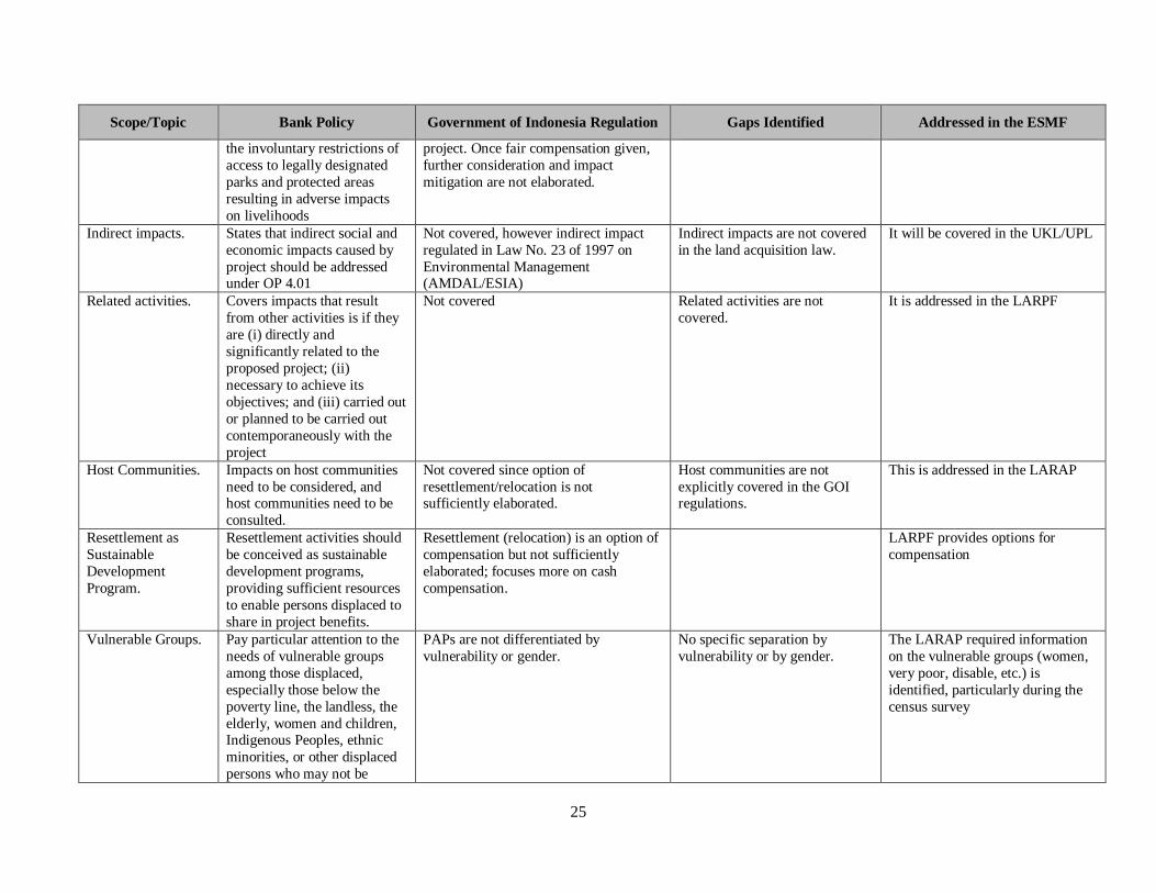
Scope/Topic Bank Policy Government of Indonesia Regulation Gaps Identified Addressed in the ESMF
protected through national
land compensation legislation.
Resettlement
Planning
Instruments.
Different planning instruments
must be prepared to achieve
the objectives of the policy
(resettlement plan,
resettlement policy framework
or process framework) and must cover all aspects of the
proposed resettlement.
Land acquisition plan6 based on a
feasibility study, the project suitability7
to the spatial plan
Requirement to prepare a LARAP
when subprojects involves
involuntary land acquisition and
resettlement
Eligibility for No
Formal Legal
Rights.
For those without formal legal
rights to lands or claims to
such land that could be
recognized under the laws of
the country, provide
resettlement assistance in lieu
of compensation for land to
help improve or at least restore
their livelihoods. Will covers
squatters and encroachers
Does not cover squatters (unless in good
faith on public land), encroachers and
renters on private land.
Landless and laborers are not
expected to be compensated and
provided rehabilitation
measured; it is the responsibility of
the landowner to compensate them.
The LARPF specified that licensed
appraisers compensation criteria
include among others, assistance
and livelihood
Eligibility for Indigenous Peoples.
IPs is covered once they have been legally recognized8
IPPF specifies that if a subprojects needs to acquire land, LARPF
applies.
Land for Land
(Resettlement).
Preference given to land based
resettlement strategies for
displaced people whose
livelihoods are land based.
No time allocation and detail procedures
to implement this resettlement scheme
LARPF provides options for
compensation
Benefits Package. Provide technically and
economically feasible
resettlement alternatives and
needed assistance, including
(a) prompt compensation at
Mainly cash; in MAPPI guideline
compensation is market price plus
transaction and other costs, plus
premium (to cover beyond valuation
cost such as emotional lost).
LARPF provides requirements for
compensation options, and licensed
appraisers assess physical assets,
cost and loss of non- physical
assets and premium
6 Not the same as World Bank LARAP/RP, here is more implementation procedure than development plan. 7 At present the spatial-planning zoning could accommodate the function that proposed by the project. If not the project has to move to other place or revision of zoning should be
issued by the local parliament proposed by the relevant government institution 8 In BPN and Forestry Regulations IP institution should be recognized by local government, while institutions that in favor of IPs prefer that the recognition comes from independent
IPs Committee.

27
Scope/Topic Bank Policy Government of Indonesia Regulation Gaps Identified Addressed in the ESMF
full replacement cost for loss
of assets attributable to the
project; (b) if there is
relocation, assistance during
relocation, and residential
housing, or housing sites, or
agricultural sites of equivalent productive potential, as
required; (c) transitional
support and development
assistance, such as land
preparation, credit facilities,
training or job opportunities as
required, in addition to
compensation measures; (d)
cash compensation for land
when the impact of land
acquisition on livelihoods is
minor; and (e) provision of civic infrastructure and
community services as
required.
Real Property (Physical Assets)
Land
Buildings & Facilities
Plants
Other things related to the
land required to restore to
the owner a property of at least the same quality as that
owned prior to the land
acquisition.
Cost & Loss (Non-Physical
Losses)
Transaction costs
Moving costs
Loss of on-going business
(business interruption)
Other losses of special
nature, subjective and difficult to calculate
Premium
Full Replacement
Cost.
Requirement for compensation
for land and asset to be at full
replacement cost
“Fair and reasonable”, based on value
assessment made by the licensed
appraisers.
Criteria used by licensed appraisers
as specified in the LARPF included
compensation for physical, non-
physical and premium
Livelihood
Restoration.
The resettlement plan or
resettlement policy framework
also include measures to
ensure that displaced persons
are:
(i) Offered support after displacement, for a transition
period, based on a reasonable
estimate of the time likely to
be needed to restore their
livelihood and standards of
living such support could take
Once fair compensation given further
consideration and impact mitigation are
not elaborated.
Impact mitigation not
elaborated.
LARPF included resettlement
assistance and livelihood

28
Scope/Topic Bank Policy Government of Indonesia Regulation Gaps Identified Addressed in the ESMF
the form of short-term jobs,
subsistence support, salary
maintenance or similar
arrangements; and
(ii) Provided with
development assistance in
addition to compensation measures described in
paragraph 6 (a) (iii), such as
land preparation, credit
facilities, training, or job
opportunities.
Indigenous Peoples. Land of indigenous people is
addressed in both OP 4.12 and
OP 4.10. If land of IPs is to be
taken, requires broad
community support and free,
prior and informed
consultation.
Land of indigenous people is treated in
the same way as other, if land rights are
recognized by relevant local government
LARPF applies of a subproject
involve land acquisition and/or
resettlement, regardless of who
own the land. Consultation as
specified in the LARPF and
LARAP should be tailored to the
local context and the characteristics
of the affected persons.
Resettlement Cost. The full costs of resettlement
activities necessary to achieve
the objectives of the project
are included in the total costs
of the project. [20]
Budget plan is part of land acquisition
plan but tend not considering the
resettlement cost.
LARPF and LARAP require that
costs for land acquisition and
resettlement is budgeted
Consultation and
Complaint
Procedure.
Displaced persons should be
meaningfully consulted and
should have opportunities to
participate in planning and
implementing resettlement
programs (2.b)
Grievance mechanism should
take into account availability of judicial recourses and
community and traditional
dispute settlement mechanism
(17)
Consultation to the PAPs needed to get
permit for the proposed location of the
project. There is no prior consultation
before negotiation on option of
compensation. The grievance redress
mechanism is clearly described and
within the court it will follows the court
procedure. Understanding the limitation and over burden of the court system, the
effectiveness of the implementation still
in question
LARPF and LARAP require
consultation and implementation of
GRM. Overall, the project has
GRM in place as a continuation of
the well-functioning GRM system
of the PNPM-Urban/ND.
29
Scope/Topic Bank Policy Government of Indonesia Regulation Gaps Identified Addressed in the ESMF
Monitoring of
outcomes.
Requirement to carry out
adequate monitoring and
evaluation of all activities set
out in the resettlement plan
[24]
Assess whether the objectives
of the resettlement instrument have been achieved, upon
completion of the project,
taking account of the baseline
conditions and the results of
resettlement monitoring [24]
Monitoring and evaluation covers the
occupation, ownership, utilization and
benefit of the result of land acquisition
without clear on when, how and what
correction measure could be enforced.
LARAP specify the requirement of
monitoring of land acquisition and
resettlement activities. Overall, the
project is required to monitor and
report the preparation and
implementation of LARAP (and
EMPs and IPPs as well)

D. Land Acquisition and Resettlement Policy Framework (LARPF)
29. As explained in the Project Description in the Environmental and Social Management
Framework (ESMF) of this project of which this LARPF is part of, at appraisal the project will not
have specific planning information9 on subprojects that will be financed under Component 3,
specifically those financed under Component 3.1 which would likely involve land acquisition and
resettlement, i.e. improvement of secondary and primary infrastructure, and connecting infrastructure
from the target slum areas and to the secondary and primary infrastructure. This LARPF may also
apply for the downstream activities of the products or results of the TA components of this project that
may get Bank financing and involve involuntary land acquisition and resettlement.
30. The project will cover in-situ slum upgrading and support the improvement of small and limited
scale secondary and primary infrastructure as well as small and limited scale connecting infrastructure
to connect slum areas with the secondary and primary infrastructure. Given the subproject nature,
potential land acquisition will be small scale, and large-scale relocation will not take place. However,
if a subproject requires large scale land acquisition and resettlement (or relocation), the project will not
finance such subproject.
31. The purpose of this policy framework is to provide requirement to city government, especially
the project management staff (City/regency Project Implementation Unit) on the principles, process,
procedures, and organizational arrangements to be applied to subprojects requiring involuntary
resettlement in preparing a resettlement plan (RP) to be prepared during project implementation, once
specific planning information of the subproject is known. It will also be used as a reference for the city
planning agency (Bappeda), provincial government and central government who are involved in
managing NSUP to ensure that project management staff at the city level plan and implement land
acquisition and resettlement in compliance with this framework.
32. In this project, involuntary resettlement includes land acquisition implemented under the
eminent domain principle that could involve physical and economic displacement. As practice in
various World Bank supported projects in Indonesia, understanding of involuntary resettlement
includes land acquisition implemented under the Indonesian laws and regulations, and resettlement (or
relocation). Hence, as the common practice in other World Bank supported projects, Land Acquisition
and Resettlement Action Plan (LARAP) is the term commonly used that is equivalent with the term
Resettlement Plan (RP) used in World Bank OP 4.12.
33. This framework relies on Government of Indonesia laws and regulations to the extent that they
are in compliance with the World Bank OP 4.12 on Involuntary Resettlement. Specific provisions are
included in this framework to address any aspect of the OP 4.12 that are not fully addressed in the
Government of Indonesia laws and regulations. GOI laws and regulations include:
9 Specific planning information includes precise sitting, alignment and zone of impacts of subprojects which can
provide information on the coverage and number of project affected persons (PAPs) that will involve in the land
acquisition and resettlement.

31
a. Law No. 2/2012 on Land Acquisition for Project Activity for Public Interest (refer to Figure 2 and
Figure 3 below);
b. Presidential Regulation No. 71/2012 on Land Acquisition and its amendments; and
c. Regulation of the Head of BPN RI No. 5/2012 on Technical Guidelines on the Implementation of
the Land Acquisition.
34. The overall objectives and principles of land acquisition and resettlement in this project are to
ensure that:
a. Land acquisition and resettlement should be avoided where feasible, or minimized, exploring all
viable alternative subproject designs;
b. Where it is not feasible to avoid land acquisition and resettlement, activities of land acquisition and
resettlement should be conceived and executed as sustainable development programs, providing
sufficient investment resources to enable the project affected persons (PAPs) to share the
subproject benefits. The PAPs should be meaningfully consulted and should have opportunities to
participate in planning and implementing the land acquisition and resettlement programs.
c. PAPs should be assisted in their efforts to improve their livelihoods and standards of living or at
least to restore them, in real terms, to pre-land acquisition and resettlement levels or to levels
prevailing prior to the beginning of project implementation, whichever is higher.
Overall, the PAPs’ living conditions should not be worse-off due the land taking by the subproject,
while at the same time they should benefit from the project.
35. This framework applies for the following situation:
a. Impacts caused by subprojects resulting in involuntary land acquisition, relocation, loss of assets
or loss of access to assets, loss of income sources or means of livelihood whether or not the PAPs
must move to another location; resulting in the involuntary restriction of access to legally
designated parks and protected areas that would result in adverse impacts on the livelihoods of the
PAPs.
b. Activities resulting in involuntary land acquisition and resettlement in linked activities, regardless
of financing sources that are:
Directly and significantly related to the NSUP subproject;
Necessary to achieve the objectives of the subproject; and
Carried out, or planned to be carried out contemporaneously with the subproject.

32
Figure 2: Preparation Stage10
10 Summarized from the Law No. 2/2012 in the Gap Analysis Study, 2014
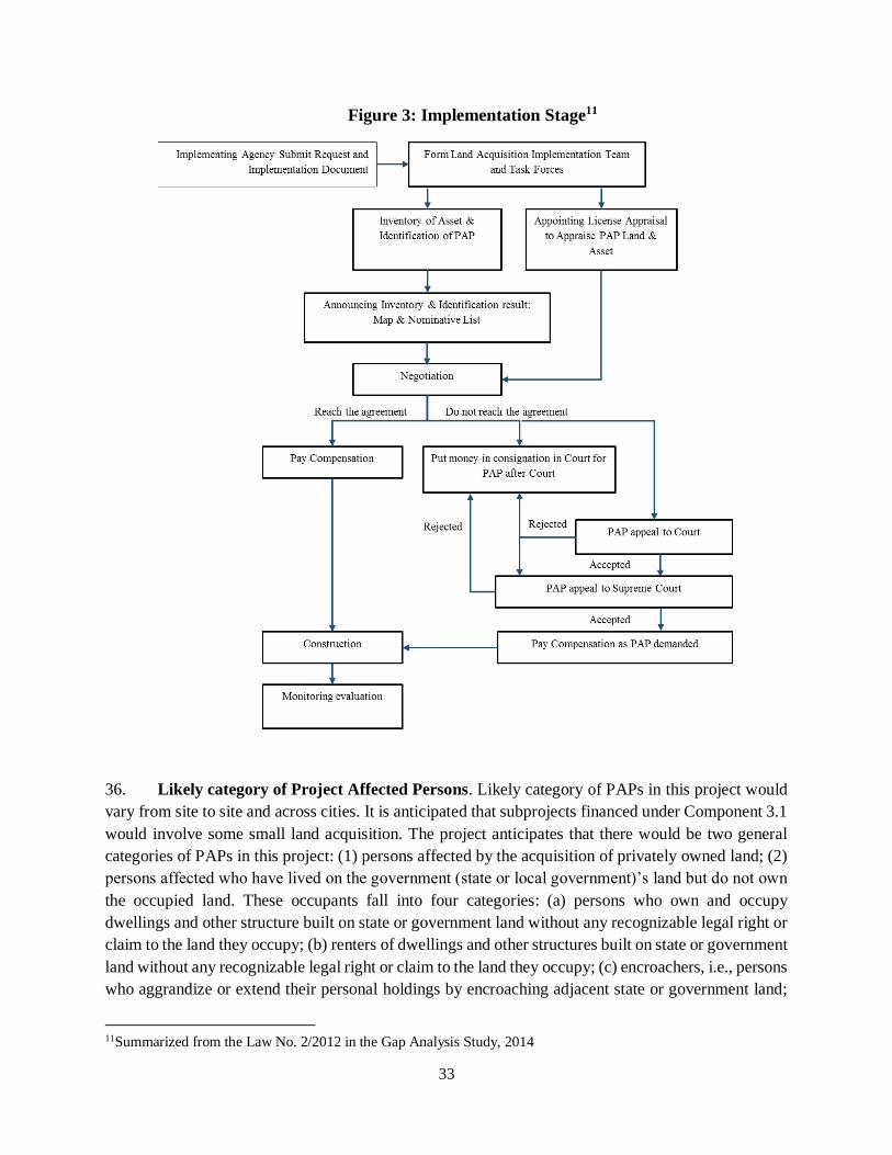
33
Figure 3: Implementation Stage11
36. Likely category of Project Affected Persons. Likely category of PAPs in this project would
vary from site to site and across cities. It is anticipated that subprojects financed under Component 3.1
would involve some small land acquisition. The project anticipates that there would be two general
categories of PAPs in this project: (1) persons affected by the acquisition of privately owned land; (2)
persons affected who have lived on the government (state or local government)’s land but do not own
the occupied land. These occupants fall into four categories: (a) persons who own and occupy
dwellings and other structure built on state or government land without any recognizable legal right or
claim to the land they occupy; (b) renters of dwellings and other structures built on state or government
land without any recognizable legal right or claim to the land they occupy; (c) encroachers, i.e., persons
who aggrandize or extend their personal holdings by encroaching adjacent state or government land;
11Summarized from the Law No. 2/2012 in the Gap Analysis Study, 2014

34
(d) squatter landlords, i.e. persons who derive illegal rents from structures built on state or government
land, but do not occupy such structures. Identification of the PAPs will be done during the preparation
of LARAP through the census survey.
37. A LARAP should adopt the following measures to ensure that the PAPs are:
a. Informed about their options and rights pertaining to resettlement;
b. Consulted on, offered choices among, and provided with technically and economically feasible
resettlement alternatives; and
c. Provided prompt and effective compensation at full replacement costs for losses of assets
attributable directly to the project.
38. If the impacts include physical relocation, a LARAP should also include measures ensuring
that the PAPs are:
a. Provided assistance (such as moving allowance) during relocation; and
b. Provided with residential housing, or housing sites, or else, as required and agreed with the PAPs
to at least equivalent the situation in the old sites.
39. Where necessary to achieve the objectives of land acquisition and resettlement, a LARAP
should also include measures to ensure that PAPs are:
a. Offered support after displacement for a transition period, based on a reasonable estimate of the
time likely to be needed to restore their livelihood and standards of living; and
b. Provided with development assistance in addition to compensation measures described in 38c
above.
40. Following the project cycle (refer to Annex 2), once the Slum Improvement Action Plan (SIAP)
is finalized, the city/regency PIU will identify the priority subprojects to be financed under Component
3.1 that will likely involve involuntary land acquisition and resettlement. During the final stage of
SIAP preparation, the city/regency PIU will have the rough site or alignment of the priority subprojects
to be constructed in the following year, and therefore a Draft LARAP can be prepared. At this stage,
assessment of the potential PAPs that will be affected in the land acquisition and resettlement will
define whether the city/regency PIU should prepare a draft full LARAP or an Abbreviated LARAP12.
The content of a full and an abbreviated LARAPs are presented in Annex 21, respectively, with the
sample outline in Annex 22. The content is more or less equivalent with the combination of activities
under the Land Acquisition Plan and the Inventory and Identification of Land Ownerships, Use and
Utilization of Land under the Implementation of Land Acquisition Stage under the law and regulations
mentioned in paragraph 34 above.
41. During the preparation or after the finalization of the detailed engineering design (DED) of a
priority subproject, the city/regency PIU should finalize the draft full LARAP or the draft Abbreviated
12 As of OP 4.12, Full LARAP and Abbreviated LARAP refer to the level of significance of impacts
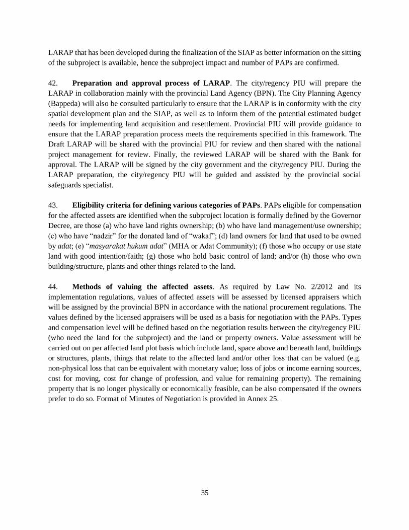
35
LARAP that has been developed during the finalization of the SIAP as better information on the sitting
of the subproject is available, hence the subproject impact and number of PAPs are confirmed.
42. Preparation and approval process of LARAP. The city/regency PIU will prepare the
LARAP in collaboration mainly with the provincial Land Agency (BPN). The City Planning Agency
(Bappeda) will also be consulted particularly to ensure that the LARAP is in conformity with the city
spatial development plan and the SIAP, as well as to inform them of the potential estimated budget
needs for implementing land acquisition and resettlement. Provincial PIU will provide guidance to
ensure that the LARAP preparation process meets the requirements specified in this framework. The
Draft LARAP will be shared with the provincial PIU for review and then shared with the national
project management for review. Finally, the reviewed LARAP will be shared with the Bank for
approval. The LARAP will be signed by the city government and the city/regency PIU. During the
LARAP preparation, the city/regency PIU will be guided and assisted by the provincial social
safeguards specialist.
43. Eligibility criteria for defining various categories of PAPs. PAPs eligible for compensation
for the affected assets are identified when the subproject location is formally defined by the Governor
Decree, are those (a) who have land rights ownership; (b) who have land management/use ownership;
(c) who have “nadzir” for the donated land of “wakaf”; (d) land owners for land that used to be owned
by adat; (e) “masyarakat hukum adat” (MHA or Adat Community); (f) those who occupy or use state
land with good intention/faith; (g) those who hold basic control of land; and/or (h) those who own
building/structure, plants and other things related to the land.
44. Methods of valuing the affected assets. As required by Law No. 2/2012 and its
implementation regulations, values of affected assets will be assessed by licensed appraisers which
will be assigned by the provincial BPN in accordance with the national procurement regulations. The
values defined by the licensed appraisers will be used as a basis for negotiation with the PAPs. Types
and compensation level will be defined based on the negotiation results between the city/regency PIU
(who need the land for the subproject) and the land or property owners. Value assessment will be
carried out on per affected land plot basis which include land, space above and beneath land, buildings
or structures, plants, things that relate to the affected land and/or other loss that can be valued (e.g.
non-physical loss that can be equivalent with monetary value; loss of jobs or income earning sources,
cost for moving, cost for change of profession, and value for remaining property). The remaining
property that is no longer physically or economically feasible, can be also compensated if the owners
prefer to do so. Format of Minutes of Negotiation is provided in Annex 25.

36
45. Land valuation/appraisal by the licensed appraisers will be carried out based on the MAPPI13
Standards as specified in MAPPI Guidelines. Compensation is comprised of market price plus
transaction costs and other costs plus premium, in more detail as follows:
a. Real property (physical assets): land, buildings and facilities, plants, and other things related to the
land acquired to restore to the owner a property of at least the same quality as that owned prior to
the land acquisition;
b. Cost and loss (non-physical losses): transaction costs, moving costs, loss of on-going business
(business interruption), other losses of special nature, subjective and difficult to calculate;
c. Premium.
46. Entitlements Matrix for the Project Affected Persons can see in Table 2 below:
Table 2: Project Affected Persons
Project Affected Persons Entitlements Expected Outcomes
Land/asset owners who lose land
and/or other assets
Compensation for loss of land and
other assets based on value
assessment carried out by licensed
appraisers
Land/asset owners will be fully
compensated for the loss of land and asset
Land/asset owners who lose temporarily or permanently their
sources of income or livelihoods
Compensation for loss of sources of income or livelihoods based on value
assessment for non-physical carried
out by licensed appraisers
Land acquisition/resettlement will not result in the impoverishment of the
affected land/asset owners
Persons who own and occupy
dwellings and other structure built on
state or government land without any
recognizable legal right or claim to
the land they occupy
Compensation for loss of dwellings
and other structure, for income
sources or livelihoods and
resettlement assistance, based on the
assessment of the licensed appraisers
Compensation received and resettlement
assistance provided will enable households
to gain access to adequate housing or to a
place that can be legally occupied and land
acquisition will not result in the
impoverishment of the affected persons.
Renters of dwellings and other
structures built on state or
government land without any
recognizable legal right or claim to the land they occupy
The project considers to provide
sufficient time (at least 2 months
from the cut-off date/at the time of
census survey) for the renters to find another place
Renters will find place to rent or to live in
accordance to their needs
Encroachers, i.e., persons who
aggrandize or extend their personal
holdings by encroaching adjacent
state or government land
Do not entitle for any compensation
for the affected assets that
encroached the state or government
land
Do not have incentive to encroach state or
government land in the future
Squatter landlords, i.e. persons who
derive illegal rents from structures
built on state or government land but
do not occupy such structures.
Do not entitle for any compensation Do not have incentive to do similar renting
scheme in other areas or in the future
47. Forms of compensation. Compensation may take several forms: (a) cash; (b) land
replacement; (c) resettlement to other site; (d) shares ownership; or (e) other forms of compensation
that are agreed both by the PAPs and the agency requiring the land (in this case is the city/regency
13 Indonesian Society of Appraisers or ISA

37
PIU). Compensation may take combination of these depending on the agreements between the PAPs
and the agency requiring the land.
48. Consultations and disclosures. Consultations and disclosures for acquiring land start from
the planning, preparation, and implementation phase. In brief summary, Law No. 2/2012 and its
implementing regulations14 specify that consultations should be carried out in the following activities:
a. At planning stage: plan of the location of subproject, purpose of the development, steps and time
frame for land acquisition, roles of licensed appraisers in the asset valuation, incentive or
compensation that would be provided for the PAPs, eligible assets or object for compensation, and
responsibility and rights of the eligible PAPs. Consultations will use public meetings, media and
information in the closest villages. Consultations will adopt dialogue approach, and can take place
more than one time, depending on the need and agreement reached. Agreement will be put in
writing. The defined subproject location requiring land will be disclosed to public in the media,
websites of the provincial and city government as well as in the website of the agency requiring
the land.
b. BPN will consult the owners of the asset during the inventory and the identification of the affected
assets. Results of the inventory will be disclosed in the village/kelurahan and kecamatan (sub-
district) offices for 14 days to receive complaints.
c. Results of asset valuation done by the licensed appraisers will be provided to the PAPs and used
as the basis for negotiations.
d. Draft and final LARAP will be disclosed in the closest kelurahan/village where the subproject
requiring land acquisition is located, in the websites of the local agency and/or in the city’s website,
and in the project www.p2kp.org website.
49. Grievance Redress Mechanisms (GRM). Process, procedures, requirements as well time for
complaints to be solved during the land acquisition process will follow Law No. 2/2012 and its
implementing regulations (including amendments). In addition, the NSUP will use the good complaint
handling system that is being used in the ongoing PNPM-Urban/ND, including the MIS system. Detail
of GRM is provided in Annex 33.
50. Organizational arrangements. Organizational arrangements for the process of acquiring land
will follow the Law No. 2/2012 and its implementing regulations (including amendments). The
city/regency PIU will work closely with the Provincial Land Agency (BPN) who is mainly in charge
of the process of land acquisition. LARAP will be prepared based on the information provided by the
Land Acquisition Plan and Inventory and Identification Report of the BPN. The final LARAP will be
signed off by the Mayor/Bupati and the Agency requiring the land. The draft LARAP will be reviewed
both by the provincial PIU and central project management, and approved by the Bank. Implementation
of LARAP will be overseen and monitored by the provincial PIU and regular implementation report
will be provided to the central project management office and the Bank. Land acquisition process
should be completed prior to the start of the construction.
14 For details please refer to the Law and implementing regulations specified in the paragraph 34.
38
51. Financing arrangements. Funds should cover compensation, operational and supporting costs
during the planning, preparation, implementation, handover of results, administration and
management, and socialization. At this point, estimated land acquisition and resettlement/relocation
costs cannot be defined as priority subprojects to be funded by the project will be determined towards
the finalization or after the finalization of SIAPs. Confirmation on the scope of land that will have to
be acquired for a subproject will be confirmed during or after the DED is completed. In principle, the
funding will be available from the Central Budget (APBN) and/or Local Budget (APBD) or
combination of these, under the agency who needs the land. Requirement for the operational and
supporting budget from APBN is regulated by the Ministry of Finance, whereas that from APBD is
regulated by the Ministry of Home Affairs.
52. Monitoring and Reporting. The provincial PIU, assisted by the provincial safeguards
specialists/consultants, will monitor the LARAP preparation and implementation at the city level.
Process of preparing and content of LARAP will be ensured in reference to the RPF. Implementation
of LARAP will be monitored based on indicators as specified in the approved LARAP, which includes
among others: (a) consultation process; (b) eligible PAPs; (c) agreed compensation level and forms;
(d) payment of compensation and delivery of assistance; (e) follow-up on the legal process of the
acquired land/remaining land; (f) the effectiveness of complaint handling mechanisms; (g) number,
type of complaints and follow up; (h) disclosures of the LARAP and transparency during the process
of land acquisition; etc. The city PIU, assisted by consultants, will input the progress of LARAP
implementation in the MIS system (currently is being upgraded to accommodate information for this
project, beyond the existing PNPM-Urban). The provincial PIU will verify the information provided
in the MIS provided by the City PIU/consultants, either through field checks and/or through expert
group meeting. The PMU will consolidate the information from MIS into the Project Monthly Report
and upload it in the project web-based reporting system. The current PNPM-Urban web-based
reporting system is being upgraded to accommodate the needs of this project. PMU will discuss issues
identified in this report with the Bank, to come to agreement on the solutions or options. Lessons
learned obtained from the report will be used to improve the project’s implementation of the land
acquisition, including improvement of the training and socialization of safeguards.
53. Others. The amendment of Presidential Regulation No. 71/2012 on Land Acquisition
(Presidential Regulation No. 40/2014) allows that land acquisition for an area less than 5 Ha to be
carried out directly by the agency requiring the land based on willing-buyer-willing seller principle,
exchange or other schemes agreed by the two parties. In this case, the required land should be located
in one area, and can be obtained in one fiscal year. The agency requiring the land may use licensed
appraisers to assess the affected assets.
E. Voluntary Land Donation Protocol
54. Land needed for a subproject will be identified during the completion of the Community
Settlement Plan (CSP). As has been the case with the PNPM-Urban/Neighborhood Development (ND),

39
on average, land needed for a subproject (tertiary community infrastructure) is relatively small and was
voluntarily donated by the community members. Identification of land needs starts during the CSP
preparation through a participatory approach, and confirmation of the need (size, for what purpose,
location) is done during the preparation of the subproject proposal at the community group level
(KSM). The protocol of voluntary land donation (VLD) is as follows:
a. The land donor will receive direct benefit from the subproject.
b. The land donor is not categorized as poor.
c. The land donor is the legitimate owner of such lands.
d. The land donations must apply to agreed priority subproject.
e. Purpose and impacts of proposed activities on donated land must be fully explained to the donor.
f. The land donations shall not cause relocation nor cause the land owner to lose their land and
livelihood in a significant manner.
g. The donated land is <10% of the total productive land size.
h. The donated land is not in dispute.
i. The location and land size is identified by PAPs and verified by facilitators, BKM and it should be
free from any environmental impact and health risk.
j. There are no structures of historic or cultural value on the donated land.
k. The land donor shall receive clear and complete information about their rights. The land owner
needs to be informed about their rights to receive compensation before making the decision to
donate the land voluntarily. The donor may request monetary or non-monetary benefits or incentive
as a condition for donation.
l. All family members of the donor must be aware of the donation. Individuals using or occupying
community or collective lands must also be aware of the donation.
m. For community or collective land, donation can only occur with the consent of individuals using
or occupying the land.
n. Verification must be obtained from each person donating land (either through proper
documentation or through confirmation by at least two witnesses).
o. Any donated land that is not used for its agreed purpose is returned to the donor.
p. In addition, the following aspects need to be carried out:
i. Facilitators should provide an opportunity to land owners to have an independent
consultation prior to making the decision to voluntarily donate their land for the subproject.
ii. Consultation with land owners concerning land donation must guarantee that no pressure
is applied to land owners in the process of deciding on whether to donate land.
iii. Land owners have the right to refuse the land donation and Project Management should
take measures to identify alternative locations for the Project Activity. The right of refusal
is specified in the donation document the donor will sign.
iv. Voluntary land donations must be documented in a legal document, the Statement Letter
for Land Donation, to be signed by land owners, facilitators and head of village, BKM,
witnesses, as well as heirs. A template Statement Letter for Land Donation is provided in
Annex 17.
v. If the land is only permitted for land use or for easement, a Statement Letter is required
and should be signed by land owners, facilitators, and head of village, BKM, and witnesses,

40
as well as heirs. A format for the Statement Letter on the Permit for Land Use is presented
in Annex 18 and the Format of the Statement Letter on Permit for Land Easement is
presented in Annex 19.
vi. The community group (KSM) should attach all other documentation related to voluntary
land donation including minutes of meetings, grievances and procedures for the settlement
of disputes.
vii. Grievance mechanism should follow the project’s grievance mechanism. If necessary, the
grievance process involves the participation of reviewers who are not directly affiliated
with the project implementers or not traditional leaders who are a party to the donation
process.
viii. An original copy of the Statement Letter should be kept both by the land owner and by the
KSM as part of the proposal. A copy of the Statement Letter should be put in the
village/kelurahan office. The proposal should be made available for the public.
ix. The donated land should be legally processed for its ownership status after the land is
donated.
x. Any taxes to be paid by the land donor for the registration of the land transfer, if applicable,
should be covered in full by the project.
xi. City PIU is also responsible in maintaining the record with documentation for each instance
of land donation. The documentation is made available for review in any grievance that
may arise.
F. Voluntary Community-based Land Consolidation Protocol
55. The project anticipates that the community of the slum area may want to carry out in-situ small-
scale voluntary community-based land consolidation (LC). This would include the rearrangements of
the buildings or structures into a more orderly manner. LC may involve road path widening and small
and simple rearrangement of land plots. LC or land readjustment includes physical rearrangement of
irregular, inadequately serviced lots into more regular, efficiently shaped lots, provision of basic
infrastructure which overall will increase the land value of the site that benefits all participating
landowners. LC makes area redevelopment without land acquisition or eviction and at the same time,
facilitates the area in complying with the city’s spatial and land-use plans.
56. In this project, the protocols for LC are as follows:
a. Community groups should voluntarily propose the LC initiative, and it should be part of the CSP;
b. City PIU, assisted by consultant and facilitators, verify the proposal on the ground that the:
i. initiative is voluntarily proposed by the community;
ii. LC is in conformity with the city’s spatial development plan and the CSP;
iii. number of community members and the LC area is physically suitable and sufficient for
the in-situ redevelopment;
iv. land ownerships status of each parcel involved in the LC area are legally clear;
v. community is well organized to prepare and implement the LC; and

41
vi. LC land area has good accessibility to other areas.
c. The city government establishes a technical team (which includes the Land Agency—BPN), to
support the community initiative, and provide socialization and training on LC, as well as guide
and assist the community during the process of preparation and implementation of LC.
d. LC participants may establish an LC team comprising of representatives elected by the LC
participants, to lead the preparation and implementation of LC. The community LC team takes the
lead in preparing the Land Consolidation Implementation Plan (LCIP). LCIP is part of the CSP.
e. The LCIP consists of back ground, purpose of LC, area of LC, list of potential participants, process
and approach of LC preparation and implementation, community meetings to reach agreements,
indicative site plan and land contribution, financing plan of the process, institutional arrangements
in the community and in coordination with the city government, disclosure, complaint handlings,
and time frame.
f. LC participants make self-identification on the list of participants, land ownership or tenure status
of each parcel, carry out measurement and mapping of the original LC area, and verified by the
City’s Land Agency. The list of participants should include men and women land owners.
g. LC participants prepare a site plan of the consolidated land parcels which includes reallocation of
land parcels with the new sizes, rearrangements or new community infrastructure and public
facilities.
h. Land contribution involved in the LC should be defined and agreed by the LC participants. The
use of the contributed land for in-situ redevelopment, new land parcels for each participant, for
public facilities and community infrastructure, and/or to finance the land development costs (as
needed, which could leverage the funds for tertiary infrastructure under component 3.2) should be
agreed by the LC participants.
i. City consultant and facilitator assist the LC participants in preparing the new site plan. The site
plan of consolidated land parcels should include calculations for all original and planned land uses.
It should also include Letter of Agreement to participate and contribute land of each participant,
minutes of all meetings, lists of attendance, photo, etc. Letter of Agreement to participate and
contribute land should be endorsed by the spouse of the land owner.
j. The draft site plan is disclosed in the public facilities such as mosques and in the village office.
The draft site plan will be reviewed and approved by the City’s technical team.
k. The City Land Agency processes the certification of the new land parcel for each participant. Cost
for certification process will be borne by the LC participants, or can be facilitated by the national
land certification program, if any.
l. Any complaints or disputes, if it cannot be solved by the community themselves, will be facilitated
by the city consultant or facilitator, and as necessary, by the City technical team.
m. All records during the preparation and implementation of LC will have to be well documented in
the LKM office and in the respective village/kelurahan office.
n. The City PIU, with the assistance of the consultant, reports the progress of the preparation and
implementation of LC, and information of the progress will be uploaded monthly in the project
MIS. The provincial PIU monitors the progress through the MIS and make field check as necessary.

42
The PMU will include the LC preparation and implementation in the Monthly Project Report,
which is available in the project’s website.
G. Indigenous Peoples Planning Framework (IPPF)
IPs communities in NSUP
57. Based on the World Bank IPs Screening Study (2010), IPs are present in five areas where the
project may be active: the Districts of Sumba Barat (East Nusa Tenggara), Toli-Toli (Central
Sulawesi), Gorontalo (Gorontalo province), and Manokwari (West Papua), and the City of Palopo
(South Sulawesi). The confirmation of the IPs presence and potential impacts on them as well as
measures to manage such impacts will be carried out during the preparation of the SIAPs and CSPs.
Confirmation on IPs presence will be done in accordance with the requirements specified in the
approved ESMF (which adopted OP 4.10, World Bank IPs Screening Study (2010) and the criteria of
“Masyarakat Hukum Adat” —MHA—summarized from various Indonesian Regulations) and
additional information gathered from respective cities. In addition, project components 1 and 2 with
the goals to support institutional and policy development and capacity development for local
governments and communities respectively may involve support for land administration policy reform
and addressing informal settlements including security of land tenure in priority areas where IPs may
present provide a rationale to ensure due-diligence processes with regards to Free, Prior, and Informed
Consultations (FPICs) and participatory approaches in project cycles as required in OP 4.10.
58. An Indigenous Peoples Plan (IPP) will be prepared during the Project implementation (after
the screening, verification and confirmation stage) in the likely event that IPs will be affected by
subproject activities. In cases where IPs communities are the beneficiaries of the subproject(s), the
project will be adopt the planning and implementation processes and procedures similar to PNPM
Urban/ND, whereby full consultation and participation in decision making are mainstreamed into
project cycles. In the case that a subproject needs to acquire land belonged to IPs community or
individual of the IPs community, the LARPF in this ESMF applies.
59. As in the case of environmental and land acquisition/resettlement impacts, potential adverse
impacts and positive effects of the project on IPs, or involvement of IPs as beneficiaries will be
identified once the villages are defined and subproject proposal is submitted by the community groups
(KSM). Screening, verification and confirmation will be carried out at the subproject proposal stage
by the BKM/LKM and facilitators.
60. Law and Regulations related to IPs. This framework takes into account issues related to IPs
as included in the following Law and Regulations:
a. UUD 1945 (Amendment) Chapter 18, clause #2 and Chapter 281 clause # 3;
b. Law No. 41 on Forestry (plus Constitutional Court Decision No. 35/PUU-X/2012, see Footnote 4);
c. MOHA Regulation No. 52/2014 on the Guidelines on the Recognition and Protection of MHA;

43
d. Ministerial Regulation of MOH No. P.62/2013 (adjustment of Ministerial Regulation No.
P.44/2012) on the Establishment of Forest Area;
e. Joint Regulation of MOHA, Ministry of Forest, Ministry of Public Works and Land Agency No.
79/2014 on Procedures to Settle Land Ownership Conflict in Forest Area;
f. Regulation of the Minister of Land Agency and Spatial development No. 9/2015 on the Procedures
to Establish the Land Communal rights on the MHA Land and Community Living in the Special
Area;
g. Law No. 6 / 2014 on Village; and
h. Law No. 18/2013 on Prevention and Alleviation of Deforestation (UUP3H).
61. Objectives. The design of this Project is structured to ensure the participation and inclusion of
various groups within communities in local level decision making over resource allocation. However,
the Project recognizes that IPs form a particular group that merits a different approach and specific
support. Therefore, in accordance with OP/BP 4.10, the following planning framework for addressing
IPs will be adopted for the Project.
62. The objectives of this framework are to:
a. Ensure that IPs participate in and benefit from the Project;
b. Avoid or minimize potentially adverse effects of the Project on IPs, and if it is unavoidable, develop
and implement mitigation measures based on free, prior, and informed consultation resulting in
broad supports from the impacted IPs communities
c. Maximize the potential positive effects of the Project on the IPs, based on free, prior, and informed
consultations with the IPs ensuring that the design and implementation of the Project incorporate
aspirations and needs of the IPs.
63. Identification. Because of the varied and changing contexts in which Indigenous Peoples live
and because there is no universally accepted definition of “Indigenous Peoples,” this framework does
not define the term. IPs in Indonesia are usually referred to as Masyarakat Adat (Customary
Communities) or Masyarakat Hukum Adat (Customary Law Communities) by Law as stipulated in the
Forestry Act 1999, Village Law 2014 and Ministry of Home Affairs Regulation 54/2014.
64. For purposes of this framework, the term “Indigenous Peoples” is used in a generic sense to
refer to a distinct, vulnerable, social and cultural group possessing the following characteristics in
varying degrees:
a. A close attachment to ancestral territories and to the natural resources in these areas;
b. Self-identification and identification by others as members of a distinct cultural group;
c. An indigenous language, different from the common regional/national;
d. The presence of customary social and political institutions.
65. Procedures and institutional arrangements. IPs communities are not prevalent in all the
project sites—they are likely to be found in particular kota/kabupaten of particular provinces. The
44
following steps will be taken to ensure that, where IPs communities are presence and affected by the
project, it caters to their specific needs.
a. Once the target sub-project areas are defined, the OSP and facilitators will screen, verify and
confirm on the presence of the IPs in reference to the above characteristics (para 62). In doing so,
OSP and facilitators will consult experts, local universities or NGOs who have good knowledge or
have worked on IPs in the area and use available references e.g. IP Study 2010 by the World Bank
and other sources. Further, OSP and facilitators with the BKM will consult the communities
concerned and neighboring communities to confirm that they are IPs.
b. In the case that the presence of IPs is confirmed and they will be part of or affected by the project,
facilitators together with the BKM, with the guidance from the OSP, will carry out a social
assessment (SA) at the kelurahan (ward) level, based on free, prior and informed consultations,
with the affected IPs communities. The format and contents of the SA will be provided in the
project’s technical guidelines. Potential adverse and positive effects of the project will be identified
during the SA preparation.
c. IPP will be prepared along with the SIAPs and CSPs in the case that the project affects (positive
and adverse) IPs. In the case that IPs constitute the beneficiaries of the project, the design and
implementation of the subproject(s) will accommodate the aspirations and needs of the IPs. In this
case, the principles of FPICs and participation will apply. The format and content of IPP is provided
in the Project’s Technical Guidelines.
d. Facilitators will work closely with the BKMs or KSMs during the preparation of the SA, the IPP
and subproject proposals. The IPP will be prepared along with the SIAPs and CSPs by the
community under the coordination of BKM.
e. During the facilitator training, facilitators will be trained in the identification of IPs. Through the
Community Self Survey exercise and poverty reflections, facilitators will identify the presence and
numbers of IPs in the community and report this to the OSPs.
f. For the areas where IPs communities are identified, OSPs will organize training for relevant
facilitators in how to work with IPs communities in a meaningful way and in good faith to identify
mechanisms for effective participation through free, prior and informed consultations, and address
specific challenges in working with such groups, for example, how to deal with groups that may
be in conflict with the larger community, etc.
g. Since facilitators will be hired locally to the extent possible, they are expected to be familiar with
such groups. Preference will be made to recruitment of local people with skills and qualifications
fit to the project. They will also be rotated as necessary to ensure that those that have been trained
in working with IPs, or have specific skill-sets that would be beneficial in working with such
groups, are made available in the right places. Management of facilitators will be handled by the
OCs.
h. Where IPs communities are identified, efforts will be made to ensure that at least one Community
Cadre is from the group and able to communicate easily with the group.
i. Where the IPs communities speak a language different from Bahasa Indonesia, facilitation and
socialization will be held in a language that these communities can easily understand. Relevant
brochures and documents will be translated in the appropriate language. Provision has been made
in the project budget to allow for additional translations of relevant project documents.
45
j. The above aims at ensuring that IPs communities participate fully in the project with free, prior
and informed consultations, are aware of their rights and responsibilities, and are able to voice their
needs during the Community Self Survey exercise and in the formulation of the SIAPs and CSPs
as well as subproject proposals. The Project Management Unit will ensure that the above steps in
point 8 are implemented and well documented during project implementation.
66. Monitoring and Grievance Procedures. The Terms of References for the OSP and NMC
include the responsibility for monitoring the treatment of isolated vulnerable people in the project.
Where IPs communities are identified, the OSPs will be required to report on their participation in the
project. Provisions will be made in the Management Information System (MIS) to monitor the
involvement of IPs communities. This will be followed by the NMC as well as monitored during
supervision missions.
67. The project has a complaint system that allows community members to raise issues or
complaints at various levels—at the kelurahan, City Coordinator Team and OSP (either at
kota/kabupaten or province level), and national levels. The project has designated contact numbers for
complaints via phone-calls and short text message (SMS) systems. There are designated staff members
at the OSPs and NMC responsible for following-up on complaints and ensuring that they are handled
adequately. Where IPs communities are concerned, the facilitators/City Coordinator Team/OSP staff
will ensure that grievance redress mechanisms are developed in culturally appropriate ways in close
collaboration with the relevant group.
68. Disclosures. As is the case with other community documents, the IPP will be disclosed in
respective project sites where IPs are affected, and if necessary, the document will be prepared in the
language of the IPs. The IPP will be part of the SIAPs and CSPs as relevant.
69. All project planning documents (SIAPs, CSPs, subproject proposals and their implementation
reports) will be disclosed at the kelurahan/community level and socialization is provided for the
community members to ensure wider access to information.
70. IPPs and other relevant documents will also be disclosed in the Project’s website.

46
III. SAFEGUARDS PREPARATION, APPROVAL AND IMPLEMENTATION
71. Principles.
a. Subprojects should avoid, and if unavoidable, should minimize negative environmental and social
impacts, including land acquisition and IPs affected, and the city government should have explored
viable alternative designs to minimize any such negative environmental and social impacts;
b. Subprojects should be in conformity with the Regional/City Spatial Development Plan and avoid
protected areas designated by the Ministry of the Environment and Forestry;
c. Any subproject entailing a negative environmental and social impact should be accompanied by a
plan to mitigate and address such impacts;
d. Monitoring and reporting of the implementation of any environmental and social safeguards
instruments will part of the overall project monitoring and reporting arrangements.
e. Subprojects eligible for financing should not include activities with significant, sensitive, complex,
irreversible and unprecedented potential adverse environmental and social impacts requiring a full
environmental assessment to manage and mitigate such impacts in accordance with Ministry of
Environment Regulation No. 5, 2012, Ministry of Public Works and Housing Regulation No. 10,
2008, and World Bank OP 4.12. Should there be a subproject identified otherwise, the project will
not finance it.
A. Safeguard Screening and Mitigation: Process, Approaches and Instruments
72. Sub-projects financed under the project will require environmental and social screening, an
assessment of potential environmental and social impacts (including disaster-related) and the
preparation of safeguards instruments for mitigation measures, during the preparation of SIAPs, CSPs
and DEDs. The SIAP and CSP are important instruments to carry out screening and identification of
potential environmental and social safeguards impacts, social assessment, and to decide on mitigation
measures through participatory planning process at the city level, and through self-mapping and
community consultations at the slum area level. Safeguards instruments, when applicable, Land
Acquisition and Resettlement Action Plans (LARAPs), and Indigenous Peoples Plan (IPP) - will be
part of SIAP.
Process of subproject screening, assessment and identification of potential impacts and development
of mitigation measures and safeguards instruments should be part of the project cycle and planning
and implementation documents. Examples of a General ESMF Checklist and Field Appraisal
Instrument prior to approval of a subproject are provided in Annex 7 and Annex 8.
73. Subproject eligibility. The project funds cannot be used to finance (a) purchase of land; (b)
economic activities involving revolving funds; (c) Category A sub-project activities with significant,
sensitive, complex, irreversible and unprecedented potential adverse environmental and social impacts
that may affect an area broader than the sites or facilities subject to physical work requiring a full
environmental assessment to manage and mitigate such impacts in accordance with World Bank OP
4.01, Ministry of Environment Regulation No. 5, 2012 and activities with the scale beyond those
47
specified in the Ministry of Public Works and Housing Regulation No. 10, 2008; and (d) a subproject
with cost above USD 2,000,000. Sub-projects with significant ancillary and related activities will not
be eligible if they are considered as Category A sub-projects. This includes sub-projects that would
require expansion of water treatment facilities, wastewater facilities, solid waste disposal facilities and
road expansion beyond connecting a slum area. Eligible sub-projects to be financed by this project are
Category B sub-projects with impacts that are site specific, few if any are irreversible, and in most
cases mitigation measures can be readily designed.
B. Component 1, 2 and 4: Policy Development, Studies and Institutional Strengthening, and
Project Management
74. These components are expected to support the strengthening of project implementation and
support the facilitation process of project implementation at national, provincial, city and community
levels, particularly in the implementation of subprojects under Component 3. They are important
components to ensure that environmental and social safeguards are mainstreamed into the project and
implemented in compliance with this ESMF. More specifically, Component 2 will be the key activity
to ensure that participating city governments, consultants, facilitators, and communities obtain
sufficient supports to carry out environmental and social management throughout the project as
specified in this ESMF.
75. Component 1 “Institutional and Policy Development”, which among others, would be
undertaking upstream strategic studies to facilitate the development of policy to support the
sustainability of slum upgrading and prevention policies, including land administration policy reform,
approaches to address informal settlements, and security of land tenure. Whereas Component 2 will
support the cities in preparing SIAPs and the communities in preparing the CSPs. Environmental and
social impacts from the products or results of activities financed by these two components cannot be
anticipated or visible at this point.
76. Downstream activities from the results or products may or may not be financed by the Bank.
In the case that downstream activities will be financed by the Bank, once the type, scope and locations
of subprojects are identified at a later stage, this ESMF will provide guidance to screen, assess potential
environmental and social impacts that may emerge from the downstream activities and provide
guidance to define and prepare safeguards instruments, as explained in the following sections of this
ESMF.
77. To ensure that environmental and social safeguards are mainstreamed into activities of
Component 1, 2 and 4, PMU will include environmental and social safeguards aspects in the Terms of
Reference of the activities (studies, training and project management). The TORs will be discussed
and shared with the Bank for review and approval.
78. Screening. Screening for activities supported by Component 1, 2 and 4 will be done
through the following steps:
48
a. Identify the type, scope and expected output of activities that will be covered under the TA contract
package, as presented in the Terms of Reference (TOR). It is clear that the project will finance
client capacity building, upstream strategic studies to facilitate the development of policy to
support the sustainability of slum upgrading and prevention policies, and activities that strengthen
project management;
b. assess the potential environmental and social implications from the outputs of the TA;
c. in the case that the outputs of the TA would lead to future environmental and social impacts, the
TOR of the TA package should include activities to analyze potential environmental and social
issues and how they will be addressed, identify indicative list of instruments to be prepared by the
downstream activities, and to prepare draft Terms of Reference of the relevant safeguards
frameworks or plans (as necessary for instance, LARPF, IPPF or LARAP, IPP) for the downstream
activities. The TORs of TA packages should be prepared in accordance with this ESMF; and
d. in the case that the TA package is a study on activities that have been implemented, the TOR will
cover the lessons learned on environmental and social issues and management that had taken place,
which will provide important information for the future project design in addressing similar issues.
C. Subprojects under Component 3.1 at the City Government Level
Environment
79. Step 1: Subproject Screening and Assessment of Potential Environmental Impacts. City
government (City/Regency PIU) screens the priority subprojects defined in the SIAP to be financed by
the project using a set of eligibility criteria. The screening process consists of three stages: (a) screening
out of sub-projects with significant and irreversible adverse environmental impacts; (b) screening of
sub-projects based on physical thresholds; and (c) screening of sub-projects based on the potential
environmental impact. The outcome of this three stage screening process will determine eligible sub-
projects and the appropriate environmental management instrument to be used for each sub-project.
Screening should also be done for the potentially linked activities and ancillary facilities.
a. Screening out of sub-projects with significant and irreversible adverse environmental
impacts. The project will not finance sub-projects with significant and irreversible adverse
environmental impacts. Such activities require complex and full environmental assessment
processes and/or environmental management measures involving significant resources, time, and
capacity within the city government’s implementing agency. Due to the annual implementation
cycle of NSUP activities and the limited capacity of city government to manage complex
environmental issues, such activities with significant and irreversible adverse environmental
impacts are considered ineligible for financing. These activities include:
i. Those using asbestos as construction material.
ii. Those using raw material and hazardous & toxic waste (B3). The project cannot finance any
project activity which uses, produces, stores or transports raw material and hazardous & toxic
waste such as toxic substance, material which may cause rush or explosion and any other
materials categorized as B3 under Indonesian law.
49
iii. Subprojects activity within, traversing or adjacent to forests. The project cannot finance any
project activity within, traversing or adjacent to forests, including conservation forests
(natural reservation forest, conservation forest, and hunting parks)15, production forests and
protection forests.
iv. Those affecting protected and sensitive areas, natural habitat and critical natural habitat. The
project cannot finance any project activity within, adjacent to or traversing protected areas
and sensitive areas such as natural conservation areas etc. Any project activity which may
alter the function or effectiveness of protected and sensitive areas. Additionally, the project
cannot finance any project activity which causes significant conversion and/ or degradation
of the natural habitat or any critical natural habitat environment.
v. Those that destroys cultural conservation area. The project must not finance any subproject
which degrades or destroys cultural value of a cultural conservation area, not only limited to
artefact and cultural structure, but also locations considered sacred or having high spiritual
value for local people. In the contract agreement with the contractor, there must be provisions
and guideline concerning what measures must be taken if these artefacts and structures are
found within the project site.
vi. Those using timber from illegal logging. The project must not finance infrastructure related
to or support illegal logging.
b. Screening of sub-projects based on physical thresholds. The project will not finance activities
that have significant environmental and social impacts requiring the preparation of AMDAL given
that the process for preparing an AMDAL instrument requires at least between 6-12 months and
hence is incompatible with the annual NSUP project cycle. This stage of the screening process
screens out activities with significant environmental impacts based on physical thresholds (e.g.,
technical characteristics, capacity, hectares affected) as determined by Regulation of Ministry of
Public Works No. 10/PRT/M/2008 as shown in Table 3. The table specifies the range of physical
thresholds for which UKL-UPL instruments are required based on an assessment of potential
impacts. Threshold values below the range indicated in the Table below will require the use of SOP
instrument.
Table 3: Criteria for Subprojects with Instrument for Environmental Management
TYPE of ACTIVITY
Scale or Extent of Project Activity
UKL/UPL (Permen PU No.10/PRT/M/2008)
I. WATER RESOURCE
Irrigated Area
a. Construction of new irrigation system covering an area of 500 to <2000ha
b. Improvement of existing irrigation area 500 to <1000ha
c. Paddy field making 100 to <500ha
II. ROAD & BRIDGES
1. Construction of Toll Road
a. Construction of toll road
15 Based on Government Regulation no. 22 of 2001 on Forest Management and Forest Management Planning, Forest
Utilization and Forest Area.
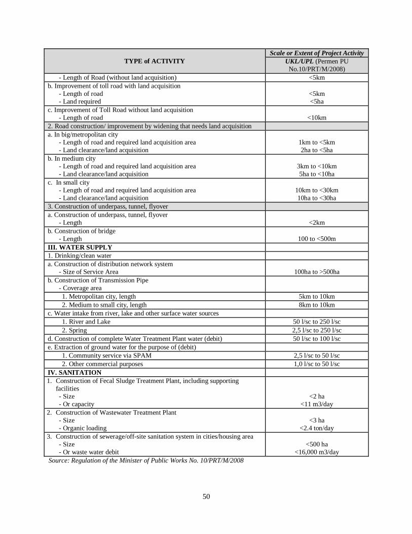
50
TYPE of ACTIVITY
Scale or Extent of Project Activity
UKL/UPL (Permen PU
No.10/PRT/M/2008)
- Length of Road (without land acquisition) <5km
b. Improvement of toll road with land acquisition
- Length of road
- Land required
<5km
<5ha
c. Improvement of Toll Road without land acquisition
- Length of road
<10km
2. Road construction/ improvement by widening that needs land acquisition
a. In big/metropolitan city
- Length of road and required land acquisition area
- Land clearance/land acquisition
1km to <5km
2ha to <5ha
b. In medium city
- Length of road and required land acquisition area
- Land clearance/land acquisition
3km to <10km
5ha to <10ha
c. In small city
- Length of road and required land acquisition area
- Land clearance/land acquisition
10km to <30km
10ha to <30ha
3. Construction of underpass, tunnel, flyover
a. Construction of underpass, tunnel, flyover
- Length
<2km
b. Construction of bridge
- Length 100 to <500m
III. WATER SUPPLY
1. Drinking/clean water
a. Construction of distribution network system
- Size of Service Area 100ha to >500ha
b. Construction of Transmission Pipe
- Coverage area
1. Metropolitan city, length 5km to 10km
2. Medium to small city, length 8km to 10km
c. Water intake from river, lake and other surface water sources
1. River and Lake 50 l/sc to 250 l/sc
2. Spring 2,5 l/sc to 250 l/sc
d. Construction of complete Water Treatment Plant water (debit) 50 l/sc to 100 l/sc
e. Extraction of ground water for the purpose of (debit)
1. Community service via SPAM 2,5 l/sc to 50 l/sc
2. Other commercial purposes 1,0 l/sc to 50 l/sc
IV. SANITATION
1. Construction of Fecal Sludge Treatment Plant, including supporting
facilities
- Size
- Or capacity
<2 ha
<11 m3/day
2. Construction of Wastewater Treatment Plant
- Size
- Organic loading
<3 ha
<2.4 ton/day
3. Construction of sewerage/off-site sanitation system in cities/housing area
- Size
- Or waste water debit
<500 ha
<16,000 m3/day
Source: Regulation of the Minister of Public Works No. 10/PRT/M/2008
51
c. Screening of sub-projects based on the potential environmental impact. The third stage of the
screening process screens for activities that, having passed through stages one and two, are
considered to have significant environmental impacts requiring the use of complex environmental
assessment and management instruments. This stage will screen out all activities that have potential
significant and large environmental impacts based on consultation with Local Environmental
Agency or based on Regulation of Ministry of Environment No. 16/2012.
80. Significant environmental impacts determined by the factors as the following:
Numbers and characteristics of people likely to be affected and their location
Area of impacts, including project’s area of influence (ancillary facilities and associated
facilities16)
Duration or exposure of impacts
Intensity of impacts
Severity and probability of impacts
Numbers of environmental component affected
Cumulative impacts
Reversibility of the impacts
Trans-boundary aspects, whether the impacts affect cross national borders.
81. Environmental impacts identification can be conducted based on the following methods:
Checklist
Interaction matrices
Overlay mapping
Secondary data
Interview/consultation with experts
82. The result of this three stage screening process will determine the environmental management
approach that will be used by each sub-project as follows: (a) activities ineligible for financing under
the project, that require full environmental assessment due to its potential significant impact and must
prepare AMDAL; (b) eligible sub-projects that require UKL-UPL due to less significant potential
impacts and meet the requirements of the Regulation of Ministry of Public Works no. 10/PRT/M/2008
for activities that must have UKL-UPL; and (c) eligible subprojects that require SOPs to mitigate
potential minor impacts; (d) eligible subprojects that require no environmental study, where no
construction, disturbance of land or water or discharge of pollutants are involved. It is expected that
some sub-projects may fall under this category. Example of environmental screening report is shown
in Annex 9.
16 Associated facilities are facilities or activities that are not funded as part of the project and, in the judgment of the
Bank, are: (a) directly and significantly related to the project; (b) carried out, or planned to be carried out,
contemporaneously with the project; and (c) necessary for the project to be viable and would not have been constructed
or expanded if the project did not exist.

52
83. The required environmental management procedures for eligible sub-projects are detailed as
follows:
a. Subproject requiring UKL and UPL: sub-projects that require UKL-UPL should follow guidelines
for the preparation of UKL-UPL as specified in Regulation of Ministry of Environment No.
16/2012 with additional requirements identified in the screening in Annex 9.
b. Subproject requiring Standard Operating Procedure (SOP): Activities determined to have minor
environmental impacts should use SOP. The Ministry of Public Works and Housing has developed
standard SOPs for key sub-sectors, including roads, water supply, and sanitation. MPWH’s SOPs
include, for example measures to control air & noise pollution and disturbance to traffic in
construction location, requirements for rehabilitation of soil and plant in areas affected by the
project as mitigation measures to land erosion, land clearing method, procedures to control
negative impact on point of loading for solid waste. Ministry of Public Works and Housing’s
complete list of guideline, guidance or SOP can be found online from www.pu.or.id or
www.binamarga.pu.or.id.
84. Step 2: Preparing the Environmental Management Instruments
a. The city government (City/Regency PIU) will prepare the required environmental management
instrument (UKL-UPL or SOP) based on the result of the screening process and the on the Detailed
Engineering Design (DED) of the subproject.
b. Procedures for the preparation of UKL-UPL. The preparation of UKL-UPL must be in accordance
to the Regulation of the Minister of Environment No.16 of 2012 concerning the Guidelines for
Preparation of Environmental Document and additional provisions included in this ESMF. The
following steps must be taken in the formulation and implementation of the UKL-UPL:
i. City/Regency PIU should coordinate with the City Environmental Agency and fill in the
UKL-UPL forms provided by the Agency. Template of UKL-UPL implementation is
presented in Annex 10.
ii. City/Regency PIU should prepare the UKL-UPL document that considers impacts on the
environment in the sub-project area of influence, including analysis of alternatives and any
additional requirements based on the screening of potential impacts.
iii. The UKL-UPL document should also contain information such as budget estimation for
programs or activities of environmental management, public consultation programs and
institutional arrangements for the UKL-UPL implementation.
iv. City/Regency PIU submits the completed forms to the City Environmental Agency for
review/ evaluation.
v. City Environmental Agency issues approval for the proposed UKL-UPL.
vi. City/Regency PIU submits copy of the final UKL-UPL to Mayor/Bupati through District
Environmental Agency. In the said UKL-UPL document, the City/Regency PIU should
provide a statement letter to guarantee the implementation of UKL-UPL. Such statement
letter should be signed by the head of the City/Regency PIU. Template for such statement
letter is presented in Annex 11: UKL-UPL Implementation Assurance Statement Letter.
vii. City/Regency PIU implements the UKL-UPL.

53
viii. City/Regency PIU reports the UKL-UPL implementation every 6 months to City
Environmental Agency and Mayor/Bupati.
c. Procedures for the preparation of SOP. The City/Regency PIU should coordinate with the
relevant work units to use/prepare the SOP for the subprojects in the corresponding sub-sectors.
Complete list of guideline, guidance or SOP is presented in Annex 12, as well as available online
from www.pu.or.id or www.binamarga.pu.or.id. Further, the City/Regency PIU should prepare a
Commitment Letter to carry out an Environmental Management and Monitoring (SPPL) for the
subproject activity. The format is available in Annex 13. The City/Regency PIU should carry out
the environmental mitigation measures by referring to the SOP for each sub-sector.
d. A copy of UKL-UPL, SOP, or SPPL already prepared by City/Regency PIU and approved by the
City Environmental Agency should be submitted to Provincial PIU. The City Environmental
Agency should provide recommendation to Provincial PIU if the preparation process and quality
of the environmental management instrument/document (UKL-UPL or SOP) meet the
requirements specified in the prevailing laws and regulations.
e. UKL-UPL, SOP, or SPPL already ratified by City Environmental Agency should be implemented
and funded by the city budget.
f. The City Environmental Agency should monitor the implementation of the recommendation for
environmental management and monitoring as specified in the UKL-UPL, SOP, or SPPL, which
should be part of the subproject civil works contract.

54
Figure 4: Flowchart on Determining Project which requires AMDAL17or UKL-UPL
(Example of a Road Construction Project)
Source: Guideline for Environmental Management Plan For Road Construction no 009/BM/2009 by DG of Bina Marga
85. Implementation of Environmental Management Plan during Construction. The overall process
for formulating the environmental assessment must be completed before City/Regency PIU can sign
the contract agreement for construction. Recommendations for environmental management and
17 Not eligible for project financing

55
monitoring become part of the contract agreement to be signed by City/Regency PIU and the
contractor, and must be supervised by a supervision consultant. A sample of key clauses for the contract
agreement with the contractor and supervision consultant with recommendations on environmental
management and monitoring is presented in Figure 5 below, or in the Ministry of Public Works’
Guideline No. 10/BM/2009 concerning specific clauses on technical specification for contractors
pertaining to environmental impacts. This guideline also includes the example of guidelines for the
mitigation of impacts from construction works (traffic, stockpiles, waste management, erosion and
sedimentation, vegetation management, utility management) as referred to in Annex 14.
Figure 5: Clauses in the Contract Agreement Related to Environmental Safeguard
Requirements of environmental safeguards:
The second party has understood clearly and shall follow recommendations from the UKL/UPL documents and
results of the environmental study......... as specified in the documents of...... page......
In conducting construction work, the second party must always follow the guidelines for environmental
safeguards, as specified in the documents............
Sanctions:
If the second party fails to comply with the recommendations and requirements for environmental safeguards
in the contract agreement, then the second party must carry out restoration at their own cost and pay
compensation to the community affected by the project as specified in the following points:
(1) ....
(2) ....
Guarantee:
The second party must guarantee that the construction work has been completed following the environmental
regulation, as written in the following documents:
(1) .....
(2) .....
The second party must guarantee that in pre-construction and construction stages, there will be no negative
impact due to work done by the second party, as regulated by document.......... If any negative impact occurs,
then the second party must take measures, as needed and as approved by the first party, at their own cost.
Physical Cultural Resources Management Framework
86. The objective of this measure is to assist in preserving physical cultural resources and avoiding
their destruction or damage. Physical Cultural Resources (PCR) includes resources of archaeological,
paleontological, historical, architectural, religious (including graveyards and burial sites), aesthetic, or
other cultural significance.
a. The scope of management physical cultural resources includes:
i. Conservation: preservation, restoration, reconstruction, adaptation, maintenance, protection;
ii. Utilization: publication/presentation, exhibition, revitalization/productive function.

56
b. Management program follows the conservation procedure that includes inventory, identification,
and plan prior to program implementation.
i. Inventory to include:
PCR profile in the form of list on various PCRs;
Map of PCR distribution in the appropriate scale;
ii. Identification of cluster and trail:
Cluster defined based on potency strategic and utilization of the PCR. Cluster definition
to consider the intensity and richness in a limited area in order to promote the heritage
atmosphere. The limited area also making the management of the PCR easier.
Trail is the path of the PCR as internal framework of the cluster and as access to other
cluster.
iii. Program strengthening:
Five years program of the village should include the PCR management;
The first year budget can be proposed to the project, based on the cluster approach.
iv. Design preparation:
Cluster and trail should be equipped with design guidelines on the development; hence
the PCR will be kept in its original condition, as long as possible. The project should
strengthen the heritage atmosphere not the other way around to erode the visual character
of the PCR.
Design guidelines should define the kelurahan regulations and agreements regarding
physical design development criteria and its harmony between building and the
environment. These guidelines to include: the architecture, facet, height, perimeter,
yards, scale, etc (that should be restored and developed according to the local condition
and need).
The development of design guidelines should be supported by design review on the
respective cluster characteristics.
87. The chance finds procedure is presented in Annex 15, the PCR Management Plan will be
prepared as part of the EMP of the subproject if there is find of the PCR on the subproject sites.
Disaster Risk Management
88. Since Indonesia is a country with high disaster risks, moreover in urban areas as the main focus
of the NSUP project, several measures need to be taken to ensure that the project’s investments as well
as the beneficiaries are disaster resilient. The principles of reducing vulnerability and increasing
capacity in the context of disaster risks are applied to all activities under NSUP. Therefore, subprojects
financed under the project will require an assessment of disaster risks. However, the actions and
programs for DRM are most effective if they are suitably integrated with the corresponding programs
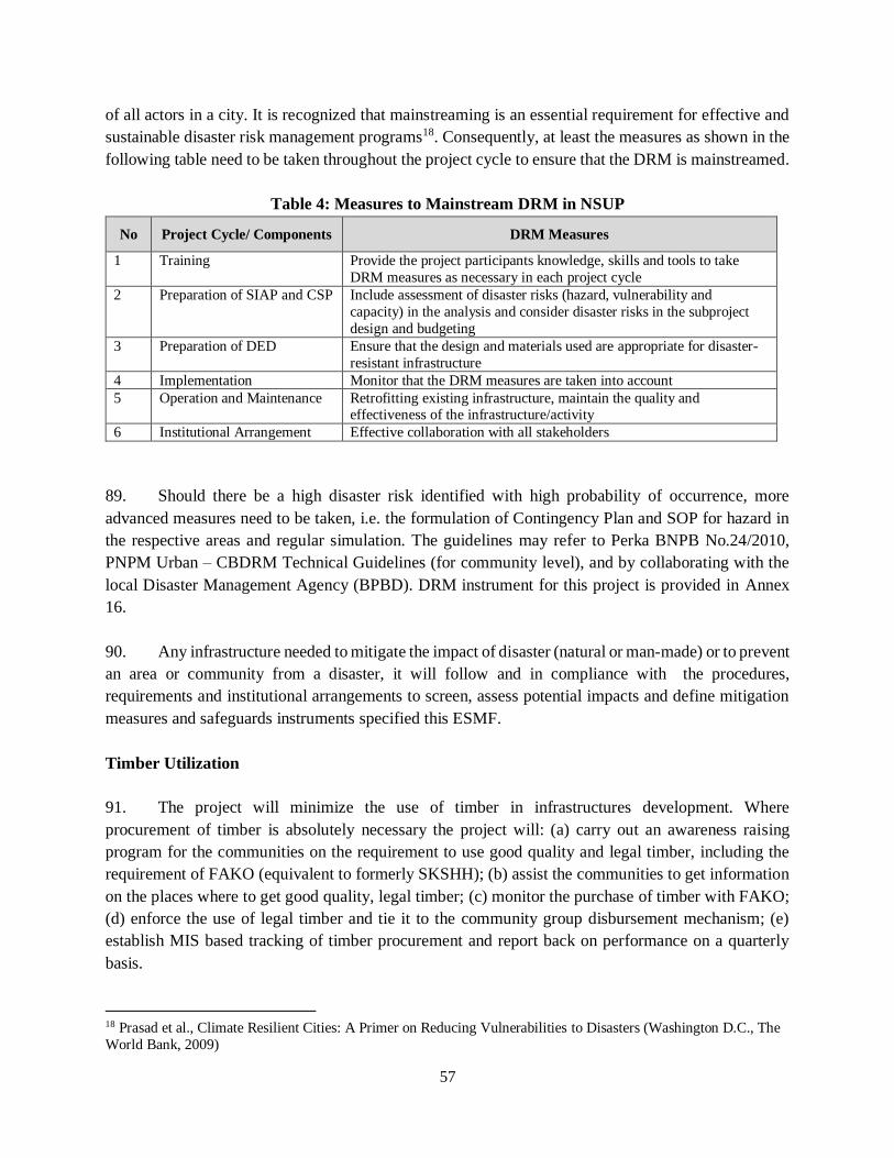
57
of all actors in a city. It is recognized that mainstreaming is an essential requirement for effective and
sustainable disaster risk management programs18. Consequently, at least the measures as shown in the
following table need to be taken throughout the project cycle to ensure that the DRM is mainstreamed.
Table 4: Measures to Mainstream DRM in NSUP
No Project Cycle/ Components DRM Measures
1 Training Provide the project participants knowledge, skills and tools to take
DRM measures as necessary in each project cycle
2 Preparation of SIAP and CSP Include assessment of disaster risks (hazard, vulnerability and
capacity) in the analysis and consider disaster risks in the subproject
design and budgeting
3 Preparation of DED Ensure that the design and materials used are appropriate for disaster-
resistant infrastructure
4 Implementation Monitor that the DRM measures are taken into account
5 Operation and Maintenance Retrofitting existing infrastructure, maintain the quality and effectiveness of the infrastructure/activity
6 Institutional Arrangement Effective collaboration with all stakeholders
89. Should there be a high disaster risk identified with high probability of occurrence, more
advanced measures need to be taken, i.e. the formulation of Contingency Plan and SOP for hazard in
the respective areas and regular simulation. The guidelines may refer to Perka BNPB No.24/2010,
PNPM Urban – CBDRM Technical Guidelines (for community level), and by collaborating with the
local Disaster Management Agency (BPBD). DRM instrument for this project is provided in Annex
16.
90. Any infrastructure needed to mitigate the impact of disaster (natural or man-made) or to prevent
an area or community from a disaster, it will follow and in compliance with the procedures,
requirements and institutional arrangements to screen, assess potential impacts and define mitigation
measures and safeguards instruments specified this ESMF.
Timber Utilization
91. The project will minimize the use of timber in infrastructures development. Where
procurement of timber is absolutely necessary the project will: (a) carry out an awareness raising
program for the communities on the requirement to use good quality and legal timber, including the
requirement of FAKO (equivalent to formerly SKSHH); (b) assist the communities to get information
on the places where to get good quality, legal timber; (c) monitor the purchase of timber with FAKO;
(d) enforce the use of legal timber and tie it to the community group disbursement mechanism; (e)
establish MIS based tracking of timber procurement and report back on performance on a quarterly
basis.
18 Prasad et al., Climate Resilient Cities: A Primer on Reducing Vulnerabilities to Disasters (Washington D.C., The
World Bank, 2009)

58
92. The training and awareness raising will feature the timber legality issue so that infrastructure
facilitators are competent in assisting communities with procuring good quality, legal timber.
93. Community awareness, in particular to the issue of ensuring that legal timber is sourced for all
infrastructure developments need, will be a feature of early discussions between project facilitators and
BKMs/LKMs and community groups, together with provision of printed media in all key centers.
Social
94. Subproject eligibility. As for environment, the project funds cannot be used to finance (a)
purchase of land; (b) economic activities involving revolving funds; (c) Category A sub-project
activities with significant, sensitive, complex, irreversible and unprecedented potential adverse
environmental and social impacts that may affect an area broader than the sites or facilities subject to
physical work requiring a full environmental assessment to manage and mitigate such impacts in
accordance with World Bank OP 4.01, Ministry of Environment Regulation No. 5, 2012 and activities
with the scale beyond those specified in the Ministry of Public Works and Housing Regulation No. 10,
2008; and (d) a subproject with cost above USD 2,000,000. Sub-projects with significant ancillary and
related activities will not be eligible if they are considered as Category A sub-projects. This includes
sub-projects that would require expansion of water treatment facilities, wastewater facilities, solid
waste disposal facilities and road expansion beyond connecting a slum area. Eligible sub-projects to
be financed by this project are Category B sub-projects with impacts that are site specific, few if any
are irreversible, and in most cases mitigation measures can be readily designed.
Land Acquisition and Resettlement
95. Step 1: Subproject Screening and Assessment of Potential Land Acquisition and Resettlement
a. The city government (City/Regency PIU) will have to screen priority subproject (improvement of
secondary and primary infrastructure and connecting infrastructure from slum areas to the existing
secondary and primary infrastructure) identified in the SIAP to be financed by the project on the
need of the land and/or resettlement. In the case that land acquisition and/or resettlement is needed
for a subproject, the City/Regency PIU will prepare a full or an abbreviated Land Acquisition
Resettlement Action Plan (LARAP) in accordance with the Land Acquisition and Resettlement
Policy Framework (LARPF) included in this ESMF (Chapter II D). The Draft LARAP (full or
abbreviated) will be part of the SIAP, and will be refined and finalized during or after the DED of
the subproject is completed. A full LARAP will be prepared in the case that a subproject require
land and/or resettlement more than 200 people (or 40 households) and an abbreviated LARAP for
a subproject require land/or resettlement up to 200 people. Land acquisition may also involve
temporary relocation of residents.

59
b. The City/Regency PIU will have to screen and identify whether the priority subproject to be
financed by the project is linked with other subprojects regardless of financing sources, that are (a)
directly and significantly related to the subproject to be financed by the project; (b) necessary to
achieve the project objective; and (c) contemporaneous to the subproject that will be financed by
the project. In the case that land acquisition and/or resettlement is needed for the linked subproject,
if there is a resettlement beyond small or limited scale, the sub-project will not be considered
eligible. If the land acquisition and resettlement including the linked activities are of small and
limited scale the City/Regency PIU will prepare a Land Acquisition and Resettlement Plan
(LARAP) in accordance with the Land Acquisition and Resettlement Policy Framework (LARPF).
The full LARAP will be prepared in the case that a subproject require land and/or resettlement
more than 200 people (or 40 households) and an abbreviated LARAP for a subproject require
land/or resettlement up to 200 people. The LARAP for the linked subproject is prepared in addition
to or along with that of the priority subproject to be financed by the project.
c. Learning from the DAK infrastructure project, land needed by a subproject may be contributed by
the beneficiaries. Typical subprojects with this land scheme are installation of transmission and
distribution water supply pipes, small road widening, and installation of waste water pipes. Land
contribution includes donation of some of the land rights by the land owner to the project, permit
of land use for certain period of time, and permit for land easement (usually for laying a pipe). The
formats of statement letters on land contribution are available in Annex 17, 18, and 19.
d. Subproject may involve temporary disturbance, land acquisition and temporary income loss during
construction leading to social impacts to the Project Affected Persons (PAPs). Identification and
mitigation measures should be identified during the preparation of LARAP.
e. Screening categories of land acquisition/and or resettlement are presented in Table 5 below.
96. Step 2: Preparing the Land Acquisition and Resettlement Action Plan (LARAP)
a. The City/Regency PIU prepares a Draft LARAP in accordance with the LARPF included in this
ESMF. The outline and format of a LARAP, along with its attachments, are presented in Annex
21 - Annex 27. The Draft LARAP is part of the SIAP.
b. The Draft LARAP will be refined and finalized once the DED for the subproject requiring land is
completed.
97. Step 3: Approval and Disclosure
a. The City/Regency PIU submitted the LARAP to the Provincial PIU for review. The Provincial PIU
will share the LARAP with the PMU for review and submit it to the Bank for approval
b. The LARAP should be shared with the Bappeda (Local Planning Agency) to be reviewed and
include the costs for its implementation in the local budget.

60
c. The LARAP is disclosed in the project website www.p2kp.org and in the city government’s
website where the subproject is located, as well as in the closest village offices in the subproject
area.
d. Subproject construction cannot start prior to the completion of land acquisition and/or resettlement.
98. Step 4: Monitoring and Reporting
a. The Provincial PIU, assisted by the social safeguards specialist (consultant) will monitor the
implementation of the approved LARAP.
b. A LARAP implementation progress report will be prepared monthly (or as needed depending on
the local situation) by the City/Regency PIU and submitted to the Bappeda, Provincial PIU, and
PMU.
99. Step 5: Grievance Redress Mechanisms
a. The project will continue to utilize the current good complaint handling system of the PNPM-
Urban/ND, which can be accessed through its website www.p2kp.org.
b. The short-text-message (SMS) complaint system as well as MIS system for complaint handling
used in the ongoing PNPM-Urban/ND will be continued as one effective tool to receive and follow-
up complaints.
Table 5: Scale of Land Acquisition and Instrument for Land Acquisition and Resettlement
Land Acquisition
Activity
Number of Project Affected People
(PAP)/Land Owner Instrument
1. With
compensation
> 200 people (or > 40 households) or eliminating >10% of their productive asset
Full LARAP
≤ 200 people (or ≤ 40 households) or
eliminating ≤ 10% productive asset Abbreviated LARAP
> 200 people (or > 40 households) or
eliminating >10% of their productive asset Full LARAP
≤ 200 people (or ≤ 40 households) or
eliminating ≤ 10% productive asset Abbreviated LARAP
2. Voluntary
Donation/Lending
from the land owner
Donation on a part of land right
Statement of Land Donation
Minutes of Public Consultation
Permit for Land
Use
Statement on Permit for Land Use
Minutes of Public Consultation
Permit for Land Easement
Statement on Permit for Land Easement
Minutes of Public Consultation
3. Relocation and
Temporary
Relocation
> 200 people (or > 40 households) Full LARAP
≤ 200 people (or ≤ 40 households) Abbreviated LARAP
4. Reconstruction > 200 people (or > 40 households) Full LARAP
≤ 200 people (or ≤ 40 households) Abbreviated LARAP

61
Indigenous Peoples (IPs)
100. Step 1: Subproject Screening and Assessment of Potential Impacts on IPs
a. Initial screening based on the World Bank IPs Screening Study (2010)19 indicated that potential
IPs presence is located in five cities/districts: Sumba Barat in East Nusa Tenggara; Toli-toli in
Central Sulawesi; Gorontalo in Gorontalo Province; Manokwari in West Papua; and Palopo city in
South Sulawesi. City/Regency PIU will further screen the IPs presence in the city where priority
subprojects identified in the SIAP are located. The screening will be done based on the criteria of
IPs specified in the IPPF in this ESMF (also refer to footnotes 4 and 5), and criteria of Masyarakat
Hukum Adat (MHA) summarized from the relevant Indonesia regulations and local values.
City/Regency PIU should further identify the existence of IPs at the site of priority sub-projects
(and its surrounding) by collecting as much information and local knowledge as possible,
especially through discussions with the local community and community leaders and local experts
on IPs. The results of the screening will be part of the SIAP.
b. City / regency PIU assess whether the subproject will affect the identified IP communities. A Social
Assessment needs to be prepared by the City/Regency PIU to map the characteristics of IPs
communities, assess potential impacts, and aspirations and needs of the IPs communities.
City/Regency PIU will be responsible for preparing an IPP in case that the proposed subproject
affects IPs communities. In the case that IPs communities are the sole or major beneficiaries of the
proposed subproject, an IPP is not needed, instead, all aspirations and needs of the IPs communities
are part of the subproject design.
101. Step 2: Preparing Social Assessment and Indigenous Peoples Plan (IPP)
a. City/Regency PIU will conduct a screening of the impacts (both positive and adverse) that may be
caused by a subproject to determine what measures should to be taken and management
instruments should be prepared. Table 6 summarizes criteria for management of social impact on
IPs based on the project type. For a subproject that affect IPs (whether adversely or positively), an
IPP will be prepared in compliance with the IPPF. The scope and content of the IPP will be
proportional to the subprojects and their impacts. The IPP is prepared with the participation of
affected communities through a social assessment and free, prior and informed consultation
process, and demonstrates broad support to the sub-project and the IPP (Guidance of preparing a
Social Assessment and IPP is provided in Annex 29 and Annex 30, respectively). If the
beneficiaries of a sub-project are IPs, an IPP is not necessary. The elements of an IPP will be
incorporated into the design of the subproject.
19 In 2010, the World Bank conducted a mapping of locations of IPs in Indonesia down to the village level for all
provinces, using the combined criteria of the World Bank and the Government of Indonesia. The results of this
mapping can be used as reference to pre-screen the presence of IPs at the site of the subprojects.
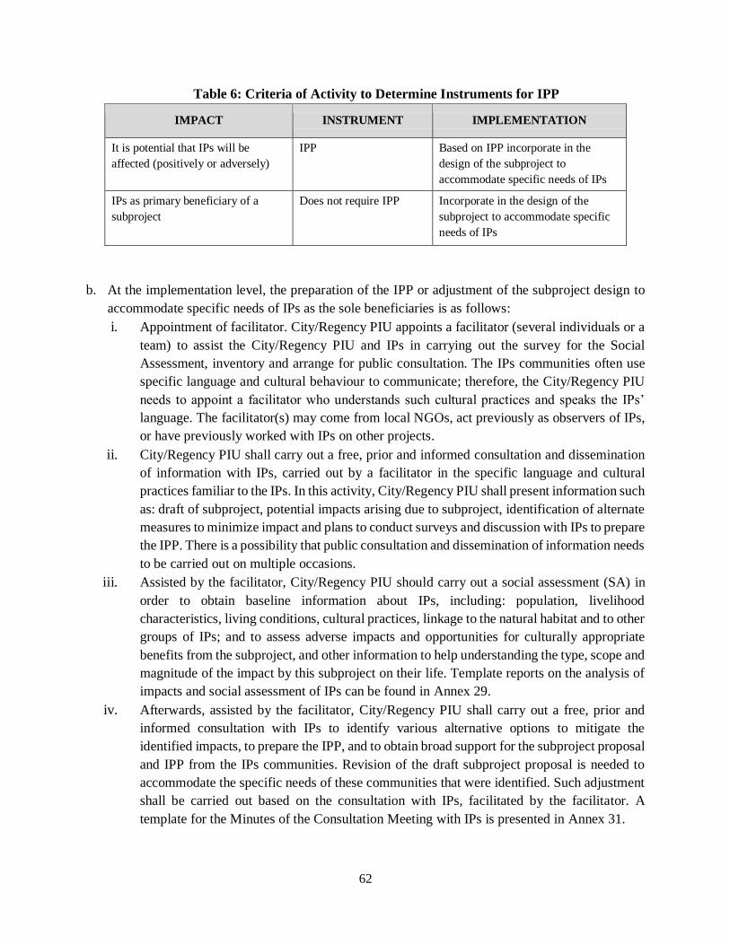
62
Table 6: Criteria of Activity to Determine Instruments for IPP
IMPACT INSTRUMENT IMPLEMENTATION
It is potential that IPs will be
affected (positively or adversely)
IPP Based on IPP incorporate in the
design of the subproject to
accommodate specific needs of IPs
IPs as primary beneficiary of a
subproject
Does not require IPP Incorporate in the design of the
subproject to accommodate specific
needs of IPs
b. At the implementation level, the preparation of the IPP or adjustment of the subproject design to
accommodate specific needs of IPs as the sole beneficiaries is as follows:
i. Appointment of facilitator. City/Regency PIU appoints a facilitator (several individuals or a
team) to assist the City/Regency PIU and IPs in carrying out the survey for the Social
Assessment, inventory and arrange for public consultation. The IPs communities often use
specific language and cultural behaviour to communicate; therefore, the City/Regency PIU
needs to appoint a facilitator who understands such cultural practices and speaks the IPs’
language. The facilitator(s) may come from local NGOs, act previously as observers of IPs,
or have previously worked with IPs on other projects.
ii. City/Regency PIU shall carry out a free, prior and informed consultation and dissemination
of information with IPs, carried out by a facilitator in the specific language and cultural
practices familiar to the IPs. In this activity, City/Regency PIU shall present information such
as: draft of subproject, potential impacts arising due to subproject, identification of alternate
measures to minimize impact and plans to conduct surveys and discussion with IPs to prepare
the IPP. There is a possibility that public consultation and dissemination of information needs
to be carried out on multiple occasions.
iii. Assisted by the facilitator, City/Regency PIU should carry out a social assessment (SA) in
order to obtain baseline information about IPs, including: population, livelihood
characteristics, living conditions, cultural practices, linkage to the natural habitat and to other
groups of IPs; and to assess adverse impacts and opportunities for culturally appropriate
benefits from the subproject, and other information to help understanding the type, scope and
magnitude of the impact by this subproject on their life. Template reports on the analysis of
impacts and social assessment of IPs can be found in Annex 29.
iv. Afterwards, assisted by the facilitator, City/Regency PIU shall carry out a free, prior and
informed consultation with IPs to identify various alternative options to mitigate the
identified impacts, to prepare the IPP, and to obtain broad support for the subproject proposal
and IPP from the IPs communities. Revision of the draft subproject proposal is needed to
accommodate the specific needs of these communities that were identified. Such adjustment
shall be carried out based on the consultation with IPs, facilitated by the facilitator. A
template for the Minutes of the Consultation Meeting with IPs is presented in Annex 31.

63
v. The draft subproject proposal, which responds to the needs of IPs should be communicated
back to the community to obtain their feedback, and enable further refinement of the plan
and confirmation of broad community support. IPs, or other relevant parties, with interest in
this matter shall have the opportunity to submit their complaints or recommendations on the
draft subproject proposal in another meeting facilitated by the facilitator City/Regency PIU
can also carry out public consultation concerning the draft subproject proposal with observers
of IPs in a workshop, public discussion or seminar.
vi. The draft subproject proposal is finalized in accordance with the recommendations provided
by IPs and their supporting groups.
vii. Implementation of the IPP, as described in the revised draft of subproject proposal.
viii. Results of the process from steps (1) to (6), carried out by City/Regency PIU, should be
documented in a complete IPP and be submitted to Bappeda and Provincial PIU for approval,
along with other documentation (for example: findings and recommendations from the social
assessment, minutes of meetings signed by the meeting’s participants, evidence of broad
community support, publication/photos of activities, certificate and public information
materials, certificate of consultation, and other relevant documentation). City/Regency PIU
should report adjustments to the implementation activities of the IPP that are carried out in
the field.
ix. Relocation of IPs should be avoided. If it cannot be avoided, the Project should prepare a
LARAP for the relocation of the IPs communities or their assets or livelihoods sources. The
decision to relocate or not to relocate should be made by the IPs communities based on the
free, prior, and informed consultations that lead to the broad support of the affected IPs
communities. The LARAP for the IPs communities will be prepared based on the free, prior,
and informed consultations that lead to the broad support of the affected IPs communities.
x. The IPP will be shared with Bappeda and will be submitted by the city/regency PIU to the
Provincial PIU and PMU for review, and then submitted to the Bank for approval. The IPP
should be part of the subproject proposal. The overall funding related to the making and
implementation of IPP shall come from APBD (Local Government Annual Budget).
102. The following aspects need to be considered by City/Regency PIU in the implementation of
IPP during technical planning and construction stages:
a. The IPP (as relevant) in the subproject proposal should become part of the contract agreement
between the contractor and City/Regency PIU. The recommendations of the IPP must be
incorporated in the technical design of the subproject, reflecting the mutual
agreement/recommendation from the IPs.
b. During construction phase, IPs should be involved in ensuring that mutual agreements and
recommendations from the IPs are carried out consistently, or if any change is needed, it can be
consulted with IPs during construction phase.
c. Provincial PIU and Pokja PKP shall coordinate with Bappeda at Provincial/District/City-level in
monitoring of the implementation of the IPP as part of the overall project monitoring.
Implementation Reports of the subproject on the implementation of the IPP shall become part of

64
the regular implementation report and the final report (see Annex 32 concerning Monitoring and
Reporting Guidelines).
103. The summary of process of environmental and social management at city level is illustrated in
the following figure.

65
Figure 6: Process of Environmental and Social Management at City Level
D. Subprojects under component 3.2 at the community level
Environmental Management for Community-Level Subproject
104. KSM will have to screen and assess potential environmental impacts of subprojects identified
in the CSP. As part of the planning process, a checklist of potential environmental issues is introduced
(see Annex 8). Subproject design should address potential adverse impacts and facilitator needs to
verify that mitigation measures have been included in the proposal. Each type of subproject is checked
by kelurahan facilitator for the various treatments that must be carried out to avoid or repair
environmental problems. At the midpoint of construction progress, the same form is brought to the
field and implementation of mitigation measures will be inspected again, at a time when it is still
feasible to easily repair deficiencies. At the end of construction, the form is checked one more time
against the original plan. The environmental specialist (hired at NMC level) updates the list on a regular
basis to reflect environmental issues and proposed mitigation measures accordingly.
105. For each type of subproject, a technical standard is included in the project manuals. For
example: drainage for roads must be installed together with culverts to discharge water safely; water
supplies cannot be located near any potential source of contamination, etc. Sustainability will be further
ENVIRONMENT SOCIAL
Negative List
NSUP
Environment
Impact
Evaluation
UKL/
UPL
SOP/
SPPL
Potencial of Social Impact to the
Indigenous Peoples (IPs)
Land Acquisition and
Resettlement
Potencial Impact
on IPs
IPs Plan
Project Activity
for IPs
Land Acquisition with
significant impact
>200 people (>40 HH)
Land Acquisition with
insignificant impact
≤200 people (≤40 HH)
Draft Abbreviated
LARAP Draft Comprehensive
LARAP
Detailed Engineering Design (DED) and Final LARAP
Approval of the Document of Social and
Environmental Impact Management
Budgeting for the Implementation of the
Recomendation for Social and Environmental
Impact Management
Integration of Recommendations for
UKL/UPL or SOP/SPPL, DRM and
PCRMP in the Construction Contract
§ Land Acquisition
§ Community Relocation
§ Asset Replacement
§ Livelihood Recovery
§ Land Administration Process
(Certificate division)
§ Integration of Recommendations
for IP Plan in the Contract
Document
§ Implementation of IP Plan that
needs to be conducted before
construction start
Implementation of Recommendation
for UKL/UPL or SOP/SPPL, DRM
and PCRMP according to contract
Continue Livelihood Recovery
(if necessary)
Consultation with IPs during
Construction
PROCESS OF ENVIRONMENTAL AND SOCIAL MANAGEMENT AT CITY LEVEL
DO
CU
ME
NT
PR
EP
AR
AT
ION
PR
OJE
CT
AC
TIV
ITY
SC
RE
EN
ING
BA
SE
D O
N P
OT
EN
TIA
L IM
PA
CT
S
AP
PR
OV
AL
AN
D
BU
DG
ET
ING
PR
E C
ON
ST
RU
CT
ION
CO
NS
TR
UC
TIO
N
MO
NIT
OR
ING
AN
D E
VA
LU
AT
ION
Potencial Impact
on Physical
Cultural Resources
Physical Cultural
Resources
Management Plan
(PCRMP)
Potencial of
Disaster Risk
Disaster Risk
Management
(DRM)

66
assured through substantial inclusion and participation of urban poor communities as well as local
governments in the design and implementation of upgrading options. Based on experiences under
ongoing PNPM-Urban/ND, below is the checklist of environmental issues and mitigation measures to
be applied in NSUP as can be seen in Annex 14.
106. Community groups (KSMs) will prepare a subproject proposal on a standard format provided
by the Technical Guidelines, signed by kelurahan facilitator and the group members. The standard
format will include requirements for subprojects that are not eligible for financing as part of the
negative list. The proposals will include a description of the activities proposed and compliance with
any applicable guidelines on environmental impacts (as well as land/asset acquisition and impact on
IPs). All proposals will be reviewed by facilitators and consultants for their feasibility, technical
soundness, and compliance with guidelines, before they are considered by the BKM/LKM as eligible
subproject for financing. Facilitators will screen subproject proposals for any environmental impacts
based on the Safeguards Technical Guidelines. These will include screening all subprojects to meet
best practice standards. BKMs with the assistance of facilitators will ensure that adequate mitigation
measures are taken. The selection of subproject proposals by the BKM for the kelurahan grant
(Component 3.2) will be made in a meeting publicized in advance and open to the public.
Indigenous Peoples
107. Step 1: Subproject Screening and Assessment of Potential Impacts on IPs
a. At the community level, BKM together with the kelurahan officials with the assistance of the
facilitators will identify the IPs presence based on the criteria specified in the IPPF and confirm it
with field visit and meeting with the IPs community. During the CSP preparation, the IPs
community will participate in the discussion and decision making. The BKM will accommodate
specific needs of the IPs community based on the community self-mapping and assessment of
potential impacts (positive and adverse) as part of the project cycle at the kelurahan level.
b. Focus group discussions, as needed, specifically for the IPs community, can be carried out during
the preparation of CSP, to assess the extent to which priority subproject would affect the IPs,
identify management measures tailored to the specific needs of the IPs. Further, the KSM will
include in a more intensive way the discussions with the IPs that will be affected by the proposed
subproject, to be financed by Component 2. Subproject design will incorporate the specific needs
of the IPs.
c. As needed, facilitators assigned for the city or kelurahan where IPs are presence and affected by
the proposed subprojects will have to be the ones who are familiar with the culture and language
of the IPs. City consultant coordinator and the City/Regency PIU will ensure that IPs are correctly
identified, consulted through free, prior, informed consultation resulting in broad support or in
agreement with the subproject and with the measures in response to the specific needs of the IPs.
108. Step 2: Subproject design incorporating specific needs of IPs.
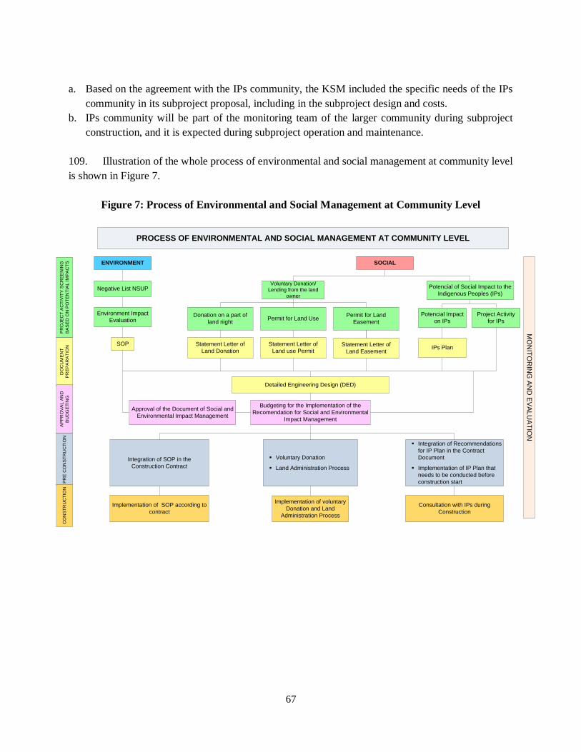
67
a. Based on the agreement with the IPs community, the KSM included the specific needs of the IPs
community in its subproject proposal, including in the subproject design and costs.
b. IPs community will be part of the monitoring team of the larger community during subproject
construction, and it is expected during subproject operation and maintenance.
109. Illustration of the whole process of environmental and social management at community level
is shown in Figure 7.
Figure 7: Process of Environmental and Social Management at Community Level
ENVIRONMENT SOCIAL
Negative List NSUP
Environment Impact
Evaluation
SOP
Potencial of Social Impact to the
Indigenous Peoples (IPs)
Voluntary Donation/
Lending from the land
owner
Potencial Impact
on IPs
IPs Plan
Project Activity
for IPsDonation on a part of
land riightPermit for Land Use
Permit for Land
Easement
Statement Letter of
Land Donation
Statement Letter of
Land use PermitStatement Letter of
Land Easement
Detailed Engineering Design (DED)
Approval of the Document of Social and
Environmental Impact Management
Budgeting for the Implementation of the
Recomendation for Social and Environmental
Impact Management
Integration of SOP in the
Construction Contract
§ Voluntary Donation
§ Land Administration Process
§ Integration of Recommendations
for IP Plan in the Contract
Document
§ Implementation of IP Plan that
needs to be conducted before
construction start
Implementation of SOP according to
contract
Implementation of voluntary
Donation and Land
Administration Process
Consultation with IPs during
Construction
PROCESS OF ENVIRONMENTAL AND SOCIAL MANAGEMENT AT COMMUNITY LEVEL
DO
CU
ME
NT
PR
EP
AR
AT
ION
PR
OJE
CT
AC
TIV
ITY
SC
RE
EN
ING
BA
SE
D O
N P
OT
EN
TIA
L IM
PA
CT
S
AP
PR
OV
AL
AN
D
BU
DG
ET
ING
PR
E C
ON
ST
RU
CT
ION
CO
NS
TR
UC
TIO
N
MO
NIT
OR
ING
AN
D E
VA
LU
AT
ION

68
IV. INSTITUTIONAL ARRANGEMENTS AND CAPACITY BUILDING
110. The Executing Agency of this project, the DGHS under the MPWH, has an extensive
experience in managing safeguards under the PNPM-Urban/ND project, REKOMPAK, in addition to
PAMSIMAS, Integrated Urban Infrastructure Development Projects (IUIDPs), DAK project, etc. The
current PMU of PNPM-Urban/ND will be strengthened and safeguards experts under the PMU’s
Advisory Consultant Team and NMC will be maintained and its capacity will continuously be
strengthened. These specialists have extensive experiences in the PNPM-Urban/ND programs. The
provincial PMU will be assisted by an environmental specialist and social development specialist to
support, oversee and guide the city governments, consultants and facilitators. Safeguards will continue
to be part of the regular training program for consultants and facilitators of the PNPM-Urban/ND who
mostly would continue to work on the National Slum Upgrading Project. Furthermore, at the city level,
urban planners and the infrastructure specialists in the consultant team will be responsible for ensuring
that this ESMF and safeguards technical guidelines are implemented consistently by the local
government and slum communities. In this project, there will be safeguards training specifically
dedicated to city governments as part of the overall training program, as well as for contractors to
ensure that subproject investment sufficiently address the potential environmental and social issues.
111. At the provincial and city levels there is a Task Force or Pokja whose function is together with
the Provincial PIU and PMU to oversee, monitor and supervise project implementation, including
safeguards. This Group consists of multi-sectorial agencies and also representatives from universities
and NGOs.
112. This ESMF will be adopted by project management staff, city governments, consultants,
facilitators and LKMs to manage environmental and social safeguards impacts and risks both for the
TA components and infrastructure components, regardless of financing sources. The ESMF (in English
and Bahasa) is accessible through the MPWH and project’s websites (www.p2kp.org) and Infoshop
(English version) prior to appraisal. This ESMF will be elaborated into a Safeguards Technical
Guidelines (STG) to be adopted during project implementation and are made available in the project’s
website, and hard copies are distributed to project management staff, city governments, consultants,
facilitators and BKMs/ LKMs. In addition to STG, the project will continue distribute the Book of
Good and Bad Practices in Community Infrastructure, published by PNPM-Urban/Rural and similar
Book from the DAK Infrastructure project.
113. Table 7 below presents the summary of the roles of each stakeholder involved in the project in
environmental and social safeguards management.

69
Table 7: Main Roles of Stakeholders Participating in the Project in Safeguards Management
INSTITUTION ROLE in SAFEGUARDS
National Level National Taskforce for Housing
and Settlement Facilitate national stakeholders on compliance of
safeguards policy at national level
Executing Agency, Head of
PMU, Project Implementation Unit (PIU)
Issue ESMF & technical guidelines related to safeguards.
Ensure safeguards compliance for overall project
stages
Conduct national public consultations
Monitor safeguards compliance through web-based
monitoring system
Evaluate safeguards compliance
Advisory Team, NMC, OSP CB
Environmental and Social
Safeguards Specialist
Formulate ESMF & technical guideline related to
safeguards
Formulate training & socialization media
Train safeguards materials to related stakeholder &
conduct socialization of safeguards
Monitor safeguards compliance through web-based monitoring system
Evaluate safeguards compliance
Provide training to provincial consultants
Current MIS is improved
Provincial level
Provincial Taskforce for Housing
and Settlement Oversee, monitor and supervise safeguards
implementation at the city level
Provincial PIU
OSP & TMC
Environmental and Social
Safeguards Specialists
Review UKL/UPL submitted by City/Regency PIU
Review LARAP submitted by Provincial PIU
Monitor implementation of UKL/UPL and LARAP
Provide safeguards training to City/Regency PIU, city
coordinator team, consultants and facilitators
City Level City Taskforce for Housing &
Settlement Facilitate safeguard compliance at city level
Providing technical support
City/ Regency PIU Ensure mainstreaming safeguards into SIAP, area
development plan, and CSP
Screen city level sub-projects
Prepare and UKL/UPL, LARAP, IPP (as needed) &
DED
Ensure safeguard compliance during preparation,
implementation and monitoring stage at city level
Monitor safeguards compliance through web-based
monitoring system at city level
Evaluate safeguards compliance at city level
City Coordinator Team
Contractors
Facilitate local government and community to
mainstream safeguards policy at city level during
preparation, implementation and monitoring stage
Train safeguards materials to city level stakeholders
Conduct socialization related to safeguards
Monitor safeguards compliance through web-based
monitoring system at city level
Evaluate safeguards compliance at city level
Ensure that potential environmental and social issues
that may arise during construction is properly
addressed
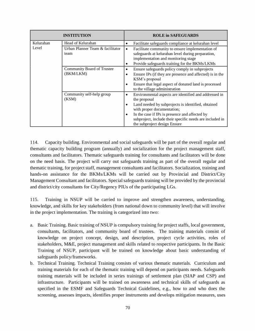
70
INSTITUTION ROLE in SAFEGUARDS
Kelurahan
Level
Head of Kelurahan Facilitate safeguards compliance at kelurahan level
Urban Planner Team & facilitator
team Facilitate community to ensure implementation of
safeguards at kelurahan level during preparation,
implementation and monitoring stage
Provide safeguards training for the BKMs/LKMs
Community Board of Trustee
(BKM/LKM) Ensure safeguards policy comply in subprojects
Ensure IPs (if they are presence and affected) is in the
KSM’s proposal
Ensure that legal aspect of donated land is processed
to the village administration
Community self-help group
(KSM) Environmental aspects are identified and addressed in
the proposal
Land needed by subprojects is identified, obtained
with proper documentation;
In the case if IPs is presence and affected by
subproject, include their specific needs are included in
the subproject design Ensure
114. Capacity building. Environmental and social safeguards will be part of the overall regular and
thematic capacity building program (annually) and socialization for the project management staff,
consultants and facilitators. Thematic safeguards training for consultants and facilitators will be done
on the need basis. The project will carry out safeguards training as part of the overall regular and
thematic training, for project staff, management consultants and facilitators. Socialization, training and
hands-on assistance for the BKMs/LKMs will be carried out by Provincial and District/City
Management Consultant and facilitators. Special safeguards training will be provided by the provincial
and district/city consultants for City/Regency PIUs of the participating LGs.
115. Training in NSUP will be carried to improve and strengthen awareness, understanding,
knowledge, and skills for key stakeholders (from national down to community level) that will involve
in the project implementation. The training is categorized into two:
a. Basic Training. Basic training of NSUP is compulsory training for project staffs, local government,
consultants, facilitators, and community board of trustees. The training materials consist of
knowledge on project concept, design, and description, project cycle activities, roles of
stakeholders, M&E, project management and skills related to respective participants. In the Basic
Training of NSUP, participant will be trained on knowledge about basic understanding of
safeguards policy/frameworks.
b. Technical Training. Technical Training consists of various thematic materials. Curriculum and
training materials for each of the thematic training will depend on participants needs. Safeguards
training materials will be included in series trainings of settlement plan (SIAP and CSP) and
infrastructure. Participants will be trained on awareness and technical skills of safeguards as
specified in the ESMF and Safeguards Technical Guidelines, e.g., how to and who does the
screening, assesses impacts, identifies proper instruments and develops mitigation measures, uses

71
various templates or forms related to EMP, LARAP, VLD, etc., and how to and who monitors
safeguards plans, etc.
116. Workshops of NSUP will be carried out to disseminate and socialize the NSUP to broader
stakeholders. The workshop will be divided into two types:
a. General Workshop. General workshop will be carried out for broader stakeholders from national
down to kelurahan level, such as university, media, researcher, city forum, etc. Basic information
on safeguards in NSUP will be part of the workshop’s materials.
b. Thematic Workshop. Thematic workshop will be implemented based on need assessment.
Workshop on safeguards could be carried out at national until kelurahan level if there is a need to
do the workshop, e.g., in a slum area that have PCR, the specific workshop could be carried out to
strengthen awareness of related stakeholders and ensure that implementation of project will be in
compliance with safeguards policy/plan. There will be training for contractors at the city level, to
strengthen the awareness and capacity of them to address potential environmental and social issues
that may arise during construction.
117. The Table 8 below summarizes the types of training and socialization for various stakeholders
involved in the project.
Table 8: Training and Socialization Activities of Which Include Safeguards
NO TARGET GROUP
TYPE OF TRAINING OR
SOCIALIZATION ACTIVITIES
Socialization
(Workshop)
Basic
Training
Technical
Training
A NATIONAL LEVEL
National Housing and Settlement Working Group √
PMU & staff √ √ √
Consultant (Advisory team, NMC, etc.) √ √ √
B PROVINCIAL LEVEL
Local Government √
City Level Housing and Settlement Working Group √
Provincial PIU √ √ √
Consultant (OSP & TMC) √ √ √
C CITY LEVEL
Local Government √
City Level Housing and Settlement Working Group √
City PIU √ √ √
Technical Team √ √ √
Consultant (TMC) √ √ √
City Coordinator Team √ √ √
Facilitator √ √ √
Contractors
√ √

72
NO TARGET GROUP
TYPE OF TRAINING OR
SOCIALIZATION ACTIVITIES
Socialization
(Workshop)
Basic
Training
Technical
Training
D KELURAHAN/DESA LEVEL
Community Board of Trustee √ √ √
Technical team (planning team, construction group, etc.) √ √ √
Community self-help group √ √ √
118. Monitoring, reporting and complaints handling. Monitoring and reporting on the
environmental and social safeguards implementation will be part of the project monitoring and
reporting system. The current MIS of PNPM-Urban/ND (accessible at www.p2kp.org) will be
continuously improved and will include records on the performance of environmental management, as
well as details of any land acquisition and/or resettlement that would take place in slum areas and cities
due to improvement of secondary and primary infrastructure and/or construction of connecting
infrastructure. The City/Regency PIU, consultants and facilitators are the responsible parties who are
in charge of ensuring that information on these are uploaded in the MIS regularly. The current effective
complaints handling system (CHS) of the ongoing PNPM-Urban/ND programs will be continuously
improved and socialized to allow a wider public at the city and community level to air their aspirations
and complaints, if any, as relevant to environmental and social safeguards. Records of complaints and
follow-ups will be continuously made available on the project website, as was the case under the
PNPM-Urban/ND program.
V. GRIEVANCE REDRESS MECHANISMS
119. The project will continue the ongoing PNPM Urban/ND complaints handling process, which
will allow community members and the general public to channel complaints and inquiries. Contact
information for complaints handling via SMS or email, as well as communication with local
government officials and facilitators should be publicized, and the record of complaints will publicized
on the project website. For NSUP, the same complaint handling management system will be used but
community awareness will be strengthened about their rights and the capacity to resolve the complaints
with the improvements in information on the website such as EIS (Executive Information System).
The project will also develop exit strategy of complaint handling management to ensure its
sustainability at kelurahan and city level. Detail of the project’s Grievance Redress Mechanisms is
provided in Annex 33.
VI. FINANCING
120. Financing safeguards implementation. The project cannot finance the purchase of land,
however, it could finance infrastructure related to safeguards impacts (such as mitigation measures for
flood management, or infrastructure development for the relocation sites) and to a certain extent, sub-
standard houses improvement and public facilities. Some proceeds of the grants to the BKM/LKM can

73
be used to facilitate the administration costs for legal processing of the donated land. City governments
(City/Regency PIU) will have to finance the preparation of the safeguards instruments (UKL/UPLs,
LARAPs, IPPs) and their implementation (such as land purchase, livelihood restorations, transitional
costs, etc.). To some extent, as part of the SIAP preparation, preparation of safeguards instruments may
be financed by Component 2 as part of the SIAP preparation. At the kelurahan level, preparation of
IPP would be part of the CSP preparation, which will be supported by Component 2. The mitigation
measures for environmental and social impacts mainly during construction will be included in the
bidding document/contract for any construction works to be carried out by contractors/third party and
in the subproject’s budget plan in the community’s proposal.
121. Financing for safeguards specialists at the national and provincial levels, as well as capacity
building activities for safeguards will be supported by Component 4 of this project.
74
ANNEXES

75
Annex 1 NSUP List of Eligible Cities
No. List of 20 Cities List of 65 Cities List of 154 Cities
1 Kota Surabaya Kota Surabaya Kota Surabaya
2 Kota Malang Kota Malang Kota Malang
3 Kota Yogyakarta Kota Yogyakarta Kota Yogyakarta
4 Kota Samarinda Kota Samarinda Kota Samarinda
5 Kota Gorontalo Kota Gorontalo Kota Gorontalo
6 Kab. Sidoarjo Kab. Sidoarjo Kab. Sidoarjo
7 Kota Mataram Kota Mataram Kota Mataram
8 Kota Kendari Kota Kendari Kota Kendari
9 Kota Palu Kota Palu Kota Palu
10 Kota Kupang Kota Kupang Kota Kupang
11 Kota Jayapura Kota Jayapura Kota Jayapura
12 Kota Surakarta Kota Surakarta Kota Surakarta
13 Kota Semarang Kota Semarang Kota Semarang
14 Kota Banjarmasin Kota Banjarmasin Kota Banjarmasin
15 Kota Ternate Kota Ternate Kota Ternate
16 Kota Manado Kota Manado Kota Manado
17 Kota Makassar Kota Makassar Kota Makassar
18 Kota Ambon Kota Ambon Kota Ambon
19 Kota Sorong Kota Sorong Kota Sorong
20 Kota Pekalongan Kota Pekalongan Kota Pekalongan
21 Kota Balikpapan Kota Balikpapan
22 Kab. Kendal Kab. Kendal
23 Kota Banjarbaru Kota Banjarbaru
24 Kota Palangkaraya Kota Palangkaraya
25 Kab. Muna Kab. Muna
26 Kota Denpasar Kota Denpasar
27 Kota Bitung Kota Bitung
28 Kab. Banjar Kab. Banjar
29 DKI Jakarta DKI Jakarta
30 Kab. Demak Kab. Demak
31 Kota Baubau Kota Baubau
32 Kota Bima Kota Bima
33 Kab. Sleman Kab. Sleman
34 Kab. Lombok Tengah Kab. Lombok Tengah
35 Kab. Kolaka Kab. Kolaka
36 Kab. Pemalang Kab. Pemalang
37 Kota Probolinggo Kota Probolinggo
38 Kab. Grobogan Kab. Grobogan

76
No. List of 20 Cities List of 65 Cities List of 154 Cities
39 Kab. Gianyar Kab. Gianyar
40 Kab. Sukoharjo Kab. Sukoharjo
41 Kota Pare-pare Kota Pare-pare
42 Kota Bontang Kota Bontang
43 Kab. Pekalongan Kab. Pekalongan
44 Kab. Sumba Timur Kab. Sumba Timur
45 Kab. Kotabaru Kab. Kotabaru
46 Kab. Purworejo Kab. Purworejo
47 Kota Tegal Kota Tegal
48 Kab. Tulungagung Kab. Tulungagung
49 Kab. Manggarai Kab. Manggarai
50 Kab. Gorontalo Kab. Gorontalo
51 Kab. Lombok Timur Kab. Lombok Timur
52 Kab. Belu Kab. Belu
53 Kota Kotamobagu Kota Kotamobagu
54 Kota Tual Kota Tual
55 Kab. Purbalingga Kab. Purbalingga
56 Kab. Semarang Kab. Semarang
57 Kota Palopo Kota Palopo
58 Kab. Bondowoso Kab. Bondowoso
59 Kab. Sikka Kab. Sikka
60 Kab. Banjarnegara Kab. Banjarnegara
61 Kab. Rembang Kab. Rembang
62 Kab. Majene Kab. Majene
63 Kab. Wonosobo Kab. Wonosobo
64 Kab. Manokwari Kab. Manokwari
65 Kab. Klungkung Kab. Klungkung
66 Kab. Buleleng
67 Kab. Magelang
68 Kab. Jepara
69 Kab. Jombang
70 Kab. Gowa
71 Kota Pasuruan
72 Kab. Klaten
73 Kota Magelang
74 Kab. Tegal
75 Kab. Banyumas
76 Kab. Gresik
77 Kab. Bulukumba
78 Kab. Tanah Toraja Utara

77
No. List of 20 Cities List of 65 Cities List of 154 Cities
79 Kab. Polewali Mandar
80 Kab. Boyolali
81 Kab. Kotawaringin Timur
82 Kab. Batang
83 Kab. Brebes
84 Kab. Lamongan
85 Kab. Hulu Sungai Tengah
86 Kab. Sidenreng Rappang
87 Kab. Hulu Sungai Selatan
88 Kab. Bantul
89 Kab. Maluku Tengah
90 Kab. Blora
91 Kab. Maros
92 Kab. Badung
93 Kab. Selayar
94 Kab. Cilacap
95 Kab. Kebumen
96 Kab. Wonogiri
97 Kab. Sragen
98 Kab. Pati
99 Kab. Temanggung
100 Kab. Ponorogo
101 Kab. Lumajang
102 Kab. Karanganyar
103 Kab. Sinjai
104 Kab. Pacitan
105 Kab. Wajo
106 Kab. Kulon Progo
107 Kab. Lombok Barat
108 Kab. Minahasa
109 Kab. Sangihe Talaud
110 Kab. Trenggalek
111 Kab. Hulu Sungai Utara
112 Kab. Bone
113 Kab. Banyuwangi
114 Kab. Situbondo
115 Kab. Toli-Toli
116 Kota Tomohon
117 Kab. Bantaeng
118 Kab. Paser

78
No. List of 20 Cities List of 65 Cities List of 154 Cities
119 Kab. Kutai Kartanegara
120 Kab. Probolinggo
121 Kota Madiun
122 Kota Salatiga
123 Kab. Bangkalan
124 Kab. Sumenep
125 Kota Blitar
126 Kab. Sumba Barat
127 Kab. Pinrang
128 Kab. Timor Tengah Selatan
129 Kota Mojokerto
130 Kab. Malang
131 Kab. Jember
132 Kab. Sumbawa
133 Kab. Minahasa Utara
134 Kab. Tanah Laut
135 Kab. Berau
136 Kab. Ngada
137 Kab. Tabalong
138 Kab. Kudus
139 Kab. Tuban
140 Kab. Blitar
141 Kab. Pasuruan
142 Kab. Mojokerto
143 Kab. Nganjuk
144 Kab. Madiun
145 Kab. Barito Kuala
146 Kab. Poso
147 Kab. Ende
148 Kab. Bojonegoro
149 Kab. Pamekasan
150 Kota Kediri
151 Kota Batu
152 Kab. Kediri
153 Kab. Magetan
154 Kota Tidore Kepulauan
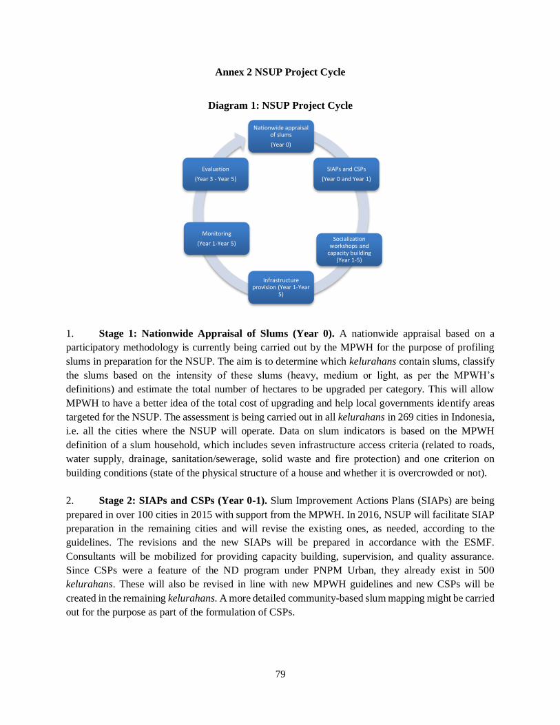
79
Annex 2 NSUP Project Cycle
Diagram 1: NSUP Project Cycle
1. Stage 1: Nationwide Appraisal of Slums (Year 0). A nationwide appraisal based on a
participatory methodology is currently being carried out by the MPWH for the purpose of profiling
slums in preparation for the NSUP. The aim is to determine which kelurahans contain slums, classify
the slums based on the intensity of these slums (heavy, medium or light, as per the MPWH’s
definitions) and estimate the total number of hectares to be upgraded per category. This will allow
MPWH to have a better idea of the total cost of upgrading and help local governments identify areas
targeted for the NSUP. The assessment is being carried out in all kelurahans in 269 cities in Indonesia,
i.e. all the cities where the NSUP will operate. Data on slum indicators is based on the MPWH
definition of a slum household, which includes seven infrastructure access criteria (related to roads,
water supply, drainage, sanitation/sewerage, solid waste and fire protection) and one criterion on
building conditions (state of the physical structure of a house and whether it is overcrowded or not).
2. Stage 2: SIAPs and CSPs (Year 0-1). Slum Improvement Actions Plans (SIAPs) are being
prepared in over 100 cities in 2015 with support from the MPWH. In 2016, NSUP will facilitate SIAP
preparation in the remaining cities and will revise the existing ones, as needed, according to the
guidelines. The revisions and the new SIAPs will be prepared in accordance with the ESMF.
Consultants will be mobilized for providing capacity building, supervision, and quality assurance.
Since CSPs were a feature of the ND program under PNPM Urban, they already exist in 500
kelurahans. These will also be revised in line with new MPWH guidelines and new CSPs will be
created in the remaining kelurahans. A more detailed community-based slum mapping might be carried
out for the purpose as part of the formulation of CSPs.
Nationwide appraisal of slums
(Year 0)
SIAPs and CSPs
(Year 0 and Year 1)
Socialization workshops and
capacity building (Year 1-5)
Infrastructure provision (Year 1-Year
5)
Monitoring
(Year 1-Year 5)
Evaluation
(Year 3 - Year 5)
80
3. Stage 3: Socialization workshops and capacity building (Year 1 – Year 5). In Year 1 of the
program, socialization workshops will be held for government officials at national, provincial and local
levels, as well as at the community level. Task Forces on Housing and Settlements (i.e. Pokja PKPs)
will be formed at provincial and city levels. Capacity building workshops and training will be held for
members of these task forces as well as other stakeholders, which will continue to take place throughout
the project cycle.
4. Stage 4: Infrastructure provision (Year 1 – Year 5). Tertiary infrastructure construction will
start at the beginning of the program. In 2016, the project will support infrastructure development in
200 ND sites in cities where both CSPs and SIAPs already exist (with revisions to the plans as needed).
Improvement of primary and second infrastructure in the vicinity of slums and/or construction of
connecting infrastructure will mainly start at the beginning of Year 2 when detailed design documents
will be drawn up for the selected cities where the Bank will finance the improvement of connecting
infrastructure.
5. Stage 5: Monitoring (Year 1 - Year 5). The NSUP will build on PNPM Urban’s advanced
web-based Management Information System (MIS), which is currently being improved to
accommodate the specific needs of this project. Facilitators will collect the data and give their logbooks
to the City Coordinators. Data management assistants at city level will input data within the MIS. The
Provincial Data Management Specialists will verify and analyze data in the MIS for further action. The
National Management Consultant (NMC) will monitor and supervise the provincial team to ensure
MIS data is regularly and accurately updated, and verification procedures are performed.
6. Step 6: Evaluation (Year 3, Year 5). The overall objectives of the evaluation are to examine
project performance and to document good practices for lessons learnt. Evaluation studies and reviews
will comprise of process evaluation as well as mid-term and final evaluation, using qualitative and
survey methods. The period of evaluation will start from Year 2 till Year 5.

81
Annex 3 Results of Stakeholders Consultation
1. Stakeholders Consultation Workshop was held on January 18, 2016 in Ministry of Public
Works and Housing (MPWH) Office. Objective of the workshop were to disseminate draft
Environmental and Social Management Framework (ESMF) of National Urban Slum Upgrading
Program (NSUP) and to get inputs from stakeholders to improve the draft Framework.
2. The workshop was attended by 26 participants, including Project staff of NSUP, representative
of local governments (LGs), communities, NGOs that are working in urban slum, universities,
consultants, and advisers of PMU of NSUP. The Bank staff was also invited and attended the meeting
as observers. Agenda of the workshop has consisted of two main sessions, first is presentation of the
project description of NSUP and importance of safeguards in entire project cycles (preparation,
implementation, monitoring and evaluation of the project). Second session was discussion of
substance of the ESMF (triggered safeguards policy) and wrap-up of the meeting results.
3. Below are some points that were discussed during the workshop that need to be considered as
inputs for revision of the ESMF:
a. Safeguards Issues:
i. Purpose of the ESMF is as an enabler rather than as a constraint to achieve project objectives
need to be emphasized. Message that safeguards is a tool to reduce negative impact and
improve more positive impact needs to be enhance through capacity building.
ii. Land issues.
Inter ministries or institutions need to closely work together to look for some solutions
on land issues in slum areas. For example, how to deal with squatters issue, customary
land, etc. Collaboration among them is one of key factor to solve land issues.
Land provision program or other land programs by government should be incorporated
with slum upgrading program.
Need detail description in technical manual which institutions who will get voluntary
land donation. Also, need detailed mechanism in technical manual on processing after
land has been donated from land owners.
Spatial planning need to be considered to resolve land issues.
In PNPM Urban, community has built infrastructure in legal land. Community tend to
avoid facilitation illegal land, even the main issues of the slum is squatters who occupy
illegal land. The participants of the meeting expected that in NSUP, land issues could
be part of the project cycle to be facilitated.
iii. Physical Cultural Resources. Collaborate with local governments, particularly who already
have LG‘s law / decree on PCR, will be potentially improving the project quality rather than
work as solitary project in PCR area.
iv. Timber. Some settlements area in Indonesia are using timber excessively for housing and
infrastructure. For example in Banjarmasin, stilt housing and wooden ramp for stilt road
above the river are using local, good quality of timber. Framework on timber will guide
community and local government to utilize legal timber for project infrastructures.

82
Recommendation from participant, if there is a policy to convert timber to other
environmentally sounded materials, need clear road map of the timber replacement use in the
technical manuals.
v. Indigenous Peoples. Based on experience of PNPM Urban, even based on IPs database there
had been indicated IPs presence in PNPM Urban areas, the project did not involve IPs. Even
the NSUP area is same with PNPM Urban area, IPs Planning Framework is prepared to
anticipate if there would be IPs presence and affected by subprojects.
b. Management Issues related to safeguards that have been discussed are as follows:
i. Need to clearly define in safeguards technical manuals on roles of institutions at the city
level and community level that will deal with safeguards issues.
ii. Ensuring training materials are suitable for community and related stakeholders.
iii. Livelihoods should be part of the project, if the project deal with land issues.
c. NGO from Budha Tzu Chi Indonesia Foundation has presented their experiences in slum upgrading
programs in DKI Jakarta. The NGO has been working together with DKI Jakarta and some CSRs
of private companies to implement the programs in three areas in DKI Jakarta. In one area, the
program has relocated 350 households without conflict from slum area in riverbank to a subsidized
apartment that is provided by DKI Jakarta. Facilitation process of the NGO was not only on
physical relocation, but also on behavior / non-physical issues too. For example, how to ensure
space adequacy per person, availability of education and health facilities, betterment of livelihoods,
and ensuring the new apartment is as humanist as it be.
4. Participants have agreed to participate in next series of consultation meetings to discuss in
more detail about safeguards that will be held during the project cycle.
5. After the workshop, the MPWH and the WB has conducted a wrap-up meeting to discuss
follow-up actions. The actions are following: i) PMU will revise the draft ESMF based on result of
the workshop and finalize the draft ESMF, ii) PMU will submit the ESMF to the Bank for approval,
iii) further discussion to improve the ESMF, if needed; iv) publish / upload ESMF in project web-site
and the Bank’s portal; and v) formulate safeguards technical manuals of environmental and social
safeguards that adopt the approved ESMF.

83
Annex 4 WBG Environmental Health and Safety Guidelines
1. The Environmental, Health, and Safety (EHS) Guidelines contain the performance levels and
measures that are generally considered to be achievable in new facilities by existing technology at
reasonable costs. Application of the EHS Guidelines to existing facilities may involve the
establishment of site-specific targets, with an appropriate timetable for achieving them. The
applicability of the EHS Guidelines should be tailored to the hazards and risks established for each
project on the basis of the results of an environmental assessment2 in which site-specific variables,
such as host country context, assimilative capacity of the environment, and other project factors, are
taken into account. The applicability of specific technical recommendations should be based on the
professional opinion of qualified and experienced persons. When host country regulations differ from
the levels and measures presented in the EHS Guidelines, projects are expected to achieve whichever
is more stringent. If less stringent levels or measures than those provided in these EHS Guidelines are
appropriate, in view of specific project circumstances, a full and detailed justification for any proposed
alternatives is needed as part of the site-specific environmental assessment. This justification should
demonstrate that the choice for any alternate performance levels is protective of human health and the
environment.
2. Employers and supervisors are obliged to implement all reasonable precautions to protect the
health and safety of workers. This section provides guidance and examples of reasonable precautions
to implement in managing principal risks to occupational health and safety. Although the focus is
placed on the operational phase of projects, much of the guidance also applies to construction and
decommissioning activities.
3. Companies should hire contractors that have the technical capability to manage the
occupational health and safety issues of their employees, extending the application of the hazard
management activities through formal procurement agreements.
4. Preventive and protective measures should be introduced according to the following order of
priority:
a. Eliminating the hazard by removing the activity from the work process. Examples include
substitution with less hazardous chemicals, using different manufacturing processes, etc;
b. Controlling the hazard at its source through use of engineering controls. Examples include local
exhaust ventilation, isolation rooms, machine guarding, acoustic insulating, etc;
c. Minimizing the hazard through design of safe work systems and administrative or institutional
control measures. Examples include job rotation, training safe work procedures, lock-out and tag-
out, workplace monitoring, limiting exposure or work duration, etc.
d. Providing appropriate personal protective equipment (PPE) in conjunction with training, use, and
maintenance of the PPE.
84
5. First Aid
a. The employer should ensure that qualified first-aid can be provided at all times. Appropriately
equipped first-aid stations should be easily accessible throughout the place of work
b. Eye-wash stations and/or emergency showers should be provided close to all workstations where
immediate flushing with water is the recommended first-aid response
c. Where the scale of work or the type of activity being carried out so requires, dedicated and
appropriately equipped first aid room(s) should be provided. First aid stations and rooms should
be equipped with gloves, gowns, and masks for protection against direct contact with blood and
other body fluids
d. Remote sites should have written emergency procedures in place for dealing with cases of trauma
or serious illness up to the point at which patient care can be transferred to an appropriate medical
facility.
6. OHS Training
a. Provisions should be made to provide OHS orientation training to all new employees to ensure
they are apprised of the basic site rules of work at / on the site and of personal protection and
preventing injury to fellow employees.
b. Training should consist of basic hazard awareness, site specific hazards, safe work practices, and
emergency procedures for fire, evacuation, and natural disaster, as appropriate. Any site-specific
hazard or color coding in use should be thoroughly reviewed as part of orientation training.
7. Basic OHS Training
a. A basic occupational training program and specialty courses should be provided, as needed, to
ensure that workers are oriented to the specific hazards of individual work assignments. Training
should generally be provided to management, supervisors, workers, and occasional visitors to areas
of risks and hazards.
b. Workers with rescue and first-aid duties should receive dedicated training so as not to inadvertently
aggravate exposures and health hazards to themselves or their coworkers. Training would include
the risks of becoming infected with blood–borne pathogens through contact with bodily fluids and
tissue.
c. Through appropriate contract specifications and monitoring, the employer should ensure that
service providers, as well as contracted and subcontracted labor, are trained adequately before
assignments begin.
8. In general the EHS pointers for general construction sub-projects among others are:
a. Ensure that all health and safety requirements are in place on construction sites.
b. Establish a project hazard reduction plan;
c. Include safety instructions for the construction activities in the contract documents;
d. Ensure that speed bumps near schools, hospitals, and markets are included in the road design;
e. Ensure sufficient visibility along the road section according to standard specifications;
f. Establish footpaths and pull-off bays along roads through villages, near markets, schools and other
community facilities;

85
g. Limit time of exposure to dust particles, chemical, and noise;
h. Enhance safety and inspection procedures;
i. Use of Personal Protection Equipment (PPE);
j. Introduction to health and safety issues in construction sites and on Construction sites including
main areas of risk to workers and others;
k. Education on basic hygiene practices to minimize spread of typical tropical diseases;
l. Procedures for seeking medical assistance in emergency or non-emergency situations and
procedures for seeking other health-related assistance;
m. Dust suppression sealing;
n. Improvements in road signage and pavement markings;
o. Attention to road accident blind spots.
9. Monitoring. Occupational health and safety monitoring programs should verify the
effectiveness of prevention and control strategies. The selected indicators should be representative of
the most significant occupational, health, and safety hazards, and the implementation of prevention
and control strategies. The occupational health and safety monitoring program should include:
a. Safety inspection, testing and calibration: This should include regular inspection and testing of all
safety features and hazard control measures focusing on engineering and personal protective
features, work procedures, places of work, installations, equipment, and tools used. The inspection
should verify that issued PPE continues to provide adequate protection and is being worn as
required. All instruments installed or used for monitoring and recording of working environment
parameters should be regularly tested and calibrated, and the respective records maintained.
b. Surveillance of the working environment: Employers should document compliance using an
appropriate combination of portable and stationary sampling and monitoring instruments.
Monitoring and analyses should be conducted according to internationally recognized methods and
standards. Monitoring methodology, locations, frequencies, and parameters should be established
individually for each project following a review of the hazards. Generally, monitoring should be
performed during commissioning of facilities or equipment and at the end of the defect and liability
period, and otherwise repeated according to the monitoring plan.
c. Surveillance of workers health: When extraordinary protective measures are required (for example,
against biological agents and/or hazardous compounds), workers should be provided appropriate
and relevant health surveillance prior to first exposure, and at regular intervals thereafter. The
surveillance should, if deemed necessary, be continued after termination of the employment.
d. Training: Training activities for employees and visitors should be adequately monitored and
documented (curriculum, duration, and participants). Emergency exercises, including fire drills,
should be documented adequately. Service providers and contractors should be contractually
required to submit to the employer adequate training documentation before start of their
assignment.
86
Annex 4A WBG Environmental Health and Safety Guidelines for Water and Sanitation1
Water and Sanitation
Applicability
The EHS Guidelines for Water and Sanitation include information relevant to the operation and
maintenance of (i) potable water treatment and distribution systems, and (ii) collection of sewage in
centralized systems (such as piped sewer collection networks) or decentralized systems (such as septic
tanks subsequently serviced by pump trucks) and treatment of collected sewage at centralized facilities.
Industry-Specific Impacts and Management
I. Environment
Environmental issues associated with water and sanitation projects may principally occur during the
construction and operational phases, depending on project-specific characteristics and components.
Recommendations for the management of EHS issues associated with construction activities as would
typically apply to the construction of civil works are provided in the General EHS Guidelines.
A. Drinking Water
1. Water Withdrawal. Traditional sources for potable water treatment include surface water
from lakes, streams, rivers, etc. and groundwater resources. Where surface or groundwater of adequate
quality is unavailable, other sources of water including seawater, brackish water, etc. may be used to
produce potable water. Development of water resources often involves balancing competing qualitative
and quantitative human needs with the rest of the environment. This is a particularly challenging issue
in the absence of a clear allocation of water rights which should be resolved with the participation of
appropriate parties in advance of project design and implementation.
2. Recommended measures to prevent, minimize, and control environmental impacts associated
with water withdrawal and to protect water quality include:
a. Evaluate potential adverse effects of surface water withdrawal on the downstream ecosystems and
use appropriate environmental flow assessment3 to determine acceptable withdrawal rates;
b. Design structures related to surface water withdrawal, including dams and water intake structures,
to minimize impacts on aquatic life. For example:
Limit maximum through-screen design intake velocity to limit entrainment of aquatic
organisms
Avoid construction of water intake structures in sensitive ecosystems. If there are threatened,
endangered, or other protected species within the hydraulic zone of influence of the surface
water intake, ensure reduction of impingement and entrainment of fish and shellfish by the
1 Summarized from WBG EHS Guideline for Water and Sanitation

87
installation of technologies such as barrier nets (seasonal or year-round), screens, and aquatic
filter barrier systems
Design water containment and diversion structures to allow unimpeded movement of fish and
other aquatic organisms and to prevent adverse impacts on water quality
Design dam outlet valves with sufficient capacities for releasing the appropriate environmental
flows
c. Avoid construction of water supply wells and water intake structures in sensitive ecosystems;
d. Evaluate potential adverse effects of groundwater withdrawal, including modeling of groundwater
level changes and resulting impacts to surface water flows, potential land subsidence, contaminant
mobilization and saltwater intrusion. Modify extraction rates and locations as necessary to prevent
unacceptable adverse current and future impacts, considering realistic future increases in demand.
3. Water Treatment. Environmental issues associated with water treatment include:
a. Solid waste
b. Wastewater
c. Hazardous chemicals
d. Air emissions
e. Ecological impacts
4. Solid Waste. Solid waste residuals generated by water treatment include process residuals,
used filtration membranes, spent media and miscellaneous wastes. Process residuals primarily consist
of settled suspended solids from source water and chemicals added in the treatment process, such as
lime and coagulants.
5. Pre-sedimentation, coagulation (e.g. with aluminum hydroxide [alum] or ferric hydroxide),
lime softening, iron and manganese removal, and slow sand and diatomaceous earth filtration all
produce sludge. Composition of the sludge depends on the treatment process and the characteristics of
the source water, and may include arsenic and other metals, radionuclides, lime, polymers and other
organic compounds, microorganisms, etc.
6. Damaged or exhausted membranes are typically produced from water treatment systems used
for desalination. Spent media may include filter media (including sand, coal, or diatomaceous earth
from filtration plants), ion exchange resins, granular activated carbon [GAC], etc.
7. Recommended measures to manage solid wastes from water treatment include:
a. Minimize the quantity of solids generated by the water treatment process through optimizing
coagulation processes;
b. Dispose of lime sludge by land application if allowed, limiting application rates to about 20 dry
metric tons per hectare (9 dry tons per acre) to minimize the potential for mobilization of metals
into plant tissue and groundwater;
c. Dispose of ferric and alum sludge by land application, if allowed and if such application can be
shown through modeling and sampling to have no adverse impacts on groundwater or surface water

88
(e.g. from nutrient runoff). Balance use of ferric and alum sludge to bind phosphorous (e.g. from
manure application at livestock operations) without causing aluminum phytotoxicity (from alum),
iron levels in excess of adulteration levels for metals in fertilizers, or excessively low available
phosphorous levels;
d. Potential impact on soil, groundwater, and surface water, in the context of protection, conservation
and long term sustainability of water and land resources, should be assessed when land is used as
part of any waste or wastewater treatment system;
e. Sludge may require special disposal if the source water contains elevated levels of toxic metals,
such as arsenic, radionuclides, etc.;
f. Regenerate activated carbon (e.g. by returning spent carbon to the supplier).
8. Wastewater. Wastewater from water treatment projects include filter backwash, reject streams
from membrane filtration processes, and brine streams from ion exchange or demineralization
processes. These waste streams may contain suspended solids and organics from the raw water, high
levels of dissolved solids, high or low pH, heavy metals, etc.
9. Recommended measures to manage wastewater effluents include:
a. Land application of wastes with high dissolved solids concentrations is generally preferred over
discharge to surface water subject to an evaluation of potential impact on soil, groundwater, and
surface water resulting from such application;
b. Recycle filter backwash into the process if possible;
c. Treat and dispose of reject streams, including brine, consistent with national and local
requirements. Disposal options include return to original source (e.g. ocean, brackish water source,
etc.) or discharge to a municipal sewerage system, evaporation, and underground injection.
10. Hazardous Chemicals. Water treatment may involve the use of chemicals for coagulation,
disinfection and water conditioning. In general, potential impacts and mitigation measures associated
with storage and use of hazardous chemicals are similar to those for other industrial projects and are
addressed in the General EHS Guideline.
11. Recommended measures to prevent, minimize, and control potential environmental impacts
associated with the storage, handling and use of disinfection chemicals in water treatment facilities
include:
a. For systems that use gas chlorination:
i. Install alarm and safety systems, including automatic shutoff valves, that are automatically
activated when a chlorine release is detected
ii. Install containment and scrubber systems to capture and neutralize chlorine should a leak
occur
iii. Use corrosion-resistant piping, valves, metering equipment, and any other equipment coming
in contact with gaseous or liquid chlorine, and keep this equipment free from contaminants,
including oil and grease

89
iv. Store chlorine away from all sources of organic chemicals, and protect from sunlight,
moisture, and high temperatures
b. Store sodium hypochlorite in cool, dry, and dark conditions for no more than one month, and use
equipment constructed of corrosion-resistant materials;
c. Store calcium hypochlorite away from any organic materials and protect from moisture; fully
empty or re-seal shipping containers to exclude moisture. Calcium hypochlorite can be stored for
up to one year;
d. Isolate ammonia storage and feed areas from chlorine and hypochlorite storage and feed areas;
e. Minimize the amount of chlorination chemicals stored on site while maintaining a sufficient
inventory to cover intermittent disruptions in supply;
f. Develop and implement a prevention program that includes identification of potential hazards,
written operating procedures, training, maintenance, and accident investigation procedures;
g. Develop and implement a plan for responding to accidental releases.
12. Air Emissions. Air emissions from water treatment operations may include ozone (in the case
of ozone disinfection) and gaseous or volatile chemicals used for disinfection processes (e.g., chlorine
and ammonia). Measures related to hazardous chemicals discussed above will mitigate risks of chlorine
and ammonia releases. In addition, specific recommended measures to manage air emissions include
installation of an ozone-destroying device at the exhaust of the ozone-reactor (e.g., catalytic oxidation,
thermal oxidation, or GAC).
13. Water Distribution. The most fundamental environmental health issues associated with
distribution networks is the maintenance of adequate pressure to protect water quality in the system as
well as sizing and adequate maintenance to assure reliable delivery of water of suitable quality. The
most significant environmental issues associated with operation of water distribution systems include:
a. Water system leaks and loss of pressure
b. Water discharges
14. Water System Leaks and Loss of Pressure. Water system leaks can reduce the pressure of
the water system compromising its integrity and ability to protect water quality (by allowing
contaminated water to leak into the system) and increasing the demands on the source water supply,
the quantity of chemicals, and the amount of power used for pumping and treatment. Leaks in the
distribution system can result from improper installation or maintenance, inadequate corrosion
protection, settlement, stress from traffic and vibrations, frost loads, overloading, and other factors.
15. Recommended measures to prevent and minimize water losses from the water distribution
system include:
a. Ensure construction meets applicable standards and industry practices;
b. Conduct regular inspection and maintenance;
c. Implement a leak detection and repair program (including records of past leaks and unaccounted-
for water to identify potential problem areas);

90
d. Consider replacing mains with a history of leaks of with a greater potential for leaks because of
their location, pressure stresses, and other risk factors.
16. Water Discharges. Water lines may be periodically flushed to remove accumulated sediments
or other impurities that have accumulated in the pipe.
17. Flushing is performed by isolating sections of the distribution system and opening flushing
valves or, more commonly, fire hydrants to cause a large volume of flow to pass through the isolated
pipeline and suspend the settled sediment. The major environmental aspect of water pipe flushing is
the discharge of flushed water, which may be high in suspended solids, residual chlorine, and other
contaminants that can harm surface water bodies. Recommended measures to prevent, minimize, and
control impacts from flushing of mains include:
a. Discharge the flush water into a municipal sewerage system with adequate capacity;
b. Discharge the flush water into a separate storm sewer system with storm water management
measures such as a detention pond, where solids can settle and residual chlorine consumed before
the water is discharged;
c. Minimize erosion during flushing, for example by avoiding discharge areas that are susceptible to
erosion and spreading the flow to reduce flow velocities.
B. Sanitation
18. A sanitation system comprises the facilities and services used by households and communities
for the safe management of their excreta. A sanitation system collects excreta and creates and effective
barrier to human contact; transports it to a suitable location; stores and/or treats it; and reuses it or
returns it to the environment. In addition to excreta, sanitation systems may also carry household
wastewater and storm water.10 Transport, storage, and disposal facilities may also manage wastes from
industries, commercial establishments, and institutions.
19. Fecal Sludge and Septage Collection. In communities not served by sewerage systems,
sanitation may be based on on-site systems, such as pit latrines, bucket latrines or flush toilets
connected to septic tanks. While pit and bucket latrines must be emptied frequently (typically daily to
weekly), solids that accumulate in septic systems (septage) must also be removed periodically, usually
every 2 to 5 years depending on design and usage to maintain proper function and prevent plugging,
overflows, and the resulting release of septic tank contents. If suitable facilities for storage, handling
and treatment of fecal sludge are not available, it may be indiscriminately dumped into the environment
or used in unhygienic manner in agriculture.
20. Recommended measures to prevent, minimize, and control releases of septage and other fecal
sludge include:
a. Promote and facilitate correct septic tank design and improvement of septic tank maintenance.
Septic tank design should balance effluent quality and maintenance needs;
b. Consider provision of systematic, regular collection of fecal sludge and septic waste;

91
c. Use appropriate collection vehicles. A combination of vacuum tanker trucks and smaller hand-
pushed vacuum tugs may be needed to service all households;
d. Facilitate discharge of fecal sludge and septage at storage and treatment facilities so that untreated
septage is not discharged to the environment.
21. Sewerage. Where population density or local conditions preclude effective on-site sanitation
systems (e.g., septic tanks and drain fields), sewage is typically conveyed via a system of pipes, pumps,
and other associated infrastructure (sewerage) to a centralized storage and/or treatment system. Solids
and liquids may be transported to a centralized location, or sewage solids may be collected in and
periodically removed from on-site interceptor tanks (see Septage and Fecal Sludge Collection, above)
while the liquids are transported to a centralized location for storage, treatment, or disposal. Users of
the sewerage system may include industry and institutions, as well as households.
22. Grey-water (water from laundry, kitchen, bath, and other domestic activities that normally does
not contain excreta) is sometimes collected and managed separately from sewage. Though grey-water
is generally less polluted than domestic or industrial wastewater, it may still contain high levels of
pathogenic microorganisms, suspended solids and substances such as oil, fat, soaps, detergents, and
other household chemicals and can have negative impacts on human health as well as soil and
groundwater quality .
23. The most significant potential environmental impacts associated with wastewater collection
arise from:
a. Domestic wastewater discharges
b. Industrial wastewater discharges
c. Leaks and overflows
24. Domestic Wastewater Discharges. Uncontrolled discharge of domestic wastewater, including
sewage and greywater, into aquatic systems can lead to, among other things, microbial and chemical
contamination of the receiving water, oxygen depletion, increased turbidity, and eutrophication.
Wastewater discharge onto streets or open ground can contribute to spread of disease, odors,
contamination of wells, deterioration of streets, etc. Measures to protect the environment as well as
public health include:
a. Provide systems for effective collection and management of sewage and greywater (separately or
combined);
b. If greywater is managed separate from sewage, implement greywater source control measures to
avoid use and discharge of problematic substances, such as oil and grease, large particles or
chemicals.
25. Industrial Wastewater Discharges. Industrial users of a sewerage system can discharge
industrial wastewaters to the sewer system. Some industrial wastes can cause fire and explosion
hazards in the sewerage system and treatment facility, disrupt biological and other processes at the
treatment facility or affect worker health and safety; some waste components may not be effectively

92
treated, and may be stripped to the atmosphere, discharged with treated effluent or partition into
treatment plant residuals rendering it potentially hazardous.
26. Recommended measures to prevent, minimize, and control industrial discharges to the
sewerage system include:
a. Treatment or pre-treatment to neutralize or remove toxic chemicals should ideally take place at the
industrial facility itself, prior to discharge of the effluent to the sewer or water body. Consider
collaboration with public authorities in the implementation of a source control program for
industrial and commercial users to ensure that any wastewater discharged to the sewer system can
be effectively treated. Examples of problematic discharges include: flammable, reactive, explosive,
corrosive, or radioactive substances; noxious or malodorous materials; medical or infectious
wastes; solid or viscous materials that could cause obstruction to the flow or operation of the
treatment plants; toxic substances; non-biodegradable oils; and pollutants that could result in the
emission of hazardous gases;
b. Collaborate with public authorities in the regular inspection of industrial user facilities and collect
samples of wastewater discharges to the sewerage system to ensure compliance with the source
control program;
c. Conduct surveillance monitoring at sewer maintenance and of the influent to the wastewater
treatment facilities;
d. Investigate upstream sources of pollutants causing treatment plant upsets or interference;
e. Facilitate public reporting of illicit discharges and connections.
27. Leaks and Overflows. Leaks and overflows from the sewerage system can cause
contamination of soil, groundwater, and surface water. Depending on the elevation of groundwater,
leaks in gravity mains may also allow groundwater into the sewer system, increasing the volume of
wastewater requiring treatment and potentially causing flooding and treatment bypass. Overflows
occur when the collection system cannot manage the volume of wastewater, for example due to high
flows during rain events or as the result of power loss, equipment malfunctions, or blockages. The
excess flows may contain raw sewage, industrial wastewater, and polluted runoff.
28. Recommended measures to prevent, minimize, and control leaks and overflows include:
a. Consider the installation of separate sewer systems for domestic wastewater and storm water runoff
in the overall planning and design of new sewerage systems;
b. When on-site sanitation systems where excreta are mixed with water predominate, consider use of
small-diameter sewerage system to collect water effluent from septic systems or interceptor tanks;
c. Limit the sewer depth where possible (e.g., by avoiding routes under streets with heavy traffic).
For shallower sewers, small inspection chambers can be used in lieu of manholes;
d. Use appropriate locally available materials for sewer construction. Spun concrete pipes can be
appropriate in some circumstances but can suffer corrosion from hydrogen sulfide if there are
blockages and/or insufficient slope;
e. Ensure sufficient hydraulic capacity to accommodate peak flows and adequate slope in gravity
mains to prevent buildup of solids and hydrogen sulfide generation;

93
f. Design manhole covers to withstand anticipated loads and ensure that the covers can be readily
replace if broken to minimize entry of garbage and silt into the system;
g. Equip pumping stations with a backup power supply, such as a diesel generator, to ensure
uninterrupted operation during power outages, and conduct regular maintenance to minimize
service interruptions. Consider redundant pump capacity in critical areas;
h. Establish routine maintenance program, including:
i. Development of an inventory of system components, with information including age,
construction materials,
ii. drainage areas served, elevations, etc
iii. Regular cleaning of grit chambers and sewer lines to remove grease, grit, and other debris
that may lead to sewer backups. Cleaning should be conducted more frequently for problem
areas. Cleaning activities may require removal of tree roots and other identified
obstructions
iv. Inspection of the condition of sanitary sewer structures and identifying areas that need
repair or maintenance. Items to note may include cracked/deteriorating pipes; leaking joints
or seals at manhole; frequent line blockages; lines that generally flow at or near capacity;
and suspected infiltration or exfiltration
v. Monitoring of sewer flow to identify potential inflows and outflows
i. Conduct repairs prioritized based on the nature and severity of the problem. Immediate clearing of
blockage or repair is warranted where an overflow is currently occurring or for urgent problems
that may cause an imminent overflow (e.g. pump station failures, sewer line ruptures, or sewer line
blockages);
j. Review previous sewer maintenance records to help identify “hot spots” or areas with frequent
maintenance problems and locations of potential system failure, and conduct preventative
maintenance, rehabilitation, or replacement of lines as needed;
k. When a spill, leak, and/or overflow occurs, keep sewage from entering the storm drain system by
covering or blocking storm drain inlets or by containing and diverting the sewage away from open
channels and other storm drain facilities (using sandbags, inflatable dams, etc.). Remove the
sewage using vacuum equipment or use other measures to divert it back to the sanitary sewer
system.
29. Wastewater and Sludge Treatment and Discharge. Sewage will normally require treatment
before it can be safely discharged to the environment. The degree and nature of wastewater and sludge
treatment depends on applicable standards and the planned disposal or use of the liquid effluent and
sludge and the application method. The various treatment processes may reduce suspended solids
(which can clog rivers, channels, and drip irrigation pipes); biodegradable organics (which are
consumed by microorganisms and can result in reduced oxygen levels in the receiving water);
pathogenic bacteria and other disease-causing organisms; and nutrients (which stimulate the growth of
undesirable algae that, as they die, can result in increased loads of biodegradable organics).
30. Wastewater discharge and use options include discharge to natural or artificial watercourses or
water bodies; discharge to treatment ponds or wetlands (including aquiculture); and direct use in

94
agriculture (e.g., crop irrigation). In all cases, the receiving water body use (e.g. navigation, recreation,
irrigation, or drinking) needs to be considered together with its assimilative capacity to establish a site-
specific discharge quality that is consistent with the most sensitive use.
31. The most significant environmental impacts related to wastewater and sludge treatment,
discharge, and use include:
a. Liquid effluents
b. Solid waste
c. Air emissions and odors
d. Hazardous chemicals
e. Ecological impacts
32. Liquid Effluents. Treated wastewater (liquid effluents) may be reused for irrigation or other
purposes or disposed subject to regulatory oversight. If not re-used, treated wastewater can be
discharged to the sea; rivers; large surface water bodies; smaller, closed surface water bodies; and
wetlands and lagoons.
33. Recommended measures to prevent, minimize, and control liquid effluents include:
a. Minimize bypass of the treatment system by using separate storm water and wastewater systems,
if possible, and providing capacity sufficient to treat peak flows;
b. Implement an industrial source control program which includes monitoring and effective
regulatory enforcement;
c. Collaborate with public officials to select appropriate treatment technologies, considering factors
such as the quality and quantity of raw wastewater and its variability; available land area for the
treatment facility; and resources for capital expenditures, operation, maintenance, and repair;
availability of skilled operators, operator training, maintenance personnel, treatment chemicals,
and replacement parts;
d. Design, construct, operate, and maintain wastewater treatment facilities and achieve effluent water
quality consistent with applicable national requirements or internationally accepted standards14
and consistent with effluent water quality goals based on the assimilative capacity and the most
sensitive end use of the receiving water;
e. Consider discharge of treated wastewater to natural or constructed wetlands, which can buffer the
impact f from discharge on the aquatic environment, unless the wetland itself would be degraded
by the discharge;
f. Treat grey-water, if collected separately from sewage, to remove organic pollutants and reduce the
levels of suspended solids, pathogenic organisms and other problematic substances to acceptable
levels based on applicable national and local regulations. Grey-water lines and point of use stations
should be clearly marked to prevent accidental use for potable water quality applications;
g. Based on an assessment of risks to human health and the environment, consider re-use of treated
effluent, especially in areas with limited raw water supplies. Treated wastewater quality for land
application or other uses should be consistent with the relevant public health-based guidance from
the World Health Organization (WHO) and applicable national requirements.

95
34. Solid Waste. Solids removed from wastewater collection and treatment systems may include
sludge and solids from cleaning of drainage and sewer collection systems (including seepage systems),
screening solids, and sludge from various unit operations used for wastewater treatment.
35. Recommended strategies for the management of solid wastes include:
a. Select appropriate sludge treatment technologies, considering, for example, the quantity and
sources of sludge; available resources for capital expenditures, training, operations and
maintenance; availability of skilled operators, maintenance personnel, etc.; and the desired disposal
methods or end uses of the treated solids;
b. Land application or other beneficial re-use of wastewater treatment plant residuals should be
considered but only based on an assessment of risks to human health and the environment. Quality
of residuals for land application should be consistent with the relevant public health-based
guidance from the World Health Organization (WHO) and applicable national requirements;
c. Processing, disposal and re-use of wastewater treatment plant residuals should be consistent with
applicable national requirements or, in their absence, internationally accepted guidance and
standards.
36. Air Emissions and Odors. Air emissions from wastewater treatment operations may include
hydrogen sulfide, methane, ozone (in the case of ozone disinfection), volatile organic compounds (such
as from industrial discharges), gaseous or volatile chemicals used for disinfection processes (e.g.,
chlorine and ammonia), and bio aerosols. Odors from treatment facilities can also be a nuisance to
workers and the surrounding community.
37. Measures related to management of air emissions from drinking water treatment systems,
discussed above, are also generally applicable to wastewater treatment facilities. In addition, the
following measures are recommended to prevent, minimize, and control air emissions and odors:
a. Cover emission points (e.g., aeration basins, clarifiers, sludge thickeners, tanks, and channels), and
vent emissions to control systems (e.g., compost beds, bio filters, chemical scrubbers, etc.) as
needed to reduce odors and otherwise meet applicable national requirements and internationally
accepted guidelines;
b. Where necessary, consider alternate aeration technologies or process configurations to reduce
volatilization.
38. Hazardous Chemicals. Wastewater treatment often includes the use of hazardous chemicals,
such as strong acids and bases for pH control, chlorine or other compounds used for disinfection, etc.
Environmental impacts and mitigation measures discussed above for disinfection in drinking water
treatment are also generally applicable to disinfection in wastewater treatment facilities. Additional
guidance on chemicals management is provided in the General EHS Guidelines.
II. Occupational Health and Safety

96
39. Occupational health and safety impacts during the construction and decommissioning of Water
and Sanitation facilities are common to other large industrial projects and are addressed in the General
EHS Guidelines. Occupational health and safety impacts associated with the operational phase of water
and sanitation projects primarily include the following:
a. Accidents and injuries
b. Chemical exposure
c. Hazardous Atmosphere
d. Exposure to pathogens and vectors
e. Noise
40. Accidents and Injuries. Work at water and sanitation facilities is often physically demanding
and may involve hazards such as open water, trenches, slippery walkways, working at heights,
energized circuits, and heavy equipment. Work at water and sanitation facilities may also involve entry
into confined spaces, including manholes, sewers, pipelines, storage tanks, wet wells, digesters, and
pump stations. Methane generated from anaerobic biodegradation of sewage can lead to fires and
explosions.
41. Mitigation measures for accidents and injuries are addressed in the General EHS Guidelines.
In addition, the following procedures are recommended to prevent, minimize, and control accidents
and injuries at water and sanitation facilities:
a. Install railing around all process tanks and pits. Require use of a life line and personal flotation
device (PFD) when workers are inside the railing, and ensure rescue buoys and throw bags are
readily available;
b. Use PFDs when working near waterways;
c. Implement a confined spaces entry program that is consistent with applicable national requirements
and internationally accepted standards. Valves to process tanks should be locked to prevent
accidental flooding during maintenance;
d. Use fall protection equipment when working at heights;
e. Maintain work areas to minimize slipping and tripping hazards;
f. Use proper techniques for trenching and shoring;
g. Implement fire and explosion prevention measures in accordance with internationally accepted
standards;
h. When installing or repairing mains adjacent to roadways, implement procedures and traffic
controls, such as:
i. Establishment of work zones so as to separate workers from traffic and from equipment as
much as possible
ii. Reduction of allowed vehicle speeds in work zones;
iii. Use of high-visibility safety apparel for workers in the vicinity of traffic
iv. For night work, provision of proper illumination for the work space, while controlling glare
so as not to blind workers and passing motorists
i. Locate all underground utilities before digging.

97
42. Chemical Exposure and Hazardous Atmospheres. Water and wastewater treatment involve
use of potentially hazardous chemicals, including strong acids and bases, chlorine, sodium and calcium
hypochlorite, and ammonia. Water may contain radioactive substances and heavy metals, which
typically accumulate in the water treatment sludge. Potential sources of exposure to radionuclides
include: pumps and piping where mineral scales accumulate; lagoons, and flocculation and
sedimentation tanks where residual sludge accumulate; filters, pumping stations, and storage tanks
where scales and sludges accumulate; facilities where filter backwash, brines, or other contaminated
water accumulates; facilities that are enclosed (radon); residuals processing or handling areas; and land
disposal or application areas where residuals are shoveled, transported, or disposed.
43. Wastewater may contain potentially hazardous chemicals depending on the source water
quality, drinking water treatment processes, and industries discharging to the sewer, including include
chlorinated organic solvents and pesticides, PCBs, polycyclic aromatics, petroleum hydrocarbons,
flame retardants, nitrosamines, heavy metals, asbestos, dioxins, and radioactive materials. In addition,
workers may be exposed to hydrogen sulfide, methane, carbon monoxide, chloroform, and other
chemicals generated during wastewater treatment. Oxygen may be displaced or consumed by
microorganisms, thus resulting in an oxygen deficient environment in areas where wastewater or
wastewater residues are processed.
44. Prudent handling and storage of hazardous chemicals, as described in General EHS Guidelines
and in Section 1, above, will help to minimize potential risks to workers. In addition, the following
procedures are recommended to prevent, minimize, and control chemical exposure at water and
sanitation facilities include:
a. Implement a training program for operators who work with chlorine and ammonia regarding safe
handling practices and emergency response procedures;
b. Provide appropriate personal protective equipment (including, for example, self-contained
breathing apparatus) and training on its proper use and maintenance.
c. Prepare escape plans from areas where there might be a chlorine or ammonia emission;
d. Install safety showers and eye wash stations near the chlorine and ammonia equipment and other
areas where hazardous chemicals are stored or used;
e. If source water contains radioactive substances, locate water treatment units and water treatment
sludge areas as far as possible from common areas (e.g., offices);
f. Conduct radiation surveys at least annually, especially in areas where radionuclides are removed;
g. Limit wastes entering the sewer system to those that can be effectively treated in the wastewater
treatment facility and reduce the amount of air-strippable hazardous compounds entering the
system by controlling industrial discharges (e.g., by permit or similar system). Analyze incoming
raw wastewater to identify hazardous constituents;
h. Ventilate enclosed processing areas and ventilate equipment, such as pump stations, prior to
maintenance.
i. Use personal gas detection equipment while working in a wastewater facility;

98
j. Continuously monitor air quality in work areas for hazardous conditions (e.g. explosive
atmosphere, oxygen deficiency);
k. Periodically sample air quality in work areas for hazardous chemicals. If needed to meet applicable
occupational health national requirements or internationally accepted standards, install engineering
controls to limit worker exposure, for example collection and treatment of off-gases from air
stripping;
l. Prohibit eating, smoking, and drinking except in designated areas;
m. Rotate personnel among the various treatment plant operations to reduce inhalation of air-stripped
chemicals, aerosols, and other potentially hazardous materials.
45. Pathogens and Vectors. Workers and staff at wastewater and sludge treatment facilities and
fields where treated wastewater or sludge is applied, as well as operators of sludge collection vehicles,
can be exposed to the many pathogens contained in sewage. Processing of sewage can generate bio-
aerosols which are suspensions of particles in the air consisting partially or wholly of microorganisms,
such as bacteria, viruses, molds, and fungi. These microorganisms can remain suspended in the air for
long periods of time, retaining viability or infectivity. Workers may also be exposed to endotoxins,
which are produced within a microorganism and released upon destruction of the cell and which can
be carried by airborne dust particles. Vectors for sewage pathogens include insects (e.g. flies), rodents
(e.g. rats) and birds (e.g. gulls).
46. Recommended measures to prevent, minimize, and control exposure to pathogens and vectors
include:
a. Wastewater and Sludge Treatment
i. Include in safety training program for workers, safe handling and personal hygiene
practices to minimize exposure to pathogens and vectors;
ii. Use vacuum trucks or tugs for removal of fecal sludge instead of manual methods;
iii. Provide and require use of suitable personal protective clothing and equipment to prevent
contact with wastewater
iv. (e.g., rubber gloves, aprons, boots, etc.). Especially provide prompt medical attention and
cover any skin trauma such as cuts and abrasions to prevent infection and use protective
clothing and goggles to prevent contact with spray and splashes;
v. Provide areas for workers to shower and change clothes before leaving work and provide
laundry service for work clothes. This practice also helps to minimize chemical and
radionuclide exposure;
vi. Encourage workers at wastewater facilities to wash hands frequently;
vii. Provide worker immunization (e.g. for Hepatitis B and tetanus) and health monitoring,
including regular physical examinations;
viii. Reduce aerosol formation and distribution, for example by:
Planting trees around the aeration basin to shield the area from wind and to capture the
droplets and particles
Using diffused aeration rather than mechanical aeration and using finer bubbles for
aeration

99
Reducing aeration rate, if possible
Use of floating covers on the mixed liquor of the aeration basin
Suppression of droplets just above the surface, (e.g. by installing a screen or mesh
above the basin);
Collection of droplets (e.g. by sedimentation, scrubber, electrostatic precipitator, or
fabric filter)
Disinfection of airborne particles (e.g., by using ultraviolet lights)
Use of submerged effluent collector (such as pipes with orifices) rather than weirs
ix. Avoid handling screenings by hand to prevent needle stick injuries;
x. Maintain good housekeeping in sewage processing and storage areas;
xi. Advise individuals with asthma, diabetes, or suppressed immune systems not to work at
wastewater treatment facilities, especially composting facilities, facility because of their
greater risk of infection.
b. Land Application
i. Consider use of drip irrigation of treated wastewater, which minimizes worker exposure
and the amount of water needed. Avoid use of spray irrigation of treated wastewater, if
possible;
ii. Provide field workers with personal protective equipment, such as rubber gloves and
waterproof shoes;
iii. Provide access to safe drinking water and sanitation (including hand washing) facilities;
iv. Provide worker health monitoring, including regular physical examinations;
v. Control vectors and intermediate hosts.
c. Noise. High noise levels can be present in the vicinity of operating machinery and flowing water
at water and sanitation facilities. Impacts and mitigation measures are similar to those at other
industrial facilities, and are addressed in the General EHS Guidelines.
III. Community Health and Safety
Community health and safety impacts during the construction of water and sanitation projects include
some which are common to those of other industry sectors and are therefore discussed in the General
EHS Guideline. Community health and safety impacts associated with operation of water and
sanitation projects are discussed separately below.
A. Drinking Water
1. Water Intake (Water Supply Protection). Both surface water and groundwater supplies can
become contaminated with potentially toxic substances of natural and anthropogenic origins, including
pathogens, toxic metals (e.g. arsenic), anions (e.g. nitrate), and organic compounds. Such
contamination might result from natural sources, actions or releases that are routine (e.g. discharges
within permit limits), accidental (e.g. from a spill), or intentional (e.g. sabotage).

100
2. Recommended measures to protect the quality of the water supply include:
a. Determine the area that contributes water to the source (e.g. watershed of a stream or recharge area
for groundwater), identify potential sources of contamination with the area, and collaborate with
public authorities in the implementation of management approaches to protect the source water
quality, such as:
i. Zoning ordinance provisions
ii. Facility inspection or hazardous material survey program
iii. Information to businesses concerning applicable requirements
iv. Environmental permits checklist for new businesses;
v. Strategic monitoring within area
vi. Development and implementation of educational campaigns to promote best management
practices that reduce the risk of water contamination
vii. Incorporation of surface water protection into regional land use planning
b. Evaluate the vulnerability of the water source to disruption or natural events, and implement
appropriate security measures as necessary, such as:
i. Continuously monitor raw water for surrogate parameters (such as pH, conductivity, total
organic carbon [TOC], and toxicity)
ii. Inspect sites at random times
iii. For reservoirs and lakes, implement a neighborhood watch program with local park staff
and other community users of the reservoir/lake
iv. Equip wellheads with intrusion alarms
3. Water Treatment. The most significant potential community health and safety impacts
associated with water treatment include:
a. Drinking water quality and supply.
b. Hazardous chemicals.
4. Drinking Water Quality and Supply. An adequate supply of clean drinking water is critical
to community health and hygiene. Recommended measures related to water treatment include:
a. Ensure that treatment capacity is adequate to meet anticipated demand;
b. Construct, operate and maintain the water treatment facility in accordance with national
requirements and internationally accepted standards to meet national water quality standards or, in
their absence, WHO Guidelines for Drinking Water Quality;
c. Evaluate the vulnerability of the treatment system and implement appropriate security measures,
such as:
i. Background checks of employees.
ii. Perimeter fencing and video surveillance.
iii. Improve the electrical power feeds to the facilities. Redundant electrical power systems
significantly reduce the vulnerability risk to essential operations.

101
5. Hazardous Chemicals. Hazardous chemical associated with drinking water treatment and
mitigation measures associated with minimizing potential impacts to the environment and to workers,
respectively. If a worst-case release scenario could affect the general public, prepare and implement a
release prevention program for major hazards as described in the General EHS Guidelines. The
prevention program should include identification of hazards, written operating procedures, training,
maintenance, accident investigation, and an emergency response plan.
6. Water Distribution. The water distribution system is a critical component in delivery of safe
potable water. Even if water is effectively treated to remove contaminants and destroy pathogens,
waterborne diseases outbreaks can occur because of deficiencies in the water distribution system.
Recommended measures to prevent or minimize potential community health risks associated with the
water distribution system include:
a. Construct, operate, and manage the water distribution system in accordance with applicable
national requirements and internationally accepted standards;
b. Construct and maintain the distribution system so that it acts as a barrier and prevents external
contamination from entering the water system by, for example:
i. Inspecting storage facilities regularly, and rehabilitate or replace storage facilities when
needed. This may include draining and removing sediments, applying rust proofing, and
repairing structures
ii. Ensuring that all installation, repair, replacement, and rehabilitation work conforms to
requirements for sanitary protection and materials quality
iii. Testing material, soil, and water quality and implementing best practices to prevent
corrosion, such as cathodic protection
iv. Preventing cross- connections with sewerage systems.
v. Separating water lines and sewer pressure mains (e.g., at least 10 feet apart or in separate
trenches, with the sewer line at least 18 inches below the water line)
c. Maintain adequate water pressure and flow throughout the system, for example by:
i. Implementing a leak detection and repair program (see section 1)
ii. Reducing residence time in pipes
iii. Maintaining positive residual pressure of at least 20 pounds per square inch (psi)
iv. Monitoring hydraulic parameters, such as inflows, outflows, and water levels in all storage
tanks, discharge flows and pressures for pumps, flows and/or pressure for regulating
valves, and pressure at critical points, and using system modeling to assess the hydraulic
integrity of the system
d. Prevent introduction of contamination from the distribution system itself, for example by:
i. Minimizing microbial growth and biofilm development (e.g. by ensuring adequate residual
disinfection levels). Collect samples from several locations throughout the distribution
system, including the farthest point, and test for both free and combined chlorine residual
to ensure that adequate chlorine residual is maintained

102
ii. Choosing residual disinfectant (e.g. chlorine or chloramines) to balance control of
pathogens and formation of potentially hazardous disinfection byproducts
iii. Using construction materials that do not contribute to release undesirable metals and other
substance or interact with residual disinfectants
B. Sanitation
1. Measures to minimize potential community health risks can be implemented both in the
collection and treatment of wastewater and sludge.
2. Wastewater and Septage Collection. Collection of sewage and transportation away from
residential areas, while not alone sufficient to protect public health, is nevertheless generally the most
important aspect of sanitation. Therefore, provision of collection services, or ensuring that collection
services are available, is of primary concern. Effective design and operation of a sewerage system, as
addressed in Section 1, can minimize the potential for community exposure and health impacts from
raw wastewater and sludge collection, for example by:
a. Preventing sewerage system overflows;
b. Preventing buildup of potentially toxic and explosive gasses in the sewer.
2. Wastewater and Sludge Treatment. Potential community health and safety impacts
associated with wastewater and sludge treatment facilities include:
a. Liquid effluents
b. Air emissions and odors
c. Physical hazards
3. Liquid Effluents. Treated wastewater effluents are typically discharged to surface water or re-
used for irrigation or other purposes. In many cases, direct or indirect human contact with treated
wastewater is likely. Therefore, adequate wastewater treatment to remove contaminants and,
especially, microorganisms and pathogens, as described in Section 1, is important not only to prevent
adverse environmental impacts, but to protect public health as well.
4. Air Emissions and Odors. Odors from wastewater treatment facilities can be a nuisance to
the neighboring community. Bio-aerosols can also carry disease-causing microorganisms.
Furthermore, releases of hazardous gases, such as chlorine, could adversely affect nearby residents.
Air emission and odor controls are addressed in Sections 1 and 1, as well as in the General EHS
Guidelines. In addition, the following measures are recommended to prevent, minimize, and control
community exposure to dust and odors from waste management facilities:
a. Provide adequate buffer area, such as trees, or fences, between processing areas and potential
receptors;
b. Avoid siting facilities near densely populated neighborhoods and installations with potentially
sensitive receptors, such as hospitals and schools. Site facilities downwind from potential
receptors, if possible.
103
5. Physical Hazards. Visitors and trespassers at wastewater treatment facilities may be subject
to many of the hazards for site workers. Recommended measures to prevent, minimize, and control
physical hazards to the community include:
a. Restrict access to waste management facilities by implementing security procedures, such as:
i. Perimeter fencing of adequate height and suitable material, with lockable site access gate
ii. Security cameras at key access points, and security alarms fitted to buildings and storage
areas; and
iii. Use of a site visitor register.
b. Light the site where necessary. As this may cause light nuisance to neighbors, the lighting
installations should be selected to minimize ambient light pollution.
6. Land Application. Use of treated wastewater in agriculture can pose public health risks.
Hazards associated with crops irrigated with treated wastewater include excreta-related pathogens and
toxic chemicals that may be present in the wastewater. The following methods are recommended to
protect consumers:
a. Treat wastewater and sludge used for land application in a manner consistent with WHO
Guidelines for the Safe Use of Wastewater, Excreta and Grey-water and applicable national
requirements;
b. Stop irrigation with treated wastewater two weeks prior to harvesting;
c. Limit irrigation with treated wastewater to crops that are cooked before eating;
d. Restrict public access to hydraulic structures carrying wastewater and to fields irrigated with
treated wastewater.
104
Annex 4b WBG Environmental Health and Safety Guidelines for Waste Management Facility1
1. Waste Management Facilities. These guidelines are for the design, construction and operation
of facilities for the management of hazardous and non-hazardous wastes, including landfills,
incinerators, solvent recovery systems, and other waste management systems. The guidelines
incorporate the general provisions of the World Bank policies for cultural properties, indigenous
peoples, involuntary resettlement, biodiversity, water resources management, and wildlands.
2. Project Siting. The principal elements of World Bank policy regarding siting, land acquisition
and development of waste management facilities and associated project features are summarized
below. Sites should be chosen through a systematic, documented process that includes consideration
of alternatives and their environmental impacts. The project must provide information regarding
project siting, addressing the following guidelines:
a. The site and access routes must be selected taking environmental factors into consideration in a
manner which will minimize, to the extent possible, impacts to natural resources, land use patterns,
sensitive ecosystems and cultural resources.
b. A surface and subsurface investigation of geology, soils, groundwater and surface water resources
should be conducted to determine leachate migration potential and the need for additional design
requirements.
c. Special consideration should be given to site proximity to developed areas and potential impacts
resulting from air emissions, odor, contamination of water resources (i.e. groundwater and/or
surface water), vector attraction, noise and truck traffic.
d. The project site should include enough land area to provide a buffer zone to minimize aesthetic
impacts.
e. Land acquisition must be carried out in accordance with World Bank resettlement policy which
requires quantification of impacts on land-based livelihood, and fair compensation to landowners
and people relying on the land for their residence and/or livelihood.
f. Selection of the site should be made after consultation with government agencies, affected
communities and concerned nongovernmental organizations.
3. The project must provide a complete record of the process by which the site was selected,
including the analysis of alternative sites, and the consultation with government agencies, affected
communities and nongovernmental organizations.
4. Erosion and Sediment. The project should develop an erosion and sediment control plan to
minimize erosion in construction areas and along access roads, reduce the risk of sediment discharge
to nearby streams, and provide for long-term maintenance and operation practices that will control
erosion and sedimentation. The control plan should include, but should not be limited to the following
measures.
1 Taken from WBG EHS Guidelines for Waste Management Facilities

105
a. The area cleared of vegetation to accommodate construction of should be minimized and slopes
should be stabilized to prevent erosion.
b. Cleared areas should be promptly re-vegetated with native grasses, shrubs and trees.
c. Overland drainage should be controlled to prevent channeling and sediment transport by diverting
flows from areas where soils are exposed, and/or by providing filter barriers or settling basins to
remove sediment before the runoff is discharged to surface waters.
d. Re-vegetated areas and areas subject to erosion should be monitored and maintained during project
operation.
5. Waste Collection, Handling and Transport. The project must conduct a survey to assess the
waste management requirements of its service area and develop a compatible program for the
collection, handling and transportation of wastes. The program should include the following measures
to mitigate potential adverse impacts to the environment, as well as public and employee health and
safety.
a. Ensure scheduled collection services and public awareness of such services.
b. Provide waste generators with appropriate refuse containers to segregate hazardous and non-
hazardous wastes.
c. Provide enclosed refuse collection vehicles or cloth tarps to cover open vehicles.
d. Minimize waste handling and maximize waste containment during all operations.
e. Control odors and the loss of wastes during transportation and at loading and unloading areas.
f. Include material recovery facilities in the project to receive, separate, process and market or reclaim
materials where possible.
g. Ensure proper maintenance of collection vehicles to ensure safe collection and transport of wastes.
6. General Environmental Requirements
a. Project facilities must be designed to minimize impacts to air and water resources, and may include,
where appropriate: venting and gas collection systems; adequate depth between the bottom of
waste piles/landfills and the top of the aquifer; adequate horizontal distance between waste
treatment facilities and the nearest surface water; stormwater runoff control systems; and leachate
collection and treatment systems.
b. Prior to construction, project sponsors must devise a program to: survey, identify and assess
cultural resource sites within the project area; train construction personnel in the identification of
cultural resources; and mitigate adverse impacts resulting from project development.
c. The potential impacts to vegetation and wildlife habitat as a result of the project should be assessed
and a plan established to mitigate the impacts.
d. Landfill design must include gas control systems to protect deep-rooted vegetation in the project
area and minimize the potential for explosion of toxic condition from the accumulation of landfill
gas in buildings.
7. Project Operations
a. Facilities should have separate receiving and handling areas for hazardous and non-hazardous
wastes.

106
b. Wastes should be analyzed prior to disposal for compatibility with treatment and disposal methods.
c. Air quality control measures must be implemented to minimize fugitive dust from materials
loading/unloading, and odors from land disposal sites and composting systems.
d. Adequate and environmentally sound and contained storage areas must be available for materials
that cannot be treated or disposed of immediately upon arrival to the facility.
e. All containment cells should be covered with soil or other suitable cover material at the end of each
working day to minimize odors and infringement by animals.
f. Waste should be composted whenever possible.
g. A monitoring program should be implemented to detect any groundwater contamination or gas
migration as a result of project operations.
h. Treated leachate and other liquid effluents from the waste management facility and associated
project facilities must meet the requirements for liquid effluents in the General Environmental
Guidelines.
i. Maintenance practices should include routine checks for failure of spill containment facilities, air
quality controls and emergency devices.
7. Incinerator Stack Emissions. Concentrations of contaminants mitted from the stacks of
incinerators, or other significant sources of air emissions, including boilers, furnaces, and electrical
generating equipment should not exceed the following limits:
Parameter/Pollutant Maximum Value
Particulate Matter 100 mg/Nm3
Nitrogen Oxides, as NO2
Coal fired 750 mg/Nm3
Oil fired 460 mg/Nm3
Gas fired 320 mg/Nm3
Sulfur Dioxide 2,000 mg/Nm3
Dioxin 1 ng/Nm3
Furan 1 ng/Nm3
8. Hazards Protection
a. Waste management facilities should be located, to the extent possible, to minimize potential risks
from earthquakes, tidal waves, floods and fires from surrounding areas.
b. Buildings and other support structures must be designed to criteria appropriate to the local seismic
risk, wind and snow loading, and any climatic and geological factors inherent at the location;
certification of the design criteria used must be provided by the structural engineers or architect.
9. Employee Health and Safety. The project must develop an Employee Health and Safety
Program that includes the following:
a. Employees working in hazardous waste facilities must undergo a medical examination when they
are hired and, at a minimum, every two years thereafter.
b. Emergency escapes routes should be provided for all employees in the event of fire, toxic gas
emissions, explosions, radiation and other hazardous exposure.

107
c. Firewalls and other fireproof structures should be incorporated into the facility design.
d. No smoking, eating or drinking rules should be strictly enforced in all work areas.
e. Unauthorized personnel should be prevented from entering hazardous or restricted areas.
f. An operations and public emergency response program should be implemented for spills, fires and
major accidents, including emergency equipment and trained personnel, and critical components
of the program tested on a regular basis.
10. Training
a. Personnel involved in the construction and operation of the project must be trained on the hazards,
safety procedures and emergency response plan associated with their tasks in accordance with the
General Health and Safety Guidelines and the General Environmental Guidelines.
b. Training should incorporate information from the Material Safety Data Sheets (MSDSs) for
potentially harmful materials.
c. Personnel should be trained in environmental, health and safety matters including accident
prevention, safe lifting practices, the use of MSDSs, safe waste handling practices, and proper
control and maintenance of equipment and facilities.
d. Project sponsors must provide training for monitoring and mitigating the effects of the project on
environmental and socio-cultural resources.
11. Record Keeping and Reporting
a. The project must maintain records of significant environmental matters, including monitoring data,
spills, occupational accidents and illness, and fires and other emergencies.
b. Records of public complaints and accidents involving the general public must be maintained.
12. The above information must be reviewed and evaluated to improve the effectiveness of the
environmental, health and safety program.

108
Annex 5 Identified Indigenous Peoples in the NSUP Participating Provinces
No. Province City Sub-district Urban Ward Population HH
IP Code Location Indigenous IP HH IP Pop IP Geo
Position
Islamic Development Bank (IDB) AREA
1 Nanggroe Aceh Darussalam
Pidie Kota Sigli Pasi Rawa 870 240
40,688 Pasir Rawa Singkil/ Aneuk
J 82 319 Low Land
2
Riau
Bengkalis
Mandau
Babussalam 24,114 4,859 42,738 Babussalam Hutan 75 347
3 Air Jamban 50,109 13,049 32,735 Air Jamban Sakai 75 308
4 Sebangar 13,181 3,276 72,777 Dusun Sebangar Sakai 70 315
5
Petani
14,422
2598
21,548 Petani IP No Name 75 335 Inland
32,720 Petani Sakai 71 360 Inland
6 Pematang Pudu 25,207 4952 12,719 Buluh Kasap Sakai 75 305 Inland
7 Bangka
Belitung
Belitung
Tanjung Pandan
Juru Seberang
2,579
648
82,174 Juru Seberang I Sawang 62 310 Coastal
71,972 Juru Seberang II Sawang 50 183 Coastal
8
Bangka
Barat
Mentok
Air Putih
2,166
605
60,013 Selindung Melayu Bangka 21 77 Inland
15 Jungku Melayu Bangka 57 285 Inland
30,014 Bendul Melayu Bangka 64 320 Inland
9 Kepulauan
Riau
Karimun
Buru Tanjung Hutan 1,782 452 71,619 Tanjung Hutan IP No Name 65 35 Coastal
10 Meral
Meral Kota 16,260 3,550 91,620 Meral Kota IP No Name 127 325 Coastal
11 Pasir Panjang 3,695 445 61,621 Pasir Panjang IP No Name 375 1,355 Coastal
World Bank (WB) AREA
1
Nusa
Tenggara Timur
Sumba Barat
Kota Waikabubak
Tebara 3,568
670
Ngadu Bona Loli 52 204 High Land
Ngadu Bona Ana Paso Ka 75 275 High Land
2 Sulawesi Tengah
Toli-Toli Baolan Dadakitan 4,500 886
23,032 Batu Botak Dondo 241 855 Low Land
3 Sulawesi Selatan
Kota Palopo
Telluwanua Salubattang 822 165
Maroangin IP No Name 230 690

109
No. Province City Sub-district Urban Ward Population HH
IP Code Location Indigenous IP HH IP Pop IP Geo
Position
4
Wara Barat Battang 1,606 288
Battang IP No Name 150 520
5 Gorontalo Gorontalo
Telaga
Hulawa 3,593 957 90,092 Puodaa Gorontalo 62 315 Coastal
6 Gorontalo Dulamayo Selatan
2,035 514
90,108 Tapaluluo Gorontalo 55 239
7 Irian Jaya
Barat Manokwari
Manokwari
Barat Wosi 8,461 1,879
41,009 Wosi Baham 7 28 Inland

110
Annex 6 Definition and Criteria for Protected and Other Sensitive Areas
No. Definition and Criteria
1 Protected Forest: Forest areas that have its principal function as a life support system for the protection of water and its natural management, to prevent floods, control from erosion, prevent sea water intrusion, and maintain soil fertility Source: Law No. 41/1999
2 Wetlands: Specific areas such as swamp water, brackish water, peat, whether natural or artificial, permanent or temporary, with stagnant or flowing water, fresh, brackish or salt, including areas of marine water, the depth of which at low tide does not exceed six meters high. Criteria: Freshwater marsh, brackish marsh, salt marshes, peat lands, waters Source: Ramsar Convention
3 Water Catchment Area: Areas with higher ability to absorb rain water so that the water will feed into an underground aquifer and is useful as a source of ground water. Criteria: High rainfall, soil structures which easily absorb water and geomorphology that is able to absorb substantial rain water. Source: Keppres No. 32/1990
4 Coastal Areas: Specific areas along the coast that have important benefits for maintaining the function of coastal sustainability. Criteria: Mainland along coastal edges, with physical conditions of a beach, located within 100 meters from the highest tide toward mainland. Source: Keppres No. 32/1990
5 Riverbanks: Areas alongside rivers, including artificial rivers/ canals/ primary irrigation channels, which have important benefits for maintaining the preservation of the river. Criteria:
Within 100 meters on either side of a large river, and 50 meters on either side of a creek, for areas that are
outside settlements;
For rivers within residential settlements, the protected and sensitive areas correspond to 10-15 meter’s
width on either side of the riverbanks. Source: Keppres No. 32/1990
6 Neighbouring Areas to Lakes/Reservoirs: Specific areas around lakes/reservoirs which serve an important function to maintain the ecosystem of the lake/reservoir. Criteria: Land along the banks of the lake/reservoir, with a width proportional to the shape and physical condition of the lake/reservoir, and between 50-100 m from the point of the highest tide. Source: Keppres No. 32/1990
7 Neighbouring Areas to Springs: Areas surrounding springs that have important benefits to maintain the preservation of the springs. Criteria: The area within a radius of 200 meters surrounding the water spring. Source: Keppres No. 32/1990
8 Nature Reserves: Nature reserve areas, which have unique plants, animals (biodiversity), and ecosystems, need to be protected naturally. Criteria: • Designated areas, which have a diversity of plants, animals and a unique ecosystem. • Areas that represent a certain biodiversity formation. • Areas that are in their natural state, and have not yet been compromised by human activity. • Areas that have broad and specific shapes, in order to support the effective management of buffer zones.
• Areas with unique characteristics, which have been identified as requiring conservation efforts. Source: Law No. 5/1990, Keppres 32/1990
9 Wildlife Areas: Wildlife refuge areas which have a distinctive form of diversity and cannot be developed in order to protect the habitat of unique species.
Source: Law No.5/1990
10 Hunting Parks: Protected areas are designated for hunting for tourism purposes (and are stocked with game animals). Criteria: • Designated areas; and/or
• Specific game species that are bred to allow hunting on a regular basis with consideration of recreation, sports and wildlife preservation. Source: Law No. 41/1999

111
No. Definition and Criteria
11 Animal Evacuation Areas: Natural reserve areas for breeding native animals. Criteria: • An existing area of native wildlife; • New designated areas, which are used for breeding of native animals.
Source: Keppres No. 32/1990
12 Aquatic and Marine Reserves: Areas of oceans and other waters that provide a natural habitat and a place for the development and protection of a diversity of plants and animals that exist in the marine ecosystem. Criteria: Regions such as marine, inland waters, coastal areas, estuaries, atoll clusters, that have a distinctive form, or uniqueness and diversity of ecosystems.
Source: Keppres No.32/1990
13 Mangroves: A coastal marine area with a natural habitat of mangrove forest which protects a unique ecosystem in certain coastal areas. Criteria: A minimum of 130 times the value of the average difference in the highest and lowest tides, as measured
from the annual low tide line, landward. Source: Keppres No. 32/1990
14 National Parks: Nature conservation areas, which have a native ecosystem, are managed by the zoning system and are utilized for the purpose of research on biodiversity, education, and support aquaculture, tourism, and recreation. Criteria: Areas which remain forested or vegetated, which have diverse flora and fauna, distinctive landscape and
good access for tourism purposes. Source: Law No.5/1990 and Keppres No.32/1990
15 Forest Parks: Nature conservation areas for the purpose of collection of plants and/or animals (native or non-native). These areas can be indigenous forests and/or new-growth forests, which are utilized for research, science, or
education, and support cultivation, culture, tourism, and recreation. Criteria: The region remains forested or vegetated and contains a biodiversity of flora and fauna, distinctive landscape and good access for tourism purposes. Source: Law No. 5/1990 and Keppres No. 32/1990
16 Nature Parks: Nature conservation areas, on land and at sea, that are mainly used for tourism and outdoor
recreation. Criteria: The area remains forested or vegetated, has diverse flora and fauna, with distinctive landscape and good access for tourism purposes. Source: Law No. 5/1990 and Keppres No. 32/1990
17 Cultural Heritage Areas and Historic, Traditional and Religious Buildings: Regions where there are buildings that have high cultural and/or historic value, as well as natural geological formations that are valued locally and nationally.
18 Protected sites and areas: Sites and areas that are considered to have strong links with the religious and cultural
values of particular social groups. Criteria: • Considered a sacred place by a particular society; • Often also a location where traditional rituals take place.
19 Vulnerable Communities: Groups of people occupying a particular area of social and cultural identity distinct from
the general public, and are considered highly vulnerable to road-building or other large-scale construction work processes. Criteria: • A group of people live in small, closed, and homogeneous communities; • A social institution exists which relies on kinship; • In general, geographically remote and relatively difficult to reach; • In general, community still exists by a subsistence economy; • Using equipment of limited technology;
• High dependence on the local environment and natural resources; • Limited access to social, economic, and political services. In addition to the above group, any low-income group that matches 3 of the 7 criteria above, and live in sensitive areas, shall also be considered as a Vulnerable Community group.
20 Settlement Areas: Regions that are used or intended as a place of settlement, with all supporting infrastructure.
Criteria: Local population density should be at least 250 inhabitants/ha and include social facilities and public facilities.
21 Natural Disaster Prone Areas: Any region which has high potential and is very susceptible to damage caused by natural disasters.
Criteria: High potential natural disasters such as volcanic eruptions, earthquakes and/or landslides. Source: Keppres No. 32/1990

112
No. Definition and Criteria
22 Productive Land: Paddy fields, crop farming land and/or farm belonging to the general public and supporting commodities having economic value and being relied upon as a source of income for their owners. Criteria: • Protection is needed to maintain productivity levels and prevent a shrinking area of productive due to land
conversion; • Land is a reliable source of economic income for its owner; • Land is reliable for commodity-production with high economic value; • Land plays a major social role, especially in the provision of employment for the farmers.
23 Steep terrain areas: Areas with steep terrain ≥ at 40o of inclination.
Criteria: The slope can be ≥ 40o inclined; generally located in mountainous areas, and prone to landslides. Source: Keppres No. 32/1990
24 Commercial Zones: Areas used or intended to be used as a place of trade and services (commerce). Criteria:
• High frequency of goods or services transactions; • Areas of collection and distribution of high-value commodities; • Areas equipped with trade facilities.
Source: Guidelines for Environmental Management Plan by DG of Bina Marga no 09/BM/09 (www. binamarga.pu.or.id)
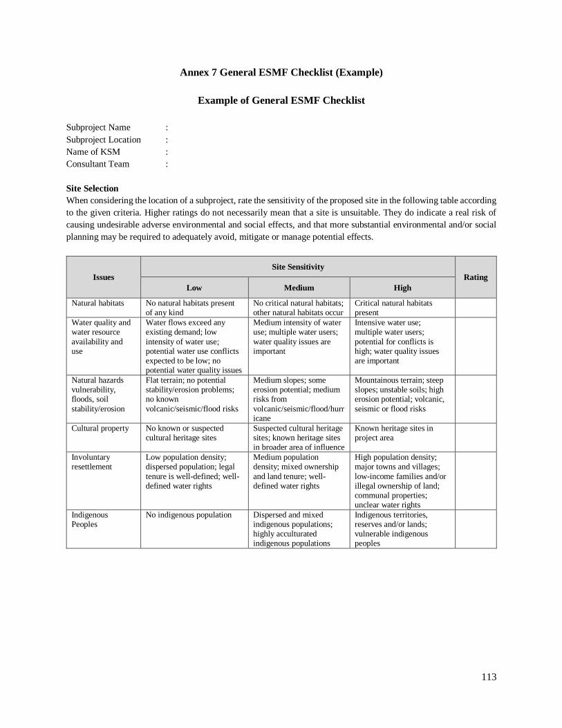
113
Annex 7 General ESMF Checklist (Example)
Example of General ESMF Checklist
Subproject Name :
Subproject Location :
Name of KSM :
Consultant Team :
Site Selection
When considering the location of a subproject, rate the sensitivity of the proposed site in the following table according
to the given criteria. Higher ratings do not necessarily mean that a site is unsuitable. They do indicate a real risk of
causing undesirable adverse environmental and social effects, and that more substantial environmental and/or social
planning may be required to adequately avoid, mitigate or manage potential effects.
Issues
Site Sensitivity
Rating
Low Medium High
Natural habitats No natural habitats present of any kind
No critical natural habitats; other natural habitats occur
Critical natural habitats present
Water quality and water resource
availability and use
Water flows exceed any existing demand; low
intensity of water use; potential water use conflicts expected to be low; no potential water quality issues
Medium intensity of water use; multiple water users;
water quality issues are important
Intensive water use; multiple water users;
potential for conflicts is high; water quality issues are important
Natural hazards vulnerability, floods, soil
stability/erosion
Flat terrain; no potential stability/erosion problems; no known
volcanic/seismic/flood risks
Medium slopes; some erosion potential; medium risks from
volcanic/seismic/flood/hurricane
Mountainous terrain; steep slopes; unstable soils; high erosion potential; volcanic,
seismic or flood risks
Cultural property No known or suspected cultural heritage sites
Suspected cultural heritage sites; known heritage sites in broader area of influence
Known heritage sites in project area
Involuntary resettlement
Low population density; dispersed population; legal
tenure is well-defined; well-defined water rights
Medium population density; mixed ownership
and land tenure; well-defined water rights
High population density; major towns and villages;
low-income families and/or illegal ownership of land; communal properties; unclear water rights
Indigenous Peoples
No indigenous population Dispersed and mixed indigenous populations; highly acculturated indigenous populations
Indigenous territories, reserves and/or lands; vulnerable indigenous peoples

114
Completeness of Subproject Application
Does the subproject application document contain, as appropriate, the following information?
No. Contents of subproject application document Yes No N/A
1. Description of the proposed project and where it is located
2. Reasons for proposing the project
3. The estimated cost of construction and operation
4. Information about how the site was chosen, and what alternatives were considered
5. A map or drawing showing the location and boundary of the project including any land required temporarily during construction
6. The plan for any physical works (e.g. layout, buildings, other structures, construction materials)
7. Any new access arrangements or changes to existing road layouts
8. Any land that needs to be acquired, as well as who owns it, lives on it or has rights to use it
9. A work program for construction, operation and decommissioning the physical works, as well as any site restoration needed afterwards
10. Construction methods
11. Resources used in construction and operation (e.g. materials, water, energy)
12. Information about measures included in the subproject plan to avoid or minimize adverse environmental and social impacts
13. Details of any permits required for the project
Checklist on Documents and Requirements for Environmental & Social Safeguards Management
No. Aspects of Environmental and Social Safeguard Yes No Remarks
1. Environmental Safeguard
1.1 Formulation of the environmental management document (UKL/UPL, or SPPL)
1.2 Integrating the document of UKL/UPL document, or SOP already ratified by
Bappedalda or Environmental Dinas/Office/Body to the SIAP document
1.3 Quarterly Report: completeness of information on Environment Management Plan
1.4
Conformity between implementation of environmental management with the
procedure as written in the technical guidelines of social and environmental
safeguards and Other relevant government regulations
1.5 Quality of environmental management implementation
1.6 Financing (planning and realization)
2. Social Safeguard
2.1 Land acquisition and/or resettlement/relocation of PAP, if any:
2.1.1
The making of instrument/document of land acquisition and/or
resettlement/relocation of PAPs, Full or Abbreviated LARAP, Statement Letter of
Land Donation. Statement Letter of Permit on Land Use, Statement Letter of
Permit on Land Easement.
2.1.2
Full or Abbreviated LARAP document that has ratified by Mayor/Bupati,
Statement Letter of Land Donation./Statement Letter of Permit on Land
Use/Statement Letter of Permit on Land Easement .shall become part of the SIAP
document
2.1.3 Quarterly Report: completeness of information about Plan and Implementation of
Land acquisition plan and/or resettlement/relocation of PAPs

115
No. Aspects of Environmental and Social Safeguard Yes No Remarks
2.1.4
Conformity between implementation of land acquisition and/or resettlement and the
procedure as written in the technical guidelines of social and environmental
safeguards and Other relevant government regulations
2.1.5 Quality of implementation of land acquisition and/or resettlement
2.1.6
Completeness of documentation (minutes of meetings, statement letter of land
donation, statement letter of rights handover, statement letter of permit on land use,
statement letter of permit on land Easement, etc.)
2.1.7 Financing (planning and realization)
2.2 Indigenous Peoples (IPs), if any:
2.2.1 Formulation of IPP*
IPP or adjustment to the project design according to the needs of IPs group
2.2.2 The IPP that has been ratified by Mayor/Bupati, shall become part of the SIAP
2.2.3 Conformity between IPP (or adjusted project design) as already agreed with the
field implementation
2.2.4 Quarterly Report: completeness of information on IPP
2.2.5
Conformity between implementation of IPP with the procedures as written in the
technical guidelines of social and environmental safeguards and Other relevant
government regulations
2.2.6 Quality of implementation of IPP
2.2.7 Completeness of documentation (minutes of meetings, statement letter to handover
the rights, pictures, etc.)
2.2.8 Financing (planning and realization)
CERTIFICATION
We certify that we have thoroughly examined all the potential adverse effects of this subproject. To the best of our
knowledge, the subproject plan as described in the application and associated planning reports (e.g. EMP, LARAP,
IPP, PMP), if any, will be adequate to avoid or minimize all adverse environmental and social impacts.
KSM (signature) : ………………………
Extension team representative/e.g. Facilitator, City Coordinator (signature): ……………..
Date : …………………

116
FOR OFFICIAL USE ONLY
Desk Appraisal by Review Authority:
The subproject can be considered for approval. The application is complete, all significant environmental
and social issues are resolved, and no further subproject planning is required.
A field appraisal is required.
Note: A field appraisal must be carried out if the subproject:
Needs to acquire land, or an individual or community’s access to land or available resources is restricted or
lost, or any individual or family is displaced.
May restrict the use of resources in a park or protected area by people living inside or outside of it.
May affect a protected area or a critical natural habitat.
May encroach onto an important natural habitat, or have an impact on ecologically sensitive ecosystems
(e.g. rivers, streams, wetlands).
May adversely affect or benefit an indigenous people.
Involves, or results in: a) diversion or use of surface waters; b) construction or rehabilitation of latrines,
septic or sewage systems; c) production of waste (e.g. slaughterhouse waste, medical waste); d) new or
rebuilt irrigation or drainage systems; or e) small dams, weirs, reservoirs or water points.
The following issues need to be clarified at the subproject site:
…………………………………………………………………………………………………………………………
…………………………………………………………………………………………………………………………
…………………………………………………………………………………………………………………………
…………………………………………………………………………………………………………………………
A Field Appraisal report will be completed and added to the subproject file.
Name of desk appraisal officer : ………………………………………………………
Signature : ………………………………………………………
Date : ………………………………………………………

117
Annex 8 Environmental and Social Field Appraisal Forms
EXAMPLE of FIELD APPRAISAL FORMS
Note:
Formats provided in this ESMF are an intended as example, the project will develop further detail forms and be
presented in the relevant technical guidelines and be included in the respective trainings or related capacity building
activities.
General Information
1. Subproject Name :
2. Location :
3. Date(s) of Field Appraisal :
4. Field Appraisal Officer and Address:
5. Facilitator/City Coord :
6. Community Representative :
7. Project Details (provide details that are not adequately presented in the subproject application. If necessary, attach
sketches of the subproject component(s) in relation to the community and to existing facilities):
Environmental and Social Issues
8. Will the project:
Need to acquire land?
Affect an individual or the community’s access to land or available resources?
Displace or result in the involuntary resettlement of an individual or family?
If “Yes”, tick one of the following bullets:
o The LARAP included in the subproject application is adequate. No further action required.
o The LARAP included in the subproject application must be improved before the application can be
considered further.
o A LARAP must be prepared and approved before the application can be considered further.
9. Will the project:
Encroach onto an important natural habitat?
Negatively affect ecologically sensitive ecosystems?
If “Yes”, tick one of the following bullets:
o The EMP included in the subproject application is adequate. No further action required.
o The EMP included in the subproject application must be improved before the application can be considered
further.
o An EMP must be prepared and approved before the application can be considered further.
10. Will this project involve or result in:
Diversion or use of surface waters?
Construction and/or rehabilitation of latrines, septic or sewage systems?
Production of waste (e.g. slaughterhouse waste, etc.)?
New or rebuilt irrigation or drainage systems?
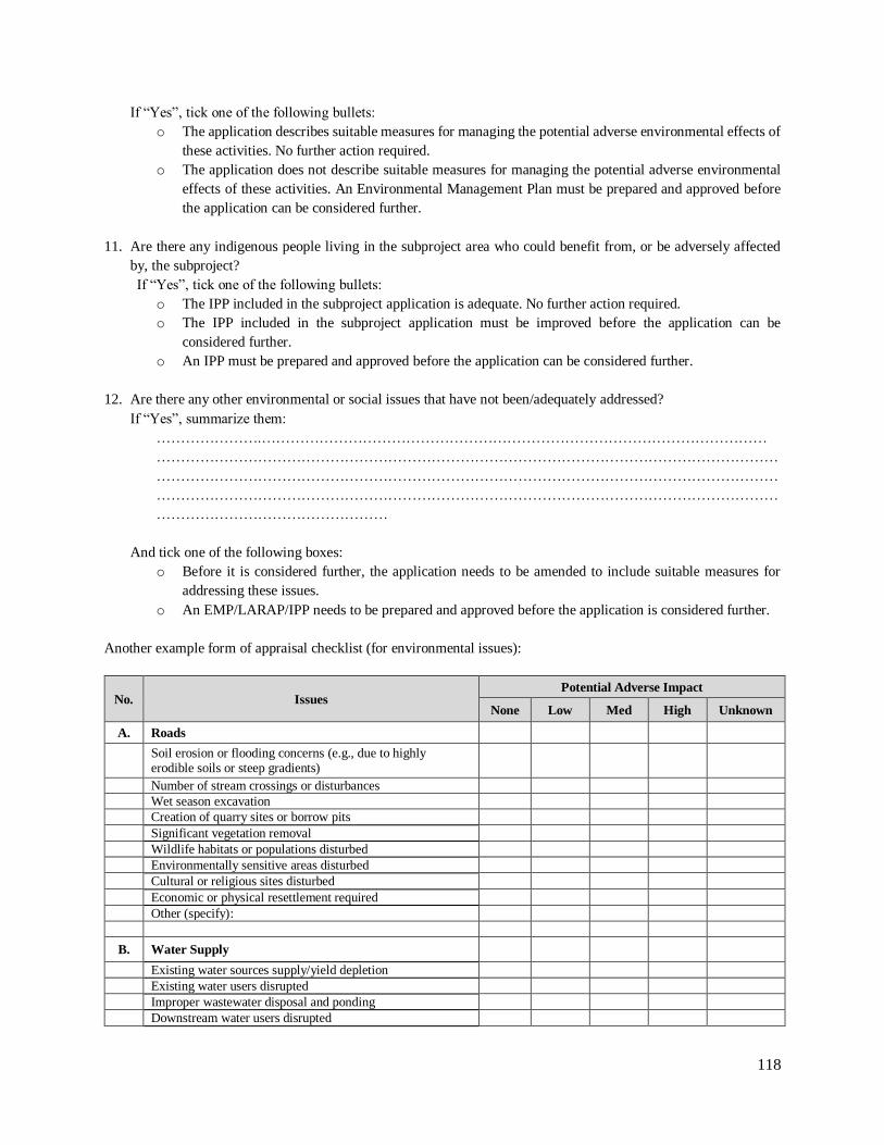
118
If “Yes”, tick one of the following bullets:
o The application describes suitable measures for managing the potential adverse environmental effects of
these activities. No further action required.
o The application does not describe suitable measures for managing the potential adverse environmental
effects of these activities. An Environmental Management Plan must be prepared and approved before
the application can be considered further.
11. Are there any indigenous people living in the subproject area who could benefit from, or be adversely affected
by, the subproject?
If “Yes”, tick one of the following bullets:
o The IPP included in the subproject application is adequate. No further action required.
o The IPP included in the subproject application must be improved before the application can be
considered further.
o An IPP must be prepared and approved before the application can be considered further.
12. Are there any other environmental or social issues that have not been/adequately addressed?
If “Yes”, summarize them:
………………….……………………………………………………………………………………………
…………………………………………………………………………………………………………………
…………………………………………………………………………………………………………………
…………………………………………………………………………………………………………………
…………………………………………
And tick one of the following boxes:
o Before it is considered further, the application needs to be amended to include suitable measures for
addressing these issues.
o An EMP/LARAP/IPP needs to be prepared and approved before the application is considered further.
Another example form of appraisal checklist (for environmental issues):
No. Issues Potential Adverse Impact
None Low Med High Unknown
A. Roads
Soil erosion or flooding concerns (e.g., due to highly erodible soils or steep gradients)
Number of stream crossings or disturbances
Wet season excavation
Creation of quarry sites or borrow pits
Significant vegetation removal
Wildlife habitats or populations disturbed
Environmentally sensitive areas disturbed
Cultural or religious sites disturbed
Economic or physical resettlement required
Other (specify):
B. Water Supply
Existing water sources supply/yield depletion
Existing water users disrupted
Improper wastewater disposal and ponding
Downstream water users disrupted
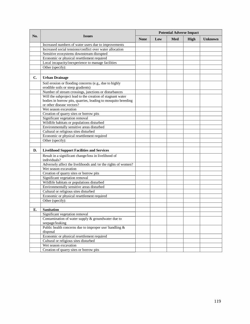
119
No. Issues Potential Adverse Impact
None Low Med High Unknown
Increased numbers of water users due to improvements
Increased social tensions/conflict over water allocation
Sensitive ecosystems downstream disrupted
Economic or physical resettlement required
Local incapacity/inexperience to manage facilities
Other (specify):
C. Urban Drainage
Soil erosion or flooding concerns (e.g., due to highly erodible soils or steep gradients)
Number of stream crossings, junctions or disturbances
Will the subproject lead to the creation of stagnant water bodies in borrow pits, quarries, leading to mosquito breeding or other disease vectors?
Wet season excavation
Creation of quarry sites or borrow pits
Significant vegetation removal
Wildlife habitats or populations disturbed
Environmentally sensitive areas disturbed
Cultural or religious sites disturbed
Economic or physical resettlement required
Other (specify):
D. Livelihood Support Facilities and Services
Result in a significant change/loss in livelihood of individuals?
Adversely affect the livelihoods and /or the rights of women?
Wet season excavation
Creation of quarry sites or borrow pits
Significant vegetation removal
Wildlife habitats or populations disturbed
Environmentally sensitive areas disturbed
Cultural or religious sites disturbed
Economic or physical resettlement required
Other (specify):
E. Sanitation
Significant vegetation removal
Contamination of water supply & groundwater due to seepage/leaking
Public health concerns due to improper use/ handling & disposal
Economic or physical resettlement required
Cultural or religious sites disturbed
Wet season excavation
Creation of quarry sites or borrow pits

120
Field Appraisal Decision
o The subproject can be considered for approval
Based on a site visit and consultations with both interested and affected parties, the field appraisal determined
that the community and its proposed project adequately address environmental and/or social issues as required by
the Project’s ESMF.
o Further subproject preparation work is required before the application can be considered further
The field appraisal has identified environmental and/social issues that have not been adequately addressed. The
following work needs to be undertaken before further consideration of the application:
………………….…………………………………………………………………………………………………
………………………………………………………………………………………………………………………
……………………………………………………………………………………………………………….
All required documentation such as amended application, EMP, LARAP, IPP will be added to the subproject file
before the subproject is considered further.
Name of field appraisal officer : ……………………….
Signature : ……………………….
Date : ……………………….

121
Annex 9 Report on Environmental Screening
(Example from a Road Project)
A. PROJECT ACTIVITY PLAN
1. Name of Project Activity …………………………………………………………………….
2. Length of Road ………….. km
3. Width of Road
a. Existing width
b. Planned width
c. Existing surface
d. Planned surface
a. ……… m
b. ……… m
c. ……… m
d. ……… m
4. Location
a. City
b. District
c. Province
a. ……………………………………………
b. ……………………………………………
c. ……………………………………………
5. Road Status National/Province/District/City
6. City Status Metropolitan/Big/Medium/Small
7. Project Type Construction/Maintenance
8. Land Acquisition Size ………….. Ha
9. Average Traffic Flow
a. Existing
b. Planned
a. ………………. Vehicles/day
b. ………………. Vehicles/day
10. Project Status Pre-feasibility study/Feasibility study
B. RESULT OF ENVIRONMENTAL SCREENING ON PROTECTED AREA AND OTHER SENSITIVE AREAS
1. Type of Land Use
a. Type / name of the protected area
b. Location of the road in protected areas
a. ………………..
b. Pass through/share boundary with/close to/far from..
2. Other Environmental Components that are sensitive to
changes (if any)
IPs / Vulnerable peoples/ Dense Settlement / Commercial Area /
Cultural Heritage Area / Steep terrain
3. Physiographic conditions of land:
a. Steep terrain (> 40%)
b. Unstable land
c. Other information
1. ………… km
2. ………… km
3. …………. (please mention)
4. Evaluation of Major Impacts Major/Minor
C. CONCLUSIONS (please select one)
1. Must have AMDAL1 Rationale: ………………………..
2. Must have UKL/UPL Rationale: ………………………..
3. Needs LARAP Rationale: ………………………..
4. No AMDAL or UKL and UPL needed (only requires
SOP)
Rationale: ………………………..
a. BUDGET ESTIMATE FOR STUDY OF
UKL/UPL, SOP, LARAP
Rp…………………………………….
1 Not eligible for financing

122
Annex 10 Format of Environmental Management Plan and Environmental Monitoring Plan
(UKL/UPL)
The following form is the Format for the Environmental Management Plan (UKL) and Environmental
Monitoring Plan (UPL). It describes the impact of the planned activities on the environment and how
it will be managed. As an integral part of the UKL/UPL, the Statement of Assurance for
Implementation of UKL/UPL will be attached using the template example shown in this annex. This
format complies with the Regulation of the Minister of Environment No. 16/2012 which can be referred
to for further guidance.
Title of Chapter/Sub-
Chapter
Content/Remarks
Statement Letter from Project Management
a. The statement letter from project management will state their accountability to ensure that the Environmental Management Plan (UKL) and Environmental Monitoring Plan (UPL) will be done. This statement Letter should be signed on a stamp duty acknowledged by the Head of Bapedalda, (local environmental agency) and the Head of Local Government
(Governor/Bupati/Mayor). b. Project management consists of those parties who prepare and implement the Project
Activities, those parties who are responsible for the operations and maintenance of the Project Activities, and other parties responsible for environmental management and monitoring.
I. DESCRIPTION OF PROJECT MANAGEMENT
1.1 Company Name ……………………………….
1.2 Name of Project
Management Entity
Name of project management entity and their job description at each stage of the Project
Activities, which should include: a. Agency or office responsible for the preparation and implementation of Project
Activities. b. Agency or office responsible for the operations and maintenance of the Project
Activities after the work is completed. c. Agency or office responsible for environmental management and monitoring.
1.3 Address, Number Phone and Fax, Website and Email
Clear address of the named agencies or offices related to the Project Activities in accordance to the point 1.1 above.
II. DESCRIPTION OF PROJECT ACTIVITIES AND ITS IMPACT
2.1 Project Activities Name Name of Project Activities in a clear and complete manner.
2.2 Project Activities Location
a. Location of the Project Activities in a clear and complete manner: Kelurahan/Village, District/city, and Province where the Project Activities and its components take place.
b. Location of the Project Activities should be drawn in a map using an adequate scale (for example, 1:50.000, accompanied with latitude and longitude of the location).
2.3 Scale of the Project Activities
An estimation of the scale and type of Project Activities (using accepted units of measurement). For example: the construction of a market of certain capacity may need to be accompanied by supporting facilities in line with the Environmental Management Plan that must mention the type of component as well as the scale.
2.4 Component of Project Activities in brief outline
A brief and clear explanation on any component of the Project Activities which have potential environmental impacts. Work components should be divided based on stages as follows: a. Pre-construction, for example: mobilization of workforce and materials, transportation,
etc.
b. Construction, for example the use of ground water, laying out of utility pipes, etc.

123
Title of Chapter/Sub-
Chapter
Content/Remarks
c. Operations and Maintenance: Post-construction, for example: clearing of excavated waste material, etc.
Also, attach the flowchart/diagram to explain the flow of work to be done, if applicable.
III POTENTIAL
ENVIRONMENTAL
IMPACT
Explain in a brief and clear manner about any Project Activities with potential environmental impacts, type of impacts which might occur, magnitude of impacts, and other matters needed to describe any potential environmental impacts on the natural and social environment. Such descriptions can be presented in tabulation, with each column representing each of the aspects. A description of the size or magnitude of the impacts should be accompanied with measurement units based on applicable laws and regulations or specific scientific analysis.
IV. ENVIRONMENTAL MANAGEMENT AND MONITORING PROGRAM
4.1 Environmental
Management Plan
b. The Environmental Management Plan(UKL) consists of the plan itself, as well as the party
in charge, frequency of interventions, implementation schedule, and types of mechanisms (e.g.: procedures for management, methods, etc.) in order to mitigate the environmental impacts identified Section III above.
c. The plan can be presented in a table format, which at minimum contains the following columns: type of impact, source, magnitude, threshold, management plan, and frequency of interventions, party in charge, and other remarks.
4.2 Environmental Monitoring Plan
a. The Environmental Monitoring Plan (UPL) consists of the plan itself, party in charge, frequency of interventions, implementation schedule, and types of mechanisms (e.g.:
procedures for monitoring, methods, etc.) in order to monitor the environmental management plan described in section 4.1 above.
b. The plan can be presented in a table format, which at minimum contains the following columns: type of impact, source, magnitude, threshold, management plan, and frequency of interventions, party in charge, and other remarks. In this monitoring plan, the thresholds should comply with the prevailing laws and regulations which are applicable according to the environmental impacts as already identified in Section III above.
V. SIGNATURE AND
OFFICE SEAL
After the UKL/UPL document is prepared and complete, the Project Manager should sign and
put an official seal on the document.
VI. REFERENCE Insert various references used in the preparation of UKL/UPL.
VII. ATTACHMENTS Attach any relevant documents or information to the UKL/UPL, e.g. tables displaying the monitoring results, and others.

124
Annex 11 Format of Statement of Assurance for UKL/UPL Implementation
Statement of Assurance for UKL/UPL Implementation
No:…………………….
In an effort to prevent, minimize and/or address the potential environmental impacts from the
Construction Work of.............................., in the District/Province of.............. as well as in accordance
to the duty and authority of the Dinas................, of the District/Province of shall carry out an
Environmental Management Plan (UKL) and Environmental Monitoring Plan (UPL) and include the
recommendations from UKL/UPL into the Detailed Design.
For the next stage, which is the physical work, implementation of the recommendations from
UKL/UPL shall be done by the party in charge for the physical work, which is “Satker..................... of
the District/Province..................”.
This statement is duly made, as confirmation to support the Environmental Management Plan (UKL)
and Environmental Monitoring Plan (UPL) on the Construction Work for the Construction of
......................., in the District/Province of..............,
Location,.........................., Date…..………..
DINAS…………….………………............
DISTRICT/PROVINCE OF .......................
Satker
NAME .................................
NIP.......................................

125
Annex 12 SOP for Environmental Management
1. Roads and Bridges:
a. General Guidelines for Environmental Management (1)- No 008/BM/2009
b. Guidelines for Planning of Environmental Management (2)-No 009/BM/2009, which includes,
among others:
i. General Guidelines for Environmental Management of Sensitive Areas. See Annex 2 of
the Guideline No. 009/BM/2009.
ii. Guidelines for Environmental Management in Forested Areas.
iii. Procedures for obtaining a Use Permit (Leasehold) for Forested Areas.
iv. Implementation Manual for Construction in Forested Areas.
v. Manual for Mitigating Development Impacts on Flora and Fauna in Forested Areas (14
pages), including:
Methods of Land Clearing;
Environmental Impact Management Plans for Roads Traversing National Parks.
vi. Guidelines on Environmental Management in Protected Zones Outside of Forested Areas.
See Annex 3 of the Guideline No. 009/BM/2009.
vii. Manual for Mitigating Construction Impacts on Flora and Fauna in Forested Areas.
viii. Manual for Mitigating Development Impacts on Water Resources.
ix. General Environmental Management Guidelines for Protection of Heritage Areas.
x. Manual for Mitigating Air-quality and Noise Pollution from Traffic.
xi. Environmental Screening Procedures for Road Projects. See Annex 4 of the Guideline No.
009/BM/2009.
c. Guidelines for Implementation of Environmental Management Plans (3) - No 010/BM/2009, which
includes, among others:
i. Sample Clauses for Specific Work, related to environmental impact mitigation measures.
See Annex 1 of the Guideline No. 010/BM/2009.
ii. Mitigation Guidelines for Construction Standards (e.g. traffic, construction base-camps,
stockpiles, collecting the material in the quarry, waste management, erosion and
sedimentation, interference of vegetation, handling utilities). See Annex 2 of the Guideline
No. 010/BM/2009.
d. Guidelines for Monitoring of Environmental Management (4) –No 011 /BM/2009.
2. Water Supply:
a. The Regulation of Ministry of Public Works and Housing (MPWH), No. 18/PRT/M/2007, on
Water Supply System Management, which includes among others:
Guidelines for Master Plan Development, Feasibility Study Preparation, Construction Phase.
b. Guidelines for Simplified Water Supply System Management (SPAM sederhana):
Guidelines for the construction of water intakes, broncaptering, underground water wells,
simplified water treatment plants, public hydrants, piping installations, and operations and
maintenance.

126
3. Irrigation:
a. Guidelines for rehabilitation/improvement of irrigation systems, to prevent adverse downstream
effects. Please refer to Regulation of MPWH No 15/PRT/M/2010, Section III.3.2.2 and III.3.3.2.
b. Please follow the MPWH Guidelines for environmental management during construction
(10/BM/2009), as per stipulated in the Regulation of MPWH No 15/PRT/M/2010. Refer to
Appendix 2 - Article III.1.
c. Guidelines for the On-site Agricultural Education for Integrated Pest Management (IPM).
i. Book 1 for Farmers
ii. Book 2 for Extension Workers
iii. Book 3 for Follow Up Actions
4. Sanitation. Implementation Guideline of DAK Community Based Sanitation (SLBM) issued
in 2014 by DG of Human Settlements, MPWH.
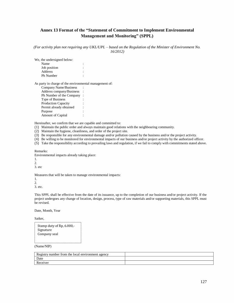
127
Annex 13 Format of the “Statement of Commitment to Implement Environmental
Management and Monitoring” (SPPL)
(For activity plan not requiring any UKL/UPL – based on the Regulation of the Minister of Environment No.
16/2012) We, the undersigned below:
Name : Job position : Address :
Ph Number : As party in charge of the environmental management of:
Company Name/Business : Address company/Business : Ph Number of the Company : Type of Business : Production Capacity : Permit already obtained :
Purpose : Amount of Capital :
Hereinafter, we confirm that we are capable and committed to: (1) Maintain the public order and always maintain good relations with the neighbouring community.
(2) Maintain the hygiene, cleanliness, and order of the project site.
(3) Be responsible for any environmental damage and/or pollution caused by the business and/or the project activity. (4) Be willing to be monitored for environmental impacts of our business and/or project activity by the authorized officer.
(5) Take the responsibility according to prevailing laws and regulation, if we fail to comply with commitments stated above.
Remarks: Environmental impacts already taking place: 1. 2. 3. etc
Measures that will be taken to manage environmental impacts: 1. 2. 3. etc. This SPPL shall be effective from the date of its issuance, up to the completion of our business and/or project activity. If the project undergoes any change of location, design, process, type of raw materials and/or supporting materials, this SPPL must
be revised. Date, Month, Year Satker,
(Name/NIP)
Registry number from the local environment agency
Date
Receiver
Stamp duty of Rp, 6.000,- Signature Company seal

128
Annex 14 Typical Subproject Impacts and Mitigation Measures
The typical subprojects that NSUP will support with the potential negative impacts and mitigation
measures are summarized in the following table:
Potential Negative Impacts Mitigation Measures
Roads, Bridge and Drainage subprojects
Erosion from fresh road cuts and fills
and temporary sedimentation of
natural drainage ways
- Limit earth moving to dry periods
- Protection of most susceptible soil surfaces with mulch
- Protection of drainage channels with berms, or fabric barriers/geo-
textile
- Installation of sedimentation basins, seeding or planting of erodible surfaces as soon as possible
- Selection an alignment that reduces environmental disturbances
- Undertaking maintenance and repairs in a timely fashion
Creation of stagnant water bodies in
borrow pits, quarries, etc. suited to
mosquito breeding and other disease
vectors
Employ measures to avoid creating habitats (e.g. improved landscaping,
re-vegetation, filing or drainage)
Roads/bridges located in critical lands
that are sensitive to erosion and
landslides
- Changing the alignment to reduce steep grades when possible
- Building civil works to stabilize side slopes – terracing or retaining
wall installation
- Using vegetative treatments to stabilize side slopes or prevent erosion
- Using special treatments to overcome ground water problems, such as
drains - Regular monitoring and inventory of risks for erosion
Blocked drains (due to design and
maintenance) stop the flow of water
and impact public health
- O&M work must clean the block drains periodically
- Stone masonry or concrete ditch are preferred as water is quickly
transported away (earth ditches drain but they need much more space
and are less stable, earth ditches also need a lot more maintenance)
- Use of natural slope as it holds up well against erosion
Public Toilets, Sanitation, and Water Supply – Health Risks on the following activities:
Water level of the dug well almost the
same as the soak away, well too close
to the toilets and septic tank
- Check the direction of groundwater flow; the well should be placed
upstream
- Build the soak away as far as possible away from the dug well
(minimum 10 m)
- - Build the proper drainage system to keep the waste water away of
the dug well
A well in the toilet: this is not
acceptable due to high risk of
contamination
- Build a basin in each toilet room and fill them from the well by pipe
channel or container
- - Keep the toilets clean and separate from the well
The sewer pipe laid on the ground surface may become brittle from the
sun’s UV rays and could also be
damaged by people stepping on it or
other impact
- Burry the sewer pipe all the way to the septic tank - Install a ventilation pipe and a manhole access in the septic tank
Incomplete septic tank structures Minimum equipment for a septic tank consists of:
1. Access manhole with a lockable cover
2. Inlet pipe
3. Dividing wall of baffle
4. Overflow pipe
5. Ventilation pipe
(To comply with SNI - 2398 – 2002 on septic tank system)
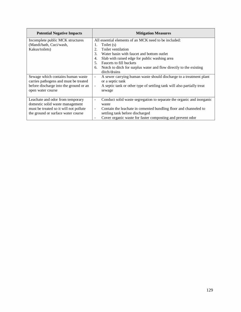
129
Potential Negative Impacts Mitigation Measures
Incomplete public MCK structures
(Mandi/bath, Cuci/wash,
Kakus/toilets)
All essential elements of an MCK need to be included:
1. Toilet (s)
2. Toilet ventilation
3. Water basin with faucet and bottom outlet
4. Slab with raised edge for public washing area
5. Faucets to fill buckets
6. Notch to ditch for surplus water and flow directly to the existing ditch/drains
Sewage which contains human waste
carries pathogens and must be treated
before discharge into the ground or an
open water course
- A sewer carrying human waste should discharge to a treatment plant
or a septic tank
- A septic tank or other type of settling tank will also partially treat
sewage
Leachate and odor from temporary
domestic solid waste management
must be treated so it will not pollute
the ground or surface water course
- Conduct solid waste segregation to separate the organic and inorganic
waste
- Contain the leachate in cemented bundling floor and channeled to
settling tank before discharged
- Cover organic waste for faster composting and prevent odor
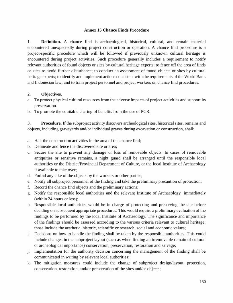
130
Annex 15 Chance Finds Procedure
1. Definition. A chance find is archaeological, historical, cultural, and remain material
encountered unexpectedly during project construction or operation. A chance find procedure is a
project-specific procedure which will be followed if previously unknown cultural heritage is
encountered during project activities. Such procedure generally includes a requirement to notify
relevant authorities of found objects or sites by cultural heritage experts; to fence off the area of finds
or sites to avoid further disturbance; to conduct an assessment of found objects or sites by cultural
heritage experts; to identify and implement actions consistent with the requirements of the World Bank
and Indonesian law; and to train project personnel and project workers on chance find procedures.
2. Objectives.
a. To protect physical cultural resources from the adverse impacts of project activities and support its
preservation.
b. To promote the equitable sharing of benefits from the use of PCR.
3. Procedure. If the subproject activity discovers archeological sites, historical sites, remains and
objects, including graveyards and/or individual graves during excavation or construction, shall:
a. Halt the construction activities in the area of the chance find;
b. Delineate and fence the discovered site or area;
c. Secure the site to prevent any damage or loss of removable objects. In cases of removable
antiquities or sensitive remains, a night guard shall be arranged until the responsible local
authorities or the District/Provincial Department of Culture, or the local Institute of Archaeology
if available to take over;
d. Forbid any take of the objects by the workers or other parties;
e. Notify all subproject personnel of the finding and take the preliminary precaution of protection;
f. Record the chance find objects and the preliminary actions;
g. Notify the responsible local authorities and the relevant Institute of Archaeology immediately
(within 24 hours or less);
h. Responsible local authorities would be in charge of protecting and preserving the site before
deciding on subsequent appropriate procedures. This would require a preliminary evaluation of the
findings to be performed by the local Institute of Archaeology. The significance and importance
of the findings should be assessed according to the various criteria relevant to cultural heritage;
those include the aesthetic, historic, scientific or research, social and economic values;
i. Decisions on how to handle the finding shall be taken by the responsible authorities. This could
include changes in the subproject layout (such as when finding an irremovable remain of cultural
or archeological importance) conservation, preservation, restoration and salvage;
j. Implementation for the authority decision concerning the management of the finding shall be
communicated in writing by relevant local authorities;
k. The mitigation measures could include the change of subproject design/layout, protection,
conservation, restoration, and/or preservation of the sites and/or objects;

131
l. Construction work at the site could resume only after permission is given from the responsible
local authorities concerning safeguard of the heritage; and
m. The subproject proponent responsible to cooperate with the relevant local authorities to monitor
all construction activities and ensure that the adequate preservation actions already taken and hence
the heritage sites protected.
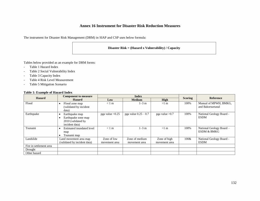
132
Annex 16 Instrument for Disaster Risk Reduction Measures
The instrument for Disaster Risk Management (DRM) in SIAP and CSP uses below formula:
Disaster Risk = (Hazard x Vulnerability) / Capacity
Tables below provided as an example for DRM forms:
- Table 1 Hazard Index
- Table 2 Social Vulnerability Index
- Table 3 Capacity Index
- Table 4 Risk Level Measurement
- Table 5 Mitigation Scenario
Table 1: Example of Hazard Index
Hazard Component to measure
Hazard
Index Scoring Reference
Low Medium High
Flood Flood zone map
(validated by incident data)
< 1 m 1–3 m >1 m 100% Manual of MPWH, BMKG,
and Bakorsurtanal
Earthquake Earthquake map
Earthquake zone map
2010 (validated by incident data)
pga value <0.25 pga value 0.25 – 0.7 pga value >0.7 100% National Geology Board - ESDM
Tsunami Estimated inundated level map
Tsunami map
< 1 m 1–3 m >1 m 100% National Geology Board – ESDM & BMKG
Landslide Land movement area map (validated by incident data)
Zone of low movement area
Zone of medium movement area
Zone of high movement area
100& National Geology Board - ESDM
Fire in settlement area
Drought
Other hazard

133
Table 2: Example of Social Vulnerability Index
Type of
Hazard
Social Vulnerability Eco & Infra Vulnerability Total
Scoring Component Index
Scoring Component Index
Scoring Low Medium High Low Medium High
Flood Density of population Productive Land
Vulnerable Group Infrastructure:
Ratio by sex Housing
Ratio of difable people Public Facility*
Ratio by age Social Facility
Earthquake Density of population Productive Land
Vulnerable Group Infrastructure:
Ratio by sex Housing
Ratio of difable people Public Facility*
Ratio by age Social Facility
Tsunami Density of population Productive Land
Vulnerable Group Infrastructure:
Ratio by sex Housing
Ratio of difable people Public Facility*
Ratio by age Social Facility
Landslide Density of population Productive Land
Vulnerable Group Infrastructure:
Ratio by sex Housing
Ratio of difable people Public Facility*
Ratio by age Social Facility
Fire in settlement area
Density of population Productive Land
Vulnerable Group Infrastructure:
Ratio by sex Housing
Ratio of difable people Public Facility*
Ratio by age Social Facility
Drought Density of population Productive Land
Vulnerable Group Infrastructure:
Ratio by sex Housing
Ratio of difable people Public Facility*
Ratio by age Social Facility
Other hazard Density of population Productive Land
Vulnerable Group Infrastructure:
Ratio by sex Housing
Ratio of difable people Public Facility*
Ratio by age Social Facility
*Public Facility including water supply, sanitation, solid waste, drainage, fire prevention, sewerage

134
Table 3: Example of Capacity Index
Type of Hazard Measured Component Index
Scoring Reference Low Medium High
All hazards Rules and institution Low Endurance /
Coping capacity
Medium
Endurance / Coping capacity
High Endurance /
Coping capacity
Finance resources for DRM
Early warning system and evacuation routes & site
Trained volunteer and social group
Awareness of preparedness has been generated at all level
Table 4: Example of Risk Level Measurement
Type of Hazard Location Index Level
Level of Risk Hazard Vulnerability Capacity
Flood
Earthquake
Landslide
Fire in settlement area
Drought
Other hazard
Based on Risk Level Measurement Index, the mitigation scenario will be formulated, integrated in spatial planning, and put in SIAP and CSP. Below is example
of mitigation scenario.
Table 5: Example of Mitigation scenario
Hazard Infrastructure that will be impacted (destroy or broken) by disaster Mitigation scenario
Flood housing:
water supply:
sanitation:
solid waste:
drainage:
sewerage:
fire prevention:
Earthquake
Landslide
Fire in settlement area
Drought
Other hazard

135
Annex 17 Format of the Statement Letter on Land Donation
I/We, the undersigned herein under:
Name :
ID Card/KTP No :
Occupation :
Address :
As the legitimate owner of the land by virtue of a valid Proof of Entitlement Number ………., Date….. or other valid
Proof of..... (specify), hereby confirm that I/we agree to donate land and/or other assets to the Local Government of
Province/District/City ………….. (specify) to be utilized for the construction of………………………………………
for the benefit of the general public.
Project Activities
Location of the land : Size of the donated land :
Size of the remaining land :
Value of other donated assets :
Existing land use :
Ownership status of the land :
(please mention the land boundary and land ownership status as well as land plot map with marking on clear
orientations)
This statement is duly made without any pressure from anyone.
Place, date this mutual agreement is signed
The land donator the donated land receiver,
Acknowledgement,
Signature (Land owner) Signature (on behalf of the Provincial/District/City Government)
Camat as PPAT
(name) (name)
Signature of Lurah/Village head Signature of Community Board of Trustees
(name) (name)
Signature of witnesses Signature of inheritance:
Name 1 signature Name 1 signature
Name 2 signature Name 2 signature
Name 3 signature Name 3 signature
Attachment: Sitemap of land to be donated and photos
Remarks: Original copy of this letter will be kept by the land donor and by the KSM as part of the proposal. A copy of the letter should be archived in the kelurahan/village office.
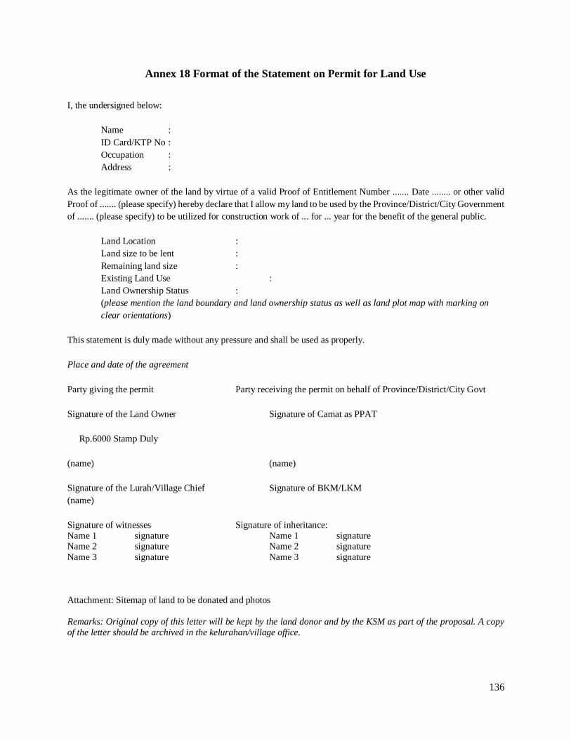
136
Annex 18 Format of the Statement on Permit for Land Use
I, the undersigned below:
Name :
ID Card/KTP No :
Occupation :
Address :
As the legitimate owner of the land by virtue of a valid Proof of Entitlement Number ....... Date ........ or other valid
Proof of ....... (please specify) hereby declare that I allow my land to be used by the Province/District/City Government
of ....... (please specify) to be utilized for construction work of ... for ... year for the benefit of the general public.
Land Location :
Land size to be lent :
Remaining land size :
Existing Land Use :
Land Ownership Status :
(please mention the land boundary and land ownership status as well as land plot map with marking on
clear orientations)
This statement is duly made without any pressure and shall be used as properly.
Place and date of the agreement
Party giving the permit Party receiving the permit on behalf of Province/District/City Govt
Signature of the Land Owner Signature of Camat as PPAT
Rp.6000 Stamp Duly
(name) (name)
Signature of the Lurah/Village Chief Signature of BKM/LKM
(name)
Signature of witnesses Signature of inheritance:
Name 1 signature Name 1 signature Name 2 signature Name 2 signature
Name 3 signature Name 3 signature
Attachment: Sitemap of land to be donated and photos
Remarks: Original copy of this letter will be kept by the land donor and by the KSM as part of the proposal. A copy
of the letter should be archived in the kelurahan/village office.
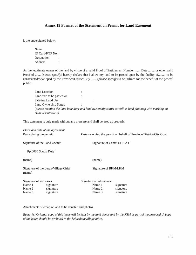
137
Annex 19 Format of the Statement on Permit for Land Easement
I, the undersigned below:
Name :
ID Card/KTP No :
Occupation :
Address :
As the legitimate owner of the land by virtue of a valid Proof of Entitlement Number ....... Date ........ or other valid
Proof of ....... (please specify) hereby declare that I allow my land to be passed upon by the facility of......... to be
constructed/developed by the Province/District/City ....... (please specify) to be utilized for the benefit of the general
public.
Land Location :
Land size to be passed on :
Existing Land Use :
Land Ownership Status :
(please mention the land boundary and land ownership status as well as land plot map with marking on
clear orientations)
This statement is duly made without any pressure and shall be used as properly.
Place and date of the agreement
Party giving the permit Party receiving the permit on behalf of Province/District/City Govt
Signature of the Land Owner Signature of Camat as PPAT
Rp.6000 Stamp Duly
(name) (name)
Signature of the Lurah/Village Chief Signature of BKM/LKM
(name)
Signature of witnesses Signature of inheritance:
Name 1 signature Name 1 signature Name 2 signature Name 2 signature
Name 3 signature Name 3 signature
Attachment: Sitemap of land to be donated and photos
Remarks: Original copy of this letter will be kept by the land donor and by the KSM as part of the proposal. A copy
of the letter should be archived in the kelurahan/village office.

138
Annex 20 Sample Outline of Land Consolidation Implementation Plan (LCIP)
Remarks: the following is a sample outline for in-situ small-scale voluntary community-based and consolidation
(LC).
1. Description of Project Activity
a. Background
b. Purpose of LC
c. Location, including the area map of the LC
d. Components of the project activity that require LC
e. Description on how the plan relates to CSP, SIAP, City’s Spatial Development Plan
2. Institutional Arrangements
a. Organization or committee responsible for the whole process of LC
b. Coordination Scheme
c. Technical assistance and capacity building provided by the project
3. Area of LC and Indicative LC Site Plan:
a. Area of land/existing buildings/structures, including map of borders, topographical features, and land use
b. Accessibility of the LC land area to other areas
c. Final LC site plan and land contribution, which includes reallocation of land parcels with the new sizes,
rearrangements or new community infrastructure and public facilities, along with their values and estimated
cost.
4. LC Participants and Land contribution
a. List of participants, location and size of land parcel, size of land contribution, their affected assets, condition of
the assets and their ownership status
b. Land ownership or tenure status of each parcel involved in the LC area
c. Plants/trees and other assets affected by the land consolidation (type, quantity, condition, age, productivity,
ownership of land, cost acquisition)
5. Process and Approach of LC
a. Phasing
b. Preparation
c. Implementation
6. Financial Plan
7. Disclosure and Complaint Handlings
8. Monitoring and Evaluation
9. Schedule for Implementation
10. Annex
a. Letter of Agreement to participate and contribute land of each participant
b. Minutes of Meetings
c. Lists of Attendance
d. Photos

139
Annex 21 Format of Full and Abbreviated LARAP
Format of Full LARAP
Note: Please also refer to the example of an outline for a LARAP (Annex 22)
A full LARAP shall include, at minimum, the elements below, as relevant. If any component is not
relevant to the Project Activity’s circumstances, it needs to be explained on the full LARAP:
1. Description of Project Activity. A general description of the Project Activity and
identification of the Project Activity’s site.
2. Potential Impacts. Identification of: (a) components of the Project Activity that would require
land and/or relocation; (b) areas to be affected by the Project Activity (area of influence); (c)
alternatives to avoid or minimize land acquisition and/or relocation; and (d) to the extent possible, any
measures adopted to avoid or minimize land acquisition and/or relocation.
3. Objectives. Objectives of the full LARAP.
4. Census of the Project Affected Persons (PAPs) and inventory of affected assets. Census
results and asset inventory, including the following information:
a. List of PAPs, with differentiation of those having land rights and occupants who do not have land
rights; vulnerable and gender;
b. Inventory of land parcels and structures affected by the Project Activity, covering the following
information:
Size of total land parcels affected, size of land to be acquired by the Project Activity, and size
of the remaining land;
Ownership status of the land and structure affected by the Project Activity and proof of
ownerships;
Function of land affected by the Project Activity;
Size and function of the affected structure, and remaining size of the structure;
Condition of the affected structures (permanent, semi-permanent, temporary, etc.)
Other assets affected by the Project Activity (trees, crops, wells, fences, etc.)
c. Total number of PAPs and households affected by the Project Activity (Project Affected
Households - PAH)
d. Number of PAHs to be relocated, which differentiate (1) those who can rebuild their houses in the
remaining land from the affected land, and (2) those who have to relocate to other locations; and
e. Number of PAHs who lose more than 10% of their productive assets.
The above information should be summarized in a Table as presented in Annex 23 “Format of
Inventory List of Land & Assets on the Land”.

140
5. Socio-economic Study. The Socio-economic Study must be conducted in the early stage of
the Project Activity’s preparation and with the involvement of the potentially PAPs. The Study must
include the following components:
a. The results of the Census of the PAPs in para No. 4 above
b. The description about production systems, labour, and household organization; and baseline
information on livelihoods and standards of living of the PAPs;
c. Characteristics of social interaction within the affected communities, including social networks
and social support systems, and how they will be affected by the Project Activity;
d. Information about vulnerable groups or persons for whom special provisions may have to be made;
e. Existing land ownership rights and systems of land transfer, including an inventory of shared
natural resources, sources from which community members obtain their livelihood and food, right
to use system based on non-ownership rights (including fishing, harvesting from vegetation/trees
for own consumption, or use of forested areas) as governed by land allocation mechanisms, locally-
applicable systems, and systems to settle any issues arising due to particular land occupation
schemes;
f. Magnitude of the expected loss –total or partial—of assets and the extent of displacement, physical
or economic, as well as public infrastructure and social services to be affected;
g. Social and cultural characteristics of the PAPs, including a description about local formal and
informal institutions (for example, community organizations, ritual groups, non-government
organizations (NGO), who are possibly related to the public consultation strategy, project design
process and implementation of resettlement);
h. Initial information concerning the livelihoods of PAPs (to include, if necessary, level of production
and income obtained from any formal as well as informal economic activity) and level of their
livelihood (including their health status); and
i. Provisions to update information on the PAPs’ livelihoods and standard of living at regular
intervals so that the latest information is available at the time of their displacement.
6. Legal Analysis. The findings of an analysis of the legal framework, covering,
a. The scope of the power of eminent domain and the nature of compensation associated with it, in
terms of both the valuation methodology and the timing of payment;
b. The applicable legal and administrative procedures, including a description of remedies available
to the PAPs in the judicial process, the normal time frame for such procedures, and any available
alternative dispute resolution mechanisms that may be relevant to resettlement under the Project;
c. Relevant laws (including customary and traditional laws) governing land tenure, valuation of assets
and losses, compensation and natural usage of rights; customary personal law related to
displacement; and environmental laws and social welfare legislation;
d. Laws and regulations relating to the agencies responsible for implementing land acquisition and
resettlement;
e. Any legal steps necessary to ensure the effective implementation of land acquisition and
resettlement under the Project, including, as appropriate, a process for recognizing claims to legal
rights to land, including any claims obtained according to traditional law and traditional usage.

141
7. Institutional Framework. The findings of an analysis of the institutional framework includes:
a. The identification of agencies responsible for resettlement activities and NGOs that may have a
role in Project Activity implementation;
b. An assessment of the institutional capacity of such agencies and NGOs; and
c. Any measure proposed to enhance the institutional capacity of agencies and NGOs responsible for
implementing land acquisition and resettlement.
8. Entitlement. Identification of PAPs entitled to receive compensation, assistance for
resettlement and support for rehabilitation, in addition to explanations regarding the criteria to
determine the entitlement among various categories of PAPs, including the time for announcing the
PAPs as affected and eligible for compensation (the cut-off-date).
9. Asset valuation and calculation of compensation on affected assets. A description of
procedures to determine the types and amount of compensation to be offered to the PAPs, which
represent the value assessment carried out by the licensed appraisers.
10. Compensation, assistance for resettlement and support for rehabilitation. A description
about the (1) various compensation packages to be offered to PAPs whose land and/or other assets are
going to be acquired by the Project Activity; (2) assistance for resettlement to the community members
who are physically relocated, and (3) support for rehabilitation for community members who will lose
their source of income or livelihood due to land acquisition for the Project Activity. The compensation
packages, combined with assistance and other support offered for every category of PAPs must be
sufficient to ensure that their livelihood following resettlement is not getting worse. Options for
resettlement and other assistance offered to PAPs must be prepared based on consultation and must be
technically and economically appropriate, and in accordance to the most preferable options from the
cultural viewpoint of the PAPs.
11. Location selection, preparation, and resettlement. Alternative resettlement sites and the
description of each site including:
a. Institutional and technical arrangements that are needed to identify and prepare the resettlement
site, whether it is in rural or urban areas, of which, a combination of potentially productive and
beneficial locations, as well as a combination of other factors, to the greatest extent possible, will
give equal benefits to the PAPs compared to their situation in their previous location, within an
estimated time period required to obtain and to convert the land and its additional resources;
b. Measures to prevent land speculation or an increasing influx of newcomers who are ineligible for
resettlement, to the site;
c. Procedures for physical relocation, including a schedule for preparation of the new relocation site
and land transfers; and,
d. Legal arrangements to occupy the land in the new relocation site and to transfer land rights to the
PAPs.

142
12. Housing, infrastructure, and social services. Plans to provide (or to finance) the settlers to
receive their entitlements pertaining to housing, infrastructure (for example, clean water, road access
etc.), and basic social services (for example, schools, health services etc.); plans to ensure that those
services are equal or greater than the existing standards of the host community; and exploration for
expansion of location, technique, and architectural design for those facilities.
13. Environmental management. A description on the boundaries of relocation area, and
assessment on the environmental impacts due to the proposed land acquisition, and the steps to reduce
and mitigate the impacts (to be coordinated, as necessary, with the environmental assessment of the
Project Activity, which requires land acquisition).
14. Participatory Process. Participation of affected community and host community is crucial.
This requires:
a. A description of the strategy of public consultation and the participatory process, involving the
PAPs, as well as the host community, in design, as well as in implementation of the land acquisition
process;
b. A summary of the views expressed by the PAPs and how these views are being considered in the
LARAP;
c. Review of alternatives to land acquisition are offered and a decision is made by PAPs concerning
the various available options, including options on forms of compensation and assistance due to
land acquisition, or relocation for families, individuals, or part of the communities or of kinship
communities, and efforts to maintain patterns of existing social organization, as well as efforts to
maintain access to cultural land (e.g. places of religious worship, or burial);
d. Institutional arrangements in which the relocated community members can report their concerns to
the authorized parties of the Project, during the planning and implementation stages, and efforts
are in place to ensure that the vulnerable groups are properly represented; and
e. Measures taken to reduce impacts of land acquisition on the community members/host community
(if relocation takes place), including consultation with members of the host community and local
government. There are arrangements to accelerate payment to the community members/host
community for the affected land or other assets which are bought for the relocated peoples, as well
as arrangements to overcome any possible conflict between the relocated peoples and the host
community; and to provide basic public services (for example, education, water, health, and
production facilities etc.) for host communities, which should be of equal service level to those of
the relocated group.
15. Grievance Procedures. The procedures must be accessible (inexpensive and easy) by any
third party to obtain settlement for any dispute arising from the Project Activity, as listed in Full
LARAP. Such grievance procedures should consider options for settlement through court and other
mechanisms such as community-based settlement of dispute, as well as traditional dispute resolution
mechanisms.

143
16. Institutional Responsibility. The organizational frameworks for land acquisition and
resettlement, including identification of institutions responsible for the implementation of Full
LARAP, of procedures on land acquisition and provision of services; plan to ensure that proper
coordination between various institutions and jurisdictions involved in the implementation is already
made; and every step (including technical assistance) required to strengthen the capacity of the
implementing agency to design and carry out land acquisition; to transfer the work to the local
authorized party or to the settlers to manage their own facility and service provided by the Project and
to transfer other responsibility from the implementing agency for land acquisition, if any.
17. Schedule of Implementation. A schedule for implementation, which includes all land
acquisition activities, starting from preparation to implementation, including target deadlines for
realization of benefits expected for the settlers and host community and cut-off dates for the various
forms of assistance. The schedule needs to describe how resettlement is linked with the overall Project
Activity’s implementation.
18. Cost and Budget. A table showing an estimation of costs for all land acquisition activities,
including an inflation factor, population growth, and other contingency expenses; schedule of
disbursement; source of fund; timely cash flow plan, and funding for land acquisition, if any, for areas
beyond the jurisdictions of the implementing agency.
19. Monitoring and Evaluation. Plan for monitoring toward land acquisition and resettlement
activity by the implementing agency, supported by independent observers as considered necessary by
the Bank, to ensure that complete and objective information can be collected; indicators for
performance monitoring to measure input, output, and outcome of the land acquisition activity; PAPs’
participation in the monitoring; submission of monitoring report to the Bank; evaluation of the impact
of land acquisition within a set time frame to be determined after all land acquisition activities and
related activities are completed. The results of monitoring should also be used to improve
implementation.
Note: The information regarding Full LARAP implementation schedule and funding sources can be
summarized in the table (see Annex 21 and Annex 22).

144
FORMAT OF AN ABBREVIATED LARAP
An Abbreviated LARAP is required for a Project Activity that affects less than 200 people, or if it
creates insignificant and minor impacts on the PAPs. Impacts are considered minor and insignificant
if the PAPs physically do not have to be relocated and not more than 10% of their productive assets
are acquired by the Project Activity. An Abbreviated LARAP shall include, at minimum, the following
components:
1. Description of the Project Activity. General description concerning the Project Activity and
identification of the Project Activity’s site.
2. Potential various impacts that may occur. The identification includes: (i) components of Project
Activities that would require land acquisition; and (ii) areas to be affected by the activity.
3. Census on the PAPs, and inventory of assets affected by the Project Activity. Results of the
survey and asset inventory, which will include: (i) list of PAPs, which differentiate PAPs who have
land rights and land users (tenants) who do not have land rights; and, (ii) inventory of land parcels
and structures affected by the Project Activity. Information produced by the survey needs to be
summarized into a table (see suggested table template in Annex 26 and 27).
4. Eligibility. Identification of which PAPs will be entitled to receive compensation and explanation
of the criteria used to determine eligibility.
5. Compensation, assessment of land and assets valuation, and resettlement assistance to be
provided. This includes a description of the compensation options and resettlement assistance that
will be offered to the PAPs. Assessment of land and asset values will be determined by the result
of an assessment result by licensed appraisers.
6. Public consultation with local community members who will lose their land and other assets.
This include activities to (a) inform the PAPs about various impacts of the Project Activity,
available options for compensation and resettlement assistance, and procedures to obtain
compensation, and (b) provide opportunity for the PAPs to express their opinion or concerns.
7. Institutional Responsibility. Brief description concerning the organizational frameworks to
implement the activities of land acquisition.
8. Schedule of Implementation. An implementation schedule shall be made to include all land
acquisition activities, including target deadlines for compensation payments. The schedule must
describe how land acquisition activities are linked to the overall Project Activity’s implementation.
9. Cost and Budget. Costs estimations for land acquisition are required by the Project Activity.
10. Complaints Handling Procedures. A workable procedure must be set up, which can be accessed
by complainants for settlement of disputes arising from the land acquisition; such complaints’
mechanisms should consider the options to go to the district court as well as community-based and
traditional dispute resolution mechanisms.
11. Monitoring. Plan to monitor land acquisition activities and compensation payment to the PAPs.

145
Annex 22 Sample Outline of LARAP
Remarks: The outline is mainly used for an Abbreviated LARAP. For a full LARAP, results of socio-economic studies
of the Project Affected Persons should be added, as well as other information as required in accordance with the Full
LARAP format (please refer to the above description – Annex 21).
1. Description of Project Activity:
a. Identify the location of the Project Activity, including District/City and Province.
b. Components of the Project Activity that require Land Acquisition.
2. Census on the Project Affected Persons (PAPs), loss of asset, and asset valuation:
a. Name of the owner(s) of affected assets;
b. Area of land/existing buildings/structures;
c. Area of land/buildings/structures acquired by the Project Activity;
d. Area of residual land/buildings/structures after the activity exposure (if the remaining of buildings/land/structures
are considered inhabitable or for use, all of the land/buildings/structures should be acquired by the Project
Activity);
e. Percentage of land/buildings/structures acquired by the Project Activity;
f. Ownership status of the land/buildings/structures;
g. Functions of land/buildings/structures to be acquired;
h. The conditions of the buildings/structures (permanent, semi-permanent, temporary, IMB, non IMB);
i. Plants/trees affected by the Project Activity (type, quantity, condition, age, productivity);
j. Other assets affected, e.g. wells, electrical installation, fence, etc., as well as the costs of acquisition.
The identification and inventory list will be disseminated in a place that is easily accessed by PAPs.
See the example table for the presentation of the results of the identification/inventory, or use the nominative
list as specified in the Regulation of BPN Head No.5/2012, as appropriate.
3. Asset valuation and compensation schemes:
a. Alternative compensation offered (cash, land replacement, or other forms);
b. The affected land and building tax (NJOP);
c. The value/price of the land, plant, buildings and assets attached to the land based on an assessment of licensed
appraisers;
d. The desired compensation level that result from consultation with PAPs;
e. Land certification process;
The result of negotiations shall be announced in a place accessible by the PAPs.
4. The consultation process on options of compensation:
a. How the public consultation were being implemented;
b. When they were held, and how frequently;
c. Where the consultations took place;
d. Persons participated in the consultations;
o Minutes of meetings must be completed and signed by all participants, and the attendance lists of participants for
all consultation should be made available.

146
5. Grievance mechanisms.
6. Financing.
7. Monitoring and evaluation.
8. Institutional arrangements for the land acquisition and grievance redress mechanism:
a. The organization or committee responsible for the implementation of the land acquisition, including persons
who can be contacted directly by the PAPs;
b. Organization responsible for reporting and monitoring;
c. Mechanisms for filing complaints and follow-up, including the person who can be contacted by the
complainants in the case he/she will file a complaint.
9. Schedule for implementation and payment. The following is the schedule of the land acquisition phases. The
types of activities in the schedule should be adjusted in accordance to the implementation in the field.
Sample of Schedule for Full and Abbreviated LARAP
Program
Activ
ity
Ou
tpu
t
Loca
tion
Un
it
Perso
n in
Ch
arg
e
Tim
e
Cost
Fin
an
cial
Sou
rce
Rem
ark
s
1. Establishment of Land Acquisition Team
2. Appointment of licensed appraisers
3. Socialization to PAPs
4. Land Measurement and boundary marking
5. Community Meeting
6. Land and Asset Valuation
7. Negotiations
8. Compensation Payment
9 Transfer of Affected Land and Certification of Remaining Lands
10. Relocation and Utility (and Site Securing)
11. Monitoring
12. Reporting

147
Annex 23 Format of Inventory List of Land & Assets on the Land
No :
Project Name :
Project Location :
Name of Interviewee :
Full Address :
Occupancy since :
Name of Interviewer :
Date of Interview :
Information about Content/Remarks
1. Land
a. Overall Land size
b. Land size affected by Project
c. Land size minus affected portion
d. Ownership status
§ Full ownership Must attach copy of the certificate and serial no.
§ HGB
§ Right to use
§ Rent
§ Cultural right
§ State land
§ No formal status
§ Others (write down)
e. Use of Land Mention the type of land use, for example: for plantation, residential, vacant land, etc.
f. For plantation, how much is the production value per annum
Mention the production value and use of crop from the vegetation/trees (for sale, household consumption, etc.)
2. Building/Structure
a. Overall size/dimension
b. Size of structure affected by the project
c. Size of structure minus those affected by the project
d. Ownership status of the said structure Own property or rent
e. Status of the structure IMB/without IMB
f. Condition of the structure Permanent/Semi Permanent/Temporary
3. Vegetation/trees
a. Type of vegetation/trees Mention kinds of productive vegetation/trees affected by the project
b. Number Number of affected vegetation/trees for each kind
c. Age of vegetation/trees To make estimation of production volume/value
4. Type of Other Assets

148
Information about Content/Remarks
a. Type of assets Mention the type of other assets to which the compensation can be paid, for example: well, fence, electrical installation, etc.
b. Number Number of each type of assets
c. Age of assets
5. Preferable Compensation in
a. Cash
b. Land
c. Serviced Land
d. Apartment/Flat
e. Basic House
f. Others, please mention:
6. If resettlement is necessary, what type of
assets they want to be relocated
Mention the type of assets PAPs wants to be relocated to the new
location
Remarks:
Result of interview above is to be compiled into one integrated table containing the overall information about the
land and assets affected by the project. The baseline information shall serve as basis to estimate the price/value of those assets by the licensed appraisers
The Compilation Table shall become one of the documents which must be attached to the LARAP report.

149
Annex 24 Minutes of Public Consultation on Land Acquisition
Title of Activity :
Date/Month/Year :
Consultation Time :
Venue :
The Project Management/Land Acquisition Team socializes the Project Activity and the plan for acquiring land:
a. Dissemination of the purpose and benefits of the Project Activity in detail and the potential positive and negative impacts, physical and non-physical impacts that may arise, and the area of influence of such Project Activity.
b. Information on the frameworks of the land acquisition and resettlement, if any.
c. Information regarding the options of the land acquisition schemes, i.e. to be compensated, purchased, the
possibility of land donation, permit for use of land, or permit for land easement.
d. Map/sketch depicting the Project Activity plan, any other demonstration tools to explain the Project Activity more
clearly.
Consultations:
a. The Project Management Team is required to encourage the meeting participants to speak proactively, especially
with regard to Project Activity’s impacts on them and express their aspirations to minimize the impacts of land
acquisition, as well as to discuss various options for land acquisition schemes and for compensation forms;
b. All questions and answers and suggestions should be noted down in this form; c. Minutes or meetings of the public consultations will be attached to the Activity Plan (RK).
Notes on the Discussion/Q&A:
a. ...........................
b. ...........................
and so on..
Agreements (if any):
a. ................
b. ..............
We, who attended this Public Consultation meeting agree with these Minutes of the Meeting, which has been prepared,
together with the Project Management/Land Acquisition Team, with the attached attendance list:
Approved, Position in Village
Signature,
1. 1st Name Village Chief
2. 2nd Name Representative of the village members
3. Community Leaders Representative of community leaders
4. 3rd Name ……………….
5. ………………………… 6. ………………………….
Acknowledged by,
(Name)
On behalf of the Project Management/Land Acquisition Team
Attachment
• Full List of Attendance (Name, gender, contact number, address, status in family, signature)
• Photos of the Event
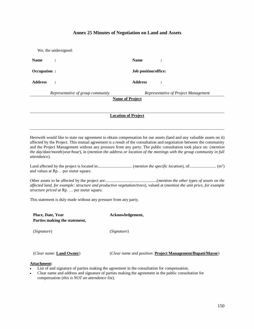
150
Annex 25 Minutes of Negotiation on Land and Assets
We, the undersigned:
Name :
Name :
Occupation :
Job position/office:
Address :
Address :
Representative of group community Representative of Project Management
Name of Project
Location of Project
Herewith would like to state our agreement to obtain compensation for our assets (land and any valuable assets on it)
affected by the Project. This mutual agreement is a result of the consultation and negotiation between the community
and the Project Management without any pressure from any party. The public consultation took place on: (mention
the day/date/month/year/hour), in (mention the address or location of the meetings with the group community in full
attendance).
Land affected by the project is located in:................................ (mention the specific location), of:......................... (m2)
and values at Rp… per meter square.
Other assets to be affected by the project are:.................................................(mention the other types of assets on the affected land, for example: structure and productive vegetation/trees), valued at (mention the unit price, for example
structure priced at Rp. … per meter square.
This statement is duly made without any pressure from any party.
Place, Date, Year Acknowledgement,
Parties making the statement,
(Signature) (Signature)
(Clear name: Land Owner) (Clear name and position: Project Management/Bupati/Mayor)
Attachment:
List of and signature of parties making the agreement in the consultation for compensation.
Clear name and address and signature of parties making the agreement in the public consultation for
compensation (this is NOT an attendance list).

151
Annex 26 Table of Compilation of PAPs and the Values of Assets
Project Name :
Location :
Place, Date/Month/Year, Acknowledgement,
Ratification:
Head of Bappeda/City PIU
(Bupati/Mayor)
Land Structure Vegetation Other
Asset Price Valuation
Name of PAP Total
number
Land
Type of Asset
Structure/Building Vegetation Other
Condition FunctionResettle/
notType
Total
numberTypeCondition
Original
size
Project
affected %
Size of remaining
structureStatusOriginal size
Project
affected size%
Size of remaining
landStatus Function

152
Annex 27 Table of Compilation List of PAPs, their Assets, and Compensation Values based on Negotiation
Venue, Date/Month/Year Acknowledgement,
Verification:
Head of Bappeda/City PIU
(Bupati/Mayor)
Type of Asset Agreement Based on Compensation Negotiation
Land Structure Vegetation OtherTotal
number
Land Structure/Building Other asset
Function TypeTotal
numberType
Resettle/
notSize Status Function Condition Size Status
Name of
PAP
Vegetation

153
Annex 28 Note on Free, Prior and Informed Consultations
1. Indigenous Peoples or Masyarakat Hukum Adat (Customary Law Communities) may be
vulnerable to the loss of, alienation/resettlement from or exploitation to natural and cultural resources.
IPs communities are often among the poorest of the poor in the community and closely tied to their
settlements, lands and related natural resources upon which the sustenance of their livelihoods depends.
Frequently, these lands and settlements are traditionally owned or under customary use and often not
legally recognized by national laws. In recognition of this vulnerability, interventions introduced
through this project with the objectives to improve land administration and address informal
settlements may potentially alienate and/or displace IPs if the mechanisms for Free, Prior and Informed
Consultations (FPICs) to obtain broad support are not built into project design and implementation.
2. Objective. The extent, frequency and degree of engagement required by the consultation
process should commensurate with the identified project risks and adverse impacts and with the
concerns raised by affected IPs. FPICs are built on mutually accepted process between affected
communities and project actors. FPICs serve at least two purposes:
a. Provide a platform to undertake a process of consultations in good faith and in a manner that
provides affected IPs with opportunities to express their concerns and views on the sharing of
development benefits, risks, impacts, and mitigation measures and explore ways to leverage
culturally and socially acceptable benefits.
b. Provide a two-way mechanism for facilitators and OCs to engage with IPs and their organizations,
including Adat councils, community groups (KSMs) and BKM/LKM to consider and respond to
the views and concerns expressed by affected IPs prior to project execution.
3. Procedures. FPICs should be orientated towards obtaining broad community support and by
which, broad community support consists of a collection of expressions by affected community
members and/or their recognized representatives in support of the proposed project/sub-project
activities. Although FPICs do not necessarily require unanimity and in some instances, decisions may
be achieved even individuals or groups within the community disagree, FPICs lay out organized and
iterative processes through which decisions and measures adopted by the project incorporate the views
of the affected IPs on matters that affect them directly.
4. The Community Participation Framework needs to be built on gender-sensitive and inter-
generationally inclusive approaches. Effective FPICs are built upon two-way processes that should:
a. Involve members of affected communities and their recognized representative bodies and
organizations in good faith.
b. Capture the views and concerns of men, women and vulnerable community segments including
the elderly, youth, displaced persons, children, people with special needs, etc. about impacts,
mitigation mechanisms, and benefits where appropriate as reflected in SIAPs and CSPs. If
necessary separate forums or engagements need to be conducted based on their preferences.
c. Begin early in the process of identification of environmental and social risks and impacts and
continue on an ongoing basis as risks and impacts arise.
154
d. Be based on the prior disclosure and dissemination/socialization of relevant, transparent, objective,
meaningful, and easily accessible information which is in a culturally appropriate language(s) and
format and is understandable to affected IPs. In designing consultation methods and use of media,
a special attention needs to be paid to include the concerns of Indigenous women, youth, and
children and their access to development opportunities and benefits.
e. Focus on inclusive engagement on those directly affected than those not directly affected;
f. Ensure that the consultation processes are free of external manipulation, interference, coercion
and/or intimidation. The ways the consultations are designed should create enabling environments
for meaningful participation, where applicable. In addition to the language(s) and media used, the
timing, venues, participation composition need to be carefully thought through to ensure everyone
could express their views without repercussions.
g. Be documented (see Annex 29).
5. In deciding whether to proceed with the project, the PMU with inputs from NMCs, TMCs,
OSPs and field facilitators ascertains on the basis of social assessment and FPICs whether affected IPs
provide their broad support to the project. Where there is such a support, BKMs/KSMs should prepare:
a. Documented evidence of FPICs as well as measures taken to avoid and minimize risks to and
adverse impacts of the affected IPs. This includes list of participants, meeting minutes and other
documentation (e.g. photos, video, etc.);
b. Additional measures, including project design modification, alternative locations, and where
applicable compensations to address adverse effects on affected IPs and to provide them with
culturally and socially appropriate benefits;
c. Action plan and recommendations for FPICs during project implementation, monitoring, and
evaluation, and
d. Any formal agreements reached with affected IPs and/or their representative organizations.
6. The World Bank will review the process and the outcome of the consultation carried out by
BKMs/LKMs with supervision from OSPs and facilitators to satisfy itself that the affected IPs have
provided their broad support to the project. The Bank does not proceed further with project processing
if it is unable to ascertain that such support exists.
7. Requirements. To ensure that FPICs can be ascertained, the following requirements are
needed to determine whether:
a. The level of engagement in a way that enables informed participation of affected IPs is acceptable;
b. The level of support and dissent among affected IPs for the project is taken into account into
decision making and development of mitigation measures.
Consideration Requirements
Project’s strategy and principles on engagement
- Community Participation Framework to mainstream FPIC;
- Project Operational Manuals on FPICs; - Budget and personnel provisions;
- Consultation schedules and other supporting documentation.
Stakeholder identification and analysis - Stakeholder analysis as part of the Social Assessment;

155
Consideration Requirements
Community Engagement - Consultation plan, public consultation and disclosure plan, and stakeholder
engagement plan; - Schedule and record of community engagement including discussions and
consultations with community members and their representatives.
Information disclosure - Disclosure plan, including schedules
- Materials prepared for disclosure and consultations;
- Record/minutes of discussions/consultations with community members and their
representatives
Free, Prior, and Informed Consultations - Record/minutes of discussions/consultations with community members and their
representatives; - Documentation of measures taken to avoid/minimize risks to and adverse
impacts on affected IPs based on community feedback; - Draft of Action Plan;
Consultations with vulnerable groups - Engagement and public consultation plan - Record/minutes of discussions/consultations with members and representatives
of vulnerable groups - Documentation of measures taken to avoid/minimize risks to and adverse
impacts on vulnerable groups based on community feedback - Draft of Action Plan
Grievance redress mechanism - Organizational structure and responsibilities and procedures to manage
grievances; - Record of grievances received, including expressions of support or dissent;
- Record/minutes of discussions with community members or representatives with
regards to grievance redress.
Feedback to affected IPs (to demonstrate that concerns and recommendations have been accommodated in the project and rationale why recommendations have not
been accommodated)
- Documentation of risk mitigation measures
- Record/minutes of discussions with community members and their
representatives; - On-going reporting on implementation of Action plan;
- Revisions in project/sub-project activities and Action Plan; - Surveys/interview records of affected IPs.
Formal expressions of support or dissent - Record/minutes of meetings/public consultations with community members and
their representatives; - Formal letters/written petitions of support/objection submitted by the
community and/or their representatives;
Informal expressions of support or objection
- Photographs, media reports, personal letters or third party accounts (NGOs,
CBOs, etc.)
Evidence of good faith consultations - Face-to-face interviews with community members/representatives in the
consultations; - Agreements reached with affected IPs (e.g. MoU, Letters of Intent, Joint
Statements, etc.) - Action plan, e.g. benefit sharing, development plan, etc.

156
Annex 29 Social Assessments of Indigenous People
1. Objectives. The purpose of Social Assessment (SA) is to evaluate the subproject’s potential
positive and adverse effects on the Indigenous Peoples in the case that Indigenous Peoples are present
in, or have collective attachment to the project area (based on the screening in accordance with the four
criteria as specified in the World Bank OP 4.10 and criteria on Masyarakat Hukum Adat and/or local
values), and to examine project alternatives where adverse effects may be significant. The breadth,
depth, and type of analysis in the SA are proportional to the nature and scale of the proposed
subproject’s potential effects on the Indigenous Peoples, whether such effects are positive or adverse.
In carrying out an SA, the city government will have to be assisted by a consultant team or individuals
who are social scientist whose qualifications, experience, and terms of reference are acceptable to the
PMU. Experts from local universities or local NGOs who have worked and have experienced in
working with the IPs are encouraged to assist the city government.
2. Outline of the SA. The SA will at least cover the following:
a. Description of Subproject Activity
b. Information about the Subproject Activity’s site and condition of the cultural community
c. Social Economic Characteristics of the affected Indigenous Peoples’ community
i. General Characteristics of IPs
ii. Specific characteristics of IPs
Cultural Social Institutions
Economic Condition and Source of livelihood for villagers
Cultural practices
Etc.
iii. Stakeholders assessments
d. Consultation process during the Social Assessment reflecting a free, prior and informed
consultation that leads to broad support from the affected IPs community on the proposed
Subproject Activity.
e. Findings and potential Subproject Activity’s impacts (positive and adverse).
i. Any potential negative (give examples)
Economic domination by outsiders
Transfer of ulayat rights
…
ii. Proposed Mitigation (give example)
Mitigation related to domination by outsiders
…
iii. Potential positive impacts and efforts to maximize these impacts
157
f. Proposed Action Plans in form of a table containing (to be included in the Draft IPP):
i. Plan to maximize the positive impacts
ii. Negative issues as findings from the study which needs mitigation
iii. The mitigation program
iv. Subproject Activities within the mitigation framework
v. Location where the impact and mitigation is going to be done
vi. Consultation framework for preparing and implementing IPP
vii. Institution in charge for preparing and implementing IPP
viii. Schedule for implementation
ix. Budget
x. Source of budget
xi. Remarks (other matters needs to be put in the report)

158
Annex 30 Format of Indigenous Peoples Plan (IPP)
The following template presents the outline of an IPP. The template can be further developed based on
field conditions and as per characteristics of the Project Activity.
Title of Chapter/Sub-
Chapter
Content/Remarks
1. DESCRIPTION OF THE PROJECT
Summary Description of Project Activity (concerning area boundary, location, type of occupation, area size, area of influence, etc.)
2. SUMMARY OF SOCIAL ASSESMENT
2.1.Baseline Data on IPs
Baseline information on the demographic, social, cultural, and political characteristic of the IPs community, the land
and territories traditionally owned or customarily used or occupied and the natural resources that they depend
Identification of key project stakeholders and elaboration of culturally appropriate process for consulting with the IPs at each stage of project cycle
2.2. Summary of results of the free, prior, and informed consultations with the affected Indigenous Peoples’
communities that was carried out during Project Activity’s preparation and led to broad community support for
the Project Activity
Identification of potential adverse and positive effects of Project Activity of the affected IPs within the Project
Activity’s area of influence
Development of measures necessary to avoid adverse effects or identification of measures to minimize, mitigate, or
compensate for such effects and ensure that IPs receive culturally appropriate benefits from the Project Activity
Mechanism to prepare and implement the public consultation with the Indigenous People (consultation concerning
the draft Project Activity plan, etc. as relevant), to include: determination of location and schedule of consultation, information dissemination /invitation, etc.
Public consultation process
Result/resolution and mutual agreement obtained during consultation meeting.
Number and representative of organization/institution presented by participants in the said consultation meeting.
2.3. A framework for ensuring the free, prior, and informed consultations with the affected IPs communities
during project implementation
3. ACTION PLAN (INPUTS FROM THE RESULTS OF THE SOCIAL ASSESSMENT)
3.1. Activities for IPs to receive social and economic benefits
3.2. Activities to avoid, minimize, mitigate, or compensate for adverse effects
3.3. Measures to Enhance the Capacity of the Project Management
3.4. Consultation with the affected IPs on the Draft IPP
4. COST ESTIMATE AND FINANCING PLAN In form of table containing information about: type of activity, party in charge, timeline/milestones, cost, funding source, and remarks.
5. INSTITUTIONAL ARRANGEMENT TO IMPLEMENT IPP
Agencies responsible for managing the implementation of the Indigenous Peoples Plan
Agencies responsible for reporting and monitoring on the implementation of the Indigenous Peoples Plan
Arrangements for monitoring of the implementation of the Indigenous Peoples Plan by the affected IPs
6. GRIEVANCE REDRESS MECHANISM ACCESSIBLE TO THE AFFECTED IPs
Mechanism for managing grievances as suggested by the results of the Social Assessment results
7. PROJECT MONITORING, EVALUATION, AND REPORTING OF IPP IMPLEMENTATION Includes arrangement for free, prior, and informed consultation with the affected IPs
Explaining the Work Plan for monitoring implementation of IPs and Reporting Mechanism.
Monitoring on progress implementation of IPP
Monitoring on process implementation of IPP
159
Title of Chapter/Sub-
Chapter
Content/Remarks
Reporting on implementation of (report to whom, which format to use, and deadline for submission of the report).
ATTACHMENT
Attach original or copy of documents as relevant to IPP, for example:
Information about the Project Activity (Map)
Table containing Baseline Data of IPs
Minutes of Dissemination and Consultation Meetings
Minutes of Agreement on Compensation Plan (if any) based on the consultations
Other relevant documentation
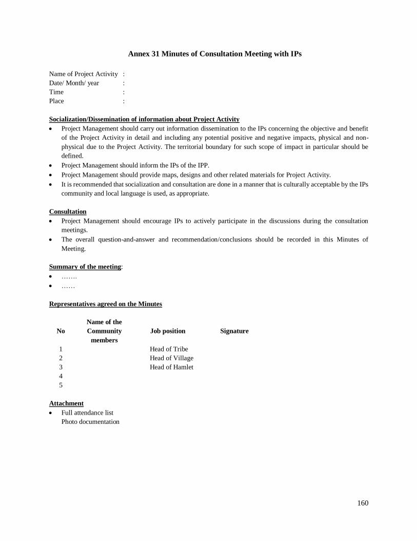
160
Annex 31 Minutes of Consultation Meeting with IPs
Name of Project Activity :
Date/ Month/ year :
Time :
Place :
Socialization/Dissemination of information about Project Activity
Project Management should carry out information dissemination to the IPs concerning the objective and benefit
of the Project Activity in detail and including any potential positive and negative impacts, physical and non-
physical due to the Project Activity. The territorial boundary for such scope of impact in particular should be
defined.
Project Management should inform the IPs of the IPP.
Project Management should provide maps, designs and other related materials for Project Activity.
It is recommended that socialization and consultation are done in a manner that is culturally acceptable by the IPs
community and local language is used, as appropriate.
Consultation
Project Management should encourage IPs to actively participate in the discussions during the consultation
meetings.
The overall question-and-answer and recommendation/conclusions should be recorded in this Minutes of
Meeting.
Summary of the meeting:
…….
……
Representatives agreed on the Minutes
No
Name of the
Community
members
Job position Signature
1 Head of Tribe
2 Head of Village
3 Head of Hamlet
4
5
Attachment
Full attendance list
Photo documentation

161
Annex 32 Monitoring and Reporting Guidelines
I. MONITORING
1. The scope of monitoring and procedures for evaluation of the management of environment,
land acquisition and resettlement, and IPs shall follow the General Guidelines of NSUP.
2. The scope of monitoring shall include, among others:
a. Conformity between the overall process in preparing the UKL/UPL or SOP, the Full LARAP or
Abbreviated LARAP, and the IPP (and/or design adjustment of the Project Activity) with the
procedures specified in these Technical Guidelines,
b. Conformity between the approved UKL/UPL or SOP, the Full LARAP or Abbreviated LARAP,
and the IPP (and/or design adjustment of the Project Activity) with their implementation on the
ground,
c. Completeness and validity of the supporting documents of the UKL/UPL or SOP/SPPL, Full
LARAP or Abbreviated LARAP, and IPP (design adjustment of the Project Activity).
3. At the National level, PMU supported by NMC using web-based monitoring system will
monitor the overall process of the planning and implementation of UKL/UPL or SOP/SPPL, the Full
LARAP or Abbreviated LARAP, and the IPP. National Task Force of Housing and Settlement will
also monitor the process through the project website. Also field visit, teleconference and/or
supervision mission will be carried if needed.
4. At the Provincial/District/City level, Provincial/City/District Task Force of Housing and
Settlement or PIU or Bappeda at City/District level supported by OSPs will monitor the overall process
of the planning and implementation of UKL/UPL or SOP/SPPL, the Full LARAP or Abbreviated
LARAP, and the IPP. Also field visit, teleconference and/or supervision mission will be carried
regularly.
5. Implementing unit (City/Regency PIU) at city/district level supported by City Coordinator
Team and Facilitator Team shall carry out monitoring on the following areas:
a. Dissemination of information about the Project Activity to the potential PAPs and potential
affected IPs;
b. Consultations during the preparation and implementation of UKL/UPL and SOP;
c. Consultations during the preparation and implementation of LARAPs and other schemes for
obtaining land (voluntary land donation, permit for the use of land and/or easement permits),
including compensation negotiation, as well as implementation of other measures, as agreed in the
LARAP;

162
d. Free, prior and informed consultations during the Social Assessment and preparation of the IPP
with the affected IPs community (that lead to broad support from the IPs on the mitigation measures
and IPP);
e. Dissemination of information to the public on the UKL/UPL, LARAP and other schemes of
obtaining land (voluntary land donation, permit for use of land and/or permit for easement), the
IPP, and their implementation;
f. Documentation of the consultations, complaints and settlement of the issues raised by various
parties during the implementation of the UKL/UPL, SOP, LARAP and other schemes for obtaining
land (voluntary land donation, permit for use of land and/or permit for easement) and IPP, and ;
g. Reporting of the monitoring results of the (1) – (6) to the Head of the Province and City/District.
II. REPORTING
1. Reporting Deadlines and Mechanisms should be in accordance with the General Guidelines of
NSUP concerning the Reporting Mechanisms.
2. The substance of the report should include components of environmental and social safeguards
management as follows:
a. General Data Form with separate columns added to assess conditions of the Indigenous Peoples,
or a separate table prepared for these purposes, as necessary.
b. Map, containing information about location, number, and identification of PAPs and potential
affected Indigenous Peoples.
c. Activity Plan Form, to be added with safeguard instruments in the form of UKL/UPL/SOP/SPPL,
Full or Abbreviated LARAP and various schemes for obtaining land (Statement Letter of Land
Donation/Land Use Permit/Land Easement Permit), and the IPP as well as the supporting
documentation.
d. Program Conformity Monitoring Form and Project Implementation Form, to be added with a report
on monitoring and implementation of the UKL/UPL, SOP/SPPL, IPP, in accordance to the existing
format or to be modified as necessary.
e. Final Report Form, to include activities as recommended by the UKL/UPL, the Full or Abbreviated
LARAP and IPP with a time frame for completion and budget.
3. Tables below provided as an example for monitoring and evaluation forms:
a. Table 1 General Data Form
b. Table 2 Program Conformity Monitoring Form
c. Table 3 Project Implementation Form

163
Table 1: Example of GENERAL DATA FORM
Kecamatan :
Kabupaten / Kota :
Province :
No
Name of
Kelurahan
(Urban Ward)
Area
(Ha)
Population Slum
area
(Ha)
Population
IP
Population
M W M W M W

Table 2: Example of PROGRAM CONFORMITY MONITORING FORM
Kecamatan :
Kabupaten / Kota :
Province :
No
Kelurahan
(Urban
Ward)
Type of
Infrastructure Volume Unit
Conform
with SIAP
Reason if not
conform with SIAP
Documentation
DED UKL/UPL* SOP/SPPL* IPP*
Drawing Spec Budget
*if applied
Table 3: Example of PROJECT IMPLEMENTATION FORM
Kecamatan :
Kabupaten / Kota : Province :
No
Kelurahan
(Urban
Ward)
Type of
Infrastructure Volume Unit
Beneficiary
Cost Procurement
Process
Plan (%) Realization (%) Problematic
Issues, incl.
UKL/UPL,
SOP/SPPL,
IPP
Handling
case M W Construction Fund Construction Fund

Annex 33 Grievance Redress Mechanisms
1. GRM in NSUP will continue PNPM Urban’s mechanism. Existing technical manual, SOP,
training modules, socialization materials, and recording of GRM data in project website will be adopted
and utilized for NSUP, including web-based data management of the GRM.
2. Based on experience of PNPM Urban as of December 31, 2015, about 148,000 complaints
have been recorded by MIS, whereby 62% located in World Bank’s funded areas. In total, 99% of
complaints have been resolved so far. The complaints were about critic, suggestion, and question on
administration and financial aspect, such as project procedure, misused of fund, negative intervention,
policy, ethics, force majeure, etc. Most of cases was concerning on implementation of infrastructure
and economic activities. None of complaints was related to safeguards directly. About 1.5% from total
complaints were identified as misuses of funds, amounting about IDR 4 billion (approximately US$
314,000), and about 40% of these outstanding cases have not been resolved for more than nine months.
PMU are still working out to resolve the misused of fund cases.
3. Complainants could convey the grievance verbally using face to face meeting with
BKM/LKM, project staff, consultant, facilitator, contractor, national government or local government,
or using other channels provided by the project, such as; i) complaint book or complaint box in BKM
office, project office, local government office or national office; ii) telephone, text messaging, and
facsimile to project staff, local government or to national line (+62817148048); iii) letter (national
address is PO BOX 2222 JKPMT); iv) email ([email protected]) and online complaint room in project’s
website (http://www.p2kp.org/pengaduan.asp?catid=1); v) audit report from various auditors, vi) etc.
4. At national level, complaint handling specialist and team will manage the GRM of NSUP
nationally. Complaint Handling Specialist at provincial level will facilitate the redress process to
ensure that all complaint will be handled properly and resolved. At city level and kelurahan level, city
coordinator and facilitator team will facilitate the grievance. If the case is under their authority, they
have to handle and ensure the case is resolved. Project staff at national and local government level
will facilitate and monitor the progress of the redress through web-based handling complaint
monitoring system (www.p2kp.org).
5. The project will provide training and socialization on GRM for project staff, consultant,
facilitator, local government, community, and other stakeholders. The training materials will not only
cover redress mechanism but also generating awareness on complaint handling.
6. As has been the practice of the GRM in PNPM Urban, there are five degrees/levels of redress
mechanism. The lowest degree (Degree 1) is if the case can be handled and resolved locally and the
highest degree (Degree 5) is if the case has to be handled by national stakeholders.

166
Figure GRM Institutional Arrangements
Table :A Sample of records of complaint handling:
Date of
Complaint
Type of
Complaint
Name/Address of
the of Complainants
Follow-up Agency in
Charge
Follow-up
activity
Date of Follow-
Up
3 December 2010
The roadway made by the contractor destroyed the
fence without any repair
Amir (received from sms 0813555666)
Contractor has been asked to do the repair on
site, and already done
SKPD Bina Marga
SMS from Grievance Redress Unit to the
sender's number
6 December 2010
National Housing and SettlementWorking Group
Provincial Housing and SettlementWorking Group
City Level Housing and SettlementWorking Group
face to face meeting with BKM/LKM, project
staff, consultant, facilitator, contractor,
national government or local government,
GRM UNIT at national level
GRM UNIT at provincial
GRM UNIT at city level
GRM UNIT at kelurahan
PMU
NMC
OSP
CITY COORDINATOR
FACILITATOR
VARIOUS CHANNEL OF GRIEVANCE
complaint book or complaint box in BKM office, project office,
local government office or national office
audit report from
various auditors
email ([email protected]) and online complaint
room in project’s website
(http://www.p2kp.org/pengaduan.asp?catid=1
telephone, text messaging, and
facsimile to project staff, local government
or to national line (+62817148048)
letter (national address is PO BOX 2222 JKPMT)
etc
DIRECT CHANNEL INDIRECT CHANNEL
BKM / VOLUNTEER
coordination line facilitation line reporting line