minnesota state gis enterprise conceptual architecture design · 3 minnesota governor’s council...
TRANSCRIPT
1
Minnesota State GIS Enterprise Conceptual Architecture Design
Version 1.0
March 23, 2005
Minnesota Governor’s Council on Geographic Information Conceptual Architecture Working Group
2
Minnesota Governor’s Council on Geographic Information Conceptual Architecture Working Group members include: David Arbeit (Land Management Information Center) David Bitner (Metropolitan Airport Commission) Chris Cialek (Land Management Information Center) Pat Cummens (Environmental Systems Research Institute, Inc.) Craig Devine (GeoAnalytics. Inc.) Mark Kotz (Metropolitan Council) Steve Lime (Minnesota Department of Natural Resources) Fred Logman (Independent Consultant) Robert Maki (Minnesota Department of Natural Resources) Matt McGuire (Dakota County)
3
Minnesota Governor’s Council on Geographic Information Conceptual Architecture Working Group
Minnesota State GIS Enterprise Conceptual Architecture Design This conceptual design document describes a system of computerized data and application resource sharing within the State of Minnesota Geographic Information System (GIS) community. The envisioned system would promote interoperability among data and application providers, reducing long-term costs in data resource and software application development for the participants. The document is intended to provide a framework for investment in the proposed system. As a conceptual design, it avoids technical specifications (e.g. hardware and software) and administrative implementation details, except where obvious industry or de facto standards present themselves.
4
Minnesota State GIS Enterprise Conceptual Architecture Design
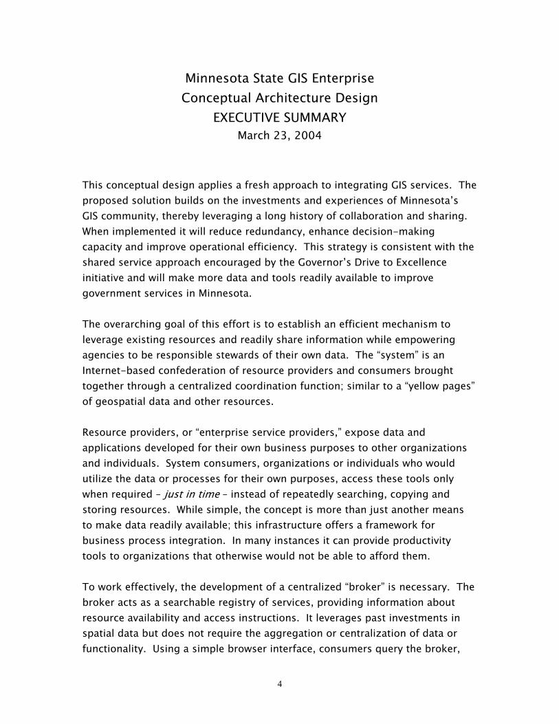
EXECUTIVE SUMMARY March 23, 2004
This conceptual design applies a fresh approach to integrating GIS services. The proposed solution builds on the investments and experiences of Minnesota’s GIS community, thereby leveraging a long history of collaboration and sharing. When implemented it will reduce redundancy, enhance decision-making capacity and improve operational efficiency. This strategy is consistent with the shared service approach encouraged by the Governor’s Drive to Excellence initiative and will make more data and tools readily available to improve government services in Minnesota. The overarching goal of this effort is to establish an efficient mechanism to leverage existing resources and readily share information while empowering agencies to be responsible stewards of their own data. The “system” is an Internet-based confederation of resource providers and consumers brought together through a centralized coordination function; similar to a “yellow pages” of geospatial data and other resources. Resource providers, or “enterprise service providers,” expose data and applications developed for their own business purposes to other organizations and individuals. System consumers, organizations or individuals who would utilize the data or processes for their own purposes, access these tools only when required – just in time – instead of repeatedly searching, copying and storing resources. While simple, the concept is more than just another means to make data readily available; this infrastructure offers a framework for business process integration. In many instances it can provide productivity tools to organizations that otherwise would not be able to afford them. To work effectively, the development of a centralized “broker” is necessary. The broker acts as a searchable registry of services, providing information about resource availability and access instructions. It leverages past investments in spatial data but does not require the aggregation or centralization of data or functionality. Using a simple browser interface, consumers query the broker,

5
find services, then directly interact with the resource providers. Conceptually, this is similar to conducting a Google search, then linking to the information of interest. The broker function facilitates enforcement of requisite standards and protocols, as well as possibly providing authentication (security) services. This architectural approach allows participants to continue to make hardware and software choices best suited for their organizations, requiring only that they utilize common industry communication and protocol standards, such as, XML, for example. Investments required to making this proposed architecture a reality, include the establishment of the “broker” capability, and a commitment by several governmental entities to actively participate. Benefits include, an innovative capacity to provide improved services, at the same time reducing costs across the enterprise by controlling unnecessary duplication.
6
Background The Governor’s Council on Geographic Information, through its Strategic Planning Committee, issued a white paper in June, 2004 proposing a strategic plan for enterprise-wide GIS in Minnesota. A Foundation for Coordinated GIS; Minnesota’s Spatial Data Infrastructure (MSDI)1 describes a framework that includes policies, standards, and practices that would improve the availability of needed data, promote integration of technology, encourage collaboration among organizations, and extend access to geospatial technologies to organizations that would not otherwise benefit from them. The benefits of a well-designed and effectively implemented MSDI include more information resources available to state programs, more efficient public information dissemination, and more state agencies profiting from the technology; enhancing the state’s return on publicly-funded technology investments. Among its recommendations, A Foundation for Coordinated GIS suggests that a conceptual architecture for integrated state services be developed. This report is an initial attempt at fulfilling that recommendation. As envisioned, the Minnesota State GIS Enterprise builds upon the considerable body of experience already gained in this subject area by several government agencies, particularly Land Management Information Center (LMIC), Metropolitan Council (Met Council), and Department of Natural Resources (DNR). Statewide efforts to facilitate data discovery and distribution using the Minnesota GeoGateway2, Data Deli3, and Data Café4 have been largely successful. They will prove instructive to designers of the new enterprise environment, which aspires to extend current capabilities to the areas of direct data access and shared application services.
Purpose
The design presented here describes a system through which organizations can extend data and application resources to other organizations and individuals. The intent is to create an environment that offers little incentive to reproduce a capability that has already been developed somewhere else, thereby minimizing redundancy and optimizing investment. The system envisioned here also provides a framework for
1 A Foundation for Coordinated GIS can be found on the web site of the Minnesota Governor’s Council on Geographic Information at: server.admin.state.mn.us/resource.html?Id=9084 2 http://geogateway.state.mn.us 3 http://deli.dnr.state.mn.us 4 http://www.metrogis.org/data/datafinder/MetroGIS_DataFinder_Cafe_WhitePaper.pdf
7
business process integration between government units, where application developers employ well-defined methods to extend business application components to collaborating partners. In short, the authoring committee is advocates the development of an enterprise environment that actively provides opportunities for government entities to collaborate.
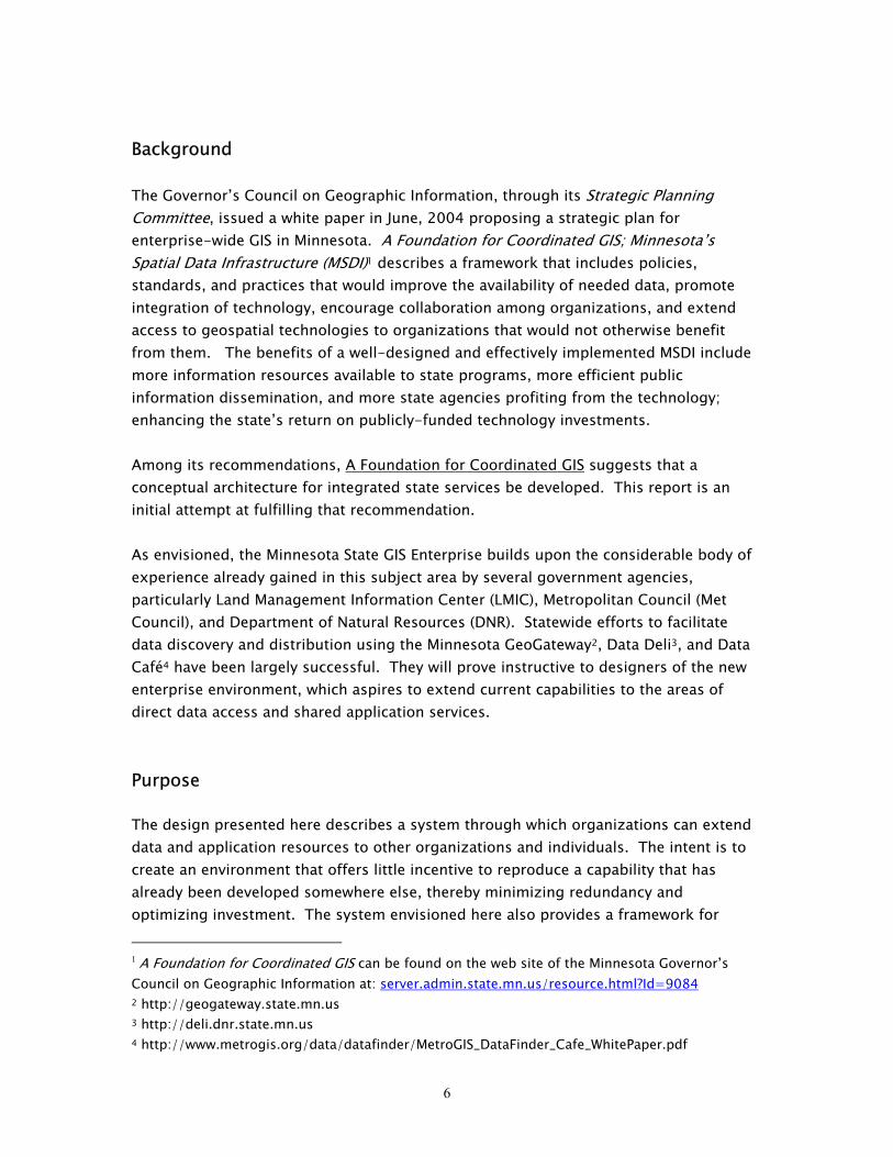
Design Overview The Minnesota State GIS Enterprise (the “Enterprise”) is envisioned as a confederated system of resource providers and consumers, with a centralized coordination function supplied by an (as yet) unnamed administrative entity (Figure 1).
CentralizedCoordination
Function
Resource Consumers
Figure 1. Minnesota GIS Enterprise Overview.
Resource ProviderResource Provider
Resource Provider
Resource Provider
Consumers learnabout resourcesthrough a set of
coordinationservices
Consumersaccess resourcesdirectly from the
source
ResourceProviders workwith CentralizedCoordination toensure proper
functioning of thesystem
The proposed system would be Internet-based, with a variety of data types streaming directly from providers to consumers. Enterprise Service Providers (ESPs) are logically resident at sites that provide some type of data or application resource conforming to enterprise standards. Data resources within this context could be raw data for graphical viewing, or more succinct data packages as responses to requests from consumers. This latter case follows a services paradigm where an ESP provides some type of
8
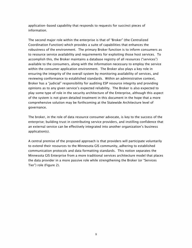
application-based capability that responds to requests for succinct pieces of information. The second major role within the enterprise is that of “Broker” (the Centralized Coordination Function) which provides a suite of capabilities that enhances the robustness of the environment. The primary Broker function is to inform consumers as to resource service availability and requirements for exploiting those host services. To accomplish this, the Broker maintains a database registry of all resources (“services”) available to the consumers, along with the information necessary to employ the service within the consumer application environment. The Broker also plays a key role in ensuring the integrity of the overall system by monitoring availability of services, and reviewing conformance to established standards. Within an administrative context, Broker has a “judicial” responsibility for auditing ESP resource integrity and providing opinions as to any given service’s expected reliability. The Broker is also expected to play some type of role in the security architecture of the Enterprise, although this aspect of the system is not given detailed treatment in this document in the hope that a more comprehensive solution may be forthcoming at the Statewide Architecture level of governance. The broker, in the role of data resource consumer advocate, is key to the success of the enterprise; building trust in contributing service providers, and instilling confidence that an external service can be effectively integrated into another organization’s business application(s). A central premise of the proposed approach is that providers will participate voluntarily to extend their resources to the Minnesota GIS community, adhering to established communication protocols and data formatting standards. This notion separates the Minnesota GIS Enterprise from a more traditional services architecture model that places the data provider in a more passive role while strengthening the Broker (or “Services Tier”) role (Figure 2).
9
Figure 2: Traditional Middle Tier Services Architecture
Catalog______________
ConsolidatedServices
______________
Security
Client GUI
ApplicationsDevelopment
Web Browser
ApplicationServices Tier Client ApplicationsBackend Databases
AS 400
SQL Server
Oracle
The Minnesota GIS Enterprise model is considerably more federated than the traditional “middle tier” example provided in Figure 2, which requires either: 1) a major realignment of staff resources and business functions (with an associated high level of risk to the contributing agencies for continuity of service), or 2) a major staff investment to create a fully-featured application services tier. Instead, the approach suggested here equips each ESP site to create data services/resources of general utility. This reduces the staffing requirement of the Broker role considerably. The approach is optimistic about government impulses to share data and application resources. The authoring committee feels that there is adequate evidence indicating that the Minnesota State GIS community is sufficiently organized and participatory to create a viable Enterprise under these terms. Establishing the low-level framework described above creates opportunities for the development of consolidated enterprise services with broad impact, including data bundling-data delivery services, map compositing, street address-matching, and theme-specific clearinghouses for communities of users.
10
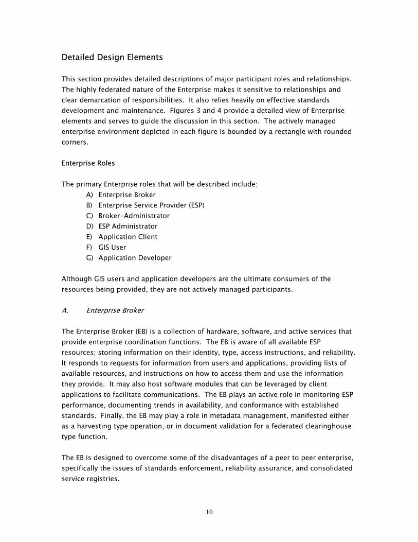
Detailed Design Elements This section provides detailed descriptions of major participant roles and relationships. The highly federated nature of the Enterprise makes it sensitive to relationships and clear demarcation of responsibilities. It also relies heavily on effective standards development and maintenance. Figures 3 and 4 provide a detailed view of Enterprise elements and serves to guide the discussion in this section. The actively managed enterprise environment depicted in each figure is bounded by a rectangle with rounded corners. Enterprise Roles The primary Enterprise roles that will be described include:
A) Enterprise Broker B) Enterprise Service Provider (ESP) C) Broker-Administrator D) ESP Administrator E) Application Client F) GIS User G) Application Developer
Although GIS users and application developers are the ultimate consumers of the resources being provided, they are not actively managed participants. A. Enterprise Broker The Enterprise Broker (EB) is a collection of hardware, software, and active services that provide enterprise coordination functions. The EB is aware of all available ESP resources; storing information on their identity, type, access instructions, and reliability. It responds to requests for information from users and applications, providing lists of available resources, and instructions on how to access them and use the information they provide. It may also host software modules that can be leveraged by client applications to facilitate communications. The EB plays an active role in monitoring ESP performance, documenting trends in availability, and conformance with established standards. Finally, the EB may play a role in metadata management, manifested either as a harvesting type operation, or in document validation for a federated clearinghouse type function. The EB is designed to overcome some of the disadvantages of a peer to peer enterprise, specifically the issues of standards enforcement, reliability assurance, and consolidated service registries.

11
The FGDC Clearinghouse5 and Geospatial One-Stop (GOS)6 sites provide examples of some Broker capabilities. The Clearinghouse provides a single point of contact regarding available resources while maintaining statistics on clearinghouse node availability. GOS tests metadata documents for standards compliance as part of its metadata harvesting function.
5 http://www.fgdc.gov/clearinghouse/clearinghouse.html 6 http://www.geo-one-stop.gov/
12
ESP 3
ESP 2
ENTERPRISEBroker ESP 1
ESPAdministrator
EBAdministrator
User
Application Developer 3 2
ApplicationClient 1
A
G
F
E
DC
B
Figure 3: Enterprise Roles
13
A list of Enterprise Broker functions includes:
Providing services that facilitate data discovery and fitness for use
determination (federated vs. centralized metadata management requires additional discussion)
Providing services that supply server connection information Providing some (currently non-specified) role in authentication process
(security) Hosting a source-services catalog (a registry database) Ensuring ESP compliance with enterprise standards Monitoring ESP access-reliability Providing support to application developers seeking to work within the
system, including documentation type validation services Hosting application objects that connect the broker to client applications
The EB also provides additional system level functions to track usage, update enterprise websites, and support other capabilities. Only one EB exists in the enterprise. The EB could reside anywhere within the enterprise, although it likely would be best situated in an organization with a clear mandate for coordinating enterprise functions. B. Enterprise Service Provider Enterprise Service Provider (ESP) is an Internet server that hosts one or more services accessible by clients within the enterprise environment. Any number of ESP’s could exist within the enterprise. An ESP exists at a contributing site, offering a suite of services registered at the Enterprise Broker site. It conforms to a standards-based operating domain. The hardware/software implementation at the site is irrelevant, as long as it is capable of accepting requests and generating standard results. The enterprise would be capable of incorporating services that already exist, leveraging our current investment. Many of these could be added to the system without modification. These include a wide variety of aerial imagery and web-based mapping products. Services may respond to a variety of communications protocols. Data products provided to the requestor may also be variable within the domain of accepted standards. For example a server may accept Web Mapping Services (WMS) requests and ship either a TIFF or JPEG file to the requestor; or it may accept a Minnesota standards-specific request for a 100 foot buffer around a sensitive trout stream, and ship a standard
14
geographic markup language (GML) file to the requestor in response; or it might respond to a request for an extensible markup language (XML)-formatted list of drivers’ license applications submitted during the previous 24 hours. An ESP is a “primary” service provider granting access to individual data resources and singular application capabilities (such as those listed in the previous paragraph). More complex services that build on these capabilities are technically classified as primary service “consumers” and properly categorized as Application Clients (AC’s). Examples of these include:
A service that draws on geographic data from multiple sources to create a symbolized web-based cartographic product,
An application that bundles data originating from multiple sources into a single delivery package, or
an application that composites data from multiple sites in real time to create a new data product available for distribution.
The boundary between primary service provider and primary service consumer is a conceptual one. In practice, the distinction is trivial. In a high-level description such as this, however, it provides focus to the actively administered enterprise domain, and isolates that realm from the value-added work of entities leveraging these core capabilities for specific business purposes.
A list of Enterprise Service Provider functions includes:
Publishing data using compliant web services protocols (responding to requests for raw data in requested format or in standard XML formats)
Hosting services that provide common business function capabilities that can be used repeatedly by multiple application clients
Interacting effectively with established security framework Publishing metadata in enterprise standard schema
An ESP could exist at either a government or non-government site. Any number of ESP’s could exist within the system. C. Enterprise Broker-Administrator The Broker-Administrator (BA) is the human complement to the EB, maintaining critical EB systems, interfacing with developers and users, providing system governance, organizing work groups around critical standards issues, providing training and technical support to developers, and enforcing policy related to participation in the enterprise. The size of the staff charged to fill this role would depend on the extent of
15
its responsibilities. As the size of the enterprise increases, additional staff may be required to maintain it. Overall, the size of the support staff may be most influenced by resource diversity of the system. Efficient staff utilization comes with greater standardization. Regardless, the investment in staff required to maintain the system would be considerably less than the cost associated with developing and maintaining redundant capabilities across the enterprise.
A list of Broker-Administrator functions includes:
Sponsoring and implementing enterprise standards Maintaining system security Maintaining services catalog (add, delete, retire, modify) Responding to support inquiries from existing and prospective service
providers Developing and delivering training to cooperators Certifying ESP’s Facilitating work groups engaged in coordination activities, such as
standards development and system performance audits Monitoring system performance
D. ESP Administrator The ESP Administrator is an authority responsible for maintaining the integrity of services provided at their site. Realistically, this responsibility requires a blend of hardware and software administration, and possibly, some custom development. ESP Administrator must have current knowledge of the standards affecting the services provided at that site. The ESP administration function may experience pressure from within the host organization to prioritize internal technical requirements at the expense of the enterprise view.
A list of ESP Administrator functions includes:
Maintaining base level hardware/software Ensuring compliance with established data and services standards Supporting metadata access Providing current information to EB with regards to service availability and
access Interfacing with Enterprise Broker-Administrator to resolve technical
difficulties and working to enhance enterprise functions
16
E. Application Client An Application Client (AC) is an application-consumer of enterprise published data. The AC is the mechanism by which enterprise information is rendered intelligible to GIS Users. AC’s can take a variety of forms ranging from generalized GIS desktops (e.g. ArcCatalog-ArcMap) to server-side business applications with very succinct information requirements. Connecting an AC to the Enterprise Broker will require an intermediary application or application component to facilitate communications. These component(s) would either be resident on the broker site, or otherwise available for integration with the client application. A list of AC functions could potentially encompass the full operating domain of a commercial GIS software suite (e.g. query processing, data conversion, symbolization, etc.) and will not be listed here.
Within the context of the enterprise, the AC has two principal functions:
Interfaces with Enterprise Broker to obtain information regarding resource availability, for the purpose of informing Enterprise Users or providing ESP site connection information.
Accesses data from ESP’s and either processes the information to obtain a result, or generates some sort of information product (a graphic display or report).
Application clients may themselves be service providers within the larger enterprise. For example, an application may exist that creates data bundles from multiple sources (as in DataFinder Café). As noted in the discussion on Enterprise Service Providers, this category of application technically exists as a consumer of primary services and is therefore outside of the primary enterprise. F. GIS User GIS Users are desktop computer users that interact with the system via a range of scenarios ranging from thick client applications (such as ArcGIS) to browser-based server-side applications. GIS users are serviced by the technical architecture, but the user role in and of itself is not a primary one within the architecture. Users are buffered by Application Clients, which serve as points of integration with the technical architecture.
17
G. Application Developer Application developers are special classes of users that require specialized and detailed access to enterprise functions. They are differentiated because additional utilities may need to be created to support staff working specifically in a development environment. Some application developers would be tasked with maintaining standard program modules that connect Application Clients to the technical architecture. Enterprise Relationships Enterprise roles function collaboratively through relationships that have their own sets of unique properties governing them. Relationships explicitly identified here include:
1. Application Client – Enterprise Broker 2. Application Client – Enterprise Service Provider 3. Enterprise Broker – Enterprise Service Provider 4. Enterprise Broker – EB Administrator 5. Enterprise Service Provider – ESP Administrator 6. EB Administrator – ESP Administrator 7. Enterprise Broker – Application Developer 8. Applications Client – GIS User 9. Application Client – Application Developer
The subsections below are keyed on Figure 4. 1. Application Client – Enterprise Broker The “Client-Broker” relationship is a heavily used path through the system. Clients will nearly always begin by querying the broker, regardless of the application context. General use clients (such as ArcCatalog) will acquire lists of available resources. More specialized application clients will acquire the latest ESP connection information. Key relationship properties include:
Requires standard communication client Requires connection information Requires authorization Makes requests to determine service availability Requires development to support each vendor’s software
2. Application Client – Enterprise Service Provider

18
The Client-ESP relationship is a non-brokered exchange of information following established enterprise communication standards. Key relationship properties include:
May either be a: o Vendor-specific relationship, or o Cross-vendor relationship enabled by a service communication standard and
data formatting standards

19
ESP 3
ESP 2
ENTERPRISEBroker ESP 1
ESPAdministrator
EBAdministrator
User
Application Developer 3 2
ApplicationClient 1
4 5
1
7
6
3
2
8
9
Figure 4: Enterprise Relationships
20
May require additional client software to process returned XML documents (i.e. XML parser)
Client request requires parameters (e.g. area of interest) Client request may require an authentication string (token) of some kind
3. Enterprise Broker (EB) – Enterprise Service Provider (ESP) The EB and ESP maintain some amount of machine-level communication; monitoring availability, possibly providing some form of EB validation service to the ESP, and (perhaps) engaging in some type of metadata harvesting operation. Key properties of the relationship include:
Service monitoring (e.g. FGDC: http://registry.fgdc.gov/serverstatus/ ) Applying validation services (checking XML documents coming out of
Applications for validation; done once/periodically) Authentication verification
4. Enterprise Broker – EB Administrator This is the relationship between the system administrator and the Enterprise Broker. In this case, the level of commitment needed to maintain the system could be fairly high, considering the many processes dependent on the robustness of the EB role. The Administrator is key in ensuring that the broker is a robust entity. Key properties of the relationship include:
Administrator maintains content Administrator provides care and feeding of the Broker (e.g. hardware, software,
updates, OS patches, etc.) Administrator generates service monitoring reports
5. Enterprise Service Provider – ESP Administrator This is the relationship between the system administrator and the system node.
Administrator maintains ESP capabilities 6. EB Administrator – ESP Administrator This is principally the person-person relationship required to maintain proper system functioning, adhere to standards, involve participants in the enterprise standards process, and other necessary human interactions. Key properties of the relationship include:
21
EB Administrator works with ESP Administrator to resolve observed technical
problems related to non-conformance and service reliability ESP Administrator reports GIS client problems with overall system functioning
7. EB – Application Developer
Application developer submits output data for validation 8. Applications Client – GIS User
Interacts through applications interfaces Using an application
9. Application Client – Application Developer
Application developer maintains application clients
Enterprise Standards Requirements Standards are essential to creating cohesive, stable, and predictable computing enterprises with low operational and maintenance costs. The standards issue is one of considerable scope and, if properly dealt with, will generate lengthy discussion. This document treats the subject in general terms, avoiding implementation detail. Within the context of the Minnesota State GIS Enterprise, several required standards categories are likely to emerge, including standards governing:
Requests from clients to Enterprise Broker (EB) Services Requests from clients to Enterprise Service Providers (ESP’s) Transfer of service configuration information from ESP’s to the EB ESP data transfer formats Digital narrative metadata document formats Narrative metadata publishing formats Formatted EB responses to requests for information Enterprise security and authentication
It is hoped that existing industry standards would be available to meet most of the enterprise standards requirements. A number of clearinghouse-type enterprises under development at the federal level that are well positioned to provide direction in this
22
regard (see footnotes 5 and 6). The Open GIS Consortium (OGC)7 also is actively developing standards relevant to this effort and similar federal efforts. Even with effective collaboration, it is likely that some custom standards development will be necessary.
Conclusion This document provides a conceptual framework for a Minnesota State GIS Enterprise environment. The Working Group members believe that the approach suggested here strikes a practical balance between maintaining agency-based business computing capabilities, and providing opportunities for collaboration within the larger state enterprise. Clearly, much work would need to be done to transform this proposed design into a functioning system. The centerpiece of the system, the Enterprise Broker, does not currently exist, nor is there any provision for its creation in any current budget. Without the Enterprise Broker, the system cannot exist, and opportunities for collaboration will remain distant and much less likely to occur. No cost estimates have been developed for designing and implementing the system; although clearly an initial investment would be required in addition to the operational costs of a first generation system. It is also unclear where the Enterprise Broker role would reside. The obvious choice in Minnesota would be Land Management Information Center (LMIC), within the Department of Administration. A close alliance with Office of Technology, also within Administration, seems like a practical step. Regardless, the hosting agency would need to maintain robust technical competencies and sound working relationships based on trust and a strong customer-service ethic. The Minnesota GIS community is arguably the most cohesive and well-coordinated group within the state computing enterprise. Advances in technology offer solutions today to hurdles that have stymied cooperative system integration in the past. The Working Group members believe that the community is ready to embrace the concepts presented here and are motivated to follow them to a successful conclusion.
7 http://www.opengeospatial.org/