minutes of the 21st meeting of the expert appraisal ......1 minutes of the 21st meeting of the...
TRANSCRIPT
1
Minutes of the 21st Meeting of the Expert Appraisal Committee for River Valley and Hydroelectric Projects held on 28.01.2019 at Teesta Meeting Hall, 1st
Floor, Vayu Block, Indira Paryavaran Bhavan, Jor Bagh Road, New Delhi–3. The 21st meeting of the re-constituted EAC for River Valley & Hydroelectric Projects was held on 28.01.2019 with the Chairmanship of Dr. Sharad Kumar Jain in the Ministry of Environment, Forest & Climate Change at Teesta Meeting Hall, 1st Floor, Vayu Wing, Indira Paryavaran Bhavan, Jor Bagh Road, New Delhi-3. The following members were present. 1. Dr. Sharad Kumar Jain - Chairman 2. Shri Sharvan Kumar - Representative of CEA 3. Dr. J.A. Johnson - Representative of WII 4. Dr. Vijay Kumar - Rep. of Ministry of Earth Sciences 5. Dr. D.M. More - Member 6. Dr. J.P. Shukla - Member
7. Dr. S. Kerketta - Member Secretary
Shri N.N. Rai, Dr. A.K. Sahoo, Prof. R.K. Kohli, Dr. T.P. Singh, Shri Chetan Pandit, Dr. (Mrs.) Poonam Kumria, Dr. S.R. Yadav and Dr. Govind Chakrapani could not present due to pre-occupation. The deliberations held and the decisions taken are as under: Item No. 21.0 Confirmation of the minutes of 20th EAC meeting.
The Minutes of the 20th EAC (River Valley & Hydroelectric Projects) meeting held on 27.11.2018 were confirmed. Item No. 21.1 Cumulative Impact Assessment and Carrying Capacity Study (CIA
& CCS) of Satluj River Basin. Presentation of draft report before the EAC for recommendation of the Study.
The draft report on “Cumulative Environmental Impact Assessment (CEIA) & Carrying Capacity Study (CCS) of hydroelectric projects in Sutlej river basin in Himachal Pradesh” was presented by Indian Council of Forestry Research and Education (ICFRE), Dehradun along with its partner institutions viz. Alternate Hydro Energy Center (AHEC), Indian Institute of Technology (IIT), Roorkee; ICAR-Directorate of Coldwater Fisheries (DCFR), Bhimtal and Salim Ali Center for Ornithology and Natural History (SACON), Coimbatore before the 21st Expert Appraisal Committee (EAC) of River Valley and Hydroelectric Projects of MoEF & CC on 28.01.2019 at New Delhi. As Dr. S.K. Jain, the Chairman of the EAC has also contributed technical inputs in the study, Dr. D.K. More was requested to Chair the meeting for this item only. Dr Jain did not participate in deliberations for this item. Background
The CEIA study final draft report for 38 HEPs in Sutlej River Basin, Himachal Pradesh was submitted and presented before 91st EAC of MoEF & CC on 08.02.2016. The EAC had suggested:
To include all HEPs including less than 10 MW in the CEIA study The Luhri project (775 MW), to be studied as Luhri Stage - I (210 MW), Stage -
II (170 MW) and Stage - III (355 MW) Slope should be considered as a factor determining riparian distance between
two cascading projects
2
Dropping of project should be based on scientific and logical reasoning framework, supported with index methodology
Depth range (m) for fishes to be reviewed Important criteria, other than fish to be considered for assessing
Environmental Flow Requirement (EFR) Critical habitat for wildlife falling within specific project to be included in the
report. During the meeting, EAC was appraised about the recommendation of 91st
EAC meeting. The compliance of the recommendation communicated vide MoM [Agenda 2.7 (C)] was presented and discussed in detailed. Thereafter, a presentation on present study awarded by MoEF & CC with CIA assessment of all 153 HEPs was made.
It was informed that for finalization of HEPs for additional study, the following
meetings were held:
Review meeting with Place & Date Decision
Review meeting with Joint Secretary (RVP)
On 03.05.2016 ICFRE was directed to submit the project proposal including budget requirement and work plan for the additional study of HEPs of less than 10 MW and Luhri HEP stage I, II & III
Meeting with DGF & Special Secretary MoEF & CC
Dehradun on 05.06.2017
Finalized number of HEPs for conducting study = 91 HEP (88+3) (<10MW and Luhri-I,II & III)
Progress review meeting New Delhi on 04.12.2017
Progress reviewed and proposed to hold stakeholders meeting at Shimla
Stakeholder meeting Shimla on 2.02.2018
A list of 27 micro HEPs (< 100 kW), were provided to ICFRE. Of which 2 HEP viz., Sol and Deva SHEPs were excluded as both fall outside the study area of Sutlej basin.
It was intimated that the study involved the active participation of the
following institutes as per the subject expertise with ICFRE as a Lead Organization:
Study component Institution
Biological Environment (Terrestrial Flora) & Socio Economic Environment
Indian Council of Forestry Research & Education, Dehradun, UK
Hydrological studies in the basin Alternate Hydro Energy Centre (AHEC), IIT, Roorkee in association with NIH, Roorkee.
Aquatic ecology studies ICAR-DCFR-Directorate of Coldwater Fisheries Research, Bhimtal
Terrestrial Fauna and Avi Fauna studies.
SACON-Salim Ali Centre for Ornithology & Natural History, Coimbatore, TN
A total of 153 hydroelectric projects were considered for the CEIA study, of
which 28 HEPs are commissioned, 18 HEPs are under construction and 107 HEPs are under development. A total of 143 HEPs are distributed in 78 the tributaries of Sutlej River. Only 10 projects exist on main Sutlej River. There are 130 small hydroelectric projects (of less than 25 MW capacity) and 23 large projects (of above 25 MW capacities).

3
Environmental Units
The study area has been divided into distinct environmental units based on the elevation, geology, hydrology, climate and vegetation viz.
1. Zanskar range is the most prominent range of the Trans Himalaya consisting of 3000-3800 m that separates Spiti valley.
2. Greater Himalaya or Inner Himalaya consists of high hills 5having elevation in the range 000 - 6000 m in the south of Spiti valley, in Kinnaur.
3. Lesser or the middle or central Himalaya: The average elevation ranges from 651 m to 1088 m up to Rampur Tehsil of Shimla district. Geologically, this part study area lies between the Main Boundary Fault and the Main Central Thrust.
Geology
The major geological setting consists of:
Trans - Himalayas (TH) : Lies in the cold arid region and is covered by lofty Greater Himalayan range. Spiti valley is composed of continuous series of highly fossiliferous marine residue rocks. The average elevation is between 3,000-3800 m
Great Himalayas (GH) is the most prominent in the southern part of Spiti and in Kinnaur. It has a mean elevation of 5,500 m with several peaks rising over 6,000 m.
Lesser Himalayas: The Middle or Lesser Himalaya is located north of Shiwalik range having peaks of 1,000–4,000 m high. Several peaks rise to nearly 5,000 m and remain snow covered throughout the year.
Rainfall
The study area receives most of the rainfall during the monsoon season, which starts in June / July. Intense rainfall focused at elevations of 900±400 m and 2100±300 m especially at the southern front. Due to rain shadow effect of the Dhauladhar and Pir Panjal ranges, rainfall starts decreasing towards Lahaul-Spiti and Kinnaur. Spiti valley is closed from all sides by high mountains and therefore it is driest and most of the precipitation falls in the form of snow. Seismic Zone
The entire study falls in the seismic zone – IV, except for part of Bilaspur which falls in the lower zone under seismic zone - V EAC Deliberations
The findings of the report, viz. Environmental Flow Requirements (EFR); Riparian distance between two cascade projects; Land Use / Land Cover changes, Water Availability & Water Quality, Sedimentation; Terrestrial and Aquatic Floral & Faunal Diversity, Socio Economic component of the environment, Cumulative Impacts and Recommendations were presented at length by the Consultant.
After detailed deliberations, following suggestions were made by the EAC:
1. EFR is required to be relooked and need to be reworked based on the river cross sections at important places and water depth requirement specific to the fish species and other uses, in the diverted river stretch due to the
4
hydroelectric project. As lower stretch of the Sutlej river is having high fish abundance and catch, river being flat compared to middle and upper Sutlej river stretch may require different EFR for hydroelectric projects falling therein.
2. Land Use / Land Cover changes with respect to snow cover area class should be rechecked and verified for the variation shown in the change detection for snow cover area.
3. Occurrence of Golden Mahseer in lower stretch of Sutlej river has been reported by Department of Zoology, Punjab University, Chandigarh / Department of Fisheries, Punjab Govt. The presence/absence of Golden Mahseer in lower stretch of Sutlej river (i.e. Koldam reservoir and its upstream) should be rechecked and documented appropriately in the study report. The presence/absence of two endemic fish species reported from Spiti valley may also be taken into account appropriately in the study report.
4. The exact locations / stretches of the fish breeding and spawning sites as mentioned in the report should be marked on a map and highlighted and details be given in the report.
5. Draft Guidelines of CWC regarding longitudinal connectivity has not yet been finalized or approved by GoI. Therefore, such references and exercise to be avoided.
6. The HEPs of below 10 MW/25 MW capacity proposed to be dropped based on their location in core or buffer zone of Protected Areas and their ESZ shall be relooked in terms of threat to the wild life (terrestrial faunal groups like- mammals, reptiles, amphibians, birds, butterflies etc.) on habitat, migration routes, breeding sites, plants, fish, etc.) due to hydroelectric project. The recommendations presented should be consolidated and specific. The recommendation regarding hydroelectric projects proposed to be dropped should be supported with scientific data.
7. The mammals like Snow Leopard, Common Leopard and birds like Monal, Cheer Pheasant, etc. are also of conservation concern as per IWPA, IUCN. This should be taken into consideration in the study report.
8. Data ‘Inventory and revival of natural springs in Himachal Pradesh’ may be collected from secondary sources.
9. Fish species listed to be revisited, important species such as Mahseer, Dipticus, schistura sp. are missing. Also requested to check species valid names.
10. E-flow recommended for downstream area is 20% is inadequate in the contest of presence of migratory species like l. dero, l. dyochelius and mahseer. It needs to be revisited according to the species need.
11. Endemic bird species & threatened mammals species in the project area need to be included.
12. Endemic bird species & threatened mammals species in the project area need to be included.
****
Item No. 21.2 Asthi Lift Irrigation Scheme-III in District Beed, Maharashtra by M/s Water Resource Department, Govt. of Maharashtra – reg. reconsideration of EC. File No J-12011/14/2015-IA-I, Proposal No. IA/MH/RIV/28875/2015
The Project Proponent (PP) was represented in the meeting by only an
Executive Engineer. The EAC took note of this and desired that senior officers at the appropriate level, viz., Chief Engineer, etc. who are familiar with the project need to attend the meeting (at directed in the agenda notes) to present the proposal and
5
answer the queries of EAC members. Such officers will be able to make commitments on behalf of PP, if required, to ensure the compliance of approved norms.
In view of the above, the EAC deferred the item and directed that the officers
at the appropriate level, viz., Chief Engineer or above will attend the meeting when the project comes up for appraisal.
**** Item No. 21.3 Bandu Nala Pumped Storage Project (900 MW) by M/s WBSEDCL
located at Sirkabad, Bhuda, Shilingda, Ayodhya, Lohadungri, Gurahata, West Bengal-reg. Fresh ToR. File No. J-12011/4/2019-IA.1 (R), Proposal No. IA/WB/RIV/88520/2018
The Project Proponent submitted a proposal for Pumped Storage Project
(900 MW) to the Ministry on 11.01.2019. The Project Proponent (PP) and the consultant, WAPCOS limited made a detailed presentation of the project and inter-alia, provided the following information:
The proposed Bandu Pumped Storage Project (900 MW) is located near Ayodhya village in Purulia district of West Bengal, India. The Scheme envisages construction of: 1) 71 m high Rock fill upper dam across river Bandu to provide a live storage of 13.49 MCM with FRL at 480.00 m and Minimum draw down Level (MDDL) at 460.83 m. Pondage for 1 MCM Irrigation requirement is also proposed in Upper Reservoir. 2) 53 m high Rock fill lower dam across river Bandu to provide a live storage of 13.49 MCM with FRL at 340.44 m and MDDL at 325.00 m. 3) An underground powerhouse with four numbers Francis type reversible pump-turbine of capacity 225 MW each. 4) An underground Transformer cavern with four numbers Power Transformer of capacity 280 MVA each. One 400 kV Gas insulated Switchgear. Headrace Tunnel size: 8.30 m (dia) x 847 m (long) x 2 lines); Tunnel size after bifurcation: 5.90 m (dia) x 112 m (long) x 4 lines, Pressure Shaft, draft tube and tailrace tunnel [Tunnel size (steel lined/draft tube): 7.00 m (dia) x 100 m (long) x 4 lines) [Tunnel size: 9.80 m (dia) x 628 m (long) x 2 lines) for conveyance of water.
There is no reserve forest, National Park, Wildlife sanctuary, Tiger/Elephant
reserve, biosphere reserve, etc. in and around the project. However, forestland is observed in the proposed project area. About 198 ha of land shall come under submergence at FRL for Upper Reservoir (97 ha) and Lower Reservoir (101 ha). Additional land is to be acquired for dam, water conductor system, power house, muck disposal areas, quarry and other project appurtenances is 189 ha. Thus, total forestland to be acquired for the project is 387 ha. 10.00 ha non-forestland (private land) is required for construction of project colony including contractor colony.
The Bandu nala carries only seasonal flow of water during and immediately
after the rains. During the monsoon, it becomes a torrent and water level rises within a few hours after heavy rains. The Bandu nala drains a catchment area of about 24.00 sq. km at the proposed lower dam site and 3.50 sq. km at upper dam site. The design flood has been assessed as 600.00 cumecs for lower dam and 130 cumecs for upper dam.
The scheme would afford on annual peaking period energy generation of
1642.50 GWh annually. The project would provide 900 MW of 5 hours daily peaking capacity benefits. Upper reservoir is having 1.0 MCM storage for irrigation purpose which can be utilised in future development.
6
The EAC deliberated on the proposed project in detailed based on the information provided by the PP and, recommended to grant fresh ToR/Scoping
clearance with the following additional conditions:
i. All the statutory clearances required for the project shall be obtained and incorporated in the EIA/EMP.
ii. Land acquired for the project shall be suitably compensated in accordance with the law of the land with the prevailing guidelines. Private land shall be acquired as per provisions of Right to Fair Compensation and Transparency in Land Acquisition, Rehabilitation and Resettlement Act, 2013.
iii. The project involves about 387 ha of forestland. Forest clearance shall be obtained as per the prevailing norms of Forest (Conservation) Act, 1980.
iv. Appropriate Biodiversity Conservation and Management plan for the Native, Rare & Endangered floral and faunal species getting affected due to the project shall be prepared.
v. The PP should complete all the tasks including conducting public hearing (as per the provisions of EIA Notification, 2006 and as amended time to time) and submit the application for final clearance within the stipulated time.
**** Item No. 21.4 Brutang Major Irrigation Project in Nayagarh District of Odisha by
M/s Water Resources Department, Government of Odisha- reg. Extension of Validity of EC. File No. J-12011/87/2005-IA.I, Proposal No. IA/OR/RIV/10185/2005
The PP submitted the Brutang Irrigation Project (Major) at Nayagarh District online on 1.1.2019 for seeking of extension of validity of environmental clearance issued on 02.06.2006. The PP made the presentation of the present status of the project and inter-alia, provided the following information:
It has been proposed to create a reservoir by constructing an earthen dam of 42 m height and 552.0 m long on Brutang nalla near village Manjari. The water will then be routed from Brutang reservoir to the existing downstream Kuanria Reservoir through a 12 km long link canal. It proposes provision of irrigation in 23,300 ha of ayacut in the 5 drought prone blocks (Nayagarh, Dasapalla, Khandapada, Nuagaon and Odagaon) of Nayagarh district, Odisha. The project involves 1524.12 ha of forestland. The project also involves submergence of 41 villages including partly submergence. Baisipalli wildlife sanctuary is located within 1.5 km away from the Brutang reservoir. The cost of the project is Rs. 1,014.66 crores (2013 price level) and BCR is 1.702.
The PP further submitted that Environmental Clearance (EC) was issued to
this project vide letter No. J-12011/87/2005-IA-I dated 02.06.2006 for a period of five years. The validity of EC expired in June, 2011. Further, extension of validity of EC was given for five years i.e. from 02.06.2011 to 01.06.2016. The PP requested MoEF & CC through online application dated 01.01.2019 for further extension of validity of EC up to 02.06.2021. The PP also intimated that the cause for delay in implementation of the project is mainly in delay in compliance of stipulations for Stage-I Forest Clearance including time taken to obtain the NBWL clearance.
While securitizing the proposal, the PP was requested to provide some information. The PP, vide their letter dated 26.11.2018, submitted the status of the project as below:
1. Topographical survey completed. 2. T.A.C. clearance obtained in 2000.

7
3. R&R clearance obtained from Ministry of Tribal Affairs, Government of India vide their letter No.200011/8/2003-CP and R/NGO dated 09.06.2008.
4. The Stage-I Forest clearance obtained from Ministry of Environment, Forest and Climate Change, Government of India vide letter Nos. F.No.8-23-FC dated 31.08.2010 and F.No.8-23/2010 F dated 09.09.2010.
5. The Pre-Construction survey work is under process.
The EAC deliberated in detailed as per the presentation and facts provided by the PP. Further, Member Secretary informed in the meeting that as per the S.O. 294 (E) dated 14.09.2016 of the Ministry, the prior EC granted for a project or activity shall be valid for a period of ten years in the case of River Valley Projects [Item 1(c) of the Schedule]. This period of validity may be extended by the Regulatory Authority concerned by a maximum period of three years, if an application is made to the Regulatory Authority by the PP within the validity period, together with an updated Form I. In the present case, a period of ten years has been completed on 01.06.2016. As per the above Notification, there is an outer limit of three years exists beyond 10 years for River Valley projects, but the PP did not apply even within ninety days of such validity period for condoning the delay for grant of extension of the validity of EC. The construction work at the site is yet to be taken up by the PP. Therefore, as per the guidelines of EIA Notification, 2006 and amendment thereof, the EAC deliberated the issue and recommended for taking of the proposal afresh and accordingly, the EAC recommended for rejection of the proposal.
**** Item No. 21.5 Nardave Medium Irrigation Project at Nardave, Tal: Kankavali,
Dist.: Sindhudurg by M/s Water Resources Department, Konkan Irrigation Development Corporation, Maharashtra Myakal- reg. consideration of Fresh Environmental Clearance. File No. J-11020/7/2017–IA.I(R), Proposal No. IA/MH/RIV/62328/2017
The Project Proponent (PP) along with MITCO Consultancy and Engineering
Services Ltd., Pune made a detailed presentation of the project and inter-alia, provided the following information:
The project envisages construction of earthen dam having a maximum height
of 66.43 m and 1,749 m length with gated spillway on the right flank and Irrigation cum Power Outlet (ICPO) on the left flank with gross storage capacity of 123.74 Mcum on Gad River near Nardev Village in Sindhudurg District of Maharashtra. The project has GCA of 12,631 ha, CCA of 9,978 ha and ICA of 8,084 ha on both the banks of Gad river from 48 villages of Kankavali, Kudal and Malvan Talukas of Sindhudurg District. Irrigation proposed in the project is by lift irrigation for which a series of 14 Nos. of K.T. Weirs shall be provided along the river course to enable lifting of water for irrigation. The project also envisages a dam foot power house with generation capacity of 3 MW. Total catchment area is of 47.70 km2. There is no upstream utilization and net annual yield at 75% dependability is 125.80 Mcum. There are no projects exist on the downstream of Nardave Medium Project.
The PP informed that the project was submitted to the Ministry for environmental clearance (EC) in 2011. The Ministry asked for forest clearance status on 19.12.2011 and the project was again resubmitted to the Ministry on 27.9.2012. The MoEF & CC did not consider the proposal as the project was falling in Western Ghat areas. Later on, the PP in the EAC meeting held during 2-3 March, 2017 intimated that Moratorium on Western Ghats has been lifted and therefore PP has applied online for grant of ToR on 8.2.2017 as per the EIA Notification, 2006 and amendment thereon.

8
The EAC in its 3rd EAC meeting noted that the project was initiated before EIA
Notification, 1994 and construction activities have been taken up accordingly. The original administrative approval for the project was given vide letter (Marathi) MHD/1085/(390/85) WRI dated 12.07.1989 for Rs. 3,243.78 lakhs. As the project was prior to enforcement of EIA Notification, 2006 and further, it was also not coming under the purview of EIA Notification, 1994, construction works had already been initiated. Till date, 61.50% work of total dam, 80% of ICPO, 40% of spillway work and 11 KT Weirs have been completed. As of now, Rs. 382.00 crores have been already spent. It was also further noted that some works have already been completed which appeared to be an ongoing project and subsequently, the project was stopped due to paucity of funds.
ToR was granted vide letter No. J-12011/7/2017 IA-1 (R) dated 10.10.2017
for collection of base line data and preparation of EIA/EMP report. Public hearing (PH) was held on 29.08.2018 at Dnyandeep Sanskrutik Bhavan, Madhyamik Vidya Mandir, Kanedi, Tehsil Kankavali, Dist. Sindhudurg Chaired by the District Collector, Sindhudurg. PP informed that issues raised during the PH were adequately addressed. Major issues were related to compensation under R&R, impact on biodiversity, risk due to dam break, air pollution and noise generation, etc. PP submitted the EIA/EMP report to the Ministry on 11.01.2019.
The total land requirement is 631.162 ha and almost 91% of land acquisition
work has been completed. Out of this total land, 585.772 ha is private land (19.115 ha to be acquired), 11.25 ha is Govt. Land and 34.14 ha is forestland. The submergence area in the catchment of the dam is 356.35 ha. Five (5) villages consisting of 967 houses are likely to be submerged due to the proposed project. Stage-I forest clearance for 34.14 ha of forestland has already been obtained on 30.09.2009 (No. 6-MHC 018/2011- BHO/1691). The project is about 2 km away from the Radhanagari Wildlife Sanctuary. Proposal was recommended for wildlife clearance by Standing Committee on NBWL held on 21.01.2015. The revised administrative approval has been accorded on 19.07.2007 [Marathi Govt. vide order No. Nardave-2007/140/(47/2007)-MPR-MPR Mantralay, Bombay]. The revised estimated cost of the project is about Rs. 44,670.76 lakhs (As per D.S.R.s 2005-06).
Base line data was collected during October 2017 to May 2018. In addition to
this, June to Sept 2017 data considered for ecology. Ambient Air Quality and Ambient Noise levels monitoring were carried out at 8 locations from both submergence and command area of the project. Air quality at all the stations was within prescribed limit. Surface water samples from 5 locations and that of Groundwater from 9 locations have been collected. Most of the parameters are found to be well within the prescribed limits. Soil samples have been collected from 13 locations. In most of the project areas, the soil type is found to be silty clay. Soils found in the project area are fertile with moderate NPK and micro nutrients.
Project benefit includes : 1) Increase in employment: 62 persons; 2) The
proposed Nardave Medium Irrigation Project intends to irrigate 8,084 ha in 48 villages of Kankavali, Kudal and Malvan Taluka of Sindhudurg District; and 3) It will lead to increase in the agro-based industries in the command area, which would eventually lead to the economic up-liftment of the area.
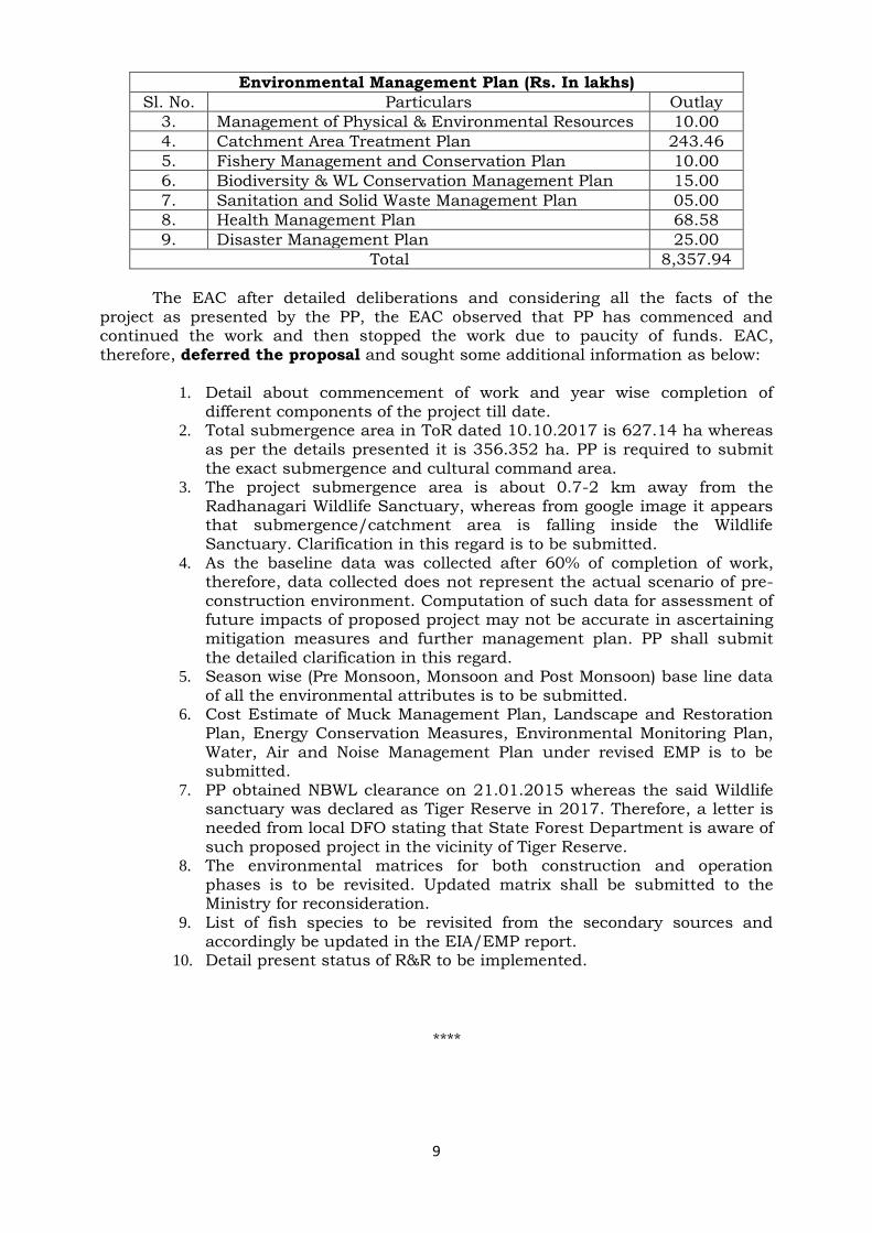
Environmental Management Plan (Rs. In lakhs)
Sl. No. Particulars Outlay
1. Rehabilitation and Resettlement Plan 7,840.83
2. Green Belt Development / Afforestration 140.07
9
Environmental Management Plan (Rs. In lakhs)
Sl. No. Particulars Outlay
3. Management of Physical & Environmental Resources 10.00
4. Catchment Area Treatment Plan 243.46
5. Fishery Management and Conservation Plan 10.00
6. Biodiversity & WL Conservation Management Plan 15.00
7. Sanitation and Solid Waste Management Plan 05.00
8. Health Management Plan 68.58
9. Disaster Management Plan 25.00
Total 8,357.94
The EAC after detailed deliberations and considering all the facts of the
project as presented by the PP, the EAC observed that PP has commenced and continued the work and then stopped the work due to paucity of funds. EAC, therefore, deferred the proposal and sought some additional information as below:
1. Detail about commencement of work and year wise completion of different components of the project till date.
2. Total submergence area in ToR dated 10.10.2017 is 627.14 ha whereas as per the details presented it is 356.352 ha. PP is required to submit the exact submergence and cultural command area.
3. The project submergence area is about 0.7-2 km away from the Radhanagari Wildlife Sanctuary, whereas from google image it appears that submergence/catchment area is falling inside the Wildlife Sanctuary. Clarification in this regard is to be submitted.
4. As the baseline data was collected after 60% of completion of work, therefore, data collected does not represent the actual scenario of pre-construction environment. Computation of such data for assessment of future impacts of proposed project may not be accurate in ascertaining mitigation measures and further management plan. PP shall submit the detailed clarification in this regard.
5. Season wise (Pre Monsoon, Monsoon and Post Monsoon) base line data of all the environmental attributes is to be submitted.
6. Cost Estimate of Muck Management Plan, Landscape and Restoration Plan, Energy Conservation Measures, Environmental Monitoring Plan, Water, Air and Noise Management Plan under revised EMP is to be submitted.
7. PP obtained NBWL clearance on 21.01.2015 whereas the said Wildlife sanctuary was declared as Tiger Reserve in 2017. Therefore, a letter is needed from local DFO stating that State Forest Department is aware of such proposed project in the vicinity of Tiger Reserve.
8. The environmental matrices for both construction and operation phases is to be revisited. Updated matrix shall be submitted to the Ministry for reconsideration.
9. List of fish species to be revisited from the secondary sources and accordingly be updated in the EIA/EMP report.
10. Detail present status of R&R to be implemented.
****

10
Item No. 21.6 Gimliang HEP (88.5 MW) Project in Anjaw District of Arunachal
Pradesh by M/s Sai Krishnodaya Industries Pvt. Ltd-reg. Extension of validity of ToR. File No. J-12011/1/2010-IA-I, Proposal No. IA/TG/RTV/87571/2017
The request for extension of validity of ToR was applied online by the PP on
31.12.2018. The PP along with the consultant made the presentation requesting extension of validity of Scoping Clearance for Gimliang HEP and inter-alia, presented the following:
Gimliang Hydroelectric Project is located in Anjaw District of Arunachal Pradesh. It envisages utilization of flow of Dav River, a tributary of Lohit River, for generation of electrical power in a run-of-the-river scheme. M/s SKIL have been allotted the project for development on BOOT basis. The diversion site is located about 1 km downstream of Goiliang Village and the barrage axis is located at Latitude 28008’25.05” N, Longitude 96038’03.29” E and the deepest river bed level is 934 m and FRL is fixed at 942 m. Surface powerhouse is located at Latitude 28005’1” N, Longitude 96033’42.32” E.
Dav river drains a catchment area of about 371.4 km2 at the proposed barrage site. The submergence area at FRL is estimated to be 1.0445 ha having a gross storage of 0.035 MCM. The Gimliang HEP envisages construction of:
A concrete Barrage 75.5 m long & 10 m high above river bed level, with 5 nos. of bays with crest level at EL. 934.00 m.
A Power Intake on the right bank aligned 900 to the river flow with invert level at EL. 936.00 m.
A 3.8 m diameter finished D-shaped head race tunnel about 9.537 km long.
A 8 m diameter, 112.3 m high restricted orifice type underground surge shaft with a dome at the top;
A 2.8 m diameter, 1.123 km long steel lined pressure shaft with three 2.0 m diameter steel penstocks each of length 41 m;
68.70 m (l) x 16.5 m (w) x 38 m (h) Surface powerhouse with 3 vertical Francis type units of 29.5 MW each;
41.5 m (l) x 65 m (w) Switchyard for housing Generator transformers & equipment.
Scoping Clearance for Gimliang HEP (88.5 MW) was accorded vide Ministry’s
letter dated 12.02.2015 with 3 years validity. Scoping clearance was extended by one more year i.e. till 11.02.2019 vide MoEF & CC letter dated 10.05.2018.
PP intimated that substantial work of survey and investigation, have been
completed. Hydrology and Power potential studies have been completed and approved by CWC. Topographic survey has also been completed, however, some geotechnical investigations are still pending. As the investigations are still incomplete, EIA and EMP studies could not be finalized, therefore extension of validity of TOR was requested for a maximum period of one year.
EAC deliberated that as per MoEF & CC OM dated 17.01.2017 and 29.08.2017, outer limit for validity of scoping clearance for River Valley and Hydroelectric Projects has been set as five years, therefore another year of extension can be granted. However, as per the present norms, this is final extension and no further request for extension will be entertained. PP was asked to complete EIA and EMP studies and submit the final report for appraisal after completing Public

11
Consultation process within the validity of TOR. Proponent was further asked to ensure that baseline data at the time of appraisal shall not be more than 3 years old.
EAC deliberated in detailed and recommended for extension of Scoping Clearance by one more year i.e. till 11.02.2020.
**** Item No. 21.7 Jeera Irrigation Project in the Bargarh District, Odisha by M/s
Department of Water Resources, Government of Odisha-regarding validity of Extension of EC. File No. J-12011/28/2010-IA.I, Proposal No. IA/OR/RIV/87677/2010.
The PP made a presentation for considering the proposal for grant of Environmental Clearance and inter-alia, provided the following information:-
The proposal was submitted online on 6.12.2019 for grant of environmental clearance to the proposed project (4,800 ha). The PP informed that earlier the proposal was discussed in the EAC meetings held during 23-24 September, 2015 and 2-3 June, 2016 for recommendation of EC. The proposal doesn’t involve displacement of families. However, 505.43 ha of private land will be submerged due to this project of which, 5.39 ha is forestland. The catchment area at the dam site is 124.90 km2 and the 75% dependable yield is 4679.40 ham. The gross storage of the project is 2,742.10 ham at 207.50 m FRL. It will provide irrigation facility in 6,000 ha of GCA and 4,800 ha of CCA with annual irrigation of 5,840 ha in the drought prone area of Bargarh district of Odisha. Once the project is implemented, the annual benefit will be Rs. 3,313.21 lakhs.
While considering the proposal for grant of EC by the EAC in its meeting
during 23-24 September, 2015, the EAC had recommended for grant of EC subject to submission of the following information:
1. Finalization of the forest diversion proposal/forest clearance. 2. Submission of Biodiversity Chapter of EIA/EMP report after
rectification by a Biological Expert/Botany Expert.
The above information was submitted to the Ministry and the EAC in its meeting held during 2-3 June, 2016 deliberated in detailed on the facts presented by the PP and recommended for grant of Environmental Clearance subject to submission of Forest Clearance which was informed to the PP by the MoEF & CC vide letter dated 29.07.2016. As the copy of Stage-I Forest Clearance could not be submitted within six months from the date of information given to the PP, the proposal was delisted from the pending list of the Ministry in July, 2017. The Forest Clearance for diversion of 5.391 ha of forestland was obtained from the Regional Office of MoEF & CC, Bhubaneshwar vide letter dated 04.08.2017 and the same was submitted to the Ministry by the PP vide letters dated 04.08.2017, 10.08.2017, 17.08.2017, 16.11.2017, 24.04.2018 and 18.10.2018. As the proposal was delisted from the pending list of the Ministry, the proposal could not be considered before the EAC as it was not appearing in the website of the Ministry. Subsequently, the proposal was opened again and made available for online submission of the documents for considering the proposal for grant of Environmental Clearance. The PP submitted the required documents online on 06.12.2018.
EAC deliberated on the facts presented by the PP and noted that the PP has submitted the Forest Clearance within eighteen months as per the OM dated 09.09.2011 but could not be considered before the EAC. Therefore, the EAC
12
recommended that the PP should be given benefit of granting of Environmental Clearance based on the documents submitted. In view of the above, EAC recommended for grant of Environmental Clearance as the requisite document submitted is complete and in order.
****
Item No. 21.8 Majhgaon Medium Irrigation project (CCA: 9,000 ha), Panna district, Madhya Pradesh, Water Resource Department, Madhya Pradesh – reg. reconsideration for EC. File No. J-12011/4/2017-IA-I(R), Proposal No. IA/MP/RIV/61490/2017
The Project Proponent and the Consultant, Enviro Infra Solutions Pvt. Ltd.,
Ghaziabad, made a presentation on the project and inter-alia, provided the following:
The project envisages construction of composite dam on Bada Nala (a
tributary of Ken River) near Narayanchua village to provide irrigation facility in Panna District of Madhya Pradesh. It is proposed to construct 3 dams on Bada Nala,viz. 8261.50 m long composite dam comprising of 1,123 m (left bank) and 3,237 m long (right bank) earthen dam with a maximum height of 36.35 m across Bada Nala and two (2) Saddle dams of length 2,171.5 m and 1,620 m. The Culturable Command Area (CCA) is 9,900 ha and irrigation facility proposed in Rabi Season is 9,900 ha, and in Kharif Season, it is 2,700 ha, benefitting 34 villages in Ajaigarh tehsil.
The total land requirement for project is 1,523.70 ha. The total submergence
area is 1,489.39 ha, out of which 426.763 ha is forestland; 166.197 ha is Government land and 930.80 ha is private land. The Stage-I FC clearance for diversion of 426.73 ha forest land has been granted vide letter No. F.8-37/2017-FC dated 3.5.2018. About 8 villages consisting of about 1,696 families are likely to be (partially) affected due to this project. The total estimated cost of the project is about Rs. 358.99 Crores.
The CCA of the project is 9,900 ha and it is a Category-B project. The Panna
Gangau Sanctuary and Ken Ghariyal Sanctuary are situated at a distance of 8.25 km and 5.25 km, respectively. Therefore, the General Conditions are applicable to this project. Hence, project was submitted at Central level. The project was granted scoping/TOR clearance on 16.5.2017 by Ministry of Environment, Forest & Climate Change.
The total catchment area of the river is 28,058 km2, out of which 24,472 km2
is in Madhya Pradesh and remaining 3,586 km2 is in Uttar Pradesh. The gross storage is 112.62 MCM and the live storage is 105.23 MCM. The total volumetric requirement of water during Kharif and Rabi Seasons shall be 15.08 MCM and 27.38 MCM, respectively. The Micro-irrigation by sprinkler shall be adopted in 100% command area.
Public Hearing (PH) was conducted by the Madhya Pradesh Pollution Control
Board on 28th May, 2018 in the Primary School of village Majhgaon, Tehsil Ajaipur, District Panna. The meeting was presided by Dr. Girish Kumar Mishra, CEO Zila Panchayat Panna (representative of DM, District Panna) and attended by Shri V.S. Rai, R.O., M.P. State Pollution Control Board, Sagar. PP informed that during PH, the likely impacts on various environmental attributes with prediction due to construction were discussed along with mitigation measures proposed. The provision under various management plan were clearly spelt out. The information on the villages to be affected due to project and the scheme for rehabilitation and

13
resettlement of displaced families and various grants under the plan as per The Right to Fair Compensation and Transparency in Land Acquisition, Rehabilitation and Resettlement Act, 2013 are explained to the general public during PH.
The project was earlier considered by EAC in its meeting held on 27.7.2018. After detailed deliberations, and considering all the facts of the project as presented by the PP, EAC sought additional information/ clarifications on one season baseline data and EIA/EMP revision, revisit and modification of environmental matrix provided in the EMP, information on fish species from secondary sources, plan for conjunctive use of water in the project area, CAD plan be revised and accordingly the EIA/EMP report be revised and submitted.
The PP submitted the additional information and the same have been presented before the EAC during meeting on 26.10.2018. The PP intimated that one season baseline data has been collected and included in Section 3.5.6 (Ambient Air), 3.5.7 (noise levels), 3.6.1 (soil), 3.7.2 (groundwater) and 3.7.3 (surface water). The resultant pollution load has been discussed in mitigation measures in Chapter-4 of EIA report. The capital budget under different heads has also been provided. Modified Leopold Matrix during construction/operation has been provided in Section 4.8 of EIA report. Information on fish species has been included in Section 3.9.9.1 of EIA and Chapter-9 of EMP. About 22 fish species have been listed in the report which has been collected from secondary sources. CAD plan has been revised based on the actual ground reality and accordingly, the EIA/EMP report has been modified and submitted. Conjunctive use of groundwater has been proposed in about 150 ha area by developing 50 tube wells. A revised CAD plan with revised financial allocation of Rs. 7,535.08 lakhs has been provided. Major positive and negative environmental impacts of the project have been provided. Details of revised EMP cost amounting to Rs.12,392 lakhs with break-up for both capital and recurring cost have been provided.
Summary of Total Cost Estimate under EMP (Rs. In Lakhs)
Sl. No. Plans Cost
1. Catchment Area Treatment Plan 450.00
2. Command Area Development Plan 7535*
3. Compensatory Afforestation Scheme 4477.00
4. Wildlife and Bio-diversity Management plan 25.00
5. Fisheries Management Plan 222.00
6. Resettlement and Rehabilitation Plan 6656.00
7. Green Belt Development Plan 36.00
8. Reservoir Rim Treatment Plan 25.00
9. Muck Management Plan 7.00
10. Landscape and Restoration Plan 4.00
11. Restoration Plan for Quarry Sites 25.00
12. Disaster Management Plan 8.00
13. Water, Air and Noise Management Plan 16.00
14. Public Health Delivery Plan 75.00
15. Labour Management Plan 18.00
16. Sanitation & Solid Waste Management Plan 54.00
17. Local Area Management Plan 180.00
18. Env. Safeguards During Construction Activities Including Road Construction
20.00
19. Energy Conservation Measures 21.00
20. Environmental Monitoring Plan 30.00
Total cost 12,392.00
* The cost of works under CAD Scheme has been excluded, as it will be funded under Central Plan with State.

14
After detailed deliberations based on the presentation including the facts presented by the PP, the Committee deferred the proposal and sought the following additional information:
1. The environmental matrices for both construction and operation phases
was presented. The committee opined that the PP shall relook at the matrices and update them since the PP was not able to justify some of the values. For each activity, weights should be assigned carefully. Updated matrices shall be submitted to the Ministry for reconsideration in the EAC.
2. One season data collected by the PP is from March-May, 2018 and is prior to the EAC meeting wherein the EAC sought some additional information. The PP must explain why such data was furnished along with the proof of collection of such data.
PP submitted the above information on 13.12.2018 and the same have been presented before the EAC during meeting held on 28.01.2019. The PP informed that major impacts are anticipated in construction phase. Modified Leopold matrix has also been updated/revised considering all short- and long-term impacts anticipated during construction phase. PP also informed that the consultant has completed the collection of third season monitoring data i.e. pre-monsoon 2018 in line with ToR and contract agreement made with Water Resource Department, MP and the same was incorporated in the revised EIA/EMP report submitted on 03.10.2018 in line with EAC MoM dated 27.07.2018. PP also submitted the proof of collection of pre-monsoon season data (March-May, 2018) by Noida Testing Laboratory (NABL accredited).
The EAC deliberated and considered all the facts of the project as presented
by the PP and the EAC recommended for grant of environmental clearance (EC) for the proposed project with the following additional conditions:
i. Necessary permission to be obtained for quarrying construction materials for the project as per the EIA Notification, 2006 and subsequent amendments thereof.
ii. Solid waste generated, especially plastic waste, etc. should not be disposed of as landfill material. It should be treated with scientific approach and recycled. Use of single-use plastics may be discouraged.
iii. Under CER activities, preference should be given to strengthen the basic amenities in the project affected villages like maintaining drinking water supply, providing health care facilities, etc.
iv. Preference to be given to the local villagers as per the requirements and suitability, in the job/ other opportunities in the project, etc.
v. Measures to be taken to develop skills of the local villagers particularly with respect to the trades related to construction works such as electrician, welder, fitter, etc.
**** Item No. 21.9 P.V. Narasimha Rao Kanthanapally Sujala Sravanthi Project
Jayashankar Bhupalapally District, Telangana by Irrigation & CAD Department, Government of Telangana – regarding consideration of Fresh EC. File No. J-12011/1/2010-IA-I, Proposal No. IA/TG/RTV/87571/2017
The Project Proponent and the Consultant, Environmental Health & Safety
Consultants Pvt. Ltd., Bengaluru, made a presentation on the project and inter-alia, provided the following:
15
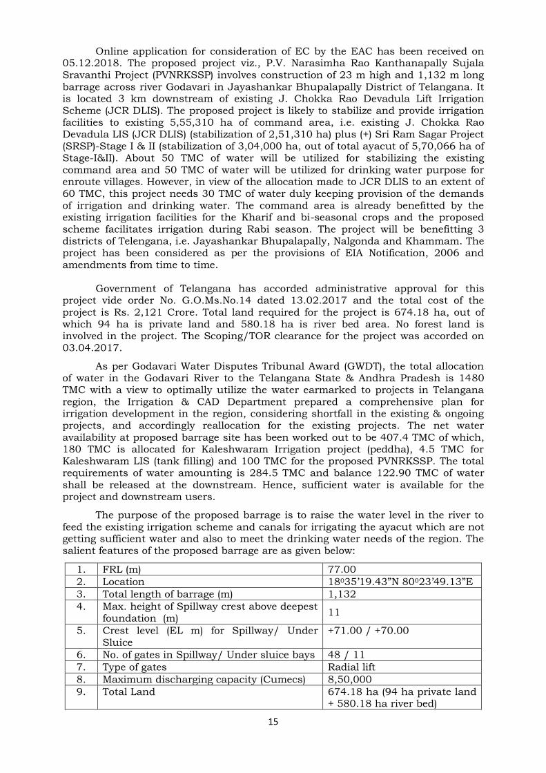
Online application for consideration of EC by the EAC has been received on 05.12.2018. The proposed project viz., P.V. Narasimha Rao Kanthanapally Sujala Sravanthi Project (PVNRKSSP) involves construction of 23 m high and 1,132 m long barrage across river Godavari in Jayashankar Bhupalapally District of Telangana. It is located 3 km downstream of existing J. Chokka Rao Devadula Lift Irrigation Scheme (JCR DLIS). The proposed project is likely to stabilize and provide irrigation facilities to existing 5,55,310 ha of command area, i.e. existing J. Chokka Rao Devadula LIS (JCR DLIS) (stabilization of 2,51,310 ha) plus (+) Sri Ram Sagar Project (SRSP)-Stage I & II (stabilization of 3,04,000 ha, out of total ayacut of 5,70,066 ha of Stage-I&II). About 50 TMC of water will be utilized for stabilizing the existing command area and 50 TMC of water will be utilized for drinking water purpose for enroute villages. However, in view of the allocation made to JCR DLIS to an extent of 60 TMC, this project needs 30 TMC of water duly keeping provision of the demands of irrigation and drinking water. The command area is already benefitted by the existing irrigation facilities for the Kharif and bi-seasonal crops and the proposed scheme facilitates irrigation during Rabi season. The project will be benefitting 3 districts of Telengana, i.e. Jayashankar Bhupalapally, Nalgonda and Khammam. The project has been considered as per the provisions of EIA Notification, 2006 and amendments from time to time.
Government of Telangana has accorded administrative approval for this
project vide order No. G.O.Ms.No.14 dated 13.02.2017 and the total cost of the project is Rs. 2,121 Crore. Total land required for the project is 674.18 ha, out of which 94 ha is private land and 580.18 ha is river bed area. No forest land is involved in the project. The Scoping/TOR clearance for the project was accorded on 03.04.2017.
As per Godavari Water Disputes Tribunal Award (GWDT), the total allocation of water in the Godavari River to the Telangana State & Andhra Pradesh is 1480 TMC with a view to optimally utilize the water earmarked to projects in Telangana region, the Irrigation & CAD Department prepared a comprehensive plan for irrigation development in the region, considering shortfall in the existing & ongoing projects, and accordingly reallocation for the existing projects. The net water availability at proposed barrage site has been worked out to be 407.4 TMC of which, 180 TMC is allocated for Kaleshwaram Irrigation project (peddha), 4.5 TMC for Kaleshwaram LIS (tank filling) and 100 TMC for the proposed PVNRKSSP. The total requirements of water amounting is 284.5 TMC and balance 122.90 TMC of water shall be released at the downstream. Hence, sufficient water is available for the project and downstream users.
The purpose of the proposed barrage is to raise the water level in the river to feed the existing irrigation scheme and canals for irrigating the ayacut which are not getting sufficient water and also to meet the drinking water needs of the region. The salient features of the proposed barrage are as given below:
1. FRL (m) 77.00
2. Location 18035’19.43”N 80023’49.13”E
3. Total length of barrage (m) 1,132
4. Max. height of Spillway crest above deepest foundation (m)
11
5. Crest level (EL m) for Spillway/ Under Sluice
+71.00 / +70.00
6. No. of gates in Spillway/ Under sluice bays 48 / 11
7. Type of gates Radial lift
8. Maximum discharging capacity (Cumecs) 8,50,000
9. Total Land 674.18 ha (94 ha private land + 580.18 ha river bed)

16
Public hearing was conducted at Zilla Parishad High School, Eturnagaram,
Jayashankar Bhupalapally District of Telangana on 27.9.2018 as per the provisions of the EIA Notification, 2006. All the issues raised during the public hearing have been incorporated in the EIA/EMP report. The main issues raised during the public hearing are implementing environmental safeguards to mitigate air, water and noise pollution, Catchment Area Treatment (CAT), jobs for local people and fair compensation for land losers. Majority of them supported the project for implementation.
The various environmental aspects covering the 10 km radius of proposed
barrage and existing command area were considered for baseline data collection. The baseline data (Monsoon season – July-September, 2017, Winter season – October-December, 2017 and Summer season January– March, 2018) was collected covering Physico-chemical aspects, biological aspects and socioeconomic aspects. Three (3) seasons data have been collected for air, noise, water, soil and ecological aspects. Impacts during construction and operation phases have been assessed and mitigation measures suggested for minimizing the anticipated impacts.
The project benefits are as given below: 1. No forestland is required for implementation of the scheme. 2. Construction of barrage across River Godavari acts as a reservoir thereby
supporting proliferation of fish species. 3. Existing irrigation schemes will be stabilized by providing assured water
for irrigation. 4. Providing safe drinking water to a large no. of villages, which has lot of
socio-economic concern. 5. Agricultural linkages will be considerably improved. 6. The project improves total farm output and hence raises farm income. 7. Altogether, 518 villages will be benefitted directly under the scheme. 8. Direct employment opportunities for 400 members (50 Technical and 350
construction labourers) will be provided during construction phase. Further, indirectly labour opportunities will be substantially improved since larger area will be brought.
The CWC vide letter No.16/27/2006-PA(N)/454-89, dated 14.03.2006 cleared
Sriram Sagar Project Stage-II for implementation. Further, vide CWC letter No. 16/27/2007 PA(N)-333-368, dated 7.3.2007, letter No. 16/27/2010-PA(N)/1939-64 dated 4.10.2010 and CWC letter No. 3/13/2017 /FTP-TLG/Mon (S)/406-16 dated 12.12.2017 accorded the clearance for implementation of J. Chokka Rao Devadula LIS.
The salient features of the project as stated in EIA/EMP report are as follows:
i. Catchment Area Treatment Plan – Catchment area of 85, 000 ha is earmarked for treatment and soil conservation measures and Rs. 158.15 Crore is estimated for implementation.
ii. The R&R Plan – Right to fair Compensation and Transparency in land Acquisition, Rehabilitation and resettlement Act, 2013 and modified Telangana Act, 2016 will be followed for compensating the land losers. Out of 94 ha, 65 ha has already been acquired and paid Rs.18.03 Crore of compensation and for remaining 29 ha, Rs. 2.53 Crore has been earmarked.
iii. Muck Disposal Plan - The project is expected to generate 32,72,754 m3 of muck. Of which, 6,54,551 m3 will be used for construction of guide and tie bunds, 6,54,551 m3 for construction of service paths, 11,45,464 m3 is used

17
for cut off trenches and 8,81,188 m3 will be used for restoration of construction area. The entire muck will be utilised in the project.
iv. Biodiversity conservation and restoration of Construction site –Restoration of construction area using green belt and plantation has been planned including conservation of Schedule-I species. An amount of Rs. 14 Lakhs is earmarked for this purpose.
v. Fisheries Development Plan – Construction of barrage and impounding of water will be beneficial to stock the fish species. An amount of Rs. 27 Lakhs has been earmarked for this purpose.
vi. Local Area Development Plan – Under this plan, upgradation of existing schools, identification of folk, art and cultural activities, smart classes and upgradation of Primary Health Centres will be taken up in the tribal areas. An amount of Rs. 40 Lakhs has been earmarked for this purpose.
vii. Environmental Monitoring Programme budget is Rs. 30.33 Lakhs earmarked for environmental monitoring during construction and operation phase of the project.
The cost estimates for implementation of EMP of the project is presented
below: Table – Cost Estimates (Rs. In lakhs) of Environmental Management Plan (EMP)
Sl. No. Heads Cost
1. Catchment Area Treatment (CAT) Plan 158,15.00
2. Command Area Development 70.00
3. Restoration of construction site (GB development) 14.00
4. Fisheries Conservation and Management Plan 27.50
5. Reservoir RIM Treatment 10.00
6. Land Acquisition 2,53.03
7. Local Area Development Plan (LADA) 40.00
8. Public Health Delivery System 10.25
9. Sanitation and Solid Waste Management Plan 7.00
10. Energy Conservation Measures 65.00
11. Environmental Safeguard Measures to control Air, Noise & Water Pollution
23.25
12. Environmental Monitoring Programme 30.33
Total 1,63,65.37
The EAC deliberated and considered all the facts of the project as presented
by the PP and deferred the proposal and sought the following additional information:
1. Price of water to be lifted be calculated based on the energy required. 2. The environmental matrices for both construction and operation phases
is to be revisited. Updated matrix shall be submitted to the Ministry for reconsideration.
3. Provisions of fish pass be explored. List of fish species to be revisited from the secondary sources and accordingly be updated in the EIA/EMP report. Minimum flow requirement be calculated during the leanest season for fish like Hilsa, Bengalensis.
4. Detail present status of R&R to be implemented. Land acquired for the project shall be suitably compensated in accordance with the law of the land with the prevailing guidelines. Private land shall be acquired as per provisions of Right to Fair Compensation and Transparency in Land Acquisition, Rehabilitation and Resettlement Act, 2013.
18
5. Only three reptile species are reported from the project area. It needs to be updated with updated list of reptiles present in this area.
6. Submission of certificate from the Chief Wildlife Warden that project is outside ESZ of Eturangaram wildlife sanctuary.
**** Item No. 21.10 Tapti (Chillure) Irrigation Project by Water Resources Department
at Village Naharpur, Dabida, Tehsil: Bhaisdehi, District: Betul M.P. – reg. Fresh ToR. File No. J-12011/01/2019-IA.I (R), Proposal No. IA/MP/RIV/76112/2018
The Project Proponent (PP) applied online vide dated 19.11.2018 for grant of
ToR/Scoping Clearance for collection baseline data and preparation of EIA/EMP report. The PP and R.S Enviro Technologies Pvt. Ltd., Gurgaon, Consultant, made a detailed presentation on the project and inter-alia, provided the following:
The present project envisages construction of an earthen dam with spillway (395 m long with 15 no.; 17x14.60 m) on river Tapti, in village Naharpur of Betul district; (Latitude 21048'19" and Longitude 77017'13"), 45 m long non-overflow dam and 37 km long main duct with 12 km long tunnel for Irrigation. Total length of dam is 745 m and the maximum height of earthen dam is 24.75 m with respect to bed level 364.00 m and is proposed to have a gross storage capacity of 305.00 MCM and live storage capacity of 277.27 MCM.
Total Catchment area of Tapti (Chillure) Dam as derived using google surveys is 3,129.98 km2 and there are 47 proposed and existing projects on the upstream of this project. The intercepted catchment area of upstream project is 1,380.00 km2. Net Catchment Area of the project is 1,749.98 km2.
The GCA of the project is 1,02,000 ha and total CCA of the project is 81,600 ha benefiting 82 villages of Khandwa district and 65 villages of Betul district. Thus total of 147 villages will be benefited. The proposed CCA of 81,600 ha is catered by two pressure pipe canal systems viz., 33,192 ha by applying power and remaining 48,408 ha by gravity flow. Maximum discharge required to be released into the canal is 29.26 cumecs. The pipe system is designed to carry 29.26 cumecs of discharge.
Project proponent informed that 16 villages in district Betul will be affected
due to submergence. Total affected families and persons because of proposed project are 1,158 and 3,937, respectively. A total 2785 ha land is required for construction of dam and reservoir, out of which 1073 ha is forest land; 334 ha is govt. land and 1,378 ha private land. Additional 59 ha (29.40 ha forestland and 29.60 ha private land) land is required for construction of duct and tunnel. A total of 200 technical staff and 800 construction labour force will engaged during construction of the project. The estimated cost of the project is Rs. 2627.95 crores.
The EAC deliberated on the proposed project in detailed based on the
information provided by the PP and recommended for grant of fresh ToR/Scoping clearance with the following additional conditions:
i. All the statutory clearances required for the project shall be obtained and incorporated in the EIA/EMP.
ii. Cropping pattern to be planned on 8 monthly basis. iii. Land acquired for the project shall be suitably compensated in accordance
with the law of the land with the prevailing guidelines. Private land shall be

19
acquired as per provisions of Right to Fair Compensation and Transparency in Land Acquisition, Rehabilitation and Resettlement Act, 2013.
iv. The project involves about 1,073 ha of forest land. Forest clearance should be obtained as per the prevailing norms of Forest (Conservation) Act, 1980.
v. As Tapti is Interstate river, clearances in respect of hydrology and water availability are to be obtained from CWC.
vi. All the tasks including conducting public hearing (as per the provisions of EIA Notification, 2006 and as amended from time to time) to be completed along with the application for EC within the valid period of ToR.
vii. As the Radhanagrai Wildlife Sanctuary is part of Sahyadri Tiger Reserve, which was declared in 2017, the legal status of land under zone of influence area need to be clarified, whether it is part of Buffer zone of tiger Reserve or Eco-sensitive zone?
viii. Fish species listed in the report is very less. This needs to be revisited and updated list of fish species in the project area need to be submitted.
**** Item No. 21.11 Raigam HEP (195 MW) project in Anjaw District of Arunachal
Pradesh by M/s Sai Krishnodaya Industries Pvt. Ltd.- Extension of validity of ToR. File No. J-12011/33/2014-IA-1, Proposal No. IA/AR/RIV/25142/2014
The request for extension of validity of ToR was applied online by the PP on
31.12.2018. Project proponent along with the consultant made the presentation requesting extension of validity of Scoping Clearance for Raigam HEP (195 MW) and inter-alia, provided the following information:
Raigam Hydroelectric Project is located in Anjaw District of Arunachal Pradesh. It envisages utilization of flow of Dalai River, a tributary of Lohit River, for generation of electrical power in a run-of-the-river scheme. M/s SKIL has been allotted the project for development on Build-Own-Operate-Transfer (BOOT) basis. The diversion site is located about 2 km upstream of Tee Pani Village and the barrage axis is located at Latitude 28º10’ 42.56” N, Longitude 96º31’ 19.56” E and the deepest river bed level is 710 m and FRL is at 725 m. Surface powerhouse is located at Latitude 28º5’ 46.30” N, Longitude 96º32’ 11.93” E.
Dalai river has a catchment area of about 1703 km2 at the proposed barrage site. The submergence area at FRL is estimated to be 9.6526 ha having a gross storage of 0.531 MCM. The Raigam HEP envisages construction of:
A concrete Barrage 149 m long & 14 m high above deepest foundation level, with 11 nos. of bays with crest level at EL. 710.00 m,
A Power Intake on the left bank aligned 900 to the river flow with invert level at EL 712 m,
7 m dia. finished modified horse shoe-shaped head race tunnel 10.375 km long,
A 22 m diameter, 77.82 m high restricted orifice type underground surge shaft with a dome at the top,
A 5.4 m diameter, 195 m long steel lined pressure shaft with three 3.20 m diameter steel penstocks of length 32.9 m/26.92 m/45.9 m,
89.6 m (l) x 18 m (w) x 40 (h) Surface Powerhouse with three vertical Francis type units of 65 MW each,
56.6 m (l) x 30 m (w) Switchyard for housing Generator transformers & equipment, and
Approximately 100 m long tail race channel connected to the river.
20
Scoping Clearance for Raigam HEP (195 MW) was accorded vide MoEF & CC
letter dated 12.01.2015 with 3 years validity. Then, scoping clearance was extended by another year i.e. till 11.01.2019 vide MoEF & CC letter dated 10.05.2018.
PP intimated that substantial work in survey and investigation have been completed. Hydrology and power potential studies have been completed and approved by CWC. Topographic survey has also been completed. However, some geotechnical investigations are still pending. As the investigations were still incomplete, EIA and EMP studies could not be finalized, therefore extension of validity of TOR was requested.
EAC deliberated that as per MoEF & CC OM dated 17.01.2017 and 29.08.2017, outer limit for validity of scoping clearance for River Valley and Hydroelectric Projects has been set as five years, therefore another year of extension can be granted. However, as per the present norms, this is final extension and no further request for extension will be entertained. PP was asked to complete EIA and EMP studies and submit the final report for appraisal after completing Public Consultation process within the validity of TOR. Proponent was further asked to ensure that baseline data at the time of appraisal would not be more than 3 years old.
EAC deliberated the facts presented by the PP and recommended for the extension of Scoping Clearance by one more year i.e. till 10.01.2020.
****
Item No. 21.12 Upper Krishna Stage III on Krishna river, Karnataka by M/s Krishna Bhagya Jal Laxmi Ltd., Karnataka- reg. reconsideration of EC. File No. J-12011/13/2014 IA.I (T), Proposal No.
IA/KA/RIV/22092/2014 The PP submitted the reply on additional information for grant of EC online on
31.12.2018. The PP gave a presentation on the reply submitted for grant of EC and inter-alia, submitted that the following information have been provided during the EAC meeting held on 24.08.2017:
UKP-III is an extension of UKP Stage-I and II projects to make use of the water
available to the state under KWDT Award-II. All these projects are in Krishna river that has a total basin area of 2.57 lakh km2, of which 1.13 lakh km2 of catchment falls in Karnataka state. The river being an inter-state river, water utilization as of now is in accordance with Krishna Water Disputes Tribunal (KWDT) award of 1976 based on the estimated 75% dependable yield with return flows. The water allocated to Karnataka state is 734 TMC. Accordingly, Govt. of Karnataka made a Master Plan to utilize 734 TMC of water for Krishna Basin. Accordingly, in upper Krishna basin two projects viz. UKP Stage-I and UKP Stage-II were allocated 119 TMC and 54 TMC water, respectively. Construction work of UKP Stage-I has been completed and that of UKP Stage-II is in progress. The total CCA proposed for irrigation in both the stages is 6,22,023 ha.
It was further informed by the PP that while agreeing to KWDT-II award in
December, 2010 based on 65% dependable yield and surplus yield, Government of Karnataka has allocated 130 TMC of water for UKP State-III project by way of storing additional water in the existing reservoir by raising FRL of Almatti Dam from EL 519.60 m to EL 524.256 m to irrigate an area of 5,30,475 ha (25 TMC under 65% dependability allocation and 105 TMC under surplus flow). Total utilization of water

21
for all the above three projects (upper Krishna Basin) will be (173 TMC + 130 TMC) 303 TMC.
UKP-III has been envisaged as an extension of UKP Stage-I and Stage-II
projects. It does not envisage construction of new dams or new structures across the river and only the sub-projects are to be taken up for extension of canals. Further, it has been planned to improve the socio-economic status of the people of the Hyderabad-Karnataka region which has been given special status under Article 371 (J) of the Constitution of India, wherein there is no assured drinking water and crops.
The proposed project involves nine sub-projects and utilization of 130 TMC of
water to irrigate 5,30,475 ha area in seven districts viz., Vijayapura, Koppal, Bagalkot, Gadag, Raichur, Kalburgi and Yadgir. Out of 9 sub-projects, 8 are extension of the UKP Stage-I and II and only Koppal LIS (48,436 ha CCA) is the new scheme and shall benefits three districts viz., Koppal, Bagalkot and Gadag. The proposed scheme benefits 746 villages of all the seven districts.
By increase of FRL from EL 519.60 m to EL 524.256 m of Almatti Dam,
30,875 ha of additional land shall be submerged and a total of 22 villages are to be rehabilitated. The total submergence of Almatti dam will now be 74,742.15 ha, of which 43,867.15 ha land has already been acquired up to EL 519.60 m. The total land required for the project is 58,375 ha. Out of which, 27,500 ha is for construction of canal and project works. The project also requires 514.08 ha of forest land under submergence. However, the area of forests has been reduced to 214 ha after re-survey. Necessary forest clearance will be obtained as per the provisions of the Forest (Conservation) Act, 1980. There is no ecologically sensitive areas, wildlife sanctuaries and national parks present in the command area. The total cost of the project is Rs. 17,207 crores as per 2011-12 price level and the B.C. ratio is 1.08. annual benefit is estimated to be Rs. 2,990.88 crores and increased production of food grains will be 14,47,829 tonnes.
The ToR/ Scoping clearance was granted on 22.08.2014 for a period of 3
years. The Public Hearing was conducted in 7 districts namely at Almatti, B. Bagewadi Taluk, Vijayapura District on 14.07.2017, at Raichur, on 21.07.2017, Agasankoppa village, Badami Taluk, Bagalkot district on 27.07.2017, at Khanpur camp, Shahapur Taluk, Yadgir district on 31.07.2017, Ijjeri village, Jewargi Taluk, Kalburgi district on 01.08.2017, Shantgeri village, Ron Taluk, Gadag district on 05.08.2017 and at Yelburga, Koppal district on 07.08.2017. PP informed that all the issues raised during the Public Consultation have been incorporated in the EIA/ EMP report. The socio-economic impact assessment was carried out separately and report was also submitted. Thereafter, the final EIA/ EMP report have been submitted to the Ministry for Environmental Clearance.
The various environmental aspects covering catchment area, submergence
area and project influence area, i.e. area within 10 km radius from main project components have been considered. The baseline data has been collected covering Physico-chemical aspects, biological aspects and socio-economic aspects. Three season data have been collected for air, noise water, soil and ecological aspects. Impacts during construction and operation phases have been assessed and mitigation measures suggested minimizing the anticipated impacts.
22
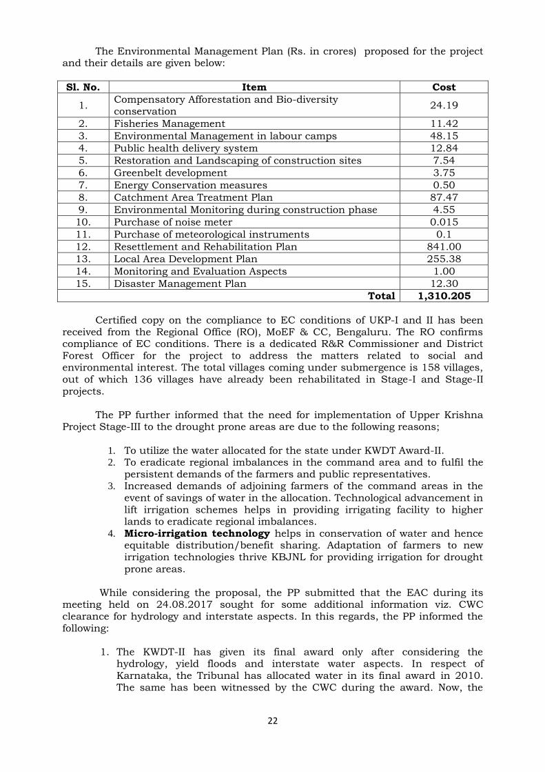
The Environmental Management Plan (Rs. in crores) proposed for the project and their details are given below:
Sl. No. Item Cost
1. Compensatory Afforestation and Bio-diversity conservation
24.19
2. Fisheries Management 11.42
3. Environmental Management in labour camps 48.15
4. Public health delivery system 12.84
5. Restoration and Landscaping of construction sites 7.54
6. Greenbelt development 3.75
7. Energy Conservation measures 0.50
8. Catchment Area Treatment Plan 87.47
9. Environmental Monitoring during construction phase 4.55
10. Purchase of noise meter 0.015
11. Purchase of meteorological instruments 0.1
12. Resettlement and Rehabilitation Plan 841.00
13. Local Area Development Plan 255.38
14. Monitoring and Evaluation Aspects 1.00
15. Disaster Management Plan 12.30
Total 1,310.205
Certified copy on the compliance to EC conditions of UKP-I and II has been
received from the Regional Office (RO), MoEF & CC, Bengaluru. The RO confirms compliance of EC conditions. There is a dedicated R&R Commissioner and District Forest Officer for the project to address the matters related to social and environmental interest. The total villages coming under submergence is 158 villages, out of which 136 villages have already been rehabilitated in Stage-I and Stage-II projects.
The PP further informed that the need for implementation of Upper Krishna Project Stage-III to the drought prone areas are due to the following reasons;
1. To utilize the water allocated for the state under KWDT Award-II. 2. To eradicate regional imbalances in the command area and to fulfil the
persistent demands of the farmers and public representatives. 3. Increased demands of adjoining farmers of the command areas in the
event of savings of water in the allocation. Technological advancement in lift irrigation schemes helps in providing irrigating facility to higher lands to eradicate regional imbalances.
4. Micro-irrigation technology helps in conservation of water and hence equitable distribution/benefit sharing. Adaptation of farmers to new irrigation technologies thrive KBJNL for providing irrigation for drought
prone areas.
While considering the proposal, the PP submitted that the EAC during its meeting held on 24.08.2017 sought for some additional information viz. CWC clearance for hydrology and interstate aspects. In this regards, the PP informed the following:
1. The KWDT-II has given its final award only after considering the hydrology, yield floods and interstate water aspects. In respect of Karnataka, the Tribunal has allocated water in its final award in 2010. The same has been witnessed by the CWC during the award. Now, the

23
issue is between the state of Andhra Pradesh and Telangana. Hence, the share of Karnataka remains same.
2. Planning Commission (now NITI AYOG) in consultation with CWC has cleared the size of the Gates as 15x15.24 m with the top of the Gates @ RL 524.256 m and the dam top @ RL 528.756 m duly considering the adequacy of the spillway, hydrology and yield aspects vide letter No. 2 (10)/88 I&CAD dated 24.09.1990.
The Member Secretary informed the EAC and reiterated that “KWDT-II award
has already been passed in December, 2010 based on 65% dependable yield and surplus yield and allocated water to Karnataka state. Out of 177 TMC of Karnataka share, Government of Karnataka has allocated 130 TMC of water for UKP State-III project by way of storing additional water in the existing reservoir by raising FRL from EL 519.60 m to EL 524.256 m of Almatti Dam to irrigate an area of 5,30,475 ha (25 TMC under 65% dependability allocation and 105 TMC under surplus flow). The total utilization of water for all the above three projects will be 303 TMC.” Therefore,
additional information viz. CWC clearance for hydrology and interstate aspects as sought in the EAC meeting have already duly been addressed in KWDT-II award including in the approval letter No. 2 (10)/88 I&CAD dated 24.09.1990 issued by the Planning Commission (now NITI AYOG). The Member Secretary further informed that the project is being implementing in the drought prone areas of Hyderabad-Karnataka region. Hence, recommendation of grant of Environmental Clearance to the present proposal will help speedy implementation of the project to benefit larger community.
The EAC deliberated based on the information provided by the PP including
the facts reiterated by the Member Secretary and recommended for grant of Environmental clearance to the proposed project with the following additional conditions:
i. Minimum 7 TMC of water to be released as e-flow during lean season. ii. A copy of Stage I forest clearance to be submitted for processing of grant
of environmental clearance. iii. Necessary permission to be obtained for quarrying construction materials
for the project as per the EIA Notification, 2006 and subsequent amendments thereof.
iv. Solid waste generated, especially plastic waste, etc. should not be disposed of as landfill material. It should be treated with scientific approach and recycled. Use of single-use plastics may be discouraged.
v. Under CER activities, preference should be given to strengthen the basic amenities in the project affected villages like maintaining drinking water supply, providing health care facilities, etc.
vi. Preference to be given to the local villagers as per the requirements and suitability, in the job/ other opportunities in the project, etc.
vii. Measures to be taken to develop skills of the local villagers particularly with respect to the trades related to construction works such as electrician, welder, fitter, etc.
**** Item No. 21.13 Banda Major Irrigation Project, Sagar, Madhya Pradesh by M/s
Water Resources Department, Madhya Pradesh – reg. modification of ToR (File No. J-12011/08/2018-IA.I (R), Proposal No. IA/MP/RTV/73548/2018
The request for extension of validity of ToR was applied online by the PP on
11.01.2019. Project proponent along with the consultant made the presentation

24
requesting recommendation of modification of ToR/Scoping Clearance for the proposal and inter-alia, provided the following information:
The dam site of the proposed Banda Major Irrigation Project is located across river Dhasan near village Uldan, Tehsil Banda, District Sagar of Madhya Pradesh. The site is located at latitude 24˚4’35.11” N and longitude 78˚45'43" E. The site is situated about 45 km away from Sagar, the district headquarters and about 25 km away from Banda Tehsil.
The Banda Major Project envisages construction of an earthen dam with Central Spillway, Pump house and Rising/Gravity mains. The project constitutes the following:
(i) Construction of 710 m long Dam with a maximum height of 23 m. (ii) The 196 m long Central Spillway & 50 m NOF including key wall (on both sides)
with 11 Nos. radial gates of size 14x8.6 m with a maximum discharging capacity of 5,920 cumecs.
(iii) The 661.50 m long earthen section on either side of the Dam portion. (iv) Storage formed by the construction of Dam will have a Gross Storage 301.50
MCM live storage of 282.31 MCM to irrigate 80,000 ha. (v) A pressurized pipe system to irrigate 80,000 ha. Total 155 km network of
gravity main and rising main are proposed for DC1, DC2 and DC3 to irrigate area of 28,400 ha, 15,600 ha and 36,000 ha, respectively.
The Banda Major Irrigation Project was earlier appraised in the 13th EAC
meeting held on 27th April, 2018 and was recommended for grant of scoping clearance with 72,000 ha CCA. Scoping Clearance was accorded by Ministry vide letter No. J-12011/8/2018-IA-I (R) dated 14.05.2018.
It was informed by PP that the detailed survey and investigation has resulted in change in submergence area and culturable command area (CCA) and therefore amendment of scoping clearance is requested. It was further informed that required investigation and field work have already been completed with the revised parameters and on the receipt of revised / amended scoping clearance, Public Hearing shall be conducted and final report shall be submitted for appraisal.
The comparison table with the parameters proposed earlier at the time of scoping clearance and the revised parameters for amended scoping clearance are as follows:
ITEMS INITIAL PROPOSAL REVISED PROPOSAL
Gross Storage 301 MCM 301.54 MCM
Live Storage 282.31 MCM 282.82 MCM
CCA 72,000 ha 80,000 ha
Submergence at FRL 4600.27 ha 4699.08 ha
Private Land 3651.82 ha 3645.13 ha
Revenue Land 548.45 ha 548.45 ha
Forest Land 400 ha 505.50 ha
No. of villages Submerged 28 (erroneously 24 were indicated in approved ToR)
28
Total Project Cost Rs. 2850.53 Crore Rs. 2610.53 Crore
EAC observed that these were minor changes after detailed survey and
investigation has been taken up and therefore, recommended for grant of amendment of scoping clearance for the revised parameters.

25
**** Item No. 21.14 Any Other items with the permission of the Chair
Item No. 21.14
(a) Cumulative Impact Assessment and Carrying Capacity Study (CIA & CCS) of Beas River Basin. Presentation of final report before the EAC for recommendation of the Study.
Cumulative Impact Assessment and Carrying Capacity Study (CIA & CCS) of
Beas River Basin, Himachal Pradesh was earlier discussed in EAC meetings in April, June, October and November 2018. In November 2018, EAC finally concluded all the discussions on Beas River Basin study and directed the Consultant to update/finalize the basin study report, keeping in view the matter discussed and recorded in various EAC meetings. The final Beas RBS shall be placed again in the EAC meeting for finalization of the various recommendations therein.
The Consultant made a presentation on the revised final report, wherein it
was explained that after incorporating all the recommendations of the discussions in the EAC meetings including that involving state government of Himachal Pradesh and also the additional data/information shared by the state government, the final report is updated. A copy of the final report has been submitted to MoEF & CC. The Executive Summary of the Beas RBS in Himachal Pradesh has been shared with all the EAC members.
The following are the recommendations of Beas RBS:
1. Jobrie HEP (12 MW) will be developed as two independent projects – one
with diversion on Allain Nala and will be of 6 MW installed capacity and another with diversion on Jobrie Nala and will be of 2 MW installed capacity. All the components including pondage for both the projects will be outside the boundary of Inderkilla WLS and its Eco-sensitive Zone (ESZ) with the exception of 2 MW project on Jobrie Nala, which can be developed in ESZ only if permitted by the ESZ notification.
2. Manalsu HEP (21.9 MW) falling within Manali WLS will undergo Wildlife Clearance as per Wildlife Protection Act. Based on the assessment by the State Board of Wildlife that whether the portion of the project coming in the WLS is a permissible activity and accordingly, Wildlife Clearance should be obtained from the Standing Committee on National Board of Wildlife.
3. Bujling HEP (20 MW) – Location of Bujling HEP will be changed/project component revised to ensure that all the components including pondage will be outside the boundary of Dhauladhar WLS as well as ESZ of Dhauladhar WLS as and when it is notified.
4. Makori HEP (20.8 MW) – Project is recommended for dropping and therefore the allotment of project will be cancelled.
5. Palchan Bhang HEP (9 MW), Bhang HEP (9 MW), Seri Rawla (7 MW), Raison (18 MW) will be developed as planned.
6. Four projects on Parbati River viz. Parbati HEP (12 MW), Sharni HEP (9.6 MW), Sarsadi HEP (9.60 MW) & Sarsadi-II HEP (9 MW) are dropped. The stretch of Parbati river from the confluence of Malana Nala with Parbati up to confluence of Parbati river with Beas river, will now have only two projects – HEP I (15 MW) and HEP II (20 MW). These projects will be so located to ensure that a minimum of 1 km of river stretch will flow free between FRL and TWL of projects in cascade. As the both the projects are less than 25 MW installed capacity, environment flow release will be

26
maintained as 20% in lean season, 30% in peak season and 25% in remaining months. Percentage calculations will be made based on the 90% dependable year discharge data used for the project design/power potential calculation in DPR.
7. Nakthan HEP (460 MW) will be re-designed with diversion on Parbati river only. Tip of the submergence of revised Nakthan HEP will be outside the Eco-Sensitive Zone of Khirganga National Park.
8. Installed capacity of present Tosh HEP will be increased from 10 MW to 20 MW and it will be termed as Tosh I HEP. Upstream of Tosh I HEP, Tosh II HEP and Tosh III HEP can be developed. However, it is to be ensured that:
a) TWL of Tosh II HEP will be at least 1 km u/s of FRL of Tosh I HEP, b) TWL of Tosh III HEP will be at least 1 km u/s of FRL of Tosh II HEP, c) FRL of Tosh III HEP will be outside the ESZ of Khirganga NP and d) All three projects will follow environment flow release norms i.e. 20%
in lean season, 30% in peak season and 25% in remaining months. Percentage calculations will be made based on the 90% dependable year discharge data used for the project design/power potential calculation in DPR.
9. Kanda Pattan HEP will be developed on Beas river between Thana Plaun HEP and Triveni Mahadev HEP, however it is to be ensured that:
a) FRL of Kanda Pattan on Beas river will be at least 1 km downstream
of TWL of Thana Plaun HEP and b) TWL of Kanda Pattan on Beas River will be at least 1 km upstream of
FRL of Triveni Mahadev HEP and c) The project will follow environment flow release norms i.e. 20% in
lean season, 30% in peak season and 25% in remaining months. Percentage calculations will be made based on the 90% dependable year discharge data used for the project design/power potential calculation in DPR.
EAC found the final set of recommendations are in line with the discussions
in earlier EAC meetings involving the state government. Hence, EAC recommended submission of final report for approval of the Competent Authority.
**** Item No. 21.14
(b) Lakhwar HEP (300 MW) at village Lohari, district Dehradun, Uttarakhand by M/s UJVNL – Consideration in the EAC based on the NGT order
The Project proponent made a presentation based on the NGT Order dated
10th January, 2019 and inter-alia, provided the following information: Combined Lakhwar Vyasi project was accepted by Planning Commission on
09.01.1976 in its Fifth plan. Storage and use of water at Lakhwar Vyasi be determined after taking into account the requirements of eastern and western Yamuna canal system and any releases required to be made from Tajewala to meet the requirement of Delhi water supply, Agra and Gurgaon canals. Lakhwar Vyasi project had three major components-Lakhwar dam, Vyasi dam and Katapathar barrage. The major works of the project commenced in 1987 and progressed up to 1992. Till 1992, substantial construction work has been done on the project viz. 40 km Road infrastructure, Dam stripping, Diversion tunnel, Intake, Underground power house, Adit to control room, Adit to erection bay, Tail race tunnel, etc.

27
MoU between Uttar Pradesh, Haryana, Rajasthan, Himachal Pradesh and National Capital Territory of Delhi on allocation of surface flow of Yamuna was signed on 12th May, 1994. As per MoU 11.983 BCM has been assessed as an annual utilizable flow of river Yamuna and has been allocated to the five beneficiary states. The catchment area treatment of river Yamuna at Lakhwar-Vyasi was part of the centrally sponsored watershed management programme at the time of start of the construction. Much work in land, surveys, project formulation, identification of degraded areas, soil conservation measures, etc. has been done till August, 1986. Government of Uttarakhand has entrusted the implementation of this project to UJVN Limited on 23.06.2008. Fresh environmental clearance of Vyasi HEP was accorded to NHPC. on 07.09.2007 and the same was transferred in favour of UJVNL vide letter No. J-12011/48/2007-IA.I dated 22.04.2010. After review of the request of UJVNL, validity of Environmental Clearance of Lakhwar MPP has been given vide letter No. J-12011/32/2010-IA.I, dated 10.01.2011. The revised DPR of Lakhwar Multipurpose Project has been prepared with an estimated cost of Rs. 3966.51 Crore. The total cost of irrigation/ drinking water component was worked out as Rs
2578.23 crores (65% of total cost) and the cost of power component was worked out as Rs. 1388.28 crores (35% of the total cost).
EAC deliberated the issue of Lakhwar Multipurpose Project vis-a-vis the NGT Order dated 10.01.2019 in detailed. Para-10 of the order of NGT states that
“We, therefore, direct the EAC to appraise the project afresh in terms of EIA
notification 2006 and impose additional general and specific conditions as may be considered necessary. EAC will be free to call for any reports which it
may consider necessary. EAC is further directed to complete the appraisal by 15.04.2019. Till the project is reappraised status quo be maintained.”
The EAC was informed that the EIA/EMP report of the Project had been
submitted to MoEF & CC in 2007 and the base line data therein found to be more than three years old. Therefore, EAC opined that 3 seasons baseline data to be collected as per EIA Notification, 2006 and the same be incorporated in the previous EIA/EMP report for which a fresh ToR/Scoping Clearance will be obtained by the PP. Similarly, the EMP and other aspects of the study are to be revised/updated accordingly. Further, the EAC recommended for a visit by a Sub-Committee of the EAC to the project site for any additional study, if any, to be taken up based on the standard ToR for River Valley Projects. The Sub-committee will consist of the following EAC Members:
1. Dr. Sharad Kumar Jain - Chairman 2. Prof. R.K. Kohli - Member 3. Shri N.N. Rai - Member 4. Dr. J.A. Johnson - Member 5. Dr. D.M. More - Member 6. Dr. (Mrs.) Poonam Kumria - Member 7. Dr. S. Kerketta - Member Secretary
As the propose project falls in Yamuna River Basin and its CIA & CCS is
already complete, the recommendation of CIA & CCS to be also part of the Project.
As there being no agenda item left, the meeting ended with a vote of thanks to the Chair.
****
28
29