mississippi river parkway...
TRANSCRIPT

Mississippi River Parkway Commission
ExperienceMississippiRiver.comEstablished in 1938

The Great River RoadThe Great River Road is one of the oldest, longest and most unique National Scenic Byways in North America. Consisting of nearly 3,000 miles of inter-connected roads along the Mississippi River from its headwaters to the Gulf of Mexico, the Great River Road has a rich history and provides travelers with a well-marked roadway they can use to explore the culture and heritage of every region.
The Mississippi River Parkway Commission (MRPC) is a 10-state organization that works collectively to lead in preserving, promoting and enhancing the Great River Road National Scenic Byway, benefiting communities and travelers.
Mississippi River Parkway Commission“Along the Great River Road, we found a little bit of everything. Heavy
industry, civilizations thousands of years old …And our own personal
history as glimpsed through two trips 16 years apart.”
–The New York Times, “Along the Mississippi, ” October 13, 2017

Impact on employmentTravel is a major industry in
the Mississippi River
Corridor and the Great
River Road helps fuel the
sector, by marketing the
route as a travel destination.
Thousands of jobs depend on
the vibrancy of the corridor.
According to the Bureau of
Labor Statistics, the Leisure
& Hospitality sector in
counties and parishes on
the route employed more
than 570,000 people
and generated nearly $1.2 billion in wages in 2017.
History of the Mississippi River Parkway CommissionThe MRPC was established in 1938 to oversee what was then called the Mississippi River Parkway (now the Great River Road). The MRPC was instrumental not only in the early planning and development of the Great River Road, but also in its construction, promotion, marketing and development.
Each state in the MRPC has its own separate commission, which is established by state statute or Governor’s Executive Order. Membership consists of state legislators, state and local officials and general members appointed by the governors, or state agency directors of the individual states.
The National MRPC is the umbrella organization that coordinates multi-state programs on behalf of the member states. The National MRPC Chair is known as the “Pilot” and is elected by the general membership each year.
The MRPC supports efforts on federal, state, and local levels to leverage dollars for highway improvements, recreation trails, bikeways, scenic overlooks, and historic preservation. The MRPC also coordinates marketing to drive visitors to the Great River Road to further enhance economic development and resource awareness.
The MRPC works in partnership with other river-related organizations including the National Forest Service, National Parks Service, Federal Highway Administration, U.S. Corps of Engineers, Fish & Wildlife Service, Mississippi River Cities and Towns Initiative; governors’ offices; state departments of transportation, economic development and tourism; museums; regional planning commissions, city and county governments; chambers of commerce, convention and visitor bureaus; and foundations.


National Scenic Byway Designation and Great River Road Signage
We’ve obtained National Scenic Byway designation on all or portions of all 10 state segments of the Great River Road.
There is signage through all 10 states on the 3,000-mile route. The signs are waypoints for travelers, and they help advertise the route to potential travelers.

The Great River Road:Travel & Tourism Infrastructure for the Mississippi River
The development of touristic
infrastructure supposes the
elaboration of detailed management
plans, able to ensure balanced
relationships between the territorial
systems’ components, especially
between infrastructure and
economy, on the one hand, and the
rural environment, which very often
feels the development of touristic
activities, on the other hand.
(Weiner, 2006; Weaver, 2001;
Andersen & Miller, 2006; Christensen
et al, 2007; Cottrell and Meisel, 2004;
Garrod and Wilson, 2003: Cotttrell and
Graefe, 1997).

In the 20th century, international development academics found a correlation between infrastructure and tourism as a key component of economic development for emerging nations. [For example, Crouch and Ritchie (2000)]
In the 21st century, the U.S. is recognizing its infrastructure shares this correlation. Neglected infrastructure investment is proving to have deleterious effects not only on tourism, but on shipping and industry as well. Unique to the Mississippi River valley, where the vast majority of towns are small and rural, the Great River Road is the network of highway and roadway intersects serving travelers and residents. It is valuable infrastructure for the 10 states on the Mississippi River’s main stem.
• Highways, roadways, ports, airports, railroads and trails for visitors and residents alike. But these modes also represent the arteries for the goods needed to service tourists as well as residents.
• Directional and interpretive signage to move people along unfamiliar roads to destinations.
• Interpretive signage to capture the stories of the people, the land and development of an area, leading to increased length of stay and revisitation.
• Scenic overlooks, information kiosks, highway rest stops.
• Communication infrastructure for GIS and other electronic connection and for trip planning, route guidance and for staying connected while away from home.
• Clean water and reliable electricity. We take it for granted, but there aren’t many visitors to Flint, Michigan, anymore.
• Public safety to safeguard the visitor and the infrastructure.
• Availability of lodging and dining properties.
• Locks, dams, harbors and landings for an expanding river cruise industry and a multi-million-dollar ocean cruising industry.
• ADA accessible public infrastructure, travel options and attractions.
Why is travel and tourism infrastructure important?
What does travel and tourism infrastructure look like?
For the Great River Road, all of this infrastructure comes into play. In addition, the Mississippi River Parkway Commission—a 10-state collaborative to oversee the Road—provides unique infrastructure support in the form of:
As the infrastructure debate continues, it’s important to point out the importance of travel and tourism infrastructure, enabling valuable tourism dollars and services to reach small, out-of-the-way American towns as well as the bustling urban centers of the Mississippi River.
For the Mississippi River, America’s iconic river as well as the heartland’s 10-state connector, the Great River Road represents crucial travel and tourism infrastructure.
• Mapping—electronic and printed
• Internet-based information for a better travel experience
• Adherence to National Scenic Byway principles
• Uniform signage and routing
• A network of over 80 Interpretive Centers that locally tell travelers the heritage and culture of an area as it relates to the Mississippi River

The MRPC has developed a Great River Road Network of Interpretive Centers with 80 sites in all 10 river states. These Interpretive Centers include museums, historic sites and parks that help share details on the history, culture and natural amenities of the byway. The MRPC works with and provides resources for the network of 80 interpretive centers located along the Great River Road.
Great River Road Network of Interpretive Centers
Interpretive center signageBranded Great River Road signage was provided to promote and drive visits to all our interpretive centers, increasing visitation, length of stay and revisitation along the length of the Mississippi River.
Map, app and website exposurePrinted and online maps, as well as our website and app highlight the Interpretive Centers.
Social media and promotionsInterpretive Centers are included among the 200+ posts annually and encouraged to participate in annual promotions.
Hospitality trainingState MRPC commissions provide Great River Road training to frontline personnel on the themes and history of the Great River Road and how to best serve byway travelers.

Minnesota• Itasca State Park – Jacob Brower Visitor
Center – Park Rapids• Forest History Center – Grand Rapids• Charles A. Lindbergh Historic Site – Little Falls• Oliver Kelley Farm, Minnesota Historical
Society – Elk River• Mill City Museum – Minneapolis• Historic Fort Snelling – St. Paul• Minnesota History Center – St. Paul• The Science Museum of Minnesota – St. Paul• NPS Mississippi River Visitor Center – St. Paul• Mississippi River Visitor Center – St. Paul• National Eagle Center – Wabasha• Minnesota Marine Art Museum – Winona• Winona County History Center – Winona
Iowa• Driftless Area Education & Visitor Center –
Lansing• Effigy Mounds National Monument – Harpers
Ferry• Motor Mill Historic Site – Elkader• Iowa DNR – Guttenberg Fish Hatchery –
Guttenberg• National Mississippi River Museum & Aquarium
& National Rivers Hall of Fame – Dubuque• E.B. Lyons Interpretive Center/Mines of Spain
Recreation Area – Dubuque• Hurstville Interpretive Center – Maquoketa• The Sawmill Museum – Clinton• Mississippi River Eco Tourism Center –
Camanche• Buffalo Bill Museum & River Pilots Pier –
LeClaire• Putnam Museum of History & Natural Science –
Davenport• Nahant Marsh Education Center – Davenport• Pine Creek Grist Mill – Muscatine• Muscatine History & Industry Center –
Muscatine• Toolesboro Mounds & Museum – Wapello• The Heritage Center Museum – Burlington• Old Fort Madison – Ft. Madison• George M. Verity Riverboat Museum – Keokuk
Wisconsin• Great River Road Visitor & Learning Center –
Prescott• Riverside Museum – La Crosse• Genoa National Fish Hatchery – Genoa• Villa Louis – Prairie du Chien• Fort Crawford Museum – Prairie du Chien• Stonefield State Historic Site – Cassville• Potosi Brewing Company – Potosi
Phone: 866-763-8310 • Fax: 608-242-8896
Web Site: ExperienceMississippiRiver.com • E-mail: [email protected]

Illinois• Mississippi River Visitor Center – Rock Island• Black Hawk State Historic Site – Rock Island• Villa Kathrine/Friends of the Castle – Quincy• Pere Marquette State Park – Grafton• National Great Rivers Museum – Alton• Cahokia Mounds State Historic Site –
Collinsville• Fort de Chartres State Historic Site – Prairie du
Rocher• Pierre Menard State Historic Site – Ellis Grove• Fort Kaskaskia – Ellis Grove• Cairo Custom House Museum – Cairo
Missouri• Mark Twain Boyhood Home & Museum –
Hannibal• City of Clarksville Visitor Center – Clarksville• Howard & Joyce Wood Education & Visitor
Center at Columbia Bottoms Conservation Area – St. Louis
• Jefferson National Expansion Memorial (Gateway Arch & Old Courthouse) – St. Louis
• Ste. Genevieve Welcome Center – Ste. Genevieve
• Trail of Tears State Park – Jackson• Cape Girardeau Conservation Campus Nature
Center – Cape Girardeau• Sikeston Depot Museum – Sikeston• New Madrid Historical Museum – New Madrid
Kentucky• Wickliffe Mounds State Historic Site – Wickliffe• Columbus-Belmont State Park – Columbus
Tennessee• Reelfoot Lake State Park Visitor Center –
Tiptonville• Mississippi River Museum at Mud Island River
Park – Memphis• C.H. Nash Museum at Chucalissa/T.O. Fuller
State Park – Memphis
Phone: 866-763-8310 • Fax: 608-242-8896
Web Site: ExperienceMississippiRiver.com • E-mail: [email protected]

Mississippi• Tunica RiverPark Museum – Tunica• Delta Blues Museum – Clarksdale• Washington County Welcome Center &
Museum of the Delta/River Road Queen Welcome Center – Greenville
• Lower Mississippi River Museum – Vicksburg• Vicksburg National Military Park – Vicksburg• Grand Gulf Military Monument Commission,
aka Grand Gulf Park – Port Gibson• Natchez Convention and Visitor Bureau –
Natchez• Mississippi Welcome Center/Woodville
Hospitality Station – Woodville
Arkansas• Mississippi County Historical & Genealogical
Society Museum – Osceola• Hampson Archaeological Museum State Park –
Wilson• Parkin Archaeological State Park – Parkin• Mississippi River State Park – Marianna• Helena Museum of Phillips County – Helena• Delta Cultural Center – Helena• Museum of the Arkansas Grand Prairie –
Stuttgart• Dale Bumpers White River National Wildlife
Refuge – St. Charles• Arkansas Post National Memorial – Gillett• WWII Japanese American Internment
Museum – McGehee• Lake Chicot State Park – Lake Village• Lakeport Plantation – Lake Village
Louisiana• Poverty Point World Heritage Site – Pioneer• Port Hudson State Historic Site – Jackson• West Feliciana Historical Society Museum – St.
Francisville• LSU Rural Life Museum & Windrush Gardens –
Baton Rouge• Plaquemine Lock State Historic Site –
Plaquemine• The Historic New Orleans Collection – New
Orleans• Louisiana State Museum – New Orleans• Jean Lafitte National Historical Park &
Preserve – New Orleans
Phone: 866-763-8310 • Fax: 608-242-8896
Web Site: ExperienceMississippiRiver.com • E-mail: [email protected]

Mississippi River Parkway Commission 10-State Corridor Management PlanA Blueprint for Enhancing and Preserving the Public’s Engagement with America’s River
The 10-state, Great River Road Corridor Management Plan (CMP) is the comprehensive shared planning document for the future of the National Scenic Byway for the Mississippi River. As a member in good standing, and one of the first and oldest National Scenic Byways, the Great River Road stands out for its length, its interpretation and its importance to travel and tourism infrastructure in America’s Heartland.
The Great River Road CMP describes fundamental responsibilities and actions that ensure the Byway continues to be consistently signed and mapped so that public access to the Mississippi River’s scenic, natural, historic, archaeological, cultural and recreational intrinsic resources is continued and maximized. Perhaps most importantly, its collective plans make safe this future recreational and commercial artery imperative to over 1,200 cities and towns and more than 119 counties and parishes.
The goal of the Great River Road is to 1) serve as a byway providing access to intrinsic resources along the river’s length, 2) honor the river with planned context sensitive and complete streets transportation design, and 3) celebrate the Mississippi River as a national icon applying meaningful interpretation and compelling storytelling.
The Great River Road was established in 1938 by Secretary of the Interior Harold Ickes and the 10 Mississippi River state governors. Since then, the Mississippi River Parkway Commissions in each state, and collectively as a 10-state organization, have served as the Great River Road’s Byway organization, with support described in statute. The Great River Road’s recent 10-state CMP updates the ambitious shared vision for access to America through its great river. It addresses the changes and demands of travelers and domestic users for multiple forms of transportation throughout the corridor. And it ensures that travelers along the River see all that local areas have to offer in the context of the waterway.
10-State Great River Road Corridor Management Plan Components
• Designated Route Mapping
• Wayshowing Guide Signs
• Byway Design
• Intrinsic Resources
• Interpretation and Storytelling
• Marketing
• Organization – Mississippi River Parkway Commission
• Partner Education and Engagement
• Byway Traveler
• Funding and Resources
“When I look over the strategic plan you’ve put together, I was most impressed. I
urge you to take a message to state DOTs, state offices of FHWA to let them know
what you want to do.”
-Former Secretary of Transportation Rodney Slater
Phone: 866-763-8310 • Fax: 608-242-8896
Web Site: ExperienceMississippiRiver.com • E-mail: [email protected]

National Office
The National Office provides professional and experienced management and promotional services while supporting states and interfacing with public inquiries about the 10-state Great River Road National Scenic Byway. The National Office provides resources and maintains a database of interested visitors, as well as partners along the 10 states.
• mrpcmembers.com: An online resource for states that includes an archive of MRPC work featuring toolkits (for use in conjunction with promotions like Drive the Great River Road Month and interpretation), agendas, meeting minutes, Great River Road logos and more
• National toll-free line: The National Office takes map orders and answers questions for travelers interested in exploring the Great River Road
All ten member states are featured on our website, ExperienceMississippiRiver.com, which welcomes over 161,000 unique users and receives more than 205,000 website visits every year.
• State information: Each state has its own page, featuring contact information, links to state MRPC and/or tourism websites and highlights interpretive centers, locks and dams, scenic overlooks, agritourism and events
• Blogs and itineraries: Our itineraries and blogs are updated regularly and contain information about attractions, recreational options and more in each of the 10 Great River Road states
• Resources: Visitors can order our free 10-state travel map or download the Drive the Great River Road mobile app (available in English and Japanese), as well as sign up to receive visitor information from individual states
Marketing and PromotionThe National Office spearheads all marketing and promotional efforts, working closely with the Board of Directors, as well as the technical committees.
Experience Mississippi River website

10-state Great River Road mapWe publish a 10-state Great River Road map, which highlights the national route in each state and information on each state’s interpretive centers. The MRPC receives map requests daily from all over the United States, and since 2015, we’ve printed 250,000 maps for distribution. We distribute the maps via mail from the MRPC National Office (for online and phone requests) and from the states and partners (through local CVBs, interpretive centers and travel information centers). Maps are also available to view and download on the MRPC website.
Drive the Great River Road mobile appWe produced a Great River Road mobile app that helps travelers to easily drive the National Scenic Byway.• 18,850 downloads• Available for free on Apple and Android devices• Directions and information included for interpretive centers, scenic overlooks, agritourism attractions,
locks & dams
Carbondale
Jonesboro
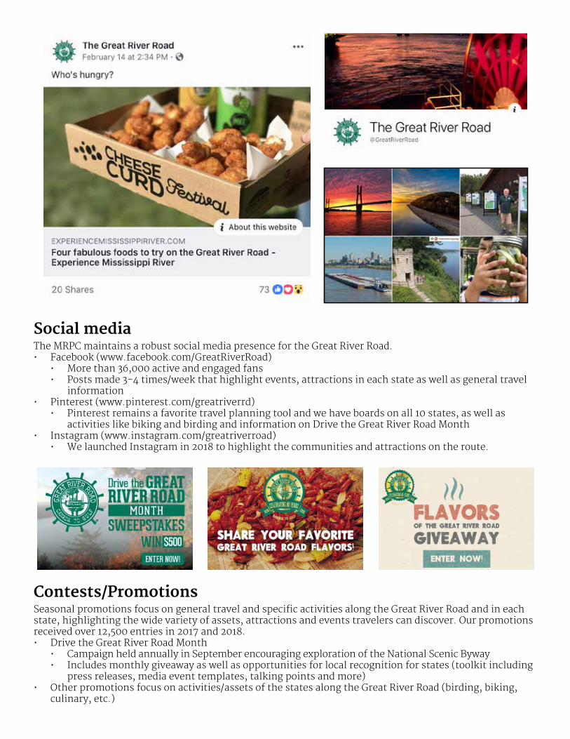
Social mediaThe MRPC maintains a robust social media presence for the Great River Road.• Facebook (www.facebook.com/GreatRiverRoad)
• More than 36,000 active and engaged fans• Posts made 3-4 times/week that highlight events, attractions in each state as well as general travel
information• Pinterest (www.pinterest.com/greatriverrd)
• Pinterest remains a favorite travel planning tool and we have boards on all 10 states, as well as activities like biking and birding and information on Drive the Great River Road Month
• Instagram (www.instagram.com/greatriverroad) • We launched Instagram in 2018 to highlight the communities and attractions on the route.
Contests/PromotionsSeasonal promotions focus on general travel and specific activities along the Great River Road and in each state, highlighting the wide variety of assets, attractions and events travelers can discover. Our promotions received over 12,500 entries in 2017 and 2018.• Drive the Great River Road Month
• Campaign held annually in September encouraging exploration of the National Scenic Byway• Includes monthly giveaway as well as opportunities for local recognition for states (toolkit including
press releases, media event templates, talking points and more)• Other promotions focus on activities/assets of the states along the Great River Road (birding, biking,
culinary, etc.)

Phone: 866-763-8310 • Fax: 608-242-8896
Web Site: ExperienceMississippiRiver.com • E-mail: [email protected]
E-newslettersWe distribute e-newsletters to nearly 27,000 opt-in subscribers interested in the travel along the Great River Road. These seasonal e-newsletters highlight the activities and attractions available during the up-coming season along with our promotions.
Public relationsOur public relations efforts get national attention. We routinely pitch story ideas and work with media, in-cluding standing interviews with radio and TV stations.Some highlights from 2017 and 2018 include:• “Along the Mississippi,” travelogue by New York Times writer Peter Kujawinski
• Shared story of his family’s road trip from Illinois to Louisiana• Appeared on the front page of NYTimes.com on October 13
• Monthly appearances on AM 1230 KWNO in Winona, MN• Worked with camping website 50campfires.com on stories about their trip along the Great River Road• “Must See Spots on The Great River Road” from 10 Best/USA Today • Mississippi River travelogue from British travel website Metro • Cruising the Mississippi River from Smithsonian Magazine
Mississippi River Country – International marketing opportunitiesThrough our partnership with the 10 state tourism offices in conjunction with Mississippi River Country,
the Great River Road is marketed to the travel trade and independent travel markets and media in Japan.
We regularly plan and host familiarization tours for Japanese media throughout the 10 states and attend
Tourism Expo Japan in Tokyo and the annual IPW trade show in the U.S.

2/4/2019 Along the Mississippi - The New York Times
https://www.nytimes.com/2017/10/13/travel/along-the-mississippi.html?_r=0 1/11
The Great River Road, the byway that runs next to the Mississippi River, was theorganizing principle of a road trip that took a family through the history of this land.
By Peter Kujawinski
Oct. 13, 2017
One Friday afternoon, we drove away from Chicago to look for rivers. The first one we cameacross was slender and manicured, like a path for floating golf carts. It followed the highway for amile or two before turning away. Then came the real thing, the DuPage River, flowing fast andhigh with spring rain. We followed that for a while, heading toward our main destination: theMississippi.
It was a simple idea for a family vacation. With our 6-year old twins and 3-year old in tow, my wifeand I would drive to the Mississippi River and head south. After a few days, we would turn back.We’d follow the Great River Road, a patchwork of state highways and county roads that form anational scenic byway along the Mississippi River, 3,000 miles from Minnesota to Louisiana. Thiswould be our first trip on the Mississippi as a family, although my wife and I had taken the roadonce before.
There’s a story to that. Back in the summer of 2001, Nancy and I got married in her hometown ofBirmingham, Ala. We talked about going on an epic honeymoon but we were moving to Haiti andthat seemed epic enough. So we decided to embark on a leisurely, romantic drive up theMississippi River, ending in Chicago, then fly to Haiti.
We had borrowed my dad’s car, and it was filled with suitcases containing our new life together.“Just Married!” signs covered the trunk. From Birmingham, it took a day and a half to get ontothe actual Great River Road. I remember pointing to a sign – look – we’re on the road!
And then we crashed.
A semi with blinking lights had unexpectedly turned in front of us. Our car went into a ditch,totaled. We ended up in a roadside motel next to a Walmart in Dyersburg, Tenn. It took two daysto gather the suitcases from the junkyard where our car had been towed and to find a way toChicago. Escape was boarding a northbound Amtrak at 3 a.m. the next town over.
We decided to try the Great River Road again after 16 years of marriage, but agreed it would notbe a do-over honeymoon. It would be a simple road trip with our children. Still, the memory ofwhat happened before was hard to shake. The Friday that we left Chicago, I asked Nancy
Along the Mississippi

2/4/2019 Along the Mississippi - The New York Times
https://www.nytimes.com/2017/10/13/travel/along-the-mississippi.html?_r=0 2/11
whether we had actually seen the Mississippi River before we crashed all those years ago. Shegrimaced and shook her head.
That is why it felt especially cathartic to drive along the Mississippi’s wide, lazy expanse the nextmorning and pass the green pilot wheel sign in the Quad Cities indicating the Great River Road.Had it just been the two of us, Nancy and I might have mused over what it all meant – the arc ofour marriage seen through the prism of the river. But our youngest, Sylvie, was annoyed at beingin her car seat, so we rushed to our first stop, Arsenal Island, the largest island on the Mississippi.
Our guide during the entire trip was a surprisingly useful – and free – foldout map of the GreatRiver Road, published by the Mississippi River Parkway Commission. It identified interpretivecenters connected to the byway in each state along the river. These were a mix of museums,historic sites, nature centers and other attractions. Iowa was an overachiever with 16. We choseto stop at the places that interested us the most, and we were never disappointed.
On this first stop, though, the map probably should have indicated that the blandly namedMississippi River Visitor Center Lock and Dam 15 was within a heavily guarded military base.Arsenal Island is headquarters of the First Army and a weapons manufacturing facility that dates
River Road going toward Levee Road in Greenville. Robert Rausch for The New York Times

2/4/2019 Along the Mississippi - The New York Times
https://www.nytimes.com/2017/10/13/travel/along-the-mississippi.html?_r=0 3/11
back to the Spanish-American War. To gain access, we had to talk to an armed security guardstanding behind bulletproof glass, get our picture taken, and undergo an instant backgroundcheck.
It was worth it. At the visitor center, we watched the lock at work, lowering boats from oneportion of the river to the next. We learned that the first bridge to span the Mississippi was builton the island. Completed in April 1856, it was destroyed soon after, rammed by the steamboatEffie Afton. Abraham Lincoln defended the bridge company in a legal case that followed, a trialthat elevated him to national prominence.
From the visitor center, we walked past the sole remaining stone pillar from that first bridge, andthen stopped to throw rocks and sticks into the water. Our children sat on the generous, bowinglimb of a shoreline oak tree and reveled in their climbing abilities. We were totally alone. It feltlike something out of Mark Twain’s childhood.
Arsenal Island, like other subsequent stops along the Great River Road, lacked tourists but heldmany layers of history. Originally the site of a wooden fort that extended American control intothe upper Mississippi, it also contained a Confederate cemetery, a National Cemetery, a U.S. Armymuseum, and 19th-century stone buildings that give the base the feel of a college campus.
Great River Road in Memphis. Robert Rausch for The New York Times

2/4/2019 Along the Mississippi - The New York Times
https://www.nytimes.com/2017/10/13/travel/along-the-mississippi.html?_r=0 4/11
We could have stayed there for a while, but the Quad Cities were only 160 miles west of Chicago,and we had a lot more of the Mississippi River to see. Over the next two days, we wandered downthrough Iowa and Missouri and the southern tip of Illinois, where the river’s unmolested bankswere marked by transport and industry. Sometimes the Great River Road ran within a stone’sthrow of the Mississippi. However, when the road swerved away, I could always find the riveragain by searching for the cooling towers of factories that lined the banks. Some of the factorieslooked abandoned, others were grimy with work. They processed corn, phosphate, meat, stoneand sand, the base materials of our world.
The wild Mississippi was nonetheless easy to find. Hawks flew everywhere, over fields justbeginning to blossom, over forests and water. My son asked if they were playing tag. We stoppedat little river towns and threw more rocks into the river. As we drove further south, the buddingtrees looked fuzzy and newly born.
Sometimes traveling is filled with annoyances – missing the turn off a highway or negotiatingbetween three children and only two pretzel sticks. But other moments are so unexpectedlyprofound that they make the entire trip worthwhile. We had one of those in Southern Illinois.
Our Great River Road map led us to Fort de Chartres, a mostly reconstructed French fort thatdates back to the 18th century, when the French claimed sovereignty over large portions of theMississippi River basin. As we neared the site, I realized that the markings on the road haddisappeared. It was nothing more than a ribbon of asphalt. Insects rose thickly from the fields andwe opened the windows to let in the afternoon sun. Everything in this little corner of the worldseemed happy.
The parking lot at Fort de Chartres was nearly empty. Acres of luminescent grass surrounded us,dotted by tall cottonwood trees. An ancient playground set, rust-streaked but still functional,tantalized our children. I climbed the levee that stands between the fort and the Mississippi’sfloodplains. On the other side, an abandoned mailbox and driveway lay under several feet ofwater.
Walking back, I approached three people dressed in French colonial attire. One of them was amiddle-aged woman so perfectly outfitted that I was momentarily surprised that she spokeEnglish. They were members of “Les Amis du Fort de Chartres,” a volunteer organizationdedicated to the upkeep of the fort. She showed me around – the small but excellent museum, andan intact powder magazine, the oldest structure in Illinois. Afterward, my 6-year-old daughterspent a half-hour trying to pet suspicious cats. As I watched her, my mind flashed back to amemory so old it seemed more like a dream. I was the child searching for cats, and my father waswatching me, grinning happily, just like I was grinning at my daughter.

2/4/2019 Along the Mississippi - The New York Times
https://www.nytimes.com/2017/10/13/travel/along-the-mississippi.html?_r=0 5/11
We left Fort de Chartres and passed an old cemetery with a memorial that read, “Here lie buriedthe remains of Michigamea Indians, early French adventurers, black slaves, victims of wars,massacres, floods and plagues.” We got lost afterward, and drove along a tiny road built on top ofthe levees. In the distance, something sat in the middle of the road. I slowed down and stoppednearby.
Nancy ran to check it out, followed by our children. It was a huge snapping turtle, its shellcovered with a mix of mud and dried prairie grass. It looked like it had emerged from an ancientera, when the Mississippi River basin held great and wondrous animals – like the mastodonswhose skeletons are still found everywhere. Another car hurtled by and almost hit the turtle.Quickly, we lifted it into the grass.
The levee road ended at the Mississippi River, next to a man fishing and a faded sign indicatingthat the area used to be the landing point of a ferry. Our car and phone GPS gave us conflictinginstructions, but it didn’t matter. We were in no rush for the moment to pass. With the windowsstill open, we drove into the setting sun.
We kept heading south, through the boot of Missouri on the way to Memphis. By design, westayed on the western side of the river, far away from Dyersburg and the site of our honeymooncrash.
Delta Cultural Center in Helena. Robert Rausch for The New York Times

2/4/2019 Along the Mississippi - The New York Times
https://www.nytimes.com/2017/10/13/travel/along-the-mississippi.html?_r=0 6/11
In Memphis, the midway point of our trip, we stayed at the Peabody Hotel, where our childrenspent nearly two days splashing in the pool and watching the hotel’s famous duck residents.Finally, we set off for the town of Helena, Ark., to visit the Delta Cultural Center. It turned out tobe another excellent museum that highlighted the music of the delta as a response to slavery.There were a few exhibits for children, but mainly they loved listening to recordings of gospel andblues musicians.
Leaving town, we visited Helena River Park and walked along a wooden pier that soared throughtrees and stopped at the river’s edge. The muddy water ran fast. Everything from twigs tobranches the size of trees floated by. Dozens of birds sat in the treetops and chattered loudly toeach other. It was around here that the Mississippi started to expand into the land around it. TheGreat River Road tiptoed around countless oxbow lakes, formed when the river meanderselsewhere and leaves behind trapped water.
Driving from Arkansas to Mississippi and then into Louisiana, we crossed the river several moretimes. Each time we crossed, our children sang the old tune spelling out the name of the river.Amazingly, it never got old.
The Old Vicksburg Bridge. Robert Rausch for The New York Times

2/4/2019 Along the Mississippi - The New York Times
https://www.nytimes.com/2017/10/13/travel/along-the-mississippi.html?_r=0 7/11
In the northeast corner of Louisiana, we visited Poverty Point, a massive earthworks siteoccupied between 1700 and 1100 BC. I had never heard of Poverty Point before noticing it on ourmap. Neither has anyone else, judging by the empty parking lot when we arrived. The only othercar there belonged to the park ranger.
But Poverty Point recently gained international renown. In 2014, it was named a Unesco WorldHeritage site, because it is “a singular achievement in earthen construction in North America: itwas not surpassed for at least 2,000 years.” When King Tutankhamen ruled over ancient Egypt,Poverty Point was the largest city in North America.
We took a tram ride around the complex: five huge mounds, including the Bird Mound, which isshaped like a bird in flight and is over 700 feet long. The mounds were discovered first, followedby six concentric C-shaped rings where up to 5,000 people may have lived. Despite its name,archaeologists believe that Poverty Point had ample natural resources to sustain this largepopulation. The only materials they lacked were stone and metal, and these they procured intrade with people as far away as the Great Lakes.
By late morning, Poverty Point had become hot and humid, an early taste of summer in the delta.We walked along the border between forest and field, and I stared nervously at the ground. Theevening before, in Mississippi, a mouse ran into the lobby of our hotel. Minutes later, thisunexpected event gained new meaning when a hotel guest discovered a poisonous snake severalfeet long waiting at a side entrance. For the rest of the trip, I approached every clump of tall grasswith suspicion.
When we left Poverty Point, the sky seemed enormous, a kaleidoscope of turbulent storm cloudsat high altitude. We put on a CD of blues musicians we had bought at the Delta Cultural Center inHelena. A vulture picking at road kill stared as we drove by, and little red-winged blackbirdsflushed from the fields.

2/4/2019 Along the Mississippi - The New York Times
https://www.nytimes.com/2017/10/13/travel/along-the-mississippi.html?_r=0 8/11
There were more trees now, as the land gradually shifted from the agriculture of the delta to thethick bayou forests of southern Mississippi and Louisiana. We drove past the optimisticallynamed river town of Waterproof, and headed back across to Natchez, Miss.
Natchez was our last stop on the trip. We considered going farther south, toward Baton Rougeand New Orleans, but by that point we had been on the road for six days, and our children,amazingly patient throughout, were close to being done. Sylvie paraded around the Natchez hotelroom, holding her preschool backpack stuffed with a baby doll, a goat and a giraffe, and declaredshe wanted to go home. Our 6-year-old twins were willing to grant us a bit more leeway as long asthey could spend more time in hotel pools.
The next morning, just before we started back north, I drove a little further down the Great RiverRoad, this time by myself. Before setting off on our trip, I had come across the early 19th-centurytravel diary of Francois Perrin du Lac, a French colonial administrator. Several miles belowNatchez, he described a U.S. fort. “Here the head-quarters of their small army are established,” hewrote. “There are also some armed vessels for the defence of the place. All the vessels thatdescend this river are obliged to stop here, and declare to what nation they belong, and the natureof their cargoes.”
During the turbulent period of the late 18th and early 19th centuries, this area of southernMississippi was an international border between Spain and the newly independent United States.The fort, later named Fort Adams after the second president, was the first port of entry to the
A view of the Riverside Park Marina, on the Mississippi River in Memphis.Robert Rausch for The New York Times

2/4/2019 Along the Mississippi - The New York Times
https://www.nytimes.com/2017/10/13/travel/along-the-mississippi.html?_r=0 9/11
United States. However, the fort’s strategic importance quickly diminished when the MississippiRiver turned away from it, isolating it in the floodplains just like an oxbow lake. Later when Spainwithdrew from the area, Fort Adams became a backwater in every sense of the word.
This is still the case. The fort itself is gone, and present-day references to the area are nearlyimpossible to find. Its Wikipedia entry ends with this mysterious sentence: “As of 1993, FortAdams was a small community and the site of businesses that provided supplies to hunting andfishing camps in the region.”
Over the course of our road trip, I became slightly obsessed with finding out what was actually inFort Adams – and I had only that morning to find out. Driving south from Natchez, I turned ontostate road 24 at the town of Woodville. On the map, Fort Adams lay at the terminus of the road,which soon left the town behind and entered thick forest. Once in a while, I saw distant woodenhouses on stilts. The road continued on, twisting and turning toward the Mississippi.
Early morning on the Mississippi River with the Helena Bridge in the background.Robert Rausch for The New York Times

2/4/2019 Along the Mississippi - The New York Times
https://www.nytimes.com/2017/10/13/travel/along-the-mississippi.html?_r=0 10/11
A few minutes later, a roadside sign indicated the nearby presence of a Native American mound. Istopped. The mound loomed next to me, well preserved behind a barbed wire fence. The sign saidthe Lessley Mound was built between 1100 and 1350, but was still used until the mid-17th century.A loud noise broke the silence and I glanced back. A man on an ATV was herding cows across theroad. His voice was loud and shrill, almost feral. He and the cows disappeared from view, butseconds later, he raced around the corner and stopped the ATV alongside my minivan.
“You’re not from around here,” he remarked, wearing a wide-brimmed hat and a white handlebarmustache. He talked animatedly about the historic presence of Native Americans in the area.Then he motioned to the mound, gave me permission to climb it, and sped away.
I ducked under the barbed wire and began climbing through dense shrubs and trees. On thesummit of the mound stood a grove of enormous bald cypress trees. One of them had a burl fivefeet long protruding from its trunk. Among the trees lay the 19th century graves of the Lessleyfamily. Since bald cypress trees can live over 600 years, these trees may have been around duringthe time of the Native Americans and the Lessleys. Somewhere below me, as the morning sunfiltered through the grove, the rancher yelled at his cows.
I returned to my car to keep looking for Fort Adams. Minutes later, a dirt road appeared andimpulsively I turned onto it because it was headed toward the Mississippi. Soon, though, the dirtroad turned muddy. Water lay everywhere, gathering in ruts and turning the forest into swamp.It’s as if the Mississippi had come to me.
I got out, well aware that a minivan is a bad vehicle to bring off-roading. Bugs raced sure-footedlyacross the surface of the water. One of them disappeared with a gulp as a fish broke the surface. Itsounded like Times Square for birds. Thousands sang in unison from the trees. The area wasnothing special. It wasn’t a national park or wildlife reserve. And yet it felt primeval. I had notrouble imagining the lives of those Poverty Point residents from 3,000 years ago.
Back on the state road, I eventually approached a sign that said Fort Adams. The asphalt endedand a network of dirt trails began. I parked next to Bubba’s One Stop, a low-slung bait shopdecorated with bleached antlers. Nearby stood the Fort Adams Baptist Church and severalwooden houses perched on brick stilts. I saw no one. The forest receded in this area, replaced by avast sweep of floodplains decorated with carpets of tiny yellow flowers and solitary oak trees.After taking a few pictures and walking around, I started back.
Along the Great River Road, we found a little bit of everything. Heavy industry, civilizationsthousands of years old, the horrors of slavery, wilderness, hawks, and turtles. And our ownpersonal history as glimpsed through two trips 16 years apart.
The Mississippi River is a movable feast, an ancient waterway filled with the ambitions, sorrowsand joys of countless lives. I imagine myself decades in the future, an old man, crossing over theriver yet again and swimming in the memory of my children yelling out the river’s name. Theriver is deep enough and long enough to hold it all.