mitigation plan - swg.usace.army.mil
TRANSCRIPT
Rev. 7/23/2013
Page 1 of 3
MITIGATION PLAN
1. Mitigation Goals and Objectives
Per details in Sheets 2 and 3 of the enclosed Mitigation Exhibits, as compensatory mitigation for
impacts to approximately 1.8 acres of wetlands by a previous owner of the property, as well as
for temporal loss of function and value, the current owner of the property proposes—on the basis
of discussions with USACE on December 18, 2012—to:
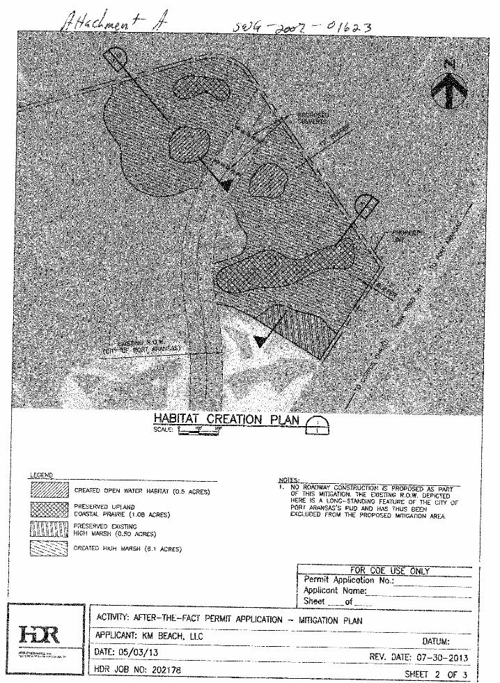
A. Mechanically lower uplands to create a total of 6.6 acres of wetland (a 3.7:1 ratio of
created to impacted wetland), including:
6.1 acres of high marsh habitat
0.5 acres of open water habitat
B. Preserve a total of 1.6 acres of existing habitat (a 0.89:1 ratio of preserved to impacted),
including:
0.5 acres of high marsh
1.1 acres of upland coastal prairie
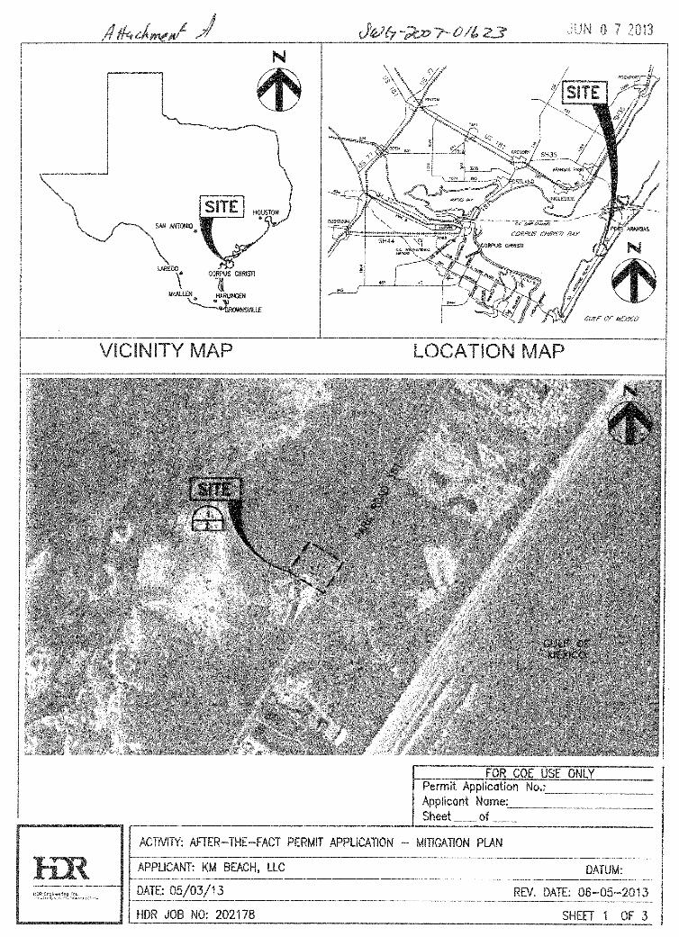
The proposed mitigation site is located on Mustang Island adjacent (north of) an existing
mitigation site (Conservation Area C, created as compensatory mitigation for impacts associated
with the Newport Marina development) (see Mitigation Exhibits, Sheet 1).
All created and preserved habitat will be protected in perpetuity by a deed restriction,
conservation easement, or an equivalent legal instrument.
2. Site Selection Information
The applicant identified a number of candidate locations for habitat creation within the vicinity
of the impacted wetlands, ultimately selecting the proposed mitigation site because it was
deemed to have a high probability of success for natural recruitment of target species due to its
proximity to existing natural wetlands and to an existing, successful, wetlands creation project.
3. Site Protection Instrument
The created habitat will be protected in perpetuity by a deed restriction, conservation easement,
or equivalent legal instrument; this instrument will be established within six months of issuance
of the after-the-fact permit.
4. Baseline Information
Impact Site
The approximately 1.8 acres of wetlands on the northern portion of the property that were
impacted by fill included two naturalized, manmade drainage features comprising freshwater
emergent species (e.g. Typha sp., Scirpus americanus, Hydrocotyle umbellata) as well as four
depression features, best described as freshwater emergent wetlands, that were dense
monocultures of Typha sp. with Sesbania drummondii along the margins.
Rev. 7/23/2013
Page 2 of 3
Mitigation Site
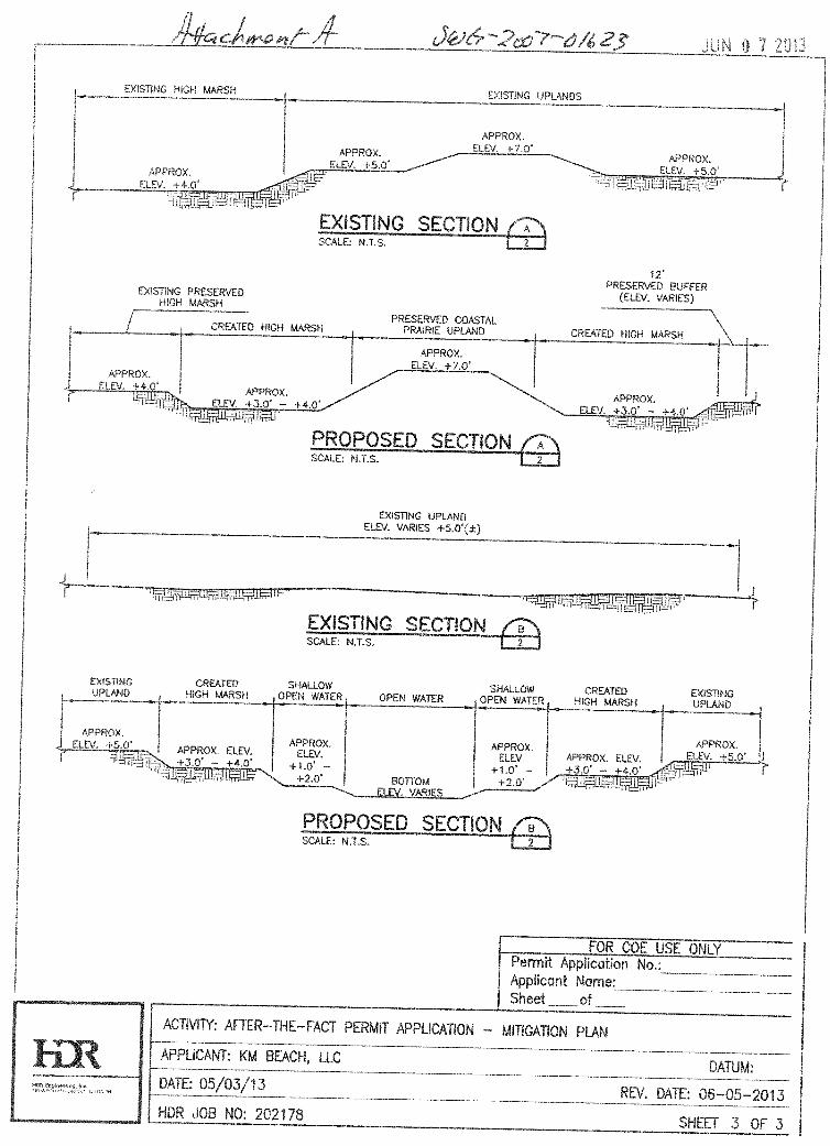
The upland areas to be lowered by mechanical excavation to create freshwater emergent
wetlands are best characterized as coastal prairie, typified by Schizachyrium scoparium, Spartina
patens, and Panicum virgatum.
5. Number of Credits to be Provided
The applicant proposes to:
A. Create a total of 6.6 acres of wetland (a 3.7:1 ratio of created to impacted wetland),
including:
6.1 acres of high marsh habitat
0.5 acres of open water habitat
B. Preserve a total of 1.6 acres of existing habitat (a 0.88:1 ratio of preserved to impacted),
including:
0.5 acres of high marsh
1.1 acres of upland coastal prairie
6. Mitigation Work Plan
Construction of the mitigation will be complete within twelve months of issuance of the after-
the-fact permit. The applicant will be responsible for constructing the mitigation. The applicant
will excavate the mitigation areas to elevations conducive to recruitment and survival of the
target species (exact elevations will be determined through a pre-construction reference elevation
survey of adjacent existing freshwater emergent wetlands). Excavated material will be placed in
uplands onsite or on nearby offsite uplands. Vegetation of converted area will be via natural
recruitment.
7. Maintenance Plan
Maintenance of the mitigation sites will be the sole responsibility of the permittee and may
include trash removal and/or the removal of invasive species.
8. Monitoring Requirements
The applicant will conduct a post-construction survey of the mitigation area within 60 days of
completion of construction and will submit a report to the USACE a report that conforms to the
USACE Regulatory Guidance Letter 08-03 and includes monitoring methodology, , and
photographs documenting site conditions.
The applicant will also monitor annually for a period of five years or until the USACE has
determined that performance standards have been achieved. After each monitoring event, the
applicant will submit to the USACE a report that conforms to the USACE Regulatory Guidance
Letter 08-03, including a description of monitoring methodology, results, and photographic
documentation of site conditions.

Rev. 7/23/2013
Page 3 of 3
9. Ecological Performance Standards
o If 25% coverage of the target habitat is not achieved after one year, the USACE will
determine if planting of the mitigation site is required.
o If 50% coverage of the target habitat is not achieved after three years, the USACE will
determine if planting of the mitigation site is required.
o If 70% coverage of the target habitat is not achieved by the end of the fifth year, the
USACE will determine if planting of the mitigation site is required.
o The USACE may waive the requirement for monitoring at any point during the five year
period if the USACE deems that there is sufficient evidence that re-vegetation of the
mitigation area meets the success criteria.
10. Long-Term Management Plan
As stated above, the created habitat will be protected in perpetuity by a deed restriction,
conservation easement, or equivalent legal instrument. Long-term management may include
removal of trash and/or invasive species as well as measures agreed upon by the applicant and
the USACE if the site does not meet ecological performance standards defined in Section 9.
11. Adaptive Management Plan
If results of the monitoring indicate that the mitigation is not successful, the applicant will
coordinate with USACE in attempt to agree upon the appropriate course of action. Potential
remedies may include but are not limited to supplemental monitoring, planting efforts,
identification of alternative sites, etc.
12. Financial Assurances
The applicant, KM Beach, LLC is a solvent company with a compelling track record of
completing successful projects. As illustrated by their request to meet with the USACE
(December 18, 2012) to vet mitigation concepts, KM Beach, LLC did their due diligence
regarding the outstanding regulatory compliance issues associated with the subject property
before purchasing it, and KM Beach, LLC is committed to resolving any regulatory compliance
issues swiftly and completely, and, as such, is committed to fulfilling any compensatory
mitigation requirements.