mmiinnnneehhoonnkk llaakkee && hhooppkkiinnss …
TRANSCRIPT

MMIINNNNEEHHOONNKK LLAAKKEE && HHOOPPKKIINNSS PPOONNDD
WWAATTEERRSSHHEEDD SSUURRVVEEYY RREEPPOORRTT
Mount Vernon Community Partnership Corp.
MARCH 2013

i
MINNEHONK LAKE & HOPKINS POND
WATERSHED SURVEY REPORT
Prepared by: FB Environmental Associates
97A Exchange St., Suite 305
Portland, ME 04101
www.fbenvironmental.com
Funding for this survey was provided by a generous grant from the Davis Conservation Foundation.
Project partners include the Mount Vernon Community Partnership Corporation, the Greater Minnehonk
Lake Association, the 30 Mile River Watershed Association, and the Town of Mount Vernon. Technical
support was provided by FB Environmental Associates and the Maine Department of Environmental
Protection.
Minnehonk Lake & Hopkins Pond Watershed Survey March 2013
ii
ACKNOWLEDGEMENTS
The following people and organizations were instrumental in the Minnehonk Lake and Hopkins Pond
Watershed Survey, and deserve special recognition for their efforts:
Watershed Survey Volunteers
Linda Fish
Liz Hayes
Tim Kinney
Dick McKeen
David Pollock
Tom Ward
Paul Whittier
Chuck Wright
Sandy Wright
Steering Committee
Linda Fish
Malcolm Hardy
Jennifer Jespersen
Christine Merchant
Dick McKeen
Lidie Robbins
Tom Ward
Paul Whittier
Sandy Wright
Greater Minnehonk Lake Association
Town of Mount Vernon
FB Environmental Associates/ Mount Vernon CPC
Greater Minnehonk Lake Association
Mount Vernon CPC
30 Mile River Watershed Association
Greater Minnehonk Lake Association/ Mount Vernon CPC
Mount Vernon CPC
Mount Vernon CPC
Technical Staff
Kristen Feindel
Jennifer Jespersen
Lidie Robbins
Maine Department of Environmental Protection
FB Environmental Associates
30 Mile River Watershed Association
Minnehonk Lake & Hopkins Pond Watershed Survey March 2013
iii
TABLE OF CONTENTS
Introduction .................................................................................................................................................... 1
Minnehonk Lake Water Quality – Why is Water Quality at Risk? .......................................................................... 1
Why is Runoff a Problem?........................................................................................................................................ 2
Minnehonk Lake & Hopkins Pond ........................................................................................................................... 2
Why protect Minnehonk Lake & Hopkins Pond from Polluted Runoff? ................................................................. 4
What is Being Done to Protect Minnehonk Lake & Hopkins Pond?........................................................................ 4
Purpose of the Watershed Survey .................................................................................................................. 6
Survey Methods ........................................................................................................................................................ 6
Summary of Survey Findings ................................................................................................................................... 8
Sector Summaries ................................................................................................................................................... 12
Residential Areas .................................................................................................................................................... 15
Roads ...................................................................................................................................................................... 16
Driveways ............................................................................................................................................................... 17
Prioritizing NPS Sites ............................................................................................................................................. 18
Next Steps - Where Do We Go From Here? ................................................................................................ 20
Conservation Practices for Homeowners ................................................................................................................ 21
Permitting ABC’s ................................................................................................................................................... 22
How to apply for a Permit by Rule with the Maine DEP ....................................................................................... 22
Where Do I Get More Information?............................................................................................................. 23
Appendix A: List of NPS Sites .................................................................................................................... 24
Minnehonk Lake & Hopkins Pond Watershed Survey March 2013
iv
LIST OF TABLES
Table 1. Summary of NPS sites by land use and impact ................................................................................ 9
Table 2. Prioritized list of NPS sites in the Minnehonk Lake & Hopkins Pond watershed ......................... 18
Table 3. Values of and threats to Minnehonk Lake water quality as identified by steering committee
members ....................................................................................................................................................... 18
Table 4. Roles & responsibilities of Minnehonk Lake partners ................................................................... 19
Table 5. 2012 Minnehonk Lake Watershed Implementation Plan ............................................................... 19
LIST OF FIGURES
Figure 1. Aerial view of the Minnehonk Lake and Hopkins Pond watershed ............................................... 3
Figure 2. Survey Sectors for the Minnehonk Lake and Hopkins Pond Watershed Survey ............................ 7
Figure 3. NPS sites in the Minnehonk Lake & Hopkins Pond watershed by land use type ........................... 8
Figure 4. Impact rating of NPS sites in the Minnehonk Lake and Hopkins Pond watershed ...................... 10
Figure 5. Estimated cost of NPS sites in the Minnehonk Lake and Hopkins Pond watershed .................... 11
Figure 6. NPS sites in the Minnehonk Lake/Hopkins Pond watershed by impact rating and sector .......... 14
Figure 7. NPS sites in the Minnehonk Lake/Hopkins Pond watershed by cost and sector.......................... 14
Figure 8. NPS sites in the Minnehonk Lake/Hopkins Pond watershed by land use and sector................... 14

1
POLLUTED RUNOFF
Also called NPS or nonpoint
source pollution. Soil,
fertilizers, septic waste and
other pollutants from diffuse
sources across the landscape
that are carried into a
waterbody by rainfall.
INTRODUCTION
Minnehonk Lake, located in the Village of
Mount Vernon, Maine, is a peaceful home to
locals, and a favored summer destination for
many. During the summer months, it is used
extensively for swimming, fishing, and boating.
Located around the lake are public swimming
areas, a boat launch, and many lakefront homes
and camps. The quality of the lake’s water is
important to the local economy of thearea.
Additionally, the area is considered valuable
habitat for plant and wildlife communities.
The Mount Vernon Community Partnership
Corporation (CPC), in cooperation with the
Greater Minnehonk Lake Association, the 30
Mile River Watershed Association, and the Maine
Department of Environmental Protection,
conducted its first ever watershed survey in
October of 2012. This is part of a long-term effort
to keep Minnehonk Lake and Hopkins Pond clean
and clear for future generations. Watershed
surveys have been used successfully throughout
Maine to document potential pollution sources
affecting water quality in Maine lakes. This survey identified 50 sites with uncontrolled soil erosion
and polluted runoff to the lake.
MINNEHONK LAKE WATER QUALITY – WHY IS WATER QUALITY AT RISK?
The biggest pollution culprit in Minnehonk Lake and Hopkins Pond, as in other Maine lakes, is polluted
runoff or nonpoint source (NPS) pollution. Stormwater runoff from rain and snowmelt picks up soil,
nutrients and other pollutants as it flows across the land, and washes into the lake.
In an undeveloped, forested watershed, stormwater runoff is slowed
and filtered by tree and shrub roots, grasses, leaves, and other
natural debris on the forest floor. It then soaks into the uneven
forest floor and filters through the soil.
In a developed watershed, however, stormwater does not always
receive the filtering treatment the forest once provided. Rain water
picks up speed as it flows across impervious surfaces like rooftops,
compacted soil, gravel camp roads and pavement, and it becomes a
destructive erosive force.
Minnehonk Lake and Hopkins Pond Watershed

Minnehonk Lake & Hopkins Pond Watershed Survey March 2013
2
WATERSHED
The area of land around a lake
that drains (or sheds) its water
into the lake through streams,
ditches, as overland flow, or
through groundwater.
Excess phosphorus can lead to algal blooms;
decreasing water quality and damaging the
ecology and aesthetics of a lake.
The Minnehonk Lake and Hopkins Pond watersheds are moderately developed by rural residential
development along roadways, and concentrated commercial and residential development in the Village
along Main Street in the northern portion of the Minnehonk Lake watershed. Though seasonal residents
increase the population significantly in summer months, in recent years there has been an increase in
single family homes in Mount Vernon, as it is quickly becoming a popular suburb of the Capital City of
Augusta (www.MtVernonMe.org). If new development is not managed properly, the increased
stormwater runoff from this development can have a negative impact on local water quality.
Minnehonk Lake is surrounded by a network of state, town, and private roads. The care of these roads is
insufficient compared to the amount of use they receive. The steep slopes and sandy soils of the area
exacerbate problems associated with stormwater runoff from the developed areas within the watershed.
WHY IS RUNOFF A PROBLEM?
The problem with runoff is not necessarily the water by itself,
but the sediment and nutrients in the runoff that can be bad
news for Maine lakes. The nutrient, phosphorus, is food for
algae and other plants and is found in soils, septic waste, pet
waste and fertilizers.
In natural conditions, the scarcity of phosphorus in a lake limits
algae growth. However, when a lake receives extra
phosphorus, algae growth increases dramatically. Sometimes
this growth causes choking blooms, but more often it results in
small changes in water quality that, over time, damage the
ecology, aesthetics and economy of lakes.
Soil is the biggest source of phosphorus in Maine lakes. As every gardener knows, phosphorus and other
nutrients are naturally present in the soil. So, we are essentially “fertilizing” Minnehonk Lake with the
soil that erodes from our driveways, roads, ditches, pathways and beaches. Studies have shown that runoff
from developed areas has 5 to 10 times the amount of phosphorus compared to runoff from forested areas.
MINNEHONK LAKE & HOPKINS POND
Minnehonk Lake and Hopkins Pond are located in western
Kennebec County, in the small Village of Mount Vernon,
Maine about 20 miles northwest of Augusta (Figure 1).
Minnehonk Lake has a watershed of 997 acres (1.6 sq. mi.) and
stretches about 2.5 miles from north to south between Route 41
and North Road. The lake has a maximum depth of 73 feet.
Water flows from Minnehonk Lake into Hopkins Stream and
through the inlet of Hopkins Pond just southeast of Minnehonk
Lake. The pond’s watershed covers an area of 412 acres (0.6
sq. mi.) and has a maximum depth of 22 feet.

Minnehonk Lake & Hopkins Pond Watershed Survey March 2013
3
The direct watershed refers to the area of land that drains directly into a waterbody through many
different means (e.g., streams, ditches, groundwater). Runoff moves through a watershed and ultimately
into a lake, pond, or stream. Therefore, it is important to document all land use activities and erosion sites
throughout the entire watershed that may currently, or have the potential to affect water quality.
Minnehonk Lake and Hopkins Pond are used for all forms of recreation (swimming, boating, fishing,
snowmobiling). The watershed contain beaches, boat launches, homes, farms and businesses as well as
natural areas such as forests and wetlands that help filter runoff from these developed areas.
Figure 1. Aerial view of the Minnehonk Lake and Hopkins Pond watershed
Minnehonk Lake & Hopkins Pond Watershed Survey March 2013
4
WHY PROTECT MINNEHONK LAKE & HOPKINS POND FROM POLLUTED RUNOFF?
Once a lake becomes polluted, it can be difficult or impossible to restore. Prevention is the key.
Our lakes and ponds serve as valuable habitat for fish, birds and other wildlife.
Minnehonk Lake supports various cold water fisheries. Species found in the lake include landlocked
salmon, large and smallmouth bass, brook trout, brown trout and splake- a brook trout/lake trout
hybrid introduced in 1981, and currently supporting a popular fishery. Splake is most commonly
caught in the winter months. Hopkins Pond is known by bass fisherman.
According to the Maine Audubon’s Maine Loon Project, there are only two adult Common Loons that
call Minnehonk Lake their home. Sadly, in 2012, one of these adults reportedly died of lead
poisoning, likely from ingesting lead fishing gear.
Minnehonk Lake provides excellent recreational opportunities for local residents and to visitors. It is
an important contributor to the local economy, and a centerpiece of the Village.
A 1996 University of Maine study found that lake water quality affects property values. For every
three foot decline in water clarity, shorefront property values can decline as much as 10 to 20%!
Declining property values affect individual landowners as well as the entire community.
Sediment deposited into lakes and ponds from erosion creates the ideal environment for invasive
species. These species can be transported via boats to other lakes and ponds.
WHAT IS BEING DONE TO PROTECT MINNEHONK LAKE & HOPKINS POND?
Over the past few years, local residents identified Minnehonk Lake as a high priority for water quality
protection. Water quality in Minnehonk Lake and Hopkins Pond has been monitored since 2006 through
the Maine Department of Environmental Protection’s Volunteer Lake Monitoring Program (VLMP). In
addition to water quality monitoring, certified aquatic plant patrollers have also been inspecting for
invasive aquatic plant species in Minnehonk Lake and Hopkins Pond. A volunteer has been monitoring
Minnehonk Lake for invasive species since 2009, and Hopkins Pond since 2011.
In 2010, 2011 and 2012, the Mount Vernon Community Partnership Corp. (CPC) organized meetings
with members of the Greater Minnehonk Lake Association (GMLA), 30 Mile River Watershed
Association (30MRWA), Mount Vernon Board of Selectmen, Mount Vernon Fire Department, the Beach
Committee, and interested citizens to begin the process of protecting the lake from polluted runoff from
nonpoint source (NPS) pollution within the lake’s watershed.
These partnerships helped to establish two shoreline buffers on Minnehonk Lake; including the
installation of more than 50 bushes and perennials by local volunteers and the Youth Conservation Corps

Minnehonk Lake & Hopkins Pond Watershed Survey March 2013
5
(YCC) at the Town Beach in 2010. The second buffer was installed behind the Mount Vernon Country
Store in 2012 as part of a Maine DEP watershed protection grant awarded to the Mount Vernon
Elementary School. The buffer planting was coupled with hands-on watershed education activities for 4th
and 5th
grade students in coordination with Maine DEP and the 30 MRWA.
In 2011, a volunteer stream corridor survey was conducted for the unnamed stream (referred to as the
“Fire Department Stream”) that flows into Minnehonk Lake by the town beach. The survey was led by
Jennifer Jespersen (FB Environmental/ CPC), with support from several local volunteers. Volunteers
assessed both physical (temperature, oxygen, stability) and biological (bugs, fish, wildlife) characteristics
of the stream, and determined that the greatest impacts to the stream and the lake are the portion of the
stream between the Fire Department and the lake. Excess sediment and associated pollutants from road
sand, and erosion in ditches and stream banks are entering the stream and therefore, the lake downstream.
A large delta in the lake at the outlet of the stream is a clear indication of these impacts. The group agreed
that making improvements along the stream would help enhance habitat for fish and other aquatic life,
and reduce the pollutants entering the lake near the public beach.
Following the stream survey, the Maine Department of Environmental Protection (Maine DEP) visited
with the survey volunteers to provide technical guidance for reducing erosion and nutrients entering the
stream and lake, and agreed with the survey findings. It was determined that additional information was
needed to identify and prioritize other potential sources of pollution to determine if financial resources
should be directed to the Fire Department Stream, or if there were other problems in the watershed that
might be a higher priority.
In 2012, the CPC applied for, and was awarded a $7,000 grant from the Davis Foundation to conduct a
watershed survey to document all potential sources of NPS pollution entering Minnehonk Lake. The CPC
enlisted the technical support of FB Environmental to help organize and lead the survey of the entire
Minnehonk Lake watershed. Other components of the project include community outreach and education,
including a public presentation of the survey results in January 2013, and development of an educational
poster for the town beach bulletin board.
Mount Vernon Elementary School students help install a shoreline
buffer at the Country Store in 2012 (Photo: 30MRWA)
Minnehonk Lake & Hopkins Pond Watershed Survey March 2013
6
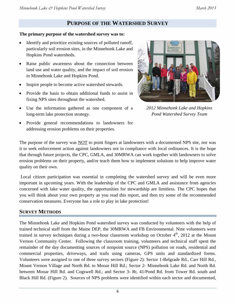
2012 Minnehonk Lake and Hopkins
Pond Watershed Survey Team
PURPOSE OF THE WATERSHED SURVEY
The primary purpose of the watershed survey was to:
Identify and prioritize existing sources of polluted runoff,
particularly soil erosion sites, in the Minnehonk Lake and
Hopkins Pond watersheds.
Raise public awareness about the connection between
land use and water quality, and the impact of soil erosion
in Minnehonk Lake and Hopkins Pond.
Inspire people to become active watershed stewards.
Provide the basis to obtain additional funds to assist in
fixing NPS sites throughout the watershed.
Use the information gathered as one component of a
long-term lake protection strategy.
Provide general recommendations to landowners for
addressing erosion problems on their properties.
The purpose of the survey was NOT to point fingers at landowners with a documented NPS site, nor was
it to seek enforcement action against landowners not in compliance with local ordinances. It is the hope
that through future projects, the CPC, GMLA, and 30MRWA can work together with landowners to solve
erosion problems on their property, and/or teach them how to implement solutions to help improve water
quality on their own.
Local citizen participation was essential in completing the watershed survey and will be even more
important in upcoming years. With the leadership of the CPC and GMLA and assistance from agencies
concerned with lake water quality, the opportunities for stewardship are limitless. The CPC hopes that
you will think about your own property as you read this report, and then try some of the recommended
conservation measures. Everyone has a role to play in lake protection!
SURVEY METHODS
The Minnehonk Lake and Hopkins Pond watershed survey was conducted by volunteers with the help of
trained technical staff from the Maine DEP, the 30MRWA and FB Environmental. Nine volunteers were
trained in survey techniques during a two-hour classroom workshop on October 4th
, 2012 at the Mount
Vernon Community Center. Following the classroom training, volunteers and technical staff spent the
remainder of the day documenting sources of nonpoint source (NPS) pollution on roads, residential and
commercial properties, driveways, and trails using cameras, GPS units and standardized forms.
Volunteers were assigned to one of three survey sectors (Figure 2): Sector 1-Belgrade Rd., Carr Hill Rd.,
Mount Vernon Village and North Rd. to Mooar Hill Rd.; Sector 2- Minnehonk Lake Rd. and North Rd.
between Mooar Hill Rd. and Cogswell Rd.; and Sector 3- Rt. 41/Pond Rd. from Tower Rd. south and
Black Hill Rd. (Figure 2). Sources of NPS problems were identified within each sector and documented,

Minnehonk Lake & Hopkins Pond Watershed Survey March 2013
7
potential solutions were recommended, and rough estimates were made for the cost of labor and materials
for improving the sites.
The data collected during the survey was entered into a computer database to create a spreadsheet, and the
documented NPS sites were plotted on maps. The sites were broken out into categories (driveways, roads,
private residences, etc.) and presented based on their impact to the lake. A description of NPS sites,
recommended actions, and associated costs are discussed in the next section, and a table with a
description of the NPS sites is located in Appendix A.
Figure 2. Survey Sectors for the Minnehonk Lake and Hopkins Pond Watershed Survey
Minnehonk Lake & Hopkins Pond Watershed Survey March 2013
8
SUMMARY OF SURVEY FINDINGS
Volunteers and technical staff identified 54 sites in the Minnehonk Lake and Hopkins Pond watershed
that are currently, or have the potential to negatively affect the water quality in Minnehonk Lake or
Hopkins Pond. Some key conclusions from the survey include:
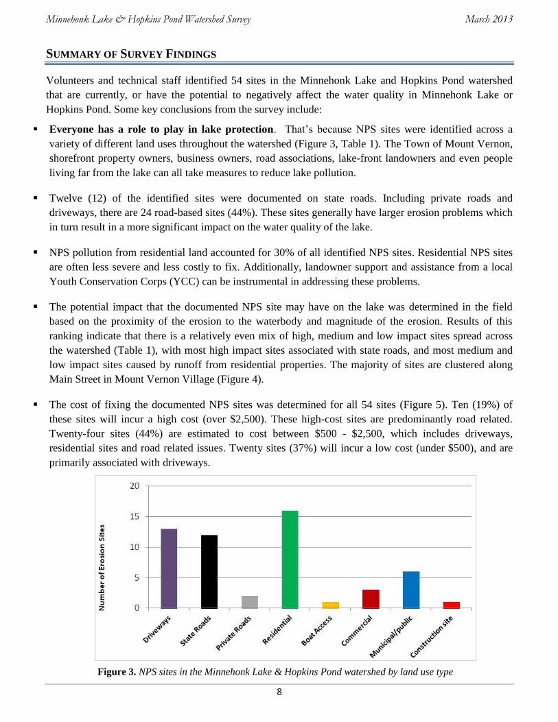
Everyone has a role to play in lake protection. That’s because NPS sites were identified across a
variety of different land uses throughout the watershed (Figure 3, Table 1). The Town of Mount Vernon,
shorefront property owners, business owners, road associations, lake-front landowners and even people
living far from the lake can all take measures to reduce lake pollution.
Twelve (12) of the identified sites were documented on state roads. Including private roads and
driveways, there are 24 road-based sites (44%). These sites generally have larger erosion problems which
in turn result in a more significant impact on the water quality of the lake.
NPS pollution from residential land accounted for 30% of all identified NPS sites. Residential NPS sites
are often less severe and less costly to fix. Additionally, landowner support and assistance from a local
Youth Conservation Corps (YCC) can be instrumental in addressing these problems.
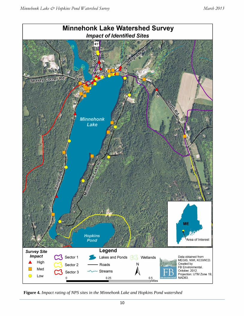
The potential impact that the documented NPS site may have on the lake was determined in the field
based on the proximity of the erosion to the waterbody and magnitude of the erosion. Results of this
ranking indicate that there is a relatively even mix of high, medium and low impact sites spread across
the watershed (Table 1), with most high impact sites associated with state roads, and most medium and
low impact sites caused by runoff from residential properties. The majority of sites are clustered along
Main Street in Mount Vernon Village (Figure 4).
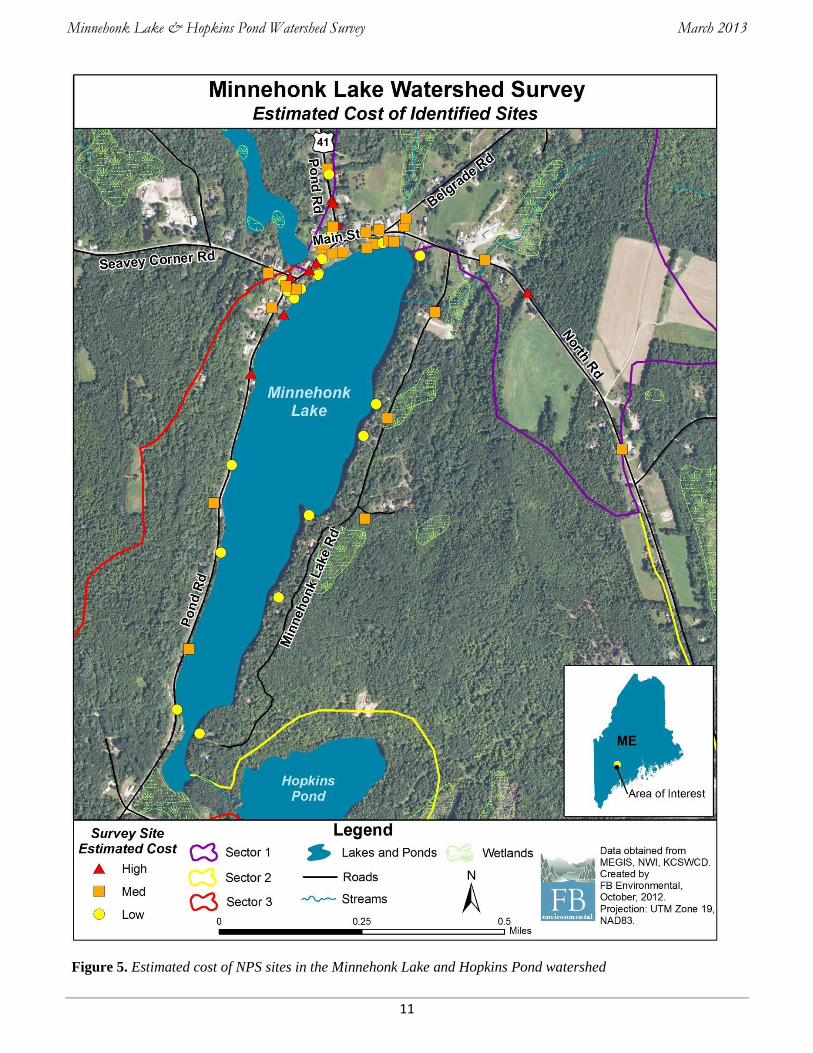
The cost of fixing the documented NPS sites was determined for all 54 sites (Figure 5). Ten (19%) of
these sites will incur a high cost (over $2,500). These high-cost sites are predominantly road related.
Twenty-four sites (44%) are estimated to cost between $500 - $2,500, which includes driveways,
residential sites and road related issues. Twenty sites (37%) will incur a low cost (under $500), and are
primarily associated with driveways.
Figure 3. NPS sites in the Minnehonk Lake & Hopkins Pond watershed by land use type

Minnehonk Lake & Hopkins Pond Watershed Survey March 2013
9
Table 1. Summary of NPS sites by land use and impact
Impact to Lake/Pond – Each site was rated for its potential impact to waterbodies. Just under half of the
surveyed sites were determined to have a medium impact on water quality. Impact is based on slope, soil
type, amount of eroding soil, buffer size and proximity to water.
“Low” impact sites are those with limited transport of soil
off-site.
“Medium” impact sites exhibit sediment transportation
off-site, but the erosion does not reach high magnitude.
“High” impact sites are those with large areas of
significant erosion and direct flow to water.
Cost of Materials and Labor – Recommendations were made for fixing each site, and the associated
cost of labor and materials was estimated. Cost is an important factor in planning for restoration and the
associated costs of BMP application.
“Low” cost sites were estimated to cost less than $500.
“Medium” cost sites range from $500 to $2,500.
“High” cost refers to sites estimated to cost more than
$2,500.
Land Use High Impact Medium Impact Low Impact Total
State Road 7 4 1 12
Private Road 0 0 2 2
Residential 1 9 6 16
Boat Access 1 0 0 1
Driveway 3 6 4 13
Commercial 0 0 3 3
Municipal/Public 3 2 1 6
Construction Site 0 0 1 1
Total 15 21 18 54
28%
39%
33%
High Impact Medium Impact
Low Impact
19%
44%
37%
High Cost Medium Cost Low Cost
Minnehonk Lake & Hopkins Pond Watershed Survey March 2013
10
Figure 4. Impact rating of NPS sites in the Minnehonk Lake and Hopkins Pond watershed
Minnehonk Lake & Hopkins Pond Watershed Survey March 2013
11
Figure 5. Estimated cost of NPS sites in the Minnehonk Lake and Hopkins Pond watershed
Minnehonk Lake & Hopkins Pond Watershed Survey March 2013
12
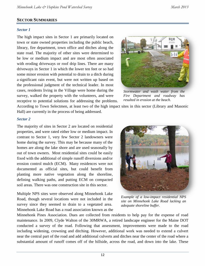
Stormwater and wash water from the
Fire Department and roadway has
resulted in erosion at the beach.
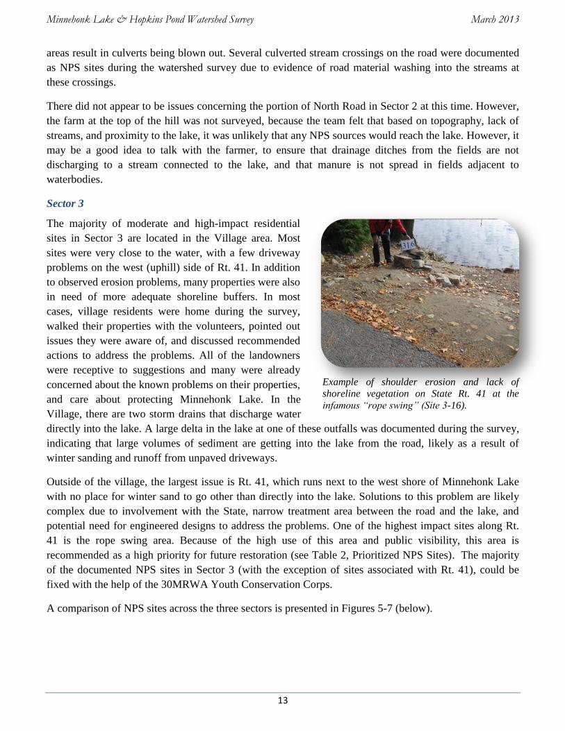
Example of a low-impact residential NPS
site on Minnehonk Lake Road lacking an
adequate shoreline buffer.
SECTOR SUMMARIES
Sector 1
The high impact sites in Sector 1 are primarily located on
town or state owned properties including the public beach,
library, fire department, town office and ditches along the
state road. The majority of other sites were determined to
be low or medium impact and are most often associated
with eroding driveways or roof drip lines. There are many
driveways in Sector 1 in which the lower ten feet or so had
some minor erosion with potential to drain to a ditch during
a significant rain event, but were not written up based on
the professional judgment of the technical leader. In most
cases, residents living in the Village were home during the
survey, walked the property with the volunteers, and were
receptive to potential solutions for addressing the problems.
According to Town Selectmen, at least two of the high impact sites in this sector (Library and Masonic
Hall) are currently in the process of being addressed.
Sector 2
The majority of sites in Sector 2 are located on residential
properties, and were rated either low or medium impact. In
contrast to Sector 1, very few Sector 2 landowners were
home during the survey. This may be because many of the
homes are along the lake shore and are used seasonally by
out of town owners. Most residential sites could be easily
fixed with the additional of simple runoff diversions and/or
erosion control mulch (ECM). Many residences were not
documented as official sites, but could benefit from
planting more native vegetation along the shoreline,
defining walking paths, and putting ECM on compacted
soil areas. There was one construction site in this sector.
Multiple NPS sites were observed along Minnehonk Lake
Road, though several locations were not included in the
survey since they seemed to drain to a vegetated area.
Minnehonk Lake Road has a road association known as the
Minnehonk Pines Association. Dues are collected from residents to help pay for the expense of road
maintenance. In 2009, Clyde Walton of the 30MRWA, a retired landscape engineer for the Maine DOT
conducted a survey of the road. Following that assessment, improvements were made to the road
including widening, crowning and ditching. However, additional work was needed to extend a culvert
near the central part of the road and add additional culverts and ditches near the center of the road where a
substantial amount of runoff comes off of the hillside, across the road, and down into the lake. These
Minnehonk Lake & Hopkins Pond Watershed Survey March 2013
13
Example of shoulder erosion and lack of
shoreline vegetation on State Rt. 41 at the
infamous “rope swing” (Site 3-16).
areas result in culverts being blown out. Several culverted stream crossings on the road were documented
as NPS sites during the watershed survey due to evidence of road material washing into the streams at
these crossings.
There did not appear to be issues concerning the portion of North Road in Sector 2 at this time. However,
the farm at the top of the hill was not surveyed, because the team felt that based on topography, lack of
streams, and proximity to the lake, it was unlikely that any NPS sources would reach the lake. However, it
may be a good idea to talk with the farmer, to ensure that drainage ditches from the fields are not
discharging to a stream connected to the lake, and that manure is not spread in fields adjacent to
waterbodies.
Sector 3
The majority of moderate and high-impact residential
sites in Sector 3 are located in the Village area. Most
sites were very close to the water, with a few driveway
problems on the west (uphill) side of Rt. 41. In addition
to observed erosion problems, many properties were also
in need of more adequate shoreline buffers. In most
cases, village residents were home during the survey,
walked their properties with the volunteers, pointed out
issues they were aware of, and discussed recommended
actions to address the problems. All of the landowners
were receptive to suggestions and many were already
concerned about the known problems on their properties,
and care about protecting Minnehonk Lake. In the
Village, there are two storm drains that discharge water
directly into the lake. A large delta in the lake at one of these outfalls was documented during the survey,
indicating that large volumes of sediment are getting into the lake from the road, likely as a result of
winter sanding and runoff from unpaved driveways.
Outside of the village, the largest issue is Rt. 41, which runs next to the west shore of Minnehonk Lake
with no place for winter sand to go other than directly into the lake. Solutions to this problem are likely
complex due to involvement with the State, narrow treatment area between the road and the lake, and
potential need for engineered designs to address the problems. One of the highest impact sites along Rt.
41 is the rope swing area. Because of the high use of this area and public visibility, this area is
recommended as a high priority for future restoration (see Table 2, Prioritized NPS Sites). The majority
of the documented NPS sites in Sector 3 (with the exception of sites associated with Rt. 41), could be
fixed with the help of the 30MRWA Youth Conservation Corps.
A comparison of NPS sites across the three sectors is presented in Figures 5-7 (below).
Minnehonk Lake & Hopkins Pond Watershed Survey March 2013
14
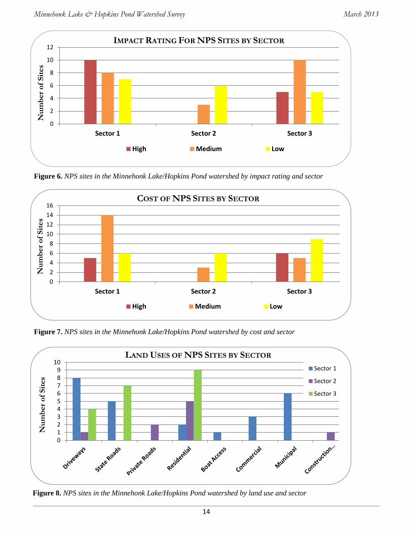
0 1 2 3 4 5 6 7 8 9
10 Sector 1
Sector 2
Sector 3
0
2
4
6
8
10
12
Sector 1 Sector 2 Sector 3
High Medium Low
0
2
4
6
8
10
12
14
16
Sector 1 Sector 2 Sector 3
High Medium Low
Figure 6. NPS sites in the Minnehonk Lake/Hopkins Pond watershed by impact rating and sector
Figure 7. NPS sites in the Minnehonk Lake/Hopkins Pond watershed by cost and sector
Figure 8. NPS sites in the Minnehonk Lake/Hopkins Pond watershed by land use and sector
IMPACT RATING FOR NPS SITES BY SECTOR
COST OF NPS SITES BY SECTOR
LAND USES OF NPS SITES BY SECTOR
Nu
mb
er
of
Sit
es
Nu
mb
er
of
Sit
es
Nu
mb
er
of
Sit
es

Minnehonk Lake & Hopkins Pond Watershed Survey March 2013
15
RESIDENTIAL AREAS
Residential areas accounted for 30% of identified sources of polluted runoff. 6 out of 16 of the residential
sites were determined to be low impact sites. 9 of the sites were of medium impact, and only 1 residential
site was assessed as high impact. 3 sites were estimated as “medium” cost, 11 of the sites had an
estimated low cost, and 2 sites were considered high cost. Below are examples of the most common
problems seen at these sites and recommended conservation practices to lessen impact to Minnehonk
Lake and Hopkins Pond.
Problem: GULLY EROSION
Solution: Control runoff from impervious surfaces. Install an infiltration trench at roof driplines. Vegetate
ditches or armor with stone. Use erosion control mulch in areas with exposed soil.
Problem: UNSTABLE SHORELINE ACCESS
Solution: Place water diverters uphill of the waterbody to trap sediments and reduce the velocity of flow.
Establish buffers at the shoreline, and define walking paths and common areas.
Infiltration Trench Erosion Control Mulch
Vegetated buffers
filter out pollutants
Water bars prevents
sedimentation to Lake
Sector 3: Site 6
Sector 3: Site 1
Minnehonk Lake & Hopkins Pond Watershed Survey March 2013
16
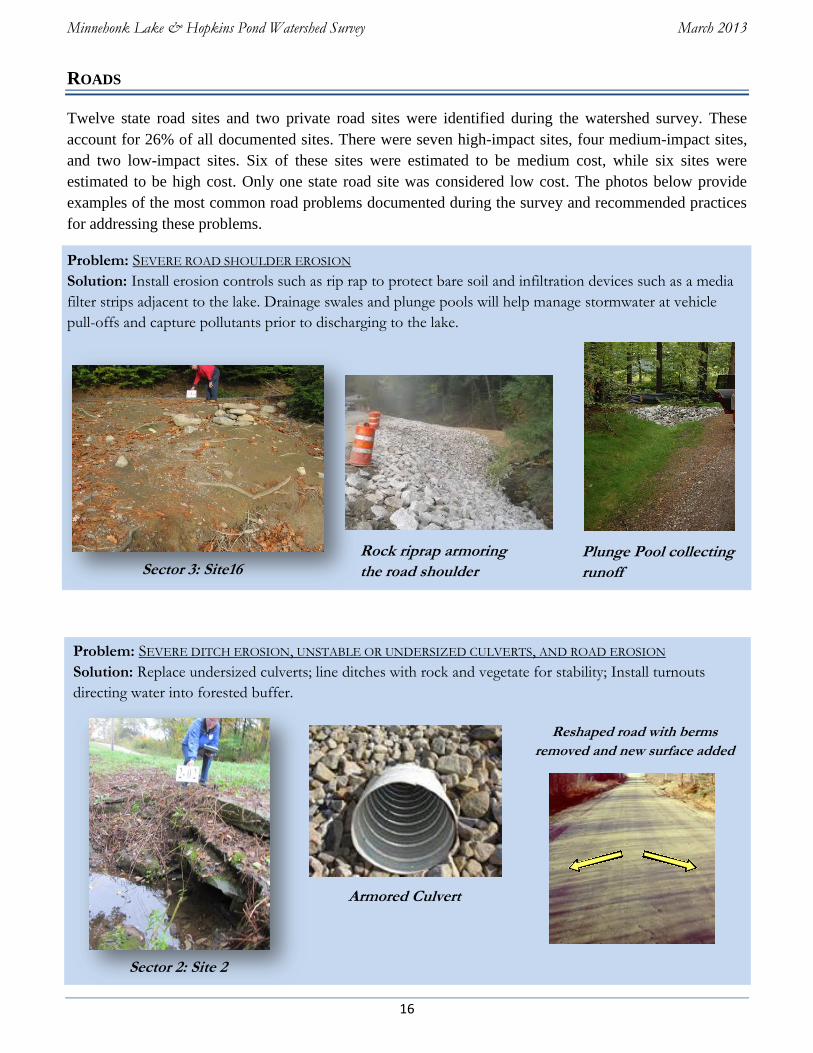
ROADS
Twelve state road sites and two private road sites were identified during the watershed survey. These
account for 26% of all documented sites. There were seven high-impact sites, four medium-impact sites,
and two low-impact sites. Six of these sites were estimated to be medium cost, while six sites were
estimated to be high cost. Only one state road site was considered low cost. The photos below provide
examples of the most common road problems documented during the survey and recommended practices
for addressing these problems.
Problem: SEVERE ROAD SHOULDER EROSION
Solution: Install erosion controls such as rip rap to protect bare soil and infiltration devices such as a media
filter strips adjacent to the lake. Drainage swales and plunge pools will help manage stormwater at vehicle
pull-offs and capture pollutants prior to discharging to the lake.
Problem: SEVERE DITCH EROSION, UNSTABLE OR UNDERSIZED CULVERTS, AND ROAD EROSION
Solution: Replace undersized culverts; line ditches with rock and vegetate for stability; Install turnouts
directing water into forested buffer.
Plunge Pool collecting
runoff
Reshaped road with berms
removed and new surface added
material
Rock riprap armoring
the road shoulder
Armored Culvert
Sector 3: Site16
Sector 2: Site 2
Minnehonk Lake & Hopkins Pond Watershed Survey March 2013
17
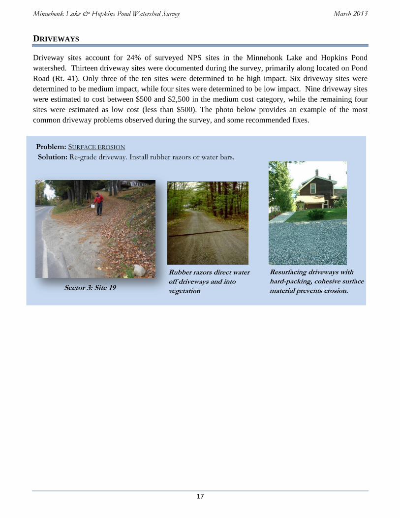
DRIVEWAYS
Driveway sites account for 24% of surveyed NPS sites in the Minnehonk Lake and Hopkins Pond
watershed. Thirteen driveway sites were documented during the survey, primarily along located on Pond
Road (Rt. 41). Only three of the ten sites were determined to be high impact. Six driveway sites were
determined to be medium impact, while four sites were determined to be low impact. Nine driveway sites
were estimated to cost between $500 and $2,500 in the medium cost category, while the remaining four
sites were estimated as low cost (less than $500). The photo below provides an example of the most
common driveway problems observed during the survey, and some recommended fixes.
Problem: SURFACE EROSION
Solution: Re-grade driveway. Install rubber razors or water bars.
Rubber razors direct water
off driveways and into
vegetation
Resurfacing driveways with
hard-packing, cohesive surface
material prevents erosion. Sector 3: Site 19
Minnehonk Lake & Hopkins Pond Watershed Survey March 2013
18
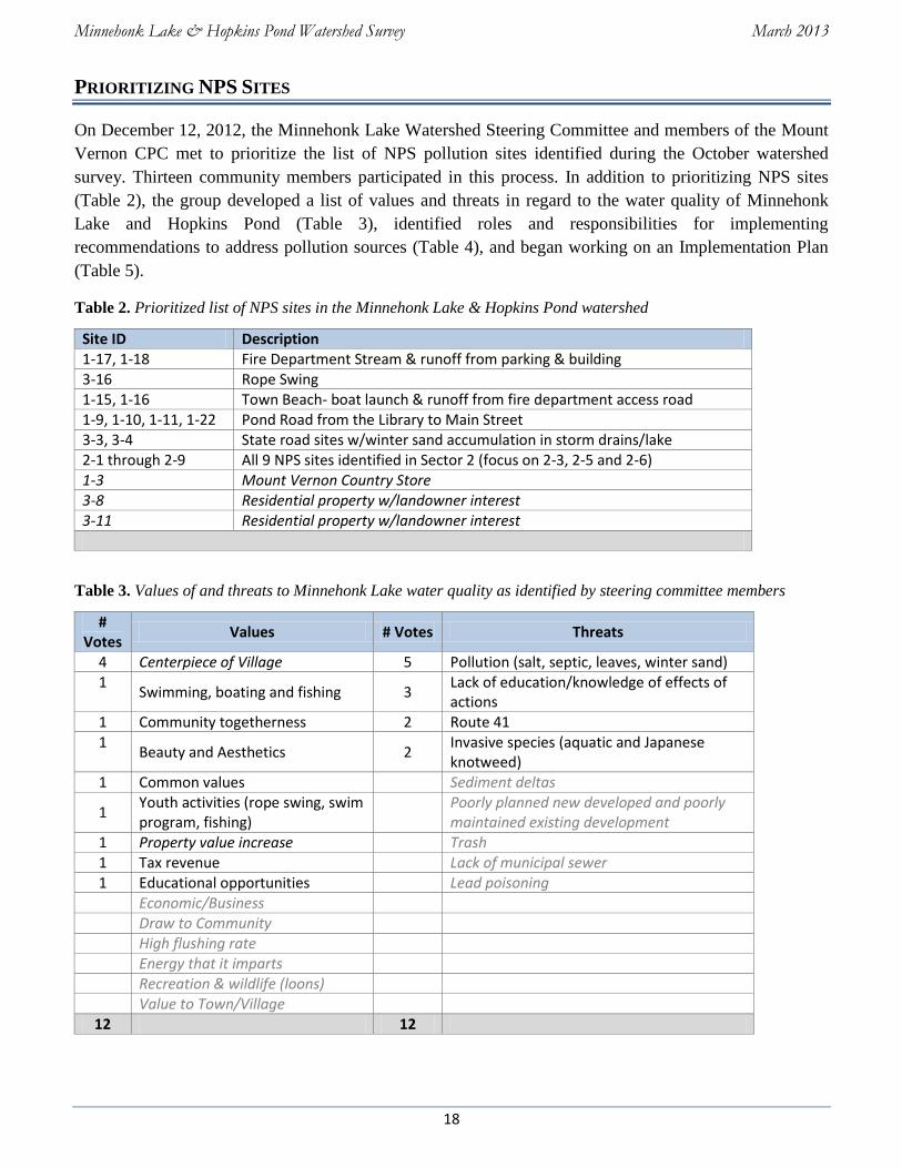
PRIORITIZING NPS SITES
On December 12, 2012, the Minnehonk Lake Watershed Steering Committee and members of the Mount
Vernon CPC met to prioritize the list of NPS pollution sites identified during the October watershed
survey. Thirteen community members participated in this process. In addition to prioritizing NPS sites
(Table 2), the group developed a list of values and threats in regard to the water quality of Minnehonk
Lake and Hopkins Pond (Table 3), identified roles and responsibilities for implementing
recommendations to address pollution sources (Table 4), and began working on an Implementation Plan
(Table 5).
Table 2. Prioritized list of NPS sites in the Minnehonk Lake & Hopkins Pond watershed
Site ID Description 1-17, 1-18 Fire Department Stream & runoff from parking & building 3-16 Rope Swing 1-15, 1-16 Town Beach- boat launch & runoff from fire department access road 1-9, 1-10, 1-11, 1-22 Pond Road from the Library to Main Street 3-3, 3-4 State road sites w/winter sand accumulation in storm drains/lake 2-1 through 2-9 All 9 NPS sites identified in Sector 2 (focus on 2-3, 2-5 and 2-6) 1-3 Mount Vernon Country Store 3-8 Residential property w/landowner interest 3-11 Residential property w/landowner interest
Table 3. Values of and threats to Minnehonk Lake water quality as identified by steering committee members
# Votes
Values # Votes Threats
4 Centerpiece of Village 5 Pollution (salt, septic, leaves, winter sand) 1
Swimming, boating and fishing 3 Lack of education/knowledge of effects of actions
1 Community togetherness 2 Route 41 1
Beauty and Aesthetics 2 Invasive species (aquatic and Japanese knotweed)
1 Common values Sediment deltas
1 Youth activities (rope swing, swim program, fishing)
Poorly planned new developed and poorly maintained existing development
1 Property value increase Trash 1 Tax revenue Lack of municipal sewer 1 Educational opportunities Lead poisoning
Economic/Business Draw to Community High flushing rate Energy that it imparts Recreation & wildlife (loons) Value to Town/Village
12 12
Minnehonk Lake & Hopkins Pond Watershed Survey March 2013
19
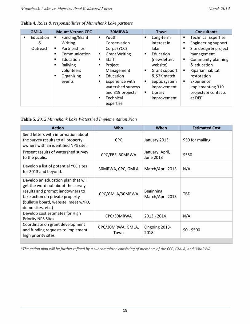
Table 4. Roles & responsibilities of Minnehonk Lake partners
GMLA Mount Vernon CPC 30MRWA Town Consultants Education
& Outreach
Funding/Grant Writing
Partnerships Communication Education Rallying
volunteers Organizing
events
Youth Conservation Corps (YCC)
Grant Writing Staff Project
Management Education Experience with
watershed surveys and 319 projects
Technical expertise
Long-term interest in lake
Education (newsletter, website)
Grant support & $3K match
Septic system improvement
Library improvement
Technical Expertise Engineering support Site design & project
management Community planning
& education Riparian habitat
restoration Experience
implementing 319 projects & contacts at DEP
Table 5. 2012 Minnehonk Lake Watershed Implementation Plan
Action Who When Estimated Cost
Send letters with information about the survey results to all property owners with an identified NPS site.
CPC January 2013 $50 for mailing
Present results of watershed survey to the public.
CPC/FBE, 30MRWA January, April, June 2013
$550
Develop a list of potential YCC sites for 2013 and beyond.
30MRWA, CPC, GMLA March/April 2013 N/A
Develop an education plan that will get the word out about the survey results and prompt landowners to take action on private property (bulletin board, website, meet w/FD, demo sites, etc.)
CPC/GMLA/30MRWA Beginning March/April 2013
TBD
Develop cost estimates for High Priority NPS Sites
CPC/30MRWA 2013 - 2014 N/A
Coordinate on grant development and funding requests to implement high priority sites
CPC/30MRWA, GMLA, Town
Ongoing 2013-2018
$0 - $500
*The action plan will be further refined by a subcommittee consisting of members of the CPC, GMLA, and 30MRWA.

Minnehonk Lake & Hopkins Pond Watershed Survey March 2013
20
NEXT STEPS - WHERE DO WE GO FROM HERE?
Improving the NPS sites identified during the watershed survey will require efforts by individual
landowners, the CPC, GMLA, road associations and state, and local municipal officials. The prioritized
list of NPS sites (Table 2) and Action Plan (Table 5), along with the interest from the community provides
a good basis for getting started with addressing these problems, and will help the project partners acquire
funding to accomplish these goals.
In addition to the actions identified by the steering committee, there are many things that individual
landowners and municipal officials can start doing now to help with this effort.
Individual Landowners
If you have a documented NPS site on your property, call the Mount Vernon CPC, GMLA, or
30MRWA for advice about how to get started.
Stop mowing and raking your shoreline and other parts of your property to bare soil. Let lawn and
raked areas revert back to natural vegetation. Deep shrub and tree roots help hold the soil in place and
help prevent erosion.
Avoid exposing bare soil. Seed and mulch bare areas. Use erosion control mulch.
Read “Permitting ABCs” on page 20 and call the Town Code Enforcement Officer and DEP before
starting doing any cutting or soil disturbance projects.
Maintain septic systems properly. Pump septic tanks (every 2 to 3 years for year round residences; 4-
5 years if seasonal) and upgrade marginal systems.
Participate in local workshops and volunteer “work parties” to help address identified NPS problems
and learn how to fix similar problems on your own property.
Become LakeSmart! Apply for a LakeSmart awards by joining together neighbors, road and local lake
associations and establishing best practices on your properties. Call Maine COLA for information.
Join the CPC, GMLA or 30MRWA and get involved with their programs and activities including the
GMLA annual meeting and the 30MRWA Youth Conservation Corps.
Municipal Officials
Enforce shoreland zoning and other ordinances to ensure protection of Minnehonk Lake and Hopkins
Pond.
Conduct regular maintenance on town roads in the watershed, and fix town road problems identified
in this survey.
Participate in, and support long-term watershed management projects.
Promote education and training for road crews, the code enforcement officer, selectmen, planning
board members and other decision makers.
Minnehonk Lake & Hopkins Pond Watershed Survey March 2013
21
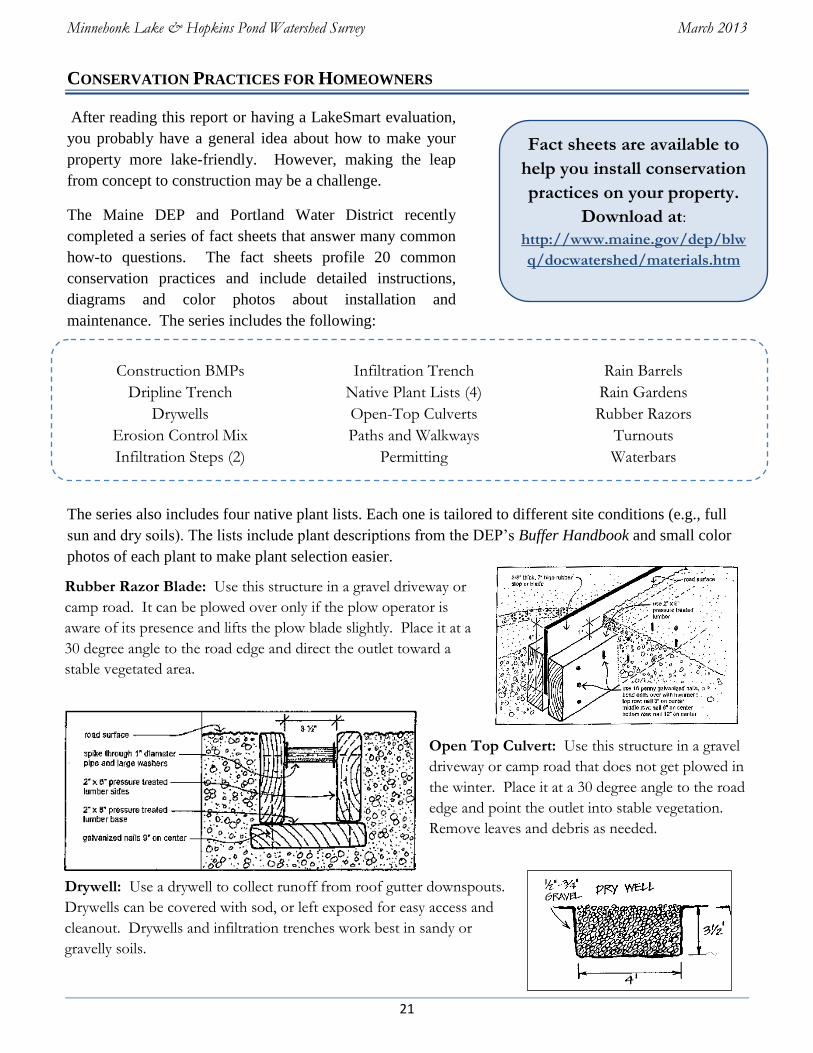
Fact sheets are available to
help you install conservation
practices on your property.
Download at:
http://www.maine.gov/dep/blw
q/docwatershed/materials.htm
Construction BMPs
Dripline Trench
Drywells
Erosion Control Mix
Infiltration Steps (2)
Infiltration Trench
Native Plant Lists (4)
Open-Top Culverts
Paths and Walkways
Permitting
Rain Barrels
Rain Gardens
Rubber Razors
Turnouts
Waterbars
CONSERVATION PRACTICES FOR HOMEOWNERS
After reading this report or having a LakeSmart evaluation,
you probably have a general idea about how to make your
property more lake-friendly. However, making the leap
from concept to construction may be a challenge.
The Maine DEP and Portland Water District recently
completed a series of fact sheets that answer many common
how-to questions. The fact sheets profile 20 common
conservation practices and include detailed instructions,
diagrams and color photos about installation and
maintenance. The series includes the following:
The series also includes four native plant lists. Each one is tailored to different site conditions (e.g., full
sun and dry soils). The lists include plant descriptions from the DEP’s Buffer Handbook and small color
photos of each plant to make plant selection easier.
Rubber Razor Blade: Use this structure in a gravel driveway or
camp road. It can be plowed over only if the plow operator is
aware of its presence and lifts the plow blade slightly. Place it at a
30 degree angle to the road edge and direct the outlet toward a
stable vegetated area.
Drywell: Use a drywell to collect runoff from roof gutter downspouts.
Drywells can be covered with sod, or left exposed for easy access and
cleanout. Drywells and infiltration trenches work best in sandy or
gravelly soils.
Open Top Culvert: Use this structure in a gravel
driveway or camp road that does not get plowed in
the winter. Place it at a 30 degree angle to the road
edge and point the outlet into stable vegetation.
Remove leaves and debris as needed.
Minnehonk Lake & Hopkins Pond Watershed Survey March 2013
22
PERMITTING ABC’S
Protection of Maine’s watersheds is ensured through the goodwill of lake residents and through laws and
ordinances created and enforced by the State of Maine and local municipalities. The following laws and
ordinances require permits for activities adjacent to wetlands and waterbodies.
Shoreland Zoning Law—Construction, clearing of vegetation and soil movement within 250 feet of
lakes, ponds, and many wetlands, and within 75 feet of most streams, falls under the Shoreland Zoning
Act, which is administered by the Town through the Code Enforcement Officer and the Planning Board.
Natural Resources Protection Act (NRPA) - Soil disturbance & other activities within 75 feet of the
lakeshore or stream also fall under the NRPA, which is administered by the DEP.
Contact the Maine DEP and Town Code Enforcement Officer if you have any plans to construct, expand
or relocate a structure, clear vegetation, create a new path or driveway, stabilize a shoreline or otherwise
disturb the soil on your property. Even if projects are planned with the intent of enhancing the
environment, contact the DEP and town to be sure.
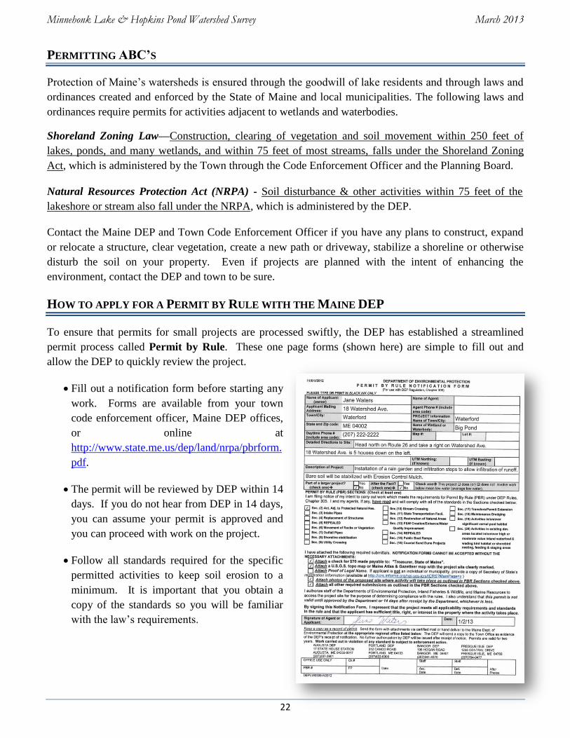
HOW TO APPLY FOR A PERMIT BY RULE WITH THE MAINE DEP
To ensure that permits for small projects are processed swiftly, the DEP has established a streamlined
permit process called Permit by Rule. These one page forms (shown here) are simple to fill out and
allow the DEP to quickly review the project.
Fill out a notification form before starting any
work. Forms are available from your town
code enforcement officer, Maine DEP offices,
or online at
http://www.state.me.us/dep/land/nrpa/pbrform.
pdf.
The permit will be reviewed by DEP within 14
days. If you do not hear from DEP in 14 days,
you can assume your permit is approved and
you can proceed with work on the project.
Follow all standards required for the specific
permitted activities to keep soil erosion to a
minimum. It is important that you obtain a
copy of the standards so you will be familiar
with the law’s requirements.
Minnehonk Lake & Hopkins Pond Watershed Survey March 2013
23
WHERE DO I GET MORE INFORMATION?
Mount Vernon Community Partnership Corporation
Sandy Wright, President
(207) 293-2582 or [email protected]
Greater Minnehonk Lake Association
Christine Merchant, President
(207) 293-4855 or [email protected]
30 Mile River Watershed Association
P.O. Box 132; Mount Vernon, ME 04352
(207) 670-7298 or [email protected]
FB Environmental Associates
97A Exchange Street; Portland, ME 04101
(207) 221-6699 or [email protected]
Kennebec County Soil and Water Conservation District
21 Enterprise Dr., Suite 1, Augusta, ME 04330
(207) 622-7847 ext. 3
Offers assistance with watershed planning and surveys, environmental
education, engineering support, seminars and training sessions, and
education on the use of conservation practices.
Maine Congress of Lake Associations (COLA)
171 Main Street, Belgrade Lakes, ME 04918
Toll free: (855) 4-ME-COLA, www.mainecola.org
As of January 1, 2013, Maine COLA will be administering the LakeSmart Program. LakeSmart shares good land
use techniques on a one-to-one basis with homeowners and recognizes those who adopt conservation practices.
Handsome blue and white Award signs identify homes where steps have been taken to prevent nutrient loading to
lakes. Posted by the lake shore and roadside, the Awards communicate a demonstration site from which others can
learn. With these concrete examples as models, the idea of doing the right thing by the lake spreads through the
community.
Maine Department of Environmental Protection
17 State House Station, Augusta, Maine 04333
Toll Free in Maine (800) 452-1942 or (207) 287-7688
Provides permit applications and assistance, numerous reference materials, environmental education, funding
opportunities, and stewardship activities for lakes.
Publications
Gravel Road Maintenance Manual: A Guide for Landowners. Kennebec County SWCD and Maine DEP.
2010. http://www.maine.gov/dep/land/watershed/camp/road/gravel_road_manual.pdf
Conservation Practices for Homeowners. Maine DEP and Portland Water District. 2006. 20 fact sheets.
http://www.maine.gov/dep/land/watershed/materials.html
Maine Shoreland Zoning—A Handbook for Shoreland Owners. Maine DEP. 2008. DEPLW0674-D08. 37
pgs. http://www.maine.gov/dep/land/slz/citizenguide.pdf
A Guide to Forming Road Associations. York County SWCD and Maine DEP. 2009. 21 pgs. &
appendices. http://www.maine.gov/dep/land/watershed/roadassociation.htm
Remember – the long term
health of the Minnehonk
Lake & Hopkins Pond
watershed depends on you.
Help us protect the Lake
for future generations to
come!

Minnehonk Lake & Hopkins Pond Watershed Survey March 2013
24
APPENDIX A: LIST OF NPS SITES
Minnehonk Lake & Hopkins Pond Watershed Survey March 2013
25
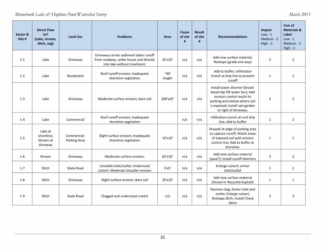
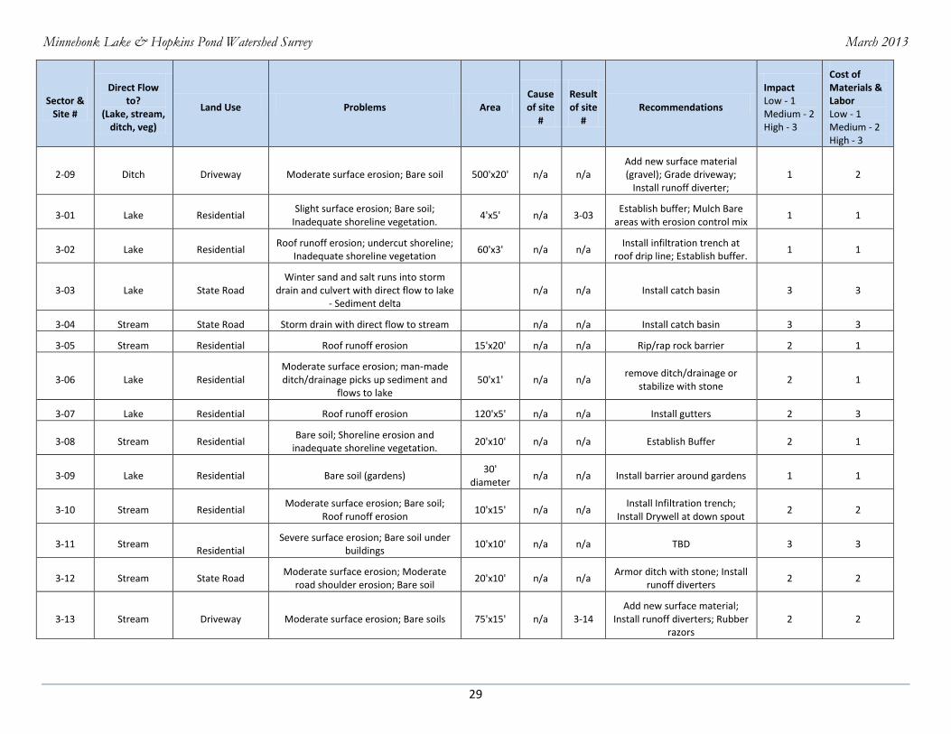
Sector & Site #
Direct Flow to?
(Lake, stream, ditch, veg)
Land Use Problems Area Cause of site
#
Result of site
# Recommendations
Impact Low - 1 Medium - 2 High - 3
Cost of Materials & Labor Low - 1 Medium - 2 High - 3
1-1 Lake Driveway Driveway carries sediment laden runoff from roadway, under house and directly
into lake without treatment. 35'x25' n/a n/a
Add new surface material; Reshape (grade one way)
2 2
1-2 Lake Residential Roof runoff erosion; Inadequate
shoreline vegetation ~90'
length n/a n/a
Add to buffer; Infiltration trench at drip line to prevent
runoff 1 2
1-3 Lake Driveway Moderate surface erosion; bare soil 200'x20' n/a n/a
Install water diverter (broad-based dip OR water bar); Add
erosion control mulch to parking area below where soil is exposed; Install rain garden
to right of driveway.
3 2
1-4 Lake Commercial Roof runoff erosion; Inadequate
shoreline vegetation n/a n/a
Infiltration trench at roof drip line; Add to buffer
1 2
1-5
Lake at shoreline; Stream at driveway
Commercial- Parking Area
Slight surface erosion; Inadequate shoreline vegetation
10'x10' n/a n/a
Drywell at edge of parking area to capture runoff; Mulch areas
of exposed soil with erosion control mix; Add to buffer at
shoreline.
1 1
1-6 Stream Driveway Moderate surface erosion; 65'x10' n/a n/a Add new surface material
(pave?); Install runoff diverters 3 2
1-7 Ditch State Road Unstable inlet/outlet; Undersized
culvert; Moderate shoulder erosion 3'x5' n/a n/a
Enlarge culvert; armor inlet/outlet
1 2
1-8 Ditch Driveway Slight surface erosion; Bare soil 20'x10' n/a n/a Add new surface material
(Gravel or Recycled Asphalt) 1 1
1-9 Ditch State Road Clogged and undersized culvert n/a n/a n/a
Remove clog; Armor inlet and outlet; Enlarge culvert;
Reshape ditch; Install Check dams
3 3

Minnehonk Lake & Hopkins Pond Watershed Survey March 2013
26
Sector & Site #
Direct Flow to?
(Lake, stream, ditch, veg)
Land Use Problems Area Cause of site
#
Result of site
# Recommendations
Impact Low - 1 Medium - 2 High - 3
Cost of Materials & Labor Low - 1 Medium - 2 High - 3
1-10 Ditch Municipal/
Public Moderate surface erosion; Bare soil 65'x40' n/a n/a
Add new surface material; Install runoff diverters;
Engineered design needed for driveway/parking lot runoff;
Install runoff diverters
3 3
1-11 Ditch State Road Sediment build-up in ditch;
Undersized/clogged/unstable inlet and outlet; Bare soil
n/a n/a 1-10
Remove clog; Armor inlet/outlet; Enlarge culvert;
Vegetate ditch; Reshape ditch; Install turnouts and check
dams; Vegetate road shoulder
3 3
1-12 Stream/storm
drain Driveway Moderate surface erosion; 50'x15' n/a n/a
Add new surface material (gravel); Reshape/crown
driveway; Install a broad-based dip; Install dry well at gutter
down spout on back of home; Install rain garden and end of
runoff diverter.
2 2
1-13 Ditch State Road Culvert undersized and clogged with
sediment; Ditch is undersized. 50' long n/a n/a
Remove clog and enlarge culvert; Armor culvert inlet
and outlet; reshape and clean out ditch.
2 2
1-14 Lake Municipal/
Public Slight surface erosion; Roof runoff
erosion; 50'x18' n/a n/a
Infiltration trench at roof drip line
1 1
1-15 Lake Boat Access Severe surface erosion; Bare soil 15'x8' n/a n/a
Add new surface material; Install new material or
structure at lower portion of boat launch area.
3 2
1-16 Lake Municipal/
Public
Moderate surface erosion; Bare soil; Moderate road shoulder erosion; Winter sand; Inadequate shoreline
vegetation
50'x1' n/a n/a
Infiltration trench along paved Fire Dept. access leading to a rain garden; Add to buffer at
shoreline.
2 2

Minnehonk Lake & Hopkins Pond Watershed Survey March 2013
27
Sector & Site #
Direct Flow to?
(Lake, stream, ditch, veg)
Land Use Problems Area Cause of site
#
Result of site
# Recommendations
Impact Low - 1 Medium - 2 High - 3
Cost of Materials & Labor Low - 1 Medium - 2 High - 3
1-17 Stream Municipal/Public
Severe surface erosion; Unstable inlet/outlet; Severe road shoulder
erosion; Roof runoff erosion; Inadequate shoreline erosion
n/a n/a
Armor culvert inlet/outlet; Install infiltration trench at
roof drip line; Install drywell at gutter down spout; Mulch areas of exposed soil with
erosion control mulch; establish and add to buffer at
shoreline.
3 2
1-18 Stream Municipal/
Public
Moderate surface erosion; Unstable inlet and outlet; Bare soil exposed;
Winter sand present; Plowing sediment into ditch and stream.
10'x10' n/a n/a
Remove clog and armor culvert inlet and outlet; Install plunge
pool; Add to buffer; limit plowing to at least 20' from
stream.
3 2
1-19 Stream/Ditch State Road Severe erosion & down cutting (2.5'
deep x 18" wide); Sediment flows into woods to stream.
500'x2' n/a n/a Reshape ditch; Install check dams; Install sediment pools
3 3
1-20 Ditch Municipal/
Public Moderate surface erosion on parking
lot; bare soil exposed 120'x100' n/a n/a
Add new surface material - pave parking lot ( porous pavement); Install runoff
diverter
2 3
1-21 Stream Residential Moderate surface erosion; Bare soil;
Roof runoff erosion 250'x20' n/a 1-19
Define parking lot area and vegetate areas of bare soil
2 2
1-22 Lake (via
storm drain) driveway
Moderate surface erosion; moderate road shoulder erosion; Bare soil
30'x10' 1-22a & 1-23
n/a
Add new surface material (gravel for parking lot &
pavement at road shoulder); vegetate shoulder.
3 2
1-22A Lake (via
storm drain) Commercial Slight surface erosion; Bare soil
dripline at side of building
1-22a; 1-23
Install an infiltration trench and a drywell at the gutter
downspout. 1 1
1-23 Lake (via
storm drain) Driveway Moderate surface erosion 50'x2' n/a 1-22
Add new surface material to driveway (gravel; pavement at
road) 2 1
Minnehonk Lake & Hopkins Pond Watershed Survey March 2013
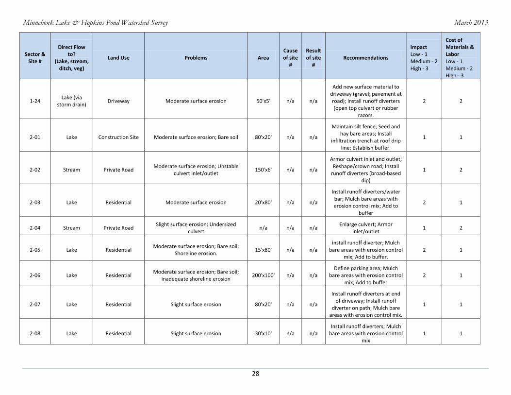
28
Sector & Site #
Direct Flow to?
(Lake, stream, ditch, veg)
Land Use Problems Area Cause of site
#
Result of site
# Recommendations
Impact Low - 1 Medium - 2 High - 3
Cost of Materials & Labor Low - 1 Medium - 2 High - 3
1-24 Lake (via
storm drain) Driveway Moderate surface erosion 50'x5' n/a n/a
Add new surface material to driveway (gravel; pavement at road); install runoff diverters (open top culvert or rubber
razors.
2 2
2-01 Lake Construction Site Moderate surface erosion; Bare soil 80'x20' n/a n/a
Maintain silt fence; Seed and hay bare areas; Install
infiltration trench at roof drip line; Establish buffer.
1 1
2-02 Stream Private Road Moderate surface erosion; Unstable
culvert inlet/outlet 150'x6' n/a n/a
Armor culvert inlet and outlet; Reshape/crown road; Install
runoff diverters (broad-based dip)
1 2
2-03 Lake Residential Moderate surface erosion 20'x80' n/a n/a
Install runoff diverters/water bar; Mulch bare areas with erosion control mix; Add to
buffer
2 1
2-04 Stream Private Road Slight surface erosion; Undersized
culvert n/a n/a n/a
Enlarge culvert; Armor inlet/outlet
1 2
2-05 Lake Residential Moderate surface erosion; Bare soil;
Shoreline erosion. 15'x80' n/a n/a
install runoff diverter; Mulch bare areas with erosion control
mix; Add to buffer. 2 1
2-06 Lake Residential Moderate surface erosion; Bare soil;
inadequate shoreline erosion 200'x100' n/a n/a
Define parking area; Mulch bare areas with erosion control
mix; Add to buffer 2 1
2-07 Lake Residential Slight surface erosion 80'x20' n/a n/a
Install runoff diverters at end of driveway; Install runoff
diverter on path; Mulch bare areas with erosion control mix.
1 1
2-08 Lake Residential Slight surface erosion 30'x10' n/a n/a Install runoff diverters; Mulch
bare areas with erosion control mix
1 1
Minnehonk Lake & Hopkins Pond Watershed Survey March 2013
29
Sector & Site #
Direct Flow to?
(Lake, stream, ditch, veg)
Land Use Problems Area Cause of site
#
Result of site
# Recommendations
Impact Low - 1 Medium - 2 High - 3
Cost of Materials & Labor Low - 1 Medium - 2 High - 3
2-09 Ditch Driveway Moderate surface erosion; Bare soil 500'x20' n/a n/a Add new surface material (gravel); Grade driveway;
Install runoff diverter; 1 2
3-01 Lake Residential Slight surface erosion; Bare soil;
Inadequate shoreline vegetation. 4'x5' n/a 3-03
Establish buffer; Mulch Bare areas with erosion control mix
1 1
3-02 Lake Residential Roof runoff erosion; undercut shoreline;
Inadequate shoreline vegetation 60'x3' n/a n/a
Install infiltration trench at roof drip line; Establish buffer.
1 1
3-03 Lake State Road Winter sand and salt runs into storm
drain and culvert with direct flow to lake - Sediment delta
n/a n/a Install catch basin 3 3
3-04 Stream State Road Storm drain with direct flow to stream n/a n/a Install catch basin 3 3
3-05 Stream Residential Roof runoff erosion 15'x20' n/a n/a Rip/rap rock barrier 2 1
3-06 Lake Residential Moderate surface erosion; man-made ditch/drainage picks up sediment and
flows to lake 50'x1' n/a n/a
remove ditch/drainage or stabilize with stone
2 1
3-07 Lake Residential Roof runoff erosion 120'x5' n/a n/a Install gutters 2 3
3-08 Stream Residential Bare soil; Shoreline erosion and
inadequate shoreline vegetation. 20'x10' n/a n/a Establish Buffer 2 1
3-09 Lake Residential Bare soil (gardens) 30'
diameter n/a n/a Install barrier around gardens 1 1
3-10 Stream Residential Moderate surface erosion; Bare soil;
Roof runoff erosion 10'x15' n/a n/a
Install Infiltration trench; Install Drywell at down spout
2 2
3-11 Stream
Residential Severe surface erosion; Bare soil under
buildings 10'x10' n/a n/a TBD 3 3
3-12 Stream State Road Moderate surface erosion; Moderate
road shoulder erosion; Bare soil 20'x10' n/a n/a
Armor ditch with stone; Install runoff diverters
2 2
3-13 Stream Driveway Moderate surface erosion; Bare soils 75'x15' n/a 3-14 Add new surface material;
Install runoff diverters; Rubber razors
2 2
Minnehonk Lake & Hopkins Pond Watershed Survey March 2013
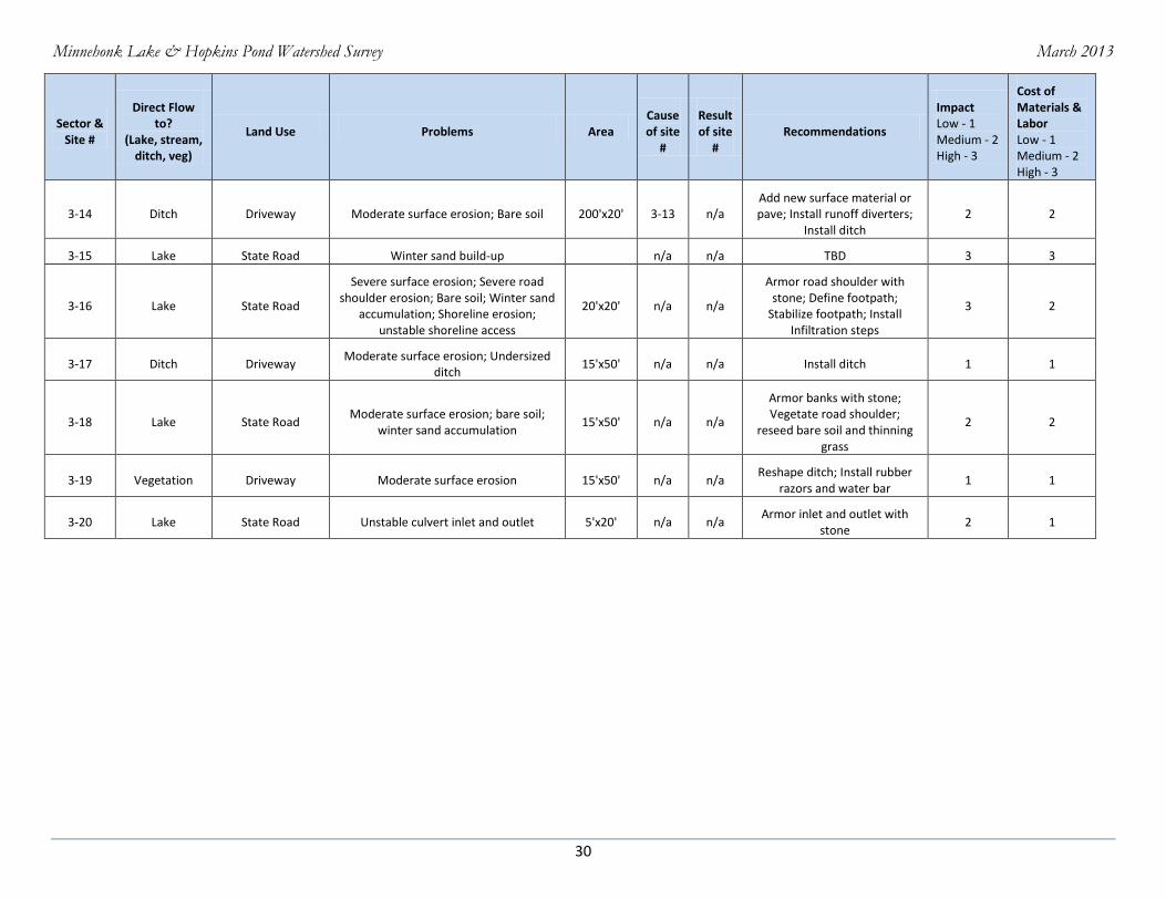
30
Sector & Site #
Direct Flow to?
(Lake, stream, ditch, veg)
Land Use Problems Area Cause of site
#
Result of site
# Recommendations
Impact Low - 1 Medium - 2 High - 3
Cost of Materials & Labor Low - 1 Medium - 2 High - 3
3-14 Ditch Driveway Moderate surface erosion; Bare soil 200'x20' 3-13 n/a Add new surface material or pave; Install runoff diverters;
Install ditch 2 2
3-15 Lake State Road Winter sand build-up n/a n/a TBD 3 3
3-16 Lake State Road
Severe surface erosion; Severe road shoulder erosion; Bare soil; Winter sand
accumulation; Shoreline erosion; unstable shoreline access
20'x20' n/a n/a
Armor road shoulder with stone; Define footpath;
Stabilize footpath; Install Infiltration steps
3 2
3-17 Ditch Driveway Moderate surface erosion; Undersized
ditch 15'x50' n/a n/a Install ditch 1 1
3-18 Lake State Road Moderate surface erosion; bare soil;
winter sand accumulation 15'x50' n/a n/a
Armor banks with stone; Vegetate road shoulder;
reseed bare soil and thinning grass
2 2
3-19 Vegetation Driveway Moderate surface erosion 15'x50' n/a n/a Reshape ditch; Install rubber
razors and water bar 1 1
3-20 Lake State Road Unstable culvert inlet and outlet 5'x20' n/a n/a Armor inlet and outlet with
stone 2 1