mmr afcee brochure 2010
TRANSCRIPT

Groundwater Plume Maps ampInformation Booklet
Groundwater Plume Maps amp Information Booklet
Air Force Center for Engineering and the Environment Massachusetts Military Reservation
Cape Cod Massachusetts
2010
MMRMMRMMRMMRMMR454664
SDMS DocID 454664
Air Force Center for Engineering and the EnvironmentAir Force Center for Engineering and the Environment
Understanding Contamination and Paths to Exposure
Risk is a measurement of the likelihood that people plants or animals may experience negative effects as a result of their exposure to contamination Risk factors are considered to be the type of contaminant its concentration and the duration and nature of contact or exposure
The Air Force Center for Engineering and the Environment (AFCEE) Installation Restoration Program (IRP) is one of several organizations that address ongoing concerns of risk and public health for those who reside near the Massachusetts Military Reservation (MMR) in the surrounding towns of Bourne Falmouth Mashpee and Sandwich
R I S K
AFCEE is currently involved with 80 locations on the MMR that have been investigated and 11 groundwater plumes are undergoing treatment One plume and additional areas are being monitored AFCEE has taken appropriate measures to clean up and restore contaminated soil and groundwater
AFCEE the US Environmental Protection Agency (EPA) and the Massachusetts Department of Environmental Protection (MassDEP) have and continue to make efforts to eliminate exposure pathways that could put people at risk from base-related contamination In areas potentially affected by groundwater contamination residences have been connected to municipal water supplies AFCEE initiated a program in 2008 to validate the status and safety of existing private wells in plume areas since some of these wells could still be used for a potable water source andor for outside watering purposes Wells that continue to be used in areas near plumes are tested free of charge to homeowners Water in nearby recreational ponds (Ashumet Johns Coonamessett Deep Jenkins Round and Snake Ponds) is tested twice during the recreational season with results to date showing no base-related contaminants Potential impacts on ecosystems in ponds vernal pools wetlands rivers and salt water harbors are also monitored Other actions to eliminate exposure pathways are addressing source areas and constructing treatment systems to clean up the plumes These systems are monitored to ensure that no unsafe levels of contaminants are reintroduced back into the environment when treated water is returned to the aquifer or when soil is cleaned
If there is no exposure there is no health risk
Exposure can only occur if there is a pathway for the contaminant to travel from the source to people plants or animals Exposure pathways include
1 Ingestion (drinking or eating contaminated water or food)
2 Dermal contact (touching contaminated soil or water eg showering swimming)
3 Inhalation (breathing in contaminated vapors of chemicals that evaporate into air)
Different routes of exposure to a contaminant can result in different health concerns The following factors and characteristics determine the type and severity of health effects that may occur as a result of exposure to contaminants
bull Concentration (how much)
bull Carcinogenic or noncarcinogenic contaminant
bull Frequency (number of days per year)
bull Age (child or adult receptor)
bull Duration (number of years)
bull Specific sensitive groups (eg pregnant women)
bull Toxicity (characteristics of the chemical)
Information Booklet - April 2010 2
Massachusetts Military ReservationMassachusetts Military Reservation
In order for there to be a risk there must first be an exposure to a contaminant The amount of risk to onersquos health depends on the duration of exposure the toxicity of the particular contaminant the concentration of the contaminant and various personal factors The primary potential health risk at and around MMR is from drinking contaminated groundwater No exposure means no risk
Source areas are located on base and most have already been cleaned up The majority of residences around the base are connected to municipal water For those residences not connected to municipal water and located in an area that might be potentially at risk AFCEE conducts a voluntary residential well sampling program Most of the residential wells in the area draw water from a shallow depth or zone in the upper portion of the aquifer while most of the plumes associated with MMR are deep mdash as much as 100 to 200 feet below the ground surface If there is no possibility of exposure to contaminants and there is no reason to believe that there will be in the future the contaminants do not pose a risk to human health or the environment Since AFCEE began managing the IRP at MMR there have been no known detections of plume-related contaminants in residential private wells above safe drinking water limits
AFCEE has provided more than 1100 conversions from private well systems to municipal water in the four Upper Cape towns in the plume areas but many residential and irrigation wells were not closed at the time of those conversions As part of AFCEErsquos Land Use Control Program if homeowners are interested in keeping and using their wells a risk assessment will be completed This would involve an evaluation of the depth of the well in proximity to the plume and may include testing of the well water AFCEE will offer free decommissioning of any well that is found to present an unacceptable risk (this involves disconnecting piping to the house and filling in the well casing) If decommissioning is not accepted AFCEE will take other steps to insure protectiveness such as requesting assistance from the appropriate Board of Health to prevent exposure offering bottled water (if the well is used for drinking) installing a treatment system on the well or providing a municipal water supply connection
Since AFCEE began managing the IRP at MMR there have been no known detections of plume-related contaminants in residential private wells above safe drinking water limits
3 Information Booklet - April 2010
Air Force Center for Engineering and the EnvironmentAir Force Center for Engineering and the Environment
Some terms you need to know
COC = Contaminant of Concern
gpm = Gallons Per Minute
GW-1 = State default cleanup value to be used in lieu of site-specific risk-based level
MCL = Maximum Contaminant Level A maximum contaminant level is the highest level of a contaminant that is allowed in drinking water MCLs are enforceable standards by the EPA
MMCL = Massachusetts Maximum Contaminant Level In cases where the MMCL is lower than EPArsquos MCL the more stringent (lower) standard is applied as part of AFCEErsquos analysis and cleanup actions
MG = Million Gallons
ROD = Record of Decision
SPEIM = System Performance and Ecological Impact Monitoring
microgL = Micrograms Per Liter A microgram per liter is approximately 1 drop in 22000 gallons
The most toxic COCs are those with the lowest target cleanup levels For example a half-drop of EDB would conceptually bring an Olympic size swimming poolrsquos concentration equal to the EDB MMCL of 002 microgL Similarly it would take 1 frac34 teaspoons of TCE to bring an Olympic size swimming poolrsquos concentration equal to the TCE MCL of 5 microgL
At MMR there are a number of COCs Contaminant of Concern Cleanup Level Type of Contaminant trichloroethene (TCE) 5 microgL solvent perchloroethene (PCE) 5 microgL solvent carbon tetrachloride (CCl4) 5 microgL solvent ethylene dibromide (EDB) 002 microgL fuel-related compound benzene 5 microgL fuel-related compound vinyl chloride (breakdown product of reductive chlorination)
2 microgL solvent
1122-TeCA 2 microgL solvent 14-dichlorobenzene 5 microgL solvent manganese 300 microgL metal thallium 2 microgL metal lead 15 microgL metal toluene 1000 microgL fuel RDX 06 microgL explosive
Information Booklet - April 2010 4
Massachusetts Military ReservationMassachusetts Military Reservation
Source Areas
A source area is an area considered to be a possible ldquosourcerdquo of contamination to the environment These areas contain contaminated soil as a result of past spills or other activities and depending on the type and concentration of contamination could threaten the underlying groundwater or the plants animals or humans who come into direct contact with the contaminated soil
There are 80 locations on the MMR that have been evaluated as part of the Air Force cleanup efforts Many of those locations were confirmed as source areas that contributed to soil andor groundwater contamination at some point in the past The current status of the source areas is shown in the graphic below Contaminated soil is either treated in place or excavated and transported to an approved facility for on-base or off-base treatment andor disposal For contamination that is too deep to safely excavate in-place soil cleanup is conducted This involves a treatment called soil vapor extraction (SVE) In the SVE process pipelines are used to apply a vacuum to the soil and remove the contaminants as vapor which is then treated with carbon in a vapor treatment system
In several cases source areas have contributed to groundwater contamination at concentrations exceeding MCLs or MMCLs thereby creating a groundwater plume
In the summer of 2007 EPA published in the Federal Register a Notice of Intent (NOI) for Partial Deletion from the Otis Air National Guard BaseCamp Edwards Superfund Site (MMR) The NOI covered 61 source areas on the MMR All of these sites have been investigated and where needed cleanup actions were completed Determinations of no-further-response and no-further-risk to human health and the environment have been made for these sites The sites that are associated with groundwater plumes have not been included even though investigation andor cleanup may have been completed
Although some sites are located within plume boundaries from the two-dimensional perspective site investigation data and plume data demonstrate that these sites are not connected to plumes Therefore EPA believes that it is acceptable to partially delist a surface site while a groundwater plume is undergoing cleanup The partial deletion does not include groundwater plumes where cleanup levels have not been met or sites where investigation or cleanup is ongoing
In late 2007 this partial deletion was finalized If any new contamination information becomes available EPA may reopen any site that was previously deleted
Investigationcleanup completed
Monitoring
77
3
Source Area Status
5 Information Booklet - April 2010
Air Force Center for Engineering and the EnvironmentAir Force Center for Engineering and the Environment
Where did this contamination come from
Since the early 1900s MMR has been used for military purposes including troop training and maneuvers military aircraft operations vehicle maintenance and support Some activities required the use of petroleum products solvents and other hazardous materials It was common practice for many years at the MMR as it was at other military bases and industrial facilities throughout the country to dispose of wastes in unlined landfills and drywells to dump and burn them at firefighter-training areas or to rinse them down drains In addition pipeline breaks and accidental spills occurred at MMR Today the use and disposal of hazardous materials is strictly managed and regulated at MMR to be protective of the environment The IRP is the program that cleans up soil and groundwater contamination resulting from historic use of the southern portion of MMR AFCEE is the agency that is responsible for the IRP EPA and MassDEP oversee AFCEErsquos cleanup effort at MMR
The US Army Environmental Commandrsquos Impact Area Groundwater Study Program (IAGWSP) is responsible for addressing soil and groundwater contamination from historic activities at Camp Edwards on the northern portion of MMR The phone number for the IAGWSP office is (508) 968-5630
Information Booklet - April 2010 6
Massachusetts Military ReservationMassachusetts Military Reservation
How are the groundwater plumes treated
Aplume is a body of groundwater containing contaminants that exceed federal andor state safe drinking water standards When chemicals from source areas travel downward through the sandy soils they eventually reach the aquifer where they begin to dissolve Once dissolved they begin to move with the groundwater thus creating a plume
To actively treat groundwater contamination extraction wells are placed within a plume to pump the contaminated groundwater from the aquifer to a treatment plant where the water is filtered through carbon held in large vessels (The used carbon is recycled off site and reused at MMR) Treated water is returned to the aquifer using reinjection wells or infiltration galleries while treatment facilities at river systems utilize bubblers
The IRP is currently addressing 12 groundwater plumes Many of these plumes are located beyond the MMR boundary and are currently in various stages of study and cleanup At this time systems are treating approximately 14 million gallons of groundwater per day Computer modeling suggests that it may take more than 30 years to fully remediate all of the groundwater contamination associated with MMR Several plumes have shown dramatic decreases in size and contaminant concentrations due to years of groundwater treatment actions Plumes and treatment systems are continually being monitored and optimized to reduce the overall cleanup time
Eleven plumes are undergoing groundwater cleanup Ashumet Valley Chemical Spill 4 (CS-4) CS-10 CS-20 CS-21 CS-23 Fuel Spill 1 (FS-1) FS-12 FS-28 FS-29 and Landfill 1 (LF-1)
One plume CS-19 is in long-term monitoring LF-2 and Storm Drain 5 (SD-5) two sites where the groundwater contamination no longer meets the definition of a plume are also in long-term monitoring
Treated water is returned to the aquifer using reinjection wells or infiltration galleries Treatment facilities at river systems utilize bubblers
Treatment plants clean up extracted contaminated groundwater by filtering it through carbon held in large vessels
Extraction wells are placed within a plume to pump contaminated groundwater from the aquifer to the treatment plant
saturated sand (aquifer)
Bubbler
The Groundwater Treatment Process
7 Information Booklet - April 2010
LRMW0003
WL18M1
Co
unty Road
Route 151
Sand
wich
Roa
d
Rou
te 2
8
Rou
te 2
8A
Thomas B Lande rs R d
Rou
te 1
30
Last Opened 4142010 11522 PM by SD YFiguresGeneralCIPlumeMaps2010ArcmapPlumeMap_8x11Pmxd
CS-19 Impact Area
Note There are other groundwater plumes in this area not part of the IRP and therefore not depicted
Town ofon the mapFor further information see httpgroundwaterprogramarmymil or
call Pamela Richardson at (508) 968-5630 Sandwich email pamelajrichardsonusarmymil
FS-12 Treatment FacilityTown of
Peters
Bourne Pond
Massachusetts Military
ETHETHETHETHETHETHETH)
ETHETHETHETHETHETH
ETHETH FS-12ETHETHNtilde
ETH
NtildeNtildeETHReservation
NtildeNtildeETH ETHETHETH Ntilde
NtildeNtildeNtildeNtildeNtildeNtildeNtildeNtildeETHETHETH
ETHETHETH
NtildeNtildeETHNtildeNtilde
NtildeNtildeSnake PimlicoPond
Pond
Weeks PondRed Brook
Harbor
CS-10 Treatment Facility
LF-1
Wakeby Pond
ETH
ETH
ETH
Mashpee Pond
LF-1 Treatment Facility LF-1 )ETH
Ntilde
CS-10 ETH
ETH) LF-1 ETHETH
ETH Sandwich Road
ETH
ETH
ETH
ETH
Treatment FacilityMegansett Harbor
ETH
ETH
CS-23
Hunter Avenue NtildeNtildeNtildeNtilde)
NtildeNtildeNtildeNtildeNtildeNtilde
NtildeETH
ETH
ETH
)
FS-1 Treatment Facility
)ETH
ETH ETHETH
ETHETHETHETH
ETHETHNtildeCS-21 CS-20 ETHETHNtildeNtilde Ntilde
NtildeETH CS-4 ETHETHCS-21
ETH
ETH
Ntilde
ETH
ETH FS-1 TreatmentAshumetETH FacilityNtilde ETH
ETH
ETH Pond ETH JohnsFS-29 ETHETH
ETH
ETH Pond Ntilde
FS-29 Ntilde Ntilde
CS-10
ETH
ETH
) Coonamessett
Ashumet ValleyFS-28 Pond
Treatment FacilityoaTown of
MashpeeFS-28 Treatment Facility ETH)
FS-28 ETH
Decommissioned Shallow FS-28 Wellpoint Extraction System Round
Ashumet ValleyPond
ETH
Jenkins Pond
Town of
Falmouth Ashumet Valley Leading Edge Treatment Facility ETH
Data Source AFCEE March 2010 AFCEE-MMR Data Warehouse Legend
Air Force Center for Plume Boundary (Dashed Where Inferred) Treatment System Piping Engineering and the Environment Defines Area of Groundwater Contaminants Infiltration GalleryTrench of Concern Above Regulatory Limits
Town Boundary IRP PLUMES AND
ETH
ETH
ETH
ETH
Reinjection Well
Extraction Well
Reinjection Well (Off)
Extraction Well (Off)
BogWetland TREATMENT SYSTEMS APRIL 2010O Installation Restoration Program
0 06 12 AFCEE - Massachusetts Military ReservationOutflow Bubbler Miles
U Treatment Facility
Information Booklet - April 2010 8
RRoouu
ttee 22
88
GGiibbbbss RRooaadd
SSaanndd
wwiicchh
PPooccaa
sssseett
RRooaadd
KKeennddrriicckk RRooaadd
WWoooodd RRooaadd
TTuurrpp
eenntt iinn
eeRR
oo aadd FFoorreessttddaallee PPooccaasssseett RRooaadd
RRoouu
ttee1133
00
GGrree
eennwwaa
yy RRooaadd
BBuu rr
gg ooiinn
ee RR
ooaadd
CCaappee CCoodd
CCaannaall
Massachusetts Military ReservationMassachusetts Military Reservation
CS-19 Groundwater Plume
The CS-19 site involves past ordnance and military waste disposal An area of approximately two acres was used to bury and detonate ordnance and munitions debris at depths to 12 feet These ordnance and waste disposal practices at the CS-19 site resulted in contaminants being released to the surrounding soil and groundwater AFCEE conducted multiple testing and cleanup actions at CS-19 between 2004 and 2009 including the removal of more than 2800 cubic yards of soil 8500 ordnance items and 27000 pounds of munitions debris from the original two-acre site
RDX an explosives compound Last Opened 3312010 104453 AM by SD YFiguresGeneralCIPlumeMaps2010ArcmapCS19plumemxdis the contaminant of concern
associated with CS-19 The NNoottee PPlluummeess ddeeppiicctteedd iinn tthhiiss mmaapp
ootthheerr tthhaann CCSS--1199 aarree nnoott ppaarrtt ooff tthhee IIRRPP groundwater plume is defined by RDX concentrations above FFoorr ffuurrtthheerr iinnffoorrmmaattiioonn sseeee
hhttttppggrroouunnddwwaatteerrpprrooggrraammaarrmmyymmiill oorrthe EPA risk-based level of ccaallll PPaammeellaa RRiicchhaarrddssoonn aatt ((550088)) 996688--55663300 eemmaaiill ppaammeellaajjrriicchhaarrddssoonnuussaarrmmyymmiill06 microgL
The CS-19 plume is located within the Central Impact Area DDeeeepp
MMaassssaacchhuusseettttss MMiilliittaarryyBBoottttoomm PPoonndd(CIA) study area and adjacent RReesseerrvvaattiioonn
to the CIA groundwater plume which is managed by the IAGWSP For more information about the IAGWSP please call 508-968-5630orvisit thewebsite at httpgroundwaterprogram armymil
LLiittttllee HHaallffwwaayy PPoonndd
DDoonnnneellyy PPoonndd
IImmppaacctt AArreeaa CCSS--1199A 2009 ROD calls for
continued monitoring of CCSS--1199 SSoouurrccee AArreeaa groundwater concentrations
and implementation of land use controls to prevent residential exposure The plume is not anticipated to move beyond the base boundary The final remedy selected for the CS-19 groundwater plume will not OOppeenniinngg
PPoonnddpredetermine or limit remedial options for the CIA plume which CS-19
is in close proximity to CS-19 Massachusetts Military
Reservation
SSnnaakkee PPoonndd
WWeeeekkss 0 1500 3000
PPoonndd Feet
Data Source AFCEE March 2010 AFCEE-MMR Data Warehouse
Legend CS-19 Plume Boundary = Explosives Plume Concentrations Army Program Plumes Air Force Center for (RDX Hexahydro-135-trinitro-135-triazine) Above EPA Perchlorate Plume - Engineering and the Environment risk-based level of 06 ugLmicrogL Concentrations Exceed Town Boundary MMCL = 20 microgL CHEMICAL SPILL-19 (CS-19)
RDX Plume -Massachusetts Military Reservation Boundary PLUME - APRIL 2010Concentrations
exceed EPA 10-6 Source Area
risk-based AFCEE - Massachusetts Military Reservation measure of concentration It is approximately level = 06 ppb equivalent to parts per billion (ppb)
Note microgL = micrograms per liter and is a
9 Information Booklet - April 2010
Air Force Center for Engineering and the EnvironmentAir Force Center for Engineering and the Environment
CS-10 Groundwater Plume
The Chemical Spill 10 (CS-10) groundwater plume resulted from spills and releases from multiple sources The primary source area originated from the former Boeing Michigan Aerospace Research Center Missile Site (from 1960 to 1973) and Unit Training Equipment Site (UTES) From 1996 through 2005 several source area cleanup actions were conducted at the site including 15 drainage structure removals and soil treatment with soil vapor extraction More than 1500 tons of contaminated soil were excavated and taken off site for disposal
Groundwater concentrations in monitoring wells located in the source area no longer exceed cleanup levels and the plume is detached from its primary source area Studies have shown that portions of the CS-10 plume no longer discharge to Ashumet and Johns Ponds Surface water sampling from both ponds in 2009 showed zero detections of contaminants associated with CS-10
The primary contaminants in the CS-10 plume are the cleaning solvents PCE and TCE which have been detected above the state and federal MCLs of 5 microgL Long-term remediation is occurring with a treatment system comprised of a series of extraction wells treatment plants reinjection wells and infiltration galleries The treatment plants use granular activated carbon to remove the solvents from the groundwater and the treated water is returned to the aquifer through the infiltration galleries and reinjection wells
An additional extraction well to address the southern trench contamination an additional reinjection well to improve hydraulic capture of the plume and revised flow rates in several extraction wells were completed in February 2009
The CS-10 Plume final ROD signed in 2009 specified continued operation and monitoring of the existing treatment system along with land use controls
CS-10 Date of ROD
or DD in Place Cleanup
Start Projected
Finish Primary
Contaminants 2009 Highest Levels (microgL)
Highest Historic Levels (microgL)
August 2009 June 1999 2055 PCE 51 400 (July 2000) TCE 1740 5110 (June 1997)
Treatment Components in Operation1
Treatment Plants Treatment Rate (gpm) (originalcurrent)1
Volume Treated (MG)2
Extraction Wells 15 Reinjection Wells 12 Infiltration Trenches 2
In Plume 2 27802290 13565 Sandwich Road 1 820410 4204 Northern Lobe uses SR 75190 9799
CS-10 Plume Treatment Systems SR = Sandwich Road ROD = Record of Decision DD = Decision Document microgL = micrograms per liter MG = million gallons gpm = gallons per minute 1 Current treatment rate as of April 1 2010 2 Through December 2009
Information Booklet - April 2010 10
ETHETHETHETH
MMMMRR BBoouunnddaarryy
RRoouuttee 115511
SSnnaakkee
PPoonndd RRooaadd
CCoonnnneerryy AAvveennuuee
TTuurrppeenn
tt iinnee
RRooaadd GG
rreeeenn
wwaayy
RRooaa
dd
Last Opened 482010 104134 AM by SD YFiguresGeneralCIPlumeMaps2010ArcmapCS10plumemxd
CS-10 In-Plume Treatment Facility SSnnaakkee PPoonndd
WWeeeekkss PPoonndd
CCSS--1100 SSoouurrccee AArreeaa
SSaannddwwiicchh BBoouurrnnee
CCSS--1100 IInn--PPlluummee TTrreeaattmmeenntt FFaacciilliittyy
ETHETH
ETHETH
CS-10 Sandwich Road Treatment Facility
ETHETH )) OOssbboorrnn PPoonndd ETHETH ETHETH
ETHETH
MMaassssaacchhuusseettttss MMiilliittaarryy RReesseerrvvaattiioonn
EEddmmuunnddss PPoonndd
ETHETH
CCSS--1100
ETHETH
SSaannddwwiicchh RRooaadd TTrreeaattmmeenntt FFaacciilliittyy
ETHETHETHETHETHETHETHETHETHETHETHETHETHETH
ETHETH )ETH
)ETH
ETHETH ETHETHETH ETHETHETHETHETH
ETHETH ETHETH
ETH
ETHETHETHETHETH ETHETH
ETHETH MMooooddyy PPoonnddETHETH
ETHETHETHETH
ETHETH
ETHETH
ETHETH
NNoorrtthheerrnn LLoobbee
AAsshhuummeett ETHETH PPoonndd
ETHETH
Plume Flows Under Pond
NNoorrtthh CCeennttrraall LLoobbee
JJoohhnnss
FFaallmmoouutthh
SSoouutthheerrnn LLoobbee
PPoonndd
MMaasshhppeeee1300 2600
Feet
Data Source AFCEE March 2010 AFCEE-MMR Data WarehouseLegend CS-10 Plume Boundary = Concentrations exceeding drinking Infiltration Trench water standards or Maximum Contaminant Level (MCL) Air Force Center for
Treatment System Pipingdashed where inferred Engineering and the Environment Represents an exceedance of trichloroethene ETH Extraction Well (On) (TCE) andor perchloroethene (PCE) ETH Extraction Well (Off) CHEMICAL SPILL-10 (CS-10)(TCE MCL = 5 microgL) (PCE MCL = 5 microgL) ETH Reinjection Well (On) PLUME - APRIL 2010 Massachusetts Military Reservation Boundary ETH Reinjection Well (Off) AFCEE - Massachusetts Military Reservation Town Boundary U Treatment Facility
U Source Area
11 Information Booklet - April 2010
0
Air Force Center for Engineering and the EnvironmentAir Force Center for Engineering and the Environment
Ashumet Valley Groundwater Plume
The Ashumet Valley plume has two sources the former firefighter-training area 1 (FTA-1) and the former MMR Sewage Treatment Plant (CS-16 and CS-17) Firefighter-training exercises were held from 1958 to 1985 at FTA-1 during which time flammable waste liquids were burned and extinguished some of which entered the sandy soil and eventually reached the groundwater aquifer The former sewage treatment plant which operated from 1936 to 1995 released treated water to a series of sand infiltration beds Sludge materials were kept on site
Treatment of contaminated soils at FTA-1 was completed in September 1997 A total of 42531 tons of soil were treated at FTA-1 using a thermal treatment process In 2001 and 2002 contaminated soil was removed from the CS-16 and CS-17 sites and taken off base for proper disposal
The primary contaminants in the Ashumet Valley plume are the cleaning solvents PCE and TCE which have been detected above the state and federal MCLs of 5 microgL The Ashumet Valley plume is currently in long-term remediation Remediation is occurring with two treatment systems each comprised of a single extraction well treatment plant and infiltration galleries river discharge The treatment plants use granular activated carbon to remove the solvents from the groundwater and the treated water is returned to the aquifer through the infiltration galleries in the central portion of the plume and to a bog ditch along the Backus River in the southern area
The Ashumet Valley Plume final ROD which was signed in 2009 specified continued operation of the existing treatment system plus additional treatment for the southern portion of the plume The southern treatment system has been installed The ROD also required land use controls
AFCEE does not believe that any portion of the plume is currently discharging into Ashumet Pond Surface water sampling from Ashumet Pond in 2009 showed that no plume contaminants were detected
In 2001 AFCEE applied an alum treatment to Ashumet Pond water to reduce the amount of phosphorus in the pond much of which comes from the basersquos wastewater treatment plant phosphorus plume In 2004 a geochemical barrier (made up of zero-valent iron mixed with pond sediment) was installed along the shoreline of Ashumet Pond to reduce the amount of phosphorus in groundwater entering the pond A second alum treatment is being evaluated for 2010
A part of the southern portion of the Ashumet Valley plume discharges to the Backus River in Falmouth Surface water testing conducted in 2009 showed results below the MCL Please note that safe drinking water guidelines (MCLs) do not apply to surface water bodies AFCEE continues to monitor the entire plume area
Ashumet Valley Date of ROD
or DD in Place Cleanup
Start Projected
Finish Primary
Contaminants 2009 Highest Levels (microgL)
Highest Historic Levels (microgL)
March 2009 November 1999 2018 PCE 43 109 (October 1998) TCE 12 83 (August 1997)
Treatment Components in Operation1
Treatment Plants Treatment Rate (gpm) (originalcurrent)1
Volume Treated (MG)2
Extraction Wells 2 Infiltration Trenches 2
Bubbler 1
1 1200350 4768
1 Mobile Treatment Unit 175175 268
ROD = Record of Decision DD = Decision Document microgL = micrograms per liter MG = million gallons gpm = gallons per minute 1 Current treatment rate as of April 1 2010 2 Through December 2009
Information Booklet - April 2010 12
MMMMRR BBoouunnddaarryy
RRoouuttee 115511
OOlldd BBaarrnnssttaabbllee RR
ooaadd
SSaanndd
wwiicchh RR
ooaadd
SSaamm TTuurrnneerr RRooaadd
CCaarrrriiaaggee SShhoopp RRoo
aadd
BBaacckk
uuss RR
iivveerr
0
Last Opened 482010 104135 AM by SD YFiguresGeneralCIPlumeMaps2010Arcmapashumetvalleymxd
BBoouurrnneeAshumet Valley Treatment Facility MMaassssaacchhuusseettttss SSaannddwwiicchhMMiilliittaarryy
RReesseerrvvaattiioonn FFTTAA--11 SSoouurrccee AArreeaa
MMooooddyy PP
FFoorrmmeerr MMMMRR SSeewwaaggee
TTrreeaattmmeenntt PPllaanntt ((SSoouurrccee AArreeaa)) AAsshhuummeett
PPoonndd
JJoohhnnss PPoonndd
DDeeeepp PPoonndd
AAsshhuummeett VVaalllleeyy TTrreeaattmmeenntt FFaacciilliittyy
CCoooonnaammeesssseettttPPoonndd
ETHETH
))
ETHETH
ETHETH
CCrrooookkeeddPPoonndd MMaasshhppeeee
FFaallmmoouutthh AAsshhuummeett VVaalllleeyy
RRoouunndd PPlluummeePPoonndd PPlluummee PPaarrttiiaallllyy
DDiisscchhaarrggeess TToo TThhee RRiivveerr
JJeennkkiinnss PPoonndd
FFllaaxx AAsshhuummeett VVaalllleeyy LLeeaaddiinn Pgg Poonndd
EEddggee TTrreeaattmmeenntt FFaacciilliittyy
1500 3000 ETHETHAshumet Valley LeadingFeet Edge Treatment Facility
Note microgL = micrograms per liter and is a measure of concentration It is approximately equivalent to parts per billion (ppb)
Data Source AFCEE March 2010 AFCEE-MMR Data WarehouseLegend ETHETH
Extraction Well (On)Ashumet Valley Plume Boundary = Concentrations exceeding drinking water standards or Maximum Contaminant Level (MCL) dashed where inferred
Air Force Center for Engineering and the Environment
Extraction Well (Off)
TTreatment Facilityreatment FacilityRepresents an exceedance of trichloroethene (TCE) andor ASHUMET VALLEY PLUME perchloroethene (PCE) Outflow Bubbler (TCE MCL = 5 microgL) Massachusetts Military APRIL 2010(PCE MCL = 5 microgL) Reservation Boundary
AFCEE - Massachusetts Military ReservationTreatment System Piping Town Boundary ThalliumManganese Area
BogWetlandInfiltration Trench
13 Information Booklet - April 2010
Air Force Center for Engineering and the EnvironmentAir Force Center for Engineering and the Environment
CS-23 and LF-1 Groundwater Plumes
The source of the Landfill 1 (LF-1) groundwater plume was the main MMR landfill which operated from 1941 to 1990 The LF-1 plume contains many COCs The more typical COCs are the solvents PCE TCE and CCl4 The state and federal MCLs for PCE TCE and CCI4 is 5 microgL
Test data indicate that no significant contamination is being released to groundwater from the older landfill cells at LF-1 and decreasing chemical concentrations in groundwater downgradient of the more recently used landfill cells suggest that the landfill cap there has been effective in reducing groundwater contamination at the source The cap is inspected annually to monitor its integrity
The LF-1 ROD signed in 2007 consists of continued long-term remediation with a groundwater extraction-and-treatment system and the implementation of land use controls The contaminated groundwater is treated at the LF-1 Treatment Plant and the Hunter Avenue Treatment Facility Water is returned to the aquifer through a reinjection well and infiltration trenches
Because a portion of the LF-1 plume discharges to both Red Brook and Squeteague Harbors surface water and discharging groundwater at the harbors are tested annually and results show that there are no ecological or human health risks
The CS-23 plume is a detached plume that has not been linked to a specific source area All of the potential source areas for the CS-23 plume have been investigated andor remediated The COCs in the CS-23 plume are TCE and CCl4
The CS-23 ROD signed in 2007 consists of continued remediation and operation of the existing groundwater cleanup system and land use controls The contaminated water is treated at the Hunter Avenue Treatment Facility Water is returned to the aquifer through infiltration trenches
LF-1 Date of ROD
or DD in Place Cleanup
Start Projected
Finish Primary
Contaminants 2009 Highest Levels (microgL)
Highest Historic Levels (microgL)
October 2007 August 1999 2047 TCE PCE 37 (TCE) 150 (TCE Aug 1999)
Treatment Components in Operation1
Treatment Plants Treatment Rate (gpm) (originalcurrent)1
Volume Treated (MG)2
Extraction Wells 6 Reinjection Wells 1 Infiltration Trench 2
2 7001245 3713
CS-23 Date of ROD
or DD in Place Cleanup
Start Projected
Finish Primary
Contaminants 2009 Highest Levels (microgL)
Highest Historic Levels (microgL)
October 2007 December 2006 2018 TCE 177 572 (June 2002)
Treatment Components in Operation1
Treatment Plants Treatment Rate (gpm) (originalcurrent)1
Volume Treated (MG)2
Extraction Wells 2 Infiltration Trench 2 1 700700 991
ROD = Record of Decision DD = Decision Document microgL = micrograms per liter MG = million gallons gpm = gallons per minute 1 Current treatment rate as of April 1 2010 2 Through December 2009
Information Booklet - April 2010 14
CS-21
CS-10
CS-21
CS-10
CCoonnnneerryy AAvveennuuee
MMMMRR BBoouunnddaarryy
RRoouutt
ee 2288
AA
RRoo uu
ttee 22
88
RRoouu
ttee 22
88
RReedd
BBrroo
ookk HH
aarrbboo
rr RRooaa dd
DDeeppoo
tt RRooaa
dd
SSccrraaggggyy NNeecc
RReettee
nnttiioo
nnBBaa
ssiinn
CCoomm
mmoonn
BBoo
rrrrooww
PPiitt
BBMMXX
TTrraacc
kk GGrr
aavveell
PPiitt
Last Opened 3312010 93956 AM by SD YFiguresGeneralCIPlumeMaps2010ArcmapLF1_CS23plumemxd
RReedd BBrrooookk PPoonndd 11994477
LF-1 Source 11995577
11995511
PPoosstt--11997700AreaRReedd BBrrooookk KKeettttllee HHoolleeHHaarrbboorr
Plume Discharges to 11997700Red Brook Harbor
LLoonngg MMaassssaacchhuusseettttss MMiilliittaarryyPPoonndd RReesseerrvvaattiioonn
LLFF--11 BBoouurrnnee ETHETHLLFF--11 IInnffiillttrraattiioonn
GGaalllleerryy aanndd TTrreenncchheesskk RRooaadd ((nnoott iinn uussee))
BBoouurrnnee 22 LLFF--11
BBoouurrnnee ETH55 ETHSSqquueetteeaagguuee HHaarrbboorr
LLFF--11 TTrreeaattmmeenntt FFaacciilliittyy
ETHETH
ETHETH
ETHETH
LLFF--11 OOssbboorrnn PPoonndd
LF-1 Treatment Facility
ETHETH
15Inform
ation Booklet -A
pril 2010
Plume Discharges to EEddmmuunnddssSqueteague Harbor SSaannddwwiicchhETHETH PPoonndd
SSppeeccttaaccllee WWeettllaanndd
VVeerrnnaall PPooooll 6655 C11 CSS--2233ETHETH
HHuunntteerr AAvveennuuee
ETHETH TTrreeaattmmeenntt FFaacciilliittyy
AA
0 1000 2000
Feet FFaallmmoouutthh microgL = micrograms per liter and is a measureNote of concentration It is approximately equivalentto parts per billion (ppb)
Hunter Avenue Treatment Facility
Legend LF-1 and CS-23 Plume Boundary = Concentrations exceeding drinking water ETHstandards or Maximum Contaminant Level (MCL) (Dashed where inferred)
ETHRepresents an exceedance of Trichloroethene (TCE) MCL = 5 microgL Perchloroethene (PCE) MCL = 5 microgL Carbon Tetrachloride (CCl4) MCL = 5 microgL 14-Dichlorobenzene (14-DCB) MCL = 5 microgL 1122-Tetrachloroethane (1122-TeCA) GW-1 = 2 microgL Vinyl Chloride (VC) MCL = 2 microgL Ethylene Dibromide (EDB) MMCL = 002 microgL U
Data Source AFCEE March 2010 AFCEE-MMR Data Warehouse
Extraction Well Massachusetts Military Reservation BoundaryReinjection Well
Public Water Town Boundary Supply Well
Infiltration GalleryTrench Source Area
BogWetland BMXBorrow Pit
Treatment Facility
Air Force Center for Engineering and the Environment
LANDFILL-1 (LF-1) AND CHEMICAL SPILL-23 (CS-23) PLUMES
APRIL 2010 AFCEE - Massachusetts Military Reservation
Cape Cod Canal
Route
28
Route 151
Route 28
Route 13
0
Route 6
Route 130
Route
28
Quaker Meetinghouse
Rd
Gree
nway
Rd
Wood Rd
Jefferson Rd
Barlo
w Rd Gibbs Rd
Connery Rd
Turpe
ntine
Rd
Frank
Perki
ns R
d
Pew R
d Ca
nal V
iew Rd
Cape Cod Canal
Route
28
Route 151
Route 28
Route 13
0
Route 6
Route 130
Route
28
Quaker Meetinghouse
Rd
Gree
nway
Rd
Wood Rd
Jefferson Rd
Barlo
w Rd Gibbs Rd
Connery Rd
Turpe
ntine
Rd
Frank
Perki
ns R
d
Pew R
d Ca
nal V
iew Rd
Last Opened 5102010 14919 PM by SD YFiguresGeneralERC_PlumemapGIS20100420Arcmaperc_plumemap_20100420mxd
Legend Chlorinated Solvents Plume -Concentrations Exceed MCLs TCE = 50 microgL PCE = 50 microgL EDB PlConcen
ume -rat ons Exceed MMCL = 002 microgLt i
Perchlorate Plume - Concentrations ExceedMMCL = 20 microgL
RDX Plume - Concentrations exceed EPA 10-6 risk-basedlevel = 06 ppb
Plumes with Remedy in Place
Cape Cod BayCape Cod Bay
NorthwesCorner NorthwesCorner
Demolition Area 2Demolition Area 2 tt
Plumes with Interim Remedy in Place Extraction Well
D Extraction Well (Off) OReinjection Well D Reinjection Well (Off) Scale 1 inch = 1 mile
0 05 1Outflow Bubbler Miles
Treatment FacilityS
Municipal Water Supply Well Town Boundary
SandwichInfiltration TrenchGallery Treatment System Pipeline
Influent Effluent
The areas of contamination show the combined contaminants of concern within each plume
Bourne
Massachusetts Military Reservation
Mashpee Falmouth
Surface water from Long Pond is also used as a drinking water source forthe town of Falmouth
Contaminant of Concern (COC) Type of Contaminant Risk-Based LevelTCE ndash trichloroethene solvent MCL = 5 microgPCE ndash perchloroethene solvent MCL = 5 microg
L
CCI4 ndash carbon tetrachloride solvent MCL = 5 microgLL
EDB ndash ethylene dibromide fuel-related compound MMCL = 002 microgLbenzene fuel-related compound MCL = 5 microgvinyl chloride solvent MCL = 2 microg
L
1122-tetrachloroethane solvent GW-1 = 2 microgL
14-dichlorobenzene solvent MCL = 5 microgLL
manganese metal EPA Health Advisory = 300 microgL Massachusetts Military Reservationthallium metal MCL = 2 microgLlead metal 15 microgL (treatment technique action level Groundwater Findings
for water distribution systems)toluene fuel MCL = 1000 microgL Issued April 2010RDX - hexahydro-135-trinitro-135- explosive HA = 2 microgLtriazine GW-1 = 1 microgL
10-6 = 06 microgperchlorate oxidizer HA = 15 microg
L MMCL = 2 microg
LL
MCL ndash Maximum Contaminant LevelMMCL ndash Massachusetts Maximum Contaminant LevelHA ndash Federal Lifetime Health Advisory Note ppb = parts per billion and is a measure of concentrationGW-1 ndash State default cleanup value to be used in lieu of site-specific risk-based level It is approximately equivalent to micrograms per liter (microgL)10-6 ndash EPA level resulting in an excess cancer risk of one in a million
Central Impact Area
Central Impact Area
S Phinneys Harbor
CS-19
S Phinneys Harbor
CS-19
WestBoundary
S J-2ern
S
S
S
J-1
J-3Demolition Area 1
WestBoundary
S J-2ern S
S
S
J-1
J-3Demolition Area 1
S S
Pocasset SS
Harbor
Hen
S L Range
S S
Peters Pond
Pocasset SS
Harbor DD FS-12 tSeveral FS-12 extraction wellurned off (not shown at this scale
s are)
Hen
S L Range
Peters Pond
DD FS-12 tSeveral FS-12 extraction wellurned off (not shown at this scale
s are)
CoveCove Snake
Weeks Pond
Pond Wakeby Pond
Snake
Weeks Pond
Pond Wakeby Pond
Red BrookRed Brook HarborHarbor
LF-1LF-1
Squeteague LF-1 MashpeeHarbor Pond
CS-10SMegansett
LF-1 Harbor DS
CS-23
S
FS-1 S Moody
DD PondCS-21 DSCS-20 D
DDCS-21 CS-4Wild Harbor
Ashumet FS-29
Squeteague LF-1 MashpeeHarbor Pond
CS-10SMegansett
LF-1 Harbor DS
CS-23
S
FS-1 S Moody
DD PondCS-21 DSCS-20 D
DDCS-21 CS-4Wild Harbor
Ashumet FS-29 D D
Pond D Johns
D
Pond Johns
Pond
Pond
CS-10 CS-10
Deep Pond
Deep Pond
Crooked Pond Crooked Pond
Coonamessett D
Pond S
DFS-28
S
Shallow Well Point system is off
FS-28 AshumetValley
Jenkins
Pond
S
Coonamessett D
Pond S
DFS-28
S
Shallow Well Point system is off
FS-28 AshumetValley
Jenkins
Pond
S
Long Pond
Long Pond
Air Force Center for Engineering and the EnvironmentAir Force Center for Engineering and the Environment
FS-1 and FS-12 Groundwater Plumes The source of the Fuel Spill 1 (FS-1) groundwater plume is the Aviation Gas Fuel Valve Test Dump Site in the eastern part of the base The site was used from 1955 to 1970 to test fuel dump valves on EC-121 Super Constellation aircraft which involved the release of fuel directly onto the ground Currently no significant levels of COCs are present in the surface or subsurface soils at the FS-1 source area and the source area groundwater is sampled for lead only
The FS-1 groundwater plume contains the fuel additive ethylene dibromide (EDB) at levels above the MMCL which is 002 microgL The FS-1 plume is currently in long-term remediation with a groundwater extraction-and-treatment system in the Quashnet River cranberry bog area just northeast of Johns Pond The system was designed to prevent upwelling of EDB contamination into the Quashnet River and associated cranberry bogs The treatment plant uses granular activated carbon to remove EDB from the groundwater which is then discharged to the Quashnet River through a series of oxygenating bubblers The latest test results showed that the FS-1 treatment system has been successful in reducing both the amount of EDB in the FS-1 plume and the EDB concentrations in the surface water of the Quashnet River and associated bogs A 2000 ROD specifies active treatment of the plume along with monitoring
The source of the FS-12 groundwater plume was an estimated 70000-gallon release from a section of a now-abandoned fuel pipeline that ran from the Cape Cod Canal to MMR EDB is the only remaining contaminant above cleanup standards in the FS-12 groundwater plume The source area groundwater is currently being monitored after having undergone subsurface remediation in the 1990s Groundwater sampling indicates that the source area has been successfully remediated The pipeline has been cleaned and closed with state and federal regulatory approval
The FS-12 plume is currently in long-term remediation with a groundwater extraction-and-treatment system The treatment system consists of extraction wells a treatment plant and reinjection wells The 2006 ROD called for the status quo of operating and monitoring the existing system The latest test results indicate that the extraction wells continue to successfully contain the FS-12 groundwater plume and the size of the plume has been reduced significantly Land use controls are in place for the FS-1 and FS-12 plumes
FS-1 Date of ROD
or DD in Place Cleanup
Start Projected
Finish Primary
Contaminants 2009 Highest Levels (microgL)
Highest Historic Levels (microgL)
April 2000 April 1999 2020 EDB 0857 445 (October 2000)
Treatment Components in Operation1
Treatment Plants Treatment Rate (gpm) (originalcurrent)1
Volume Treated (MG)2
Extraction Wells 3 Bubblers 3 1 750515 33053
FS-12 Date of ROD
or DD in Place Cleanup
Start Projected
Finish Primary
Contaminants 2009 Highest Levels (microgL)
Highest Historic Levels (microgL)
September 2006 September 1997 2048 EDB 231 890 (November 1996)
Treatment Components in Operation1
Treatment Plants Treatment Rate (gpm) (originalcurrent)1
Volume Treated (MG)2
Extraction Wells 4 Reinjection Wells 20 1 772360 4082
ROD = Record of Decision DD = Decision Document microgL = micrograms per liter MG = million gallons gpm = gallons per minute 1 Current treatment rate as of April 1 2010 2 Through December 2009
Information Booklet - April 2010 18
Co
FP
erki
nsR
d
Co
FP
erki
nsR
d
-
-
QQuuaasshhnneett RRiivveerr GG
rreeaatt HHaayy
RRooaa dd
hhiinnnn
ee yyss
RRooaadd
BBeeaarr
sseess
RRooaa
dd SSaa
ddddlleebb
aacckk RRooaadd
GGrraaffttoonn PPoocckknnee
tt RRooaadd
PPiimmlliiccoo PP nndd RRdd
JJBB TThhoommppssoonn RRdd
SSnn aakkeePPoonndd RRdd
RRtt 113300
nnnneerryy AAvv CCoonnnneerryy AAvv
Last Opened 482010 105423 AM by SD YFiguresGeneralCIPlumeMaps2010ArcmapFS1_FS12plumemxd
FFSS--1122 SSoouurrccee AArreeaa
NNoottee PPlluummeess ddeeppiicctteedd iinn tthhiiss mmaapp ootthheerr tthhaann FFSS--11 aanndd FFSS--1122
aarree nnoott ppaarrtt ooff tthhee IIRRPP FFoorr ffuurrtthheerr iinnffoorrmmaattiioonn sseeee
hhttttppggrroouunnddwwaatteerrpprrooggrraammaarrmmyymmiill oorr ccaallll PPaammeellaa RRiicchhaarrddssoonn aatt ((550088)) 996688--55663300 FFSS--1122 TTrreeaattmmeenntt FFaacciilliittyy
FS 12 Treatment Facility
PP
SSaannddwwiicchheemmaaiill ppaammeellaajjrriicchhaarrddssoonnuussaarrmmyymmiill DD DD
DDDD DDDD
DDDDDD DDDD DD DD DD
DD Ntilde D DNtilde DD FFSS--1122
Ntilde Ntilde
ETHETHD
DDDDDDDNtildeNtildeNtildeNtilde
ETH
NtildeNtilde ETH
DDDDETHETHETHETHNtildeNtildeNtildeNtildeNtildeNtildeNtildeNtildeNtildeNtildeNtildeNtildeNtilde
D DDD NtildeNtildeNtildeNtildeDD NtildeNtildeNtildeSSnnaakk Ntildeee NtildeNtildeNtildeNtildeNtilde NtildeNtildeNtildeNtildePPoonnddBBoouurrnnee oo
WWaakkeebbyy PPoonndd
MMaasshhppeeee
MMaassssaacchhuusseettttss MMiilliittaarryy
RReesseerrvvaattiioonn
PPoonndd
FFSS--11 SSoouurrccee AArreeaa
MMaasshhppeeee
FFSS--11
MMooooddyy PPoonndd
FFSS--11 TTrreeaattmmeenntt FFaacciilliittyy
FS 1 Treatment Facility JJoohhnnss
with bubbler in foreground PPoonndd 0 1500 3000
Feet
Legend Data Source AFCEE March 2010 AFCEE-MMR Data Warehouse
ETH
FS-1 and FS-12 Plume Boundary = Concentrations Outflow Bubbler Army Program Plumes exceeding drinking water standards or Massachusetts Extraction Well (On) Perchlorate Plume shyMaximum Contaminant Level (MMCL) Represents an Concentrations exceedance of ethylene dibromide (EDB) Exceed
ETH Reinjection Well (On) D Extraction Well (Off)
(EDB MMCL = 002 microgL) (Dashed Where Inferred) MMCL = 20 microgL D Reinjection Well (Off)Treatment System Piping RDX Plume shy
Massachusetts Military Reservation Boundary U Treatment Facility Concentrations exceed EPA 10-6
Town Boundary Source Area Note microgL = micrograms per liter and is a measure of U risk-based
level = 06 ppb concentrationIt is approximately equivalent to parts BogWetland per billion (ppb)
19
Air Force Center for Engineering and the Environment
FUEL SPILL-1 (FS-1) AND FUEL SPILL-12 (FS-12)
APRIL 2010 AFCEE - Massachusetts Military Reservation
Information Booklet - April 2010
Air Force Center for Engineering and the EnvironmentAir Force Center for Engineering and the Environment
CS-4 CS-20 CS-21 FS-28 and FS-29 Groundwater Plumes
Five groundwater plumes can be found in the area north and south of Route 151 in the town of Falmouth They are FS-28 FS-29 CS-4 CS-20 and CS-21 Only CS-4 has a known source area a former vehicle maintenance area and storage yard on the MMR The other plumes were found to be disconnected from distinct source areas They most likely originated somewhere in the southern portion of MMR which contained various aircraft and vehicle maintenance shops runways and housingpersonnel support facilities Records indicate that spills andor releases occurred in these areas in the past COCs in the plumes are fuel and solvent-related contaminants They include EDB PCE TCE and CCl4 The MMCL for EDB is 002 microgL while the MCL for the rest of the contaminants is 5 microgL
More than 18000 tons of contaminated soil were treated on site at the CS-4 source area and additional soil was transported off site for proper disposal A groundwater extraction-and-treatment system began operating in 1993 but was later replaced by a more efficient system in 2006 to better capture the plume
Portions of the FS-28 plume were first discovered in 1993 beneath the leading edge of the CS-4 plume In 1996 groundwater investigations found EDB upwelling into the Coonamessett River in Falmouth No EDB is presently detected in the Coonamessett River The FS-28 plume is currently in long-term remediation with a groundwater extraction-and-treatment system A treatment plant is located in a bog area just south of Hatchville Road and treated water is discharged to the Coonamessett River through two oxygenating bubblers Shallow wellpoint extraction wells operated for several years but are no longer being used In 2007 a new extraction well was installed to the south to address a deep lobe of EDB
The FS-28 plume underflows Coonamessett Pond and has not affected the pond or a nearby Town of Falmouth municipal well In 2002 AFCEE funded a $52 million wellhead treatment system to ensure a safe water supply for the Falmouth well A ROD was issued in October 2000
The FS-29 CS-20 and CS-21 groundwater plumes were discovered in the late 1990s A ROD for FS-29 was issued in October 2000 and a ROD for CS-4 CS-20 and CS-21 was issued in February 2000 Since 2006 the FS-29 CS-4 CS-20 and CS-21 groundwater plumes have been undergoing active treatment through a series of extraction wells reinjection wells and infiltration trenches Extracted plume water is treated with granular activated carbon at the Hunter Avenue Treatment Facility on base Land use controls are in place for all these plumes
Plume Date of ROD
or DD in Place Cleanup
Start Projected
Finish Primary
Contaminants 2009 Highest Levels (microgL)
Highest Historic Levels (microgL)
CS-4 February 2000 (ESD 92008) November 2005 2014
TCE 55 19 (February 1997) PCE 232 61 (February 1997)
CS-20 February 2000 (ESD 92008) January 2006 2017 PCE 205 981 (September 2005)
CS-21 February 2000 (ESD 92008) September 2006 2027 TCE 98 988 (June 2001)
FS-28 October 2000 (ESD 92008) October 1997 2047 EDB 138 18 (January 1997)
FS-29 October 2000 (ESD 92008) September 2006 2018 EDB 0084 0318 (May 2001)
ROD = Record of Decision DD = Decision Document microgL = micrograms per liter MG = million gallons gpm = gallons per minute
Information Booklet - April 2010 20
Massachusetts Military ReservationMassachusetts Military Reservation
Plume Explanation Contaminants of concern exceed drinking water standards or Maximum Contaminant Level (MCL) CS-20 Perchloroethene (PCE) (PCE MCL = 5 microgL) FS-29 Ethylene dibromide (EDB) and carbon tetrachloride (CCl4)
(EDB MMCL = 002 microgL) (CCl4 MCL = 5 microgL) CS-4 Trichloroethene (TCE) perchloroethene (PCE)
1122- tetrachlorethane (1122- TeCA) andor ethylene dibromide (EDB) (TCE MCL = 5 microgL) (PCE MCL = 5 microgL) (1122-TeCA GW-1 = 2 microgL) (EDB MMCL = 002 microgL)
CS-21 Trichloroethene (TCE) (TCE MCL = 5 microgL)
Note microgL = micrograms per liter and is a measure of concentration It is approximately equivalent to parts per billion (ppb)
Treatment Components in Operation1
Treatment Plants
Treatment Rate (gpm)1
(originalcurrent)
Volume Treated (MG)2
Extraction Wells 2 Infiltration Trenches 2 1 620199 1027
Extraction Wells 2 Reinjection Wells 4 1 775773 1460
Extraction Wells 4 Reinjection Wells 3 1 14001395 2213
Extraction Wells 2 Bubblers 2 1 750600 43045
Extraction Wells 1 Reinjection Wells 2 1 525224 642
ESD = Explanation of Significant Differences 1 Current treatment rate as of April 1 2010 2 Through December 2009
21 Information Booklet - April 2010
-
SamTurner R
d
Hay
way
Rd
Hatchv
illeRd
Thomas B Landers Rd Sa
ndw
ich
Rd
Boxb
erry
Hill
Rd
Hill and Plain Rd
Route 151
Hatchville Rd
Sand
wichRd
Sam
Tur
ner R
d
Last Opened 412010 82704 AM by SD YFiguresGeneralCIPlumeMaps2010ArcmapFS28plumemxd
Falmouth
FS 28 Treatment Facility
Deep Pond
Plume Flows Under Pond
Round Pond
Coonamessett Pond Coonamessett
Water Supply Well FS-28
Crooked Pond
Outflow Bubbler
ETH
FS-28 Treatment Facility Broad River
FS-28 Shallow Outflow Bubbler
Pond Decommissioned Shallow
Wellpoint Extraction System
DR
AF
T
FS-28
Round Pond
ETHETH
Jenkins Pond
Pond 14
0 770 1540
Feet
Data Source AFCEE March 2010 MMR-AFCEE Data WarehouseLegend FS-28 Plume Boundary = Concentrations exceeding drinking ETH Extraction Well
Air Force Center for water standards or Massachusetts Maximum Contaminant Outflow Bubbler Engineering and the EnvironmentLevel (MMCL) dashed where inferred Represents an exceedance of ethylene dibromide (EDB) Public Drinking FUEL SPILL 28 (FS-28)(EDB MMCL = 002 microgL) Water Supply Well
PLUME - APRIL 2010BogWetland Treatment Facility AFCEE - Massachusetts Military Reservation
Treatment System Piping Note microgL = micrograms per liter and is a measure of concentration
It is approximately equivalent to parts per billion (ppb)
Information Booklet - April 2010 22
MMR Boundary Falmouth
Sandw
ich
Mashpe
e
Whe
eler
Rd
Reilly
Redlands
Rd
Br a
nsha
w S
t
Curr ier R
d
Sim
p kinsR
d
Hoo
ppol
eR
d
Club
Valley
Dr
Gen
eral
sBl
vd
MMR Boundary Falmouth
Sandw
ich
Mashpe
e
Whe
eler
Rd
Reilly
Redlands
Rd
Bra
nsha
w S
t
Currier R
d
Sim
p kinsR
d
Hoo
ppol
eR
d
Club
Val leyD
r
Gen
eral
sBl
vd
Massachusetts Military ReservationMassachusetts Military Reservation
Progress Over The Years
Much progress has been made over the last 15 years Program-wide the source areas have been cleaned up and 11 groundwater plumes are undergoing pump-and-treat cleanup action both on and off base All environmental cleanup decisions and remedies are in place In the future the program will continue to monitor adjust and shut down treatment systems as cleanup progress is made The Air Force will continue to conduct the most efficient cleanup operations while ensuring the protection of public health and the environment
The SD-5 plume depiction illustrates the transformation of the plume over time due to the effect of cleanup systems used by the Air Force for several years Contaminated water was cleaned by using two technologies The first involved extracting the plume water pumping it to a treatment building where large vessels of granular activated carbon removed the solvent contamination and then the clean water was returned to the ground through reinjection wells Two recirculation wells were also used Those involved two underground standalone treatment systems within the neighboring community That technology used air and pumps to remove the solvents from the plume and capture them in carbon tanks The plume has now been cleaned up to the point where only residual traces of solvent contamination are found in monitoring wells which are periodically tested
The following pages depict the cleanup progress of several IRP groundwater plumes over time Most plumes show a significant reduction in size and contaminant mass A few show a larger area which is related to plume information uncertainties in the early part of the cleanup program and changing conditions over time a significant reason why diligent monitoring is required For more information and depictions of all AFCEE groundwater plumes progress over time go to httpwwwmmrorgCleanupplumes_fshtm
Last Opened 3292010 115403 AM by SD YFiguresGeneralPlumeMapsComparison2010ArcMapSD5comp_97_10mxd
SandwichSandwich
Mashpee Mashpee
Ashumet PondAshumet PondFalmouth FalmouthJohns PondJohns Pond
1997 2010
Legend Data Source AFCEE MMR-AFCEE Data Warehouse
Town Boundary
Massachusetts Military Reservation Boundary SD-5 PLUME 1997 AND 2010 COMPARISON
Plume Boundary AFCEE - Massachusetts Military Reservation 0 1100 2200
BogWetland Feet
23 Information Booklet - April 2010
Plum
e Com
parison Over Tim
e
MMR Boundary Falmouth
Sandw
ich
Mashpe
e
Route 151
Kit tredge Rd
Connery Av
Whe
eler
Rd
Cole Rd
Le e Rd Hatc
hville
Rd
Herbert Rd
Reilly
Sam Turner R
d
Sandw
ich R
d
Herbert Rd
Connery Av
Route 151
MMR Boundary Falmouth
Sandw
ich
Mashpe
e
Route 151
Kittredge Rd
Connery Av
Whe
eler
Rd
Cole Rd
Le e Rd
Hatchv
ille R
d
Herbert Rd
Reilly
Sam Turner R
d
Sandw
ich R
d
Herber t Rd
Connery Av
Route 151
MMR Boundary
Falmouth
Sandw
ich
ashpe
e
Route 151
Cur
rier R
d
Whe
eler
Rd
Hayway Rd
Sam Turner R
d
Thomas B Landers Rd
Hatch
ville
Rd
Mi lf
or d
Rd Elai n Av
Sandw
ich
Rd
Meredith Dr
Redlands Rd
R eg is R
d
Jam
ie Ln
Hill a
nd Plain Rd
Old Barnstable R
d
Cloverfield Way Route 151
Sand
wich R
d
Route 151
MMR Boundary
Falmouth
Sandw
ich
ashpe
e
Route 151
Cur
rier R
d
Whe
eler
Rd
Sam Turner R
d
Thomas B Landers Rd
Hatchv
ille R
d
Mil f
ord
Rd Elain Av
Sandw
i ch
Rd
Meredith Dr
Redlands Rd
R eg is R
d
Jam
ie Ln
Hill a
nd Plain Rd
Old Barnsta
ble Rd
Cloverfield Way Route 151
Sand
wich R
d
Plu
me
Com
paris
on O
ver T
ime
Last Opened 3292010 110332 AM by SD YFiguresGeneralPlumeMapsComparison2010ArcMapCS10comp_97_10mxd
Snake Pond Snake Pond
BourneBourne
Sandwich Sandwich
MashpeeMashpee Falmouth Ashumet PondAshumet PondFalmouth Johns PondJohns Pond
Coonamessett Pond 2010Coonamessett Pond 1997 Legend
Massachusetts Military Reservation Boundary
BogWetland
Town Boundary
Plume Boundary (Dashed Where Inferred) Primary Contaminants Trichloroethene (TCE) Perchloroethene (PCE)
0 2300 4600
Feet
Data Source AFCEE MMR-AFCEE Data Warehouse
CS-10 PLUME 1997 AND 2010 COMPARISON AFCEE - Massachusetts Military Reservation
Last Opened 3292010 101508 AM by SD YFiguresGeneralPlumeMapsComparison2010ArcMapAVcomp_96_10mxd
Sandwich Sandwich MMashpee MMashpee
FalmouthFalmouth Ashumet Pond Ashumet Pond
Johns Pond Johns Pond
Coonamessett Pond Coonamessett Pond
Broad RiverBroad River
Jenkins Pond Jenkins Pond Pond 14 Pond 14 Fresh PondFresh Pond
20101996
Legend
Plume Boundary Primary Contaminants Trichloroethene (TCE) Perchloroethene (PCE)
Massachusetts Military Reservation Boundary
BogWetland
Town Boundary
0 2250 4500
Feet
Data Source AFCEE MMR-AFCEE Data Warehouse
ASHUMET VALLEY PLUME 1996 AND 2010 COMPARISON AFCEE - Massachusetts Military Reservation
Information Booklet - April 2010 24
Sandwich
MM
R Bo
unda
ry
MM
R
Sandwich Mashpee
Snake Pond Rd
Boun
dary
Dana
Rd
Arnol
d Rd
Pinecrest Dr
Artisan Way
Cha
dwic
k R
d
Jeannes Way
Gre
enw
ay R
d
Rout
e 13
0
Emerald Way
Week
s Po
nd D
r
Blac
kth rn Path
Green
way R
d
Greenway Rd
MM
R Bo
unda
ry
MM
R Bo
unda
ry Sandwich Mashpee
Greenway Rd
Dana
Rd
Arnol
d Rd
Pinecrest Dr
Artisan Way
Cha
dwic
k R
d
Jeannes Way
Emerald Way
Rout
e 13
0
Snake Pond Rd
Wee
ks P
ond
Dr
Blac
kth rn Path
Gre
enw
ay R
d
Greenw
ay R
d
MMR Boundary
Mas
hpee
Sand
wic
h
Route 130
Reilly
Great H
ay Rd
Love
lls L
n
Bear
ses
Rd
Sadd
leback Rd
Graf ton Pocknet Rd
Great Hay Rd
Mas
hpee
Sand
wic
h
MMR Boundary
Route 130
Love
ll s L
n
Rei
lly
Great H
ay Rd
Bear
ses
Rd
Lowell
Rd
Grafton P
ockne
t Rd
Echo Rd
Bookers Rd
Sadd
leback Rd
Quashnet Rd
Back Rd
Ashumet Rd
Bakers Rd
Easton S
t
Phi
nney
s Rd
Asher s P at h
Shorewood Dr
Great Hay Rd
Bear
ses
Rd
Rei
lly
Grea t H
ay Rd
Love
lls L
n
Grafton Pocknet Rd
Gre at H
ay Rd
Last Opened 3292010 113034 AM by SD YFiguresGeneralPlumeMapsComparison2010ArcMapFS12comp_97_10mxd
Snake Pond Snake Pondoo
Sandwich SandwichWeeks Pond Weeks Pond
1997 2010 Data Source AFCEE MMR-AFCEE Data WarehouseLegend
Town Boundary
FS-12 PLUMEMassachusetts Military Reservation Boundary 1997 AND 2010 COMPARISON AFCEE - Massachusetts Military ReservationPlume Boundary Primary Contaminants Benzene Ethylene Dibromide (EDB)
0 960 1920 BogWetland Feet
Last Opened 3292010 112823 AM by SD YFiguresGeneralPlumeMapsComparison2010ArcMapFS1comp_98_10mxd
aay
Rd
Gre
tH
Mashpee
Mashpee Pond Mashpee Pond
Mashpee
Johns PondJohns Pond
20101998
Legend Data Source AFCEE MMR-AFCEE Data Warehouse
Town Boundary
Massachusetts Military Reservation Boundary FS-1 PLUME 1998 AND 2010 COMPARISON
Plume Boundary (Dashed Where Inferred) Primary Contaminant Ethylene Dibromide (EDB)
0 1000 2000
AFCEE - Massachusetts Military Reservation
BogWetland Feet
25 Information Booklet - April 2010
Plum
e Com
parison Over Tim
e
MMR Bo
Sandw
ich
Mas
hpee San
dwich
Sandw
ich
Mashpe
e
Deep PondLittle Jenkins Pond
Sandw
ich
Coonamessett PondDeep PondLittle Jenkins Pond
undary
Falmouth
Sandwich
MMR Boundary
Route 151
mas B Landers Rd
Sam Turner R
d
Hatchv
il le R
d
Deer Pond Rd
Sandw
ich
Rd
Boxberry Hill Rd
Hill and Plain Rd
Old Barnstable R
d
Cloverfield Way
Blac
ksmith Shop Rd
Regis Rd
Route 151
Route 151
Sam Tu rner R
d
Route 151
Route 151
Sandw
ich R
d
MMR Boundary Falmouth
Sandwich
Route 151
mas B Landers Rd
Sam Tu rner R
d
Deer Pond Rd
Hatch
ville
Rd
Sandw
ich
Rd
Box
ber r
y H
il l R
d
Hill and Plain Rd
Old Barnstable R
d
Cloverfield Way
Blac
ksmith Shop Rd
Route 151
Route 151
Route 151
Sandw
ich R
d
Route 151
Sand
wich R
d
Boxberry Hill Rd
MMR Boundary
Falmouth
Bourne
Sand
wic
h
Route 151
Kittredge Rd
Cole Rd
Lee Rd
Sandwich R
d
Boxberry Hill Rd
Route 151
Route 151
MMR Boundary
Falmouth
Bourne
Sand
wic
h
Route 151
Kittredge Rd
Cole Rd
Lee Rd
Sa
ndwich
Rd
Boxberry Hill Rd
Route 151
Route 151
Last Opened 3292010 113441 AM by SD YFiguresGeneralPlumeMapsComparison2010ArcMapFS28comp_98_10mxdP
lum
e C
ompa
rison
Ove
r Tim
e
Coonamessett PondCoonamessett Pond
Falmouth FalmouthThoTho Broad River
Broad River
Jenkins PondJenkins Pond Pond 14Pond 14 20101998
Data Source AFCEE MMR-AFCEE Data WarehouseLegend
Town Boundary
FS-28 PLUME Massachusetts Military Reservation Boundary 1998 AND 2010 COMPARISON Plume Boundary (Dashed Where Inferred) AFCEE - Massachusetts Military Reservation Primary Contaminant Ethylene Dibromide (EDB)
0 1700 3400
BogWetland Feet
Last Opened 3292010 101742 AM by SD YFiguresGeneralPlumeMapsComparison2010ArcMapCS4comp_96_10mxd
Bourne Bourne Osborn Pond Osborn Pond
Edmunds Pond Edmunds Pond
Spit Pond Spit Pond
SandwichSandwich
FalmouthFalmouth
1996 2010 Data Source AFCEE MMR-AFCEE Data WarehouseLegend
Town Boundary
CS-4 PLUME 1996 AND 2010 COMPARISON
Massachusetts Military Reservation Boundary
Plume Boundary Primary Contaminants Trichloroethene (TCE) Perchloroethene (PCE) AFCEE - Massachusetts Military Reservation
0 1400 2800BogWetland Feet
Information Booklet - April 2010 26
Little Jenkins Pond Little Jenkins Pond
MMR Boundary
Falmouth
Bourne
Sand
wic
h
Route 151
Rou
te 2
8
Sam Turner Rd
Rou
te 2
8
MMR Boundary
Falmouth
Bourne
Sand
wic
h
Route 151
Rou
te 2
8
Sam Turner Rd
Rou
te 2
8
Falmouth
Bourne
Sand
wic
h
MMR Boundary
Rou
te 2
8
Route 151
Rou
te 2
8
Sand
wic
h
Falmouth
Bourne
MMR Boundary
Rou
te 2
8
Route 151
Rou
te 2
8
Last Opened 3292010 111229 AM by SD YFiguresGeneralPlumeMapsComparison2010ArcMapCS21comp_99_10mxd
Osborn Pond Osborn Pond
Bourne Bourne Edmunds Pond Edmunds Pond
Spit Pond Spit Pond
Sandwich Sandwich
Falmouth Falmouth
Deep Pond Deep Pond Coonamessett Pond Coonamessett Pond
1999 2010 Round Pond Round Pond Crooked Pond Crooked Pond
Legend Data Source AFCEE MMR-AFCEE Data Warehouse
Town Boundary
Massachusetts Military Reservation Boundary CS-21 PLUME 1999 AND 2010 COMPARISON
Plume Boundary Primary Contaminant Trichloroethene (TCE) AFCEE - Massachusetts Military Reservation
BogWetland 0 1400 2800
Feet
Last Opened 3292010 112004 AM by SD YFiguresGeneralPlumeMapsComparison2010ArcMapCS23comp_02_10mxd
Osborn Pond Osborn Pond
Bourne Bourne Edmunds Pond Edmunds Pond
Spit Pond Spit Pond
Falmouth Falmouth
2010 2002 Data Source AFCEE MMR-AFCEE Data Warehouse Legend
Town Boundary
CS-23 PLUME 2002 AND 2010 COMPARISON
Massachusetts Military Reservation Boundary
Plume Boundary (Dashed Where Inferred) Primary Contaminants AFCEE - Massachusetts Military Reservation Trichloroethene (TCE) Carbon Tetrachloride (CCl4)
0 1000 2000 BogWetland Feet
27 Information Booklet - April 2010
Plum
e Com
parison Over Tim
e
Deep Pond Little Jenkins PondLittle Jenkins Pond
Sandw
ich
Bourne Osborn PondBourne
Osborn Pond
MMR Boundary
Falmouth
Bourne
Sand
wic
h
Rou
te 2
8
Co le R
d
Route 151
Kittredge Rd
Conne ry Av
Le e Rd
Herbert Rd
Shor
e R
oute
Boxberry Hill Rd
Rou
te 2
8
Cole Rd Rou
te 2
8
Rout
e 28
Route 151
Rou
te 2
8
Rout
e 28
Route 151
Connery Av
MMR Boundary
Falmouth
Bourne
Sand
wic
h
Rou
te 2
8
Cole R
d
Route 151
Kittredge Rd
Connery Av
Le e Rd
Herbert Rd
Shor
e Ro
ute
Boxberry Hill Rd
Rou
te 2
8
Rou
te 2
8
Rout
e 28
Route 151
Rou
te 2
8
Rout
e 28
Connery Av
MMR Boundary
Falmouth
Bourne
Sand
wic
h
Route 151
Kittredge Rd
Cole Rd
Sam
Turner Rd
Hatchv
ille R
d
Boxberry Hill Rd
Sand
wich R
d
Hill
and Plain Rd
Hay
way
Rd
Route 151
Route 151
MMR Boundary
Falmouth
Bourne
Sand
wic
h
Route 151
Kittredge Rd
Cole Rd
Sam
Turner Rd
Hatch
ville
Rd
Hill
and Plain Rd
Sandw
ich R
d
Hay
way
Rd
Route 151
Route 151
Plu
me
Com
paris
on O
ver T
ime
Last Opened 3292010 115107 AM by SD YFiguresGeneralPlumeMapsComparison2010ArcMapLF1comp_97_10mxd
BourneBourne
Osborn Pond Osborn Pond
Edmunds Pond Edmunds Pond Spit Pond Spit Pond
Sandwich Sandwich
Falmouth Falmouth
20101997
Data Source AFCEE MMR-AFCEE Data WarehouseLegend
Town Boundary
LF-1 PLUME 1997 AND 2010 COMPARISON
Massachusetts Military Reservation Boundary
Plume Boundary (Dashed Where Inferred) Primary Contaminants Carbon Tetrachloride (CCl4) Perchloroethene (PCE) Tetrachloroethene (TCE) AFCEE - Massachusetts Military Reservation
BogWetland 0 2000 4000
Feet
Last Opened 3292010 110911 AM by SD YFiguresGeneralPlumeMapsComparison2010ArcMapCS20comp_99_10mxd
Bourne BourneEdmunds Pond Edmunds Pond
Spit Pond Spit Pond
SandwichSandwich
FalmouthFalmouth
Little Jenkins Pond Little Jenkins Pond Deep Pond Deep Pond Coonamessett PondCoonamessett Pond
Round Pond Round PondCrooked Pond Crooked Pond
1999 2010
Legend
Plume Boundary Primary Contaminant Perchloroethene (PCE)
Massachusetts Military Reservation Boundary
BogWetland
Town Boundary
0 1400 2800
Feet
Data Source AFCEE MMR-AFCEE Data Warehouse
CS-20 PLUME 1999 AND 2010 COMPARISON AFCEE - Massachusetts Military Reservation
Information Booklet - April 2010 28
Massachusetts Military ReservationMassachusetts Military Reservation
Information Booklet - April 2010
AFCEErsquos aggressive optimization activities have resulted in a more sustainable remediation program at MMR Our ldquobetter cheaper fasterrdquo approach is intended to expedite aquifer restoration and cleanup timeframes while reducing costs to the taxpayers and minimizing our carbon footprint Optimization activities conducted by AFCEE at MMR include
Demonstrating alternative in situ technologies such as a passive zero-valent iron barrier This barrier requiresbullno OampM and was installed along the Ashumet Pond shoreline to help reduce phosphorus discharging into the surface water
Continuously adjusting groundwater remediation systems as the groundwater plumes change over time Forbullexample extraction wells are taken out of operation once the portion of the aquifer is cleaned up In some cases extraction wells are added if deemed necessary to expedite aquifer restoration and eliminate risks to human health and the environment In other cases flow rates at extraction wells are modified as needed andor systems are pulse-pumped and packers are installed in extraction wells to focus extraction stress on changing contaminant distribution In one case a reinjection well was converted to an extraction well when contamination was detected unexpectedly in monitoring wells outside of the delineated plume area
Installing variable frequency drives (VFDs) on extraction well pumpbullmotors to save energy and reduce wear and tear on pumpmotor assemblies In the absence of VFDs extraction well pumps and motors are changed out by our well maintenance staff to appropriately size the pumps and motors to optimized flow rates at extraction wells resulting in a reduction in unnecessary energy use In addition energy saving premium efficiency motors have been installed on booster and transfer pumps in treatment plants
Adjusting the number of monitoring locations frequency of samplingbulland analytes in the monitoring program as the remediation requirements are refined Passive sampling techniques such as passive diffusion bags and Hydrasleevesreg are used to the maximum extent possible to save time reduce costs and reduce impacts to the environment as compared to conventional pumped sampling
Passive sampling technique
Zero-valent iron barrier along Ashumet Pond shorelineIn situ chemical oxidation operation
Information Booklet - April 201029
Sustainable Remediation at the Massachusetts Military Reservation
Air Force Center for Engineering and the EnvironmentAir Force Center for Engineering and the Environment
Recycling granular activated carbon which is used in thebulltreatment systems to remove the contaminants from the groundwater through a process called reactivation Our used carbon is removed from the vessels reactivated off site and returned to MMR for reuse
Providing treated water for beneficial reuse such as irrigatingbullthe Veterans Affairs cemetery and as a geothermal source for heating ventilating and air conditioning systems
Pilot-testing new technologies such as ozone and hydrogenbulltreatment of plant influent water to determine if they can be used effectively to pretreat the water and extend the life of the carbon beds andor reduce operating costs
Evaluating various types of carbon to determine if a morebullefficient product is available
Employing energy conservation measures such as efficientbulllighting occupancy sensors and programmable thermostats in treatment plants and administrative buildings and recycling products such as paper tubing batteries and light bulbs to the maximum extent possible
Using biodiesel fuel and vegetable-based hydraulic oil to thebullmaximum extent possible in our diesel powered equipment
Employing low impact direct-push technology to collectbullgroundwater samples instead of using augersonic well drilling when viable AFCEE owns and operates a direct-push rig that is track mounted has a smaller footprint uses environmentally sensitive biofuels and is responsive Not only is this method of drilling more sustainable than other methods it is also less expensive since the work is done by site staff AFCEEMMR holds the record depth achieved by direct-push drilling technology - 319 feet below ground surface
Optimizing power purchase agreements for additional costbullsavings purchasing green energy and participating in the New England energy demand response program
Accounting for costs efficiency and environmental impactbullof our program decisions These activities are tracked and reported in quarterly optimization reports These reports are available on the wwwmmrorg website
Information Booklet - April 2010 30
Low impact direct-push unit
Irrigation at the VA cemetery
Sustainable Remediation at the Massachusetts Military Reservation
Massachusetts Military ReservationMassachusetts Military Reservation
Information Booklet - April 2010
A major optimization effort completed last year was the installation of renewable energy in the form of a 15 MW Fuhrlaender wind turbine The wind turbine started operating on December 2 2009 and is expected to reduce AFCEErsquos annual $2 million electric cost by 25 to 30 The wind turbine is also anticipated to offset air emissions generated indirectly through the use of electricity from fossil fuel based power plants by approximately 25 to 30 Based on a range of utility cost projections and an estimate of the turbinersquos energy production the $46 million wind turbine is anticipated to have a payback period between six and eight years
31
Renewable Energy Wind Turbine
Attendees at the AFCEE wind turbine dedication ceremony at the MMR on Nov 2 2009 Left top to bottom Mr Joe Orciuch Environmental Chemical Corporation Project Manager Mr Bill Delahunt US Congressman 10th Congressional District of Massachusetts Mr Ira W Leighton Acting Regional Administrator US Environmental Protection Agency - New England and Mr Ian Bowles Secretary Executive Office of Energy and Environmental Affairs - Massachusetts Right top to bottom Ms Rose Forbes AFCEE Project Manager Major General Joseph C Carter Adjutant General of Massachusetts Mr Tad D Davis IV Deputy Assistant Secretary of the Army for Environment Safety and Occupational Health and Mr Mike McGhee Acting Deputy Assistant Secretary of the Air Force for Energy Environment Safety and Occupational Health
Massachusetts Department of Environmental Protection
Ellie Grillo Phone (508) 946-2866 E-mail elliegrillostatemaus
US Environmental Protection Agency Jeanethe Falvey Phone (617) 918-1020 E-mail falveyjeanetheepagov
Air Force Center for Engineering and the Environment
Doug Karson Phone (508) 968-4678 ext 2 E-mail douglaskarsonusafmil
Restoring our
For more information wwwmmrorg
Impact Area Groundwater Study Program Pamela J Richardson Phone (508) 968-5630
E-mail pamelajrichardsonusarmymil
sole-source aquiferfor future generations
Printed on 20 Post-Consumer Fiber

Air Force Center for Engineering and the EnvironmentAir Force Center for Engineering and the Environment
Understanding Contamination and Paths to Exposure
Risk is a measurement of the likelihood that people plants or animals may experience negative effects as a result of their exposure to contamination Risk factors are considered to be the type of contaminant its concentration and the duration and nature of contact or exposure
The Air Force Center for Engineering and the Environment (AFCEE) Installation Restoration Program (IRP) is one of several organizations that address ongoing concerns of risk and public health for those who reside near the Massachusetts Military Reservation (MMR) in the surrounding towns of Bourne Falmouth Mashpee and Sandwich
R I S K
AFCEE is currently involved with 80 locations on the MMR that have been investigated and 11 groundwater plumes are undergoing treatment One plume and additional areas are being monitored AFCEE has taken appropriate measures to clean up and restore contaminated soil and groundwater
AFCEE the US Environmental Protection Agency (EPA) and the Massachusetts Department of Environmental Protection (MassDEP) have and continue to make efforts to eliminate exposure pathways that could put people at risk from base-related contamination In areas potentially affected by groundwater contamination residences have been connected to municipal water supplies AFCEE initiated a program in 2008 to validate the status and safety of existing private wells in plume areas since some of these wells could still be used for a potable water source andor for outside watering purposes Wells that continue to be used in areas near plumes are tested free of charge to homeowners Water in nearby recreational ponds (Ashumet Johns Coonamessett Deep Jenkins Round and Snake Ponds) is tested twice during the recreational season with results to date showing no base-related contaminants Potential impacts on ecosystems in ponds vernal pools wetlands rivers and salt water harbors are also monitored Other actions to eliminate exposure pathways are addressing source areas and constructing treatment systems to clean up the plumes These systems are monitored to ensure that no unsafe levels of contaminants are reintroduced back into the environment when treated water is returned to the aquifer or when soil is cleaned
If there is no exposure there is no health risk
Exposure can only occur if there is a pathway for the contaminant to travel from the source to people plants or animals Exposure pathways include
1 Ingestion (drinking or eating contaminated water or food)
2 Dermal contact (touching contaminated soil or water eg showering swimming)
3 Inhalation (breathing in contaminated vapors of chemicals that evaporate into air)
Different routes of exposure to a contaminant can result in different health concerns The following factors and characteristics determine the type and severity of health effects that may occur as a result of exposure to contaminants
bull Concentration (how much)
bull Carcinogenic or noncarcinogenic contaminant
bull Frequency (number of days per year)
bull Age (child or adult receptor)
bull Duration (number of years)
bull Specific sensitive groups (eg pregnant women)
bull Toxicity (characteristics of the chemical)
Information Booklet - April 2010 2
Massachusetts Military ReservationMassachusetts Military Reservation
In order for there to be a risk there must first be an exposure to a contaminant The amount of risk to onersquos health depends on the duration of exposure the toxicity of the particular contaminant the concentration of the contaminant and various personal factors The primary potential health risk at and around MMR is from drinking contaminated groundwater No exposure means no risk
Source areas are located on base and most have already been cleaned up The majority of residences around the base are connected to municipal water For those residences not connected to municipal water and located in an area that might be potentially at risk AFCEE conducts a voluntary residential well sampling program Most of the residential wells in the area draw water from a shallow depth or zone in the upper portion of the aquifer while most of the plumes associated with MMR are deep mdash as much as 100 to 200 feet below the ground surface If there is no possibility of exposure to contaminants and there is no reason to believe that there will be in the future the contaminants do not pose a risk to human health or the environment Since AFCEE began managing the IRP at MMR there have been no known detections of plume-related contaminants in residential private wells above safe drinking water limits
AFCEE has provided more than 1100 conversions from private well systems to municipal water in the four Upper Cape towns in the plume areas but many residential and irrigation wells were not closed at the time of those conversions As part of AFCEErsquos Land Use Control Program if homeowners are interested in keeping and using their wells a risk assessment will be completed This would involve an evaluation of the depth of the well in proximity to the plume and may include testing of the well water AFCEE will offer free decommissioning of any well that is found to present an unacceptable risk (this involves disconnecting piping to the house and filling in the well casing) If decommissioning is not accepted AFCEE will take other steps to insure protectiveness such as requesting assistance from the appropriate Board of Health to prevent exposure offering bottled water (if the well is used for drinking) installing a treatment system on the well or providing a municipal water supply connection
Since AFCEE began managing the IRP at MMR there have been no known detections of plume-related contaminants in residential private wells above safe drinking water limits
3 Information Booklet - April 2010
Air Force Center for Engineering and the EnvironmentAir Force Center for Engineering and the Environment
Some terms you need to know
COC = Contaminant of Concern
gpm = Gallons Per Minute
GW-1 = State default cleanup value to be used in lieu of site-specific risk-based level
MCL = Maximum Contaminant Level A maximum contaminant level is the highest level of a contaminant that is allowed in drinking water MCLs are enforceable standards by the EPA
MMCL = Massachusetts Maximum Contaminant Level In cases where the MMCL is lower than EPArsquos MCL the more stringent (lower) standard is applied as part of AFCEErsquos analysis and cleanup actions
MG = Million Gallons
ROD = Record of Decision
SPEIM = System Performance and Ecological Impact Monitoring
microgL = Micrograms Per Liter A microgram per liter is approximately 1 drop in 22000 gallons
The most toxic COCs are those with the lowest target cleanup levels For example a half-drop of EDB would conceptually bring an Olympic size swimming poolrsquos concentration equal to the EDB MMCL of 002 microgL Similarly it would take 1 frac34 teaspoons of TCE to bring an Olympic size swimming poolrsquos concentration equal to the TCE MCL of 5 microgL
At MMR there are a number of COCs Contaminant of Concern Cleanup Level Type of Contaminant trichloroethene (TCE) 5 microgL solvent perchloroethene (PCE) 5 microgL solvent carbon tetrachloride (CCl4) 5 microgL solvent ethylene dibromide (EDB) 002 microgL fuel-related compound benzene 5 microgL fuel-related compound vinyl chloride (breakdown product of reductive chlorination)
2 microgL solvent
1122-TeCA 2 microgL solvent 14-dichlorobenzene 5 microgL solvent manganese 300 microgL metal thallium 2 microgL metal lead 15 microgL metal toluene 1000 microgL fuel RDX 06 microgL explosive
Information Booklet - April 2010 4
Massachusetts Military ReservationMassachusetts Military Reservation
Source Areas
A source area is an area considered to be a possible ldquosourcerdquo of contamination to the environment These areas contain contaminated soil as a result of past spills or other activities and depending on the type and concentration of contamination could threaten the underlying groundwater or the plants animals or humans who come into direct contact with the contaminated soil
There are 80 locations on the MMR that have been evaluated as part of the Air Force cleanup efforts Many of those locations were confirmed as source areas that contributed to soil andor groundwater contamination at some point in the past The current status of the source areas is shown in the graphic below Contaminated soil is either treated in place or excavated and transported to an approved facility for on-base or off-base treatment andor disposal For contamination that is too deep to safely excavate in-place soil cleanup is conducted This involves a treatment called soil vapor extraction (SVE) In the SVE process pipelines are used to apply a vacuum to the soil and remove the contaminants as vapor which is then treated with carbon in a vapor treatment system
In several cases source areas have contributed to groundwater contamination at concentrations exceeding MCLs or MMCLs thereby creating a groundwater plume
In the summer of 2007 EPA published in the Federal Register a Notice of Intent (NOI) for Partial Deletion from the Otis Air National Guard BaseCamp Edwards Superfund Site (MMR) The NOI covered 61 source areas on the MMR All of these sites have been investigated and where needed cleanup actions were completed Determinations of no-further-response and no-further-risk to human health and the environment have been made for these sites The sites that are associated with groundwater plumes have not been included even though investigation andor cleanup may have been completed
Although some sites are located within plume boundaries from the two-dimensional perspective site investigation data and plume data demonstrate that these sites are not connected to plumes Therefore EPA believes that it is acceptable to partially delist a surface site while a groundwater plume is undergoing cleanup The partial deletion does not include groundwater plumes where cleanup levels have not been met or sites where investigation or cleanup is ongoing
In late 2007 this partial deletion was finalized If any new contamination information becomes available EPA may reopen any site that was previously deleted
Investigationcleanup completed
Monitoring
77
3
Source Area Status
5 Information Booklet - April 2010
Air Force Center for Engineering and the EnvironmentAir Force Center for Engineering and the Environment
Where did this contamination come from
Since the early 1900s MMR has been used for military purposes including troop training and maneuvers military aircraft operations vehicle maintenance and support Some activities required the use of petroleum products solvents and other hazardous materials It was common practice for many years at the MMR as it was at other military bases and industrial facilities throughout the country to dispose of wastes in unlined landfills and drywells to dump and burn them at firefighter-training areas or to rinse them down drains In addition pipeline breaks and accidental spills occurred at MMR Today the use and disposal of hazardous materials is strictly managed and regulated at MMR to be protective of the environment The IRP is the program that cleans up soil and groundwater contamination resulting from historic use of the southern portion of MMR AFCEE is the agency that is responsible for the IRP EPA and MassDEP oversee AFCEErsquos cleanup effort at MMR
The US Army Environmental Commandrsquos Impact Area Groundwater Study Program (IAGWSP) is responsible for addressing soil and groundwater contamination from historic activities at Camp Edwards on the northern portion of MMR The phone number for the IAGWSP office is (508) 968-5630
Information Booklet - April 2010 6
Massachusetts Military ReservationMassachusetts Military Reservation
How are the groundwater plumes treated
Aplume is a body of groundwater containing contaminants that exceed federal andor state safe drinking water standards When chemicals from source areas travel downward through the sandy soils they eventually reach the aquifer where they begin to dissolve Once dissolved they begin to move with the groundwater thus creating a plume
To actively treat groundwater contamination extraction wells are placed within a plume to pump the contaminated groundwater from the aquifer to a treatment plant where the water is filtered through carbon held in large vessels (The used carbon is recycled off site and reused at MMR) Treated water is returned to the aquifer using reinjection wells or infiltration galleries while treatment facilities at river systems utilize bubblers
The IRP is currently addressing 12 groundwater plumes Many of these plumes are located beyond the MMR boundary and are currently in various stages of study and cleanup At this time systems are treating approximately 14 million gallons of groundwater per day Computer modeling suggests that it may take more than 30 years to fully remediate all of the groundwater contamination associated with MMR Several plumes have shown dramatic decreases in size and contaminant concentrations due to years of groundwater treatment actions Plumes and treatment systems are continually being monitored and optimized to reduce the overall cleanup time
Eleven plumes are undergoing groundwater cleanup Ashumet Valley Chemical Spill 4 (CS-4) CS-10 CS-20 CS-21 CS-23 Fuel Spill 1 (FS-1) FS-12 FS-28 FS-29 and Landfill 1 (LF-1)
One plume CS-19 is in long-term monitoring LF-2 and Storm Drain 5 (SD-5) two sites where the groundwater contamination no longer meets the definition of a plume are also in long-term monitoring
Treated water is returned to the aquifer using reinjection wells or infiltration galleries Treatment facilities at river systems utilize bubblers
Treatment plants clean up extracted contaminated groundwater by filtering it through carbon held in large vessels
Extraction wells are placed within a plume to pump contaminated groundwater from the aquifer to the treatment plant
saturated sand (aquifer)
Bubbler
The Groundwater Treatment Process
7 Information Booklet - April 2010
LRMW0003
WL18M1
Co
unty Road
Route 151
Sand
wich
Roa
d
Rou
te 2
8
Rou
te 2
8A
Thomas B Lande rs R d
Rou
te 1
30
Last Opened 4142010 11522 PM by SD YFiguresGeneralCIPlumeMaps2010ArcmapPlumeMap_8x11Pmxd
CS-19 Impact Area
Note There are other groundwater plumes in this area not part of the IRP and therefore not depicted
Town ofon the mapFor further information see httpgroundwaterprogramarmymil or
call Pamela Richardson at (508) 968-5630 Sandwich email pamelajrichardsonusarmymil
FS-12 Treatment FacilityTown of
Peters
Bourne Pond
Massachusetts Military
ETHETHETHETHETHETHETH)
ETHETHETHETHETHETH
ETHETH FS-12ETHETHNtilde
ETH
NtildeNtildeETHReservation
NtildeNtildeETH ETHETHETH Ntilde
NtildeNtildeNtildeNtildeNtildeNtildeNtildeNtildeETHETHETH
ETHETHETH
NtildeNtildeETHNtildeNtilde
NtildeNtildeSnake PimlicoPond
Pond
Weeks PondRed Brook
Harbor
CS-10 Treatment Facility
LF-1
Wakeby Pond
ETH
ETH
ETH
Mashpee Pond
LF-1 Treatment Facility LF-1 )ETH
Ntilde
CS-10 ETH
ETH) LF-1 ETHETH
ETH Sandwich Road
ETH
ETH
ETH
ETH
Treatment FacilityMegansett Harbor
ETH
ETH
CS-23
Hunter Avenue NtildeNtildeNtildeNtilde)
NtildeNtildeNtildeNtildeNtildeNtilde
NtildeETH
ETH
ETH
)
FS-1 Treatment Facility
)ETH
ETH ETHETH
ETHETHETHETH
ETHETHNtildeCS-21 CS-20 ETHETHNtildeNtilde Ntilde
NtildeETH CS-4 ETHETHCS-21
ETH
ETH
Ntilde
ETH
ETH FS-1 TreatmentAshumetETH FacilityNtilde ETH
ETH
ETH Pond ETH JohnsFS-29 ETHETH
ETH
ETH Pond Ntilde
FS-29 Ntilde Ntilde
CS-10
ETH
ETH
) Coonamessett
Ashumet ValleyFS-28 Pond
Treatment FacilityoaTown of
MashpeeFS-28 Treatment Facility ETH)
FS-28 ETH
Decommissioned Shallow FS-28 Wellpoint Extraction System Round
Ashumet ValleyPond
ETH
Jenkins Pond
Town of
Falmouth Ashumet Valley Leading Edge Treatment Facility ETH
Data Source AFCEE March 2010 AFCEE-MMR Data Warehouse Legend
Air Force Center for Plume Boundary (Dashed Where Inferred) Treatment System Piping Engineering and the Environment Defines Area of Groundwater Contaminants Infiltration GalleryTrench of Concern Above Regulatory Limits
Town Boundary IRP PLUMES AND
ETH
ETH
ETH
ETH
Reinjection Well
Extraction Well
Reinjection Well (Off)
Extraction Well (Off)
BogWetland TREATMENT SYSTEMS APRIL 2010O Installation Restoration Program
0 06 12 AFCEE - Massachusetts Military ReservationOutflow Bubbler Miles
U Treatment Facility
Information Booklet - April 2010 8
RRoouu
ttee 22
88
GGiibbbbss RRooaadd
SSaanndd
wwiicchh
PPooccaa
sssseett
RRooaadd
KKeennddrriicckk RRooaadd
WWoooodd RRooaadd
TTuurrpp
eenntt iinn
eeRR
oo aadd FFoorreessttddaallee PPooccaasssseett RRooaadd
RRoouu
ttee1133
00
GGrree
eennwwaa
yy RRooaadd
BBuu rr
gg ooiinn
ee RR
ooaadd
CCaappee CCoodd
CCaannaall
Massachusetts Military ReservationMassachusetts Military Reservation
CS-19 Groundwater Plume
The CS-19 site involves past ordnance and military waste disposal An area of approximately two acres was used to bury and detonate ordnance and munitions debris at depths to 12 feet These ordnance and waste disposal practices at the CS-19 site resulted in contaminants being released to the surrounding soil and groundwater AFCEE conducted multiple testing and cleanup actions at CS-19 between 2004 and 2009 including the removal of more than 2800 cubic yards of soil 8500 ordnance items and 27000 pounds of munitions debris from the original two-acre site
RDX an explosives compound Last Opened 3312010 104453 AM by SD YFiguresGeneralCIPlumeMaps2010ArcmapCS19plumemxdis the contaminant of concern
associated with CS-19 The NNoottee PPlluummeess ddeeppiicctteedd iinn tthhiiss mmaapp
ootthheerr tthhaann CCSS--1199 aarree nnoott ppaarrtt ooff tthhee IIRRPP groundwater plume is defined by RDX concentrations above FFoorr ffuurrtthheerr iinnffoorrmmaattiioonn sseeee
hhttttppggrroouunnddwwaatteerrpprrooggrraammaarrmmyymmiill oorrthe EPA risk-based level of ccaallll PPaammeellaa RRiicchhaarrddssoonn aatt ((550088)) 996688--55663300 eemmaaiill ppaammeellaajjrriicchhaarrddssoonnuussaarrmmyymmiill06 microgL
The CS-19 plume is located within the Central Impact Area DDeeeepp
MMaassssaacchhuusseettttss MMiilliittaarryyBBoottttoomm PPoonndd(CIA) study area and adjacent RReesseerrvvaattiioonn
to the CIA groundwater plume which is managed by the IAGWSP For more information about the IAGWSP please call 508-968-5630orvisit thewebsite at httpgroundwaterprogram armymil
LLiittttllee HHaallffwwaayy PPoonndd
DDoonnnneellyy PPoonndd
IImmppaacctt AArreeaa CCSS--1199A 2009 ROD calls for
continued monitoring of CCSS--1199 SSoouurrccee AArreeaa groundwater concentrations
and implementation of land use controls to prevent residential exposure The plume is not anticipated to move beyond the base boundary The final remedy selected for the CS-19 groundwater plume will not OOppeenniinngg
PPoonnddpredetermine or limit remedial options for the CIA plume which CS-19
is in close proximity to CS-19 Massachusetts Military
Reservation
SSnnaakkee PPoonndd
WWeeeekkss 0 1500 3000
PPoonndd Feet
Data Source AFCEE March 2010 AFCEE-MMR Data Warehouse
Legend CS-19 Plume Boundary = Explosives Plume Concentrations Army Program Plumes Air Force Center for (RDX Hexahydro-135-trinitro-135-triazine) Above EPA Perchlorate Plume - Engineering and the Environment risk-based level of 06 ugLmicrogL Concentrations Exceed Town Boundary MMCL = 20 microgL CHEMICAL SPILL-19 (CS-19)
RDX Plume -Massachusetts Military Reservation Boundary PLUME - APRIL 2010Concentrations
exceed EPA 10-6 Source Area
risk-based AFCEE - Massachusetts Military Reservation measure of concentration It is approximately level = 06 ppb equivalent to parts per billion (ppb)
Note microgL = micrograms per liter and is a
9 Information Booklet - April 2010
Air Force Center for Engineering and the EnvironmentAir Force Center for Engineering and the Environment
CS-10 Groundwater Plume
The Chemical Spill 10 (CS-10) groundwater plume resulted from spills and releases from multiple sources The primary source area originated from the former Boeing Michigan Aerospace Research Center Missile Site (from 1960 to 1973) and Unit Training Equipment Site (UTES) From 1996 through 2005 several source area cleanup actions were conducted at the site including 15 drainage structure removals and soil treatment with soil vapor extraction More than 1500 tons of contaminated soil were excavated and taken off site for disposal
Groundwater concentrations in monitoring wells located in the source area no longer exceed cleanup levels and the plume is detached from its primary source area Studies have shown that portions of the CS-10 plume no longer discharge to Ashumet and Johns Ponds Surface water sampling from both ponds in 2009 showed zero detections of contaminants associated with CS-10
The primary contaminants in the CS-10 plume are the cleaning solvents PCE and TCE which have been detected above the state and federal MCLs of 5 microgL Long-term remediation is occurring with a treatment system comprised of a series of extraction wells treatment plants reinjection wells and infiltration galleries The treatment plants use granular activated carbon to remove the solvents from the groundwater and the treated water is returned to the aquifer through the infiltration galleries and reinjection wells
An additional extraction well to address the southern trench contamination an additional reinjection well to improve hydraulic capture of the plume and revised flow rates in several extraction wells were completed in February 2009
The CS-10 Plume final ROD signed in 2009 specified continued operation and monitoring of the existing treatment system along with land use controls
CS-10 Date of ROD
or DD in Place Cleanup
Start Projected
Finish Primary
Contaminants 2009 Highest Levels (microgL)
Highest Historic Levels (microgL)
August 2009 June 1999 2055 PCE 51 400 (July 2000) TCE 1740 5110 (June 1997)
Treatment Components in Operation1
Treatment Plants Treatment Rate (gpm) (originalcurrent)1
Volume Treated (MG)2
Extraction Wells 15 Reinjection Wells 12 Infiltration Trenches 2
In Plume 2 27802290 13565 Sandwich Road 1 820410 4204 Northern Lobe uses SR 75190 9799
CS-10 Plume Treatment Systems SR = Sandwich Road ROD = Record of Decision DD = Decision Document microgL = micrograms per liter MG = million gallons gpm = gallons per minute 1 Current treatment rate as of April 1 2010 2 Through December 2009
Information Booklet - April 2010 10
ETHETHETHETH
MMMMRR BBoouunnddaarryy
RRoouuttee 115511
SSnnaakkee
PPoonndd RRooaadd
CCoonnnneerryy AAvveennuuee
TTuurrppeenn
tt iinnee
RRooaadd GG
rreeeenn
wwaayy
RRooaa
dd
Last Opened 482010 104134 AM by SD YFiguresGeneralCIPlumeMaps2010ArcmapCS10plumemxd
CS-10 In-Plume Treatment Facility SSnnaakkee PPoonndd
WWeeeekkss PPoonndd
CCSS--1100 SSoouurrccee AArreeaa
SSaannddwwiicchh BBoouurrnnee
CCSS--1100 IInn--PPlluummee TTrreeaattmmeenntt FFaacciilliittyy
ETHETH
ETHETH
CS-10 Sandwich Road Treatment Facility
ETHETH )) OOssbboorrnn PPoonndd ETHETH ETHETH
ETHETH
MMaassssaacchhuusseettttss MMiilliittaarryy RReesseerrvvaattiioonn
EEddmmuunnddss PPoonndd
ETHETH
CCSS--1100
ETHETH
SSaannddwwiicchh RRooaadd TTrreeaattmmeenntt FFaacciilliittyy
ETHETHETHETHETHETHETHETHETHETHETHETHETHETH
ETHETH )ETH
)ETH
ETHETH ETHETHETH ETHETHETHETHETH
ETHETH ETHETH
ETH
ETHETHETHETHETH ETHETH
ETHETH MMooooddyy PPoonnddETHETH
ETHETHETHETH
ETHETH
ETHETH
ETHETH
NNoorrtthheerrnn LLoobbee
AAsshhuummeett ETHETH PPoonndd
ETHETH
Plume Flows Under Pond
NNoorrtthh CCeennttrraall LLoobbee
JJoohhnnss
FFaallmmoouutthh
SSoouutthheerrnn LLoobbee
PPoonndd
MMaasshhppeeee1300 2600
Feet
Data Source AFCEE March 2010 AFCEE-MMR Data WarehouseLegend CS-10 Plume Boundary = Concentrations exceeding drinking Infiltration Trench water standards or Maximum Contaminant Level (MCL) Air Force Center for
Treatment System Pipingdashed where inferred Engineering and the Environment Represents an exceedance of trichloroethene ETH Extraction Well (On) (TCE) andor perchloroethene (PCE) ETH Extraction Well (Off) CHEMICAL SPILL-10 (CS-10)(TCE MCL = 5 microgL) (PCE MCL = 5 microgL) ETH Reinjection Well (On) PLUME - APRIL 2010 Massachusetts Military Reservation Boundary ETH Reinjection Well (Off) AFCEE - Massachusetts Military Reservation Town Boundary U Treatment Facility
U Source Area
11 Information Booklet - April 2010
0
Air Force Center for Engineering and the EnvironmentAir Force Center for Engineering and the Environment
Ashumet Valley Groundwater Plume
The Ashumet Valley plume has two sources the former firefighter-training area 1 (FTA-1) and the former MMR Sewage Treatment Plant (CS-16 and CS-17) Firefighter-training exercises were held from 1958 to 1985 at FTA-1 during which time flammable waste liquids were burned and extinguished some of which entered the sandy soil and eventually reached the groundwater aquifer The former sewage treatment plant which operated from 1936 to 1995 released treated water to a series of sand infiltration beds Sludge materials were kept on site
Treatment of contaminated soils at FTA-1 was completed in September 1997 A total of 42531 tons of soil were treated at FTA-1 using a thermal treatment process In 2001 and 2002 contaminated soil was removed from the CS-16 and CS-17 sites and taken off base for proper disposal
The primary contaminants in the Ashumet Valley plume are the cleaning solvents PCE and TCE which have been detected above the state and federal MCLs of 5 microgL The Ashumet Valley plume is currently in long-term remediation Remediation is occurring with two treatment systems each comprised of a single extraction well treatment plant and infiltration galleries river discharge The treatment plants use granular activated carbon to remove the solvents from the groundwater and the treated water is returned to the aquifer through the infiltration galleries in the central portion of the plume and to a bog ditch along the Backus River in the southern area
The Ashumet Valley Plume final ROD which was signed in 2009 specified continued operation of the existing treatment system plus additional treatment for the southern portion of the plume The southern treatment system has been installed The ROD also required land use controls
AFCEE does not believe that any portion of the plume is currently discharging into Ashumet Pond Surface water sampling from Ashumet Pond in 2009 showed that no plume contaminants were detected
In 2001 AFCEE applied an alum treatment to Ashumet Pond water to reduce the amount of phosphorus in the pond much of which comes from the basersquos wastewater treatment plant phosphorus plume In 2004 a geochemical barrier (made up of zero-valent iron mixed with pond sediment) was installed along the shoreline of Ashumet Pond to reduce the amount of phosphorus in groundwater entering the pond A second alum treatment is being evaluated for 2010
A part of the southern portion of the Ashumet Valley plume discharges to the Backus River in Falmouth Surface water testing conducted in 2009 showed results below the MCL Please note that safe drinking water guidelines (MCLs) do not apply to surface water bodies AFCEE continues to monitor the entire plume area
Ashumet Valley Date of ROD
or DD in Place Cleanup
Start Projected
Finish Primary
Contaminants 2009 Highest Levels (microgL)
Highest Historic Levels (microgL)
March 2009 November 1999 2018 PCE 43 109 (October 1998) TCE 12 83 (August 1997)
Treatment Components in Operation1
Treatment Plants Treatment Rate (gpm) (originalcurrent)1
Volume Treated (MG)2
Extraction Wells 2 Infiltration Trenches 2
Bubbler 1
1 1200350 4768
1 Mobile Treatment Unit 175175 268
ROD = Record of Decision DD = Decision Document microgL = micrograms per liter MG = million gallons gpm = gallons per minute 1 Current treatment rate as of April 1 2010 2 Through December 2009
Information Booklet - April 2010 12
MMMMRR BBoouunnddaarryy
RRoouuttee 115511
OOlldd BBaarrnnssttaabbllee RR
ooaadd
SSaanndd
wwiicchh RR
ooaadd
SSaamm TTuurrnneerr RRooaadd
CCaarrrriiaaggee SShhoopp RRoo
aadd
BBaacckk
uuss RR
iivveerr
0
Last Opened 482010 104135 AM by SD YFiguresGeneralCIPlumeMaps2010Arcmapashumetvalleymxd
BBoouurrnneeAshumet Valley Treatment Facility MMaassssaacchhuusseettttss SSaannddwwiicchhMMiilliittaarryy
RReesseerrvvaattiioonn FFTTAA--11 SSoouurrccee AArreeaa
MMooooddyy PP
FFoorrmmeerr MMMMRR SSeewwaaggee
TTrreeaattmmeenntt PPllaanntt ((SSoouurrccee AArreeaa)) AAsshhuummeett
PPoonndd
JJoohhnnss PPoonndd
DDeeeepp PPoonndd
AAsshhuummeett VVaalllleeyy TTrreeaattmmeenntt FFaacciilliittyy
CCoooonnaammeesssseettttPPoonndd
ETHETH
))
ETHETH
ETHETH
CCrrooookkeeddPPoonndd MMaasshhppeeee
FFaallmmoouutthh AAsshhuummeett VVaalllleeyy
RRoouunndd PPlluummeePPoonndd PPlluummee PPaarrttiiaallllyy
DDiisscchhaarrggeess TToo TThhee RRiivveerr
JJeennkkiinnss PPoonndd
FFllaaxx AAsshhuummeett VVaalllleeyy LLeeaaddiinn Pgg Poonndd
EEddggee TTrreeaattmmeenntt FFaacciilliittyy
1500 3000 ETHETHAshumet Valley LeadingFeet Edge Treatment Facility
Note microgL = micrograms per liter and is a measure of concentration It is approximately equivalent to parts per billion (ppb)
Data Source AFCEE March 2010 AFCEE-MMR Data WarehouseLegend ETHETH
Extraction Well (On)Ashumet Valley Plume Boundary = Concentrations exceeding drinking water standards or Maximum Contaminant Level (MCL) dashed where inferred
Air Force Center for Engineering and the Environment
Extraction Well (Off)
TTreatment Facilityreatment FacilityRepresents an exceedance of trichloroethene (TCE) andor ASHUMET VALLEY PLUME perchloroethene (PCE) Outflow Bubbler (TCE MCL = 5 microgL) Massachusetts Military APRIL 2010(PCE MCL = 5 microgL) Reservation Boundary
AFCEE - Massachusetts Military ReservationTreatment System Piping Town Boundary ThalliumManganese Area
BogWetlandInfiltration Trench
13 Information Booklet - April 2010
Air Force Center for Engineering and the EnvironmentAir Force Center for Engineering and the Environment
CS-23 and LF-1 Groundwater Plumes
The source of the Landfill 1 (LF-1) groundwater plume was the main MMR landfill which operated from 1941 to 1990 The LF-1 plume contains many COCs The more typical COCs are the solvents PCE TCE and CCl4 The state and federal MCLs for PCE TCE and CCI4 is 5 microgL
Test data indicate that no significant contamination is being released to groundwater from the older landfill cells at LF-1 and decreasing chemical concentrations in groundwater downgradient of the more recently used landfill cells suggest that the landfill cap there has been effective in reducing groundwater contamination at the source The cap is inspected annually to monitor its integrity
The LF-1 ROD signed in 2007 consists of continued long-term remediation with a groundwater extraction-and-treatment system and the implementation of land use controls The contaminated groundwater is treated at the LF-1 Treatment Plant and the Hunter Avenue Treatment Facility Water is returned to the aquifer through a reinjection well and infiltration trenches
Because a portion of the LF-1 plume discharges to both Red Brook and Squeteague Harbors surface water and discharging groundwater at the harbors are tested annually and results show that there are no ecological or human health risks
The CS-23 plume is a detached plume that has not been linked to a specific source area All of the potential source areas for the CS-23 plume have been investigated andor remediated The COCs in the CS-23 plume are TCE and CCl4
The CS-23 ROD signed in 2007 consists of continued remediation and operation of the existing groundwater cleanup system and land use controls The contaminated water is treated at the Hunter Avenue Treatment Facility Water is returned to the aquifer through infiltration trenches
LF-1 Date of ROD
or DD in Place Cleanup
Start Projected
Finish Primary
Contaminants 2009 Highest Levels (microgL)
Highest Historic Levels (microgL)
October 2007 August 1999 2047 TCE PCE 37 (TCE) 150 (TCE Aug 1999)
Treatment Components in Operation1
Treatment Plants Treatment Rate (gpm) (originalcurrent)1
Volume Treated (MG)2
Extraction Wells 6 Reinjection Wells 1 Infiltration Trench 2
2 7001245 3713
CS-23 Date of ROD
or DD in Place Cleanup
Start Projected
Finish Primary
Contaminants 2009 Highest Levels (microgL)
Highest Historic Levels (microgL)
October 2007 December 2006 2018 TCE 177 572 (June 2002)
Treatment Components in Operation1
Treatment Plants Treatment Rate (gpm) (originalcurrent)1
Volume Treated (MG)2
Extraction Wells 2 Infiltration Trench 2 1 700700 991
ROD = Record of Decision DD = Decision Document microgL = micrograms per liter MG = million gallons gpm = gallons per minute 1 Current treatment rate as of April 1 2010 2 Through December 2009
Information Booklet - April 2010 14
CS-21
CS-10
CS-21
CS-10
CCoonnnneerryy AAvveennuuee
MMMMRR BBoouunnddaarryy
RRoouutt
ee 2288
AA
RRoo uu
ttee 22
88
RRoouu
ttee 22
88
RReedd
BBrroo
ookk HH
aarrbboo
rr RRooaa dd
DDeeppoo
tt RRooaa
dd
SSccrraaggggyy NNeecc
RReettee
nnttiioo
nnBBaa
ssiinn
CCoomm
mmoonn
BBoo
rrrrooww
PPiitt
BBMMXX
TTrraacc
kk GGrr
aavveell
PPiitt
Last Opened 3312010 93956 AM by SD YFiguresGeneralCIPlumeMaps2010ArcmapLF1_CS23plumemxd
RReedd BBrrooookk PPoonndd 11994477
LF-1 Source 11995577
11995511
PPoosstt--11997700AreaRReedd BBrrooookk KKeettttllee HHoolleeHHaarrbboorr
Plume Discharges to 11997700Red Brook Harbor
LLoonngg MMaassssaacchhuusseettttss MMiilliittaarryyPPoonndd RReesseerrvvaattiioonn
LLFF--11 BBoouurrnnee ETHETHLLFF--11 IInnffiillttrraattiioonn
GGaalllleerryy aanndd TTrreenncchheesskk RRooaadd ((nnoott iinn uussee))
BBoouurrnnee 22 LLFF--11
BBoouurrnnee ETH55 ETHSSqquueetteeaagguuee HHaarrbboorr
LLFF--11 TTrreeaattmmeenntt FFaacciilliittyy
ETHETH
ETHETH
ETHETH
LLFF--11 OOssbboorrnn PPoonndd
LF-1 Treatment Facility
ETHETH
15Inform
ation Booklet -A
pril 2010
Plume Discharges to EEddmmuunnddssSqueteague Harbor SSaannddwwiicchhETHETH PPoonndd
SSppeeccttaaccllee WWeettllaanndd
VVeerrnnaall PPooooll 6655 C11 CSS--2233ETHETH
HHuunntteerr AAvveennuuee
ETHETH TTrreeaattmmeenntt FFaacciilliittyy
AA
0 1000 2000
Feet FFaallmmoouutthh microgL = micrograms per liter and is a measureNote of concentration It is approximately equivalentto parts per billion (ppb)
Hunter Avenue Treatment Facility
Legend LF-1 and CS-23 Plume Boundary = Concentrations exceeding drinking water ETHstandards or Maximum Contaminant Level (MCL) (Dashed where inferred)
ETHRepresents an exceedance of Trichloroethene (TCE) MCL = 5 microgL Perchloroethene (PCE) MCL = 5 microgL Carbon Tetrachloride (CCl4) MCL = 5 microgL 14-Dichlorobenzene (14-DCB) MCL = 5 microgL 1122-Tetrachloroethane (1122-TeCA) GW-1 = 2 microgL Vinyl Chloride (VC) MCL = 2 microgL Ethylene Dibromide (EDB) MMCL = 002 microgL U
Data Source AFCEE March 2010 AFCEE-MMR Data Warehouse
Extraction Well Massachusetts Military Reservation BoundaryReinjection Well
Public Water Town Boundary Supply Well
Infiltration GalleryTrench Source Area
BogWetland BMXBorrow Pit
Treatment Facility
Air Force Center for Engineering and the Environment
LANDFILL-1 (LF-1) AND CHEMICAL SPILL-23 (CS-23) PLUMES
APRIL 2010 AFCEE - Massachusetts Military Reservation
Cape Cod Canal
Route
28
Route 151
Route 28
Route 13
0
Route 6
Route 130
Route
28
Quaker Meetinghouse
Rd
Gree
nway
Rd
Wood Rd
Jefferson Rd
Barlo
w Rd Gibbs Rd
Connery Rd
Turpe
ntine
Rd
Frank
Perki
ns R
d
Pew R
d Ca
nal V
iew Rd
Cape Cod Canal
Route
28
Route 151
Route 28
Route 13
0
Route 6
Route 130
Route
28
Quaker Meetinghouse
Rd
Gree
nway
Rd
Wood Rd
Jefferson Rd
Barlo
w Rd Gibbs Rd
Connery Rd
Turpe
ntine
Rd
Frank
Perki
ns R
d
Pew R
d Ca
nal V
iew Rd
Last Opened 5102010 14919 PM by SD YFiguresGeneralERC_PlumemapGIS20100420Arcmaperc_plumemap_20100420mxd
Legend Chlorinated Solvents Plume -Concentrations Exceed MCLs TCE = 50 microgL PCE = 50 microgL EDB PlConcen
ume -rat ons Exceed MMCL = 002 microgLt i
Perchlorate Plume - Concentrations ExceedMMCL = 20 microgL
RDX Plume - Concentrations exceed EPA 10-6 risk-basedlevel = 06 ppb
Plumes with Remedy in Place
Cape Cod BayCape Cod Bay
NorthwesCorner NorthwesCorner
Demolition Area 2Demolition Area 2 tt
Plumes with Interim Remedy in Place Extraction Well
D Extraction Well (Off) OReinjection Well D Reinjection Well (Off) Scale 1 inch = 1 mile
0 05 1Outflow Bubbler Miles
Treatment FacilityS
Municipal Water Supply Well Town Boundary
SandwichInfiltration TrenchGallery Treatment System Pipeline
Influent Effluent
The areas of contamination show the combined contaminants of concern within each plume
Bourne
Massachusetts Military Reservation
Mashpee Falmouth
Surface water from Long Pond is also used as a drinking water source forthe town of Falmouth
Contaminant of Concern (COC) Type of Contaminant Risk-Based LevelTCE ndash trichloroethene solvent MCL = 5 microgPCE ndash perchloroethene solvent MCL = 5 microg
L
CCI4 ndash carbon tetrachloride solvent MCL = 5 microgLL
EDB ndash ethylene dibromide fuel-related compound MMCL = 002 microgLbenzene fuel-related compound MCL = 5 microgvinyl chloride solvent MCL = 2 microg
L
1122-tetrachloroethane solvent GW-1 = 2 microgL
14-dichlorobenzene solvent MCL = 5 microgLL
manganese metal EPA Health Advisory = 300 microgL Massachusetts Military Reservationthallium metal MCL = 2 microgLlead metal 15 microgL (treatment technique action level Groundwater Findings
for water distribution systems)toluene fuel MCL = 1000 microgL Issued April 2010RDX - hexahydro-135-trinitro-135- explosive HA = 2 microgLtriazine GW-1 = 1 microgL
10-6 = 06 microgperchlorate oxidizer HA = 15 microg
L MMCL = 2 microg
LL
MCL ndash Maximum Contaminant LevelMMCL ndash Massachusetts Maximum Contaminant LevelHA ndash Federal Lifetime Health Advisory Note ppb = parts per billion and is a measure of concentrationGW-1 ndash State default cleanup value to be used in lieu of site-specific risk-based level It is approximately equivalent to micrograms per liter (microgL)10-6 ndash EPA level resulting in an excess cancer risk of one in a million
Central Impact Area
Central Impact Area
S Phinneys Harbor
CS-19
S Phinneys Harbor
CS-19
WestBoundary
S J-2ern
S
S
S
J-1
J-3Demolition Area 1
WestBoundary
S J-2ern S
S
S
J-1
J-3Demolition Area 1
S S
Pocasset SS
Harbor
Hen
S L Range
S S
Peters Pond
Pocasset SS
Harbor DD FS-12 tSeveral FS-12 extraction wellurned off (not shown at this scale
s are)
Hen
S L Range
Peters Pond
DD FS-12 tSeveral FS-12 extraction wellurned off (not shown at this scale
s are)
CoveCove Snake
Weeks Pond
Pond Wakeby Pond
Snake
Weeks Pond
Pond Wakeby Pond
Red BrookRed Brook HarborHarbor
LF-1LF-1
Squeteague LF-1 MashpeeHarbor Pond
CS-10SMegansett
LF-1 Harbor DS
CS-23
S
FS-1 S Moody
DD PondCS-21 DSCS-20 D
DDCS-21 CS-4Wild Harbor
Ashumet FS-29
Squeteague LF-1 MashpeeHarbor Pond
CS-10SMegansett
LF-1 Harbor DS
CS-23
S
FS-1 S Moody
DD PondCS-21 DSCS-20 D
DDCS-21 CS-4Wild Harbor
Ashumet FS-29 D D
Pond D Johns
D
Pond Johns
Pond
Pond
CS-10 CS-10
Deep Pond
Deep Pond
Crooked Pond Crooked Pond
Coonamessett D
Pond S
DFS-28
S
Shallow Well Point system is off
FS-28 AshumetValley
Jenkins
Pond
S
Coonamessett D
Pond S
DFS-28
S
Shallow Well Point system is off
FS-28 AshumetValley
Jenkins
Pond
S
Long Pond
Long Pond
Air Force Center for Engineering and the EnvironmentAir Force Center for Engineering and the Environment
FS-1 and FS-12 Groundwater Plumes The source of the Fuel Spill 1 (FS-1) groundwater plume is the Aviation Gas Fuel Valve Test Dump Site in the eastern part of the base The site was used from 1955 to 1970 to test fuel dump valves on EC-121 Super Constellation aircraft which involved the release of fuel directly onto the ground Currently no significant levels of COCs are present in the surface or subsurface soils at the FS-1 source area and the source area groundwater is sampled for lead only
The FS-1 groundwater plume contains the fuel additive ethylene dibromide (EDB) at levels above the MMCL which is 002 microgL The FS-1 plume is currently in long-term remediation with a groundwater extraction-and-treatment system in the Quashnet River cranberry bog area just northeast of Johns Pond The system was designed to prevent upwelling of EDB contamination into the Quashnet River and associated cranberry bogs The treatment plant uses granular activated carbon to remove EDB from the groundwater which is then discharged to the Quashnet River through a series of oxygenating bubblers The latest test results showed that the FS-1 treatment system has been successful in reducing both the amount of EDB in the FS-1 plume and the EDB concentrations in the surface water of the Quashnet River and associated bogs A 2000 ROD specifies active treatment of the plume along with monitoring
The source of the FS-12 groundwater plume was an estimated 70000-gallon release from a section of a now-abandoned fuel pipeline that ran from the Cape Cod Canal to MMR EDB is the only remaining contaminant above cleanup standards in the FS-12 groundwater plume The source area groundwater is currently being monitored after having undergone subsurface remediation in the 1990s Groundwater sampling indicates that the source area has been successfully remediated The pipeline has been cleaned and closed with state and federal regulatory approval
The FS-12 plume is currently in long-term remediation with a groundwater extraction-and-treatment system The treatment system consists of extraction wells a treatment plant and reinjection wells The 2006 ROD called for the status quo of operating and monitoring the existing system The latest test results indicate that the extraction wells continue to successfully contain the FS-12 groundwater plume and the size of the plume has been reduced significantly Land use controls are in place for the FS-1 and FS-12 plumes
FS-1 Date of ROD
or DD in Place Cleanup
Start Projected
Finish Primary
Contaminants 2009 Highest Levels (microgL)
Highest Historic Levels (microgL)
April 2000 April 1999 2020 EDB 0857 445 (October 2000)
Treatment Components in Operation1
Treatment Plants Treatment Rate (gpm) (originalcurrent)1
Volume Treated (MG)2
Extraction Wells 3 Bubblers 3 1 750515 33053
FS-12 Date of ROD
or DD in Place Cleanup
Start Projected
Finish Primary
Contaminants 2009 Highest Levels (microgL)
Highest Historic Levels (microgL)
September 2006 September 1997 2048 EDB 231 890 (November 1996)
Treatment Components in Operation1
Treatment Plants Treatment Rate (gpm) (originalcurrent)1
Volume Treated (MG)2
Extraction Wells 4 Reinjection Wells 20 1 772360 4082
ROD = Record of Decision DD = Decision Document microgL = micrograms per liter MG = million gallons gpm = gallons per minute 1 Current treatment rate as of April 1 2010 2 Through December 2009
Information Booklet - April 2010 18
Co
FP
erki
nsR
d
Co
FP
erki
nsR
d
-
-
QQuuaasshhnneett RRiivveerr GG
rreeaatt HHaayy
RRooaa dd
hhiinnnn
ee yyss
RRooaadd
BBeeaarr
sseess
RRooaa
dd SSaa
ddddlleebb
aacckk RRooaadd
GGrraaffttoonn PPoocckknnee
tt RRooaadd
PPiimmlliiccoo PP nndd RRdd
JJBB TThhoommppssoonn RRdd
SSnn aakkeePPoonndd RRdd
RRtt 113300
nnnneerryy AAvv CCoonnnneerryy AAvv
Last Opened 482010 105423 AM by SD YFiguresGeneralCIPlumeMaps2010ArcmapFS1_FS12plumemxd
FFSS--1122 SSoouurrccee AArreeaa
NNoottee PPlluummeess ddeeppiicctteedd iinn tthhiiss mmaapp ootthheerr tthhaann FFSS--11 aanndd FFSS--1122
aarree nnoott ppaarrtt ooff tthhee IIRRPP FFoorr ffuurrtthheerr iinnffoorrmmaattiioonn sseeee
hhttttppggrroouunnddwwaatteerrpprrooggrraammaarrmmyymmiill oorr ccaallll PPaammeellaa RRiicchhaarrddssoonn aatt ((550088)) 996688--55663300 FFSS--1122 TTrreeaattmmeenntt FFaacciilliittyy
FS 12 Treatment Facility
PP
SSaannddwwiicchheemmaaiill ppaammeellaajjrriicchhaarrddssoonnuussaarrmmyymmiill DD DD
DDDD DDDD
DDDDDD DDDD DD DD DD
DD Ntilde D DNtilde DD FFSS--1122
Ntilde Ntilde
ETHETHD
DDDDDDDNtildeNtildeNtildeNtilde
ETH
NtildeNtilde ETH
DDDDETHETHETHETHNtildeNtildeNtildeNtildeNtildeNtildeNtildeNtildeNtildeNtildeNtildeNtildeNtilde
D DDD NtildeNtildeNtildeNtildeDD NtildeNtildeNtildeSSnnaakk Ntildeee NtildeNtildeNtildeNtildeNtilde NtildeNtildeNtildeNtildePPoonnddBBoouurrnnee oo
WWaakkeebbyy PPoonndd
MMaasshhppeeee
MMaassssaacchhuusseettttss MMiilliittaarryy
RReesseerrvvaattiioonn
PPoonndd
FFSS--11 SSoouurrccee AArreeaa
MMaasshhppeeee
FFSS--11
MMooooddyy PPoonndd
FFSS--11 TTrreeaattmmeenntt FFaacciilliittyy
FS 1 Treatment Facility JJoohhnnss
with bubbler in foreground PPoonndd 0 1500 3000
Feet
Legend Data Source AFCEE March 2010 AFCEE-MMR Data Warehouse
ETH
FS-1 and FS-12 Plume Boundary = Concentrations Outflow Bubbler Army Program Plumes exceeding drinking water standards or Massachusetts Extraction Well (On) Perchlorate Plume shyMaximum Contaminant Level (MMCL) Represents an Concentrations exceedance of ethylene dibromide (EDB) Exceed
ETH Reinjection Well (On) D Extraction Well (Off)
(EDB MMCL = 002 microgL) (Dashed Where Inferred) MMCL = 20 microgL D Reinjection Well (Off)Treatment System Piping RDX Plume shy
Massachusetts Military Reservation Boundary U Treatment Facility Concentrations exceed EPA 10-6
Town Boundary Source Area Note microgL = micrograms per liter and is a measure of U risk-based
level = 06 ppb concentrationIt is approximately equivalent to parts BogWetland per billion (ppb)
19
Air Force Center for Engineering and the Environment
FUEL SPILL-1 (FS-1) AND FUEL SPILL-12 (FS-12)
APRIL 2010 AFCEE - Massachusetts Military Reservation
Information Booklet - April 2010
Air Force Center for Engineering and the EnvironmentAir Force Center for Engineering and the Environment
CS-4 CS-20 CS-21 FS-28 and FS-29 Groundwater Plumes
Five groundwater plumes can be found in the area north and south of Route 151 in the town of Falmouth They are FS-28 FS-29 CS-4 CS-20 and CS-21 Only CS-4 has a known source area a former vehicle maintenance area and storage yard on the MMR The other plumes were found to be disconnected from distinct source areas They most likely originated somewhere in the southern portion of MMR which contained various aircraft and vehicle maintenance shops runways and housingpersonnel support facilities Records indicate that spills andor releases occurred in these areas in the past COCs in the plumes are fuel and solvent-related contaminants They include EDB PCE TCE and CCl4 The MMCL for EDB is 002 microgL while the MCL for the rest of the contaminants is 5 microgL
More than 18000 tons of contaminated soil were treated on site at the CS-4 source area and additional soil was transported off site for proper disposal A groundwater extraction-and-treatment system began operating in 1993 but was later replaced by a more efficient system in 2006 to better capture the plume
Portions of the FS-28 plume were first discovered in 1993 beneath the leading edge of the CS-4 plume In 1996 groundwater investigations found EDB upwelling into the Coonamessett River in Falmouth No EDB is presently detected in the Coonamessett River The FS-28 plume is currently in long-term remediation with a groundwater extraction-and-treatment system A treatment plant is located in a bog area just south of Hatchville Road and treated water is discharged to the Coonamessett River through two oxygenating bubblers Shallow wellpoint extraction wells operated for several years but are no longer being used In 2007 a new extraction well was installed to the south to address a deep lobe of EDB
The FS-28 plume underflows Coonamessett Pond and has not affected the pond or a nearby Town of Falmouth municipal well In 2002 AFCEE funded a $52 million wellhead treatment system to ensure a safe water supply for the Falmouth well A ROD was issued in October 2000
The FS-29 CS-20 and CS-21 groundwater plumes were discovered in the late 1990s A ROD for FS-29 was issued in October 2000 and a ROD for CS-4 CS-20 and CS-21 was issued in February 2000 Since 2006 the FS-29 CS-4 CS-20 and CS-21 groundwater plumes have been undergoing active treatment through a series of extraction wells reinjection wells and infiltration trenches Extracted plume water is treated with granular activated carbon at the Hunter Avenue Treatment Facility on base Land use controls are in place for all these plumes
Plume Date of ROD
or DD in Place Cleanup
Start Projected
Finish Primary
Contaminants 2009 Highest Levels (microgL)
Highest Historic Levels (microgL)
CS-4 February 2000 (ESD 92008) November 2005 2014
TCE 55 19 (February 1997) PCE 232 61 (February 1997)
CS-20 February 2000 (ESD 92008) January 2006 2017 PCE 205 981 (September 2005)
CS-21 February 2000 (ESD 92008) September 2006 2027 TCE 98 988 (June 2001)
FS-28 October 2000 (ESD 92008) October 1997 2047 EDB 138 18 (January 1997)
FS-29 October 2000 (ESD 92008) September 2006 2018 EDB 0084 0318 (May 2001)
ROD = Record of Decision DD = Decision Document microgL = micrograms per liter MG = million gallons gpm = gallons per minute
Information Booklet - April 2010 20
Massachusetts Military ReservationMassachusetts Military Reservation
Plume Explanation Contaminants of concern exceed drinking water standards or Maximum Contaminant Level (MCL) CS-20 Perchloroethene (PCE) (PCE MCL = 5 microgL) FS-29 Ethylene dibromide (EDB) and carbon tetrachloride (CCl4)
(EDB MMCL = 002 microgL) (CCl4 MCL = 5 microgL) CS-4 Trichloroethene (TCE) perchloroethene (PCE)
1122- tetrachlorethane (1122- TeCA) andor ethylene dibromide (EDB) (TCE MCL = 5 microgL) (PCE MCL = 5 microgL) (1122-TeCA GW-1 = 2 microgL) (EDB MMCL = 002 microgL)
CS-21 Trichloroethene (TCE) (TCE MCL = 5 microgL)
Note microgL = micrograms per liter and is a measure of concentration It is approximately equivalent to parts per billion (ppb)
Treatment Components in Operation1
Treatment Plants
Treatment Rate (gpm)1
(originalcurrent)
Volume Treated (MG)2
Extraction Wells 2 Infiltration Trenches 2 1 620199 1027
Extraction Wells 2 Reinjection Wells 4 1 775773 1460
Extraction Wells 4 Reinjection Wells 3 1 14001395 2213
Extraction Wells 2 Bubblers 2 1 750600 43045
Extraction Wells 1 Reinjection Wells 2 1 525224 642
ESD = Explanation of Significant Differences 1 Current treatment rate as of April 1 2010 2 Through December 2009
21 Information Booklet - April 2010
-
SamTurner R
d
Hay
way
Rd
Hatchv
illeRd
Thomas B Landers Rd Sa
ndw
ich
Rd
Boxb
erry
Hill
Rd
Hill and Plain Rd
Route 151
Hatchville Rd
Sand
wichRd
Sam
Tur
ner R
d
Last Opened 412010 82704 AM by SD YFiguresGeneralCIPlumeMaps2010ArcmapFS28plumemxd
Falmouth
FS 28 Treatment Facility
Deep Pond
Plume Flows Under Pond
Round Pond
Coonamessett Pond Coonamessett
Water Supply Well FS-28
Crooked Pond
Outflow Bubbler
ETH
FS-28 Treatment Facility Broad River
FS-28 Shallow Outflow Bubbler
Pond Decommissioned Shallow
Wellpoint Extraction System
DR
AF
T
FS-28
Round Pond
ETHETH
Jenkins Pond
Pond 14
0 770 1540
Feet
Data Source AFCEE March 2010 MMR-AFCEE Data WarehouseLegend FS-28 Plume Boundary = Concentrations exceeding drinking ETH Extraction Well
Air Force Center for water standards or Massachusetts Maximum Contaminant Outflow Bubbler Engineering and the EnvironmentLevel (MMCL) dashed where inferred Represents an exceedance of ethylene dibromide (EDB) Public Drinking FUEL SPILL 28 (FS-28)(EDB MMCL = 002 microgL) Water Supply Well
PLUME - APRIL 2010BogWetland Treatment Facility AFCEE - Massachusetts Military Reservation
Treatment System Piping Note microgL = micrograms per liter and is a measure of concentration
It is approximately equivalent to parts per billion (ppb)
Information Booklet - April 2010 22
MMR Boundary Falmouth
Sandw
ich
Mashpe
e
Whe
eler
Rd
Reilly
Redlands
Rd
Br a
nsha
w S
t
Curr ier R
d
Sim
p kinsR
d
Hoo
ppol
eR
d
Club
Valley
Dr
Gen
eral
sBl
vd
MMR Boundary Falmouth
Sandw
ich
Mashpe
e
Whe
eler
Rd
Reilly
Redlands
Rd
Bra
nsha
w S
t
Currier R
d
Sim
p kinsR
d
Hoo
ppol
eR
d
Club
Val leyD
r
Gen
eral
sBl
vd
Massachusetts Military ReservationMassachusetts Military Reservation
Progress Over The Years
Much progress has been made over the last 15 years Program-wide the source areas have been cleaned up and 11 groundwater plumes are undergoing pump-and-treat cleanup action both on and off base All environmental cleanup decisions and remedies are in place In the future the program will continue to monitor adjust and shut down treatment systems as cleanup progress is made The Air Force will continue to conduct the most efficient cleanup operations while ensuring the protection of public health and the environment
The SD-5 plume depiction illustrates the transformation of the plume over time due to the effect of cleanup systems used by the Air Force for several years Contaminated water was cleaned by using two technologies The first involved extracting the plume water pumping it to a treatment building where large vessels of granular activated carbon removed the solvent contamination and then the clean water was returned to the ground through reinjection wells Two recirculation wells were also used Those involved two underground standalone treatment systems within the neighboring community That technology used air and pumps to remove the solvents from the plume and capture them in carbon tanks The plume has now been cleaned up to the point where only residual traces of solvent contamination are found in monitoring wells which are periodically tested
The following pages depict the cleanup progress of several IRP groundwater plumes over time Most plumes show a significant reduction in size and contaminant mass A few show a larger area which is related to plume information uncertainties in the early part of the cleanup program and changing conditions over time a significant reason why diligent monitoring is required For more information and depictions of all AFCEE groundwater plumes progress over time go to httpwwwmmrorgCleanupplumes_fshtm
Last Opened 3292010 115403 AM by SD YFiguresGeneralPlumeMapsComparison2010ArcMapSD5comp_97_10mxd
SandwichSandwich
Mashpee Mashpee
Ashumet PondAshumet PondFalmouth FalmouthJohns PondJohns Pond
1997 2010
Legend Data Source AFCEE MMR-AFCEE Data Warehouse
Town Boundary
Massachusetts Military Reservation Boundary SD-5 PLUME 1997 AND 2010 COMPARISON
Plume Boundary AFCEE - Massachusetts Military Reservation 0 1100 2200
BogWetland Feet
23 Information Booklet - April 2010
Plum
e Com
parison Over Tim
e
MMR Boundary Falmouth
Sandw
ich
Mashpe
e
Route 151
Kit tredge Rd
Connery Av
Whe
eler
Rd
Cole Rd
Le e Rd Hatc
hville
Rd
Herbert Rd
Reilly
Sam Turner R
d
Sandw
ich R
d
Herbert Rd
Connery Av
Route 151
MMR Boundary Falmouth
Sandw
ich
Mashpe
e
Route 151
Kittredge Rd
Connery Av
Whe
eler
Rd
Cole Rd
Le e Rd
Hatchv
ille R
d
Herbert Rd
Reilly
Sam Turner R
d
Sandw
ich R
d
Herber t Rd
Connery Av
Route 151
MMR Boundary
Falmouth
Sandw
ich
ashpe
e
Route 151
Cur
rier R
d
Whe
eler
Rd
Hayway Rd
Sam Turner R
d
Thomas B Landers Rd
Hatch
ville
Rd
Mi lf
or d
Rd Elai n Av
Sandw
ich
Rd
Meredith Dr
Redlands Rd
R eg is R
d
Jam
ie Ln
Hill a
nd Plain Rd
Old Barnstable R
d
Cloverfield Way Route 151
Sand
wich R
d
Route 151
MMR Boundary
Falmouth
Sandw
ich
ashpe
e
Route 151
Cur
rier R
d
Whe
eler
Rd
Sam Turner R
d
Thomas B Landers Rd
Hatchv
ille R
d
Mil f
ord
Rd Elain Av
Sandw
i ch
Rd
Meredith Dr
Redlands Rd
R eg is R
d
Jam
ie Ln
Hill a
nd Plain Rd
Old Barnsta
ble Rd
Cloverfield Way Route 151
Sand
wich R
d
Plu
me
Com
paris
on O
ver T
ime
Last Opened 3292010 110332 AM by SD YFiguresGeneralPlumeMapsComparison2010ArcMapCS10comp_97_10mxd
Snake Pond Snake Pond
BourneBourne
Sandwich Sandwich
MashpeeMashpee Falmouth Ashumet PondAshumet PondFalmouth Johns PondJohns Pond
Coonamessett Pond 2010Coonamessett Pond 1997 Legend
Massachusetts Military Reservation Boundary
BogWetland
Town Boundary
Plume Boundary (Dashed Where Inferred) Primary Contaminants Trichloroethene (TCE) Perchloroethene (PCE)
0 2300 4600
Feet
Data Source AFCEE MMR-AFCEE Data Warehouse
CS-10 PLUME 1997 AND 2010 COMPARISON AFCEE - Massachusetts Military Reservation
Last Opened 3292010 101508 AM by SD YFiguresGeneralPlumeMapsComparison2010ArcMapAVcomp_96_10mxd
Sandwich Sandwich MMashpee MMashpee
FalmouthFalmouth Ashumet Pond Ashumet Pond
Johns Pond Johns Pond
Coonamessett Pond Coonamessett Pond
Broad RiverBroad River
Jenkins Pond Jenkins Pond Pond 14 Pond 14 Fresh PondFresh Pond
20101996
Legend
Plume Boundary Primary Contaminants Trichloroethene (TCE) Perchloroethene (PCE)
Massachusetts Military Reservation Boundary
BogWetland
Town Boundary
0 2250 4500
Feet
Data Source AFCEE MMR-AFCEE Data Warehouse
ASHUMET VALLEY PLUME 1996 AND 2010 COMPARISON AFCEE - Massachusetts Military Reservation
Information Booklet - April 2010 24
Sandwich
MM
R Bo
unda
ry
MM
R
Sandwich Mashpee
Snake Pond Rd
Boun
dary
Dana
Rd
Arnol
d Rd
Pinecrest Dr
Artisan Way
Cha
dwic
k R
d
Jeannes Way
Gre
enw
ay R
d
Rout
e 13
0
Emerald Way
Week
s Po
nd D
r
Blac
kth rn Path
Green
way R
d
Greenway Rd
MM
R Bo
unda
ry
MM
R Bo
unda
ry Sandwich Mashpee
Greenway Rd
Dana
Rd
Arnol
d Rd
Pinecrest Dr
Artisan Way
Cha
dwic
k R
d
Jeannes Way
Emerald Way
Rout
e 13
0
Snake Pond Rd
Wee
ks P
ond
Dr
Blac
kth rn Path
Gre
enw
ay R
d
Greenw
ay R
d
MMR Boundary
Mas
hpee
Sand
wic
h
Route 130
Reilly
Great H
ay Rd
Love
lls L
n
Bear
ses
Rd
Sadd
leback Rd
Graf ton Pocknet Rd
Great Hay Rd
Mas
hpee
Sand
wic
h
MMR Boundary
Route 130
Love
ll s L
n
Rei
lly
Great H
ay Rd
Bear
ses
Rd
Lowell
Rd
Grafton P
ockne
t Rd
Echo Rd
Bookers Rd
Sadd
leback Rd
Quashnet Rd
Back Rd
Ashumet Rd
Bakers Rd
Easton S
t
Phi
nney
s Rd
Asher s P at h
Shorewood Dr
Great Hay Rd
Bear
ses
Rd
Rei
lly
Grea t H
ay Rd
Love
lls L
n
Grafton Pocknet Rd
Gre at H
ay Rd
Last Opened 3292010 113034 AM by SD YFiguresGeneralPlumeMapsComparison2010ArcMapFS12comp_97_10mxd
Snake Pond Snake Pondoo
Sandwich SandwichWeeks Pond Weeks Pond
1997 2010 Data Source AFCEE MMR-AFCEE Data WarehouseLegend
Town Boundary
FS-12 PLUMEMassachusetts Military Reservation Boundary 1997 AND 2010 COMPARISON AFCEE - Massachusetts Military ReservationPlume Boundary Primary Contaminants Benzene Ethylene Dibromide (EDB)
0 960 1920 BogWetland Feet
Last Opened 3292010 112823 AM by SD YFiguresGeneralPlumeMapsComparison2010ArcMapFS1comp_98_10mxd
aay
Rd
Gre
tH
Mashpee
Mashpee Pond Mashpee Pond
Mashpee
Johns PondJohns Pond
20101998
Legend Data Source AFCEE MMR-AFCEE Data Warehouse
Town Boundary
Massachusetts Military Reservation Boundary FS-1 PLUME 1998 AND 2010 COMPARISON
Plume Boundary (Dashed Where Inferred) Primary Contaminant Ethylene Dibromide (EDB)
0 1000 2000
AFCEE - Massachusetts Military Reservation
BogWetland Feet
25 Information Booklet - April 2010
Plum
e Com
parison Over Tim
e
MMR Bo
Sandw
ich
Mas
hpee San
dwich
Sandw
ich
Mashpe
e
Deep PondLittle Jenkins Pond
Sandw
ich
Coonamessett PondDeep PondLittle Jenkins Pond
undary
Falmouth
Sandwich
MMR Boundary
Route 151
mas B Landers Rd
Sam Turner R
d
Hatchv
il le R
d
Deer Pond Rd
Sandw
ich
Rd
Boxberry Hill Rd
Hill and Plain Rd
Old Barnstable R
d
Cloverfield Way
Blac
ksmith Shop Rd
Regis Rd
Route 151
Route 151
Sam Tu rner R
d
Route 151
Route 151
Sandw
ich R
d
MMR Boundary Falmouth
Sandwich
Route 151
mas B Landers Rd
Sam Tu rner R
d
Deer Pond Rd
Hatch
ville
Rd
Sandw
ich
Rd
Box
ber r
y H
il l R
d
Hill and Plain Rd
Old Barnstable R
d
Cloverfield Way
Blac
ksmith Shop Rd
Route 151
Route 151
Route 151
Sandw
ich R
d
Route 151
Sand
wich R
d
Boxberry Hill Rd
MMR Boundary
Falmouth
Bourne
Sand
wic
h
Route 151
Kittredge Rd
Cole Rd
Lee Rd
Sandwich R
d
Boxberry Hill Rd
Route 151
Route 151
MMR Boundary
Falmouth
Bourne
Sand
wic
h
Route 151
Kittredge Rd
Cole Rd
Lee Rd
Sa
ndwich
Rd
Boxberry Hill Rd
Route 151
Route 151
Last Opened 3292010 113441 AM by SD YFiguresGeneralPlumeMapsComparison2010ArcMapFS28comp_98_10mxdP
lum
e C
ompa
rison
Ove
r Tim
e
Coonamessett PondCoonamessett Pond
Falmouth FalmouthThoTho Broad River
Broad River
Jenkins PondJenkins Pond Pond 14Pond 14 20101998
Data Source AFCEE MMR-AFCEE Data WarehouseLegend
Town Boundary
FS-28 PLUME Massachusetts Military Reservation Boundary 1998 AND 2010 COMPARISON Plume Boundary (Dashed Where Inferred) AFCEE - Massachusetts Military Reservation Primary Contaminant Ethylene Dibromide (EDB)
0 1700 3400
BogWetland Feet
Last Opened 3292010 101742 AM by SD YFiguresGeneralPlumeMapsComparison2010ArcMapCS4comp_96_10mxd
Bourne Bourne Osborn Pond Osborn Pond
Edmunds Pond Edmunds Pond
Spit Pond Spit Pond
SandwichSandwich
FalmouthFalmouth
1996 2010 Data Source AFCEE MMR-AFCEE Data WarehouseLegend
Town Boundary
CS-4 PLUME 1996 AND 2010 COMPARISON
Massachusetts Military Reservation Boundary
Plume Boundary Primary Contaminants Trichloroethene (TCE) Perchloroethene (PCE) AFCEE - Massachusetts Military Reservation
0 1400 2800BogWetland Feet
Information Booklet - April 2010 26
Little Jenkins Pond Little Jenkins Pond
MMR Boundary
Falmouth
Bourne
Sand
wic
h
Route 151
Rou
te 2
8
Sam Turner Rd
Rou
te 2
8
MMR Boundary
Falmouth
Bourne
Sand
wic
h
Route 151
Rou
te 2
8
Sam Turner Rd
Rou
te 2
8
Falmouth
Bourne
Sand
wic
h
MMR Boundary
Rou
te 2
8
Route 151
Rou
te 2
8
Sand
wic
h
Falmouth
Bourne
MMR Boundary
Rou
te 2
8
Route 151
Rou
te 2
8
Last Opened 3292010 111229 AM by SD YFiguresGeneralPlumeMapsComparison2010ArcMapCS21comp_99_10mxd
Osborn Pond Osborn Pond
Bourne Bourne Edmunds Pond Edmunds Pond
Spit Pond Spit Pond
Sandwich Sandwich
Falmouth Falmouth
Deep Pond Deep Pond Coonamessett Pond Coonamessett Pond
1999 2010 Round Pond Round Pond Crooked Pond Crooked Pond
Legend Data Source AFCEE MMR-AFCEE Data Warehouse
Town Boundary
Massachusetts Military Reservation Boundary CS-21 PLUME 1999 AND 2010 COMPARISON
Plume Boundary Primary Contaminant Trichloroethene (TCE) AFCEE - Massachusetts Military Reservation
BogWetland 0 1400 2800
Feet
Last Opened 3292010 112004 AM by SD YFiguresGeneralPlumeMapsComparison2010ArcMapCS23comp_02_10mxd
Osborn Pond Osborn Pond
Bourne Bourne Edmunds Pond Edmunds Pond
Spit Pond Spit Pond
Falmouth Falmouth
2010 2002 Data Source AFCEE MMR-AFCEE Data Warehouse Legend
Town Boundary
CS-23 PLUME 2002 AND 2010 COMPARISON
Massachusetts Military Reservation Boundary
Plume Boundary (Dashed Where Inferred) Primary Contaminants AFCEE - Massachusetts Military Reservation Trichloroethene (TCE) Carbon Tetrachloride (CCl4)
0 1000 2000 BogWetland Feet
27 Information Booklet - April 2010
Plum
e Com
parison Over Tim
e
Deep Pond Little Jenkins PondLittle Jenkins Pond
Sandw
ich
Bourne Osborn PondBourne
Osborn Pond
MMR Boundary
Falmouth
Bourne
Sand
wic
h
Rou
te 2
8
Co le R
d
Route 151
Kittredge Rd
Conne ry Av
Le e Rd
Herbert Rd
Shor
e R
oute
Boxberry Hill Rd
Rou
te 2
8
Cole Rd Rou
te 2
8
Rout
e 28
Route 151
Rou
te 2
8
Rout
e 28
Route 151
Connery Av
MMR Boundary
Falmouth
Bourne
Sand
wic
h
Rou
te 2
8
Cole R
d
Route 151
Kittredge Rd
Connery Av
Le e Rd
Herbert Rd
Shor
e Ro
ute
Boxberry Hill Rd
Rou
te 2
8
Rou
te 2
8
Rout
e 28
Route 151
Rou
te 2
8
Rout
e 28
Connery Av
MMR Boundary
Falmouth
Bourne
Sand
wic
h
Route 151
Kittredge Rd
Cole Rd
Sam
Turner Rd
Hatchv
ille R
d
Boxberry Hill Rd
Sand
wich R
d
Hill
and Plain Rd
Hay
way
Rd
Route 151
Route 151
MMR Boundary
Falmouth
Bourne
Sand
wic
h
Route 151
Kittredge Rd
Cole Rd
Sam
Turner Rd
Hatch
ville
Rd
Hill
and Plain Rd
Sandw
ich R
d
Hay
way
Rd
Route 151
Route 151
Plu
me
Com
paris
on O
ver T
ime
Last Opened 3292010 115107 AM by SD YFiguresGeneralPlumeMapsComparison2010ArcMapLF1comp_97_10mxd
BourneBourne
Osborn Pond Osborn Pond
Edmunds Pond Edmunds Pond Spit Pond Spit Pond
Sandwich Sandwich
Falmouth Falmouth
20101997
Data Source AFCEE MMR-AFCEE Data WarehouseLegend
Town Boundary
LF-1 PLUME 1997 AND 2010 COMPARISON
Massachusetts Military Reservation Boundary
Plume Boundary (Dashed Where Inferred) Primary Contaminants Carbon Tetrachloride (CCl4) Perchloroethene (PCE) Tetrachloroethene (TCE) AFCEE - Massachusetts Military Reservation
BogWetland 0 2000 4000
Feet
Last Opened 3292010 110911 AM by SD YFiguresGeneralPlumeMapsComparison2010ArcMapCS20comp_99_10mxd
Bourne BourneEdmunds Pond Edmunds Pond
Spit Pond Spit Pond
SandwichSandwich
FalmouthFalmouth
Little Jenkins Pond Little Jenkins Pond Deep Pond Deep Pond Coonamessett PondCoonamessett Pond
Round Pond Round PondCrooked Pond Crooked Pond
1999 2010
Legend
Plume Boundary Primary Contaminant Perchloroethene (PCE)
Massachusetts Military Reservation Boundary
BogWetland
Town Boundary
0 1400 2800
Feet
Data Source AFCEE MMR-AFCEE Data Warehouse
CS-20 PLUME 1999 AND 2010 COMPARISON AFCEE - Massachusetts Military Reservation
Information Booklet - April 2010 28
Massachusetts Military ReservationMassachusetts Military Reservation
Information Booklet - April 2010
AFCEErsquos aggressive optimization activities have resulted in a more sustainable remediation program at MMR Our ldquobetter cheaper fasterrdquo approach is intended to expedite aquifer restoration and cleanup timeframes while reducing costs to the taxpayers and minimizing our carbon footprint Optimization activities conducted by AFCEE at MMR include
Demonstrating alternative in situ technologies such as a passive zero-valent iron barrier This barrier requiresbullno OampM and was installed along the Ashumet Pond shoreline to help reduce phosphorus discharging into the surface water
Continuously adjusting groundwater remediation systems as the groundwater plumes change over time Forbullexample extraction wells are taken out of operation once the portion of the aquifer is cleaned up In some cases extraction wells are added if deemed necessary to expedite aquifer restoration and eliminate risks to human health and the environment In other cases flow rates at extraction wells are modified as needed andor systems are pulse-pumped and packers are installed in extraction wells to focus extraction stress on changing contaminant distribution In one case a reinjection well was converted to an extraction well when contamination was detected unexpectedly in monitoring wells outside of the delineated plume area
Installing variable frequency drives (VFDs) on extraction well pumpbullmotors to save energy and reduce wear and tear on pumpmotor assemblies In the absence of VFDs extraction well pumps and motors are changed out by our well maintenance staff to appropriately size the pumps and motors to optimized flow rates at extraction wells resulting in a reduction in unnecessary energy use In addition energy saving premium efficiency motors have been installed on booster and transfer pumps in treatment plants
Adjusting the number of monitoring locations frequency of samplingbulland analytes in the monitoring program as the remediation requirements are refined Passive sampling techniques such as passive diffusion bags and Hydrasleevesreg are used to the maximum extent possible to save time reduce costs and reduce impacts to the environment as compared to conventional pumped sampling
Passive sampling technique
Zero-valent iron barrier along Ashumet Pond shorelineIn situ chemical oxidation operation
Information Booklet - April 201029
Sustainable Remediation at the Massachusetts Military Reservation
Air Force Center for Engineering and the EnvironmentAir Force Center for Engineering and the Environment
Recycling granular activated carbon which is used in thebulltreatment systems to remove the contaminants from the groundwater through a process called reactivation Our used carbon is removed from the vessels reactivated off site and returned to MMR for reuse
Providing treated water for beneficial reuse such as irrigatingbullthe Veterans Affairs cemetery and as a geothermal source for heating ventilating and air conditioning systems
Pilot-testing new technologies such as ozone and hydrogenbulltreatment of plant influent water to determine if they can be used effectively to pretreat the water and extend the life of the carbon beds andor reduce operating costs
Evaluating various types of carbon to determine if a morebullefficient product is available
Employing energy conservation measures such as efficientbulllighting occupancy sensors and programmable thermostats in treatment plants and administrative buildings and recycling products such as paper tubing batteries and light bulbs to the maximum extent possible
Using biodiesel fuel and vegetable-based hydraulic oil to thebullmaximum extent possible in our diesel powered equipment
Employing low impact direct-push technology to collectbullgroundwater samples instead of using augersonic well drilling when viable AFCEE owns and operates a direct-push rig that is track mounted has a smaller footprint uses environmentally sensitive biofuels and is responsive Not only is this method of drilling more sustainable than other methods it is also less expensive since the work is done by site staff AFCEEMMR holds the record depth achieved by direct-push drilling technology - 319 feet below ground surface
Optimizing power purchase agreements for additional costbullsavings purchasing green energy and participating in the New England energy demand response program
Accounting for costs efficiency and environmental impactbullof our program decisions These activities are tracked and reported in quarterly optimization reports These reports are available on the wwwmmrorg website
Information Booklet - April 2010 30
Low impact direct-push unit
Irrigation at the VA cemetery
Sustainable Remediation at the Massachusetts Military Reservation
Massachusetts Military ReservationMassachusetts Military Reservation
Information Booklet - April 2010
A major optimization effort completed last year was the installation of renewable energy in the form of a 15 MW Fuhrlaender wind turbine The wind turbine started operating on December 2 2009 and is expected to reduce AFCEErsquos annual $2 million electric cost by 25 to 30 The wind turbine is also anticipated to offset air emissions generated indirectly through the use of electricity from fossil fuel based power plants by approximately 25 to 30 Based on a range of utility cost projections and an estimate of the turbinersquos energy production the $46 million wind turbine is anticipated to have a payback period between six and eight years
31
Renewable Energy Wind Turbine
Attendees at the AFCEE wind turbine dedication ceremony at the MMR on Nov 2 2009 Left top to bottom Mr Joe Orciuch Environmental Chemical Corporation Project Manager Mr Bill Delahunt US Congressman 10th Congressional District of Massachusetts Mr Ira W Leighton Acting Regional Administrator US Environmental Protection Agency - New England and Mr Ian Bowles Secretary Executive Office of Energy and Environmental Affairs - Massachusetts Right top to bottom Ms Rose Forbes AFCEE Project Manager Major General Joseph C Carter Adjutant General of Massachusetts Mr Tad D Davis IV Deputy Assistant Secretary of the Army for Environment Safety and Occupational Health and Mr Mike McGhee Acting Deputy Assistant Secretary of the Air Force for Energy Environment Safety and Occupational Health
Massachusetts Department of Environmental Protection
Ellie Grillo Phone (508) 946-2866 E-mail elliegrillostatemaus
US Environmental Protection Agency Jeanethe Falvey Phone (617) 918-1020 E-mail falveyjeanetheepagov
Air Force Center for Engineering and the Environment
Doug Karson Phone (508) 968-4678 ext 2 E-mail douglaskarsonusafmil
Restoring our
For more information wwwmmrorg
Impact Area Groundwater Study Program Pamela J Richardson Phone (508) 968-5630
E-mail pamelajrichardsonusarmymil
sole-source aquiferfor future generations
Printed on 20 Post-Consumer Fiber

Massachusetts Military ReservationMassachusetts Military Reservation
In order for there to be a risk there must first be an exposure to a contaminant The amount of risk to onersquos health depends on the duration of exposure the toxicity of the particular contaminant the concentration of the contaminant and various personal factors The primary potential health risk at and around MMR is from drinking contaminated groundwater No exposure means no risk
Source areas are located on base and most have already been cleaned up The majority of residences around the base are connected to municipal water For those residences not connected to municipal water and located in an area that might be potentially at risk AFCEE conducts a voluntary residential well sampling program Most of the residential wells in the area draw water from a shallow depth or zone in the upper portion of the aquifer while most of the plumes associated with MMR are deep mdash as much as 100 to 200 feet below the ground surface If there is no possibility of exposure to contaminants and there is no reason to believe that there will be in the future the contaminants do not pose a risk to human health or the environment Since AFCEE began managing the IRP at MMR there have been no known detections of plume-related contaminants in residential private wells above safe drinking water limits
AFCEE has provided more than 1100 conversions from private well systems to municipal water in the four Upper Cape towns in the plume areas but many residential and irrigation wells were not closed at the time of those conversions As part of AFCEErsquos Land Use Control Program if homeowners are interested in keeping and using their wells a risk assessment will be completed This would involve an evaluation of the depth of the well in proximity to the plume and may include testing of the well water AFCEE will offer free decommissioning of any well that is found to present an unacceptable risk (this involves disconnecting piping to the house and filling in the well casing) If decommissioning is not accepted AFCEE will take other steps to insure protectiveness such as requesting assistance from the appropriate Board of Health to prevent exposure offering bottled water (if the well is used for drinking) installing a treatment system on the well or providing a municipal water supply connection
Since AFCEE began managing the IRP at MMR there have been no known detections of plume-related contaminants in residential private wells above safe drinking water limits
3 Information Booklet - April 2010
Air Force Center for Engineering and the EnvironmentAir Force Center for Engineering and the Environment
Some terms you need to know
COC = Contaminant of Concern
gpm = Gallons Per Minute
GW-1 = State default cleanup value to be used in lieu of site-specific risk-based level
MCL = Maximum Contaminant Level A maximum contaminant level is the highest level of a contaminant that is allowed in drinking water MCLs are enforceable standards by the EPA
MMCL = Massachusetts Maximum Contaminant Level In cases where the MMCL is lower than EPArsquos MCL the more stringent (lower) standard is applied as part of AFCEErsquos analysis and cleanup actions
MG = Million Gallons
ROD = Record of Decision
SPEIM = System Performance and Ecological Impact Monitoring
microgL = Micrograms Per Liter A microgram per liter is approximately 1 drop in 22000 gallons
The most toxic COCs are those with the lowest target cleanup levels For example a half-drop of EDB would conceptually bring an Olympic size swimming poolrsquos concentration equal to the EDB MMCL of 002 microgL Similarly it would take 1 frac34 teaspoons of TCE to bring an Olympic size swimming poolrsquos concentration equal to the TCE MCL of 5 microgL
At MMR there are a number of COCs Contaminant of Concern Cleanup Level Type of Contaminant trichloroethene (TCE) 5 microgL solvent perchloroethene (PCE) 5 microgL solvent carbon tetrachloride (CCl4) 5 microgL solvent ethylene dibromide (EDB) 002 microgL fuel-related compound benzene 5 microgL fuel-related compound vinyl chloride (breakdown product of reductive chlorination)
2 microgL solvent
1122-TeCA 2 microgL solvent 14-dichlorobenzene 5 microgL solvent manganese 300 microgL metal thallium 2 microgL metal lead 15 microgL metal toluene 1000 microgL fuel RDX 06 microgL explosive
Information Booklet - April 2010 4
Massachusetts Military ReservationMassachusetts Military Reservation
Source Areas
A source area is an area considered to be a possible ldquosourcerdquo of contamination to the environment These areas contain contaminated soil as a result of past spills or other activities and depending on the type and concentration of contamination could threaten the underlying groundwater or the plants animals or humans who come into direct contact with the contaminated soil
There are 80 locations on the MMR that have been evaluated as part of the Air Force cleanup efforts Many of those locations were confirmed as source areas that contributed to soil andor groundwater contamination at some point in the past The current status of the source areas is shown in the graphic below Contaminated soil is either treated in place or excavated and transported to an approved facility for on-base or off-base treatment andor disposal For contamination that is too deep to safely excavate in-place soil cleanup is conducted This involves a treatment called soil vapor extraction (SVE) In the SVE process pipelines are used to apply a vacuum to the soil and remove the contaminants as vapor which is then treated with carbon in a vapor treatment system
In several cases source areas have contributed to groundwater contamination at concentrations exceeding MCLs or MMCLs thereby creating a groundwater plume
In the summer of 2007 EPA published in the Federal Register a Notice of Intent (NOI) for Partial Deletion from the Otis Air National Guard BaseCamp Edwards Superfund Site (MMR) The NOI covered 61 source areas on the MMR All of these sites have been investigated and where needed cleanup actions were completed Determinations of no-further-response and no-further-risk to human health and the environment have been made for these sites The sites that are associated with groundwater plumes have not been included even though investigation andor cleanup may have been completed
Although some sites are located within plume boundaries from the two-dimensional perspective site investigation data and plume data demonstrate that these sites are not connected to plumes Therefore EPA believes that it is acceptable to partially delist a surface site while a groundwater plume is undergoing cleanup The partial deletion does not include groundwater plumes where cleanup levels have not been met or sites where investigation or cleanup is ongoing
In late 2007 this partial deletion was finalized If any new contamination information becomes available EPA may reopen any site that was previously deleted
Investigationcleanup completed
Monitoring
77
3
Source Area Status
5 Information Booklet - April 2010
Air Force Center for Engineering and the EnvironmentAir Force Center for Engineering and the Environment
Where did this contamination come from
Since the early 1900s MMR has been used for military purposes including troop training and maneuvers military aircraft operations vehicle maintenance and support Some activities required the use of petroleum products solvents and other hazardous materials It was common practice for many years at the MMR as it was at other military bases and industrial facilities throughout the country to dispose of wastes in unlined landfills and drywells to dump and burn them at firefighter-training areas or to rinse them down drains In addition pipeline breaks and accidental spills occurred at MMR Today the use and disposal of hazardous materials is strictly managed and regulated at MMR to be protective of the environment The IRP is the program that cleans up soil and groundwater contamination resulting from historic use of the southern portion of MMR AFCEE is the agency that is responsible for the IRP EPA and MassDEP oversee AFCEErsquos cleanup effort at MMR
The US Army Environmental Commandrsquos Impact Area Groundwater Study Program (IAGWSP) is responsible for addressing soil and groundwater contamination from historic activities at Camp Edwards on the northern portion of MMR The phone number for the IAGWSP office is (508) 968-5630
Information Booklet - April 2010 6
Massachusetts Military ReservationMassachusetts Military Reservation
How are the groundwater plumes treated
Aplume is a body of groundwater containing contaminants that exceed federal andor state safe drinking water standards When chemicals from source areas travel downward through the sandy soils they eventually reach the aquifer where they begin to dissolve Once dissolved they begin to move with the groundwater thus creating a plume
To actively treat groundwater contamination extraction wells are placed within a plume to pump the contaminated groundwater from the aquifer to a treatment plant where the water is filtered through carbon held in large vessels (The used carbon is recycled off site and reused at MMR) Treated water is returned to the aquifer using reinjection wells or infiltration galleries while treatment facilities at river systems utilize bubblers
The IRP is currently addressing 12 groundwater plumes Many of these plumes are located beyond the MMR boundary and are currently in various stages of study and cleanup At this time systems are treating approximately 14 million gallons of groundwater per day Computer modeling suggests that it may take more than 30 years to fully remediate all of the groundwater contamination associated with MMR Several plumes have shown dramatic decreases in size and contaminant concentrations due to years of groundwater treatment actions Plumes and treatment systems are continually being monitored and optimized to reduce the overall cleanup time
Eleven plumes are undergoing groundwater cleanup Ashumet Valley Chemical Spill 4 (CS-4) CS-10 CS-20 CS-21 CS-23 Fuel Spill 1 (FS-1) FS-12 FS-28 FS-29 and Landfill 1 (LF-1)
One plume CS-19 is in long-term monitoring LF-2 and Storm Drain 5 (SD-5) two sites where the groundwater contamination no longer meets the definition of a plume are also in long-term monitoring
Treated water is returned to the aquifer using reinjection wells or infiltration galleries Treatment facilities at river systems utilize bubblers
Treatment plants clean up extracted contaminated groundwater by filtering it through carbon held in large vessels
Extraction wells are placed within a plume to pump contaminated groundwater from the aquifer to the treatment plant
saturated sand (aquifer)
Bubbler
The Groundwater Treatment Process
7 Information Booklet - April 2010
LRMW0003
WL18M1
Co
unty Road
Route 151
Sand
wich
Roa
d
Rou
te 2
8
Rou
te 2
8A
Thomas B Lande rs R d
Rou
te 1
30
Last Opened 4142010 11522 PM by SD YFiguresGeneralCIPlumeMaps2010ArcmapPlumeMap_8x11Pmxd
CS-19 Impact Area
Note There are other groundwater plumes in this area not part of the IRP and therefore not depicted
Town ofon the mapFor further information see httpgroundwaterprogramarmymil or
call Pamela Richardson at (508) 968-5630 Sandwich email pamelajrichardsonusarmymil
FS-12 Treatment FacilityTown of
Peters
Bourne Pond
Massachusetts Military
ETHETHETHETHETHETHETH)
ETHETHETHETHETHETH
ETHETH FS-12ETHETHNtilde
ETH
NtildeNtildeETHReservation
NtildeNtildeETH ETHETHETH Ntilde
NtildeNtildeNtildeNtildeNtildeNtildeNtildeNtildeETHETHETH
ETHETHETH
NtildeNtildeETHNtildeNtilde
NtildeNtildeSnake PimlicoPond
Pond
Weeks PondRed Brook
Harbor
CS-10 Treatment Facility
LF-1
Wakeby Pond
ETH
ETH
ETH
Mashpee Pond
LF-1 Treatment Facility LF-1 )ETH
Ntilde
CS-10 ETH
ETH) LF-1 ETHETH
ETH Sandwich Road
ETH
ETH
ETH
ETH
Treatment FacilityMegansett Harbor
ETH
ETH
CS-23
Hunter Avenue NtildeNtildeNtildeNtilde)
NtildeNtildeNtildeNtildeNtildeNtilde
NtildeETH
ETH
ETH
)
FS-1 Treatment Facility
)ETH
ETH ETHETH
ETHETHETHETH
ETHETHNtildeCS-21 CS-20 ETHETHNtildeNtilde Ntilde
NtildeETH CS-4 ETHETHCS-21
ETH
ETH
Ntilde
ETH
ETH FS-1 TreatmentAshumetETH FacilityNtilde ETH
ETH
ETH Pond ETH JohnsFS-29 ETHETH
ETH
ETH Pond Ntilde
FS-29 Ntilde Ntilde
CS-10
ETH
ETH
) Coonamessett
Ashumet ValleyFS-28 Pond
Treatment FacilityoaTown of
MashpeeFS-28 Treatment Facility ETH)
FS-28 ETH
Decommissioned Shallow FS-28 Wellpoint Extraction System Round
Ashumet ValleyPond
ETH
Jenkins Pond
Town of
Falmouth Ashumet Valley Leading Edge Treatment Facility ETH
Data Source AFCEE March 2010 AFCEE-MMR Data Warehouse Legend
Air Force Center for Plume Boundary (Dashed Where Inferred) Treatment System Piping Engineering and the Environment Defines Area of Groundwater Contaminants Infiltration GalleryTrench of Concern Above Regulatory Limits
Town Boundary IRP PLUMES AND
ETH
ETH
ETH
ETH
Reinjection Well
Extraction Well
Reinjection Well (Off)
Extraction Well (Off)
BogWetland TREATMENT SYSTEMS APRIL 2010O Installation Restoration Program
0 06 12 AFCEE - Massachusetts Military ReservationOutflow Bubbler Miles
U Treatment Facility
Information Booklet - April 2010 8
RRoouu
ttee 22
88
GGiibbbbss RRooaadd
SSaanndd
wwiicchh
PPooccaa
sssseett
RRooaadd
KKeennddrriicckk RRooaadd
WWoooodd RRooaadd
TTuurrpp
eenntt iinn
eeRR
oo aadd FFoorreessttddaallee PPooccaasssseett RRooaadd
RRoouu
ttee1133
00
GGrree
eennwwaa
yy RRooaadd
BBuu rr
gg ooiinn
ee RR
ooaadd
CCaappee CCoodd
CCaannaall
Massachusetts Military ReservationMassachusetts Military Reservation
CS-19 Groundwater Plume
The CS-19 site involves past ordnance and military waste disposal An area of approximately two acres was used to bury and detonate ordnance and munitions debris at depths to 12 feet These ordnance and waste disposal practices at the CS-19 site resulted in contaminants being released to the surrounding soil and groundwater AFCEE conducted multiple testing and cleanup actions at CS-19 between 2004 and 2009 including the removal of more than 2800 cubic yards of soil 8500 ordnance items and 27000 pounds of munitions debris from the original two-acre site
RDX an explosives compound Last Opened 3312010 104453 AM by SD YFiguresGeneralCIPlumeMaps2010ArcmapCS19plumemxdis the contaminant of concern
associated with CS-19 The NNoottee PPlluummeess ddeeppiicctteedd iinn tthhiiss mmaapp
ootthheerr tthhaann CCSS--1199 aarree nnoott ppaarrtt ooff tthhee IIRRPP groundwater plume is defined by RDX concentrations above FFoorr ffuurrtthheerr iinnffoorrmmaattiioonn sseeee
hhttttppggrroouunnddwwaatteerrpprrooggrraammaarrmmyymmiill oorrthe EPA risk-based level of ccaallll PPaammeellaa RRiicchhaarrddssoonn aatt ((550088)) 996688--55663300 eemmaaiill ppaammeellaajjrriicchhaarrddssoonnuussaarrmmyymmiill06 microgL
The CS-19 plume is located within the Central Impact Area DDeeeepp
MMaassssaacchhuusseettttss MMiilliittaarryyBBoottttoomm PPoonndd(CIA) study area and adjacent RReesseerrvvaattiioonn
to the CIA groundwater plume which is managed by the IAGWSP For more information about the IAGWSP please call 508-968-5630orvisit thewebsite at httpgroundwaterprogram armymil
LLiittttllee HHaallffwwaayy PPoonndd
DDoonnnneellyy PPoonndd
IImmppaacctt AArreeaa CCSS--1199A 2009 ROD calls for
continued monitoring of CCSS--1199 SSoouurrccee AArreeaa groundwater concentrations
and implementation of land use controls to prevent residential exposure The plume is not anticipated to move beyond the base boundary The final remedy selected for the CS-19 groundwater plume will not OOppeenniinngg
PPoonnddpredetermine or limit remedial options for the CIA plume which CS-19
is in close proximity to CS-19 Massachusetts Military
Reservation
SSnnaakkee PPoonndd
WWeeeekkss 0 1500 3000
PPoonndd Feet
Data Source AFCEE March 2010 AFCEE-MMR Data Warehouse
Legend CS-19 Plume Boundary = Explosives Plume Concentrations Army Program Plumes Air Force Center for (RDX Hexahydro-135-trinitro-135-triazine) Above EPA Perchlorate Plume - Engineering and the Environment risk-based level of 06 ugLmicrogL Concentrations Exceed Town Boundary MMCL = 20 microgL CHEMICAL SPILL-19 (CS-19)
RDX Plume -Massachusetts Military Reservation Boundary PLUME - APRIL 2010Concentrations
exceed EPA 10-6 Source Area
risk-based AFCEE - Massachusetts Military Reservation measure of concentration It is approximately level = 06 ppb equivalent to parts per billion (ppb)
Note microgL = micrograms per liter and is a
9 Information Booklet - April 2010
Air Force Center for Engineering and the EnvironmentAir Force Center for Engineering and the Environment
CS-10 Groundwater Plume
The Chemical Spill 10 (CS-10) groundwater plume resulted from spills and releases from multiple sources The primary source area originated from the former Boeing Michigan Aerospace Research Center Missile Site (from 1960 to 1973) and Unit Training Equipment Site (UTES) From 1996 through 2005 several source area cleanup actions were conducted at the site including 15 drainage structure removals and soil treatment with soil vapor extraction More than 1500 tons of contaminated soil were excavated and taken off site for disposal
Groundwater concentrations in monitoring wells located in the source area no longer exceed cleanup levels and the plume is detached from its primary source area Studies have shown that portions of the CS-10 plume no longer discharge to Ashumet and Johns Ponds Surface water sampling from both ponds in 2009 showed zero detections of contaminants associated with CS-10
The primary contaminants in the CS-10 plume are the cleaning solvents PCE and TCE which have been detected above the state and federal MCLs of 5 microgL Long-term remediation is occurring with a treatment system comprised of a series of extraction wells treatment plants reinjection wells and infiltration galleries The treatment plants use granular activated carbon to remove the solvents from the groundwater and the treated water is returned to the aquifer through the infiltration galleries and reinjection wells
An additional extraction well to address the southern trench contamination an additional reinjection well to improve hydraulic capture of the plume and revised flow rates in several extraction wells were completed in February 2009
The CS-10 Plume final ROD signed in 2009 specified continued operation and monitoring of the existing treatment system along with land use controls
CS-10 Date of ROD
or DD in Place Cleanup
Start Projected
Finish Primary
Contaminants 2009 Highest Levels (microgL)
Highest Historic Levels (microgL)
August 2009 June 1999 2055 PCE 51 400 (July 2000) TCE 1740 5110 (June 1997)
Treatment Components in Operation1
Treatment Plants Treatment Rate (gpm) (originalcurrent)1
Volume Treated (MG)2
Extraction Wells 15 Reinjection Wells 12 Infiltration Trenches 2
In Plume 2 27802290 13565 Sandwich Road 1 820410 4204 Northern Lobe uses SR 75190 9799
CS-10 Plume Treatment Systems SR = Sandwich Road ROD = Record of Decision DD = Decision Document microgL = micrograms per liter MG = million gallons gpm = gallons per minute 1 Current treatment rate as of April 1 2010 2 Through December 2009
Information Booklet - April 2010 10
ETHETHETHETH
MMMMRR BBoouunnddaarryy
RRoouuttee 115511
SSnnaakkee
PPoonndd RRooaadd
CCoonnnneerryy AAvveennuuee
TTuurrppeenn
tt iinnee
RRooaadd GG
rreeeenn
wwaayy
RRooaa
dd
Last Opened 482010 104134 AM by SD YFiguresGeneralCIPlumeMaps2010ArcmapCS10plumemxd
CS-10 In-Plume Treatment Facility SSnnaakkee PPoonndd
WWeeeekkss PPoonndd
CCSS--1100 SSoouurrccee AArreeaa
SSaannddwwiicchh BBoouurrnnee
CCSS--1100 IInn--PPlluummee TTrreeaattmmeenntt FFaacciilliittyy
ETHETH
ETHETH
CS-10 Sandwich Road Treatment Facility
ETHETH )) OOssbboorrnn PPoonndd ETHETH ETHETH
ETHETH
MMaassssaacchhuusseettttss MMiilliittaarryy RReesseerrvvaattiioonn
EEddmmuunnddss PPoonndd
ETHETH
CCSS--1100
ETHETH
SSaannddwwiicchh RRooaadd TTrreeaattmmeenntt FFaacciilliittyy
ETHETHETHETHETHETHETHETHETHETHETHETHETHETH
ETHETH )ETH
)ETH
ETHETH ETHETHETH ETHETHETHETHETH
ETHETH ETHETH
ETH
ETHETHETHETHETH ETHETH
ETHETH MMooooddyy PPoonnddETHETH
ETHETHETHETH
ETHETH
ETHETH
ETHETH
NNoorrtthheerrnn LLoobbee
AAsshhuummeett ETHETH PPoonndd
ETHETH
Plume Flows Under Pond
NNoorrtthh CCeennttrraall LLoobbee
JJoohhnnss
FFaallmmoouutthh
SSoouutthheerrnn LLoobbee
PPoonndd
MMaasshhppeeee1300 2600
Feet
Data Source AFCEE March 2010 AFCEE-MMR Data WarehouseLegend CS-10 Plume Boundary = Concentrations exceeding drinking Infiltration Trench water standards or Maximum Contaminant Level (MCL) Air Force Center for
Treatment System Pipingdashed where inferred Engineering and the Environment Represents an exceedance of trichloroethene ETH Extraction Well (On) (TCE) andor perchloroethene (PCE) ETH Extraction Well (Off) CHEMICAL SPILL-10 (CS-10)(TCE MCL = 5 microgL) (PCE MCL = 5 microgL) ETH Reinjection Well (On) PLUME - APRIL 2010 Massachusetts Military Reservation Boundary ETH Reinjection Well (Off) AFCEE - Massachusetts Military Reservation Town Boundary U Treatment Facility
U Source Area
11 Information Booklet - April 2010
0
Air Force Center for Engineering and the EnvironmentAir Force Center for Engineering and the Environment
Ashumet Valley Groundwater Plume
The Ashumet Valley plume has two sources the former firefighter-training area 1 (FTA-1) and the former MMR Sewage Treatment Plant (CS-16 and CS-17) Firefighter-training exercises were held from 1958 to 1985 at FTA-1 during which time flammable waste liquids were burned and extinguished some of which entered the sandy soil and eventually reached the groundwater aquifer The former sewage treatment plant which operated from 1936 to 1995 released treated water to a series of sand infiltration beds Sludge materials were kept on site
Treatment of contaminated soils at FTA-1 was completed in September 1997 A total of 42531 tons of soil were treated at FTA-1 using a thermal treatment process In 2001 and 2002 contaminated soil was removed from the CS-16 and CS-17 sites and taken off base for proper disposal
The primary contaminants in the Ashumet Valley plume are the cleaning solvents PCE and TCE which have been detected above the state and federal MCLs of 5 microgL The Ashumet Valley plume is currently in long-term remediation Remediation is occurring with two treatment systems each comprised of a single extraction well treatment plant and infiltration galleries river discharge The treatment plants use granular activated carbon to remove the solvents from the groundwater and the treated water is returned to the aquifer through the infiltration galleries in the central portion of the plume and to a bog ditch along the Backus River in the southern area
The Ashumet Valley Plume final ROD which was signed in 2009 specified continued operation of the existing treatment system plus additional treatment for the southern portion of the plume The southern treatment system has been installed The ROD also required land use controls
AFCEE does not believe that any portion of the plume is currently discharging into Ashumet Pond Surface water sampling from Ashumet Pond in 2009 showed that no plume contaminants were detected
In 2001 AFCEE applied an alum treatment to Ashumet Pond water to reduce the amount of phosphorus in the pond much of which comes from the basersquos wastewater treatment plant phosphorus plume In 2004 a geochemical barrier (made up of zero-valent iron mixed with pond sediment) was installed along the shoreline of Ashumet Pond to reduce the amount of phosphorus in groundwater entering the pond A second alum treatment is being evaluated for 2010
A part of the southern portion of the Ashumet Valley plume discharges to the Backus River in Falmouth Surface water testing conducted in 2009 showed results below the MCL Please note that safe drinking water guidelines (MCLs) do not apply to surface water bodies AFCEE continues to monitor the entire plume area
Ashumet Valley Date of ROD
or DD in Place Cleanup
Start Projected
Finish Primary
Contaminants 2009 Highest Levels (microgL)
Highest Historic Levels (microgL)
March 2009 November 1999 2018 PCE 43 109 (October 1998) TCE 12 83 (August 1997)
Treatment Components in Operation1
Treatment Plants Treatment Rate (gpm) (originalcurrent)1
Volume Treated (MG)2
Extraction Wells 2 Infiltration Trenches 2
Bubbler 1
1 1200350 4768
1 Mobile Treatment Unit 175175 268
ROD = Record of Decision DD = Decision Document microgL = micrograms per liter MG = million gallons gpm = gallons per minute 1 Current treatment rate as of April 1 2010 2 Through December 2009
Information Booklet - April 2010 12
MMMMRR BBoouunnddaarryy
RRoouuttee 115511
OOlldd BBaarrnnssttaabbllee RR
ooaadd
SSaanndd
wwiicchh RR
ooaadd
SSaamm TTuurrnneerr RRooaadd
CCaarrrriiaaggee SShhoopp RRoo
aadd
BBaacckk
uuss RR
iivveerr
0
Last Opened 482010 104135 AM by SD YFiguresGeneralCIPlumeMaps2010Arcmapashumetvalleymxd
BBoouurrnneeAshumet Valley Treatment Facility MMaassssaacchhuusseettttss SSaannddwwiicchhMMiilliittaarryy
RReesseerrvvaattiioonn FFTTAA--11 SSoouurrccee AArreeaa
MMooooddyy PP
FFoorrmmeerr MMMMRR SSeewwaaggee
TTrreeaattmmeenntt PPllaanntt ((SSoouurrccee AArreeaa)) AAsshhuummeett
PPoonndd
JJoohhnnss PPoonndd
DDeeeepp PPoonndd
AAsshhuummeett VVaalllleeyy TTrreeaattmmeenntt FFaacciilliittyy
CCoooonnaammeesssseettttPPoonndd
ETHETH
))
ETHETH
ETHETH
CCrrooookkeeddPPoonndd MMaasshhppeeee
FFaallmmoouutthh AAsshhuummeett VVaalllleeyy
RRoouunndd PPlluummeePPoonndd PPlluummee PPaarrttiiaallllyy
DDiisscchhaarrggeess TToo TThhee RRiivveerr
JJeennkkiinnss PPoonndd
FFllaaxx AAsshhuummeett VVaalllleeyy LLeeaaddiinn Pgg Poonndd
EEddggee TTrreeaattmmeenntt FFaacciilliittyy
1500 3000 ETHETHAshumet Valley LeadingFeet Edge Treatment Facility
Note microgL = micrograms per liter and is a measure of concentration It is approximately equivalent to parts per billion (ppb)
Data Source AFCEE March 2010 AFCEE-MMR Data WarehouseLegend ETHETH
Extraction Well (On)Ashumet Valley Plume Boundary = Concentrations exceeding drinking water standards or Maximum Contaminant Level (MCL) dashed where inferred
Air Force Center for Engineering and the Environment
Extraction Well (Off)
TTreatment Facilityreatment FacilityRepresents an exceedance of trichloroethene (TCE) andor ASHUMET VALLEY PLUME perchloroethene (PCE) Outflow Bubbler (TCE MCL = 5 microgL) Massachusetts Military APRIL 2010(PCE MCL = 5 microgL) Reservation Boundary
AFCEE - Massachusetts Military ReservationTreatment System Piping Town Boundary ThalliumManganese Area
BogWetlandInfiltration Trench
13 Information Booklet - April 2010
Air Force Center for Engineering and the EnvironmentAir Force Center for Engineering and the Environment
CS-23 and LF-1 Groundwater Plumes
The source of the Landfill 1 (LF-1) groundwater plume was the main MMR landfill which operated from 1941 to 1990 The LF-1 plume contains many COCs The more typical COCs are the solvents PCE TCE and CCl4 The state and federal MCLs for PCE TCE and CCI4 is 5 microgL
Test data indicate that no significant contamination is being released to groundwater from the older landfill cells at LF-1 and decreasing chemical concentrations in groundwater downgradient of the more recently used landfill cells suggest that the landfill cap there has been effective in reducing groundwater contamination at the source The cap is inspected annually to monitor its integrity
The LF-1 ROD signed in 2007 consists of continued long-term remediation with a groundwater extraction-and-treatment system and the implementation of land use controls The contaminated groundwater is treated at the LF-1 Treatment Plant and the Hunter Avenue Treatment Facility Water is returned to the aquifer through a reinjection well and infiltration trenches
Because a portion of the LF-1 plume discharges to both Red Brook and Squeteague Harbors surface water and discharging groundwater at the harbors are tested annually and results show that there are no ecological or human health risks
The CS-23 plume is a detached plume that has not been linked to a specific source area All of the potential source areas for the CS-23 plume have been investigated andor remediated The COCs in the CS-23 plume are TCE and CCl4
The CS-23 ROD signed in 2007 consists of continued remediation and operation of the existing groundwater cleanup system and land use controls The contaminated water is treated at the Hunter Avenue Treatment Facility Water is returned to the aquifer through infiltration trenches
LF-1 Date of ROD
or DD in Place Cleanup
Start Projected
Finish Primary
Contaminants 2009 Highest Levels (microgL)
Highest Historic Levels (microgL)
October 2007 August 1999 2047 TCE PCE 37 (TCE) 150 (TCE Aug 1999)
Treatment Components in Operation1
Treatment Plants Treatment Rate (gpm) (originalcurrent)1
Volume Treated (MG)2
Extraction Wells 6 Reinjection Wells 1 Infiltration Trench 2
2 7001245 3713
CS-23 Date of ROD
or DD in Place Cleanup
Start Projected
Finish Primary
Contaminants 2009 Highest Levels (microgL)
Highest Historic Levels (microgL)
October 2007 December 2006 2018 TCE 177 572 (June 2002)
Treatment Components in Operation1
Treatment Plants Treatment Rate (gpm) (originalcurrent)1
Volume Treated (MG)2
Extraction Wells 2 Infiltration Trench 2 1 700700 991
ROD = Record of Decision DD = Decision Document microgL = micrograms per liter MG = million gallons gpm = gallons per minute 1 Current treatment rate as of April 1 2010 2 Through December 2009
Information Booklet - April 2010 14
CS-21
CS-10
CS-21
CS-10
CCoonnnneerryy AAvveennuuee
MMMMRR BBoouunnddaarryy
RRoouutt
ee 2288
AA
RRoo uu
ttee 22
88
RRoouu
ttee 22
88
RReedd
BBrroo
ookk HH
aarrbboo
rr RRooaa dd
DDeeppoo
tt RRooaa
dd
SSccrraaggggyy NNeecc
RReettee
nnttiioo
nnBBaa
ssiinn
CCoomm
mmoonn
BBoo
rrrrooww
PPiitt
BBMMXX
TTrraacc
kk GGrr
aavveell
PPiitt
Last Opened 3312010 93956 AM by SD YFiguresGeneralCIPlumeMaps2010ArcmapLF1_CS23plumemxd
RReedd BBrrooookk PPoonndd 11994477
LF-1 Source 11995577
11995511
PPoosstt--11997700AreaRReedd BBrrooookk KKeettttllee HHoolleeHHaarrbboorr
Plume Discharges to 11997700Red Brook Harbor
LLoonngg MMaassssaacchhuusseettttss MMiilliittaarryyPPoonndd RReesseerrvvaattiioonn
LLFF--11 BBoouurrnnee ETHETHLLFF--11 IInnffiillttrraattiioonn
GGaalllleerryy aanndd TTrreenncchheesskk RRooaadd ((nnoott iinn uussee))
BBoouurrnnee 22 LLFF--11
BBoouurrnnee ETH55 ETHSSqquueetteeaagguuee HHaarrbboorr
LLFF--11 TTrreeaattmmeenntt FFaacciilliittyy
ETHETH
ETHETH
ETHETH
LLFF--11 OOssbboorrnn PPoonndd
LF-1 Treatment Facility
ETHETH
15Inform
ation Booklet -A
pril 2010
Plume Discharges to EEddmmuunnddssSqueteague Harbor SSaannddwwiicchhETHETH PPoonndd
SSppeeccttaaccllee WWeettllaanndd
VVeerrnnaall PPooooll 6655 C11 CSS--2233ETHETH
HHuunntteerr AAvveennuuee
ETHETH TTrreeaattmmeenntt FFaacciilliittyy
AA
0 1000 2000
Feet FFaallmmoouutthh microgL = micrograms per liter and is a measureNote of concentration It is approximately equivalentto parts per billion (ppb)
Hunter Avenue Treatment Facility
Legend LF-1 and CS-23 Plume Boundary = Concentrations exceeding drinking water ETHstandards or Maximum Contaminant Level (MCL) (Dashed where inferred)
ETHRepresents an exceedance of Trichloroethene (TCE) MCL = 5 microgL Perchloroethene (PCE) MCL = 5 microgL Carbon Tetrachloride (CCl4) MCL = 5 microgL 14-Dichlorobenzene (14-DCB) MCL = 5 microgL 1122-Tetrachloroethane (1122-TeCA) GW-1 = 2 microgL Vinyl Chloride (VC) MCL = 2 microgL Ethylene Dibromide (EDB) MMCL = 002 microgL U
Data Source AFCEE March 2010 AFCEE-MMR Data Warehouse
Extraction Well Massachusetts Military Reservation BoundaryReinjection Well
Public Water Town Boundary Supply Well
Infiltration GalleryTrench Source Area
BogWetland BMXBorrow Pit
Treatment Facility
Air Force Center for Engineering and the Environment
LANDFILL-1 (LF-1) AND CHEMICAL SPILL-23 (CS-23) PLUMES
APRIL 2010 AFCEE - Massachusetts Military Reservation
Cape Cod Canal
Route
28
Route 151
Route 28
Route 13
0
Route 6
Route 130
Route
28
Quaker Meetinghouse
Rd
Gree
nway
Rd
Wood Rd
Jefferson Rd
Barlo
w Rd Gibbs Rd
Connery Rd
Turpe
ntine
Rd
Frank
Perki
ns R
d
Pew R
d Ca
nal V
iew Rd
Cape Cod Canal
Route
28
Route 151
Route 28
Route 13
0
Route 6
Route 130
Route
28
Quaker Meetinghouse
Rd
Gree
nway
Rd
Wood Rd
Jefferson Rd
Barlo
w Rd Gibbs Rd
Connery Rd
Turpe
ntine
Rd
Frank
Perki
ns R
d
Pew R
d Ca
nal V
iew Rd
Last Opened 5102010 14919 PM by SD YFiguresGeneralERC_PlumemapGIS20100420Arcmaperc_plumemap_20100420mxd
Legend Chlorinated Solvents Plume -Concentrations Exceed MCLs TCE = 50 microgL PCE = 50 microgL EDB PlConcen
ume -rat ons Exceed MMCL = 002 microgLt i
Perchlorate Plume - Concentrations ExceedMMCL = 20 microgL
RDX Plume - Concentrations exceed EPA 10-6 risk-basedlevel = 06 ppb
Plumes with Remedy in Place
Cape Cod BayCape Cod Bay
NorthwesCorner NorthwesCorner
Demolition Area 2Demolition Area 2 tt
Plumes with Interim Remedy in Place Extraction Well
D Extraction Well (Off) OReinjection Well D Reinjection Well (Off) Scale 1 inch = 1 mile
0 05 1Outflow Bubbler Miles
Treatment FacilityS
Municipal Water Supply Well Town Boundary
SandwichInfiltration TrenchGallery Treatment System Pipeline
Influent Effluent
The areas of contamination show the combined contaminants of concern within each plume
Bourne
Massachusetts Military Reservation
Mashpee Falmouth
Surface water from Long Pond is also used as a drinking water source forthe town of Falmouth
Contaminant of Concern (COC) Type of Contaminant Risk-Based LevelTCE ndash trichloroethene solvent MCL = 5 microgPCE ndash perchloroethene solvent MCL = 5 microg
L
CCI4 ndash carbon tetrachloride solvent MCL = 5 microgLL
EDB ndash ethylene dibromide fuel-related compound MMCL = 002 microgLbenzene fuel-related compound MCL = 5 microgvinyl chloride solvent MCL = 2 microg
L
1122-tetrachloroethane solvent GW-1 = 2 microgL
14-dichlorobenzene solvent MCL = 5 microgLL
manganese metal EPA Health Advisory = 300 microgL Massachusetts Military Reservationthallium metal MCL = 2 microgLlead metal 15 microgL (treatment technique action level Groundwater Findings
for water distribution systems)toluene fuel MCL = 1000 microgL Issued April 2010RDX - hexahydro-135-trinitro-135- explosive HA = 2 microgLtriazine GW-1 = 1 microgL
10-6 = 06 microgperchlorate oxidizer HA = 15 microg
L MMCL = 2 microg
LL
MCL ndash Maximum Contaminant LevelMMCL ndash Massachusetts Maximum Contaminant LevelHA ndash Federal Lifetime Health Advisory Note ppb = parts per billion and is a measure of concentrationGW-1 ndash State default cleanup value to be used in lieu of site-specific risk-based level It is approximately equivalent to micrograms per liter (microgL)10-6 ndash EPA level resulting in an excess cancer risk of one in a million
Central Impact Area
Central Impact Area
S Phinneys Harbor
CS-19
S Phinneys Harbor
CS-19
WestBoundary
S J-2ern
S
S
S
J-1
J-3Demolition Area 1
WestBoundary
S J-2ern S
S
S
J-1
J-3Demolition Area 1
S S
Pocasset SS
Harbor
Hen
S L Range
S S
Peters Pond
Pocasset SS
Harbor DD FS-12 tSeveral FS-12 extraction wellurned off (not shown at this scale
s are)
Hen
S L Range
Peters Pond
DD FS-12 tSeveral FS-12 extraction wellurned off (not shown at this scale
s are)
CoveCove Snake
Weeks Pond
Pond Wakeby Pond
Snake
Weeks Pond
Pond Wakeby Pond
Red BrookRed Brook HarborHarbor
LF-1LF-1
Squeteague LF-1 MashpeeHarbor Pond
CS-10SMegansett
LF-1 Harbor DS
CS-23
S
FS-1 S Moody
DD PondCS-21 DSCS-20 D
DDCS-21 CS-4Wild Harbor
Ashumet FS-29
Squeteague LF-1 MashpeeHarbor Pond
CS-10SMegansett
LF-1 Harbor DS
CS-23
S
FS-1 S Moody
DD PondCS-21 DSCS-20 D
DDCS-21 CS-4Wild Harbor
Ashumet FS-29 D D
Pond D Johns
D
Pond Johns
Pond
Pond
CS-10 CS-10
Deep Pond
Deep Pond
Crooked Pond Crooked Pond
Coonamessett D
Pond S
DFS-28
S
Shallow Well Point system is off
FS-28 AshumetValley
Jenkins
Pond
S
Coonamessett D
Pond S
DFS-28
S
Shallow Well Point system is off
FS-28 AshumetValley
Jenkins
Pond
S
Long Pond
Long Pond
Air Force Center for Engineering and the EnvironmentAir Force Center for Engineering and the Environment
FS-1 and FS-12 Groundwater Plumes The source of the Fuel Spill 1 (FS-1) groundwater plume is the Aviation Gas Fuel Valve Test Dump Site in the eastern part of the base The site was used from 1955 to 1970 to test fuel dump valves on EC-121 Super Constellation aircraft which involved the release of fuel directly onto the ground Currently no significant levels of COCs are present in the surface or subsurface soils at the FS-1 source area and the source area groundwater is sampled for lead only
The FS-1 groundwater plume contains the fuel additive ethylene dibromide (EDB) at levels above the MMCL which is 002 microgL The FS-1 plume is currently in long-term remediation with a groundwater extraction-and-treatment system in the Quashnet River cranberry bog area just northeast of Johns Pond The system was designed to prevent upwelling of EDB contamination into the Quashnet River and associated cranberry bogs The treatment plant uses granular activated carbon to remove EDB from the groundwater which is then discharged to the Quashnet River through a series of oxygenating bubblers The latest test results showed that the FS-1 treatment system has been successful in reducing both the amount of EDB in the FS-1 plume and the EDB concentrations in the surface water of the Quashnet River and associated bogs A 2000 ROD specifies active treatment of the plume along with monitoring
The source of the FS-12 groundwater plume was an estimated 70000-gallon release from a section of a now-abandoned fuel pipeline that ran from the Cape Cod Canal to MMR EDB is the only remaining contaminant above cleanup standards in the FS-12 groundwater plume The source area groundwater is currently being monitored after having undergone subsurface remediation in the 1990s Groundwater sampling indicates that the source area has been successfully remediated The pipeline has been cleaned and closed with state and federal regulatory approval
The FS-12 plume is currently in long-term remediation with a groundwater extraction-and-treatment system The treatment system consists of extraction wells a treatment plant and reinjection wells The 2006 ROD called for the status quo of operating and monitoring the existing system The latest test results indicate that the extraction wells continue to successfully contain the FS-12 groundwater plume and the size of the plume has been reduced significantly Land use controls are in place for the FS-1 and FS-12 plumes
FS-1 Date of ROD
or DD in Place Cleanup
Start Projected
Finish Primary
Contaminants 2009 Highest Levels (microgL)
Highest Historic Levels (microgL)
April 2000 April 1999 2020 EDB 0857 445 (October 2000)
Treatment Components in Operation1
Treatment Plants Treatment Rate (gpm) (originalcurrent)1
Volume Treated (MG)2
Extraction Wells 3 Bubblers 3 1 750515 33053
FS-12 Date of ROD
or DD in Place Cleanup
Start Projected
Finish Primary
Contaminants 2009 Highest Levels (microgL)
Highest Historic Levels (microgL)
September 2006 September 1997 2048 EDB 231 890 (November 1996)
Treatment Components in Operation1
Treatment Plants Treatment Rate (gpm) (originalcurrent)1
Volume Treated (MG)2
Extraction Wells 4 Reinjection Wells 20 1 772360 4082
ROD = Record of Decision DD = Decision Document microgL = micrograms per liter MG = million gallons gpm = gallons per minute 1 Current treatment rate as of April 1 2010 2 Through December 2009
Information Booklet - April 2010 18
Co
FP
erki
nsR
d
Co
FP
erki
nsR
d
-
-
QQuuaasshhnneett RRiivveerr GG
rreeaatt HHaayy
RRooaa dd
hhiinnnn
ee yyss
RRooaadd
BBeeaarr
sseess
RRooaa
dd SSaa
ddddlleebb
aacckk RRooaadd
GGrraaffttoonn PPoocckknnee
tt RRooaadd
PPiimmlliiccoo PP nndd RRdd
JJBB TThhoommppssoonn RRdd
SSnn aakkeePPoonndd RRdd
RRtt 113300
nnnneerryy AAvv CCoonnnneerryy AAvv
Last Opened 482010 105423 AM by SD YFiguresGeneralCIPlumeMaps2010ArcmapFS1_FS12plumemxd
FFSS--1122 SSoouurrccee AArreeaa
NNoottee PPlluummeess ddeeppiicctteedd iinn tthhiiss mmaapp ootthheerr tthhaann FFSS--11 aanndd FFSS--1122
aarree nnoott ppaarrtt ooff tthhee IIRRPP FFoorr ffuurrtthheerr iinnffoorrmmaattiioonn sseeee
hhttttppggrroouunnddwwaatteerrpprrooggrraammaarrmmyymmiill oorr ccaallll PPaammeellaa RRiicchhaarrddssoonn aatt ((550088)) 996688--55663300 FFSS--1122 TTrreeaattmmeenntt FFaacciilliittyy
FS 12 Treatment Facility
PP
SSaannddwwiicchheemmaaiill ppaammeellaajjrriicchhaarrddssoonnuussaarrmmyymmiill DD DD
DDDD DDDD
DDDDDD DDDD DD DD DD
DD Ntilde D DNtilde DD FFSS--1122
Ntilde Ntilde
ETHETHD
DDDDDDDNtildeNtildeNtildeNtilde
ETH
NtildeNtilde ETH
DDDDETHETHETHETHNtildeNtildeNtildeNtildeNtildeNtildeNtildeNtildeNtildeNtildeNtildeNtildeNtilde
D DDD NtildeNtildeNtildeNtildeDD NtildeNtildeNtildeSSnnaakk Ntildeee NtildeNtildeNtildeNtildeNtilde NtildeNtildeNtildeNtildePPoonnddBBoouurrnnee oo
WWaakkeebbyy PPoonndd
MMaasshhppeeee
MMaassssaacchhuusseettttss MMiilliittaarryy
RReesseerrvvaattiioonn
PPoonndd
FFSS--11 SSoouurrccee AArreeaa
MMaasshhppeeee
FFSS--11
MMooooddyy PPoonndd
FFSS--11 TTrreeaattmmeenntt FFaacciilliittyy
FS 1 Treatment Facility JJoohhnnss
with bubbler in foreground PPoonndd 0 1500 3000
Feet
Legend Data Source AFCEE March 2010 AFCEE-MMR Data Warehouse
ETH
FS-1 and FS-12 Plume Boundary = Concentrations Outflow Bubbler Army Program Plumes exceeding drinking water standards or Massachusetts Extraction Well (On) Perchlorate Plume shyMaximum Contaminant Level (MMCL) Represents an Concentrations exceedance of ethylene dibromide (EDB) Exceed
ETH Reinjection Well (On) D Extraction Well (Off)
(EDB MMCL = 002 microgL) (Dashed Where Inferred) MMCL = 20 microgL D Reinjection Well (Off)Treatment System Piping RDX Plume shy
Massachusetts Military Reservation Boundary U Treatment Facility Concentrations exceed EPA 10-6
Town Boundary Source Area Note microgL = micrograms per liter and is a measure of U risk-based
level = 06 ppb concentrationIt is approximately equivalent to parts BogWetland per billion (ppb)
19
Air Force Center for Engineering and the Environment
FUEL SPILL-1 (FS-1) AND FUEL SPILL-12 (FS-12)
APRIL 2010 AFCEE - Massachusetts Military Reservation
Information Booklet - April 2010
Air Force Center for Engineering and the EnvironmentAir Force Center for Engineering and the Environment
CS-4 CS-20 CS-21 FS-28 and FS-29 Groundwater Plumes
Five groundwater plumes can be found in the area north and south of Route 151 in the town of Falmouth They are FS-28 FS-29 CS-4 CS-20 and CS-21 Only CS-4 has a known source area a former vehicle maintenance area and storage yard on the MMR The other plumes were found to be disconnected from distinct source areas They most likely originated somewhere in the southern portion of MMR which contained various aircraft and vehicle maintenance shops runways and housingpersonnel support facilities Records indicate that spills andor releases occurred in these areas in the past COCs in the plumes are fuel and solvent-related contaminants They include EDB PCE TCE and CCl4 The MMCL for EDB is 002 microgL while the MCL for the rest of the contaminants is 5 microgL
More than 18000 tons of contaminated soil were treated on site at the CS-4 source area and additional soil was transported off site for proper disposal A groundwater extraction-and-treatment system began operating in 1993 but was later replaced by a more efficient system in 2006 to better capture the plume
Portions of the FS-28 plume were first discovered in 1993 beneath the leading edge of the CS-4 plume In 1996 groundwater investigations found EDB upwelling into the Coonamessett River in Falmouth No EDB is presently detected in the Coonamessett River The FS-28 plume is currently in long-term remediation with a groundwater extraction-and-treatment system A treatment plant is located in a bog area just south of Hatchville Road and treated water is discharged to the Coonamessett River through two oxygenating bubblers Shallow wellpoint extraction wells operated for several years but are no longer being used In 2007 a new extraction well was installed to the south to address a deep lobe of EDB
The FS-28 plume underflows Coonamessett Pond and has not affected the pond or a nearby Town of Falmouth municipal well In 2002 AFCEE funded a $52 million wellhead treatment system to ensure a safe water supply for the Falmouth well A ROD was issued in October 2000
The FS-29 CS-20 and CS-21 groundwater plumes were discovered in the late 1990s A ROD for FS-29 was issued in October 2000 and a ROD for CS-4 CS-20 and CS-21 was issued in February 2000 Since 2006 the FS-29 CS-4 CS-20 and CS-21 groundwater plumes have been undergoing active treatment through a series of extraction wells reinjection wells and infiltration trenches Extracted plume water is treated with granular activated carbon at the Hunter Avenue Treatment Facility on base Land use controls are in place for all these plumes
Plume Date of ROD
or DD in Place Cleanup
Start Projected
Finish Primary
Contaminants 2009 Highest Levels (microgL)
Highest Historic Levels (microgL)
CS-4 February 2000 (ESD 92008) November 2005 2014
TCE 55 19 (February 1997) PCE 232 61 (February 1997)
CS-20 February 2000 (ESD 92008) January 2006 2017 PCE 205 981 (September 2005)
CS-21 February 2000 (ESD 92008) September 2006 2027 TCE 98 988 (June 2001)
FS-28 October 2000 (ESD 92008) October 1997 2047 EDB 138 18 (January 1997)
FS-29 October 2000 (ESD 92008) September 2006 2018 EDB 0084 0318 (May 2001)
ROD = Record of Decision DD = Decision Document microgL = micrograms per liter MG = million gallons gpm = gallons per minute
Information Booklet - April 2010 20
Massachusetts Military ReservationMassachusetts Military Reservation
Plume Explanation Contaminants of concern exceed drinking water standards or Maximum Contaminant Level (MCL) CS-20 Perchloroethene (PCE) (PCE MCL = 5 microgL) FS-29 Ethylene dibromide (EDB) and carbon tetrachloride (CCl4)
(EDB MMCL = 002 microgL) (CCl4 MCL = 5 microgL) CS-4 Trichloroethene (TCE) perchloroethene (PCE)
1122- tetrachlorethane (1122- TeCA) andor ethylene dibromide (EDB) (TCE MCL = 5 microgL) (PCE MCL = 5 microgL) (1122-TeCA GW-1 = 2 microgL) (EDB MMCL = 002 microgL)
CS-21 Trichloroethene (TCE) (TCE MCL = 5 microgL)
Note microgL = micrograms per liter and is a measure of concentration It is approximately equivalent to parts per billion (ppb)
Treatment Components in Operation1
Treatment Plants
Treatment Rate (gpm)1
(originalcurrent)
Volume Treated (MG)2
Extraction Wells 2 Infiltration Trenches 2 1 620199 1027
Extraction Wells 2 Reinjection Wells 4 1 775773 1460
Extraction Wells 4 Reinjection Wells 3 1 14001395 2213
Extraction Wells 2 Bubblers 2 1 750600 43045
Extraction Wells 1 Reinjection Wells 2 1 525224 642
ESD = Explanation of Significant Differences 1 Current treatment rate as of April 1 2010 2 Through December 2009
21 Information Booklet - April 2010
-
SamTurner R
d
Hay
way
Rd
Hatchv
illeRd
Thomas B Landers Rd Sa
ndw
ich
Rd
Boxb
erry
Hill
Rd
Hill and Plain Rd
Route 151
Hatchville Rd
Sand
wichRd
Sam
Tur
ner R
d
Last Opened 412010 82704 AM by SD YFiguresGeneralCIPlumeMaps2010ArcmapFS28plumemxd
Falmouth
FS 28 Treatment Facility
Deep Pond
Plume Flows Under Pond
Round Pond
Coonamessett Pond Coonamessett
Water Supply Well FS-28
Crooked Pond
Outflow Bubbler
ETH
FS-28 Treatment Facility Broad River
FS-28 Shallow Outflow Bubbler
Pond Decommissioned Shallow
Wellpoint Extraction System
DR
AF
T
FS-28
Round Pond
ETHETH
Jenkins Pond
Pond 14
0 770 1540
Feet
Data Source AFCEE March 2010 MMR-AFCEE Data WarehouseLegend FS-28 Plume Boundary = Concentrations exceeding drinking ETH Extraction Well
Air Force Center for water standards or Massachusetts Maximum Contaminant Outflow Bubbler Engineering and the EnvironmentLevel (MMCL) dashed where inferred Represents an exceedance of ethylene dibromide (EDB) Public Drinking FUEL SPILL 28 (FS-28)(EDB MMCL = 002 microgL) Water Supply Well
PLUME - APRIL 2010BogWetland Treatment Facility AFCEE - Massachusetts Military Reservation
Treatment System Piping Note microgL = micrograms per liter and is a measure of concentration
It is approximately equivalent to parts per billion (ppb)
Information Booklet - April 2010 22
MMR Boundary Falmouth
Sandw
ich
Mashpe
e
Whe
eler
Rd
Reilly
Redlands
Rd
Br a
nsha
w S
t
Curr ier R
d
Sim
p kinsR
d
Hoo
ppol
eR
d
Club
Valley
Dr
Gen
eral
sBl
vd
MMR Boundary Falmouth
Sandw
ich
Mashpe
e
Whe
eler
Rd
Reilly
Redlands
Rd
Bra
nsha
w S
t
Currier R
d
Sim
p kinsR
d
Hoo
ppol
eR
d
Club
Val leyD
r
Gen
eral
sBl
vd
Massachusetts Military ReservationMassachusetts Military Reservation
Progress Over The Years
Much progress has been made over the last 15 years Program-wide the source areas have been cleaned up and 11 groundwater plumes are undergoing pump-and-treat cleanup action both on and off base All environmental cleanup decisions and remedies are in place In the future the program will continue to monitor adjust and shut down treatment systems as cleanup progress is made The Air Force will continue to conduct the most efficient cleanup operations while ensuring the protection of public health and the environment
The SD-5 plume depiction illustrates the transformation of the plume over time due to the effect of cleanup systems used by the Air Force for several years Contaminated water was cleaned by using two technologies The first involved extracting the plume water pumping it to a treatment building where large vessels of granular activated carbon removed the solvent contamination and then the clean water was returned to the ground through reinjection wells Two recirculation wells were also used Those involved two underground standalone treatment systems within the neighboring community That technology used air and pumps to remove the solvents from the plume and capture them in carbon tanks The plume has now been cleaned up to the point where only residual traces of solvent contamination are found in monitoring wells which are periodically tested
The following pages depict the cleanup progress of several IRP groundwater plumes over time Most plumes show a significant reduction in size and contaminant mass A few show a larger area which is related to plume information uncertainties in the early part of the cleanup program and changing conditions over time a significant reason why diligent monitoring is required For more information and depictions of all AFCEE groundwater plumes progress over time go to httpwwwmmrorgCleanupplumes_fshtm
Last Opened 3292010 115403 AM by SD YFiguresGeneralPlumeMapsComparison2010ArcMapSD5comp_97_10mxd
SandwichSandwich
Mashpee Mashpee
Ashumet PondAshumet PondFalmouth FalmouthJohns PondJohns Pond
1997 2010
Legend Data Source AFCEE MMR-AFCEE Data Warehouse
Town Boundary
Massachusetts Military Reservation Boundary SD-5 PLUME 1997 AND 2010 COMPARISON
Plume Boundary AFCEE - Massachusetts Military Reservation 0 1100 2200
BogWetland Feet
23 Information Booklet - April 2010
Plum
e Com
parison Over Tim
e
MMR Boundary Falmouth
Sandw
ich
Mashpe
e
Route 151
Kit tredge Rd
Connery Av
Whe
eler
Rd
Cole Rd
Le e Rd Hatc
hville
Rd
Herbert Rd
Reilly
Sam Turner R
d
Sandw
ich R
d
Herbert Rd
Connery Av
Route 151
MMR Boundary Falmouth
Sandw
ich
Mashpe
e
Route 151
Kittredge Rd
Connery Av
Whe
eler
Rd
Cole Rd
Le e Rd
Hatchv
ille R
d
Herbert Rd
Reilly
Sam Turner R
d
Sandw
ich R
d
Herber t Rd
Connery Av
Route 151
MMR Boundary
Falmouth
Sandw
ich
ashpe
e
Route 151
Cur
rier R
d
Whe
eler
Rd
Hayway Rd
Sam Turner R
d
Thomas B Landers Rd
Hatch
ville
Rd
Mi lf
or d
Rd Elai n Av
Sandw
ich
Rd
Meredith Dr
Redlands Rd
R eg is R
d
Jam
ie Ln
Hill a
nd Plain Rd
Old Barnstable R
d
Cloverfield Way Route 151
Sand
wich R
d
Route 151
MMR Boundary
Falmouth
Sandw
ich
ashpe
e
Route 151
Cur
rier R
d
Whe
eler
Rd
Sam Turner R
d
Thomas B Landers Rd
Hatchv
ille R
d
Mil f
ord
Rd Elain Av
Sandw
i ch
Rd
Meredith Dr
Redlands Rd
R eg is R
d
Jam
ie Ln
Hill a
nd Plain Rd
Old Barnsta
ble Rd
Cloverfield Way Route 151
Sand
wich R
d
Plu
me
Com
paris
on O
ver T
ime
Last Opened 3292010 110332 AM by SD YFiguresGeneralPlumeMapsComparison2010ArcMapCS10comp_97_10mxd
Snake Pond Snake Pond
BourneBourne
Sandwich Sandwich
MashpeeMashpee Falmouth Ashumet PondAshumet PondFalmouth Johns PondJohns Pond
Coonamessett Pond 2010Coonamessett Pond 1997 Legend
Massachusetts Military Reservation Boundary
BogWetland
Town Boundary
Plume Boundary (Dashed Where Inferred) Primary Contaminants Trichloroethene (TCE) Perchloroethene (PCE)
0 2300 4600
Feet
Data Source AFCEE MMR-AFCEE Data Warehouse
CS-10 PLUME 1997 AND 2010 COMPARISON AFCEE - Massachusetts Military Reservation
Last Opened 3292010 101508 AM by SD YFiguresGeneralPlumeMapsComparison2010ArcMapAVcomp_96_10mxd
Sandwich Sandwich MMashpee MMashpee
FalmouthFalmouth Ashumet Pond Ashumet Pond
Johns Pond Johns Pond
Coonamessett Pond Coonamessett Pond
Broad RiverBroad River
Jenkins Pond Jenkins Pond Pond 14 Pond 14 Fresh PondFresh Pond
20101996
Legend
Plume Boundary Primary Contaminants Trichloroethene (TCE) Perchloroethene (PCE)
Massachusetts Military Reservation Boundary
BogWetland
Town Boundary
0 2250 4500
Feet
Data Source AFCEE MMR-AFCEE Data Warehouse
ASHUMET VALLEY PLUME 1996 AND 2010 COMPARISON AFCEE - Massachusetts Military Reservation
Information Booklet - April 2010 24
Sandwich
MM
R Bo
unda
ry
MM
R
Sandwich Mashpee
Snake Pond Rd
Boun
dary
Dana
Rd
Arnol
d Rd
Pinecrest Dr
Artisan Way
Cha
dwic
k R
d
Jeannes Way
Gre
enw
ay R
d
Rout
e 13
0
Emerald Way
Week
s Po
nd D
r
Blac
kth rn Path
Green
way R
d
Greenway Rd
MM
R Bo
unda
ry
MM
R Bo
unda
ry Sandwich Mashpee
Greenway Rd
Dana
Rd
Arnol
d Rd
Pinecrest Dr
Artisan Way
Cha
dwic
k R
d
Jeannes Way
Emerald Way
Rout
e 13
0
Snake Pond Rd
Wee
ks P
ond
Dr
Blac
kth rn Path
Gre
enw
ay R
d
Greenw
ay R
d
MMR Boundary
Mas
hpee
Sand
wic
h
Route 130
Reilly
Great H
ay Rd
Love
lls L
n
Bear
ses
Rd
Sadd
leback Rd
Graf ton Pocknet Rd
Great Hay Rd
Mas
hpee
Sand
wic
h
MMR Boundary
Route 130
Love
ll s L
n
Rei
lly
Great H
ay Rd
Bear
ses
Rd
Lowell
Rd
Grafton P
ockne
t Rd
Echo Rd
Bookers Rd
Sadd
leback Rd
Quashnet Rd
Back Rd
Ashumet Rd
Bakers Rd
Easton S
t
Phi
nney
s Rd
Asher s P at h
Shorewood Dr
Great Hay Rd
Bear
ses
Rd
Rei
lly
Grea t H
ay Rd
Love
lls L
n
Grafton Pocknet Rd
Gre at H
ay Rd
Last Opened 3292010 113034 AM by SD YFiguresGeneralPlumeMapsComparison2010ArcMapFS12comp_97_10mxd
Snake Pond Snake Pondoo
Sandwich SandwichWeeks Pond Weeks Pond
1997 2010 Data Source AFCEE MMR-AFCEE Data WarehouseLegend
Town Boundary
FS-12 PLUMEMassachusetts Military Reservation Boundary 1997 AND 2010 COMPARISON AFCEE - Massachusetts Military ReservationPlume Boundary Primary Contaminants Benzene Ethylene Dibromide (EDB)
0 960 1920 BogWetland Feet
Last Opened 3292010 112823 AM by SD YFiguresGeneralPlumeMapsComparison2010ArcMapFS1comp_98_10mxd
aay
Rd
Gre
tH
Mashpee
Mashpee Pond Mashpee Pond
Mashpee
Johns PondJohns Pond
20101998
Legend Data Source AFCEE MMR-AFCEE Data Warehouse
Town Boundary
Massachusetts Military Reservation Boundary FS-1 PLUME 1998 AND 2010 COMPARISON
Plume Boundary (Dashed Where Inferred) Primary Contaminant Ethylene Dibromide (EDB)
0 1000 2000
AFCEE - Massachusetts Military Reservation
BogWetland Feet
25 Information Booklet - April 2010
Plum
e Com
parison Over Tim
e
MMR Bo
Sandw
ich
Mas
hpee San
dwich
Sandw
ich
Mashpe
e
Deep PondLittle Jenkins Pond
Sandw
ich
Coonamessett PondDeep PondLittle Jenkins Pond
undary
Falmouth
Sandwich
MMR Boundary
Route 151
mas B Landers Rd
Sam Turner R
d
Hatchv
il le R
d
Deer Pond Rd
Sandw
ich
Rd
Boxberry Hill Rd
Hill and Plain Rd
Old Barnstable R
d
Cloverfield Way
Blac
ksmith Shop Rd
Regis Rd
Route 151
Route 151
Sam Tu rner R
d
Route 151
Route 151
Sandw
ich R
d
MMR Boundary Falmouth
Sandwich
Route 151
mas B Landers Rd
Sam Tu rner R
d
Deer Pond Rd
Hatch
ville
Rd
Sandw
ich
Rd
Box
ber r
y H
il l R
d
Hill and Plain Rd
Old Barnstable R
d
Cloverfield Way
Blac
ksmith Shop Rd
Route 151
Route 151
Route 151
Sandw
ich R
d
Route 151
Sand
wich R
d
Boxberry Hill Rd
MMR Boundary
Falmouth
Bourne
Sand
wic
h
Route 151
Kittredge Rd
Cole Rd
Lee Rd
Sandwich R
d
Boxberry Hill Rd
Route 151
Route 151
MMR Boundary
Falmouth
Bourne
Sand
wic
h
Route 151
Kittredge Rd
Cole Rd
Lee Rd
Sa
ndwich
Rd
Boxberry Hill Rd
Route 151
Route 151
Last Opened 3292010 113441 AM by SD YFiguresGeneralPlumeMapsComparison2010ArcMapFS28comp_98_10mxdP
lum
e C
ompa
rison
Ove
r Tim
e
Coonamessett PondCoonamessett Pond
Falmouth FalmouthThoTho Broad River
Broad River
Jenkins PondJenkins Pond Pond 14Pond 14 20101998
Data Source AFCEE MMR-AFCEE Data WarehouseLegend
Town Boundary
FS-28 PLUME Massachusetts Military Reservation Boundary 1998 AND 2010 COMPARISON Plume Boundary (Dashed Where Inferred) AFCEE - Massachusetts Military Reservation Primary Contaminant Ethylene Dibromide (EDB)
0 1700 3400
BogWetland Feet
Last Opened 3292010 101742 AM by SD YFiguresGeneralPlumeMapsComparison2010ArcMapCS4comp_96_10mxd
Bourne Bourne Osborn Pond Osborn Pond
Edmunds Pond Edmunds Pond
Spit Pond Spit Pond
SandwichSandwich
FalmouthFalmouth
1996 2010 Data Source AFCEE MMR-AFCEE Data WarehouseLegend
Town Boundary
CS-4 PLUME 1996 AND 2010 COMPARISON
Massachusetts Military Reservation Boundary
Plume Boundary Primary Contaminants Trichloroethene (TCE) Perchloroethene (PCE) AFCEE - Massachusetts Military Reservation
0 1400 2800BogWetland Feet
Information Booklet - April 2010 26
Little Jenkins Pond Little Jenkins Pond
MMR Boundary
Falmouth
Bourne
Sand
wic
h
Route 151
Rou
te 2
8
Sam Turner Rd
Rou
te 2
8
MMR Boundary
Falmouth
Bourne
Sand
wic
h
Route 151
Rou
te 2
8
Sam Turner Rd
Rou
te 2
8
Falmouth
Bourne
Sand
wic
h
MMR Boundary
Rou
te 2
8
Route 151
Rou
te 2
8
Sand
wic
h
Falmouth
Bourne
MMR Boundary
Rou
te 2
8
Route 151
Rou
te 2
8
Last Opened 3292010 111229 AM by SD YFiguresGeneralPlumeMapsComparison2010ArcMapCS21comp_99_10mxd
Osborn Pond Osborn Pond
Bourne Bourne Edmunds Pond Edmunds Pond
Spit Pond Spit Pond
Sandwich Sandwich
Falmouth Falmouth
Deep Pond Deep Pond Coonamessett Pond Coonamessett Pond
1999 2010 Round Pond Round Pond Crooked Pond Crooked Pond
Legend Data Source AFCEE MMR-AFCEE Data Warehouse
Town Boundary
Massachusetts Military Reservation Boundary CS-21 PLUME 1999 AND 2010 COMPARISON
Plume Boundary Primary Contaminant Trichloroethene (TCE) AFCEE - Massachusetts Military Reservation
BogWetland 0 1400 2800
Feet
Last Opened 3292010 112004 AM by SD YFiguresGeneralPlumeMapsComparison2010ArcMapCS23comp_02_10mxd
Osborn Pond Osborn Pond
Bourne Bourne Edmunds Pond Edmunds Pond
Spit Pond Spit Pond
Falmouth Falmouth
2010 2002 Data Source AFCEE MMR-AFCEE Data Warehouse Legend
Town Boundary
CS-23 PLUME 2002 AND 2010 COMPARISON
Massachusetts Military Reservation Boundary
Plume Boundary (Dashed Where Inferred) Primary Contaminants AFCEE - Massachusetts Military Reservation Trichloroethene (TCE) Carbon Tetrachloride (CCl4)
0 1000 2000 BogWetland Feet
27 Information Booklet - April 2010
Plum
e Com
parison Over Tim
e
Deep Pond Little Jenkins PondLittle Jenkins Pond
Sandw
ich
Bourne Osborn PondBourne
Osborn Pond
MMR Boundary
Falmouth
Bourne
Sand
wic
h
Rou
te 2
8
Co le R
d
Route 151
Kittredge Rd
Conne ry Av
Le e Rd
Herbert Rd
Shor
e R
oute
Boxberry Hill Rd
Rou
te 2
8
Cole Rd Rou
te 2
8
Rout
e 28
Route 151
Rou
te 2
8
Rout
e 28
Route 151
Connery Av
MMR Boundary
Falmouth
Bourne
Sand
wic
h
Rou
te 2
8
Cole R
d
Route 151
Kittredge Rd
Connery Av
Le e Rd
Herbert Rd
Shor
e Ro
ute
Boxberry Hill Rd
Rou
te 2
8
Rou
te 2
8
Rout
e 28
Route 151
Rou
te 2
8
Rout
e 28
Connery Av
MMR Boundary
Falmouth
Bourne
Sand
wic
h
Route 151
Kittredge Rd
Cole Rd
Sam
Turner Rd
Hatchv
ille R
d
Boxberry Hill Rd
Sand
wich R
d
Hill
and Plain Rd
Hay
way
Rd
Route 151
Route 151
MMR Boundary
Falmouth
Bourne
Sand
wic
h
Route 151
Kittredge Rd
Cole Rd
Sam
Turner Rd
Hatch
ville
Rd
Hill
and Plain Rd
Sandw
ich R
d
Hay
way
Rd
Route 151
Route 151
Plu
me
Com
paris
on O
ver T
ime
Last Opened 3292010 115107 AM by SD YFiguresGeneralPlumeMapsComparison2010ArcMapLF1comp_97_10mxd
BourneBourne
Osborn Pond Osborn Pond
Edmunds Pond Edmunds Pond Spit Pond Spit Pond
Sandwich Sandwich
Falmouth Falmouth
20101997
Data Source AFCEE MMR-AFCEE Data WarehouseLegend
Town Boundary
LF-1 PLUME 1997 AND 2010 COMPARISON
Massachusetts Military Reservation Boundary
Plume Boundary (Dashed Where Inferred) Primary Contaminants Carbon Tetrachloride (CCl4) Perchloroethene (PCE) Tetrachloroethene (TCE) AFCEE - Massachusetts Military Reservation
BogWetland 0 2000 4000
Feet
Last Opened 3292010 110911 AM by SD YFiguresGeneralPlumeMapsComparison2010ArcMapCS20comp_99_10mxd
Bourne BourneEdmunds Pond Edmunds Pond
Spit Pond Spit Pond
SandwichSandwich
FalmouthFalmouth
Little Jenkins Pond Little Jenkins Pond Deep Pond Deep Pond Coonamessett PondCoonamessett Pond
Round Pond Round PondCrooked Pond Crooked Pond
1999 2010
Legend
Plume Boundary Primary Contaminant Perchloroethene (PCE)
Massachusetts Military Reservation Boundary
BogWetland
Town Boundary
0 1400 2800
Feet
Data Source AFCEE MMR-AFCEE Data Warehouse
CS-20 PLUME 1999 AND 2010 COMPARISON AFCEE - Massachusetts Military Reservation
Information Booklet - April 2010 28
Massachusetts Military ReservationMassachusetts Military Reservation
Information Booklet - April 2010
AFCEErsquos aggressive optimization activities have resulted in a more sustainable remediation program at MMR Our ldquobetter cheaper fasterrdquo approach is intended to expedite aquifer restoration and cleanup timeframes while reducing costs to the taxpayers and minimizing our carbon footprint Optimization activities conducted by AFCEE at MMR include
Demonstrating alternative in situ technologies such as a passive zero-valent iron barrier This barrier requiresbullno OampM and was installed along the Ashumet Pond shoreline to help reduce phosphorus discharging into the surface water
Continuously adjusting groundwater remediation systems as the groundwater plumes change over time Forbullexample extraction wells are taken out of operation once the portion of the aquifer is cleaned up In some cases extraction wells are added if deemed necessary to expedite aquifer restoration and eliminate risks to human health and the environment In other cases flow rates at extraction wells are modified as needed andor systems are pulse-pumped and packers are installed in extraction wells to focus extraction stress on changing contaminant distribution In one case a reinjection well was converted to an extraction well when contamination was detected unexpectedly in monitoring wells outside of the delineated plume area
Installing variable frequency drives (VFDs) on extraction well pumpbullmotors to save energy and reduce wear and tear on pumpmotor assemblies In the absence of VFDs extraction well pumps and motors are changed out by our well maintenance staff to appropriately size the pumps and motors to optimized flow rates at extraction wells resulting in a reduction in unnecessary energy use In addition energy saving premium efficiency motors have been installed on booster and transfer pumps in treatment plants
Adjusting the number of monitoring locations frequency of samplingbulland analytes in the monitoring program as the remediation requirements are refined Passive sampling techniques such as passive diffusion bags and Hydrasleevesreg are used to the maximum extent possible to save time reduce costs and reduce impacts to the environment as compared to conventional pumped sampling
Passive sampling technique
Zero-valent iron barrier along Ashumet Pond shorelineIn situ chemical oxidation operation
Information Booklet - April 201029
Sustainable Remediation at the Massachusetts Military Reservation
Air Force Center for Engineering and the EnvironmentAir Force Center for Engineering and the Environment
Recycling granular activated carbon which is used in thebulltreatment systems to remove the contaminants from the groundwater through a process called reactivation Our used carbon is removed from the vessels reactivated off site and returned to MMR for reuse
Providing treated water for beneficial reuse such as irrigatingbullthe Veterans Affairs cemetery and as a geothermal source for heating ventilating and air conditioning systems
Pilot-testing new technologies such as ozone and hydrogenbulltreatment of plant influent water to determine if they can be used effectively to pretreat the water and extend the life of the carbon beds andor reduce operating costs
Evaluating various types of carbon to determine if a morebullefficient product is available
Employing energy conservation measures such as efficientbulllighting occupancy sensors and programmable thermostats in treatment plants and administrative buildings and recycling products such as paper tubing batteries and light bulbs to the maximum extent possible
Using biodiesel fuel and vegetable-based hydraulic oil to thebullmaximum extent possible in our diesel powered equipment
Employing low impact direct-push technology to collectbullgroundwater samples instead of using augersonic well drilling when viable AFCEE owns and operates a direct-push rig that is track mounted has a smaller footprint uses environmentally sensitive biofuels and is responsive Not only is this method of drilling more sustainable than other methods it is also less expensive since the work is done by site staff AFCEEMMR holds the record depth achieved by direct-push drilling technology - 319 feet below ground surface
Optimizing power purchase agreements for additional costbullsavings purchasing green energy and participating in the New England energy demand response program
Accounting for costs efficiency and environmental impactbullof our program decisions These activities are tracked and reported in quarterly optimization reports These reports are available on the wwwmmrorg website
Information Booklet - April 2010 30
Low impact direct-push unit
Irrigation at the VA cemetery
Sustainable Remediation at the Massachusetts Military Reservation
Massachusetts Military ReservationMassachusetts Military Reservation
Information Booklet - April 2010
A major optimization effort completed last year was the installation of renewable energy in the form of a 15 MW Fuhrlaender wind turbine The wind turbine started operating on December 2 2009 and is expected to reduce AFCEErsquos annual $2 million electric cost by 25 to 30 The wind turbine is also anticipated to offset air emissions generated indirectly through the use of electricity from fossil fuel based power plants by approximately 25 to 30 Based on a range of utility cost projections and an estimate of the turbinersquos energy production the $46 million wind turbine is anticipated to have a payback period between six and eight years
31
Renewable Energy Wind Turbine
Attendees at the AFCEE wind turbine dedication ceremony at the MMR on Nov 2 2009 Left top to bottom Mr Joe Orciuch Environmental Chemical Corporation Project Manager Mr Bill Delahunt US Congressman 10th Congressional District of Massachusetts Mr Ira W Leighton Acting Regional Administrator US Environmental Protection Agency - New England and Mr Ian Bowles Secretary Executive Office of Energy and Environmental Affairs - Massachusetts Right top to bottom Ms Rose Forbes AFCEE Project Manager Major General Joseph C Carter Adjutant General of Massachusetts Mr Tad D Davis IV Deputy Assistant Secretary of the Army for Environment Safety and Occupational Health and Mr Mike McGhee Acting Deputy Assistant Secretary of the Air Force for Energy Environment Safety and Occupational Health
Massachusetts Department of Environmental Protection
Ellie Grillo Phone (508) 946-2866 E-mail elliegrillostatemaus
US Environmental Protection Agency Jeanethe Falvey Phone (617) 918-1020 E-mail falveyjeanetheepagov
Air Force Center for Engineering and the Environment
Doug Karson Phone (508) 968-4678 ext 2 E-mail douglaskarsonusafmil
Restoring our
For more information wwwmmrorg
Impact Area Groundwater Study Program Pamela J Richardson Phone (508) 968-5630
E-mail pamelajrichardsonusarmymil
sole-source aquiferfor future generations
Printed on 20 Post-Consumer Fiber

Air Force Center for Engineering and the EnvironmentAir Force Center for Engineering and the Environment
Some terms you need to know
COC = Contaminant of Concern
gpm = Gallons Per Minute
GW-1 = State default cleanup value to be used in lieu of site-specific risk-based level
MCL = Maximum Contaminant Level A maximum contaminant level is the highest level of a contaminant that is allowed in drinking water MCLs are enforceable standards by the EPA
MMCL = Massachusetts Maximum Contaminant Level In cases where the MMCL is lower than EPArsquos MCL the more stringent (lower) standard is applied as part of AFCEErsquos analysis and cleanup actions
MG = Million Gallons
ROD = Record of Decision
SPEIM = System Performance and Ecological Impact Monitoring
microgL = Micrograms Per Liter A microgram per liter is approximately 1 drop in 22000 gallons
The most toxic COCs are those with the lowest target cleanup levels For example a half-drop of EDB would conceptually bring an Olympic size swimming poolrsquos concentration equal to the EDB MMCL of 002 microgL Similarly it would take 1 frac34 teaspoons of TCE to bring an Olympic size swimming poolrsquos concentration equal to the TCE MCL of 5 microgL
At MMR there are a number of COCs Contaminant of Concern Cleanup Level Type of Contaminant trichloroethene (TCE) 5 microgL solvent perchloroethene (PCE) 5 microgL solvent carbon tetrachloride (CCl4) 5 microgL solvent ethylene dibromide (EDB) 002 microgL fuel-related compound benzene 5 microgL fuel-related compound vinyl chloride (breakdown product of reductive chlorination)
2 microgL solvent
1122-TeCA 2 microgL solvent 14-dichlorobenzene 5 microgL solvent manganese 300 microgL metal thallium 2 microgL metal lead 15 microgL metal toluene 1000 microgL fuel RDX 06 microgL explosive
Information Booklet - April 2010 4
Massachusetts Military ReservationMassachusetts Military Reservation
Source Areas
A source area is an area considered to be a possible ldquosourcerdquo of contamination to the environment These areas contain contaminated soil as a result of past spills or other activities and depending on the type and concentration of contamination could threaten the underlying groundwater or the plants animals or humans who come into direct contact with the contaminated soil
There are 80 locations on the MMR that have been evaluated as part of the Air Force cleanup efforts Many of those locations were confirmed as source areas that contributed to soil andor groundwater contamination at some point in the past The current status of the source areas is shown in the graphic below Contaminated soil is either treated in place or excavated and transported to an approved facility for on-base or off-base treatment andor disposal For contamination that is too deep to safely excavate in-place soil cleanup is conducted This involves a treatment called soil vapor extraction (SVE) In the SVE process pipelines are used to apply a vacuum to the soil and remove the contaminants as vapor which is then treated with carbon in a vapor treatment system
In several cases source areas have contributed to groundwater contamination at concentrations exceeding MCLs or MMCLs thereby creating a groundwater plume
In the summer of 2007 EPA published in the Federal Register a Notice of Intent (NOI) for Partial Deletion from the Otis Air National Guard BaseCamp Edwards Superfund Site (MMR) The NOI covered 61 source areas on the MMR All of these sites have been investigated and where needed cleanup actions were completed Determinations of no-further-response and no-further-risk to human health and the environment have been made for these sites The sites that are associated with groundwater plumes have not been included even though investigation andor cleanup may have been completed
Although some sites are located within plume boundaries from the two-dimensional perspective site investigation data and plume data demonstrate that these sites are not connected to plumes Therefore EPA believes that it is acceptable to partially delist a surface site while a groundwater plume is undergoing cleanup The partial deletion does not include groundwater plumes where cleanup levels have not been met or sites where investigation or cleanup is ongoing
In late 2007 this partial deletion was finalized If any new contamination information becomes available EPA may reopen any site that was previously deleted
Investigationcleanup completed
Monitoring
77
3
Source Area Status
5 Information Booklet - April 2010
Air Force Center for Engineering and the EnvironmentAir Force Center for Engineering and the Environment
Where did this contamination come from
Since the early 1900s MMR has been used for military purposes including troop training and maneuvers military aircraft operations vehicle maintenance and support Some activities required the use of petroleum products solvents and other hazardous materials It was common practice for many years at the MMR as it was at other military bases and industrial facilities throughout the country to dispose of wastes in unlined landfills and drywells to dump and burn them at firefighter-training areas or to rinse them down drains In addition pipeline breaks and accidental spills occurred at MMR Today the use and disposal of hazardous materials is strictly managed and regulated at MMR to be protective of the environment The IRP is the program that cleans up soil and groundwater contamination resulting from historic use of the southern portion of MMR AFCEE is the agency that is responsible for the IRP EPA and MassDEP oversee AFCEErsquos cleanup effort at MMR
The US Army Environmental Commandrsquos Impact Area Groundwater Study Program (IAGWSP) is responsible for addressing soil and groundwater contamination from historic activities at Camp Edwards on the northern portion of MMR The phone number for the IAGWSP office is (508) 968-5630
Information Booklet - April 2010 6
Massachusetts Military ReservationMassachusetts Military Reservation
How are the groundwater plumes treated
Aplume is a body of groundwater containing contaminants that exceed federal andor state safe drinking water standards When chemicals from source areas travel downward through the sandy soils they eventually reach the aquifer where they begin to dissolve Once dissolved they begin to move with the groundwater thus creating a plume
To actively treat groundwater contamination extraction wells are placed within a plume to pump the contaminated groundwater from the aquifer to a treatment plant where the water is filtered through carbon held in large vessels (The used carbon is recycled off site and reused at MMR) Treated water is returned to the aquifer using reinjection wells or infiltration galleries while treatment facilities at river systems utilize bubblers
The IRP is currently addressing 12 groundwater plumes Many of these plumes are located beyond the MMR boundary and are currently in various stages of study and cleanup At this time systems are treating approximately 14 million gallons of groundwater per day Computer modeling suggests that it may take more than 30 years to fully remediate all of the groundwater contamination associated with MMR Several plumes have shown dramatic decreases in size and contaminant concentrations due to years of groundwater treatment actions Plumes and treatment systems are continually being monitored and optimized to reduce the overall cleanup time
Eleven plumes are undergoing groundwater cleanup Ashumet Valley Chemical Spill 4 (CS-4) CS-10 CS-20 CS-21 CS-23 Fuel Spill 1 (FS-1) FS-12 FS-28 FS-29 and Landfill 1 (LF-1)
One plume CS-19 is in long-term monitoring LF-2 and Storm Drain 5 (SD-5) two sites where the groundwater contamination no longer meets the definition of a plume are also in long-term monitoring
Treated water is returned to the aquifer using reinjection wells or infiltration galleries Treatment facilities at river systems utilize bubblers
Treatment plants clean up extracted contaminated groundwater by filtering it through carbon held in large vessels
Extraction wells are placed within a plume to pump contaminated groundwater from the aquifer to the treatment plant
saturated sand (aquifer)
Bubbler
The Groundwater Treatment Process
7 Information Booklet - April 2010
LRMW0003
WL18M1
Co
unty Road
Route 151
Sand
wich
Roa
d
Rou
te 2
8
Rou
te 2
8A
Thomas B Lande rs R d
Rou
te 1
30
Last Opened 4142010 11522 PM by SD YFiguresGeneralCIPlumeMaps2010ArcmapPlumeMap_8x11Pmxd
CS-19 Impact Area
Note There are other groundwater plumes in this area not part of the IRP and therefore not depicted
Town ofon the mapFor further information see httpgroundwaterprogramarmymil or
call Pamela Richardson at (508) 968-5630 Sandwich email pamelajrichardsonusarmymil
FS-12 Treatment FacilityTown of
Peters
Bourne Pond
Massachusetts Military
ETHETHETHETHETHETHETH)
ETHETHETHETHETHETH
ETHETH FS-12ETHETHNtilde
ETH
NtildeNtildeETHReservation
NtildeNtildeETH ETHETHETH Ntilde
NtildeNtildeNtildeNtildeNtildeNtildeNtildeNtildeETHETHETH
ETHETHETH
NtildeNtildeETHNtildeNtilde
NtildeNtildeSnake PimlicoPond
Pond
Weeks PondRed Brook
Harbor
CS-10 Treatment Facility
LF-1
Wakeby Pond
ETH
ETH
ETH
Mashpee Pond
LF-1 Treatment Facility LF-1 )ETH
Ntilde
CS-10 ETH
ETH) LF-1 ETHETH
ETH Sandwich Road
ETH
ETH
ETH
ETH
Treatment FacilityMegansett Harbor
ETH
ETH
CS-23
Hunter Avenue NtildeNtildeNtildeNtilde)
NtildeNtildeNtildeNtildeNtildeNtilde
NtildeETH
ETH
ETH
)
FS-1 Treatment Facility
)ETH
ETH ETHETH
ETHETHETHETH
ETHETHNtildeCS-21 CS-20 ETHETHNtildeNtilde Ntilde
NtildeETH CS-4 ETHETHCS-21
ETH
ETH
Ntilde
ETH
ETH FS-1 TreatmentAshumetETH FacilityNtilde ETH
ETH
ETH Pond ETH JohnsFS-29 ETHETH
ETH
ETH Pond Ntilde
FS-29 Ntilde Ntilde
CS-10
ETH
ETH
) Coonamessett
Ashumet ValleyFS-28 Pond
Treatment FacilityoaTown of
MashpeeFS-28 Treatment Facility ETH)
FS-28 ETH
Decommissioned Shallow FS-28 Wellpoint Extraction System Round
Ashumet ValleyPond
ETH
Jenkins Pond
Town of
Falmouth Ashumet Valley Leading Edge Treatment Facility ETH
Data Source AFCEE March 2010 AFCEE-MMR Data Warehouse Legend
Air Force Center for Plume Boundary (Dashed Where Inferred) Treatment System Piping Engineering and the Environment Defines Area of Groundwater Contaminants Infiltration GalleryTrench of Concern Above Regulatory Limits
Town Boundary IRP PLUMES AND
ETH
ETH
ETH
ETH
Reinjection Well
Extraction Well
Reinjection Well (Off)
Extraction Well (Off)
BogWetland TREATMENT SYSTEMS APRIL 2010O Installation Restoration Program
0 06 12 AFCEE - Massachusetts Military ReservationOutflow Bubbler Miles
U Treatment Facility
Information Booklet - April 2010 8
RRoouu
ttee 22
88
GGiibbbbss RRooaadd
SSaanndd
wwiicchh
PPooccaa
sssseett
RRooaadd
KKeennddrriicckk RRooaadd
WWoooodd RRooaadd
TTuurrpp
eenntt iinn
eeRR
oo aadd FFoorreessttddaallee PPooccaasssseett RRooaadd
RRoouu
ttee1133
00
GGrree
eennwwaa
yy RRooaadd
BBuu rr
gg ooiinn
ee RR
ooaadd
CCaappee CCoodd
CCaannaall
Massachusetts Military ReservationMassachusetts Military Reservation
CS-19 Groundwater Plume
The CS-19 site involves past ordnance and military waste disposal An area of approximately two acres was used to bury and detonate ordnance and munitions debris at depths to 12 feet These ordnance and waste disposal practices at the CS-19 site resulted in contaminants being released to the surrounding soil and groundwater AFCEE conducted multiple testing and cleanup actions at CS-19 between 2004 and 2009 including the removal of more than 2800 cubic yards of soil 8500 ordnance items and 27000 pounds of munitions debris from the original two-acre site
RDX an explosives compound Last Opened 3312010 104453 AM by SD YFiguresGeneralCIPlumeMaps2010ArcmapCS19plumemxdis the contaminant of concern
associated with CS-19 The NNoottee PPlluummeess ddeeppiicctteedd iinn tthhiiss mmaapp
ootthheerr tthhaann CCSS--1199 aarree nnoott ppaarrtt ooff tthhee IIRRPP groundwater plume is defined by RDX concentrations above FFoorr ffuurrtthheerr iinnffoorrmmaattiioonn sseeee
hhttttppggrroouunnddwwaatteerrpprrooggrraammaarrmmyymmiill oorrthe EPA risk-based level of ccaallll PPaammeellaa RRiicchhaarrddssoonn aatt ((550088)) 996688--55663300 eemmaaiill ppaammeellaajjrriicchhaarrddssoonnuussaarrmmyymmiill06 microgL
The CS-19 plume is located within the Central Impact Area DDeeeepp
MMaassssaacchhuusseettttss MMiilliittaarryyBBoottttoomm PPoonndd(CIA) study area and adjacent RReesseerrvvaattiioonn
to the CIA groundwater plume which is managed by the IAGWSP For more information about the IAGWSP please call 508-968-5630orvisit thewebsite at httpgroundwaterprogram armymil
LLiittttllee HHaallffwwaayy PPoonndd
DDoonnnneellyy PPoonndd
IImmppaacctt AArreeaa CCSS--1199A 2009 ROD calls for
continued monitoring of CCSS--1199 SSoouurrccee AArreeaa groundwater concentrations
and implementation of land use controls to prevent residential exposure The plume is not anticipated to move beyond the base boundary The final remedy selected for the CS-19 groundwater plume will not OOppeenniinngg
PPoonnddpredetermine or limit remedial options for the CIA plume which CS-19
is in close proximity to CS-19 Massachusetts Military
Reservation
SSnnaakkee PPoonndd
WWeeeekkss 0 1500 3000
PPoonndd Feet
Data Source AFCEE March 2010 AFCEE-MMR Data Warehouse
Legend CS-19 Plume Boundary = Explosives Plume Concentrations Army Program Plumes Air Force Center for (RDX Hexahydro-135-trinitro-135-triazine) Above EPA Perchlorate Plume - Engineering and the Environment risk-based level of 06 ugLmicrogL Concentrations Exceed Town Boundary MMCL = 20 microgL CHEMICAL SPILL-19 (CS-19)
RDX Plume -Massachusetts Military Reservation Boundary PLUME - APRIL 2010Concentrations
exceed EPA 10-6 Source Area
risk-based AFCEE - Massachusetts Military Reservation measure of concentration It is approximately level = 06 ppb equivalent to parts per billion (ppb)
Note microgL = micrograms per liter and is a
9 Information Booklet - April 2010
Air Force Center for Engineering and the EnvironmentAir Force Center for Engineering and the Environment
CS-10 Groundwater Plume
The Chemical Spill 10 (CS-10) groundwater plume resulted from spills and releases from multiple sources The primary source area originated from the former Boeing Michigan Aerospace Research Center Missile Site (from 1960 to 1973) and Unit Training Equipment Site (UTES) From 1996 through 2005 several source area cleanup actions were conducted at the site including 15 drainage structure removals and soil treatment with soil vapor extraction More than 1500 tons of contaminated soil were excavated and taken off site for disposal
Groundwater concentrations in monitoring wells located in the source area no longer exceed cleanup levels and the plume is detached from its primary source area Studies have shown that portions of the CS-10 plume no longer discharge to Ashumet and Johns Ponds Surface water sampling from both ponds in 2009 showed zero detections of contaminants associated with CS-10
The primary contaminants in the CS-10 plume are the cleaning solvents PCE and TCE which have been detected above the state and federal MCLs of 5 microgL Long-term remediation is occurring with a treatment system comprised of a series of extraction wells treatment plants reinjection wells and infiltration galleries The treatment plants use granular activated carbon to remove the solvents from the groundwater and the treated water is returned to the aquifer through the infiltration galleries and reinjection wells
An additional extraction well to address the southern trench contamination an additional reinjection well to improve hydraulic capture of the plume and revised flow rates in several extraction wells were completed in February 2009
The CS-10 Plume final ROD signed in 2009 specified continued operation and monitoring of the existing treatment system along with land use controls
CS-10 Date of ROD
or DD in Place Cleanup
Start Projected
Finish Primary
Contaminants 2009 Highest Levels (microgL)
Highest Historic Levels (microgL)
August 2009 June 1999 2055 PCE 51 400 (July 2000) TCE 1740 5110 (June 1997)
Treatment Components in Operation1
Treatment Plants Treatment Rate (gpm) (originalcurrent)1
Volume Treated (MG)2
Extraction Wells 15 Reinjection Wells 12 Infiltration Trenches 2
In Plume 2 27802290 13565 Sandwich Road 1 820410 4204 Northern Lobe uses SR 75190 9799
CS-10 Plume Treatment Systems SR = Sandwich Road ROD = Record of Decision DD = Decision Document microgL = micrograms per liter MG = million gallons gpm = gallons per minute 1 Current treatment rate as of April 1 2010 2 Through December 2009
Information Booklet - April 2010 10
ETHETHETHETH
MMMMRR BBoouunnddaarryy
RRoouuttee 115511
SSnnaakkee
PPoonndd RRooaadd
CCoonnnneerryy AAvveennuuee
TTuurrppeenn
tt iinnee
RRooaadd GG
rreeeenn
wwaayy
RRooaa
dd
Last Opened 482010 104134 AM by SD YFiguresGeneralCIPlumeMaps2010ArcmapCS10plumemxd
CS-10 In-Plume Treatment Facility SSnnaakkee PPoonndd
WWeeeekkss PPoonndd
CCSS--1100 SSoouurrccee AArreeaa
SSaannddwwiicchh BBoouurrnnee
CCSS--1100 IInn--PPlluummee TTrreeaattmmeenntt FFaacciilliittyy
ETHETH
ETHETH
CS-10 Sandwich Road Treatment Facility
ETHETH )) OOssbboorrnn PPoonndd ETHETH ETHETH
ETHETH
MMaassssaacchhuusseettttss MMiilliittaarryy RReesseerrvvaattiioonn
EEddmmuunnddss PPoonndd
ETHETH
CCSS--1100
ETHETH
SSaannddwwiicchh RRooaadd TTrreeaattmmeenntt FFaacciilliittyy
ETHETHETHETHETHETHETHETHETHETHETHETHETHETH
ETHETH )ETH
)ETH
ETHETH ETHETHETH ETHETHETHETHETH
ETHETH ETHETH
ETH
ETHETHETHETHETH ETHETH
ETHETH MMooooddyy PPoonnddETHETH
ETHETHETHETH
ETHETH
ETHETH
ETHETH
NNoorrtthheerrnn LLoobbee
AAsshhuummeett ETHETH PPoonndd
ETHETH
Plume Flows Under Pond
NNoorrtthh CCeennttrraall LLoobbee
JJoohhnnss
FFaallmmoouutthh
SSoouutthheerrnn LLoobbee
PPoonndd
MMaasshhppeeee1300 2600
Feet
Data Source AFCEE March 2010 AFCEE-MMR Data WarehouseLegend CS-10 Plume Boundary = Concentrations exceeding drinking Infiltration Trench water standards or Maximum Contaminant Level (MCL) Air Force Center for
Treatment System Pipingdashed where inferred Engineering and the Environment Represents an exceedance of trichloroethene ETH Extraction Well (On) (TCE) andor perchloroethene (PCE) ETH Extraction Well (Off) CHEMICAL SPILL-10 (CS-10)(TCE MCL = 5 microgL) (PCE MCL = 5 microgL) ETH Reinjection Well (On) PLUME - APRIL 2010 Massachusetts Military Reservation Boundary ETH Reinjection Well (Off) AFCEE - Massachusetts Military Reservation Town Boundary U Treatment Facility
U Source Area
11 Information Booklet - April 2010
0
Air Force Center for Engineering and the EnvironmentAir Force Center for Engineering and the Environment
Ashumet Valley Groundwater Plume
The Ashumet Valley plume has two sources the former firefighter-training area 1 (FTA-1) and the former MMR Sewage Treatment Plant (CS-16 and CS-17) Firefighter-training exercises were held from 1958 to 1985 at FTA-1 during which time flammable waste liquids were burned and extinguished some of which entered the sandy soil and eventually reached the groundwater aquifer The former sewage treatment plant which operated from 1936 to 1995 released treated water to a series of sand infiltration beds Sludge materials were kept on site
Treatment of contaminated soils at FTA-1 was completed in September 1997 A total of 42531 tons of soil were treated at FTA-1 using a thermal treatment process In 2001 and 2002 contaminated soil was removed from the CS-16 and CS-17 sites and taken off base for proper disposal
The primary contaminants in the Ashumet Valley plume are the cleaning solvents PCE and TCE which have been detected above the state and federal MCLs of 5 microgL The Ashumet Valley plume is currently in long-term remediation Remediation is occurring with two treatment systems each comprised of a single extraction well treatment plant and infiltration galleries river discharge The treatment plants use granular activated carbon to remove the solvents from the groundwater and the treated water is returned to the aquifer through the infiltration galleries in the central portion of the plume and to a bog ditch along the Backus River in the southern area
The Ashumet Valley Plume final ROD which was signed in 2009 specified continued operation of the existing treatment system plus additional treatment for the southern portion of the plume The southern treatment system has been installed The ROD also required land use controls
AFCEE does not believe that any portion of the plume is currently discharging into Ashumet Pond Surface water sampling from Ashumet Pond in 2009 showed that no plume contaminants were detected
In 2001 AFCEE applied an alum treatment to Ashumet Pond water to reduce the amount of phosphorus in the pond much of which comes from the basersquos wastewater treatment plant phosphorus plume In 2004 a geochemical barrier (made up of zero-valent iron mixed with pond sediment) was installed along the shoreline of Ashumet Pond to reduce the amount of phosphorus in groundwater entering the pond A second alum treatment is being evaluated for 2010
A part of the southern portion of the Ashumet Valley plume discharges to the Backus River in Falmouth Surface water testing conducted in 2009 showed results below the MCL Please note that safe drinking water guidelines (MCLs) do not apply to surface water bodies AFCEE continues to monitor the entire plume area
Ashumet Valley Date of ROD
or DD in Place Cleanup
Start Projected
Finish Primary
Contaminants 2009 Highest Levels (microgL)
Highest Historic Levels (microgL)
March 2009 November 1999 2018 PCE 43 109 (October 1998) TCE 12 83 (August 1997)
Treatment Components in Operation1
Treatment Plants Treatment Rate (gpm) (originalcurrent)1
Volume Treated (MG)2
Extraction Wells 2 Infiltration Trenches 2
Bubbler 1
1 1200350 4768
1 Mobile Treatment Unit 175175 268
ROD = Record of Decision DD = Decision Document microgL = micrograms per liter MG = million gallons gpm = gallons per minute 1 Current treatment rate as of April 1 2010 2 Through December 2009
Information Booklet - April 2010 12
MMMMRR BBoouunnddaarryy
RRoouuttee 115511
OOlldd BBaarrnnssttaabbllee RR
ooaadd
SSaanndd
wwiicchh RR
ooaadd
SSaamm TTuurrnneerr RRooaadd
CCaarrrriiaaggee SShhoopp RRoo
aadd
BBaacckk
uuss RR
iivveerr
0
Last Opened 482010 104135 AM by SD YFiguresGeneralCIPlumeMaps2010Arcmapashumetvalleymxd
BBoouurrnneeAshumet Valley Treatment Facility MMaassssaacchhuusseettttss SSaannddwwiicchhMMiilliittaarryy
RReesseerrvvaattiioonn FFTTAA--11 SSoouurrccee AArreeaa
MMooooddyy PP
FFoorrmmeerr MMMMRR SSeewwaaggee
TTrreeaattmmeenntt PPllaanntt ((SSoouurrccee AArreeaa)) AAsshhuummeett
PPoonndd
JJoohhnnss PPoonndd
DDeeeepp PPoonndd
AAsshhuummeett VVaalllleeyy TTrreeaattmmeenntt FFaacciilliittyy
CCoooonnaammeesssseettttPPoonndd
ETHETH
))
ETHETH
ETHETH
CCrrooookkeeddPPoonndd MMaasshhppeeee
FFaallmmoouutthh AAsshhuummeett VVaalllleeyy
RRoouunndd PPlluummeePPoonndd PPlluummee PPaarrttiiaallllyy
DDiisscchhaarrggeess TToo TThhee RRiivveerr
JJeennkkiinnss PPoonndd
FFllaaxx AAsshhuummeett VVaalllleeyy LLeeaaddiinn Pgg Poonndd
EEddggee TTrreeaattmmeenntt FFaacciilliittyy
1500 3000 ETHETHAshumet Valley LeadingFeet Edge Treatment Facility
Note microgL = micrograms per liter and is a measure of concentration It is approximately equivalent to parts per billion (ppb)
Data Source AFCEE March 2010 AFCEE-MMR Data WarehouseLegend ETHETH
Extraction Well (On)Ashumet Valley Plume Boundary = Concentrations exceeding drinking water standards or Maximum Contaminant Level (MCL) dashed where inferred
Air Force Center for Engineering and the Environment
Extraction Well (Off)
TTreatment Facilityreatment FacilityRepresents an exceedance of trichloroethene (TCE) andor ASHUMET VALLEY PLUME perchloroethene (PCE) Outflow Bubbler (TCE MCL = 5 microgL) Massachusetts Military APRIL 2010(PCE MCL = 5 microgL) Reservation Boundary
AFCEE - Massachusetts Military ReservationTreatment System Piping Town Boundary ThalliumManganese Area
BogWetlandInfiltration Trench
13 Information Booklet - April 2010
Air Force Center for Engineering and the EnvironmentAir Force Center for Engineering and the Environment
CS-23 and LF-1 Groundwater Plumes
The source of the Landfill 1 (LF-1) groundwater plume was the main MMR landfill which operated from 1941 to 1990 The LF-1 plume contains many COCs The more typical COCs are the solvents PCE TCE and CCl4 The state and federal MCLs for PCE TCE and CCI4 is 5 microgL
Test data indicate that no significant contamination is being released to groundwater from the older landfill cells at LF-1 and decreasing chemical concentrations in groundwater downgradient of the more recently used landfill cells suggest that the landfill cap there has been effective in reducing groundwater contamination at the source The cap is inspected annually to monitor its integrity
The LF-1 ROD signed in 2007 consists of continued long-term remediation with a groundwater extraction-and-treatment system and the implementation of land use controls The contaminated groundwater is treated at the LF-1 Treatment Plant and the Hunter Avenue Treatment Facility Water is returned to the aquifer through a reinjection well and infiltration trenches
Because a portion of the LF-1 plume discharges to both Red Brook and Squeteague Harbors surface water and discharging groundwater at the harbors are tested annually and results show that there are no ecological or human health risks
The CS-23 plume is a detached plume that has not been linked to a specific source area All of the potential source areas for the CS-23 plume have been investigated andor remediated The COCs in the CS-23 plume are TCE and CCl4
The CS-23 ROD signed in 2007 consists of continued remediation and operation of the existing groundwater cleanup system and land use controls The contaminated water is treated at the Hunter Avenue Treatment Facility Water is returned to the aquifer through infiltration trenches
LF-1 Date of ROD
or DD in Place Cleanup
Start Projected
Finish Primary
Contaminants 2009 Highest Levels (microgL)
Highest Historic Levels (microgL)
October 2007 August 1999 2047 TCE PCE 37 (TCE) 150 (TCE Aug 1999)
Treatment Components in Operation1
Treatment Plants Treatment Rate (gpm) (originalcurrent)1
Volume Treated (MG)2
Extraction Wells 6 Reinjection Wells 1 Infiltration Trench 2
2 7001245 3713
CS-23 Date of ROD
or DD in Place Cleanup
Start Projected
Finish Primary
Contaminants 2009 Highest Levels (microgL)
Highest Historic Levels (microgL)
October 2007 December 2006 2018 TCE 177 572 (June 2002)
Treatment Components in Operation1
Treatment Plants Treatment Rate (gpm) (originalcurrent)1
Volume Treated (MG)2
Extraction Wells 2 Infiltration Trench 2 1 700700 991
ROD = Record of Decision DD = Decision Document microgL = micrograms per liter MG = million gallons gpm = gallons per minute 1 Current treatment rate as of April 1 2010 2 Through December 2009
Information Booklet - April 2010 14
CS-21
CS-10
CS-21
CS-10
CCoonnnneerryy AAvveennuuee
MMMMRR BBoouunnddaarryy
RRoouutt
ee 2288
AA
RRoo uu
ttee 22
88
RRoouu
ttee 22
88
RReedd
BBrroo
ookk HH
aarrbboo
rr RRooaa dd
DDeeppoo
tt RRooaa
dd
SSccrraaggggyy NNeecc
RReettee
nnttiioo
nnBBaa
ssiinn
CCoomm
mmoonn
BBoo
rrrrooww
PPiitt
BBMMXX
TTrraacc
kk GGrr
aavveell
PPiitt
Last Opened 3312010 93956 AM by SD YFiguresGeneralCIPlumeMaps2010ArcmapLF1_CS23plumemxd
RReedd BBrrooookk PPoonndd 11994477
LF-1 Source 11995577
11995511
PPoosstt--11997700AreaRReedd BBrrooookk KKeettttllee HHoolleeHHaarrbboorr
Plume Discharges to 11997700Red Brook Harbor
LLoonngg MMaassssaacchhuusseettttss MMiilliittaarryyPPoonndd RReesseerrvvaattiioonn
LLFF--11 BBoouurrnnee ETHETHLLFF--11 IInnffiillttrraattiioonn
GGaalllleerryy aanndd TTrreenncchheesskk RRooaadd ((nnoott iinn uussee))
BBoouurrnnee 22 LLFF--11
BBoouurrnnee ETH55 ETHSSqquueetteeaagguuee HHaarrbboorr
LLFF--11 TTrreeaattmmeenntt FFaacciilliittyy
ETHETH
ETHETH
ETHETH
LLFF--11 OOssbboorrnn PPoonndd
LF-1 Treatment Facility
ETHETH
15Inform
ation Booklet -A
pril 2010
Plume Discharges to EEddmmuunnddssSqueteague Harbor SSaannddwwiicchhETHETH PPoonndd
SSppeeccttaaccllee WWeettllaanndd
VVeerrnnaall PPooooll 6655 C11 CSS--2233ETHETH
HHuunntteerr AAvveennuuee
ETHETH TTrreeaattmmeenntt FFaacciilliittyy
AA
0 1000 2000
Feet FFaallmmoouutthh microgL = micrograms per liter and is a measureNote of concentration It is approximately equivalentto parts per billion (ppb)
Hunter Avenue Treatment Facility
Legend LF-1 and CS-23 Plume Boundary = Concentrations exceeding drinking water ETHstandards or Maximum Contaminant Level (MCL) (Dashed where inferred)
ETHRepresents an exceedance of Trichloroethene (TCE) MCL = 5 microgL Perchloroethene (PCE) MCL = 5 microgL Carbon Tetrachloride (CCl4) MCL = 5 microgL 14-Dichlorobenzene (14-DCB) MCL = 5 microgL 1122-Tetrachloroethane (1122-TeCA) GW-1 = 2 microgL Vinyl Chloride (VC) MCL = 2 microgL Ethylene Dibromide (EDB) MMCL = 002 microgL U
Data Source AFCEE March 2010 AFCEE-MMR Data Warehouse
Extraction Well Massachusetts Military Reservation BoundaryReinjection Well
Public Water Town Boundary Supply Well
Infiltration GalleryTrench Source Area
BogWetland BMXBorrow Pit
Treatment Facility
Air Force Center for Engineering and the Environment
LANDFILL-1 (LF-1) AND CHEMICAL SPILL-23 (CS-23) PLUMES
APRIL 2010 AFCEE - Massachusetts Military Reservation
Cape Cod Canal
Route
28
Route 151
Route 28
Route 13
0
Route 6
Route 130
Route
28
Quaker Meetinghouse
Rd
Gree
nway
Rd
Wood Rd
Jefferson Rd
Barlo
w Rd Gibbs Rd
Connery Rd
Turpe
ntine
Rd
Frank
Perki
ns R
d
Pew R
d Ca
nal V
iew Rd
Cape Cod Canal
Route
28
Route 151
Route 28
Route 13
0
Route 6
Route 130
Route
28
Quaker Meetinghouse
Rd
Gree
nway
Rd
Wood Rd
Jefferson Rd
Barlo
w Rd Gibbs Rd
Connery Rd
Turpe
ntine
Rd
Frank
Perki
ns R
d
Pew R
d Ca
nal V
iew Rd
Last Opened 5102010 14919 PM by SD YFiguresGeneralERC_PlumemapGIS20100420Arcmaperc_plumemap_20100420mxd
Legend Chlorinated Solvents Plume -Concentrations Exceed MCLs TCE = 50 microgL PCE = 50 microgL EDB PlConcen
ume -rat ons Exceed MMCL = 002 microgLt i
Perchlorate Plume - Concentrations ExceedMMCL = 20 microgL
RDX Plume - Concentrations exceed EPA 10-6 risk-basedlevel = 06 ppb
Plumes with Remedy in Place
Cape Cod BayCape Cod Bay
NorthwesCorner NorthwesCorner
Demolition Area 2Demolition Area 2 tt
Plumes with Interim Remedy in Place Extraction Well
D Extraction Well (Off) OReinjection Well D Reinjection Well (Off) Scale 1 inch = 1 mile
0 05 1Outflow Bubbler Miles
Treatment FacilityS
Municipal Water Supply Well Town Boundary
SandwichInfiltration TrenchGallery Treatment System Pipeline
Influent Effluent
The areas of contamination show the combined contaminants of concern within each plume
Bourne
Massachusetts Military Reservation
Mashpee Falmouth
Surface water from Long Pond is also used as a drinking water source forthe town of Falmouth
Contaminant of Concern (COC) Type of Contaminant Risk-Based LevelTCE ndash trichloroethene solvent MCL = 5 microgPCE ndash perchloroethene solvent MCL = 5 microg
L
CCI4 ndash carbon tetrachloride solvent MCL = 5 microgLL
EDB ndash ethylene dibromide fuel-related compound MMCL = 002 microgLbenzene fuel-related compound MCL = 5 microgvinyl chloride solvent MCL = 2 microg
L
1122-tetrachloroethane solvent GW-1 = 2 microgL
14-dichlorobenzene solvent MCL = 5 microgLL
manganese metal EPA Health Advisory = 300 microgL Massachusetts Military Reservationthallium metal MCL = 2 microgLlead metal 15 microgL (treatment technique action level Groundwater Findings
for water distribution systems)toluene fuel MCL = 1000 microgL Issued April 2010RDX - hexahydro-135-trinitro-135- explosive HA = 2 microgLtriazine GW-1 = 1 microgL
10-6 = 06 microgperchlorate oxidizer HA = 15 microg
L MMCL = 2 microg
LL
MCL ndash Maximum Contaminant LevelMMCL ndash Massachusetts Maximum Contaminant LevelHA ndash Federal Lifetime Health Advisory Note ppb = parts per billion and is a measure of concentrationGW-1 ndash State default cleanup value to be used in lieu of site-specific risk-based level It is approximately equivalent to micrograms per liter (microgL)10-6 ndash EPA level resulting in an excess cancer risk of one in a million
Central Impact Area
Central Impact Area
S Phinneys Harbor
CS-19
S Phinneys Harbor
CS-19
WestBoundary
S J-2ern
S
S
S
J-1
J-3Demolition Area 1
WestBoundary
S J-2ern S
S
S
J-1
J-3Demolition Area 1
S S
Pocasset SS
Harbor
Hen
S L Range
S S
Peters Pond
Pocasset SS
Harbor DD FS-12 tSeveral FS-12 extraction wellurned off (not shown at this scale
s are)
Hen
S L Range
Peters Pond
DD FS-12 tSeveral FS-12 extraction wellurned off (not shown at this scale
s are)
CoveCove Snake
Weeks Pond
Pond Wakeby Pond
Snake
Weeks Pond
Pond Wakeby Pond
Red BrookRed Brook HarborHarbor
LF-1LF-1
Squeteague LF-1 MashpeeHarbor Pond
CS-10SMegansett
LF-1 Harbor DS
CS-23
S
FS-1 S Moody
DD PondCS-21 DSCS-20 D
DDCS-21 CS-4Wild Harbor
Ashumet FS-29
Squeteague LF-1 MashpeeHarbor Pond
CS-10SMegansett
LF-1 Harbor DS
CS-23
S
FS-1 S Moody
DD PondCS-21 DSCS-20 D
DDCS-21 CS-4Wild Harbor
Ashumet FS-29 D D
Pond D Johns
D
Pond Johns
Pond
Pond
CS-10 CS-10
Deep Pond
Deep Pond
Crooked Pond Crooked Pond
Coonamessett D
Pond S
DFS-28
S
Shallow Well Point system is off
FS-28 AshumetValley
Jenkins
Pond
S
Coonamessett D
Pond S
DFS-28
S
Shallow Well Point system is off
FS-28 AshumetValley
Jenkins
Pond
S
Long Pond
Long Pond
Air Force Center for Engineering and the EnvironmentAir Force Center for Engineering and the Environment
FS-1 and FS-12 Groundwater Plumes The source of the Fuel Spill 1 (FS-1) groundwater plume is the Aviation Gas Fuel Valve Test Dump Site in the eastern part of the base The site was used from 1955 to 1970 to test fuel dump valves on EC-121 Super Constellation aircraft which involved the release of fuel directly onto the ground Currently no significant levels of COCs are present in the surface or subsurface soils at the FS-1 source area and the source area groundwater is sampled for lead only
The FS-1 groundwater plume contains the fuel additive ethylene dibromide (EDB) at levels above the MMCL which is 002 microgL The FS-1 plume is currently in long-term remediation with a groundwater extraction-and-treatment system in the Quashnet River cranberry bog area just northeast of Johns Pond The system was designed to prevent upwelling of EDB contamination into the Quashnet River and associated cranberry bogs The treatment plant uses granular activated carbon to remove EDB from the groundwater which is then discharged to the Quashnet River through a series of oxygenating bubblers The latest test results showed that the FS-1 treatment system has been successful in reducing both the amount of EDB in the FS-1 plume and the EDB concentrations in the surface water of the Quashnet River and associated bogs A 2000 ROD specifies active treatment of the plume along with monitoring
The source of the FS-12 groundwater plume was an estimated 70000-gallon release from a section of a now-abandoned fuel pipeline that ran from the Cape Cod Canal to MMR EDB is the only remaining contaminant above cleanup standards in the FS-12 groundwater plume The source area groundwater is currently being monitored after having undergone subsurface remediation in the 1990s Groundwater sampling indicates that the source area has been successfully remediated The pipeline has been cleaned and closed with state and federal regulatory approval
The FS-12 plume is currently in long-term remediation with a groundwater extraction-and-treatment system The treatment system consists of extraction wells a treatment plant and reinjection wells The 2006 ROD called for the status quo of operating and monitoring the existing system The latest test results indicate that the extraction wells continue to successfully contain the FS-12 groundwater plume and the size of the plume has been reduced significantly Land use controls are in place for the FS-1 and FS-12 plumes
FS-1 Date of ROD
or DD in Place Cleanup
Start Projected
Finish Primary
Contaminants 2009 Highest Levels (microgL)
Highest Historic Levels (microgL)
April 2000 April 1999 2020 EDB 0857 445 (October 2000)
Treatment Components in Operation1
Treatment Plants Treatment Rate (gpm) (originalcurrent)1
Volume Treated (MG)2
Extraction Wells 3 Bubblers 3 1 750515 33053
FS-12 Date of ROD
or DD in Place Cleanup
Start Projected
Finish Primary
Contaminants 2009 Highest Levels (microgL)
Highest Historic Levels (microgL)
September 2006 September 1997 2048 EDB 231 890 (November 1996)
Treatment Components in Operation1
Treatment Plants Treatment Rate (gpm) (originalcurrent)1
Volume Treated (MG)2
Extraction Wells 4 Reinjection Wells 20 1 772360 4082
ROD = Record of Decision DD = Decision Document microgL = micrograms per liter MG = million gallons gpm = gallons per minute 1 Current treatment rate as of April 1 2010 2 Through December 2009
Information Booklet - April 2010 18
Co
FP
erki
nsR
d
Co
FP
erki
nsR
d
-
-
QQuuaasshhnneett RRiivveerr GG
rreeaatt HHaayy
RRooaa dd
hhiinnnn
ee yyss
RRooaadd
BBeeaarr
sseess
RRooaa
dd SSaa
ddddlleebb
aacckk RRooaadd
GGrraaffttoonn PPoocckknnee
tt RRooaadd
PPiimmlliiccoo PP nndd RRdd
JJBB TThhoommppssoonn RRdd
SSnn aakkeePPoonndd RRdd
RRtt 113300
nnnneerryy AAvv CCoonnnneerryy AAvv
Last Opened 482010 105423 AM by SD YFiguresGeneralCIPlumeMaps2010ArcmapFS1_FS12plumemxd
FFSS--1122 SSoouurrccee AArreeaa
NNoottee PPlluummeess ddeeppiicctteedd iinn tthhiiss mmaapp ootthheerr tthhaann FFSS--11 aanndd FFSS--1122
aarree nnoott ppaarrtt ooff tthhee IIRRPP FFoorr ffuurrtthheerr iinnffoorrmmaattiioonn sseeee
hhttttppggrroouunnddwwaatteerrpprrooggrraammaarrmmyymmiill oorr ccaallll PPaammeellaa RRiicchhaarrddssoonn aatt ((550088)) 996688--55663300 FFSS--1122 TTrreeaattmmeenntt FFaacciilliittyy
FS 12 Treatment Facility
PP
SSaannddwwiicchheemmaaiill ppaammeellaajjrriicchhaarrddssoonnuussaarrmmyymmiill DD DD
DDDD DDDD
DDDDDD DDDD DD DD DD
DD Ntilde D DNtilde DD FFSS--1122
Ntilde Ntilde
ETHETHD
DDDDDDDNtildeNtildeNtildeNtilde
ETH
NtildeNtilde ETH
DDDDETHETHETHETHNtildeNtildeNtildeNtildeNtildeNtildeNtildeNtildeNtildeNtildeNtildeNtildeNtilde
D DDD NtildeNtildeNtildeNtildeDD NtildeNtildeNtildeSSnnaakk Ntildeee NtildeNtildeNtildeNtildeNtilde NtildeNtildeNtildeNtildePPoonnddBBoouurrnnee oo
WWaakkeebbyy PPoonndd
MMaasshhppeeee
MMaassssaacchhuusseettttss MMiilliittaarryy
RReesseerrvvaattiioonn
PPoonndd
FFSS--11 SSoouurrccee AArreeaa
MMaasshhppeeee
FFSS--11
MMooooddyy PPoonndd
FFSS--11 TTrreeaattmmeenntt FFaacciilliittyy
FS 1 Treatment Facility JJoohhnnss
with bubbler in foreground PPoonndd 0 1500 3000
Feet
Legend Data Source AFCEE March 2010 AFCEE-MMR Data Warehouse
ETH
FS-1 and FS-12 Plume Boundary = Concentrations Outflow Bubbler Army Program Plumes exceeding drinking water standards or Massachusetts Extraction Well (On) Perchlorate Plume shyMaximum Contaminant Level (MMCL) Represents an Concentrations exceedance of ethylene dibromide (EDB) Exceed
ETH Reinjection Well (On) D Extraction Well (Off)
(EDB MMCL = 002 microgL) (Dashed Where Inferred) MMCL = 20 microgL D Reinjection Well (Off)Treatment System Piping RDX Plume shy
Massachusetts Military Reservation Boundary U Treatment Facility Concentrations exceed EPA 10-6
Town Boundary Source Area Note microgL = micrograms per liter and is a measure of U risk-based
level = 06 ppb concentrationIt is approximately equivalent to parts BogWetland per billion (ppb)
19
Air Force Center for Engineering and the Environment
FUEL SPILL-1 (FS-1) AND FUEL SPILL-12 (FS-12)
APRIL 2010 AFCEE - Massachusetts Military Reservation
Information Booklet - April 2010
Air Force Center for Engineering and the EnvironmentAir Force Center for Engineering and the Environment
CS-4 CS-20 CS-21 FS-28 and FS-29 Groundwater Plumes
Five groundwater plumes can be found in the area north and south of Route 151 in the town of Falmouth They are FS-28 FS-29 CS-4 CS-20 and CS-21 Only CS-4 has a known source area a former vehicle maintenance area and storage yard on the MMR The other plumes were found to be disconnected from distinct source areas They most likely originated somewhere in the southern portion of MMR which contained various aircraft and vehicle maintenance shops runways and housingpersonnel support facilities Records indicate that spills andor releases occurred in these areas in the past COCs in the plumes are fuel and solvent-related contaminants They include EDB PCE TCE and CCl4 The MMCL for EDB is 002 microgL while the MCL for the rest of the contaminants is 5 microgL
More than 18000 tons of contaminated soil were treated on site at the CS-4 source area and additional soil was transported off site for proper disposal A groundwater extraction-and-treatment system began operating in 1993 but was later replaced by a more efficient system in 2006 to better capture the plume
Portions of the FS-28 plume were first discovered in 1993 beneath the leading edge of the CS-4 plume In 1996 groundwater investigations found EDB upwelling into the Coonamessett River in Falmouth No EDB is presently detected in the Coonamessett River The FS-28 plume is currently in long-term remediation with a groundwater extraction-and-treatment system A treatment plant is located in a bog area just south of Hatchville Road and treated water is discharged to the Coonamessett River through two oxygenating bubblers Shallow wellpoint extraction wells operated for several years but are no longer being used In 2007 a new extraction well was installed to the south to address a deep lobe of EDB
The FS-28 plume underflows Coonamessett Pond and has not affected the pond or a nearby Town of Falmouth municipal well In 2002 AFCEE funded a $52 million wellhead treatment system to ensure a safe water supply for the Falmouth well A ROD was issued in October 2000
The FS-29 CS-20 and CS-21 groundwater plumes were discovered in the late 1990s A ROD for FS-29 was issued in October 2000 and a ROD for CS-4 CS-20 and CS-21 was issued in February 2000 Since 2006 the FS-29 CS-4 CS-20 and CS-21 groundwater plumes have been undergoing active treatment through a series of extraction wells reinjection wells and infiltration trenches Extracted plume water is treated with granular activated carbon at the Hunter Avenue Treatment Facility on base Land use controls are in place for all these plumes
Plume Date of ROD
or DD in Place Cleanup
Start Projected
Finish Primary
Contaminants 2009 Highest Levels (microgL)
Highest Historic Levels (microgL)
CS-4 February 2000 (ESD 92008) November 2005 2014
TCE 55 19 (February 1997) PCE 232 61 (February 1997)
CS-20 February 2000 (ESD 92008) January 2006 2017 PCE 205 981 (September 2005)
CS-21 February 2000 (ESD 92008) September 2006 2027 TCE 98 988 (June 2001)
FS-28 October 2000 (ESD 92008) October 1997 2047 EDB 138 18 (January 1997)
FS-29 October 2000 (ESD 92008) September 2006 2018 EDB 0084 0318 (May 2001)
ROD = Record of Decision DD = Decision Document microgL = micrograms per liter MG = million gallons gpm = gallons per minute
Information Booklet - April 2010 20
Massachusetts Military ReservationMassachusetts Military Reservation
Plume Explanation Contaminants of concern exceed drinking water standards or Maximum Contaminant Level (MCL) CS-20 Perchloroethene (PCE) (PCE MCL = 5 microgL) FS-29 Ethylene dibromide (EDB) and carbon tetrachloride (CCl4)
(EDB MMCL = 002 microgL) (CCl4 MCL = 5 microgL) CS-4 Trichloroethene (TCE) perchloroethene (PCE)
1122- tetrachlorethane (1122- TeCA) andor ethylene dibromide (EDB) (TCE MCL = 5 microgL) (PCE MCL = 5 microgL) (1122-TeCA GW-1 = 2 microgL) (EDB MMCL = 002 microgL)
CS-21 Trichloroethene (TCE) (TCE MCL = 5 microgL)
Note microgL = micrograms per liter and is a measure of concentration It is approximately equivalent to parts per billion (ppb)
Treatment Components in Operation1
Treatment Plants
Treatment Rate (gpm)1
(originalcurrent)
Volume Treated (MG)2
Extraction Wells 2 Infiltration Trenches 2 1 620199 1027
Extraction Wells 2 Reinjection Wells 4 1 775773 1460
Extraction Wells 4 Reinjection Wells 3 1 14001395 2213
Extraction Wells 2 Bubblers 2 1 750600 43045
Extraction Wells 1 Reinjection Wells 2 1 525224 642
ESD = Explanation of Significant Differences 1 Current treatment rate as of April 1 2010 2 Through December 2009
21 Information Booklet - April 2010
-
SamTurner R
d
Hay
way
Rd
Hatchv
illeRd
Thomas B Landers Rd Sa
ndw
ich
Rd
Boxb
erry
Hill
Rd
Hill and Plain Rd
Route 151
Hatchville Rd
Sand
wichRd
Sam
Tur
ner R
d
Last Opened 412010 82704 AM by SD YFiguresGeneralCIPlumeMaps2010ArcmapFS28plumemxd
Falmouth
FS 28 Treatment Facility
Deep Pond
Plume Flows Under Pond
Round Pond
Coonamessett Pond Coonamessett
Water Supply Well FS-28
Crooked Pond
Outflow Bubbler
ETH
FS-28 Treatment Facility Broad River
FS-28 Shallow Outflow Bubbler
Pond Decommissioned Shallow
Wellpoint Extraction System
DR
AF
T
FS-28
Round Pond
ETHETH
Jenkins Pond
Pond 14
0 770 1540
Feet
Data Source AFCEE March 2010 MMR-AFCEE Data WarehouseLegend FS-28 Plume Boundary = Concentrations exceeding drinking ETH Extraction Well
Air Force Center for water standards or Massachusetts Maximum Contaminant Outflow Bubbler Engineering and the EnvironmentLevel (MMCL) dashed where inferred Represents an exceedance of ethylene dibromide (EDB) Public Drinking FUEL SPILL 28 (FS-28)(EDB MMCL = 002 microgL) Water Supply Well
PLUME - APRIL 2010BogWetland Treatment Facility AFCEE - Massachusetts Military Reservation
Treatment System Piping Note microgL = micrograms per liter and is a measure of concentration
It is approximately equivalent to parts per billion (ppb)
Information Booklet - April 2010 22
MMR Boundary Falmouth
Sandw
ich
Mashpe
e
Whe
eler
Rd
Reilly
Redlands
Rd
Br a
nsha
w S
t
Curr ier R
d
Sim
p kinsR
d
Hoo
ppol
eR
d
Club
Valley
Dr
Gen
eral
sBl
vd
MMR Boundary Falmouth
Sandw
ich
Mashpe
e
Whe
eler
Rd
Reilly
Redlands
Rd
Bra
nsha
w S
t
Currier R
d
Sim
p kinsR
d
Hoo
ppol
eR
d
Club
Val leyD
r
Gen
eral
sBl
vd
Massachusetts Military ReservationMassachusetts Military Reservation
Progress Over The Years
Much progress has been made over the last 15 years Program-wide the source areas have been cleaned up and 11 groundwater plumes are undergoing pump-and-treat cleanup action both on and off base All environmental cleanup decisions and remedies are in place In the future the program will continue to monitor adjust and shut down treatment systems as cleanup progress is made The Air Force will continue to conduct the most efficient cleanup operations while ensuring the protection of public health and the environment
The SD-5 plume depiction illustrates the transformation of the plume over time due to the effect of cleanup systems used by the Air Force for several years Contaminated water was cleaned by using two technologies The first involved extracting the plume water pumping it to a treatment building where large vessels of granular activated carbon removed the solvent contamination and then the clean water was returned to the ground through reinjection wells Two recirculation wells were also used Those involved two underground standalone treatment systems within the neighboring community That technology used air and pumps to remove the solvents from the plume and capture them in carbon tanks The plume has now been cleaned up to the point where only residual traces of solvent contamination are found in monitoring wells which are periodically tested
The following pages depict the cleanup progress of several IRP groundwater plumes over time Most plumes show a significant reduction in size and contaminant mass A few show a larger area which is related to plume information uncertainties in the early part of the cleanup program and changing conditions over time a significant reason why diligent monitoring is required For more information and depictions of all AFCEE groundwater plumes progress over time go to httpwwwmmrorgCleanupplumes_fshtm
Last Opened 3292010 115403 AM by SD YFiguresGeneralPlumeMapsComparison2010ArcMapSD5comp_97_10mxd
SandwichSandwich
Mashpee Mashpee
Ashumet PondAshumet PondFalmouth FalmouthJohns PondJohns Pond
1997 2010
Legend Data Source AFCEE MMR-AFCEE Data Warehouse
Town Boundary
Massachusetts Military Reservation Boundary SD-5 PLUME 1997 AND 2010 COMPARISON
Plume Boundary AFCEE - Massachusetts Military Reservation 0 1100 2200
BogWetland Feet
23 Information Booklet - April 2010
Plum
e Com
parison Over Tim
e
MMR Boundary Falmouth
Sandw
ich
Mashpe
e
Route 151
Kit tredge Rd
Connery Av
Whe
eler
Rd
Cole Rd
Le e Rd Hatc
hville
Rd
Herbert Rd
Reilly
Sam Turner R
d
Sandw
ich R
d
Herbert Rd
Connery Av
Route 151
MMR Boundary Falmouth
Sandw
ich
Mashpe
e
Route 151
Kittredge Rd
Connery Av
Whe
eler
Rd
Cole Rd
Le e Rd
Hatchv
ille R
d
Herbert Rd
Reilly
Sam Turner R
d
Sandw
ich R
d
Herber t Rd
Connery Av
Route 151
MMR Boundary
Falmouth
Sandw
ich
ashpe
e
Route 151
Cur
rier R
d
Whe
eler
Rd
Hayway Rd
Sam Turner R
d
Thomas B Landers Rd
Hatch
ville
Rd
Mi lf
or d
Rd Elai n Av
Sandw
ich
Rd
Meredith Dr
Redlands Rd
R eg is R
d
Jam
ie Ln
Hill a
nd Plain Rd
Old Barnstable R
d
Cloverfield Way Route 151
Sand
wich R
d
Route 151
MMR Boundary
Falmouth
Sandw
ich
ashpe
e
Route 151
Cur
rier R
d
Whe
eler
Rd
Sam Turner R
d
Thomas B Landers Rd
Hatchv
ille R
d
Mil f
ord
Rd Elain Av
Sandw
i ch
Rd
Meredith Dr
Redlands Rd
R eg is R
d
Jam
ie Ln
Hill a
nd Plain Rd
Old Barnsta
ble Rd
Cloverfield Way Route 151
Sand
wich R
d
Plu
me
Com
paris
on O
ver T
ime
Last Opened 3292010 110332 AM by SD YFiguresGeneralPlumeMapsComparison2010ArcMapCS10comp_97_10mxd
Snake Pond Snake Pond
BourneBourne
Sandwich Sandwich
MashpeeMashpee Falmouth Ashumet PondAshumet PondFalmouth Johns PondJohns Pond
Coonamessett Pond 2010Coonamessett Pond 1997 Legend
Massachusetts Military Reservation Boundary
BogWetland
Town Boundary
Plume Boundary (Dashed Where Inferred) Primary Contaminants Trichloroethene (TCE) Perchloroethene (PCE)
0 2300 4600
Feet
Data Source AFCEE MMR-AFCEE Data Warehouse
CS-10 PLUME 1997 AND 2010 COMPARISON AFCEE - Massachusetts Military Reservation
Last Opened 3292010 101508 AM by SD YFiguresGeneralPlumeMapsComparison2010ArcMapAVcomp_96_10mxd
Sandwich Sandwich MMashpee MMashpee
FalmouthFalmouth Ashumet Pond Ashumet Pond
Johns Pond Johns Pond
Coonamessett Pond Coonamessett Pond
Broad RiverBroad River
Jenkins Pond Jenkins Pond Pond 14 Pond 14 Fresh PondFresh Pond
20101996
Legend
Plume Boundary Primary Contaminants Trichloroethene (TCE) Perchloroethene (PCE)
Massachusetts Military Reservation Boundary
BogWetland
Town Boundary
0 2250 4500
Feet
Data Source AFCEE MMR-AFCEE Data Warehouse
ASHUMET VALLEY PLUME 1996 AND 2010 COMPARISON AFCEE - Massachusetts Military Reservation
Information Booklet - April 2010 24
Sandwich
MM
R Bo
unda
ry
MM
R
Sandwich Mashpee
Snake Pond Rd
Boun
dary
Dana
Rd
Arnol
d Rd
Pinecrest Dr
Artisan Way
Cha
dwic
k R
d
Jeannes Way
Gre
enw
ay R
d
Rout
e 13
0
Emerald Way
Week
s Po
nd D
r
Blac
kth rn Path
Green
way R
d
Greenway Rd
MM
R Bo
unda
ry
MM
R Bo
unda
ry Sandwich Mashpee
Greenway Rd
Dana
Rd
Arnol
d Rd
Pinecrest Dr
Artisan Way
Cha
dwic
k R
d
Jeannes Way
Emerald Way
Rout
e 13
0
Snake Pond Rd
Wee
ks P
ond
Dr
Blac
kth rn Path
Gre
enw
ay R
d
Greenw
ay R
d
MMR Boundary
Mas
hpee
Sand
wic
h
Route 130
Reilly
Great H
ay Rd
Love
lls L
n
Bear
ses
Rd
Sadd
leback Rd
Graf ton Pocknet Rd
Great Hay Rd
Mas
hpee
Sand
wic
h
MMR Boundary
Route 130
Love
ll s L
n
Rei
lly
Great H
ay Rd
Bear
ses
Rd
Lowell
Rd
Grafton P
ockne
t Rd
Echo Rd
Bookers Rd
Sadd
leback Rd
Quashnet Rd
Back Rd
Ashumet Rd
Bakers Rd
Easton S
t
Phi
nney
s Rd
Asher s P at h
Shorewood Dr
Great Hay Rd
Bear
ses
Rd
Rei
lly
Grea t H
ay Rd
Love
lls L
n
Grafton Pocknet Rd
Gre at H
ay Rd
Last Opened 3292010 113034 AM by SD YFiguresGeneralPlumeMapsComparison2010ArcMapFS12comp_97_10mxd
Snake Pond Snake Pondoo
Sandwich SandwichWeeks Pond Weeks Pond
1997 2010 Data Source AFCEE MMR-AFCEE Data WarehouseLegend
Town Boundary
FS-12 PLUMEMassachusetts Military Reservation Boundary 1997 AND 2010 COMPARISON AFCEE - Massachusetts Military ReservationPlume Boundary Primary Contaminants Benzene Ethylene Dibromide (EDB)
0 960 1920 BogWetland Feet
Last Opened 3292010 112823 AM by SD YFiguresGeneralPlumeMapsComparison2010ArcMapFS1comp_98_10mxd
aay
Rd
Gre
tH
Mashpee
Mashpee Pond Mashpee Pond
Mashpee
Johns PondJohns Pond
20101998
Legend Data Source AFCEE MMR-AFCEE Data Warehouse
Town Boundary
Massachusetts Military Reservation Boundary FS-1 PLUME 1998 AND 2010 COMPARISON
Plume Boundary (Dashed Where Inferred) Primary Contaminant Ethylene Dibromide (EDB)
0 1000 2000
AFCEE - Massachusetts Military Reservation
BogWetland Feet
25 Information Booklet - April 2010
Plum
e Com
parison Over Tim
e
MMR Bo
Sandw
ich
Mas
hpee San
dwich
Sandw
ich
Mashpe
e
Deep PondLittle Jenkins Pond
Sandw
ich
Coonamessett PondDeep PondLittle Jenkins Pond
undary
Falmouth
Sandwich
MMR Boundary
Route 151
mas B Landers Rd
Sam Turner R
d
Hatchv
il le R
d
Deer Pond Rd
Sandw
ich
Rd
Boxberry Hill Rd
Hill and Plain Rd
Old Barnstable R
d
Cloverfield Way
Blac
ksmith Shop Rd
Regis Rd
Route 151
Route 151
Sam Tu rner R
d
Route 151
Route 151
Sandw
ich R
d
MMR Boundary Falmouth
Sandwich
Route 151
mas B Landers Rd
Sam Tu rner R
d
Deer Pond Rd
Hatch
ville
Rd
Sandw
ich
Rd
Box
ber r
y H
il l R
d
Hill and Plain Rd
Old Barnstable R
d
Cloverfield Way
Blac
ksmith Shop Rd
Route 151
Route 151
Route 151
Sandw
ich R
d
Route 151
Sand
wich R
d
Boxberry Hill Rd
MMR Boundary
Falmouth
Bourne
Sand
wic
h
Route 151
Kittredge Rd
Cole Rd
Lee Rd
Sandwich R
d
Boxberry Hill Rd
Route 151
Route 151
MMR Boundary
Falmouth
Bourne
Sand
wic
h
Route 151
Kittredge Rd
Cole Rd
Lee Rd
Sa
ndwich
Rd
Boxberry Hill Rd
Route 151
Route 151
Last Opened 3292010 113441 AM by SD YFiguresGeneralPlumeMapsComparison2010ArcMapFS28comp_98_10mxdP
lum
e C
ompa
rison
Ove
r Tim
e
Coonamessett PondCoonamessett Pond
Falmouth FalmouthThoTho Broad River
Broad River
Jenkins PondJenkins Pond Pond 14Pond 14 20101998
Data Source AFCEE MMR-AFCEE Data WarehouseLegend
Town Boundary
FS-28 PLUME Massachusetts Military Reservation Boundary 1998 AND 2010 COMPARISON Plume Boundary (Dashed Where Inferred) AFCEE - Massachusetts Military Reservation Primary Contaminant Ethylene Dibromide (EDB)
0 1700 3400
BogWetland Feet
Last Opened 3292010 101742 AM by SD YFiguresGeneralPlumeMapsComparison2010ArcMapCS4comp_96_10mxd
Bourne Bourne Osborn Pond Osborn Pond
Edmunds Pond Edmunds Pond
Spit Pond Spit Pond
SandwichSandwich
FalmouthFalmouth
1996 2010 Data Source AFCEE MMR-AFCEE Data WarehouseLegend
Town Boundary
CS-4 PLUME 1996 AND 2010 COMPARISON
Massachusetts Military Reservation Boundary
Plume Boundary Primary Contaminants Trichloroethene (TCE) Perchloroethene (PCE) AFCEE - Massachusetts Military Reservation
0 1400 2800BogWetland Feet
Information Booklet - April 2010 26
Little Jenkins Pond Little Jenkins Pond
MMR Boundary
Falmouth
Bourne
Sand
wic
h
Route 151
Rou
te 2
8
Sam Turner Rd
Rou
te 2
8
MMR Boundary
Falmouth
Bourne
Sand
wic
h
Route 151
Rou
te 2
8
Sam Turner Rd
Rou
te 2
8
Falmouth
Bourne
Sand
wic
h
MMR Boundary
Rou
te 2
8
Route 151
Rou
te 2
8
Sand
wic
h
Falmouth
Bourne
MMR Boundary
Rou
te 2
8
Route 151
Rou
te 2
8
Last Opened 3292010 111229 AM by SD YFiguresGeneralPlumeMapsComparison2010ArcMapCS21comp_99_10mxd
Osborn Pond Osborn Pond
Bourne Bourne Edmunds Pond Edmunds Pond
Spit Pond Spit Pond
Sandwich Sandwich
Falmouth Falmouth
Deep Pond Deep Pond Coonamessett Pond Coonamessett Pond
1999 2010 Round Pond Round Pond Crooked Pond Crooked Pond
Legend Data Source AFCEE MMR-AFCEE Data Warehouse
Town Boundary
Massachusetts Military Reservation Boundary CS-21 PLUME 1999 AND 2010 COMPARISON
Plume Boundary Primary Contaminant Trichloroethene (TCE) AFCEE - Massachusetts Military Reservation
BogWetland 0 1400 2800
Feet
Last Opened 3292010 112004 AM by SD YFiguresGeneralPlumeMapsComparison2010ArcMapCS23comp_02_10mxd
Osborn Pond Osborn Pond
Bourne Bourne Edmunds Pond Edmunds Pond
Spit Pond Spit Pond
Falmouth Falmouth
2010 2002 Data Source AFCEE MMR-AFCEE Data Warehouse Legend
Town Boundary
CS-23 PLUME 2002 AND 2010 COMPARISON
Massachusetts Military Reservation Boundary
Plume Boundary (Dashed Where Inferred) Primary Contaminants AFCEE - Massachusetts Military Reservation Trichloroethene (TCE) Carbon Tetrachloride (CCl4)
0 1000 2000 BogWetland Feet
27 Information Booklet - April 2010
Plum
e Com
parison Over Tim
e
Deep Pond Little Jenkins PondLittle Jenkins Pond
Sandw
ich
Bourne Osborn PondBourne
Osborn Pond
MMR Boundary
Falmouth
Bourne
Sand
wic
h
Rou
te 2
8
Co le R
d
Route 151
Kittredge Rd
Conne ry Av
Le e Rd
Herbert Rd
Shor
e R
oute
Boxberry Hill Rd
Rou
te 2
8
Cole Rd Rou
te 2
8
Rout
e 28
Route 151
Rou
te 2
8
Rout
e 28
Route 151
Connery Av
MMR Boundary
Falmouth
Bourne
Sand
wic
h
Rou
te 2
8
Cole R
d
Route 151
Kittredge Rd
Connery Av
Le e Rd
Herbert Rd
Shor
e Ro
ute
Boxberry Hill Rd
Rou
te 2
8
Rou
te 2
8
Rout
e 28
Route 151
Rou
te 2
8
Rout
e 28
Connery Av
MMR Boundary
Falmouth
Bourne
Sand
wic
h
Route 151
Kittredge Rd
Cole Rd
Sam
Turner Rd
Hatchv
ille R
d
Boxberry Hill Rd
Sand
wich R
d
Hill
and Plain Rd
Hay
way
Rd
Route 151
Route 151
MMR Boundary
Falmouth
Bourne
Sand
wic
h
Route 151
Kittredge Rd
Cole Rd
Sam
Turner Rd
Hatch
ville
Rd
Hill
and Plain Rd
Sandw
ich R
d
Hay
way
Rd
Route 151
Route 151
Plu
me
Com
paris
on O
ver T
ime
Last Opened 3292010 115107 AM by SD YFiguresGeneralPlumeMapsComparison2010ArcMapLF1comp_97_10mxd
BourneBourne
Osborn Pond Osborn Pond
Edmunds Pond Edmunds Pond Spit Pond Spit Pond
Sandwich Sandwich
Falmouth Falmouth
20101997
Data Source AFCEE MMR-AFCEE Data WarehouseLegend
Town Boundary
LF-1 PLUME 1997 AND 2010 COMPARISON
Massachusetts Military Reservation Boundary
Plume Boundary (Dashed Where Inferred) Primary Contaminants Carbon Tetrachloride (CCl4) Perchloroethene (PCE) Tetrachloroethene (TCE) AFCEE - Massachusetts Military Reservation
BogWetland 0 2000 4000
Feet
Last Opened 3292010 110911 AM by SD YFiguresGeneralPlumeMapsComparison2010ArcMapCS20comp_99_10mxd
Bourne BourneEdmunds Pond Edmunds Pond
Spit Pond Spit Pond
SandwichSandwich
FalmouthFalmouth
Little Jenkins Pond Little Jenkins Pond Deep Pond Deep Pond Coonamessett PondCoonamessett Pond
Round Pond Round PondCrooked Pond Crooked Pond
1999 2010
Legend
Plume Boundary Primary Contaminant Perchloroethene (PCE)
Massachusetts Military Reservation Boundary
BogWetland
Town Boundary
0 1400 2800
Feet
Data Source AFCEE MMR-AFCEE Data Warehouse
CS-20 PLUME 1999 AND 2010 COMPARISON AFCEE - Massachusetts Military Reservation
Information Booklet - April 2010 28
Massachusetts Military ReservationMassachusetts Military Reservation
Information Booklet - April 2010
AFCEErsquos aggressive optimization activities have resulted in a more sustainable remediation program at MMR Our ldquobetter cheaper fasterrdquo approach is intended to expedite aquifer restoration and cleanup timeframes while reducing costs to the taxpayers and minimizing our carbon footprint Optimization activities conducted by AFCEE at MMR include
Demonstrating alternative in situ technologies such as a passive zero-valent iron barrier This barrier requiresbullno OampM and was installed along the Ashumet Pond shoreline to help reduce phosphorus discharging into the surface water
Continuously adjusting groundwater remediation systems as the groundwater plumes change over time Forbullexample extraction wells are taken out of operation once the portion of the aquifer is cleaned up In some cases extraction wells are added if deemed necessary to expedite aquifer restoration and eliminate risks to human health and the environment In other cases flow rates at extraction wells are modified as needed andor systems are pulse-pumped and packers are installed in extraction wells to focus extraction stress on changing contaminant distribution In one case a reinjection well was converted to an extraction well when contamination was detected unexpectedly in monitoring wells outside of the delineated plume area
Installing variable frequency drives (VFDs) on extraction well pumpbullmotors to save energy and reduce wear and tear on pumpmotor assemblies In the absence of VFDs extraction well pumps and motors are changed out by our well maintenance staff to appropriately size the pumps and motors to optimized flow rates at extraction wells resulting in a reduction in unnecessary energy use In addition energy saving premium efficiency motors have been installed on booster and transfer pumps in treatment plants
Adjusting the number of monitoring locations frequency of samplingbulland analytes in the monitoring program as the remediation requirements are refined Passive sampling techniques such as passive diffusion bags and Hydrasleevesreg are used to the maximum extent possible to save time reduce costs and reduce impacts to the environment as compared to conventional pumped sampling
Passive sampling technique
Zero-valent iron barrier along Ashumet Pond shorelineIn situ chemical oxidation operation
Information Booklet - April 201029
Sustainable Remediation at the Massachusetts Military Reservation
Air Force Center for Engineering and the EnvironmentAir Force Center for Engineering and the Environment
Recycling granular activated carbon which is used in thebulltreatment systems to remove the contaminants from the groundwater through a process called reactivation Our used carbon is removed from the vessels reactivated off site and returned to MMR for reuse
Providing treated water for beneficial reuse such as irrigatingbullthe Veterans Affairs cemetery and as a geothermal source for heating ventilating and air conditioning systems
Pilot-testing new technologies such as ozone and hydrogenbulltreatment of plant influent water to determine if they can be used effectively to pretreat the water and extend the life of the carbon beds andor reduce operating costs
Evaluating various types of carbon to determine if a morebullefficient product is available
Employing energy conservation measures such as efficientbulllighting occupancy sensors and programmable thermostats in treatment plants and administrative buildings and recycling products such as paper tubing batteries and light bulbs to the maximum extent possible
Using biodiesel fuel and vegetable-based hydraulic oil to thebullmaximum extent possible in our diesel powered equipment
Employing low impact direct-push technology to collectbullgroundwater samples instead of using augersonic well drilling when viable AFCEE owns and operates a direct-push rig that is track mounted has a smaller footprint uses environmentally sensitive biofuels and is responsive Not only is this method of drilling more sustainable than other methods it is also less expensive since the work is done by site staff AFCEEMMR holds the record depth achieved by direct-push drilling technology - 319 feet below ground surface
Optimizing power purchase agreements for additional costbullsavings purchasing green energy and participating in the New England energy demand response program
Accounting for costs efficiency and environmental impactbullof our program decisions These activities are tracked and reported in quarterly optimization reports These reports are available on the wwwmmrorg website
Information Booklet - April 2010 30
Low impact direct-push unit
Irrigation at the VA cemetery
Sustainable Remediation at the Massachusetts Military Reservation
Massachusetts Military ReservationMassachusetts Military Reservation
Information Booklet - April 2010
A major optimization effort completed last year was the installation of renewable energy in the form of a 15 MW Fuhrlaender wind turbine The wind turbine started operating on December 2 2009 and is expected to reduce AFCEErsquos annual $2 million electric cost by 25 to 30 The wind turbine is also anticipated to offset air emissions generated indirectly through the use of electricity from fossil fuel based power plants by approximately 25 to 30 Based on a range of utility cost projections and an estimate of the turbinersquos energy production the $46 million wind turbine is anticipated to have a payback period between six and eight years
31
Renewable Energy Wind Turbine
Attendees at the AFCEE wind turbine dedication ceremony at the MMR on Nov 2 2009 Left top to bottom Mr Joe Orciuch Environmental Chemical Corporation Project Manager Mr Bill Delahunt US Congressman 10th Congressional District of Massachusetts Mr Ira W Leighton Acting Regional Administrator US Environmental Protection Agency - New England and Mr Ian Bowles Secretary Executive Office of Energy and Environmental Affairs - Massachusetts Right top to bottom Ms Rose Forbes AFCEE Project Manager Major General Joseph C Carter Adjutant General of Massachusetts Mr Tad D Davis IV Deputy Assistant Secretary of the Army for Environment Safety and Occupational Health and Mr Mike McGhee Acting Deputy Assistant Secretary of the Air Force for Energy Environment Safety and Occupational Health
Massachusetts Department of Environmental Protection
Ellie Grillo Phone (508) 946-2866 E-mail elliegrillostatemaus
US Environmental Protection Agency Jeanethe Falvey Phone (617) 918-1020 E-mail falveyjeanetheepagov
Air Force Center for Engineering and the Environment
Doug Karson Phone (508) 968-4678 ext 2 E-mail douglaskarsonusafmil
Restoring our
For more information wwwmmrorg
Impact Area Groundwater Study Program Pamela J Richardson Phone (508) 968-5630
E-mail pamelajrichardsonusarmymil
sole-source aquiferfor future generations
Printed on 20 Post-Consumer Fiber

Massachusetts Military ReservationMassachusetts Military Reservation
Source Areas
A source area is an area considered to be a possible ldquosourcerdquo of contamination to the environment These areas contain contaminated soil as a result of past spills or other activities and depending on the type and concentration of contamination could threaten the underlying groundwater or the plants animals or humans who come into direct contact with the contaminated soil
There are 80 locations on the MMR that have been evaluated as part of the Air Force cleanup efforts Many of those locations were confirmed as source areas that contributed to soil andor groundwater contamination at some point in the past The current status of the source areas is shown in the graphic below Contaminated soil is either treated in place or excavated and transported to an approved facility for on-base or off-base treatment andor disposal For contamination that is too deep to safely excavate in-place soil cleanup is conducted This involves a treatment called soil vapor extraction (SVE) In the SVE process pipelines are used to apply a vacuum to the soil and remove the contaminants as vapor which is then treated with carbon in a vapor treatment system
In several cases source areas have contributed to groundwater contamination at concentrations exceeding MCLs or MMCLs thereby creating a groundwater plume
In the summer of 2007 EPA published in the Federal Register a Notice of Intent (NOI) for Partial Deletion from the Otis Air National Guard BaseCamp Edwards Superfund Site (MMR) The NOI covered 61 source areas on the MMR All of these sites have been investigated and where needed cleanup actions were completed Determinations of no-further-response and no-further-risk to human health and the environment have been made for these sites The sites that are associated with groundwater plumes have not been included even though investigation andor cleanup may have been completed
Although some sites are located within plume boundaries from the two-dimensional perspective site investigation data and plume data demonstrate that these sites are not connected to plumes Therefore EPA believes that it is acceptable to partially delist a surface site while a groundwater plume is undergoing cleanup The partial deletion does not include groundwater plumes where cleanup levels have not been met or sites where investigation or cleanup is ongoing
In late 2007 this partial deletion was finalized If any new contamination information becomes available EPA may reopen any site that was previously deleted
Investigationcleanup completed
Monitoring
77
3
Source Area Status
5 Information Booklet - April 2010
Air Force Center for Engineering and the EnvironmentAir Force Center for Engineering and the Environment
Where did this contamination come from
Since the early 1900s MMR has been used for military purposes including troop training and maneuvers military aircraft operations vehicle maintenance and support Some activities required the use of petroleum products solvents and other hazardous materials It was common practice for many years at the MMR as it was at other military bases and industrial facilities throughout the country to dispose of wastes in unlined landfills and drywells to dump and burn them at firefighter-training areas or to rinse them down drains In addition pipeline breaks and accidental spills occurred at MMR Today the use and disposal of hazardous materials is strictly managed and regulated at MMR to be protective of the environment The IRP is the program that cleans up soil and groundwater contamination resulting from historic use of the southern portion of MMR AFCEE is the agency that is responsible for the IRP EPA and MassDEP oversee AFCEErsquos cleanup effort at MMR
The US Army Environmental Commandrsquos Impact Area Groundwater Study Program (IAGWSP) is responsible for addressing soil and groundwater contamination from historic activities at Camp Edwards on the northern portion of MMR The phone number for the IAGWSP office is (508) 968-5630
Information Booklet - April 2010 6
Massachusetts Military ReservationMassachusetts Military Reservation
How are the groundwater plumes treated
Aplume is a body of groundwater containing contaminants that exceed federal andor state safe drinking water standards When chemicals from source areas travel downward through the sandy soils they eventually reach the aquifer where they begin to dissolve Once dissolved they begin to move with the groundwater thus creating a plume
To actively treat groundwater contamination extraction wells are placed within a plume to pump the contaminated groundwater from the aquifer to a treatment plant where the water is filtered through carbon held in large vessels (The used carbon is recycled off site and reused at MMR) Treated water is returned to the aquifer using reinjection wells or infiltration galleries while treatment facilities at river systems utilize bubblers
The IRP is currently addressing 12 groundwater plumes Many of these plumes are located beyond the MMR boundary and are currently in various stages of study and cleanup At this time systems are treating approximately 14 million gallons of groundwater per day Computer modeling suggests that it may take more than 30 years to fully remediate all of the groundwater contamination associated with MMR Several plumes have shown dramatic decreases in size and contaminant concentrations due to years of groundwater treatment actions Plumes and treatment systems are continually being monitored and optimized to reduce the overall cleanup time
Eleven plumes are undergoing groundwater cleanup Ashumet Valley Chemical Spill 4 (CS-4) CS-10 CS-20 CS-21 CS-23 Fuel Spill 1 (FS-1) FS-12 FS-28 FS-29 and Landfill 1 (LF-1)
One plume CS-19 is in long-term monitoring LF-2 and Storm Drain 5 (SD-5) two sites where the groundwater contamination no longer meets the definition of a plume are also in long-term monitoring
Treated water is returned to the aquifer using reinjection wells or infiltration galleries Treatment facilities at river systems utilize bubblers
Treatment plants clean up extracted contaminated groundwater by filtering it through carbon held in large vessels
Extraction wells are placed within a plume to pump contaminated groundwater from the aquifer to the treatment plant
saturated sand (aquifer)
Bubbler
The Groundwater Treatment Process
7 Information Booklet - April 2010
LRMW0003
WL18M1
Co
unty Road
Route 151
Sand
wich
Roa
d
Rou
te 2
8
Rou
te 2
8A
Thomas B Lande rs R d
Rou
te 1
30
Last Opened 4142010 11522 PM by SD YFiguresGeneralCIPlumeMaps2010ArcmapPlumeMap_8x11Pmxd
CS-19 Impact Area
Note There are other groundwater plumes in this area not part of the IRP and therefore not depicted
Town ofon the mapFor further information see httpgroundwaterprogramarmymil or
call Pamela Richardson at (508) 968-5630 Sandwich email pamelajrichardsonusarmymil
FS-12 Treatment FacilityTown of
Peters
Bourne Pond
Massachusetts Military
ETHETHETHETHETHETHETH)
ETHETHETHETHETHETH
ETHETH FS-12ETHETHNtilde
ETH
NtildeNtildeETHReservation
NtildeNtildeETH ETHETHETH Ntilde
NtildeNtildeNtildeNtildeNtildeNtildeNtildeNtildeETHETHETH
ETHETHETH
NtildeNtildeETHNtildeNtilde
NtildeNtildeSnake PimlicoPond
Pond
Weeks PondRed Brook
Harbor
CS-10 Treatment Facility
LF-1
Wakeby Pond
ETH
ETH
ETH
Mashpee Pond
LF-1 Treatment Facility LF-1 )ETH
Ntilde
CS-10 ETH
ETH) LF-1 ETHETH
ETH Sandwich Road
ETH
ETH
ETH
ETH
Treatment FacilityMegansett Harbor
ETH
ETH
CS-23
Hunter Avenue NtildeNtildeNtildeNtilde)
NtildeNtildeNtildeNtildeNtildeNtilde
NtildeETH
ETH
ETH
)
FS-1 Treatment Facility
)ETH
ETH ETHETH
ETHETHETHETH
ETHETHNtildeCS-21 CS-20 ETHETHNtildeNtilde Ntilde
NtildeETH CS-4 ETHETHCS-21
ETH
ETH
Ntilde
ETH
ETH FS-1 TreatmentAshumetETH FacilityNtilde ETH
ETH
ETH Pond ETH JohnsFS-29 ETHETH
ETH
ETH Pond Ntilde
FS-29 Ntilde Ntilde
CS-10
ETH
ETH
) Coonamessett
Ashumet ValleyFS-28 Pond
Treatment FacilityoaTown of
MashpeeFS-28 Treatment Facility ETH)
FS-28 ETH
Decommissioned Shallow FS-28 Wellpoint Extraction System Round
Ashumet ValleyPond
ETH
Jenkins Pond
Town of
Falmouth Ashumet Valley Leading Edge Treatment Facility ETH
Data Source AFCEE March 2010 AFCEE-MMR Data Warehouse Legend
Air Force Center for Plume Boundary (Dashed Where Inferred) Treatment System Piping Engineering and the Environment Defines Area of Groundwater Contaminants Infiltration GalleryTrench of Concern Above Regulatory Limits
Town Boundary IRP PLUMES AND
ETH
ETH
ETH
ETH
Reinjection Well
Extraction Well
Reinjection Well (Off)
Extraction Well (Off)
BogWetland TREATMENT SYSTEMS APRIL 2010O Installation Restoration Program
0 06 12 AFCEE - Massachusetts Military ReservationOutflow Bubbler Miles
U Treatment Facility
Information Booklet - April 2010 8
RRoouu
ttee 22
88
GGiibbbbss RRooaadd
SSaanndd
wwiicchh
PPooccaa
sssseett
RRooaadd
KKeennddrriicckk RRooaadd
WWoooodd RRooaadd
TTuurrpp
eenntt iinn
eeRR
oo aadd FFoorreessttddaallee PPooccaasssseett RRooaadd
RRoouu
ttee1133
00
GGrree
eennwwaa
yy RRooaadd
BBuu rr
gg ooiinn
ee RR
ooaadd
CCaappee CCoodd
CCaannaall
Massachusetts Military ReservationMassachusetts Military Reservation
CS-19 Groundwater Plume
The CS-19 site involves past ordnance and military waste disposal An area of approximately two acres was used to bury and detonate ordnance and munitions debris at depths to 12 feet These ordnance and waste disposal practices at the CS-19 site resulted in contaminants being released to the surrounding soil and groundwater AFCEE conducted multiple testing and cleanup actions at CS-19 between 2004 and 2009 including the removal of more than 2800 cubic yards of soil 8500 ordnance items and 27000 pounds of munitions debris from the original two-acre site
RDX an explosives compound Last Opened 3312010 104453 AM by SD YFiguresGeneralCIPlumeMaps2010ArcmapCS19plumemxdis the contaminant of concern
associated with CS-19 The NNoottee PPlluummeess ddeeppiicctteedd iinn tthhiiss mmaapp
ootthheerr tthhaann CCSS--1199 aarree nnoott ppaarrtt ooff tthhee IIRRPP groundwater plume is defined by RDX concentrations above FFoorr ffuurrtthheerr iinnffoorrmmaattiioonn sseeee
hhttttppggrroouunnddwwaatteerrpprrooggrraammaarrmmyymmiill oorrthe EPA risk-based level of ccaallll PPaammeellaa RRiicchhaarrddssoonn aatt ((550088)) 996688--55663300 eemmaaiill ppaammeellaajjrriicchhaarrddssoonnuussaarrmmyymmiill06 microgL
The CS-19 plume is located within the Central Impact Area DDeeeepp
MMaassssaacchhuusseettttss MMiilliittaarryyBBoottttoomm PPoonndd(CIA) study area and adjacent RReesseerrvvaattiioonn
to the CIA groundwater plume which is managed by the IAGWSP For more information about the IAGWSP please call 508-968-5630orvisit thewebsite at httpgroundwaterprogram armymil
LLiittttllee HHaallffwwaayy PPoonndd
DDoonnnneellyy PPoonndd
IImmppaacctt AArreeaa CCSS--1199A 2009 ROD calls for
continued monitoring of CCSS--1199 SSoouurrccee AArreeaa groundwater concentrations
and implementation of land use controls to prevent residential exposure The plume is not anticipated to move beyond the base boundary The final remedy selected for the CS-19 groundwater plume will not OOppeenniinngg
PPoonnddpredetermine or limit remedial options for the CIA plume which CS-19
is in close proximity to CS-19 Massachusetts Military
Reservation
SSnnaakkee PPoonndd
WWeeeekkss 0 1500 3000
PPoonndd Feet
Data Source AFCEE March 2010 AFCEE-MMR Data Warehouse
Legend CS-19 Plume Boundary = Explosives Plume Concentrations Army Program Plumes Air Force Center for (RDX Hexahydro-135-trinitro-135-triazine) Above EPA Perchlorate Plume - Engineering and the Environment risk-based level of 06 ugLmicrogL Concentrations Exceed Town Boundary MMCL = 20 microgL CHEMICAL SPILL-19 (CS-19)
RDX Plume -Massachusetts Military Reservation Boundary PLUME - APRIL 2010Concentrations
exceed EPA 10-6 Source Area
risk-based AFCEE - Massachusetts Military Reservation measure of concentration It is approximately level = 06 ppb equivalent to parts per billion (ppb)
Note microgL = micrograms per liter and is a
9 Information Booklet - April 2010
Air Force Center for Engineering and the EnvironmentAir Force Center for Engineering and the Environment
CS-10 Groundwater Plume
The Chemical Spill 10 (CS-10) groundwater plume resulted from spills and releases from multiple sources The primary source area originated from the former Boeing Michigan Aerospace Research Center Missile Site (from 1960 to 1973) and Unit Training Equipment Site (UTES) From 1996 through 2005 several source area cleanup actions were conducted at the site including 15 drainage structure removals and soil treatment with soil vapor extraction More than 1500 tons of contaminated soil were excavated and taken off site for disposal
Groundwater concentrations in monitoring wells located in the source area no longer exceed cleanup levels and the plume is detached from its primary source area Studies have shown that portions of the CS-10 plume no longer discharge to Ashumet and Johns Ponds Surface water sampling from both ponds in 2009 showed zero detections of contaminants associated with CS-10
The primary contaminants in the CS-10 plume are the cleaning solvents PCE and TCE which have been detected above the state and federal MCLs of 5 microgL Long-term remediation is occurring with a treatment system comprised of a series of extraction wells treatment plants reinjection wells and infiltration galleries The treatment plants use granular activated carbon to remove the solvents from the groundwater and the treated water is returned to the aquifer through the infiltration galleries and reinjection wells
An additional extraction well to address the southern trench contamination an additional reinjection well to improve hydraulic capture of the plume and revised flow rates in several extraction wells were completed in February 2009
The CS-10 Plume final ROD signed in 2009 specified continued operation and monitoring of the existing treatment system along with land use controls
CS-10 Date of ROD
or DD in Place Cleanup
Start Projected
Finish Primary
Contaminants 2009 Highest Levels (microgL)
Highest Historic Levels (microgL)
August 2009 June 1999 2055 PCE 51 400 (July 2000) TCE 1740 5110 (June 1997)
Treatment Components in Operation1
Treatment Plants Treatment Rate (gpm) (originalcurrent)1
Volume Treated (MG)2
Extraction Wells 15 Reinjection Wells 12 Infiltration Trenches 2
In Plume 2 27802290 13565 Sandwich Road 1 820410 4204 Northern Lobe uses SR 75190 9799
CS-10 Plume Treatment Systems SR = Sandwich Road ROD = Record of Decision DD = Decision Document microgL = micrograms per liter MG = million gallons gpm = gallons per minute 1 Current treatment rate as of April 1 2010 2 Through December 2009
Information Booklet - April 2010 10
ETHETHETHETH
MMMMRR BBoouunnddaarryy
RRoouuttee 115511
SSnnaakkee
PPoonndd RRooaadd
CCoonnnneerryy AAvveennuuee
TTuurrppeenn
tt iinnee
RRooaadd GG
rreeeenn
wwaayy
RRooaa
dd
Last Opened 482010 104134 AM by SD YFiguresGeneralCIPlumeMaps2010ArcmapCS10plumemxd
CS-10 In-Plume Treatment Facility SSnnaakkee PPoonndd
WWeeeekkss PPoonndd
CCSS--1100 SSoouurrccee AArreeaa
SSaannddwwiicchh BBoouurrnnee
CCSS--1100 IInn--PPlluummee TTrreeaattmmeenntt FFaacciilliittyy
ETHETH
ETHETH
CS-10 Sandwich Road Treatment Facility
ETHETH )) OOssbboorrnn PPoonndd ETHETH ETHETH
ETHETH
MMaassssaacchhuusseettttss MMiilliittaarryy RReesseerrvvaattiioonn
EEddmmuunnddss PPoonndd
ETHETH
CCSS--1100
ETHETH
SSaannddwwiicchh RRooaadd TTrreeaattmmeenntt FFaacciilliittyy
ETHETHETHETHETHETHETHETHETHETHETHETHETHETH
ETHETH )ETH
)ETH
ETHETH ETHETHETH ETHETHETHETHETH
ETHETH ETHETH
ETH
ETHETHETHETHETH ETHETH
ETHETH MMooooddyy PPoonnddETHETH
ETHETHETHETH
ETHETH
ETHETH
ETHETH
NNoorrtthheerrnn LLoobbee
AAsshhuummeett ETHETH PPoonndd
ETHETH
Plume Flows Under Pond
NNoorrtthh CCeennttrraall LLoobbee
JJoohhnnss
FFaallmmoouutthh
SSoouutthheerrnn LLoobbee
PPoonndd
MMaasshhppeeee1300 2600
Feet
Data Source AFCEE March 2010 AFCEE-MMR Data WarehouseLegend CS-10 Plume Boundary = Concentrations exceeding drinking Infiltration Trench water standards or Maximum Contaminant Level (MCL) Air Force Center for
Treatment System Pipingdashed where inferred Engineering and the Environment Represents an exceedance of trichloroethene ETH Extraction Well (On) (TCE) andor perchloroethene (PCE) ETH Extraction Well (Off) CHEMICAL SPILL-10 (CS-10)(TCE MCL = 5 microgL) (PCE MCL = 5 microgL) ETH Reinjection Well (On) PLUME - APRIL 2010 Massachusetts Military Reservation Boundary ETH Reinjection Well (Off) AFCEE - Massachusetts Military Reservation Town Boundary U Treatment Facility
U Source Area
11 Information Booklet - April 2010
0
Air Force Center for Engineering and the EnvironmentAir Force Center for Engineering and the Environment
Ashumet Valley Groundwater Plume
The Ashumet Valley plume has two sources the former firefighter-training area 1 (FTA-1) and the former MMR Sewage Treatment Plant (CS-16 and CS-17) Firefighter-training exercises were held from 1958 to 1985 at FTA-1 during which time flammable waste liquids were burned and extinguished some of which entered the sandy soil and eventually reached the groundwater aquifer The former sewage treatment plant which operated from 1936 to 1995 released treated water to a series of sand infiltration beds Sludge materials were kept on site
Treatment of contaminated soils at FTA-1 was completed in September 1997 A total of 42531 tons of soil were treated at FTA-1 using a thermal treatment process In 2001 and 2002 contaminated soil was removed from the CS-16 and CS-17 sites and taken off base for proper disposal
The primary contaminants in the Ashumet Valley plume are the cleaning solvents PCE and TCE which have been detected above the state and federal MCLs of 5 microgL The Ashumet Valley plume is currently in long-term remediation Remediation is occurring with two treatment systems each comprised of a single extraction well treatment plant and infiltration galleries river discharge The treatment plants use granular activated carbon to remove the solvents from the groundwater and the treated water is returned to the aquifer through the infiltration galleries in the central portion of the plume and to a bog ditch along the Backus River in the southern area
The Ashumet Valley Plume final ROD which was signed in 2009 specified continued operation of the existing treatment system plus additional treatment for the southern portion of the plume The southern treatment system has been installed The ROD also required land use controls
AFCEE does not believe that any portion of the plume is currently discharging into Ashumet Pond Surface water sampling from Ashumet Pond in 2009 showed that no plume contaminants were detected
In 2001 AFCEE applied an alum treatment to Ashumet Pond water to reduce the amount of phosphorus in the pond much of which comes from the basersquos wastewater treatment plant phosphorus plume In 2004 a geochemical barrier (made up of zero-valent iron mixed with pond sediment) was installed along the shoreline of Ashumet Pond to reduce the amount of phosphorus in groundwater entering the pond A second alum treatment is being evaluated for 2010
A part of the southern portion of the Ashumet Valley plume discharges to the Backus River in Falmouth Surface water testing conducted in 2009 showed results below the MCL Please note that safe drinking water guidelines (MCLs) do not apply to surface water bodies AFCEE continues to monitor the entire plume area
Ashumet Valley Date of ROD
or DD in Place Cleanup
Start Projected
Finish Primary
Contaminants 2009 Highest Levels (microgL)
Highest Historic Levels (microgL)
March 2009 November 1999 2018 PCE 43 109 (October 1998) TCE 12 83 (August 1997)
Treatment Components in Operation1
Treatment Plants Treatment Rate (gpm) (originalcurrent)1
Volume Treated (MG)2
Extraction Wells 2 Infiltration Trenches 2
Bubbler 1
1 1200350 4768
1 Mobile Treatment Unit 175175 268
ROD = Record of Decision DD = Decision Document microgL = micrograms per liter MG = million gallons gpm = gallons per minute 1 Current treatment rate as of April 1 2010 2 Through December 2009
Information Booklet - April 2010 12
MMMMRR BBoouunnddaarryy
RRoouuttee 115511
OOlldd BBaarrnnssttaabbllee RR
ooaadd
SSaanndd
wwiicchh RR
ooaadd
SSaamm TTuurrnneerr RRooaadd
CCaarrrriiaaggee SShhoopp RRoo
aadd
BBaacckk
uuss RR
iivveerr
0
Last Opened 482010 104135 AM by SD YFiguresGeneralCIPlumeMaps2010Arcmapashumetvalleymxd
BBoouurrnneeAshumet Valley Treatment Facility MMaassssaacchhuusseettttss SSaannddwwiicchhMMiilliittaarryy
RReesseerrvvaattiioonn FFTTAA--11 SSoouurrccee AArreeaa
MMooooddyy PP
FFoorrmmeerr MMMMRR SSeewwaaggee
TTrreeaattmmeenntt PPllaanntt ((SSoouurrccee AArreeaa)) AAsshhuummeett
PPoonndd
JJoohhnnss PPoonndd
DDeeeepp PPoonndd
AAsshhuummeett VVaalllleeyy TTrreeaattmmeenntt FFaacciilliittyy
CCoooonnaammeesssseettttPPoonndd
ETHETH
))
ETHETH
ETHETH
CCrrooookkeeddPPoonndd MMaasshhppeeee
FFaallmmoouutthh AAsshhuummeett VVaalllleeyy
RRoouunndd PPlluummeePPoonndd PPlluummee PPaarrttiiaallllyy
DDiisscchhaarrggeess TToo TThhee RRiivveerr
JJeennkkiinnss PPoonndd
FFllaaxx AAsshhuummeett VVaalllleeyy LLeeaaddiinn Pgg Poonndd
EEddggee TTrreeaattmmeenntt FFaacciilliittyy
1500 3000 ETHETHAshumet Valley LeadingFeet Edge Treatment Facility
Note microgL = micrograms per liter and is a measure of concentration It is approximately equivalent to parts per billion (ppb)
Data Source AFCEE March 2010 AFCEE-MMR Data WarehouseLegend ETHETH
Extraction Well (On)Ashumet Valley Plume Boundary = Concentrations exceeding drinking water standards or Maximum Contaminant Level (MCL) dashed where inferred
Air Force Center for Engineering and the Environment
Extraction Well (Off)
TTreatment Facilityreatment FacilityRepresents an exceedance of trichloroethene (TCE) andor ASHUMET VALLEY PLUME perchloroethene (PCE) Outflow Bubbler (TCE MCL = 5 microgL) Massachusetts Military APRIL 2010(PCE MCL = 5 microgL) Reservation Boundary
AFCEE - Massachusetts Military ReservationTreatment System Piping Town Boundary ThalliumManganese Area
BogWetlandInfiltration Trench
13 Information Booklet - April 2010
Air Force Center for Engineering and the EnvironmentAir Force Center for Engineering and the Environment
CS-23 and LF-1 Groundwater Plumes
The source of the Landfill 1 (LF-1) groundwater plume was the main MMR landfill which operated from 1941 to 1990 The LF-1 plume contains many COCs The more typical COCs are the solvents PCE TCE and CCl4 The state and federal MCLs for PCE TCE and CCI4 is 5 microgL
Test data indicate that no significant contamination is being released to groundwater from the older landfill cells at LF-1 and decreasing chemical concentrations in groundwater downgradient of the more recently used landfill cells suggest that the landfill cap there has been effective in reducing groundwater contamination at the source The cap is inspected annually to monitor its integrity
The LF-1 ROD signed in 2007 consists of continued long-term remediation with a groundwater extraction-and-treatment system and the implementation of land use controls The contaminated groundwater is treated at the LF-1 Treatment Plant and the Hunter Avenue Treatment Facility Water is returned to the aquifer through a reinjection well and infiltration trenches
Because a portion of the LF-1 plume discharges to both Red Brook and Squeteague Harbors surface water and discharging groundwater at the harbors are tested annually and results show that there are no ecological or human health risks
The CS-23 plume is a detached plume that has not been linked to a specific source area All of the potential source areas for the CS-23 plume have been investigated andor remediated The COCs in the CS-23 plume are TCE and CCl4
The CS-23 ROD signed in 2007 consists of continued remediation and operation of the existing groundwater cleanup system and land use controls The contaminated water is treated at the Hunter Avenue Treatment Facility Water is returned to the aquifer through infiltration trenches
LF-1 Date of ROD
or DD in Place Cleanup
Start Projected
Finish Primary
Contaminants 2009 Highest Levels (microgL)
Highest Historic Levels (microgL)
October 2007 August 1999 2047 TCE PCE 37 (TCE) 150 (TCE Aug 1999)
Treatment Components in Operation1
Treatment Plants Treatment Rate (gpm) (originalcurrent)1
Volume Treated (MG)2
Extraction Wells 6 Reinjection Wells 1 Infiltration Trench 2
2 7001245 3713
CS-23 Date of ROD
or DD in Place Cleanup
Start Projected
Finish Primary
Contaminants 2009 Highest Levels (microgL)
Highest Historic Levels (microgL)
October 2007 December 2006 2018 TCE 177 572 (June 2002)
Treatment Components in Operation1
Treatment Plants Treatment Rate (gpm) (originalcurrent)1
Volume Treated (MG)2
Extraction Wells 2 Infiltration Trench 2 1 700700 991
ROD = Record of Decision DD = Decision Document microgL = micrograms per liter MG = million gallons gpm = gallons per minute 1 Current treatment rate as of April 1 2010 2 Through December 2009
Information Booklet - April 2010 14
CS-21
CS-10
CS-21
CS-10
CCoonnnneerryy AAvveennuuee
MMMMRR BBoouunnddaarryy
RRoouutt
ee 2288
AA
RRoo uu
ttee 22
88
RRoouu
ttee 22
88
RReedd
BBrroo
ookk HH
aarrbboo
rr RRooaa dd
DDeeppoo
tt RRooaa
dd
SSccrraaggggyy NNeecc
RReettee
nnttiioo
nnBBaa
ssiinn
CCoomm
mmoonn
BBoo
rrrrooww
PPiitt
BBMMXX
TTrraacc
kk GGrr
aavveell
PPiitt
Last Opened 3312010 93956 AM by SD YFiguresGeneralCIPlumeMaps2010ArcmapLF1_CS23plumemxd
RReedd BBrrooookk PPoonndd 11994477
LF-1 Source 11995577
11995511
PPoosstt--11997700AreaRReedd BBrrooookk KKeettttllee HHoolleeHHaarrbboorr
Plume Discharges to 11997700Red Brook Harbor
LLoonngg MMaassssaacchhuusseettttss MMiilliittaarryyPPoonndd RReesseerrvvaattiioonn
LLFF--11 BBoouurrnnee ETHETHLLFF--11 IInnffiillttrraattiioonn
GGaalllleerryy aanndd TTrreenncchheesskk RRooaadd ((nnoott iinn uussee))
BBoouurrnnee 22 LLFF--11
BBoouurrnnee ETH55 ETHSSqquueetteeaagguuee HHaarrbboorr
LLFF--11 TTrreeaattmmeenntt FFaacciilliittyy
ETHETH
ETHETH
ETHETH
LLFF--11 OOssbboorrnn PPoonndd
LF-1 Treatment Facility
ETHETH
15Inform
ation Booklet -A
pril 2010
Plume Discharges to EEddmmuunnddssSqueteague Harbor SSaannddwwiicchhETHETH PPoonndd
SSppeeccttaaccllee WWeettllaanndd
VVeerrnnaall PPooooll 6655 C11 CSS--2233ETHETH
HHuunntteerr AAvveennuuee
ETHETH TTrreeaattmmeenntt FFaacciilliittyy
AA
0 1000 2000
Feet FFaallmmoouutthh microgL = micrograms per liter and is a measureNote of concentration It is approximately equivalentto parts per billion (ppb)
Hunter Avenue Treatment Facility
Legend LF-1 and CS-23 Plume Boundary = Concentrations exceeding drinking water ETHstandards or Maximum Contaminant Level (MCL) (Dashed where inferred)
ETHRepresents an exceedance of Trichloroethene (TCE) MCL = 5 microgL Perchloroethene (PCE) MCL = 5 microgL Carbon Tetrachloride (CCl4) MCL = 5 microgL 14-Dichlorobenzene (14-DCB) MCL = 5 microgL 1122-Tetrachloroethane (1122-TeCA) GW-1 = 2 microgL Vinyl Chloride (VC) MCL = 2 microgL Ethylene Dibromide (EDB) MMCL = 002 microgL U
Data Source AFCEE March 2010 AFCEE-MMR Data Warehouse
Extraction Well Massachusetts Military Reservation BoundaryReinjection Well
Public Water Town Boundary Supply Well
Infiltration GalleryTrench Source Area
BogWetland BMXBorrow Pit
Treatment Facility
Air Force Center for Engineering and the Environment
LANDFILL-1 (LF-1) AND CHEMICAL SPILL-23 (CS-23) PLUMES
APRIL 2010 AFCEE - Massachusetts Military Reservation
Cape Cod Canal
Route
28
Route 151
Route 28
Route 13
0
Route 6
Route 130
Route
28
Quaker Meetinghouse
Rd
Gree
nway
Rd
Wood Rd
Jefferson Rd
Barlo
w Rd Gibbs Rd
Connery Rd
Turpe
ntine
Rd
Frank
Perki
ns R
d
Pew R
d Ca
nal V
iew Rd
Cape Cod Canal
Route
28
Route 151
Route 28
Route 13
0
Route 6
Route 130
Route
28
Quaker Meetinghouse
Rd
Gree
nway
Rd
Wood Rd
Jefferson Rd
Barlo
w Rd Gibbs Rd
Connery Rd
Turpe
ntine
Rd
Frank
Perki
ns R
d
Pew R
d Ca
nal V
iew Rd
Last Opened 5102010 14919 PM by SD YFiguresGeneralERC_PlumemapGIS20100420Arcmaperc_plumemap_20100420mxd
Legend Chlorinated Solvents Plume -Concentrations Exceed MCLs TCE = 50 microgL PCE = 50 microgL EDB PlConcen
ume -rat ons Exceed MMCL = 002 microgLt i
Perchlorate Plume - Concentrations ExceedMMCL = 20 microgL
RDX Plume - Concentrations exceed EPA 10-6 risk-basedlevel = 06 ppb
Plumes with Remedy in Place
Cape Cod BayCape Cod Bay
NorthwesCorner NorthwesCorner
Demolition Area 2Demolition Area 2 tt
Plumes with Interim Remedy in Place Extraction Well
D Extraction Well (Off) OReinjection Well D Reinjection Well (Off) Scale 1 inch = 1 mile
0 05 1Outflow Bubbler Miles
Treatment FacilityS
Municipal Water Supply Well Town Boundary
SandwichInfiltration TrenchGallery Treatment System Pipeline
Influent Effluent
The areas of contamination show the combined contaminants of concern within each plume
Bourne
Massachusetts Military Reservation
Mashpee Falmouth
Surface water from Long Pond is also used as a drinking water source forthe town of Falmouth
Contaminant of Concern (COC) Type of Contaminant Risk-Based LevelTCE ndash trichloroethene solvent MCL = 5 microgPCE ndash perchloroethene solvent MCL = 5 microg
L
CCI4 ndash carbon tetrachloride solvent MCL = 5 microgLL
EDB ndash ethylene dibromide fuel-related compound MMCL = 002 microgLbenzene fuel-related compound MCL = 5 microgvinyl chloride solvent MCL = 2 microg
L
1122-tetrachloroethane solvent GW-1 = 2 microgL
14-dichlorobenzene solvent MCL = 5 microgLL
manganese metal EPA Health Advisory = 300 microgL Massachusetts Military Reservationthallium metal MCL = 2 microgLlead metal 15 microgL (treatment technique action level Groundwater Findings
for water distribution systems)toluene fuel MCL = 1000 microgL Issued April 2010RDX - hexahydro-135-trinitro-135- explosive HA = 2 microgLtriazine GW-1 = 1 microgL
10-6 = 06 microgperchlorate oxidizer HA = 15 microg
L MMCL = 2 microg
LL
MCL ndash Maximum Contaminant LevelMMCL ndash Massachusetts Maximum Contaminant LevelHA ndash Federal Lifetime Health Advisory Note ppb = parts per billion and is a measure of concentrationGW-1 ndash State default cleanup value to be used in lieu of site-specific risk-based level It is approximately equivalent to micrograms per liter (microgL)10-6 ndash EPA level resulting in an excess cancer risk of one in a million
Central Impact Area
Central Impact Area
S Phinneys Harbor
CS-19
S Phinneys Harbor
CS-19
WestBoundary
S J-2ern
S
S
S
J-1
J-3Demolition Area 1
WestBoundary
S J-2ern S
S
S
J-1
J-3Demolition Area 1
S S
Pocasset SS
Harbor
Hen
S L Range
S S
Peters Pond
Pocasset SS
Harbor DD FS-12 tSeveral FS-12 extraction wellurned off (not shown at this scale
s are)
Hen
S L Range
Peters Pond
DD FS-12 tSeveral FS-12 extraction wellurned off (not shown at this scale
s are)
CoveCove Snake
Weeks Pond
Pond Wakeby Pond
Snake
Weeks Pond
Pond Wakeby Pond
Red BrookRed Brook HarborHarbor
LF-1LF-1
Squeteague LF-1 MashpeeHarbor Pond
CS-10SMegansett
LF-1 Harbor DS
CS-23
S
FS-1 S Moody
DD PondCS-21 DSCS-20 D
DDCS-21 CS-4Wild Harbor
Ashumet FS-29
Squeteague LF-1 MashpeeHarbor Pond
CS-10SMegansett
LF-1 Harbor DS
CS-23
S
FS-1 S Moody
DD PondCS-21 DSCS-20 D
DDCS-21 CS-4Wild Harbor
Ashumet FS-29 D D
Pond D Johns
D
Pond Johns
Pond
Pond
CS-10 CS-10
Deep Pond
Deep Pond
Crooked Pond Crooked Pond
Coonamessett D
Pond S
DFS-28
S
Shallow Well Point system is off
FS-28 AshumetValley
Jenkins
Pond
S
Coonamessett D
Pond S
DFS-28
S
Shallow Well Point system is off
FS-28 AshumetValley
Jenkins
Pond
S
Long Pond
Long Pond
Air Force Center for Engineering and the EnvironmentAir Force Center for Engineering and the Environment
FS-1 and FS-12 Groundwater Plumes The source of the Fuel Spill 1 (FS-1) groundwater plume is the Aviation Gas Fuel Valve Test Dump Site in the eastern part of the base The site was used from 1955 to 1970 to test fuel dump valves on EC-121 Super Constellation aircraft which involved the release of fuel directly onto the ground Currently no significant levels of COCs are present in the surface or subsurface soils at the FS-1 source area and the source area groundwater is sampled for lead only
The FS-1 groundwater plume contains the fuel additive ethylene dibromide (EDB) at levels above the MMCL which is 002 microgL The FS-1 plume is currently in long-term remediation with a groundwater extraction-and-treatment system in the Quashnet River cranberry bog area just northeast of Johns Pond The system was designed to prevent upwelling of EDB contamination into the Quashnet River and associated cranberry bogs The treatment plant uses granular activated carbon to remove EDB from the groundwater which is then discharged to the Quashnet River through a series of oxygenating bubblers The latest test results showed that the FS-1 treatment system has been successful in reducing both the amount of EDB in the FS-1 plume and the EDB concentrations in the surface water of the Quashnet River and associated bogs A 2000 ROD specifies active treatment of the plume along with monitoring
The source of the FS-12 groundwater plume was an estimated 70000-gallon release from a section of a now-abandoned fuel pipeline that ran from the Cape Cod Canal to MMR EDB is the only remaining contaminant above cleanup standards in the FS-12 groundwater plume The source area groundwater is currently being monitored after having undergone subsurface remediation in the 1990s Groundwater sampling indicates that the source area has been successfully remediated The pipeline has been cleaned and closed with state and federal regulatory approval
The FS-12 plume is currently in long-term remediation with a groundwater extraction-and-treatment system The treatment system consists of extraction wells a treatment plant and reinjection wells The 2006 ROD called for the status quo of operating and monitoring the existing system The latest test results indicate that the extraction wells continue to successfully contain the FS-12 groundwater plume and the size of the plume has been reduced significantly Land use controls are in place for the FS-1 and FS-12 plumes
FS-1 Date of ROD
or DD in Place Cleanup
Start Projected
Finish Primary
Contaminants 2009 Highest Levels (microgL)
Highest Historic Levels (microgL)
April 2000 April 1999 2020 EDB 0857 445 (October 2000)
Treatment Components in Operation1
Treatment Plants Treatment Rate (gpm) (originalcurrent)1
Volume Treated (MG)2
Extraction Wells 3 Bubblers 3 1 750515 33053
FS-12 Date of ROD
or DD in Place Cleanup
Start Projected
Finish Primary
Contaminants 2009 Highest Levels (microgL)
Highest Historic Levels (microgL)
September 2006 September 1997 2048 EDB 231 890 (November 1996)
Treatment Components in Operation1
Treatment Plants Treatment Rate (gpm) (originalcurrent)1
Volume Treated (MG)2
Extraction Wells 4 Reinjection Wells 20 1 772360 4082
ROD = Record of Decision DD = Decision Document microgL = micrograms per liter MG = million gallons gpm = gallons per minute 1 Current treatment rate as of April 1 2010 2 Through December 2009
Information Booklet - April 2010 18
Co
FP
erki
nsR
d
Co
FP
erki
nsR
d
-
-
QQuuaasshhnneett RRiivveerr GG
rreeaatt HHaayy
RRooaa dd
hhiinnnn
ee yyss
RRooaadd
BBeeaarr
sseess
RRooaa
dd SSaa
ddddlleebb
aacckk RRooaadd
GGrraaffttoonn PPoocckknnee
tt RRooaadd
PPiimmlliiccoo PP nndd RRdd
JJBB TThhoommppssoonn RRdd
SSnn aakkeePPoonndd RRdd
RRtt 113300
nnnneerryy AAvv CCoonnnneerryy AAvv
Last Opened 482010 105423 AM by SD YFiguresGeneralCIPlumeMaps2010ArcmapFS1_FS12plumemxd
FFSS--1122 SSoouurrccee AArreeaa
NNoottee PPlluummeess ddeeppiicctteedd iinn tthhiiss mmaapp ootthheerr tthhaann FFSS--11 aanndd FFSS--1122
aarree nnoott ppaarrtt ooff tthhee IIRRPP FFoorr ffuurrtthheerr iinnffoorrmmaattiioonn sseeee
hhttttppggrroouunnddwwaatteerrpprrooggrraammaarrmmyymmiill oorr ccaallll PPaammeellaa RRiicchhaarrddssoonn aatt ((550088)) 996688--55663300 FFSS--1122 TTrreeaattmmeenntt FFaacciilliittyy
FS 12 Treatment Facility
PP
SSaannddwwiicchheemmaaiill ppaammeellaajjrriicchhaarrddssoonnuussaarrmmyymmiill DD DD
DDDD DDDD
DDDDDD DDDD DD DD DD
DD Ntilde D DNtilde DD FFSS--1122
Ntilde Ntilde
ETHETHD
DDDDDDDNtildeNtildeNtildeNtilde
ETH
NtildeNtilde ETH
DDDDETHETHETHETHNtildeNtildeNtildeNtildeNtildeNtildeNtildeNtildeNtildeNtildeNtildeNtildeNtilde
D DDD NtildeNtildeNtildeNtildeDD NtildeNtildeNtildeSSnnaakk Ntildeee NtildeNtildeNtildeNtildeNtilde NtildeNtildeNtildeNtildePPoonnddBBoouurrnnee oo
WWaakkeebbyy PPoonndd
MMaasshhppeeee
MMaassssaacchhuusseettttss MMiilliittaarryy
RReesseerrvvaattiioonn
PPoonndd
FFSS--11 SSoouurrccee AArreeaa
MMaasshhppeeee
FFSS--11
MMooooddyy PPoonndd
FFSS--11 TTrreeaattmmeenntt FFaacciilliittyy
FS 1 Treatment Facility JJoohhnnss
with bubbler in foreground PPoonndd 0 1500 3000
Feet
Legend Data Source AFCEE March 2010 AFCEE-MMR Data Warehouse
ETH
FS-1 and FS-12 Plume Boundary = Concentrations Outflow Bubbler Army Program Plumes exceeding drinking water standards or Massachusetts Extraction Well (On) Perchlorate Plume shyMaximum Contaminant Level (MMCL) Represents an Concentrations exceedance of ethylene dibromide (EDB) Exceed
ETH Reinjection Well (On) D Extraction Well (Off)
(EDB MMCL = 002 microgL) (Dashed Where Inferred) MMCL = 20 microgL D Reinjection Well (Off)Treatment System Piping RDX Plume shy
Massachusetts Military Reservation Boundary U Treatment Facility Concentrations exceed EPA 10-6
Town Boundary Source Area Note microgL = micrograms per liter and is a measure of U risk-based
level = 06 ppb concentrationIt is approximately equivalent to parts BogWetland per billion (ppb)
19
Air Force Center for Engineering and the Environment
FUEL SPILL-1 (FS-1) AND FUEL SPILL-12 (FS-12)
APRIL 2010 AFCEE - Massachusetts Military Reservation
Information Booklet - April 2010
Air Force Center for Engineering and the EnvironmentAir Force Center for Engineering and the Environment
CS-4 CS-20 CS-21 FS-28 and FS-29 Groundwater Plumes
Five groundwater plumes can be found in the area north and south of Route 151 in the town of Falmouth They are FS-28 FS-29 CS-4 CS-20 and CS-21 Only CS-4 has a known source area a former vehicle maintenance area and storage yard on the MMR The other plumes were found to be disconnected from distinct source areas They most likely originated somewhere in the southern portion of MMR which contained various aircraft and vehicle maintenance shops runways and housingpersonnel support facilities Records indicate that spills andor releases occurred in these areas in the past COCs in the plumes are fuel and solvent-related contaminants They include EDB PCE TCE and CCl4 The MMCL for EDB is 002 microgL while the MCL for the rest of the contaminants is 5 microgL
More than 18000 tons of contaminated soil were treated on site at the CS-4 source area and additional soil was transported off site for proper disposal A groundwater extraction-and-treatment system began operating in 1993 but was later replaced by a more efficient system in 2006 to better capture the plume
Portions of the FS-28 plume were first discovered in 1993 beneath the leading edge of the CS-4 plume In 1996 groundwater investigations found EDB upwelling into the Coonamessett River in Falmouth No EDB is presently detected in the Coonamessett River The FS-28 plume is currently in long-term remediation with a groundwater extraction-and-treatment system A treatment plant is located in a bog area just south of Hatchville Road and treated water is discharged to the Coonamessett River through two oxygenating bubblers Shallow wellpoint extraction wells operated for several years but are no longer being used In 2007 a new extraction well was installed to the south to address a deep lobe of EDB
The FS-28 plume underflows Coonamessett Pond and has not affected the pond or a nearby Town of Falmouth municipal well In 2002 AFCEE funded a $52 million wellhead treatment system to ensure a safe water supply for the Falmouth well A ROD was issued in October 2000
The FS-29 CS-20 and CS-21 groundwater plumes were discovered in the late 1990s A ROD for FS-29 was issued in October 2000 and a ROD for CS-4 CS-20 and CS-21 was issued in February 2000 Since 2006 the FS-29 CS-4 CS-20 and CS-21 groundwater plumes have been undergoing active treatment through a series of extraction wells reinjection wells and infiltration trenches Extracted plume water is treated with granular activated carbon at the Hunter Avenue Treatment Facility on base Land use controls are in place for all these plumes
Plume Date of ROD
or DD in Place Cleanup
Start Projected
Finish Primary
Contaminants 2009 Highest Levels (microgL)
Highest Historic Levels (microgL)
CS-4 February 2000 (ESD 92008) November 2005 2014
TCE 55 19 (February 1997) PCE 232 61 (February 1997)
CS-20 February 2000 (ESD 92008) January 2006 2017 PCE 205 981 (September 2005)
CS-21 February 2000 (ESD 92008) September 2006 2027 TCE 98 988 (June 2001)
FS-28 October 2000 (ESD 92008) October 1997 2047 EDB 138 18 (January 1997)
FS-29 October 2000 (ESD 92008) September 2006 2018 EDB 0084 0318 (May 2001)
ROD = Record of Decision DD = Decision Document microgL = micrograms per liter MG = million gallons gpm = gallons per minute
Information Booklet - April 2010 20
Massachusetts Military ReservationMassachusetts Military Reservation
Plume Explanation Contaminants of concern exceed drinking water standards or Maximum Contaminant Level (MCL) CS-20 Perchloroethene (PCE) (PCE MCL = 5 microgL) FS-29 Ethylene dibromide (EDB) and carbon tetrachloride (CCl4)
(EDB MMCL = 002 microgL) (CCl4 MCL = 5 microgL) CS-4 Trichloroethene (TCE) perchloroethene (PCE)
1122- tetrachlorethane (1122- TeCA) andor ethylene dibromide (EDB) (TCE MCL = 5 microgL) (PCE MCL = 5 microgL) (1122-TeCA GW-1 = 2 microgL) (EDB MMCL = 002 microgL)
CS-21 Trichloroethene (TCE) (TCE MCL = 5 microgL)
Note microgL = micrograms per liter and is a measure of concentration It is approximately equivalent to parts per billion (ppb)
Treatment Components in Operation1
Treatment Plants
Treatment Rate (gpm)1
(originalcurrent)
Volume Treated (MG)2
Extraction Wells 2 Infiltration Trenches 2 1 620199 1027
Extraction Wells 2 Reinjection Wells 4 1 775773 1460
Extraction Wells 4 Reinjection Wells 3 1 14001395 2213
Extraction Wells 2 Bubblers 2 1 750600 43045
Extraction Wells 1 Reinjection Wells 2 1 525224 642
ESD = Explanation of Significant Differences 1 Current treatment rate as of April 1 2010 2 Through December 2009
21 Information Booklet - April 2010
-
SamTurner R
d
Hay
way
Rd
Hatchv
illeRd
Thomas B Landers Rd Sa
ndw
ich
Rd
Boxb
erry
Hill
Rd
Hill and Plain Rd
Route 151
Hatchville Rd
Sand
wichRd
Sam
Tur
ner R
d
Last Opened 412010 82704 AM by SD YFiguresGeneralCIPlumeMaps2010ArcmapFS28plumemxd
Falmouth
FS 28 Treatment Facility
Deep Pond
Plume Flows Under Pond
Round Pond
Coonamessett Pond Coonamessett
Water Supply Well FS-28
Crooked Pond
Outflow Bubbler
ETH
FS-28 Treatment Facility Broad River
FS-28 Shallow Outflow Bubbler
Pond Decommissioned Shallow
Wellpoint Extraction System
DR
AF
T
FS-28
Round Pond
ETHETH
Jenkins Pond
Pond 14
0 770 1540
Feet
Data Source AFCEE March 2010 MMR-AFCEE Data WarehouseLegend FS-28 Plume Boundary = Concentrations exceeding drinking ETH Extraction Well
Air Force Center for water standards or Massachusetts Maximum Contaminant Outflow Bubbler Engineering and the EnvironmentLevel (MMCL) dashed where inferred Represents an exceedance of ethylene dibromide (EDB) Public Drinking FUEL SPILL 28 (FS-28)(EDB MMCL = 002 microgL) Water Supply Well
PLUME - APRIL 2010BogWetland Treatment Facility AFCEE - Massachusetts Military Reservation
Treatment System Piping Note microgL = micrograms per liter and is a measure of concentration
It is approximately equivalent to parts per billion (ppb)
Information Booklet - April 2010 22
MMR Boundary Falmouth
Sandw
ich
Mashpe
e
Whe
eler
Rd
Reilly
Redlands
Rd
Br a
nsha
w S
t
Curr ier R
d
Sim
p kinsR
d
Hoo
ppol
eR
d
Club
Valley
Dr
Gen
eral
sBl
vd
MMR Boundary Falmouth
Sandw
ich
Mashpe
e
Whe
eler
Rd
Reilly
Redlands
Rd
Bra
nsha
w S
t
Currier R
d
Sim
p kinsR
d
Hoo
ppol
eR
d
Club
Val leyD
r
Gen
eral
sBl
vd
Massachusetts Military ReservationMassachusetts Military Reservation
Progress Over The Years
Much progress has been made over the last 15 years Program-wide the source areas have been cleaned up and 11 groundwater plumes are undergoing pump-and-treat cleanup action both on and off base All environmental cleanup decisions and remedies are in place In the future the program will continue to monitor adjust and shut down treatment systems as cleanup progress is made The Air Force will continue to conduct the most efficient cleanup operations while ensuring the protection of public health and the environment
The SD-5 plume depiction illustrates the transformation of the plume over time due to the effect of cleanup systems used by the Air Force for several years Contaminated water was cleaned by using two technologies The first involved extracting the plume water pumping it to a treatment building where large vessels of granular activated carbon removed the solvent contamination and then the clean water was returned to the ground through reinjection wells Two recirculation wells were also used Those involved two underground standalone treatment systems within the neighboring community That technology used air and pumps to remove the solvents from the plume and capture them in carbon tanks The plume has now been cleaned up to the point where only residual traces of solvent contamination are found in monitoring wells which are periodically tested
The following pages depict the cleanup progress of several IRP groundwater plumes over time Most plumes show a significant reduction in size and contaminant mass A few show a larger area which is related to plume information uncertainties in the early part of the cleanup program and changing conditions over time a significant reason why diligent monitoring is required For more information and depictions of all AFCEE groundwater plumes progress over time go to httpwwwmmrorgCleanupplumes_fshtm
Last Opened 3292010 115403 AM by SD YFiguresGeneralPlumeMapsComparison2010ArcMapSD5comp_97_10mxd
SandwichSandwich
Mashpee Mashpee
Ashumet PondAshumet PondFalmouth FalmouthJohns PondJohns Pond
1997 2010
Legend Data Source AFCEE MMR-AFCEE Data Warehouse
Town Boundary
Massachusetts Military Reservation Boundary SD-5 PLUME 1997 AND 2010 COMPARISON
Plume Boundary AFCEE - Massachusetts Military Reservation 0 1100 2200
BogWetland Feet
23 Information Booklet - April 2010
Plum
e Com
parison Over Tim
e
MMR Boundary Falmouth
Sandw
ich
Mashpe
e
Route 151
Kit tredge Rd
Connery Av
Whe
eler
Rd
Cole Rd
Le e Rd Hatc
hville
Rd
Herbert Rd
Reilly
Sam Turner R
d
Sandw
ich R
d
Herbert Rd
Connery Av
Route 151
MMR Boundary Falmouth
Sandw
ich
Mashpe
e
Route 151
Kittredge Rd
Connery Av
Whe
eler
Rd
Cole Rd
Le e Rd
Hatchv
ille R
d
Herbert Rd
Reilly
Sam Turner R
d
Sandw
ich R
d
Herber t Rd
Connery Av
Route 151
MMR Boundary
Falmouth
Sandw
ich
ashpe
e
Route 151
Cur
rier R
d
Whe
eler
Rd
Hayway Rd
Sam Turner R
d
Thomas B Landers Rd
Hatch
ville
Rd
Mi lf
or d
Rd Elai n Av
Sandw
ich
Rd
Meredith Dr
Redlands Rd
R eg is R
d
Jam
ie Ln
Hill a
nd Plain Rd
Old Barnstable R
d
Cloverfield Way Route 151
Sand
wich R
d
Route 151
MMR Boundary
Falmouth
Sandw
ich
ashpe
e
Route 151
Cur
rier R
d
Whe
eler
Rd
Sam Turner R
d
Thomas B Landers Rd
Hatchv
ille R
d
Mil f
ord
Rd Elain Av
Sandw
i ch
Rd
Meredith Dr
Redlands Rd
R eg is R
d
Jam
ie Ln
Hill a
nd Plain Rd
Old Barnsta
ble Rd
Cloverfield Way Route 151
Sand
wich R
d
Plu
me
Com
paris
on O
ver T
ime
Last Opened 3292010 110332 AM by SD YFiguresGeneralPlumeMapsComparison2010ArcMapCS10comp_97_10mxd
Snake Pond Snake Pond
BourneBourne
Sandwich Sandwich
MashpeeMashpee Falmouth Ashumet PondAshumet PondFalmouth Johns PondJohns Pond
Coonamessett Pond 2010Coonamessett Pond 1997 Legend
Massachusetts Military Reservation Boundary
BogWetland
Town Boundary
Plume Boundary (Dashed Where Inferred) Primary Contaminants Trichloroethene (TCE) Perchloroethene (PCE)
0 2300 4600
Feet
Data Source AFCEE MMR-AFCEE Data Warehouse
CS-10 PLUME 1997 AND 2010 COMPARISON AFCEE - Massachusetts Military Reservation
Last Opened 3292010 101508 AM by SD YFiguresGeneralPlumeMapsComparison2010ArcMapAVcomp_96_10mxd
Sandwich Sandwich MMashpee MMashpee
FalmouthFalmouth Ashumet Pond Ashumet Pond
Johns Pond Johns Pond
Coonamessett Pond Coonamessett Pond
Broad RiverBroad River
Jenkins Pond Jenkins Pond Pond 14 Pond 14 Fresh PondFresh Pond
20101996
Legend
Plume Boundary Primary Contaminants Trichloroethene (TCE) Perchloroethene (PCE)
Massachusetts Military Reservation Boundary
BogWetland
Town Boundary
0 2250 4500
Feet
Data Source AFCEE MMR-AFCEE Data Warehouse
ASHUMET VALLEY PLUME 1996 AND 2010 COMPARISON AFCEE - Massachusetts Military Reservation
Information Booklet - April 2010 24
Sandwich
MM
R Bo
unda
ry
MM
R
Sandwich Mashpee
Snake Pond Rd
Boun
dary
Dana
Rd
Arnol
d Rd
Pinecrest Dr
Artisan Way
Cha
dwic
k R
d
Jeannes Way
Gre
enw
ay R
d
Rout
e 13
0
Emerald Way
Week
s Po
nd D
r
Blac
kth rn Path
Green
way R
d
Greenway Rd
MM
R Bo
unda
ry
MM
R Bo
unda
ry Sandwich Mashpee
Greenway Rd
Dana
Rd
Arnol
d Rd
Pinecrest Dr
Artisan Way
Cha
dwic
k R
d
Jeannes Way
Emerald Way
Rout
e 13
0
Snake Pond Rd
Wee
ks P
ond
Dr
Blac
kth rn Path
Gre
enw
ay R
d
Greenw
ay R
d
MMR Boundary
Mas
hpee
Sand
wic
h
Route 130
Reilly
Great H
ay Rd
Love
lls L
n
Bear
ses
Rd
Sadd
leback Rd
Graf ton Pocknet Rd
Great Hay Rd
Mas
hpee
Sand
wic
h
MMR Boundary
Route 130
Love
ll s L
n
Rei
lly
Great H
ay Rd
Bear
ses
Rd
Lowell
Rd
Grafton P
ockne
t Rd
Echo Rd
Bookers Rd
Sadd
leback Rd
Quashnet Rd
Back Rd
Ashumet Rd
Bakers Rd
Easton S
t
Phi
nney
s Rd
Asher s P at h
Shorewood Dr
Great Hay Rd
Bear
ses
Rd
Rei
lly
Grea t H
ay Rd
Love
lls L
n
Grafton Pocknet Rd
Gre at H
ay Rd
Last Opened 3292010 113034 AM by SD YFiguresGeneralPlumeMapsComparison2010ArcMapFS12comp_97_10mxd
Snake Pond Snake Pondoo
Sandwich SandwichWeeks Pond Weeks Pond
1997 2010 Data Source AFCEE MMR-AFCEE Data WarehouseLegend
Town Boundary
FS-12 PLUMEMassachusetts Military Reservation Boundary 1997 AND 2010 COMPARISON AFCEE - Massachusetts Military ReservationPlume Boundary Primary Contaminants Benzene Ethylene Dibromide (EDB)
0 960 1920 BogWetland Feet
Last Opened 3292010 112823 AM by SD YFiguresGeneralPlumeMapsComparison2010ArcMapFS1comp_98_10mxd
aay
Rd
Gre
tH
Mashpee
Mashpee Pond Mashpee Pond
Mashpee
Johns PondJohns Pond
20101998
Legend Data Source AFCEE MMR-AFCEE Data Warehouse
Town Boundary
Massachusetts Military Reservation Boundary FS-1 PLUME 1998 AND 2010 COMPARISON
Plume Boundary (Dashed Where Inferred) Primary Contaminant Ethylene Dibromide (EDB)
0 1000 2000
AFCEE - Massachusetts Military Reservation
BogWetland Feet
25 Information Booklet - April 2010
Plum
e Com
parison Over Tim
e
MMR Bo
Sandw
ich
Mas
hpee San
dwich
Sandw
ich
Mashpe
e
Deep PondLittle Jenkins Pond
Sandw
ich
Coonamessett PondDeep PondLittle Jenkins Pond
undary
Falmouth
Sandwich
MMR Boundary
Route 151
mas B Landers Rd
Sam Turner R
d
Hatchv
il le R
d
Deer Pond Rd
Sandw
ich
Rd
Boxberry Hill Rd
Hill and Plain Rd
Old Barnstable R
d
Cloverfield Way
Blac
ksmith Shop Rd
Regis Rd
Route 151
Route 151
Sam Tu rner R
d
Route 151
Route 151
Sandw
ich R
d
MMR Boundary Falmouth
Sandwich
Route 151
mas B Landers Rd
Sam Tu rner R
d
Deer Pond Rd
Hatch
ville
Rd
Sandw
ich
Rd
Box
ber r
y H
il l R
d
Hill and Plain Rd
Old Barnstable R
d
Cloverfield Way
Blac
ksmith Shop Rd
Route 151
Route 151
Route 151
Sandw
ich R
d
Route 151
Sand
wich R
d
Boxberry Hill Rd
MMR Boundary
Falmouth
Bourne
Sand
wic
h
Route 151
Kittredge Rd
Cole Rd
Lee Rd
Sandwich R
d
Boxberry Hill Rd
Route 151
Route 151
MMR Boundary
Falmouth
Bourne
Sand
wic
h
Route 151
Kittredge Rd
Cole Rd
Lee Rd
Sa
ndwich
Rd
Boxberry Hill Rd
Route 151
Route 151
Last Opened 3292010 113441 AM by SD YFiguresGeneralPlumeMapsComparison2010ArcMapFS28comp_98_10mxdP
lum
e C
ompa
rison
Ove
r Tim
e
Coonamessett PondCoonamessett Pond
Falmouth FalmouthThoTho Broad River
Broad River
Jenkins PondJenkins Pond Pond 14Pond 14 20101998
Data Source AFCEE MMR-AFCEE Data WarehouseLegend
Town Boundary
FS-28 PLUME Massachusetts Military Reservation Boundary 1998 AND 2010 COMPARISON Plume Boundary (Dashed Where Inferred) AFCEE - Massachusetts Military Reservation Primary Contaminant Ethylene Dibromide (EDB)
0 1700 3400
BogWetland Feet
Last Opened 3292010 101742 AM by SD YFiguresGeneralPlumeMapsComparison2010ArcMapCS4comp_96_10mxd
Bourne Bourne Osborn Pond Osborn Pond
Edmunds Pond Edmunds Pond
Spit Pond Spit Pond
SandwichSandwich
FalmouthFalmouth
1996 2010 Data Source AFCEE MMR-AFCEE Data WarehouseLegend
Town Boundary
CS-4 PLUME 1996 AND 2010 COMPARISON
Massachusetts Military Reservation Boundary
Plume Boundary Primary Contaminants Trichloroethene (TCE) Perchloroethene (PCE) AFCEE - Massachusetts Military Reservation
0 1400 2800BogWetland Feet
Information Booklet - April 2010 26
Little Jenkins Pond Little Jenkins Pond
MMR Boundary
Falmouth
Bourne
Sand
wic
h
Route 151
Rou
te 2
8
Sam Turner Rd
Rou
te 2
8
MMR Boundary
Falmouth
Bourne
Sand
wic
h
Route 151
Rou
te 2
8
Sam Turner Rd
Rou
te 2
8
Falmouth
Bourne
Sand
wic
h
MMR Boundary
Rou
te 2
8
Route 151
Rou
te 2
8
Sand
wic
h
Falmouth
Bourne
MMR Boundary
Rou
te 2
8
Route 151
Rou
te 2
8
Last Opened 3292010 111229 AM by SD YFiguresGeneralPlumeMapsComparison2010ArcMapCS21comp_99_10mxd
Osborn Pond Osborn Pond
Bourne Bourne Edmunds Pond Edmunds Pond
Spit Pond Spit Pond
Sandwich Sandwich
Falmouth Falmouth
Deep Pond Deep Pond Coonamessett Pond Coonamessett Pond
1999 2010 Round Pond Round Pond Crooked Pond Crooked Pond
Legend Data Source AFCEE MMR-AFCEE Data Warehouse
Town Boundary
Massachusetts Military Reservation Boundary CS-21 PLUME 1999 AND 2010 COMPARISON
Plume Boundary Primary Contaminant Trichloroethene (TCE) AFCEE - Massachusetts Military Reservation
BogWetland 0 1400 2800
Feet
Last Opened 3292010 112004 AM by SD YFiguresGeneralPlumeMapsComparison2010ArcMapCS23comp_02_10mxd
Osborn Pond Osborn Pond
Bourne Bourne Edmunds Pond Edmunds Pond
Spit Pond Spit Pond
Falmouth Falmouth
2010 2002 Data Source AFCEE MMR-AFCEE Data Warehouse Legend
Town Boundary
CS-23 PLUME 2002 AND 2010 COMPARISON
Massachusetts Military Reservation Boundary
Plume Boundary (Dashed Where Inferred) Primary Contaminants AFCEE - Massachusetts Military Reservation Trichloroethene (TCE) Carbon Tetrachloride (CCl4)
0 1000 2000 BogWetland Feet
27 Information Booklet - April 2010
Plum
e Com
parison Over Tim
e
Deep Pond Little Jenkins PondLittle Jenkins Pond
Sandw
ich
Bourne Osborn PondBourne
Osborn Pond
MMR Boundary
Falmouth
Bourne
Sand
wic
h
Rou
te 2
8
Co le R
d
Route 151
Kittredge Rd
Conne ry Av
Le e Rd
Herbert Rd
Shor
e R
oute
Boxberry Hill Rd
Rou
te 2
8
Cole Rd Rou
te 2
8
Rout
e 28
Route 151
Rou
te 2
8
Rout
e 28
Route 151
Connery Av
MMR Boundary
Falmouth
Bourne
Sand
wic
h
Rou
te 2
8
Cole R
d
Route 151
Kittredge Rd
Connery Av
Le e Rd
Herbert Rd
Shor
e Ro
ute
Boxberry Hill Rd
Rou
te 2
8
Rou
te 2
8
Rout
e 28
Route 151
Rou
te 2
8
Rout
e 28
Connery Av
MMR Boundary
Falmouth
Bourne
Sand
wic
h
Route 151
Kittredge Rd
Cole Rd
Sam
Turner Rd
Hatchv
ille R
d
Boxberry Hill Rd
Sand
wich R
d
Hill
and Plain Rd
Hay
way
Rd
Route 151
Route 151
MMR Boundary
Falmouth
Bourne
Sand
wic
h
Route 151
Kittredge Rd
Cole Rd
Sam
Turner Rd
Hatch
ville
Rd
Hill
and Plain Rd
Sandw
ich R
d
Hay
way
Rd
Route 151
Route 151
Plu
me
Com
paris
on O
ver T
ime
Last Opened 3292010 115107 AM by SD YFiguresGeneralPlumeMapsComparison2010ArcMapLF1comp_97_10mxd
BourneBourne
Osborn Pond Osborn Pond
Edmunds Pond Edmunds Pond Spit Pond Spit Pond
Sandwich Sandwich
Falmouth Falmouth
20101997
Data Source AFCEE MMR-AFCEE Data WarehouseLegend
Town Boundary
LF-1 PLUME 1997 AND 2010 COMPARISON
Massachusetts Military Reservation Boundary
Plume Boundary (Dashed Where Inferred) Primary Contaminants Carbon Tetrachloride (CCl4) Perchloroethene (PCE) Tetrachloroethene (TCE) AFCEE - Massachusetts Military Reservation
BogWetland 0 2000 4000
Feet
Last Opened 3292010 110911 AM by SD YFiguresGeneralPlumeMapsComparison2010ArcMapCS20comp_99_10mxd
Bourne BourneEdmunds Pond Edmunds Pond
Spit Pond Spit Pond
SandwichSandwich
FalmouthFalmouth
Little Jenkins Pond Little Jenkins Pond Deep Pond Deep Pond Coonamessett PondCoonamessett Pond
Round Pond Round PondCrooked Pond Crooked Pond
1999 2010
Legend
Plume Boundary Primary Contaminant Perchloroethene (PCE)
Massachusetts Military Reservation Boundary
BogWetland
Town Boundary
0 1400 2800
Feet
Data Source AFCEE MMR-AFCEE Data Warehouse
CS-20 PLUME 1999 AND 2010 COMPARISON AFCEE - Massachusetts Military Reservation
Information Booklet - April 2010 28
Massachusetts Military ReservationMassachusetts Military Reservation
Information Booklet - April 2010
AFCEErsquos aggressive optimization activities have resulted in a more sustainable remediation program at MMR Our ldquobetter cheaper fasterrdquo approach is intended to expedite aquifer restoration and cleanup timeframes while reducing costs to the taxpayers and minimizing our carbon footprint Optimization activities conducted by AFCEE at MMR include
Demonstrating alternative in situ technologies such as a passive zero-valent iron barrier This barrier requiresbullno OampM and was installed along the Ashumet Pond shoreline to help reduce phosphorus discharging into the surface water
Continuously adjusting groundwater remediation systems as the groundwater plumes change over time Forbullexample extraction wells are taken out of operation once the portion of the aquifer is cleaned up In some cases extraction wells are added if deemed necessary to expedite aquifer restoration and eliminate risks to human health and the environment In other cases flow rates at extraction wells are modified as needed andor systems are pulse-pumped and packers are installed in extraction wells to focus extraction stress on changing contaminant distribution In one case a reinjection well was converted to an extraction well when contamination was detected unexpectedly in monitoring wells outside of the delineated plume area
Installing variable frequency drives (VFDs) on extraction well pumpbullmotors to save energy and reduce wear and tear on pumpmotor assemblies In the absence of VFDs extraction well pumps and motors are changed out by our well maintenance staff to appropriately size the pumps and motors to optimized flow rates at extraction wells resulting in a reduction in unnecessary energy use In addition energy saving premium efficiency motors have been installed on booster and transfer pumps in treatment plants
Adjusting the number of monitoring locations frequency of samplingbulland analytes in the monitoring program as the remediation requirements are refined Passive sampling techniques such as passive diffusion bags and Hydrasleevesreg are used to the maximum extent possible to save time reduce costs and reduce impacts to the environment as compared to conventional pumped sampling
Passive sampling technique
Zero-valent iron barrier along Ashumet Pond shorelineIn situ chemical oxidation operation
Information Booklet - April 201029
Sustainable Remediation at the Massachusetts Military Reservation
Air Force Center for Engineering and the EnvironmentAir Force Center for Engineering and the Environment
Recycling granular activated carbon which is used in thebulltreatment systems to remove the contaminants from the groundwater through a process called reactivation Our used carbon is removed from the vessels reactivated off site and returned to MMR for reuse
Providing treated water for beneficial reuse such as irrigatingbullthe Veterans Affairs cemetery and as a geothermal source for heating ventilating and air conditioning systems
Pilot-testing new technologies such as ozone and hydrogenbulltreatment of plant influent water to determine if they can be used effectively to pretreat the water and extend the life of the carbon beds andor reduce operating costs
Evaluating various types of carbon to determine if a morebullefficient product is available
Employing energy conservation measures such as efficientbulllighting occupancy sensors and programmable thermostats in treatment plants and administrative buildings and recycling products such as paper tubing batteries and light bulbs to the maximum extent possible
Using biodiesel fuel and vegetable-based hydraulic oil to thebullmaximum extent possible in our diesel powered equipment
Employing low impact direct-push technology to collectbullgroundwater samples instead of using augersonic well drilling when viable AFCEE owns and operates a direct-push rig that is track mounted has a smaller footprint uses environmentally sensitive biofuels and is responsive Not only is this method of drilling more sustainable than other methods it is also less expensive since the work is done by site staff AFCEEMMR holds the record depth achieved by direct-push drilling technology - 319 feet below ground surface
Optimizing power purchase agreements for additional costbullsavings purchasing green energy and participating in the New England energy demand response program
Accounting for costs efficiency and environmental impactbullof our program decisions These activities are tracked and reported in quarterly optimization reports These reports are available on the wwwmmrorg website
Information Booklet - April 2010 30
Low impact direct-push unit
Irrigation at the VA cemetery
Sustainable Remediation at the Massachusetts Military Reservation
Massachusetts Military ReservationMassachusetts Military Reservation
Information Booklet - April 2010
A major optimization effort completed last year was the installation of renewable energy in the form of a 15 MW Fuhrlaender wind turbine The wind turbine started operating on December 2 2009 and is expected to reduce AFCEErsquos annual $2 million electric cost by 25 to 30 The wind turbine is also anticipated to offset air emissions generated indirectly through the use of electricity from fossil fuel based power plants by approximately 25 to 30 Based on a range of utility cost projections and an estimate of the turbinersquos energy production the $46 million wind turbine is anticipated to have a payback period between six and eight years
31
Renewable Energy Wind Turbine
Attendees at the AFCEE wind turbine dedication ceremony at the MMR on Nov 2 2009 Left top to bottom Mr Joe Orciuch Environmental Chemical Corporation Project Manager Mr Bill Delahunt US Congressman 10th Congressional District of Massachusetts Mr Ira W Leighton Acting Regional Administrator US Environmental Protection Agency - New England and Mr Ian Bowles Secretary Executive Office of Energy and Environmental Affairs - Massachusetts Right top to bottom Ms Rose Forbes AFCEE Project Manager Major General Joseph C Carter Adjutant General of Massachusetts Mr Tad D Davis IV Deputy Assistant Secretary of the Army for Environment Safety and Occupational Health and Mr Mike McGhee Acting Deputy Assistant Secretary of the Air Force for Energy Environment Safety and Occupational Health
Massachusetts Department of Environmental Protection
Ellie Grillo Phone (508) 946-2866 E-mail elliegrillostatemaus
US Environmental Protection Agency Jeanethe Falvey Phone (617) 918-1020 E-mail falveyjeanetheepagov
Air Force Center for Engineering and the Environment
Doug Karson Phone (508) 968-4678 ext 2 E-mail douglaskarsonusafmil
Restoring our
For more information wwwmmrorg
Impact Area Groundwater Study Program Pamela J Richardson Phone (508) 968-5630
E-mail pamelajrichardsonusarmymil
sole-source aquiferfor future generations
Printed on 20 Post-Consumer Fiber
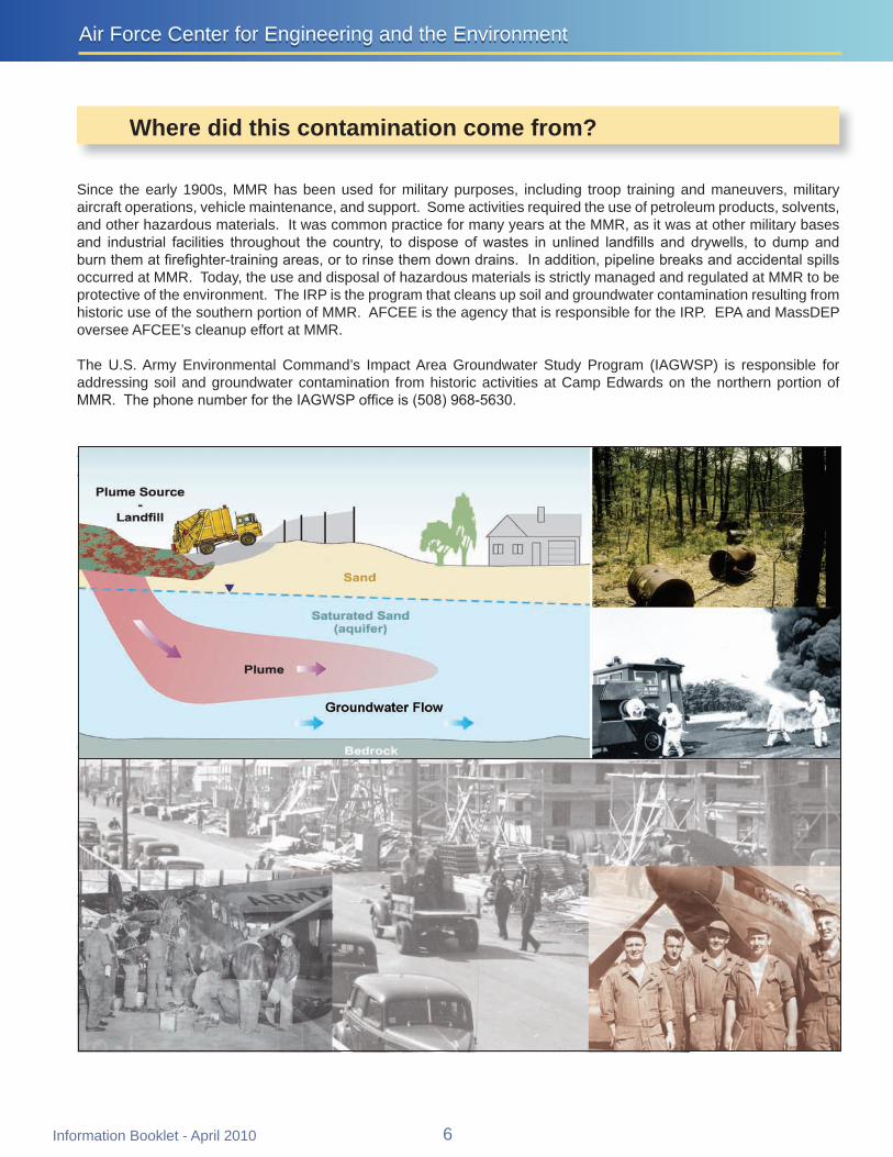
Air Force Center for Engineering and the EnvironmentAir Force Center for Engineering and the Environment
Where did this contamination come from
Since the early 1900s MMR has been used for military purposes including troop training and maneuvers military aircraft operations vehicle maintenance and support Some activities required the use of petroleum products solvents and other hazardous materials It was common practice for many years at the MMR as it was at other military bases and industrial facilities throughout the country to dispose of wastes in unlined landfills and drywells to dump and burn them at firefighter-training areas or to rinse them down drains In addition pipeline breaks and accidental spills occurred at MMR Today the use and disposal of hazardous materials is strictly managed and regulated at MMR to be protective of the environment The IRP is the program that cleans up soil and groundwater contamination resulting from historic use of the southern portion of MMR AFCEE is the agency that is responsible for the IRP EPA and MassDEP oversee AFCEErsquos cleanup effort at MMR
The US Army Environmental Commandrsquos Impact Area Groundwater Study Program (IAGWSP) is responsible for addressing soil and groundwater contamination from historic activities at Camp Edwards on the northern portion of MMR The phone number for the IAGWSP office is (508) 968-5630
Information Booklet - April 2010 6
Massachusetts Military ReservationMassachusetts Military Reservation
How are the groundwater plumes treated
Aplume is a body of groundwater containing contaminants that exceed federal andor state safe drinking water standards When chemicals from source areas travel downward through the sandy soils they eventually reach the aquifer where they begin to dissolve Once dissolved they begin to move with the groundwater thus creating a plume
To actively treat groundwater contamination extraction wells are placed within a plume to pump the contaminated groundwater from the aquifer to a treatment plant where the water is filtered through carbon held in large vessels (The used carbon is recycled off site and reused at MMR) Treated water is returned to the aquifer using reinjection wells or infiltration galleries while treatment facilities at river systems utilize bubblers
The IRP is currently addressing 12 groundwater plumes Many of these plumes are located beyond the MMR boundary and are currently in various stages of study and cleanup At this time systems are treating approximately 14 million gallons of groundwater per day Computer modeling suggests that it may take more than 30 years to fully remediate all of the groundwater contamination associated with MMR Several plumes have shown dramatic decreases in size and contaminant concentrations due to years of groundwater treatment actions Plumes and treatment systems are continually being monitored and optimized to reduce the overall cleanup time
Eleven plumes are undergoing groundwater cleanup Ashumet Valley Chemical Spill 4 (CS-4) CS-10 CS-20 CS-21 CS-23 Fuel Spill 1 (FS-1) FS-12 FS-28 FS-29 and Landfill 1 (LF-1)
One plume CS-19 is in long-term monitoring LF-2 and Storm Drain 5 (SD-5) two sites where the groundwater contamination no longer meets the definition of a plume are also in long-term monitoring
Treated water is returned to the aquifer using reinjection wells or infiltration galleries Treatment facilities at river systems utilize bubblers
Treatment plants clean up extracted contaminated groundwater by filtering it through carbon held in large vessels
Extraction wells are placed within a plume to pump contaminated groundwater from the aquifer to the treatment plant
saturated sand (aquifer)
Bubbler
The Groundwater Treatment Process
7 Information Booklet - April 2010
LRMW0003
WL18M1
Co
unty Road
Route 151
Sand
wich
Roa
d
Rou
te 2
8
Rou
te 2
8A
Thomas B Lande rs R d
Rou
te 1
30
Last Opened 4142010 11522 PM by SD YFiguresGeneralCIPlumeMaps2010ArcmapPlumeMap_8x11Pmxd
CS-19 Impact Area
Note There are other groundwater plumes in this area not part of the IRP and therefore not depicted
Town ofon the mapFor further information see httpgroundwaterprogramarmymil or
call Pamela Richardson at (508) 968-5630 Sandwich email pamelajrichardsonusarmymil
FS-12 Treatment FacilityTown of
Peters
Bourne Pond
Massachusetts Military
ETHETHETHETHETHETHETH)
ETHETHETHETHETHETH
ETHETH FS-12ETHETHNtilde
ETH
NtildeNtildeETHReservation
NtildeNtildeETH ETHETHETH Ntilde
NtildeNtildeNtildeNtildeNtildeNtildeNtildeNtildeETHETHETH
ETHETHETH
NtildeNtildeETHNtildeNtilde
NtildeNtildeSnake PimlicoPond
Pond
Weeks PondRed Brook
Harbor
CS-10 Treatment Facility
LF-1
Wakeby Pond
ETH
ETH
ETH
Mashpee Pond
LF-1 Treatment Facility LF-1 )ETH
Ntilde
CS-10 ETH
ETH) LF-1 ETHETH
ETH Sandwich Road
ETH
ETH
ETH
ETH
Treatment FacilityMegansett Harbor
ETH
ETH
CS-23
Hunter Avenue NtildeNtildeNtildeNtilde)
NtildeNtildeNtildeNtildeNtildeNtilde
NtildeETH
ETH
ETH
)
FS-1 Treatment Facility
)ETH
ETH ETHETH
ETHETHETHETH
ETHETHNtildeCS-21 CS-20 ETHETHNtildeNtilde Ntilde
NtildeETH CS-4 ETHETHCS-21
ETH
ETH
Ntilde
ETH
ETH FS-1 TreatmentAshumetETH FacilityNtilde ETH
ETH
ETH Pond ETH JohnsFS-29 ETHETH
ETH
ETH Pond Ntilde
FS-29 Ntilde Ntilde
CS-10
ETH
ETH
) Coonamessett
Ashumet ValleyFS-28 Pond
Treatment FacilityoaTown of
MashpeeFS-28 Treatment Facility ETH)
FS-28 ETH
Decommissioned Shallow FS-28 Wellpoint Extraction System Round
Ashumet ValleyPond
ETH
Jenkins Pond
Town of
Falmouth Ashumet Valley Leading Edge Treatment Facility ETH
Data Source AFCEE March 2010 AFCEE-MMR Data Warehouse Legend
Air Force Center for Plume Boundary (Dashed Where Inferred) Treatment System Piping Engineering and the Environment Defines Area of Groundwater Contaminants Infiltration GalleryTrench of Concern Above Regulatory Limits
Town Boundary IRP PLUMES AND
ETH
ETH
ETH
ETH
Reinjection Well
Extraction Well
Reinjection Well (Off)
Extraction Well (Off)
BogWetland TREATMENT SYSTEMS APRIL 2010O Installation Restoration Program
0 06 12 AFCEE - Massachusetts Military ReservationOutflow Bubbler Miles
U Treatment Facility
Information Booklet - April 2010 8
RRoouu
ttee 22
88
GGiibbbbss RRooaadd
SSaanndd
wwiicchh
PPooccaa
sssseett
RRooaadd
KKeennddrriicckk RRooaadd
WWoooodd RRooaadd
TTuurrpp
eenntt iinn
eeRR
oo aadd FFoorreessttddaallee PPooccaasssseett RRooaadd
RRoouu
ttee1133
00
GGrree
eennwwaa
yy RRooaadd
BBuu rr
gg ooiinn
ee RR
ooaadd
CCaappee CCoodd
CCaannaall
Massachusetts Military ReservationMassachusetts Military Reservation
CS-19 Groundwater Plume
The CS-19 site involves past ordnance and military waste disposal An area of approximately two acres was used to bury and detonate ordnance and munitions debris at depths to 12 feet These ordnance and waste disposal practices at the CS-19 site resulted in contaminants being released to the surrounding soil and groundwater AFCEE conducted multiple testing and cleanup actions at CS-19 between 2004 and 2009 including the removal of more than 2800 cubic yards of soil 8500 ordnance items and 27000 pounds of munitions debris from the original two-acre site
RDX an explosives compound Last Opened 3312010 104453 AM by SD YFiguresGeneralCIPlumeMaps2010ArcmapCS19plumemxdis the contaminant of concern
associated with CS-19 The NNoottee PPlluummeess ddeeppiicctteedd iinn tthhiiss mmaapp
ootthheerr tthhaann CCSS--1199 aarree nnoott ppaarrtt ooff tthhee IIRRPP groundwater plume is defined by RDX concentrations above FFoorr ffuurrtthheerr iinnffoorrmmaattiioonn sseeee
hhttttppggrroouunnddwwaatteerrpprrooggrraammaarrmmyymmiill oorrthe EPA risk-based level of ccaallll PPaammeellaa RRiicchhaarrddssoonn aatt ((550088)) 996688--55663300 eemmaaiill ppaammeellaajjrriicchhaarrddssoonnuussaarrmmyymmiill06 microgL
The CS-19 plume is located within the Central Impact Area DDeeeepp
MMaassssaacchhuusseettttss MMiilliittaarryyBBoottttoomm PPoonndd(CIA) study area and adjacent RReesseerrvvaattiioonn
to the CIA groundwater plume which is managed by the IAGWSP For more information about the IAGWSP please call 508-968-5630orvisit thewebsite at httpgroundwaterprogram armymil
LLiittttllee HHaallffwwaayy PPoonndd
DDoonnnneellyy PPoonndd
IImmppaacctt AArreeaa CCSS--1199A 2009 ROD calls for
continued monitoring of CCSS--1199 SSoouurrccee AArreeaa groundwater concentrations
and implementation of land use controls to prevent residential exposure The plume is not anticipated to move beyond the base boundary The final remedy selected for the CS-19 groundwater plume will not OOppeenniinngg
PPoonnddpredetermine or limit remedial options for the CIA plume which CS-19
is in close proximity to CS-19 Massachusetts Military
Reservation
SSnnaakkee PPoonndd
WWeeeekkss 0 1500 3000
PPoonndd Feet
Data Source AFCEE March 2010 AFCEE-MMR Data Warehouse
Legend CS-19 Plume Boundary = Explosives Plume Concentrations Army Program Plumes Air Force Center for (RDX Hexahydro-135-trinitro-135-triazine) Above EPA Perchlorate Plume - Engineering and the Environment risk-based level of 06 ugLmicrogL Concentrations Exceed Town Boundary MMCL = 20 microgL CHEMICAL SPILL-19 (CS-19)
RDX Plume -Massachusetts Military Reservation Boundary PLUME - APRIL 2010Concentrations
exceed EPA 10-6 Source Area
risk-based AFCEE - Massachusetts Military Reservation measure of concentration It is approximately level = 06 ppb equivalent to parts per billion (ppb)
Note microgL = micrograms per liter and is a
9 Information Booklet - April 2010
Air Force Center for Engineering and the EnvironmentAir Force Center for Engineering and the Environment
CS-10 Groundwater Plume
The Chemical Spill 10 (CS-10) groundwater plume resulted from spills and releases from multiple sources The primary source area originated from the former Boeing Michigan Aerospace Research Center Missile Site (from 1960 to 1973) and Unit Training Equipment Site (UTES) From 1996 through 2005 several source area cleanup actions were conducted at the site including 15 drainage structure removals and soil treatment with soil vapor extraction More than 1500 tons of contaminated soil were excavated and taken off site for disposal
Groundwater concentrations in monitoring wells located in the source area no longer exceed cleanup levels and the plume is detached from its primary source area Studies have shown that portions of the CS-10 plume no longer discharge to Ashumet and Johns Ponds Surface water sampling from both ponds in 2009 showed zero detections of contaminants associated with CS-10
The primary contaminants in the CS-10 plume are the cleaning solvents PCE and TCE which have been detected above the state and federal MCLs of 5 microgL Long-term remediation is occurring with a treatment system comprised of a series of extraction wells treatment plants reinjection wells and infiltration galleries The treatment plants use granular activated carbon to remove the solvents from the groundwater and the treated water is returned to the aquifer through the infiltration galleries and reinjection wells
An additional extraction well to address the southern trench contamination an additional reinjection well to improve hydraulic capture of the plume and revised flow rates in several extraction wells were completed in February 2009
The CS-10 Plume final ROD signed in 2009 specified continued operation and monitoring of the existing treatment system along with land use controls
CS-10 Date of ROD
or DD in Place Cleanup
Start Projected
Finish Primary
Contaminants 2009 Highest Levels (microgL)
Highest Historic Levels (microgL)
August 2009 June 1999 2055 PCE 51 400 (July 2000) TCE 1740 5110 (June 1997)
Treatment Components in Operation1
Treatment Plants Treatment Rate (gpm) (originalcurrent)1
Volume Treated (MG)2
Extraction Wells 15 Reinjection Wells 12 Infiltration Trenches 2
In Plume 2 27802290 13565 Sandwich Road 1 820410 4204 Northern Lobe uses SR 75190 9799
CS-10 Plume Treatment Systems SR = Sandwich Road ROD = Record of Decision DD = Decision Document microgL = micrograms per liter MG = million gallons gpm = gallons per minute 1 Current treatment rate as of April 1 2010 2 Through December 2009
Information Booklet - April 2010 10
ETHETHETHETH
MMMMRR BBoouunnddaarryy
RRoouuttee 115511
SSnnaakkee
PPoonndd RRooaadd
CCoonnnneerryy AAvveennuuee
TTuurrppeenn
tt iinnee
RRooaadd GG
rreeeenn
wwaayy
RRooaa
dd
Last Opened 482010 104134 AM by SD YFiguresGeneralCIPlumeMaps2010ArcmapCS10plumemxd
CS-10 In-Plume Treatment Facility SSnnaakkee PPoonndd
WWeeeekkss PPoonndd
CCSS--1100 SSoouurrccee AArreeaa
SSaannddwwiicchh BBoouurrnnee
CCSS--1100 IInn--PPlluummee TTrreeaattmmeenntt FFaacciilliittyy
ETHETH
ETHETH
CS-10 Sandwich Road Treatment Facility
ETHETH )) OOssbboorrnn PPoonndd ETHETH ETHETH
ETHETH
MMaassssaacchhuusseettttss MMiilliittaarryy RReesseerrvvaattiioonn
EEddmmuunnddss PPoonndd
ETHETH
CCSS--1100
ETHETH
SSaannddwwiicchh RRooaadd TTrreeaattmmeenntt FFaacciilliittyy
ETHETHETHETHETHETHETHETHETHETHETHETHETHETH
ETHETH )ETH
)ETH
ETHETH ETHETHETH ETHETHETHETHETH
ETHETH ETHETH
ETH
ETHETHETHETHETH ETHETH
ETHETH MMooooddyy PPoonnddETHETH
ETHETHETHETH
ETHETH
ETHETH
ETHETH
NNoorrtthheerrnn LLoobbee
AAsshhuummeett ETHETH PPoonndd
ETHETH
Plume Flows Under Pond
NNoorrtthh CCeennttrraall LLoobbee
JJoohhnnss
FFaallmmoouutthh
SSoouutthheerrnn LLoobbee
PPoonndd
MMaasshhppeeee1300 2600
Feet
Data Source AFCEE March 2010 AFCEE-MMR Data WarehouseLegend CS-10 Plume Boundary = Concentrations exceeding drinking Infiltration Trench water standards or Maximum Contaminant Level (MCL) Air Force Center for
Treatment System Pipingdashed where inferred Engineering and the Environment Represents an exceedance of trichloroethene ETH Extraction Well (On) (TCE) andor perchloroethene (PCE) ETH Extraction Well (Off) CHEMICAL SPILL-10 (CS-10)(TCE MCL = 5 microgL) (PCE MCL = 5 microgL) ETH Reinjection Well (On) PLUME - APRIL 2010 Massachusetts Military Reservation Boundary ETH Reinjection Well (Off) AFCEE - Massachusetts Military Reservation Town Boundary U Treatment Facility
U Source Area
11 Information Booklet - April 2010
0
Air Force Center for Engineering and the EnvironmentAir Force Center for Engineering and the Environment
Ashumet Valley Groundwater Plume
The Ashumet Valley plume has two sources the former firefighter-training area 1 (FTA-1) and the former MMR Sewage Treatment Plant (CS-16 and CS-17) Firefighter-training exercises were held from 1958 to 1985 at FTA-1 during which time flammable waste liquids were burned and extinguished some of which entered the sandy soil and eventually reached the groundwater aquifer The former sewage treatment plant which operated from 1936 to 1995 released treated water to a series of sand infiltration beds Sludge materials were kept on site
Treatment of contaminated soils at FTA-1 was completed in September 1997 A total of 42531 tons of soil were treated at FTA-1 using a thermal treatment process In 2001 and 2002 contaminated soil was removed from the CS-16 and CS-17 sites and taken off base for proper disposal
The primary contaminants in the Ashumet Valley plume are the cleaning solvents PCE and TCE which have been detected above the state and federal MCLs of 5 microgL The Ashumet Valley plume is currently in long-term remediation Remediation is occurring with two treatment systems each comprised of a single extraction well treatment plant and infiltration galleries river discharge The treatment plants use granular activated carbon to remove the solvents from the groundwater and the treated water is returned to the aquifer through the infiltration galleries in the central portion of the plume and to a bog ditch along the Backus River in the southern area
The Ashumet Valley Plume final ROD which was signed in 2009 specified continued operation of the existing treatment system plus additional treatment for the southern portion of the plume The southern treatment system has been installed The ROD also required land use controls
AFCEE does not believe that any portion of the plume is currently discharging into Ashumet Pond Surface water sampling from Ashumet Pond in 2009 showed that no plume contaminants were detected
In 2001 AFCEE applied an alum treatment to Ashumet Pond water to reduce the amount of phosphorus in the pond much of which comes from the basersquos wastewater treatment plant phosphorus plume In 2004 a geochemical barrier (made up of zero-valent iron mixed with pond sediment) was installed along the shoreline of Ashumet Pond to reduce the amount of phosphorus in groundwater entering the pond A second alum treatment is being evaluated for 2010
A part of the southern portion of the Ashumet Valley plume discharges to the Backus River in Falmouth Surface water testing conducted in 2009 showed results below the MCL Please note that safe drinking water guidelines (MCLs) do not apply to surface water bodies AFCEE continues to monitor the entire plume area
Ashumet Valley Date of ROD
or DD in Place Cleanup
Start Projected
Finish Primary
Contaminants 2009 Highest Levels (microgL)
Highest Historic Levels (microgL)
March 2009 November 1999 2018 PCE 43 109 (October 1998) TCE 12 83 (August 1997)
Treatment Components in Operation1
Treatment Plants Treatment Rate (gpm) (originalcurrent)1
Volume Treated (MG)2
Extraction Wells 2 Infiltration Trenches 2
Bubbler 1
1 1200350 4768
1 Mobile Treatment Unit 175175 268
ROD = Record of Decision DD = Decision Document microgL = micrograms per liter MG = million gallons gpm = gallons per minute 1 Current treatment rate as of April 1 2010 2 Through December 2009
Information Booklet - April 2010 12
MMMMRR BBoouunnddaarryy
RRoouuttee 115511
OOlldd BBaarrnnssttaabbllee RR
ooaadd
SSaanndd
wwiicchh RR
ooaadd
SSaamm TTuurrnneerr RRooaadd
CCaarrrriiaaggee SShhoopp RRoo
aadd
BBaacckk
uuss RR
iivveerr
0
Last Opened 482010 104135 AM by SD YFiguresGeneralCIPlumeMaps2010Arcmapashumetvalleymxd
BBoouurrnneeAshumet Valley Treatment Facility MMaassssaacchhuusseettttss SSaannddwwiicchhMMiilliittaarryy
RReesseerrvvaattiioonn FFTTAA--11 SSoouurrccee AArreeaa
MMooooddyy PP
FFoorrmmeerr MMMMRR SSeewwaaggee
TTrreeaattmmeenntt PPllaanntt ((SSoouurrccee AArreeaa)) AAsshhuummeett
PPoonndd
JJoohhnnss PPoonndd
DDeeeepp PPoonndd
AAsshhuummeett VVaalllleeyy TTrreeaattmmeenntt FFaacciilliittyy
CCoooonnaammeesssseettttPPoonndd
ETHETH
))
ETHETH
ETHETH
CCrrooookkeeddPPoonndd MMaasshhppeeee
FFaallmmoouutthh AAsshhuummeett VVaalllleeyy
RRoouunndd PPlluummeePPoonndd PPlluummee PPaarrttiiaallllyy
DDiisscchhaarrggeess TToo TThhee RRiivveerr
JJeennkkiinnss PPoonndd
FFllaaxx AAsshhuummeett VVaalllleeyy LLeeaaddiinn Pgg Poonndd
EEddggee TTrreeaattmmeenntt FFaacciilliittyy
1500 3000 ETHETHAshumet Valley LeadingFeet Edge Treatment Facility
Note microgL = micrograms per liter and is a measure of concentration It is approximately equivalent to parts per billion (ppb)
Data Source AFCEE March 2010 AFCEE-MMR Data WarehouseLegend ETHETH
Extraction Well (On)Ashumet Valley Plume Boundary = Concentrations exceeding drinking water standards or Maximum Contaminant Level (MCL) dashed where inferred
Air Force Center for Engineering and the Environment
Extraction Well (Off)
TTreatment Facilityreatment FacilityRepresents an exceedance of trichloroethene (TCE) andor ASHUMET VALLEY PLUME perchloroethene (PCE) Outflow Bubbler (TCE MCL = 5 microgL) Massachusetts Military APRIL 2010(PCE MCL = 5 microgL) Reservation Boundary
AFCEE - Massachusetts Military ReservationTreatment System Piping Town Boundary ThalliumManganese Area
BogWetlandInfiltration Trench
13 Information Booklet - April 2010
Air Force Center for Engineering and the EnvironmentAir Force Center for Engineering and the Environment
CS-23 and LF-1 Groundwater Plumes
The source of the Landfill 1 (LF-1) groundwater plume was the main MMR landfill which operated from 1941 to 1990 The LF-1 plume contains many COCs The more typical COCs are the solvents PCE TCE and CCl4 The state and federal MCLs for PCE TCE and CCI4 is 5 microgL
Test data indicate that no significant contamination is being released to groundwater from the older landfill cells at LF-1 and decreasing chemical concentrations in groundwater downgradient of the more recently used landfill cells suggest that the landfill cap there has been effective in reducing groundwater contamination at the source The cap is inspected annually to monitor its integrity
The LF-1 ROD signed in 2007 consists of continued long-term remediation with a groundwater extraction-and-treatment system and the implementation of land use controls The contaminated groundwater is treated at the LF-1 Treatment Plant and the Hunter Avenue Treatment Facility Water is returned to the aquifer through a reinjection well and infiltration trenches
Because a portion of the LF-1 plume discharges to both Red Brook and Squeteague Harbors surface water and discharging groundwater at the harbors are tested annually and results show that there are no ecological or human health risks
The CS-23 plume is a detached plume that has not been linked to a specific source area All of the potential source areas for the CS-23 plume have been investigated andor remediated The COCs in the CS-23 plume are TCE and CCl4
The CS-23 ROD signed in 2007 consists of continued remediation and operation of the existing groundwater cleanup system and land use controls The contaminated water is treated at the Hunter Avenue Treatment Facility Water is returned to the aquifer through infiltration trenches
LF-1 Date of ROD
or DD in Place Cleanup
Start Projected
Finish Primary
Contaminants 2009 Highest Levels (microgL)
Highest Historic Levels (microgL)
October 2007 August 1999 2047 TCE PCE 37 (TCE) 150 (TCE Aug 1999)
Treatment Components in Operation1
Treatment Plants Treatment Rate (gpm) (originalcurrent)1
Volume Treated (MG)2
Extraction Wells 6 Reinjection Wells 1 Infiltration Trench 2
2 7001245 3713
CS-23 Date of ROD
or DD in Place Cleanup
Start Projected
Finish Primary
Contaminants 2009 Highest Levels (microgL)
Highest Historic Levels (microgL)
October 2007 December 2006 2018 TCE 177 572 (June 2002)
Treatment Components in Operation1
Treatment Plants Treatment Rate (gpm) (originalcurrent)1
Volume Treated (MG)2
Extraction Wells 2 Infiltration Trench 2 1 700700 991
ROD = Record of Decision DD = Decision Document microgL = micrograms per liter MG = million gallons gpm = gallons per minute 1 Current treatment rate as of April 1 2010 2 Through December 2009
Information Booklet - April 2010 14
CS-21
CS-10
CS-21
CS-10
CCoonnnneerryy AAvveennuuee
MMMMRR BBoouunnddaarryy
RRoouutt
ee 2288
AA
RRoo uu
ttee 22
88
RRoouu
ttee 22
88
RReedd
BBrroo
ookk HH
aarrbboo
rr RRooaa dd
DDeeppoo
tt RRooaa
dd
SSccrraaggggyy NNeecc
RReettee
nnttiioo
nnBBaa
ssiinn
CCoomm
mmoonn
BBoo
rrrrooww
PPiitt
BBMMXX
TTrraacc
kk GGrr
aavveell
PPiitt
Last Opened 3312010 93956 AM by SD YFiguresGeneralCIPlumeMaps2010ArcmapLF1_CS23plumemxd
RReedd BBrrooookk PPoonndd 11994477
LF-1 Source 11995577
11995511
PPoosstt--11997700AreaRReedd BBrrooookk KKeettttllee HHoolleeHHaarrbboorr
Plume Discharges to 11997700Red Brook Harbor
LLoonngg MMaassssaacchhuusseettttss MMiilliittaarryyPPoonndd RReesseerrvvaattiioonn
LLFF--11 BBoouurrnnee ETHETHLLFF--11 IInnffiillttrraattiioonn
GGaalllleerryy aanndd TTrreenncchheesskk RRooaadd ((nnoott iinn uussee))
BBoouurrnnee 22 LLFF--11
BBoouurrnnee ETH55 ETHSSqquueetteeaagguuee HHaarrbboorr
LLFF--11 TTrreeaattmmeenntt FFaacciilliittyy
ETHETH
ETHETH
ETHETH
LLFF--11 OOssbboorrnn PPoonndd
LF-1 Treatment Facility
ETHETH
15Inform
ation Booklet -A
pril 2010
Plume Discharges to EEddmmuunnddssSqueteague Harbor SSaannddwwiicchhETHETH PPoonndd
SSppeeccttaaccllee WWeettllaanndd
VVeerrnnaall PPooooll 6655 C11 CSS--2233ETHETH
HHuunntteerr AAvveennuuee
ETHETH TTrreeaattmmeenntt FFaacciilliittyy
AA
0 1000 2000
Feet FFaallmmoouutthh microgL = micrograms per liter and is a measureNote of concentration It is approximately equivalentto parts per billion (ppb)
Hunter Avenue Treatment Facility
Legend LF-1 and CS-23 Plume Boundary = Concentrations exceeding drinking water ETHstandards or Maximum Contaminant Level (MCL) (Dashed where inferred)
ETHRepresents an exceedance of Trichloroethene (TCE) MCL = 5 microgL Perchloroethene (PCE) MCL = 5 microgL Carbon Tetrachloride (CCl4) MCL = 5 microgL 14-Dichlorobenzene (14-DCB) MCL = 5 microgL 1122-Tetrachloroethane (1122-TeCA) GW-1 = 2 microgL Vinyl Chloride (VC) MCL = 2 microgL Ethylene Dibromide (EDB) MMCL = 002 microgL U
Data Source AFCEE March 2010 AFCEE-MMR Data Warehouse
Extraction Well Massachusetts Military Reservation BoundaryReinjection Well
Public Water Town Boundary Supply Well
Infiltration GalleryTrench Source Area
BogWetland BMXBorrow Pit
Treatment Facility
Air Force Center for Engineering and the Environment
LANDFILL-1 (LF-1) AND CHEMICAL SPILL-23 (CS-23) PLUMES
APRIL 2010 AFCEE - Massachusetts Military Reservation
Cape Cod Canal
Route
28
Route 151
Route 28
Route 13
0
Route 6
Route 130
Route
28
Quaker Meetinghouse
Rd
Gree
nway
Rd
Wood Rd
Jefferson Rd
Barlo
w Rd Gibbs Rd
Connery Rd
Turpe
ntine
Rd
Frank
Perki
ns R
d
Pew R
d Ca
nal V
iew Rd
Cape Cod Canal
Route
28
Route 151
Route 28
Route 13
0
Route 6
Route 130
Route
28
Quaker Meetinghouse
Rd
Gree
nway
Rd
Wood Rd
Jefferson Rd
Barlo
w Rd Gibbs Rd
Connery Rd
Turpe
ntine
Rd
Frank
Perki
ns R
d
Pew R
d Ca
nal V
iew Rd
Last Opened 5102010 14919 PM by SD YFiguresGeneralERC_PlumemapGIS20100420Arcmaperc_plumemap_20100420mxd
Legend Chlorinated Solvents Plume -Concentrations Exceed MCLs TCE = 50 microgL PCE = 50 microgL EDB PlConcen
ume -rat ons Exceed MMCL = 002 microgLt i
Perchlorate Plume - Concentrations ExceedMMCL = 20 microgL
RDX Plume - Concentrations exceed EPA 10-6 risk-basedlevel = 06 ppb
Plumes with Remedy in Place
Cape Cod BayCape Cod Bay
NorthwesCorner NorthwesCorner
Demolition Area 2Demolition Area 2 tt
Plumes with Interim Remedy in Place Extraction Well
D Extraction Well (Off) OReinjection Well D Reinjection Well (Off) Scale 1 inch = 1 mile
0 05 1Outflow Bubbler Miles
Treatment FacilityS
Municipal Water Supply Well Town Boundary
SandwichInfiltration TrenchGallery Treatment System Pipeline
Influent Effluent
The areas of contamination show the combined contaminants of concern within each plume
Bourne
Massachusetts Military Reservation
Mashpee Falmouth
Surface water from Long Pond is also used as a drinking water source forthe town of Falmouth
Contaminant of Concern (COC) Type of Contaminant Risk-Based LevelTCE ndash trichloroethene solvent MCL = 5 microgPCE ndash perchloroethene solvent MCL = 5 microg
L
CCI4 ndash carbon tetrachloride solvent MCL = 5 microgLL
EDB ndash ethylene dibromide fuel-related compound MMCL = 002 microgLbenzene fuel-related compound MCL = 5 microgvinyl chloride solvent MCL = 2 microg
L
1122-tetrachloroethane solvent GW-1 = 2 microgL
14-dichlorobenzene solvent MCL = 5 microgLL
manganese metal EPA Health Advisory = 300 microgL Massachusetts Military Reservationthallium metal MCL = 2 microgLlead metal 15 microgL (treatment technique action level Groundwater Findings
for water distribution systems)toluene fuel MCL = 1000 microgL Issued April 2010RDX - hexahydro-135-trinitro-135- explosive HA = 2 microgLtriazine GW-1 = 1 microgL
10-6 = 06 microgperchlorate oxidizer HA = 15 microg
L MMCL = 2 microg
LL
MCL ndash Maximum Contaminant LevelMMCL ndash Massachusetts Maximum Contaminant LevelHA ndash Federal Lifetime Health Advisory Note ppb = parts per billion and is a measure of concentrationGW-1 ndash State default cleanup value to be used in lieu of site-specific risk-based level It is approximately equivalent to micrograms per liter (microgL)10-6 ndash EPA level resulting in an excess cancer risk of one in a million
Central Impact Area
Central Impact Area
S Phinneys Harbor
CS-19
S Phinneys Harbor
CS-19
WestBoundary
S J-2ern
S
S
S
J-1
J-3Demolition Area 1
WestBoundary
S J-2ern S
S
S
J-1
J-3Demolition Area 1
S S
Pocasset SS
Harbor
Hen
S L Range
S S
Peters Pond
Pocasset SS
Harbor DD FS-12 tSeveral FS-12 extraction wellurned off (not shown at this scale
s are)
Hen
S L Range
Peters Pond
DD FS-12 tSeveral FS-12 extraction wellurned off (not shown at this scale
s are)
CoveCove Snake
Weeks Pond
Pond Wakeby Pond
Snake
Weeks Pond
Pond Wakeby Pond
Red BrookRed Brook HarborHarbor
LF-1LF-1
Squeteague LF-1 MashpeeHarbor Pond
CS-10SMegansett
LF-1 Harbor DS
CS-23
S
FS-1 S Moody
DD PondCS-21 DSCS-20 D
DDCS-21 CS-4Wild Harbor
Ashumet FS-29
Squeteague LF-1 MashpeeHarbor Pond
CS-10SMegansett
LF-1 Harbor DS
CS-23
S
FS-1 S Moody
DD PondCS-21 DSCS-20 D
DDCS-21 CS-4Wild Harbor
Ashumet FS-29 D D
Pond D Johns
D
Pond Johns
Pond
Pond
CS-10 CS-10
Deep Pond
Deep Pond
Crooked Pond Crooked Pond
Coonamessett D
Pond S
DFS-28
S
Shallow Well Point system is off
FS-28 AshumetValley
Jenkins
Pond
S
Coonamessett D
Pond S
DFS-28
S
Shallow Well Point system is off
FS-28 AshumetValley
Jenkins
Pond
S
Long Pond
Long Pond
Air Force Center for Engineering and the EnvironmentAir Force Center for Engineering and the Environment
FS-1 and FS-12 Groundwater Plumes The source of the Fuel Spill 1 (FS-1) groundwater plume is the Aviation Gas Fuel Valve Test Dump Site in the eastern part of the base The site was used from 1955 to 1970 to test fuel dump valves on EC-121 Super Constellation aircraft which involved the release of fuel directly onto the ground Currently no significant levels of COCs are present in the surface or subsurface soils at the FS-1 source area and the source area groundwater is sampled for lead only
The FS-1 groundwater plume contains the fuel additive ethylene dibromide (EDB) at levels above the MMCL which is 002 microgL The FS-1 plume is currently in long-term remediation with a groundwater extraction-and-treatment system in the Quashnet River cranberry bog area just northeast of Johns Pond The system was designed to prevent upwelling of EDB contamination into the Quashnet River and associated cranberry bogs The treatment plant uses granular activated carbon to remove EDB from the groundwater which is then discharged to the Quashnet River through a series of oxygenating bubblers The latest test results showed that the FS-1 treatment system has been successful in reducing both the amount of EDB in the FS-1 plume and the EDB concentrations in the surface water of the Quashnet River and associated bogs A 2000 ROD specifies active treatment of the plume along with monitoring
The source of the FS-12 groundwater plume was an estimated 70000-gallon release from a section of a now-abandoned fuel pipeline that ran from the Cape Cod Canal to MMR EDB is the only remaining contaminant above cleanup standards in the FS-12 groundwater plume The source area groundwater is currently being monitored after having undergone subsurface remediation in the 1990s Groundwater sampling indicates that the source area has been successfully remediated The pipeline has been cleaned and closed with state and federal regulatory approval
The FS-12 plume is currently in long-term remediation with a groundwater extraction-and-treatment system The treatment system consists of extraction wells a treatment plant and reinjection wells The 2006 ROD called for the status quo of operating and monitoring the existing system The latest test results indicate that the extraction wells continue to successfully contain the FS-12 groundwater plume and the size of the plume has been reduced significantly Land use controls are in place for the FS-1 and FS-12 plumes
FS-1 Date of ROD
or DD in Place Cleanup
Start Projected
Finish Primary
Contaminants 2009 Highest Levels (microgL)
Highest Historic Levels (microgL)
April 2000 April 1999 2020 EDB 0857 445 (October 2000)
Treatment Components in Operation1
Treatment Plants Treatment Rate (gpm) (originalcurrent)1
Volume Treated (MG)2
Extraction Wells 3 Bubblers 3 1 750515 33053
FS-12 Date of ROD
or DD in Place Cleanup
Start Projected
Finish Primary
Contaminants 2009 Highest Levels (microgL)
Highest Historic Levels (microgL)
September 2006 September 1997 2048 EDB 231 890 (November 1996)
Treatment Components in Operation1
Treatment Plants Treatment Rate (gpm) (originalcurrent)1
Volume Treated (MG)2
Extraction Wells 4 Reinjection Wells 20 1 772360 4082
ROD = Record of Decision DD = Decision Document microgL = micrograms per liter MG = million gallons gpm = gallons per minute 1 Current treatment rate as of April 1 2010 2 Through December 2009
Information Booklet - April 2010 18
Co
FP
erki
nsR
d
Co
FP
erki
nsR
d
-
-
QQuuaasshhnneett RRiivveerr GG
rreeaatt HHaayy
RRooaa dd
hhiinnnn
ee yyss
RRooaadd
BBeeaarr
sseess
RRooaa
dd SSaa
ddddlleebb
aacckk RRooaadd
GGrraaffttoonn PPoocckknnee
tt RRooaadd
PPiimmlliiccoo PP nndd RRdd
JJBB TThhoommppssoonn RRdd
SSnn aakkeePPoonndd RRdd
RRtt 113300
nnnneerryy AAvv CCoonnnneerryy AAvv
Last Opened 482010 105423 AM by SD YFiguresGeneralCIPlumeMaps2010ArcmapFS1_FS12plumemxd
FFSS--1122 SSoouurrccee AArreeaa
NNoottee PPlluummeess ddeeppiicctteedd iinn tthhiiss mmaapp ootthheerr tthhaann FFSS--11 aanndd FFSS--1122
aarree nnoott ppaarrtt ooff tthhee IIRRPP FFoorr ffuurrtthheerr iinnffoorrmmaattiioonn sseeee
hhttttppggrroouunnddwwaatteerrpprrooggrraammaarrmmyymmiill oorr ccaallll PPaammeellaa RRiicchhaarrddssoonn aatt ((550088)) 996688--55663300 FFSS--1122 TTrreeaattmmeenntt FFaacciilliittyy
FS 12 Treatment Facility
PP
SSaannddwwiicchheemmaaiill ppaammeellaajjrriicchhaarrddssoonnuussaarrmmyymmiill DD DD
DDDD DDDD
DDDDDD DDDD DD DD DD
DD Ntilde D DNtilde DD FFSS--1122
Ntilde Ntilde
ETHETHD
DDDDDDDNtildeNtildeNtildeNtilde
ETH
NtildeNtilde ETH
DDDDETHETHETHETHNtildeNtildeNtildeNtildeNtildeNtildeNtildeNtildeNtildeNtildeNtildeNtildeNtilde
D DDD NtildeNtildeNtildeNtildeDD NtildeNtildeNtildeSSnnaakk Ntildeee NtildeNtildeNtildeNtildeNtilde NtildeNtildeNtildeNtildePPoonnddBBoouurrnnee oo
WWaakkeebbyy PPoonndd
MMaasshhppeeee
MMaassssaacchhuusseettttss MMiilliittaarryy
RReesseerrvvaattiioonn
PPoonndd
FFSS--11 SSoouurrccee AArreeaa
MMaasshhppeeee
FFSS--11
MMooooddyy PPoonndd
FFSS--11 TTrreeaattmmeenntt FFaacciilliittyy
FS 1 Treatment Facility JJoohhnnss
with bubbler in foreground PPoonndd 0 1500 3000
Feet
Legend Data Source AFCEE March 2010 AFCEE-MMR Data Warehouse
ETH
FS-1 and FS-12 Plume Boundary = Concentrations Outflow Bubbler Army Program Plumes exceeding drinking water standards or Massachusetts Extraction Well (On) Perchlorate Plume shyMaximum Contaminant Level (MMCL) Represents an Concentrations exceedance of ethylene dibromide (EDB) Exceed
ETH Reinjection Well (On) D Extraction Well (Off)
(EDB MMCL = 002 microgL) (Dashed Where Inferred) MMCL = 20 microgL D Reinjection Well (Off)Treatment System Piping RDX Plume shy
Massachusetts Military Reservation Boundary U Treatment Facility Concentrations exceed EPA 10-6
Town Boundary Source Area Note microgL = micrograms per liter and is a measure of U risk-based
level = 06 ppb concentrationIt is approximately equivalent to parts BogWetland per billion (ppb)
19
Air Force Center for Engineering and the Environment
FUEL SPILL-1 (FS-1) AND FUEL SPILL-12 (FS-12)
APRIL 2010 AFCEE - Massachusetts Military Reservation
Information Booklet - April 2010
Air Force Center for Engineering and the EnvironmentAir Force Center for Engineering and the Environment
CS-4 CS-20 CS-21 FS-28 and FS-29 Groundwater Plumes
Five groundwater plumes can be found in the area north and south of Route 151 in the town of Falmouth They are FS-28 FS-29 CS-4 CS-20 and CS-21 Only CS-4 has a known source area a former vehicle maintenance area and storage yard on the MMR The other plumes were found to be disconnected from distinct source areas They most likely originated somewhere in the southern portion of MMR which contained various aircraft and vehicle maintenance shops runways and housingpersonnel support facilities Records indicate that spills andor releases occurred in these areas in the past COCs in the plumes are fuel and solvent-related contaminants They include EDB PCE TCE and CCl4 The MMCL for EDB is 002 microgL while the MCL for the rest of the contaminants is 5 microgL
More than 18000 tons of contaminated soil were treated on site at the CS-4 source area and additional soil was transported off site for proper disposal A groundwater extraction-and-treatment system began operating in 1993 but was later replaced by a more efficient system in 2006 to better capture the plume
Portions of the FS-28 plume were first discovered in 1993 beneath the leading edge of the CS-4 plume In 1996 groundwater investigations found EDB upwelling into the Coonamessett River in Falmouth No EDB is presently detected in the Coonamessett River The FS-28 plume is currently in long-term remediation with a groundwater extraction-and-treatment system A treatment plant is located in a bog area just south of Hatchville Road and treated water is discharged to the Coonamessett River through two oxygenating bubblers Shallow wellpoint extraction wells operated for several years but are no longer being used In 2007 a new extraction well was installed to the south to address a deep lobe of EDB
The FS-28 plume underflows Coonamessett Pond and has not affected the pond or a nearby Town of Falmouth municipal well In 2002 AFCEE funded a $52 million wellhead treatment system to ensure a safe water supply for the Falmouth well A ROD was issued in October 2000
The FS-29 CS-20 and CS-21 groundwater plumes were discovered in the late 1990s A ROD for FS-29 was issued in October 2000 and a ROD for CS-4 CS-20 and CS-21 was issued in February 2000 Since 2006 the FS-29 CS-4 CS-20 and CS-21 groundwater plumes have been undergoing active treatment through a series of extraction wells reinjection wells and infiltration trenches Extracted plume water is treated with granular activated carbon at the Hunter Avenue Treatment Facility on base Land use controls are in place for all these plumes
Plume Date of ROD
or DD in Place Cleanup
Start Projected
Finish Primary
Contaminants 2009 Highest Levels (microgL)
Highest Historic Levels (microgL)
CS-4 February 2000 (ESD 92008) November 2005 2014
TCE 55 19 (February 1997) PCE 232 61 (February 1997)
CS-20 February 2000 (ESD 92008) January 2006 2017 PCE 205 981 (September 2005)
CS-21 February 2000 (ESD 92008) September 2006 2027 TCE 98 988 (June 2001)
FS-28 October 2000 (ESD 92008) October 1997 2047 EDB 138 18 (January 1997)
FS-29 October 2000 (ESD 92008) September 2006 2018 EDB 0084 0318 (May 2001)
ROD = Record of Decision DD = Decision Document microgL = micrograms per liter MG = million gallons gpm = gallons per minute
Information Booklet - April 2010 20
Massachusetts Military ReservationMassachusetts Military Reservation
Plume Explanation Contaminants of concern exceed drinking water standards or Maximum Contaminant Level (MCL) CS-20 Perchloroethene (PCE) (PCE MCL = 5 microgL) FS-29 Ethylene dibromide (EDB) and carbon tetrachloride (CCl4)
(EDB MMCL = 002 microgL) (CCl4 MCL = 5 microgL) CS-4 Trichloroethene (TCE) perchloroethene (PCE)
1122- tetrachlorethane (1122- TeCA) andor ethylene dibromide (EDB) (TCE MCL = 5 microgL) (PCE MCL = 5 microgL) (1122-TeCA GW-1 = 2 microgL) (EDB MMCL = 002 microgL)
CS-21 Trichloroethene (TCE) (TCE MCL = 5 microgL)
Note microgL = micrograms per liter and is a measure of concentration It is approximately equivalent to parts per billion (ppb)
Treatment Components in Operation1
Treatment Plants
Treatment Rate (gpm)1
(originalcurrent)
Volume Treated (MG)2
Extraction Wells 2 Infiltration Trenches 2 1 620199 1027
Extraction Wells 2 Reinjection Wells 4 1 775773 1460
Extraction Wells 4 Reinjection Wells 3 1 14001395 2213
Extraction Wells 2 Bubblers 2 1 750600 43045
Extraction Wells 1 Reinjection Wells 2 1 525224 642
ESD = Explanation of Significant Differences 1 Current treatment rate as of April 1 2010 2 Through December 2009
21 Information Booklet - April 2010
-
SamTurner R
d
Hay
way
Rd
Hatchv
illeRd
Thomas B Landers Rd Sa
ndw
ich
Rd
Boxb
erry
Hill
Rd
Hill and Plain Rd
Route 151
Hatchville Rd
Sand
wichRd
Sam
Tur
ner R
d
Last Opened 412010 82704 AM by SD YFiguresGeneralCIPlumeMaps2010ArcmapFS28plumemxd
Falmouth
FS 28 Treatment Facility
Deep Pond
Plume Flows Under Pond
Round Pond
Coonamessett Pond Coonamessett
Water Supply Well FS-28
Crooked Pond
Outflow Bubbler
ETH
FS-28 Treatment Facility Broad River
FS-28 Shallow Outflow Bubbler
Pond Decommissioned Shallow
Wellpoint Extraction System
DR
AF
T
FS-28
Round Pond
ETHETH
Jenkins Pond
Pond 14
0 770 1540
Feet
Data Source AFCEE March 2010 MMR-AFCEE Data WarehouseLegend FS-28 Plume Boundary = Concentrations exceeding drinking ETH Extraction Well
Air Force Center for water standards or Massachusetts Maximum Contaminant Outflow Bubbler Engineering and the EnvironmentLevel (MMCL) dashed where inferred Represents an exceedance of ethylene dibromide (EDB) Public Drinking FUEL SPILL 28 (FS-28)(EDB MMCL = 002 microgL) Water Supply Well
PLUME - APRIL 2010BogWetland Treatment Facility AFCEE - Massachusetts Military Reservation
Treatment System Piping Note microgL = micrograms per liter and is a measure of concentration
It is approximately equivalent to parts per billion (ppb)
Information Booklet - April 2010 22
MMR Boundary Falmouth
Sandw
ich
Mashpe
e
Whe
eler
Rd
Reilly
Redlands
Rd
Br a
nsha
w S
t
Curr ier R
d
Sim
p kinsR
d
Hoo
ppol
eR
d
Club
Valley
Dr
Gen
eral
sBl
vd
MMR Boundary Falmouth
Sandw
ich
Mashpe
e
Whe
eler
Rd
Reilly
Redlands
Rd
Bra
nsha
w S
t
Currier R
d
Sim
p kinsR
d
Hoo
ppol
eR
d
Club
Val leyD
r
Gen
eral
sBl
vd
Massachusetts Military ReservationMassachusetts Military Reservation
Progress Over The Years
Much progress has been made over the last 15 years Program-wide the source areas have been cleaned up and 11 groundwater plumes are undergoing pump-and-treat cleanup action both on and off base All environmental cleanup decisions and remedies are in place In the future the program will continue to monitor adjust and shut down treatment systems as cleanup progress is made The Air Force will continue to conduct the most efficient cleanup operations while ensuring the protection of public health and the environment
The SD-5 plume depiction illustrates the transformation of the plume over time due to the effect of cleanup systems used by the Air Force for several years Contaminated water was cleaned by using two technologies The first involved extracting the plume water pumping it to a treatment building where large vessels of granular activated carbon removed the solvent contamination and then the clean water was returned to the ground through reinjection wells Two recirculation wells were also used Those involved two underground standalone treatment systems within the neighboring community That technology used air and pumps to remove the solvents from the plume and capture them in carbon tanks The plume has now been cleaned up to the point where only residual traces of solvent contamination are found in monitoring wells which are periodically tested
The following pages depict the cleanup progress of several IRP groundwater plumes over time Most plumes show a significant reduction in size and contaminant mass A few show a larger area which is related to plume information uncertainties in the early part of the cleanup program and changing conditions over time a significant reason why diligent monitoring is required For more information and depictions of all AFCEE groundwater plumes progress over time go to httpwwwmmrorgCleanupplumes_fshtm
Last Opened 3292010 115403 AM by SD YFiguresGeneralPlumeMapsComparison2010ArcMapSD5comp_97_10mxd
SandwichSandwich
Mashpee Mashpee
Ashumet PondAshumet PondFalmouth FalmouthJohns PondJohns Pond
1997 2010
Legend Data Source AFCEE MMR-AFCEE Data Warehouse
Town Boundary
Massachusetts Military Reservation Boundary SD-5 PLUME 1997 AND 2010 COMPARISON
Plume Boundary AFCEE - Massachusetts Military Reservation 0 1100 2200
BogWetland Feet
23 Information Booklet - April 2010
Plum
e Com
parison Over Tim
e
MMR Boundary Falmouth
Sandw
ich
Mashpe
e
Route 151
Kit tredge Rd
Connery Av
Whe
eler
Rd
Cole Rd
Le e Rd Hatc
hville
Rd
Herbert Rd
Reilly
Sam Turner R
d
Sandw
ich R
d
Herbert Rd
Connery Av
Route 151
MMR Boundary Falmouth
Sandw
ich
Mashpe
e
Route 151
Kittredge Rd
Connery Av
Whe
eler
Rd
Cole Rd
Le e Rd
Hatchv
ille R
d
Herbert Rd
Reilly
Sam Turner R
d
Sandw
ich R
d
Herber t Rd
Connery Av
Route 151
MMR Boundary
Falmouth
Sandw
ich
ashpe
e
Route 151
Cur
rier R
d
Whe
eler
Rd
Hayway Rd
Sam Turner R
d
Thomas B Landers Rd
Hatch
ville
Rd
Mi lf
or d
Rd Elai n Av
Sandw
ich
Rd
Meredith Dr
Redlands Rd
R eg is R
d
Jam
ie Ln
Hill a
nd Plain Rd
Old Barnstable R
d
Cloverfield Way Route 151
Sand
wich R
d
Route 151
MMR Boundary
Falmouth
Sandw
ich
ashpe
e
Route 151
Cur
rier R
d
Whe
eler
Rd
Sam Turner R
d
Thomas B Landers Rd
Hatchv
ille R
d
Mil f
ord
Rd Elain Av
Sandw
i ch
Rd
Meredith Dr
Redlands Rd
R eg is R
d
Jam
ie Ln
Hill a
nd Plain Rd
Old Barnsta
ble Rd
Cloverfield Way Route 151
Sand
wich R
d
Plu
me
Com
paris
on O
ver T
ime
Last Opened 3292010 110332 AM by SD YFiguresGeneralPlumeMapsComparison2010ArcMapCS10comp_97_10mxd
Snake Pond Snake Pond
BourneBourne
Sandwich Sandwich
MashpeeMashpee Falmouth Ashumet PondAshumet PondFalmouth Johns PondJohns Pond
Coonamessett Pond 2010Coonamessett Pond 1997 Legend
Massachusetts Military Reservation Boundary
BogWetland
Town Boundary
Plume Boundary (Dashed Where Inferred) Primary Contaminants Trichloroethene (TCE) Perchloroethene (PCE)
0 2300 4600
Feet
Data Source AFCEE MMR-AFCEE Data Warehouse
CS-10 PLUME 1997 AND 2010 COMPARISON AFCEE - Massachusetts Military Reservation
Last Opened 3292010 101508 AM by SD YFiguresGeneralPlumeMapsComparison2010ArcMapAVcomp_96_10mxd
Sandwich Sandwich MMashpee MMashpee
FalmouthFalmouth Ashumet Pond Ashumet Pond
Johns Pond Johns Pond
Coonamessett Pond Coonamessett Pond
Broad RiverBroad River
Jenkins Pond Jenkins Pond Pond 14 Pond 14 Fresh PondFresh Pond
20101996
Legend
Plume Boundary Primary Contaminants Trichloroethene (TCE) Perchloroethene (PCE)
Massachusetts Military Reservation Boundary
BogWetland
Town Boundary
0 2250 4500
Feet
Data Source AFCEE MMR-AFCEE Data Warehouse
ASHUMET VALLEY PLUME 1996 AND 2010 COMPARISON AFCEE - Massachusetts Military Reservation
Information Booklet - April 2010 24
Sandwich
MM
R Bo
unda
ry
MM
R
Sandwich Mashpee
Snake Pond Rd
Boun
dary
Dana
Rd
Arnol
d Rd
Pinecrest Dr
Artisan Way
Cha
dwic
k R
d
Jeannes Way
Gre
enw
ay R
d
Rout
e 13
0
Emerald Way
Week
s Po
nd D
r
Blac
kth rn Path
Green
way R
d
Greenway Rd
MM
R Bo
unda
ry
MM
R Bo
unda
ry Sandwich Mashpee
Greenway Rd
Dana
Rd
Arnol
d Rd
Pinecrest Dr
Artisan Way
Cha
dwic
k R
d
Jeannes Way
Emerald Way
Rout
e 13
0
Snake Pond Rd
Wee
ks P
ond
Dr
Blac
kth rn Path
Gre
enw
ay R
d
Greenw
ay R
d
MMR Boundary
Mas
hpee
Sand
wic
h
Route 130
Reilly
Great H
ay Rd
Love
lls L
n
Bear
ses
Rd
Sadd
leback Rd
Graf ton Pocknet Rd
Great Hay Rd
Mas
hpee
Sand
wic
h
MMR Boundary
Route 130
Love
ll s L
n
Rei
lly
Great H
ay Rd
Bear
ses
Rd
Lowell
Rd
Grafton P
ockne
t Rd
Echo Rd
Bookers Rd
Sadd
leback Rd
Quashnet Rd
Back Rd
Ashumet Rd
Bakers Rd
Easton S
t
Phi
nney
s Rd
Asher s P at h
Shorewood Dr
Great Hay Rd
Bear
ses
Rd
Rei
lly
Grea t H
ay Rd
Love
lls L
n
Grafton Pocknet Rd
Gre at H
ay Rd
Last Opened 3292010 113034 AM by SD YFiguresGeneralPlumeMapsComparison2010ArcMapFS12comp_97_10mxd
Snake Pond Snake Pondoo
Sandwich SandwichWeeks Pond Weeks Pond
1997 2010 Data Source AFCEE MMR-AFCEE Data WarehouseLegend
Town Boundary
FS-12 PLUMEMassachusetts Military Reservation Boundary 1997 AND 2010 COMPARISON AFCEE - Massachusetts Military ReservationPlume Boundary Primary Contaminants Benzene Ethylene Dibromide (EDB)
0 960 1920 BogWetland Feet
Last Opened 3292010 112823 AM by SD YFiguresGeneralPlumeMapsComparison2010ArcMapFS1comp_98_10mxd
aay
Rd
Gre
tH
Mashpee
Mashpee Pond Mashpee Pond
Mashpee
Johns PondJohns Pond
20101998
Legend Data Source AFCEE MMR-AFCEE Data Warehouse
Town Boundary
Massachusetts Military Reservation Boundary FS-1 PLUME 1998 AND 2010 COMPARISON
Plume Boundary (Dashed Where Inferred) Primary Contaminant Ethylene Dibromide (EDB)
0 1000 2000
AFCEE - Massachusetts Military Reservation
BogWetland Feet
25 Information Booklet - April 2010
Plum
e Com
parison Over Tim
e
MMR Bo
Sandw
ich
Mas
hpee San
dwich
Sandw
ich
Mashpe
e
Deep PondLittle Jenkins Pond
Sandw
ich
Coonamessett PondDeep PondLittle Jenkins Pond
undary
Falmouth
Sandwich
MMR Boundary
Route 151
mas B Landers Rd
Sam Turner R
d
Hatchv
il le R
d
Deer Pond Rd
Sandw
ich
Rd
Boxberry Hill Rd
Hill and Plain Rd
Old Barnstable R
d
Cloverfield Way
Blac
ksmith Shop Rd
Regis Rd
Route 151
Route 151
Sam Tu rner R
d
Route 151
Route 151
Sandw
ich R
d
MMR Boundary Falmouth
Sandwich
Route 151
mas B Landers Rd
Sam Tu rner R
d
Deer Pond Rd
Hatch
ville
Rd
Sandw
ich
Rd
Box
ber r
y H
il l R
d
Hill and Plain Rd
Old Barnstable R
d
Cloverfield Way
Blac
ksmith Shop Rd
Route 151
Route 151
Route 151
Sandw
ich R
d
Route 151
Sand
wich R
d
Boxberry Hill Rd
MMR Boundary
Falmouth
Bourne
Sand
wic
h
Route 151
Kittredge Rd
Cole Rd
Lee Rd
Sandwich R
d
Boxberry Hill Rd
Route 151
Route 151
MMR Boundary
Falmouth
Bourne
Sand
wic
h
Route 151
Kittredge Rd
Cole Rd
Lee Rd
Sa
ndwich
Rd
Boxberry Hill Rd
Route 151
Route 151
Last Opened 3292010 113441 AM by SD YFiguresGeneralPlumeMapsComparison2010ArcMapFS28comp_98_10mxdP
lum
e C
ompa
rison
Ove
r Tim
e
Coonamessett PondCoonamessett Pond
Falmouth FalmouthThoTho Broad River
Broad River
Jenkins PondJenkins Pond Pond 14Pond 14 20101998
Data Source AFCEE MMR-AFCEE Data WarehouseLegend
Town Boundary
FS-28 PLUME Massachusetts Military Reservation Boundary 1998 AND 2010 COMPARISON Plume Boundary (Dashed Where Inferred) AFCEE - Massachusetts Military Reservation Primary Contaminant Ethylene Dibromide (EDB)
0 1700 3400
BogWetland Feet
Last Opened 3292010 101742 AM by SD YFiguresGeneralPlumeMapsComparison2010ArcMapCS4comp_96_10mxd
Bourne Bourne Osborn Pond Osborn Pond
Edmunds Pond Edmunds Pond
Spit Pond Spit Pond
SandwichSandwich
FalmouthFalmouth
1996 2010 Data Source AFCEE MMR-AFCEE Data WarehouseLegend
Town Boundary
CS-4 PLUME 1996 AND 2010 COMPARISON
Massachusetts Military Reservation Boundary
Plume Boundary Primary Contaminants Trichloroethene (TCE) Perchloroethene (PCE) AFCEE - Massachusetts Military Reservation
0 1400 2800BogWetland Feet
Information Booklet - April 2010 26
Little Jenkins Pond Little Jenkins Pond
MMR Boundary
Falmouth
Bourne
Sand
wic
h
Route 151
Rou
te 2
8
Sam Turner Rd
Rou
te 2
8
MMR Boundary
Falmouth
Bourne
Sand
wic
h
Route 151
Rou
te 2
8
Sam Turner Rd
Rou
te 2
8
Falmouth
Bourne
Sand
wic
h
MMR Boundary
Rou
te 2
8
Route 151
Rou
te 2
8
Sand
wic
h
Falmouth
Bourne
MMR Boundary
Rou
te 2
8
Route 151
Rou
te 2
8
Last Opened 3292010 111229 AM by SD YFiguresGeneralPlumeMapsComparison2010ArcMapCS21comp_99_10mxd
Osborn Pond Osborn Pond
Bourne Bourne Edmunds Pond Edmunds Pond
Spit Pond Spit Pond
Sandwich Sandwich
Falmouth Falmouth
Deep Pond Deep Pond Coonamessett Pond Coonamessett Pond
1999 2010 Round Pond Round Pond Crooked Pond Crooked Pond
Legend Data Source AFCEE MMR-AFCEE Data Warehouse
Town Boundary
Massachusetts Military Reservation Boundary CS-21 PLUME 1999 AND 2010 COMPARISON
Plume Boundary Primary Contaminant Trichloroethene (TCE) AFCEE - Massachusetts Military Reservation
BogWetland 0 1400 2800
Feet
Last Opened 3292010 112004 AM by SD YFiguresGeneralPlumeMapsComparison2010ArcMapCS23comp_02_10mxd
Osborn Pond Osborn Pond
Bourne Bourne Edmunds Pond Edmunds Pond
Spit Pond Spit Pond
Falmouth Falmouth
2010 2002 Data Source AFCEE MMR-AFCEE Data Warehouse Legend
Town Boundary
CS-23 PLUME 2002 AND 2010 COMPARISON
Massachusetts Military Reservation Boundary
Plume Boundary (Dashed Where Inferred) Primary Contaminants AFCEE - Massachusetts Military Reservation Trichloroethene (TCE) Carbon Tetrachloride (CCl4)
0 1000 2000 BogWetland Feet
27 Information Booklet - April 2010
Plum
e Com
parison Over Tim
e
Deep Pond Little Jenkins PondLittle Jenkins Pond
Sandw
ich
Bourne Osborn PondBourne
Osborn Pond
MMR Boundary
Falmouth
Bourne
Sand
wic
h
Rou
te 2
8
Co le R
d
Route 151
Kittredge Rd
Conne ry Av
Le e Rd
Herbert Rd
Shor
e R
oute
Boxberry Hill Rd
Rou
te 2
8
Cole Rd Rou
te 2
8
Rout
e 28
Route 151
Rou
te 2
8
Rout
e 28
Route 151
Connery Av
MMR Boundary
Falmouth
Bourne
Sand
wic
h
Rou
te 2
8
Cole R
d
Route 151
Kittredge Rd
Connery Av
Le e Rd
Herbert Rd
Shor
e Ro
ute
Boxberry Hill Rd
Rou
te 2
8
Rou
te 2
8
Rout
e 28
Route 151
Rou
te 2
8
Rout
e 28
Connery Av
MMR Boundary
Falmouth
Bourne
Sand
wic
h
Route 151
Kittredge Rd
Cole Rd
Sam
Turner Rd
Hatchv
ille R
d
Boxberry Hill Rd
Sand
wich R
d
Hill
and Plain Rd
Hay
way
Rd
Route 151
Route 151
MMR Boundary
Falmouth
Bourne
Sand
wic
h
Route 151
Kittredge Rd
Cole Rd
Sam
Turner Rd
Hatch
ville
Rd
Hill
and Plain Rd
Sandw
ich R
d
Hay
way
Rd
Route 151
Route 151
Plu
me
Com
paris
on O
ver T
ime
Last Opened 3292010 115107 AM by SD YFiguresGeneralPlumeMapsComparison2010ArcMapLF1comp_97_10mxd
BourneBourne
Osborn Pond Osborn Pond
Edmunds Pond Edmunds Pond Spit Pond Spit Pond
Sandwich Sandwich
Falmouth Falmouth
20101997
Data Source AFCEE MMR-AFCEE Data WarehouseLegend
Town Boundary
LF-1 PLUME 1997 AND 2010 COMPARISON
Massachusetts Military Reservation Boundary
Plume Boundary (Dashed Where Inferred) Primary Contaminants Carbon Tetrachloride (CCl4) Perchloroethene (PCE) Tetrachloroethene (TCE) AFCEE - Massachusetts Military Reservation
BogWetland 0 2000 4000
Feet
Last Opened 3292010 110911 AM by SD YFiguresGeneralPlumeMapsComparison2010ArcMapCS20comp_99_10mxd
Bourne BourneEdmunds Pond Edmunds Pond
Spit Pond Spit Pond
SandwichSandwich
FalmouthFalmouth
Little Jenkins Pond Little Jenkins Pond Deep Pond Deep Pond Coonamessett PondCoonamessett Pond
Round Pond Round PondCrooked Pond Crooked Pond
1999 2010
Legend
Plume Boundary Primary Contaminant Perchloroethene (PCE)
Massachusetts Military Reservation Boundary
BogWetland
Town Boundary
0 1400 2800
Feet
Data Source AFCEE MMR-AFCEE Data Warehouse
CS-20 PLUME 1999 AND 2010 COMPARISON AFCEE - Massachusetts Military Reservation
Information Booklet - April 2010 28
Massachusetts Military ReservationMassachusetts Military Reservation
Information Booklet - April 2010
AFCEErsquos aggressive optimization activities have resulted in a more sustainable remediation program at MMR Our ldquobetter cheaper fasterrdquo approach is intended to expedite aquifer restoration and cleanup timeframes while reducing costs to the taxpayers and minimizing our carbon footprint Optimization activities conducted by AFCEE at MMR include
Demonstrating alternative in situ technologies such as a passive zero-valent iron barrier This barrier requiresbullno OampM and was installed along the Ashumet Pond shoreline to help reduce phosphorus discharging into the surface water
Continuously adjusting groundwater remediation systems as the groundwater plumes change over time Forbullexample extraction wells are taken out of operation once the portion of the aquifer is cleaned up In some cases extraction wells are added if deemed necessary to expedite aquifer restoration and eliminate risks to human health and the environment In other cases flow rates at extraction wells are modified as needed andor systems are pulse-pumped and packers are installed in extraction wells to focus extraction stress on changing contaminant distribution In one case a reinjection well was converted to an extraction well when contamination was detected unexpectedly in monitoring wells outside of the delineated plume area
Installing variable frequency drives (VFDs) on extraction well pumpbullmotors to save energy and reduce wear and tear on pumpmotor assemblies In the absence of VFDs extraction well pumps and motors are changed out by our well maintenance staff to appropriately size the pumps and motors to optimized flow rates at extraction wells resulting in a reduction in unnecessary energy use In addition energy saving premium efficiency motors have been installed on booster and transfer pumps in treatment plants
Adjusting the number of monitoring locations frequency of samplingbulland analytes in the monitoring program as the remediation requirements are refined Passive sampling techniques such as passive diffusion bags and Hydrasleevesreg are used to the maximum extent possible to save time reduce costs and reduce impacts to the environment as compared to conventional pumped sampling
Passive sampling technique
Zero-valent iron barrier along Ashumet Pond shorelineIn situ chemical oxidation operation
Information Booklet - April 201029
Sustainable Remediation at the Massachusetts Military Reservation
Air Force Center for Engineering and the EnvironmentAir Force Center for Engineering and the Environment
Recycling granular activated carbon which is used in thebulltreatment systems to remove the contaminants from the groundwater through a process called reactivation Our used carbon is removed from the vessels reactivated off site and returned to MMR for reuse
Providing treated water for beneficial reuse such as irrigatingbullthe Veterans Affairs cemetery and as a geothermal source for heating ventilating and air conditioning systems
Pilot-testing new technologies such as ozone and hydrogenbulltreatment of plant influent water to determine if they can be used effectively to pretreat the water and extend the life of the carbon beds andor reduce operating costs
Evaluating various types of carbon to determine if a morebullefficient product is available
Employing energy conservation measures such as efficientbulllighting occupancy sensors and programmable thermostats in treatment plants and administrative buildings and recycling products such as paper tubing batteries and light bulbs to the maximum extent possible
Using biodiesel fuel and vegetable-based hydraulic oil to thebullmaximum extent possible in our diesel powered equipment
Employing low impact direct-push technology to collectbullgroundwater samples instead of using augersonic well drilling when viable AFCEE owns and operates a direct-push rig that is track mounted has a smaller footprint uses environmentally sensitive biofuels and is responsive Not only is this method of drilling more sustainable than other methods it is also less expensive since the work is done by site staff AFCEEMMR holds the record depth achieved by direct-push drilling technology - 319 feet below ground surface
Optimizing power purchase agreements for additional costbullsavings purchasing green energy and participating in the New England energy demand response program
Accounting for costs efficiency and environmental impactbullof our program decisions These activities are tracked and reported in quarterly optimization reports These reports are available on the wwwmmrorg website
Information Booklet - April 2010 30
Low impact direct-push unit
Irrigation at the VA cemetery
Sustainable Remediation at the Massachusetts Military Reservation
Massachusetts Military ReservationMassachusetts Military Reservation
Information Booklet - April 2010
A major optimization effort completed last year was the installation of renewable energy in the form of a 15 MW Fuhrlaender wind turbine The wind turbine started operating on December 2 2009 and is expected to reduce AFCEErsquos annual $2 million electric cost by 25 to 30 The wind turbine is also anticipated to offset air emissions generated indirectly through the use of electricity from fossil fuel based power plants by approximately 25 to 30 Based on a range of utility cost projections and an estimate of the turbinersquos energy production the $46 million wind turbine is anticipated to have a payback period between six and eight years
31
Renewable Energy Wind Turbine
Attendees at the AFCEE wind turbine dedication ceremony at the MMR on Nov 2 2009 Left top to bottom Mr Joe Orciuch Environmental Chemical Corporation Project Manager Mr Bill Delahunt US Congressman 10th Congressional District of Massachusetts Mr Ira W Leighton Acting Regional Administrator US Environmental Protection Agency - New England and Mr Ian Bowles Secretary Executive Office of Energy and Environmental Affairs - Massachusetts Right top to bottom Ms Rose Forbes AFCEE Project Manager Major General Joseph C Carter Adjutant General of Massachusetts Mr Tad D Davis IV Deputy Assistant Secretary of the Army for Environment Safety and Occupational Health and Mr Mike McGhee Acting Deputy Assistant Secretary of the Air Force for Energy Environment Safety and Occupational Health
Massachusetts Department of Environmental Protection
Ellie Grillo Phone (508) 946-2866 E-mail elliegrillostatemaus
US Environmental Protection Agency Jeanethe Falvey Phone (617) 918-1020 E-mail falveyjeanetheepagov
Air Force Center for Engineering and the Environment
Doug Karson Phone (508) 968-4678 ext 2 E-mail douglaskarsonusafmil
Restoring our
For more information wwwmmrorg
Impact Area Groundwater Study Program Pamela J Richardson Phone (508) 968-5630
E-mail pamelajrichardsonusarmymil
sole-source aquiferfor future generations
Printed on 20 Post-Consumer Fiber

Massachusetts Military ReservationMassachusetts Military Reservation
How are the groundwater plumes treated
Aplume is a body of groundwater containing contaminants that exceed federal andor state safe drinking water standards When chemicals from source areas travel downward through the sandy soils they eventually reach the aquifer where they begin to dissolve Once dissolved they begin to move with the groundwater thus creating a plume
To actively treat groundwater contamination extraction wells are placed within a plume to pump the contaminated groundwater from the aquifer to a treatment plant where the water is filtered through carbon held in large vessels (The used carbon is recycled off site and reused at MMR) Treated water is returned to the aquifer using reinjection wells or infiltration galleries while treatment facilities at river systems utilize bubblers
The IRP is currently addressing 12 groundwater plumes Many of these plumes are located beyond the MMR boundary and are currently in various stages of study and cleanup At this time systems are treating approximately 14 million gallons of groundwater per day Computer modeling suggests that it may take more than 30 years to fully remediate all of the groundwater contamination associated with MMR Several plumes have shown dramatic decreases in size and contaminant concentrations due to years of groundwater treatment actions Plumes and treatment systems are continually being monitored and optimized to reduce the overall cleanup time
Eleven plumes are undergoing groundwater cleanup Ashumet Valley Chemical Spill 4 (CS-4) CS-10 CS-20 CS-21 CS-23 Fuel Spill 1 (FS-1) FS-12 FS-28 FS-29 and Landfill 1 (LF-1)
One plume CS-19 is in long-term monitoring LF-2 and Storm Drain 5 (SD-5) two sites where the groundwater contamination no longer meets the definition of a plume are also in long-term monitoring
Treated water is returned to the aquifer using reinjection wells or infiltration galleries Treatment facilities at river systems utilize bubblers
Treatment plants clean up extracted contaminated groundwater by filtering it through carbon held in large vessels
Extraction wells are placed within a plume to pump contaminated groundwater from the aquifer to the treatment plant
saturated sand (aquifer)
Bubbler
The Groundwater Treatment Process
7 Information Booklet - April 2010
LRMW0003
WL18M1
Co
unty Road
Route 151
Sand
wich
Roa
d
Rou
te 2
8
Rou
te 2
8A
Thomas B Lande rs R d
Rou
te 1
30
Last Opened 4142010 11522 PM by SD YFiguresGeneralCIPlumeMaps2010ArcmapPlumeMap_8x11Pmxd
CS-19 Impact Area
Note There are other groundwater plumes in this area not part of the IRP and therefore not depicted
Town ofon the mapFor further information see httpgroundwaterprogramarmymil or
call Pamela Richardson at (508) 968-5630 Sandwich email pamelajrichardsonusarmymil
FS-12 Treatment FacilityTown of
Peters
Bourne Pond
Massachusetts Military
ETHETHETHETHETHETHETH)
ETHETHETHETHETHETH
ETHETH FS-12ETHETHNtilde
ETH
NtildeNtildeETHReservation
NtildeNtildeETH ETHETHETH Ntilde
NtildeNtildeNtildeNtildeNtildeNtildeNtildeNtildeETHETHETH
ETHETHETH
NtildeNtildeETHNtildeNtilde
NtildeNtildeSnake PimlicoPond
Pond
Weeks PondRed Brook
Harbor
CS-10 Treatment Facility
LF-1
Wakeby Pond
ETH
ETH
ETH
Mashpee Pond
LF-1 Treatment Facility LF-1 )ETH
Ntilde
CS-10 ETH
ETH) LF-1 ETHETH
ETH Sandwich Road
ETH
ETH
ETH
ETH
Treatment FacilityMegansett Harbor
ETH
ETH
CS-23
Hunter Avenue NtildeNtildeNtildeNtilde)
NtildeNtildeNtildeNtildeNtildeNtilde
NtildeETH
ETH
ETH
)
FS-1 Treatment Facility
)ETH
ETH ETHETH
ETHETHETHETH
ETHETHNtildeCS-21 CS-20 ETHETHNtildeNtilde Ntilde
NtildeETH CS-4 ETHETHCS-21
ETH
ETH
Ntilde
ETH
ETH FS-1 TreatmentAshumetETH FacilityNtilde ETH
ETH
ETH Pond ETH JohnsFS-29 ETHETH
ETH
ETH Pond Ntilde
FS-29 Ntilde Ntilde
CS-10
ETH
ETH
) Coonamessett
Ashumet ValleyFS-28 Pond
Treatment FacilityoaTown of
MashpeeFS-28 Treatment Facility ETH)
FS-28 ETH
Decommissioned Shallow FS-28 Wellpoint Extraction System Round
Ashumet ValleyPond
ETH
Jenkins Pond
Town of
Falmouth Ashumet Valley Leading Edge Treatment Facility ETH
Data Source AFCEE March 2010 AFCEE-MMR Data Warehouse Legend
Air Force Center for Plume Boundary (Dashed Where Inferred) Treatment System Piping Engineering and the Environment Defines Area of Groundwater Contaminants Infiltration GalleryTrench of Concern Above Regulatory Limits
Town Boundary IRP PLUMES AND
ETH
ETH
ETH
ETH
Reinjection Well
Extraction Well
Reinjection Well (Off)
Extraction Well (Off)
BogWetland TREATMENT SYSTEMS APRIL 2010O Installation Restoration Program
0 06 12 AFCEE - Massachusetts Military ReservationOutflow Bubbler Miles
U Treatment Facility
Information Booklet - April 2010 8
RRoouu
ttee 22
88
GGiibbbbss RRooaadd
SSaanndd
wwiicchh
PPooccaa
sssseett
RRooaadd
KKeennddrriicckk RRooaadd
WWoooodd RRooaadd
TTuurrpp
eenntt iinn
eeRR
oo aadd FFoorreessttddaallee PPooccaasssseett RRooaadd
RRoouu
ttee1133
00
GGrree
eennwwaa
yy RRooaadd
BBuu rr
gg ooiinn
ee RR
ooaadd
CCaappee CCoodd
CCaannaall
Massachusetts Military ReservationMassachusetts Military Reservation
CS-19 Groundwater Plume
The CS-19 site involves past ordnance and military waste disposal An area of approximately two acres was used to bury and detonate ordnance and munitions debris at depths to 12 feet These ordnance and waste disposal practices at the CS-19 site resulted in contaminants being released to the surrounding soil and groundwater AFCEE conducted multiple testing and cleanup actions at CS-19 between 2004 and 2009 including the removal of more than 2800 cubic yards of soil 8500 ordnance items and 27000 pounds of munitions debris from the original two-acre site
RDX an explosives compound Last Opened 3312010 104453 AM by SD YFiguresGeneralCIPlumeMaps2010ArcmapCS19plumemxdis the contaminant of concern
associated with CS-19 The NNoottee PPlluummeess ddeeppiicctteedd iinn tthhiiss mmaapp
ootthheerr tthhaann CCSS--1199 aarree nnoott ppaarrtt ooff tthhee IIRRPP groundwater plume is defined by RDX concentrations above FFoorr ffuurrtthheerr iinnffoorrmmaattiioonn sseeee
hhttttppggrroouunnddwwaatteerrpprrooggrraammaarrmmyymmiill oorrthe EPA risk-based level of ccaallll PPaammeellaa RRiicchhaarrddssoonn aatt ((550088)) 996688--55663300 eemmaaiill ppaammeellaajjrriicchhaarrddssoonnuussaarrmmyymmiill06 microgL
The CS-19 plume is located within the Central Impact Area DDeeeepp
MMaassssaacchhuusseettttss MMiilliittaarryyBBoottttoomm PPoonndd(CIA) study area and adjacent RReesseerrvvaattiioonn
to the CIA groundwater plume which is managed by the IAGWSP For more information about the IAGWSP please call 508-968-5630orvisit thewebsite at httpgroundwaterprogram armymil
LLiittttllee HHaallffwwaayy PPoonndd
DDoonnnneellyy PPoonndd
IImmppaacctt AArreeaa CCSS--1199A 2009 ROD calls for
continued monitoring of CCSS--1199 SSoouurrccee AArreeaa groundwater concentrations
and implementation of land use controls to prevent residential exposure The plume is not anticipated to move beyond the base boundary The final remedy selected for the CS-19 groundwater plume will not OOppeenniinngg
PPoonnddpredetermine or limit remedial options for the CIA plume which CS-19
is in close proximity to CS-19 Massachusetts Military
Reservation
SSnnaakkee PPoonndd
WWeeeekkss 0 1500 3000
PPoonndd Feet
Data Source AFCEE March 2010 AFCEE-MMR Data Warehouse
Legend CS-19 Plume Boundary = Explosives Plume Concentrations Army Program Plumes Air Force Center for (RDX Hexahydro-135-trinitro-135-triazine) Above EPA Perchlorate Plume - Engineering and the Environment risk-based level of 06 ugLmicrogL Concentrations Exceed Town Boundary MMCL = 20 microgL CHEMICAL SPILL-19 (CS-19)
RDX Plume -Massachusetts Military Reservation Boundary PLUME - APRIL 2010Concentrations
exceed EPA 10-6 Source Area
risk-based AFCEE - Massachusetts Military Reservation measure of concentration It is approximately level = 06 ppb equivalent to parts per billion (ppb)
Note microgL = micrograms per liter and is a
9 Information Booklet - April 2010
Air Force Center for Engineering and the EnvironmentAir Force Center for Engineering and the Environment
CS-10 Groundwater Plume
The Chemical Spill 10 (CS-10) groundwater plume resulted from spills and releases from multiple sources The primary source area originated from the former Boeing Michigan Aerospace Research Center Missile Site (from 1960 to 1973) and Unit Training Equipment Site (UTES) From 1996 through 2005 several source area cleanup actions were conducted at the site including 15 drainage structure removals and soil treatment with soil vapor extraction More than 1500 tons of contaminated soil were excavated and taken off site for disposal
Groundwater concentrations in monitoring wells located in the source area no longer exceed cleanup levels and the plume is detached from its primary source area Studies have shown that portions of the CS-10 plume no longer discharge to Ashumet and Johns Ponds Surface water sampling from both ponds in 2009 showed zero detections of contaminants associated with CS-10
The primary contaminants in the CS-10 plume are the cleaning solvents PCE and TCE which have been detected above the state and federal MCLs of 5 microgL Long-term remediation is occurring with a treatment system comprised of a series of extraction wells treatment plants reinjection wells and infiltration galleries The treatment plants use granular activated carbon to remove the solvents from the groundwater and the treated water is returned to the aquifer through the infiltration galleries and reinjection wells
An additional extraction well to address the southern trench contamination an additional reinjection well to improve hydraulic capture of the plume and revised flow rates in several extraction wells were completed in February 2009
The CS-10 Plume final ROD signed in 2009 specified continued operation and monitoring of the existing treatment system along with land use controls
CS-10 Date of ROD
or DD in Place Cleanup
Start Projected
Finish Primary
Contaminants 2009 Highest Levels (microgL)
Highest Historic Levels (microgL)
August 2009 June 1999 2055 PCE 51 400 (July 2000) TCE 1740 5110 (June 1997)
Treatment Components in Operation1
Treatment Plants Treatment Rate (gpm) (originalcurrent)1
Volume Treated (MG)2
Extraction Wells 15 Reinjection Wells 12 Infiltration Trenches 2
In Plume 2 27802290 13565 Sandwich Road 1 820410 4204 Northern Lobe uses SR 75190 9799
CS-10 Plume Treatment Systems SR = Sandwich Road ROD = Record of Decision DD = Decision Document microgL = micrograms per liter MG = million gallons gpm = gallons per minute 1 Current treatment rate as of April 1 2010 2 Through December 2009
Information Booklet - April 2010 10
ETHETHETHETH
MMMMRR BBoouunnddaarryy
RRoouuttee 115511
SSnnaakkee
PPoonndd RRooaadd
CCoonnnneerryy AAvveennuuee
TTuurrppeenn
tt iinnee
RRooaadd GG
rreeeenn
wwaayy
RRooaa
dd
Last Opened 482010 104134 AM by SD YFiguresGeneralCIPlumeMaps2010ArcmapCS10plumemxd
CS-10 In-Plume Treatment Facility SSnnaakkee PPoonndd
WWeeeekkss PPoonndd
CCSS--1100 SSoouurrccee AArreeaa
SSaannddwwiicchh BBoouurrnnee
CCSS--1100 IInn--PPlluummee TTrreeaattmmeenntt FFaacciilliittyy
ETHETH
ETHETH
CS-10 Sandwich Road Treatment Facility
ETHETH )) OOssbboorrnn PPoonndd ETHETH ETHETH
ETHETH
MMaassssaacchhuusseettttss MMiilliittaarryy RReesseerrvvaattiioonn
EEddmmuunnddss PPoonndd
ETHETH
CCSS--1100
ETHETH
SSaannddwwiicchh RRooaadd TTrreeaattmmeenntt FFaacciilliittyy
ETHETHETHETHETHETHETHETHETHETHETHETHETHETH
ETHETH )ETH
)ETH
ETHETH ETHETHETH ETHETHETHETHETH
ETHETH ETHETH
ETH
ETHETHETHETHETH ETHETH
ETHETH MMooooddyy PPoonnddETHETH
ETHETHETHETH
ETHETH
ETHETH
ETHETH
NNoorrtthheerrnn LLoobbee
AAsshhuummeett ETHETH PPoonndd
ETHETH
Plume Flows Under Pond
NNoorrtthh CCeennttrraall LLoobbee
JJoohhnnss
FFaallmmoouutthh
SSoouutthheerrnn LLoobbee
PPoonndd
MMaasshhppeeee1300 2600
Feet
Data Source AFCEE March 2010 AFCEE-MMR Data WarehouseLegend CS-10 Plume Boundary = Concentrations exceeding drinking Infiltration Trench water standards or Maximum Contaminant Level (MCL) Air Force Center for
Treatment System Pipingdashed where inferred Engineering and the Environment Represents an exceedance of trichloroethene ETH Extraction Well (On) (TCE) andor perchloroethene (PCE) ETH Extraction Well (Off) CHEMICAL SPILL-10 (CS-10)(TCE MCL = 5 microgL) (PCE MCL = 5 microgL) ETH Reinjection Well (On) PLUME - APRIL 2010 Massachusetts Military Reservation Boundary ETH Reinjection Well (Off) AFCEE - Massachusetts Military Reservation Town Boundary U Treatment Facility
U Source Area
11 Information Booklet - April 2010
0
Air Force Center for Engineering and the EnvironmentAir Force Center for Engineering and the Environment
Ashumet Valley Groundwater Plume
The Ashumet Valley plume has two sources the former firefighter-training area 1 (FTA-1) and the former MMR Sewage Treatment Plant (CS-16 and CS-17) Firefighter-training exercises were held from 1958 to 1985 at FTA-1 during which time flammable waste liquids were burned and extinguished some of which entered the sandy soil and eventually reached the groundwater aquifer The former sewage treatment plant which operated from 1936 to 1995 released treated water to a series of sand infiltration beds Sludge materials were kept on site
Treatment of contaminated soils at FTA-1 was completed in September 1997 A total of 42531 tons of soil were treated at FTA-1 using a thermal treatment process In 2001 and 2002 contaminated soil was removed from the CS-16 and CS-17 sites and taken off base for proper disposal
The primary contaminants in the Ashumet Valley plume are the cleaning solvents PCE and TCE which have been detected above the state and federal MCLs of 5 microgL The Ashumet Valley plume is currently in long-term remediation Remediation is occurring with two treatment systems each comprised of a single extraction well treatment plant and infiltration galleries river discharge The treatment plants use granular activated carbon to remove the solvents from the groundwater and the treated water is returned to the aquifer through the infiltration galleries in the central portion of the plume and to a bog ditch along the Backus River in the southern area
The Ashumet Valley Plume final ROD which was signed in 2009 specified continued operation of the existing treatment system plus additional treatment for the southern portion of the plume The southern treatment system has been installed The ROD also required land use controls
AFCEE does not believe that any portion of the plume is currently discharging into Ashumet Pond Surface water sampling from Ashumet Pond in 2009 showed that no plume contaminants were detected
In 2001 AFCEE applied an alum treatment to Ashumet Pond water to reduce the amount of phosphorus in the pond much of which comes from the basersquos wastewater treatment plant phosphorus plume In 2004 a geochemical barrier (made up of zero-valent iron mixed with pond sediment) was installed along the shoreline of Ashumet Pond to reduce the amount of phosphorus in groundwater entering the pond A second alum treatment is being evaluated for 2010
A part of the southern portion of the Ashumet Valley plume discharges to the Backus River in Falmouth Surface water testing conducted in 2009 showed results below the MCL Please note that safe drinking water guidelines (MCLs) do not apply to surface water bodies AFCEE continues to monitor the entire plume area
Ashumet Valley Date of ROD
or DD in Place Cleanup
Start Projected
Finish Primary
Contaminants 2009 Highest Levels (microgL)
Highest Historic Levels (microgL)
March 2009 November 1999 2018 PCE 43 109 (October 1998) TCE 12 83 (August 1997)
Treatment Components in Operation1
Treatment Plants Treatment Rate (gpm) (originalcurrent)1
Volume Treated (MG)2
Extraction Wells 2 Infiltration Trenches 2
Bubbler 1
1 1200350 4768
1 Mobile Treatment Unit 175175 268
ROD = Record of Decision DD = Decision Document microgL = micrograms per liter MG = million gallons gpm = gallons per minute 1 Current treatment rate as of April 1 2010 2 Through December 2009
Information Booklet - April 2010 12
MMMMRR BBoouunnddaarryy
RRoouuttee 115511
OOlldd BBaarrnnssttaabbllee RR
ooaadd
SSaanndd
wwiicchh RR
ooaadd
SSaamm TTuurrnneerr RRooaadd
CCaarrrriiaaggee SShhoopp RRoo
aadd
BBaacckk
uuss RR
iivveerr
0
Last Opened 482010 104135 AM by SD YFiguresGeneralCIPlumeMaps2010Arcmapashumetvalleymxd
BBoouurrnneeAshumet Valley Treatment Facility MMaassssaacchhuusseettttss SSaannddwwiicchhMMiilliittaarryy
RReesseerrvvaattiioonn FFTTAA--11 SSoouurrccee AArreeaa
MMooooddyy PP
FFoorrmmeerr MMMMRR SSeewwaaggee
TTrreeaattmmeenntt PPllaanntt ((SSoouurrccee AArreeaa)) AAsshhuummeett
PPoonndd
JJoohhnnss PPoonndd
DDeeeepp PPoonndd
AAsshhuummeett VVaalllleeyy TTrreeaattmmeenntt FFaacciilliittyy
CCoooonnaammeesssseettttPPoonndd
ETHETH
))
ETHETH
ETHETH
CCrrooookkeeddPPoonndd MMaasshhppeeee
FFaallmmoouutthh AAsshhuummeett VVaalllleeyy
RRoouunndd PPlluummeePPoonndd PPlluummee PPaarrttiiaallllyy
DDiisscchhaarrggeess TToo TThhee RRiivveerr
JJeennkkiinnss PPoonndd
FFllaaxx AAsshhuummeett VVaalllleeyy LLeeaaddiinn Pgg Poonndd
EEddggee TTrreeaattmmeenntt FFaacciilliittyy
1500 3000 ETHETHAshumet Valley LeadingFeet Edge Treatment Facility
Note microgL = micrograms per liter and is a measure of concentration It is approximately equivalent to parts per billion (ppb)
Data Source AFCEE March 2010 AFCEE-MMR Data WarehouseLegend ETHETH
Extraction Well (On)Ashumet Valley Plume Boundary = Concentrations exceeding drinking water standards or Maximum Contaminant Level (MCL) dashed where inferred
Air Force Center for Engineering and the Environment
Extraction Well (Off)
TTreatment Facilityreatment FacilityRepresents an exceedance of trichloroethene (TCE) andor ASHUMET VALLEY PLUME perchloroethene (PCE) Outflow Bubbler (TCE MCL = 5 microgL) Massachusetts Military APRIL 2010(PCE MCL = 5 microgL) Reservation Boundary
AFCEE - Massachusetts Military ReservationTreatment System Piping Town Boundary ThalliumManganese Area
BogWetlandInfiltration Trench
13 Information Booklet - April 2010
Air Force Center for Engineering and the EnvironmentAir Force Center for Engineering and the Environment
CS-23 and LF-1 Groundwater Plumes
The source of the Landfill 1 (LF-1) groundwater plume was the main MMR landfill which operated from 1941 to 1990 The LF-1 plume contains many COCs The more typical COCs are the solvents PCE TCE and CCl4 The state and federal MCLs for PCE TCE and CCI4 is 5 microgL
Test data indicate that no significant contamination is being released to groundwater from the older landfill cells at LF-1 and decreasing chemical concentrations in groundwater downgradient of the more recently used landfill cells suggest that the landfill cap there has been effective in reducing groundwater contamination at the source The cap is inspected annually to monitor its integrity
The LF-1 ROD signed in 2007 consists of continued long-term remediation with a groundwater extraction-and-treatment system and the implementation of land use controls The contaminated groundwater is treated at the LF-1 Treatment Plant and the Hunter Avenue Treatment Facility Water is returned to the aquifer through a reinjection well and infiltration trenches
Because a portion of the LF-1 plume discharges to both Red Brook and Squeteague Harbors surface water and discharging groundwater at the harbors are tested annually and results show that there are no ecological or human health risks
The CS-23 plume is a detached plume that has not been linked to a specific source area All of the potential source areas for the CS-23 plume have been investigated andor remediated The COCs in the CS-23 plume are TCE and CCl4
The CS-23 ROD signed in 2007 consists of continued remediation and operation of the existing groundwater cleanup system and land use controls The contaminated water is treated at the Hunter Avenue Treatment Facility Water is returned to the aquifer through infiltration trenches
LF-1 Date of ROD
or DD in Place Cleanup
Start Projected
Finish Primary
Contaminants 2009 Highest Levels (microgL)
Highest Historic Levels (microgL)
October 2007 August 1999 2047 TCE PCE 37 (TCE) 150 (TCE Aug 1999)
Treatment Components in Operation1
Treatment Plants Treatment Rate (gpm) (originalcurrent)1
Volume Treated (MG)2
Extraction Wells 6 Reinjection Wells 1 Infiltration Trench 2
2 7001245 3713
CS-23 Date of ROD
or DD in Place Cleanup
Start Projected
Finish Primary
Contaminants 2009 Highest Levels (microgL)
Highest Historic Levels (microgL)
October 2007 December 2006 2018 TCE 177 572 (June 2002)
Treatment Components in Operation1
Treatment Plants Treatment Rate (gpm) (originalcurrent)1
Volume Treated (MG)2
Extraction Wells 2 Infiltration Trench 2 1 700700 991
ROD = Record of Decision DD = Decision Document microgL = micrograms per liter MG = million gallons gpm = gallons per minute 1 Current treatment rate as of April 1 2010 2 Through December 2009
Information Booklet - April 2010 14
CS-21
CS-10
CS-21
CS-10
CCoonnnneerryy AAvveennuuee
MMMMRR BBoouunnddaarryy
RRoouutt
ee 2288
AA
RRoo uu
ttee 22
88
RRoouu
ttee 22
88
RReedd
BBrroo
ookk HH
aarrbboo
rr RRooaa dd
DDeeppoo
tt RRooaa
dd
SSccrraaggggyy NNeecc
RReettee
nnttiioo
nnBBaa
ssiinn
CCoomm
mmoonn
BBoo
rrrrooww
PPiitt
BBMMXX
TTrraacc
kk GGrr
aavveell
PPiitt
Last Opened 3312010 93956 AM by SD YFiguresGeneralCIPlumeMaps2010ArcmapLF1_CS23plumemxd
RReedd BBrrooookk PPoonndd 11994477
LF-1 Source 11995577
11995511
PPoosstt--11997700AreaRReedd BBrrooookk KKeettttllee HHoolleeHHaarrbboorr
Plume Discharges to 11997700Red Brook Harbor
LLoonngg MMaassssaacchhuusseettttss MMiilliittaarryyPPoonndd RReesseerrvvaattiioonn
LLFF--11 BBoouurrnnee ETHETHLLFF--11 IInnffiillttrraattiioonn
GGaalllleerryy aanndd TTrreenncchheesskk RRooaadd ((nnoott iinn uussee))
BBoouurrnnee 22 LLFF--11
BBoouurrnnee ETH55 ETHSSqquueetteeaagguuee HHaarrbboorr
LLFF--11 TTrreeaattmmeenntt FFaacciilliittyy
ETHETH
ETHETH
ETHETH
LLFF--11 OOssbboorrnn PPoonndd
LF-1 Treatment Facility
ETHETH
15Inform
ation Booklet -A
pril 2010
Plume Discharges to EEddmmuunnddssSqueteague Harbor SSaannddwwiicchhETHETH PPoonndd
SSppeeccttaaccllee WWeettllaanndd
VVeerrnnaall PPooooll 6655 C11 CSS--2233ETHETH
HHuunntteerr AAvveennuuee
ETHETH TTrreeaattmmeenntt FFaacciilliittyy
AA
0 1000 2000
Feet FFaallmmoouutthh microgL = micrograms per liter and is a measureNote of concentration It is approximately equivalentto parts per billion (ppb)
Hunter Avenue Treatment Facility
Legend LF-1 and CS-23 Plume Boundary = Concentrations exceeding drinking water ETHstandards or Maximum Contaminant Level (MCL) (Dashed where inferred)
ETHRepresents an exceedance of Trichloroethene (TCE) MCL = 5 microgL Perchloroethene (PCE) MCL = 5 microgL Carbon Tetrachloride (CCl4) MCL = 5 microgL 14-Dichlorobenzene (14-DCB) MCL = 5 microgL 1122-Tetrachloroethane (1122-TeCA) GW-1 = 2 microgL Vinyl Chloride (VC) MCL = 2 microgL Ethylene Dibromide (EDB) MMCL = 002 microgL U
Data Source AFCEE March 2010 AFCEE-MMR Data Warehouse
Extraction Well Massachusetts Military Reservation BoundaryReinjection Well
Public Water Town Boundary Supply Well
Infiltration GalleryTrench Source Area
BogWetland BMXBorrow Pit
Treatment Facility
Air Force Center for Engineering and the Environment
LANDFILL-1 (LF-1) AND CHEMICAL SPILL-23 (CS-23) PLUMES
APRIL 2010 AFCEE - Massachusetts Military Reservation
Cape Cod Canal
Route
28
Route 151
Route 28
Route 13
0
Route 6
Route 130
Route
28
Quaker Meetinghouse
Rd
Gree
nway
Rd
Wood Rd
Jefferson Rd
Barlo
w Rd Gibbs Rd
Connery Rd
Turpe
ntine
Rd
Frank
Perki
ns R
d
Pew R
d Ca
nal V
iew Rd
Cape Cod Canal
Route
28
Route 151
Route 28
Route 13
0
Route 6
Route 130
Route
28
Quaker Meetinghouse
Rd
Gree
nway
Rd
Wood Rd
Jefferson Rd
Barlo
w Rd Gibbs Rd
Connery Rd
Turpe
ntine
Rd
Frank
Perki
ns R
d
Pew R
d Ca
nal V
iew Rd
Last Opened 5102010 14919 PM by SD YFiguresGeneralERC_PlumemapGIS20100420Arcmaperc_plumemap_20100420mxd
Legend Chlorinated Solvents Plume -Concentrations Exceed MCLs TCE = 50 microgL PCE = 50 microgL EDB PlConcen
ume -rat ons Exceed MMCL = 002 microgLt i
Perchlorate Plume - Concentrations ExceedMMCL = 20 microgL
RDX Plume - Concentrations exceed EPA 10-6 risk-basedlevel = 06 ppb
Plumes with Remedy in Place
Cape Cod BayCape Cod Bay
NorthwesCorner NorthwesCorner
Demolition Area 2Demolition Area 2 tt
Plumes with Interim Remedy in Place Extraction Well
D Extraction Well (Off) OReinjection Well D Reinjection Well (Off) Scale 1 inch = 1 mile
0 05 1Outflow Bubbler Miles
Treatment FacilityS
Municipal Water Supply Well Town Boundary
SandwichInfiltration TrenchGallery Treatment System Pipeline
Influent Effluent
The areas of contamination show the combined contaminants of concern within each plume
Bourne
Massachusetts Military Reservation
Mashpee Falmouth
Surface water from Long Pond is also used as a drinking water source forthe town of Falmouth
Contaminant of Concern (COC) Type of Contaminant Risk-Based LevelTCE ndash trichloroethene solvent MCL = 5 microgPCE ndash perchloroethene solvent MCL = 5 microg
L
CCI4 ndash carbon tetrachloride solvent MCL = 5 microgLL
EDB ndash ethylene dibromide fuel-related compound MMCL = 002 microgLbenzene fuel-related compound MCL = 5 microgvinyl chloride solvent MCL = 2 microg
L
1122-tetrachloroethane solvent GW-1 = 2 microgL
14-dichlorobenzene solvent MCL = 5 microgLL
manganese metal EPA Health Advisory = 300 microgL Massachusetts Military Reservationthallium metal MCL = 2 microgLlead metal 15 microgL (treatment technique action level Groundwater Findings
for water distribution systems)toluene fuel MCL = 1000 microgL Issued April 2010RDX - hexahydro-135-trinitro-135- explosive HA = 2 microgLtriazine GW-1 = 1 microgL
10-6 = 06 microgperchlorate oxidizer HA = 15 microg
L MMCL = 2 microg
LL
MCL ndash Maximum Contaminant LevelMMCL ndash Massachusetts Maximum Contaminant LevelHA ndash Federal Lifetime Health Advisory Note ppb = parts per billion and is a measure of concentrationGW-1 ndash State default cleanup value to be used in lieu of site-specific risk-based level It is approximately equivalent to micrograms per liter (microgL)10-6 ndash EPA level resulting in an excess cancer risk of one in a million
Central Impact Area
Central Impact Area
S Phinneys Harbor
CS-19
S Phinneys Harbor
CS-19
WestBoundary
S J-2ern
S
S
S
J-1
J-3Demolition Area 1
WestBoundary
S J-2ern S
S
S
J-1
J-3Demolition Area 1
S S
Pocasset SS
Harbor
Hen
S L Range
S S
Peters Pond
Pocasset SS
Harbor DD FS-12 tSeveral FS-12 extraction wellurned off (not shown at this scale
s are)
Hen
S L Range
Peters Pond
DD FS-12 tSeveral FS-12 extraction wellurned off (not shown at this scale
s are)
CoveCove Snake
Weeks Pond
Pond Wakeby Pond
Snake
Weeks Pond
Pond Wakeby Pond
Red BrookRed Brook HarborHarbor
LF-1LF-1
Squeteague LF-1 MashpeeHarbor Pond
CS-10SMegansett
LF-1 Harbor DS
CS-23
S
FS-1 S Moody
DD PondCS-21 DSCS-20 D
DDCS-21 CS-4Wild Harbor
Ashumet FS-29
Squeteague LF-1 MashpeeHarbor Pond
CS-10SMegansett
LF-1 Harbor DS
CS-23
S
FS-1 S Moody
DD PondCS-21 DSCS-20 D
DDCS-21 CS-4Wild Harbor
Ashumet FS-29 D D
Pond D Johns
D
Pond Johns
Pond
Pond
CS-10 CS-10
Deep Pond
Deep Pond
Crooked Pond Crooked Pond
Coonamessett D
Pond S
DFS-28
S
Shallow Well Point system is off
FS-28 AshumetValley
Jenkins
Pond
S
Coonamessett D
Pond S
DFS-28
S
Shallow Well Point system is off
FS-28 AshumetValley
Jenkins
Pond
S
Long Pond
Long Pond
Air Force Center for Engineering and the EnvironmentAir Force Center for Engineering and the Environment
FS-1 and FS-12 Groundwater Plumes The source of the Fuel Spill 1 (FS-1) groundwater plume is the Aviation Gas Fuel Valve Test Dump Site in the eastern part of the base The site was used from 1955 to 1970 to test fuel dump valves on EC-121 Super Constellation aircraft which involved the release of fuel directly onto the ground Currently no significant levels of COCs are present in the surface or subsurface soils at the FS-1 source area and the source area groundwater is sampled for lead only
The FS-1 groundwater plume contains the fuel additive ethylene dibromide (EDB) at levels above the MMCL which is 002 microgL The FS-1 plume is currently in long-term remediation with a groundwater extraction-and-treatment system in the Quashnet River cranberry bog area just northeast of Johns Pond The system was designed to prevent upwelling of EDB contamination into the Quashnet River and associated cranberry bogs The treatment plant uses granular activated carbon to remove EDB from the groundwater which is then discharged to the Quashnet River through a series of oxygenating bubblers The latest test results showed that the FS-1 treatment system has been successful in reducing both the amount of EDB in the FS-1 plume and the EDB concentrations in the surface water of the Quashnet River and associated bogs A 2000 ROD specifies active treatment of the plume along with monitoring
The source of the FS-12 groundwater plume was an estimated 70000-gallon release from a section of a now-abandoned fuel pipeline that ran from the Cape Cod Canal to MMR EDB is the only remaining contaminant above cleanup standards in the FS-12 groundwater plume The source area groundwater is currently being monitored after having undergone subsurface remediation in the 1990s Groundwater sampling indicates that the source area has been successfully remediated The pipeline has been cleaned and closed with state and federal regulatory approval
The FS-12 plume is currently in long-term remediation with a groundwater extraction-and-treatment system The treatment system consists of extraction wells a treatment plant and reinjection wells The 2006 ROD called for the status quo of operating and monitoring the existing system The latest test results indicate that the extraction wells continue to successfully contain the FS-12 groundwater plume and the size of the plume has been reduced significantly Land use controls are in place for the FS-1 and FS-12 plumes
FS-1 Date of ROD
or DD in Place Cleanup
Start Projected
Finish Primary
Contaminants 2009 Highest Levels (microgL)
Highest Historic Levels (microgL)
April 2000 April 1999 2020 EDB 0857 445 (October 2000)
Treatment Components in Operation1
Treatment Plants Treatment Rate (gpm) (originalcurrent)1
Volume Treated (MG)2
Extraction Wells 3 Bubblers 3 1 750515 33053
FS-12 Date of ROD
or DD in Place Cleanup
Start Projected
Finish Primary
Contaminants 2009 Highest Levels (microgL)
Highest Historic Levels (microgL)
September 2006 September 1997 2048 EDB 231 890 (November 1996)
Treatment Components in Operation1
Treatment Plants Treatment Rate (gpm) (originalcurrent)1
Volume Treated (MG)2
Extraction Wells 4 Reinjection Wells 20 1 772360 4082
ROD = Record of Decision DD = Decision Document microgL = micrograms per liter MG = million gallons gpm = gallons per minute 1 Current treatment rate as of April 1 2010 2 Through December 2009
Information Booklet - April 2010 18
Co
FP
erki
nsR
d
Co
FP
erki
nsR
d
-
-
QQuuaasshhnneett RRiivveerr GG
rreeaatt HHaayy
RRooaa dd
hhiinnnn
ee yyss
RRooaadd
BBeeaarr
sseess
RRooaa
dd SSaa
ddddlleebb
aacckk RRooaadd
GGrraaffttoonn PPoocckknnee
tt RRooaadd
PPiimmlliiccoo PP nndd RRdd
JJBB TThhoommppssoonn RRdd
SSnn aakkeePPoonndd RRdd
RRtt 113300
nnnneerryy AAvv CCoonnnneerryy AAvv
Last Opened 482010 105423 AM by SD YFiguresGeneralCIPlumeMaps2010ArcmapFS1_FS12plumemxd
FFSS--1122 SSoouurrccee AArreeaa
NNoottee PPlluummeess ddeeppiicctteedd iinn tthhiiss mmaapp ootthheerr tthhaann FFSS--11 aanndd FFSS--1122
aarree nnoott ppaarrtt ooff tthhee IIRRPP FFoorr ffuurrtthheerr iinnffoorrmmaattiioonn sseeee
hhttttppggrroouunnddwwaatteerrpprrooggrraammaarrmmyymmiill oorr ccaallll PPaammeellaa RRiicchhaarrddssoonn aatt ((550088)) 996688--55663300 FFSS--1122 TTrreeaattmmeenntt FFaacciilliittyy
FS 12 Treatment Facility
PP
SSaannddwwiicchheemmaaiill ppaammeellaajjrriicchhaarrddssoonnuussaarrmmyymmiill DD DD
DDDD DDDD
DDDDDD DDDD DD DD DD
DD Ntilde D DNtilde DD FFSS--1122
Ntilde Ntilde
ETHETHD
DDDDDDDNtildeNtildeNtildeNtilde
ETH
NtildeNtilde ETH
DDDDETHETHETHETHNtildeNtildeNtildeNtildeNtildeNtildeNtildeNtildeNtildeNtildeNtildeNtildeNtilde
D DDD NtildeNtildeNtildeNtildeDD NtildeNtildeNtildeSSnnaakk Ntildeee NtildeNtildeNtildeNtildeNtilde NtildeNtildeNtildeNtildePPoonnddBBoouurrnnee oo
WWaakkeebbyy PPoonndd
MMaasshhppeeee
MMaassssaacchhuusseettttss MMiilliittaarryy
RReesseerrvvaattiioonn
PPoonndd
FFSS--11 SSoouurrccee AArreeaa
MMaasshhppeeee
FFSS--11
MMooooddyy PPoonndd
FFSS--11 TTrreeaattmmeenntt FFaacciilliittyy
FS 1 Treatment Facility JJoohhnnss
with bubbler in foreground PPoonndd 0 1500 3000
Feet
Legend Data Source AFCEE March 2010 AFCEE-MMR Data Warehouse
ETH
FS-1 and FS-12 Plume Boundary = Concentrations Outflow Bubbler Army Program Plumes exceeding drinking water standards or Massachusetts Extraction Well (On) Perchlorate Plume shyMaximum Contaminant Level (MMCL) Represents an Concentrations exceedance of ethylene dibromide (EDB) Exceed
ETH Reinjection Well (On) D Extraction Well (Off)
(EDB MMCL = 002 microgL) (Dashed Where Inferred) MMCL = 20 microgL D Reinjection Well (Off)Treatment System Piping RDX Plume shy
Massachusetts Military Reservation Boundary U Treatment Facility Concentrations exceed EPA 10-6
Town Boundary Source Area Note microgL = micrograms per liter and is a measure of U risk-based
level = 06 ppb concentrationIt is approximately equivalent to parts BogWetland per billion (ppb)
19
Air Force Center for Engineering and the Environment
FUEL SPILL-1 (FS-1) AND FUEL SPILL-12 (FS-12)
APRIL 2010 AFCEE - Massachusetts Military Reservation
Information Booklet - April 2010
Air Force Center for Engineering and the EnvironmentAir Force Center for Engineering and the Environment
CS-4 CS-20 CS-21 FS-28 and FS-29 Groundwater Plumes
Five groundwater plumes can be found in the area north and south of Route 151 in the town of Falmouth They are FS-28 FS-29 CS-4 CS-20 and CS-21 Only CS-4 has a known source area a former vehicle maintenance area and storage yard on the MMR The other plumes were found to be disconnected from distinct source areas They most likely originated somewhere in the southern portion of MMR which contained various aircraft and vehicle maintenance shops runways and housingpersonnel support facilities Records indicate that spills andor releases occurred in these areas in the past COCs in the plumes are fuel and solvent-related contaminants They include EDB PCE TCE and CCl4 The MMCL for EDB is 002 microgL while the MCL for the rest of the contaminants is 5 microgL
More than 18000 tons of contaminated soil were treated on site at the CS-4 source area and additional soil was transported off site for proper disposal A groundwater extraction-and-treatment system began operating in 1993 but was later replaced by a more efficient system in 2006 to better capture the plume
Portions of the FS-28 plume were first discovered in 1993 beneath the leading edge of the CS-4 plume In 1996 groundwater investigations found EDB upwelling into the Coonamessett River in Falmouth No EDB is presently detected in the Coonamessett River The FS-28 plume is currently in long-term remediation with a groundwater extraction-and-treatment system A treatment plant is located in a bog area just south of Hatchville Road and treated water is discharged to the Coonamessett River through two oxygenating bubblers Shallow wellpoint extraction wells operated for several years but are no longer being used In 2007 a new extraction well was installed to the south to address a deep lobe of EDB
The FS-28 plume underflows Coonamessett Pond and has not affected the pond or a nearby Town of Falmouth municipal well In 2002 AFCEE funded a $52 million wellhead treatment system to ensure a safe water supply for the Falmouth well A ROD was issued in October 2000
The FS-29 CS-20 and CS-21 groundwater plumes were discovered in the late 1990s A ROD for FS-29 was issued in October 2000 and a ROD for CS-4 CS-20 and CS-21 was issued in February 2000 Since 2006 the FS-29 CS-4 CS-20 and CS-21 groundwater plumes have been undergoing active treatment through a series of extraction wells reinjection wells and infiltration trenches Extracted plume water is treated with granular activated carbon at the Hunter Avenue Treatment Facility on base Land use controls are in place for all these plumes
Plume Date of ROD
or DD in Place Cleanup
Start Projected
Finish Primary
Contaminants 2009 Highest Levels (microgL)
Highest Historic Levels (microgL)
CS-4 February 2000 (ESD 92008) November 2005 2014
TCE 55 19 (February 1997) PCE 232 61 (February 1997)
CS-20 February 2000 (ESD 92008) January 2006 2017 PCE 205 981 (September 2005)
CS-21 February 2000 (ESD 92008) September 2006 2027 TCE 98 988 (June 2001)
FS-28 October 2000 (ESD 92008) October 1997 2047 EDB 138 18 (January 1997)
FS-29 October 2000 (ESD 92008) September 2006 2018 EDB 0084 0318 (May 2001)
ROD = Record of Decision DD = Decision Document microgL = micrograms per liter MG = million gallons gpm = gallons per minute
Information Booklet - April 2010 20
Massachusetts Military ReservationMassachusetts Military Reservation
Plume Explanation Contaminants of concern exceed drinking water standards or Maximum Contaminant Level (MCL) CS-20 Perchloroethene (PCE) (PCE MCL = 5 microgL) FS-29 Ethylene dibromide (EDB) and carbon tetrachloride (CCl4)
(EDB MMCL = 002 microgL) (CCl4 MCL = 5 microgL) CS-4 Trichloroethene (TCE) perchloroethene (PCE)
1122- tetrachlorethane (1122- TeCA) andor ethylene dibromide (EDB) (TCE MCL = 5 microgL) (PCE MCL = 5 microgL) (1122-TeCA GW-1 = 2 microgL) (EDB MMCL = 002 microgL)
CS-21 Trichloroethene (TCE) (TCE MCL = 5 microgL)
Note microgL = micrograms per liter and is a measure of concentration It is approximately equivalent to parts per billion (ppb)
Treatment Components in Operation1
Treatment Plants
Treatment Rate (gpm)1
(originalcurrent)
Volume Treated (MG)2
Extraction Wells 2 Infiltration Trenches 2 1 620199 1027
Extraction Wells 2 Reinjection Wells 4 1 775773 1460
Extraction Wells 4 Reinjection Wells 3 1 14001395 2213
Extraction Wells 2 Bubblers 2 1 750600 43045
Extraction Wells 1 Reinjection Wells 2 1 525224 642
ESD = Explanation of Significant Differences 1 Current treatment rate as of April 1 2010 2 Through December 2009
21 Information Booklet - April 2010
-
SamTurner R
d
Hay
way
Rd
Hatchv
illeRd
Thomas B Landers Rd Sa
ndw
ich
Rd
Boxb
erry
Hill
Rd
Hill and Plain Rd
Route 151
Hatchville Rd
Sand
wichRd
Sam
Tur
ner R
d
Last Opened 412010 82704 AM by SD YFiguresGeneralCIPlumeMaps2010ArcmapFS28plumemxd
Falmouth
FS 28 Treatment Facility
Deep Pond
Plume Flows Under Pond
Round Pond
Coonamessett Pond Coonamessett
Water Supply Well FS-28
Crooked Pond
Outflow Bubbler
ETH
FS-28 Treatment Facility Broad River
FS-28 Shallow Outflow Bubbler
Pond Decommissioned Shallow
Wellpoint Extraction System
DR
AF
T
FS-28
Round Pond
ETHETH
Jenkins Pond
Pond 14
0 770 1540
Feet
Data Source AFCEE March 2010 MMR-AFCEE Data WarehouseLegend FS-28 Plume Boundary = Concentrations exceeding drinking ETH Extraction Well
Air Force Center for water standards or Massachusetts Maximum Contaminant Outflow Bubbler Engineering and the EnvironmentLevel (MMCL) dashed where inferred Represents an exceedance of ethylene dibromide (EDB) Public Drinking FUEL SPILL 28 (FS-28)(EDB MMCL = 002 microgL) Water Supply Well
PLUME - APRIL 2010BogWetland Treatment Facility AFCEE - Massachusetts Military Reservation
Treatment System Piping Note microgL = micrograms per liter and is a measure of concentration
It is approximately equivalent to parts per billion (ppb)
Information Booklet - April 2010 22
MMR Boundary Falmouth
Sandw
ich
Mashpe
e
Whe
eler
Rd
Reilly
Redlands
Rd
Br a
nsha
w S
t
Curr ier R
d
Sim
p kinsR
d
Hoo
ppol
eR
d
Club
Valley
Dr
Gen
eral
sBl
vd
MMR Boundary Falmouth
Sandw
ich
Mashpe
e
Whe
eler
Rd
Reilly
Redlands
Rd
Bra
nsha
w S
t
Currier R
d
Sim
p kinsR
d
Hoo
ppol
eR
d
Club
Val leyD
r
Gen
eral
sBl
vd
Massachusetts Military ReservationMassachusetts Military Reservation
Progress Over The Years
Much progress has been made over the last 15 years Program-wide the source areas have been cleaned up and 11 groundwater plumes are undergoing pump-and-treat cleanup action both on and off base All environmental cleanup decisions and remedies are in place In the future the program will continue to monitor adjust and shut down treatment systems as cleanup progress is made The Air Force will continue to conduct the most efficient cleanup operations while ensuring the protection of public health and the environment
The SD-5 plume depiction illustrates the transformation of the plume over time due to the effect of cleanup systems used by the Air Force for several years Contaminated water was cleaned by using two technologies The first involved extracting the plume water pumping it to a treatment building where large vessels of granular activated carbon removed the solvent contamination and then the clean water was returned to the ground through reinjection wells Two recirculation wells were also used Those involved two underground standalone treatment systems within the neighboring community That technology used air and pumps to remove the solvents from the plume and capture them in carbon tanks The plume has now been cleaned up to the point where only residual traces of solvent contamination are found in monitoring wells which are periodically tested
The following pages depict the cleanup progress of several IRP groundwater plumes over time Most plumes show a significant reduction in size and contaminant mass A few show a larger area which is related to plume information uncertainties in the early part of the cleanup program and changing conditions over time a significant reason why diligent monitoring is required For more information and depictions of all AFCEE groundwater plumes progress over time go to httpwwwmmrorgCleanupplumes_fshtm
Last Opened 3292010 115403 AM by SD YFiguresGeneralPlumeMapsComparison2010ArcMapSD5comp_97_10mxd
SandwichSandwich
Mashpee Mashpee
Ashumet PondAshumet PondFalmouth FalmouthJohns PondJohns Pond
1997 2010
Legend Data Source AFCEE MMR-AFCEE Data Warehouse
Town Boundary
Massachusetts Military Reservation Boundary SD-5 PLUME 1997 AND 2010 COMPARISON
Plume Boundary AFCEE - Massachusetts Military Reservation 0 1100 2200
BogWetland Feet
23 Information Booklet - April 2010
Plum
e Com
parison Over Tim
e
MMR Boundary Falmouth
Sandw
ich
Mashpe
e
Route 151
Kit tredge Rd
Connery Av
Whe
eler
Rd
Cole Rd
Le e Rd Hatc
hville
Rd
Herbert Rd
Reilly
Sam Turner R
d
Sandw
ich R
d
Herbert Rd
Connery Av
Route 151
MMR Boundary Falmouth
Sandw
ich
Mashpe
e
Route 151
Kittredge Rd
Connery Av
Whe
eler
Rd
Cole Rd
Le e Rd
Hatchv
ille R
d
Herbert Rd
Reilly
Sam Turner R
d
Sandw
ich R
d
Herber t Rd
Connery Av
Route 151
MMR Boundary
Falmouth
Sandw
ich
ashpe
e
Route 151
Cur
rier R
d
Whe
eler
Rd
Hayway Rd
Sam Turner R
d
Thomas B Landers Rd
Hatch
ville
Rd
Mi lf
or d
Rd Elai n Av
Sandw
ich
Rd
Meredith Dr
Redlands Rd
R eg is R
d
Jam
ie Ln
Hill a
nd Plain Rd
Old Barnstable R
d
Cloverfield Way Route 151
Sand
wich R
d
Route 151
MMR Boundary
Falmouth
Sandw
ich
ashpe
e
Route 151
Cur
rier R
d
Whe
eler
Rd
Sam Turner R
d
Thomas B Landers Rd
Hatchv
ille R
d
Mil f
ord
Rd Elain Av
Sandw
i ch
Rd
Meredith Dr
Redlands Rd
R eg is R
d
Jam
ie Ln
Hill a
nd Plain Rd
Old Barnsta
ble Rd
Cloverfield Way Route 151
Sand
wich R
d
Plu
me
Com
paris
on O
ver T
ime
Last Opened 3292010 110332 AM by SD YFiguresGeneralPlumeMapsComparison2010ArcMapCS10comp_97_10mxd
Snake Pond Snake Pond
BourneBourne
Sandwich Sandwich
MashpeeMashpee Falmouth Ashumet PondAshumet PondFalmouth Johns PondJohns Pond
Coonamessett Pond 2010Coonamessett Pond 1997 Legend
Massachusetts Military Reservation Boundary
BogWetland
Town Boundary
Plume Boundary (Dashed Where Inferred) Primary Contaminants Trichloroethene (TCE) Perchloroethene (PCE)
0 2300 4600
Feet
Data Source AFCEE MMR-AFCEE Data Warehouse
CS-10 PLUME 1997 AND 2010 COMPARISON AFCEE - Massachusetts Military Reservation
Last Opened 3292010 101508 AM by SD YFiguresGeneralPlumeMapsComparison2010ArcMapAVcomp_96_10mxd
Sandwich Sandwich MMashpee MMashpee
FalmouthFalmouth Ashumet Pond Ashumet Pond
Johns Pond Johns Pond
Coonamessett Pond Coonamessett Pond
Broad RiverBroad River
Jenkins Pond Jenkins Pond Pond 14 Pond 14 Fresh PondFresh Pond
20101996
Legend
Plume Boundary Primary Contaminants Trichloroethene (TCE) Perchloroethene (PCE)
Massachusetts Military Reservation Boundary
BogWetland
Town Boundary
0 2250 4500
Feet
Data Source AFCEE MMR-AFCEE Data Warehouse
ASHUMET VALLEY PLUME 1996 AND 2010 COMPARISON AFCEE - Massachusetts Military Reservation
Information Booklet - April 2010 24
Sandwich
MM
R Bo
unda
ry
MM
R
Sandwich Mashpee
Snake Pond Rd
Boun
dary
Dana
Rd
Arnol
d Rd
Pinecrest Dr
Artisan Way
Cha
dwic
k R
d
Jeannes Way
Gre
enw
ay R
d
Rout
e 13
0
Emerald Way
Week
s Po
nd D
r
Blac
kth rn Path
Green
way R
d
Greenway Rd
MM
R Bo
unda
ry
MM
R Bo
unda
ry Sandwich Mashpee
Greenway Rd
Dana
Rd
Arnol
d Rd
Pinecrest Dr
Artisan Way
Cha
dwic
k R
d
Jeannes Way
Emerald Way
Rout
e 13
0
Snake Pond Rd
Wee
ks P
ond
Dr
Blac
kth rn Path
Gre
enw
ay R
d
Greenw
ay R
d
MMR Boundary
Mas
hpee
Sand
wic
h
Route 130
Reilly
Great H
ay Rd
Love
lls L
n
Bear
ses
Rd
Sadd
leback Rd
Graf ton Pocknet Rd
Great Hay Rd
Mas
hpee
Sand
wic
h
MMR Boundary
Route 130
Love
ll s L
n
Rei
lly
Great H
ay Rd
Bear
ses
Rd
Lowell
Rd
Grafton P
ockne
t Rd
Echo Rd
Bookers Rd
Sadd
leback Rd
Quashnet Rd
Back Rd
Ashumet Rd
Bakers Rd
Easton S
t
Phi
nney
s Rd
Asher s P at h
Shorewood Dr
Great Hay Rd
Bear
ses
Rd
Rei
lly
Grea t H
ay Rd
Love
lls L
n
Grafton Pocknet Rd
Gre at H
ay Rd
Last Opened 3292010 113034 AM by SD YFiguresGeneralPlumeMapsComparison2010ArcMapFS12comp_97_10mxd
Snake Pond Snake Pondoo
Sandwich SandwichWeeks Pond Weeks Pond
1997 2010 Data Source AFCEE MMR-AFCEE Data WarehouseLegend
Town Boundary
FS-12 PLUMEMassachusetts Military Reservation Boundary 1997 AND 2010 COMPARISON AFCEE - Massachusetts Military ReservationPlume Boundary Primary Contaminants Benzene Ethylene Dibromide (EDB)
0 960 1920 BogWetland Feet
Last Opened 3292010 112823 AM by SD YFiguresGeneralPlumeMapsComparison2010ArcMapFS1comp_98_10mxd
aay
Rd
Gre
tH
Mashpee
Mashpee Pond Mashpee Pond
Mashpee
Johns PondJohns Pond
20101998
Legend Data Source AFCEE MMR-AFCEE Data Warehouse
Town Boundary
Massachusetts Military Reservation Boundary FS-1 PLUME 1998 AND 2010 COMPARISON
Plume Boundary (Dashed Where Inferred) Primary Contaminant Ethylene Dibromide (EDB)
0 1000 2000
AFCEE - Massachusetts Military Reservation
BogWetland Feet
25 Information Booklet - April 2010
Plum
e Com
parison Over Tim
e
MMR Bo
Sandw
ich
Mas
hpee San
dwich
Sandw
ich
Mashpe
e
Deep PondLittle Jenkins Pond
Sandw
ich
Coonamessett PondDeep PondLittle Jenkins Pond
undary
Falmouth
Sandwich
MMR Boundary
Route 151
mas B Landers Rd
Sam Turner R
d
Hatchv
il le R
d
Deer Pond Rd
Sandw
ich
Rd
Boxberry Hill Rd
Hill and Plain Rd
Old Barnstable R
d
Cloverfield Way
Blac
ksmith Shop Rd
Regis Rd
Route 151
Route 151
Sam Tu rner R
d
Route 151
Route 151
Sandw
ich R
d
MMR Boundary Falmouth
Sandwich
Route 151
mas B Landers Rd
Sam Tu rner R
d
Deer Pond Rd
Hatch
ville
Rd
Sandw
ich
Rd
Box
ber r
y H
il l R
d
Hill and Plain Rd
Old Barnstable R
d
Cloverfield Way
Blac
ksmith Shop Rd
Route 151
Route 151
Route 151
Sandw
ich R
d
Route 151
Sand
wich R
d
Boxberry Hill Rd
MMR Boundary
Falmouth
Bourne
Sand
wic
h
Route 151
Kittredge Rd
Cole Rd
Lee Rd
Sandwich R
d
Boxberry Hill Rd
Route 151
Route 151
MMR Boundary
Falmouth
Bourne
Sand
wic
h
Route 151
Kittredge Rd
Cole Rd
Lee Rd
Sa
ndwich
Rd
Boxberry Hill Rd
Route 151
Route 151
Last Opened 3292010 113441 AM by SD YFiguresGeneralPlumeMapsComparison2010ArcMapFS28comp_98_10mxdP
lum
e C
ompa
rison
Ove
r Tim
e
Coonamessett PondCoonamessett Pond
Falmouth FalmouthThoTho Broad River
Broad River
Jenkins PondJenkins Pond Pond 14Pond 14 20101998
Data Source AFCEE MMR-AFCEE Data WarehouseLegend
Town Boundary
FS-28 PLUME Massachusetts Military Reservation Boundary 1998 AND 2010 COMPARISON Plume Boundary (Dashed Where Inferred) AFCEE - Massachusetts Military Reservation Primary Contaminant Ethylene Dibromide (EDB)
0 1700 3400
BogWetland Feet
Last Opened 3292010 101742 AM by SD YFiguresGeneralPlumeMapsComparison2010ArcMapCS4comp_96_10mxd
Bourne Bourne Osborn Pond Osborn Pond
Edmunds Pond Edmunds Pond
Spit Pond Spit Pond
SandwichSandwich
FalmouthFalmouth
1996 2010 Data Source AFCEE MMR-AFCEE Data WarehouseLegend
Town Boundary
CS-4 PLUME 1996 AND 2010 COMPARISON
Massachusetts Military Reservation Boundary
Plume Boundary Primary Contaminants Trichloroethene (TCE) Perchloroethene (PCE) AFCEE - Massachusetts Military Reservation
0 1400 2800BogWetland Feet
Information Booklet - April 2010 26
Little Jenkins Pond Little Jenkins Pond
MMR Boundary
Falmouth
Bourne
Sand
wic
h
Route 151
Rou
te 2
8
Sam Turner Rd
Rou
te 2
8
MMR Boundary
Falmouth
Bourne
Sand
wic
h
Route 151
Rou
te 2
8
Sam Turner Rd
Rou
te 2
8
Falmouth
Bourne
Sand
wic
h
MMR Boundary
Rou
te 2
8
Route 151
Rou
te 2
8
Sand
wic
h
Falmouth
Bourne
MMR Boundary
Rou
te 2
8
Route 151
Rou
te 2
8
Last Opened 3292010 111229 AM by SD YFiguresGeneralPlumeMapsComparison2010ArcMapCS21comp_99_10mxd
Osborn Pond Osborn Pond
Bourne Bourne Edmunds Pond Edmunds Pond
Spit Pond Spit Pond
Sandwich Sandwich
Falmouth Falmouth
Deep Pond Deep Pond Coonamessett Pond Coonamessett Pond
1999 2010 Round Pond Round Pond Crooked Pond Crooked Pond
Legend Data Source AFCEE MMR-AFCEE Data Warehouse
Town Boundary
Massachusetts Military Reservation Boundary CS-21 PLUME 1999 AND 2010 COMPARISON
Plume Boundary Primary Contaminant Trichloroethene (TCE) AFCEE - Massachusetts Military Reservation
BogWetland 0 1400 2800
Feet
Last Opened 3292010 112004 AM by SD YFiguresGeneralPlumeMapsComparison2010ArcMapCS23comp_02_10mxd
Osborn Pond Osborn Pond
Bourne Bourne Edmunds Pond Edmunds Pond
Spit Pond Spit Pond
Falmouth Falmouth
2010 2002 Data Source AFCEE MMR-AFCEE Data Warehouse Legend
Town Boundary
CS-23 PLUME 2002 AND 2010 COMPARISON
Massachusetts Military Reservation Boundary
Plume Boundary (Dashed Where Inferred) Primary Contaminants AFCEE - Massachusetts Military Reservation Trichloroethene (TCE) Carbon Tetrachloride (CCl4)
0 1000 2000 BogWetland Feet
27 Information Booklet - April 2010
Plum
e Com
parison Over Tim
e
Deep Pond Little Jenkins PondLittle Jenkins Pond
Sandw
ich
Bourne Osborn PondBourne
Osborn Pond
MMR Boundary
Falmouth
Bourne
Sand
wic
h
Rou
te 2
8
Co le R
d
Route 151
Kittredge Rd
Conne ry Av
Le e Rd
Herbert Rd
Shor
e R
oute
Boxberry Hill Rd
Rou
te 2
8
Cole Rd Rou
te 2
8
Rout
e 28
Route 151
Rou
te 2
8
Rout
e 28
Route 151
Connery Av
MMR Boundary
Falmouth
Bourne
Sand
wic
h
Rou
te 2
8
Cole R
d
Route 151
Kittredge Rd
Connery Av
Le e Rd
Herbert Rd
Shor
e Ro
ute
Boxberry Hill Rd
Rou
te 2
8
Rou
te 2
8
Rout
e 28
Route 151
Rou
te 2
8
Rout
e 28
Connery Av
MMR Boundary
Falmouth
Bourne
Sand
wic
h
Route 151
Kittredge Rd
Cole Rd
Sam
Turner Rd
Hatchv
ille R
d
Boxberry Hill Rd
Sand
wich R
d
Hill
and Plain Rd
Hay
way
Rd
Route 151
Route 151
MMR Boundary
Falmouth
Bourne
Sand
wic
h
Route 151
Kittredge Rd
Cole Rd
Sam
Turner Rd
Hatch
ville
Rd
Hill
and Plain Rd
Sandw
ich R
d
Hay
way
Rd
Route 151
Route 151
Plu
me
Com
paris
on O
ver T
ime
Last Opened 3292010 115107 AM by SD YFiguresGeneralPlumeMapsComparison2010ArcMapLF1comp_97_10mxd
BourneBourne
Osborn Pond Osborn Pond
Edmunds Pond Edmunds Pond Spit Pond Spit Pond
Sandwich Sandwich
Falmouth Falmouth
20101997
Data Source AFCEE MMR-AFCEE Data WarehouseLegend
Town Boundary
LF-1 PLUME 1997 AND 2010 COMPARISON
Massachusetts Military Reservation Boundary
Plume Boundary (Dashed Where Inferred) Primary Contaminants Carbon Tetrachloride (CCl4) Perchloroethene (PCE) Tetrachloroethene (TCE) AFCEE - Massachusetts Military Reservation
BogWetland 0 2000 4000
Feet
Last Opened 3292010 110911 AM by SD YFiguresGeneralPlumeMapsComparison2010ArcMapCS20comp_99_10mxd
Bourne BourneEdmunds Pond Edmunds Pond
Spit Pond Spit Pond
SandwichSandwich
FalmouthFalmouth
Little Jenkins Pond Little Jenkins Pond Deep Pond Deep Pond Coonamessett PondCoonamessett Pond
Round Pond Round PondCrooked Pond Crooked Pond
1999 2010
Legend
Plume Boundary Primary Contaminant Perchloroethene (PCE)
Massachusetts Military Reservation Boundary
BogWetland
Town Boundary
0 1400 2800
Feet
Data Source AFCEE MMR-AFCEE Data Warehouse
CS-20 PLUME 1999 AND 2010 COMPARISON AFCEE - Massachusetts Military Reservation
Information Booklet - April 2010 28
Massachusetts Military ReservationMassachusetts Military Reservation
Information Booklet - April 2010
AFCEErsquos aggressive optimization activities have resulted in a more sustainable remediation program at MMR Our ldquobetter cheaper fasterrdquo approach is intended to expedite aquifer restoration and cleanup timeframes while reducing costs to the taxpayers and minimizing our carbon footprint Optimization activities conducted by AFCEE at MMR include
Demonstrating alternative in situ technologies such as a passive zero-valent iron barrier This barrier requiresbullno OampM and was installed along the Ashumet Pond shoreline to help reduce phosphorus discharging into the surface water
Continuously adjusting groundwater remediation systems as the groundwater plumes change over time Forbullexample extraction wells are taken out of operation once the portion of the aquifer is cleaned up In some cases extraction wells are added if deemed necessary to expedite aquifer restoration and eliminate risks to human health and the environment In other cases flow rates at extraction wells are modified as needed andor systems are pulse-pumped and packers are installed in extraction wells to focus extraction stress on changing contaminant distribution In one case a reinjection well was converted to an extraction well when contamination was detected unexpectedly in monitoring wells outside of the delineated plume area
Installing variable frequency drives (VFDs) on extraction well pumpbullmotors to save energy and reduce wear and tear on pumpmotor assemblies In the absence of VFDs extraction well pumps and motors are changed out by our well maintenance staff to appropriately size the pumps and motors to optimized flow rates at extraction wells resulting in a reduction in unnecessary energy use In addition energy saving premium efficiency motors have been installed on booster and transfer pumps in treatment plants
Adjusting the number of monitoring locations frequency of samplingbulland analytes in the monitoring program as the remediation requirements are refined Passive sampling techniques such as passive diffusion bags and Hydrasleevesreg are used to the maximum extent possible to save time reduce costs and reduce impacts to the environment as compared to conventional pumped sampling
Passive sampling technique
Zero-valent iron barrier along Ashumet Pond shorelineIn situ chemical oxidation operation
Information Booklet - April 201029
Sustainable Remediation at the Massachusetts Military Reservation
Air Force Center for Engineering and the EnvironmentAir Force Center for Engineering and the Environment
Recycling granular activated carbon which is used in thebulltreatment systems to remove the contaminants from the groundwater through a process called reactivation Our used carbon is removed from the vessels reactivated off site and returned to MMR for reuse
Providing treated water for beneficial reuse such as irrigatingbullthe Veterans Affairs cemetery and as a geothermal source for heating ventilating and air conditioning systems
Pilot-testing new technologies such as ozone and hydrogenbulltreatment of plant influent water to determine if they can be used effectively to pretreat the water and extend the life of the carbon beds andor reduce operating costs
Evaluating various types of carbon to determine if a morebullefficient product is available
Employing energy conservation measures such as efficientbulllighting occupancy sensors and programmable thermostats in treatment plants and administrative buildings and recycling products such as paper tubing batteries and light bulbs to the maximum extent possible
Using biodiesel fuel and vegetable-based hydraulic oil to thebullmaximum extent possible in our diesel powered equipment
Employing low impact direct-push technology to collectbullgroundwater samples instead of using augersonic well drilling when viable AFCEE owns and operates a direct-push rig that is track mounted has a smaller footprint uses environmentally sensitive biofuels and is responsive Not only is this method of drilling more sustainable than other methods it is also less expensive since the work is done by site staff AFCEEMMR holds the record depth achieved by direct-push drilling technology - 319 feet below ground surface
Optimizing power purchase agreements for additional costbullsavings purchasing green energy and participating in the New England energy demand response program
Accounting for costs efficiency and environmental impactbullof our program decisions These activities are tracked and reported in quarterly optimization reports These reports are available on the wwwmmrorg website
Information Booklet - April 2010 30
Low impact direct-push unit
Irrigation at the VA cemetery
Sustainable Remediation at the Massachusetts Military Reservation
Massachusetts Military ReservationMassachusetts Military Reservation
Information Booklet - April 2010
A major optimization effort completed last year was the installation of renewable energy in the form of a 15 MW Fuhrlaender wind turbine The wind turbine started operating on December 2 2009 and is expected to reduce AFCEErsquos annual $2 million electric cost by 25 to 30 The wind turbine is also anticipated to offset air emissions generated indirectly through the use of electricity from fossil fuel based power plants by approximately 25 to 30 Based on a range of utility cost projections and an estimate of the turbinersquos energy production the $46 million wind turbine is anticipated to have a payback period between six and eight years
31
Renewable Energy Wind Turbine
Attendees at the AFCEE wind turbine dedication ceremony at the MMR on Nov 2 2009 Left top to bottom Mr Joe Orciuch Environmental Chemical Corporation Project Manager Mr Bill Delahunt US Congressman 10th Congressional District of Massachusetts Mr Ira W Leighton Acting Regional Administrator US Environmental Protection Agency - New England and Mr Ian Bowles Secretary Executive Office of Energy and Environmental Affairs - Massachusetts Right top to bottom Ms Rose Forbes AFCEE Project Manager Major General Joseph C Carter Adjutant General of Massachusetts Mr Tad D Davis IV Deputy Assistant Secretary of the Army for Environment Safety and Occupational Health and Mr Mike McGhee Acting Deputy Assistant Secretary of the Air Force for Energy Environment Safety and Occupational Health
Massachusetts Department of Environmental Protection
Ellie Grillo Phone (508) 946-2866 E-mail elliegrillostatemaus
US Environmental Protection Agency Jeanethe Falvey Phone (617) 918-1020 E-mail falveyjeanetheepagov
Air Force Center for Engineering and the Environment
Doug Karson Phone (508) 968-4678 ext 2 E-mail douglaskarsonusafmil
Restoring our
For more information wwwmmrorg
Impact Area Groundwater Study Program Pamela J Richardson Phone (508) 968-5630
E-mail pamelajrichardsonusarmymil
sole-source aquiferfor future generations
Printed on 20 Post-Consumer Fiber
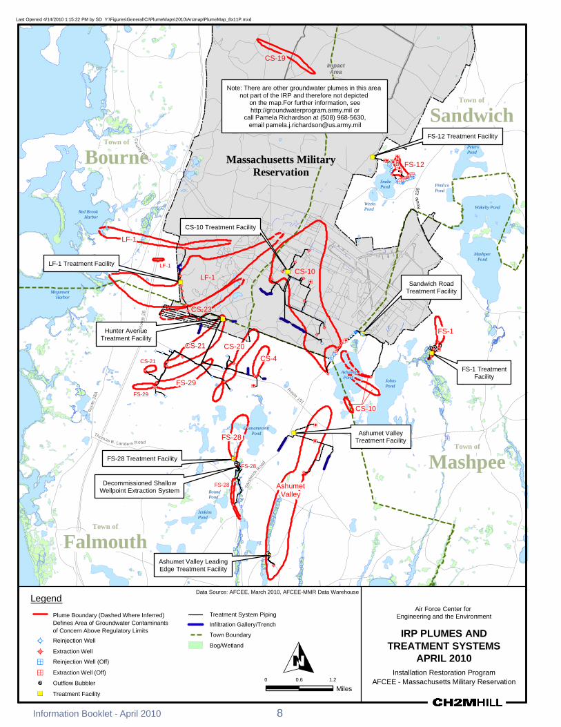

RRoouu
ttee 22
88
GGiibbbbss RRooaadd
SSaanndd
wwiicchh
PPooccaa
sssseett
RRooaadd
KKeennddrriicckk RRooaadd
WWoooodd RRooaadd
TTuurrpp
eenntt iinn
eeRR
oo aadd FFoorreessttddaallee PPooccaasssseett RRooaadd
RRoouu
ttee1133
00
GGrree
eennwwaa
yy RRooaadd
BBuu rr
gg ooiinn
ee RR
ooaadd
CCaappee CCoodd
CCaannaall
Massachusetts Military ReservationMassachusetts Military Reservation
CS-19 Groundwater Plume
The CS-19 site involves past ordnance and military waste disposal An area of approximately two acres was used to bury and detonate ordnance and munitions debris at depths to 12 feet These ordnance and waste disposal practices at the CS-19 site resulted in contaminants being released to the surrounding soil and groundwater AFCEE conducted multiple testing and cleanup actions at CS-19 between 2004 and 2009 including the removal of more than 2800 cubic yards of soil 8500 ordnance items and 27000 pounds of munitions debris from the original two-acre site
RDX an explosives compound Last Opened 3312010 104453 AM by SD YFiguresGeneralCIPlumeMaps2010ArcmapCS19plumemxdis the contaminant of concern
associated with CS-19 The NNoottee PPlluummeess ddeeppiicctteedd iinn tthhiiss mmaapp
ootthheerr tthhaann CCSS--1199 aarree nnoott ppaarrtt ooff tthhee IIRRPP groundwater plume is defined by RDX concentrations above FFoorr ffuurrtthheerr iinnffoorrmmaattiioonn sseeee
hhttttppggrroouunnddwwaatteerrpprrooggrraammaarrmmyymmiill oorrthe EPA risk-based level of ccaallll PPaammeellaa RRiicchhaarrddssoonn aatt ((550088)) 996688--55663300 eemmaaiill ppaammeellaajjrriicchhaarrddssoonnuussaarrmmyymmiill06 microgL
The CS-19 plume is located within the Central Impact Area DDeeeepp
MMaassssaacchhuusseettttss MMiilliittaarryyBBoottttoomm PPoonndd(CIA) study area and adjacent RReesseerrvvaattiioonn
to the CIA groundwater plume which is managed by the IAGWSP For more information about the IAGWSP please call 508-968-5630orvisit thewebsite at httpgroundwaterprogram armymil
LLiittttllee HHaallffwwaayy PPoonndd
DDoonnnneellyy PPoonndd
IImmppaacctt AArreeaa CCSS--1199A 2009 ROD calls for
continued monitoring of CCSS--1199 SSoouurrccee AArreeaa groundwater concentrations
and implementation of land use controls to prevent residential exposure The plume is not anticipated to move beyond the base boundary The final remedy selected for the CS-19 groundwater plume will not OOppeenniinngg
PPoonnddpredetermine or limit remedial options for the CIA plume which CS-19
is in close proximity to CS-19 Massachusetts Military
Reservation
SSnnaakkee PPoonndd
WWeeeekkss 0 1500 3000
PPoonndd Feet
Data Source AFCEE March 2010 AFCEE-MMR Data Warehouse
Legend CS-19 Plume Boundary = Explosives Plume Concentrations Army Program Plumes Air Force Center for (RDX Hexahydro-135-trinitro-135-triazine) Above EPA Perchlorate Plume - Engineering and the Environment risk-based level of 06 ugLmicrogL Concentrations Exceed Town Boundary MMCL = 20 microgL CHEMICAL SPILL-19 (CS-19)
RDX Plume -Massachusetts Military Reservation Boundary PLUME - APRIL 2010Concentrations
exceed EPA 10-6 Source Area
risk-based AFCEE - Massachusetts Military Reservation measure of concentration It is approximately level = 06 ppb equivalent to parts per billion (ppb)
Note microgL = micrograms per liter and is a
9 Information Booklet - April 2010
Air Force Center for Engineering and the EnvironmentAir Force Center for Engineering and the Environment
CS-10 Groundwater Plume
The Chemical Spill 10 (CS-10) groundwater plume resulted from spills and releases from multiple sources The primary source area originated from the former Boeing Michigan Aerospace Research Center Missile Site (from 1960 to 1973) and Unit Training Equipment Site (UTES) From 1996 through 2005 several source area cleanup actions were conducted at the site including 15 drainage structure removals and soil treatment with soil vapor extraction More than 1500 tons of contaminated soil were excavated and taken off site for disposal
Groundwater concentrations in monitoring wells located in the source area no longer exceed cleanup levels and the plume is detached from its primary source area Studies have shown that portions of the CS-10 plume no longer discharge to Ashumet and Johns Ponds Surface water sampling from both ponds in 2009 showed zero detections of contaminants associated with CS-10
The primary contaminants in the CS-10 plume are the cleaning solvents PCE and TCE which have been detected above the state and federal MCLs of 5 microgL Long-term remediation is occurring with a treatment system comprised of a series of extraction wells treatment plants reinjection wells and infiltration galleries The treatment plants use granular activated carbon to remove the solvents from the groundwater and the treated water is returned to the aquifer through the infiltration galleries and reinjection wells
An additional extraction well to address the southern trench contamination an additional reinjection well to improve hydraulic capture of the plume and revised flow rates in several extraction wells were completed in February 2009
The CS-10 Plume final ROD signed in 2009 specified continued operation and monitoring of the existing treatment system along with land use controls
CS-10 Date of ROD
or DD in Place Cleanup
Start Projected
Finish Primary
Contaminants 2009 Highest Levels (microgL)
Highest Historic Levels (microgL)
August 2009 June 1999 2055 PCE 51 400 (July 2000) TCE 1740 5110 (June 1997)
Treatment Components in Operation1
Treatment Plants Treatment Rate (gpm) (originalcurrent)1
Volume Treated (MG)2
Extraction Wells 15 Reinjection Wells 12 Infiltration Trenches 2
In Plume 2 27802290 13565 Sandwich Road 1 820410 4204 Northern Lobe uses SR 75190 9799
CS-10 Plume Treatment Systems SR = Sandwich Road ROD = Record of Decision DD = Decision Document microgL = micrograms per liter MG = million gallons gpm = gallons per minute 1 Current treatment rate as of April 1 2010 2 Through December 2009
Information Booklet - April 2010 10
ETHETHETHETH
MMMMRR BBoouunnddaarryy
RRoouuttee 115511
SSnnaakkee
PPoonndd RRooaadd
CCoonnnneerryy AAvveennuuee
TTuurrppeenn
tt iinnee
RRooaadd GG
rreeeenn
wwaayy
RRooaa
dd
Last Opened 482010 104134 AM by SD YFiguresGeneralCIPlumeMaps2010ArcmapCS10plumemxd
CS-10 In-Plume Treatment Facility SSnnaakkee PPoonndd
WWeeeekkss PPoonndd
CCSS--1100 SSoouurrccee AArreeaa
SSaannddwwiicchh BBoouurrnnee
CCSS--1100 IInn--PPlluummee TTrreeaattmmeenntt FFaacciilliittyy
ETHETH
ETHETH
CS-10 Sandwich Road Treatment Facility
ETHETH )) OOssbboorrnn PPoonndd ETHETH ETHETH
ETHETH
MMaassssaacchhuusseettttss MMiilliittaarryy RReesseerrvvaattiioonn
EEddmmuunnddss PPoonndd
ETHETH
CCSS--1100
ETHETH
SSaannddwwiicchh RRooaadd TTrreeaattmmeenntt FFaacciilliittyy
ETHETHETHETHETHETHETHETHETHETHETHETHETHETH
ETHETH )ETH
)ETH
ETHETH ETHETHETH ETHETHETHETHETH
ETHETH ETHETH
ETH
ETHETHETHETHETH ETHETH
ETHETH MMooooddyy PPoonnddETHETH
ETHETHETHETH
ETHETH
ETHETH
ETHETH
NNoorrtthheerrnn LLoobbee
AAsshhuummeett ETHETH PPoonndd
ETHETH
Plume Flows Under Pond
NNoorrtthh CCeennttrraall LLoobbee
JJoohhnnss
FFaallmmoouutthh
SSoouutthheerrnn LLoobbee
PPoonndd
MMaasshhppeeee1300 2600
Feet
Data Source AFCEE March 2010 AFCEE-MMR Data WarehouseLegend CS-10 Plume Boundary = Concentrations exceeding drinking Infiltration Trench water standards or Maximum Contaminant Level (MCL) Air Force Center for
Treatment System Pipingdashed where inferred Engineering and the Environment Represents an exceedance of trichloroethene ETH Extraction Well (On) (TCE) andor perchloroethene (PCE) ETH Extraction Well (Off) CHEMICAL SPILL-10 (CS-10)(TCE MCL = 5 microgL) (PCE MCL = 5 microgL) ETH Reinjection Well (On) PLUME - APRIL 2010 Massachusetts Military Reservation Boundary ETH Reinjection Well (Off) AFCEE - Massachusetts Military Reservation Town Boundary U Treatment Facility
U Source Area
11 Information Booklet - April 2010
0
Air Force Center for Engineering and the EnvironmentAir Force Center for Engineering and the Environment
Ashumet Valley Groundwater Plume
The Ashumet Valley plume has two sources the former firefighter-training area 1 (FTA-1) and the former MMR Sewage Treatment Plant (CS-16 and CS-17) Firefighter-training exercises were held from 1958 to 1985 at FTA-1 during which time flammable waste liquids were burned and extinguished some of which entered the sandy soil and eventually reached the groundwater aquifer The former sewage treatment plant which operated from 1936 to 1995 released treated water to a series of sand infiltration beds Sludge materials were kept on site
Treatment of contaminated soils at FTA-1 was completed in September 1997 A total of 42531 tons of soil were treated at FTA-1 using a thermal treatment process In 2001 and 2002 contaminated soil was removed from the CS-16 and CS-17 sites and taken off base for proper disposal
The primary contaminants in the Ashumet Valley plume are the cleaning solvents PCE and TCE which have been detected above the state and federal MCLs of 5 microgL The Ashumet Valley plume is currently in long-term remediation Remediation is occurring with two treatment systems each comprised of a single extraction well treatment plant and infiltration galleries river discharge The treatment plants use granular activated carbon to remove the solvents from the groundwater and the treated water is returned to the aquifer through the infiltration galleries in the central portion of the plume and to a bog ditch along the Backus River in the southern area
The Ashumet Valley Plume final ROD which was signed in 2009 specified continued operation of the existing treatment system plus additional treatment for the southern portion of the plume The southern treatment system has been installed The ROD also required land use controls
AFCEE does not believe that any portion of the plume is currently discharging into Ashumet Pond Surface water sampling from Ashumet Pond in 2009 showed that no plume contaminants were detected
In 2001 AFCEE applied an alum treatment to Ashumet Pond water to reduce the amount of phosphorus in the pond much of which comes from the basersquos wastewater treatment plant phosphorus plume In 2004 a geochemical barrier (made up of zero-valent iron mixed with pond sediment) was installed along the shoreline of Ashumet Pond to reduce the amount of phosphorus in groundwater entering the pond A second alum treatment is being evaluated for 2010
A part of the southern portion of the Ashumet Valley plume discharges to the Backus River in Falmouth Surface water testing conducted in 2009 showed results below the MCL Please note that safe drinking water guidelines (MCLs) do not apply to surface water bodies AFCEE continues to monitor the entire plume area
Ashumet Valley Date of ROD
or DD in Place Cleanup
Start Projected
Finish Primary
Contaminants 2009 Highest Levels (microgL)
Highest Historic Levels (microgL)
March 2009 November 1999 2018 PCE 43 109 (October 1998) TCE 12 83 (August 1997)
Treatment Components in Operation1
Treatment Plants Treatment Rate (gpm) (originalcurrent)1
Volume Treated (MG)2
Extraction Wells 2 Infiltration Trenches 2
Bubbler 1
1 1200350 4768
1 Mobile Treatment Unit 175175 268
ROD = Record of Decision DD = Decision Document microgL = micrograms per liter MG = million gallons gpm = gallons per minute 1 Current treatment rate as of April 1 2010 2 Through December 2009
Information Booklet - April 2010 12
MMMMRR BBoouunnddaarryy
RRoouuttee 115511
OOlldd BBaarrnnssttaabbllee RR
ooaadd
SSaanndd
wwiicchh RR
ooaadd
SSaamm TTuurrnneerr RRooaadd
CCaarrrriiaaggee SShhoopp RRoo
aadd
BBaacckk
uuss RR
iivveerr
0
Last Opened 482010 104135 AM by SD YFiguresGeneralCIPlumeMaps2010Arcmapashumetvalleymxd
BBoouurrnneeAshumet Valley Treatment Facility MMaassssaacchhuusseettttss SSaannddwwiicchhMMiilliittaarryy
RReesseerrvvaattiioonn FFTTAA--11 SSoouurrccee AArreeaa
MMooooddyy PP
FFoorrmmeerr MMMMRR SSeewwaaggee
TTrreeaattmmeenntt PPllaanntt ((SSoouurrccee AArreeaa)) AAsshhuummeett
PPoonndd
JJoohhnnss PPoonndd
DDeeeepp PPoonndd
AAsshhuummeett VVaalllleeyy TTrreeaattmmeenntt FFaacciilliittyy
CCoooonnaammeesssseettttPPoonndd
ETHETH
))
ETHETH
ETHETH
CCrrooookkeeddPPoonndd MMaasshhppeeee
FFaallmmoouutthh AAsshhuummeett VVaalllleeyy
RRoouunndd PPlluummeePPoonndd PPlluummee PPaarrttiiaallllyy
DDiisscchhaarrggeess TToo TThhee RRiivveerr
JJeennkkiinnss PPoonndd
FFllaaxx AAsshhuummeett VVaalllleeyy LLeeaaddiinn Pgg Poonndd
EEddggee TTrreeaattmmeenntt FFaacciilliittyy
1500 3000 ETHETHAshumet Valley LeadingFeet Edge Treatment Facility
Note microgL = micrograms per liter and is a measure of concentration It is approximately equivalent to parts per billion (ppb)
Data Source AFCEE March 2010 AFCEE-MMR Data WarehouseLegend ETHETH
Extraction Well (On)Ashumet Valley Plume Boundary = Concentrations exceeding drinking water standards or Maximum Contaminant Level (MCL) dashed where inferred
Air Force Center for Engineering and the Environment
Extraction Well (Off)
TTreatment Facilityreatment FacilityRepresents an exceedance of trichloroethene (TCE) andor ASHUMET VALLEY PLUME perchloroethene (PCE) Outflow Bubbler (TCE MCL = 5 microgL) Massachusetts Military APRIL 2010(PCE MCL = 5 microgL) Reservation Boundary
AFCEE - Massachusetts Military ReservationTreatment System Piping Town Boundary ThalliumManganese Area
BogWetlandInfiltration Trench
13 Information Booklet - April 2010
Air Force Center for Engineering and the EnvironmentAir Force Center for Engineering and the Environment
CS-23 and LF-1 Groundwater Plumes
The source of the Landfill 1 (LF-1) groundwater plume was the main MMR landfill which operated from 1941 to 1990 The LF-1 plume contains many COCs The more typical COCs are the solvents PCE TCE and CCl4 The state and federal MCLs for PCE TCE and CCI4 is 5 microgL
Test data indicate that no significant contamination is being released to groundwater from the older landfill cells at LF-1 and decreasing chemical concentrations in groundwater downgradient of the more recently used landfill cells suggest that the landfill cap there has been effective in reducing groundwater contamination at the source The cap is inspected annually to monitor its integrity
The LF-1 ROD signed in 2007 consists of continued long-term remediation with a groundwater extraction-and-treatment system and the implementation of land use controls The contaminated groundwater is treated at the LF-1 Treatment Plant and the Hunter Avenue Treatment Facility Water is returned to the aquifer through a reinjection well and infiltration trenches
Because a portion of the LF-1 plume discharges to both Red Brook and Squeteague Harbors surface water and discharging groundwater at the harbors are tested annually and results show that there are no ecological or human health risks
The CS-23 plume is a detached plume that has not been linked to a specific source area All of the potential source areas for the CS-23 plume have been investigated andor remediated The COCs in the CS-23 plume are TCE and CCl4
The CS-23 ROD signed in 2007 consists of continued remediation and operation of the existing groundwater cleanup system and land use controls The contaminated water is treated at the Hunter Avenue Treatment Facility Water is returned to the aquifer through infiltration trenches
LF-1 Date of ROD
or DD in Place Cleanup
Start Projected
Finish Primary
Contaminants 2009 Highest Levels (microgL)
Highest Historic Levels (microgL)
October 2007 August 1999 2047 TCE PCE 37 (TCE) 150 (TCE Aug 1999)
Treatment Components in Operation1
Treatment Plants Treatment Rate (gpm) (originalcurrent)1
Volume Treated (MG)2
Extraction Wells 6 Reinjection Wells 1 Infiltration Trench 2
2 7001245 3713
CS-23 Date of ROD
or DD in Place Cleanup
Start Projected
Finish Primary
Contaminants 2009 Highest Levels (microgL)
Highest Historic Levels (microgL)
October 2007 December 2006 2018 TCE 177 572 (June 2002)
Treatment Components in Operation1
Treatment Plants Treatment Rate (gpm) (originalcurrent)1
Volume Treated (MG)2
Extraction Wells 2 Infiltration Trench 2 1 700700 991
ROD = Record of Decision DD = Decision Document microgL = micrograms per liter MG = million gallons gpm = gallons per minute 1 Current treatment rate as of April 1 2010 2 Through December 2009
Information Booklet - April 2010 14
CS-21
CS-10
CS-21
CS-10
CCoonnnneerryy AAvveennuuee
MMMMRR BBoouunnddaarryy
RRoouutt
ee 2288
AA
RRoo uu
ttee 22
88
RRoouu
ttee 22
88
RReedd
BBrroo
ookk HH
aarrbboo
rr RRooaa dd
DDeeppoo
tt RRooaa
dd
SSccrraaggggyy NNeecc
RReettee
nnttiioo
nnBBaa
ssiinn
CCoomm
mmoonn
BBoo
rrrrooww
PPiitt
BBMMXX
TTrraacc
kk GGrr
aavveell
PPiitt
Last Opened 3312010 93956 AM by SD YFiguresGeneralCIPlumeMaps2010ArcmapLF1_CS23plumemxd
RReedd BBrrooookk PPoonndd 11994477
LF-1 Source 11995577
11995511
PPoosstt--11997700AreaRReedd BBrrooookk KKeettttllee HHoolleeHHaarrbboorr
Plume Discharges to 11997700Red Brook Harbor
LLoonngg MMaassssaacchhuusseettttss MMiilliittaarryyPPoonndd RReesseerrvvaattiioonn
LLFF--11 BBoouurrnnee ETHETHLLFF--11 IInnffiillttrraattiioonn
GGaalllleerryy aanndd TTrreenncchheesskk RRooaadd ((nnoott iinn uussee))
BBoouurrnnee 22 LLFF--11
BBoouurrnnee ETH55 ETHSSqquueetteeaagguuee HHaarrbboorr
LLFF--11 TTrreeaattmmeenntt FFaacciilliittyy
ETHETH
ETHETH
ETHETH
LLFF--11 OOssbboorrnn PPoonndd
LF-1 Treatment Facility
ETHETH
15Inform
ation Booklet -A
pril 2010
Plume Discharges to EEddmmuunnddssSqueteague Harbor SSaannddwwiicchhETHETH PPoonndd
SSppeeccttaaccllee WWeettllaanndd
VVeerrnnaall PPooooll 6655 C11 CSS--2233ETHETH
HHuunntteerr AAvveennuuee
ETHETH TTrreeaattmmeenntt FFaacciilliittyy
AA
0 1000 2000
Feet FFaallmmoouutthh microgL = micrograms per liter and is a measureNote of concentration It is approximately equivalentto parts per billion (ppb)
Hunter Avenue Treatment Facility
Legend LF-1 and CS-23 Plume Boundary = Concentrations exceeding drinking water ETHstandards or Maximum Contaminant Level (MCL) (Dashed where inferred)
ETHRepresents an exceedance of Trichloroethene (TCE) MCL = 5 microgL Perchloroethene (PCE) MCL = 5 microgL Carbon Tetrachloride (CCl4) MCL = 5 microgL 14-Dichlorobenzene (14-DCB) MCL = 5 microgL 1122-Tetrachloroethane (1122-TeCA) GW-1 = 2 microgL Vinyl Chloride (VC) MCL = 2 microgL Ethylene Dibromide (EDB) MMCL = 002 microgL U
Data Source AFCEE March 2010 AFCEE-MMR Data Warehouse
Extraction Well Massachusetts Military Reservation BoundaryReinjection Well
Public Water Town Boundary Supply Well
Infiltration GalleryTrench Source Area
BogWetland BMXBorrow Pit
Treatment Facility
Air Force Center for Engineering and the Environment
LANDFILL-1 (LF-1) AND CHEMICAL SPILL-23 (CS-23) PLUMES
APRIL 2010 AFCEE - Massachusetts Military Reservation
Cape Cod Canal
Route
28
Route 151
Route 28
Route 13
0
Route 6
Route 130
Route
28
Quaker Meetinghouse
Rd
Gree
nway
Rd
Wood Rd
Jefferson Rd
Barlo
w Rd Gibbs Rd
Connery Rd
Turpe
ntine
Rd
Frank
Perki
ns R
d
Pew R
d Ca
nal V
iew Rd
Cape Cod Canal
Route
28
Route 151
Route 28
Route 13
0
Route 6
Route 130
Route
28
Quaker Meetinghouse
Rd
Gree
nway
Rd
Wood Rd
Jefferson Rd
Barlo
w Rd Gibbs Rd
Connery Rd
Turpe
ntine
Rd
Frank
Perki
ns R
d
Pew R
d Ca
nal V
iew Rd
Last Opened 5102010 14919 PM by SD YFiguresGeneralERC_PlumemapGIS20100420Arcmaperc_plumemap_20100420mxd
Legend Chlorinated Solvents Plume -Concentrations Exceed MCLs TCE = 50 microgL PCE = 50 microgL EDB PlConcen
ume -rat ons Exceed MMCL = 002 microgLt i
Perchlorate Plume - Concentrations ExceedMMCL = 20 microgL
RDX Plume - Concentrations exceed EPA 10-6 risk-basedlevel = 06 ppb
Plumes with Remedy in Place
Cape Cod BayCape Cod Bay
NorthwesCorner NorthwesCorner
Demolition Area 2Demolition Area 2 tt
Plumes with Interim Remedy in Place Extraction Well
D Extraction Well (Off) OReinjection Well D Reinjection Well (Off) Scale 1 inch = 1 mile
0 05 1Outflow Bubbler Miles
Treatment FacilityS
Municipal Water Supply Well Town Boundary
SandwichInfiltration TrenchGallery Treatment System Pipeline
Influent Effluent
The areas of contamination show the combined contaminants of concern within each plume
Bourne
Massachusetts Military Reservation
Mashpee Falmouth
Surface water from Long Pond is also used as a drinking water source forthe town of Falmouth
Contaminant of Concern (COC) Type of Contaminant Risk-Based LevelTCE ndash trichloroethene solvent MCL = 5 microgPCE ndash perchloroethene solvent MCL = 5 microg
L
CCI4 ndash carbon tetrachloride solvent MCL = 5 microgLL
EDB ndash ethylene dibromide fuel-related compound MMCL = 002 microgLbenzene fuel-related compound MCL = 5 microgvinyl chloride solvent MCL = 2 microg
L
1122-tetrachloroethane solvent GW-1 = 2 microgL
14-dichlorobenzene solvent MCL = 5 microgLL
manganese metal EPA Health Advisory = 300 microgL Massachusetts Military Reservationthallium metal MCL = 2 microgLlead metal 15 microgL (treatment technique action level Groundwater Findings
for water distribution systems)toluene fuel MCL = 1000 microgL Issued April 2010RDX - hexahydro-135-trinitro-135- explosive HA = 2 microgLtriazine GW-1 = 1 microgL
10-6 = 06 microgperchlorate oxidizer HA = 15 microg
L MMCL = 2 microg
LL
MCL ndash Maximum Contaminant LevelMMCL ndash Massachusetts Maximum Contaminant LevelHA ndash Federal Lifetime Health Advisory Note ppb = parts per billion and is a measure of concentrationGW-1 ndash State default cleanup value to be used in lieu of site-specific risk-based level It is approximately equivalent to micrograms per liter (microgL)10-6 ndash EPA level resulting in an excess cancer risk of one in a million
Central Impact Area
Central Impact Area
S Phinneys Harbor
CS-19
S Phinneys Harbor
CS-19
WestBoundary
S J-2ern
S
S
S
J-1
J-3Demolition Area 1
WestBoundary
S J-2ern S
S
S
J-1
J-3Demolition Area 1
S S
Pocasset SS
Harbor
Hen
S L Range
S S
Peters Pond
Pocasset SS
Harbor DD FS-12 tSeveral FS-12 extraction wellurned off (not shown at this scale
s are)
Hen
S L Range
Peters Pond
DD FS-12 tSeveral FS-12 extraction wellurned off (not shown at this scale
s are)
CoveCove Snake
Weeks Pond
Pond Wakeby Pond
Snake
Weeks Pond
Pond Wakeby Pond
Red BrookRed Brook HarborHarbor
LF-1LF-1
Squeteague LF-1 MashpeeHarbor Pond
CS-10SMegansett
LF-1 Harbor DS
CS-23
S
FS-1 S Moody
DD PondCS-21 DSCS-20 D
DDCS-21 CS-4Wild Harbor
Ashumet FS-29
Squeteague LF-1 MashpeeHarbor Pond
CS-10SMegansett
LF-1 Harbor DS
CS-23
S
FS-1 S Moody
DD PondCS-21 DSCS-20 D
DDCS-21 CS-4Wild Harbor
Ashumet FS-29 D D
Pond D Johns
D
Pond Johns
Pond
Pond
CS-10 CS-10
Deep Pond
Deep Pond
Crooked Pond Crooked Pond
Coonamessett D
Pond S
DFS-28
S
Shallow Well Point system is off
FS-28 AshumetValley
Jenkins
Pond
S
Coonamessett D
Pond S
DFS-28
S
Shallow Well Point system is off
FS-28 AshumetValley
Jenkins
Pond
S
Long Pond
Long Pond
Air Force Center for Engineering and the EnvironmentAir Force Center for Engineering and the Environment
FS-1 and FS-12 Groundwater Plumes The source of the Fuel Spill 1 (FS-1) groundwater plume is the Aviation Gas Fuel Valve Test Dump Site in the eastern part of the base The site was used from 1955 to 1970 to test fuel dump valves on EC-121 Super Constellation aircraft which involved the release of fuel directly onto the ground Currently no significant levels of COCs are present in the surface or subsurface soils at the FS-1 source area and the source area groundwater is sampled for lead only
The FS-1 groundwater plume contains the fuel additive ethylene dibromide (EDB) at levels above the MMCL which is 002 microgL The FS-1 plume is currently in long-term remediation with a groundwater extraction-and-treatment system in the Quashnet River cranberry bog area just northeast of Johns Pond The system was designed to prevent upwelling of EDB contamination into the Quashnet River and associated cranberry bogs The treatment plant uses granular activated carbon to remove EDB from the groundwater which is then discharged to the Quashnet River through a series of oxygenating bubblers The latest test results showed that the FS-1 treatment system has been successful in reducing both the amount of EDB in the FS-1 plume and the EDB concentrations in the surface water of the Quashnet River and associated bogs A 2000 ROD specifies active treatment of the plume along with monitoring
The source of the FS-12 groundwater plume was an estimated 70000-gallon release from a section of a now-abandoned fuel pipeline that ran from the Cape Cod Canal to MMR EDB is the only remaining contaminant above cleanup standards in the FS-12 groundwater plume The source area groundwater is currently being monitored after having undergone subsurface remediation in the 1990s Groundwater sampling indicates that the source area has been successfully remediated The pipeline has been cleaned and closed with state and federal regulatory approval
The FS-12 plume is currently in long-term remediation with a groundwater extraction-and-treatment system The treatment system consists of extraction wells a treatment plant and reinjection wells The 2006 ROD called for the status quo of operating and monitoring the existing system The latest test results indicate that the extraction wells continue to successfully contain the FS-12 groundwater plume and the size of the plume has been reduced significantly Land use controls are in place for the FS-1 and FS-12 plumes
FS-1 Date of ROD
or DD in Place Cleanup
Start Projected
Finish Primary
Contaminants 2009 Highest Levels (microgL)
Highest Historic Levels (microgL)
April 2000 April 1999 2020 EDB 0857 445 (October 2000)
Treatment Components in Operation1
Treatment Plants Treatment Rate (gpm) (originalcurrent)1
Volume Treated (MG)2
Extraction Wells 3 Bubblers 3 1 750515 33053
FS-12 Date of ROD
or DD in Place Cleanup
Start Projected
Finish Primary
Contaminants 2009 Highest Levels (microgL)
Highest Historic Levels (microgL)
September 2006 September 1997 2048 EDB 231 890 (November 1996)
Treatment Components in Operation1
Treatment Plants Treatment Rate (gpm) (originalcurrent)1
Volume Treated (MG)2
Extraction Wells 4 Reinjection Wells 20 1 772360 4082
ROD = Record of Decision DD = Decision Document microgL = micrograms per liter MG = million gallons gpm = gallons per minute 1 Current treatment rate as of April 1 2010 2 Through December 2009
Information Booklet - April 2010 18
Co
FP
erki
nsR
d
Co
FP
erki
nsR
d
-
-
QQuuaasshhnneett RRiivveerr GG
rreeaatt HHaayy
RRooaa dd
hhiinnnn
ee yyss
RRooaadd
BBeeaarr
sseess
RRooaa
dd SSaa
ddddlleebb
aacckk RRooaadd
GGrraaffttoonn PPoocckknnee
tt RRooaadd
PPiimmlliiccoo PP nndd RRdd
JJBB TThhoommppssoonn RRdd
SSnn aakkeePPoonndd RRdd
RRtt 113300
nnnneerryy AAvv CCoonnnneerryy AAvv
Last Opened 482010 105423 AM by SD YFiguresGeneralCIPlumeMaps2010ArcmapFS1_FS12plumemxd
FFSS--1122 SSoouurrccee AArreeaa
NNoottee PPlluummeess ddeeppiicctteedd iinn tthhiiss mmaapp ootthheerr tthhaann FFSS--11 aanndd FFSS--1122
aarree nnoott ppaarrtt ooff tthhee IIRRPP FFoorr ffuurrtthheerr iinnffoorrmmaattiioonn sseeee
hhttttppggrroouunnddwwaatteerrpprrooggrraammaarrmmyymmiill oorr ccaallll PPaammeellaa RRiicchhaarrddssoonn aatt ((550088)) 996688--55663300 FFSS--1122 TTrreeaattmmeenntt FFaacciilliittyy
FS 12 Treatment Facility
PP
SSaannddwwiicchheemmaaiill ppaammeellaajjrriicchhaarrddssoonnuussaarrmmyymmiill DD DD
DDDD DDDD
DDDDDD DDDD DD DD DD
DD Ntilde D DNtilde DD FFSS--1122
Ntilde Ntilde
ETHETHD
DDDDDDDNtildeNtildeNtildeNtilde
ETH
NtildeNtilde ETH
DDDDETHETHETHETHNtildeNtildeNtildeNtildeNtildeNtildeNtildeNtildeNtildeNtildeNtildeNtildeNtilde
D DDD NtildeNtildeNtildeNtildeDD NtildeNtildeNtildeSSnnaakk Ntildeee NtildeNtildeNtildeNtildeNtilde NtildeNtildeNtildeNtildePPoonnddBBoouurrnnee oo
WWaakkeebbyy PPoonndd
MMaasshhppeeee
MMaassssaacchhuusseettttss MMiilliittaarryy
RReesseerrvvaattiioonn
PPoonndd
FFSS--11 SSoouurrccee AArreeaa
MMaasshhppeeee
FFSS--11
MMooooddyy PPoonndd
FFSS--11 TTrreeaattmmeenntt FFaacciilliittyy
FS 1 Treatment Facility JJoohhnnss
with bubbler in foreground PPoonndd 0 1500 3000
Feet
Legend Data Source AFCEE March 2010 AFCEE-MMR Data Warehouse
ETH
FS-1 and FS-12 Plume Boundary = Concentrations Outflow Bubbler Army Program Plumes exceeding drinking water standards or Massachusetts Extraction Well (On) Perchlorate Plume shyMaximum Contaminant Level (MMCL) Represents an Concentrations exceedance of ethylene dibromide (EDB) Exceed
ETH Reinjection Well (On) D Extraction Well (Off)
(EDB MMCL = 002 microgL) (Dashed Where Inferred) MMCL = 20 microgL D Reinjection Well (Off)Treatment System Piping RDX Plume shy
Massachusetts Military Reservation Boundary U Treatment Facility Concentrations exceed EPA 10-6
Town Boundary Source Area Note microgL = micrograms per liter and is a measure of U risk-based
level = 06 ppb concentrationIt is approximately equivalent to parts BogWetland per billion (ppb)
19
Air Force Center for Engineering and the Environment
FUEL SPILL-1 (FS-1) AND FUEL SPILL-12 (FS-12)
APRIL 2010 AFCEE - Massachusetts Military Reservation
Information Booklet - April 2010
Air Force Center for Engineering and the EnvironmentAir Force Center for Engineering and the Environment
CS-4 CS-20 CS-21 FS-28 and FS-29 Groundwater Plumes
Five groundwater plumes can be found in the area north and south of Route 151 in the town of Falmouth They are FS-28 FS-29 CS-4 CS-20 and CS-21 Only CS-4 has a known source area a former vehicle maintenance area and storage yard on the MMR The other plumes were found to be disconnected from distinct source areas They most likely originated somewhere in the southern portion of MMR which contained various aircraft and vehicle maintenance shops runways and housingpersonnel support facilities Records indicate that spills andor releases occurred in these areas in the past COCs in the plumes are fuel and solvent-related contaminants They include EDB PCE TCE and CCl4 The MMCL for EDB is 002 microgL while the MCL for the rest of the contaminants is 5 microgL
More than 18000 tons of contaminated soil were treated on site at the CS-4 source area and additional soil was transported off site for proper disposal A groundwater extraction-and-treatment system began operating in 1993 but was later replaced by a more efficient system in 2006 to better capture the plume
Portions of the FS-28 plume were first discovered in 1993 beneath the leading edge of the CS-4 plume In 1996 groundwater investigations found EDB upwelling into the Coonamessett River in Falmouth No EDB is presently detected in the Coonamessett River The FS-28 plume is currently in long-term remediation with a groundwater extraction-and-treatment system A treatment plant is located in a bog area just south of Hatchville Road and treated water is discharged to the Coonamessett River through two oxygenating bubblers Shallow wellpoint extraction wells operated for several years but are no longer being used In 2007 a new extraction well was installed to the south to address a deep lobe of EDB
The FS-28 plume underflows Coonamessett Pond and has not affected the pond or a nearby Town of Falmouth municipal well In 2002 AFCEE funded a $52 million wellhead treatment system to ensure a safe water supply for the Falmouth well A ROD was issued in October 2000
The FS-29 CS-20 and CS-21 groundwater plumes were discovered in the late 1990s A ROD for FS-29 was issued in October 2000 and a ROD for CS-4 CS-20 and CS-21 was issued in February 2000 Since 2006 the FS-29 CS-4 CS-20 and CS-21 groundwater plumes have been undergoing active treatment through a series of extraction wells reinjection wells and infiltration trenches Extracted plume water is treated with granular activated carbon at the Hunter Avenue Treatment Facility on base Land use controls are in place for all these plumes
Plume Date of ROD
or DD in Place Cleanup
Start Projected
Finish Primary
Contaminants 2009 Highest Levels (microgL)
Highest Historic Levels (microgL)
CS-4 February 2000 (ESD 92008) November 2005 2014
TCE 55 19 (February 1997) PCE 232 61 (February 1997)
CS-20 February 2000 (ESD 92008) January 2006 2017 PCE 205 981 (September 2005)
CS-21 February 2000 (ESD 92008) September 2006 2027 TCE 98 988 (June 2001)
FS-28 October 2000 (ESD 92008) October 1997 2047 EDB 138 18 (January 1997)
FS-29 October 2000 (ESD 92008) September 2006 2018 EDB 0084 0318 (May 2001)
ROD = Record of Decision DD = Decision Document microgL = micrograms per liter MG = million gallons gpm = gallons per minute
Information Booklet - April 2010 20
Massachusetts Military ReservationMassachusetts Military Reservation
Plume Explanation Contaminants of concern exceed drinking water standards or Maximum Contaminant Level (MCL) CS-20 Perchloroethene (PCE) (PCE MCL = 5 microgL) FS-29 Ethylene dibromide (EDB) and carbon tetrachloride (CCl4)
(EDB MMCL = 002 microgL) (CCl4 MCL = 5 microgL) CS-4 Trichloroethene (TCE) perchloroethene (PCE)
1122- tetrachlorethane (1122- TeCA) andor ethylene dibromide (EDB) (TCE MCL = 5 microgL) (PCE MCL = 5 microgL) (1122-TeCA GW-1 = 2 microgL) (EDB MMCL = 002 microgL)
CS-21 Trichloroethene (TCE) (TCE MCL = 5 microgL)
Note microgL = micrograms per liter and is a measure of concentration It is approximately equivalent to parts per billion (ppb)
Treatment Components in Operation1
Treatment Plants
Treatment Rate (gpm)1
(originalcurrent)
Volume Treated (MG)2
Extraction Wells 2 Infiltration Trenches 2 1 620199 1027
Extraction Wells 2 Reinjection Wells 4 1 775773 1460
Extraction Wells 4 Reinjection Wells 3 1 14001395 2213
Extraction Wells 2 Bubblers 2 1 750600 43045
Extraction Wells 1 Reinjection Wells 2 1 525224 642
ESD = Explanation of Significant Differences 1 Current treatment rate as of April 1 2010 2 Through December 2009
21 Information Booklet - April 2010
-
SamTurner R
d
Hay
way
Rd
Hatchv
illeRd
Thomas B Landers Rd Sa
ndw
ich
Rd
Boxb
erry
Hill
Rd
Hill and Plain Rd
Route 151
Hatchville Rd
Sand
wichRd
Sam
Tur
ner R
d
Last Opened 412010 82704 AM by SD YFiguresGeneralCIPlumeMaps2010ArcmapFS28plumemxd
Falmouth
FS 28 Treatment Facility
Deep Pond
Plume Flows Under Pond
Round Pond
Coonamessett Pond Coonamessett
Water Supply Well FS-28
Crooked Pond
Outflow Bubbler
ETH
FS-28 Treatment Facility Broad River
FS-28 Shallow Outflow Bubbler
Pond Decommissioned Shallow
Wellpoint Extraction System
DR
AF
T
FS-28
Round Pond
ETHETH
Jenkins Pond
Pond 14
0 770 1540
Feet
Data Source AFCEE March 2010 MMR-AFCEE Data WarehouseLegend FS-28 Plume Boundary = Concentrations exceeding drinking ETH Extraction Well
Air Force Center for water standards or Massachusetts Maximum Contaminant Outflow Bubbler Engineering and the EnvironmentLevel (MMCL) dashed where inferred Represents an exceedance of ethylene dibromide (EDB) Public Drinking FUEL SPILL 28 (FS-28)(EDB MMCL = 002 microgL) Water Supply Well
PLUME - APRIL 2010BogWetland Treatment Facility AFCEE - Massachusetts Military Reservation
Treatment System Piping Note microgL = micrograms per liter and is a measure of concentration
It is approximately equivalent to parts per billion (ppb)
Information Booklet - April 2010 22
MMR Boundary Falmouth
Sandw
ich
Mashpe
e
Whe
eler
Rd
Reilly
Redlands
Rd
Br a
nsha
w S
t
Curr ier R
d
Sim
p kinsR
d
Hoo
ppol
eR
d
Club
Valley
Dr
Gen
eral
sBl
vd
MMR Boundary Falmouth
Sandw
ich
Mashpe
e
Whe
eler
Rd
Reilly
Redlands
Rd
Bra
nsha
w S
t
Currier R
d
Sim
p kinsR
d
Hoo
ppol
eR
d
Club
Val leyD
r
Gen
eral
sBl
vd
Massachusetts Military ReservationMassachusetts Military Reservation
Progress Over The Years
Much progress has been made over the last 15 years Program-wide the source areas have been cleaned up and 11 groundwater plumes are undergoing pump-and-treat cleanup action both on and off base All environmental cleanup decisions and remedies are in place In the future the program will continue to monitor adjust and shut down treatment systems as cleanup progress is made The Air Force will continue to conduct the most efficient cleanup operations while ensuring the protection of public health and the environment
The SD-5 plume depiction illustrates the transformation of the plume over time due to the effect of cleanup systems used by the Air Force for several years Contaminated water was cleaned by using two technologies The first involved extracting the plume water pumping it to a treatment building where large vessels of granular activated carbon removed the solvent contamination and then the clean water was returned to the ground through reinjection wells Two recirculation wells were also used Those involved two underground standalone treatment systems within the neighboring community That technology used air and pumps to remove the solvents from the plume and capture them in carbon tanks The plume has now been cleaned up to the point where only residual traces of solvent contamination are found in monitoring wells which are periodically tested
The following pages depict the cleanup progress of several IRP groundwater plumes over time Most plumes show a significant reduction in size and contaminant mass A few show a larger area which is related to plume information uncertainties in the early part of the cleanup program and changing conditions over time a significant reason why diligent monitoring is required For more information and depictions of all AFCEE groundwater plumes progress over time go to httpwwwmmrorgCleanupplumes_fshtm
Last Opened 3292010 115403 AM by SD YFiguresGeneralPlumeMapsComparison2010ArcMapSD5comp_97_10mxd
SandwichSandwich
Mashpee Mashpee
Ashumet PondAshumet PondFalmouth FalmouthJohns PondJohns Pond
1997 2010
Legend Data Source AFCEE MMR-AFCEE Data Warehouse
Town Boundary
Massachusetts Military Reservation Boundary SD-5 PLUME 1997 AND 2010 COMPARISON
Plume Boundary AFCEE - Massachusetts Military Reservation 0 1100 2200
BogWetland Feet
23 Information Booklet - April 2010
Plum
e Com
parison Over Tim
e
MMR Boundary Falmouth
Sandw
ich
Mashpe
e
Route 151
Kit tredge Rd
Connery Av
Whe
eler
Rd
Cole Rd
Le e Rd Hatc
hville
Rd
Herbert Rd
Reilly
Sam Turner R
d
Sandw
ich R
d
Herbert Rd
Connery Av
Route 151
MMR Boundary Falmouth
Sandw
ich
Mashpe
e
Route 151
Kittredge Rd
Connery Av
Whe
eler
Rd
Cole Rd
Le e Rd
Hatchv
ille R
d
Herbert Rd
Reilly
Sam Turner R
d
Sandw
ich R
d
Herber t Rd
Connery Av
Route 151
MMR Boundary
Falmouth
Sandw
ich
ashpe
e
Route 151
Cur
rier R
d
Whe
eler
Rd
Hayway Rd
Sam Turner R
d
Thomas B Landers Rd
Hatch
ville
Rd
Mi lf
or d
Rd Elai n Av
Sandw
ich
Rd
Meredith Dr
Redlands Rd
R eg is R
d
Jam
ie Ln
Hill a
nd Plain Rd
Old Barnstable R
d
Cloverfield Way Route 151
Sand
wich R
d
Route 151
MMR Boundary
Falmouth
Sandw
ich
ashpe
e
Route 151
Cur
rier R
d
Whe
eler
Rd
Sam Turner R
d
Thomas B Landers Rd
Hatchv
ille R
d
Mil f
ord
Rd Elain Av
Sandw
i ch
Rd
Meredith Dr
Redlands Rd
R eg is R
d
Jam
ie Ln
Hill a
nd Plain Rd
Old Barnsta
ble Rd
Cloverfield Way Route 151
Sand
wich R
d
Plu
me
Com
paris
on O
ver T
ime
Last Opened 3292010 110332 AM by SD YFiguresGeneralPlumeMapsComparison2010ArcMapCS10comp_97_10mxd
Snake Pond Snake Pond
BourneBourne
Sandwich Sandwich
MashpeeMashpee Falmouth Ashumet PondAshumet PondFalmouth Johns PondJohns Pond
Coonamessett Pond 2010Coonamessett Pond 1997 Legend
Massachusetts Military Reservation Boundary
BogWetland
Town Boundary
Plume Boundary (Dashed Where Inferred) Primary Contaminants Trichloroethene (TCE) Perchloroethene (PCE)
0 2300 4600
Feet
Data Source AFCEE MMR-AFCEE Data Warehouse
CS-10 PLUME 1997 AND 2010 COMPARISON AFCEE - Massachusetts Military Reservation
Last Opened 3292010 101508 AM by SD YFiguresGeneralPlumeMapsComparison2010ArcMapAVcomp_96_10mxd
Sandwich Sandwich MMashpee MMashpee
FalmouthFalmouth Ashumet Pond Ashumet Pond
Johns Pond Johns Pond
Coonamessett Pond Coonamessett Pond
Broad RiverBroad River
Jenkins Pond Jenkins Pond Pond 14 Pond 14 Fresh PondFresh Pond
20101996
Legend
Plume Boundary Primary Contaminants Trichloroethene (TCE) Perchloroethene (PCE)
Massachusetts Military Reservation Boundary
BogWetland
Town Boundary
0 2250 4500
Feet
Data Source AFCEE MMR-AFCEE Data Warehouse
ASHUMET VALLEY PLUME 1996 AND 2010 COMPARISON AFCEE - Massachusetts Military Reservation
Information Booklet - April 2010 24
Sandwich
MM
R Bo
unda
ry
MM
R
Sandwich Mashpee
Snake Pond Rd
Boun
dary
Dana
Rd
Arnol
d Rd
Pinecrest Dr
Artisan Way
Cha
dwic
k R
d
Jeannes Way
Gre
enw
ay R
d
Rout
e 13
0
Emerald Way
Week
s Po
nd D
r
Blac
kth rn Path
Green
way R
d
Greenway Rd
MM
R Bo
unda
ry
MM
R Bo
unda
ry Sandwich Mashpee
Greenway Rd
Dana
Rd
Arnol
d Rd
Pinecrest Dr
Artisan Way
Cha
dwic
k R
d
Jeannes Way
Emerald Way
Rout
e 13
0
Snake Pond Rd
Wee
ks P
ond
Dr
Blac
kth rn Path
Gre
enw
ay R
d
Greenw
ay R
d
MMR Boundary
Mas
hpee
Sand
wic
h
Route 130
Reilly
Great H
ay Rd
Love
lls L
n
Bear
ses
Rd
Sadd
leback Rd
Graf ton Pocknet Rd
Great Hay Rd
Mas
hpee
Sand
wic
h
MMR Boundary
Route 130
Love
ll s L
n
Rei
lly
Great H
ay Rd
Bear
ses
Rd
Lowell
Rd
Grafton P
ockne
t Rd
Echo Rd
Bookers Rd
Sadd
leback Rd
Quashnet Rd
Back Rd
Ashumet Rd
Bakers Rd
Easton S
t
Phi
nney
s Rd
Asher s P at h
Shorewood Dr
Great Hay Rd
Bear
ses
Rd
Rei
lly
Grea t H
ay Rd
Love
lls L
n
Grafton Pocknet Rd
Gre at H
ay Rd
Last Opened 3292010 113034 AM by SD YFiguresGeneralPlumeMapsComparison2010ArcMapFS12comp_97_10mxd
Snake Pond Snake Pondoo
Sandwich SandwichWeeks Pond Weeks Pond
1997 2010 Data Source AFCEE MMR-AFCEE Data WarehouseLegend
Town Boundary
FS-12 PLUMEMassachusetts Military Reservation Boundary 1997 AND 2010 COMPARISON AFCEE - Massachusetts Military ReservationPlume Boundary Primary Contaminants Benzene Ethylene Dibromide (EDB)
0 960 1920 BogWetland Feet
Last Opened 3292010 112823 AM by SD YFiguresGeneralPlumeMapsComparison2010ArcMapFS1comp_98_10mxd
aay
Rd
Gre
tH
Mashpee
Mashpee Pond Mashpee Pond
Mashpee
Johns PondJohns Pond
20101998
Legend Data Source AFCEE MMR-AFCEE Data Warehouse
Town Boundary
Massachusetts Military Reservation Boundary FS-1 PLUME 1998 AND 2010 COMPARISON
Plume Boundary (Dashed Where Inferred) Primary Contaminant Ethylene Dibromide (EDB)
0 1000 2000
AFCEE - Massachusetts Military Reservation
BogWetland Feet
25 Information Booklet - April 2010
Plum
e Com
parison Over Tim
e
MMR Bo
Sandw
ich
Mas
hpee San
dwich
Sandw
ich
Mashpe
e
Deep PondLittle Jenkins Pond
Sandw
ich
Coonamessett PondDeep PondLittle Jenkins Pond
undary
Falmouth
Sandwich
MMR Boundary
Route 151
mas B Landers Rd
Sam Turner R
d
Hatchv
il le R
d
Deer Pond Rd
Sandw
ich
Rd
Boxberry Hill Rd
Hill and Plain Rd
Old Barnstable R
d
Cloverfield Way
Blac
ksmith Shop Rd
Regis Rd
Route 151
Route 151
Sam Tu rner R
d
Route 151
Route 151
Sandw
ich R
d
MMR Boundary Falmouth
Sandwich
Route 151
mas B Landers Rd
Sam Tu rner R
d
Deer Pond Rd
Hatch
ville
Rd
Sandw
ich
Rd
Box
ber r
y H
il l R
d
Hill and Plain Rd
Old Barnstable R
d
Cloverfield Way
Blac
ksmith Shop Rd
Route 151
Route 151
Route 151
Sandw
ich R
d
Route 151
Sand
wich R
d
Boxberry Hill Rd
MMR Boundary
Falmouth
Bourne
Sand
wic
h
Route 151
Kittredge Rd
Cole Rd
Lee Rd
Sandwich R
d
Boxberry Hill Rd
Route 151
Route 151
MMR Boundary
Falmouth
Bourne
Sand
wic
h
Route 151
Kittredge Rd
Cole Rd
Lee Rd
Sa
ndwich
Rd
Boxberry Hill Rd
Route 151
Route 151
Last Opened 3292010 113441 AM by SD YFiguresGeneralPlumeMapsComparison2010ArcMapFS28comp_98_10mxdP
lum
e C
ompa
rison
Ove
r Tim
e
Coonamessett PondCoonamessett Pond
Falmouth FalmouthThoTho Broad River
Broad River
Jenkins PondJenkins Pond Pond 14Pond 14 20101998
Data Source AFCEE MMR-AFCEE Data WarehouseLegend
Town Boundary
FS-28 PLUME Massachusetts Military Reservation Boundary 1998 AND 2010 COMPARISON Plume Boundary (Dashed Where Inferred) AFCEE - Massachusetts Military Reservation Primary Contaminant Ethylene Dibromide (EDB)
0 1700 3400
BogWetland Feet
Last Opened 3292010 101742 AM by SD YFiguresGeneralPlumeMapsComparison2010ArcMapCS4comp_96_10mxd
Bourne Bourne Osborn Pond Osborn Pond
Edmunds Pond Edmunds Pond
Spit Pond Spit Pond
SandwichSandwich
FalmouthFalmouth
1996 2010 Data Source AFCEE MMR-AFCEE Data WarehouseLegend
Town Boundary
CS-4 PLUME 1996 AND 2010 COMPARISON
Massachusetts Military Reservation Boundary
Plume Boundary Primary Contaminants Trichloroethene (TCE) Perchloroethene (PCE) AFCEE - Massachusetts Military Reservation
0 1400 2800BogWetland Feet
Information Booklet - April 2010 26
Little Jenkins Pond Little Jenkins Pond
MMR Boundary
Falmouth
Bourne
Sand
wic
h
Route 151
Rou
te 2
8
Sam Turner Rd
Rou
te 2
8
MMR Boundary
Falmouth
Bourne
Sand
wic
h
Route 151
Rou
te 2
8
Sam Turner Rd
Rou
te 2
8
Falmouth
Bourne
Sand
wic
h
MMR Boundary
Rou
te 2
8
Route 151
Rou
te 2
8
Sand
wic
h
Falmouth
Bourne
MMR Boundary
Rou
te 2
8
Route 151
Rou
te 2
8
Last Opened 3292010 111229 AM by SD YFiguresGeneralPlumeMapsComparison2010ArcMapCS21comp_99_10mxd
Osborn Pond Osborn Pond
Bourne Bourne Edmunds Pond Edmunds Pond
Spit Pond Spit Pond
Sandwich Sandwich
Falmouth Falmouth
Deep Pond Deep Pond Coonamessett Pond Coonamessett Pond
1999 2010 Round Pond Round Pond Crooked Pond Crooked Pond
Legend Data Source AFCEE MMR-AFCEE Data Warehouse
Town Boundary
Massachusetts Military Reservation Boundary CS-21 PLUME 1999 AND 2010 COMPARISON
Plume Boundary Primary Contaminant Trichloroethene (TCE) AFCEE - Massachusetts Military Reservation
BogWetland 0 1400 2800
Feet
Last Opened 3292010 112004 AM by SD YFiguresGeneralPlumeMapsComparison2010ArcMapCS23comp_02_10mxd
Osborn Pond Osborn Pond
Bourne Bourne Edmunds Pond Edmunds Pond
Spit Pond Spit Pond
Falmouth Falmouth
2010 2002 Data Source AFCEE MMR-AFCEE Data Warehouse Legend
Town Boundary
CS-23 PLUME 2002 AND 2010 COMPARISON
Massachusetts Military Reservation Boundary
Plume Boundary (Dashed Where Inferred) Primary Contaminants AFCEE - Massachusetts Military Reservation Trichloroethene (TCE) Carbon Tetrachloride (CCl4)
0 1000 2000 BogWetland Feet
27 Information Booklet - April 2010
Plum
e Com
parison Over Tim
e
Deep Pond Little Jenkins PondLittle Jenkins Pond
Sandw
ich
Bourne Osborn PondBourne
Osborn Pond
MMR Boundary
Falmouth
Bourne
Sand
wic
h
Rou
te 2
8
Co le R
d
Route 151
Kittredge Rd
Conne ry Av
Le e Rd
Herbert Rd
Shor
e R
oute
Boxberry Hill Rd
Rou
te 2
8
Cole Rd Rou
te 2
8
Rout
e 28
Route 151
Rou
te 2
8
Rout
e 28
Route 151
Connery Av
MMR Boundary
Falmouth
Bourne
Sand
wic
h
Rou
te 2
8
Cole R
d
Route 151
Kittredge Rd
Connery Av
Le e Rd
Herbert Rd
Shor
e Ro
ute
Boxberry Hill Rd
Rou
te 2
8
Rou
te 2
8
Rout
e 28
Route 151
Rou
te 2
8
Rout
e 28
Connery Av
MMR Boundary
Falmouth
Bourne
Sand
wic
h
Route 151
Kittredge Rd
Cole Rd
Sam
Turner Rd
Hatchv
ille R
d
Boxberry Hill Rd
Sand
wich R
d
Hill
and Plain Rd
Hay
way
Rd
Route 151
Route 151
MMR Boundary
Falmouth
Bourne
Sand
wic
h
Route 151
Kittredge Rd
Cole Rd
Sam
Turner Rd
Hatch
ville
Rd
Hill
and Plain Rd
Sandw
ich R
d
Hay
way
Rd
Route 151
Route 151
Plu
me
Com
paris
on O
ver T
ime
Last Opened 3292010 115107 AM by SD YFiguresGeneralPlumeMapsComparison2010ArcMapLF1comp_97_10mxd
BourneBourne
Osborn Pond Osborn Pond
Edmunds Pond Edmunds Pond Spit Pond Spit Pond
Sandwich Sandwich
Falmouth Falmouth
20101997
Data Source AFCEE MMR-AFCEE Data WarehouseLegend
Town Boundary
LF-1 PLUME 1997 AND 2010 COMPARISON
Massachusetts Military Reservation Boundary
Plume Boundary (Dashed Where Inferred) Primary Contaminants Carbon Tetrachloride (CCl4) Perchloroethene (PCE) Tetrachloroethene (TCE) AFCEE - Massachusetts Military Reservation
BogWetland 0 2000 4000
Feet
Last Opened 3292010 110911 AM by SD YFiguresGeneralPlumeMapsComparison2010ArcMapCS20comp_99_10mxd
Bourne BourneEdmunds Pond Edmunds Pond
Spit Pond Spit Pond
SandwichSandwich
FalmouthFalmouth
Little Jenkins Pond Little Jenkins Pond Deep Pond Deep Pond Coonamessett PondCoonamessett Pond
Round Pond Round PondCrooked Pond Crooked Pond
1999 2010
Legend
Plume Boundary Primary Contaminant Perchloroethene (PCE)
Massachusetts Military Reservation Boundary
BogWetland
Town Boundary
0 1400 2800
Feet
Data Source AFCEE MMR-AFCEE Data Warehouse
CS-20 PLUME 1999 AND 2010 COMPARISON AFCEE - Massachusetts Military Reservation
Information Booklet - April 2010 28
Massachusetts Military ReservationMassachusetts Military Reservation
Information Booklet - April 2010
AFCEErsquos aggressive optimization activities have resulted in a more sustainable remediation program at MMR Our ldquobetter cheaper fasterrdquo approach is intended to expedite aquifer restoration and cleanup timeframes while reducing costs to the taxpayers and minimizing our carbon footprint Optimization activities conducted by AFCEE at MMR include
Demonstrating alternative in situ technologies such as a passive zero-valent iron barrier This barrier requiresbullno OampM and was installed along the Ashumet Pond shoreline to help reduce phosphorus discharging into the surface water
Continuously adjusting groundwater remediation systems as the groundwater plumes change over time Forbullexample extraction wells are taken out of operation once the portion of the aquifer is cleaned up In some cases extraction wells are added if deemed necessary to expedite aquifer restoration and eliminate risks to human health and the environment In other cases flow rates at extraction wells are modified as needed andor systems are pulse-pumped and packers are installed in extraction wells to focus extraction stress on changing contaminant distribution In one case a reinjection well was converted to an extraction well when contamination was detected unexpectedly in monitoring wells outside of the delineated plume area
Installing variable frequency drives (VFDs) on extraction well pumpbullmotors to save energy and reduce wear and tear on pumpmotor assemblies In the absence of VFDs extraction well pumps and motors are changed out by our well maintenance staff to appropriately size the pumps and motors to optimized flow rates at extraction wells resulting in a reduction in unnecessary energy use In addition energy saving premium efficiency motors have been installed on booster and transfer pumps in treatment plants
Adjusting the number of monitoring locations frequency of samplingbulland analytes in the monitoring program as the remediation requirements are refined Passive sampling techniques such as passive diffusion bags and Hydrasleevesreg are used to the maximum extent possible to save time reduce costs and reduce impacts to the environment as compared to conventional pumped sampling
Passive sampling technique
Zero-valent iron barrier along Ashumet Pond shorelineIn situ chemical oxidation operation
Information Booklet - April 201029
Sustainable Remediation at the Massachusetts Military Reservation
Air Force Center for Engineering and the EnvironmentAir Force Center for Engineering and the Environment
Recycling granular activated carbon which is used in thebulltreatment systems to remove the contaminants from the groundwater through a process called reactivation Our used carbon is removed from the vessels reactivated off site and returned to MMR for reuse
Providing treated water for beneficial reuse such as irrigatingbullthe Veterans Affairs cemetery and as a geothermal source for heating ventilating and air conditioning systems
Pilot-testing new technologies such as ozone and hydrogenbulltreatment of plant influent water to determine if they can be used effectively to pretreat the water and extend the life of the carbon beds andor reduce operating costs
Evaluating various types of carbon to determine if a morebullefficient product is available
Employing energy conservation measures such as efficientbulllighting occupancy sensors and programmable thermostats in treatment plants and administrative buildings and recycling products such as paper tubing batteries and light bulbs to the maximum extent possible
Using biodiesel fuel and vegetable-based hydraulic oil to thebullmaximum extent possible in our diesel powered equipment
Employing low impact direct-push technology to collectbullgroundwater samples instead of using augersonic well drilling when viable AFCEE owns and operates a direct-push rig that is track mounted has a smaller footprint uses environmentally sensitive biofuels and is responsive Not only is this method of drilling more sustainable than other methods it is also less expensive since the work is done by site staff AFCEEMMR holds the record depth achieved by direct-push drilling technology - 319 feet below ground surface
Optimizing power purchase agreements for additional costbullsavings purchasing green energy and participating in the New England energy demand response program
Accounting for costs efficiency and environmental impactbullof our program decisions These activities are tracked and reported in quarterly optimization reports These reports are available on the wwwmmrorg website
Information Booklet - April 2010 30
Low impact direct-push unit
Irrigation at the VA cemetery
Sustainable Remediation at the Massachusetts Military Reservation
Massachusetts Military ReservationMassachusetts Military Reservation
Information Booklet - April 2010
A major optimization effort completed last year was the installation of renewable energy in the form of a 15 MW Fuhrlaender wind turbine The wind turbine started operating on December 2 2009 and is expected to reduce AFCEErsquos annual $2 million electric cost by 25 to 30 The wind turbine is also anticipated to offset air emissions generated indirectly through the use of electricity from fossil fuel based power plants by approximately 25 to 30 Based on a range of utility cost projections and an estimate of the turbinersquos energy production the $46 million wind turbine is anticipated to have a payback period between six and eight years
31
Renewable Energy Wind Turbine
Attendees at the AFCEE wind turbine dedication ceremony at the MMR on Nov 2 2009 Left top to bottom Mr Joe Orciuch Environmental Chemical Corporation Project Manager Mr Bill Delahunt US Congressman 10th Congressional District of Massachusetts Mr Ira W Leighton Acting Regional Administrator US Environmental Protection Agency - New England and Mr Ian Bowles Secretary Executive Office of Energy and Environmental Affairs - Massachusetts Right top to bottom Ms Rose Forbes AFCEE Project Manager Major General Joseph C Carter Adjutant General of Massachusetts Mr Tad D Davis IV Deputy Assistant Secretary of the Army for Environment Safety and Occupational Health and Mr Mike McGhee Acting Deputy Assistant Secretary of the Air Force for Energy Environment Safety and Occupational Health
Massachusetts Department of Environmental Protection
Ellie Grillo Phone (508) 946-2866 E-mail elliegrillostatemaus
US Environmental Protection Agency Jeanethe Falvey Phone (617) 918-1020 E-mail falveyjeanetheepagov
Air Force Center for Engineering and the Environment
Doug Karson Phone (508) 968-4678 ext 2 E-mail douglaskarsonusafmil
Restoring our
For more information wwwmmrorg
Impact Area Groundwater Study Program Pamela J Richardson Phone (508) 968-5630
E-mail pamelajrichardsonusarmymil
sole-source aquiferfor future generations
Printed on 20 Post-Consumer Fiber

Air Force Center for Engineering and the EnvironmentAir Force Center for Engineering and the Environment
CS-10 Groundwater Plume
The Chemical Spill 10 (CS-10) groundwater plume resulted from spills and releases from multiple sources The primary source area originated from the former Boeing Michigan Aerospace Research Center Missile Site (from 1960 to 1973) and Unit Training Equipment Site (UTES) From 1996 through 2005 several source area cleanup actions were conducted at the site including 15 drainage structure removals and soil treatment with soil vapor extraction More than 1500 tons of contaminated soil were excavated and taken off site for disposal
Groundwater concentrations in monitoring wells located in the source area no longer exceed cleanup levels and the plume is detached from its primary source area Studies have shown that portions of the CS-10 plume no longer discharge to Ashumet and Johns Ponds Surface water sampling from both ponds in 2009 showed zero detections of contaminants associated with CS-10
The primary contaminants in the CS-10 plume are the cleaning solvents PCE and TCE which have been detected above the state and federal MCLs of 5 microgL Long-term remediation is occurring with a treatment system comprised of a series of extraction wells treatment plants reinjection wells and infiltration galleries The treatment plants use granular activated carbon to remove the solvents from the groundwater and the treated water is returned to the aquifer through the infiltration galleries and reinjection wells
An additional extraction well to address the southern trench contamination an additional reinjection well to improve hydraulic capture of the plume and revised flow rates in several extraction wells were completed in February 2009
The CS-10 Plume final ROD signed in 2009 specified continued operation and monitoring of the existing treatment system along with land use controls
CS-10 Date of ROD
or DD in Place Cleanup
Start Projected
Finish Primary
Contaminants 2009 Highest Levels (microgL)
Highest Historic Levels (microgL)
August 2009 June 1999 2055 PCE 51 400 (July 2000) TCE 1740 5110 (June 1997)
Treatment Components in Operation1
Treatment Plants Treatment Rate (gpm) (originalcurrent)1
Volume Treated (MG)2
Extraction Wells 15 Reinjection Wells 12 Infiltration Trenches 2
In Plume 2 27802290 13565 Sandwich Road 1 820410 4204 Northern Lobe uses SR 75190 9799
CS-10 Plume Treatment Systems SR = Sandwich Road ROD = Record of Decision DD = Decision Document microgL = micrograms per liter MG = million gallons gpm = gallons per minute 1 Current treatment rate as of April 1 2010 2 Through December 2009
Information Booklet - April 2010 10
ETHETHETHETH
MMMMRR BBoouunnddaarryy
RRoouuttee 115511
SSnnaakkee
PPoonndd RRooaadd
CCoonnnneerryy AAvveennuuee
TTuurrppeenn
tt iinnee
RRooaadd GG
rreeeenn
wwaayy
RRooaa
dd
Last Opened 482010 104134 AM by SD YFiguresGeneralCIPlumeMaps2010ArcmapCS10plumemxd
CS-10 In-Plume Treatment Facility SSnnaakkee PPoonndd
WWeeeekkss PPoonndd
CCSS--1100 SSoouurrccee AArreeaa
SSaannddwwiicchh BBoouurrnnee
CCSS--1100 IInn--PPlluummee TTrreeaattmmeenntt FFaacciilliittyy
ETHETH
ETHETH
CS-10 Sandwich Road Treatment Facility
ETHETH )) OOssbboorrnn PPoonndd ETHETH ETHETH
ETHETH
MMaassssaacchhuusseettttss MMiilliittaarryy RReesseerrvvaattiioonn
EEddmmuunnddss PPoonndd
ETHETH
CCSS--1100
ETHETH
SSaannddwwiicchh RRooaadd TTrreeaattmmeenntt FFaacciilliittyy
ETHETHETHETHETHETHETHETHETHETHETHETHETHETH
ETHETH )ETH
)ETH
ETHETH ETHETHETH ETHETHETHETHETH
ETHETH ETHETH
ETH
ETHETHETHETHETH ETHETH
ETHETH MMooooddyy PPoonnddETHETH
ETHETHETHETH
ETHETH
ETHETH
ETHETH
NNoorrtthheerrnn LLoobbee
AAsshhuummeett ETHETH PPoonndd
ETHETH
Plume Flows Under Pond
NNoorrtthh CCeennttrraall LLoobbee
JJoohhnnss
FFaallmmoouutthh
SSoouutthheerrnn LLoobbee
PPoonndd
MMaasshhppeeee1300 2600
Feet
Data Source AFCEE March 2010 AFCEE-MMR Data WarehouseLegend CS-10 Plume Boundary = Concentrations exceeding drinking Infiltration Trench water standards or Maximum Contaminant Level (MCL) Air Force Center for
Treatment System Pipingdashed where inferred Engineering and the Environment Represents an exceedance of trichloroethene ETH Extraction Well (On) (TCE) andor perchloroethene (PCE) ETH Extraction Well (Off) CHEMICAL SPILL-10 (CS-10)(TCE MCL = 5 microgL) (PCE MCL = 5 microgL) ETH Reinjection Well (On) PLUME - APRIL 2010 Massachusetts Military Reservation Boundary ETH Reinjection Well (Off) AFCEE - Massachusetts Military Reservation Town Boundary U Treatment Facility
U Source Area
11 Information Booklet - April 2010
0
Air Force Center for Engineering and the EnvironmentAir Force Center for Engineering and the Environment
Ashumet Valley Groundwater Plume
The Ashumet Valley plume has two sources the former firefighter-training area 1 (FTA-1) and the former MMR Sewage Treatment Plant (CS-16 and CS-17) Firefighter-training exercises were held from 1958 to 1985 at FTA-1 during which time flammable waste liquids were burned and extinguished some of which entered the sandy soil and eventually reached the groundwater aquifer The former sewage treatment plant which operated from 1936 to 1995 released treated water to a series of sand infiltration beds Sludge materials were kept on site
Treatment of contaminated soils at FTA-1 was completed in September 1997 A total of 42531 tons of soil were treated at FTA-1 using a thermal treatment process In 2001 and 2002 contaminated soil was removed from the CS-16 and CS-17 sites and taken off base for proper disposal
The primary contaminants in the Ashumet Valley plume are the cleaning solvents PCE and TCE which have been detected above the state and federal MCLs of 5 microgL The Ashumet Valley plume is currently in long-term remediation Remediation is occurring with two treatment systems each comprised of a single extraction well treatment plant and infiltration galleries river discharge The treatment plants use granular activated carbon to remove the solvents from the groundwater and the treated water is returned to the aquifer through the infiltration galleries in the central portion of the plume and to a bog ditch along the Backus River in the southern area
The Ashumet Valley Plume final ROD which was signed in 2009 specified continued operation of the existing treatment system plus additional treatment for the southern portion of the plume The southern treatment system has been installed The ROD also required land use controls
AFCEE does not believe that any portion of the plume is currently discharging into Ashumet Pond Surface water sampling from Ashumet Pond in 2009 showed that no plume contaminants were detected
In 2001 AFCEE applied an alum treatment to Ashumet Pond water to reduce the amount of phosphorus in the pond much of which comes from the basersquos wastewater treatment plant phosphorus plume In 2004 a geochemical barrier (made up of zero-valent iron mixed with pond sediment) was installed along the shoreline of Ashumet Pond to reduce the amount of phosphorus in groundwater entering the pond A second alum treatment is being evaluated for 2010
A part of the southern portion of the Ashumet Valley plume discharges to the Backus River in Falmouth Surface water testing conducted in 2009 showed results below the MCL Please note that safe drinking water guidelines (MCLs) do not apply to surface water bodies AFCEE continues to monitor the entire plume area
Ashumet Valley Date of ROD
or DD in Place Cleanup
Start Projected
Finish Primary
Contaminants 2009 Highest Levels (microgL)
Highest Historic Levels (microgL)
March 2009 November 1999 2018 PCE 43 109 (October 1998) TCE 12 83 (August 1997)
Treatment Components in Operation1
Treatment Plants Treatment Rate (gpm) (originalcurrent)1
Volume Treated (MG)2
Extraction Wells 2 Infiltration Trenches 2
Bubbler 1
1 1200350 4768
1 Mobile Treatment Unit 175175 268
ROD = Record of Decision DD = Decision Document microgL = micrograms per liter MG = million gallons gpm = gallons per minute 1 Current treatment rate as of April 1 2010 2 Through December 2009
Information Booklet - April 2010 12
MMMMRR BBoouunnddaarryy
RRoouuttee 115511
OOlldd BBaarrnnssttaabbllee RR
ooaadd
SSaanndd
wwiicchh RR
ooaadd
SSaamm TTuurrnneerr RRooaadd
CCaarrrriiaaggee SShhoopp RRoo
aadd
BBaacckk
uuss RR
iivveerr
0
Last Opened 482010 104135 AM by SD YFiguresGeneralCIPlumeMaps2010Arcmapashumetvalleymxd
BBoouurrnneeAshumet Valley Treatment Facility MMaassssaacchhuusseettttss SSaannddwwiicchhMMiilliittaarryy
RReesseerrvvaattiioonn FFTTAA--11 SSoouurrccee AArreeaa
MMooooddyy PP
FFoorrmmeerr MMMMRR SSeewwaaggee
TTrreeaattmmeenntt PPllaanntt ((SSoouurrccee AArreeaa)) AAsshhuummeett
PPoonndd
JJoohhnnss PPoonndd
DDeeeepp PPoonndd
AAsshhuummeett VVaalllleeyy TTrreeaattmmeenntt FFaacciilliittyy
CCoooonnaammeesssseettttPPoonndd
ETHETH
))
ETHETH
ETHETH
CCrrooookkeeddPPoonndd MMaasshhppeeee
FFaallmmoouutthh AAsshhuummeett VVaalllleeyy
RRoouunndd PPlluummeePPoonndd PPlluummee PPaarrttiiaallllyy
DDiisscchhaarrggeess TToo TThhee RRiivveerr
JJeennkkiinnss PPoonndd
FFllaaxx AAsshhuummeett VVaalllleeyy LLeeaaddiinn Pgg Poonndd
EEddggee TTrreeaattmmeenntt FFaacciilliittyy
1500 3000 ETHETHAshumet Valley LeadingFeet Edge Treatment Facility
Note microgL = micrograms per liter and is a measure of concentration It is approximately equivalent to parts per billion (ppb)
Data Source AFCEE March 2010 AFCEE-MMR Data WarehouseLegend ETHETH
Extraction Well (On)Ashumet Valley Plume Boundary = Concentrations exceeding drinking water standards or Maximum Contaminant Level (MCL) dashed where inferred
Air Force Center for Engineering and the Environment
Extraction Well (Off)
TTreatment Facilityreatment FacilityRepresents an exceedance of trichloroethene (TCE) andor ASHUMET VALLEY PLUME perchloroethene (PCE) Outflow Bubbler (TCE MCL = 5 microgL) Massachusetts Military APRIL 2010(PCE MCL = 5 microgL) Reservation Boundary
AFCEE - Massachusetts Military ReservationTreatment System Piping Town Boundary ThalliumManganese Area
BogWetlandInfiltration Trench
13 Information Booklet - April 2010
Air Force Center for Engineering and the EnvironmentAir Force Center for Engineering and the Environment
CS-23 and LF-1 Groundwater Plumes
The source of the Landfill 1 (LF-1) groundwater plume was the main MMR landfill which operated from 1941 to 1990 The LF-1 plume contains many COCs The more typical COCs are the solvents PCE TCE and CCl4 The state and federal MCLs for PCE TCE and CCI4 is 5 microgL
Test data indicate that no significant contamination is being released to groundwater from the older landfill cells at LF-1 and decreasing chemical concentrations in groundwater downgradient of the more recently used landfill cells suggest that the landfill cap there has been effective in reducing groundwater contamination at the source The cap is inspected annually to monitor its integrity
The LF-1 ROD signed in 2007 consists of continued long-term remediation with a groundwater extraction-and-treatment system and the implementation of land use controls The contaminated groundwater is treated at the LF-1 Treatment Plant and the Hunter Avenue Treatment Facility Water is returned to the aquifer through a reinjection well and infiltration trenches
Because a portion of the LF-1 plume discharges to both Red Brook and Squeteague Harbors surface water and discharging groundwater at the harbors are tested annually and results show that there are no ecological or human health risks
The CS-23 plume is a detached plume that has not been linked to a specific source area All of the potential source areas for the CS-23 plume have been investigated andor remediated The COCs in the CS-23 plume are TCE and CCl4
The CS-23 ROD signed in 2007 consists of continued remediation and operation of the existing groundwater cleanup system and land use controls The contaminated water is treated at the Hunter Avenue Treatment Facility Water is returned to the aquifer through infiltration trenches
LF-1 Date of ROD
or DD in Place Cleanup
Start Projected
Finish Primary
Contaminants 2009 Highest Levels (microgL)
Highest Historic Levels (microgL)
October 2007 August 1999 2047 TCE PCE 37 (TCE) 150 (TCE Aug 1999)
Treatment Components in Operation1
Treatment Plants Treatment Rate (gpm) (originalcurrent)1
Volume Treated (MG)2
Extraction Wells 6 Reinjection Wells 1 Infiltration Trench 2
2 7001245 3713
CS-23 Date of ROD
or DD in Place Cleanup
Start Projected
Finish Primary
Contaminants 2009 Highest Levels (microgL)
Highest Historic Levels (microgL)
October 2007 December 2006 2018 TCE 177 572 (June 2002)
Treatment Components in Operation1
Treatment Plants Treatment Rate (gpm) (originalcurrent)1
Volume Treated (MG)2
Extraction Wells 2 Infiltration Trench 2 1 700700 991
ROD = Record of Decision DD = Decision Document microgL = micrograms per liter MG = million gallons gpm = gallons per minute 1 Current treatment rate as of April 1 2010 2 Through December 2009
Information Booklet - April 2010 14
CS-21
CS-10
CS-21
CS-10
CCoonnnneerryy AAvveennuuee
MMMMRR BBoouunnddaarryy
RRoouutt
ee 2288
AA
RRoo uu
ttee 22
88
RRoouu
ttee 22
88
RReedd
BBrroo
ookk HH
aarrbboo
rr RRooaa dd
DDeeppoo
tt RRooaa
dd
SSccrraaggggyy NNeecc
RReettee
nnttiioo
nnBBaa
ssiinn
CCoomm
mmoonn
BBoo
rrrrooww
PPiitt
BBMMXX
TTrraacc
kk GGrr
aavveell
PPiitt
Last Opened 3312010 93956 AM by SD YFiguresGeneralCIPlumeMaps2010ArcmapLF1_CS23plumemxd
RReedd BBrrooookk PPoonndd 11994477
LF-1 Source 11995577
11995511
PPoosstt--11997700AreaRReedd BBrrooookk KKeettttllee HHoolleeHHaarrbboorr
Plume Discharges to 11997700Red Brook Harbor
LLoonngg MMaassssaacchhuusseettttss MMiilliittaarryyPPoonndd RReesseerrvvaattiioonn
LLFF--11 BBoouurrnnee ETHETHLLFF--11 IInnffiillttrraattiioonn
GGaalllleerryy aanndd TTrreenncchheesskk RRooaadd ((nnoott iinn uussee))
BBoouurrnnee 22 LLFF--11
BBoouurrnnee ETH55 ETHSSqquueetteeaagguuee HHaarrbboorr
LLFF--11 TTrreeaattmmeenntt FFaacciilliittyy
ETHETH
ETHETH
ETHETH
LLFF--11 OOssbboorrnn PPoonndd
LF-1 Treatment Facility
ETHETH
15Inform
ation Booklet -A
pril 2010
Plume Discharges to EEddmmuunnddssSqueteague Harbor SSaannddwwiicchhETHETH PPoonndd
SSppeeccttaaccllee WWeettllaanndd
VVeerrnnaall PPooooll 6655 C11 CSS--2233ETHETH
HHuunntteerr AAvveennuuee
ETHETH TTrreeaattmmeenntt FFaacciilliittyy
AA
0 1000 2000
Feet FFaallmmoouutthh microgL = micrograms per liter and is a measureNote of concentration It is approximately equivalentto parts per billion (ppb)
Hunter Avenue Treatment Facility
Legend LF-1 and CS-23 Plume Boundary = Concentrations exceeding drinking water ETHstandards or Maximum Contaminant Level (MCL) (Dashed where inferred)
ETHRepresents an exceedance of Trichloroethene (TCE) MCL = 5 microgL Perchloroethene (PCE) MCL = 5 microgL Carbon Tetrachloride (CCl4) MCL = 5 microgL 14-Dichlorobenzene (14-DCB) MCL = 5 microgL 1122-Tetrachloroethane (1122-TeCA) GW-1 = 2 microgL Vinyl Chloride (VC) MCL = 2 microgL Ethylene Dibromide (EDB) MMCL = 002 microgL U
Data Source AFCEE March 2010 AFCEE-MMR Data Warehouse
Extraction Well Massachusetts Military Reservation BoundaryReinjection Well
Public Water Town Boundary Supply Well
Infiltration GalleryTrench Source Area
BogWetland BMXBorrow Pit
Treatment Facility
Air Force Center for Engineering and the Environment
LANDFILL-1 (LF-1) AND CHEMICAL SPILL-23 (CS-23) PLUMES
APRIL 2010 AFCEE - Massachusetts Military Reservation
Cape Cod Canal
Route
28
Route 151
Route 28
Route 13
0
Route 6
Route 130
Route
28
Quaker Meetinghouse
Rd
Gree
nway
Rd
Wood Rd
Jefferson Rd
Barlo
w Rd Gibbs Rd
Connery Rd
Turpe
ntine
Rd
Frank
Perki
ns R
d
Pew R
d Ca
nal V
iew Rd
Cape Cod Canal
Route
28
Route 151
Route 28
Route 13
0
Route 6
Route 130
Route
28
Quaker Meetinghouse
Rd
Gree
nway
Rd
Wood Rd
Jefferson Rd
Barlo
w Rd Gibbs Rd
Connery Rd
Turpe
ntine
Rd
Frank
Perki
ns R
d
Pew R
d Ca
nal V
iew Rd
Last Opened 5102010 14919 PM by SD YFiguresGeneralERC_PlumemapGIS20100420Arcmaperc_plumemap_20100420mxd
Legend Chlorinated Solvents Plume -Concentrations Exceed MCLs TCE = 50 microgL PCE = 50 microgL EDB PlConcen
ume -rat ons Exceed MMCL = 002 microgLt i
Perchlorate Plume - Concentrations ExceedMMCL = 20 microgL
RDX Plume - Concentrations exceed EPA 10-6 risk-basedlevel = 06 ppb
Plumes with Remedy in Place
Cape Cod BayCape Cod Bay
NorthwesCorner NorthwesCorner
Demolition Area 2Demolition Area 2 tt
Plumes with Interim Remedy in Place Extraction Well
D Extraction Well (Off) OReinjection Well D Reinjection Well (Off) Scale 1 inch = 1 mile
0 05 1Outflow Bubbler Miles
Treatment FacilityS
Municipal Water Supply Well Town Boundary
SandwichInfiltration TrenchGallery Treatment System Pipeline
Influent Effluent
The areas of contamination show the combined contaminants of concern within each plume
Bourne
Massachusetts Military Reservation
Mashpee Falmouth
Surface water from Long Pond is also used as a drinking water source forthe town of Falmouth
Contaminant of Concern (COC) Type of Contaminant Risk-Based LevelTCE ndash trichloroethene solvent MCL = 5 microgPCE ndash perchloroethene solvent MCL = 5 microg
L
CCI4 ndash carbon tetrachloride solvent MCL = 5 microgLL
EDB ndash ethylene dibromide fuel-related compound MMCL = 002 microgLbenzene fuel-related compound MCL = 5 microgvinyl chloride solvent MCL = 2 microg
L
1122-tetrachloroethane solvent GW-1 = 2 microgL
14-dichlorobenzene solvent MCL = 5 microgLL
manganese metal EPA Health Advisory = 300 microgL Massachusetts Military Reservationthallium metal MCL = 2 microgLlead metal 15 microgL (treatment technique action level Groundwater Findings
for water distribution systems)toluene fuel MCL = 1000 microgL Issued April 2010RDX - hexahydro-135-trinitro-135- explosive HA = 2 microgLtriazine GW-1 = 1 microgL
10-6 = 06 microgperchlorate oxidizer HA = 15 microg
L MMCL = 2 microg
LL
MCL ndash Maximum Contaminant LevelMMCL ndash Massachusetts Maximum Contaminant LevelHA ndash Federal Lifetime Health Advisory Note ppb = parts per billion and is a measure of concentrationGW-1 ndash State default cleanup value to be used in lieu of site-specific risk-based level It is approximately equivalent to micrograms per liter (microgL)10-6 ndash EPA level resulting in an excess cancer risk of one in a million
Central Impact Area
Central Impact Area
S Phinneys Harbor
CS-19
S Phinneys Harbor
CS-19
WestBoundary
S J-2ern
S
S
S
J-1
J-3Demolition Area 1
WestBoundary
S J-2ern S
S
S
J-1
J-3Demolition Area 1
S S
Pocasset SS
Harbor
Hen
S L Range
S S
Peters Pond
Pocasset SS
Harbor DD FS-12 tSeveral FS-12 extraction wellurned off (not shown at this scale
s are)
Hen
S L Range
Peters Pond
DD FS-12 tSeveral FS-12 extraction wellurned off (not shown at this scale
s are)
CoveCove Snake
Weeks Pond
Pond Wakeby Pond
Snake
Weeks Pond
Pond Wakeby Pond
Red BrookRed Brook HarborHarbor
LF-1LF-1
Squeteague LF-1 MashpeeHarbor Pond
CS-10SMegansett
LF-1 Harbor DS
CS-23
S
FS-1 S Moody
DD PondCS-21 DSCS-20 D
DDCS-21 CS-4Wild Harbor
Ashumet FS-29
Squeteague LF-1 MashpeeHarbor Pond
CS-10SMegansett
LF-1 Harbor DS
CS-23
S
FS-1 S Moody
DD PondCS-21 DSCS-20 D
DDCS-21 CS-4Wild Harbor
Ashumet FS-29 D D
Pond D Johns
D
Pond Johns
Pond
Pond
CS-10 CS-10
Deep Pond
Deep Pond
Crooked Pond Crooked Pond
Coonamessett D
Pond S
DFS-28
S
Shallow Well Point system is off
FS-28 AshumetValley
Jenkins
Pond
S
Coonamessett D
Pond S
DFS-28
S
Shallow Well Point system is off
FS-28 AshumetValley
Jenkins
Pond
S
Long Pond
Long Pond
Air Force Center for Engineering and the EnvironmentAir Force Center for Engineering and the Environment
FS-1 and FS-12 Groundwater Plumes The source of the Fuel Spill 1 (FS-1) groundwater plume is the Aviation Gas Fuel Valve Test Dump Site in the eastern part of the base The site was used from 1955 to 1970 to test fuel dump valves on EC-121 Super Constellation aircraft which involved the release of fuel directly onto the ground Currently no significant levels of COCs are present in the surface or subsurface soils at the FS-1 source area and the source area groundwater is sampled for lead only
The FS-1 groundwater plume contains the fuel additive ethylene dibromide (EDB) at levels above the MMCL which is 002 microgL The FS-1 plume is currently in long-term remediation with a groundwater extraction-and-treatment system in the Quashnet River cranberry bog area just northeast of Johns Pond The system was designed to prevent upwelling of EDB contamination into the Quashnet River and associated cranberry bogs The treatment plant uses granular activated carbon to remove EDB from the groundwater which is then discharged to the Quashnet River through a series of oxygenating bubblers The latest test results showed that the FS-1 treatment system has been successful in reducing both the amount of EDB in the FS-1 plume and the EDB concentrations in the surface water of the Quashnet River and associated bogs A 2000 ROD specifies active treatment of the plume along with monitoring
The source of the FS-12 groundwater plume was an estimated 70000-gallon release from a section of a now-abandoned fuel pipeline that ran from the Cape Cod Canal to MMR EDB is the only remaining contaminant above cleanup standards in the FS-12 groundwater plume The source area groundwater is currently being monitored after having undergone subsurface remediation in the 1990s Groundwater sampling indicates that the source area has been successfully remediated The pipeline has been cleaned and closed with state and federal regulatory approval
The FS-12 plume is currently in long-term remediation with a groundwater extraction-and-treatment system The treatment system consists of extraction wells a treatment plant and reinjection wells The 2006 ROD called for the status quo of operating and monitoring the existing system The latest test results indicate that the extraction wells continue to successfully contain the FS-12 groundwater plume and the size of the plume has been reduced significantly Land use controls are in place for the FS-1 and FS-12 plumes
FS-1 Date of ROD
or DD in Place Cleanup
Start Projected
Finish Primary
Contaminants 2009 Highest Levels (microgL)
Highest Historic Levels (microgL)
April 2000 April 1999 2020 EDB 0857 445 (October 2000)
Treatment Components in Operation1
Treatment Plants Treatment Rate (gpm) (originalcurrent)1
Volume Treated (MG)2
Extraction Wells 3 Bubblers 3 1 750515 33053
FS-12 Date of ROD
or DD in Place Cleanup
Start Projected
Finish Primary
Contaminants 2009 Highest Levels (microgL)
Highest Historic Levels (microgL)
September 2006 September 1997 2048 EDB 231 890 (November 1996)
Treatment Components in Operation1
Treatment Plants Treatment Rate (gpm) (originalcurrent)1
Volume Treated (MG)2
Extraction Wells 4 Reinjection Wells 20 1 772360 4082
ROD = Record of Decision DD = Decision Document microgL = micrograms per liter MG = million gallons gpm = gallons per minute 1 Current treatment rate as of April 1 2010 2 Through December 2009
Information Booklet - April 2010 18
Co
FP
erki
nsR
d
Co
FP
erki
nsR
d
-
-
QQuuaasshhnneett RRiivveerr GG
rreeaatt HHaayy
RRooaa dd
hhiinnnn
ee yyss
RRooaadd
BBeeaarr
sseess
RRooaa
dd SSaa
ddddlleebb
aacckk RRooaadd
GGrraaffttoonn PPoocckknnee
tt RRooaadd
PPiimmlliiccoo PP nndd RRdd
JJBB TThhoommppssoonn RRdd
SSnn aakkeePPoonndd RRdd
RRtt 113300
nnnneerryy AAvv CCoonnnneerryy AAvv
Last Opened 482010 105423 AM by SD YFiguresGeneralCIPlumeMaps2010ArcmapFS1_FS12plumemxd
FFSS--1122 SSoouurrccee AArreeaa
NNoottee PPlluummeess ddeeppiicctteedd iinn tthhiiss mmaapp ootthheerr tthhaann FFSS--11 aanndd FFSS--1122
aarree nnoott ppaarrtt ooff tthhee IIRRPP FFoorr ffuurrtthheerr iinnffoorrmmaattiioonn sseeee
hhttttppggrroouunnddwwaatteerrpprrooggrraammaarrmmyymmiill oorr ccaallll PPaammeellaa RRiicchhaarrddssoonn aatt ((550088)) 996688--55663300 FFSS--1122 TTrreeaattmmeenntt FFaacciilliittyy
FS 12 Treatment Facility
PP
SSaannddwwiicchheemmaaiill ppaammeellaajjrriicchhaarrddssoonnuussaarrmmyymmiill DD DD
DDDD DDDD
DDDDDD DDDD DD DD DD
DD Ntilde D DNtilde DD FFSS--1122
Ntilde Ntilde
ETHETHD
DDDDDDDNtildeNtildeNtildeNtilde
ETH
NtildeNtilde ETH
DDDDETHETHETHETHNtildeNtildeNtildeNtildeNtildeNtildeNtildeNtildeNtildeNtildeNtildeNtildeNtilde
D DDD NtildeNtildeNtildeNtildeDD NtildeNtildeNtildeSSnnaakk Ntildeee NtildeNtildeNtildeNtildeNtilde NtildeNtildeNtildeNtildePPoonnddBBoouurrnnee oo
WWaakkeebbyy PPoonndd
MMaasshhppeeee
MMaassssaacchhuusseettttss MMiilliittaarryy
RReesseerrvvaattiioonn
PPoonndd
FFSS--11 SSoouurrccee AArreeaa
MMaasshhppeeee
FFSS--11
MMooooddyy PPoonndd
FFSS--11 TTrreeaattmmeenntt FFaacciilliittyy
FS 1 Treatment Facility JJoohhnnss
with bubbler in foreground PPoonndd 0 1500 3000
Feet
Legend Data Source AFCEE March 2010 AFCEE-MMR Data Warehouse
ETH
FS-1 and FS-12 Plume Boundary = Concentrations Outflow Bubbler Army Program Plumes exceeding drinking water standards or Massachusetts Extraction Well (On) Perchlorate Plume shyMaximum Contaminant Level (MMCL) Represents an Concentrations exceedance of ethylene dibromide (EDB) Exceed
ETH Reinjection Well (On) D Extraction Well (Off)
(EDB MMCL = 002 microgL) (Dashed Where Inferred) MMCL = 20 microgL D Reinjection Well (Off)Treatment System Piping RDX Plume shy
Massachusetts Military Reservation Boundary U Treatment Facility Concentrations exceed EPA 10-6
Town Boundary Source Area Note microgL = micrograms per liter and is a measure of U risk-based
level = 06 ppb concentrationIt is approximately equivalent to parts BogWetland per billion (ppb)
19
Air Force Center for Engineering and the Environment
FUEL SPILL-1 (FS-1) AND FUEL SPILL-12 (FS-12)
APRIL 2010 AFCEE - Massachusetts Military Reservation
Information Booklet - April 2010
Air Force Center for Engineering and the EnvironmentAir Force Center for Engineering and the Environment
CS-4 CS-20 CS-21 FS-28 and FS-29 Groundwater Plumes
Five groundwater plumes can be found in the area north and south of Route 151 in the town of Falmouth They are FS-28 FS-29 CS-4 CS-20 and CS-21 Only CS-4 has a known source area a former vehicle maintenance area and storage yard on the MMR The other plumes were found to be disconnected from distinct source areas They most likely originated somewhere in the southern portion of MMR which contained various aircraft and vehicle maintenance shops runways and housingpersonnel support facilities Records indicate that spills andor releases occurred in these areas in the past COCs in the plumes are fuel and solvent-related contaminants They include EDB PCE TCE and CCl4 The MMCL for EDB is 002 microgL while the MCL for the rest of the contaminants is 5 microgL
More than 18000 tons of contaminated soil were treated on site at the CS-4 source area and additional soil was transported off site for proper disposal A groundwater extraction-and-treatment system began operating in 1993 but was later replaced by a more efficient system in 2006 to better capture the plume
Portions of the FS-28 plume were first discovered in 1993 beneath the leading edge of the CS-4 plume In 1996 groundwater investigations found EDB upwelling into the Coonamessett River in Falmouth No EDB is presently detected in the Coonamessett River The FS-28 plume is currently in long-term remediation with a groundwater extraction-and-treatment system A treatment plant is located in a bog area just south of Hatchville Road and treated water is discharged to the Coonamessett River through two oxygenating bubblers Shallow wellpoint extraction wells operated for several years but are no longer being used In 2007 a new extraction well was installed to the south to address a deep lobe of EDB
The FS-28 plume underflows Coonamessett Pond and has not affected the pond or a nearby Town of Falmouth municipal well In 2002 AFCEE funded a $52 million wellhead treatment system to ensure a safe water supply for the Falmouth well A ROD was issued in October 2000
The FS-29 CS-20 and CS-21 groundwater plumes were discovered in the late 1990s A ROD for FS-29 was issued in October 2000 and a ROD for CS-4 CS-20 and CS-21 was issued in February 2000 Since 2006 the FS-29 CS-4 CS-20 and CS-21 groundwater plumes have been undergoing active treatment through a series of extraction wells reinjection wells and infiltration trenches Extracted plume water is treated with granular activated carbon at the Hunter Avenue Treatment Facility on base Land use controls are in place for all these plumes
Plume Date of ROD
or DD in Place Cleanup
Start Projected
Finish Primary
Contaminants 2009 Highest Levels (microgL)
Highest Historic Levels (microgL)
CS-4 February 2000 (ESD 92008) November 2005 2014
TCE 55 19 (February 1997) PCE 232 61 (February 1997)
CS-20 February 2000 (ESD 92008) January 2006 2017 PCE 205 981 (September 2005)
CS-21 February 2000 (ESD 92008) September 2006 2027 TCE 98 988 (June 2001)
FS-28 October 2000 (ESD 92008) October 1997 2047 EDB 138 18 (January 1997)
FS-29 October 2000 (ESD 92008) September 2006 2018 EDB 0084 0318 (May 2001)
ROD = Record of Decision DD = Decision Document microgL = micrograms per liter MG = million gallons gpm = gallons per minute
Information Booklet - April 2010 20
Massachusetts Military ReservationMassachusetts Military Reservation
Plume Explanation Contaminants of concern exceed drinking water standards or Maximum Contaminant Level (MCL) CS-20 Perchloroethene (PCE) (PCE MCL = 5 microgL) FS-29 Ethylene dibromide (EDB) and carbon tetrachloride (CCl4)
(EDB MMCL = 002 microgL) (CCl4 MCL = 5 microgL) CS-4 Trichloroethene (TCE) perchloroethene (PCE)
1122- tetrachlorethane (1122- TeCA) andor ethylene dibromide (EDB) (TCE MCL = 5 microgL) (PCE MCL = 5 microgL) (1122-TeCA GW-1 = 2 microgL) (EDB MMCL = 002 microgL)
CS-21 Trichloroethene (TCE) (TCE MCL = 5 microgL)
Note microgL = micrograms per liter and is a measure of concentration It is approximately equivalent to parts per billion (ppb)
Treatment Components in Operation1
Treatment Plants
Treatment Rate (gpm)1
(originalcurrent)
Volume Treated (MG)2
Extraction Wells 2 Infiltration Trenches 2 1 620199 1027
Extraction Wells 2 Reinjection Wells 4 1 775773 1460
Extraction Wells 4 Reinjection Wells 3 1 14001395 2213
Extraction Wells 2 Bubblers 2 1 750600 43045
Extraction Wells 1 Reinjection Wells 2 1 525224 642
ESD = Explanation of Significant Differences 1 Current treatment rate as of April 1 2010 2 Through December 2009
21 Information Booklet - April 2010
-
SamTurner R
d
Hay
way
Rd
Hatchv
illeRd
Thomas B Landers Rd Sa
ndw
ich
Rd
Boxb
erry
Hill
Rd
Hill and Plain Rd
Route 151
Hatchville Rd
Sand
wichRd
Sam
Tur
ner R
d
Last Opened 412010 82704 AM by SD YFiguresGeneralCIPlumeMaps2010ArcmapFS28plumemxd
Falmouth
FS 28 Treatment Facility
Deep Pond
Plume Flows Under Pond
Round Pond
Coonamessett Pond Coonamessett
Water Supply Well FS-28
Crooked Pond
Outflow Bubbler
ETH
FS-28 Treatment Facility Broad River
FS-28 Shallow Outflow Bubbler
Pond Decommissioned Shallow
Wellpoint Extraction System
DR
AF
T
FS-28
Round Pond
ETHETH
Jenkins Pond
Pond 14
0 770 1540
Feet
Data Source AFCEE March 2010 MMR-AFCEE Data WarehouseLegend FS-28 Plume Boundary = Concentrations exceeding drinking ETH Extraction Well
Air Force Center for water standards or Massachusetts Maximum Contaminant Outflow Bubbler Engineering and the EnvironmentLevel (MMCL) dashed where inferred Represents an exceedance of ethylene dibromide (EDB) Public Drinking FUEL SPILL 28 (FS-28)(EDB MMCL = 002 microgL) Water Supply Well
PLUME - APRIL 2010BogWetland Treatment Facility AFCEE - Massachusetts Military Reservation
Treatment System Piping Note microgL = micrograms per liter and is a measure of concentration
It is approximately equivalent to parts per billion (ppb)
Information Booklet - April 2010 22
MMR Boundary Falmouth
Sandw
ich
Mashpe
e
Whe
eler
Rd
Reilly
Redlands
Rd
Br a
nsha
w S
t
Curr ier R
d
Sim
p kinsR
d
Hoo
ppol
eR
d
Club
Valley
Dr
Gen
eral
sBl
vd
MMR Boundary Falmouth
Sandw
ich
Mashpe
e
Whe
eler
Rd
Reilly
Redlands
Rd
Bra
nsha
w S
t
Currier R
d
Sim
p kinsR
d
Hoo
ppol
eR
d
Club
Val leyD
r
Gen
eral
sBl
vd
Massachusetts Military ReservationMassachusetts Military Reservation
Progress Over The Years
Much progress has been made over the last 15 years Program-wide the source areas have been cleaned up and 11 groundwater plumes are undergoing pump-and-treat cleanup action both on and off base All environmental cleanup decisions and remedies are in place In the future the program will continue to monitor adjust and shut down treatment systems as cleanup progress is made The Air Force will continue to conduct the most efficient cleanup operations while ensuring the protection of public health and the environment
The SD-5 plume depiction illustrates the transformation of the plume over time due to the effect of cleanup systems used by the Air Force for several years Contaminated water was cleaned by using two technologies The first involved extracting the plume water pumping it to a treatment building where large vessels of granular activated carbon removed the solvent contamination and then the clean water was returned to the ground through reinjection wells Two recirculation wells were also used Those involved two underground standalone treatment systems within the neighboring community That technology used air and pumps to remove the solvents from the plume and capture them in carbon tanks The plume has now been cleaned up to the point where only residual traces of solvent contamination are found in monitoring wells which are periodically tested
The following pages depict the cleanup progress of several IRP groundwater plumes over time Most plumes show a significant reduction in size and contaminant mass A few show a larger area which is related to plume information uncertainties in the early part of the cleanup program and changing conditions over time a significant reason why diligent monitoring is required For more information and depictions of all AFCEE groundwater plumes progress over time go to httpwwwmmrorgCleanupplumes_fshtm
Last Opened 3292010 115403 AM by SD YFiguresGeneralPlumeMapsComparison2010ArcMapSD5comp_97_10mxd
SandwichSandwich
Mashpee Mashpee
Ashumet PondAshumet PondFalmouth FalmouthJohns PondJohns Pond
1997 2010
Legend Data Source AFCEE MMR-AFCEE Data Warehouse
Town Boundary
Massachusetts Military Reservation Boundary SD-5 PLUME 1997 AND 2010 COMPARISON
Plume Boundary AFCEE - Massachusetts Military Reservation 0 1100 2200
BogWetland Feet
23 Information Booklet - April 2010
Plum
e Com
parison Over Tim
e
MMR Boundary Falmouth
Sandw
ich
Mashpe
e
Route 151
Kit tredge Rd
Connery Av
Whe
eler
Rd
Cole Rd
Le e Rd Hatc
hville
Rd
Herbert Rd
Reilly
Sam Turner R
d
Sandw
ich R
d
Herbert Rd
Connery Av
Route 151
MMR Boundary Falmouth
Sandw
ich
Mashpe
e
Route 151
Kittredge Rd
Connery Av
Whe
eler
Rd
Cole Rd
Le e Rd
Hatchv
ille R
d
Herbert Rd
Reilly
Sam Turner R
d
Sandw
ich R
d
Herber t Rd
Connery Av
Route 151
MMR Boundary
Falmouth
Sandw
ich
ashpe
e
Route 151
Cur
rier R
d
Whe
eler
Rd
Hayway Rd
Sam Turner R
d
Thomas B Landers Rd
Hatch
ville
Rd
Mi lf
or d
Rd Elai n Av
Sandw
ich
Rd
Meredith Dr
Redlands Rd
R eg is R
d
Jam
ie Ln
Hill a
nd Plain Rd
Old Barnstable R
d
Cloverfield Way Route 151
Sand
wich R
d
Route 151
MMR Boundary
Falmouth
Sandw
ich
ashpe
e
Route 151
Cur
rier R
d
Whe
eler
Rd
Sam Turner R
d
Thomas B Landers Rd
Hatchv
ille R
d
Mil f
ord
Rd Elain Av
Sandw
i ch
Rd
Meredith Dr
Redlands Rd
R eg is R
d
Jam
ie Ln
Hill a
nd Plain Rd
Old Barnsta
ble Rd
Cloverfield Way Route 151
Sand
wich R
d
Plu
me
Com
paris
on O
ver T
ime
Last Opened 3292010 110332 AM by SD YFiguresGeneralPlumeMapsComparison2010ArcMapCS10comp_97_10mxd
Snake Pond Snake Pond
BourneBourne
Sandwich Sandwich
MashpeeMashpee Falmouth Ashumet PondAshumet PondFalmouth Johns PondJohns Pond
Coonamessett Pond 2010Coonamessett Pond 1997 Legend
Massachusetts Military Reservation Boundary
BogWetland
Town Boundary
Plume Boundary (Dashed Where Inferred) Primary Contaminants Trichloroethene (TCE) Perchloroethene (PCE)
0 2300 4600
Feet
Data Source AFCEE MMR-AFCEE Data Warehouse
CS-10 PLUME 1997 AND 2010 COMPARISON AFCEE - Massachusetts Military Reservation
Last Opened 3292010 101508 AM by SD YFiguresGeneralPlumeMapsComparison2010ArcMapAVcomp_96_10mxd
Sandwich Sandwich MMashpee MMashpee
FalmouthFalmouth Ashumet Pond Ashumet Pond
Johns Pond Johns Pond
Coonamessett Pond Coonamessett Pond
Broad RiverBroad River
Jenkins Pond Jenkins Pond Pond 14 Pond 14 Fresh PondFresh Pond
20101996
Legend
Plume Boundary Primary Contaminants Trichloroethene (TCE) Perchloroethene (PCE)
Massachusetts Military Reservation Boundary
BogWetland
Town Boundary
0 2250 4500
Feet
Data Source AFCEE MMR-AFCEE Data Warehouse
ASHUMET VALLEY PLUME 1996 AND 2010 COMPARISON AFCEE - Massachusetts Military Reservation
Information Booklet - April 2010 24
Sandwich
MM
R Bo
unda
ry
MM
R
Sandwich Mashpee
Snake Pond Rd
Boun
dary
Dana
Rd
Arnol
d Rd
Pinecrest Dr
Artisan Way
Cha
dwic
k R
d
Jeannes Way
Gre
enw
ay R
d
Rout
e 13
0
Emerald Way
Week
s Po
nd D
r
Blac
kth rn Path
Green
way R
d
Greenway Rd
MM
R Bo
unda
ry
MM
R Bo
unda
ry Sandwich Mashpee
Greenway Rd
Dana
Rd
Arnol
d Rd
Pinecrest Dr
Artisan Way
Cha
dwic
k R
d
Jeannes Way
Emerald Way
Rout
e 13
0
Snake Pond Rd
Wee
ks P
ond
Dr
Blac
kth rn Path
Gre
enw
ay R
d
Greenw
ay R
d
MMR Boundary
Mas
hpee
Sand
wic
h
Route 130
Reilly
Great H
ay Rd
Love
lls L
n
Bear
ses
Rd
Sadd
leback Rd
Graf ton Pocknet Rd
Great Hay Rd
Mas
hpee
Sand
wic
h
MMR Boundary
Route 130
Love
ll s L
n
Rei
lly
Great H
ay Rd
Bear
ses
Rd
Lowell
Rd
Grafton P
ockne
t Rd
Echo Rd
Bookers Rd
Sadd
leback Rd
Quashnet Rd
Back Rd
Ashumet Rd
Bakers Rd
Easton S
t
Phi
nney
s Rd
Asher s P at h
Shorewood Dr
Great Hay Rd
Bear
ses
Rd
Rei
lly
Grea t H
ay Rd
Love
lls L
n
Grafton Pocknet Rd
Gre at H
ay Rd
Last Opened 3292010 113034 AM by SD YFiguresGeneralPlumeMapsComparison2010ArcMapFS12comp_97_10mxd
Snake Pond Snake Pondoo
Sandwich SandwichWeeks Pond Weeks Pond
1997 2010 Data Source AFCEE MMR-AFCEE Data WarehouseLegend
Town Boundary
FS-12 PLUMEMassachusetts Military Reservation Boundary 1997 AND 2010 COMPARISON AFCEE - Massachusetts Military ReservationPlume Boundary Primary Contaminants Benzene Ethylene Dibromide (EDB)
0 960 1920 BogWetland Feet
Last Opened 3292010 112823 AM by SD YFiguresGeneralPlumeMapsComparison2010ArcMapFS1comp_98_10mxd
aay
Rd
Gre
tH
Mashpee
Mashpee Pond Mashpee Pond
Mashpee
Johns PondJohns Pond
20101998
Legend Data Source AFCEE MMR-AFCEE Data Warehouse
Town Boundary
Massachusetts Military Reservation Boundary FS-1 PLUME 1998 AND 2010 COMPARISON
Plume Boundary (Dashed Where Inferred) Primary Contaminant Ethylene Dibromide (EDB)
0 1000 2000
AFCEE - Massachusetts Military Reservation
BogWetland Feet
25 Information Booklet - April 2010
Plum
e Com
parison Over Tim
e
MMR Bo
Sandw
ich
Mas
hpee San
dwich
Sandw
ich
Mashpe
e
Deep PondLittle Jenkins Pond
Sandw
ich
Coonamessett PondDeep PondLittle Jenkins Pond
undary
Falmouth
Sandwich
MMR Boundary
Route 151
mas B Landers Rd
Sam Turner R
d
Hatchv
il le R
d
Deer Pond Rd
Sandw
ich
Rd
Boxberry Hill Rd
Hill and Plain Rd
Old Barnstable R
d
Cloverfield Way
Blac
ksmith Shop Rd
Regis Rd
Route 151
Route 151
Sam Tu rner R
d
Route 151
Route 151
Sandw
ich R
d
MMR Boundary Falmouth
Sandwich
Route 151
mas B Landers Rd
Sam Tu rner R
d
Deer Pond Rd
Hatch
ville
Rd
Sandw
ich
Rd
Box
ber r
y H
il l R
d
Hill and Plain Rd
Old Barnstable R
d
Cloverfield Way
Blac
ksmith Shop Rd
Route 151
Route 151
Route 151
Sandw
ich R
d
Route 151
Sand
wich R
d
Boxberry Hill Rd
MMR Boundary
Falmouth
Bourne
Sand
wic
h
Route 151
Kittredge Rd
Cole Rd
Lee Rd
Sandwich R
d
Boxberry Hill Rd
Route 151
Route 151
MMR Boundary
Falmouth
Bourne
Sand
wic
h
Route 151
Kittredge Rd
Cole Rd
Lee Rd
Sa
ndwich
Rd
Boxberry Hill Rd
Route 151
Route 151
Last Opened 3292010 113441 AM by SD YFiguresGeneralPlumeMapsComparison2010ArcMapFS28comp_98_10mxdP
lum
e C
ompa
rison
Ove
r Tim
e
Coonamessett PondCoonamessett Pond
Falmouth FalmouthThoTho Broad River
Broad River
Jenkins PondJenkins Pond Pond 14Pond 14 20101998
Data Source AFCEE MMR-AFCEE Data WarehouseLegend
Town Boundary
FS-28 PLUME Massachusetts Military Reservation Boundary 1998 AND 2010 COMPARISON Plume Boundary (Dashed Where Inferred) AFCEE - Massachusetts Military Reservation Primary Contaminant Ethylene Dibromide (EDB)
0 1700 3400
BogWetland Feet
Last Opened 3292010 101742 AM by SD YFiguresGeneralPlumeMapsComparison2010ArcMapCS4comp_96_10mxd
Bourne Bourne Osborn Pond Osborn Pond
Edmunds Pond Edmunds Pond
Spit Pond Spit Pond
SandwichSandwich
FalmouthFalmouth
1996 2010 Data Source AFCEE MMR-AFCEE Data WarehouseLegend
Town Boundary
CS-4 PLUME 1996 AND 2010 COMPARISON
Massachusetts Military Reservation Boundary
Plume Boundary Primary Contaminants Trichloroethene (TCE) Perchloroethene (PCE) AFCEE - Massachusetts Military Reservation
0 1400 2800BogWetland Feet
Information Booklet - April 2010 26
Little Jenkins Pond Little Jenkins Pond
MMR Boundary
Falmouth
Bourne
Sand
wic
h
Route 151
Rou
te 2
8
Sam Turner Rd
Rou
te 2
8
MMR Boundary
Falmouth
Bourne
Sand
wic
h
Route 151
Rou
te 2
8
Sam Turner Rd
Rou
te 2
8
Falmouth
Bourne
Sand
wic
h
MMR Boundary
Rou
te 2
8
Route 151
Rou
te 2
8
Sand
wic
h
Falmouth
Bourne
MMR Boundary
Rou
te 2
8
Route 151
Rou
te 2
8
Last Opened 3292010 111229 AM by SD YFiguresGeneralPlumeMapsComparison2010ArcMapCS21comp_99_10mxd
Osborn Pond Osborn Pond
Bourne Bourne Edmunds Pond Edmunds Pond
Spit Pond Spit Pond
Sandwich Sandwich
Falmouth Falmouth
Deep Pond Deep Pond Coonamessett Pond Coonamessett Pond
1999 2010 Round Pond Round Pond Crooked Pond Crooked Pond
Legend Data Source AFCEE MMR-AFCEE Data Warehouse
Town Boundary
Massachusetts Military Reservation Boundary CS-21 PLUME 1999 AND 2010 COMPARISON
Plume Boundary Primary Contaminant Trichloroethene (TCE) AFCEE - Massachusetts Military Reservation
BogWetland 0 1400 2800
Feet
Last Opened 3292010 112004 AM by SD YFiguresGeneralPlumeMapsComparison2010ArcMapCS23comp_02_10mxd
Osborn Pond Osborn Pond
Bourne Bourne Edmunds Pond Edmunds Pond
Spit Pond Spit Pond
Falmouth Falmouth
2010 2002 Data Source AFCEE MMR-AFCEE Data Warehouse Legend
Town Boundary
CS-23 PLUME 2002 AND 2010 COMPARISON
Massachusetts Military Reservation Boundary
Plume Boundary (Dashed Where Inferred) Primary Contaminants AFCEE - Massachusetts Military Reservation Trichloroethene (TCE) Carbon Tetrachloride (CCl4)
0 1000 2000 BogWetland Feet
27 Information Booklet - April 2010
Plum
e Com
parison Over Tim
e
Deep Pond Little Jenkins PondLittle Jenkins Pond
Sandw
ich
Bourne Osborn PondBourne
Osborn Pond
MMR Boundary
Falmouth
Bourne
Sand
wic
h
Rou
te 2
8
Co le R
d
Route 151
Kittredge Rd
Conne ry Av
Le e Rd
Herbert Rd
Shor
e R
oute
Boxberry Hill Rd
Rou
te 2
8
Cole Rd Rou
te 2
8
Rout
e 28
Route 151
Rou
te 2
8
Rout
e 28
Route 151
Connery Av
MMR Boundary
Falmouth
Bourne
Sand
wic
h
Rou
te 2
8
Cole R
d
Route 151
Kittredge Rd
Connery Av
Le e Rd
Herbert Rd
Shor
e Ro
ute
Boxberry Hill Rd
Rou
te 2
8
Rou
te 2
8
Rout
e 28
Route 151
Rou
te 2
8
Rout
e 28
Connery Av
MMR Boundary
Falmouth
Bourne
Sand
wic
h
Route 151
Kittredge Rd
Cole Rd
Sam
Turner Rd
Hatchv
ille R
d
Boxberry Hill Rd
Sand
wich R
d
Hill
and Plain Rd
Hay
way
Rd
Route 151
Route 151
MMR Boundary
Falmouth
Bourne
Sand
wic
h
Route 151
Kittredge Rd
Cole Rd
Sam
Turner Rd
Hatch
ville
Rd
Hill
and Plain Rd
Sandw
ich R
d
Hay
way
Rd
Route 151
Route 151
Plu
me
Com
paris
on O
ver T
ime
Last Opened 3292010 115107 AM by SD YFiguresGeneralPlumeMapsComparison2010ArcMapLF1comp_97_10mxd
BourneBourne
Osborn Pond Osborn Pond
Edmunds Pond Edmunds Pond Spit Pond Spit Pond
Sandwich Sandwich
Falmouth Falmouth
20101997
Data Source AFCEE MMR-AFCEE Data WarehouseLegend
Town Boundary
LF-1 PLUME 1997 AND 2010 COMPARISON
Massachusetts Military Reservation Boundary
Plume Boundary (Dashed Where Inferred) Primary Contaminants Carbon Tetrachloride (CCl4) Perchloroethene (PCE) Tetrachloroethene (TCE) AFCEE - Massachusetts Military Reservation
BogWetland 0 2000 4000
Feet
Last Opened 3292010 110911 AM by SD YFiguresGeneralPlumeMapsComparison2010ArcMapCS20comp_99_10mxd
Bourne BourneEdmunds Pond Edmunds Pond
Spit Pond Spit Pond
SandwichSandwich
FalmouthFalmouth
Little Jenkins Pond Little Jenkins Pond Deep Pond Deep Pond Coonamessett PondCoonamessett Pond
Round Pond Round PondCrooked Pond Crooked Pond
1999 2010
Legend
Plume Boundary Primary Contaminant Perchloroethene (PCE)
Massachusetts Military Reservation Boundary
BogWetland
Town Boundary
0 1400 2800
Feet
Data Source AFCEE MMR-AFCEE Data Warehouse
CS-20 PLUME 1999 AND 2010 COMPARISON AFCEE - Massachusetts Military Reservation
Information Booklet - April 2010 28
Massachusetts Military ReservationMassachusetts Military Reservation
Information Booklet - April 2010
AFCEErsquos aggressive optimization activities have resulted in a more sustainable remediation program at MMR Our ldquobetter cheaper fasterrdquo approach is intended to expedite aquifer restoration and cleanup timeframes while reducing costs to the taxpayers and minimizing our carbon footprint Optimization activities conducted by AFCEE at MMR include
Demonstrating alternative in situ technologies such as a passive zero-valent iron barrier This barrier requiresbullno OampM and was installed along the Ashumet Pond shoreline to help reduce phosphorus discharging into the surface water
Continuously adjusting groundwater remediation systems as the groundwater plumes change over time Forbullexample extraction wells are taken out of operation once the portion of the aquifer is cleaned up In some cases extraction wells are added if deemed necessary to expedite aquifer restoration and eliminate risks to human health and the environment In other cases flow rates at extraction wells are modified as needed andor systems are pulse-pumped and packers are installed in extraction wells to focus extraction stress on changing contaminant distribution In one case a reinjection well was converted to an extraction well when contamination was detected unexpectedly in monitoring wells outside of the delineated plume area
Installing variable frequency drives (VFDs) on extraction well pumpbullmotors to save energy and reduce wear and tear on pumpmotor assemblies In the absence of VFDs extraction well pumps and motors are changed out by our well maintenance staff to appropriately size the pumps and motors to optimized flow rates at extraction wells resulting in a reduction in unnecessary energy use In addition energy saving premium efficiency motors have been installed on booster and transfer pumps in treatment plants
Adjusting the number of monitoring locations frequency of samplingbulland analytes in the monitoring program as the remediation requirements are refined Passive sampling techniques such as passive diffusion bags and Hydrasleevesreg are used to the maximum extent possible to save time reduce costs and reduce impacts to the environment as compared to conventional pumped sampling
Passive sampling technique
Zero-valent iron barrier along Ashumet Pond shorelineIn situ chemical oxidation operation
Information Booklet - April 201029
Sustainable Remediation at the Massachusetts Military Reservation
Air Force Center for Engineering and the EnvironmentAir Force Center for Engineering and the Environment
Recycling granular activated carbon which is used in thebulltreatment systems to remove the contaminants from the groundwater through a process called reactivation Our used carbon is removed from the vessels reactivated off site and returned to MMR for reuse
Providing treated water for beneficial reuse such as irrigatingbullthe Veterans Affairs cemetery and as a geothermal source for heating ventilating and air conditioning systems
Pilot-testing new technologies such as ozone and hydrogenbulltreatment of plant influent water to determine if they can be used effectively to pretreat the water and extend the life of the carbon beds andor reduce operating costs
Evaluating various types of carbon to determine if a morebullefficient product is available
Employing energy conservation measures such as efficientbulllighting occupancy sensors and programmable thermostats in treatment plants and administrative buildings and recycling products such as paper tubing batteries and light bulbs to the maximum extent possible
Using biodiesel fuel and vegetable-based hydraulic oil to thebullmaximum extent possible in our diesel powered equipment
Employing low impact direct-push technology to collectbullgroundwater samples instead of using augersonic well drilling when viable AFCEE owns and operates a direct-push rig that is track mounted has a smaller footprint uses environmentally sensitive biofuels and is responsive Not only is this method of drilling more sustainable than other methods it is also less expensive since the work is done by site staff AFCEEMMR holds the record depth achieved by direct-push drilling technology - 319 feet below ground surface
Optimizing power purchase agreements for additional costbullsavings purchasing green energy and participating in the New England energy demand response program
Accounting for costs efficiency and environmental impactbullof our program decisions These activities are tracked and reported in quarterly optimization reports These reports are available on the wwwmmrorg website
Information Booklet - April 2010 30
Low impact direct-push unit
Irrigation at the VA cemetery
Sustainable Remediation at the Massachusetts Military Reservation
Massachusetts Military ReservationMassachusetts Military Reservation
Information Booklet - April 2010
A major optimization effort completed last year was the installation of renewable energy in the form of a 15 MW Fuhrlaender wind turbine The wind turbine started operating on December 2 2009 and is expected to reduce AFCEErsquos annual $2 million electric cost by 25 to 30 The wind turbine is also anticipated to offset air emissions generated indirectly through the use of electricity from fossil fuel based power plants by approximately 25 to 30 Based on a range of utility cost projections and an estimate of the turbinersquos energy production the $46 million wind turbine is anticipated to have a payback period between six and eight years
31
Renewable Energy Wind Turbine
Attendees at the AFCEE wind turbine dedication ceremony at the MMR on Nov 2 2009 Left top to bottom Mr Joe Orciuch Environmental Chemical Corporation Project Manager Mr Bill Delahunt US Congressman 10th Congressional District of Massachusetts Mr Ira W Leighton Acting Regional Administrator US Environmental Protection Agency - New England and Mr Ian Bowles Secretary Executive Office of Energy and Environmental Affairs - Massachusetts Right top to bottom Ms Rose Forbes AFCEE Project Manager Major General Joseph C Carter Adjutant General of Massachusetts Mr Tad D Davis IV Deputy Assistant Secretary of the Army for Environment Safety and Occupational Health and Mr Mike McGhee Acting Deputy Assistant Secretary of the Air Force for Energy Environment Safety and Occupational Health
Massachusetts Department of Environmental Protection
Ellie Grillo Phone (508) 946-2866 E-mail elliegrillostatemaus
US Environmental Protection Agency Jeanethe Falvey Phone (617) 918-1020 E-mail falveyjeanetheepagov
Air Force Center for Engineering and the Environment
Doug Karson Phone (508) 968-4678 ext 2 E-mail douglaskarsonusafmil
Restoring our
For more information wwwmmrorg
Impact Area Groundwater Study Program Pamela J Richardson Phone (508) 968-5630
E-mail pamelajrichardsonusarmymil
sole-source aquiferfor future generations
Printed on 20 Post-Consumer Fiber
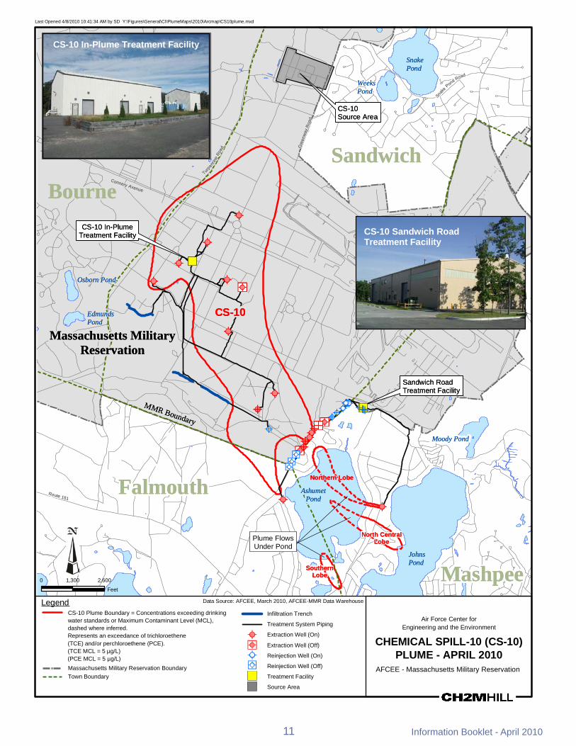
ETHETHETHETH
MMMMRR BBoouunnddaarryy
RRoouuttee 115511
SSnnaakkee
PPoonndd RRooaadd
CCoonnnneerryy AAvveennuuee
TTuurrppeenn
tt iinnee
RRooaadd GG
rreeeenn
wwaayy
RRooaa
dd
Last Opened 482010 104134 AM by SD YFiguresGeneralCIPlumeMaps2010ArcmapCS10plumemxd
CS-10 In-Plume Treatment Facility SSnnaakkee PPoonndd
WWeeeekkss PPoonndd
CCSS--1100 SSoouurrccee AArreeaa
SSaannddwwiicchh BBoouurrnnee
CCSS--1100 IInn--PPlluummee TTrreeaattmmeenntt FFaacciilliittyy
ETHETH
ETHETH
CS-10 Sandwich Road Treatment Facility
ETHETH )) OOssbboorrnn PPoonndd ETHETH ETHETH
ETHETH
MMaassssaacchhuusseettttss MMiilliittaarryy RReesseerrvvaattiioonn
EEddmmuunnddss PPoonndd
ETHETH
CCSS--1100
ETHETH
SSaannddwwiicchh RRooaadd TTrreeaattmmeenntt FFaacciilliittyy
ETHETHETHETHETHETHETHETHETHETHETHETHETHETH
ETHETH )ETH
)ETH
ETHETH ETHETHETH ETHETHETHETHETH
ETHETH ETHETH
ETH
ETHETHETHETHETH ETHETH
ETHETH MMooooddyy PPoonnddETHETH
ETHETHETHETH
ETHETH
ETHETH
ETHETH
NNoorrtthheerrnn LLoobbee
AAsshhuummeett ETHETH PPoonndd
ETHETH
Plume Flows Under Pond
NNoorrtthh CCeennttrraall LLoobbee
JJoohhnnss
FFaallmmoouutthh
SSoouutthheerrnn LLoobbee
PPoonndd
MMaasshhppeeee1300 2600
Feet
Data Source AFCEE March 2010 AFCEE-MMR Data WarehouseLegend CS-10 Plume Boundary = Concentrations exceeding drinking Infiltration Trench water standards or Maximum Contaminant Level (MCL) Air Force Center for
Treatment System Pipingdashed where inferred Engineering and the Environment Represents an exceedance of trichloroethene ETH Extraction Well (On) (TCE) andor perchloroethene (PCE) ETH Extraction Well (Off) CHEMICAL SPILL-10 (CS-10)(TCE MCL = 5 microgL) (PCE MCL = 5 microgL) ETH Reinjection Well (On) PLUME - APRIL 2010 Massachusetts Military Reservation Boundary ETH Reinjection Well (Off) AFCEE - Massachusetts Military Reservation Town Boundary U Treatment Facility
U Source Area
11 Information Booklet - April 2010
0
Air Force Center for Engineering and the EnvironmentAir Force Center for Engineering and the Environment
Ashumet Valley Groundwater Plume
The Ashumet Valley plume has two sources the former firefighter-training area 1 (FTA-1) and the former MMR Sewage Treatment Plant (CS-16 and CS-17) Firefighter-training exercises were held from 1958 to 1985 at FTA-1 during which time flammable waste liquids were burned and extinguished some of which entered the sandy soil and eventually reached the groundwater aquifer The former sewage treatment plant which operated from 1936 to 1995 released treated water to a series of sand infiltration beds Sludge materials were kept on site
Treatment of contaminated soils at FTA-1 was completed in September 1997 A total of 42531 tons of soil were treated at FTA-1 using a thermal treatment process In 2001 and 2002 contaminated soil was removed from the CS-16 and CS-17 sites and taken off base for proper disposal
The primary contaminants in the Ashumet Valley plume are the cleaning solvents PCE and TCE which have been detected above the state and federal MCLs of 5 microgL The Ashumet Valley plume is currently in long-term remediation Remediation is occurring with two treatment systems each comprised of a single extraction well treatment plant and infiltration galleries river discharge The treatment plants use granular activated carbon to remove the solvents from the groundwater and the treated water is returned to the aquifer through the infiltration galleries in the central portion of the plume and to a bog ditch along the Backus River in the southern area
The Ashumet Valley Plume final ROD which was signed in 2009 specified continued operation of the existing treatment system plus additional treatment for the southern portion of the plume The southern treatment system has been installed The ROD also required land use controls
AFCEE does not believe that any portion of the plume is currently discharging into Ashumet Pond Surface water sampling from Ashumet Pond in 2009 showed that no plume contaminants were detected
In 2001 AFCEE applied an alum treatment to Ashumet Pond water to reduce the amount of phosphorus in the pond much of which comes from the basersquos wastewater treatment plant phosphorus plume In 2004 a geochemical barrier (made up of zero-valent iron mixed with pond sediment) was installed along the shoreline of Ashumet Pond to reduce the amount of phosphorus in groundwater entering the pond A second alum treatment is being evaluated for 2010
A part of the southern portion of the Ashumet Valley plume discharges to the Backus River in Falmouth Surface water testing conducted in 2009 showed results below the MCL Please note that safe drinking water guidelines (MCLs) do not apply to surface water bodies AFCEE continues to monitor the entire plume area
Ashumet Valley Date of ROD
or DD in Place Cleanup
Start Projected
Finish Primary
Contaminants 2009 Highest Levels (microgL)
Highest Historic Levels (microgL)
March 2009 November 1999 2018 PCE 43 109 (October 1998) TCE 12 83 (August 1997)
Treatment Components in Operation1
Treatment Plants Treatment Rate (gpm) (originalcurrent)1
Volume Treated (MG)2
Extraction Wells 2 Infiltration Trenches 2
Bubbler 1
1 1200350 4768
1 Mobile Treatment Unit 175175 268
ROD = Record of Decision DD = Decision Document microgL = micrograms per liter MG = million gallons gpm = gallons per minute 1 Current treatment rate as of April 1 2010 2 Through December 2009
Information Booklet - April 2010 12
MMMMRR BBoouunnddaarryy
RRoouuttee 115511
OOlldd BBaarrnnssttaabbllee RR
ooaadd
SSaanndd
wwiicchh RR
ooaadd
SSaamm TTuurrnneerr RRooaadd
CCaarrrriiaaggee SShhoopp RRoo
aadd
BBaacckk
uuss RR
iivveerr
0
Last Opened 482010 104135 AM by SD YFiguresGeneralCIPlumeMaps2010Arcmapashumetvalleymxd
BBoouurrnneeAshumet Valley Treatment Facility MMaassssaacchhuusseettttss SSaannddwwiicchhMMiilliittaarryy
RReesseerrvvaattiioonn FFTTAA--11 SSoouurrccee AArreeaa
MMooooddyy PP
FFoorrmmeerr MMMMRR SSeewwaaggee
TTrreeaattmmeenntt PPllaanntt ((SSoouurrccee AArreeaa)) AAsshhuummeett
PPoonndd
JJoohhnnss PPoonndd
DDeeeepp PPoonndd
AAsshhuummeett VVaalllleeyy TTrreeaattmmeenntt FFaacciilliittyy
CCoooonnaammeesssseettttPPoonndd
ETHETH
))
ETHETH
ETHETH
CCrrooookkeeddPPoonndd MMaasshhppeeee
FFaallmmoouutthh AAsshhuummeett VVaalllleeyy
RRoouunndd PPlluummeePPoonndd PPlluummee PPaarrttiiaallllyy
DDiisscchhaarrggeess TToo TThhee RRiivveerr
JJeennkkiinnss PPoonndd
FFllaaxx AAsshhuummeett VVaalllleeyy LLeeaaddiinn Pgg Poonndd
EEddggee TTrreeaattmmeenntt FFaacciilliittyy
1500 3000 ETHETHAshumet Valley LeadingFeet Edge Treatment Facility
Note microgL = micrograms per liter and is a measure of concentration It is approximately equivalent to parts per billion (ppb)
Data Source AFCEE March 2010 AFCEE-MMR Data WarehouseLegend ETHETH
Extraction Well (On)Ashumet Valley Plume Boundary = Concentrations exceeding drinking water standards or Maximum Contaminant Level (MCL) dashed where inferred
Air Force Center for Engineering and the Environment
Extraction Well (Off)
TTreatment Facilityreatment FacilityRepresents an exceedance of trichloroethene (TCE) andor ASHUMET VALLEY PLUME perchloroethene (PCE) Outflow Bubbler (TCE MCL = 5 microgL) Massachusetts Military APRIL 2010(PCE MCL = 5 microgL) Reservation Boundary
AFCEE - Massachusetts Military ReservationTreatment System Piping Town Boundary ThalliumManganese Area
BogWetlandInfiltration Trench
13 Information Booklet - April 2010
Air Force Center for Engineering and the EnvironmentAir Force Center for Engineering and the Environment
CS-23 and LF-1 Groundwater Plumes
The source of the Landfill 1 (LF-1) groundwater plume was the main MMR landfill which operated from 1941 to 1990 The LF-1 plume contains many COCs The more typical COCs are the solvents PCE TCE and CCl4 The state and federal MCLs for PCE TCE and CCI4 is 5 microgL
Test data indicate that no significant contamination is being released to groundwater from the older landfill cells at LF-1 and decreasing chemical concentrations in groundwater downgradient of the more recently used landfill cells suggest that the landfill cap there has been effective in reducing groundwater contamination at the source The cap is inspected annually to monitor its integrity
The LF-1 ROD signed in 2007 consists of continued long-term remediation with a groundwater extraction-and-treatment system and the implementation of land use controls The contaminated groundwater is treated at the LF-1 Treatment Plant and the Hunter Avenue Treatment Facility Water is returned to the aquifer through a reinjection well and infiltration trenches
Because a portion of the LF-1 plume discharges to both Red Brook and Squeteague Harbors surface water and discharging groundwater at the harbors are tested annually and results show that there are no ecological or human health risks
The CS-23 plume is a detached plume that has not been linked to a specific source area All of the potential source areas for the CS-23 plume have been investigated andor remediated The COCs in the CS-23 plume are TCE and CCl4
The CS-23 ROD signed in 2007 consists of continued remediation and operation of the existing groundwater cleanup system and land use controls The contaminated water is treated at the Hunter Avenue Treatment Facility Water is returned to the aquifer through infiltration trenches
LF-1 Date of ROD
or DD in Place Cleanup
Start Projected
Finish Primary
Contaminants 2009 Highest Levels (microgL)
Highest Historic Levels (microgL)
October 2007 August 1999 2047 TCE PCE 37 (TCE) 150 (TCE Aug 1999)
Treatment Components in Operation1
Treatment Plants Treatment Rate (gpm) (originalcurrent)1
Volume Treated (MG)2
Extraction Wells 6 Reinjection Wells 1 Infiltration Trench 2
2 7001245 3713
CS-23 Date of ROD
or DD in Place Cleanup
Start Projected
Finish Primary
Contaminants 2009 Highest Levels (microgL)
Highest Historic Levels (microgL)
October 2007 December 2006 2018 TCE 177 572 (June 2002)
Treatment Components in Operation1
Treatment Plants Treatment Rate (gpm) (originalcurrent)1
Volume Treated (MG)2
Extraction Wells 2 Infiltration Trench 2 1 700700 991
ROD = Record of Decision DD = Decision Document microgL = micrograms per liter MG = million gallons gpm = gallons per minute 1 Current treatment rate as of April 1 2010 2 Through December 2009
Information Booklet - April 2010 14
CS-21
CS-10
CS-21
CS-10
CCoonnnneerryy AAvveennuuee
MMMMRR BBoouunnddaarryy
RRoouutt
ee 2288
AA
RRoo uu
ttee 22
88
RRoouu
ttee 22
88
RReedd
BBrroo
ookk HH
aarrbboo
rr RRooaa dd
DDeeppoo
tt RRooaa
dd
SSccrraaggggyy NNeecc
RReettee
nnttiioo
nnBBaa
ssiinn
CCoomm
mmoonn
BBoo
rrrrooww
PPiitt
BBMMXX
TTrraacc
kk GGrr
aavveell
PPiitt
Last Opened 3312010 93956 AM by SD YFiguresGeneralCIPlumeMaps2010ArcmapLF1_CS23plumemxd
RReedd BBrrooookk PPoonndd 11994477
LF-1 Source 11995577
11995511
PPoosstt--11997700AreaRReedd BBrrooookk KKeettttllee HHoolleeHHaarrbboorr
Plume Discharges to 11997700Red Brook Harbor
LLoonngg MMaassssaacchhuusseettttss MMiilliittaarryyPPoonndd RReesseerrvvaattiioonn
LLFF--11 BBoouurrnnee ETHETHLLFF--11 IInnffiillttrraattiioonn
GGaalllleerryy aanndd TTrreenncchheesskk RRooaadd ((nnoott iinn uussee))
BBoouurrnnee 22 LLFF--11
BBoouurrnnee ETH55 ETHSSqquueetteeaagguuee HHaarrbboorr
LLFF--11 TTrreeaattmmeenntt FFaacciilliittyy
ETHETH
ETHETH
ETHETH
LLFF--11 OOssbboorrnn PPoonndd
LF-1 Treatment Facility
ETHETH
15Inform
ation Booklet -A
pril 2010
Plume Discharges to EEddmmuunnddssSqueteague Harbor SSaannddwwiicchhETHETH PPoonndd
SSppeeccttaaccllee WWeettllaanndd
VVeerrnnaall PPooooll 6655 C11 CSS--2233ETHETH
HHuunntteerr AAvveennuuee
ETHETH TTrreeaattmmeenntt FFaacciilliittyy
AA
0 1000 2000
Feet FFaallmmoouutthh microgL = micrograms per liter and is a measureNote of concentration It is approximately equivalentto parts per billion (ppb)
Hunter Avenue Treatment Facility
Legend LF-1 and CS-23 Plume Boundary = Concentrations exceeding drinking water ETHstandards or Maximum Contaminant Level (MCL) (Dashed where inferred)
ETHRepresents an exceedance of Trichloroethene (TCE) MCL = 5 microgL Perchloroethene (PCE) MCL = 5 microgL Carbon Tetrachloride (CCl4) MCL = 5 microgL 14-Dichlorobenzene (14-DCB) MCL = 5 microgL 1122-Tetrachloroethane (1122-TeCA) GW-1 = 2 microgL Vinyl Chloride (VC) MCL = 2 microgL Ethylene Dibromide (EDB) MMCL = 002 microgL U
Data Source AFCEE March 2010 AFCEE-MMR Data Warehouse
Extraction Well Massachusetts Military Reservation BoundaryReinjection Well
Public Water Town Boundary Supply Well
Infiltration GalleryTrench Source Area
BogWetland BMXBorrow Pit
Treatment Facility
Air Force Center for Engineering and the Environment
LANDFILL-1 (LF-1) AND CHEMICAL SPILL-23 (CS-23) PLUMES
APRIL 2010 AFCEE - Massachusetts Military Reservation
Cape Cod Canal
Route
28
Route 151
Route 28
Route 13
0
Route 6
Route 130
Route
28
Quaker Meetinghouse
Rd
Gree
nway
Rd
Wood Rd
Jefferson Rd
Barlo
w Rd Gibbs Rd
Connery Rd
Turpe
ntine
Rd
Frank
Perki
ns R
d
Pew R
d Ca
nal V
iew Rd
Cape Cod Canal
Route
28
Route 151
Route 28
Route 13
0
Route 6
Route 130
Route
28
Quaker Meetinghouse
Rd
Gree
nway
Rd
Wood Rd
Jefferson Rd
Barlo
w Rd Gibbs Rd
Connery Rd
Turpe
ntine
Rd
Frank
Perki
ns R
d
Pew R
d Ca
nal V
iew Rd
Last Opened 5102010 14919 PM by SD YFiguresGeneralERC_PlumemapGIS20100420Arcmaperc_plumemap_20100420mxd
Legend Chlorinated Solvents Plume -Concentrations Exceed MCLs TCE = 50 microgL PCE = 50 microgL EDB PlConcen
ume -rat ons Exceed MMCL = 002 microgLt i
Perchlorate Plume - Concentrations ExceedMMCL = 20 microgL
RDX Plume - Concentrations exceed EPA 10-6 risk-basedlevel = 06 ppb
Plumes with Remedy in Place
Cape Cod BayCape Cod Bay
NorthwesCorner NorthwesCorner
Demolition Area 2Demolition Area 2 tt
Plumes with Interim Remedy in Place Extraction Well
D Extraction Well (Off) OReinjection Well D Reinjection Well (Off) Scale 1 inch = 1 mile
0 05 1Outflow Bubbler Miles
Treatment FacilityS
Municipal Water Supply Well Town Boundary
SandwichInfiltration TrenchGallery Treatment System Pipeline
Influent Effluent
The areas of contamination show the combined contaminants of concern within each plume
Bourne
Massachusetts Military Reservation
Mashpee Falmouth
Surface water from Long Pond is also used as a drinking water source forthe town of Falmouth
Contaminant of Concern (COC) Type of Contaminant Risk-Based LevelTCE ndash trichloroethene solvent MCL = 5 microgPCE ndash perchloroethene solvent MCL = 5 microg
L
CCI4 ndash carbon tetrachloride solvent MCL = 5 microgLL
EDB ndash ethylene dibromide fuel-related compound MMCL = 002 microgLbenzene fuel-related compound MCL = 5 microgvinyl chloride solvent MCL = 2 microg
L
1122-tetrachloroethane solvent GW-1 = 2 microgL
14-dichlorobenzene solvent MCL = 5 microgLL
manganese metal EPA Health Advisory = 300 microgL Massachusetts Military Reservationthallium metal MCL = 2 microgLlead metal 15 microgL (treatment technique action level Groundwater Findings
for water distribution systems)toluene fuel MCL = 1000 microgL Issued April 2010RDX - hexahydro-135-trinitro-135- explosive HA = 2 microgLtriazine GW-1 = 1 microgL
10-6 = 06 microgperchlorate oxidizer HA = 15 microg
L MMCL = 2 microg
LL
MCL ndash Maximum Contaminant LevelMMCL ndash Massachusetts Maximum Contaminant LevelHA ndash Federal Lifetime Health Advisory Note ppb = parts per billion and is a measure of concentrationGW-1 ndash State default cleanup value to be used in lieu of site-specific risk-based level It is approximately equivalent to micrograms per liter (microgL)10-6 ndash EPA level resulting in an excess cancer risk of one in a million
Central Impact Area
Central Impact Area
S Phinneys Harbor
CS-19
S Phinneys Harbor
CS-19
WestBoundary
S J-2ern
S
S
S
J-1
J-3Demolition Area 1
WestBoundary
S J-2ern S
S
S
J-1
J-3Demolition Area 1
S S
Pocasset SS
Harbor
Hen
S L Range
S S
Peters Pond
Pocasset SS
Harbor DD FS-12 tSeveral FS-12 extraction wellurned off (not shown at this scale
s are)
Hen
S L Range
Peters Pond
DD FS-12 tSeveral FS-12 extraction wellurned off (not shown at this scale
s are)
CoveCove Snake
Weeks Pond
Pond Wakeby Pond
Snake
Weeks Pond
Pond Wakeby Pond
Red BrookRed Brook HarborHarbor
LF-1LF-1
Squeteague LF-1 MashpeeHarbor Pond
CS-10SMegansett
LF-1 Harbor DS
CS-23
S
FS-1 S Moody
DD PondCS-21 DSCS-20 D
DDCS-21 CS-4Wild Harbor
Ashumet FS-29
Squeteague LF-1 MashpeeHarbor Pond
CS-10SMegansett
LF-1 Harbor DS
CS-23
S
FS-1 S Moody
DD PondCS-21 DSCS-20 D
DDCS-21 CS-4Wild Harbor
Ashumet FS-29 D D
Pond D Johns
D
Pond Johns
Pond
Pond
CS-10 CS-10
Deep Pond
Deep Pond
Crooked Pond Crooked Pond
Coonamessett D
Pond S
DFS-28
S
Shallow Well Point system is off
FS-28 AshumetValley
Jenkins
Pond
S
Coonamessett D
Pond S
DFS-28
S
Shallow Well Point system is off
FS-28 AshumetValley
Jenkins
Pond
S
Long Pond
Long Pond
Air Force Center for Engineering and the EnvironmentAir Force Center for Engineering and the Environment
FS-1 and FS-12 Groundwater Plumes The source of the Fuel Spill 1 (FS-1) groundwater plume is the Aviation Gas Fuel Valve Test Dump Site in the eastern part of the base The site was used from 1955 to 1970 to test fuel dump valves on EC-121 Super Constellation aircraft which involved the release of fuel directly onto the ground Currently no significant levels of COCs are present in the surface or subsurface soils at the FS-1 source area and the source area groundwater is sampled for lead only
The FS-1 groundwater plume contains the fuel additive ethylene dibromide (EDB) at levels above the MMCL which is 002 microgL The FS-1 plume is currently in long-term remediation with a groundwater extraction-and-treatment system in the Quashnet River cranberry bog area just northeast of Johns Pond The system was designed to prevent upwelling of EDB contamination into the Quashnet River and associated cranberry bogs The treatment plant uses granular activated carbon to remove EDB from the groundwater which is then discharged to the Quashnet River through a series of oxygenating bubblers The latest test results showed that the FS-1 treatment system has been successful in reducing both the amount of EDB in the FS-1 plume and the EDB concentrations in the surface water of the Quashnet River and associated bogs A 2000 ROD specifies active treatment of the plume along with monitoring
The source of the FS-12 groundwater plume was an estimated 70000-gallon release from a section of a now-abandoned fuel pipeline that ran from the Cape Cod Canal to MMR EDB is the only remaining contaminant above cleanup standards in the FS-12 groundwater plume The source area groundwater is currently being monitored after having undergone subsurface remediation in the 1990s Groundwater sampling indicates that the source area has been successfully remediated The pipeline has been cleaned and closed with state and federal regulatory approval
The FS-12 plume is currently in long-term remediation with a groundwater extraction-and-treatment system The treatment system consists of extraction wells a treatment plant and reinjection wells The 2006 ROD called for the status quo of operating and monitoring the existing system The latest test results indicate that the extraction wells continue to successfully contain the FS-12 groundwater plume and the size of the plume has been reduced significantly Land use controls are in place for the FS-1 and FS-12 plumes
FS-1 Date of ROD
or DD in Place Cleanup
Start Projected
Finish Primary
Contaminants 2009 Highest Levels (microgL)
Highest Historic Levels (microgL)
April 2000 April 1999 2020 EDB 0857 445 (October 2000)
Treatment Components in Operation1
Treatment Plants Treatment Rate (gpm) (originalcurrent)1
Volume Treated (MG)2
Extraction Wells 3 Bubblers 3 1 750515 33053
FS-12 Date of ROD
or DD in Place Cleanup
Start Projected
Finish Primary
Contaminants 2009 Highest Levels (microgL)
Highest Historic Levels (microgL)
September 2006 September 1997 2048 EDB 231 890 (November 1996)
Treatment Components in Operation1
Treatment Plants Treatment Rate (gpm) (originalcurrent)1
Volume Treated (MG)2
Extraction Wells 4 Reinjection Wells 20 1 772360 4082
ROD = Record of Decision DD = Decision Document microgL = micrograms per liter MG = million gallons gpm = gallons per minute 1 Current treatment rate as of April 1 2010 2 Through December 2009
Information Booklet - April 2010 18
Co
FP
erki
nsR
d
Co
FP
erki
nsR
d
-
-
QQuuaasshhnneett RRiivveerr GG
rreeaatt HHaayy
RRooaa dd
hhiinnnn
ee yyss
RRooaadd
BBeeaarr
sseess
RRooaa
dd SSaa
ddddlleebb
aacckk RRooaadd
GGrraaffttoonn PPoocckknnee
tt RRooaadd
PPiimmlliiccoo PP nndd RRdd
JJBB TThhoommppssoonn RRdd
SSnn aakkeePPoonndd RRdd
RRtt 113300
nnnneerryy AAvv CCoonnnneerryy AAvv
Last Opened 482010 105423 AM by SD YFiguresGeneralCIPlumeMaps2010ArcmapFS1_FS12plumemxd
FFSS--1122 SSoouurrccee AArreeaa
NNoottee PPlluummeess ddeeppiicctteedd iinn tthhiiss mmaapp ootthheerr tthhaann FFSS--11 aanndd FFSS--1122
aarree nnoott ppaarrtt ooff tthhee IIRRPP FFoorr ffuurrtthheerr iinnffoorrmmaattiioonn sseeee
hhttttppggrroouunnddwwaatteerrpprrooggrraammaarrmmyymmiill oorr ccaallll PPaammeellaa RRiicchhaarrddssoonn aatt ((550088)) 996688--55663300 FFSS--1122 TTrreeaattmmeenntt FFaacciilliittyy
FS 12 Treatment Facility
PP
SSaannddwwiicchheemmaaiill ppaammeellaajjrriicchhaarrddssoonnuussaarrmmyymmiill DD DD
DDDD DDDD
DDDDDD DDDD DD DD DD
DD Ntilde D DNtilde DD FFSS--1122
Ntilde Ntilde
ETHETHD
DDDDDDDNtildeNtildeNtildeNtilde
ETH
NtildeNtilde ETH
DDDDETHETHETHETHNtildeNtildeNtildeNtildeNtildeNtildeNtildeNtildeNtildeNtildeNtildeNtildeNtilde
D DDD NtildeNtildeNtildeNtildeDD NtildeNtildeNtildeSSnnaakk Ntildeee NtildeNtildeNtildeNtildeNtilde NtildeNtildeNtildeNtildePPoonnddBBoouurrnnee oo
WWaakkeebbyy PPoonndd
MMaasshhppeeee
MMaassssaacchhuusseettttss MMiilliittaarryy
RReesseerrvvaattiioonn
PPoonndd
FFSS--11 SSoouurrccee AArreeaa
MMaasshhppeeee
FFSS--11
MMooooddyy PPoonndd
FFSS--11 TTrreeaattmmeenntt FFaacciilliittyy
FS 1 Treatment Facility JJoohhnnss
with bubbler in foreground PPoonndd 0 1500 3000
Feet
Legend Data Source AFCEE March 2010 AFCEE-MMR Data Warehouse
ETH
FS-1 and FS-12 Plume Boundary = Concentrations Outflow Bubbler Army Program Plumes exceeding drinking water standards or Massachusetts Extraction Well (On) Perchlorate Plume shyMaximum Contaminant Level (MMCL) Represents an Concentrations exceedance of ethylene dibromide (EDB) Exceed
ETH Reinjection Well (On) D Extraction Well (Off)
(EDB MMCL = 002 microgL) (Dashed Where Inferred) MMCL = 20 microgL D Reinjection Well (Off)Treatment System Piping RDX Plume shy
Massachusetts Military Reservation Boundary U Treatment Facility Concentrations exceed EPA 10-6
Town Boundary Source Area Note microgL = micrograms per liter and is a measure of U risk-based
level = 06 ppb concentrationIt is approximately equivalent to parts BogWetland per billion (ppb)
19
Air Force Center for Engineering and the Environment
FUEL SPILL-1 (FS-1) AND FUEL SPILL-12 (FS-12)
APRIL 2010 AFCEE - Massachusetts Military Reservation
Information Booklet - April 2010
Air Force Center for Engineering and the EnvironmentAir Force Center for Engineering and the Environment
CS-4 CS-20 CS-21 FS-28 and FS-29 Groundwater Plumes
Five groundwater plumes can be found in the area north and south of Route 151 in the town of Falmouth They are FS-28 FS-29 CS-4 CS-20 and CS-21 Only CS-4 has a known source area a former vehicle maintenance area and storage yard on the MMR The other plumes were found to be disconnected from distinct source areas They most likely originated somewhere in the southern portion of MMR which contained various aircraft and vehicle maintenance shops runways and housingpersonnel support facilities Records indicate that spills andor releases occurred in these areas in the past COCs in the plumes are fuel and solvent-related contaminants They include EDB PCE TCE and CCl4 The MMCL for EDB is 002 microgL while the MCL for the rest of the contaminants is 5 microgL
More than 18000 tons of contaminated soil were treated on site at the CS-4 source area and additional soil was transported off site for proper disposal A groundwater extraction-and-treatment system began operating in 1993 but was later replaced by a more efficient system in 2006 to better capture the plume
Portions of the FS-28 plume were first discovered in 1993 beneath the leading edge of the CS-4 plume In 1996 groundwater investigations found EDB upwelling into the Coonamessett River in Falmouth No EDB is presently detected in the Coonamessett River The FS-28 plume is currently in long-term remediation with a groundwater extraction-and-treatment system A treatment plant is located in a bog area just south of Hatchville Road and treated water is discharged to the Coonamessett River through two oxygenating bubblers Shallow wellpoint extraction wells operated for several years but are no longer being used In 2007 a new extraction well was installed to the south to address a deep lobe of EDB
The FS-28 plume underflows Coonamessett Pond and has not affected the pond or a nearby Town of Falmouth municipal well In 2002 AFCEE funded a $52 million wellhead treatment system to ensure a safe water supply for the Falmouth well A ROD was issued in October 2000
The FS-29 CS-20 and CS-21 groundwater plumes were discovered in the late 1990s A ROD for FS-29 was issued in October 2000 and a ROD for CS-4 CS-20 and CS-21 was issued in February 2000 Since 2006 the FS-29 CS-4 CS-20 and CS-21 groundwater plumes have been undergoing active treatment through a series of extraction wells reinjection wells and infiltration trenches Extracted plume water is treated with granular activated carbon at the Hunter Avenue Treatment Facility on base Land use controls are in place for all these plumes
Plume Date of ROD
or DD in Place Cleanup
Start Projected
Finish Primary
Contaminants 2009 Highest Levels (microgL)
Highest Historic Levels (microgL)
CS-4 February 2000 (ESD 92008) November 2005 2014
TCE 55 19 (February 1997) PCE 232 61 (February 1997)
CS-20 February 2000 (ESD 92008) January 2006 2017 PCE 205 981 (September 2005)
CS-21 February 2000 (ESD 92008) September 2006 2027 TCE 98 988 (June 2001)
FS-28 October 2000 (ESD 92008) October 1997 2047 EDB 138 18 (January 1997)
FS-29 October 2000 (ESD 92008) September 2006 2018 EDB 0084 0318 (May 2001)
ROD = Record of Decision DD = Decision Document microgL = micrograms per liter MG = million gallons gpm = gallons per minute
Information Booklet - April 2010 20
Massachusetts Military ReservationMassachusetts Military Reservation
Plume Explanation Contaminants of concern exceed drinking water standards or Maximum Contaminant Level (MCL) CS-20 Perchloroethene (PCE) (PCE MCL = 5 microgL) FS-29 Ethylene dibromide (EDB) and carbon tetrachloride (CCl4)
(EDB MMCL = 002 microgL) (CCl4 MCL = 5 microgL) CS-4 Trichloroethene (TCE) perchloroethene (PCE)
1122- tetrachlorethane (1122- TeCA) andor ethylene dibromide (EDB) (TCE MCL = 5 microgL) (PCE MCL = 5 microgL) (1122-TeCA GW-1 = 2 microgL) (EDB MMCL = 002 microgL)
CS-21 Trichloroethene (TCE) (TCE MCL = 5 microgL)
Note microgL = micrograms per liter and is a measure of concentration It is approximately equivalent to parts per billion (ppb)
Treatment Components in Operation1
Treatment Plants
Treatment Rate (gpm)1
(originalcurrent)
Volume Treated (MG)2
Extraction Wells 2 Infiltration Trenches 2 1 620199 1027
Extraction Wells 2 Reinjection Wells 4 1 775773 1460
Extraction Wells 4 Reinjection Wells 3 1 14001395 2213
Extraction Wells 2 Bubblers 2 1 750600 43045
Extraction Wells 1 Reinjection Wells 2 1 525224 642
ESD = Explanation of Significant Differences 1 Current treatment rate as of April 1 2010 2 Through December 2009
21 Information Booklet - April 2010
-
SamTurner R
d
Hay
way
Rd
Hatchv
illeRd
Thomas B Landers Rd Sa
ndw
ich
Rd
Boxb
erry
Hill
Rd
Hill and Plain Rd
Route 151
Hatchville Rd
Sand
wichRd
Sam
Tur
ner R
d
Last Opened 412010 82704 AM by SD YFiguresGeneralCIPlumeMaps2010ArcmapFS28plumemxd
Falmouth
FS 28 Treatment Facility
Deep Pond
Plume Flows Under Pond
Round Pond
Coonamessett Pond Coonamessett
Water Supply Well FS-28
Crooked Pond
Outflow Bubbler
ETH
FS-28 Treatment Facility Broad River
FS-28 Shallow Outflow Bubbler
Pond Decommissioned Shallow
Wellpoint Extraction System
DR
AF
T
FS-28
Round Pond
ETHETH
Jenkins Pond
Pond 14
0 770 1540
Feet
Data Source AFCEE March 2010 MMR-AFCEE Data WarehouseLegend FS-28 Plume Boundary = Concentrations exceeding drinking ETH Extraction Well
Air Force Center for water standards or Massachusetts Maximum Contaminant Outflow Bubbler Engineering and the EnvironmentLevel (MMCL) dashed where inferred Represents an exceedance of ethylene dibromide (EDB) Public Drinking FUEL SPILL 28 (FS-28)(EDB MMCL = 002 microgL) Water Supply Well
PLUME - APRIL 2010BogWetland Treatment Facility AFCEE - Massachusetts Military Reservation
Treatment System Piping Note microgL = micrograms per liter and is a measure of concentration
It is approximately equivalent to parts per billion (ppb)
Information Booklet - April 2010 22
MMR Boundary Falmouth
Sandw
ich
Mashpe
e
Whe
eler
Rd
Reilly
Redlands
Rd
Br a
nsha
w S
t
Curr ier R
d
Sim
p kinsR
d
Hoo
ppol
eR
d
Club
Valley
Dr
Gen
eral
sBl
vd
MMR Boundary Falmouth
Sandw
ich
Mashpe
e
Whe
eler
Rd
Reilly
Redlands
Rd
Bra
nsha
w S
t
Currier R
d
Sim
p kinsR
d
Hoo
ppol
eR
d
Club
Val leyD
r
Gen
eral
sBl
vd
Massachusetts Military ReservationMassachusetts Military Reservation
Progress Over The Years
Much progress has been made over the last 15 years Program-wide the source areas have been cleaned up and 11 groundwater plumes are undergoing pump-and-treat cleanup action both on and off base All environmental cleanup decisions and remedies are in place In the future the program will continue to monitor adjust and shut down treatment systems as cleanup progress is made The Air Force will continue to conduct the most efficient cleanup operations while ensuring the protection of public health and the environment
The SD-5 plume depiction illustrates the transformation of the plume over time due to the effect of cleanup systems used by the Air Force for several years Contaminated water was cleaned by using two technologies The first involved extracting the plume water pumping it to a treatment building where large vessels of granular activated carbon removed the solvent contamination and then the clean water was returned to the ground through reinjection wells Two recirculation wells were also used Those involved two underground standalone treatment systems within the neighboring community That technology used air and pumps to remove the solvents from the plume and capture them in carbon tanks The plume has now been cleaned up to the point where only residual traces of solvent contamination are found in monitoring wells which are periodically tested
The following pages depict the cleanup progress of several IRP groundwater plumes over time Most plumes show a significant reduction in size and contaminant mass A few show a larger area which is related to plume information uncertainties in the early part of the cleanup program and changing conditions over time a significant reason why diligent monitoring is required For more information and depictions of all AFCEE groundwater plumes progress over time go to httpwwwmmrorgCleanupplumes_fshtm
Last Opened 3292010 115403 AM by SD YFiguresGeneralPlumeMapsComparison2010ArcMapSD5comp_97_10mxd
SandwichSandwich
Mashpee Mashpee
Ashumet PondAshumet PondFalmouth FalmouthJohns PondJohns Pond
1997 2010
Legend Data Source AFCEE MMR-AFCEE Data Warehouse
Town Boundary
Massachusetts Military Reservation Boundary SD-5 PLUME 1997 AND 2010 COMPARISON
Plume Boundary AFCEE - Massachusetts Military Reservation 0 1100 2200
BogWetland Feet
23 Information Booklet - April 2010
Plum
e Com
parison Over Tim
e
MMR Boundary Falmouth
Sandw
ich
Mashpe
e
Route 151
Kit tredge Rd
Connery Av
Whe
eler
Rd
Cole Rd
Le e Rd Hatc
hville
Rd
Herbert Rd
Reilly
Sam Turner R
d
Sandw
ich R
d
Herbert Rd
Connery Av
Route 151
MMR Boundary Falmouth
Sandw
ich
Mashpe
e
Route 151
Kittredge Rd
Connery Av
Whe
eler
Rd
Cole Rd
Le e Rd
Hatchv
ille R
d
Herbert Rd
Reilly
Sam Turner R
d
Sandw
ich R
d
Herber t Rd
Connery Av
Route 151
MMR Boundary
Falmouth
Sandw
ich
ashpe
e
Route 151
Cur
rier R
d
Whe
eler
Rd
Hayway Rd
Sam Turner R
d
Thomas B Landers Rd
Hatch
ville
Rd
Mi lf
or d
Rd Elai n Av
Sandw
ich
Rd
Meredith Dr
Redlands Rd
R eg is R
d
Jam
ie Ln
Hill a
nd Plain Rd
Old Barnstable R
d
Cloverfield Way Route 151
Sand
wich R
d
Route 151
MMR Boundary
Falmouth
Sandw
ich
ashpe
e
Route 151
Cur
rier R
d
Whe
eler
Rd
Sam Turner R
d
Thomas B Landers Rd
Hatchv
ille R
d
Mil f
ord
Rd Elain Av
Sandw
i ch
Rd
Meredith Dr
Redlands Rd
R eg is R
d
Jam
ie Ln
Hill a
nd Plain Rd
Old Barnsta
ble Rd
Cloverfield Way Route 151
Sand
wich R
d
Plu
me
Com
paris
on O
ver T
ime
Last Opened 3292010 110332 AM by SD YFiguresGeneralPlumeMapsComparison2010ArcMapCS10comp_97_10mxd
Snake Pond Snake Pond
BourneBourne
Sandwich Sandwich
MashpeeMashpee Falmouth Ashumet PondAshumet PondFalmouth Johns PondJohns Pond
Coonamessett Pond 2010Coonamessett Pond 1997 Legend
Massachusetts Military Reservation Boundary
BogWetland
Town Boundary
Plume Boundary (Dashed Where Inferred) Primary Contaminants Trichloroethene (TCE) Perchloroethene (PCE)
0 2300 4600
Feet
Data Source AFCEE MMR-AFCEE Data Warehouse
CS-10 PLUME 1997 AND 2010 COMPARISON AFCEE - Massachusetts Military Reservation
Last Opened 3292010 101508 AM by SD YFiguresGeneralPlumeMapsComparison2010ArcMapAVcomp_96_10mxd
Sandwich Sandwich MMashpee MMashpee
FalmouthFalmouth Ashumet Pond Ashumet Pond
Johns Pond Johns Pond
Coonamessett Pond Coonamessett Pond
Broad RiverBroad River
Jenkins Pond Jenkins Pond Pond 14 Pond 14 Fresh PondFresh Pond
20101996
Legend
Plume Boundary Primary Contaminants Trichloroethene (TCE) Perchloroethene (PCE)
Massachusetts Military Reservation Boundary
BogWetland
Town Boundary
0 2250 4500
Feet
Data Source AFCEE MMR-AFCEE Data Warehouse
ASHUMET VALLEY PLUME 1996 AND 2010 COMPARISON AFCEE - Massachusetts Military Reservation
Information Booklet - April 2010 24
Sandwich
MM
R Bo
unda
ry
MM
R
Sandwich Mashpee
Snake Pond Rd
Boun
dary
Dana
Rd
Arnol
d Rd
Pinecrest Dr
Artisan Way
Cha
dwic
k R
d
Jeannes Way
Gre
enw
ay R
d
Rout
e 13
0
Emerald Way
Week
s Po
nd D
r
Blac
kth rn Path
Green
way R
d
Greenway Rd
MM
R Bo
unda
ry
MM
R Bo
unda
ry Sandwich Mashpee
Greenway Rd
Dana
Rd
Arnol
d Rd
Pinecrest Dr
Artisan Way
Cha
dwic
k R
d
Jeannes Way
Emerald Way
Rout
e 13
0
Snake Pond Rd
Wee
ks P
ond
Dr
Blac
kth rn Path
Gre
enw
ay R
d
Greenw
ay R
d
MMR Boundary
Mas
hpee
Sand
wic
h
Route 130
Reilly
Great H
ay Rd
Love
lls L
n
Bear
ses
Rd
Sadd
leback Rd
Graf ton Pocknet Rd
Great Hay Rd
Mas
hpee
Sand
wic
h
MMR Boundary
Route 130
Love
ll s L
n
Rei
lly
Great H
ay Rd
Bear
ses
Rd
Lowell
Rd
Grafton P
ockne
t Rd
Echo Rd
Bookers Rd
Sadd
leback Rd
Quashnet Rd
Back Rd
Ashumet Rd
Bakers Rd
Easton S
t
Phi
nney
s Rd
Asher s P at h
Shorewood Dr
Great Hay Rd
Bear
ses
Rd
Rei
lly
Grea t H
ay Rd
Love
lls L
n
Grafton Pocknet Rd
Gre at H
ay Rd
Last Opened 3292010 113034 AM by SD YFiguresGeneralPlumeMapsComparison2010ArcMapFS12comp_97_10mxd
Snake Pond Snake Pondoo
Sandwich SandwichWeeks Pond Weeks Pond
1997 2010 Data Source AFCEE MMR-AFCEE Data WarehouseLegend
Town Boundary
FS-12 PLUMEMassachusetts Military Reservation Boundary 1997 AND 2010 COMPARISON AFCEE - Massachusetts Military ReservationPlume Boundary Primary Contaminants Benzene Ethylene Dibromide (EDB)
0 960 1920 BogWetland Feet
Last Opened 3292010 112823 AM by SD YFiguresGeneralPlumeMapsComparison2010ArcMapFS1comp_98_10mxd
aay
Rd
Gre
tH
Mashpee
Mashpee Pond Mashpee Pond
Mashpee
Johns PondJohns Pond
20101998
Legend Data Source AFCEE MMR-AFCEE Data Warehouse
Town Boundary
Massachusetts Military Reservation Boundary FS-1 PLUME 1998 AND 2010 COMPARISON
Plume Boundary (Dashed Where Inferred) Primary Contaminant Ethylene Dibromide (EDB)
0 1000 2000
AFCEE - Massachusetts Military Reservation
BogWetland Feet
25 Information Booklet - April 2010
Plum
e Com
parison Over Tim
e
MMR Bo
Sandw
ich
Mas
hpee San
dwich
Sandw
ich
Mashpe
e
Deep PondLittle Jenkins Pond
Sandw
ich
Coonamessett PondDeep PondLittle Jenkins Pond
undary
Falmouth
Sandwich
MMR Boundary
Route 151
mas B Landers Rd
Sam Turner R
d
Hatchv
il le R
d
Deer Pond Rd
Sandw
ich
Rd
Boxberry Hill Rd
Hill and Plain Rd
Old Barnstable R
d
Cloverfield Way
Blac
ksmith Shop Rd
Regis Rd
Route 151
Route 151
Sam Tu rner R
d
Route 151
Route 151
Sandw
ich R
d
MMR Boundary Falmouth
Sandwich
Route 151
mas B Landers Rd
Sam Tu rner R
d
Deer Pond Rd
Hatch
ville
Rd
Sandw
ich
Rd
Box
ber r
y H
il l R
d
Hill and Plain Rd
Old Barnstable R
d
Cloverfield Way
Blac
ksmith Shop Rd
Route 151
Route 151
Route 151
Sandw
ich R
d
Route 151
Sand
wich R
d
Boxberry Hill Rd
MMR Boundary
Falmouth
Bourne
Sand
wic
h
Route 151
Kittredge Rd
Cole Rd
Lee Rd
Sandwich R
d
Boxberry Hill Rd
Route 151
Route 151
MMR Boundary
Falmouth
Bourne
Sand
wic
h
Route 151
Kittredge Rd
Cole Rd
Lee Rd
Sa
ndwich
Rd
Boxberry Hill Rd
Route 151
Route 151
Last Opened 3292010 113441 AM by SD YFiguresGeneralPlumeMapsComparison2010ArcMapFS28comp_98_10mxdP
lum
e C
ompa
rison
Ove
r Tim
e
Coonamessett PondCoonamessett Pond
Falmouth FalmouthThoTho Broad River
Broad River
Jenkins PondJenkins Pond Pond 14Pond 14 20101998
Data Source AFCEE MMR-AFCEE Data WarehouseLegend
Town Boundary
FS-28 PLUME Massachusetts Military Reservation Boundary 1998 AND 2010 COMPARISON Plume Boundary (Dashed Where Inferred) AFCEE - Massachusetts Military Reservation Primary Contaminant Ethylene Dibromide (EDB)
0 1700 3400
BogWetland Feet
Last Opened 3292010 101742 AM by SD YFiguresGeneralPlumeMapsComparison2010ArcMapCS4comp_96_10mxd
Bourne Bourne Osborn Pond Osborn Pond
Edmunds Pond Edmunds Pond
Spit Pond Spit Pond
SandwichSandwich
FalmouthFalmouth
1996 2010 Data Source AFCEE MMR-AFCEE Data WarehouseLegend
Town Boundary
CS-4 PLUME 1996 AND 2010 COMPARISON
Massachusetts Military Reservation Boundary
Plume Boundary Primary Contaminants Trichloroethene (TCE) Perchloroethene (PCE) AFCEE - Massachusetts Military Reservation
0 1400 2800BogWetland Feet
Information Booklet - April 2010 26
Little Jenkins Pond Little Jenkins Pond
MMR Boundary
Falmouth
Bourne
Sand
wic
h
Route 151
Rou
te 2
8
Sam Turner Rd
Rou
te 2
8
MMR Boundary
Falmouth
Bourne
Sand
wic
h
Route 151
Rou
te 2
8
Sam Turner Rd
Rou
te 2
8
Falmouth
Bourne
Sand
wic
h
MMR Boundary
Rou
te 2
8
Route 151
Rou
te 2
8
Sand
wic
h
Falmouth
Bourne
MMR Boundary
Rou
te 2
8
Route 151
Rou
te 2
8
Last Opened 3292010 111229 AM by SD YFiguresGeneralPlumeMapsComparison2010ArcMapCS21comp_99_10mxd
Osborn Pond Osborn Pond
Bourne Bourne Edmunds Pond Edmunds Pond
Spit Pond Spit Pond
Sandwich Sandwich
Falmouth Falmouth
Deep Pond Deep Pond Coonamessett Pond Coonamessett Pond
1999 2010 Round Pond Round Pond Crooked Pond Crooked Pond
Legend Data Source AFCEE MMR-AFCEE Data Warehouse
Town Boundary
Massachusetts Military Reservation Boundary CS-21 PLUME 1999 AND 2010 COMPARISON
Plume Boundary Primary Contaminant Trichloroethene (TCE) AFCEE - Massachusetts Military Reservation
BogWetland 0 1400 2800
Feet
Last Opened 3292010 112004 AM by SD YFiguresGeneralPlumeMapsComparison2010ArcMapCS23comp_02_10mxd
Osborn Pond Osborn Pond
Bourne Bourne Edmunds Pond Edmunds Pond
Spit Pond Spit Pond
Falmouth Falmouth
2010 2002 Data Source AFCEE MMR-AFCEE Data Warehouse Legend
Town Boundary
CS-23 PLUME 2002 AND 2010 COMPARISON
Massachusetts Military Reservation Boundary
Plume Boundary (Dashed Where Inferred) Primary Contaminants AFCEE - Massachusetts Military Reservation Trichloroethene (TCE) Carbon Tetrachloride (CCl4)
0 1000 2000 BogWetland Feet
27 Information Booklet - April 2010
Plum
e Com
parison Over Tim
e
Deep Pond Little Jenkins PondLittle Jenkins Pond
Sandw
ich
Bourne Osborn PondBourne
Osborn Pond
MMR Boundary
Falmouth
Bourne
Sand
wic
h
Rou
te 2
8
Co le R
d
Route 151
Kittredge Rd
Conne ry Av
Le e Rd
Herbert Rd
Shor
e R
oute
Boxberry Hill Rd
Rou
te 2
8
Cole Rd Rou
te 2
8
Rout
e 28
Route 151
Rou
te 2
8
Rout
e 28
Route 151
Connery Av
MMR Boundary
Falmouth
Bourne
Sand
wic
h
Rou
te 2
8
Cole R
d
Route 151
Kittredge Rd
Connery Av
Le e Rd
Herbert Rd
Shor
e Ro
ute
Boxberry Hill Rd
Rou
te 2
8
Rou
te 2
8
Rout
e 28
Route 151
Rou
te 2
8
Rout
e 28
Connery Av
MMR Boundary
Falmouth
Bourne
Sand
wic
h
Route 151
Kittredge Rd
Cole Rd
Sam
Turner Rd
Hatchv
ille R
d
Boxberry Hill Rd
Sand
wich R
d
Hill
and Plain Rd
Hay
way
Rd
Route 151
Route 151
MMR Boundary
Falmouth
Bourne
Sand
wic
h
Route 151
Kittredge Rd
Cole Rd
Sam
Turner Rd
Hatch
ville
Rd
Hill
and Plain Rd
Sandw
ich R
d
Hay
way
Rd
Route 151
Route 151
Plu
me
Com
paris
on O
ver T
ime
Last Opened 3292010 115107 AM by SD YFiguresGeneralPlumeMapsComparison2010ArcMapLF1comp_97_10mxd
BourneBourne
Osborn Pond Osborn Pond
Edmunds Pond Edmunds Pond Spit Pond Spit Pond
Sandwich Sandwich
Falmouth Falmouth
20101997
Data Source AFCEE MMR-AFCEE Data WarehouseLegend
Town Boundary
LF-1 PLUME 1997 AND 2010 COMPARISON
Massachusetts Military Reservation Boundary
Plume Boundary (Dashed Where Inferred) Primary Contaminants Carbon Tetrachloride (CCl4) Perchloroethene (PCE) Tetrachloroethene (TCE) AFCEE - Massachusetts Military Reservation
BogWetland 0 2000 4000
Feet
Last Opened 3292010 110911 AM by SD YFiguresGeneralPlumeMapsComparison2010ArcMapCS20comp_99_10mxd
Bourne BourneEdmunds Pond Edmunds Pond
Spit Pond Spit Pond
SandwichSandwich
FalmouthFalmouth
Little Jenkins Pond Little Jenkins Pond Deep Pond Deep Pond Coonamessett PondCoonamessett Pond
Round Pond Round PondCrooked Pond Crooked Pond
1999 2010
Legend
Plume Boundary Primary Contaminant Perchloroethene (PCE)
Massachusetts Military Reservation Boundary
BogWetland
Town Boundary
0 1400 2800
Feet
Data Source AFCEE MMR-AFCEE Data Warehouse
CS-20 PLUME 1999 AND 2010 COMPARISON AFCEE - Massachusetts Military Reservation
Information Booklet - April 2010 28
Massachusetts Military ReservationMassachusetts Military Reservation
Information Booklet - April 2010
AFCEErsquos aggressive optimization activities have resulted in a more sustainable remediation program at MMR Our ldquobetter cheaper fasterrdquo approach is intended to expedite aquifer restoration and cleanup timeframes while reducing costs to the taxpayers and minimizing our carbon footprint Optimization activities conducted by AFCEE at MMR include
Demonstrating alternative in situ technologies such as a passive zero-valent iron barrier This barrier requiresbullno OampM and was installed along the Ashumet Pond shoreline to help reduce phosphorus discharging into the surface water
Continuously adjusting groundwater remediation systems as the groundwater plumes change over time Forbullexample extraction wells are taken out of operation once the portion of the aquifer is cleaned up In some cases extraction wells are added if deemed necessary to expedite aquifer restoration and eliminate risks to human health and the environment In other cases flow rates at extraction wells are modified as needed andor systems are pulse-pumped and packers are installed in extraction wells to focus extraction stress on changing contaminant distribution In one case a reinjection well was converted to an extraction well when contamination was detected unexpectedly in monitoring wells outside of the delineated plume area
Installing variable frequency drives (VFDs) on extraction well pumpbullmotors to save energy and reduce wear and tear on pumpmotor assemblies In the absence of VFDs extraction well pumps and motors are changed out by our well maintenance staff to appropriately size the pumps and motors to optimized flow rates at extraction wells resulting in a reduction in unnecessary energy use In addition energy saving premium efficiency motors have been installed on booster and transfer pumps in treatment plants
Adjusting the number of monitoring locations frequency of samplingbulland analytes in the monitoring program as the remediation requirements are refined Passive sampling techniques such as passive diffusion bags and Hydrasleevesreg are used to the maximum extent possible to save time reduce costs and reduce impacts to the environment as compared to conventional pumped sampling
Passive sampling technique
Zero-valent iron barrier along Ashumet Pond shorelineIn situ chemical oxidation operation
Information Booklet - April 201029
Sustainable Remediation at the Massachusetts Military Reservation
Air Force Center for Engineering and the EnvironmentAir Force Center for Engineering and the Environment
Recycling granular activated carbon which is used in thebulltreatment systems to remove the contaminants from the groundwater through a process called reactivation Our used carbon is removed from the vessels reactivated off site and returned to MMR for reuse
Providing treated water for beneficial reuse such as irrigatingbullthe Veterans Affairs cemetery and as a geothermal source for heating ventilating and air conditioning systems
Pilot-testing new technologies such as ozone and hydrogenbulltreatment of plant influent water to determine if they can be used effectively to pretreat the water and extend the life of the carbon beds andor reduce operating costs
Evaluating various types of carbon to determine if a morebullefficient product is available
Employing energy conservation measures such as efficientbulllighting occupancy sensors and programmable thermostats in treatment plants and administrative buildings and recycling products such as paper tubing batteries and light bulbs to the maximum extent possible
Using biodiesel fuel and vegetable-based hydraulic oil to thebullmaximum extent possible in our diesel powered equipment
Employing low impact direct-push technology to collectbullgroundwater samples instead of using augersonic well drilling when viable AFCEE owns and operates a direct-push rig that is track mounted has a smaller footprint uses environmentally sensitive biofuels and is responsive Not only is this method of drilling more sustainable than other methods it is also less expensive since the work is done by site staff AFCEEMMR holds the record depth achieved by direct-push drilling technology - 319 feet below ground surface
Optimizing power purchase agreements for additional costbullsavings purchasing green energy and participating in the New England energy demand response program
Accounting for costs efficiency and environmental impactbullof our program decisions These activities are tracked and reported in quarterly optimization reports These reports are available on the wwwmmrorg website
Information Booklet - April 2010 30
Low impact direct-push unit
Irrigation at the VA cemetery
Sustainable Remediation at the Massachusetts Military Reservation
Massachusetts Military ReservationMassachusetts Military Reservation
Information Booklet - April 2010
A major optimization effort completed last year was the installation of renewable energy in the form of a 15 MW Fuhrlaender wind turbine The wind turbine started operating on December 2 2009 and is expected to reduce AFCEErsquos annual $2 million electric cost by 25 to 30 The wind turbine is also anticipated to offset air emissions generated indirectly through the use of electricity from fossil fuel based power plants by approximately 25 to 30 Based on a range of utility cost projections and an estimate of the turbinersquos energy production the $46 million wind turbine is anticipated to have a payback period between six and eight years
31
Renewable Energy Wind Turbine
Attendees at the AFCEE wind turbine dedication ceremony at the MMR on Nov 2 2009 Left top to bottom Mr Joe Orciuch Environmental Chemical Corporation Project Manager Mr Bill Delahunt US Congressman 10th Congressional District of Massachusetts Mr Ira W Leighton Acting Regional Administrator US Environmental Protection Agency - New England and Mr Ian Bowles Secretary Executive Office of Energy and Environmental Affairs - Massachusetts Right top to bottom Ms Rose Forbes AFCEE Project Manager Major General Joseph C Carter Adjutant General of Massachusetts Mr Tad D Davis IV Deputy Assistant Secretary of the Army for Environment Safety and Occupational Health and Mr Mike McGhee Acting Deputy Assistant Secretary of the Air Force for Energy Environment Safety and Occupational Health
Massachusetts Department of Environmental Protection
Ellie Grillo Phone (508) 946-2866 E-mail elliegrillostatemaus
US Environmental Protection Agency Jeanethe Falvey Phone (617) 918-1020 E-mail falveyjeanetheepagov
Air Force Center for Engineering and the Environment
Doug Karson Phone (508) 968-4678 ext 2 E-mail douglaskarsonusafmil
Restoring our
For more information wwwmmrorg
Impact Area Groundwater Study Program Pamela J Richardson Phone (508) 968-5630
E-mail pamelajrichardsonusarmymil
sole-source aquiferfor future generations
Printed on 20 Post-Consumer Fiber

Air Force Center for Engineering and the EnvironmentAir Force Center for Engineering and the Environment
Ashumet Valley Groundwater Plume
The Ashumet Valley plume has two sources the former firefighter-training area 1 (FTA-1) and the former MMR Sewage Treatment Plant (CS-16 and CS-17) Firefighter-training exercises were held from 1958 to 1985 at FTA-1 during which time flammable waste liquids were burned and extinguished some of which entered the sandy soil and eventually reached the groundwater aquifer The former sewage treatment plant which operated from 1936 to 1995 released treated water to a series of sand infiltration beds Sludge materials were kept on site
Treatment of contaminated soils at FTA-1 was completed in September 1997 A total of 42531 tons of soil were treated at FTA-1 using a thermal treatment process In 2001 and 2002 contaminated soil was removed from the CS-16 and CS-17 sites and taken off base for proper disposal
The primary contaminants in the Ashumet Valley plume are the cleaning solvents PCE and TCE which have been detected above the state and federal MCLs of 5 microgL The Ashumet Valley plume is currently in long-term remediation Remediation is occurring with two treatment systems each comprised of a single extraction well treatment plant and infiltration galleries river discharge The treatment plants use granular activated carbon to remove the solvents from the groundwater and the treated water is returned to the aquifer through the infiltration galleries in the central portion of the plume and to a bog ditch along the Backus River in the southern area
The Ashumet Valley Plume final ROD which was signed in 2009 specified continued operation of the existing treatment system plus additional treatment for the southern portion of the plume The southern treatment system has been installed The ROD also required land use controls
AFCEE does not believe that any portion of the plume is currently discharging into Ashumet Pond Surface water sampling from Ashumet Pond in 2009 showed that no plume contaminants were detected
In 2001 AFCEE applied an alum treatment to Ashumet Pond water to reduce the amount of phosphorus in the pond much of which comes from the basersquos wastewater treatment plant phosphorus plume In 2004 a geochemical barrier (made up of zero-valent iron mixed with pond sediment) was installed along the shoreline of Ashumet Pond to reduce the amount of phosphorus in groundwater entering the pond A second alum treatment is being evaluated for 2010
A part of the southern portion of the Ashumet Valley plume discharges to the Backus River in Falmouth Surface water testing conducted in 2009 showed results below the MCL Please note that safe drinking water guidelines (MCLs) do not apply to surface water bodies AFCEE continues to monitor the entire plume area
Ashumet Valley Date of ROD
or DD in Place Cleanup
Start Projected
Finish Primary
Contaminants 2009 Highest Levels (microgL)
Highest Historic Levels (microgL)
March 2009 November 1999 2018 PCE 43 109 (October 1998) TCE 12 83 (August 1997)
Treatment Components in Operation1
Treatment Plants Treatment Rate (gpm) (originalcurrent)1
Volume Treated (MG)2
Extraction Wells 2 Infiltration Trenches 2
Bubbler 1
1 1200350 4768
1 Mobile Treatment Unit 175175 268
ROD = Record of Decision DD = Decision Document microgL = micrograms per liter MG = million gallons gpm = gallons per minute 1 Current treatment rate as of April 1 2010 2 Through December 2009
Information Booklet - April 2010 12
MMMMRR BBoouunnddaarryy
RRoouuttee 115511
OOlldd BBaarrnnssttaabbllee RR
ooaadd
SSaanndd
wwiicchh RR
ooaadd
SSaamm TTuurrnneerr RRooaadd
CCaarrrriiaaggee SShhoopp RRoo
aadd
BBaacckk
uuss RR
iivveerr
0
Last Opened 482010 104135 AM by SD YFiguresGeneralCIPlumeMaps2010Arcmapashumetvalleymxd
BBoouurrnneeAshumet Valley Treatment Facility MMaassssaacchhuusseettttss SSaannddwwiicchhMMiilliittaarryy
RReesseerrvvaattiioonn FFTTAA--11 SSoouurrccee AArreeaa
MMooooddyy PP
FFoorrmmeerr MMMMRR SSeewwaaggee
TTrreeaattmmeenntt PPllaanntt ((SSoouurrccee AArreeaa)) AAsshhuummeett
PPoonndd
JJoohhnnss PPoonndd
DDeeeepp PPoonndd
AAsshhuummeett VVaalllleeyy TTrreeaattmmeenntt FFaacciilliittyy
CCoooonnaammeesssseettttPPoonndd
ETHETH
))
ETHETH
ETHETH
CCrrooookkeeddPPoonndd MMaasshhppeeee
FFaallmmoouutthh AAsshhuummeett VVaalllleeyy
RRoouunndd PPlluummeePPoonndd PPlluummee PPaarrttiiaallllyy
DDiisscchhaarrggeess TToo TThhee RRiivveerr
JJeennkkiinnss PPoonndd
FFllaaxx AAsshhuummeett VVaalllleeyy LLeeaaddiinn Pgg Poonndd
EEddggee TTrreeaattmmeenntt FFaacciilliittyy
1500 3000 ETHETHAshumet Valley LeadingFeet Edge Treatment Facility
Note microgL = micrograms per liter and is a measure of concentration It is approximately equivalent to parts per billion (ppb)
Data Source AFCEE March 2010 AFCEE-MMR Data WarehouseLegend ETHETH
Extraction Well (On)Ashumet Valley Plume Boundary = Concentrations exceeding drinking water standards or Maximum Contaminant Level (MCL) dashed where inferred
Air Force Center for Engineering and the Environment
Extraction Well (Off)
TTreatment Facilityreatment FacilityRepresents an exceedance of trichloroethene (TCE) andor ASHUMET VALLEY PLUME perchloroethene (PCE) Outflow Bubbler (TCE MCL = 5 microgL) Massachusetts Military APRIL 2010(PCE MCL = 5 microgL) Reservation Boundary
AFCEE - Massachusetts Military ReservationTreatment System Piping Town Boundary ThalliumManganese Area
BogWetlandInfiltration Trench
13 Information Booklet - April 2010
Air Force Center for Engineering and the EnvironmentAir Force Center for Engineering and the Environment
CS-23 and LF-1 Groundwater Plumes
The source of the Landfill 1 (LF-1) groundwater plume was the main MMR landfill which operated from 1941 to 1990 The LF-1 plume contains many COCs The more typical COCs are the solvents PCE TCE and CCl4 The state and federal MCLs for PCE TCE and CCI4 is 5 microgL
Test data indicate that no significant contamination is being released to groundwater from the older landfill cells at LF-1 and decreasing chemical concentrations in groundwater downgradient of the more recently used landfill cells suggest that the landfill cap there has been effective in reducing groundwater contamination at the source The cap is inspected annually to monitor its integrity
The LF-1 ROD signed in 2007 consists of continued long-term remediation with a groundwater extraction-and-treatment system and the implementation of land use controls The contaminated groundwater is treated at the LF-1 Treatment Plant and the Hunter Avenue Treatment Facility Water is returned to the aquifer through a reinjection well and infiltration trenches
Because a portion of the LF-1 plume discharges to both Red Brook and Squeteague Harbors surface water and discharging groundwater at the harbors are tested annually and results show that there are no ecological or human health risks
The CS-23 plume is a detached plume that has not been linked to a specific source area All of the potential source areas for the CS-23 plume have been investigated andor remediated The COCs in the CS-23 plume are TCE and CCl4
The CS-23 ROD signed in 2007 consists of continued remediation and operation of the existing groundwater cleanup system and land use controls The contaminated water is treated at the Hunter Avenue Treatment Facility Water is returned to the aquifer through infiltration trenches
LF-1 Date of ROD
or DD in Place Cleanup
Start Projected
Finish Primary
Contaminants 2009 Highest Levels (microgL)
Highest Historic Levels (microgL)
October 2007 August 1999 2047 TCE PCE 37 (TCE) 150 (TCE Aug 1999)
Treatment Components in Operation1
Treatment Plants Treatment Rate (gpm) (originalcurrent)1
Volume Treated (MG)2
Extraction Wells 6 Reinjection Wells 1 Infiltration Trench 2
2 7001245 3713
CS-23 Date of ROD
or DD in Place Cleanup
Start Projected
Finish Primary
Contaminants 2009 Highest Levels (microgL)
Highest Historic Levels (microgL)
October 2007 December 2006 2018 TCE 177 572 (June 2002)
Treatment Components in Operation1
Treatment Plants Treatment Rate (gpm) (originalcurrent)1
Volume Treated (MG)2
Extraction Wells 2 Infiltration Trench 2 1 700700 991
ROD = Record of Decision DD = Decision Document microgL = micrograms per liter MG = million gallons gpm = gallons per minute 1 Current treatment rate as of April 1 2010 2 Through December 2009
Information Booklet - April 2010 14
CS-21
CS-10
CS-21
CS-10
CCoonnnneerryy AAvveennuuee
MMMMRR BBoouunnddaarryy
RRoouutt
ee 2288
AA
RRoo uu
ttee 22
88
RRoouu
ttee 22
88
RReedd
BBrroo
ookk HH
aarrbboo
rr RRooaa dd
DDeeppoo
tt RRooaa
dd
SSccrraaggggyy NNeecc
RReettee
nnttiioo
nnBBaa
ssiinn
CCoomm
mmoonn
BBoo
rrrrooww
PPiitt
BBMMXX
TTrraacc
kk GGrr
aavveell
PPiitt
Last Opened 3312010 93956 AM by SD YFiguresGeneralCIPlumeMaps2010ArcmapLF1_CS23plumemxd
RReedd BBrrooookk PPoonndd 11994477
LF-1 Source 11995577
11995511
PPoosstt--11997700AreaRReedd BBrrooookk KKeettttllee HHoolleeHHaarrbboorr
Plume Discharges to 11997700Red Brook Harbor
LLoonngg MMaassssaacchhuusseettttss MMiilliittaarryyPPoonndd RReesseerrvvaattiioonn
LLFF--11 BBoouurrnnee ETHETHLLFF--11 IInnffiillttrraattiioonn
GGaalllleerryy aanndd TTrreenncchheesskk RRooaadd ((nnoott iinn uussee))
BBoouurrnnee 22 LLFF--11
BBoouurrnnee ETH55 ETHSSqquueetteeaagguuee HHaarrbboorr
LLFF--11 TTrreeaattmmeenntt FFaacciilliittyy
ETHETH
ETHETH
ETHETH
LLFF--11 OOssbboorrnn PPoonndd
LF-1 Treatment Facility
ETHETH
15Inform
ation Booklet -A
pril 2010
Plume Discharges to EEddmmuunnddssSqueteague Harbor SSaannddwwiicchhETHETH PPoonndd
SSppeeccttaaccllee WWeettllaanndd
VVeerrnnaall PPooooll 6655 C11 CSS--2233ETHETH
HHuunntteerr AAvveennuuee
ETHETH TTrreeaattmmeenntt FFaacciilliittyy
AA
0 1000 2000
Feet FFaallmmoouutthh microgL = micrograms per liter and is a measureNote of concentration It is approximately equivalentto parts per billion (ppb)
Hunter Avenue Treatment Facility
Legend LF-1 and CS-23 Plume Boundary = Concentrations exceeding drinking water ETHstandards or Maximum Contaminant Level (MCL) (Dashed where inferred)
ETHRepresents an exceedance of Trichloroethene (TCE) MCL = 5 microgL Perchloroethene (PCE) MCL = 5 microgL Carbon Tetrachloride (CCl4) MCL = 5 microgL 14-Dichlorobenzene (14-DCB) MCL = 5 microgL 1122-Tetrachloroethane (1122-TeCA) GW-1 = 2 microgL Vinyl Chloride (VC) MCL = 2 microgL Ethylene Dibromide (EDB) MMCL = 002 microgL U
Data Source AFCEE March 2010 AFCEE-MMR Data Warehouse
Extraction Well Massachusetts Military Reservation BoundaryReinjection Well
Public Water Town Boundary Supply Well
Infiltration GalleryTrench Source Area
BogWetland BMXBorrow Pit
Treatment Facility
Air Force Center for Engineering and the Environment
LANDFILL-1 (LF-1) AND CHEMICAL SPILL-23 (CS-23) PLUMES
APRIL 2010 AFCEE - Massachusetts Military Reservation
Cape Cod Canal
Route
28
Route 151
Route 28
Route 13
0
Route 6
Route 130
Route
28
Quaker Meetinghouse
Rd
Gree
nway
Rd
Wood Rd
Jefferson Rd
Barlo
w Rd Gibbs Rd
Connery Rd
Turpe
ntine
Rd
Frank
Perki
ns R
d
Pew R
d Ca
nal V
iew Rd
Cape Cod Canal
Route
28
Route 151
Route 28
Route 13
0
Route 6
Route 130
Route
28
Quaker Meetinghouse
Rd
Gree
nway
Rd
Wood Rd
Jefferson Rd
Barlo
w Rd Gibbs Rd
Connery Rd
Turpe
ntine
Rd
Frank
Perki
ns R
d
Pew R
d Ca
nal V
iew Rd
Last Opened 5102010 14919 PM by SD YFiguresGeneralERC_PlumemapGIS20100420Arcmaperc_plumemap_20100420mxd
Legend Chlorinated Solvents Plume -Concentrations Exceed MCLs TCE = 50 microgL PCE = 50 microgL EDB PlConcen
ume -rat ons Exceed MMCL = 002 microgLt i
Perchlorate Plume - Concentrations ExceedMMCL = 20 microgL
RDX Plume - Concentrations exceed EPA 10-6 risk-basedlevel = 06 ppb
Plumes with Remedy in Place
Cape Cod BayCape Cod Bay
NorthwesCorner NorthwesCorner
Demolition Area 2Demolition Area 2 tt
Plumes with Interim Remedy in Place Extraction Well
D Extraction Well (Off) OReinjection Well D Reinjection Well (Off) Scale 1 inch = 1 mile
0 05 1Outflow Bubbler Miles
Treatment FacilityS
Municipal Water Supply Well Town Boundary
SandwichInfiltration TrenchGallery Treatment System Pipeline
Influent Effluent
The areas of contamination show the combined contaminants of concern within each plume
Bourne
Massachusetts Military Reservation
Mashpee Falmouth
Surface water from Long Pond is also used as a drinking water source forthe town of Falmouth
Contaminant of Concern (COC) Type of Contaminant Risk-Based LevelTCE ndash trichloroethene solvent MCL = 5 microgPCE ndash perchloroethene solvent MCL = 5 microg
L
CCI4 ndash carbon tetrachloride solvent MCL = 5 microgLL
EDB ndash ethylene dibromide fuel-related compound MMCL = 002 microgLbenzene fuel-related compound MCL = 5 microgvinyl chloride solvent MCL = 2 microg
L
1122-tetrachloroethane solvent GW-1 = 2 microgL
14-dichlorobenzene solvent MCL = 5 microgLL
manganese metal EPA Health Advisory = 300 microgL Massachusetts Military Reservationthallium metal MCL = 2 microgLlead metal 15 microgL (treatment technique action level Groundwater Findings
for water distribution systems)toluene fuel MCL = 1000 microgL Issued April 2010RDX - hexahydro-135-trinitro-135- explosive HA = 2 microgLtriazine GW-1 = 1 microgL
10-6 = 06 microgperchlorate oxidizer HA = 15 microg
L MMCL = 2 microg
LL
MCL ndash Maximum Contaminant LevelMMCL ndash Massachusetts Maximum Contaminant LevelHA ndash Federal Lifetime Health Advisory Note ppb = parts per billion and is a measure of concentrationGW-1 ndash State default cleanup value to be used in lieu of site-specific risk-based level It is approximately equivalent to micrograms per liter (microgL)10-6 ndash EPA level resulting in an excess cancer risk of one in a million
Central Impact Area
Central Impact Area
S Phinneys Harbor
CS-19
S Phinneys Harbor
CS-19
WestBoundary
S J-2ern
S
S
S
J-1
J-3Demolition Area 1
WestBoundary
S J-2ern S
S
S
J-1
J-3Demolition Area 1
S S
Pocasset SS
Harbor
Hen
S L Range
S S
Peters Pond
Pocasset SS
Harbor DD FS-12 tSeveral FS-12 extraction wellurned off (not shown at this scale
s are)
Hen
S L Range
Peters Pond
DD FS-12 tSeveral FS-12 extraction wellurned off (not shown at this scale
s are)
CoveCove Snake
Weeks Pond
Pond Wakeby Pond
Snake
Weeks Pond
Pond Wakeby Pond
Red BrookRed Brook HarborHarbor
LF-1LF-1
Squeteague LF-1 MashpeeHarbor Pond
CS-10SMegansett
LF-1 Harbor DS
CS-23
S
FS-1 S Moody
DD PondCS-21 DSCS-20 D
DDCS-21 CS-4Wild Harbor
Ashumet FS-29
Squeteague LF-1 MashpeeHarbor Pond
CS-10SMegansett
LF-1 Harbor DS
CS-23
S
FS-1 S Moody
DD PondCS-21 DSCS-20 D
DDCS-21 CS-4Wild Harbor
Ashumet FS-29 D D
Pond D Johns
D
Pond Johns
Pond
Pond
CS-10 CS-10
Deep Pond
Deep Pond
Crooked Pond Crooked Pond
Coonamessett D
Pond S
DFS-28
S
Shallow Well Point system is off
FS-28 AshumetValley
Jenkins
Pond
S
Coonamessett D
Pond S
DFS-28
S
Shallow Well Point system is off
FS-28 AshumetValley
Jenkins
Pond
S
Long Pond
Long Pond
Air Force Center for Engineering and the EnvironmentAir Force Center for Engineering and the Environment
FS-1 and FS-12 Groundwater Plumes The source of the Fuel Spill 1 (FS-1) groundwater plume is the Aviation Gas Fuel Valve Test Dump Site in the eastern part of the base The site was used from 1955 to 1970 to test fuel dump valves on EC-121 Super Constellation aircraft which involved the release of fuel directly onto the ground Currently no significant levels of COCs are present in the surface or subsurface soils at the FS-1 source area and the source area groundwater is sampled for lead only
The FS-1 groundwater plume contains the fuel additive ethylene dibromide (EDB) at levels above the MMCL which is 002 microgL The FS-1 plume is currently in long-term remediation with a groundwater extraction-and-treatment system in the Quashnet River cranberry bog area just northeast of Johns Pond The system was designed to prevent upwelling of EDB contamination into the Quashnet River and associated cranberry bogs The treatment plant uses granular activated carbon to remove EDB from the groundwater which is then discharged to the Quashnet River through a series of oxygenating bubblers The latest test results showed that the FS-1 treatment system has been successful in reducing both the amount of EDB in the FS-1 plume and the EDB concentrations in the surface water of the Quashnet River and associated bogs A 2000 ROD specifies active treatment of the plume along with monitoring
The source of the FS-12 groundwater plume was an estimated 70000-gallon release from a section of a now-abandoned fuel pipeline that ran from the Cape Cod Canal to MMR EDB is the only remaining contaminant above cleanup standards in the FS-12 groundwater plume The source area groundwater is currently being monitored after having undergone subsurface remediation in the 1990s Groundwater sampling indicates that the source area has been successfully remediated The pipeline has been cleaned and closed with state and federal regulatory approval
The FS-12 plume is currently in long-term remediation with a groundwater extraction-and-treatment system The treatment system consists of extraction wells a treatment plant and reinjection wells The 2006 ROD called for the status quo of operating and monitoring the existing system The latest test results indicate that the extraction wells continue to successfully contain the FS-12 groundwater plume and the size of the plume has been reduced significantly Land use controls are in place for the FS-1 and FS-12 plumes
FS-1 Date of ROD
or DD in Place Cleanup
Start Projected
Finish Primary
Contaminants 2009 Highest Levels (microgL)
Highest Historic Levels (microgL)
April 2000 April 1999 2020 EDB 0857 445 (October 2000)
Treatment Components in Operation1
Treatment Plants Treatment Rate (gpm) (originalcurrent)1
Volume Treated (MG)2
Extraction Wells 3 Bubblers 3 1 750515 33053
FS-12 Date of ROD
or DD in Place Cleanup
Start Projected
Finish Primary
Contaminants 2009 Highest Levels (microgL)
Highest Historic Levels (microgL)
September 2006 September 1997 2048 EDB 231 890 (November 1996)
Treatment Components in Operation1
Treatment Plants Treatment Rate (gpm) (originalcurrent)1
Volume Treated (MG)2
Extraction Wells 4 Reinjection Wells 20 1 772360 4082
ROD = Record of Decision DD = Decision Document microgL = micrograms per liter MG = million gallons gpm = gallons per minute 1 Current treatment rate as of April 1 2010 2 Through December 2009
Information Booklet - April 2010 18
Co
FP
erki
nsR
d
Co
FP
erki
nsR
d
-
-
QQuuaasshhnneett RRiivveerr GG
rreeaatt HHaayy
RRooaa dd
hhiinnnn
ee yyss
RRooaadd
BBeeaarr
sseess
RRooaa
dd SSaa
ddddlleebb
aacckk RRooaadd
GGrraaffttoonn PPoocckknnee
tt RRooaadd
PPiimmlliiccoo PP nndd RRdd
JJBB TThhoommppssoonn RRdd
SSnn aakkeePPoonndd RRdd
RRtt 113300
nnnneerryy AAvv CCoonnnneerryy AAvv
Last Opened 482010 105423 AM by SD YFiguresGeneralCIPlumeMaps2010ArcmapFS1_FS12plumemxd
FFSS--1122 SSoouurrccee AArreeaa
NNoottee PPlluummeess ddeeppiicctteedd iinn tthhiiss mmaapp ootthheerr tthhaann FFSS--11 aanndd FFSS--1122
aarree nnoott ppaarrtt ooff tthhee IIRRPP FFoorr ffuurrtthheerr iinnffoorrmmaattiioonn sseeee
hhttttppggrroouunnddwwaatteerrpprrooggrraammaarrmmyymmiill oorr ccaallll PPaammeellaa RRiicchhaarrddssoonn aatt ((550088)) 996688--55663300 FFSS--1122 TTrreeaattmmeenntt FFaacciilliittyy
FS 12 Treatment Facility
PP
SSaannddwwiicchheemmaaiill ppaammeellaajjrriicchhaarrddssoonnuussaarrmmyymmiill DD DD
DDDD DDDD
DDDDDD DDDD DD DD DD
DD Ntilde D DNtilde DD FFSS--1122
Ntilde Ntilde
ETHETHD
DDDDDDDNtildeNtildeNtildeNtilde
ETH
NtildeNtilde ETH
DDDDETHETHETHETHNtildeNtildeNtildeNtildeNtildeNtildeNtildeNtildeNtildeNtildeNtildeNtildeNtilde
D DDD NtildeNtildeNtildeNtildeDD NtildeNtildeNtildeSSnnaakk Ntildeee NtildeNtildeNtildeNtildeNtilde NtildeNtildeNtildeNtildePPoonnddBBoouurrnnee oo
WWaakkeebbyy PPoonndd
MMaasshhppeeee
MMaassssaacchhuusseettttss MMiilliittaarryy
RReesseerrvvaattiioonn
PPoonndd
FFSS--11 SSoouurrccee AArreeaa
MMaasshhppeeee
FFSS--11
MMooooddyy PPoonndd
FFSS--11 TTrreeaattmmeenntt FFaacciilliittyy
FS 1 Treatment Facility JJoohhnnss
with bubbler in foreground PPoonndd 0 1500 3000
Feet
Legend Data Source AFCEE March 2010 AFCEE-MMR Data Warehouse
ETH
FS-1 and FS-12 Plume Boundary = Concentrations Outflow Bubbler Army Program Plumes exceeding drinking water standards or Massachusetts Extraction Well (On) Perchlorate Plume shyMaximum Contaminant Level (MMCL) Represents an Concentrations exceedance of ethylene dibromide (EDB) Exceed
ETH Reinjection Well (On) D Extraction Well (Off)
(EDB MMCL = 002 microgL) (Dashed Where Inferred) MMCL = 20 microgL D Reinjection Well (Off)Treatment System Piping RDX Plume shy
Massachusetts Military Reservation Boundary U Treatment Facility Concentrations exceed EPA 10-6
Town Boundary Source Area Note microgL = micrograms per liter and is a measure of U risk-based
level = 06 ppb concentrationIt is approximately equivalent to parts BogWetland per billion (ppb)
19
Air Force Center for Engineering and the Environment
FUEL SPILL-1 (FS-1) AND FUEL SPILL-12 (FS-12)
APRIL 2010 AFCEE - Massachusetts Military Reservation
Information Booklet - April 2010
Air Force Center for Engineering and the EnvironmentAir Force Center for Engineering and the Environment
CS-4 CS-20 CS-21 FS-28 and FS-29 Groundwater Plumes
Five groundwater plumes can be found in the area north and south of Route 151 in the town of Falmouth They are FS-28 FS-29 CS-4 CS-20 and CS-21 Only CS-4 has a known source area a former vehicle maintenance area and storage yard on the MMR The other plumes were found to be disconnected from distinct source areas They most likely originated somewhere in the southern portion of MMR which contained various aircraft and vehicle maintenance shops runways and housingpersonnel support facilities Records indicate that spills andor releases occurred in these areas in the past COCs in the plumes are fuel and solvent-related contaminants They include EDB PCE TCE and CCl4 The MMCL for EDB is 002 microgL while the MCL for the rest of the contaminants is 5 microgL
More than 18000 tons of contaminated soil were treated on site at the CS-4 source area and additional soil was transported off site for proper disposal A groundwater extraction-and-treatment system began operating in 1993 but was later replaced by a more efficient system in 2006 to better capture the plume
Portions of the FS-28 plume were first discovered in 1993 beneath the leading edge of the CS-4 plume In 1996 groundwater investigations found EDB upwelling into the Coonamessett River in Falmouth No EDB is presently detected in the Coonamessett River The FS-28 plume is currently in long-term remediation with a groundwater extraction-and-treatment system A treatment plant is located in a bog area just south of Hatchville Road and treated water is discharged to the Coonamessett River through two oxygenating bubblers Shallow wellpoint extraction wells operated for several years but are no longer being used In 2007 a new extraction well was installed to the south to address a deep lobe of EDB
The FS-28 plume underflows Coonamessett Pond and has not affected the pond or a nearby Town of Falmouth municipal well In 2002 AFCEE funded a $52 million wellhead treatment system to ensure a safe water supply for the Falmouth well A ROD was issued in October 2000
The FS-29 CS-20 and CS-21 groundwater plumes were discovered in the late 1990s A ROD for FS-29 was issued in October 2000 and a ROD for CS-4 CS-20 and CS-21 was issued in February 2000 Since 2006 the FS-29 CS-4 CS-20 and CS-21 groundwater plumes have been undergoing active treatment through a series of extraction wells reinjection wells and infiltration trenches Extracted plume water is treated with granular activated carbon at the Hunter Avenue Treatment Facility on base Land use controls are in place for all these plumes
Plume Date of ROD
or DD in Place Cleanup
Start Projected
Finish Primary
Contaminants 2009 Highest Levels (microgL)
Highest Historic Levels (microgL)
CS-4 February 2000 (ESD 92008) November 2005 2014
TCE 55 19 (February 1997) PCE 232 61 (February 1997)
CS-20 February 2000 (ESD 92008) January 2006 2017 PCE 205 981 (September 2005)
CS-21 February 2000 (ESD 92008) September 2006 2027 TCE 98 988 (June 2001)
FS-28 October 2000 (ESD 92008) October 1997 2047 EDB 138 18 (January 1997)
FS-29 October 2000 (ESD 92008) September 2006 2018 EDB 0084 0318 (May 2001)
ROD = Record of Decision DD = Decision Document microgL = micrograms per liter MG = million gallons gpm = gallons per minute
Information Booklet - April 2010 20
Massachusetts Military ReservationMassachusetts Military Reservation
Plume Explanation Contaminants of concern exceed drinking water standards or Maximum Contaminant Level (MCL) CS-20 Perchloroethene (PCE) (PCE MCL = 5 microgL) FS-29 Ethylene dibromide (EDB) and carbon tetrachloride (CCl4)
(EDB MMCL = 002 microgL) (CCl4 MCL = 5 microgL) CS-4 Trichloroethene (TCE) perchloroethene (PCE)
1122- tetrachlorethane (1122- TeCA) andor ethylene dibromide (EDB) (TCE MCL = 5 microgL) (PCE MCL = 5 microgL) (1122-TeCA GW-1 = 2 microgL) (EDB MMCL = 002 microgL)
CS-21 Trichloroethene (TCE) (TCE MCL = 5 microgL)
Note microgL = micrograms per liter and is a measure of concentration It is approximately equivalent to parts per billion (ppb)
Treatment Components in Operation1
Treatment Plants
Treatment Rate (gpm)1
(originalcurrent)
Volume Treated (MG)2
Extraction Wells 2 Infiltration Trenches 2 1 620199 1027
Extraction Wells 2 Reinjection Wells 4 1 775773 1460
Extraction Wells 4 Reinjection Wells 3 1 14001395 2213
Extraction Wells 2 Bubblers 2 1 750600 43045
Extraction Wells 1 Reinjection Wells 2 1 525224 642
ESD = Explanation of Significant Differences 1 Current treatment rate as of April 1 2010 2 Through December 2009
21 Information Booklet - April 2010
-
SamTurner R
d
Hay
way
Rd
Hatchv
illeRd
Thomas B Landers Rd Sa
ndw
ich
Rd
Boxb
erry
Hill
Rd
Hill and Plain Rd
Route 151
Hatchville Rd
Sand
wichRd
Sam
Tur
ner R
d
Last Opened 412010 82704 AM by SD YFiguresGeneralCIPlumeMaps2010ArcmapFS28plumemxd
Falmouth
FS 28 Treatment Facility
Deep Pond
Plume Flows Under Pond
Round Pond
Coonamessett Pond Coonamessett
Water Supply Well FS-28
Crooked Pond
Outflow Bubbler
ETH
FS-28 Treatment Facility Broad River
FS-28 Shallow Outflow Bubbler
Pond Decommissioned Shallow
Wellpoint Extraction System
DR
AF
T
FS-28
Round Pond
ETHETH
Jenkins Pond
Pond 14
0 770 1540
Feet
Data Source AFCEE March 2010 MMR-AFCEE Data WarehouseLegend FS-28 Plume Boundary = Concentrations exceeding drinking ETH Extraction Well
Air Force Center for water standards or Massachusetts Maximum Contaminant Outflow Bubbler Engineering and the EnvironmentLevel (MMCL) dashed where inferred Represents an exceedance of ethylene dibromide (EDB) Public Drinking FUEL SPILL 28 (FS-28)(EDB MMCL = 002 microgL) Water Supply Well
PLUME - APRIL 2010BogWetland Treatment Facility AFCEE - Massachusetts Military Reservation
Treatment System Piping Note microgL = micrograms per liter and is a measure of concentration
It is approximately equivalent to parts per billion (ppb)
Information Booklet - April 2010 22
MMR Boundary Falmouth
Sandw
ich
Mashpe
e
Whe
eler
Rd
Reilly
Redlands
Rd
Br a
nsha
w S
t
Curr ier R
d
Sim
p kinsR
d
Hoo
ppol
eR
d
Club
Valley
Dr
Gen
eral
sBl
vd
MMR Boundary Falmouth
Sandw
ich
Mashpe
e
Whe
eler
Rd
Reilly
Redlands
Rd
Bra
nsha
w S
t
Currier R
d
Sim
p kinsR
d
Hoo
ppol
eR
d
Club
Val leyD
r
Gen
eral
sBl
vd
Massachusetts Military ReservationMassachusetts Military Reservation
Progress Over The Years
Much progress has been made over the last 15 years Program-wide the source areas have been cleaned up and 11 groundwater plumes are undergoing pump-and-treat cleanup action both on and off base All environmental cleanup decisions and remedies are in place In the future the program will continue to monitor adjust and shut down treatment systems as cleanup progress is made The Air Force will continue to conduct the most efficient cleanup operations while ensuring the protection of public health and the environment
The SD-5 plume depiction illustrates the transformation of the plume over time due to the effect of cleanup systems used by the Air Force for several years Contaminated water was cleaned by using two technologies The first involved extracting the plume water pumping it to a treatment building where large vessels of granular activated carbon removed the solvent contamination and then the clean water was returned to the ground through reinjection wells Two recirculation wells were also used Those involved two underground standalone treatment systems within the neighboring community That technology used air and pumps to remove the solvents from the plume and capture them in carbon tanks The plume has now been cleaned up to the point where only residual traces of solvent contamination are found in monitoring wells which are periodically tested
The following pages depict the cleanup progress of several IRP groundwater plumes over time Most plumes show a significant reduction in size and contaminant mass A few show a larger area which is related to plume information uncertainties in the early part of the cleanup program and changing conditions over time a significant reason why diligent monitoring is required For more information and depictions of all AFCEE groundwater plumes progress over time go to httpwwwmmrorgCleanupplumes_fshtm
Last Opened 3292010 115403 AM by SD YFiguresGeneralPlumeMapsComparison2010ArcMapSD5comp_97_10mxd
SandwichSandwich
Mashpee Mashpee
Ashumet PondAshumet PondFalmouth FalmouthJohns PondJohns Pond
1997 2010
Legend Data Source AFCEE MMR-AFCEE Data Warehouse
Town Boundary
Massachusetts Military Reservation Boundary SD-5 PLUME 1997 AND 2010 COMPARISON
Plume Boundary AFCEE - Massachusetts Military Reservation 0 1100 2200
BogWetland Feet
23 Information Booklet - April 2010
Plum
e Com
parison Over Tim
e
MMR Boundary Falmouth
Sandw
ich
Mashpe
e
Route 151
Kit tredge Rd
Connery Av
Whe
eler
Rd
Cole Rd
Le e Rd Hatc
hville
Rd
Herbert Rd
Reilly
Sam Turner R
d
Sandw
ich R
d
Herbert Rd
Connery Av
Route 151
MMR Boundary Falmouth
Sandw
ich
Mashpe
e
Route 151
Kittredge Rd
Connery Av
Whe
eler
Rd
Cole Rd
Le e Rd
Hatchv
ille R
d
Herbert Rd
Reilly
Sam Turner R
d
Sandw
ich R
d
Herber t Rd
Connery Av
Route 151
MMR Boundary
Falmouth
Sandw
ich
ashpe
e
Route 151
Cur
rier R
d
Whe
eler
Rd
Hayway Rd
Sam Turner R
d
Thomas B Landers Rd
Hatch
ville
Rd
Mi lf
or d
Rd Elai n Av
Sandw
ich
Rd
Meredith Dr
Redlands Rd
R eg is R
d
Jam
ie Ln
Hill a
nd Plain Rd
Old Barnstable R
d
Cloverfield Way Route 151
Sand
wich R
d
Route 151
MMR Boundary
Falmouth
Sandw
ich
ashpe
e
Route 151
Cur
rier R
d
Whe
eler
Rd
Sam Turner R
d
Thomas B Landers Rd
Hatchv
ille R
d
Mil f
ord
Rd Elain Av
Sandw
i ch
Rd
Meredith Dr
Redlands Rd
R eg is R
d
Jam
ie Ln
Hill a
nd Plain Rd
Old Barnsta
ble Rd
Cloverfield Way Route 151
Sand
wich R
d
Plu
me
Com
paris
on O
ver T
ime
Last Opened 3292010 110332 AM by SD YFiguresGeneralPlumeMapsComparison2010ArcMapCS10comp_97_10mxd
Snake Pond Snake Pond
BourneBourne
Sandwich Sandwich
MashpeeMashpee Falmouth Ashumet PondAshumet PondFalmouth Johns PondJohns Pond
Coonamessett Pond 2010Coonamessett Pond 1997 Legend
Massachusetts Military Reservation Boundary
BogWetland
Town Boundary
Plume Boundary (Dashed Where Inferred) Primary Contaminants Trichloroethene (TCE) Perchloroethene (PCE)
0 2300 4600
Feet
Data Source AFCEE MMR-AFCEE Data Warehouse
CS-10 PLUME 1997 AND 2010 COMPARISON AFCEE - Massachusetts Military Reservation
Last Opened 3292010 101508 AM by SD YFiguresGeneralPlumeMapsComparison2010ArcMapAVcomp_96_10mxd
Sandwich Sandwich MMashpee MMashpee
FalmouthFalmouth Ashumet Pond Ashumet Pond
Johns Pond Johns Pond
Coonamessett Pond Coonamessett Pond
Broad RiverBroad River
Jenkins Pond Jenkins Pond Pond 14 Pond 14 Fresh PondFresh Pond
20101996
Legend
Plume Boundary Primary Contaminants Trichloroethene (TCE) Perchloroethene (PCE)
Massachusetts Military Reservation Boundary
BogWetland
Town Boundary
0 2250 4500
Feet
Data Source AFCEE MMR-AFCEE Data Warehouse
ASHUMET VALLEY PLUME 1996 AND 2010 COMPARISON AFCEE - Massachusetts Military Reservation
Information Booklet - April 2010 24
Sandwich
MM
R Bo
unda
ry
MM
R
Sandwich Mashpee
Snake Pond Rd
Boun
dary
Dana
Rd
Arnol
d Rd
Pinecrest Dr
Artisan Way
Cha
dwic
k R
d
Jeannes Way
Gre
enw
ay R
d
Rout
e 13
0
Emerald Way
Week
s Po
nd D
r
Blac
kth rn Path
Green
way R
d
Greenway Rd
MM
R Bo
unda
ry
MM
R Bo
unda
ry Sandwich Mashpee
Greenway Rd
Dana
Rd
Arnol
d Rd
Pinecrest Dr
Artisan Way
Cha
dwic
k R
d
Jeannes Way
Emerald Way
Rout
e 13
0
Snake Pond Rd
Wee
ks P
ond
Dr
Blac
kth rn Path
Gre
enw
ay R
d
Greenw
ay R
d
MMR Boundary
Mas
hpee
Sand
wic
h
Route 130
Reilly
Great H
ay Rd
Love
lls L
n
Bear
ses
Rd
Sadd
leback Rd
Graf ton Pocknet Rd
Great Hay Rd
Mas
hpee
Sand
wic
h
MMR Boundary
Route 130
Love
ll s L
n
Rei
lly
Great H
ay Rd
Bear
ses
Rd
Lowell
Rd
Grafton P
ockne
t Rd
Echo Rd
Bookers Rd
Sadd
leback Rd
Quashnet Rd
Back Rd
Ashumet Rd
Bakers Rd
Easton S
t
Phi
nney
s Rd
Asher s P at h
Shorewood Dr
Great Hay Rd
Bear
ses
Rd
Rei
lly
Grea t H
ay Rd
Love
lls L
n
Grafton Pocknet Rd
Gre at H
ay Rd
Last Opened 3292010 113034 AM by SD YFiguresGeneralPlumeMapsComparison2010ArcMapFS12comp_97_10mxd
Snake Pond Snake Pondoo
Sandwich SandwichWeeks Pond Weeks Pond
1997 2010 Data Source AFCEE MMR-AFCEE Data WarehouseLegend
Town Boundary
FS-12 PLUMEMassachusetts Military Reservation Boundary 1997 AND 2010 COMPARISON AFCEE - Massachusetts Military ReservationPlume Boundary Primary Contaminants Benzene Ethylene Dibromide (EDB)
0 960 1920 BogWetland Feet
Last Opened 3292010 112823 AM by SD YFiguresGeneralPlumeMapsComparison2010ArcMapFS1comp_98_10mxd
aay
Rd
Gre
tH
Mashpee
Mashpee Pond Mashpee Pond
Mashpee
Johns PondJohns Pond
20101998
Legend Data Source AFCEE MMR-AFCEE Data Warehouse
Town Boundary
Massachusetts Military Reservation Boundary FS-1 PLUME 1998 AND 2010 COMPARISON
Plume Boundary (Dashed Where Inferred) Primary Contaminant Ethylene Dibromide (EDB)
0 1000 2000
AFCEE - Massachusetts Military Reservation
BogWetland Feet
25 Information Booklet - April 2010
Plum
e Com
parison Over Tim
e
MMR Bo
Sandw
ich
Mas
hpee San
dwich
Sandw
ich
Mashpe
e
Deep PondLittle Jenkins Pond
Sandw
ich
Coonamessett PondDeep PondLittle Jenkins Pond
undary
Falmouth
Sandwich
MMR Boundary
Route 151
mas B Landers Rd
Sam Turner R
d
Hatchv
il le R
d
Deer Pond Rd
Sandw
ich
Rd
Boxberry Hill Rd
Hill and Plain Rd
Old Barnstable R
d
Cloverfield Way
Blac
ksmith Shop Rd
Regis Rd
Route 151
Route 151
Sam Tu rner R
d
Route 151
Route 151
Sandw
ich R
d
MMR Boundary Falmouth
Sandwich
Route 151
mas B Landers Rd
Sam Tu rner R
d
Deer Pond Rd
Hatch
ville
Rd
Sandw
ich
Rd
Box
ber r
y H
il l R
d
Hill and Plain Rd
Old Barnstable R
d
Cloverfield Way
Blac
ksmith Shop Rd
Route 151
Route 151
Route 151
Sandw
ich R
d
Route 151
Sand
wich R
d
Boxberry Hill Rd
MMR Boundary
Falmouth
Bourne
Sand
wic
h
Route 151
Kittredge Rd
Cole Rd
Lee Rd
Sandwich R
d
Boxberry Hill Rd
Route 151
Route 151
MMR Boundary
Falmouth
Bourne
Sand
wic
h
Route 151
Kittredge Rd
Cole Rd
Lee Rd
Sa
ndwich
Rd
Boxberry Hill Rd
Route 151
Route 151
Last Opened 3292010 113441 AM by SD YFiguresGeneralPlumeMapsComparison2010ArcMapFS28comp_98_10mxdP
lum
e C
ompa
rison
Ove
r Tim
e
Coonamessett PondCoonamessett Pond
Falmouth FalmouthThoTho Broad River
Broad River
Jenkins PondJenkins Pond Pond 14Pond 14 20101998
Data Source AFCEE MMR-AFCEE Data WarehouseLegend
Town Boundary
FS-28 PLUME Massachusetts Military Reservation Boundary 1998 AND 2010 COMPARISON Plume Boundary (Dashed Where Inferred) AFCEE - Massachusetts Military Reservation Primary Contaminant Ethylene Dibromide (EDB)
0 1700 3400
BogWetland Feet
Last Opened 3292010 101742 AM by SD YFiguresGeneralPlumeMapsComparison2010ArcMapCS4comp_96_10mxd
Bourne Bourne Osborn Pond Osborn Pond
Edmunds Pond Edmunds Pond
Spit Pond Spit Pond
SandwichSandwich
FalmouthFalmouth
1996 2010 Data Source AFCEE MMR-AFCEE Data WarehouseLegend
Town Boundary
CS-4 PLUME 1996 AND 2010 COMPARISON
Massachusetts Military Reservation Boundary
Plume Boundary Primary Contaminants Trichloroethene (TCE) Perchloroethene (PCE) AFCEE - Massachusetts Military Reservation
0 1400 2800BogWetland Feet
Information Booklet - April 2010 26
Little Jenkins Pond Little Jenkins Pond
MMR Boundary
Falmouth
Bourne
Sand
wic
h
Route 151
Rou
te 2
8
Sam Turner Rd
Rou
te 2
8
MMR Boundary
Falmouth
Bourne
Sand
wic
h
Route 151
Rou
te 2
8
Sam Turner Rd
Rou
te 2
8
Falmouth
Bourne
Sand
wic
h
MMR Boundary
Rou
te 2
8
Route 151
Rou
te 2
8
Sand
wic
h
Falmouth
Bourne
MMR Boundary
Rou
te 2
8
Route 151
Rou
te 2
8
Last Opened 3292010 111229 AM by SD YFiguresGeneralPlumeMapsComparison2010ArcMapCS21comp_99_10mxd
Osborn Pond Osborn Pond
Bourne Bourne Edmunds Pond Edmunds Pond
Spit Pond Spit Pond
Sandwich Sandwich
Falmouth Falmouth
Deep Pond Deep Pond Coonamessett Pond Coonamessett Pond
1999 2010 Round Pond Round Pond Crooked Pond Crooked Pond
Legend Data Source AFCEE MMR-AFCEE Data Warehouse
Town Boundary
Massachusetts Military Reservation Boundary CS-21 PLUME 1999 AND 2010 COMPARISON
Plume Boundary Primary Contaminant Trichloroethene (TCE) AFCEE - Massachusetts Military Reservation
BogWetland 0 1400 2800
Feet
Last Opened 3292010 112004 AM by SD YFiguresGeneralPlumeMapsComparison2010ArcMapCS23comp_02_10mxd
Osborn Pond Osborn Pond
Bourne Bourne Edmunds Pond Edmunds Pond
Spit Pond Spit Pond
Falmouth Falmouth
2010 2002 Data Source AFCEE MMR-AFCEE Data Warehouse Legend
Town Boundary
CS-23 PLUME 2002 AND 2010 COMPARISON
Massachusetts Military Reservation Boundary
Plume Boundary (Dashed Where Inferred) Primary Contaminants AFCEE - Massachusetts Military Reservation Trichloroethene (TCE) Carbon Tetrachloride (CCl4)
0 1000 2000 BogWetland Feet
27 Information Booklet - April 2010
Plum
e Com
parison Over Tim
e
Deep Pond Little Jenkins PondLittle Jenkins Pond
Sandw
ich
Bourne Osborn PondBourne
Osborn Pond
MMR Boundary
Falmouth
Bourne
Sand
wic
h
Rou
te 2
8
Co le R
d
Route 151
Kittredge Rd
Conne ry Av
Le e Rd
Herbert Rd
Shor
e R
oute
Boxberry Hill Rd
Rou
te 2
8
Cole Rd Rou
te 2
8
Rout
e 28
Route 151
Rou
te 2
8
Rout
e 28
Route 151
Connery Av
MMR Boundary
Falmouth
Bourne
Sand
wic
h
Rou
te 2
8
Cole R
d
Route 151
Kittredge Rd
Connery Av
Le e Rd
Herbert Rd
Shor
e Ro
ute
Boxberry Hill Rd
Rou
te 2
8
Rou
te 2
8
Rout
e 28
Route 151
Rou
te 2
8
Rout
e 28
Connery Av
MMR Boundary
Falmouth
Bourne
Sand
wic
h
Route 151
Kittredge Rd
Cole Rd
Sam
Turner Rd
Hatchv
ille R
d
Boxberry Hill Rd
Sand
wich R
d
Hill
and Plain Rd
Hay
way
Rd
Route 151
Route 151
MMR Boundary
Falmouth
Bourne
Sand
wic
h
Route 151
Kittredge Rd
Cole Rd
Sam
Turner Rd
Hatch
ville
Rd
Hill
and Plain Rd
Sandw
ich R
d
Hay
way
Rd
Route 151
Route 151
Plu
me
Com
paris
on O
ver T
ime
Last Opened 3292010 115107 AM by SD YFiguresGeneralPlumeMapsComparison2010ArcMapLF1comp_97_10mxd
BourneBourne
Osborn Pond Osborn Pond
Edmunds Pond Edmunds Pond Spit Pond Spit Pond
Sandwich Sandwich
Falmouth Falmouth
20101997
Data Source AFCEE MMR-AFCEE Data WarehouseLegend
Town Boundary
LF-1 PLUME 1997 AND 2010 COMPARISON
Massachusetts Military Reservation Boundary
Plume Boundary (Dashed Where Inferred) Primary Contaminants Carbon Tetrachloride (CCl4) Perchloroethene (PCE) Tetrachloroethene (TCE) AFCEE - Massachusetts Military Reservation
BogWetland 0 2000 4000
Feet
Last Opened 3292010 110911 AM by SD YFiguresGeneralPlumeMapsComparison2010ArcMapCS20comp_99_10mxd
Bourne BourneEdmunds Pond Edmunds Pond
Spit Pond Spit Pond
SandwichSandwich
FalmouthFalmouth
Little Jenkins Pond Little Jenkins Pond Deep Pond Deep Pond Coonamessett PondCoonamessett Pond
Round Pond Round PondCrooked Pond Crooked Pond
1999 2010
Legend
Plume Boundary Primary Contaminant Perchloroethene (PCE)
Massachusetts Military Reservation Boundary
BogWetland
Town Boundary
0 1400 2800
Feet
Data Source AFCEE MMR-AFCEE Data Warehouse
CS-20 PLUME 1999 AND 2010 COMPARISON AFCEE - Massachusetts Military Reservation
Information Booklet - April 2010 28
Massachusetts Military ReservationMassachusetts Military Reservation
Information Booklet - April 2010
AFCEErsquos aggressive optimization activities have resulted in a more sustainable remediation program at MMR Our ldquobetter cheaper fasterrdquo approach is intended to expedite aquifer restoration and cleanup timeframes while reducing costs to the taxpayers and minimizing our carbon footprint Optimization activities conducted by AFCEE at MMR include
Demonstrating alternative in situ technologies such as a passive zero-valent iron barrier This barrier requiresbullno OampM and was installed along the Ashumet Pond shoreline to help reduce phosphorus discharging into the surface water
Continuously adjusting groundwater remediation systems as the groundwater plumes change over time Forbullexample extraction wells are taken out of operation once the portion of the aquifer is cleaned up In some cases extraction wells are added if deemed necessary to expedite aquifer restoration and eliminate risks to human health and the environment In other cases flow rates at extraction wells are modified as needed andor systems are pulse-pumped and packers are installed in extraction wells to focus extraction stress on changing contaminant distribution In one case a reinjection well was converted to an extraction well when contamination was detected unexpectedly in monitoring wells outside of the delineated plume area
Installing variable frequency drives (VFDs) on extraction well pumpbullmotors to save energy and reduce wear and tear on pumpmotor assemblies In the absence of VFDs extraction well pumps and motors are changed out by our well maintenance staff to appropriately size the pumps and motors to optimized flow rates at extraction wells resulting in a reduction in unnecessary energy use In addition energy saving premium efficiency motors have been installed on booster and transfer pumps in treatment plants
Adjusting the number of monitoring locations frequency of samplingbulland analytes in the monitoring program as the remediation requirements are refined Passive sampling techniques such as passive diffusion bags and Hydrasleevesreg are used to the maximum extent possible to save time reduce costs and reduce impacts to the environment as compared to conventional pumped sampling
Passive sampling technique
Zero-valent iron barrier along Ashumet Pond shorelineIn situ chemical oxidation operation
Information Booklet - April 201029
Sustainable Remediation at the Massachusetts Military Reservation
Air Force Center for Engineering and the EnvironmentAir Force Center for Engineering and the Environment
Recycling granular activated carbon which is used in thebulltreatment systems to remove the contaminants from the groundwater through a process called reactivation Our used carbon is removed from the vessels reactivated off site and returned to MMR for reuse
Providing treated water for beneficial reuse such as irrigatingbullthe Veterans Affairs cemetery and as a geothermal source for heating ventilating and air conditioning systems
Pilot-testing new technologies such as ozone and hydrogenbulltreatment of plant influent water to determine if they can be used effectively to pretreat the water and extend the life of the carbon beds andor reduce operating costs
Evaluating various types of carbon to determine if a morebullefficient product is available
Employing energy conservation measures such as efficientbulllighting occupancy sensors and programmable thermostats in treatment plants and administrative buildings and recycling products such as paper tubing batteries and light bulbs to the maximum extent possible
Using biodiesel fuel and vegetable-based hydraulic oil to thebullmaximum extent possible in our diesel powered equipment
Employing low impact direct-push technology to collectbullgroundwater samples instead of using augersonic well drilling when viable AFCEE owns and operates a direct-push rig that is track mounted has a smaller footprint uses environmentally sensitive biofuels and is responsive Not only is this method of drilling more sustainable than other methods it is also less expensive since the work is done by site staff AFCEEMMR holds the record depth achieved by direct-push drilling technology - 319 feet below ground surface
Optimizing power purchase agreements for additional costbullsavings purchasing green energy and participating in the New England energy demand response program
Accounting for costs efficiency and environmental impactbullof our program decisions These activities are tracked and reported in quarterly optimization reports These reports are available on the wwwmmrorg website
Information Booklet - April 2010 30
Low impact direct-push unit
Irrigation at the VA cemetery
Sustainable Remediation at the Massachusetts Military Reservation
Massachusetts Military ReservationMassachusetts Military Reservation
Information Booklet - April 2010
A major optimization effort completed last year was the installation of renewable energy in the form of a 15 MW Fuhrlaender wind turbine The wind turbine started operating on December 2 2009 and is expected to reduce AFCEErsquos annual $2 million electric cost by 25 to 30 The wind turbine is also anticipated to offset air emissions generated indirectly through the use of electricity from fossil fuel based power plants by approximately 25 to 30 Based on a range of utility cost projections and an estimate of the turbinersquos energy production the $46 million wind turbine is anticipated to have a payback period between six and eight years
31
Renewable Energy Wind Turbine
Attendees at the AFCEE wind turbine dedication ceremony at the MMR on Nov 2 2009 Left top to bottom Mr Joe Orciuch Environmental Chemical Corporation Project Manager Mr Bill Delahunt US Congressman 10th Congressional District of Massachusetts Mr Ira W Leighton Acting Regional Administrator US Environmental Protection Agency - New England and Mr Ian Bowles Secretary Executive Office of Energy and Environmental Affairs - Massachusetts Right top to bottom Ms Rose Forbes AFCEE Project Manager Major General Joseph C Carter Adjutant General of Massachusetts Mr Tad D Davis IV Deputy Assistant Secretary of the Army for Environment Safety and Occupational Health and Mr Mike McGhee Acting Deputy Assistant Secretary of the Air Force for Energy Environment Safety and Occupational Health
Massachusetts Department of Environmental Protection
Ellie Grillo Phone (508) 946-2866 E-mail elliegrillostatemaus
US Environmental Protection Agency Jeanethe Falvey Phone (617) 918-1020 E-mail falveyjeanetheepagov
Air Force Center for Engineering and the Environment
Doug Karson Phone (508) 968-4678 ext 2 E-mail douglaskarsonusafmil
Restoring our
For more information wwwmmrorg
Impact Area Groundwater Study Program Pamela J Richardson Phone (508) 968-5630
E-mail pamelajrichardsonusarmymil
sole-source aquiferfor future generations
Printed on 20 Post-Consumer Fiber

MMMMRR BBoouunnddaarryy
RRoouuttee 115511
OOlldd BBaarrnnssttaabbllee RR
ooaadd
SSaanndd
wwiicchh RR
ooaadd
SSaamm TTuurrnneerr RRooaadd
CCaarrrriiaaggee SShhoopp RRoo
aadd
BBaacckk
uuss RR
iivveerr
0
Last Opened 482010 104135 AM by SD YFiguresGeneralCIPlumeMaps2010Arcmapashumetvalleymxd
BBoouurrnneeAshumet Valley Treatment Facility MMaassssaacchhuusseettttss SSaannddwwiicchhMMiilliittaarryy
RReesseerrvvaattiioonn FFTTAA--11 SSoouurrccee AArreeaa
MMooooddyy PP
FFoorrmmeerr MMMMRR SSeewwaaggee
TTrreeaattmmeenntt PPllaanntt ((SSoouurrccee AArreeaa)) AAsshhuummeett
PPoonndd
JJoohhnnss PPoonndd
DDeeeepp PPoonndd
AAsshhuummeett VVaalllleeyy TTrreeaattmmeenntt FFaacciilliittyy
CCoooonnaammeesssseettttPPoonndd
ETHETH
))
ETHETH
ETHETH
CCrrooookkeeddPPoonndd MMaasshhppeeee
FFaallmmoouutthh AAsshhuummeett VVaalllleeyy
RRoouunndd PPlluummeePPoonndd PPlluummee PPaarrttiiaallllyy
DDiisscchhaarrggeess TToo TThhee RRiivveerr
JJeennkkiinnss PPoonndd
FFllaaxx AAsshhuummeett VVaalllleeyy LLeeaaddiinn Pgg Poonndd
EEddggee TTrreeaattmmeenntt FFaacciilliittyy
1500 3000 ETHETHAshumet Valley LeadingFeet Edge Treatment Facility
Note microgL = micrograms per liter and is a measure of concentration It is approximately equivalent to parts per billion (ppb)
Data Source AFCEE March 2010 AFCEE-MMR Data WarehouseLegend ETHETH
Extraction Well (On)Ashumet Valley Plume Boundary = Concentrations exceeding drinking water standards or Maximum Contaminant Level (MCL) dashed where inferred
Air Force Center for Engineering and the Environment
Extraction Well (Off)
TTreatment Facilityreatment FacilityRepresents an exceedance of trichloroethene (TCE) andor ASHUMET VALLEY PLUME perchloroethene (PCE) Outflow Bubbler (TCE MCL = 5 microgL) Massachusetts Military APRIL 2010(PCE MCL = 5 microgL) Reservation Boundary
AFCEE - Massachusetts Military ReservationTreatment System Piping Town Boundary ThalliumManganese Area
BogWetlandInfiltration Trench
13 Information Booklet - April 2010
Air Force Center for Engineering and the EnvironmentAir Force Center for Engineering and the Environment
CS-23 and LF-1 Groundwater Plumes
The source of the Landfill 1 (LF-1) groundwater plume was the main MMR landfill which operated from 1941 to 1990 The LF-1 plume contains many COCs The more typical COCs are the solvents PCE TCE and CCl4 The state and federal MCLs for PCE TCE and CCI4 is 5 microgL
Test data indicate that no significant contamination is being released to groundwater from the older landfill cells at LF-1 and decreasing chemical concentrations in groundwater downgradient of the more recently used landfill cells suggest that the landfill cap there has been effective in reducing groundwater contamination at the source The cap is inspected annually to monitor its integrity
The LF-1 ROD signed in 2007 consists of continued long-term remediation with a groundwater extraction-and-treatment system and the implementation of land use controls The contaminated groundwater is treated at the LF-1 Treatment Plant and the Hunter Avenue Treatment Facility Water is returned to the aquifer through a reinjection well and infiltration trenches
Because a portion of the LF-1 plume discharges to both Red Brook and Squeteague Harbors surface water and discharging groundwater at the harbors are tested annually and results show that there are no ecological or human health risks
The CS-23 plume is a detached plume that has not been linked to a specific source area All of the potential source areas for the CS-23 plume have been investigated andor remediated The COCs in the CS-23 plume are TCE and CCl4
The CS-23 ROD signed in 2007 consists of continued remediation and operation of the existing groundwater cleanup system and land use controls The contaminated water is treated at the Hunter Avenue Treatment Facility Water is returned to the aquifer through infiltration trenches
LF-1 Date of ROD
or DD in Place Cleanup
Start Projected
Finish Primary
Contaminants 2009 Highest Levels (microgL)
Highest Historic Levels (microgL)
October 2007 August 1999 2047 TCE PCE 37 (TCE) 150 (TCE Aug 1999)
Treatment Components in Operation1
Treatment Plants Treatment Rate (gpm) (originalcurrent)1
Volume Treated (MG)2
Extraction Wells 6 Reinjection Wells 1 Infiltration Trench 2
2 7001245 3713
CS-23 Date of ROD
or DD in Place Cleanup
Start Projected
Finish Primary
Contaminants 2009 Highest Levels (microgL)
Highest Historic Levels (microgL)
October 2007 December 2006 2018 TCE 177 572 (June 2002)
Treatment Components in Operation1
Treatment Plants Treatment Rate (gpm) (originalcurrent)1
Volume Treated (MG)2
Extraction Wells 2 Infiltration Trench 2 1 700700 991
ROD = Record of Decision DD = Decision Document microgL = micrograms per liter MG = million gallons gpm = gallons per minute 1 Current treatment rate as of April 1 2010 2 Through December 2009
Information Booklet - April 2010 14
CS-21
CS-10
CS-21
CS-10
CCoonnnneerryy AAvveennuuee
MMMMRR BBoouunnddaarryy
RRoouutt
ee 2288
AA
RRoo uu
ttee 22
88
RRoouu
ttee 22
88
RReedd
BBrroo
ookk HH
aarrbboo
rr RRooaa dd
DDeeppoo
tt RRooaa
dd
SSccrraaggggyy NNeecc
RReettee
nnttiioo
nnBBaa
ssiinn
CCoomm
mmoonn
BBoo
rrrrooww
PPiitt
BBMMXX
TTrraacc
kk GGrr
aavveell
PPiitt
Last Opened 3312010 93956 AM by SD YFiguresGeneralCIPlumeMaps2010ArcmapLF1_CS23plumemxd
RReedd BBrrooookk PPoonndd 11994477
LF-1 Source 11995577
11995511
PPoosstt--11997700AreaRReedd BBrrooookk KKeettttllee HHoolleeHHaarrbboorr
Plume Discharges to 11997700Red Brook Harbor
LLoonngg MMaassssaacchhuusseettttss MMiilliittaarryyPPoonndd RReesseerrvvaattiioonn
LLFF--11 BBoouurrnnee ETHETHLLFF--11 IInnffiillttrraattiioonn
GGaalllleerryy aanndd TTrreenncchheesskk RRooaadd ((nnoott iinn uussee))
BBoouurrnnee 22 LLFF--11
BBoouurrnnee ETH55 ETHSSqquueetteeaagguuee HHaarrbboorr
LLFF--11 TTrreeaattmmeenntt FFaacciilliittyy
ETHETH
ETHETH
ETHETH
LLFF--11 OOssbboorrnn PPoonndd
LF-1 Treatment Facility
ETHETH
15Inform
ation Booklet -A
pril 2010
Plume Discharges to EEddmmuunnddssSqueteague Harbor SSaannddwwiicchhETHETH PPoonndd
SSppeeccttaaccllee WWeettllaanndd
VVeerrnnaall PPooooll 6655 C11 CSS--2233ETHETH
HHuunntteerr AAvveennuuee
ETHETH TTrreeaattmmeenntt FFaacciilliittyy
AA
0 1000 2000
Feet FFaallmmoouutthh microgL = micrograms per liter and is a measureNote of concentration It is approximately equivalentto parts per billion (ppb)
Hunter Avenue Treatment Facility
Legend LF-1 and CS-23 Plume Boundary = Concentrations exceeding drinking water ETHstandards or Maximum Contaminant Level (MCL) (Dashed where inferred)
ETHRepresents an exceedance of Trichloroethene (TCE) MCL = 5 microgL Perchloroethene (PCE) MCL = 5 microgL Carbon Tetrachloride (CCl4) MCL = 5 microgL 14-Dichlorobenzene (14-DCB) MCL = 5 microgL 1122-Tetrachloroethane (1122-TeCA) GW-1 = 2 microgL Vinyl Chloride (VC) MCL = 2 microgL Ethylene Dibromide (EDB) MMCL = 002 microgL U
Data Source AFCEE March 2010 AFCEE-MMR Data Warehouse
Extraction Well Massachusetts Military Reservation BoundaryReinjection Well
Public Water Town Boundary Supply Well
Infiltration GalleryTrench Source Area
BogWetland BMXBorrow Pit
Treatment Facility
Air Force Center for Engineering and the Environment
LANDFILL-1 (LF-1) AND CHEMICAL SPILL-23 (CS-23) PLUMES
APRIL 2010 AFCEE - Massachusetts Military Reservation
Cape Cod Canal
Route
28
Route 151
Route 28
Route 13
0
Route 6
Route 130
Route
28
Quaker Meetinghouse
Rd
Gree
nway
Rd
Wood Rd
Jefferson Rd
Barlo
w Rd Gibbs Rd
Connery Rd
Turpe
ntine
Rd
Frank
Perki
ns R
d
Pew R
d Ca
nal V
iew Rd
Cape Cod Canal
Route
28
Route 151
Route 28
Route 13
0
Route 6
Route 130
Route
28
Quaker Meetinghouse
Rd
Gree
nway
Rd
Wood Rd
Jefferson Rd
Barlo
w Rd Gibbs Rd
Connery Rd
Turpe
ntine
Rd
Frank
Perki
ns R
d
Pew R
d Ca
nal V
iew Rd
Last Opened 5102010 14919 PM by SD YFiguresGeneralERC_PlumemapGIS20100420Arcmaperc_plumemap_20100420mxd
Legend Chlorinated Solvents Plume -Concentrations Exceed MCLs TCE = 50 microgL PCE = 50 microgL EDB PlConcen
ume -rat ons Exceed MMCL = 002 microgLt i
Perchlorate Plume - Concentrations ExceedMMCL = 20 microgL
RDX Plume - Concentrations exceed EPA 10-6 risk-basedlevel = 06 ppb
Plumes with Remedy in Place
Cape Cod BayCape Cod Bay
NorthwesCorner NorthwesCorner
Demolition Area 2Demolition Area 2 tt
Plumes with Interim Remedy in Place Extraction Well
D Extraction Well (Off) OReinjection Well D Reinjection Well (Off) Scale 1 inch = 1 mile
0 05 1Outflow Bubbler Miles
Treatment FacilityS
Municipal Water Supply Well Town Boundary
SandwichInfiltration TrenchGallery Treatment System Pipeline
Influent Effluent
The areas of contamination show the combined contaminants of concern within each plume
Bourne
Massachusetts Military Reservation
Mashpee Falmouth
Surface water from Long Pond is also used as a drinking water source forthe town of Falmouth
Contaminant of Concern (COC) Type of Contaminant Risk-Based LevelTCE ndash trichloroethene solvent MCL = 5 microgPCE ndash perchloroethene solvent MCL = 5 microg
L
CCI4 ndash carbon tetrachloride solvent MCL = 5 microgLL
EDB ndash ethylene dibromide fuel-related compound MMCL = 002 microgLbenzene fuel-related compound MCL = 5 microgvinyl chloride solvent MCL = 2 microg
L
1122-tetrachloroethane solvent GW-1 = 2 microgL
14-dichlorobenzene solvent MCL = 5 microgLL
manganese metal EPA Health Advisory = 300 microgL Massachusetts Military Reservationthallium metal MCL = 2 microgLlead metal 15 microgL (treatment technique action level Groundwater Findings
for water distribution systems)toluene fuel MCL = 1000 microgL Issued April 2010RDX - hexahydro-135-trinitro-135- explosive HA = 2 microgLtriazine GW-1 = 1 microgL
10-6 = 06 microgperchlorate oxidizer HA = 15 microg
L MMCL = 2 microg
LL
MCL ndash Maximum Contaminant LevelMMCL ndash Massachusetts Maximum Contaminant LevelHA ndash Federal Lifetime Health Advisory Note ppb = parts per billion and is a measure of concentrationGW-1 ndash State default cleanup value to be used in lieu of site-specific risk-based level It is approximately equivalent to micrograms per liter (microgL)10-6 ndash EPA level resulting in an excess cancer risk of one in a million
Central Impact Area
Central Impact Area
S Phinneys Harbor
CS-19
S Phinneys Harbor
CS-19
WestBoundary
S J-2ern
S
S
S
J-1
J-3Demolition Area 1
WestBoundary
S J-2ern S
S
S
J-1
J-3Demolition Area 1
S S
Pocasset SS
Harbor
Hen
S L Range
S S
Peters Pond
Pocasset SS
Harbor DD FS-12 tSeveral FS-12 extraction wellurned off (not shown at this scale
s are)
Hen
S L Range
Peters Pond
DD FS-12 tSeveral FS-12 extraction wellurned off (not shown at this scale
s are)
CoveCove Snake
Weeks Pond
Pond Wakeby Pond
Snake
Weeks Pond
Pond Wakeby Pond
Red BrookRed Brook HarborHarbor
LF-1LF-1
Squeteague LF-1 MashpeeHarbor Pond
CS-10SMegansett
LF-1 Harbor DS
CS-23
S
FS-1 S Moody
DD PondCS-21 DSCS-20 D
DDCS-21 CS-4Wild Harbor
Ashumet FS-29
Squeteague LF-1 MashpeeHarbor Pond
CS-10SMegansett
LF-1 Harbor DS
CS-23
S
FS-1 S Moody
DD PondCS-21 DSCS-20 D
DDCS-21 CS-4Wild Harbor
Ashumet FS-29 D D
Pond D Johns
D
Pond Johns
Pond
Pond
CS-10 CS-10
Deep Pond
Deep Pond
Crooked Pond Crooked Pond
Coonamessett D
Pond S
DFS-28
S
Shallow Well Point system is off
FS-28 AshumetValley
Jenkins
Pond
S
Coonamessett D
Pond S
DFS-28
S
Shallow Well Point system is off
FS-28 AshumetValley
Jenkins
Pond
S
Long Pond
Long Pond
Air Force Center for Engineering and the EnvironmentAir Force Center for Engineering and the Environment
FS-1 and FS-12 Groundwater Plumes The source of the Fuel Spill 1 (FS-1) groundwater plume is the Aviation Gas Fuel Valve Test Dump Site in the eastern part of the base The site was used from 1955 to 1970 to test fuel dump valves on EC-121 Super Constellation aircraft which involved the release of fuel directly onto the ground Currently no significant levels of COCs are present in the surface or subsurface soils at the FS-1 source area and the source area groundwater is sampled for lead only
The FS-1 groundwater plume contains the fuel additive ethylene dibromide (EDB) at levels above the MMCL which is 002 microgL The FS-1 plume is currently in long-term remediation with a groundwater extraction-and-treatment system in the Quashnet River cranberry bog area just northeast of Johns Pond The system was designed to prevent upwelling of EDB contamination into the Quashnet River and associated cranberry bogs The treatment plant uses granular activated carbon to remove EDB from the groundwater which is then discharged to the Quashnet River through a series of oxygenating bubblers The latest test results showed that the FS-1 treatment system has been successful in reducing both the amount of EDB in the FS-1 plume and the EDB concentrations in the surface water of the Quashnet River and associated bogs A 2000 ROD specifies active treatment of the plume along with monitoring
The source of the FS-12 groundwater plume was an estimated 70000-gallon release from a section of a now-abandoned fuel pipeline that ran from the Cape Cod Canal to MMR EDB is the only remaining contaminant above cleanup standards in the FS-12 groundwater plume The source area groundwater is currently being monitored after having undergone subsurface remediation in the 1990s Groundwater sampling indicates that the source area has been successfully remediated The pipeline has been cleaned and closed with state and federal regulatory approval
The FS-12 plume is currently in long-term remediation with a groundwater extraction-and-treatment system The treatment system consists of extraction wells a treatment plant and reinjection wells The 2006 ROD called for the status quo of operating and monitoring the existing system The latest test results indicate that the extraction wells continue to successfully contain the FS-12 groundwater plume and the size of the plume has been reduced significantly Land use controls are in place for the FS-1 and FS-12 plumes
FS-1 Date of ROD
or DD in Place Cleanup
Start Projected
Finish Primary
Contaminants 2009 Highest Levels (microgL)
Highest Historic Levels (microgL)
April 2000 April 1999 2020 EDB 0857 445 (October 2000)
Treatment Components in Operation1
Treatment Plants Treatment Rate (gpm) (originalcurrent)1
Volume Treated (MG)2
Extraction Wells 3 Bubblers 3 1 750515 33053
FS-12 Date of ROD
or DD in Place Cleanup
Start Projected
Finish Primary
Contaminants 2009 Highest Levels (microgL)
Highest Historic Levels (microgL)
September 2006 September 1997 2048 EDB 231 890 (November 1996)
Treatment Components in Operation1
Treatment Plants Treatment Rate (gpm) (originalcurrent)1
Volume Treated (MG)2
Extraction Wells 4 Reinjection Wells 20 1 772360 4082
ROD = Record of Decision DD = Decision Document microgL = micrograms per liter MG = million gallons gpm = gallons per minute 1 Current treatment rate as of April 1 2010 2 Through December 2009
Information Booklet - April 2010 18
Co
FP
erki
nsR
d
Co
FP
erki
nsR
d
-
-
QQuuaasshhnneett RRiivveerr GG
rreeaatt HHaayy
RRooaa dd
hhiinnnn
ee yyss
RRooaadd
BBeeaarr
sseess
RRooaa
dd SSaa
ddddlleebb
aacckk RRooaadd
GGrraaffttoonn PPoocckknnee
tt RRooaadd
PPiimmlliiccoo PP nndd RRdd
JJBB TThhoommppssoonn RRdd
SSnn aakkeePPoonndd RRdd
RRtt 113300
nnnneerryy AAvv CCoonnnneerryy AAvv
Last Opened 482010 105423 AM by SD YFiguresGeneralCIPlumeMaps2010ArcmapFS1_FS12plumemxd
FFSS--1122 SSoouurrccee AArreeaa
NNoottee PPlluummeess ddeeppiicctteedd iinn tthhiiss mmaapp ootthheerr tthhaann FFSS--11 aanndd FFSS--1122
aarree nnoott ppaarrtt ooff tthhee IIRRPP FFoorr ffuurrtthheerr iinnffoorrmmaattiioonn sseeee
hhttttppggrroouunnddwwaatteerrpprrooggrraammaarrmmyymmiill oorr ccaallll PPaammeellaa RRiicchhaarrddssoonn aatt ((550088)) 996688--55663300 FFSS--1122 TTrreeaattmmeenntt FFaacciilliittyy
FS 12 Treatment Facility
PP
SSaannddwwiicchheemmaaiill ppaammeellaajjrriicchhaarrddssoonnuussaarrmmyymmiill DD DD
DDDD DDDD
DDDDDD DDDD DD DD DD
DD Ntilde D DNtilde DD FFSS--1122
Ntilde Ntilde
ETHETHD
DDDDDDDNtildeNtildeNtildeNtilde
ETH
NtildeNtilde ETH
DDDDETHETHETHETHNtildeNtildeNtildeNtildeNtildeNtildeNtildeNtildeNtildeNtildeNtildeNtildeNtilde
D DDD NtildeNtildeNtildeNtildeDD NtildeNtildeNtildeSSnnaakk Ntildeee NtildeNtildeNtildeNtildeNtilde NtildeNtildeNtildeNtildePPoonnddBBoouurrnnee oo
WWaakkeebbyy PPoonndd
MMaasshhppeeee
MMaassssaacchhuusseettttss MMiilliittaarryy
RReesseerrvvaattiioonn
PPoonndd
FFSS--11 SSoouurrccee AArreeaa
MMaasshhppeeee
FFSS--11
MMooooddyy PPoonndd
FFSS--11 TTrreeaattmmeenntt FFaacciilliittyy
FS 1 Treatment Facility JJoohhnnss
with bubbler in foreground PPoonndd 0 1500 3000
Feet
Legend Data Source AFCEE March 2010 AFCEE-MMR Data Warehouse
ETH
FS-1 and FS-12 Plume Boundary = Concentrations Outflow Bubbler Army Program Plumes exceeding drinking water standards or Massachusetts Extraction Well (On) Perchlorate Plume shyMaximum Contaminant Level (MMCL) Represents an Concentrations exceedance of ethylene dibromide (EDB) Exceed
ETH Reinjection Well (On) D Extraction Well (Off)
(EDB MMCL = 002 microgL) (Dashed Where Inferred) MMCL = 20 microgL D Reinjection Well (Off)Treatment System Piping RDX Plume shy
Massachusetts Military Reservation Boundary U Treatment Facility Concentrations exceed EPA 10-6
Town Boundary Source Area Note microgL = micrograms per liter and is a measure of U risk-based
level = 06 ppb concentrationIt is approximately equivalent to parts BogWetland per billion (ppb)
19
Air Force Center for Engineering and the Environment
FUEL SPILL-1 (FS-1) AND FUEL SPILL-12 (FS-12)
APRIL 2010 AFCEE - Massachusetts Military Reservation
Information Booklet - April 2010
Air Force Center for Engineering and the EnvironmentAir Force Center for Engineering and the Environment
CS-4 CS-20 CS-21 FS-28 and FS-29 Groundwater Plumes
Five groundwater plumes can be found in the area north and south of Route 151 in the town of Falmouth They are FS-28 FS-29 CS-4 CS-20 and CS-21 Only CS-4 has a known source area a former vehicle maintenance area and storage yard on the MMR The other plumes were found to be disconnected from distinct source areas They most likely originated somewhere in the southern portion of MMR which contained various aircraft and vehicle maintenance shops runways and housingpersonnel support facilities Records indicate that spills andor releases occurred in these areas in the past COCs in the plumes are fuel and solvent-related contaminants They include EDB PCE TCE and CCl4 The MMCL for EDB is 002 microgL while the MCL for the rest of the contaminants is 5 microgL
More than 18000 tons of contaminated soil were treated on site at the CS-4 source area and additional soil was transported off site for proper disposal A groundwater extraction-and-treatment system began operating in 1993 but was later replaced by a more efficient system in 2006 to better capture the plume
Portions of the FS-28 plume were first discovered in 1993 beneath the leading edge of the CS-4 plume In 1996 groundwater investigations found EDB upwelling into the Coonamessett River in Falmouth No EDB is presently detected in the Coonamessett River The FS-28 plume is currently in long-term remediation with a groundwater extraction-and-treatment system A treatment plant is located in a bog area just south of Hatchville Road and treated water is discharged to the Coonamessett River through two oxygenating bubblers Shallow wellpoint extraction wells operated for several years but are no longer being used In 2007 a new extraction well was installed to the south to address a deep lobe of EDB
The FS-28 plume underflows Coonamessett Pond and has not affected the pond or a nearby Town of Falmouth municipal well In 2002 AFCEE funded a $52 million wellhead treatment system to ensure a safe water supply for the Falmouth well A ROD was issued in October 2000
The FS-29 CS-20 and CS-21 groundwater plumes were discovered in the late 1990s A ROD for FS-29 was issued in October 2000 and a ROD for CS-4 CS-20 and CS-21 was issued in February 2000 Since 2006 the FS-29 CS-4 CS-20 and CS-21 groundwater plumes have been undergoing active treatment through a series of extraction wells reinjection wells and infiltration trenches Extracted plume water is treated with granular activated carbon at the Hunter Avenue Treatment Facility on base Land use controls are in place for all these plumes
Plume Date of ROD
or DD in Place Cleanup
Start Projected
Finish Primary
Contaminants 2009 Highest Levels (microgL)
Highest Historic Levels (microgL)
CS-4 February 2000 (ESD 92008) November 2005 2014
TCE 55 19 (February 1997) PCE 232 61 (February 1997)
CS-20 February 2000 (ESD 92008) January 2006 2017 PCE 205 981 (September 2005)
CS-21 February 2000 (ESD 92008) September 2006 2027 TCE 98 988 (June 2001)
FS-28 October 2000 (ESD 92008) October 1997 2047 EDB 138 18 (January 1997)
FS-29 October 2000 (ESD 92008) September 2006 2018 EDB 0084 0318 (May 2001)
ROD = Record of Decision DD = Decision Document microgL = micrograms per liter MG = million gallons gpm = gallons per minute
Information Booklet - April 2010 20
Massachusetts Military ReservationMassachusetts Military Reservation
Plume Explanation Contaminants of concern exceed drinking water standards or Maximum Contaminant Level (MCL) CS-20 Perchloroethene (PCE) (PCE MCL = 5 microgL) FS-29 Ethylene dibromide (EDB) and carbon tetrachloride (CCl4)
(EDB MMCL = 002 microgL) (CCl4 MCL = 5 microgL) CS-4 Trichloroethene (TCE) perchloroethene (PCE)
1122- tetrachlorethane (1122- TeCA) andor ethylene dibromide (EDB) (TCE MCL = 5 microgL) (PCE MCL = 5 microgL) (1122-TeCA GW-1 = 2 microgL) (EDB MMCL = 002 microgL)
CS-21 Trichloroethene (TCE) (TCE MCL = 5 microgL)
Note microgL = micrograms per liter and is a measure of concentration It is approximately equivalent to parts per billion (ppb)
Treatment Components in Operation1
Treatment Plants
Treatment Rate (gpm)1
(originalcurrent)
Volume Treated (MG)2
Extraction Wells 2 Infiltration Trenches 2 1 620199 1027
Extraction Wells 2 Reinjection Wells 4 1 775773 1460
Extraction Wells 4 Reinjection Wells 3 1 14001395 2213
Extraction Wells 2 Bubblers 2 1 750600 43045
Extraction Wells 1 Reinjection Wells 2 1 525224 642
ESD = Explanation of Significant Differences 1 Current treatment rate as of April 1 2010 2 Through December 2009
21 Information Booklet - April 2010
-
SamTurner R
d
Hay
way
Rd
Hatchv
illeRd
Thomas B Landers Rd Sa
ndw
ich
Rd
Boxb
erry
Hill
Rd
Hill and Plain Rd
Route 151
Hatchville Rd
Sand
wichRd
Sam
Tur
ner R
d
Last Opened 412010 82704 AM by SD YFiguresGeneralCIPlumeMaps2010ArcmapFS28plumemxd
Falmouth
FS 28 Treatment Facility
Deep Pond
Plume Flows Under Pond
Round Pond
Coonamessett Pond Coonamessett
Water Supply Well FS-28
Crooked Pond
Outflow Bubbler
ETH
FS-28 Treatment Facility Broad River
FS-28 Shallow Outflow Bubbler
Pond Decommissioned Shallow
Wellpoint Extraction System
DR
AF
T
FS-28
Round Pond
ETHETH
Jenkins Pond
Pond 14
0 770 1540
Feet
Data Source AFCEE March 2010 MMR-AFCEE Data WarehouseLegend FS-28 Plume Boundary = Concentrations exceeding drinking ETH Extraction Well
Air Force Center for water standards or Massachusetts Maximum Contaminant Outflow Bubbler Engineering and the EnvironmentLevel (MMCL) dashed where inferred Represents an exceedance of ethylene dibromide (EDB) Public Drinking FUEL SPILL 28 (FS-28)(EDB MMCL = 002 microgL) Water Supply Well
PLUME - APRIL 2010BogWetland Treatment Facility AFCEE - Massachusetts Military Reservation
Treatment System Piping Note microgL = micrograms per liter and is a measure of concentration
It is approximately equivalent to parts per billion (ppb)
Information Booklet - April 2010 22
MMR Boundary Falmouth
Sandw
ich
Mashpe
e
Whe
eler
Rd
Reilly
Redlands
Rd
Br a
nsha
w S
t
Curr ier R
d
Sim
p kinsR
d
Hoo
ppol
eR
d
Club
Valley
Dr
Gen
eral
sBl
vd
MMR Boundary Falmouth
Sandw
ich
Mashpe
e
Whe
eler
Rd
Reilly
Redlands
Rd
Bra
nsha
w S
t
Currier R
d
Sim
p kinsR
d
Hoo
ppol
eR
d
Club
Val leyD
r
Gen
eral
sBl
vd
Massachusetts Military ReservationMassachusetts Military Reservation
Progress Over The Years
Much progress has been made over the last 15 years Program-wide the source areas have been cleaned up and 11 groundwater plumes are undergoing pump-and-treat cleanup action both on and off base All environmental cleanup decisions and remedies are in place In the future the program will continue to monitor adjust and shut down treatment systems as cleanup progress is made The Air Force will continue to conduct the most efficient cleanup operations while ensuring the protection of public health and the environment
The SD-5 plume depiction illustrates the transformation of the plume over time due to the effect of cleanup systems used by the Air Force for several years Contaminated water was cleaned by using two technologies The first involved extracting the plume water pumping it to a treatment building where large vessels of granular activated carbon removed the solvent contamination and then the clean water was returned to the ground through reinjection wells Two recirculation wells were also used Those involved two underground standalone treatment systems within the neighboring community That technology used air and pumps to remove the solvents from the plume and capture them in carbon tanks The plume has now been cleaned up to the point where only residual traces of solvent contamination are found in monitoring wells which are periodically tested
The following pages depict the cleanup progress of several IRP groundwater plumes over time Most plumes show a significant reduction in size and contaminant mass A few show a larger area which is related to plume information uncertainties in the early part of the cleanup program and changing conditions over time a significant reason why diligent monitoring is required For more information and depictions of all AFCEE groundwater plumes progress over time go to httpwwwmmrorgCleanupplumes_fshtm
Last Opened 3292010 115403 AM by SD YFiguresGeneralPlumeMapsComparison2010ArcMapSD5comp_97_10mxd
SandwichSandwich
Mashpee Mashpee
Ashumet PondAshumet PondFalmouth FalmouthJohns PondJohns Pond
1997 2010
Legend Data Source AFCEE MMR-AFCEE Data Warehouse
Town Boundary
Massachusetts Military Reservation Boundary SD-5 PLUME 1997 AND 2010 COMPARISON
Plume Boundary AFCEE - Massachusetts Military Reservation 0 1100 2200
BogWetland Feet
23 Information Booklet - April 2010
Plum
e Com
parison Over Tim
e
MMR Boundary Falmouth
Sandw
ich
Mashpe
e
Route 151
Kit tredge Rd
Connery Av
Whe
eler
Rd
Cole Rd
Le e Rd Hatc
hville
Rd
Herbert Rd
Reilly
Sam Turner R
d
Sandw
ich R
d
Herbert Rd
Connery Av
Route 151
MMR Boundary Falmouth
Sandw
ich
Mashpe
e
Route 151
Kittredge Rd
Connery Av
Whe
eler
Rd
Cole Rd
Le e Rd
Hatchv
ille R
d
Herbert Rd
Reilly
Sam Turner R
d
Sandw
ich R
d
Herber t Rd
Connery Av
Route 151
MMR Boundary
Falmouth
Sandw
ich
ashpe
e
Route 151
Cur
rier R
d
Whe
eler
Rd
Hayway Rd
Sam Turner R
d
Thomas B Landers Rd
Hatch
ville
Rd
Mi lf
or d
Rd Elai n Av
Sandw
ich
Rd
Meredith Dr
Redlands Rd
R eg is R
d
Jam
ie Ln
Hill a
nd Plain Rd
Old Barnstable R
d
Cloverfield Way Route 151
Sand
wich R
d
Route 151
MMR Boundary
Falmouth
Sandw
ich
ashpe
e
Route 151
Cur
rier R
d
Whe
eler
Rd
Sam Turner R
d
Thomas B Landers Rd
Hatchv
ille R
d
Mil f
ord
Rd Elain Av
Sandw
i ch
Rd
Meredith Dr
Redlands Rd
R eg is R
d
Jam
ie Ln
Hill a
nd Plain Rd
Old Barnsta
ble Rd
Cloverfield Way Route 151
Sand
wich R
d
Plu
me
Com
paris
on O
ver T
ime
Last Opened 3292010 110332 AM by SD YFiguresGeneralPlumeMapsComparison2010ArcMapCS10comp_97_10mxd
Snake Pond Snake Pond
BourneBourne
Sandwich Sandwich
MashpeeMashpee Falmouth Ashumet PondAshumet PondFalmouth Johns PondJohns Pond
Coonamessett Pond 2010Coonamessett Pond 1997 Legend
Massachusetts Military Reservation Boundary
BogWetland
Town Boundary
Plume Boundary (Dashed Where Inferred) Primary Contaminants Trichloroethene (TCE) Perchloroethene (PCE)
0 2300 4600
Feet
Data Source AFCEE MMR-AFCEE Data Warehouse
CS-10 PLUME 1997 AND 2010 COMPARISON AFCEE - Massachusetts Military Reservation
Last Opened 3292010 101508 AM by SD YFiguresGeneralPlumeMapsComparison2010ArcMapAVcomp_96_10mxd
Sandwich Sandwich MMashpee MMashpee
FalmouthFalmouth Ashumet Pond Ashumet Pond
Johns Pond Johns Pond
Coonamessett Pond Coonamessett Pond
Broad RiverBroad River
Jenkins Pond Jenkins Pond Pond 14 Pond 14 Fresh PondFresh Pond
20101996
Legend
Plume Boundary Primary Contaminants Trichloroethene (TCE) Perchloroethene (PCE)
Massachusetts Military Reservation Boundary
BogWetland
Town Boundary
0 2250 4500
Feet
Data Source AFCEE MMR-AFCEE Data Warehouse
ASHUMET VALLEY PLUME 1996 AND 2010 COMPARISON AFCEE - Massachusetts Military Reservation
Information Booklet - April 2010 24
Sandwich
MM
R Bo
unda
ry
MM
R
Sandwich Mashpee
Snake Pond Rd
Boun
dary
Dana
Rd
Arnol
d Rd
Pinecrest Dr
Artisan Way
Cha
dwic
k R
d
Jeannes Way
Gre
enw
ay R
d
Rout
e 13
0
Emerald Way
Week
s Po
nd D
r
Blac
kth rn Path
Green
way R
d
Greenway Rd
MM
R Bo
unda
ry
MM
R Bo
unda
ry Sandwich Mashpee
Greenway Rd
Dana
Rd
Arnol
d Rd
Pinecrest Dr
Artisan Way
Cha
dwic
k R
d
Jeannes Way
Emerald Way
Rout
e 13
0
Snake Pond Rd
Wee
ks P
ond
Dr
Blac
kth rn Path
Gre
enw
ay R
d
Greenw
ay R
d
MMR Boundary
Mas
hpee
Sand
wic
h
Route 130
Reilly
Great H
ay Rd
Love
lls L
n
Bear
ses
Rd
Sadd
leback Rd
Graf ton Pocknet Rd
Great Hay Rd
Mas
hpee
Sand
wic
h
MMR Boundary
Route 130
Love
ll s L
n
Rei
lly
Great H
ay Rd
Bear
ses
Rd
Lowell
Rd
Grafton P
ockne
t Rd
Echo Rd
Bookers Rd
Sadd
leback Rd
Quashnet Rd
Back Rd
Ashumet Rd
Bakers Rd
Easton S
t
Phi
nney
s Rd
Asher s P at h
Shorewood Dr
Great Hay Rd
Bear
ses
Rd
Rei
lly
Grea t H
ay Rd
Love
lls L
n
Grafton Pocknet Rd
Gre at H
ay Rd
Last Opened 3292010 113034 AM by SD YFiguresGeneralPlumeMapsComparison2010ArcMapFS12comp_97_10mxd
Snake Pond Snake Pondoo
Sandwich SandwichWeeks Pond Weeks Pond
1997 2010 Data Source AFCEE MMR-AFCEE Data WarehouseLegend
Town Boundary
FS-12 PLUMEMassachusetts Military Reservation Boundary 1997 AND 2010 COMPARISON AFCEE - Massachusetts Military ReservationPlume Boundary Primary Contaminants Benzene Ethylene Dibromide (EDB)
0 960 1920 BogWetland Feet
Last Opened 3292010 112823 AM by SD YFiguresGeneralPlumeMapsComparison2010ArcMapFS1comp_98_10mxd
aay
Rd
Gre
tH
Mashpee
Mashpee Pond Mashpee Pond
Mashpee
Johns PondJohns Pond
20101998
Legend Data Source AFCEE MMR-AFCEE Data Warehouse
Town Boundary
Massachusetts Military Reservation Boundary FS-1 PLUME 1998 AND 2010 COMPARISON
Plume Boundary (Dashed Where Inferred) Primary Contaminant Ethylene Dibromide (EDB)
0 1000 2000
AFCEE - Massachusetts Military Reservation
BogWetland Feet
25 Information Booklet - April 2010
Plum
e Com
parison Over Tim
e
MMR Bo
Sandw
ich
Mas
hpee San
dwich
Sandw
ich
Mashpe
e
Deep PondLittle Jenkins Pond
Sandw
ich
Coonamessett PondDeep PondLittle Jenkins Pond
undary
Falmouth
Sandwich
MMR Boundary
Route 151
mas B Landers Rd
Sam Turner R
d
Hatchv
il le R
d
Deer Pond Rd
Sandw
ich
Rd
Boxberry Hill Rd
Hill and Plain Rd
Old Barnstable R
d
Cloverfield Way
Blac
ksmith Shop Rd
Regis Rd
Route 151
Route 151
Sam Tu rner R
d
Route 151
Route 151
Sandw
ich R
d
MMR Boundary Falmouth
Sandwich
Route 151
mas B Landers Rd
Sam Tu rner R
d
Deer Pond Rd
Hatch
ville
Rd
Sandw
ich
Rd
Box
ber r
y H
il l R
d
Hill and Plain Rd
Old Barnstable R
d
Cloverfield Way
Blac
ksmith Shop Rd
Route 151
Route 151
Route 151
Sandw
ich R
d
Route 151
Sand
wich R
d
Boxberry Hill Rd
MMR Boundary
Falmouth
Bourne
Sand
wic
h
Route 151
Kittredge Rd
Cole Rd
Lee Rd
Sandwich R
d
Boxberry Hill Rd
Route 151
Route 151
MMR Boundary
Falmouth
Bourne
Sand
wic
h
Route 151
Kittredge Rd
Cole Rd
Lee Rd
Sa
ndwich
Rd
Boxberry Hill Rd
Route 151
Route 151
Last Opened 3292010 113441 AM by SD YFiguresGeneralPlumeMapsComparison2010ArcMapFS28comp_98_10mxdP
lum
e C
ompa
rison
Ove
r Tim
e
Coonamessett PondCoonamessett Pond
Falmouth FalmouthThoTho Broad River
Broad River
Jenkins PondJenkins Pond Pond 14Pond 14 20101998
Data Source AFCEE MMR-AFCEE Data WarehouseLegend
Town Boundary
FS-28 PLUME Massachusetts Military Reservation Boundary 1998 AND 2010 COMPARISON Plume Boundary (Dashed Where Inferred) AFCEE - Massachusetts Military Reservation Primary Contaminant Ethylene Dibromide (EDB)
0 1700 3400
BogWetland Feet
Last Opened 3292010 101742 AM by SD YFiguresGeneralPlumeMapsComparison2010ArcMapCS4comp_96_10mxd
Bourne Bourne Osborn Pond Osborn Pond
Edmunds Pond Edmunds Pond
Spit Pond Spit Pond
SandwichSandwich
FalmouthFalmouth
1996 2010 Data Source AFCEE MMR-AFCEE Data WarehouseLegend
Town Boundary
CS-4 PLUME 1996 AND 2010 COMPARISON
Massachusetts Military Reservation Boundary
Plume Boundary Primary Contaminants Trichloroethene (TCE) Perchloroethene (PCE) AFCEE - Massachusetts Military Reservation
0 1400 2800BogWetland Feet
Information Booklet - April 2010 26
Little Jenkins Pond Little Jenkins Pond
MMR Boundary
Falmouth
Bourne
Sand
wic
h
Route 151
Rou
te 2
8
Sam Turner Rd
Rou
te 2
8
MMR Boundary
Falmouth
Bourne
Sand
wic
h
Route 151
Rou
te 2
8
Sam Turner Rd
Rou
te 2
8
Falmouth
Bourne
Sand
wic
h
MMR Boundary
Rou
te 2
8
Route 151
Rou
te 2
8
Sand
wic
h
Falmouth
Bourne
MMR Boundary
Rou
te 2
8
Route 151
Rou
te 2
8
Last Opened 3292010 111229 AM by SD YFiguresGeneralPlumeMapsComparison2010ArcMapCS21comp_99_10mxd
Osborn Pond Osborn Pond
Bourne Bourne Edmunds Pond Edmunds Pond
Spit Pond Spit Pond
Sandwich Sandwich
Falmouth Falmouth
Deep Pond Deep Pond Coonamessett Pond Coonamessett Pond
1999 2010 Round Pond Round Pond Crooked Pond Crooked Pond
Legend Data Source AFCEE MMR-AFCEE Data Warehouse
Town Boundary
Massachusetts Military Reservation Boundary CS-21 PLUME 1999 AND 2010 COMPARISON
Plume Boundary Primary Contaminant Trichloroethene (TCE) AFCEE - Massachusetts Military Reservation
BogWetland 0 1400 2800
Feet
Last Opened 3292010 112004 AM by SD YFiguresGeneralPlumeMapsComparison2010ArcMapCS23comp_02_10mxd
Osborn Pond Osborn Pond
Bourne Bourne Edmunds Pond Edmunds Pond
Spit Pond Spit Pond
Falmouth Falmouth
2010 2002 Data Source AFCEE MMR-AFCEE Data Warehouse Legend
Town Boundary
CS-23 PLUME 2002 AND 2010 COMPARISON
Massachusetts Military Reservation Boundary
Plume Boundary (Dashed Where Inferred) Primary Contaminants AFCEE - Massachusetts Military Reservation Trichloroethene (TCE) Carbon Tetrachloride (CCl4)
0 1000 2000 BogWetland Feet
27 Information Booklet - April 2010
Plum
e Com
parison Over Tim
e
Deep Pond Little Jenkins PondLittle Jenkins Pond
Sandw
ich
Bourne Osborn PondBourne
Osborn Pond
MMR Boundary
Falmouth
Bourne
Sand
wic
h
Rou
te 2
8
Co le R
d
Route 151
Kittredge Rd
Conne ry Av
Le e Rd
Herbert Rd
Shor
e R
oute
Boxberry Hill Rd
Rou
te 2
8
Cole Rd Rou
te 2
8
Rout
e 28
Route 151
Rou
te 2
8
Rout
e 28
Route 151
Connery Av
MMR Boundary
Falmouth
Bourne
Sand
wic
h
Rou
te 2
8
Cole R
d
Route 151
Kittredge Rd
Connery Av
Le e Rd
Herbert Rd
Shor
e Ro
ute
Boxberry Hill Rd
Rou
te 2
8
Rou
te 2
8
Rout
e 28
Route 151
Rou
te 2
8
Rout
e 28
Connery Av
MMR Boundary
Falmouth
Bourne
Sand
wic
h
Route 151
Kittredge Rd
Cole Rd
Sam
Turner Rd
Hatchv
ille R
d
Boxberry Hill Rd
Sand
wich R
d
Hill
and Plain Rd
Hay
way
Rd
Route 151
Route 151
MMR Boundary
Falmouth
Bourne
Sand
wic
h
Route 151
Kittredge Rd
Cole Rd
Sam
Turner Rd
Hatch
ville
Rd
Hill
and Plain Rd
Sandw
ich R
d
Hay
way
Rd
Route 151
Route 151
Plu
me
Com
paris
on O
ver T
ime
Last Opened 3292010 115107 AM by SD YFiguresGeneralPlumeMapsComparison2010ArcMapLF1comp_97_10mxd
BourneBourne
Osborn Pond Osborn Pond
Edmunds Pond Edmunds Pond Spit Pond Spit Pond
Sandwich Sandwich
Falmouth Falmouth
20101997
Data Source AFCEE MMR-AFCEE Data WarehouseLegend
Town Boundary
LF-1 PLUME 1997 AND 2010 COMPARISON
Massachusetts Military Reservation Boundary
Plume Boundary (Dashed Where Inferred) Primary Contaminants Carbon Tetrachloride (CCl4) Perchloroethene (PCE) Tetrachloroethene (TCE) AFCEE - Massachusetts Military Reservation
BogWetland 0 2000 4000
Feet
Last Opened 3292010 110911 AM by SD YFiguresGeneralPlumeMapsComparison2010ArcMapCS20comp_99_10mxd
Bourne BourneEdmunds Pond Edmunds Pond
Spit Pond Spit Pond
SandwichSandwich
FalmouthFalmouth
Little Jenkins Pond Little Jenkins Pond Deep Pond Deep Pond Coonamessett PondCoonamessett Pond
Round Pond Round PondCrooked Pond Crooked Pond
1999 2010
Legend
Plume Boundary Primary Contaminant Perchloroethene (PCE)
Massachusetts Military Reservation Boundary
BogWetland
Town Boundary
0 1400 2800
Feet
Data Source AFCEE MMR-AFCEE Data Warehouse
CS-20 PLUME 1999 AND 2010 COMPARISON AFCEE - Massachusetts Military Reservation
Information Booklet - April 2010 28
Massachusetts Military ReservationMassachusetts Military Reservation
Information Booklet - April 2010
AFCEErsquos aggressive optimization activities have resulted in a more sustainable remediation program at MMR Our ldquobetter cheaper fasterrdquo approach is intended to expedite aquifer restoration and cleanup timeframes while reducing costs to the taxpayers and minimizing our carbon footprint Optimization activities conducted by AFCEE at MMR include
Demonstrating alternative in situ technologies such as a passive zero-valent iron barrier This barrier requiresbullno OampM and was installed along the Ashumet Pond shoreline to help reduce phosphorus discharging into the surface water
Continuously adjusting groundwater remediation systems as the groundwater plumes change over time Forbullexample extraction wells are taken out of operation once the portion of the aquifer is cleaned up In some cases extraction wells are added if deemed necessary to expedite aquifer restoration and eliminate risks to human health and the environment In other cases flow rates at extraction wells are modified as needed andor systems are pulse-pumped and packers are installed in extraction wells to focus extraction stress on changing contaminant distribution In one case a reinjection well was converted to an extraction well when contamination was detected unexpectedly in monitoring wells outside of the delineated plume area
Installing variable frequency drives (VFDs) on extraction well pumpbullmotors to save energy and reduce wear and tear on pumpmotor assemblies In the absence of VFDs extraction well pumps and motors are changed out by our well maintenance staff to appropriately size the pumps and motors to optimized flow rates at extraction wells resulting in a reduction in unnecessary energy use In addition energy saving premium efficiency motors have been installed on booster and transfer pumps in treatment plants
Adjusting the number of monitoring locations frequency of samplingbulland analytes in the monitoring program as the remediation requirements are refined Passive sampling techniques such as passive diffusion bags and Hydrasleevesreg are used to the maximum extent possible to save time reduce costs and reduce impacts to the environment as compared to conventional pumped sampling
Passive sampling technique
Zero-valent iron barrier along Ashumet Pond shorelineIn situ chemical oxidation operation
Information Booklet - April 201029
Sustainable Remediation at the Massachusetts Military Reservation
Air Force Center for Engineering and the EnvironmentAir Force Center for Engineering and the Environment
Recycling granular activated carbon which is used in thebulltreatment systems to remove the contaminants from the groundwater through a process called reactivation Our used carbon is removed from the vessels reactivated off site and returned to MMR for reuse
Providing treated water for beneficial reuse such as irrigatingbullthe Veterans Affairs cemetery and as a geothermal source for heating ventilating and air conditioning systems
Pilot-testing new technologies such as ozone and hydrogenbulltreatment of plant influent water to determine if they can be used effectively to pretreat the water and extend the life of the carbon beds andor reduce operating costs
Evaluating various types of carbon to determine if a morebullefficient product is available
Employing energy conservation measures such as efficientbulllighting occupancy sensors and programmable thermostats in treatment plants and administrative buildings and recycling products such as paper tubing batteries and light bulbs to the maximum extent possible
Using biodiesel fuel and vegetable-based hydraulic oil to thebullmaximum extent possible in our diesel powered equipment
Employing low impact direct-push technology to collectbullgroundwater samples instead of using augersonic well drilling when viable AFCEE owns and operates a direct-push rig that is track mounted has a smaller footprint uses environmentally sensitive biofuels and is responsive Not only is this method of drilling more sustainable than other methods it is also less expensive since the work is done by site staff AFCEEMMR holds the record depth achieved by direct-push drilling technology - 319 feet below ground surface
Optimizing power purchase agreements for additional costbullsavings purchasing green energy and participating in the New England energy demand response program
Accounting for costs efficiency and environmental impactbullof our program decisions These activities are tracked and reported in quarterly optimization reports These reports are available on the wwwmmrorg website
Information Booklet - April 2010 30
Low impact direct-push unit
Irrigation at the VA cemetery
Sustainable Remediation at the Massachusetts Military Reservation
Massachusetts Military ReservationMassachusetts Military Reservation
Information Booklet - April 2010
A major optimization effort completed last year was the installation of renewable energy in the form of a 15 MW Fuhrlaender wind turbine The wind turbine started operating on December 2 2009 and is expected to reduce AFCEErsquos annual $2 million electric cost by 25 to 30 The wind turbine is also anticipated to offset air emissions generated indirectly through the use of electricity from fossil fuel based power plants by approximately 25 to 30 Based on a range of utility cost projections and an estimate of the turbinersquos energy production the $46 million wind turbine is anticipated to have a payback period between six and eight years
31
Renewable Energy Wind Turbine
Attendees at the AFCEE wind turbine dedication ceremony at the MMR on Nov 2 2009 Left top to bottom Mr Joe Orciuch Environmental Chemical Corporation Project Manager Mr Bill Delahunt US Congressman 10th Congressional District of Massachusetts Mr Ira W Leighton Acting Regional Administrator US Environmental Protection Agency - New England and Mr Ian Bowles Secretary Executive Office of Energy and Environmental Affairs - Massachusetts Right top to bottom Ms Rose Forbes AFCEE Project Manager Major General Joseph C Carter Adjutant General of Massachusetts Mr Tad D Davis IV Deputy Assistant Secretary of the Army for Environment Safety and Occupational Health and Mr Mike McGhee Acting Deputy Assistant Secretary of the Air Force for Energy Environment Safety and Occupational Health
Massachusetts Department of Environmental Protection
Ellie Grillo Phone (508) 946-2866 E-mail elliegrillostatemaus
US Environmental Protection Agency Jeanethe Falvey Phone (617) 918-1020 E-mail falveyjeanetheepagov
Air Force Center for Engineering and the Environment
Doug Karson Phone (508) 968-4678 ext 2 E-mail douglaskarsonusafmil
Restoring our
For more information wwwmmrorg
Impact Area Groundwater Study Program Pamela J Richardson Phone (508) 968-5630
E-mail pamelajrichardsonusarmymil
sole-source aquiferfor future generations
Printed on 20 Post-Consumer Fiber

Air Force Center for Engineering and the EnvironmentAir Force Center for Engineering and the Environment
CS-23 and LF-1 Groundwater Plumes
The source of the Landfill 1 (LF-1) groundwater plume was the main MMR landfill which operated from 1941 to 1990 The LF-1 plume contains many COCs The more typical COCs are the solvents PCE TCE and CCl4 The state and federal MCLs for PCE TCE and CCI4 is 5 microgL
Test data indicate that no significant contamination is being released to groundwater from the older landfill cells at LF-1 and decreasing chemical concentrations in groundwater downgradient of the more recently used landfill cells suggest that the landfill cap there has been effective in reducing groundwater contamination at the source The cap is inspected annually to monitor its integrity
The LF-1 ROD signed in 2007 consists of continued long-term remediation with a groundwater extraction-and-treatment system and the implementation of land use controls The contaminated groundwater is treated at the LF-1 Treatment Plant and the Hunter Avenue Treatment Facility Water is returned to the aquifer through a reinjection well and infiltration trenches
Because a portion of the LF-1 plume discharges to both Red Brook and Squeteague Harbors surface water and discharging groundwater at the harbors are tested annually and results show that there are no ecological or human health risks
The CS-23 plume is a detached plume that has not been linked to a specific source area All of the potential source areas for the CS-23 plume have been investigated andor remediated The COCs in the CS-23 plume are TCE and CCl4
The CS-23 ROD signed in 2007 consists of continued remediation and operation of the existing groundwater cleanup system and land use controls The contaminated water is treated at the Hunter Avenue Treatment Facility Water is returned to the aquifer through infiltration trenches
LF-1 Date of ROD
or DD in Place Cleanup
Start Projected
Finish Primary
Contaminants 2009 Highest Levels (microgL)
Highest Historic Levels (microgL)
October 2007 August 1999 2047 TCE PCE 37 (TCE) 150 (TCE Aug 1999)
Treatment Components in Operation1
Treatment Plants Treatment Rate (gpm) (originalcurrent)1
Volume Treated (MG)2
Extraction Wells 6 Reinjection Wells 1 Infiltration Trench 2
2 7001245 3713
CS-23 Date of ROD
or DD in Place Cleanup
Start Projected
Finish Primary
Contaminants 2009 Highest Levels (microgL)
Highest Historic Levels (microgL)
October 2007 December 2006 2018 TCE 177 572 (June 2002)
Treatment Components in Operation1
Treatment Plants Treatment Rate (gpm) (originalcurrent)1
Volume Treated (MG)2
Extraction Wells 2 Infiltration Trench 2 1 700700 991
ROD = Record of Decision DD = Decision Document microgL = micrograms per liter MG = million gallons gpm = gallons per minute 1 Current treatment rate as of April 1 2010 2 Through December 2009
Information Booklet - April 2010 14
CS-21
CS-10
CS-21
CS-10
CCoonnnneerryy AAvveennuuee
MMMMRR BBoouunnddaarryy
RRoouutt
ee 2288
AA
RRoo uu
ttee 22
88
RRoouu
ttee 22
88
RReedd
BBrroo
ookk HH
aarrbboo
rr RRooaa dd
DDeeppoo
tt RRooaa
dd
SSccrraaggggyy NNeecc
RReettee
nnttiioo
nnBBaa
ssiinn
CCoomm
mmoonn
BBoo
rrrrooww
PPiitt
BBMMXX
TTrraacc
kk GGrr
aavveell
PPiitt
Last Opened 3312010 93956 AM by SD YFiguresGeneralCIPlumeMaps2010ArcmapLF1_CS23plumemxd
RReedd BBrrooookk PPoonndd 11994477
LF-1 Source 11995577
11995511
PPoosstt--11997700AreaRReedd BBrrooookk KKeettttllee HHoolleeHHaarrbboorr
Plume Discharges to 11997700Red Brook Harbor
LLoonngg MMaassssaacchhuusseettttss MMiilliittaarryyPPoonndd RReesseerrvvaattiioonn
LLFF--11 BBoouurrnnee ETHETHLLFF--11 IInnffiillttrraattiioonn
GGaalllleerryy aanndd TTrreenncchheesskk RRooaadd ((nnoott iinn uussee))
BBoouurrnnee 22 LLFF--11
BBoouurrnnee ETH55 ETHSSqquueetteeaagguuee HHaarrbboorr
LLFF--11 TTrreeaattmmeenntt FFaacciilliittyy
ETHETH
ETHETH
ETHETH
LLFF--11 OOssbboorrnn PPoonndd
LF-1 Treatment Facility
ETHETH
15Inform
ation Booklet -A
pril 2010
Plume Discharges to EEddmmuunnddssSqueteague Harbor SSaannddwwiicchhETHETH PPoonndd
SSppeeccttaaccllee WWeettllaanndd
VVeerrnnaall PPooooll 6655 C11 CSS--2233ETHETH
HHuunntteerr AAvveennuuee
ETHETH TTrreeaattmmeenntt FFaacciilliittyy
AA
0 1000 2000
Feet FFaallmmoouutthh microgL = micrograms per liter and is a measureNote of concentration It is approximately equivalentto parts per billion (ppb)
Hunter Avenue Treatment Facility
Legend LF-1 and CS-23 Plume Boundary = Concentrations exceeding drinking water ETHstandards or Maximum Contaminant Level (MCL) (Dashed where inferred)
ETHRepresents an exceedance of Trichloroethene (TCE) MCL = 5 microgL Perchloroethene (PCE) MCL = 5 microgL Carbon Tetrachloride (CCl4) MCL = 5 microgL 14-Dichlorobenzene (14-DCB) MCL = 5 microgL 1122-Tetrachloroethane (1122-TeCA) GW-1 = 2 microgL Vinyl Chloride (VC) MCL = 2 microgL Ethylene Dibromide (EDB) MMCL = 002 microgL U
Data Source AFCEE March 2010 AFCEE-MMR Data Warehouse
Extraction Well Massachusetts Military Reservation BoundaryReinjection Well
Public Water Town Boundary Supply Well
Infiltration GalleryTrench Source Area
BogWetland BMXBorrow Pit
Treatment Facility
Air Force Center for Engineering and the Environment
LANDFILL-1 (LF-1) AND CHEMICAL SPILL-23 (CS-23) PLUMES
APRIL 2010 AFCEE - Massachusetts Military Reservation
Cape Cod Canal
Route
28
Route 151
Route 28
Route 13
0
Route 6
Route 130
Route
28
Quaker Meetinghouse
Rd
Gree
nway
Rd
Wood Rd
Jefferson Rd
Barlo
w Rd Gibbs Rd
Connery Rd
Turpe
ntine
Rd
Frank
Perki
ns R
d
Pew R
d Ca
nal V
iew Rd
Cape Cod Canal
Route
28
Route 151
Route 28
Route 13
0
Route 6
Route 130
Route
28
Quaker Meetinghouse
Rd
Gree
nway
Rd
Wood Rd
Jefferson Rd
Barlo
w Rd Gibbs Rd
Connery Rd
Turpe
ntine
Rd
Frank
Perki
ns R
d
Pew R
d Ca
nal V
iew Rd
Last Opened 5102010 14919 PM by SD YFiguresGeneralERC_PlumemapGIS20100420Arcmaperc_plumemap_20100420mxd
Legend Chlorinated Solvents Plume -Concentrations Exceed MCLs TCE = 50 microgL PCE = 50 microgL EDB PlConcen
ume -rat ons Exceed MMCL = 002 microgLt i
Perchlorate Plume - Concentrations ExceedMMCL = 20 microgL
RDX Plume - Concentrations exceed EPA 10-6 risk-basedlevel = 06 ppb
Plumes with Remedy in Place
Cape Cod BayCape Cod Bay
NorthwesCorner NorthwesCorner
Demolition Area 2Demolition Area 2 tt
Plumes with Interim Remedy in Place Extraction Well
D Extraction Well (Off) OReinjection Well D Reinjection Well (Off) Scale 1 inch = 1 mile
0 05 1Outflow Bubbler Miles
Treatment FacilityS
Municipal Water Supply Well Town Boundary
SandwichInfiltration TrenchGallery Treatment System Pipeline
Influent Effluent
The areas of contamination show the combined contaminants of concern within each plume
Bourne
Massachusetts Military Reservation
Mashpee Falmouth
Surface water from Long Pond is also used as a drinking water source forthe town of Falmouth
Contaminant of Concern (COC) Type of Contaminant Risk-Based LevelTCE ndash trichloroethene solvent MCL = 5 microgPCE ndash perchloroethene solvent MCL = 5 microg
L
CCI4 ndash carbon tetrachloride solvent MCL = 5 microgLL
EDB ndash ethylene dibromide fuel-related compound MMCL = 002 microgLbenzene fuel-related compound MCL = 5 microgvinyl chloride solvent MCL = 2 microg
L
1122-tetrachloroethane solvent GW-1 = 2 microgL
14-dichlorobenzene solvent MCL = 5 microgLL
manganese metal EPA Health Advisory = 300 microgL Massachusetts Military Reservationthallium metal MCL = 2 microgLlead metal 15 microgL (treatment technique action level Groundwater Findings
for water distribution systems)toluene fuel MCL = 1000 microgL Issued April 2010RDX - hexahydro-135-trinitro-135- explosive HA = 2 microgLtriazine GW-1 = 1 microgL
10-6 = 06 microgperchlorate oxidizer HA = 15 microg
L MMCL = 2 microg
LL
MCL ndash Maximum Contaminant LevelMMCL ndash Massachusetts Maximum Contaminant LevelHA ndash Federal Lifetime Health Advisory Note ppb = parts per billion and is a measure of concentrationGW-1 ndash State default cleanup value to be used in lieu of site-specific risk-based level It is approximately equivalent to micrograms per liter (microgL)10-6 ndash EPA level resulting in an excess cancer risk of one in a million
Central Impact Area
Central Impact Area
S Phinneys Harbor
CS-19
S Phinneys Harbor
CS-19
WestBoundary
S J-2ern
S
S
S
J-1
J-3Demolition Area 1
WestBoundary
S J-2ern S
S
S
J-1
J-3Demolition Area 1
S S
Pocasset SS
Harbor
Hen
S L Range
S S
Peters Pond
Pocasset SS
Harbor DD FS-12 tSeveral FS-12 extraction wellurned off (not shown at this scale
s are)
Hen
S L Range
Peters Pond
DD FS-12 tSeveral FS-12 extraction wellurned off (not shown at this scale
s are)
CoveCove Snake
Weeks Pond
Pond Wakeby Pond
Snake
Weeks Pond
Pond Wakeby Pond
Red BrookRed Brook HarborHarbor
LF-1LF-1
Squeteague LF-1 MashpeeHarbor Pond
CS-10SMegansett
LF-1 Harbor DS
CS-23
S
FS-1 S Moody
DD PondCS-21 DSCS-20 D
DDCS-21 CS-4Wild Harbor
Ashumet FS-29
Squeteague LF-1 MashpeeHarbor Pond
CS-10SMegansett
LF-1 Harbor DS
CS-23
S
FS-1 S Moody
DD PondCS-21 DSCS-20 D
DDCS-21 CS-4Wild Harbor
Ashumet FS-29 D D
Pond D Johns
D
Pond Johns
Pond
Pond
CS-10 CS-10
Deep Pond
Deep Pond
Crooked Pond Crooked Pond
Coonamessett D
Pond S
DFS-28
S
Shallow Well Point system is off
FS-28 AshumetValley
Jenkins
Pond
S
Coonamessett D
Pond S
DFS-28
S
Shallow Well Point system is off
FS-28 AshumetValley
Jenkins
Pond
S
Long Pond
Long Pond
Air Force Center for Engineering and the EnvironmentAir Force Center for Engineering and the Environment
FS-1 and FS-12 Groundwater Plumes The source of the Fuel Spill 1 (FS-1) groundwater plume is the Aviation Gas Fuel Valve Test Dump Site in the eastern part of the base The site was used from 1955 to 1970 to test fuel dump valves on EC-121 Super Constellation aircraft which involved the release of fuel directly onto the ground Currently no significant levels of COCs are present in the surface or subsurface soils at the FS-1 source area and the source area groundwater is sampled for lead only
The FS-1 groundwater plume contains the fuel additive ethylene dibromide (EDB) at levels above the MMCL which is 002 microgL The FS-1 plume is currently in long-term remediation with a groundwater extraction-and-treatment system in the Quashnet River cranberry bog area just northeast of Johns Pond The system was designed to prevent upwelling of EDB contamination into the Quashnet River and associated cranberry bogs The treatment plant uses granular activated carbon to remove EDB from the groundwater which is then discharged to the Quashnet River through a series of oxygenating bubblers The latest test results showed that the FS-1 treatment system has been successful in reducing both the amount of EDB in the FS-1 plume and the EDB concentrations in the surface water of the Quashnet River and associated bogs A 2000 ROD specifies active treatment of the plume along with monitoring
The source of the FS-12 groundwater plume was an estimated 70000-gallon release from a section of a now-abandoned fuel pipeline that ran from the Cape Cod Canal to MMR EDB is the only remaining contaminant above cleanup standards in the FS-12 groundwater plume The source area groundwater is currently being monitored after having undergone subsurface remediation in the 1990s Groundwater sampling indicates that the source area has been successfully remediated The pipeline has been cleaned and closed with state and federal regulatory approval
The FS-12 plume is currently in long-term remediation with a groundwater extraction-and-treatment system The treatment system consists of extraction wells a treatment plant and reinjection wells The 2006 ROD called for the status quo of operating and monitoring the existing system The latest test results indicate that the extraction wells continue to successfully contain the FS-12 groundwater plume and the size of the plume has been reduced significantly Land use controls are in place for the FS-1 and FS-12 plumes
FS-1 Date of ROD
or DD in Place Cleanup
Start Projected
Finish Primary
Contaminants 2009 Highest Levels (microgL)
Highest Historic Levels (microgL)
April 2000 April 1999 2020 EDB 0857 445 (October 2000)
Treatment Components in Operation1
Treatment Plants Treatment Rate (gpm) (originalcurrent)1
Volume Treated (MG)2
Extraction Wells 3 Bubblers 3 1 750515 33053
FS-12 Date of ROD
or DD in Place Cleanup
Start Projected
Finish Primary
Contaminants 2009 Highest Levels (microgL)
Highest Historic Levels (microgL)
September 2006 September 1997 2048 EDB 231 890 (November 1996)
Treatment Components in Operation1
Treatment Plants Treatment Rate (gpm) (originalcurrent)1
Volume Treated (MG)2
Extraction Wells 4 Reinjection Wells 20 1 772360 4082
ROD = Record of Decision DD = Decision Document microgL = micrograms per liter MG = million gallons gpm = gallons per minute 1 Current treatment rate as of April 1 2010 2 Through December 2009
Information Booklet - April 2010 18
Co
FP
erki
nsR
d
Co
FP
erki
nsR
d
-
-
QQuuaasshhnneett RRiivveerr GG
rreeaatt HHaayy
RRooaa dd
hhiinnnn
ee yyss
RRooaadd
BBeeaarr
sseess
RRooaa
dd SSaa
ddddlleebb
aacckk RRooaadd
GGrraaffttoonn PPoocckknnee
tt RRooaadd
PPiimmlliiccoo PP nndd RRdd
JJBB TThhoommppssoonn RRdd
SSnn aakkeePPoonndd RRdd
RRtt 113300
nnnneerryy AAvv CCoonnnneerryy AAvv
Last Opened 482010 105423 AM by SD YFiguresGeneralCIPlumeMaps2010ArcmapFS1_FS12plumemxd
FFSS--1122 SSoouurrccee AArreeaa
NNoottee PPlluummeess ddeeppiicctteedd iinn tthhiiss mmaapp ootthheerr tthhaann FFSS--11 aanndd FFSS--1122
aarree nnoott ppaarrtt ooff tthhee IIRRPP FFoorr ffuurrtthheerr iinnffoorrmmaattiioonn sseeee
hhttttppggrroouunnddwwaatteerrpprrooggrraammaarrmmyymmiill oorr ccaallll PPaammeellaa RRiicchhaarrddssoonn aatt ((550088)) 996688--55663300 FFSS--1122 TTrreeaattmmeenntt FFaacciilliittyy
FS 12 Treatment Facility
PP
SSaannddwwiicchheemmaaiill ppaammeellaajjrriicchhaarrddssoonnuussaarrmmyymmiill DD DD
DDDD DDDD
DDDDDD DDDD DD DD DD
DD Ntilde D DNtilde DD FFSS--1122
Ntilde Ntilde
ETHETHD
DDDDDDDNtildeNtildeNtildeNtilde
ETH
NtildeNtilde ETH
DDDDETHETHETHETHNtildeNtildeNtildeNtildeNtildeNtildeNtildeNtildeNtildeNtildeNtildeNtildeNtilde
D DDD NtildeNtildeNtildeNtildeDD NtildeNtildeNtildeSSnnaakk Ntildeee NtildeNtildeNtildeNtildeNtilde NtildeNtildeNtildeNtildePPoonnddBBoouurrnnee oo
WWaakkeebbyy PPoonndd
MMaasshhppeeee
MMaassssaacchhuusseettttss MMiilliittaarryy
RReesseerrvvaattiioonn
PPoonndd
FFSS--11 SSoouurrccee AArreeaa
MMaasshhppeeee
FFSS--11
MMooooddyy PPoonndd
FFSS--11 TTrreeaattmmeenntt FFaacciilliittyy
FS 1 Treatment Facility JJoohhnnss
with bubbler in foreground PPoonndd 0 1500 3000
Feet
Legend Data Source AFCEE March 2010 AFCEE-MMR Data Warehouse
ETH
FS-1 and FS-12 Plume Boundary = Concentrations Outflow Bubbler Army Program Plumes exceeding drinking water standards or Massachusetts Extraction Well (On) Perchlorate Plume shyMaximum Contaminant Level (MMCL) Represents an Concentrations exceedance of ethylene dibromide (EDB) Exceed
ETH Reinjection Well (On) D Extraction Well (Off)
(EDB MMCL = 002 microgL) (Dashed Where Inferred) MMCL = 20 microgL D Reinjection Well (Off)Treatment System Piping RDX Plume shy
Massachusetts Military Reservation Boundary U Treatment Facility Concentrations exceed EPA 10-6
Town Boundary Source Area Note microgL = micrograms per liter and is a measure of U risk-based
level = 06 ppb concentrationIt is approximately equivalent to parts BogWetland per billion (ppb)
19
Air Force Center for Engineering and the Environment
FUEL SPILL-1 (FS-1) AND FUEL SPILL-12 (FS-12)
APRIL 2010 AFCEE - Massachusetts Military Reservation
Information Booklet - April 2010
Air Force Center for Engineering and the EnvironmentAir Force Center for Engineering and the Environment
CS-4 CS-20 CS-21 FS-28 and FS-29 Groundwater Plumes
Five groundwater plumes can be found in the area north and south of Route 151 in the town of Falmouth They are FS-28 FS-29 CS-4 CS-20 and CS-21 Only CS-4 has a known source area a former vehicle maintenance area and storage yard on the MMR The other plumes were found to be disconnected from distinct source areas They most likely originated somewhere in the southern portion of MMR which contained various aircraft and vehicle maintenance shops runways and housingpersonnel support facilities Records indicate that spills andor releases occurred in these areas in the past COCs in the plumes are fuel and solvent-related contaminants They include EDB PCE TCE and CCl4 The MMCL for EDB is 002 microgL while the MCL for the rest of the contaminants is 5 microgL
More than 18000 tons of contaminated soil were treated on site at the CS-4 source area and additional soil was transported off site for proper disposal A groundwater extraction-and-treatment system began operating in 1993 but was later replaced by a more efficient system in 2006 to better capture the plume
Portions of the FS-28 plume were first discovered in 1993 beneath the leading edge of the CS-4 plume In 1996 groundwater investigations found EDB upwelling into the Coonamessett River in Falmouth No EDB is presently detected in the Coonamessett River The FS-28 plume is currently in long-term remediation with a groundwater extraction-and-treatment system A treatment plant is located in a bog area just south of Hatchville Road and treated water is discharged to the Coonamessett River through two oxygenating bubblers Shallow wellpoint extraction wells operated for several years but are no longer being used In 2007 a new extraction well was installed to the south to address a deep lobe of EDB
The FS-28 plume underflows Coonamessett Pond and has not affected the pond or a nearby Town of Falmouth municipal well In 2002 AFCEE funded a $52 million wellhead treatment system to ensure a safe water supply for the Falmouth well A ROD was issued in October 2000
The FS-29 CS-20 and CS-21 groundwater plumes were discovered in the late 1990s A ROD for FS-29 was issued in October 2000 and a ROD for CS-4 CS-20 and CS-21 was issued in February 2000 Since 2006 the FS-29 CS-4 CS-20 and CS-21 groundwater plumes have been undergoing active treatment through a series of extraction wells reinjection wells and infiltration trenches Extracted plume water is treated with granular activated carbon at the Hunter Avenue Treatment Facility on base Land use controls are in place for all these plumes
Plume Date of ROD
or DD in Place Cleanup
Start Projected
Finish Primary
Contaminants 2009 Highest Levels (microgL)
Highest Historic Levels (microgL)
CS-4 February 2000 (ESD 92008) November 2005 2014
TCE 55 19 (February 1997) PCE 232 61 (February 1997)
CS-20 February 2000 (ESD 92008) January 2006 2017 PCE 205 981 (September 2005)
CS-21 February 2000 (ESD 92008) September 2006 2027 TCE 98 988 (June 2001)
FS-28 October 2000 (ESD 92008) October 1997 2047 EDB 138 18 (January 1997)
FS-29 October 2000 (ESD 92008) September 2006 2018 EDB 0084 0318 (May 2001)
ROD = Record of Decision DD = Decision Document microgL = micrograms per liter MG = million gallons gpm = gallons per minute
Information Booklet - April 2010 20
Massachusetts Military ReservationMassachusetts Military Reservation
Plume Explanation Contaminants of concern exceed drinking water standards or Maximum Contaminant Level (MCL) CS-20 Perchloroethene (PCE) (PCE MCL = 5 microgL) FS-29 Ethylene dibromide (EDB) and carbon tetrachloride (CCl4)
(EDB MMCL = 002 microgL) (CCl4 MCL = 5 microgL) CS-4 Trichloroethene (TCE) perchloroethene (PCE)
1122- tetrachlorethane (1122- TeCA) andor ethylene dibromide (EDB) (TCE MCL = 5 microgL) (PCE MCL = 5 microgL) (1122-TeCA GW-1 = 2 microgL) (EDB MMCL = 002 microgL)
CS-21 Trichloroethene (TCE) (TCE MCL = 5 microgL)
Note microgL = micrograms per liter and is a measure of concentration It is approximately equivalent to parts per billion (ppb)
Treatment Components in Operation1
Treatment Plants
Treatment Rate (gpm)1
(originalcurrent)
Volume Treated (MG)2
Extraction Wells 2 Infiltration Trenches 2 1 620199 1027
Extraction Wells 2 Reinjection Wells 4 1 775773 1460
Extraction Wells 4 Reinjection Wells 3 1 14001395 2213
Extraction Wells 2 Bubblers 2 1 750600 43045
Extraction Wells 1 Reinjection Wells 2 1 525224 642
ESD = Explanation of Significant Differences 1 Current treatment rate as of April 1 2010 2 Through December 2009
21 Information Booklet - April 2010
-
SamTurner R
d
Hay
way
Rd
Hatchv
illeRd
Thomas B Landers Rd Sa
ndw
ich
Rd
Boxb
erry
Hill
Rd
Hill and Plain Rd
Route 151
Hatchville Rd
Sand
wichRd
Sam
Tur
ner R
d
Last Opened 412010 82704 AM by SD YFiguresGeneralCIPlumeMaps2010ArcmapFS28plumemxd
Falmouth
FS 28 Treatment Facility
Deep Pond
Plume Flows Under Pond
Round Pond
Coonamessett Pond Coonamessett
Water Supply Well FS-28
Crooked Pond
Outflow Bubbler
ETH
FS-28 Treatment Facility Broad River
FS-28 Shallow Outflow Bubbler
Pond Decommissioned Shallow
Wellpoint Extraction System
DR
AF
T
FS-28
Round Pond
ETHETH
Jenkins Pond
Pond 14
0 770 1540
Feet
Data Source AFCEE March 2010 MMR-AFCEE Data WarehouseLegend FS-28 Plume Boundary = Concentrations exceeding drinking ETH Extraction Well
Air Force Center for water standards or Massachusetts Maximum Contaminant Outflow Bubbler Engineering and the EnvironmentLevel (MMCL) dashed where inferred Represents an exceedance of ethylene dibromide (EDB) Public Drinking FUEL SPILL 28 (FS-28)(EDB MMCL = 002 microgL) Water Supply Well
PLUME - APRIL 2010BogWetland Treatment Facility AFCEE - Massachusetts Military Reservation
Treatment System Piping Note microgL = micrograms per liter and is a measure of concentration
It is approximately equivalent to parts per billion (ppb)
Information Booklet - April 2010 22
MMR Boundary Falmouth
Sandw
ich
Mashpe
e
Whe
eler
Rd
Reilly
Redlands
Rd
Br a
nsha
w S
t
Curr ier R
d
Sim
p kinsR
d
Hoo
ppol
eR
d
Club
Valley
Dr
Gen
eral
sBl
vd
MMR Boundary Falmouth
Sandw
ich
Mashpe
e
Whe
eler
Rd
Reilly
Redlands
Rd
Bra
nsha
w S
t
Currier R
d
Sim
p kinsR
d
Hoo
ppol
eR
d
Club
Val leyD
r
Gen
eral
sBl
vd
Massachusetts Military ReservationMassachusetts Military Reservation
Progress Over The Years
Much progress has been made over the last 15 years Program-wide the source areas have been cleaned up and 11 groundwater plumes are undergoing pump-and-treat cleanup action both on and off base All environmental cleanup decisions and remedies are in place In the future the program will continue to monitor adjust and shut down treatment systems as cleanup progress is made The Air Force will continue to conduct the most efficient cleanup operations while ensuring the protection of public health and the environment
The SD-5 plume depiction illustrates the transformation of the plume over time due to the effect of cleanup systems used by the Air Force for several years Contaminated water was cleaned by using two technologies The first involved extracting the plume water pumping it to a treatment building where large vessels of granular activated carbon removed the solvent contamination and then the clean water was returned to the ground through reinjection wells Two recirculation wells were also used Those involved two underground standalone treatment systems within the neighboring community That technology used air and pumps to remove the solvents from the plume and capture them in carbon tanks The plume has now been cleaned up to the point where only residual traces of solvent contamination are found in monitoring wells which are periodically tested
The following pages depict the cleanup progress of several IRP groundwater plumes over time Most plumes show a significant reduction in size and contaminant mass A few show a larger area which is related to plume information uncertainties in the early part of the cleanup program and changing conditions over time a significant reason why diligent monitoring is required For more information and depictions of all AFCEE groundwater plumes progress over time go to httpwwwmmrorgCleanupplumes_fshtm
Last Opened 3292010 115403 AM by SD YFiguresGeneralPlumeMapsComparison2010ArcMapSD5comp_97_10mxd
SandwichSandwich
Mashpee Mashpee
Ashumet PondAshumet PondFalmouth FalmouthJohns PondJohns Pond
1997 2010
Legend Data Source AFCEE MMR-AFCEE Data Warehouse
Town Boundary
Massachusetts Military Reservation Boundary SD-5 PLUME 1997 AND 2010 COMPARISON
Plume Boundary AFCEE - Massachusetts Military Reservation 0 1100 2200
BogWetland Feet
23 Information Booklet - April 2010
Plum
e Com
parison Over Tim
e
MMR Boundary Falmouth
Sandw
ich
Mashpe
e
Route 151
Kit tredge Rd
Connery Av
Whe
eler
Rd
Cole Rd
Le e Rd Hatc
hville
Rd
Herbert Rd
Reilly
Sam Turner R
d
Sandw
ich R
d
Herbert Rd
Connery Av
Route 151
MMR Boundary Falmouth
Sandw
ich
Mashpe
e
Route 151
Kittredge Rd
Connery Av
Whe
eler
Rd
Cole Rd
Le e Rd
Hatchv
ille R
d
Herbert Rd
Reilly
Sam Turner R
d
Sandw
ich R
d
Herber t Rd
Connery Av
Route 151
MMR Boundary
Falmouth
Sandw
ich
ashpe
e
Route 151
Cur
rier R
d
Whe
eler
Rd
Hayway Rd
Sam Turner R
d
Thomas B Landers Rd
Hatch
ville
Rd
Mi lf
or d
Rd Elai n Av
Sandw
ich
Rd
Meredith Dr
Redlands Rd
R eg is R
d
Jam
ie Ln
Hill a
nd Plain Rd
Old Barnstable R
d
Cloverfield Way Route 151
Sand
wich R
d
Route 151
MMR Boundary
Falmouth
Sandw
ich
ashpe
e
Route 151
Cur
rier R
d
Whe
eler
Rd
Sam Turner R
d
Thomas B Landers Rd
Hatchv
ille R
d
Mil f
ord
Rd Elain Av
Sandw
i ch
Rd
Meredith Dr
Redlands Rd
R eg is R
d
Jam
ie Ln
Hill a
nd Plain Rd
Old Barnsta
ble Rd
Cloverfield Way Route 151
Sand
wich R
d
Plu
me
Com
paris
on O
ver T
ime
Last Opened 3292010 110332 AM by SD YFiguresGeneralPlumeMapsComparison2010ArcMapCS10comp_97_10mxd
Snake Pond Snake Pond
BourneBourne
Sandwich Sandwich
MashpeeMashpee Falmouth Ashumet PondAshumet PondFalmouth Johns PondJohns Pond
Coonamessett Pond 2010Coonamessett Pond 1997 Legend
Massachusetts Military Reservation Boundary
BogWetland
Town Boundary
Plume Boundary (Dashed Where Inferred) Primary Contaminants Trichloroethene (TCE) Perchloroethene (PCE)
0 2300 4600
Feet
Data Source AFCEE MMR-AFCEE Data Warehouse
CS-10 PLUME 1997 AND 2010 COMPARISON AFCEE - Massachusetts Military Reservation
Last Opened 3292010 101508 AM by SD YFiguresGeneralPlumeMapsComparison2010ArcMapAVcomp_96_10mxd
Sandwich Sandwich MMashpee MMashpee
FalmouthFalmouth Ashumet Pond Ashumet Pond
Johns Pond Johns Pond
Coonamessett Pond Coonamessett Pond
Broad RiverBroad River
Jenkins Pond Jenkins Pond Pond 14 Pond 14 Fresh PondFresh Pond
20101996
Legend
Plume Boundary Primary Contaminants Trichloroethene (TCE) Perchloroethene (PCE)
Massachusetts Military Reservation Boundary
BogWetland
Town Boundary
0 2250 4500
Feet
Data Source AFCEE MMR-AFCEE Data Warehouse
ASHUMET VALLEY PLUME 1996 AND 2010 COMPARISON AFCEE - Massachusetts Military Reservation
Information Booklet - April 2010 24
Sandwich
MM
R Bo
unda
ry
MM
R
Sandwich Mashpee
Snake Pond Rd
Boun
dary
Dana
Rd
Arnol
d Rd
Pinecrest Dr
Artisan Way
Cha
dwic
k R
d
Jeannes Way
Gre
enw
ay R
d
Rout
e 13
0
Emerald Way
Week
s Po
nd D
r
Blac
kth rn Path
Green
way R
d
Greenway Rd
MM
R Bo
unda
ry
MM
R Bo
unda
ry Sandwich Mashpee
Greenway Rd
Dana
Rd
Arnol
d Rd
Pinecrest Dr
Artisan Way
Cha
dwic
k R
d
Jeannes Way
Emerald Way
Rout
e 13
0
Snake Pond Rd
Wee
ks P
ond
Dr
Blac
kth rn Path
Gre
enw
ay R
d
Greenw
ay R
d
MMR Boundary
Mas
hpee
Sand
wic
h
Route 130
Reilly
Great H
ay Rd
Love
lls L
n
Bear
ses
Rd
Sadd
leback Rd
Graf ton Pocknet Rd
Great Hay Rd
Mas
hpee
Sand
wic
h
MMR Boundary
Route 130
Love
ll s L
n
Rei
lly
Great H
ay Rd
Bear
ses
Rd
Lowell
Rd
Grafton P
ockne
t Rd
Echo Rd
Bookers Rd
Sadd
leback Rd
Quashnet Rd
Back Rd
Ashumet Rd
Bakers Rd
Easton S
t
Phi
nney
s Rd
Asher s P at h
Shorewood Dr
Great Hay Rd
Bear
ses
Rd
Rei
lly
Grea t H
ay Rd
Love
lls L
n
Grafton Pocknet Rd
Gre at H
ay Rd
Last Opened 3292010 113034 AM by SD YFiguresGeneralPlumeMapsComparison2010ArcMapFS12comp_97_10mxd
Snake Pond Snake Pondoo
Sandwich SandwichWeeks Pond Weeks Pond
1997 2010 Data Source AFCEE MMR-AFCEE Data WarehouseLegend
Town Boundary
FS-12 PLUMEMassachusetts Military Reservation Boundary 1997 AND 2010 COMPARISON AFCEE - Massachusetts Military ReservationPlume Boundary Primary Contaminants Benzene Ethylene Dibromide (EDB)
0 960 1920 BogWetland Feet
Last Opened 3292010 112823 AM by SD YFiguresGeneralPlumeMapsComparison2010ArcMapFS1comp_98_10mxd
aay
Rd
Gre
tH
Mashpee
Mashpee Pond Mashpee Pond
Mashpee
Johns PondJohns Pond
20101998
Legend Data Source AFCEE MMR-AFCEE Data Warehouse
Town Boundary
Massachusetts Military Reservation Boundary FS-1 PLUME 1998 AND 2010 COMPARISON
Plume Boundary (Dashed Where Inferred) Primary Contaminant Ethylene Dibromide (EDB)
0 1000 2000
AFCEE - Massachusetts Military Reservation
BogWetland Feet
25 Information Booklet - April 2010
Plum
e Com
parison Over Tim
e
MMR Bo
Sandw
ich
Mas
hpee San
dwich
Sandw
ich
Mashpe
e
Deep PondLittle Jenkins Pond
Sandw
ich
Coonamessett PondDeep PondLittle Jenkins Pond
undary
Falmouth
Sandwich
MMR Boundary
Route 151
mas B Landers Rd
Sam Turner R
d
Hatchv
il le R
d
Deer Pond Rd
Sandw
ich
Rd
Boxberry Hill Rd
Hill and Plain Rd
Old Barnstable R
d
Cloverfield Way
Blac
ksmith Shop Rd
Regis Rd
Route 151
Route 151
Sam Tu rner R
d
Route 151
Route 151
Sandw
ich R
d
MMR Boundary Falmouth
Sandwich
Route 151
mas B Landers Rd
Sam Tu rner R
d
Deer Pond Rd
Hatch
ville
Rd
Sandw
ich
Rd
Box
ber r
y H
il l R
d
Hill and Plain Rd
Old Barnstable R
d
Cloverfield Way
Blac
ksmith Shop Rd
Route 151
Route 151
Route 151
Sandw
ich R
d
Route 151
Sand
wich R
d
Boxberry Hill Rd
MMR Boundary
Falmouth
Bourne
Sand
wic
h
Route 151
Kittredge Rd
Cole Rd
Lee Rd
Sandwich R
d
Boxberry Hill Rd
Route 151
Route 151
MMR Boundary
Falmouth
Bourne
Sand
wic
h
Route 151
Kittredge Rd
Cole Rd
Lee Rd
Sa
ndwich
Rd
Boxberry Hill Rd
Route 151
Route 151
Last Opened 3292010 113441 AM by SD YFiguresGeneralPlumeMapsComparison2010ArcMapFS28comp_98_10mxdP
lum
e C
ompa
rison
Ove
r Tim
e
Coonamessett PondCoonamessett Pond
Falmouth FalmouthThoTho Broad River
Broad River
Jenkins PondJenkins Pond Pond 14Pond 14 20101998
Data Source AFCEE MMR-AFCEE Data WarehouseLegend
Town Boundary
FS-28 PLUME Massachusetts Military Reservation Boundary 1998 AND 2010 COMPARISON Plume Boundary (Dashed Where Inferred) AFCEE - Massachusetts Military Reservation Primary Contaminant Ethylene Dibromide (EDB)
0 1700 3400
BogWetland Feet
Last Opened 3292010 101742 AM by SD YFiguresGeneralPlumeMapsComparison2010ArcMapCS4comp_96_10mxd
Bourne Bourne Osborn Pond Osborn Pond
Edmunds Pond Edmunds Pond
Spit Pond Spit Pond
SandwichSandwich
FalmouthFalmouth
1996 2010 Data Source AFCEE MMR-AFCEE Data WarehouseLegend
Town Boundary
CS-4 PLUME 1996 AND 2010 COMPARISON
Massachusetts Military Reservation Boundary
Plume Boundary Primary Contaminants Trichloroethene (TCE) Perchloroethene (PCE) AFCEE - Massachusetts Military Reservation
0 1400 2800BogWetland Feet
Information Booklet - April 2010 26
Little Jenkins Pond Little Jenkins Pond
MMR Boundary
Falmouth
Bourne
Sand
wic
h
Route 151
Rou
te 2
8
Sam Turner Rd
Rou
te 2
8
MMR Boundary
Falmouth
Bourne
Sand
wic
h
Route 151
Rou
te 2
8
Sam Turner Rd
Rou
te 2
8
Falmouth
Bourne
Sand
wic
h
MMR Boundary
Rou
te 2
8
Route 151
Rou
te 2
8
Sand
wic
h
Falmouth
Bourne
MMR Boundary
Rou
te 2
8
Route 151
Rou
te 2
8
Last Opened 3292010 111229 AM by SD YFiguresGeneralPlumeMapsComparison2010ArcMapCS21comp_99_10mxd
Osborn Pond Osborn Pond
Bourne Bourne Edmunds Pond Edmunds Pond
Spit Pond Spit Pond
Sandwich Sandwich
Falmouth Falmouth
Deep Pond Deep Pond Coonamessett Pond Coonamessett Pond
1999 2010 Round Pond Round Pond Crooked Pond Crooked Pond
Legend Data Source AFCEE MMR-AFCEE Data Warehouse
Town Boundary
Massachusetts Military Reservation Boundary CS-21 PLUME 1999 AND 2010 COMPARISON
Plume Boundary Primary Contaminant Trichloroethene (TCE) AFCEE - Massachusetts Military Reservation
BogWetland 0 1400 2800
Feet
Last Opened 3292010 112004 AM by SD YFiguresGeneralPlumeMapsComparison2010ArcMapCS23comp_02_10mxd
Osborn Pond Osborn Pond
Bourne Bourne Edmunds Pond Edmunds Pond
Spit Pond Spit Pond
Falmouth Falmouth
2010 2002 Data Source AFCEE MMR-AFCEE Data Warehouse Legend
Town Boundary
CS-23 PLUME 2002 AND 2010 COMPARISON
Massachusetts Military Reservation Boundary
Plume Boundary (Dashed Where Inferred) Primary Contaminants AFCEE - Massachusetts Military Reservation Trichloroethene (TCE) Carbon Tetrachloride (CCl4)
0 1000 2000 BogWetland Feet
27 Information Booklet - April 2010
Plum
e Com
parison Over Tim
e
Deep Pond Little Jenkins PondLittle Jenkins Pond
Sandw
ich
Bourne Osborn PondBourne
Osborn Pond
MMR Boundary
Falmouth
Bourne
Sand
wic
h
Rou
te 2
8
Co le R
d
Route 151
Kittredge Rd
Conne ry Av
Le e Rd
Herbert Rd
Shor
e R
oute
Boxberry Hill Rd
Rou
te 2
8
Cole Rd Rou
te 2
8
Rout
e 28
Route 151
Rou
te 2
8
Rout
e 28
Route 151
Connery Av
MMR Boundary
Falmouth
Bourne
Sand
wic
h
Rou
te 2
8
Cole R
d
Route 151
Kittredge Rd
Connery Av
Le e Rd
Herbert Rd
Shor
e Ro
ute
Boxberry Hill Rd
Rou
te 2
8
Rou
te 2
8
Rout
e 28
Route 151
Rou
te 2
8
Rout
e 28
Connery Av
MMR Boundary
Falmouth
Bourne
Sand
wic
h
Route 151
Kittredge Rd
Cole Rd
Sam
Turner Rd
Hatchv
ille R
d
Boxberry Hill Rd
Sand
wich R
d
Hill
and Plain Rd
Hay
way
Rd
Route 151
Route 151
MMR Boundary
Falmouth
Bourne
Sand
wic
h
Route 151
Kittredge Rd
Cole Rd
Sam
Turner Rd
Hatch
ville
Rd
Hill
and Plain Rd
Sandw
ich R
d
Hay
way
Rd
Route 151
Route 151
Plu
me
Com
paris
on O
ver T
ime
Last Opened 3292010 115107 AM by SD YFiguresGeneralPlumeMapsComparison2010ArcMapLF1comp_97_10mxd
BourneBourne
Osborn Pond Osborn Pond
Edmunds Pond Edmunds Pond Spit Pond Spit Pond
Sandwich Sandwich
Falmouth Falmouth
20101997
Data Source AFCEE MMR-AFCEE Data WarehouseLegend
Town Boundary
LF-1 PLUME 1997 AND 2010 COMPARISON
Massachusetts Military Reservation Boundary
Plume Boundary (Dashed Where Inferred) Primary Contaminants Carbon Tetrachloride (CCl4) Perchloroethene (PCE) Tetrachloroethene (TCE) AFCEE - Massachusetts Military Reservation
BogWetland 0 2000 4000
Feet
Last Opened 3292010 110911 AM by SD YFiguresGeneralPlumeMapsComparison2010ArcMapCS20comp_99_10mxd
Bourne BourneEdmunds Pond Edmunds Pond
Spit Pond Spit Pond
SandwichSandwich
FalmouthFalmouth
Little Jenkins Pond Little Jenkins Pond Deep Pond Deep Pond Coonamessett PondCoonamessett Pond
Round Pond Round PondCrooked Pond Crooked Pond
1999 2010
Legend
Plume Boundary Primary Contaminant Perchloroethene (PCE)
Massachusetts Military Reservation Boundary
BogWetland
Town Boundary
0 1400 2800
Feet
Data Source AFCEE MMR-AFCEE Data Warehouse
CS-20 PLUME 1999 AND 2010 COMPARISON AFCEE - Massachusetts Military Reservation
Information Booklet - April 2010 28
Massachusetts Military ReservationMassachusetts Military Reservation
Information Booklet - April 2010
AFCEErsquos aggressive optimization activities have resulted in a more sustainable remediation program at MMR Our ldquobetter cheaper fasterrdquo approach is intended to expedite aquifer restoration and cleanup timeframes while reducing costs to the taxpayers and minimizing our carbon footprint Optimization activities conducted by AFCEE at MMR include
Demonstrating alternative in situ technologies such as a passive zero-valent iron barrier This barrier requiresbullno OampM and was installed along the Ashumet Pond shoreline to help reduce phosphorus discharging into the surface water
Continuously adjusting groundwater remediation systems as the groundwater plumes change over time Forbullexample extraction wells are taken out of operation once the portion of the aquifer is cleaned up In some cases extraction wells are added if deemed necessary to expedite aquifer restoration and eliminate risks to human health and the environment In other cases flow rates at extraction wells are modified as needed andor systems are pulse-pumped and packers are installed in extraction wells to focus extraction stress on changing contaminant distribution In one case a reinjection well was converted to an extraction well when contamination was detected unexpectedly in monitoring wells outside of the delineated plume area
Installing variable frequency drives (VFDs) on extraction well pumpbullmotors to save energy and reduce wear and tear on pumpmotor assemblies In the absence of VFDs extraction well pumps and motors are changed out by our well maintenance staff to appropriately size the pumps and motors to optimized flow rates at extraction wells resulting in a reduction in unnecessary energy use In addition energy saving premium efficiency motors have been installed on booster and transfer pumps in treatment plants
Adjusting the number of monitoring locations frequency of samplingbulland analytes in the monitoring program as the remediation requirements are refined Passive sampling techniques such as passive diffusion bags and Hydrasleevesreg are used to the maximum extent possible to save time reduce costs and reduce impacts to the environment as compared to conventional pumped sampling
Passive sampling technique
Zero-valent iron barrier along Ashumet Pond shorelineIn situ chemical oxidation operation
Information Booklet - April 201029
Sustainable Remediation at the Massachusetts Military Reservation
Air Force Center for Engineering and the EnvironmentAir Force Center for Engineering and the Environment
Recycling granular activated carbon which is used in thebulltreatment systems to remove the contaminants from the groundwater through a process called reactivation Our used carbon is removed from the vessels reactivated off site and returned to MMR for reuse
Providing treated water for beneficial reuse such as irrigatingbullthe Veterans Affairs cemetery and as a geothermal source for heating ventilating and air conditioning systems
Pilot-testing new technologies such as ozone and hydrogenbulltreatment of plant influent water to determine if they can be used effectively to pretreat the water and extend the life of the carbon beds andor reduce operating costs
Evaluating various types of carbon to determine if a morebullefficient product is available
Employing energy conservation measures such as efficientbulllighting occupancy sensors and programmable thermostats in treatment plants and administrative buildings and recycling products such as paper tubing batteries and light bulbs to the maximum extent possible
Using biodiesel fuel and vegetable-based hydraulic oil to thebullmaximum extent possible in our diesel powered equipment
Employing low impact direct-push technology to collectbullgroundwater samples instead of using augersonic well drilling when viable AFCEE owns and operates a direct-push rig that is track mounted has a smaller footprint uses environmentally sensitive biofuels and is responsive Not only is this method of drilling more sustainable than other methods it is also less expensive since the work is done by site staff AFCEEMMR holds the record depth achieved by direct-push drilling technology - 319 feet below ground surface
Optimizing power purchase agreements for additional costbullsavings purchasing green energy and participating in the New England energy demand response program
Accounting for costs efficiency and environmental impactbullof our program decisions These activities are tracked and reported in quarterly optimization reports These reports are available on the wwwmmrorg website
Information Booklet - April 2010 30
Low impact direct-push unit
Irrigation at the VA cemetery
Sustainable Remediation at the Massachusetts Military Reservation
Massachusetts Military ReservationMassachusetts Military Reservation
Information Booklet - April 2010
A major optimization effort completed last year was the installation of renewable energy in the form of a 15 MW Fuhrlaender wind turbine The wind turbine started operating on December 2 2009 and is expected to reduce AFCEErsquos annual $2 million electric cost by 25 to 30 The wind turbine is also anticipated to offset air emissions generated indirectly through the use of electricity from fossil fuel based power plants by approximately 25 to 30 Based on a range of utility cost projections and an estimate of the turbinersquos energy production the $46 million wind turbine is anticipated to have a payback period between six and eight years
31
Renewable Energy Wind Turbine
Attendees at the AFCEE wind turbine dedication ceremony at the MMR on Nov 2 2009 Left top to bottom Mr Joe Orciuch Environmental Chemical Corporation Project Manager Mr Bill Delahunt US Congressman 10th Congressional District of Massachusetts Mr Ira W Leighton Acting Regional Administrator US Environmental Protection Agency - New England and Mr Ian Bowles Secretary Executive Office of Energy and Environmental Affairs - Massachusetts Right top to bottom Ms Rose Forbes AFCEE Project Manager Major General Joseph C Carter Adjutant General of Massachusetts Mr Tad D Davis IV Deputy Assistant Secretary of the Army for Environment Safety and Occupational Health and Mr Mike McGhee Acting Deputy Assistant Secretary of the Air Force for Energy Environment Safety and Occupational Health
Massachusetts Department of Environmental Protection
Ellie Grillo Phone (508) 946-2866 E-mail elliegrillostatemaus
US Environmental Protection Agency Jeanethe Falvey Phone (617) 918-1020 E-mail falveyjeanetheepagov
Air Force Center for Engineering and the Environment
Doug Karson Phone (508) 968-4678 ext 2 E-mail douglaskarsonusafmil
Restoring our
For more information wwwmmrorg
Impact Area Groundwater Study Program Pamela J Richardson Phone (508) 968-5630
E-mail pamelajrichardsonusarmymil
sole-source aquiferfor future generations
Printed on 20 Post-Consumer Fiber
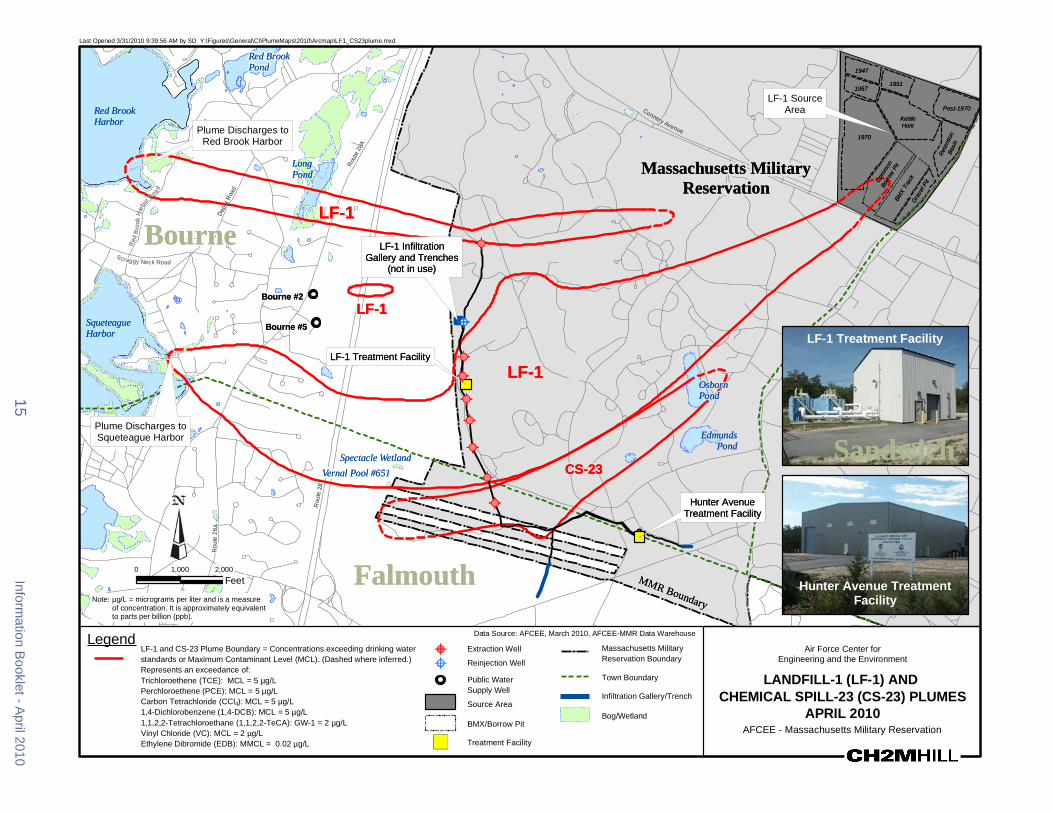
CS-21
CS-10
CS-21
CS-10
CCoonnnneerryy AAvveennuuee
MMMMRR BBoouunnddaarryy
RRoouutt
ee 2288
AA
RRoo uu
ttee 22
88
RRoouu
ttee 22
88
RReedd
BBrroo
ookk HH
aarrbboo
rr RRooaa dd
DDeeppoo
tt RRooaa
dd
SSccrraaggggyy NNeecc
RReettee
nnttiioo
nnBBaa
ssiinn
CCoomm
mmoonn
BBoo
rrrrooww
PPiitt
BBMMXX
TTrraacc
kk GGrr
aavveell
PPiitt
Last Opened 3312010 93956 AM by SD YFiguresGeneralCIPlumeMaps2010ArcmapLF1_CS23plumemxd
RReedd BBrrooookk PPoonndd 11994477
LF-1 Source 11995577
11995511
PPoosstt--11997700AreaRReedd BBrrooookk KKeettttllee HHoolleeHHaarrbboorr
Plume Discharges to 11997700Red Brook Harbor
LLoonngg MMaassssaacchhuusseettttss MMiilliittaarryyPPoonndd RReesseerrvvaattiioonn
LLFF--11 BBoouurrnnee ETHETHLLFF--11 IInnffiillttrraattiioonn
GGaalllleerryy aanndd TTrreenncchheesskk RRooaadd ((nnoott iinn uussee))
BBoouurrnnee 22 LLFF--11
BBoouurrnnee ETH55 ETHSSqquueetteeaagguuee HHaarrbboorr
LLFF--11 TTrreeaattmmeenntt FFaacciilliittyy
ETHETH
ETHETH
ETHETH
LLFF--11 OOssbboorrnn PPoonndd
LF-1 Treatment Facility
ETHETH
15Inform
ation Booklet -A
pril 2010
Plume Discharges to EEddmmuunnddssSqueteague Harbor SSaannddwwiicchhETHETH PPoonndd
SSppeeccttaaccllee WWeettllaanndd
VVeerrnnaall PPooooll 6655 C11 CSS--2233ETHETH
HHuunntteerr AAvveennuuee
ETHETH TTrreeaattmmeenntt FFaacciilliittyy
AA
0 1000 2000
Feet FFaallmmoouutthh microgL = micrograms per liter and is a measureNote of concentration It is approximately equivalentto parts per billion (ppb)
Hunter Avenue Treatment Facility
Legend LF-1 and CS-23 Plume Boundary = Concentrations exceeding drinking water ETHstandards or Maximum Contaminant Level (MCL) (Dashed where inferred)
ETHRepresents an exceedance of Trichloroethene (TCE) MCL = 5 microgL Perchloroethene (PCE) MCL = 5 microgL Carbon Tetrachloride (CCl4) MCL = 5 microgL 14-Dichlorobenzene (14-DCB) MCL = 5 microgL 1122-Tetrachloroethane (1122-TeCA) GW-1 = 2 microgL Vinyl Chloride (VC) MCL = 2 microgL Ethylene Dibromide (EDB) MMCL = 002 microgL U
Data Source AFCEE March 2010 AFCEE-MMR Data Warehouse
Extraction Well Massachusetts Military Reservation BoundaryReinjection Well
Public Water Town Boundary Supply Well
Infiltration GalleryTrench Source Area
BogWetland BMXBorrow Pit
Treatment Facility
Air Force Center for Engineering and the Environment
LANDFILL-1 (LF-1) AND CHEMICAL SPILL-23 (CS-23) PLUMES
APRIL 2010 AFCEE - Massachusetts Military Reservation
Cape Cod Canal
Route
28
Route 151
Route 28
Route 13
0
Route 6
Route 130
Route
28
Quaker Meetinghouse
Rd
Gree
nway
Rd
Wood Rd
Jefferson Rd
Barlo
w Rd Gibbs Rd
Connery Rd
Turpe
ntine
Rd
Frank
Perki
ns R
d
Pew R
d Ca
nal V
iew Rd
Cape Cod Canal
Route
28
Route 151
Route 28
Route 13
0
Route 6
Route 130
Route
28
Quaker Meetinghouse
Rd
Gree
nway
Rd
Wood Rd
Jefferson Rd
Barlo
w Rd Gibbs Rd
Connery Rd
Turpe
ntine
Rd
Frank
Perki
ns R
d
Pew R
d Ca
nal V
iew Rd
Last Opened 5102010 14919 PM by SD YFiguresGeneralERC_PlumemapGIS20100420Arcmaperc_plumemap_20100420mxd
Legend Chlorinated Solvents Plume -Concentrations Exceed MCLs TCE = 50 microgL PCE = 50 microgL EDB PlConcen
ume -rat ons Exceed MMCL = 002 microgLt i
Perchlorate Plume - Concentrations ExceedMMCL = 20 microgL
RDX Plume - Concentrations exceed EPA 10-6 risk-basedlevel = 06 ppb
Plumes with Remedy in Place
Cape Cod BayCape Cod Bay
NorthwesCorner NorthwesCorner
Demolition Area 2Demolition Area 2 tt
Plumes with Interim Remedy in Place Extraction Well
D Extraction Well (Off) OReinjection Well D Reinjection Well (Off) Scale 1 inch = 1 mile
0 05 1Outflow Bubbler Miles
Treatment FacilityS
Municipal Water Supply Well Town Boundary
SandwichInfiltration TrenchGallery Treatment System Pipeline
Influent Effluent
The areas of contamination show the combined contaminants of concern within each plume
Bourne
Massachusetts Military Reservation
Mashpee Falmouth
Surface water from Long Pond is also used as a drinking water source forthe town of Falmouth
Contaminant of Concern (COC) Type of Contaminant Risk-Based LevelTCE ndash trichloroethene solvent MCL = 5 microgPCE ndash perchloroethene solvent MCL = 5 microg
L
CCI4 ndash carbon tetrachloride solvent MCL = 5 microgLL
EDB ndash ethylene dibromide fuel-related compound MMCL = 002 microgLbenzene fuel-related compound MCL = 5 microgvinyl chloride solvent MCL = 2 microg
L
1122-tetrachloroethane solvent GW-1 = 2 microgL
14-dichlorobenzene solvent MCL = 5 microgLL
manganese metal EPA Health Advisory = 300 microgL Massachusetts Military Reservationthallium metal MCL = 2 microgLlead metal 15 microgL (treatment technique action level Groundwater Findings
for water distribution systems)toluene fuel MCL = 1000 microgL Issued April 2010RDX - hexahydro-135-trinitro-135- explosive HA = 2 microgLtriazine GW-1 = 1 microgL
10-6 = 06 microgperchlorate oxidizer HA = 15 microg
L MMCL = 2 microg
LL
MCL ndash Maximum Contaminant LevelMMCL ndash Massachusetts Maximum Contaminant LevelHA ndash Federal Lifetime Health Advisory Note ppb = parts per billion and is a measure of concentrationGW-1 ndash State default cleanup value to be used in lieu of site-specific risk-based level It is approximately equivalent to micrograms per liter (microgL)10-6 ndash EPA level resulting in an excess cancer risk of one in a million
Central Impact Area
Central Impact Area
S Phinneys Harbor
CS-19
S Phinneys Harbor
CS-19
WestBoundary
S J-2ern
S
S
S
J-1
J-3Demolition Area 1
WestBoundary
S J-2ern S
S
S
J-1
J-3Demolition Area 1
S S
Pocasset SS
Harbor
Hen
S L Range
S S
Peters Pond
Pocasset SS
Harbor DD FS-12 tSeveral FS-12 extraction wellurned off (not shown at this scale
s are)
Hen
S L Range
Peters Pond
DD FS-12 tSeveral FS-12 extraction wellurned off (not shown at this scale
s are)
CoveCove Snake
Weeks Pond
Pond Wakeby Pond
Snake
Weeks Pond
Pond Wakeby Pond
Red BrookRed Brook HarborHarbor
LF-1LF-1
Squeteague LF-1 MashpeeHarbor Pond
CS-10SMegansett
LF-1 Harbor DS
CS-23
S
FS-1 S Moody
DD PondCS-21 DSCS-20 D
DDCS-21 CS-4Wild Harbor
Ashumet FS-29
Squeteague LF-1 MashpeeHarbor Pond
CS-10SMegansett
LF-1 Harbor DS
CS-23
S
FS-1 S Moody
DD PondCS-21 DSCS-20 D
DDCS-21 CS-4Wild Harbor
Ashumet FS-29 D D
Pond D Johns
D
Pond Johns
Pond
Pond
CS-10 CS-10
Deep Pond
Deep Pond
Crooked Pond Crooked Pond
Coonamessett D
Pond S
DFS-28
S
Shallow Well Point system is off
FS-28 AshumetValley
Jenkins
Pond
S
Coonamessett D
Pond S
DFS-28
S
Shallow Well Point system is off
FS-28 AshumetValley
Jenkins
Pond
S
Long Pond
Long Pond
Air Force Center for Engineering and the EnvironmentAir Force Center for Engineering and the Environment
FS-1 and FS-12 Groundwater Plumes The source of the Fuel Spill 1 (FS-1) groundwater plume is the Aviation Gas Fuel Valve Test Dump Site in the eastern part of the base The site was used from 1955 to 1970 to test fuel dump valves on EC-121 Super Constellation aircraft which involved the release of fuel directly onto the ground Currently no significant levels of COCs are present in the surface or subsurface soils at the FS-1 source area and the source area groundwater is sampled for lead only
The FS-1 groundwater plume contains the fuel additive ethylene dibromide (EDB) at levels above the MMCL which is 002 microgL The FS-1 plume is currently in long-term remediation with a groundwater extraction-and-treatment system in the Quashnet River cranberry bog area just northeast of Johns Pond The system was designed to prevent upwelling of EDB contamination into the Quashnet River and associated cranberry bogs The treatment plant uses granular activated carbon to remove EDB from the groundwater which is then discharged to the Quashnet River through a series of oxygenating bubblers The latest test results showed that the FS-1 treatment system has been successful in reducing both the amount of EDB in the FS-1 plume and the EDB concentrations in the surface water of the Quashnet River and associated bogs A 2000 ROD specifies active treatment of the plume along with monitoring
The source of the FS-12 groundwater plume was an estimated 70000-gallon release from a section of a now-abandoned fuel pipeline that ran from the Cape Cod Canal to MMR EDB is the only remaining contaminant above cleanup standards in the FS-12 groundwater plume The source area groundwater is currently being monitored after having undergone subsurface remediation in the 1990s Groundwater sampling indicates that the source area has been successfully remediated The pipeline has been cleaned and closed with state and federal regulatory approval
The FS-12 plume is currently in long-term remediation with a groundwater extraction-and-treatment system The treatment system consists of extraction wells a treatment plant and reinjection wells The 2006 ROD called for the status quo of operating and monitoring the existing system The latest test results indicate that the extraction wells continue to successfully contain the FS-12 groundwater plume and the size of the plume has been reduced significantly Land use controls are in place for the FS-1 and FS-12 plumes
FS-1 Date of ROD
or DD in Place Cleanup
Start Projected
Finish Primary
Contaminants 2009 Highest Levels (microgL)
Highest Historic Levels (microgL)
April 2000 April 1999 2020 EDB 0857 445 (October 2000)
Treatment Components in Operation1
Treatment Plants Treatment Rate (gpm) (originalcurrent)1
Volume Treated (MG)2
Extraction Wells 3 Bubblers 3 1 750515 33053
FS-12 Date of ROD
or DD in Place Cleanup
Start Projected
Finish Primary
Contaminants 2009 Highest Levels (microgL)
Highest Historic Levels (microgL)
September 2006 September 1997 2048 EDB 231 890 (November 1996)
Treatment Components in Operation1
Treatment Plants Treatment Rate (gpm) (originalcurrent)1
Volume Treated (MG)2
Extraction Wells 4 Reinjection Wells 20 1 772360 4082
ROD = Record of Decision DD = Decision Document microgL = micrograms per liter MG = million gallons gpm = gallons per minute 1 Current treatment rate as of April 1 2010 2 Through December 2009
Information Booklet - April 2010 18
Co
FP
erki
nsR
d
Co
FP
erki
nsR
d
-
-
QQuuaasshhnneett RRiivveerr GG
rreeaatt HHaayy
RRooaa dd
hhiinnnn
ee yyss
RRooaadd
BBeeaarr
sseess
RRooaa
dd SSaa
ddddlleebb
aacckk RRooaadd
GGrraaffttoonn PPoocckknnee
tt RRooaadd
PPiimmlliiccoo PP nndd RRdd
JJBB TThhoommppssoonn RRdd
SSnn aakkeePPoonndd RRdd
RRtt 113300
nnnneerryy AAvv CCoonnnneerryy AAvv
Last Opened 482010 105423 AM by SD YFiguresGeneralCIPlumeMaps2010ArcmapFS1_FS12plumemxd
FFSS--1122 SSoouurrccee AArreeaa
NNoottee PPlluummeess ddeeppiicctteedd iinn tthhiiss mmaapp ootthheerr tthhaann FFSS--11 aanndd FFSS--1122
aarree nnoott ppaarrtt ooff tthhee IIRRPP FFoorr ffuurrtthheerr iinnffoorrmmaattiioonn sseeee
hhttttppggrroouunnddwwaatteerrpprrooggrraammaarrmmyymmiill oorr ccaallll PPaammeellaa RRiicchhaarrddssoonn aatt ((550088)) 996688--55663300 FFSS--1122 TTrreeaattmmeenntt FFaacciilliittyy
FS 12 Treatment Facility
PP
SSaannddwwiicchheemmaaiill ppaammeellaajjrriicchhaarrddssoonnuussaarrmmyymmiill DD DD
DDDD DDDD
DDDDDD DDDD DD DD DD
DD Ntilde D DNtilde DD FFSS--1122
Ntilde Ntilde
ETHETHD
DDDDDDDNtildeNtildeNtildeNtilde
ETH
NtildeNtilde ETH
DDDDETHETHETHETHNtildeNtildeNtildeNtildeNtildeNtildeNtildeNtildeNtildeNtildeNtildeNtildeNtilde
D DDD NtildeNtildeNtildeNtildeDD NtildeNtildeNtildeSSnnaakk Ntildeee NtildeNtildeNtildeNtildeNtilde NtildeNtildeNtildeNtildePPoonnddBBoouurrnnee oo
WWaakkeebbyy PPoonndd
MMaasshhppeeee
MMaassssaacchhuusseettttss MMiilliittaarryy
RReesseerrvvaattiioonn
PPoonndd
FFSS--11 SSoouurrccee AArreeaa
MMaasshhppeeee
FFSS--11
MMooooddyy PPoonndd
FFSS--11 TTrreeaattmmeenntt FFaacciilliittyy
FS 1 Treatment Facility JJoohhnnss
with bubbler in foreground PPoonndd 0 1500 3000
Feet
Legend Data Source AFCEE March 2010 AFCEE-MMR Data Warehouse
ETH
FS-1 and FS-12 Plume Boundary = Concentrations Outflow Bubbler Army Program Plumes exceeding drinking water standards or Massachusetts Extraction Well (On) Perchlorate Plume shyMaximum Contaminant Level (MMCL) Represents an Concentrations exceedance of ethylene dibromide (EDB) Exceed
ETH Reinjection Well (On) D Extraction Well (Off)
(EDB MMCL = 002 microgL) (Dashed Where Inferred) MMCL = 20 microgL D Reinjection Well (Off)Treatment System Piping RDX Plume shy
Massachusetts Military Reservation Boundary U Treatment Facility Concentrations exceed EPA 10-6
Town Boundary Source Area Note microgL = micrograms per liter and is a measure of U risk-based
level = 06 ppb concentrationIt is approximately equivalent to parts BogWetland per billion (ppb)
19
Air Force Center for Engineering and the Environment
FUEL SPILL-1 (FS-1) AND FUEL SPILL-12 (FS-12)
APRIL 2010 AFCEE - Massachusetts Military Reservation
Information Booklet - April 2010
Air Force Center for Engineering and the EnvironmentAir Force Center for Engineering and the Environment
CS-4 CS-20 CS-21 FS-28 and FS-29 Groundwater Plumes
Five groundwater plumes can be found in the area north and south of Route 151 in the town of Falmouth They are FS-28 FS-29 CS-4 CS-20 and CS-21 Only CS-4 has a known source area a former vehicle maintenance area and storage yard on the MMR The other plumes were found to be disconnected from distinct source areas They most likely originated somewhere in the southern portion of MMR which contained various aircraft and vehicle maintenance shops runways and housingpersonnel support facilities Records indicate that spills andor releases occurred in these areas in the past COCs in the plumes are fuel and solvent-related contaminants They include EDB PCE TCE and CCl4 The MMCL for EDB is 002 microgL while the MCL for the rest of the contaminants is 5 microgL
More than 18000 tons of contaminated soil were treated on site at the CS-4 source area and additional soil was transported off site for proper disposal A groundwater extraction-and-treatment system began operating in 1993 but was later replaced by a more efficient system in 2006 to better capture the plume
Portions of the FS-28 plume were first discovered in 1993 beneath the leading edge of the CS-4 plume In 1996 groundwater investigations found EDB upwelling into the Coonamessett River in Falmouth No EDB is presently detected in the Coonamessett River The FS-28 plume is currently in long-term remediation with a groundwater extraction-and-treatment system A treatment plant is located in a bog area just south of Hatchville Road and treated water is discharged to the Coonamessett River through two oxygenating bubblers Shallow wellpoint extraction wells operated for several years but are no longer being used In 2007 a new extraction well was installed to the south to address a deep lobe of EDB
The FS-28 plume underflows Coonamessett Pond and has not affected the pond or a nearby Town of Falmouth municipal well In 2002 AFCEE funded a $52 million wellhead treatment system to ensure a safe water supply for the Falmouth well A ROD was issued in October 2000
The FS-29 CS-20 and CS-21 groundwater plumes were discovered in the late 1990s A ROD for FS-29 was issued in October 2000 and a ROD for CS-4 CS-20 and CS-21 was issued in February 2000 Since 2006 the FS-29 CS-4 CS-20 and CS-21 groundwater plumes have been undergoing active treatment through a series of extraction wells reinjection wells and infiltration trenches Extracted plume water is treated with granular activated carbon at the Hunter Avenue Treatment Facility on base Land use controls are in place for all these plumes
Plume Date of ROD
or DD in Place Cleanup
Start Projected
Finish Primary
Contaminants 2009 Highest Levels (microgL)
Highest Historic Levels (microgL)
CS-4 February 2000 (ESD 92008) November 2005 2014
TCE 55 19 (February 1997) PCE 232 61 (February 1997)
CS-20 February 2000 (ESD 92008) January 2006 2017 PCE 205 981 (September 2005)
CS-21 February 2000 (ESD 92008) September 2006 2027 TCE 98 988 (June 2001)
FS-28 October 2000 (ESD 92008) October 1997 2047 EDB 138 18 (January 1997)
FS-29 October 2000 (ESD 92008) September 2006 2018 EDB 0084 0318 (May 2001)
ROD = Record of Decision DD = Decision Document microgL = micrograms per liter MG = million gallons gpm = gallons per minute
Information Booklet - April 2010 20
Massachusetts Military ReservationMassachusetts Military Reservation
Plume Explanation Contaminants of concern exceed drinking water standards or Maximum Contaminant Level (MCL) CS-20 Perchloroethene (PCE) (PCE MCL = 5 microgL) FS-29 Ethylene dibromide (EDB) and carbon tetrachloride (CCl4)
(EDB MMCL = 002 microgL) (CCl4 MCL = 5 microgL) CS-4 Trichloroethene (TCE) perchloroethene (PCE)
1122- tetrachlorethane (1122- TeCA) andor ethylene dibromide (EDB) (TCE MCL = 5 microgL) (PCE MCL = 5 microgL) (1122-TeCA GW-1 = 2 microgL) (EDB MMCL = 002 microgL)
CS-21 Trichloroethene (TCE) (TCE MCL = 5 microgL)
Note microgL = micrograms per liter and is a measure of concentration It is approximately equivalent to parts per billion (ppb)
Treatment Components in Operation1
Treatment Plants
Treatment Rate (gpm)1
(originalcurrent)
Volume Treated (MG)2
Extraction Wells 2 Infiltration Trenches 2 1 620199 1027
Extraction Wells 2 Reinjection Wells 4 1 775773 1460
Extraction Wells 4 Reinjection Wells 3 1 14001395 2213
Extraction Wells 2 Bubblers 2 1 750600 43045
Extraction Wells 1 Reinjection Wells 2 1 525224 642
ESD = Explanation of Significant Differences 1 Current treatment rate as of April 1 2010 2 Through December 2009
21 Information Booklet - April 2010
-
SamTurner R
d
Hay
way
Rd
Hatchv
illeRd
Thomas B Landers Rd Sa
ndw
ich
Rd
Boxb
erry
Hill
Rd
Hill and Plain Rd
Route 151
Hatchville Rd
Sand
wichRd
Sam
Tur
ner R
d
Last Opened 412010 82704 AM by SD YFiguresGeneralCIPlumeMaps2010ArcmapFS28plumemxd
Falmouth
FS 28 Treatment Facility
Deep Pond
Plume Flows Under Pond
Round Pond
Coonamessett Pond Coonamessett
Water Supply Well FS-28
Crooked Pond
Outflow Bubbler
ETH
FS-28 Treatment Facility Broad River
FS-28 Shallow Outflow Bubbler
Pond Decommissioned Shallow
Wellpoint Extraction System
DR
AF
T
FS-28
Round Pond
ETHETH
Jenkins Pond
Pond 14
0 770 1540
Feet
Data Source AFCEE March 2010 MMR-AFCEE Data WarehouseLegend FS-28 Plume Boundary = Concentrations exceeding drinking ETH Extraction Well
Air Force Center for water standards or Massachusetts Maximum Contaminant Outflow Bubbler Engineering and the EnvironmentLevel (MMCL) dashed where inferred Represents an exceedance of ethylene dibromide (EDB) Public Drinking FUEL SPILL 28 (FS-28)(EDB MMCL = 002 microgL) Water Supply Well
PLUME - APRIL 2010BogWetland Treatment Facility AFCEE - Massachusetts Military Reservation
Treatment System Piping Note microgL = micrograms per liter and is a measure of concentration
It is approximately equivalent to parts per billion (ppb)
Information Booklet - April 2010 22
MMR Boundary Falmouth
Sandw
ich
Mashpe
e
Whe
eler
Rd
Reilly
Redlands
Rd
Br a
nsha
w S
t
Curr ier R
d
Sim
p kinsR
d
Hoo
ppol
eR
d
Club
Valley
Dr
Gen
eral
sBl
vd
MMR Boundary Falmouth
Sandw
ich
Mashpe
e
Whe
eler
Rd
Reilly
Redlands
Rd
Bra
nsha
w S
t
Currier R
d
Sim
p kinsR
d
Hoo
ppol
eR
d
Club
Val leyD
r
Gen
eral
sBl
vd
Massachusetts Military ReservationMassachusetts Military Reservation
Progress Over The Years
Much progress has been made over the last 15 years Program-wide the source areas have been cleaned up and 11 groundwater plumes are undergoing pump-and-treat cleanup action both on and off base All environmental cleanup decisions and remedies are in place In the future the program will continue to monitor adjust and shut down treatment systems as cleanup progress is made The Air Force will continue to conduct the most efficient cleanup operations while ensuring the protection of public health and the environment
The SD-5 plume depiction illustrates the transformation of the plume over time due to the effect of cleanup systems used by the Air Force for several years Contaminated water was cleaned by using two technologies The first involved extracting the plume water pumping it to a treatment building where large vessels of granular activated carbon removed the solvent contamination and then the clean water was returned to the ground through reinjection wells Two recirculation wells were also used Those involved two underground standalone treatment systems within the neighboring community That technology used air and pumps to remove the solvents from the plume and capture them in carbon tanks The plume has now been cleaned up to the point where only residual traces of solvent contamination are found in monitoring wells which are periodically tested
The following pages depict the cleanup progress of several IRP groundwater plumes over time Most plumes show a significant reduction in size and contaminant mass A few show a larger area which is related to plume information uncertainties in the early part of the cleanup program and changing conditions over time a significant reason why diligent monitoring is required For more information and depictions of all AFCEE groundwater plumes progress over time go to httpwwwmmrorgCleanupplumes_fshtm
Last Opened 3292010 115403 AM by SD YFiguresGeneralPlumeMapsComparison2010ArcMapSD5comp_97_10mxd
SandwichSandwich
Mashpee Mashpee
Ashumet PondAshumet PondFalmouth FalmouthJohns PondJohns Pond
1997 2010
Legend Data Source AFCEE MMR-AFCEE Data Warehouse
Town Boundary
Massachusetts Military Reservation Boundary SD-5 PLUME 1997 AND 2010 COMPARISON
Plume Boundary AFCEE - Massachusetts Military Reservation 0 1100 2200
BogWetland Feet
23 Information Booklet - April 2010
Plum
e Com
parison Over Tim
e
MMR Boundary Falmouth
Sandw
ich
Mashpe
e
Route 151
Kit tredge Rd
Connery Av
Whe
eler
Rd
Cole Rd
Le e Rd Hatc
hville
Rd
Herbert Rd
Reilly
Sam Turner R
d
Sandw
ich R
d
Herbert Rd
Connery Av
Route 151
MMR Boundary Falmouth
Sandw
ich
Mashpe
e
Route 151
Kittredge Rd
Connery Av
Whe
eler
Rd
Cole Rd
Le e Rd
Hatchv
ille R
d
Herbert Rd
Reilly
Sam Turner R
d
Sandw
ich R
d
Herber t Rd
Connery Av
Route 151
MMR Boundary
Falmouth
Sandw
ich
ashpe
e
Route 151
Cur
rier R
d
Whe
eler
Rd
Hayway Rd
Sam Turner R
d
Thomas B Landers Rd
Hatch
ville
Rd
Mi lf
or d
Rd Elai n Av
Sandw
ich
Rd
Meredith Dr
Redlands Rd
R eg is R
d
Jam
ie Ln
Hill a
nd Plain Rd
Old Barnstable R
d
Cloverfield Way Route 151
Sand
wich R
d
Route 151
MMR Boundary
Falmouth
Sandw
ich
ashpe
e
Route 151
Cur
rier R
d
Whe
eler
Rd
Sam Turner R
d
Thomas B Landers Rd
Hatchv
ille R
d
Mil f
ord
Rd Elain Av
Sandw
i ch
Rd
Meredith Dr
Redlands Rd
R eg is R
d
Jam
ie Ln
Hill a
nd Plain Rd
Old Barnsta
ble Rd
Cloverfield Way Route 151
Sand
wich R
d
Plu
me
Com
paris
on O
ver T
ime
Last Opened 3292010 110332 AM by SD YFiguresGeneralPlumeMapsComparison2010ArcMapCS10comp_97_10mxd
Snake Pond Snake Pond
BourneBourne
Sandwich Sandwich
MashpeeMashpee Falmouth Ashumet PondAshumet PondFalmouth Johns PondJohns Pond
Coonamessett Pond 2010Coonamessett Pond 1997 Legend
Massachusetts Military Reservation Boundary
BogWetland
Town Boundary
Plume Boundary (Dashed Where Inferred) Primary Contaminants Trichloroethene (TCE) Perchloroethene (PCE)
0 2300 4600
Feet
Data Source AFCEE MMR-AFCEE Data Warehouse
CS-10 PLUME 1997 AND 2010 COMPARISON AFCEE - Massachusetts Military Reservation
Last Opened 3292010 101508 AM by SD YFiguresGeneralPlumeMapsComparison2010ArcMapAVcomp_96_10mxd
Sandwich Sandwich MMashpee MMashpee
FalmouthFalmouth Ashumet Pond Ashumet Pond
Johns Pond Johns Pond
Coonamessett Pond Coonamessett Pond
Broad RiverBroad River
Jenkins Pond Jenkins Pond Pond 14 Pond 14 Fresh PondFresh Pond
20101996
Legend
Plume Boundary Primary Contaminants Trichloroethene (TCE) Perchloroethene (PCE)
Massachusetts Military Reservation Boundary
BogWetland
Town Boundary
0 2250 4500
Feet
Data Source AFCEE MMR-AFCEE Data Warehouse
ASHUMET VALLEY PLUME 1996 AND 2010 COMPARISON AFCEE - Massachusetts Military Reservation
Information Booklet - April 2010 24
Sandwich
MM
R Bo
unda
ry
MM
R
Sandwich Mashpee
Snake Pond Rd
Boun
dary
Dana
Rd
Arnol
d Rd
Pinecrest Dr
Artisan Way
Cha
dwic
k R
d
Jeannes Way
Gre
enw
ay R
d
Rout
e 13
0
Emerald Way
Week
s Po
nd D
r
Blac
kth rn Path
Green
way R
d
Greenway Rd
MM
R Bo
unda
ry
MM
R Bo
unda
ry Sandwich Mashpee
Greenway Rd
Dana
Rd
Arnol
d Rd
Pinecrest Dr
Artisan Way
Cha
dwic
k R
d
Jeannes Way
Emerald Way
Rout
e 13
0
Snake Pond Rd
Wee
ks P
ond
Dr
Blac
kth rn Path
Gre
enw
ay R
d
Greenw
ay R
d
MMR Boundary
Mas
hpee
Sand
wic
h
Route 130
Reilly
Great H
ay Rd
Love
lls L
n
Bear
ses
Rd
Sadd
leback Rd
Graf ton Pocknet Rd
Great Hay Rd
Mas
hpee
Sand
wic
h
MMR Boundary
Route 130
Love
ll s L
n
Rei
lly
Great H
ay Rd
Bear
ses
Rd
Lowell
Rd
Grafton P
ockne
t Rd
Echo Rd
Bookers Rd
Sadd
leback Rd
Quashnet Rd
Back Rd
Ashumet Rd
Bakers Rd
Easton S
t
Phi
nney
s Rd
Asher s P at h
Shorewood Dr
Great Hay Rd
Bear
ses
Rd
Rei
lly
Grea t H
ay Rd
Love
lls L
n
Grafton Pocknet Rd
Gre at H
ay Rd
Last Opened 3292010 113034 AM by SD YFiguresGeneralPlumeMapsComparison2010ArcMapFS12comp_97_10mxd
Snake Pond Snake Pondoo
Sandwich SandwichWeeks Pond Weeks Pond
1997 2010 Data Source AFCEE MMR-AFCEE Data WarehouseLegend
Town Boundary
FS-12 PLUMEMassachusetts Military Reservation Boundary 1997 AND 2010 COMPARISON AFCEE - Massachusetts Military ReservationPlume Boundary Primary Contaminants Benzene Ethylene Dibromide (EDB)
0 960 1920 BogWetland Feet
Last Opened 3292010 112823 AM by SD YFiguresGeneralPlumeMapsComparison2010ArcMapFS1comp_98_10mxd
aay
Rd
Gre
tH
Mashpee
Mashpee Pond Mashpee Pond
Mashpee
Johns PondJohns Pond
20101998
Legend Data Source AFCEE MMR-AFCEE Data Warehouse
Town Boundary
Massachusetts Military Reservation Boundary FS-1 PLUME 1998 AND 2010 COMPARISON
Plume Boundary (Dashed Where Inferred) Primary Contaminant Ethylene Dibromide (EDB)
0 1000 2000
AFCEE - Massachusetts Military Reservation
BogWetland Feet
25 Information Booklet - April 2010
Plum
e Com
parison Over Tim
e
MMR Bo
Sandw
ich
Mas
hpee San
dwich
Sandw
ich
Mashpe
e
Deep PondLittle Jenkins Pond
Sandw
ich
Coonamessett PondDeep PondLittle Jenkins Pond
undary
Falmouth
Sandwich
MMR Boundary
Route 151
mas B Landers Rd
Sam Turner R
d
Hatchv
il le R
d
Deer Pond Rd
Sandw
ich
Rd
Boxberry Hill Rd
Hill and Plain Rd
Old Barnstable R
d
Cloverfield Way
Blac
ksmith Shop Rd
Regis Rd
Route 151
Route 151
Sam Tu rner R
d
Route 151
Route 151
Sandw
ich R
d
MMR Boundary Falmouth
Sandwich
Route 151
mas B Landers Rd
Sam Tu rner R
d
Deer Pond Rd
Hatch
ville
Rd
Sandw
ich
Rd
Box
ber r
y H
il l R
d
Hill and Plain Rd
Old Barnstable R
d
Cloverfield Way
Blac
ksmith Shop Rd
Route 151
Route 151
Route 151
Sandw
ich R
d
Route 151
Sand
wich R
d
Boxberry Hill Rd
MMR Boundary
Falmouth
Bourne
Sand
wic
h
Route 151
Kittredge Rd
Cole Rd
Lee Rd
Sandwich R
d
Boxberry Hill Rd
Route 151
Route 151
MMR Boundary
Falmouth
Bourne
Sand
wic
h
Route 151
Kittredge Rd
Cole Rd
Lee Rd
Sa
ndwich
Rd
Boxberry Hill Rd
Route 151
Route 151
Last Opened 3292010 113441 AM by SD YFiguresGeneralPlumeMapsComparison2010ArcMapFS28comp_98_10mxdP
lum
e C
ompa
rison
Ove
r Tim
e
Coonamessett PondCoonamessett Pond
Falmouth FalmouthThoTho Broad River
Broad River
Jenkins PondJenkins Pond Pond 14Pond 14 20101998
Data Source AFCEE MMR-AFCEE Data WarehouseLegend
Town Boundary
FS-28 PLUME Massachusetts Military Reservation Boundary 1998 AND 2010 COMPARISON Plume Boundary (Dashed Where Inferred) AFCEE - Massachusetts Military Reservation Primary Contaminant Ethylene Dibromide (EDB)
0 1700 3400
BogWetland Feet
Last Opened 3292010 101742 AM by SD YFiguresGeneralPlumeMapsComparison2010ArcMapCS4comp_96_10mxd
Bourne Bourne Osborn Pond Osborn Pond
Edmunds Pond Edmunds Pond
Spit Pond Spit Pond
SandwichSandwich
FalmouthFalmouth
1996 2010 Data Source AFCEE MMR-AFCEE Data WarehouseLegend
Town Boundary
CS-4 PLUME 1996 AND 2010 COMPARISON
Massachusetts Military Reservation Boundary
Plume Boundary Primary Contaminants Trichloroethene (TCE) Perchloroethene (PCE) AFCEE - Massachusetts Military Reservation
0 1400 2800BogWetland Feet
Information Booklet - April 2010 26
Little Jenkins Pond Little Jenkins Pond
MMR Boundary
Falmouth
Bourne
Sand
wic
h
Route 151
Rou
te 2
8
Sam Turner Rd
Rou
te 2
8
MMR Boundary
Falmouth
Bourne
Sand
wic
h
Route 151
Rou
te 2
8
Sam Turner Rd
Rou
te 2
8
Falmouth
Bourne
Sand
wic
h
MMR Boundary
Rou
te 2
8
Route 151
Rou
te 2
8
Sand
wic
h
Falmouth
Bourne
MMR Boundary
Rou
te 2
8
Route 151
Rou
te 2
8
Last Opened 3292010 111229 AM by SD YFiguresGeneralPlumeMapsComparison2010ArcMapCS21comp_99_10mxd
Osborn Pond Osborn Pond
Bourne Bourne Edmunds Pond Edmunds Pond
Spit Pond Spit Pond
Sandwich Sandwich
Falmouth Falmouth
Deep Pond Deep Pond Coonamessett Pond Coonamessett Pond
1999 2010 Round Pond Round Pond Crooked Pond Crooked Pond
Legend Data Source AFCEE MMR-AFCEE Data Warehouse
Town Boundary
Massachusetts Military Reservation Boundary CS-21 PLUME 1999 AND 2010 COMPARISON
Plume Boundary Primary Contaminant Trichloroethene (TCE) AFCEE - Massachusetts Military Reservation
BogWetland 0 1400 2800
Feet
Last Opened 3292010 112004 AM by SD YFiguresGeneralPlumeMapsComparison2010ArcMapCS23comp_02_10mxd
Osborn Pond Osborn Pond
Bourne Bourne Edmunds Pond Edmunds Pond
Spit Pond Spit Pond
Falmouth Falmouth
2010 2002 Data Source AFCEE MMR-AFCEE Data Warehouse Legend
Town Boundary
CS-23 PLUME 2002 AND 2010 COMPARISON
Massachusetts Military Reservation Boundary
Plume Boundary (Dashed Where Inferred) Primary Contaminants AFCEE - Massachusetts Military Reservation Trichloroethene (TCE) Carbon Tetrachloride (CCl4)
0 1000 2000 BogWetland Feet
27 Information Booklet - April 2010
Plum
e Com
parison Over Tim
e
Deep Pond Little Jenkins PondLittle Jenkins Pond
Sandw
ich
Bourne Osborn PondBourne
Osborn Pond
MMR Boundary
Falmouth
Bourne
Sand
wic
h
Rou
te 2
8
Co le R
d
Route 151
Kittredge Rd
Conne ry Av
Le e Rd
Herbert Rd
Shor
e R
oute
Boxberry Hill Rd
Rou
te 2
8
Cole Rd Rou
te 2
8
Rout
e 28
Route 151
Rou
te 2
8
Rout
e 28
Route 151
Connery Av
MMR Boundary
Falmouth
Bourne
Sand
wic
h
Rou
te 2
8
Cole R
d
Route 151
Kittredge Rd
Connery Av
Le e Rd
Herbert Rd
Shor
e Ro
ute
Boxberry Hill Rd
Rou
te 2
8
Rou
te 2
8
Rout
e 28
Route 151
Rou
te 2
8
Rout
e 28
Connery Av
MMR Boundary
Falmouth
Bourne
Sand
wic
h
Route 151
Kittredge Rd
Cole Rd
Sam
Turner Rd
Hatchv
ille R
d
Boxberry Hill Rd
Sand
wich R
d
Hill
and Plain Rd
Hay
way
Rd
Route 151
Route 151
MMR Boundary
Falmouth
Bourne
Sand
wic
h
Route 151
Kittredge Rd
Cole Rd
Sam
Turner Rd
Hatch
ville
Rd
Hill
and Plain Rd
Sandw
ich R
d
Hay
way
Rd
Route 151
Route 151
Plu
me
Com
paris
on O
ver T
ime
Last Opened 3292010 115107 AM by SD YFiguresGeneralPlumeMapsComparison2010ArcMapLF1comp_97_10mxd
BourneBourne
Osborn Pond Osborn Pond
Edmunds Pond Edmunds Pond Spit Pond Spit Pond
Sandwich Sandwich
Falmouth Falmouth
20101997
Data Source AFCEE MMR-AFCEE Data WarehouseLegend
Town Boundary
LF-1 PLUME 1997 AND 2010 COMPARISON
Massachusetts Military Reservation Boundary
Plume Boundary (Dashed Where Inferred) Primary Contaminants Carbon Tetrachloride (CCl4) Perchloroethene (PCE) Tetrachloroethene (TCE) AFCEE - Massachusetts Military Reservation
BogWetland 0 2000 4000
Feet
Last Opened 3292010 110911 AM by SD YFiguresGeneralPlumeMapsComparison2010ArcMapCS20comp_99_10mxd
Bourne BourneEdmunds Pond Edmunds Pond
Spit Pond Spit Pond
SandwichSandwich
FalmouthFalmouth
Little Jenkins Pond Little Jenkins Pond Deep Pond Deep Pond Coonamessett PondCoonamessett Pond
Round Pond Round PondCrooked Pond Crooked Pond
1999 2010
Legend
Plume Boundary Primary Contaminant Perchloroethene (PCE)
Massachusetts Military Reservation Boundary
BogWetland
Town Boundary
0 1400 2800
Feet
Data Source AFCEE MMR-AFCEE Data Warehouse
CS-20 PLUME 1999 AND 2010 COMPARISON AFCEE - Massachusetts Military Reservation
Information Booklet - April 2010 28
Massachusetts Military ReservationMassachusetts Military Reservation
Information Booklet - April 2010
AFCEErsquos aggressive optimization activities have resulted in a more sustainable remediation program at MMR Our ldquobetter cheaper fasterrdquo approach is intended to expedite aquifer restoration and cleanup timeframes while reducing costs to the taxpayers and minimizing our carbon footprint Optimization activities conducted by AFCEE at MMR include
Demonstrating alternative in situ technologies such as a passive zero-valent iron barrier This barrier requiresbullno OampM and was installed along the Ashumet Pond shoreline to help reduce phosphorus discharging into the surface water
Continuously adjusting groundwater remediation systems as the groundwater plumes change over time Forbullexample extraction wells are taken out of operation once the portion of the aquifer is cleaned up In some cases extraction wells are added if deemed necessary to expedite aquifer restoration and eliminate risks to human health and the environment In other cases flow rates at extraction wells are modified as needed andor systems are pulse-pumped and packers are installed in extraction wells to focus extraction stress on changing contaminant distribution In one case a reinjection well was converted to an extraction well when contamination was detected unexpectedly in monitoring wells outside of the delineated plume area
Installing variable frequency drives (VFDs) on extraction well pumpbullmotors to save energy and reduce wear and tear on pumpmotor assemblies In the absence of VFDs extraction well pumps and motors are changed out by our well maintenance staff to appropriately size the pumps and motors to optimized flow rates at extraction wells resulting in a reduction in unnecessary energy use In addition energy saving premium efficiency motors have been installed on booster and transfer pumps in treatment plants
Adjusting the number of monitoring locations frequency of samplingbulland analytes in the monitoring program as the remediation requirements are refined Passive sampling techniques such as passive diffusion bags and Hydrasleevesreg are used to the maximum extent possible to save time reduce costs and reduce impacts to the environment as compared to conventional pumped sampling
Passive sampling technique
Zero-valent iron barrier along Ashumet Pond shorelineIn situ chemical oxidation operation
Information Booklet - April 201029
Sustainable Remediation at the Massachusetts Military Reservation
Air Force Center for Engineering and the EnvironmentAir Force Center for Engineering and the Environment
Recycling granular activated carbon which is used in thebulltreatment systems to remove the contaminants from the groundwater through a process called reactivation Our used carbon is removed from the vessels reactivated off site and returned to MMR for reuse
Providing treated water for beneficial reuse such as irrigatingbullthe Veterans Affairs cemetery and as a geothermal source for heating ventilating and air conditioning systems
Pilot-testing new technologies such as ozone and hydrogenbulltreatment of plant influent water to determine if they can be used effectively to pretreat the water and extend the life of the carbon beds andor reduce operating costs
Evaluating various types of carbon to determine if a morebullefficient product is available
Employing energy conservation measures such as efficientbulllighting occupancy sensors and programmable thermostats in treatment plants and administrative buildings and recycling products such as paper tubing batteries and light bulbs to the maximum extent possible
Using biodiesel fuel and vegetable-based hydraulic oil to thebullmaximum extent possible in our diesel powered equipment
Employing low impact direct-push technology to collectbullgroundwater samples instead of using augersonic well drilling when viable AFCEE owns and operates a direct-push rig that is track mounted has a smaller footprint uses environmentally sensitive biofuels and is responsive Not only is this method of drilling more sustainable than other methods it is also less expensive since the work is done by site staff AFCEEMMR holds the record depth achieved by direct-push drilling technology - 319 feet below ground surface
Optimizing power purchase agreements for additional costbullsavings purchasing green energy and participating in the New England energy demand response program
Accounting for costs efficiency and environmental impactbullof our program decisions These activities are tracked and reported in quarterly optimization reports These reports are available on the wwwmmrorg website
Information Booklet - April 2010 30
Low impact direct-push unit
Irrigation at the VA cemetery
Sustainable Remediation at the Massachusetts Military Reservation
Massachusetts Military ReservationMassachusetts Military Reservation
Information Booklet - April 2010
A major optimization effort completed last year was the installation of renewable energy in the form of a 15 MW Fuhrlaender wind turbine The wind turbine started operating on December 2 2009 and is expected to reduce AFCEErsquos annual $2 million electric cost by 25 to 30 The wind turbine is also anticipated to offset air emissions generated indirectly through the use of electricity from fossil fuel based power plants by approximately 25 to 30 Based on a range of utility cost projections and an estimate of the turbinersquos energy production the $46 million wind turbine is anticipated to have a payback period between six and eight years
31
Renewable Energy Wind Turbine
Attendees at the AFCEE wind turbine dedication ceremony at the MMR on Nov 2 2009 Left top to bottom Mr Joe Orciuch Environmental Chemical Corporation Project Manager Mr Bill Delahunt US Congressman 10th Congressional District of Massachusetts Mr Ira W Leighton Acting Regional Administrator US Environmental Protection Agency - New England and Mr Ian Bowles Secretary Executive Office of Energy and Environmental Affairs - Massachusetts Right top to bottom Ms Rose Forbes AFCEE Project Manager Major General Joseph C Carter Adjutant General of Massachusetts Mr Tad D Davis IV Deputy Assistant Secretary of the Army for Environment Safety and Occupational Health and Mr Mike McGhee Acting Deputy Assistant Secretary of the Air Force for Energy Environment Safety and Occupational Health
Massachusetts Department of Environmental Protection
Ellie Grillo Phone (508) 946-2866 E-mail elliegrillostatemaus
US Environmental Protection Agency Jeanethe Falvey Phone (617) 918-1020 E-mail falveyjeanetheepagov
Air Force Center for Engineering and the Environment
Doug Karson Phone (508) 968-4678 ext 2 E-mail douglaskarsonusafmil
Restoring our
For more information wwwmmrorg
Impact Area Groundwater Study Program Pamela J Richardson Phone (508) 968-5630
E-mail pamelajrichardsonusarmymil
sole-source aquiferfor future generations
Printed on 20 Post-Consumer Fiber

Cape Cod Canal
Route
28
Route 151
Route 28
Route 13
0
Route 6
Route 130
Route
28
Quaker Meetinghouse
Rd
Gree
nway
Rd
Wood Rd
Jefferson Rd
Barlo
w Rd Gibbs Rd
Connery Rd
Turpe
ntine
Rd
Frank
Perki
ns R
d
Pew R
d Ca
nal V
iew Rd
Cape Cod Canal
Route
28
Route 151
Route 28
Route 13
0
Route 6
Route 130
Route
28
Quaker Meetinghouse
Rd
Gree
nway
Rd
Wood Rd
Jefferson Rd
Barlo
w Rd Gibbs Rd
Connery Rd
Turpe
ntine
Rd
Frank
Perki
ns R
d
Pew R
d Ca
nal V
iew Rd
Last Opened 5102010 14919 PM by SD YFiguresGeneralERC_PlumemapGIS20100420Arcmaperc_plumemap_20100420mxd
Legend Chlorinated Solvents Plume -Concentrations Exceed MCLs TCE = 50 microgL PCE = 50 microgL EDB PlConcen
ume -rat ons Exceed MMCL = 002 microgLt i
Perchlorate Plume - Concentrations ExceedMMCL = 20 microgL
RDX Plume - Concentrations exceed EPA 10-6 risk-basedlevel = 06 ppb
Plumes with Remedy in Place
Cape Cod BayCape Cod Bay
NorthwesCorner NorthwesCorner
Demolition Area 2Demolition Area 2 tt
Plumes with Interim Remedy in Place Extraction Well
D Extraction Well (Off) OReinjection Well D Reinjection Well (Off) Scale 1 inch = 1 mile
0 05 1Outflow Bubbler Miles
Treatment FacilityS
Municipal Water Supply Well Town Boundary
SandwichInfiltration TrenchGallery Treatment System Pipeline
Influent Effluent
The areas of contamination show the combined contaminants of concern within each plume
Bourne
Massachusetts Military Reservation
Mashpee Falmouth
Surface water from Long Pond is also used as a drinking water source forthe town of Falmouth
Contaminant of Concern (COC) Type of Contaminant Risk-Based LevelTCE ndash trichloroethene solvent MCL = 5 microgPCE ndash perchloroethene solvent MCL = 5 microg
L
CCI4 ndash carbon tetrachloride solvent MCL = 5 microgLL
EDB ndash ethylene dibromide fuel-related compound MMCL = 002 microgLbenzene fuel-related compound MCL = 5 microgvinyl chloride solvent MCL = 2 microg
L
1122-tetrachloroethane solvent GW-1 = 2 microgL
14-dichlorobenzene solvent MCL = 5 microgLL
manganese metal EPA Health Advisory = 300 microgL Massachusetts Military Reservationthallium metal MCL = 2 microgLlead metal 15 microgL (treatment technique action level Groundwater Findings
for water distribution systems)toluene fuel MCL = 1000 microgL Issued April 2010RDX - hexahydro-135-trinitro-135- explosive HA = 2 microgLtriazine GW-1 = 1 microgL
10-6 = 06 microgperchlorate oxidizer HA = 15 microg
L MMCL = 2 microg
LL
MCL ndash Maximum Contaminant LevelMMCL ndash Massachusetts Maximum Contaminant LevelHA ndash Federal Lifetime Health Advisory Note ppb = parts per billion and is a measure of concentrationGW-1 ndash State default cleanup value to be used in lieu of site-specific risk-based level It is approximately equivalent to micrograms per liter (microgL)10-6 ndash EPA level resulting in an excess cancer risk of one in a million
Central Impact Area
Central Impact Area
S Phinneys Harbor
CS-19
S Phinneys Harbor
CS-19
WestBoundary
S J-2ern
S
S
S
J-1
J-3Demolition Area 1
WestBoundary
S J-2ern S
S
S
J-1
J-3Demolition Area 1
S S
Pocasset SS
Harbor
Hen
S L Range
S S
Peters Pond
Pocasset SS
Harbor DD FS-12 tSeveral FS-12 extraction wellurned off (not shown at this scale
s are)
Hen
S L Range
Peters Pond
DD FS-12 tSeveral FS-12 extraction wellurned off (not shown at this scale
s are)
CoveCove Snake
Weeks Pond
Pond Wakeby Pond
Snake
Weeks Pond
Pond Wakeby Pond
Red BrookRed Brook HarborHarbor
LF-1LF-1
Squeteague LF-1 MashpeeHarbor Pond
CS-10SMegansett
LF-1 Harbor DS
CS-23
S
FS-1 S Moody
DD PondCS-21 DSCS-20 D
DDCS-21 CS-4Wild Harbor
Ashumet FS-29
Squeteague LF-1 MashpeeHarbor Pond
CS-10SMegansett
LF-1 Harbor DS
CS-23
S
FS-1 S Moody
DD PondCS-21 DSCS-20 D
DDCS-21 CS-4Wild Harbor
Ashumet FS-29 D D
Pond D Johns
D
Pond Johns
Pond
Pond
CS-10 CS-10
Deep Pond
Deep Pond
Crooked Pond Crooked Pond
Coonamessett D
Pond S
DFS-28
S
Shallow Well Point system is off
FS-28 AshumetValley
Jenkins
Pond
S
Coonamessett D
Pond S
DFS-28
S
Shallow Well Point system is off
FS-28 AshumetValley
Jenkins
Pond
S
Long Pond
Long Pond
Air Force Center for Engineering and the EnvironmentAir Force Center for Engineering and the Environment
FS-1 and FS-12 Groundwater Plumes The source of the Fuel Spill 1 (FS-1) groundwater plume is the Aviation Gas Fuel Valve Test Dump Site in the eastern part of the base The site was used from 1955 to 1970 to test fuel dump valves on EC-121 Super Constellation aircraft which involved the release of fuel directly onto the ground Currently no significant levels of COCs are present in the surface or subsurface soils at the FS-1 source area and the source area groundwater is sampled for lead only
The FS-1 groundwater plume contains the fuel additive ethylene dibromide (EDB) at levels above the MMCL which is 002 microgL The FS-1 plume is currently in long-term remediation with a groundwater extraction-and-treatment system in the Quashnet River cranberry bog area just northeast of Johns Pond The system was designed to prevent upwelling of EDB contamination into the Quashnet River and associated cranberry bogs The treatment plant uses granular activated carbon to remove EDB from the groundwater which is then discharged to the Quashnet River through a series of oxygenating bubblers The latest test results showed that the FS-1 treatment system has been successful in reducing both the amount of EDB in the FS-1 plume and the EDB concentrations in the surface water of the Quashnet River and associated bogs A 2000 ROD specifies active treatment of the plume along with monitoring
The source of the FS-12 groundwater plume was an estimated 70000-gallon release from a section of a now-abandoned fuel pipeline that ran from the Cape Cod Canal to MMR EDB is the only remaining contaminant above cleanup standards in the FS-12 groundwater plume The source area groundwater is currently being monitored after having undergone subsurface remediation in the 1990s Groundwater sampling indicates that the source area has been successfully remediated The pipeline has been cleaned and closed with state and federal regulatory approval
The FS-12 plume is currently in long-term remediation with a groundwater extraction-and-treatment system The treatment system consists of extraction wells a treatment plant and reinjection wells The 2006 ROD called for the status quo of operating and monitoring the existing system The latest test results indicate that the extraction wells continue to successfully contain the FS-12 groundwater plume and the size of the plume has been reduced significantly Land use controls are in place for the FS-1 and FS-12 plumes
FS-1 Date of ROD
or DD in Place Cleanup
Start Projected
Finish Primary
Contaminants 2009 Highest Levels (microgL)
Highest Historic Levels (microgL)
April 2000 April 1999 2020 EDB 0857 445 (October 2000)
Treatment Components in Operation1
Treatment Plants Treatment Rate (gpm) (originalcurrent)1
Volume Treated (MG)2
Extraction Wells 3 Bubblers 3 1 750515 33053
FS-12 Date of ROD
or DD in Place Cleanup
Start Projected
Finish Primary
Contaminants 2009 Highest Levels (microgL)
Highest Historic Levels (microgL)
September 2006 September 1997 2048 EDB 231 890 (November 1996)
Treatment Components in Operation1
Treatment Plants Treatment Rate (gpm) (originalcurrent)1
Volume Treated (MG)2
Extraction Wells 4 Reinjection Wells 20 1 772360 4082
ROD = Record of Decision DD = Decision Document microgL = micrograms per liter MG = million gallons gpm = gallons per minute 1 Current treatment rate as of April 1 2010 2 Through December 2009
Information Booklet - April 2010 18
Co
FP
erki
nsR
d
Co
FP
erki
nsR
d
-
-
QQuuaasshhnneett RRiivveerr GG
rreeaatt HHaayy
RRooaa dd
hhiinnnn
ee yyss
RRooaadd
BBeeaarr
sseess
RRooaa
dd SSaa
ddddlleebb
aacckk RRooaadd
GGrraaffttoonn PPoocckknnee
tt RRooaadd
PPiimmlliiccoo PP nndd RRdd
JJBB TThhoommppssoonn RRdd
SSnn aakkeePPoonndd RRdd
RRtt 113300
nnnneerryy AAvv CCoonnnneerryy AAvv
Last Opened 482010 105423 AM by SD YFiguresGeneralCIPlumeMaps2010ArcmapFS1_FS12plumemxd
FFSS--1122 SSoouurrccee AArreeaa
NNoottee PPlluummeess ddeeppiicctteedd iinn tthhiiss mmaapp ootthheerr tthhaann FFSS--11 aanndd FFSS--1122
aarree nnoott ppaarrtt ooff tthhee IIRRPP FFoorr ffuurrtthheerr iinnffoorrmmaattiioonn sseeee
hhttttppggrroouunnddwwaatteerrpprrooggrraammaarrmmyymmiill oorr ccaallll PPaammeellaa RRiicchhaarrddssoonn aatt ((550088)) 996688--55663300 FFSS--1122 TTrreeaattmmeenntt FFaacciilliittyy
FS 12 Treatment Facility
PP
SSaannddwwiicchheemmaaiill ppaammeellaajjrriicchhaarrddssoonnuussaarrmmyymmiill DD DD
DDDD DDDD
DDDDDD DDDD DD DD DD
DD Ntilde D DNtilde DD FFSS--1122
Ntilde Ntilde
ETHETHD
DDDDDDDNtildeNtildeNtildeNtilde
ETH
NtildeNtilde ETH
DDDDETHETHETHETHNtildeNtildeNtildeNtildeNtildeNtildeNtildeNtildeNtildeNtildeNtildeNtildeNtilde
D DDD NtildeNtildeNtildeNtildeDD NtildeNtildeNtildeSSnnaakk Ntildeee NtildeNtildeNtildeNtildeNtilde NtildeNtildeNtildeNtildePPoonnddBBoouurrnnee oo
WWaakkeebbyy PPoonndd
MMaasshhppeeee
MMaassssaacchhuusseettttss MMiilliittaarryy
RReesseerrvvaattiioonn
PPoonndd
FFSS--11 SSoouurrccee AArreeaa
MMaasshhppeeee
FFSS--11
MMooooddyy PPoonndd
FFSS--11 TTrreeaattmmeenntt FFaacciilliittyy
FS 1 Treatment Facility JJoohhnnss
with bubbler in foreground PPoonndd 0 1500 3000
Feet
Legend Data Source AFCEE March 2010 AFCEE-MMR Data Warehouse
ETH
FS-1 and FS-12 Plume Boundary = Concentrations Outflow Bubbler Army Program Plumes exceeding drinking water standards or Massachusetts Extraction Well (On) Perchlorate Plume shyMaximum Contaminant Level (MMCL) Represents an Concentrations exceedance of ethylene dibromide (EDB) Exceed
ETH Reinjection Well (On) D Extraction Well (Off)
(EDB MMCL = 002 microgL) (Dashed Where Inferred) MMCL = 20 microgL D Reinjection Well (Off)Treatment System Piping RDX Plume shy
Massachusetts Military Reservation Boundary U Treatment Facility Concentrations exceed EPA 10-6
Town Boundary Source Area Note microgL = micrograms per liter and is a measure of U risk-based
level = 06 ppb concentrationIt is approximately equivalent to parts BogWetland per billion (ppb)
19
Air Force Center for Engineering and the Environment
FUEL SPILL-1 (FS-1) AND FUEL SPILL-12 (FS-12)
APRIL 2010 AFCEE - Massachusetts Military Reservation
Information Booklet - April 2010
Air Force Center for Engineering and the EnvironmentAir Force Center for Engineering and the Environment
CS-4 CS-20 CS-21 FS-28 and FS-29 Groundwater Plumes
Five groundwater plumes can be found in the area north and south of Route 151 in the town of Falmouth They are FS-28 FS-29 CS-4 CS-20 and CS-21 Only CS-4 has a known source area a former vehicle maintenance area and storage yard on the MMR The other plumes were found to be disconnected from distinct source areas They most likely originated somewhere in the southern portion of MMR which contained various aircraft and vehicle maintenance shops runways and housingpersonnel support facilities Records indicate that spills andor releases occurred in these areas in the past COCs in the plumes are fuel and solvent-related contaminants They include EDB PCE TCE and CCl4 The MMCL for EDB is 002 microgL while the MCL for the rest of the contaminants is 5 microgL
More than 18000 tons of contaminated soil were treated on site at the CS-4 source area and additional soil was transported off site for proper disposal A groundwater extraction-and-treatment system began operating in 1993 but was later replaced by a more efficient system in 2006 to better capture the plume
Portions of the FS-28 plume were first discovered in 1993 beneath the leading edge of the CS-4 plume In 1996 groundwater investigations found EDB upwelling into the Coonamessett River in Falmouth No EDB is presently detected in the Coonamessett River The FS-28 plume is currently in long-term remediation with a groundwater extraction-and-treatment system A treatment plant is located in a bog area just south of Hatchville Road and treated water is discharged to the Coonamessett River through two oxygenating bubblers Shallow wellpoint extraction wells operated for several years but are no longer being used In 2007 a new extraction well was installed to the south to address a deep lobe of EDB
The FS-28 plume underflows Coonamessett Pond and has not affected the pond or a nearby Town of Falmouth municipal well In 2002 AFCEE funded a $52 million wellhead treatment system to ensure a safe water supply for the Falmouth well A ROD was issued in October 2000
The FS-29 CS-20 and CS-21 groundwater plumes were discovered in the late 1990s A ROD for FS-29 was issued in October 2000 and a ROD for CS-4 CS-20 and CS-21 was issued in February 2000 Since 2006 the FS-29 CS-4 CS-20 and CS-21 groundwater plumes have been undergoing active treatment through a series of extraction wells reinjection wells and infiltration trenches Extracted plume water is treated with granular activated carbon at the Hunter Avenue Treatment Facility on base Land use controls are in place for all these plumes
Plume Date of ROD
or DD in Place Cleanup
Start Projected
Finish Primary
Contaminants 2009 Highest Levels (microgL)
Highest Historic Levels (microgL)
CS-4 February 2000 (ESD 92008) November 2005 2014
TCE 55 19 (February 1997) PCE 232 61 (February 1997)
CS-20 February 2000 (ESD 92008) January 2006 2017 PCE 205 981 (September 2005)
CS-21 February 2000 (ESD 92008) September 2006 2027 TCE 98 988 (June 2001)
FS-28 October 2000 (ESD 92008) October 1997 2047 EDB 138 18 (January 1997)
FS-29 October 2000 (ESD 92008) September 2006 2018 EDB 0084 0318 (May 2001)
ROD = Record of Decision DD = Decision Document microgL = micrograms per liter MG = million gallons gpm = gallons per minute
Information Booklet - April 2010 20
Massachusetts Military ReservationMassachusetts Military Reservation
Plume Explanation Contaminants of concern exceed drinking water standards or Maximum Contaminant Level (MCL) CS-20 Perchloroethene (PCE) (PCE MCL = 5 microgL) FS-29 Ethylene dibromide (EDB) and carbon tetrachloride (CCl4)
(EDB MMCL = 002 microgL) (CCl4 MCL = 5 microgL) CS-4 Trichloroethene (TCE) perchloroethene (PCE)
1122- tetrachlorethane (1122- TeCA) andor ethylene dibromide (EDB) (TCE MCL = 5 microgL) (PCE MCL = 5 microgL) (1122-TeCA GW-1 = 2 microgL) (EDB MMCL = 002 microgL)
CS-21 Trichloroethene (TCE) (TCE MCL = 5 microgL)
Note microgL = micrograms per liter and is a measure of concentration It is approximately equivalent to parts per billion (ppb)
Treatment Components in Operation1
Treatment Plants
Treatment Rate (gpm)1
(originalcurrent)
Volume Treated (MG)2
Extraction Wells 2 Infiltration Trenches 2 1 620199 1027
Extraction Wells 2 Reinjection Wells 4 1 775773 1460
Extraction Wells 4 Reinjection Wells 3 1 14001395 2213
Extraction Wells 2 Bubblers 2 1 750600 43045
Extraction Wells 1 Reinjection Wells 2 1 525224 642
ESD = Explanation of Significant Differences 1 Current treatment rate as of April 1 2010 2 Through December 2009
21 Information Booklet - April 2010
-
SamTurner R
d
Hay
way
Rd
Hatchv
illeRd
Thomas B Landers Rd Sa
ndw
ich
Rd
Boxb
erry
Hill
Rd
Hill and Plain Rd
Route 151
Hatchville Rd
Sand
wichRd
Sam
Tur
ner R
d
Last Opened 412010 82704 AM by SD YFiguresGeneralCIPlumeMaps2010ArcmapFS28plumemxd
Falmouth
FS 28 Treatment Facility
Deep Pond
Plume Flows Under Pond
Round Pond
Coonamessett Pond Coonamessett
Water Supply Well FS-28
Crooked Pond
Outflow Bubbler
ETH
FS-28 Treatment Facility Broad River
FS-28 Shallow Outflow Bubbler
Pond Decommissioned Shallow
Wellpoint Extraction System
DR
AF
T
FS-28
Round Pond
ETHETH
Jenkins Pond
Pond 14
0 770 1540
Feet
Data Source AFCEE March 2010 MMR-AFCEE Data WarehouseLegend FS-28 Plume Boundary = Concentrations exceeding drinking ETH Extraction Well
Air Force Center for water standards or Massachusetts Maximum Contaminant Outflow Bubbler Engineering and the EnvironmentLevel (MMCL) dashed where inferred Represents an exceedance of ethylene dibromide (EDB) Public Drinking FUEL SPILL 28 (FS-28)(EDB MMCL = 002 microgL) Water Supply Well
PLUME - APRIL 2010BogWetland Treatment Facility AFCEE - Massachusetts Military Reservation
Treatment System Piping Note microgL = micrograms per liter and is a measure of concentration
It is approximately equivalent to parts per billion (ppb)
Information Booklet - April 2010 22
MMR Boundary Falmouth
Sandw
ich
Mashpe
e
Whe
eler
Rd
Reilly
Redlands
Rd
Br a
nsha
w S
t
Curr ier R
d
Sim
p kinsR
d
Hoo
ppol
eR
d
Club
Valley
Dr
Gen
eral
sBl
vd
MMR Boundary Falmouth
Sandw
ich
Mashpe
e
Whe
eler
Rd
Reilly
Redlands
Rd
Bra
nsha
w S
t
Currier R
d
Sim
p kinsR
d
Hoo
ppol
eR
d
Club
Val leyD
r
Gen
eral
sBl
vd
Massachusetts Military ReservationMassachusetts Military Reservation
Progress Over The Years
Much progress has been made over the last 15 years Program-wide the source areas have been cleaned up and 11 groundwater plumes are undergoing pump-and-treat cleanup action both on and off base All environmental cleanup decisions and remedies are in place In the future the program will continue to monitor adjust and shut down treatment systems as cleanup progress is made The Air Force will continue to conduct the most efficient cleanup operations while ensuring the protection of public health and the environment
The SD-5 plume depiction illustrates the transformation of the plume over time due to the effect of cleanup systems used by the Air Force for several years Contaminated water was cleaned by using two technologies The first involved extracting the plume water pumping it to a treatment building where large vessels of granular activated carbon removed the solvent contamination and then the clean water was returned to the ground through reinjection wells Two recirculation wells were also used Those involved two underground standalone treatment systems within the neighboring community That technology used air and pumps to remove the solvents from the plume and capture them in carbon tanks The plume has now been cleaned up to the point where only residual traces of solvent contamination are found in monitoring wells which are periodically tested
The following pages depict the cleanup progress of several IRP groundwater plumes over time Most plumes show a significant reduction in size and contaminant mass A few show a larger area which is related to plume information uncertainties in the early part of the cleanup program and changing conditions over time a significant reason why diligent monitoring is required For more information and depictions of all AFCEE groundwater plumes progress over time go to httpwwwmmrorgCleanupplumes_fshtm
Last Opened 3292010 115403 AM by SD YFiguresGeneralPlumeMapsComparison2010ArcMapSD5comp_97_10mxd
SandwichSandwich
Mashpee Mashpee
Ashumet PondAshumet PondFalmouth FalmouthJohns PondJohns Pond
1997 2010
Legend Data Source AFCEE MMR-AFCEE Data Warehouse
Town Boundary
Massachusetts Military Reservation Boundary SD-5 PLUME 1997 AND 2010 COMPARISON
Plume Boundary AFCEE - Massachusetts Military Reservation 0 1100 2200
BogWetland Feet
23 Information Booklet - April 2010
Plum
e Com
parison Over Tim
e
MMR Boundary Falmouth
Sandw
ich
Mashpe
e
Route 151
Kit tredge Rd
Connery Av
Whe
eler
Rd
Cole Rd
Le e Rd Hatc
hville
Rd
Herbert Rd
Reilly
Sam Turner R
d
Sandw
ich R
d
Herbert Rd
Connery Av
Route 151
MMR Boundary Falmouth
Sandw
ich
Mashpe
e
Route 151
Kittredge Rd
Connery Av
Whe
eler
Rd
Cole Rd
Le e Rd
Hatchv
ille R
d
Herbert Rd
Reilly
Sam Turner R
d
Sandw
ich R
d
Herber t Rd
Connery Av
Route 151
MMR Boundary
Falmouth
Sandw
ich
ashpe
e
Route 151
Cur
rier R
d
Whe
eler
Rd
Hayway Rd
Sam Turner R
d
Thomas B Landers Rd
Hatch
ville
Rd
Mi lf
or d
Rd Elai n Av
Sandw
ich
Rd
Meredith Dr
Redlands Rd
R eg is R
d
Jam
ie Ln
Hill a
nd Plain Rd
Old Barnstable R
d
Cloverfield Way Route 151
Sand
wich R
d
Route 151
MMR Boundary
Falmouth
Sandw
ich
ashpe
e
Route 151
Cur
rier R
d
Whe
eler
Rd
Sam Turner R
d
Thomas B Landers Rd
Hatchv
ille R
d
Mil f
ord
Rd Elain Av
Sandw
i ch
Rd
Meredith Dr
Redlands Rd
R eg is R
d
Jam
ie Ln
Hill a
nd Plain Rd
Old Barnsta
ble Rd
Cloverfield Way Route 151
Sand
wich R
d
Plu
me
Com
paris
on O
ver T
ime
Last Opened 3292010 110332 AM by SD YFiguresGeneralPlumeMapsComparison2010ArcMapCS10comp_97_10mxd
Snake Pond Snake Pond
BourneBourne
Sandwich Sandwich
MashpeeMashpee Falmouth Ashumet PondAshumet PondFalmouth Johns PondJohns Pond
Coonamessett Pond 2010Coonamessett Pond 1997 Legend
Massachusetts Military Reservation Boundary
BogWetland
Town Boundary
Plume Boundary (Dashed Where Inferred) Primary Contaminants Trichloroethene (TCE) Perchloroethene (PCE)
0 2300 4600
Feet
Data Source AFCEE MMR-AFCEE Data Warehouse
CS-10 PLUME 1997 AND 2010 COMPARISON AFCEE - Massachusetts Military Reservation
Last Opened 3292010 101508 AM by SD YFiguresGeneralPlumeMapsComparison2010ArcMapAVcomp_96_10mxd
Sandwich Sandwich MMashpee MMashpee
FalmouthFalmouth Ashumet Pond Ashumet Pond
Johns Pond Johns Pond
Coonamessett Pond Coonamessett Pond
Broad RiverBroad River
Jenkins Pond Jenkins Pond Pond 14 Pond 14 Fresh PondFresh Pond
20101996
Legend
Plume Boundary Primary Contaminants Trichloroethene (TCE) Perchloroethene (PCE)
Massachusetts Military Reservation Boundary
BogWetland
Town Boundary
0 2250 4500
Feet
Data Source AFCEE MMR-AFCEE Data Warehouse
ASHUMET VALLEY PLUME 1996 AND 2010 COMPARISON AFCEE - Massachusetts Military Reservation
Information Booklet - April 2010 24
Sandwich
MM
R Bo
unda
ry
MM
R
Sandwich Mashpee
Snake Pond Rd
Boun
dary
Dana
Rd
Arnol
d Rd
Pinecrest Dr
Artisan Way
Cha
dwic
k R
d
Jeannes Way
Gre
enw
ay R
d
Rout
e 13
0
Emerald Way
Week
s Po
nd D
r
Blac
kth rn Path
Green
way R
d
Greenway Rd
MM
R Bo
unda
ry
MM
R Bo
unda
ry Sandwich Mashpee
Greenway Rd
Dana
Rd
Arnol
d Rd
Pinecrest Dr
Artisan Way
Cha
dwic
k R
d
Jeannes Way
Emerald Way
Rout
e 13
0
Snake Pond Rd
Wee
ks P
ond
Dr
Blac
kth rn Path
Gre
enw
ay R
d
Greenw
ay R
d
MMR Boundary
Mas
hpee
Sand
wic
h
Route 130
Reilly
Great H
ay Rd
Love
lls L
n
Bear
ses
Rd
Sadd
leback Rd
Graf ton Pocknet Rd
Great Hay Rd
Mas
hpee
Sand
wic
h
MMR Boundary
Route 130
Love
ll s L
n
Rei
lly
Great H
ay Rd
Bear
ses
Rd
Lowell
Rd
Grafton P
ockne
t Rd
Echo Rd
Bookers Rd
Sadd
leback Rd
Quashnet Rd
Back Rd
Ashumet Rd
Bakers Rd
Easton S
t
Phi
nney
s Rd
Asher s P at h
Shorewood Dr
Great Hay Rd
Bear
ses
Rd
Rei
lly
Grea t H
ay Rd
Love
lls L
n
Grafton Pocknet Rd
Gre at H
ay Rd
Last Opened 3292010 113034 AM by SD YFiguresGeneralPlumeMapsComparison2010ArcMapFS12comp_97_10mxd
Snake Pond Snake Pondoo
Sandwich SandwichWeeks Pond Weeks Pond
1997 2010 Data Source AFCEE MMR-AFCEE Data WarehouseLegend
Town Boundary
FS-12 PLUMEMassachusetts Military Reservation Boundary 1997 AND 2010 COMPARISON AFCEE - Massachusetts Military ReservationPlume Boundary Primary Contaminants Benzene Ethylene Dibromide (EDB)
0 960 1920 BogWetland Feet
Last Opened 3292010 112823 AM by SD YFiguresGeneralPlumeMapsComparison2010ArcMapFS1comp_98_10mxd
aay
Rd
Gre
tH
Mashpee
Mashpee Pond Mashpee Pond
Mashpee
Johns PondJohns Pond
20101998
Legend Data Source AFCEE MMR-AFCEE Data Warehouse
Town Boundary
Massachusetts Military Reservation Boundary FS-1 PLUME 1998 AND 2010 COMPARISON
Plume Boundary (Dashed Where Inferred) Primary Contaminant Ethylene Dibromide (EDB)
0 1000 2000
AFCEE - Massachusetts Military Reservation
BogWetland Feet
25 Information Booklet - April 2010
Plum
e Com
parison Over Tim
e
MMR Bo
Sandw
ich
Mas
hpee San
dwich
Sandw
ich
Mashpe
e
Deep PondLittle Jenkins Pond
Sandw
ich
Coonamessett PondDeep PondLittle Jenkins Pond
undary
Falmouth
Sandwich
MMR Boundary
Route 151
mas B Landers Rd
Sam Turner R
d
Hatchv
il le R
d
Deer Pond Rd
Sandw
ich
Rd
Boxberry Hill Rd
Hill and Plain Rd
Old Barnstable R
d
Cloverfield Way
Blac
ksmith Shop Rd
Regis Rd
Route 151
Route 151
Sam Tu rner R
d
Route 151
Route 151
Sandw
ich R
d
MMR Boundary Falmouth
Sandwich
Route 151
mas B Landers Rd
Sam Tu rner R
d
Deer Pond Rd
Hatch
ville
Rd
Sandw
ich
Rd
Box
ber r
y H
il l R
d
Hill and Plain Rd
Old Barnstable R
d
Cloverfield Way
Blac
ksmith Shop Rd
Route 151
Route 151
Route 151
Sandw
ich R
d
Route 151
Sand
wich R
d
Boxberry Hill Rd
MMR Boundary
Falmouth
Bourne
Sand
wic
h
Route 151
Kittredge Rd
Cole Rd
Lee Rd
Sandwich R
d
Boxberry Hill Rd
Route 151
Route 151
MMR Boundary
Falmouth
Bourne
Sand
wic
h
Route 151
Kittredge Rd
Cole Rd
Lee Rd
Sa
ndwich
Rd
Boxberry Hill Rd
Route 151
Route 151
Last Opened 3292010 113441 AM by SD YFiguresGeneralPlumeMapsComparison2010ArcMapFS28comp_98_10mxdP
lum
e C
ompa
rison
Ove
r Tim
e
Coonamessett PondCoonamessett Pond
Falmouth FalmouthThoTho Broad River
Broad River
Jenkins PondJenkins Pond Pond 14Pond 14 20101998
Data Source AFCEE MMR-AFCEE Data WarehouseLegend
Town Boundary
FS-28 PLUME Massachusetts Military Reservation Boundary 1998 AND 2010 COMPARISON Plume Boundary (Dashed Where Inferred) AFCEE - Massachusetts Military Reservation Primary Contaminant Ethylene Dibromide (EDB)
0 1700 3400
BogWetland Feet
Last Opened 3292010 101742 AM by SD YFiguresGeneralPlumeMapsComparison2010ArcMapCS4comp_96_10mxd
Bourne Bourne Osborn Pond Osborn Pond
Edmunds Pond Edmunds Pond
Spit Pond Spit Pond
SandwichSandwich
FalmouthFalmouth
1996 2010 Data Source AFCEE MMR-AFCEE Data WarehouseLegend
Town Boundary
CS-4 PLUME 1996 AND 2010 COMPARISON
Massachusetts Military Reservation Boundary
Plume Boundary Primary Contaminants Trichloroethene (TCE) Perchloroethene (PCE) AFCEE - Massachusetts Military Reservation
0 1400 2800BogWetland Feet
Information Booklet - April 2010 26
Little Jenkins Pond Little Jenkins Pond
MMR Boundary
Falmouth
Bourne
Sand
wic
h
Route 151
Rou
te 2
8
Sam Turner Rd
Rou
te 2
8
MMR Boundary
Falmouth
Bourne
Sand
wic
h
Route 151
Rou
te 2
8
Sam Turner Rd
Rou
te 2
8
Falmouth
Bourne
Sand
wic
h
MMR Boundary
Rou
te 2
8
Route 151
Rou
te 2
8
Sand
wic
h
Falmouth
Bourne
MMR Boundary
Rou
te 2
8
Route 151
Rou
te 2
8
Last Opened 3292010 111229 AM by SD YFiguresGeneralPlumeMapsComparison2010ArcMapCS21comp_99_10mxd
Osborn Pond Osborn Pond
Bourne Bourne Edmunds Pond Edmunds Pond
Spit Pond Spit Pond
Sandwich Sandwich
Falmouth Falmouth
Deep Pond Deep Pond Coonamessett Pond Coonamessett Pond
1999 2010 Round Pond Round Pond Crooked Pond Crooked Pond
Legend Data Source AFCEE MMR-AFCEE Data Warehouse
Town Boundary
Massachusetts Military Reservation Boundary CS-21 PLUME 1999 AND 2010 COMPARISON
Plume Boundary Primary Contaminant Trichloroethene (TCE) AFCEE - Massachusetts Military Reservation
BogWetland 0 1400 2800
Feet
Last Opened 3292010 112004 AM by SD YFiguresGeneralPlumeMapsComparison2010ArcMapCS23comp_02_10mxd
Osborn Pond Osborn Pond
Bourne Bourne Edmunds Pond Edmunds Pond
Spit Pond Spit Pond
Falmouth Falmouth
2010 2002 Data Source AFCEE MMR-AFCEE Data Warehouse Legend
Town Boundary
CS-23 PLUME 2002 AND 2010 COMPARISON
Massachusetts Military Reservation Boundary
Plume Boundary (Dashed Where Inferred) Primary Contaminants AFCEE - Massachusetts Military Reservation Trichloroethene (TCE) Carbon Tetrachloride (CCl4)
0 1000 2000 BogWetland Feet
27 Information Booklet - April 2010
Plum
e Com
parison Over Tim
e
Deep Pond Little Jenkins PondLittle Jenkins Pond
Sandw
ich
Bourne Osborn PondBourne
Osborn Pond
MMR Boundary
Falmouth
Bourne
Sand
wic
h
Rou
te 2
8
Co le R
d
Route 151
Kittredge Rd
Conne ry Av
Le e Rd
Herbert Rd
Shor
e R
oute
Boxberry Hill Rd
Rou
te 2
8
Cole Rd Rou
te 2
8
Rout
e 28
Route 151
Rou
te 2
8
Rout
e 28
Route 151
Connery Av
MMR Boundary
Falmouth
Bourne
Sand
wic
h
Rou
te 2
8
Cole R
d
Route 151
Kittredge Rd
Connery Av
Le e Rd
Herbert Rd
Shor
e Ro
ute
Boxberry Hill Rd
Rou
te 2
8
Rou
te 2
8
Rout
e 28
Route 151
Rou
te 2
8
Rout
e 28
Connery Av
MMR Boundary
Falmouth
Bourne
Sand
wic
h
Route 151
Kittredge Rd
Cole Rd
Sam
Turner Rd
Hatchv
ille R
d
Boxberry Hill Rd
Sand
wich R
d
Hill
and Plain Rd
Hay
way
Rd
Route 151
Route 151
MMR Boundary
Falmouth
Bourne
Sand
wic
h
Route 151
Kittredge Rd
Cole Rd
Sam
Turner Rd
Hatch
ville
Rd
Hill
and Plain Rd
Sandw
ich R
d
Hay
way
Rd
Route 151
Route 151
Plu
me
Com
paris
on O
ver T
ime
Last Opened 3292010 115107 AM by SD YFiguresGeneralPlumeMapsComparison2010ArcMapLF1comp_97_10mxd
BourneBourne
Osborn Pond Osborn Pond
Edmunds Pond Edmunds Pond Spit Pond Spit Pond
Sandwich Sandwich
Falmouth Falmouth
20101997
Data Source AFCEE MMR-AFCEE Data WarehouseLegend
Town Boundary
LF-1 PLUME 1997 AND 2010 COMPARISON
Massachusetts Military Reservation Boundary
Plume Boundary (Dashed Where Inferred) Primary Contaminants Carbon Tetrachloride (CCl4) Perchloroethene (PCE) Tetrachloroethene (TCE) AFCEE - Massachusetts Military Reservation
BogWetland 0 2000 4000
Feet
Last Opened 3292010 110911 AM by SD YFiguresGeneralPlumeMapsComparison2010ArcMapCS20comp_99_10mxd
Bourne BourneEdmunds Pond Edmunds Pond
Spit Pond Spit Pond
SandwichSandwich
FalmouthFalmouth
Little Jenkins Pond Little Jenkins Pond Deep Pond Deep Pond Coonamessett PondCoonamessett Pond
Round Pond Round PondCrooked Pond Crooked Pond
1999 2010
Legend
Plume Boundary Primary Contaminant Perchloroethene (PCE)
Massachusetts Military Reservation Boundary
BogWetland
Town Boundary
0 1400 2800
Feet
Data Source AFCEE MMR-AFCEE Data Warehouse
CS-20 PLUME 1999 AND 2010 COMPARISON AFCEE - Massachusetts Military Reservation
Information Booklet - April 2010 28
Massachusetts Military ReservationMassachusetts Military Reservation
Information Booklet - April 2010
AFCEErsquos aggressive optimization activities have resulted in a more sustainable remediation program at MMR Our ldquobetter cheaper fasterrdquo approach is intended to expedite aquifer restoration and cleanup timeframes while reducing costs to the taxpayers and minimizing our carbon footprint Optimization activities conducted by AFCEE at MMR include
Demonstrating alternative in situ technologies such as a passive zero-valent iron barrier This barrier requiresbullno OampM and was installed along the Ashumet Pond shoreline to help reduce phosphorus discharging into the surface water
Continuously adjusting groundwater remediation systems as the groundwater plumes change over time Forbullexample extraction wells are taken out of operation once the portion of the aquifer is cleaned up In some cases extraction wells are added if deemed necessary to expedite aquifer restoration and eliminate risks to human health and the environment In other cases flow rates at extraction wells are modified as needed andor systems are pulse-pumped and packers are installed in extraction wells to focus extraction stress on changing contaminant distribution In one case a reinjection well was converted to an extraction well when contamination was detected unexpectedly in monitoring wells outside of the delineated plume area
Installing variable frequency drives (VFDs) on extraction well pumpbullmotors to save energy and reduce wear and tear on pumpmotor assemblies In the absence of VFDs extraction well pumps and motors are changed out by our well maintenance staff to appropriately size the pumps and motors to optimized flow rates at extraction wells resulting in a reduction in unnecessary energy use In addition energy saving premium efficiency motors have been installed on booster and transfer pumps in treatment plants
Adjusting the number of monitoring locations frequency of samplingbulland analytes in the monitoring program as the remediation requirements are refined Passive sampling techniques such as passive diffusion bags and Hydrasleevesreg are used to the maximum extent possible to save time reduce costs and reduce impacts to the environment as compared to conventional pumped sampling
Passive sampling technique
Zero-valent iron barrier along Ashumet Pond shorelineIn situ chemical oxidation operation
Information Booklet - April 201029
Sustainable Remediation at the Massachusetts Military Reservation
Air Force Center for Engineering and the EnvironmentAir Force Center for Engineering and the Environment
Recycling granular activated carbon which is used in thebulltreatment systems to remove the contaminants from the groundwater through a process called reactivation Our used carbon is removed from the vessels reactivated off site and returned to MMR for reuse
Providing treated water for beneficial reuse such as irrigatingbullthe Veterans Affairs cemetery and as a geothermal source for heating ventilating and air conditioning systems
Pilot-testing new technologies such as ozone and hydrogenbulltreatment of plant influent water to determine if they can be used effectively to pretreat the water and extend the life of the carbon beds andor reduce operating costs
Evaluating various types of carbon to determine if a morebullefficient product is available
Employing energy conservation measures such as efficientbulllighting occupancy sensors and programmable thermostats in treatment plants and administrative buildings and recycling products such as paper tubing batteries and light bulbs to the maximum extent possible
Using biodiesel fuel and vegetable-based hydraulic oil to thebullmaximum extent possible in our diesel powered equipment
Employing low impact direct-push technology to collectbullgroundwater samples instead of using augersonic well drilling when viable AFCEE owns and operates a direct-push rig that is track mounted has a smaller footprint uses environmentally sensitive biofuels and is responsive Not only is this method of drilling more sustainable than other methods it is also less expensive since the work is done by site staff AFCEEMMR holds the record depth achieved by direct-push drilling technology - 319 feet below ground surface
Optimizing power purchase agreements for additional costbullsavings purchasing green energy and participating in the New England energy demand response program
Accounting for costs efficiency and environmental impactbullof our program decisions These activities are tracked and reported in quarterly optimization reports These reports are available on the wwwmmrorg website
Information Booklet - April 2010 30
Low impact direct-push unit
Irrigation at the VA cemetery
Sustainable Remediation at the Massachusetts Military Reservation
Massachusetts Military ReservationMassachusetts Military Reservation
Information Booklet - April 2010
A major optimization effort completed last year was the installation of renewable energy in the form of a 15 MW Fuhrlaender wind turbine The wind turbine started operating on December 2 2009 and is expected to reduce AFCEErsquos annual $2 million electric cost by 25 to 30 The wind turbine is also anticipated to offset air emissions generated indirectly through the use of electricity from fossil fuel based power plants by approximately 25 to 30 Based on a range of utility cost projections and an estimate of the turbinersquos energy production the $46 million wind turbine is anticipated to have a payback period between six and eight years
31
Renewable Energy Wind Turbine
Attendees at the AFCEE wind turbine dedication ceremony at the MMR on Nov 2 2009 Left top to bottom Mr Joe Orciuch Environmental Chemical Corporation Project Manager Mr Bill Delahunt US Congressman 10th Congressional District of Massachusetts Mr Ira W Leighton Acting Regional Administrator US Environmental Protection Agency - New England and Mr Ian Bowles Secretary Executive Office of Energy and Environmental Affairs - Massachusetts Right top to bottom Ms Rose Forbes AFCEE Project Manager Major General Joseph C Carter Adjutant General of Massachusetts Mr Tad D Davis IV Deputy Assistant Secretary of the Army for Environment Safety and Occupational Health and Mr Mike McGhee Acting Deputy Assistant Secretary of the Air Force for Energy Environment Safety and Occupational Health
Massachusetts Department of Environmental Protection
Ellie Grillo Phone (508) 946-2866 E-mail elliegrillostatemaus
US Environmental Protection Agency Jeanethe Falvey Phone (617) 918-1020 E-mail falveyjeanetheepagov
Air Force Center for Engineering and the Environment
Doug Karson Phone (508) 968-4678 ext 2 E-mail douglaskarsonusafmil
Restoring our
For more information wwwmmrorg
Impact Area Groundwater Study Program Pamela J Richardson Phone (508) 968-5630
E-mail pamelajrichardsonusarmymil
sole-source aquiferfor future generations
Printed on 20 Post-Consumer Fiber

Air Force Center for Engineering and the EnvironmentAir Force Center for Engineering and the Environment
FS-1 and FS-12 Groundwater Plumes The source of the Fuel Spill 1 (FS-1) groundwater plume is the Aviation Gas Fuel Valve Test Dump Site in the eastern part of the base The site was used from 1955 to 1970 to test fuel dump valves on EC-121 Super Constellation aircraft which involved the release of fuel directly onto the ground Currently no significant levels of COCs are present in the surface or subsurface soils at the FS-1 source area and the source area groundwater is sampled for lead only
The FS-1 groundwater plume contains the fuel additive ethylene dibromide (EDB) at levels above the MMCL which is 002 microgL The FS-1 plume is currently in long-term remediation with a groundwater extraction-and-treatment system in the Quashnet River cranberry bog area just northeast of Johns Pond The system was designed to prevent upwelling of EDB contamination into the Quashnet River and associated cranberry bogs The treatment plant uses granular activated carbon to remove EDB from the groundwater which is then discharged to the Quashnet River through a series of oxygenating bubblers The latest test results showed that the FS-1 treatment system has been successful in reducing both the amount of EDB in the FS-1 plume and the EDB concentrations in the surface water of the Quashnet River and associated bogs A 2000 ROD specifies active treatment of the plume along with monitoring
The source of the FS-12 groundwater plume was an estimated 70000-gallon release from a section of a now-abandoned fuel pipeline that ran from the Cape Cod Canal to MMR EDB is the only remaining contaminant above cleanup standards in the FS-12 groundwater plume The source area groundwater is currently being monitored after having undergone subsurface remediation in the 1990s Groundwater sampling indicates that the source area has been successfully remediated The pipeline has been cleaned and closed with state and federal regulatory approval
The FS-12 plume is currently in long-term remediation with a groundwater extraction-and-treatment system The treatment system consists of extraction wells a treatment plant and reinjection wells The 2006 ROD called for the status quo of operating and monitoring the existing system The latest test results indicate that the extraction wells continue to successfully contain the FS-12 groundwater plume and the size of the plume has been reduced significantly Land use controls are in place for the FS-1 and FS-12 plumes
FS-1 Date of ROD
or DD in Place Cleanup
Start Projected
Finish Primary
Contaminants 2009 Highest Levels (microgL)
Highest Historic Levels (microgL)
April 2000 April 1999 2020 EDB 0857 445 (October 2000)
Treatment Components in Operation1
Treatment Plants Treatment Rate (gpm) (originalcurrent)1
Volume Treated (MG)2
Extraction Wells 3 Bubblers 3 1 750515 33053
FS-12 Date of ROD
or DD in Place Cleanup
Start Projected
Finish Primary
Contaminants 2009 Highest Levels (microgL)
Highest Historic Levels (microgL)
September 2006 September 1997 2048 EDB 231 890 (November 1996)
Treatment Components in Operation1
Treatment Plants Treatment Rate (gpm) (originalcurrent)1
Volume Treated (MG)2
Extraction Wells 4 Reinjection Wells 20 1 772360 4082
ROD = Record of Decision DD = Decision Document microgL = micrograms per liter MG = million gallons gpm = gallons per minute 1 Current treatment rate as of April 1 2010 2 Through December 2009
Information Booklet - April 2010 18
Co
FP
erki
nsR
d
Co
FP
erki
nsR
d
-
-
QQuuaasshhnneett RRiivveerr GG
rreeaatt HHaayy
RRooaa dd
hhiinnnn
ee yyss
RRooaadd
BBeeaarr
sseess
RRooaa
dd SSaa
ddddlleebb
aacckk RRooaadd
GGrraaffttoonn PPoocckknnee
tt RRooaadd
PPiimmlliiccoo PP nndd RRdd
JJBB TThhoommppssoonn RRdd
SSnn aakkeePPoonndd RRdd
RRtt 113300
nnnneerryy AAvv CCoonnnneerryy AAvv
Last Opened 482010 105423 AM by SD YFiguresGeneralCIPlumeMaps2010ArcmapFS1_FS12plumemxd
FFSS--1122 SSoouurrccee AArreeaa
NNoottee PPlluummeess ddeeppiicctteedd iinn tthhiiss mmaapp ootthheerr tthhaann FFSS--11 aanndd FFSS--1122
aarree nnoott ppaarrtt ooff tthhee IIRRPP FFoorr ffuurrtthheerr iinnffoorrmmaattiioonn sseeee
hhttttppggrroouunnddwwaatteerrpprrooggrraammaarrmmyymmiill oorr ccaallll PPaammeellaa RRiicchhaarrddssoonn aatt ((550088)) 996688--55663300 FFSS--1122 TTrreeaattmmeenntt FFaacciilliittyy
FS 12 Treatment Facility
PP
SSaannddwwiicchheemmaaiill ppaammeellaajjrriicchhaarrddssoonnuussaarrmmyymmiill DD DD
DDDD DDDD
DDDDDD DDDD DD DD DD
DD Ntilde D DNtilde DD FFSS--1122
Ntilde Ntilde
ETHETHD
DDDDDDDNtildeNtildeNtildeNtilde
ETH
NtildeNtilde ETH
DDDDETHETHETHETHNtildeNtildeNtildeNtildeNtildeNtildeNtildeNtildeNtildeNtildeNtildeNtildeNtilde
D DDD NtildeNtildeNtildeNtildeDD NtildeNtildeNtildeSSnnaakk Ntildeee NtildeNtildeNtildeNtildeNtilde NtildeNtildeNtildeNtildePPoonnddBBoouurrnnee oo
WWaakkeebbyy PPoonndd
MMaasshhppeeee
MMaassssaacchhuusseettttss MMiilliittaarryy
RReesseerrvvaattiioonn
PPoonndd
FFSS--11 SSoouurrccee AArreeaa
MMaasshhppeeee
FFSS--11
MMooooddyy PPoonndd
FFSS--11 TTrreeaattmmeenntt FFaacciilliittyy
FS 1 Treatment Facility JJoohhnnss
with bubbler in foreground PPoonndd 0 1500 3000
Feet
Legend Data Source AFCEE March 2010 AFCEE-MMR Data Warehouse
ETH
FS-1 and FS-12 Plume Boundary = Concentrations Outflow Bubbler Army Program Plumes exceeding drinking water standards or Massachusetts Extraction Well (On) Perchlorate Plume shyMaximum Contaminant Level (MMCL) Represents an Concentrations exceedance of ethylene dibromide (EDB) Exceed
ETH Reinjection Well (On) D Extraction Well (Off)
(EDB MMCL = 002 microgL) (Dashed Where Inferred) MMCL = 20 microgL D Reinjection Well (Off)Treatment System Piping RDX Plume shy
Massachusetts Military Reservation Boundary U Treatment Facility Concentrations exceed EPA 10-6
Town Boundary Source Area Note microgL = micrograms per liter and is a measure of U risk-based
level = 06 ppb concentrationIt is approximately equivalent to parts BogWetland per billion (ppb)
19
Air Force Center for Engineering and the Environment
FUEL SPILL-1 (FS-1) AND FUEL SPILL-12 (FS-12)
APRIL 2010 AFCEE - Massachusetts Military Reservation
Information Booklet - April 2010
Air Force Center for Engineering and the EnvironmentAir Force Center for Engineering and the Environment
CS-4 CS-20 CS-21 FS-28 and FS-29 Groundwater Plumes
Five groundwater plumes can be found in the area north and south of Route 151 in the town of Falmouth They are FS-28 FS-29 CS-4 CS-20 and CS-21 Only CS-4 has a known source area a former vehicle maintenance area and storage yard on the MMR The other plumes were found to be disconnected from distinct source areas They most likely originated somewhere in the southern portion of MMR which contained various aircraft and vehicle maintenance shops runways and housingpersonnel support facilities Records indicate that spills andor releases occurred in these areas in the past COCs in the plumes are fuel and solvent-related contaminants They include EDB PCE TCE and CCl4 The MMCL for EDB is 002 microgL while the MCL for the rest of the contaminants is 5 microgL
More than 18000 tons of contaminated soil were treated on site at the CS-4 source area and additional soil was transported off site for proper disposal A groundwater extraction-and-treatment system began operating in 1993 but was later replaced by a more efficient system in 2006 to better capture the plume
Portions of the FS-28 plume were first discovered in 1993 beneath the leading edge of the CS-4 plume In 1996 groundwater investigations found EDB upwelling into the Coonamessett River in Falmouth No EDB is presently detected in the Coonamessett River The FS-28 plume is currently in long-term remediation with a groundwater extraction-and-treatment system A treatment plant is located in a bog area just south of Hatchville Road and treated water is discharged to the Coonamessett River through two oxygenating bubblers Shallow wellpoint extraction wells operated for several years but are no longer being used In 2007 a new extraction well was installed to the south to address a deep lobe of EDB
The FS-28 plume underflows Coonamessett Pond and has not affected the pond or a nearby Town of Falmouth municipal well In 2002 AFCEE funded a $52 million wellhead treatment system to ensure a safe water supply for the Falmouth well A ROD was issued in October 2000
The FS-29 CS-20 and CS-21 groundwater plumes were discovered in the late 1990s A ROD for FS-29 was issued in October 2000 and a ROD for CS-4 CS-20 and CS-21 was issued in February 2000 Since 2006 the FS-29 CS-4 CS-20 and CS-21 groundwater plumes have been undergoing active treatment through a series of extraction wells reinjection wells and infiltration trenches Extracted plume water is treated with granular activated carbon at the Hunter Avenue Treatment Facility on base Land use controls are in place for all these plumes
Plume Date of ROD
or DD in Place Cleanup
Start Projected
Finish Primary
Contaminants 2009 Highest Levels (microgL)
Highest Historic Levels (microgL)
CS-4 February 2000 (ESD 92008) November 2005 2014
TCE 55 19 (February 1997) PCE 232 61 (February 1997)
CS-20 February 2000 (ESD 92008) January 2006 2017 PCE 205 981 (September 2005)
CS-21 February 2000 (ESD 92008) September 2006 2027 TCE 98 988 (June 2001)
FS-28 October 2000 (ESD 92008) October 1997 2047 EDB 138 18 (January 1997)
FS-29 October 2000 (ESD 92008) September 2006 2018 EDB 0084 0318 (May 2001)
ROD = Record of Decision DD = Decision Document microgL = micrograms per liter MG = million gallons gpm = gallons per minute
Information Booklet - April 2010 20
Massachusetts Military ReservationMassachusetts Military Reservation
Plume Explanation Contaminants of concern exceed drinking water standards or Maximum Contaminant Level (MCL) CS-20 Perchloroethene (PCE) (PCE MCL = 5 microgL) FS-29 Ethylene dibromide (EDB) and carbon tetrachloride (CCl4)
(EDB MMCL = 002 microgL) (CCl4 MCL = 5 microgL) CS-4 Trichloroethene (TCE) perchloroethene (PCE)
1122- tetrachlorethane (1122- TeCA) andor ethylene dibromide (EDB) (TCE MCL = 5 microgL) (PCE MCL = 5 microgL) (1122-TeCA GW-1 = 2 microgL) (EDB MMCL = 002 microgL)
CS-21 Trichloroethene (TCE) (TCE MCL = 5 microgL)
Note microgL = micrograms per liter and is a measure of concentration It is approximately equivalent to parts per billion (ppb)
Treatment Components in Operation1
Treatment Plants
Treatment Rate (gpm)1
(originalcurrent)
Volume Treated (MG)2
Extraction Wells 2 Infiltration Trenches 2 1 620199 1027
Extraction Wells 2 Reinjection Wells 4 1 775773 1460
Extraction Wells 4 Reinjection Wells 3 1 14001395 2213
Extraction Wells 2 Bubblers 2 1 750600 43045
Extraction Wells 1 Reinjection Wells 2 1 525224 642
ESD = Explanation of Significant Differences 1 Current treatment rate as of April 1 2010 2 Through December 2009
21 Information Booklet - April 2010
-
SamTurner R
d
Hay
way
Rd
Hatchv
illeRd
Thomas B Landers Rd Sa
ndw
ich
Rd
Boxb
erry
Hill
Rd
Hill and Plain Rd
Route 151
Hatchville Rd
Sand
wichRd
Sam
Tur
ner R
d
Last Opened 412010 82704 AM by SD YFiguresGeneralCIPlumeMaps2010ArcmapFS28plumemxd
Falmouth
FS 28 Treatment Facility
Deep Pond
Plume Flows Under Pond
Round Pond
Coonamessett Pond Coonamessett
Water Supply Well FS-28
Crooked Pond
Outflow Bubbler
ETH
FS-28 Treatment Facility Broad River
FS-28 Shallow Outflow Bubbler
Pond Decommissioned Shallow
Wellpoint Extraction System
DR
AF
T
FS-28
Round Pond
ETHETH
Jenkins Pond
Pond 14
0 770 1540
Feet
Data Source AFCEE March 2010 MMR-AFCEE Data WarehouseLegend FS-28 Plume Boundary = Concentrations exceeding drinking ETH Extraction Well
Air Force Center for water standards or Massachusetts Maximum Contaminant Outflow Bubbler Engineering and the EnvironmentLevel (MMCL) dashed where inferred Represents an exceedance of ethylene dibromide (EDB) Public Drinking FUEL SPILL 28 (FS-28)(EDB MMCL = 002 microgL) Water Supply Well
PLUME - APRIL 2010BogWetland Treatment Facility AFCEE - Massachusetts Military Reservation
Treatment System Piping Note microgL = micrograms per liter and is a measure of concentration
It is approximately equivalent to parts per billion (ppb)
Information Booklet - April 2010 22
MMR Boundary Falmouth
Sandw
ich
Mashpe
e
Whe
eler
Rd
Reilly
Redlands
Rd
Br a
nsha
w S
t
Curr ier R
d
Sim
p kinsR
d
Hoo
ppol
eR
d
Club
Valley
Dr
Gen
eral
sBl
vd
MMR Boundary Falmouth
Sandw
ich
Mashpe
e
Whe
eler
Rd
Reilly
Redlands
Rd
Bra
nsha
w S
t
Currier R
d
Sim
p kinsR
d
Hoo
ppol
eR
d
Club
Val leyD
r
Gen
eral
sBl
vd
Massachusetts Military ReservationMassachusetts Military Reservation
Progress Over The Years
Much progress has been made over the last 15 years Program-wide the source areas have been cleaned up and 11 groundwater plumes are undergoing pump-and-treat cleanup action both on and off base All environmental cleanup decisions and remedies are in place In the future the program will continue to monitor adjust and shut down treatment systems as cleanup progress is made The Air Force will continue to conduct the most efficient cleanup operations while ensuring the protection of public health and the environment
The SD-5 plume depiction illustrates the transformation of the plume over time due to the effect of cleanup systems used by the Air Force for several years Contaminated water was cleaned by using two technologies The first involved extracting the plume water pumping it to a treatment building where large vessels of granular activated carbon removed the solvent contamination and then the clean water was returned to the ground through reinjection wells Two recirculation wells were also used Those involved two underground standalone treatment systems within the neighboring community That technology used air and pumps to remove the solvents from the plume and capture them in carbon tanks The plume has now been cleaned up to the point where only residual traces of solvent contamination are found in monitoring wells which are periodically tested
The following pages depict the cleanup progress of several IRP groundwater plumes over time Most plumes show a significant reduction in size and contaminant mass A few show a larger area which is related to plume information uncertainties in the early part of the cleanup program and changing conditions over time a significant reason why diligent monitoring is required For more information and depictions of all AFCEE groundwater plumes progress over time go to httpwwwmmrorgCleanupplumes_fshtm
Last Opened 3292010 115403 AM by SD YFiguresGeneralPlumeMapsComparison2010ArcMapSD5comp_97_10mxd
SandwichSandwich
Mashpee Mashpee
Ashumet PondAshumet PondFalmouth FalmouthJohns PondJohns Pond
1997 2010
Legend Data Source AFCEE MMR-AFCEE Data Warehouse
Town Boundary
Massachusetts Military Reservation Boundary SD-5 PLUME 1997 AND 2010 COMPARISON
Plume Boundary AFCEE - Massachusetts Military Reservation 0 1100 2200
BogWetland Feet
23 Information Booklet - April 2010
Plum
e Com
parison Over Tim
e
MMR Boundary Falmouth
Sandw
ich
Mashpe
e
Route 151
Kit tredge Rd
Connery Av
Whe
eler
Rd
Cole Rd
Le e Rd Hatc
hville
Rd
Herbert Rd
Reilly
Sam Turner R
d
Sandw
ich R
d
Herbert Rd
Connery Av
Route 151
MMR Boundary Falmouth
Sandw
ich
Mashpe
e
Route 151
Kittredge Rd
Connery Av
Whe
eler
Rd
Cole Rd
Le e Rd
Hatchv
ille R
d
Herbert Rd
Reilly
Sam Turner R
d
Sandw
ich R
d
Herber t Rd
Connery Av
Route 151
MMR Boundary
Falmouth
Sandw
ich
ashpe
e
Route 151
Cur
rier R
d
Whe
eler
Rd
Hayway Rd
Sam Turner R
d
Thomas B Landers Rd
Hatch
ville
Rd
Mi lf
or d
Rd Elai n Av
Sandw
ich
Rd
Meredith Dr
Redlands Rd
R eg is R
d
Jam
ie Ln
Hill a
nd Plain Rd
Old Barnstable R
d
Cloverfield Way Route 151
Sand
wich R
d
Route 151
MMR Boundary
Falmouth
Sandw
ich
ashpe
e
Route 151
Cur
rier R
d
Whe
eler
Rd
Sam Turner R
d
Thomas B Landers Rd
Hatchv
ille R
d
Mil f
ord
Rd Elain Av
Sandw
i ch
Rd
Meredith Dr
Redlands Rd
R eg is R
d
Jam
ie Ln
Hill a
nd Plain Rd
Old Barnsta
ble Rd
Cloverfield Way Route 151
Sand
wich R
d
Plu
me
Com
paris
on O
ver T
ime
Last Opened 3292010 110332 AM by SD YFiguresGeneralPlumeMapsComparison2010ArcMapCS10comp_97_10mxd
Snake Pond Snake Pond
BourneBourne
Sandwich Sandwich
MashpeeMashpee Falmouth Ashumet PondAshumet PondFalmouth Johns PondJohns Pond
Coonamessett Pond 2010Coonamessett Pond 1997 Legend
Massachusetts Military Reservation Boundary
BogWetland
Town Boundary
Plume Boundary (Dashed Where Inferred) Primary Contaminants Trichloroethene (TCE) Perchloroethene (PCE)
0 2300 4600
Feet
Data Source AFCEE MMR-AFCEE Data Warehouse
CS-10 PLUME 1997 AND 2010 COMPARISON AFCEE - Massachusetts Military Reservation
Last Opened 3292010 101508 AM by SD YFiguresGeneralPlumeMapsComparison2010ArcMapAVcomp_96_10mxd
Sandwich Sandwich MMashpee MMashpee
FalmouthFalmouth Ashumet Pond Ashumet Pond
Johns Pond Johns Pond
Coonamessett Pond Coonamessett Pond
Broad RiverBroad River
Jenkins Pond Jenkins Pond Pond 14 Pond 14 Fresh PondFresh Pond
20101996
Legend
Plume Boundary Primary Contaminants Trichloroethene (TCE) Perchloroethene (PCE)
Massachusetts Military Reservation Boundary
BogWetland
Town Boundary
0 2250 4500
Feet
Data Source AFCEE MMR-AFCEE Data Warehouse
ASHUMET VALLEY PLUME 1996 AND 2010 COMPARISON AFCEE - Massachusetts Military Reservation
Information Booklet - April 2010 24
Sandwich
MM
R Bo
unda
ry
MM
R
Sandwich Mashpee
Snake Pond Rd
Boun
dary
Dana
Rd
Arnol
d Rd
Pinecrest Dr
Artisan Way
Cha
dwic
k R
d
Jeannes Way
Gre
enw
ay R
d
Rout
e 13
0
Emerald Way
Week
s Po
nd D
r
Blac
kth rn Path
Green
way R
d
Greenway Rd
MM
R Bo
unda
ry
MM
R Bo
unda
ry Sandwich Mashpee
Greenway Rd
Dana
Rd
Arnol
d Rd
Pinecrest Dr
Artisan Way
Cha
dwic
k R
d
Jeannes Way
Emerald Way
Rout
e 13
0
Snake Pond Rd
Wee
ks P
ond
Dr
Blac
kth rn Path
Gre
enw
ay R
d
Greenw
ay R
d
MMR Boundary
Mas
hpee
Sand
wic
h
Route 130
Reilly
Great H
ay Rd
Love
lls L
n
Bear
ses
Rd
Sadd
leback Rd
Graf ton Pocknet Rd
Great Hay Rd
Mas
hpee
Sand
wic
h
MMR Boundary
Route 130
Love
ll s L
n
Rei
lly
Great H
ay Rd
Bear
ses
Rd
Lowell
Rd
Grafton P
ockne
t Rd
Echo Rd
Bookers Rd
Sadd
leback Rd
Quashnet Rd
Back Rd
Ashumet Rd
Bakers Rd
Easton S
t
Phi
nney
s Rd
Asher s P at h
Shorewood Dr
Great Hay Rd
Bear
ses
Rd
Rei
lly
Grea t H
ay Rd
Love
lls L
n
Grafton Pocknet Rd
Gre at H
ay Rd
Last Opened 3292010 113034 AM by SD YFiguresGeneralPlumeMapsComparison2010ArcMapFS12comp_97_10mxd
Snake Pond Snake Pondoo
Sandwich SandwichWeeks Pond Weeks Pond
1997 2010 Data Source AFCEE MMR-AFCEE Data WarehouseLegend
Town Boundary
FS-12 PLUMEMassachusetts Military Reservation Boundary 1997 AND 2010 COMPARISON AFCEE - Massachusetts Military ReservationPlume Boundary Primary Contaminants Benzene Ethylene Dibromide (EDB)
0 960 1920 BogWetland Feet
Last Opened 3292010 112823 AM by SD YFiguresGeneralPlumeMapsComparison2010ArcMapFS1comp_98_10mxd
aay
Rd
Gre
tH
Mashpee
Mashpee Pond Mashpee Pond
Mashpee
Johns PondJohns Pond
20101998
Legend Data Source AFCEE MMR-AFCEE Data Warehouse
Town Boundary
Massachusetts Military Reservation Boundary FS-1 PLUME 1998 AND 2010 COMPARISON
Plume Boundary (Dashed Where Inferred) Primary Contaminant Ethylene Dibromide (EDB)
0 1000 2000
AFCEE - Massachusetts Military Reservation
BogWetland Feet
25 Information Booklet - April 2010
Plum
e Com
parison Over Tim
e
MMR Bo
Sandw
ich
Mas
hpee San
dwich
Sandw
ich
Mashpe
e
Deep PondLittle Jenkins Pond
Sandw
ich
Coonamessett PondDeep PondLittle Jenkins Pond
undary
Falmouth
Sandwich
MMR Boundary
Route 151
mas B Landers Rd
Sam Turner R
d
Hatchv
il le R
d
Deer Pond Rd
Sandw
ich
Rd
Boxberry Hill Rd
Hill and Plain Rd
Old Barnstable R
d
Cloverfield Way
Blac
ksmith Shop Rd
Regis Rd
Route 151
Route 151
Sam Tu rner R
d
Route 151
Route 151
Sandw
ich R
d
MMR Boundary Falmouth
Sandwich
Route 151
mas B Landers Rd
Sam Tu rner R
d
Deer Pond Rd
Hatch
ville
Rd
Sandw
ich
Rd
Box
ber r
y H
il l R
d
Hill and Plain Rd
Old Barnstable R
d
Cloverfield Way
Blac
ksmith Shop Rd
Route 151
Route 151
Route 151
Sandw
ich R
d
Route 151
Sand
wich R
d
Boxberry Hill Rd
MMR Boundary
Falmouth
Bourne
Sand
wic
h
Route 151
Kittredge Rd
Cole Rd
Lee Rd
Sandwich R
d
Boxberry Hill Rd
Route 151
Route 151
MMR Boundary
Falmouth
Bourne
Sand
wic
h
Route 151
Kittredge Rd
Cole Rd
Lee Rd
Sa
ndwich
Rd
Boxberry Hill Rd
Route 151
Route 151
Last Opened 3292010 113441 AM by SD YFiguresGeneralPlumeMapsComparison2010ArcMapFS28comp_98_10mxdP
lum
e C
ompa
rison
Ove
r Tim
e
Coonamessett PondCoonamessett Pond
Falmouth FalmouthThoTho Broad River
Broad River
Jenkins PondJenkins Pond Pond 14Pond 14 20101998
Data Source AFCEE MMR-AFCEE Data WarehouseLegend
Town Boundary
FS-28 PLUME Massachusetts Military Reservation Boundary 1998 AND 2010 COMPARISON Plume Boundary (Dashed Where Inferred) AFCEE - Massachusetts Military Reservation Primary Contaminant Ethylene Dibromide (EDB)
0 1700 3400
BogWetland Feet
Last Opened 3292010 101742 AM by SD YFiguresGeneralPlumeMapsComparison2010ArcMapCS4comp_96_10mxd
Bourne Bourne Osborn Pond Osborn Pond
Edmunds Pond Edmunds Pond
Spit Pond Spit Pond
SandwichSandwich
FalmouthFalmouth
1996 2010 Data Source AFCEE MMR-AFCEE Data WarehouseLegend
Town Boundary
CS-4 PLUME 1996 AND 2010 COMPARISON
Massachusetts Military Reservation Boundary
Plume Boundary Primary Contaminants Trichloroethene (TCE) Perchloroethene (PCE) AFCEE - Massachusetts Military Reservation
0 1400 2800BogWetland Feet
Information Booklet - April 2010 26
Little Jenkins Pond Little Jenkins Pond
MMR Boundary
Falmouth
Bourne
Sand
wic
h
Route 151
Rou
te 2
8
Sam Turner Rd
Rou
te 2
8
MMR Boundary
Falmouth
Bourne
Sand
wic
h
Route 151
Rou
te 2
8
Sam Turner Rd
Rou
te 2
8
Falmouth
Bourne
Sand
wic
h
MMR Boundary
Rou
te 2
8
Route 151
Rou
te 2
8
Sand
wic
h
Falmouth
Bourne
MMR Boundary
Rou
te 2
8
Route 151
Rou
te 2
8
Last Opened 3292010 111229 AM by SD YFiguresGeneralPlumeMapsComparison2010ArcMapCS21comp_99_10mxd
Osborn Pond Osborn Pond
Bourne Bourne Edmunds Pond Edmunds Pond
Spit Pond Spit Pond
Sandwich Sandwich
Falmouth Falmouth
Deep Pond Deep Pond Coonamessett Pond Coonamessett Pond
1999 2010 Round Pond Round Pond Crooked Pond Crooked Pond
Legend Data Source AFCEE MMR-AFCEE Data Warehouse
Town Boundary
Massachusetts Military Reservation Boundary CS-21 PLUME 1999 AND 2010 COMPARISON
Plume Boundary Primary Contaminant Trichloroethene (TCE) AFCEE - Massachusetts Military Reservation
BogWetland 0 1400 2800
Feet
Last Opened 3292010 112004 AM by SD YFiguresGeneralPlumeMapsComparison2010ArcMapCS23comp_02_10mxd
Osborn Pond Osborn Pond
Bourne Bourne Edmunds Pond Edmunds Pond
Spit Pond Spit Pond
Falmouth Falmouth
2010 2002 Data Source AFCEE MMR-AFCEE Data Warehouse Legend
Town Boundary
CS-23 PLUME 2002 AND 2010 COMPARISON
Massachusetts Military Reservation Boundary
Plume Boundary (Dashed Where Inferred) Primary Contaminants AFCEE - Massachusetts Military Reservation Trichloroethene (TCE) Carbon Tetrachloride (CCl4)
0 1000 2000 BogWetland Feet
27 Information Booklet - April 2010
Plum
e Com
parison Over Tim
e
Deep Pond Little Jenkins PondLittle Jenkins Pond
Sandw
ich
Bourne Osborn PondBourne
Osborn Pond
MMR Boundary
Falmouth
Bourne
Sand
wic
h
Rou
te 2
8
Co le R
d
Route 151
Kittredge Rd
Conne ry Av
Le e Rd
Herbert Rd
Shor
e R
oute
Boxberry Hill Rd
Rou
te 2
8
Cole Rd Rou
te 2
8
Rout
e 28
Route 151
Rou
te 2
8
Rout
e 28
Route 151
Connery Av
MMR Boundary
Falmouth
Bourne
Sand
wic
h
Rou
te 2
8
Cole R
d
Route 151
Kittredge Rd
Connery Av
Le e Rd
Herbert Rd
Shor
e Ro
ute
Boxberry Hill Rd
Rou
te 2
8
Rou
te 2
8
Rout
e 28
Route 151
Rou
te 2
8
Rout
e 28
Connery Av
MMR Boundary
Falmouth
Bourne
Sand
wic
h
Route 151
Kittredge Rd
Cole Rd
Sam
Turner Rd
Hatchv
ille R
d
Boxberry Hill Rd
Sand
wich R
d
Hill
and Plain Rd
Hay
way
Rd
Route 151
Route 151
MMR Boundary
Falmouth
Bourne
Sand
wic
h
Route 151
Kittredge Rd
Cole Rd
Sam
Turner Rd
Hatch
ville
Rd
Hill
and Plain Rd
Sandw
ich R
d
Hay
way
Rd
Route 151
Route 151
Plu
me
Com
paris
on O
ver T
ime
Last Opened 3292010 115107 AM by SD YFiguresGeneralPlumeMapsComparison2010ArcMapLF1comp_97_10mxd
BourneBourne
Osborn Pond Osborn Pond
Edmunds Pond Edmunds Pond Spit Pond Spit Pond
Sandwich Sandwich
Falmouth Falmouth
20101997
Data Source AFCEE MMR-AFCEE Data WarehouseLegend
Town Boundary
LF-1 PLUME 1997 AND 2010 COMPARISON
Massachusetts Military Reservation Boundary
Plume Boundary (Dashed Where Inferred) Primary Contaminants Carbon Tetrachloride (CCl4) Perchloroethene (PCE) Tetrachloroethene (TCE) AFCEE - Massachusetts Military Reservation
BogWetland 0 2000 4000
Feet
Last Opened 3292010 110911 AM by SD YFiguresGeneralPlumeMapsComparison2010ArcMapCS20comp_99_10mxd
Bourne BourneEdmunds Pond Edmunds Pond
Spit Pond Spit Pond
SandwichSandwich
FalmouthFalmouth
Little Jenkins Pond Little Jenkins Pond Deep Pond Deep Pond Coonamessett PondCoonamessett Pond
Round Pond Round PondCrooked Pond Crooked Pond
1999 2010
Legend
Plume Boundary Primary Contaminant Perchloroethene (PCE)
Massachusetts Military Reservation Boundary
BogWetland
Town Boundary
0 1400 2800
Feet
Data Source AFCEE MMR-AFCEE Data Warehouse
CS-20 PLUME 1999 AND 2010 COMPARISON AFCEE - Massachusetts Military Reservation
Information Booklet - April 2010 28
Massachusetts Military ReservationMassachusetts Military Reservation
Information Booklet - April 2010
AFCEErsquos aggressive optimization activities have resulted in a more sustainable remediation program at MMR Our ldquobetter cheaper fasterrdquo approach is intended to expedite aquifer restoration and cleanup timeframes while reducing costs to the taxpayers and minimizing our carbon footprint Optimization activities conducted by AFCEE at MMR include
Demonstrating alternative in situ technologies such as a passive zero-valent iron barrier This barrier requiresbullno OampM and was installed along the Ashumet Pond shoreline to help reduce phosphorus discharging into the surface water
Continuously adjusting groundwater remediation systems as the groundwater plumes change over time Forbullexample extraction wells are taken out of operation once the portion of the aquifer is cleaned up In some cases extraction wells are added if deemed necessary to expedite aquifer restoration and eliminate risks to human health and the environment In other cases flow rates at extraction wells are modified as needed andor systems are pulse-pumped and packers are installed in extraction wells to focus extraction stress on changing contaminant distribution In one case a reinjection well was converted to an extraction well when contamination was detected unexpectedly in monitoring wells outside of the delineated plume area
Installing variable frequency drives (VFDs) on extraction well pumpbullmotors to save energy and reduce wear and tear on pumpmotor assemblies In the absence of VFDs extraction well pumps and motors are changed out by our well maintenance staff to appropriately size the pumps and motors to optimized flow rates at extraction wells resulting in a reduction in unnecessary energy use In addition energy saving premium efficiency motors have been installed on booster and transfer pumps in treatment plants
Adjusting the number of monitoring locations frequency of samplingbulland analytes in the monitoring program as the remediation requirements are refined Passive sampling techniques such as passive diffusion bags and Hydrasleevesreg are used to the maximum extent possible to save time reduce costs and reduce impacts to the environment as compared to conventional pumped sampling
Passive sampling technique
Zero-valent iron barrier along Ashumet Pond shorelineIn situ chemical oxidation operation
Information Booklet - April 201029
Sustainable Remediation at the Massachusetts Military Reservation
Air Force Center for Engineering and the EnvironmentAir Force Center for Engineering and the Environment
Recycling granular activated carbon which is used in thebulltreatment systems to remove the contaminants from the groundwater through a process called reactivation Our used carbon is removed from the vessels reactivated off site and returned to MMR for reuse
Providing treated water for beneficial reuse such as irrigatingbullthe Veterans Affairs cemetery and as a geothermal source for heating ventilating and air conditioning systems
Pilot-testing new technologies such as ozone and hydrogenbulltreatment of plant influent water to determine if they can be used effectively to pretreat the water and extend the life of the carbon beds andor reduce operating costs
Evaluating various types of carbon to determine if a morebullefficient product is available
Employing energy conservation measures such as efficientbulllighting occupancy sensors and programmable thermostats in treatment plants and administrative buildings and recycling products such as paper tubing batteries and light bulbs to the maximum extent possible
Using biodiesel fuel and vegetable-based hydraulic oil to thebullmaximum extent possible in our diesel powered equipment
Employing low impact direct-push technology to collectbullgroundwater samples instead of using augersonic well drilling when viable AFCEE owns and operates a direct-push rig that is track mounted has a smaller footprint uses environmentally sensitive biofuels and is responsive Not only is this method of drilling more sustainable than other methods it is also less expensive since the work is done by site staff AFCEEMMR holds the record depth achieved by direct-push drilling technology - 319 feet below ground surface
Optimizing power purchase agreements for additional costbullsavings purchasing green energy and participating in the New England energy demand response program
Accounting for costs efficiency and environmental impactbullof our program decisions These activities are tracked and reported in quarterly optimization reports These reports are available on the wwwmmrorg website
Information Booklet - April 2010 30
Low impact direct-push unit
Irrigation at the VA cemetery
Sustainable Remediation at the Massachusetts Military Reservation
Massachusetts Military ReservationMassachusetts Military Reservation
Information Booklet - April 2010
A major optimization effort completed last year was the installation of renewable energy in the form of a 15 MW Fuhrlaender wind turbine The wind turbine started operating on December 2 2009 and is expected to reduce AFCEErsquos annual $2 million electric cost by 25 to 30 The wind turbine is also anticipated to offset air emissions generated indirectly through the use of electricity from fossil fuel based power plants by approximately 25 to 30 Based on a range of utility cost projections and an estimate of the turbinersquos energy production the $46 million wind turbine is anticipated to have a payback period between six and eight years
31
Renewable Energy Wind Turbine
Attendees at the AFCEE wind turbine dedication ceremony at the MMR on Nov 2 2009 Left top to bottom Mr Joe Orciuch Environmental Chemical Corporation Project Manager Mr Bill Delahunt US Congressman 10th Congressional District of Massachusetts Mr Ira W Leighton Acting Regional Administrator US Environmental Protection Agency - New England and Mr Ian Bowles Secretary Executive Office of Energy and Environmental Affairs - Massachusetts Right top to bottom Ms Rose Forbes AFCEE Project Manager Major General Joseph C Carter Adjutant General of Massachusetts Mr Tad D Davis IV Deputy Assistant Secretary of the Army for Environment Safety and Occupational Health and Mr Mike McGhee Acting Deputy Assistant Secretary of the Air Force for Energy Environment Safety and Occupational Health
Massachusetts Department of Environmental Protection
Ellie Grillo Phone (508) 946-2866 E-mail elliegrillostatemaus
US Environmental Protection Agency Jeanethe Falvey Phone (617) 918-1020 E-mail falveyjeanetheepagov
Air Force Center for Engineering and the Environment
Doug Karson Phone (508) 968-4678 ext 2 E-mail douglaskarsonusafmil
Restoring our
For more information wwwmmrorg
Impact Area Groundwater Study Program Pamela J Richardson Phone (508) 968-5630
E-mail pamelajrichardsonusarmymil
sole-source aquiferfor future generations
Printed on 20 Post-Consumer Fiber

Co
FP
erki
nsR
d
Co
FP
erki
nsR
d
-
-
QQuuaasshhnneett RRiivveerr GG
rreeaatt HHaayy
RRooaa dd
hhiinnnn
ee yyss
RRooaadd
BBeeaarr
sseess
RRooaa
dd SSaa
ddddlleebb
aacckk RRooaadd
GGrraaffttoonn PPoocckknnee
tt RRooaadd
PPiimmlliiccoo PP nndd RRdd
JJBB TThhoommppssoonn RRdd
SSnn aakkeePPoonndd RRdd
RRtt 113300
nnnneerryy AAvv CCoonnnneerryy AAvv
Last Opened 482010 105423 AM by SD YFiguresGeneralCIPlumeMaps2010ArcmapFS1_FS12plumemxd
FFSS--1122 SSoouurrccee AArreeaa
NNoottee PPlluummeess ddeeppiicctteedd iinn tthhiiss mmaapp ootthheerr tthhaann FFSS--11 aanndd FFSS--1122
aarree nnoott ppaarrtt ooff tthhee IIRRPP FFoorr ffuurrtthheerr iinnffoorrmmaattiioonn sseeee
hhttttppggrroouunnddwwaatteerrpprrooggrraammaarrmmyymmiill oorr ccaallll PPaammeellaa RRiicchhaarrddssoonn aatt ((550088)) 996688--55663300 FFSS--1122 TTrreeaattmmeenntt FFaacciilliittyy
FS 12 Treatment Facility
PP
SSaannddwwiicchheemmaaiill ppaammeellaajjrriicchhaarrddssoonnuussaarrmmyymmiill DD DD
DDDD DDDD
DDDDDD DDDD DD DD DD
DD Ntilde D DNtilde DD FFSS--1122
Ntilde Ntilde
ETHETHD
DDDDDDDNtildeNtildeNtildeNtilde
ETH
NtildeNtilde ETH
DDDDETHETHETHETHNtildeNtildeNtildeNtildeNtildeNtildeNtildeNtildeNtildeNtildeNtildeNtildeNtilde
D DDD NtildeNtildeNtildeNtildeDD NtildeNtildeNtildeSSnnaakk Ntildeee NtildeNtildeNtildeNtildeNtilde NtildeNtildeNtildeNtildePPoonnddBBoouurrnnee oo
WWaakkeebbyy PPoonndd
MMaasshhppeeee
MMaassssaacchhuusseettttss MMiilliittaarryy
RReesseerrvvaattiioonn
PPoonndd
FFSS--11 SSoouurrccee AArreeaa
MMaasshhppeeee
FFSS--11
MMooooddyy PPoonndd
FFSS--11 TTrreeaattmmeenntt FFaacciilliittyy
FS 1 Treatment Facility JJoohhnnss
with bubbler in foreground PPoonndd 0 1500 3000
Feet
Legend Data Source AFCEE March 2010 AFCEE-MMR Data Warehouse
ETH
FS-1 and FS-12 Plume Boundary = Concentrations Outflow Bubbler Army Program Plumes exceeding drinking water standards or Massachusetts Extraction Well (On) Perchlorate Plume shyMaximum Contaminant Level (MMCL) Represents an Concentrations exceedance of ethylene dibromide (EDB) Exceed
ETH Reinjection Well (On) D Extraction Well (Off)
(EDB MMCL = 002 microgL) (Dashed Where Inferred) MMCL = 20 microgL D Reinjection Well (Off)Treatment System Piping RDX Plume shy
Massachusetts Military Reservation Boundary U Treatment Facility Concentrations exceed EPA 10-6
Town Boundary Source Area Note microgL = micrograms per liter and is a measure of U risk-based
level = 06 ppb concentrationIt is approximately equivalent to parts BogWetland per billion (ppb)
19
Air Force Center for Engineering and the Environment
FUEL SPILL-1 (FS-1) AND FUEL SPILL-12 (FS-12)
APRIL 2010 AFCEE - Massachusetts Military Reservation
Information Booklet - April 2010
Air Force Center for Engineering and the EnvironmentAir Force Center for Engineering and the Environment
CS-4 CS-20 CS-21 FS-28 and FS-29 Groundwater Plumes
Five groundwater plumes can be found in the area north and south of Route 151 in the town of Falmouth They are FS-28 FS-29 CS-4 CS-20 and CS-21 Only CS-4 has a known source area a former vehicle maintenance area and storage yard on the MMR The other plumes were found to be disconnected from distinct source areas They most likely originated somewhere in the southern portion of MMR which contained various aircraft and vehicle maintenance shops runways and housingpersonnel support facilities Records indicate that spills andor releases occurred in these areas in the past COCs in the plumes are fuel and solvent-related contaminants They include EDB PCE TCE and CCl4 The MMCL for EDB is 002 microgL while the MCL for the rest of the contaminants is 5 microgL
More than 18000 tons of contaminated soil were treated on site at the CS-4 source area and additional soil was transported off site for proper disposal A groundwater extraction-and-treatment system began operating in 1993 but was later replaced by a more efficient system in 2006 to better capture the plume
Portions of the FS-28 plume were first discovered in 1993 beneath the leading edge of the CS-4 plume In 1996 groundwater investigations found EDB upwelling into the Coonamessett River in Falmouth No EDB is presently detected in the Coonamessett River The FS-28 plume is currently in long-term remediation with a groundwater extraction-and-treatment system A treatment plant is located in a bog area just south of Hatchville Road and treated water is discharged to the Coonamessett River through two oxygenating bubblers Shallow wellpoint extraction wells operated for several years but are no longer being used In 2007 a new extraction well was installed to the south to address a deep lobe of EDB
The FS-28 plume underflows Coonamessett Pond and has not affected the pond or a nearby Town of Falmouth municipal well In 2002 AFCEE funded a $52 million wellhead treatment system to ensure a safe water supply for the Falmouth well A ROD was issued in October 2000
The FS-29 CS-20 and CS-21 groundwater plumes were discovered in the late 1990s A ROD for FS-29 was issued in October 2000 and a ROD for CS-4 CS-20 and CS-21 was issued in February 2000 Since 2006 the FS-29 CS-4 CS-20 and CS-21 groundwater plumes have been undergoing active treatment through a series of extraction wells reinjection wells and infiltration trenches Extracted plume water is treated with granular activated carbon at the Hunter Avenue Treatment Facility on base Land use controls are in place for all these plumes
Plume Date of ROD
or DD in Place Cleanup
Start Projected
Finish Primary
Contaminants 2009 Highest Levels (microgL)
Highest Historic Levels (microgL)
CS-4 February 2000 (ESD 92008) November 2005 2014
TCE 55 19 (February 1997) PCE 232 61 (February 1997)
CS-20 February 2000 (ESD 92008) January 2006 2017 PCE 205 981 (September 2005)
CS-21 February 2000 (ESD 92008) September 2006 2027 TCE 98 988 (June 2001)
FS-28 October 2000 (ESD 92008) October 1997 2047 EDB 138 18 (January 1997)
FS-29 October 2000 (ESD 92008) September 2006 2018 EDB 0084 0318 (May 2001)
ROD = Record of Decision DD = Decision Document microgL = micrograms per liter MG = million gallons gpm = gallons per minute
Information Booklet - April 2010 20
Massachusetts Military ReservationMassachusetts Military Reservation
Plume Explanation Contaminants of concern exceed drinking water standards or Maximum Contaminant Level (MCL) CS-20 Perchloroethene (PCE) (PCE MCL = 5 microgL) FS-29 Ethylene dibromide (EDB) and carbon tetrachloride (CCl4)
(EDB MMCL = 002 microgL) (CCl4 MCL = 5 microgL) CS-4 Trichloroethene (TCE) perchloroethene (PCE)
1122- tetrachlorethane (1122- TeCA) andor ethylene dibromide (EDB) (TCE MCL = 5 microgL) (PCE MCL = 5 microgL) (1122-TeCA GW-1 = 2 microgL) (EDB MMCL = 002 microgL)
CS-21 Trichloroethene (TCE) (TCE MCL = 5 microgL)
Note microgL = micrograms per liter and is a measure of concentration It is approximately equivalent to parts per billion (ppb)
Treatment Components in Operation1
Treatment Plants
Treatment Rate (gpm)1
(originalcurrent)
Volume Treated (MG)2
Extraction Wells 2 Infiltration Trenches 2 1 620199 1027
Extraction Wells 2 Reinjection Wells 4 1 775773 1460
Extraction Wells 4 Reinjection Wells 3 1 14001395 2213
Extraction Wells 2 Bubblers 2 1 750600 43045
Extraction Wells 1 Reinjection Wells 2 1 525224 642
ESD = Explanation of Significant Differences 1 Current treatment rate as of April 1 2010 2 Through December 2009
21 Information Booklet - April 2010
-
SamTurner R
d
Hay
way
Rd
Hatchv
illeRd
Thomas B Landers Rd Sa
ndw
ich
Rd
Boxb
erry
Hill
Rd
Hill and Plain Rd
Route 151
Hatchville Rd
Sand
wichRd
Sam
Tur
ner R
d
Last Opened 412010 82704 AM by SD YFiguresGeneralCIPlumeMaps2010ArcmapFS28plumemxd
Falmouth
FS 28 Treatment Facility
Deep Pond
Plume Flows Under Pond
Round Pond
Coonamessett Pond Coonamessett
Water Supply Well FS-28
Crooked Pond
Outflow Bubbler
ETH
FS-28 Treatment Facility Broad River
FS-28 Shallow Outflow Bubbler
Pond Decommissioned Shallow
Wellpoint Extraction System
DR
AF
T
FS-28
Round Pond
ETHETH
Jenkins Pond
Pond 14
0 770 1540
Feet
Data Source AFCEE March 2010 MMR-AFCEE Data WarehouseLegend FS-28 Plume Boundary = Concentrations exceeding drinking ETH Extraction Well
Air Force Center for water standards or Massachusetts Maximum Contaminant Outflow Bubbler Engineering and the EnvironmentLevel (MMCL) dashed where inferred Represents an exceedance of ethylene dibromide (EDB) Public Drinking FUEL SPILL 28 (FS-28)(EDB MMCL = 002 microgL) Water Supply Well
PLUME - APRIL 2010BogWetland Treatment Facility AFCEE - Massachusetts Military Reservation
Treatment System Piping Note microgL = micrograms per liter and is a measure of concentration
It is approximately equivalent to parts per billion (ppb)
Information Booklet - April 2010 22
MMR Boundary Falmouth
Sandw
ich
Mashpe
e
Whe
eler
Rd
Reilly
Redlands
Rd
Br a
nsha
w S
t
Curr ier R
d
Sim
p kinsR
d
Hoo
ppol
eR
d
Club
Valley
Dr
Gen
eral
sBl
vd
MMR Boundary Falmouth
Sandw
ich
Mashpe
e
Whe
eler
Rd
Reilly
Redlands
Rd
Bra
nsha
w S
t
Currier R
d
Sim
p kinsR
d
Hoo
ppol
eR
d
Club
Val leyD
r
Gen
eral
sBl
vd
Massachusetts Military ReservationMassachusetts Military Reservation
Progress Over The Years
Much progress has been made over the last 15 years Program-wide the source areas have been cleaned up and 11 groundwater plumes are undergoing pump-and-treat cleanup action both on and off base All environmental cleanup decisions and remedies are in place In the future the program will continue to monitor adjust and shut down treatment systems as cleanup progress is made The Air Force will continue to conduct the most efficient cleanup operations while ensuring the protection of public health and the environment
The SD-5 plume depiction illustrates the transformation of the plume over time due to the effect of cleanup systems used by the Air Force for several years Contaminated water was cleaned by using two technologies The first involved extracting the plume water pumping it to a treatment building where large vessels of granular activated carbon removed the solvent contamination and then the clean water was returned to the ground through reinjection wells Two recirculation wells were also used Those involved two underground standalone treatment systems within the neighboring community That technology used air and pumps to remove the solvents from the plume and capture them in carbon tanks The plume has now been cleaned up to the point where only residual traces of solvent contamination are found in monitoring wells which are periodically tested
The following pages depict the cleanup progress of several IRP groundwater plumes over time Most plumes show a significant reduction in size and contaminant mass A few show a larger area which is related to plume information uncertainties in the early part of the cleanup program and changing conditions over time a significant reason why diligent monitoring is required For more information and depictions of all AFCEE groundwater plumes progress over time go to httpwwwmmrorgCleanupplumes_fshtm
Last Opened 3292010 115403 AM by SD YFiguresGeneralPlumeMapsComparison2010ArcMapSD5comp_97_10mxd
SandwichSandwich
Mashpee Mashpee
Ashumet PondAshumet PondFalmouth FalmouthJohns PondJohns Pond
1997 2010
Legend Data Source AFCEE MMR-AFCEE Data Warehouse
Town Boundary
Massachusetts Military Reservation Boundary SD-5 PLUME 1997 AND 2010 COMPARISON
Plume Boundary AFCEE - Massachusetts Military Reservation 0 1100 2200
BogWetland Feet
23 Information Booklet - April 2010
Plum
e Com
parison Over Tim
e
MMR Boundary Falmouth
Sandw
ich
Mashpe
e
Route 151
Kit tredge Rd
Connery Av
Whe
eler
Rd
Cole Rd
Le e Rd Hatc
hville
Rd
Herbert Rd
Reilly
Sam Turner R
d
Sandw
ich R
d
Herbert Rd
Connery Av
Route 151
MMR Boundary Falmouth
Sandw
ich
Mashpe
e
Route 151
Kittredge Rd
Connery Av
Whe
eler
Rd
Cole Rd
Le e Rd
Hatchv
ille R
d
Herbert Rd
Reilly
Sam Turner R
d
Sandw
ich R
d
Herber t Rd
Connery Av
Route 151
MMR Boundary
Falmouth
Sandw
ich
ashpe
e
Route 151
Cur
rier R
d
Whe
eler
Rd
Hayway Rd
Sam Turner R
d
Thomas B Landers Rd
Hatch
ville
Rd
Mi lf
or d
Rd Elai n Av
Sandw
ich
Rd
Meredith Dr
Redlands Rd
R eg is R
d
Jam
ie Ln
Hill a
nd Plain Rd
Old Barnstable R
d
Cloverfield Way Route 151
Sand
wich R
d
Route 151
MMR Boundary
Falmouth
Sandw
ich
ashpe
e
Route 151
Cur
rier R
d
Whe
eler
Rd
Sam Turner R
d
Thomas B Landers Rd
Hatchv
ille R
d
Mil f
ord
Rd Elain Av
Sandw
i ch
Rd
Meredith Dr
Redlands Rd
R eg is R
d
Jam
ie Ln
Hill a
nd Plain Rd
Old Barnsta
ble Rd
Cloverfield Way Route 151
Sand
wich R
d
Plu
me
Com
paris
on O
ver T
ime
Last Opened 3292010 110332 AM by SD YFiguresGeneralPlumeMapsComparison2010ArcMapCS10comp_97_10mxd
Snake Pond Snake Pond
BourneBourne
Sandwich Sandwich
MashpeeMashpee Falmouth Ashumet PondAshumet PondFalmouth Johns PondJohns Pond
Coonamessett Pond 2010Coonamessett Pond 1997 Legend
Massachusetts Military Reservation Boundary
BogWetland
Town Boundary
Plume Boundary (Dashed Where Inferred) Primary Contaminants Trichloroethene (TCE) Perchloroethene (PCE)
0 2300 4600
Feet
Data Source AFCEE MMR-AFCEE Data Warehouse
CS-10 PLUME 1997 AND 2010 COMPARISON AFCEE - Massachusetts Military Reservation
Last Opened 3292010 101508 AM by SD YFiguresGeneralPlumeMapsComparison2010ArcMapAVcomp_96_10mxd
Sandwich Sandwich MMashpee MMashpee
FalmouthFalmouth Ashumet Pond Ashumet Pond
Johns Pond Johns Pond
Coonamessett Pond Coonamessett Pond
Broad RiverBroad River
Jenkins Pond Jenkins Pond Pond 14 Pond 14 Fresh PondFresh Pond
20101996
Legend
Plume Boundary Primary Contaminants Trichloroethene (TCE) Perchloroethene (PCE)
Massachusetts Military Reservation Boundary
BogWetland
Town Boundary
0 2250 4500
Feet
Data Source AFCEE MMR-AFCEE Data Warehouse
ASHUMET VALLEY PLUME 1996 AND 2010 COMPARISON AFCEE - Massachusetts Military Reservation
Information Booklet - April 2010 24
Sandwich
MM
R Bo
unda
ry
MM
R
Sandwich Mashpee
Snake Pond Rd
Boun
dary
Dana
Rd
Arnol
d Rd
Pinecrest Dr
Artisan Way
Cha
dwic
k R
d
Jeannes Way
Gre
enw
ay R
d
Rout
e 13
0
Emerald Way
Week
s Po
nd D
r
Blac
kth rn Path
Green
way R
d
Greenway Rd
MM
R Bo
unda
ry
MM
R Bo
unda
ry Sandwich Mashpee
Greenway Rd
Dana
Rd
Arnol
d Rd
Pinecrest Dr
Artisan Way
Cha
dwic
k R
d
Jeannes Way
Emerald Way
Rout
e 13
0
Snake Pond Rd
Wee
ks P
ond
Dr
Blac
kth rn Path
Gre
enw
ay R
d
Greenw
ay R
d
MMR Boundary
Mas
hpee
Sand
wic
h
Route 130
Reilly
Great H
ay Rd
Love
lls L
n
Bear
ses
Rd
Sadd
leback Rd
Graf ton Pocknet Rd
Great Hay Rd
Mas
hpee
Sand
wic
h
MMR Boundary
Route 130
Love
ll s L
n
Rei
lly
Great H
ay Rd
Bear
ses
Rd
Lowell
Rd
Grafton P
ockne
t Rd
Echo Rd
Bookers Rd
Sadd
leback Rd
Quashnet Rd
Back Rd
Ashumet Rd
Bakers Rd
Easton S
t
Phi
nney
s Rd
Asher s P at h
Shorewood Dr
Great Hay Rd
Bear
ses
Rd
Rei
lly
Grea t H
ay Rd
Love
lls L
n
Grafton Pocknet Rd
Gre at H
ay Rd
Last Opened 3292010 113034 AM by SD YFiguresGeneralPlumeMapsComparison2010ArcMapFS12comp_97_10mxd
Snake Pond Snake Pondoo
Sandwich SandwichWeeks Pond Weeks Pond
1997 2010 Data Source AFCEE MMR-AFCEE Data WarehouseLegend
Town Boundary
FS-12 PLUMEMassachusetts Military Reservation Boundary 1997 AND 2010 COMPARISON AFCEE - Massachusetts Military ReservationPlume Boundary Primary Contaminants Benzene Ethylene Dibromide (EDB)
0 960 1920 BogWetland Feet
Last Opened 3292010 112823 AM by SD YFiguresGeneralPlumeMapsComparison2010ArcMapFS1comp_98_10mxd
aay
Rd
Gre
tH
Mashpee
Mashpee Pond Mashpee Pond
Mashpee
Johns PondJohns Pond
20101998
Legend Data Source AFCEE MMR-AFCEE Data Warehouse
Town Boundary
Massachusetts Military Reservation Boundary FS-1 PLUME 1998 AND 2010 COMPARISON
Plume Boundary (Dashed Where Inferred) Primary Contaminant Ethylene Dibromide (EDB)
0 1000 2000
AFCEE - Massachusetts Military Reservation
BogWetland Feet
25 Information Booklet - April 2010
Plum
e Com
parison Over Tim
e
MMR Bo
Sandw
ich
Mas
hpee San
dwich
Sandw
ich
Mashpe
e
Deep PondLittle Jenkins Pond
Sandw
ich
Coonamessett PondDeep PondLittle Jenkins Pond
undary
Falmouth
Sandwich
MMR Boundary
Route 151
mas B Landers Rd
Sam Turner R
d
Hatchv
il le R
d
Deer Pond Rd
Sandw
ich
Rd
Boxberry Hill Rd
Hill and Plain Rd
Old Barnstable R
d
Cloverfield Way
Blac
ksmith Shop Rd
Regis Rd
Route 151
Route 151
Sam Tu rner R
d
Route 151
Route 151
Sandw
ich R
d
MMR Boundary Falmouth
Sandwich
Route 151
mas B Landers Rd
Sam Tu rner R
d
Deer Pond Rd
Hatch
ville
Rd
Sandw
ich
Rd
Box
ber r
y H
il l R
d
Hill and Plain Rd
Old Barnstable R
d
Cloverfield Way
Blac
ksmith Shop Rd
Route 151
Route 151
Route 151
Sandw
ich R
d
Route 151
Sand
wich R
d
Boxberry Hill Rd
MMR Boundary
Falmouth
Bourne
Sand
wic
h
Route 151
Kittredge Rd
Cole Rd
Lee Rd
Sandwich R
d
Boxberry Hill Rd
Route 151
Route 151
MMR Boundary
Falmouth
Bourne
Sand
wic
h
Route 151
Kittredge Rd
Cole Rd
Lee Rd
Sa
ndwich
Rd
Boxberry Hill Rd
Route 151
Route 151
Last Opened 3292010 113441 AM by SD YFiguresGeneralPlumeMapsComparison2010ArcMapFS28comp_98_10mxdP
lum
e C
ompa
rison
Ove
r Tim
e
Coonamessett PondCoonamessett Pond
Falmouth FalmouthThoTho Broad River
Broad River
Jenkins PondJenkins Pond Pond 14Pond 14 20101998
Data Source AFCEE MMR-AFCEE Data WarehouseLegend
Town Boundary
FS-28 PLUME Massachusetts Military Reservation Boundary 1998 AND 2010 COMPARISON Plume Boundary (Dashed Where Inferred) AFCEE - Massachusetts Military Reservation Primary Contaminant Ethylene Dibromide (EDB)
0 1700 3400
BogWetland Feet
Last Opened 3292010 101742 AM by SD YFiguresGeneralPlumeMapsComparison2010ArcMapCS4comp_96_10mxd
Bourne Bourne Osborn Pond Osborn Pond
Edmunds Pond Edmunds Pond
Spit Pond Spit Pond
SandwichSandwich
FalmouthFalmouth
1996 2010 Data Source AFCEE MMR-AFCEE Data WarehouseLegend
Town Boundary
CS-4 PLUME 1996 AND 2010 COMPARISON
Massachusetts Military Reservation Boundary
Plume Boundary Primary Contaminants Trichloroethene (TCE) Perchloroethene (PCE) AFCEE - Massachusetts Military Reservation
0 1400 2800BogWetland Feet
Information Booklet - April 2010 26
Little Jenkins Pond Little Jenkins Pond
MMR Boundary
Falmouth
Bourne
Sand
wic
h
Route 151
Rou
te 2
8
Sam Turner Rd
Rou
te 2
8
MMR Boundary
Falmouth
Bourne
Sand
wic
h
Route 151
Rou
te 2
8
Sam Turner Rd
Rou
te 2
8
Falmouth
Bourne
Sand
wic
h
MMR Boundary
Rou
te 2
8
Route 151
Rou
te 2
8
Sand
wic
h
Falmouth
Bourne
MMR Boundary
Rou
te 2
8
Route 151
Rou
te 2
8
Last Opened 3292010 111229 AM by SD YFiguresGeneralPlumeMapsComparison2010ArcMapCS21comp_99_10mxd
Osborn Pond Osborn Pond
Bourne Bourne Edmunds Pond Edmunds Pond
Spit Pond Spit Pond
Sandwich Sandwich
Falmouth Falmouth
Deep Pond Deep Pond Coonamessett Pond Coonamessett Pond
1999 2010 Round Pond Round Pond Crooked Pond Crooked Pond
Legend Data Source AFCEE MMR-AFCEE Data Warehouse
Town Boundary
Massachusetts Military Reservation Boundary CS-21 PLUME 1999 AND 2010 COMPARISON
Plume Boundary Primary Contaminant Trichloroethene (TCE) AFCEE - Massachusetts Military Reservation
BogWetland 0 1400 2800
Feet
Last Opened 3292010 112004 AM by SD YFiguresGeneralPlumeMapsComparison2010ArcMapCS23comp_02_10mxd
Osborn Pond Osborn Pond
Bourne Bourne Edmunds Pond Edmunds Pond
Spit Pond Spit Pond
Falmouth Falmouth
2010 2002 Data Source AFCEE MMR-AFCEE Data Warehouse Legend
Town Boundary
CS-23 PLUME 2002 AND 2010 COMPARISON
Massachusetts Military Reservation Boundary
Plume Boundary (Dashed Where Inferred) Primary Contaminants AFCEE - Massachusetts Military Reservation Trichloroethene (TCE) Carbon Tetrachloride (CCl4)
0 1000 2000 BogWetland Feet
27 Information Booklet - April 2010
Plum
e Com
parison Over Tim
e
Deep Pond Little Jenkins PondLittle Jenkins Pond
Sandw
ich
Bourne Osborn PondBourne
Osborn Pond
MMR Boundary
Falmouth
Bourne
Sand
wic
h
Rou
te 2
8
Co le R
d
Route 151
Kittredge Rd
Conne ry Av
Le e Rd
Herbert Rd
Shor
e R
oute
Boxberry Hill Rd
Rou
te 2
8
Cole Rd Rou
te 2
8
Rout
e 28
Route 151
Rou
te 2
8
Rout
e 28
Route 151
Connery Av
MMR Boundary
Falmouth
Bourne
Sand
wic
h
Rou
te 2
8
Cole R
d
Route 151
Kittredge Rd
Connery Av
Le e Rd
Herbert Rd
Shor
e Ro
ute
Boxberry Hill Rd
Rou
te 2
8
Rou
te 2
8
Rout
e 28
Route 151
Rou
te 2
8
Rout
e 28
Connery Av
MMR Boundary
Falmouth
Bourne
Sand
wic
h
Route 151
Kittredge Rd
Cole Rd
Sam
Turner Rd
Hatchv
ille R
d
Boxberry Hill Rd
Sand
wich R
d
Hill
and Plain Rd
Hay
way
Rd
Route 151
Route 151
MMR Boundary
Falmouth
Bourne
Sand
wic
h
Route 151
Kittredge Rd
Cole Rd
Sam
Turner Rd
Hatch
ville
Rd
Hill
and Plain Rd
Sandw
ich R
d
Hay
way
Rd
Route 151
Route 151
Plu
me
Com
paris
on O
ver T
ime
Last Opened 3292010 115107 AM by SD YFiguresGeneralPlumeMapsComparison2010ArcMapLF1comp_97_10mxd
BourneBourne
Osborn Pond Osborn Pond
Edmunds Pond Edmunds Pond Spit Pond Spit Pond
Sandwich Sandwich
Falmouth Falmouth
20101997
Data Source AFCEE MMR-AFCEE Data WarehouseLegend
Town Boundary
LF-1 PLUME 1997 AND 2010 COMPARISON
Massachusetts Military Reservation Boundary
Plume Boundary (Dashed Where Inferred) Primary Contaminants Carbon Tetrachloride (CCl4) Perchloroethene (PCE) Tetrachloroethene (TCE) AFCEE - Massachusetts Military Reservation
BogWetland 0 2000 4000
Feet
Last Opened 3292010 110911 AM by SD YFiguresGeneralPlumeMapsComparison2010ArcMapCS20comp_99_10mxd
Bourne BourneEdmunds Pond Edmunds Pond
Spit Pond Spit Pond
SandwichSandwich
FalmouthFalmouth
Little Jenkins Pond Little Jenkins Pond Deep Pond Deep Pond Coonamessett PondCoonamessett Pond
Round Pond Round PondCrooked Pond Crooked Pond
1999 2010
Legend
Plume Boundary Primary Contaminant Perchloroethene (PCE)
Massachusetts Military Reservation Boundary
BogWetland
Town Boundary
0 1400 2800
Feet
Data Source AFCEE MMR-AFCEE Data Warehouse
CS-20 PLUME 1999 AND 2010 COMPARISON AFCEE - Massachusetts Military Reservation
Information Booklet - April 2010 28
Massachusetts Military ReservationMassachusetts Military Reservation
Information Booklet - April 2010
AFCEErsquos aggressive optimization activities have resulted in a more sustainable remediation program at MMR Our ldquobetter cheaper fasterrdquo approach is intended to expedite aquifer restoration and cleanup timeframes while reducing costs to the taxpayers and minimizing our carbon footprint Optimization activities conducted by AFCEE at MMR include
Demonstrating alternative in situ technologies such as a passive zero-valent iron barrier This barrier requiresbullno OampM and was installed along the Ashumet Pond shoreline to help reduce phosphorus discharging into the surface water
Continuously adjusting groundwater remediation systems as the groundwater plumes change over time Forbullexample extraction wells are taken out of operation once the portion of the aquifer is cleaned up In some cases extraction wells are added if deemed necessary to expedite aquifer restoration and eliminate risks to human health and the environment In other cases flow rates at extraction wells are modified as needed andor systems are pulse-pumped and packers are installed in extraction wells to focus extraction stress on changing contaminant distribution In one case a reinjection well was converted to an extraction well when contamination was detected unexpectedly in monitoring wells outside of the delineated plume area
Installing variable frequency drives (VFDs) on extraction well pumpbullmotors to save energy and reduce wear and tear on pumpmotor assemblies In the absence of VFDs extraction well pumps and motors are changed out by our well maintenance staff to appropriately size the pumps and motors to optimized flow rates at extraction wells resulting in a reduction in unnecessary energy use In addition energy saving premium efficiency motors have been installed on booster and transfer pumps in treatment plants
Adjusting the number of monitoring locations frequency of samplingbulland analytes in the monitoring program as the remediation requirements are refined Passive sampling techniques such as passive diffusion bags and Hydrasleevesreg are used to the maximum extent possible to save time reduce costs and reduce impacts to the environment as compared to conventional pumped sampling
Passive sampling technique
Zero-valent iron barrier along Ashumet Pond shorelineIn situ chemical oxidation operation
Information Booklet - April 201029
Sustainable Remediation at the Massachusetts Military Reservation
Air Force Center for Engineering and the EnvironmentAir Force Center for Engineering and the Environment
Recycling granular activated carbon which is used in thebulltreatment systems to remove the contaminants from the groundwater through a process called reactivation Our used carbon is removed from the vessels reactivated off site and returned to MMR for reuse
Providing treated water for beneficial reuse such as irrigatingbullthe Veterans Affairs cemetery and as a geothermal source for heating ventilating and air conditioning systems
Pilot-testing new technologies such as ozone and hydrogenbulltreatment of plant influent water to determine if they can be used effectively to pretreat the water and extend the life of the carbon beds andor reduce operating costs
Evaluating various types of carbon to determine if a morebullefficient product is available
Employing energy conservation measures such as efficientbulllighting occupancy sensors and programmable thermostats in treatment plants and administrative buildings and recycling products such as paper tubing batteries and light bulbs to the maximum extent possible
Using biodiesel fuel and vegetable-based hydraulic oil to thebullmaximum extent possible in our diesel powered equipment
Employing low impact direct-push technology to collectbullgroundwater samples instead of using augersonic well drilling when viable AFCEE owns and operates a direct-push rig that is track mounted has a smaller footprint uses environmentally sensitive biofuels and is responsive Not only is this method of drilling more sustainable than other methods it is also less expensive since the work is done by site staff AFCEEMMR holds the record depth achieved by direct-push drilling technology - 319 feet below ground surface
Optimizing power purchase agreements for additional costbullsavings purchasing green energy and participating in the New England energy demand response program
Accounting for costs efficiency and environmental impactbullof our program decisions These activities are tracked and reported in quarterly optimization reports These reports are available on the wwwmmrorg website
Information Booklet - April 2010 30
Low impact direct-push unit
Irrigation at the VA cemetery
Sustainable Remediation at the Massachusetts Military Reservation
Massachusetts Military ReservationMassachusetts Military Reservation
Information Booklet - April 2010
A major optimization effort completed last year was the installation of renewable energy in the form of a 15 MW Fuhrlaender wind turbine The wind turbine started operating on December 2 2009 and is expected to reduce AFCEErsquos annual $2 million electric cost by 25 to 30 The wind turbine is also anticipated to offset air emissions generated indirectly through the use of electricity from fossil fuel based power plants by approximately 25 to 30 Based on a range of utility cost projections and an estimate of the turbinersquos energy production the $46 million wind turbine is anticipated to have a payback period between six and eight years
31
Renewable Energy Wind Turbine
Attendees at the AFCEE wind turbine dedication ceremony at the MMR on Nov 2 2009 Left top to bottom Mr Joe Orciuch Environmental Chemical Corporation Project Manager Mr Bill Delahunt US Congressman 10th Congressional District of Massachusetts Mr Ira W Leighton Acting Regional Administrator US Environmental Protection Agency - New England and Mr Ian Bowles Secretary Executive Office of Energy and Environmental Affairs - Massachusetts Right top to bottom Ms Rose Forbes AFCEE Project Manager Major General Joseph C Carter Adjutant General of Massachusetts Mr Tad D Davis IV Deputy Assistant Secretary of the Army for Environment Safety and Occupational Health and Mr Mike McGhee Acting Deputy Assistant Secretary of the Air Force for Energy Environment Safety and Occupational Health
Massachusetts Department of Environmental Protection
Ellie Grillo Phone (508) 946-2866 E-mail elliegrillostatemaus
US Environmental Protection Agency Jeanethe Falvey Phone (617) 918-1020 E-mail falveyjeanetheepagov
Air Force Center for Engineering and the Environment
Doug Karson Phone (508) 968-4678 ext 2 E-mail douglaskarsonusafmil
Restoring our
For more information wwwmmrorg
Impact Area Groundwater Study Program Pamela J Richardson Phone (508) 968-5630
E-mail pamelajrichardsonusarmymil
sole-source aquiferfor future generations
Printed on 20 Post-Consumer Fiber

Air Force Center for Engineering and the EnvironmentAir Force Center for Engineering and the Environment
CS-4 CS-20 CS-21 FS-28 and FS-29 Groundwater Plumes
Five groundwater plumes can be found in the area north and south of Route 151 in the town of Falmouth They are FS-28 FS-29 CS-4 CS-20 and CS-21 Only CS-4 has a known source area a former vehicle maintenance area and storage yard on the MMR The other plumes were found to be disconnected from distinct source areas They most likely originated somewhere in the southern portion of MMR which contained various aircraft and vehicle maintenance shops runways and housingpersonnel support facilities Records indicate that spills andor releases occurred in these areas in the past COCs in the plumes are fuel and solvent-related contaminants They include EDB PCE TCE and CCl4 The MMCL for EDB is 002 microgL while the MCL for the rest of the contaminants is 5 microgL
More than 18000 tons of contaminated soil were treated on site at the CS-4 source area and additional soil was transported off site for proper disposal A groundwater extraction-and-treatment system began operating in 1993 but was later replaced by a more efficient system in 2006 to better capture the plume
Portions of the FS-28 plume were first discovered in 1993 beneath the leading edge of the CS-4 plume In 1996 groundwater investigations found EDB upwelling into the Coonamessett River in Falmouth No EDB is presently detected in the Coonamessett River The FS-28 plume is currently in long-term remediation with a groundwater extraction-and-treatment system A treatment plant is located in a bog area just south of Hatchville Road and treated water is discharged to the Coonamessett River through two oxygenating bubblers Shallow wellpoint extraction wells operated for several years but are no longer being used In 2007 a new extraction well was installed to the south to address a deep lobe of EDB
The FS-28 plume underflows Coonamessett Pond and has not affected the pond or a nearby Town of Falmouth municipal well In 2002 AFCEE funded a $52 million wellhead treatment system to ensure a safe water supply for the Falmouth well A ROD was issued in October 2000
The FS-29 CS-20 and CS-21 groundwater plumes were discovered in the late 1990s A ROD for FS-29 was issued in October 2000 and a ROD for CS-4 CS-20 and CS-21 was issued in February 2000 Since 2006 the FS-29 CS-4 CS-20 and CS-21 groundwater plumes have been undergoing active treatment through a series of extraction wells reinjection wells and infiltration trenches Extracted plume water is treated with granular activated carbon at the Hunter Avenue Treatment Facility on base Land use controls are in place for all these plumes
Plume Date of ROD
or DD in Place Cleanup
Start Projected
Finish Primary
Contaminants 2009 Highest Levels (microgL)
Highest Historic Levels (microgL)
CS-4 February 2000 (ESD 92008) November 2005 2014
TCE 55 19 (February 1997) PCE 232 61 (February 1997)
CS-20 February 2000 (ESD 92008) January 2006 2017 PCE 205 981 (September 2005)
CS-21 February 2000 (ESD 92008) September 2006 2027 TCE 98 988 (June 2001)
FS-28 October 2000 (ESD 92008) October 1997 2047 EDB 138 18 (January 1997)
FS-29 October 2000 (ESD 92008) September 2006 2018 EDB 0084 0318 (May 2001)
ROD = Record of Decision DD = Decision Document microgL = micrograms per liter MG = million gallons gpm = gallons per minute
Information Booklet - April 2010 20
Massachusetts Military ReservationMassachusetts Military Reservation
Plume Explanation Contaminants of concern exceed drinking water standards or Maximum Contaminant Level (MCL) CS-20 Perchloroethene (PCE) (PCE MCL = 5 microgL) FS-29 Ethylene dibromide (EDB) and carbon tetrachloride (CCl4)
(EDB MMCL = 002 microgL) (CCl4 MCL = 5 microgL) CS-4 Trichloroethene (TCE) perchloroethene (PCE)
1122- tetrachlorethane (1122- TeCA) andor ethylene dibromide (EDB) (TCE MCL = 5 microgL) (PCE MCL = 5 microgL) (1122-TeCA GW-1 = 2 microgL) (EDB MMCL = 002 microgL)
CS-21 Trichloroethene (TCE) (TCE MCL = 5 microgL)
Note microgL = micrograms per liter and is a measure of concentration It is approximately equivalent to parts per billion (ppb)
Treatment Components in Operation1
Treatment Plants
Treatment Rate (gpm)1
(originalcurrent)
Volume Treated (MG)2
Extraction Wells 2 Infiltration Trenches 2 1 620199 1027
Extraction Wells 2 Reinjection Wells 4 1 775773 1460
Extraction Wells 4 Reinjection Wells 3 1 14001395 2213
Extraction Wells 2 Bubblers 2 1 750600 43045
Extraction Wells 1 Reinjection Wells 2 1 525224 642
ESD = Explanation of Significant Differences 1 Current treatment rate as of April 1 2010 2 Through December 2009
21 Information Booklet - April 2010
-
SamTurner R
d
Hay
way
Rd
Hatchv
illeRd
Thomas B Landers Rd Sa
ndw
ich
Rd
Boxb
erry
Hill
Rd
Hill and Plain Rd
Route 151
Hatchville Rd
Sand
wichRd
Sam
Tur
ner R
d
Last Opened 412010 82704 AM by SD YFiguresGeneralCIPlumeMaps2010ArcmapFS28plumemxd
Falmouth
FS 28 Treatment Facility
Deep Pond
Plume Flows Under Pond
Round Pond
Coonamessett Pond Coonamessett
Water Supply Well FS-28
Crooked Pond
Outflow Bubbler
ETH
FS-28 Treatment Facility Broad River
FS-28 Shallow Outflow Bubbler
Pond Decommissioned Shallow
Wellpoint Extraction System
DR
AF
T
FS-28
Round Pond
ETHETH
Jenkins Pond
Pond 14
0 770 1540
Feet
Data Source AFCEE March 2010 MMR-AFCEE Data WarehouseLegend FS-28 Plume Boundary = Concentrations exceeding drinking ETH Extraction Well
Air Force Center for water standards or Massachusetts Maximum Contaminant Outflow Bubbler Engineering and the EnvironmentLevel (MMCL) dashed where inferred Represents an exceedance of ethylene dibromide (EDB) Public Drinking FUEL SPILL 28 (FS-28)(EDB MMCL = 002 microgL) Water Supply Well
PLUME - APRIL 2010BogWetland Treatment Facility AFCEE - Massachusetts Military Reservation
Treatment System Piping Note microgL = micrograms per liter and is a measure of concentration
It is approximately equivalent to parts per billion (ppb)
Information Booklet - April 2010 22
MMR Boundary Falmouth
Sandw
ich
Mashpe
e
Whe
eler
Rd
Reilly
Redlands
Rd
Br a
nsha
w S
t
Curr ier R
d
Sim
p kinsR
d
Hoo
ppol
eR
d
Club
Valley
Dr
Gen
eral
sBl
vd
MMR Boundary Falmouth
Sandw
ich
Mashpe
e
Whe
eler
Rd
Reilly
Redlands
Rd
Bra
nsha
w S
t
Currier R
d
Sim
p kinsR
d
Hoo
ppol
eR
d
Club
Val leyD
r
Gen
eral
sBl
vd
Massachusetts Military ReservationMassachusetts Military Reservation
Progress Over The Years
Much progress has been made over the last 15 years Program-wide the source areas have been cleaned up and 11 groundwater plumes are undergoing pump-and-treat cleanup action both on and off base All environmental cleanup decisions and remedies are in place In the future the program will continue to monitor adjust and shut down treatment systems as cleanup progress is made The Air Force will continue to conduct the most efficient cleanup operations while ensuring the protection of public health and the environment
The SD-5 plume depiction illustrates the transformation of the plume over time due to the effect of cleanup systems used by the Air Force for several years Contaminated water was cleaned by using two technologies The first involved extracting the plume water pumping it to a treatment building where large vessels of granular activated carbon removed the solvent contamination and then the clean water was returned to the ground through reinjection wells Two recirculation wells were also used Those involved two underground standalone treatment systems within the neighboring community That technology used air and pumps to remove the solvents from the plume and capture them in carbon tanks The plume has now been cleaned up to the point where only residual traces of solvent contamination are found in monitoring wells which are periodically tested
The following pages depict the cleanup progress of several IRP groundwater plumes over time Most plumes show a significant reduction in size and contaminant mass A few show a larger area which is related to plume information uncertainties in the early part of the cleanup program and changing conditions over time a significant reason why diligent monitoring is required For more information and depictions of all AFCEE groundwater plumes progress over time go to httpwwwmmrorgCleanupplumes_fshtm
Last Opened 3292010 115403 AM by SD YFiguresGeneralPlumeMapsComparison2010ArcMapSD5comp_97_10mxd
SandwichSandwich
Mashpee Mashpee
Ashumet PondAshumet PondFalmouth FalmouthJohns PondJohns Pond
1997 2010
Legend Data Source AFCEE MMR-AFCEE Data Warehouse
Town Boundary
Massachusetts Military Reservation Boundary SD-5 PLUME 1997 AND 2010 COMPARISON
Plume Boundary AFCEE - Massachusetts Military Reservation 0 1100 2200
BogWetland Feet
23 Information Booklet - April 2010
Plum
e Com
parison Over Tim
e
MMR Boundary Falmouth
Sandw
ich
Mashpe
e
Route 151
Kit tredge Rd
Connery Av
Whe
eler
Rd
Cole Rd
Le e Rd Hatc
hville
Rd
Herbert Rd
Reilly
Sam Turner R
d
Sandw
ich R
d
Herbert Rd
Connery Av
Route 151
MMR Boundary Falmouth
Sandw
ich
Mashpe
e
Route 151
Kittredge Rd
Connery Av
Whe
eler
Rd
Cole Rd
Le e Rd
Hatchv
ille R
d
Herbert Rd
Reilly
Sam Turner R
d
Sandw
ich R
d
Herber t Rd
Connery Av
Route 151
MMR Boundary
Falmouth
Sandw
ich
ashpe
e
Route 151
Cur
rier R
d
Whe
eler
Rd
Hayway Rd
Sam Turner R
d
Thomas B Landers Rd
Hatch
ville
Rd
Mi lf
or d
Rd Elai n Av
Sandw
ich
Rd
Meredith Dr
Redlands Rd
R eg is R
d
Jam
ie Ln
Hill a
nd Plain Rd
Old Barnstable R
d
Cloverfield Way Route 151
Sand
wich R
d
Route 151
MMR Boundary
Falmouth
Sandw
ich
ashpe
e
Route 151
Cur
rier R
d
Whe
eler
Rd
Sam Turner R
d
Thomas B Landers Rd
Hatchv
ille R
d
Mil f
ord
Rd Elain Av
Sandw
i ch
Rd
Meredith Dr
Redlands Rd
R eg is R
d
Jam
ie Ln
Hill a
nd Plain Rd
Old Barnsta
ble Rd
Cloverfield Way Route 151
Sand
wich R
d
Plu
me
Com
paris
on O
ver T
ime
Last Opened 3292010 110332 AM by SD YFiguresGeneralPlumeMapsComparison2010ArcMapCS10comp_97_10mxd
Snake Pond Snake Pond
BourneBourne
Sandwich Sandwich
MashpeeMashpee Falmouth Ashumet PondAshumet PondFalmouth Johns PondJohns Pond
Coonamessett Pond 2010Coonamessett Pond 1997 Legend
Massachusetts Military Reservation Boundary
BogWetland
Town Boundary
Plume Boundary (Dashed Where Inferred) Primary Contaminants Trichloroethene (TCE) Perchloroethene (PCE)
0 2300 4600
Feet
Data Source AFCEE MMR-AFCEE Data Warehouse
CS-10 PLUME 1997 AND 2010 COMPARISON AFCEE - Massachusetts Military Reservation
Last Opened 3292010 101508 AM by SD YFiguresGeneralPlumeMapsComparison2010ArcMapAVcomp_96_10mxd
Sandwich Sandwich MMashpee MMashpee
FalmouthFalmouth Ashumet Pond Ashumet Pond
Johns Pond Johns Pond
Coonamessett Pond Coonamessett Pond
Broad RiverBroad River
Jenkins Pond Jenkins Pond Pond 14 Pond 14 Fresh PondFresh Pond
20101996
Legend
Plume Boundary Primary Contaminants Trichloroethene (TCE) Perchloroethene (PCE)
Massachusetts Military Reservation Boundary
BogWetland
Town Boundary
0 2250 4500
Feet
Data Source AFCEE MMR-AFCEE Data Warehouse
ASHUMET VALLEY PLUME 1996 AND 2010 COMPARISON AFCEE - Massachusetts Military Reservation
Information Booklet - April 2010 24
Sandwich
MM
R Bo
unda
ry
MM
R
Sandwich Mashpee
Snake Pond Rd
Boun
dary
Dana
Rd
Arnol
d Rd
Pinecrest Dr
Artisan Way
Cha
dwic
k R
d
Jeannes Way
Gre
enw
ay R
d
Rout
e 13
0
Emerald Way
Week
s Po
nd D
r
Blac
kth rn Path
Green
way R
d
Greenway Rd
MM
R Bo
unda
ry
MM
R Bo
unda
ry Sandwich Mashpee
Greenway Rd
Dana
Rd
Arnol
d Rd
Pinecrest Dr
Artisan Way
Cha
dwic
k R
d
Jeannes Way
Emerald Way
Rout
e 13
0
Snake Pond Rd
Wee
ks P
ond
Dr
Blac
kth rn Path
Gre
enw
ay R
d
Greenw
ay R
d
MMR Boundary
Mas
hpee
Sand
wic
h
Route 130
Reilly
Great H
ay Rd
Love
lls L
n
Bear
ses
Rd
Sadd
leback Rd
Graf ton Pocknet Rd
Great Hay Rd
Mas
hpee
Sand
wic
h
MMR Boundary
Route 130
Love
ll s L
n
Rei
lly
Great H
ay Rd
Bear
ses
Rd
Lowell
Rd
Grafton P
ockne
t Rd
Echo Rd
Bookers Rd
Sadd
leback Rd
Quashnet Rd
Back Rd
Ashumet Rd
Bakers Rd
Easton S
t
Phi
nney
s Rd
Asher s P at h
Shorewood Dr
Great Hay Rd
Bear
ses
Rd
Rei
lly
Grea t H
ay Rd
Love
lls L
n
Grafton Pocknet Rd
Gre at H
ay Rd
Last Opened 3292010 113034 AM by SD YFiguresGeneralPlumeMapsComparison2010ArcMapFS12comp_97_10mxd
Snake Pond Snake Pondoo
Sandwich SandwichWeeks Pond Weeks Pond
1997 2010 Data Source AFCEE MMR-AFCEE Data WarehouseLegend
Town Boundary
FS-12 PLUMEMassachusetts Military Reservation Boundary 1997 AND 2010 COMPARISON AFCEE - Massachusetts Military ReservationPlume Boundary Primary Contaminants Benzene Ethylene Dibromide (EDB)
0 960 1920 BogWetland Feet
Last Opened 3292010 112823 AM by SD YFiguresGeneralPlumeMapsComparison2010ArcMapFS1comp_98_10mxd
aay
Rd
Gre
tH
Mashpee
Mashpee Pond Mashpee Pond
Mashpee
Johns PondJohns Pond
20101998
Legend Data Source AFCEE MMR-AFCEE Data Warehouse
Town Boundary
Massachusetts Military Reservation Boundary FS-1 PLUME 1998 AND 2010 COMPARISON
Plume Boundary (Dashed Where Inferred) Primary Contaminant Ethylene Dibromide (EDB)
0 1000 2000
AFCEE - Massachusetts Military Reservation
BogWetland Feet
25 Information Booklet - April 2010
Plum
e Com
parison Over Tim
e
MMR Bo
Sandw
ich
Mas
hpee San
dwich
Sandw
ich
Mashpe
e
Deep PondLittle Jenkins Pond
Sandw
ich
Coonamessett PondDeep PondLittle Jenkins Pond
undary
Falmouth
Sandwich
MMR Boundary
Route 151
mas B Landers Rd
Sam Turner R
d
Hatchv
il le R
d
Deer Pond Rd
Sandw
ich
Rd
Boxberry Hill Rd
Hill and Plain Rd
Old Barnstable R
d
Cloverfield Way
Blac
ksmith Shop Rd
Regis Rd
Route 151
Route 151
Sam Tu rner R
d
Route 151
Route 151
Sandw
ich R
d
MMR Boundary Falmouth
Sandwich
Route 151
mas B Landers Rd
Sam Tu rner R
d
Deer Pond Rd
Hatch
ville
Rd
Sandw
ich
Rd
Box
ber r
y H
il l R
d
Hill and Plain Rd
Old Barnstable R
d
Cloverfield Way
Blac
ksmith Shop Rd
Route 151
Route 151
Route 151
Sandw
ich R
d
Route 151
Sand
wich R
d
Boxberry Hill Rd
MMR Boundary
Falmouth
Bourne
Sand
wic
h
Route 151
Kittredge Rd
Cole Rd
Lee Rd
Sandwich R
d
Boxberry Hill Rd
Route 151
Route 151
MMR Boundary
Falmouth
Bourne
Sand
wic
h
Route 151
Kittredge Rd
Cole Rd
Lee Rd
Sa
ndwich
Rd
Boxberry Hill Rd
Route 151
Route 151
Last Opened 3292010 113441 AM by SD YFiguresGeneralPlumeMapsComparison2010ArcMapFS28comp_98_10mxdP
lum
e C
ompa
rison
Ove
r Tim
e
Coonamessett PondCoonamessett Pond
Falmouth FalmouthThoTho Broad River
Broad River
Jenkins PondJenkins Pond Pond 14Pond 14 20101998
Data Source AFCEE MMR-AFCEE Data WarehouseLegend
Town Boundary
FS-28 PLUME Massachusetts Military Reservation Boundary 1998 AND 2010 COMPARISON Plume Boundary (Dashed Where Inferred) AFCEE - Massachusetts Military Reservation Primary Contaminant Ethylene Dibromide (EDB)
0 1700 3400
BogWetland Feet
Last Opened 3292010 101742 AM by SD YFiguresGeneralPlumeMapsComparison2010ArcMapCS4comp_96_10mxd
Bourne Bourne Osborn Pond Osborn Pond
Edmunds Pond Edmunds Pond
Spit Pond Spit Pond
SandwichSandwich
FalmouthFalmouth
1996 2010 Data Source AFCEE MMR-AFCEE Data WarehouseLegend
Town Boundary
CS-4 PLUME 1996 AND 2010 COMPARISON
Massachusetts Military Reservation Boundary
Plume Boundary Primary Contaminants Trichloroethene (TCE) Perchloroethene (PCE) AFCEE - Massachusetts Military Reservation
0 1400 2800BogWetland Feet
Information Booklet - April 2010 26
Little Jenkins Pond Little Jenkins Pond
MMR Boundary
Falmouth
Bourne
Sand
wic
h
Route 151
Rou
te 2
8
Sam Turner Rd
Rou
te 2
8
MMR Boundary
Falmouth
Bourne
Sand
wic
h
Route 151
Rou
te 2
8
Sam Turner Rd
Rou
te 2
8
Falmouth
Bourne
Sand
wic
h
MMR Boundary
Rou
te 2
8
Route 151
Rou
te 2
8
Sand
wic
h
Falmouth
Bourne
MMR Boundary
Rou
te 2
8
Route 151
Rou
te 2
8
Last Opened 3292010 111229 AM by SD YFiguresGeneralPlumeMapsComparison2010ArcMapCS21comp_99_10mxd
Osborn Pond Osborn Pond
Bourne Bourne Edmunds Pond Edmunds Pond
Spit Pond Spit Pond
Sandwich Sandwich
Falmouth Falmouth
Deep Pond Deep Pond Coonamessett Pond Coonamessett Pond
1999 2010 Round Pond Round Pond Crooked Pond Crooked Pond
Legend Data Source AFCEE MMR-AFCEE Data Warehouse
Town Boundary
Massachusetts Military Reservation Boundary CS-21 PLUME 1999 AND 2010 COMPARISON
Plume Boundary Primary Contaminant Trichloroethene (TCE) AFCEE - Massachusetts Military Reservation
BogWetland 0 1400 2800
Feet
Last Opened 3292010 112004 AM by SD YFiguresGeneralPlumeMapsComparison2010ArcMapCS23comp_02_10mxd
Osborn Pond Osborn Pond
Bourne Bourne Edmunds Pond Edmunds Pond
Spit Pond Spit Pond
Falmouth Falmouth
2010 2002 Data Source AFCEE MMR-AFCEE Data Warehouse Legend
Town Boundary
CS-23 PLUME 2002 AND 2010 COMPARISON
Massachusetts Military Reservation Boundary
Plume Boundary (Dashed Where Inferred) Primary Contaminants AFCEE - Massachusetts Military Reservation Trichloroethene (TCE) Carbon Tetrachloride (CCl4)
0 1000 2000 BogWetland Feet
27 Information Booklet - April 2010
Plum
e Com
parison Over Tim
e
Deep Pond Little Jenkins PondLittle Jenkins Pond
Sandw
ich
Bourne Osborn PondBourne
Osborn Pond
MMR Boundary
Falmouth
Bourne
Sand
wic
h
Rou
te 2
8
Co le R
d
Route 151
Kittredge Rd
Conne ry Av
Le e Rd
Herbert Rd
Shor
e R
oute
Boxberry Hill Rd
Rou
te 2
8
Cole Rd Rou
te 2
8
Rout
e 28
Route 151
Rou
te 2
8
Rout
e 28
Route 151
Connery Av
MMR Boundary
Falmouth
Bourne
Sand
wic
h
Rou
te 2
8
Cole R
d
Route 151
Kittredge Rd
Connery Av
Le e Rd
Herbert Rd
Shor
e Ro
ute
Boxberry Hill Rd
Rou
te 2
8
Rou
te 2
8
Rout
e 28
Route 151
Rou
te 2
8
Rout
e 28
Connery Av
MMR Boundary
Falmouth
Bourne
Sand
wic
h
Route 151
Kittredge Rd
Cole Rd
Sam
Turner Rd
Hatchv
ille R
d
Boxberry Hill Rd
Sand
wich R
d
Hill
and Plain Rd
Hay
way
Rd
Route 151
Route 151
MMR Boundary
Falmouth
Bourne
Sand
wic
h
Route 151
Kittredge Rd
Cole Rd
Sam
Turner Rd
Hatch
ville
Rd
Hill
and Plain Rd
Sandw
ich R
d
Hay
way
Rd
Route 151
Route 151
Plu
me
Com
paris
on O
ver T
ime
Last Opened 3292010 115107 AM by SD YFiguresGeneralPlumeMapsComparison2010ArcMapLF1comp_97_10mxd
BourneBourne
Osborn Pond Osborn Pond
Edmunds Pond Edmunds Pond Spit Pond Spit Pond
Sandwich Sandwich
Falmouth Falmouth
20101997
Data Source AFCEE MMR-AFCEE Data WarehouseLegend
Town Boundary
LF-1 PLUME 1997 AND 2010 COMPARISON
Massachusetts Military Reservation Boundary
Plume Boundary (Dashed Where Inferred) Primary Contaminants Carbon Tetrachloride (CCl4) Perchloroethene (PCE) Tetrachloroethene (TCE) AFCEE - Massachusetts Military Reservation
BogWetland 0 2000 4000
Feet
Last Opened 3292010 110911 AM by SD YFiguresGeneralPlumeMapsComparison2010ArcMapCS20comp_99_10mxd
Bourne BourneEdmunds Pond Edmunds Pond
Spit Pond Spit Pond
SandwichSandwich
FalmouthFalmouth
Little Jenkins Pond Little Jenkins Pond Deep Pond Deep Pond Coonamessett PondCoonamessett Pond
Round Pond Round PondCrooked Pond Crooked Pond
1999 2010
Legend
Plume Boundary Primary Contaminant Perchloroethene (PCE)
Massachusetts Military Reservation Boundary
BogWetland
Town Boundary
0 1400 2800
Feet
Data Source AFCEE MMR-AFCEE Data Warehouse
CS-20 PLUME 1999 AND 2010 COMPARISON AFCEE - Massachusetts Military Reservation
Information Booklet - April 2010 28
Massachusetts Military ReservationMassachusetts Military Reservation
Information Booklet - April 2010
AFCEErsquos aggressive optimization activities have resulted in a more sustainable remediation program at MMR Our ldquobetter cheaper fasterrdquo approach is intended to expedite aquifer restoration and cleanup timeframes while reducing costs to the taxpayers and minimizing our carbon footprint Optimization activities conducted by AFCEE at MMR include
Demonstrating alternative in situ technologies such as a passive zero-valent iron barrier This barrier requiresbullno OampM and was installed along the Ashumet Pond shoreline to help reduce phosphorus discharging into the surface water
Continuously adjusting groundwater remediation systems as the groundwater plumes change over time Forbullexample extraction wells are taken out of operation once the portion of the aquifer is cleaned up In some cases extraction wells are added if deemed necessary to expedite aquifer restoration and eliminate risks to human health and the environment In other cases flow rates at extraction wells are modified as needed andor systems are pulse-pumped and packers are installed in extraction wells to focus extraction stress on changing contaminant distribution In one case a reinjection well was converted to an extraction well when contamination was detected unexpectedly in monitoring wells outside of the delineated plume area
Installing variable frequency drives (VFDs) on extraction well pumpbullmotors to save energy and reduce wear and tear on pumpmotor assemblies In the absence of VFDs extraction well pumps and motors are changed out by our well maintenance staff to appropriately size the pumps and motors to optimized flow rates at extraction wells resulting in a reduction in unnecessary energy use In addition energy saving premium efficiency motors have been installed on booster and transfer pumps in treatment plants
Adjusting the number of monitoring locations frequency of samplingbulland analytes in the monitoring program as the remediation requirements are refined Passive sampling techniques such as passive diffusion bags and Hydrasleevesreg are used to the maximum extent possible to save time reduce costs and reduce impacts to the environment as compared to conventional pumped sampling
Passive sampling technique
Zero-valent iron barrier along Ashumet Pond shorelineIn situ chemical oxidation operation
Information Booklet - April 201029
Sustainable Remediation at the Massachusetts Military Reservation
Air Force Center for Engineering and the EnvironmentAir Force Center for Engineering and the Environment
Recycling granular activated carbon which is used in thebulltreatment systems to remove the contaminants from the groundwater through a process called reactivation Our used carbon is removed from the vessels reactivated off site and returned to MMR for reuse
Providing treated water for beneficial reuse such as irrigatingbullthe Veterans Affairs cemetery and as a geothermal source for heating ventilating and air conditioning systems
Pilot-testing new technologies such as ozone and hydrogenbulltreatment of plant influent water to determine if they can be used effectively to pretreat the water and extend the life of the carbon beds andor reduce operating costs
Evaluating various types of carbon to determine if a morebullefficient product is available
Employing energy conservation measures such as efficientbulllighting occupancy sensors and programmable thermostats in treatment plants and administrative buildings and recycling products such as paper tubing batteries and light bulbs to the maximum extent possible
Using biodiesel fuel and vegetable-based hydraulic oil to thebullmaximum extent possible in our diesel powered equipment
Employing low impact direct-push technology to collectbullgroundwater samples instead of using augersonic well drilling when viable AFCEE owns and operates a direct-push rig that is track mounted has a smaller footprint uses environmentally sensitive biofuels and is responsive Not only is this method of drilling more sustainable than other methods it is also less expensive since the work is done by site staff AFCEEMMR holds the record depth achieved by direct-push drilling technology - 319 feet below ground surface
Optimizing power purchase agreements for additional costbullsavings purchasing green energy and participating in the New England energy demand response program
Accounting for costs efficiency and environmental impactbullof our program decisions These activities are tracked and reported in quarterly optimization reports These reports are available on the wwwmmrorg website
Information Booklet - April 2010 30
Low impact direct-push unit
Irrigation at the VA cemetery
Sustainable Remediation at the Massachusetts Military Reservation
Massachusetts Military ReservationMassachusetts Military Reservation
Information Booklet - April 2010
A major optimization effort completed last year was the installation of renewable energy in the form of a 15 MW Fuhrlaender wind turbine The wind turbine started operating on December 2 2009 and is expected to reduce AFCEErsquos annual $2 million electric cost by 25 to 30 The wind turbine is also anticipated to offset air emissions generated indirectly through the use of electricity from fossil fuel based power plants by approximately 25 to 30 Based on a range of utility cost projections and an estimate of the turbinersquos energy production the $46 million wind turbine is anticipated to have a payback period between six and eight years
31
Renewable Energy Wind Turbine
Attendees at the AFCEE wind turbine dedication ceremony at the MMR on Nov 2 2009 Left top to bottom Mr Joe Orciuch Environmental Chemical Corporation Project Manager Mr Bill Delahunt US Congressman 10th Congressional District of Massachusetts Mr Ira W Leighton Acting Regional Administrator US Environmental Protection Agency - New England and Mr Ian Bowles Secretary Executive Office of Energy and Environmental Affairs - Massachusetts Right top to bottom Ms Rose Forbes AFCEE Project Manager Major General Joseph C Carter Adjutant General of Massachusetts Mr Tad D Davis IV Deputy Assistant Secretary of the Army for Environment Safety and Occupational Health and Mr Mike McGhee Acting Deputy Assistant Secretary of the Air Force for Energy Environment Safety and Occupational Health
Massachusetts Department of Environmental Protection
Ellie Grillo Phone (508) 946-2866 E-mail elliegrillostatemaus
US Environmental Protection Agency Jeanethe Falvey Phone (617) 918-1020 E-mail falveyjeanetheepagov
Air Force Center for Engineering and the Environment
Doug Karson Phone (508) 968-4678 ext 2 E-mail douglaskarsonusafmil
Restoring our
For more information wwwmmrorg
Impact Area Groundwater Study Program Pamela J Richardson Phone (508) 968-5630
E-mail pamelajrichardsonusarmymil
sole-source aquiferfor future generations
Printed on 20 Post-Consumer Fiber

Massachusetts Military ReservationMassachusetts Military Reservation
Plume Explanation Contaminants of concern exceed drinking water standards or Maximum Contaminant Level (MCL) CS-20 Perchloroethene (PCE) (PCE MCL = 5 microgL) FS-29 Ethylene dibromide (EDB) and carbon tetrachloride (CCl4)
(EDB MMCL = 002 microgL) (CCl4 MCL = 5 microgL) CS-4 Trichloroethene (TCE) perchloroethene (PCE)
1122- tetrachlorethane (1122- TeCA) andor ethylene dibromide (EDB) (TCE MCL = 5 microgL) (PCE MCL = 5 microgL) (1122-TeCA GW-1 = 2 microgL) (EDB MMCL = 002 microgL)
CS-21 Trichloroethene (TCE) (TCE MCL = 5 microgL)
Note microgL = micrograms per liter and is a measure of concentration It is approximately equivalent to parts per billion (ppb)
Treatment Components in Operation1
Treatment Plants
Treatment Rate (gpm)1
(originalcurrent)
Volume Treated (MG)2
Extraction Wells 2 Infiltration Trenches 2 1 620199 1027
Extraction Wells 2 Reinjection Wells 4 1 775773 1460
Extraction Wells 4 Reinjection Wells 3 1 14001395 2213
Extraction Wells 2 Bubblers 2 1 750600 43045
Extraction Wells 1 Reinjection Wells 2 1 525224 642
ESD = Explanation of Significant Differences 1 Current treatment rate as of April 1 2010 2 Through December 2009
21 Information Booklet - April 2010
-
SamTurner R
d
Hay
way
Rd
Hatchv
illeRd
Thomas B Landers Rd Sa
ndw
ich
Rd
Boxb
erry
Hill
Rd
Hill and Plain Rd
Route 151
Hatchville Rd
Sand
wichRd
Sam
Tur
ner R
d
Last Opened 412010 82704 AM by SD YFiguresGeneralCIPlumeMaps2010ArcmapFS28plumemxd
Falmouth
FS 28 Treatment Facility
Deep Pond
Plume Flows Under Pond
Round Pond
Coonamessett Pond Coonamessett
Water Supply Well FS-28
Crooked Pond
Outflow Bubbler
ETH
FS-28 Treatment Facility Broad River
FS-28 Shallow Outflow Bubbler
Pond Decommissioned Shallow
Wellpoint Extraction System
DR
AF
T
FS-28
Round Pond
ETHETH
Jenkins Pond
Pond 14
0 770 1540
Feet
Data Source AFCEE March 2010 MMR-AFCEE Data WarehouseLegend FS-28 Plume Boundary = Concentrations exceeding drinking ETH Extraction Well
Air Force Center for water standards or Massachusetts Maximum Contaminant Outflow Bubbler Engineering and the EnvironmentLevel (MMCL) dashed where inferred Represents an exceedance of ethylene dibromide (EDB) Public Drinking FUEL SPILL 28 (FS-28)(EDB MMCL = 002 microgL) Water Supply Well
PLUME - APRIL 2010BogWetland Treatment Facility AFCEE - Massachusetts Military Reservation
Treatment System Piping Note microgL = micrograms per liter and is a measure of concentration
It is approximately equivalent to parts per billion (ppb)
Information Booklet - April 2010 22
MMR Boundary Falmouth
Sandw
ich
Mashpe
e
Whe
eler
Rd
Reilly
Redlands
Rd
Br a
nsha
w S
t
Curr ier R
d
Sim
p kinsR
d
Hoo
ppol
eR
d
Club
Valley
Dr
Gen
eral
sBl
vd
MMR Boundary Falmouth
Sandw
ich
Mashpe
e
Whe
eler
Rd
Reilly
Redlands
Rd
Bra
nsha
w S
t
Currier R
d
Sim
p kinsR
d
Hoo
ppol
eR
d
Club
Val leyD
r
Gen
eral
sBl
vd
Massachusetts Military ReservationMassachusetts Military Reservation
Progress Over The Years
Much progress has been made over the last 15 years Program-wide the source areas have been cleaned up and 11 groundwater plumes are undergoing pump-and-treat cleanup action both on and off base All environmental cleanup decisions and remedies are in place In the future the program will continue to monitor adjust and shut down treatment systems as cleanup progress is made The Air Force will continue to conduct the most efficient cleanup operations while ensuring the protection of public health and the environment
The SD-5 plume depiction illustrates the transformation of the plume over time due to the effect of cleanup systems used by the Air Force for several years Contaminated water was cleaned by using two technologies The first involved extracting the plume water pumping it to a treatment building where large vessels of granular activated carbon removed the solvent contamination and then the clean water was returned to the ground through reinjection wells Two recirculation wells were also used Those involved two underground standalone treatment systems within the neighboring community That technology used air and pumps to remove the solvents from the plume and capture them in carbon tanks The plume has now been cleaned up to the point where only residual traces of solvent contamination are found in monitoring wells which are periodically tested
The following pages depict the cleanup progress of several IRP groundwater plumes over time Most plumes show a significant reduction in size and contaminant mass A few show a larger area which is related to plume information uncertainties in the early part of the cleanup program and changing conditions over time a significant reason why diligent monitoring is required For more information and depictions of all AFCEE groundwater plumes progress over time go to httpwwwmmrorgCleanupplumes_fshtm
Last Opened 3292010 115403 AM by SD YFiguresGeneralPlumeMapsComparison2010ArcMapSD5comp_97_10mxd
SandwichSandwich
Mashpee Mashpee
Ashumet PondAshumet PondFalmouth FalmouthJohns PondJohns Pond
1997 2010
Legend Data Source AFCEE MMR-AFCEE Data Warehouse
Town Boundary
Massachusetts Military Reservation Boundary SD-5 PLUME 1997 AND 2010 COMPARISON
Plume Boundary AFCEE - Massachusetts Military Reservation 0 1100 2200
BogWetland Feet
23 Information Booklet - April 2010
Plum
e Com
parison Over Tim
e
MMR Boundary Falmouth
Sandw
ich
Mashpe
e
Route 151
Kit tredge Rd
Connery Av
Whe
eler
Rd
Cole Rd
Le e Rd Hatc
hville
Rd
Herbert Rd
Reilly
Sam Turner R
d
Sandw
ich R
d
Herbert Rd
Connery Av
Route 151
MMR Boundary Falmouth
Sandw
ich
Mashpe
e
Route 151
Kittredge Rd
Connery Av
Whe
eler
Rd
Cole Rd
Le e Rd
Hatchv
ille R
d
Herbert Rd
Reilly
Sam Turner R
d
Sandw
ich R
d
Herber t Rd
Connery Av
Route 151
MMR Boundary
Falmouth
Sandw
ich
ashpe
e
Route 151
Cur
rier R
d
Whe
eler
Rd
Hayway Rd
Sam Turner R
d
Thomas B Landers Rd
Hatch
ville
Rd
Mi lf
or d
Rd Elai n Av
Sandw
ich
Rd
Meredith Dr
Redlands Rd
R eg is R
d
Jam
ie Ln
Hill a
nd Plain Rd
Old Barnstable R
d
Cloverfield Way Route 151
Sand
wich R
d
Route 151
MMR Boundary
Falmouth
Sandw
ich
ashpe
e
Route 151
Cur
rier R
d
Whe
eler
Rd
Sam Turner R
d
Thomas B Landers Rd
Hatchv
ille R
d
Mil f
ord
Rd Elain Av
Sandw
i ch
Rd
Meredith Dr
Redlands Rd
R eg is R
d
Jam
ie Ln
Hill a
nd Plain Rd
Old Barnsta
ble Rd
Cloverfield Way Route 151
Sand
wich R
d
Plu
me
Com
paris
on O
ver T
ime
Last Opened 3292010 110332 AM by SD YFiguresGeneralPlumeMapsComparison2010ArcMapCS10comp_97_10mxd
Snake Pond Snake Pond
BourneBourne
Sandwich Sandwich
MashpeeMashpee Falmouth Ashumet PondAshumet PondFalmouth Johns PondJohns Pond
Coonamessett Pond 2010Coonamessett Pond 1997 Legend
Massachusetts Military Reservation Boundary
BogWetland
Town Boundary
Plume Boundary (Dashed Where Inferred) Primary Contaminants Trichloroethene (TCE) Perchloroethene (PCE)
0 2300 4600
Feet
Data Source AFCEE MMR-AFCEE Data Warehouse
CS-10 PLUME 1997 AND 2010 COMPARISON AFCEE - Massachusetts Military Reservation
Last Opened 3292010 101508 AM by SD YFiguresGeneralPlumeMapsComparison2010ArcMapAVcomp_96_10mxd
Sandwich Sandwich MMashpee MMashpee
FalmouthFalmouth Ashumet Pond Ashumet Pond
Johns Pond Johns Pond
Coonamessett Pond Coonamessett Pond
Broad RiverBroad River
Jenkins Pond Jenkins Pond Pond 14 Pond 14 Fresh PondFresh Pond
20101996
Legend
Plume Boundary Primary Contaminants Trichloroethene (TCE) Perchloroethene (PCE)
Massachusetts Military Reservation Boundary
BogWetland
Town Boundary
0 2250 4500
Feet
Data Source AFCEE MMR-AFCEE Data Warehouse
ASHUMET VALLEY PLUME 1996 AND 2010 COMPARISON AFCEE - Massachusetts Military Reservation
Information Booklet - April 2010 24
Sandwich
MM
R Bo
unda
ry
MM
R
Sandwich Mashpee
Snake Pond Rd
Boun
dary
Dana
Rd
Arnol
d Rd
Pinecrest Dr
Artisan Way
Cha
dwic
k R
d
Jeannes Way
Gre
enw
ay R
d
Rout
e 13
0
Emerald Way
Week
s Po
nd D
r
Blac
kth rn Path
Green
way R
d
Greenway Rd
MM
R Bo
unda
ry
MM
R Bo
unda
ry Sandwich Mashpee
Greenway Rd
Dana
Rd
Arnol
d Rd
Pinecrest Dr
Artisan Way
Cha
dwic
k R
d
Jeannes Way
Emerald Way
Rout
e 13
0
Snake Pond Rd
Wee
ks P
ond
Dr
Blac
kth rn Path
Gre
enw
ay R
d
Greenw
ay R
d
MMR Boundary
Mas
hpee
Sand
wic
h
Route 130
Reilly
Great H
ay Rd
Love
lls L
n
Bear
ses
Rd
Sadd
leback Rd
Graf ton Pocknet Rd
Great Hay Rd
Mas
hpee
Sand
wic
h
MMR Boundary
Route 130
Love
ll s L
n
Rei
lly
Great H
ay Rd
Bear
ses
Rd
Lowell
Rd
Grafton P
ockne
t Rd
Echo Rd
Bookers Rd
Sadd
leback Rd
Quashnet Rd
Back Rd
Ashumet Rd
Bakers Rd
Easton S
t
Phi
nney
s Rd
Asher s P at h
Shorewood Dr
Great Hay Rd
Bear
ses
Rd
Rei
lly
Grea t H
ay Rd
Love
lls L
n
Grafton Pocknet Rd
Gre at H
ay Rd
Last Opened 3292010 113034 AM by SD YFiguresGeneralPlumeMapsComparison2010ArcMapFS12comp_97_10mxd
Snake Pond Snake Pondoo
Sandwich SandwichWeeks Pond Weeks Pond
1997 2010 Data Source AFCEE MMR-AFCEE Data WarehouseLegend
Town Boundary
FS-12 PLUMEMassachusetts Military Reservation Boundary 1997 AND 2010 COMPARISON AFCEE - Massachusetts Military ReservationPlume Boundary Primary Contaminants Benzene Ethylene Dibromide (EDB)
0 960 1920 BogWetland Feet
Last Opened 3292010 112823 AM by SD YFiguresGeneralPlumeMapsComparison2010ArcMapFS1comp_98_10mxd
aay
Rd
Gre
tH
Mashpee
Mashpee Pond Mashpee Pond
Mashpee
Johns PondJohns Pond
20101998
Legend Data Source AFCEE MMR-AFCEE Data Warehouse
Town Boundary
Massachusetts Military Reservation Boundary FS-1 PLUME 1998 AND 2010 COMPARISON
Plume Boundary (Dashed Where Inferred) Primary Contaminant Ethylene Dibromide (EDB)
0 1000 2000
AFCEE - Massachusetts Military Reservation
BogWetland Feet
25 Information Booklet - April 2010
Plum
e Com
parison Over Tim
e
MMR Bo
Sandw
ich
Mas
hpee San
dwich
Sandw
ich
Mashpe
e
Deep PondLittle Jenkins Pond
Sandw
ich
Coonamessett PondDeep PondLittle Jenkins Pond
undary
Falmouth
Sandwich
MMR Boundary
Route 151
mas B Landers Rd
Sam Turner R
d
Hatchv
il le R
d
Deer Pond Rd
Sandw
ich
Rd
Boxberry Hill Rd
Hill and Plain Rd
Old Barnstable R
d
Cloverfield Way
Blac
ksmith Shop Rd
Regis Rd
Route 151
Route 151
Sam Tu rner R
d
Route 151
Route 151
Sandw
ich R
d
MMR Boundary Falmouth
Sandwich
Route 151
mas B Landers Rd
Sam Tu rner R
d
Deer Pond Rd
Hatch
ville
Rd
Sandw
ich
Rd
Box
ber r
y H
il l R
d
Hill and Plain Rd
Old Barnstable R
d
Cloverfield Way
Blac
ksmith Shop Rd
Route 151
Route 151
Route 151
Sandw
ich R
d
Route 151
Sand
wich R
d
Boxberry Hill Rd
MMR Boundary
Falmouth
Bourne
Sand
wic
h
Route 151
Kittredge Rd
Cole Rd
Lee Rd
Sandwich R
d
Boxberry Hill Rd
Route 151
Route 151
MMR Boundary
Falmouth
Bourne
Sand
wic
h
Route 151
Kittredge Rd
Cole Rd
Lee Rd
Sa
ndwich
Rd
Boxberry Hill Rd
Route 151
Route 151
Last Opened 3292010 113441 AM by SD YFiguresGeneralPlumeMapsComparison2010ArcMapFS28comp_98_10mxdP
lum
e C
ompa
rison
Ove
r Tim
e
Coonamessett PondCoonamessett Pond
Falmouth FalmouthThoTho Broad River
Broad River
Jenkins PondJenkins Pond Pond 14Pond 14 20101998
Data Source AFCEE MMR-AFCEE Data WarehouseLegend
Town Boundary
FS-28 PLUME Massachusetts Military Reservation Boundary 1998 AND 2010 COMPARISON Plume Boundary (Dashed Where Inferred) AFCEE - Massachusetts Military Reservation Primary Contaminant Ethylene Dibromide (EDB)
0 1700 3400
BogWetland Feet
Last Opened 3292010 101742 AM by SD YFiguresGeneralPlumeMapsComparison2010ArcMapCS4comp_96_10mxd
Bourne Bourne Osborn Pond Osborn Pond
Edmunds Pond Edmunds Pond
Spit Pond Spit Pond
SandwichSandwich
FalmouthFalmouth
1996 2010 Data Source AFCEE MMR-AFCEE Data WarehouseLegend
Town Boundary
CS-4 PLUME 1996 AND 2010 COMPARISON
Massachusetts Military Reservation Boundary
Plume Boundary Primary Contaminants Trichloroethene (TCE) Perchloroethene (PCE) AFCEE - Massachusetts Military Reservation
0 1400 2800BogWetland Feet
Information Booklet - April 2010 26
Little Jenkins Pond Little Jenkins Pond
MMR Boundary
Falmouth
Bourne
Sand
wic
h
Route 151
Rou
te 2
8
Sam Turner Rd
Rou
te 2
8
MMR Boundary
Falmouth
Bourne
Sand
wic
h
Route 151
Rou
te 2
8
Sam Turner Rd
Rou
te 2
8
Falmouth
Bourne
Sand
wic
h
MMR Boundary
Rou
te 2
8
Route 151
Rou
te 2
8
Sand
wic
h
Falmouth
Bourne
MMR Boundary
Rou
te 2
8
Route 151
Rou
te 2
8
Last Opened 3292010 111229 AM by SD YFiguresGeneralPlumeMapsComparison2010ArcMapCS21comp_99_10mxd
Osborn Pond Osborn Pond
Bourne Bourne Edmunds Pond Edmunds Pond
Spit Pond Spit Pond
Sandwich Sandwich
Falmouth Falmouth
Deep Pond Deep Pond Coonamessett Pond Coonamessett Pond
1999 2010 Round Pond Round Pond Crooked Pond Crooked Pond
Legend Data Source AFCEE MMR-AFCEE Data Warehouse
Town Boundary
Massachusetts Military Reservation Boundary CS-21 PLUME 1999 AND 2010 COMPARISON
Plume Boundary Primary Contaminant Trichloroethene (TCE) AFCEE - Massachusetts Military Reservation
BogWetland 0 1400 2800
Feet
Last Opened 3292010 112004 AM by SD YFiguresGeneralPlumeMapsComparison2010ArcMapCS23comp_02_10mxd
Osborn Pond Osborn Pond
Bourne Bourne Edmunds Pond Edmunds Pond
Spit Pond Spit Pond
Falmouth Falmouth
2010 2002 Data Source AFCEE MMR-AFCEE Data Warehouse Legend
Town Boundary
CS-23 PLUME 2002 AND 2010 COMPARISON
Massachusetts Military Reservation Boundary
Plume Boundary (Dashed Where Inferred) Primary Contaminants AFCEE - Massachusetts Military Reservation Trichloroethene (TCE) Carbon Tetrachloride (CCl4)
0 1000 2000 BogWetland Feet
27 Information Booklet - April 2010
Plum
e Com
parison Over Tim
e
Deep Pond Little Jenkins PondLittle Jenkins Pond
Sandw
ich
Bourne Osborn PondBourne
Osborn Pond
MMR Boundary
Falmouth
Bourne
Sand
wic
h
Rou
te 2
8
Co le R
d
Route 151
Kittredge Rd
Conne ry Av
Le e Rd
Herbert Rd
Shor
e R
oute
Boxberry Hill Rd
Rou
te 2
8
Cole Rd Rou
te 2
8
Rout
e 28
Route 151
Rou
te 2
8
Rout
e 28
Route 151
Connery Av
MMR Boundary
Falmouth
Bourne
Sand
wic
h
Rou
te 2
8
Cole R
d
Route 151
Kittredge Rd
Connery Av
Le e Rd
Herbert Rd
Shor
e Ro
ute
Boxberry Hill Rd
Rou
te 2
8
Rou
te 2
8
Rout
e 28
Route 151
Rou
te 2
8
Rout
e 28
Connery Av
MMR Boundary
Falmouth
Bourne
Sand
wic
h
Route 151
Kittredge Rd
Cole Rd
Sam
Turner Rd
Hatchv
ille R
d
Boxberry Hill Rd
Sand
wich R
d
Hill
and Plain Rd
Hay
way
Rd
Route 151
Route 151
MMR Boundary
Falmouth
Bourne
Sand
wic
h
Route 151
Kittredge Rd
Cole Rd
Sam
Turner Rd
Hatch
ville
Rd
Hill
and Plain Rd
Sandw
ich R
d
Hay
way
Rd
Route 151
Route 151
Plu
me
Com
paris
on O
ver T
ime
Last Opened 3292010 115107 AM by SD YFiguresGeneralPlumeMapsComparison2010ArcMapLF1comp_97_10mxd
BourneBourne
Osborn Pond Osborn Pond
Edmunds Pond Edmunds Pond Spit Pond Spit Pond
Sandwich Sandwich
Falmouth Falmouth
20101997
Data Source AFCEE MMR-AFCEE Data WarehouseLegend
Town Boundary
LF-1 PLUME 1997 AND 2010 COMPARISON
Massachusetts Military Reservation Boundary
Plume Boundary (Dashed Where Inferred) Primary Contaminants Carbon Tetrachloride (CCl4) Perchloroethene (PCE) Tetrachloroethene (TCE) AFCEE - Massachusetts Military Reservation
BogWetland 0 2000 4000
Feet
Last Opened 3292010 110911 AM by SD YFiguresGeneralPlumeMapsComparison2010ArcMapCS20comp_99_10mxd
Bourne BourneEdmunds Pond Edmunds Pond
Spit Pond Spit Pond
SandwichSandwich
FalmouthFalmouth
Little Jenkins Pond Little Jenkins Pond Deep Pond Deep Pond Coonamessett PondCoonamessett Pond
Round Pond Round PondCrooked Pond Crooked Pond
1999 2010
Legend
Plume Boundary Primary Contaminant Perchloroethene (PCE)
Massachusetts Military Reservation Boundary
BogWetland
Town Boundary
0 1400 2800
Feet
Data Source AFCEE MMR-AFCEE Data Warehouse
CS-20 PLUME 1999 AND 2010 COMPARISON AFCEE - Massachusetts Military Reservation
Information Booklet - April 2010 28
Massachusetts Military ReservationMassachusetts Military Reservation
Information Booklet - April 2010
AFCEErsquos aggressive optimization activities have resulted in a more sustainable remediation program at MMR Our ldquobetter cheaper fasterrdquo approach is intended to expedite aquifer restoration and cleanup timeframes while reducing costs to the taxpayers and minimizing our carbon footprint Optimization activities conducted by AFCEE at MMR include
Demonstrating alternative in situ technologies such as a passive zero-valent iron barrier This barrier requiresbullno OampM and was installed along the Ashumet Pond shoreline to help reduce phosphorus discharging into the surface water
Continuously adjusting groundwater remediation systems as the groundwater plumes change over time Forbullexample extraction wells are taken out of operation once the portion of the aquifer is cleaned up In some cases extraction wells are added if deemed necessary to expedite aquifer restoration and eliminate risks to human health and the environment In other cases flow rates at extraction wells are modified as needed andor systems are pulse-pumped and packers are installed in extraction wells to focus extraction stress on changing contaminant distribution In one case a reinjection well was converted to an extraction well when contamination was detected unexpectedly in monitoring wells outside of the delineated plume area
Installing variable frequency drives (VFDs) on extraction well pumpbullmotors to save energy and reduce wear and tear on pumpmotor assemblies In the absence of VFDs extraction well pumps and motors are changed out by our well maintenance staff to appropriately size the pumps and motors to optimized flow rates at extraction wells resulting in a reduction in unnecessary energy use In addition energy saving premium efficiency motors have been installed on booster and transfer pumps in treatment plants
Adjusting the number of monitoring locations frequency of samplingbulland analytes in the monitoring program as the remediation requirements are refined Passive sampling techniques such as passive diffusion bags and Hydrasleevesreg are used to the maximum extent possible to save time reduce costs and reduce impacts to the environment as compared to conventional pumped sampling
Passive sampling technique
Zero-valent iron barrier along Ashumet Pond shorelineIn situ chemical oxidation operation
Information Booklet - April 201029
Sustainable Remediation at the Massachusetts Military Reservation
Air Force Center for Engineering and the EnvironmentAir Force Center for Engineering and the Environment
Recycling granular activated carbon which is used in thebulltreatment systems to remove the contaminants from the groundwater through a process called reactivation Our used carbon is removed from the vessels reactivated off site and returned to MMR for reuse
Providing treated water for beneficial reuse such as irrigatingbullthe Veterans Affairs cemetery and as a geothermal source for heating ventilating and air conditioning systems
Pilot-testing new technologies such as ozone and hydrogenbulltreatment of plant influent water to determine if they can be used effectively to pretreat the water and extend the life of the carbon beds andor reduce operating costs
Evaluating various types of carbon to determine if a morebullefficient product is available
Employing energy conservation measures such as efficientbulllighting occupancy sensors and programmable thermostats in treatment plants and administrative buildings and recycling products such as paper tubing batteries and light bulbs to the maximum extent possible
Using biodiesel fuel and vegetable-based hydraulic oil to thebullmaximum extent possible in our diesel powered equipment
Employing low impact direct-push technology to collectbullgroundwater samples instead of using augersonic well drilling when viable AFCEE owns and operates a direct-push rig that is track mounted has a smaller footprint uses environmentally sensitive biofuels and is responsive Not only is this method of drilling more sustainable than other methods it is also less expensive since the work is done by site staff AFCEEMMR holds the record depth achieved by direct-push drilling technology - 319 feet below ground surface
Optimizing power purchase agreements for additional costbullsavings purchasing green energy and participating in the New England energy demand response program
Accounting for costs efficiency and environmental impactbullof our program decisions These activities are tracked and reported in quarterly optimization reports These reports are available on the wwwmmrorg website
Information Booklet - April 2010 30
Low impact direct-push unit
Irrigation at the VA cemetery
Sustainable Remediation at the Massachusetts Military Reservation
Massachusetts Military ReservationMassachusetts Military Reservation
Information Booklet - April 2010
A major optimization effort completed last year was the installation of renewable energy in the form of a 15 MW Fuhrlaender wind turbine The wind turbine started operating on December 2 2009 and is expected to reduce AFCEErsquos annual $2 million electric cost by 25 to 30 The wind turbine is also anticipated to offset air emissions generated indirectly through the use of electricity from fossil fuel based power plants by approximately 25 to 30 Based on a range of utility cost projections and an estimate of the turbinersquos energy production the $46 million wind turbine is anticipated to have a payback period between six and eight years
31
Renewable Energy Wind Turbine
Attendees at the AFCEE wind turbine dedication ceremony at the MMR on Nov 2 2009 Left top to bottom Mr Joe Orciuch Environmental Chemical Corporation Project Manager Mr Bill Delahunt US Congressman 10th Congressional District of Massachusetts Mr Ira W Leighton Acting Regional Administrator US Environmental Protection Agency - New England and Mr Ian Bowles Secretary Executive Office of Energy and Environmental Affairs - Massachusetts Right top to bottom Ms Rose Forbes AFCEE Project Manager Major General Joseph C Carter Adjutant General of Massachusetts Mr Tad D Davis IV Deputy Assistant Secretary of the Army for Environment Safety and Occupational Health and Mr Mike McGhee Acting Deputy Assistant Secretary of the Air Force for Energy Environment Safety and Occupational Health
Massachusetts Department of Environmental Protection
Ellie Grillo Phone (508) 946-2866 E-mail elliegrillostatemaus
US Environmental Protection Agency Jeanethe Falvey Phone (617) 918-1020 E-mail falveyjeanetheepagov
Air Force Center for Engineering and the Environment
Doug Karson Phone (508) 968-4678 ext 2 E-mail douglaskarsonusafmil
Restoring our
For more information wwwmmrorg
Impact Area Groundwater Study Program Pamela J Richardson Phone (508) 968-5630
E-mail pamelajrichardsonusarmymil
sole-source aquiferfor future generations
Printed on 20 Post-Consumer Fiber
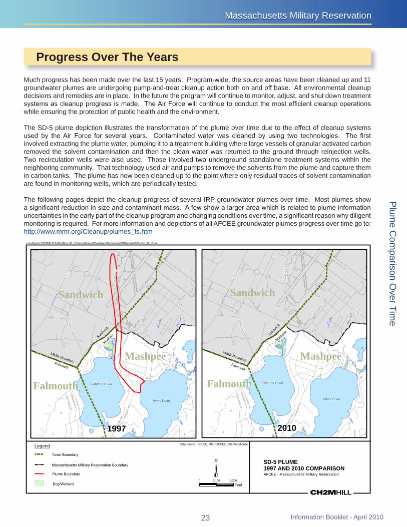
MMR Boundary Falmouth
Sandw
ich
Mashpe
e
Whe
eler
Rd
Reilly
Redlands
Rd
Br a
nsha
w S
t
Curr ier R
d
Sim
p kinsR
d
Hoo
ppol
eR
d
Club
Valley
Dr
Gen
eral
sBl
vd
MMR Boundary Falmouth
Sandw
ich
Mashpe
e
Whe
eler
Rd
Reilly
Redlands
Rd
Bra
nsha
w S
t
Currier R
d
Sim
p kinsR
d
Hoo
ppol
eR
d
Club
Val leyD
r
Gen
eral
sBl
vd
Massachusetts Military ReservationMassachusetts Military Reservation
Progress Over The Years
Much progress has been made over the last 15 years Program-wide the source areas have been cleaned up and 11 groundwater plumes are undergoing pump-and-treat cleanup action both on and off base All environmental cleanup decisions and remedies are in place In the future the program will continue to monitor adjust and shut down treatment systems as cleanup progress is made The Air Force will continue to conduct the most efficient cleanup operations while ensuring the protection of public health and the environment
The SD-5 plume depiction illustrates the transformation of the plume over time due to the effect of cleanup systems used by the Air Force for several years Contaminated water was cleaned by using two technologies The first involved extracting the plume water pumping it to a treatment building where large vessels of granular activated carbon removed the solvent contamination and then the clean water was returned to the ground through reinjection wells Two recirculation wells were also used Those involved two underground standalone treatment systems within the neighboring community That technology used air and pumps to remove the solvents from the plume and capture them in carbon tanks The plume has now been cleaned up to the point where only residual traces of solvent contamination are found in monitoring wells which are periodically tested
The following pages depict the cleanup progress of several IRP groundwater plumes over time Most plumes show a significant reduction in size and contaminant mass A few show a larger area which is related to plume information uncertainties in the early part of the cleanup program and changing conditions over time a significant reason why diligent monitoring is required For more information and depictions of all AFCEE groundwater plumes progress over time go to httpwwwmmrorgCleanupplumes_fshtm
Last Opened 3292010 115403 AM by SD YFiguresGeneralPlumeMapsComparison2010ArcMapSD5comp_97_10mxd
SandwichSandwich
Mashpee Mashpee
Ashumet PondAshumet PondFalmouth FalmouthJohns PondJohns Pond
1997 2010
Legend Data Source AFCEE MMR-AFCEE Data Warehouse
Town Boundary
Massachusetts Military Reservation Boundary SD-5 PLUME 1997 AND 2010 COMPARISON
Plume Boundary AFCEE - Massachusetts Military Reservation 0 1100 2200
BogWetland Feet
23 Information Booklet - April 2010
Plum
e Com
parison Over Tim
e
MMR Boundary Falmouth
Sandw
ich
Mashpe
e
Route 151
Kit tredge Rd
Connery Av
Whe
eler
Rd
Cole Rd
Le e Rd Hatc
hville
Rd
Herbert Rd
Reilly
Sam Turner R
d
Sandw
ich R
d
Herbert Rd
Connery Av
Route 151
MMR Boundary Falmouth
Sandw
ich
Mashpe
e
Route 151
Kittredge Rd
Connery Av
Whe
eler
Rd
Cole Rd
Le e Rd
Hatchv
ille R
d
Herbert Rd
Reilly
Sam Turner R
d
Sandw
ich R
d
Herber t Rd
Connery Av
Route 151
MMR Boundary
Falmouth
Sandw
ich
ashpe
e
Route 151
Cur
rier R
d
Whe
eler
Rd
Hayway Rd
Sam Turner R
d
Thomas B Landers Rd
Hatch
ville
Rd
Mi lf
or d
Rd Elai n Av
Sandw
ich
Rd
Meredith Dr
Redlands Rd
R eg is R
d
Jam
ie Ln
Hill a
nd Plain Rd
Old Barnstable R
d
Cloverfield Way Route 151
Sand
wich R
d
Route 151
MMR Boundary
Falmouth
Sandw
ich
ashpe
e
Route 151
Cur
rier R
d
Whe
eler
Rd
Sam Turner R
d
Thomas B Landers Rd
Hatchv
ille R
d
Mil f
ord
Rd Elain Av
Sandw
i ch
Rd
Meredith Dr
Redlands Rd
R eg is R
d
Jam
ie Ln
Hill a
nd Plain Rd
Old Barnsta
ble Rd
Cloverfield Way Route 151
Sand
wich R
d
Plu
me
Com
paris
on O
ver T
ime
Last Opened 3292010 110332 AM by SD YFiguresGeneralPlumeMapsComparison2010ArcMapCS10comp_97_10mxd
Snake Pond Snake Pond
BourneBourne
Sandwich Sandwich
MashpeeMashpee Falmouth Ashumet PondAshumet PondFalmouth Johns PondJohns Pond
Coonamessett Pond 2010Coonamessett Pond 1997 Legend
Massachusetts Military Reservation Boundary
BogWetland
Town Boundary
Plume Boundary (Dashed Where Inferred) Primary Contaminants Trichloroethene (TCE) Perchloroethene (PCE)
0 2300 4600
Feet
Data Source AFCEE MMR-AFCEE Data Warehouse
CS-10 PLUME 1997 AND 2010 COMPARISON AFCEE - Massachusetts Military Reservation
Last Opened 3292010 101508 AM by SD YFiguresGeneralPlumeMapsComparison2010ArcMapAVcomp_96_10mxd
Sandwich Sandwich MMashpee MMashpee
FalmouthFalmouth Ashumet Pond Ashumet Pond
Johns Pond Johns Pond
Coonamessett Pond Coonamessett Pond
Broad RiverBroad River
Jenkins Pond Jenkins Pond Pond 14 Pond 14 Fresh PondFresh Pond
20101996
Legend
Plume Boundary Primary Contaminants Trichloroethene (TCE) Perchloroethene (PCE)
Massachusetts Military Reservation Boundary
BogWetland
Town Boundary
0 2250 4500
Feet
Data Source AFCEE MMR-AFCEE Data Warehouse
ASHUMET VALLEY PLUME 1996 AND 2010 COMPARISON AFCEE - Massachusetts Military Reservation
Information Booklet - April 2010 24
Sandwich
MM
R Bo
unda
ry
MM
R
Sandwich Mashpee
Snake Pond Rd
Boun
dary
Dana
Rd
Arnol
d Rd
Pinecrest Dr
Artisan Way
Cha
dwic
k R
d
Jeannes Way
Gre
enw
ay R
d
Rout
e 13
0
Emerald Way
Week
s Po
nd D
r
Blac
kth rn Path
Green
way R
d
Greenway Rd
MM
R Bo
unda
ry
MM
R Bo
unda
ry Sandwich Mashpee
Greenway Rd
Dana
Rd
Arnol
d Rd
Pinecrest Dr
Artisan Way
Cha
dwic
k R
d
Jeannes Way
Emerald Way
Rout
e 13
0
Snake Pond Rd
Wee
ks P
ond
Dr
Blac
kth rn Path
Gre
enw
ay R
d
Greenw
ay R
d
MMR Boundary
Mas
hpee
Sand
wic
h
Route 130
Reilly
Great H
ay Rd
Love
lls L
n
Bear
ses
Rd
Sadd
leback Rd
Graf ton Pocknet Rd
Great Hay Rd
Mas
hpee
Sand
wic
h
MMR Boundary
Route 130
Love
ll s L
n
Rei
lly
Great H
ay Rd
Bear
ses
Rd
Lowell
Rd
Grafton P
ockne
t Rd
Echo Rd
Bookers Rd
Sadd
leback Rd
Quashnet Rd
Back Rd
Ashumet Rd
Bakers Rd
Easton S
t
Phi
nney
s Rd
Asher s P at h
Shorewood Dr
Great Hay Rd
Bear
ses
Rd
Rei
lly
Grea t H
ay Rd
Love
lls L
n
Grafton Pocknet Rd
Gre at H
ay Rd
Last Opened 3292010 113034 AM by SD YFiguresGeneralPlumeMapsComparison2010ArcMapFS12comp_97_10mxd
Snake Pond Snake Pondoo
Sandwich SandwichWeeks Pond Weeks Pond
1997 2010 Data Source AFCEE MMR-AFCEE Data WarehouseLegend
Town Boundary
FS-12 PLUMEMassachusetts Military Reservation Boundary 1997 AND 2010 COMPARISON AFCEE - Massachusetts Military ReservationPlume Boundary Primary Contaminants Benzene Ethylene Dibromide (EDB)
0 960 1920 BogWetland Feet
Last Opened 3292010 112823 AM by SD YFiguresGeneralPlumeMapsComparison2010ArcMapFS1comp_98_10mxd
aay
Rd
Gre
tH
Mashpee
Mashpee Pond Mashpee Pond
Mashpee
Johns PondJohns Pond
20101998
Legend Data Source AFCEE MMR-AFCEE Data Warehouse
Town Boundary
Massachusetts Military Reservation Boundary FS-1 PLUME 1998 AND 2010 COMPARISON
Plume Boundary (Dashed Where Inferred) Primary Contaminant Ethylene Dibromide (EDB)
0 1000 2000
AFCEE - Massachusetts Military Reservation
BogWetland Feet
25 Information Booklet - April 2010
Plum
e Com
parison Over Tim
e
MMR Bo
Sandw
ich
Mas
hpee San
dwich
Sandw
ich
Mashpe
e
Deep PondLittle Jenkins Pond
Sandw
ich
Coonamessett PondDeep PondLittle Jenkins Pond
undary
Falmouth
Sandwich
MMR Boundary
Route 151
mas B Landers Rd
Sam Turner R
d
Hatchv
il le R
d
Deer Pond Rd
Sandw
ich
Rd
Boxberry Hill Rd
Hill and Plain Rd
Old Barnstable R
d
Cloverfield Way
Blac
ksmith Shop Rd
Regis Rd
Route 151
Route 151
Sam Tu rner R
d
Route 151
Route 151
Sandw
ich R
d
MMR Boundary Falmouth
Sandwich
Route 151
mas B Landers Rd
Sam Tu rner R
d
Deer Pond Rd
Hatch
ville
Rd
Sandw
ich
Rd
Box
ber r
y H
il l R
d
Hill and Plain Rd
Old Barnstable R
d
Cloverfield Way
Blac
ksmith Shop Rd
Route 151
Route 151
Route 151
Sandw
ich R
d
Route 151
Sand
wich R
d
Boxberry Hill Rd
MMR Boundary
Falmouth
Bourne
Sand
wic
h
Route 151
Kittredge Rd
Cole Rd
Lee Rd
Sandwich R
d
Boxberry Hill Rd
Route 151
Route 151
MMR Boundary
Falmouth
Bourne
Sand
wic
h
Route 151
Kittredge Rd
Cole Rd
Lee Rd
Sa
ndwich
Rd
Boxberry Hill Rd
Route 151
Route 151
Last Opened 3292010 113441 AM by SD YFiguresGeneralPlumeMapsComparison2010ArcMapFS28comp_98_10mxdP
lum
e C
ompa
rison
Ove
r Tim
e
Coonamessett PondCoonamessett Pond
Falmouth FalmouthThoTho Broad River
Broad River
Jenkins PondJenkins Pond Pond 14Pond 14 20101998
Data Source AFCEE MMR-AFCEE Data WarehouseLegend
Town Boundary
FS-28 PLUME Massachusetts Military Reservation Boundary 1998 AND 2010 COMPARISON Plume Boundary (Dashed Where Inferred) AFCEE - Massachusetts Military Reservation Primary Contaminant Ethylene Dibromide (EDB)
0 1700 3400
BogWetland Feet
Last Opened 3292010 101742 AM by SD YFiguresGeneralPlumeMapsComparison2010ArcMapCS4comp_96_10mxd
Bourne Bourne Osborn Pond Osborn Pond
Edmunds Pond Edmunds Pond
Spit Pond Spit Pond
SandwichSandwich
FalmouthFalmouth
1996 2010 Data Source AFCEE MMR-AFCEE Data WarehouseLegend
Town Boundary
CS-4 PLUME 1996 AND 2010 COMPARISON
Massachusetts Military Reservation Boundary
Plume Boundary Primary Contaminants Trichloroethene (TCE) Perchloroethene (PCE) AFCEE - Massachusetts Military Reservation
0 1400 2800BogWetland Feet
Information Booklet - April 2010 26
Little Jenkins Pond Little Jenkins Pond
MMR Boundary
Falmouth
Bourne
Sand
wic
h
Route 151
Rou
te 2
8
Sam Turner Rd
Rou
te 2
8
MMR Boundary
Falmouth
Bourne
Sand
wic
h
Route 151
Rou
te 2
8
Sam Turner Rd
Rou
te 2
8
Falmouth
Bourne
Sand
wic
h
MMR Boundary
Rou
te 2
8
Route 151
Rou
te 2
8
Sand
wic
h
Falmouth
Bourne
MMR Boundary
Rou
te 2
8
Route 151
Rou
te 2
8
Last Opened 3292010 111229 AM by SD YFiguresGeneralPlumeMapsComparison2010ArcMapCS21comp_99_10mxd
Osborn Pond Osborn Pond
Bourne Bourne Edmunds Pond Edmunds Pond
Spit Pond Spit Pond
Sandwich Sandwich
Falmouth Falmouth
Deep Pond Deep Pond Coonamessett Pond Coonamessett Pond
1999 2010 Round Pond Round Pond Crooked Pond Crooked Pond
Legend Data Source AFCEE MMR-AFCEE Data Warehouse
Town Boundary
Massachusetts Military Reservation Boundary CS-21 PLUME 1999 AND 2010 COMPARISON
Plume Boundary Primary Contaminant Trichloroethene (TCE) AFCEE - Massachusetts Military Reservation
BogWetland 0 1400 2800
Feet
Last Opened 3292010 112004 AM by SD YFiguresGeneralPlumeMapsComparison2010ArcMapCS23comp_02_10mxd
Osborn Pond Osborn Pond
Bourne Bourne Edmunds Pond Edmunds Pond
Spit Pond Spit Pond
Falmouth Falmouth
2010 2002 Data Source AFCEE MMR-AFCEE Data Warehouse Legend
Town Boundary
CS-23 PLUME 2002 AND 2010 COMPARISON
Massachusetts Military Reservation Boundary
Plume Boundary (Dashed Where Inferred) Primary Contaminants AFCEE - Massachusetts Military Reservation Trichloroethene (TCE) Carbon Tetrachloride (CCl4)
0 1000 2000 BogWetland Feet
27 Information Booklet - April 2010
Plum
e Com
parison Over Tim
e
Deep Pond Little Jenkins PondLittle Jenkins Pond
Sandw
ich
Bourne Osborn PondBourne
Osborn Pond
MMR Boundary
Falmouth
Bourne
Sand
wic
h
Rou
te 2
8
Co le R
d
Route 151
Kittredge Rd
Conne ry Av
Le e Rd
Herbert Rd
Shor
e R
oute
Boxberry Hill Rd
Rou
te 2
8
Cole Rd Rou
te 2
8
Rout
e 28
Route 151
Rou
te 2
8
Rout
e 28
Route 151
Connery Av
MMR Boundary
Falmouth
Bourne
Sand
wic
h
Rou
te 2
8
Cole R
d
Route 151
Kittredge Rd
Connery Av
Le e Rd
Herbert Rd
Shor
e Ro
ute
Boxberry Hill Rd
Rou
te 2
8
Rou
te 2
8
Rout
e 28
Route 151
Rou
te 2
8
Rout
e 28
Connery Av
MMR Boundary
Falmouth
Bourne
Sand
wic
h
Route 151
Kittredge Rd
Cole Rd
Sam
Turner Rd
Hatchv
ille R
d
Boxberry Hill Rd
Sand
wich R
d
Hill
and Plain Rd
Hay
way
Rd
Route 151
Route 151
MMR Boundary
Falmouth
Bourne
Sand
wic
h
Route 151
Kittredge Rd
Cole Rd
Sam
Turner Rd
Hatch
ville
Rd
Hill
and Plain Rd
Sandw
ich R
d
Hay
way
Rd
Route 151
Route 151
Plu
me
Com
paris
on O
ver T
ime
Last Opened 3292010 115107 AM by SD YFiguresGeneralPlumeMapsComparison2010ArcMapLF1comp_97_10mxd
BourneBourne
Osborn Pond Osborn Pond
Edmunds Pond Edmunds Pond Spit Pond Spit Pond
Sandwich Sandwich
Falmouth Falmouth
20101997
Data Source AFCEE MMR-AFCEE Data WarehouseLegend
Town Boundary
LF-1 PLUME 1997 AND 2010 COMPARISON
Massachusetts Military Reservation Boundary
Plume Boundary (Dashed Where Inferred) Primary Contaminants Carbon Tetrachloride (CCl4) Perchloroethene (PCE) Tetrachloroethene (TCE) AFCEE - Massachusetts Military Reservation
BogWetland 0 2000 4000
Feet
Last Opened 3292010 110911 AM by SD YFiguresGeneralPlumeMapsComparison2010ArcMapCS20comp_99_10mxd
Bourne BourneEdmunds Pond Edmunds Pond
Spit Pond Spit Pond
SandwichSandwich
FalmouthFalmouth
Little Jenkins Pond Little Jenkins Pond Deep Pond Deep Pond Coonamessett PondCoonamessett Pond
Round Pond Round PondCrooked Pond Crooked Pond
1999 2010
Legend
Plume Boundary Primary Contaminant Perchloroethene (PCE)
Massachusetts Military Reservation Boundary
BogWetland
Town Boundary
0 1400 2800
Feet
Data Source AFCEE MMR-AFCEE Data Warehouse
CS-20 PLUME 1999 AND 2010 COMPARISON AFCEE - Massachusetts Military Reservation
Information Booklet - April 2010 28
Massachusetts Military ReservationMassachusetts Military Reservation
Information Booklet - April 2010
AFCEErsquos aggressive optimization activities have resulted in a more sustainable remediation program at MMR Our ldquobetter cheaper fasterrdquo approach is intended to expedite aquifer restoration and cleanup timeframes while reducing costs to the taxpayers and minimizing our carbon footprint Optimization activities conducted by AFCEE at MMR include
Demonstrating alternative in situ technologies such as a passive zero-valent iron barrier This barrier requiresbullno OampM and was installed along the Ashumet Pond shoreline to help reduce phosphorus discharging into the surface water
Continuously adjusting groundwater remediation systems as the groundwater plumes change over time Forbullexample extraction wells are taken out of operation once the portion of the aquifer is cleaned up In some cases extraction wells are added if deemed necessary to expedite aquifer restoration and eliminate risks to human health and the environment In other cases flow rates at extraction wells are modified as needed andor systems are pulse-pumped and packers are installed in extraction wells to focus extraction stress on changing contaminant distribution In one case a reinjection well was converted to an extraction well when contamination was detected unexpectedly in monitoring wells outside of the delineated plume area
Installing variable frequency drives (VFDs) on extraction well pumpbullmotors to save energy and reduce wear and tear on pumpmotor assemblies In the absence of VFDs extraction well pumps and motors are changed out by our well maintenance staff to appropriately size the pumps and motors to optimized flow rates at extraction wells resulting in a reduction in unnecessary energy use In addition energy saving premium efficiency motors have been installed on booster and transfer pumps in treatment plants
Adjusting the number of monitoring locations frequency of samplingbulland analytes in the monitoring program as the remediation requirements are refined Passive sampling techniques such as passive diffusion bags and Hydrasleevesreg are used to the maximum extent possible to save time reduce costs and reduce impacts to the environment as compared to conventional pumped sampling
Passive sampling technique
Zero-valent iron barrier along Ashumet Pond shorelineIn situ chemical oxidation operation
Information Booklet - April 201029
Sustainable Remediation at the Massachusetts Military Reservation
Air Force Center for Engineering and the EnvironmentAir Force Center for Engineering and the Environment
Recycling granular activated carbon which is used in thebulltreatment systems to remove the contaminants from the groundwater through a process called reactivation Our used carbon is removed from the vessels reactivated off site and returned to MMR for reuse
Providing treated water for beneficial reuse such as irrigatingbullthe Veterans Affairs cemetery and as a geothermal source for heating ventilating and air conditioning systems
Pilot-testing new technologies such as ozone and hydrogenbulltreatment of plant influent water to determine if they can be used effectively to pretreat the water and extend the life of the carbon beds andor reduce operating costs
Evaluating various types of carbon to determine if a morebullefficient product is available
Employing energy conservation measures such as efficientbulllighting occupancy sensors and programmable thermostats in treatment plants and administrative buildings and recycling products such as paper tubing batteries and light bulbs to the maximum extent possible
Using biodiesel fuel and vegetable-based hydraulic oil to thebullmaximum extent possible in our diesel powered equipment
Employing low impact direct-push technology to collectbullgroundwater samples instead of using augersonic well drilling when viable AFCEE owns and operates a direct-push rig that is track mounted has a smaller footprint uses environmentally sensitive biofuels and is responsive Not only is this method of drilling more sustainable than other methods it is also less expensive since the work is done by site staff AFCEEMMR holds the record depth achieved by direct-push drilling technology - 319 feet below ground surface
Optimizing power purchase agreements for additional costbullsavings purchasing green energy and participating in the New England energy demand response program
Accounting for costs efficiency and environmental impactbullof our program decisions These activities are tracked and reported in quarterly optimization reports These reports are available on the wwwmmrorg website
Information Booklet - April 2010 30
Low impact direct-push unit
Irrigation at the VA cemetery
Sustainable Remediation at the Massachusetts Military Reservation
Massachusetts Military ReservationMassachusetts Military Reservation
Information Booklet - April 2010
A major optimization effort completed last year was the installation of renewable energy in the form of a 15 MW Fuhrlaender wind turbine The wind turbine started operating on December 2 2009 and is expected to reduce AFCEErsquos annual $2 million electric cost by 25 to 30 The wind turbine is also anticipated to offset air emissions generated indirectly through the use of electricity from fossil fuel based power plants by approximately 25 to 30 Based on a range of utility cost projections and an estimate of the turbinersquos energy production the $46 million wind turbine is anticipated to have a payback period between six and eight years
31
Renewable Energy Wind Turbine
Attendees at the AFCEE wind turbine dedication ceremony at the MMR on Nov 2 2009 Left top to bottom Mr Joe Orciuch Environmental Chemical Corporation Project Manager Mr Bill Delahunt US Congressman 10th Congressional District of Massachusetts Mr Ira W Leighton Acting Regional Administrator US Environmental Protection Agency - New England and Mr Ian Bowles Secretary Executive Office of Energy and Environmental Affairs - Massachusetts Right top to bottom Ms Rose Forbes AFCEE Project Manager Major General Joseph C Carter Adjutant General of Massachusetts Mr Tad D Davis IV Deputy Assistant Secretary of the Army for Environment Safety and Occupational Health and Mr Mike McGhee Acting Deputy Assistant Secretary of the Air Force for Energy Environment Safety and Occupational Health
Massachusetts Department of Environmental Protection
Ellie Grillo Phone (508) 946-2866 E-mail elliegrillostatemaus
US Environmental Protection Agency Jeanethe Falvey Phone (617) 918-1020 E-mail falveyjeanetheepagov
Air Force Center for Engineering and the Environment
Doug Karson Phone (508) 968-4678 ext 2 E-mail douglaskarsonusafmil
Restoring our
For more information wwwmmrorg
Impact Area Groundwater Study Program Pamela J Richardson Phone (508) 968-5630
E-mail pamelajrichardsonusarmymil
sole-source aquiferfor future generations
Printed on 20 Post-Consumer Fiber

MMR Boundary Falmouth
Sandw
ich
Mashpe
e
Route 151
Kit tredge Rd
Connery Av
Whe
eler
Rd
Cole Rd
Le e Rd Hatc
hville
Rd
Herbert Rd
Reilly
Sam Turner R
d
Sandw
ich R
d
Herbert Rd
Connery Av
Route 151
MMR Boundary Falmouth
Sandw
ich
Mashpe
e
Route 151
Kittredge Rd
Connery Av
Whe
eler
Rd
Cole Rd
Le e Rd
Hatchv
ille R
d
Herbert Rd
Reilly
Sam Turner R
d
Sandw
ich R
d
Herber t Rd
Connery Av
Route 151
MMR Boundary
Falmouth
Sandw
ich
ashpe
e
Route 151
Cur
rier R
d
Whe
eler
Rd
Hayway Rd
Sam Turner R
d
Thomas B Landers Rd
Hatch
ville
Rd
Mi lf
or d
Rd Elai n Av
Sandw
ich
Rd
Meredith Dr
Redlands Rd
R eg is R
d
Jam
ie Ln
Hill a
nd Plain Rd
Old Barnstable R
d
Cloverfield Way Route 151
Sand
wich R
d
Route 151
MMR Boundary
Falmouth
Sandw
ich
ashpe
e
Route 151
Cur
rier R
d
Whe
eler
Rd
Sam Turner R
d
Thomas B Landers Rd
Hatchv
ille R
d
Mil f
ord
Rd Elain Av
Sandw
i ch
Rd
Meredith Dr
Redlands Rd
R eg is R
d
Jam
ie Ln
Hill a
nd Plain Rd
Old Barnsta
ble Rd
Cloverfield Way Route 151
Sand
wich R
d
Plu
me
Com
paris
on O
ver T
ime
Last Opened 3292010 110332 AM by SD YFiguresGeneralPlumeMapsComparison2010ArcMapCS10comp_97_10mxd
Snake Pond Snake Pond
BourneBourne
Sandwich Sandwich
MashpeeMashpee Falmouth Ashumet PondAshumet PondFalmouth Johns PondJohns Pond
Coonamessett Pond 2010Coonamessett Pond 1997 Legend
Massachusetts Military Reservation Boundary
BogWetland
Town Boundary
Plume Boundary (Dashed Where Inferred) Primary Contaminants Trichloroethene (TCE) Perchloroethene (PCE)
0 2300 4600
Feet
Data Source AFCEE MMR-AFCEE Data Warehouse
CS-10 PLUME 1997 AND 2010 COMPARISON AFCEE - Massachusetts Military Reservation
Last Opened 3292010 101508 AM by SD YFiguresGeneralPlumeMapsComparison2010ArcMapAVcomp_96_10mxd
Sandwich Sandwich MMashpee MMashpee
FalmouthFalmouth Ashumet Pond Ashumet Pond
Johns Pond Johns Pond
Coonamessett Pond Coonamessett Pond
Broad RiverBroad River
Jenkins Pond Jenkins Pond Pond 14 Pond 14 Fresh PondFresh Pond
20101996
Legend
Plume Boundary Primary Contaminants Trichloroethene (TCE) Perchloroethene (PCE)
Massachusetts Military Reservation Boundary
BogWetland
Town Boundary
0 2250 4500
Feet
Data Source AFCEE MMR-AFCEE Data Warehouse
ASHUMET VALLEY PLUME 1996 AND 2010 COMPARISON AFCEE - Massachusetts Military Reservation
Information Booklet - April 2010 24
Sandwich
MM
R Bo
unda
ry
MM
R
Sandwich Mashpee
Snake Pond Rd
Boun
dary
Dana
Rd
Arnol
d Rd
Pinecrest Dr
Artisan Way
Cha
dwic
k R
d
Jeannes Way
Gre
enw
ay R
d
Rout
e 13
0
Emerald Way
Week
s Po
nd D
r
Blac
kth rn Path
Green
way R
d
Greenway Rd
MM
R Bo
unda
ry
MM
R Bo
unda
ry Sandwich Mashpee
Greenway Rd
Dana
Rd
Arnol
d Rd
Pinecrest Dr
Artisan Way
Cha
dwic
k R
d
Jeannes Way
Emerald Way
Rout
e 13
0
Snake Pond Rd
Wee
ks P
ond
Dr
Blac
kth rn Path
Gre
enw
ay R
d
Greenw
ay R
d
MMR Boundary
Mas
hpee
Sand
wic
h
Route 130
Reilly
Great H
ay Rd
Love
lls L
n
Bear
ses
Rd
Sadd
leback Rd
Graf ton Pocknet Rd
Great Hay Rd
Mas
hpee
Sand
wic
h
MMR Boundary
Route 130
Love
ll s L
n
Rei
lly
Great H
ay Rd
Bear
ses
Rd
Lowell
Rd
Grafton P
ockne
t Rd
Echo Rd
Bookers Rd
Sadd
leback Rd
Quashnet Rd
Back Rd
Ashumet Rd
Bakers Rd
Easton S
t
Phi
nney
s Rd
Asher s P at h
Shorewood Dr
Great Hay Rd
Bear
ses
Rd
Rei
lly
Grea t H
ay Rd
Love
lls L
n
Grafton Pocknet Rd
Gre at H
ay Rd
Last Opened 3292010 113034 AM by SD YFiguresGeneralPlumeMapsComparison2010ArcMapFS12comp_97_10mxd
Snake Pond Snake Pondoo
Sandwich SandwichWeeks Pond Weeks Pond
1997 2010 Data Source AFCEE MMR-AFCEE Data WarehouseLegend
Town Boundary
FS-12 PLUMEMassachusetts Military Reservation Boundary 1997 AND 2010 COMPARISON AFCEE - Massachusetts Military ReservationPlume Boundary Primary Contaminants Benzene Ethylene Dibromide (EDB)
0 960 1920 BogWetland Feet
Last Opened 3292010 112823 AM by SD YFiguresGeneralPlumeMapsComparison2010ArcMapFS1comp_98_10mxd
aay
Rd
Gre
tH
Mashpee
Mashpee Pond Mashpee Pond
Mashpee
Johns PondJohns Pond
20101998
Legend Data Source AFCEE MMR-AFCEE Data Warehouse
Town Boundary
Massachusetts Military Reservation Boundary FS-1 PLUME 1998 AND 2010 COMPARISON
Plume Boundary (Dashed Where Inferred) Primary Contaminant Ethylene Dibromide (EDB)
0 1000 2000
AFCEE - Massachusetts Military Reservation
BogWetland Feet
25 Information Booklet - April 2010
Plum
e Com
parison Over Tim
e
MMR Bo
Sandw
ich
Mas
hpee San
dwich
Sandw
ich
Mashpe
e
Deep PondLittle Jenkins Pond
Sandw
ich
Coonamessett PondDeep PondLittle Jenkins Pond
undary
Falmouth
Sandwich
MMR Boundary
Route 151
mas B Landers Rd
Sam Turner R
d
Hatchv
il le R
d
Deer Pond Rd
Sandw
ich
Rd
Boxberry Hill Rd
Hill and Plain Rd
Old Barnstable R
d
Cloverfield Way
Blac
ksmith Shop Rd
Regis Rd
Route 151
Route 151
Sam Tu rner R
d
Route 151
Route 151
Sandw
ich R
d
MMR Boundary Falmouth
Sandwich
Route 151
mas B Landers Rd
Sam Tu rner R
d
Deer Pond Rd
Hatch
ville
Rd
Sandw
ich
Rd
Box
ber r
y H
il l R
d
Hill and Plain Rd
Old Barnstable R
d
Cloverfield Way
Blac
ksmith Shop Rd
Route 151
Route 151
Route 151
Sandw
ich R
d
Route 151
Sand
wich R
d
Boxberry Hill Rd
MMR Boundary
Falmouth
Bourne
Sand
wic
h
Route 151
Kittredge Rd
Cole Rd
Lee Rd
Sandwich R
d
Boxberry Hill Rd
Route 151
Route 151
MMR Boundary
Falmouth
Bourne
Sand
wic
h
Route 151
Kittredge Rd
Cole Rd
Lee Rd
Sa
ndwich
Rd
Boxberry Hill Rd
Route 151
Route 151
Last Opened 3292010 113441 AM by SD YFiguresGeneralPlumeMapsComparison2010ArcMapFS28comp_98_10mxdP
lum
e C
ompa
rison
Ove
r Tim
e
Coonamessett PondCoonamessett Pond
Falmouth FalmouthThoTho Broad River
Broad River
Jenkins PondJenkins Pond Pond 14Pond 14 20101998
Data Source AFCEE MMR-AFCEE Data WarehouseLegend
Town Boundary
FS-28 PLUME Massachusetts Military Reservation Boundary 1998 AND 2010 COMPARISON Plume Boundary (Dashed Where Inferred) AFCEE - Massachusetts Military Reservation Primary Contaminant Ethylene Dibromide (EDB)
0 1700 3400
BogWetland Feet
Last Opened 3292010 101742 AM by SD YFiguresGeneralPlumeMapsComparison2010ArcMapCS4comp_96_10mxd
Bourne Bourne Osborn Pond Osborn Pond
Edmunds Pond Edmunds Pond
Spit Pond Spit Pond
SandwichSandwich
FalmouthFalmouth
1996 2010 Data Source AFCEE MMR-AFCEE Data WarehouseLegend
Town Boundary
CS-4 PLUME 1996 AND 2010 COMPARISON
Massachusetts Military Reservation Boundary
Plume Boundary Primary Contaminants Trichloroethene (TCE) Perchloroethene (PCE) AFCEE - Massachusetts Military Reservation
0 1400 2800BogWetland Feet
Information Booklet - April 2010 26
Little Jenkins Pond Little Jenkins Pond
MMR Boundary
Falmouth
Bourne
Sand
wic
h
Route 151
Rou
te 2
8
Sam Turner Rd
Rou
te 2
8
MMR Boundary
Falmouth
Bourne
Sand
wic
h
Route 151
Rou
te 2
8
Sam Turner Rd
Rou
te 2
8
Falmouth
Bourne
Sand
wic
h
MMR Boundary
Rou
te 2
8
Route 151
Rou
te 2
8
Sand
wic
h
Falmouth
Bourne
MMR Boundary
Rou
te 2
8
Route 151
Rou
te 2
8
Last Opened 3292010 111229 AM by SD YFiguresGeneralPlumeMapsComparison2010ArcMapCS21comp_99_10mxd
Osborn Pond Osborn Pond
Bourne Bourne Edmunds Pond Edmunds Pond
Spit Pond Spit Pond
Sandwich Sandwich
Falmouth Falmouth
Deep Pond Deep Pond Coonamessett Pond Coonamessett Pond
1999 2010 Round Pond Round Pond Crooked Pond Crooked Pond
Legend Data Source AFCEE MMR-AFCEE Data Warehouse
Town Boundary
Massachusetts Military Reservation Boundary CS-21 PLUME 1999 AND 2010 COMPARISON
Plume Boundary Primary Contaminant Trichloroethene (TCE) AFCEE - Massachusetts Military Reservation
BogWetland 0 1400 2800
Feet
Last Opened 3292010 112004 AM by SD YFiguresGeneralPlumeMapsComparison2010ArcMapCS23comp_02_10mxd
Osborn Pond Osborn Pond
Bourne Bourne Edmunds Pond Edmunds Pond
Spit Pond Spit Pond
Falmouth Falmouth
2010 2002 Data Source AFCEE MMR-AFCEE Data Warehouse Legend
Town Boundary
CS-23 PLUME 2002 AND 2010 COMPARISON
Massachusetts Military Reservation Boundary
Plume Boundary (Dashed Where Inferred) Primary Contaminants AFCEE - Massachusetts Military Reservation Trichloroethene (TCE) Carbon Tetrachloride (CCl4)
0 1000 2000 BogWetland Feet
27 Information Booklet - April 2010
Plum
e Com
parison Over Tim
e
Deep Pond Little Jenkins PondLittle Jenkins Pond
Sandw
ich
Bourne Osborn PondBourne
Osborn Pond
MMR Boundary
Falmouth
Bourne
Sand
wic
h
Rou
te 2
8
Co le R
d
Route 151
Kittredge Rd
Conne ry Av
Le e Rd
Herbert Rd
Shor
e R
oute
Boxberry Hill Rd
Rou
te 2
8
Cole Rd Rou
te 2
8
Rout
e 28
Route 151
Rou
te 2
8
Rout
e 28
Route 151
Connery Av
MMR Boundary
Falmouth
Bourne
Sand
wic
h
Rou
te 2
8
Cole R
d
Route 151
Kittredge Rd
Connery Av
Le e Rd
Herbert Rd
Shor
e Ro
ute
Boxberry Hill Rd
Rou
te 2
8
Rou
te 2
8
Rout
e 28
Route 151
Rou
te 2
8
Rout
e 28
Connery Av
MMR Boundary
Falmouth
Bourne
Sand
wic
h
Route 151
Kittredge Rd
Cole Rd
Sam
Turner Rd
Hatchv
ille R
d
Boxberry Hill Rd
Sand
wich R
d
Hill
and Plain Rd
Hay
way
Rd
Route 151
Route 151
MMR Boundary
Falmouth
Bourne
Sand
wic
h
Route 151
Kittredge Rd
Cole Rd
Sam
Turner Rd
Hatch
ville
Rd
Hill
and Plain Rd
Sandw
ich R
d
Hay
way
Rd
Route 151
Route 151
Plu
me
Com
paris
on O
ver T
ime
Last Opened 3292010 115107 AM by SD YFiguresGeneralPlumeMapsComparison2010ArcMapLF1comp_97_10mxd
BourneBourne
Osborn Pond Osborn Pond
Edmunds Pond Edmunds Pond Spit Pond Spit Pond
Sandwich Sandwich
Falmouth Falmouth
20101997
Data Source AFCEE MMR-AFCEE Data WarehouseLegend
Town Boundary
LF-1 PLUME 1997 AND 2010 COMPARISON
Massachusetts Military Reservation Boundary
Plume Boundary (Dashed Where Inferred) Primary Contaminants Carbon Tetrachloride (CCl4) Perchloroethene (PCE) Tetrachloroethene (TCE) AFCEE - Massachusetts Military Reservation
BogWetland 0 2000 4000
Feet
Last Opened 3292010 110911 AM by SD YFiguresGeneralPlumeMapsComparison2010ArcMapCS20comp_99_10mxd
Bourne BourneEdmunds Pond Edmunds Pond
Spit Pond Spit Pond
SandwichSandwich
FalmouthFalmouth
Little Jenkins Pond Little Jenkins Pond Deep Pond Deep Pond Coonamessett PondCoonamessett Pond
Round Pond Round PondCrooked Pond Crooked Pond
1999 2010
Legend
Plume Boundary Primary Contaminant Perchloroethene (PCE)
Massachusetts Military Reservation Boundary
BogWetland
Town Boundary
0 1400 2800
Feet
Data Source AFCEE MMR-AFCEE Data Warehouse
CS-20 PLUME 1999 AND 2010 COMPARISON AFCEE - Massachusetts Military Reservation
Information Booklet - April 2010 28
Massachusetts Military ReservationMassachusetts Military Reservation
Information Booklet - April 2010
AFCEErsquos aggressive optimization activities have resulted in a more sustainable remediation program at MMR Our ldquobetter cheaper fasterrdquo approach is intended to expedite aquifer restoration and cleanup timeframes while reducing costs to the taxpayers and minimizing our carbon footprint Optimization activities conducted by AFCEE at MMR include
Demonstrating alternative in situ technologies such as a passive zero-valent iron barrier This barrier requiresbullno OampM and was installed along the Ashumet Pond shoreline to help reduce phosphorus discharging into the surface water
Continuously adjusting groundwater remediation systems as the groundwater plumes change over time Forbullexample extraction wells are taken out of operation once the portion of the aquifer is cleaned up In some cases extraction wells are added if deemed necessary to expedite aquifer restoration and eliminate risks to human health and the environment In other cases flow rates at extraction wells are modified as needed andor systems are pulse-pumped and packers are installed in extraction wells to focus extraction stress on changing contaminant distribution In one case a reinjection well was converted to an extraction well when contamination was detected unexpectedly in monitoring wells outside of the delineated plume area
Installing variable frequency drives (VFDs) on extraction well pumpbullmotors to save energy and reduce wear and tear on pumpmotor assemblies In the absence of VFDs extraction well pumps and motors are changed out by our well maintenance staff to appropriately size the pumps and motors to optimized flow rates at extraction wells resulting in a reduction in unnecessary energy use In addition energy saving premium efficiency motors have been installed on booster and transfer pumps in treatment plants
Adjusting the number of monitoring locations frequency of samplingbulland analytes in the monitoring program as the remediation requirements are refined Passive sampling techniques such as passive diffusion bags and Hydrasleevesreg are used to the maximum extent possible to save time reduce costs and reduce impacts to the environment as compared to conventional pumped sampling
Passive sampling technique
Zero-valent iron barrier along Ashumet Pond shorelineIn situ chemical oxidation operation
Information Booklet - April 201029
Sustainable Remediation at the Massachusetts Military Reservation
Air Force Center for Engineering and the EnvironmentAir Force Center for Engineering and the Environment
Recycling granular activated carbon which is used in thebulltreatment systems to remove the contaminants from the groundwater through a process called reactivation Our used carbon is removed from the vessels reactivated off site and returned to MMR for reuse
Providing treated water for beneficial reuse such as irrigatingbullthe Veterans Affairs cemetery and as a geothermal source for heating ventilating and air conditioning systems
Pilot-testing new technologies such as ozone and hydrogenbulltreatment of plant influent water to determine if they can be used effectively to pretreat the water and extend the life of the carbon beds andor reduce operating costs
Evaluating various types of carbon to determine if a morebullefficient product is available
Employing energy conservation measures such as efficientbulllighting occupancy sensors and programmable thermostats in treatment plants and administrative buildings and recycling products such as paper tubing batteries and light bulbs to the maximum extent possible
Using biodiesel fuel and vegetable-based hydraulic oil to thebullmaximum extent possible in our diesel powered equipment
Employing low impact direct-push technology to collectbullgroundwater samples instead of using augersonic well drilling when viable AFCEE owns and operates a direct-push rig that is track mounted has a smaller footprint uses environmentally sensitive biofuels and is responsive Not only is this method of drilling more sustainable than other methods it is also less expensive since the work is done by site staff AFCEEMMR holds the record depth achieved by direct-push drilling technology - 319 feet below ground surface
Optimizing power purchase agreements for additional costbullsavings purchasing green energy and participating in the New England energy demand response program
Accounting for costs efficiency and environmental impactbullof our program decisions These activities are tracked and reported in quarterly optimization reports These reports are available on the wwwmmrorg website
Information Booklet - April 2010 30
Low impact direct-push unit
Irrigation at the VA cemetery
Sustainable Remediation at the Massachusetts Military Reservation
Massachusetts Military ReservationMassachusetts Military Reservation
Information Booklet - April 2010
A major optimization effort completed last year was the installation of renewable energy in the form of a 15 MW Fuhrlaender wind turbine The wind turbine started operating on December 2 2009 and is expected to reduce AFCEErsquos annual $2 million electric cost by 25 to 30 The wind turbine is also anticipated to offset air emissions generated indirectly through the use of electricity from fossil fuel based power plants by approximately 25 to 30 Based on a range of utility cost projections and an estimate of the turbinersquos energy production the $46 million wind turbine is anticipated to have a payback period between six and eight years
31
Renewable Energy Wind Turbine
Attendees at the AFCEE wind turbine dedication ceremony at the MMR on Nov 2 2009 Left top to bottom Mr Joe Orciuch Environmental Chemical Corporation Project Manager Mr Bill Delahunt US Congressman 10th Congressional District of Massachusetts Mr Ira W Leighton Acting Regional Administrator US Environmental Protection Agency - New England and Mr Ian Bowles Secretary Executive Office of Energy and Environmental Affairs - Massachusetts Right top to bottom Ms Rose Forbes AFCEE Project Manager Major General Joseph C Carter Adjutant General of Massachusetts Mr Tad D Davis IV Deputy Assistant Secretary of the Army for Environment Safety and Occupational Health and Mr Mike McGhee Acting Deputy Assistant Secretary of the Air Force for Energy Environment Safety and Occupational Health
Massachusetts Department of Environmental Protection
Ellie Grillo Phone (508) 946-2866 E-mail elliegrillostatemaus
US Environmental Protection Agency Jeanethe Falvey Phone (617) 918-1020 E-mail falveyjeanetheepagov
Air Force Center for Engineering and the Environment
Doug Karson Phone (508) 968-4678 ext 2 E-mail douglaskarsonusafmil
Restoring our
For more information wwwmmrorg
Impact Area Groundwater Study Program Pamela J Richardson Phone (508) 968-5630
E-mail pamelajrichardsonusarmymil
sole-source aquiferfor future generations
Printed on 20 Post-Consumer Fiber

Sandwich
MM
R Bo
unda
ry
MM
R
Sandwich Mashpee
Snake Pond Rd
Boun
dary
Dana
Rd
Arnol
d Rd
Pinecrest Dr
Artisan Way
Cha
dwic
k R
d
Jeannes Way
Gre
enw
ay R
d
Rout
e 13
0
Emerald Way
Week
s Po
nd D
r
Blac
kth rn Path
Green
way R
d
Greenway Rd
MM
R Bo
unda
ry
MM
R Bo
unda
ry Sandwich Mashpee
Greenway Rd
Dana
Rd
Arnol
d Rd
Pinecrest Dr
Artisan Way
Cha
dwic
k R
d
Jeannes Way
Emerald Way
Rout
e 13
0
Snake Pond Rd
Wee
ks P
ond
Dr
Blac
kth rn Path
Gre
enw
ay R
d
Greenw
ay R
d
MMR Boundary
Mas
hpee
Sand
wic
h
Route 130
Reilly
Great H
ay Rd
Love
lls L
n
Bear
ses
Rd
Sadd
leback Rd
Graf ton Pocknet Rd
Great Hay Rd
Mas
hpee
Sand
wic
h
MMR Boundary
Route 130
Love
ll s L
n
Rei
lly
Great H
ay Rd
Bear
ses
Rd
Lowell
Rd
Grafton P
ockne
t Rd
Echo Rd
Bookers Rd
Sadd
leback Rd
Quashnet Rd
Back Rd
Ashumet Rd
Bakers Rd
Easton S
t
Phi
nney
s Rd
Asher s P at h
Shorewood Dr
Great Hay Rd
Bear
ses
Rd
Rei
lly
Grea t H
ay Rd
Love
lls L
n
Grafton Pocknet Rd
Gre at H
ay Rd
Last Opened 3292010 113034 AM by SD YFiguresGeneralPlumeMapsComparison2010ArcMapFS12comp_97_10mxd
Snake Pond Snake Pondoo
Sandwich SandwichWeeks Pond Weeks Pond
1997 2010 Data Source AFCEE MMR-AFCEE Data WarehouseLegend
Town Boundary
FS-12 PLUMEMassachusetts Military Reservation Boundary 1997 AND 2010 COMPARISON AFCEE - Massachusetts Military ReservationPlume Boundary Primary Contaminants Benzene Ethylene Dibromide (EDB)
0 960 1920 BogWetland Feet
Last Opened 3292010 112823 AM by SD YFiguresGeneralPlumeMapsComparison2010ArcMapFS1comp_98_10mxd
aay
Rd
Gre
tH
Mashpee
Mashpee Pond Mashpee Pond
Mashpee
Johns PondJohns Pond
20101998
Legend Data Source AFCEE MMR-AFCEE Data Warehouse
Town Boundary
Massachusetts Military Reservation Boundary FS-1 PLUME 1998 AND 2010 COMPARISON
Plume Boundary (Dashed Where Inferred) Primary Contaminant Ethylene Dibromide (EDB)
0 1000 2000
AFCEE - Massachusetts Military Reservation
BogWetland Feet
25 Information Booklet - April 2010
Plum
e Com
parison Over Tim
e
MMR Bo
Sandw
ich
Mas
hpee San
dwich
Sandw
ich
Mashpe
e
Deep PondLittle Jenkins Pond
Sandw
ich
Coonamessett PondDeep PondLittle Jenkins Pond
undary
Falmouth
Sandwich
MMR Boundary
Route 151
mas B Landers Rd
Sam Turner R
d
Hatchv
il le R
d
Deer Pond Rd
Sandw
ich
Rd
Boxberry Hill Rd
Hill and Plain Rd
Old Barnstable R
d
Cloverfield Way
Blac
ksmith Shop Rd
Regis Rd
Route 151
Route 151
Sam Tu rner R
d
Route 151
Route 151
Sandw
ich R
d
MMR Boundary Falmouth
Sandwich
Route 151
mas B Landers Rd
Sam Tu rner R
d
Deer Pond Rd
Hatch
ville
Rd
Sandw
ich
Rd
Box
ber r
y H
il l R
d
Hill and Plain Rd
Old Barnstable R
d
Cloverfield Way
Blac
ksmith Shop Rd
Route 151
Route 151
Route 151
Sandw
ich R
d
Route 151
Sand
wich R
d
Boxberry Hill Rd
MMR Boundary
Falmouth
Bourne
Sand
wic
h
Route 151
Kittredge Rd
Cole Rd
Lee Rd
Sandwich R
d
Boxberry Hill Rd
Route 151
Route 151
MMR Boundary
Falmouth
Bourne
Sand
wic
h
Route 151
Kittredge Rd
Cole Rd
Lee Rd
Sa
ndwich
Rd
Boxberry Hill Rd
Route 151
Route 151
Last Opened 3292010 113441 AM by SD YFiguresGeneralPlumeMapsComparison2010ArcMapFS28comp_98_10mxdP
lum
e C
ompa
rison
Ove
r Tim
e
Coonamessett PondCoonamessett Pond
Falmouth FalmouthThoTho Broad River
Broad River
Jenkins PondJenkins Pond Pond 14Pond 14 20101998
Data Source AFCEE MMR-AFCEE Data WarehouseLegend
Town Boundary
FS-28 PLUME Massachusetts Military Reservation Boundary 1998 AND 2010 COMPARISON Plume Boundary (Dashed Where Inferred) AFCEE - Massachusetts Military Reservation Primary Contaminant Ethylene Dibromide (EDB)
0 1700 3400
BogWetland Feet
Last Opened 3292010 101742 AM by SD YFiguresGeneralPlumeMapsComparison2010ArcMapCS4comp_96_10mxd
Bourne Bourne Osborn Pond Osborn Pond
Edmunds Pond Edmunds Pond
Spit Pond Spit Pond
SandwichSandwich
FalmouthFalmouth
1996 2010 Data Source AFCEE MMR-AFCEE Data WarehouseLegend
Town Boundary
CS-4 PLUME 1996 AND 2010 COMPARISON
Massachusetts Military Reservation Boundary
Plume Boundary Primary Contaminants Trichloroethene (TCE) Perchloroethene (PCE) AFCEE - Massachusetts Military Reservation
0 1400 2800BogWetland Feet
Information Booklet - April 2010 26
Little Jenkins Pond Little Jenkins Pond
MMR Boundary
Falmouth
Bourne
Sand
wic
h
Route 151
Rou
te 2
8
Sam Turner Rd
Rou
te 2
8
MMR Boundary
Falmouth
Bourne
Sand
wic
h
Route 151
Rou
te 2
8
Sam Turner Rd
Rou
te 2
8
Falmouth
Bourne
Sand
wic
h
MMR Boundary
Rou
te 2
8
Route 151
Rou
te 2
8
Sand
wic
h
Falmouth
Bourne
MMR Boundary
Rou
te 2
8
Route 151
Rou
te 2
8
Last Opened 3292010 111229 AM by SD YFiguresGeneralPlumeMapsComparison2010ArcMapCS21comp_99_10mxd
Osborn Pond Osborn Pond
Bourne Bourne Edmunds Pond Edmunds Pond
Spit Pond Spit Pond
Sandwich Sandwich
Falmouth Falmouth
Deep Pond Deep Pond Coonamessett Pond Coonamessett Pond
1999 2010 Round Pond Round Pond Crooked Pond Crooked Pond
Legend Data Source AFCEE MMR-AFCEE Data Warehouse
Town Boundary
Massachusetts Military Reservation Boundary CS-21 PLUME 1999 AND 2010 COMPARISON
Plume Boundary Primary Contaminant Trichloroethene (TCE) AFCEE - Massachusetts Military Reservation
BogWetland 0 1400 2800
Feet
Last Opened 3292010 112004 AM by SD YFiguresGeneralPlumeMapsComparison2010ArcMapCS23comp_02_10mxd
Osborn Pond Osborn Pond
Bourne Bourne Edmunds Pond Edmunds Pond
Spit Pond Spit Pond
Falmouth Falmouth
2010 2002 Data Source AFCEE MMR-AFCEE Data Warehouse Legend
Town Boundary
CS-23 PLUME 2002 AND 2010 COMPARISON
Massachusetts Military Reservation Boundary
Plume Boundary (Dashed Where Inferred) Primary Contaminants AFCEE - Massachusetts Military Reservation Trichloroethene (TCE) Carbon Tetrachloride (CCl4)
0 1000 2000 BogWetland Feet
27 Information Booklet - April 2010
Plum
e Com
parison Over Tim
e
Deep Pond Little Jenkins PondLittle Jenkins Pond
Sandw
ich
Bourne Osborn PondBourne
Osborn Pond
MMR Boundary
Falmouth
Bourne
Sand
wic
h
Rou
te 2
8
Co le R
d
Route 151
Kittredge Rd
Conne ry Av
Le e Rd
Herbert Rd
Shor
e R
oute
Boxberry Hill Rd
Rou
te 2
8
Cole Rd Rou
te 2
8
Rout
e 28
Route 151
Rou
te 2
8
Rout
e 28
Route 151
Connery Av
MMR Boundary
Falmouth
Bourne
Sand
wic
h
Rou
te 2
8
Cole R
d
Route 151
Kittredge Rd
Connery Av
Le e Rd
Herbert Rd
Shor
e Ro
ute
Boxberry Hill Rd
Rou
te 2
8
Rou
te 2
8
Rout
e 28
Route 151
Rou
te 2
8
Rout
e 28
Connery Av
MMR Boundary
Falmouth
Bourne
Sand
wic
h
Route 151
Kittredge Rd
Cole Rd
Sam
Turner Rd
Hatchv
ille R
d
Boxberry Hill Rd
Sand
wich R
d
Hill
and Plain Rd
Hay
way
Rd
Route 151
Route 151
MMR Boundary
Falmouth
Bourne
Sand
wic
h
Route 151
Kittredge Rd
Cole Rd
Sam
Turner Rd
Hatch
ville
Rd
Hill
and Plain Rd
Sandw
ich R
d
Hay
way
Rd
Route 151
Route 151
Plu
me
Com
paris
on O
ver T
ime
Last Opened 3292010 115107 AM by SD YFiguresGeneralPlumeMapsComparison2010ArcMapLF1comp_97_10mxd
BourneBourne
Osborn Pond Osborn Pond
Edmunds Pond Edmunds Pond Spit Pond Spit Pond
Sandwich Sandwich
Falmouth Falmouth
20101997
Data Source AFCEE MMR-AFCEE Data WarehouseLegend
Town Boundary
LF-1 PLUME 1997 AND 2010 COMPARISON
Massachusetts Military Reservation Boundary
Plume Boundary (Dashed Where Inferred) Primary Contaminants Carbon Tetrachloride (CCl4) Perchloroethene (PCE) Tetrachloroethene (TCE) AFCEE - Massachusetts Military Reservation
BogWetland 0 2000 4000
Feet
Last Opened 3292010 110911 AM by SD YFiguresGeneralPlumeMapsComparison2010ArcMapCS20comp_99_10mxd
Bourne BourneEdmunds Pond Edmunds Pond
Spit Pond Spit Pond
SandwichSandwich
FalmouthFalmouth
Little Jenkins Pond Little Jenkins Pond Deep Pond Deep Pond Coonamessett PondCoonamessett Pond
Round Pond Round PondCrooked Pond Crooked Pond
1999 2010
Legend
Plume Boundary Primary Contaminant Perchloroethene (PCE)
Massachusetts Military Reservation Boundary
BogWetland
Town Boundary
0 1400 2800
Feet
Data Source AFCEE MMR-AFCEE Data Warehouse
CS-20 PLUME 1999 AND 2010 COMPARISON AFCEE - Massachusetts Military Reservation
Information Booklet - April 2010 28
Massachusetts Military ReservationMassachusetts Military Reservation
Information Booklet - April 2010
AFCEErsquos aggressive optimization activities have resulted in a more sustainable remediation program at MMR Our ldquobetter cheaper fasterrdquo approach is intended to expedite aquifer restoration and cleanup timeframes while reducing costs to the taxpayers and minimizing our carbon footprint Optimization activities conducted by AFCEE at MMR include
Demonstrating alternative in situ technologies such as a passive zero-valent iron barrier This barrier requiresbullno OampM and was installed along the Ashumet Pond shoreline to help reduce phosphorus discharging into the surface water
Continuously adjusting groundwater remediation systems as the groundwater plumes change over time Forbullexample extraction wells are taken out of operation once the portion of the aquifer is cleaned up In some cases extraction wells are added if deemed necessary to expedite aquifer restoration and eliminate risks to human health and the environment In other cases flow rates at extraction wells are modified as needed andor systems are pulse-pumped and packers are installed in extraction wells to focus extraction stress on changing contaminant distribution In one case a reinjection well was converted to an extraction well when contamination was detected unexpectedly in monitoring wells outside of the delineated plume area
Installing variable frequency drives (VFDs) on extraction well pumpbullmotors to save energy and reduce wear and tear on pumpmotor assemblies In the absence of VFDs extraction well pumps and motors are changed out by our well maintenance staff to appropriately size the pumps and motors to optimized flow rates at extraction wells resulting in a reduction in unnecessary energy use In addition energy saving premium efficiency motors have been installed on booster and transfer pumps in treatment plants
Adjusting the number of monitoring locations frequency of samplingbulland analytes in the monitoring program as the remediation requirements are refined Passive sampling techniques such as passive diffusion bags and Hydrasleevesreg are used to the maximum extent possible to save time reduce costs and reduce impacts to the environment as compared to conventional pumped sampling
Passive sampling technique
Zero-valent iron barrier along Ashumet Pond shorelineIn situ chemical oxidation operation
Information Booklet - April 201029
Sustainable Remediation at the Massachusetts Military Reservation
Air Force Center for Engineering and the EnvironmentAir Force Center for Engineering and the Environment
Recycling granular activated carbon which is used in thebulltreatment systems to remove the contaminants from the groundwater through a process called reactivation Our used carbon is removed from the vessels reactivated off site and returned to MMR for reuse
Providing treated water for beneficial reuse such as irrigatingbullthe Veterans Affairs cemetery and as a geothermal source for heating ventilating and air conditioning systems
Pilot-testing new technologies such as ozone and hydrogenbulltreatment of plant influent water to determine if they can be used effectively to pretreat the water and extend the life of the carbon beds andor reduce operating costs
Evaluating various types of carbon to determine if a morebullefficient product is available
Employing energy conservation measures such as efficientbulllighting occupancy sensors and programmable thermostats in treatment plants and administrative buildings and recycling products such as paper tubing batteries and light bulbs to the maximum extent possible
Using biodiesel fuel and vegetable-based hydraulic oil to thebullmaximum extent possible in our diesel powered equipment
Employing low impact direct-push technology to collectbullgroundwater samples instead of using augersonic well drilling when viable AFCEE owns and operates a direct-push rig that is track mounted has a smaller footprint uses environmentally sensitive biofuels and is responsive Not only is this method of drilling more sustainable than other methods it is also less expensive since the work is done by site staff AFCEEMMR holds the record depth achieved by direct-push drilling technology - 319 feet below ground surface
Optimizing power purchase agreements for additional costbullsavings purchasing green energy and participating in the New England energy demand response program
Accounting for costs efficiency and environmental impactbullof our program decisions These activities are tracked and reported in quarterly optimization reports These reports are available on the wwwmmrorg website
Information Booklet - April 2010 30
Low impact direct-push unit
Irrigation at the VA cemetery
Sustainable Remediation at the Massachusetts Military Reservation
Massachusetts Military ReservationMassachusetts Military Reservation
Information Booklet - April 2010
A major optimization effort completed last year was the installation of renewable energy in the form of a 15 MW Fuhrlaender wind turbine The wind turbine started operating on December 2 2009 and is expected to reduce AFCEErsquos annual $2 million electric cost by 25 to 30 The wind turbine is also anticipated to offset air emissions generated indirectly through the use of electricity from fossil fuel based power plants by approximately 25 to 30 Based on a range of utility cost projections and an estimate of the turbinersquos energy production the $46 million wind turbine is anticipated to have a payback period between six and eight years
31
Renewable Energy Wind Turbine
Attendees at the AFCEE wind turbine dedication ceremony at the MMR on Nov 2 2009 Left top to bottom Mr Joe Orciuch Environmental Chemical Corporation Project Manager Mr Bill Delahunt US Congressman 10th Congressional District of Massachusetts Mr Ira W Leighton Acting Regional Administrator US Environmental Protection Agency - New England and Mr Ian Bowles Secretary Executive Office of Energy and Environmental Affairs - Massachusetts Right top to bottom Ms Rose Forbes AFCEE Project Manager Major General Joseph C Carter Adjutant General of Massachusetts Mr Tad D Davis IV Deputy Assistant Secretary of the Army for Environment Safety and Occupational Health and Mr Mike McGhee Acting Deputy Assistant Secretary of the Air Force for Energy Environment Safety and Occupational Health
Massachusetts Department of Environmental Protection
Ellie Grillo Phone (508) 946-2866 E-mail elliegrillostatemaus
US Environmental Protection Agency Jeanethe Falvey Phone (617) 918-1020 E-mail falveyjeanetheepagov
Air Force Center for Engineering and the Environment
Doug Karson Phone (508) 968-4678 ext 2 E-mail douglaskarsonusafmil
Restoring our
For more information wwwmmrorg
Impact Area Groundwater Study Program Pamela J Richardson Phone (508) 968-5630
E-mail pamelajrichardsonusarmymil
sole-source aquiferfor future generations
Printed on 20 Post-Consumer Fiber

Massachusetts Military ReservationMassachusetts Military Reservation
Information Booklet - April 2010
AFCEErsquos aggressive optimization activities have resulted in a more sustainable remediation program at MMR Our ldquobetter cheaper fasterrdquo approach is intended to expedite aquifer restoration and cleanup timeframes while reducing costs to the taxpayers and minimizing our carbon footprint Optimization activities conducted by AFCEE at MMR include
Demonstrating alternative in situ technologies such as a passive zero-valent iron barrier This barrier requiresbullno OampM and was installed along the Ashumet Pond shoreline to help reduce phosphorus discharging into the surface water
Continuously adjusting groundwater remediation systems as the groundwater plumes change over time Forbullexample extraction wells are taken out of operation once the portion of the aquifer is cleaned up In some cases extraction wells are added if deemed necessary to expedite aquifer restoration and eliminate risks to human health and the environment In other cases flow rates at extraction wells are modified as needed andor systems are pulse-pumped and packers are installed in extraction wells to focus extraction stress on changing contaminant distribution In one case a reinjection well was converted to an extraction well when contamination was detected unexpectedly in monitoring wells outside of the delineated plume area
Installing variable frequency drives (VFDs) on extraction well pumpbullmotors to save energy and reduce wear and tear on pumpmotor assemblies In the absence of VFDs extraction well pumps and motors are changed out by our well maintenance staff to appropriately size the pumps and motors to optimized flow rates at extraction wells resulting in a reduction in unnecessary energy use In addition energy saving premium efficiency motors have been installed on booster and transfer pumps in treatment plants
Adjusting the number of monitoring locations frequency of samplingbulland analytes in the monitoring program as the remediation requirements are refined Passive sampling techniques such as passive diffusion bags and Hydrasleevesreg are used to the maximum extent possible to save time reduce costs and reduce impacts to the environment as compared to conventional pumped sampling
Passive sampling technique
Zero-valent iron barrier along Ashumet Pond shorelineIn situ chemical oxidation operation
Information Booklet - April 201029
Sustainable Remediation at the Massachusetts Military Reservation
Air Force Center for Engineering and the EnvironmentAir Force Center for Engineering and the Environment
Recycling granular activated carbon which is used in thebulltreatment systems to remove the contaminants from the groundwater through a process called reactivation Our used carbon is removed from the vessels reactivated off site and returned to MMR for reuse
Providing treated water for beneficial reuse such as irrigatingbullthe Veterans Affairs cemetery and as a geothermal source for heating ventilating and air conditioning systems
Pilot-testing new technologies such as ozone and hydrogenbulltreatment of plant influent water to determine if they can be used effectively to pretreat the water and extend the life of the carbon beds andor reduce operating costs
Evaluating various types of carbon to determine if a morebullefficient product is available
Employing energy conservation measures such as efficientbulllighting occupancy sensors and programmable thermostats in treatment plants and administrative buildings and recycling products such as paper tubing batteries and light bulbs to the maximum extent possible
Using biodiesel fuel and vegetable-based hydraulic oil to thebullmaximum extent possible in our diesel powered equipment
Employing low impact direct-push technology to collectbullgroundwater samples instead of using augersonic well drilling when viable AFCEE owns and operates a direct-push rig that is track mounted has a smaller footprint uses environmentally sensitive biofuels and is responsive Not only is this method of drilling more sustainable than other methods it is also less expensive since the work is done by site staff AFCEEMMR holds the record depth achieved by direct-push drilling technology - 319 feet below ground surface
Optimizing power purchase agreements for additional costbullsavings purchasing green energy and participating in the New England energy demand response program
Accounting for costs efficiency and environmental impactbullof our program decisions These activities are tracked and reported in quarterly optimization reports These reports are available on the wwwmmrorg website
Information Booklet - April 2010 30
Low impact direct-push unit
Irrigation at the VA cemetery
Sustainable Remediation at the Massachusetts Military Reservation
Massachusetts Military ReservationMassachusetts Military Reservation
Information Booklet - April 2010
A major optimization effort completed last year was the installation of renewable energy in the form of a 15 MW Fuhrlaender wind turbine The wind turbine started operating on December 2 2009 and is expected to reduce AFCEErsquos annual $2 million electric cost by 25 to 30 The wind turbine is also anticipated to offset air emissions generated indirectly through the use of electricity from fossil fuel based power plants by approximately 25 to 30 Based on a range of utility cost projections and an estimate of the turbinersquos energy production the $46 million wind turbine is anticipated to have a payback period between six and eight years
31
Renewable Energy Wind Turbine
Attendees at the AFCEE wind turbine dedication ceremony at the MMR on Nov 2 2009 Left top to bottom Mr Joe Orciuch Environmental Chemical Corporation Project Manager Mr Bill Delahunt US Congressman 10th Congressional District of Massachusetts Mr Ira W Leighton Acting Regional Administrator US Environmental Protection Agency - New England and Mr Ian Bowles Secretary Executive Office of Energy and Environmental Affairs - Massachusetts Right top to bottom Ms Rose Forbes AFCEE Project Manager Major General Joseph C Carter Adjutant General of Massachusetts Mr Tad D Davis IV Deputy Assistant Secretary of the Army for Environment Safety and Occupational Health and Mr Mike McGhee Acting Deputy Assistant Secretary of the Air Force for Energy Environment Safety and Occupational Health
Massachusetts Department of Environmental Protection
Ellie Grillo Phone (508) 946-2866 E-mail elliegrillostatemaus
US Environmental Protection Agency Jeanethe Falvey Phone (617) 918-1020 E-mail falveyjeanetheepagov
Air Force Center for Engineering and the Environment
Doug Karson Phone (508) 968-4678 ext 2 E-mail douglaskarsonusafmil
Restoring our
For more information wwwmmrorg
Impact Area Groundwater Study Program Pamela J Richardson Phone (508) 968-5630
E-mail pamelajrichardsonusarmymil
sole-source aquiferfor future generations
Printed on 20 Post-Consumer Fiber