mobilemappingfortransportationcorridors_kopp.pdf
TRANSCRIPT

Lidar Mapping for Transportation Corridors
George Kopp, MoDOT – Design
Alexa Mitchell, MoDOT – Design

Light Detection and Ranging (LiDAR) Technology Evaluation
project was undertaken to provide an analysis on the current
state of Laser based technology and its applicability, potential
accuracies and information content with respect to MoDOT
applications.
This study involved collection of Airborne, Static
(Terrestrial) and Mobile LiDAR over a known project area with
existing control and check data sets and provides an
assessment of accuracy, cost and feasibility for MODOT
projects.
Sanborn Map Company
HDR Engineering
Missouri Department of Transportation

Goal of Research
Evaluate Advantages (or disadvantages) of data
collected from LiDAR based mapping technology
compared with data collected from traditional
photogrammetric and survey methods.

Goal of Research
A 7.5 mile relocation project was selected for study
by MoDOT where data was collected by standard
photogrammetric processes
Study would perform:
Aerial Lidar
Mobile Lidar
Static Lidar
Compare to traditional ground survey also

Project LocationThe data collection for this research was undertaken along Route A in Franklin County, Missouri between the cities of Union and Washington.
This area was chosen due to the availability of independent survey control and reference data

Data Collection
Aerial Data was collected December 17, 2009
Mobile data was collected December 17 with a test
run on December 16 to review the route for any
potential collection issues
The static collection occurred December 17th and
December 18, 2009.

Aerial Collection
Aerial LiDAR System Leica ALS50-II
Aerial Digital Camera Appanix DSS 439
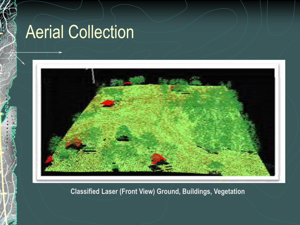
Aerial Collection
Classified Laser (Front View) Ground, Buildings, Vegetation

Mobile Collection
Optech Lynx Mobile Mapping System

Mobile Collection
Mobile Tile SchemeMobile Data - All Points

Static Collection
Optech ILRIS 3D Laser Scanner Trimble GX Advanced Terrestrial Scanner

Static Collection
Static LiDAR Intersection Route A and Highway BB Colored by Elevation

Feature Extraction
Stereo collection using LiDAR- Grammetry was
utilized for breakline and feature extraction

Feature Extraction
Synthetic “black & white” Stereo Imagery was
generated from both the mobile data and aerial
datasets using GEOCUE LiDAR1 Cue PAC for
use in feature mapping in 3D stereo
environment. The stereo imagery was created
using all point classes to create 3D datasets
comprising all the required features.

Project Overview
Key Observations
Aerial Lidar – Collect day or night –schedule flexibility
Can “map” the same features as traditional photogrammetry” – look
down perspective
Cost effective for wide area projects
Provide higher density “3D point” measurements to improve surface
modeling
Requires additional specialized software and hardware

Project Overview
Key Observations
Mobile Lidar– Collect day or night –schedule flexibility
Map many similar features as photogrammetry, however is limited due to ground perspective
Suitable for corridor, urban or tunnel mapping
Provide significantly higher density “point” measurements to improve surface modeling
Lower risk and rapid collection of data over conventional survey
Limitations as to the range of the sensor and occlusions or shadowing affecting potential information content
Requires additional specialized software and hardware

Project Overview
Key Observations
Static Lidar Collect day or night
Map a limited feature set as compared to photogrammetry
Suitable for high detail local area surveys, such as tunnels, or
enhancement project
Provide highest potential short range density “point” measurements to
improve surface modeling
Reduces risk and potential schedule over traditional survey
Requires additional specialized software and hardware

LiDAR Technology collects an enormous volume of data, depending on
the application this may not be required
Data Volume
Class Points
Default 39,871
Ground 30,815,366
Low Vegetation 57,778,875
Medium Vegetation 2,680,066
High Vegetation 18,064,128
Buildings 3,105,888
Low Points 5,266
Total 112,489,460
Class Points
Default 12,930,697
Ground 88,843,333
Low Vegetation 429,024,011
Medium Vegetation 24,694,914
High Vegetation 101,940,979
Buildings 1,018,456
Low Points 14,308
Total 658,466,698
Aerial LiDAR Mobile LiDAR

Cost Summary
Conventional Aerial is still the most cost effective method to collect
traditional mapping features
Lidar can provide potential cost saving over traditional survey providing
additional information content that can be “mined” in the office
Summary Hrs Labor
Cost
Person Days $/Mile
Traditional Survey Design 1281 $131,585 160.1 $18,798
Aerial Lidar 444 $58,250 55.5 $8,321
Mobile Lidar 726 $81,688 90.8 $9,933
Static Lidar 1700 $204,805 212.5 $29,258
Conventional Aerial Mapping 548 $55,234 68.5 $7,891
****Cost Estimated on 7 Mile corridor - Mobilization cost and ODC's not included

Schedule Summary
Conventional Aerial or LiDAR Mapping provides for the shortest
potential schedule for mapping data, based on available staff and
resources
Aerial and Mobile Lidar can provide schedule benefit over traditional
survey methods
Summary Person Hrs Schedule
Traditional Survey
Design 1281 48.2
Aerial Lidar 444 40.5
Mobile Lidar 726 57.1
Static Lidar 1700 94.0
Conventional Aerial
Mapping 548 42.9
****Schedule is based on staff

Potential Safety ImpactsTASK Aerial LiDAR Comments Mobile
LiDAR
Comments
Planning Low Office Low Office
Ground Survey
–Control
Med Check point
collection
Med 1 or 2 survey
points/mile
Data Collection NA Low- Aerial Low Collected in traffic
Traffic Control NA NA- Aerial NA Collected at posted
speed
Road Access NA NA- Aerial Low Collect on any
accessible
road/track/trail
Ground Survey- base
Stations
Low Remote or controlled
location
Low Remote or
Controlled Location
Aerial and Mobile Lidar reduces the need for
surveyors on or near the road

Potential Safety Impacts
Traditional Aerial is a low risk activity as the primary data
collection is remote
TASK Conventional
Aerial
Comments
Planning Low Office
Ground Survey
–Control
Med Check point
collection
Data Collection NA Low- Aerial
Traffic Control NA NA- Aerial
Road Access NA NA- Aerial
Ground Survey- base
Stations
Low Remote or controlled
location

Potential Safety Impacts
Traditional and Static survey have a higher degree of risk and impact
as these activities are on or near the roadway
TASK Static LiDAR Comments Traditional
Survey
Comments
Planning Low Office Low Office
Ground Survey
–Control
High Near project – road
area
High Near project – road
area
Data Collection High Edge of road /on road High Edge of road /on road
Traffic Control High Required for safety-
shoulder/lane
closures
High Required for safety-
shoulder/lane
closures
Road Access High Speed and cone
zones
High Speed and cone
zones
Near Road ProjectGround Survey- base
Stations
Med Near project – road
area
Med

Additional Features from LiDAR
Many of the Lidar
based Features can
be captured via
“virtual survey “ in
the office – reducing
field costs
Feature Aerial
LiDAR
Mobile
LiDAR
Static
LiDAR
Traditonal
Aerial
Curb Restricted YES YES YES
Gutter/Drain Yes YES YES YES
Traffic signal NO YES YES NO
Traffic poles NO YES YES YES
Road and Local Terrain
Information YES YES YES YES
Parking Meters NO YES YES NO
Walls YES YES YES YES
Obstruction in the right of way
YES YES YES Restricted
Manholes NO YES YES YES
Sidewalks YES YES YES YES
Overhead Clearance NO YES YES NO
Lights Restricted YES YES Restricted
Utility Wires and Connections
Restricted YES YES Restricted
Garbage Cans NO YES YES NO
Benches NO YES YES NO
Fences NO YES YES Restricted
Guardrails/Barriers NO YES YES YES
Retaining Walls Restricted YES YES YES
Vegetation -Line of Site
obstructions Restricted YES YES Restricted

Implementation Benefits
Safety enhancements
LiDAR surveying techniques can provide a safer method of surveying
a project corridor.
Surveyors, motorists, and designers all will see an improvement in
safety throughout the project corridor, during surveying operations
and through the reduction in site visits and design field checks.

Implementation Benefits
Accuracy The accuracy and detail of the LiDAR survey allows for increased efficiency in the design phase of the project.
The LiDAR survey allows for more accurate development of project profiles and for generation of more precise earthwork quantities.
The LiDAR data can be filtered from a highly, detailed survey to a lower data density tailored to meet specific project needs.
MOBILE DATA Aerial Data
US Feet cm US Feet cm
Average dz -0.002 +0.06 -0.019 -0.57
Minimum dz -0.196 -5.97 -0.472 -14.39
Maximum dz +0.338 +10.3 +0.318 +9.69
Average magnitude +0.104 +3.17 +0.135 +4.11
Root mean square +0.0126 +3.84 +0.173 +5.27
Std deviation +0.128 +3.90 +0.173 +5.27

Implementation Benefits
Speed The speed of collection, especially mobile LiDAR, cannot be matched
via traditional methods.
The enhancement in speed of collection allows surveying tasks to be
completed around constraints that restrict when certain activities may
take place.

Implementation Benefits
Cost LiDAR surveys can help reduce construction change orders in
earthwork quantities by providing a more accurate existing ground
model.
They can help to limit costs associated with design tasks by allowing
existing sign surveys to be conducted from the office and assist in utility
coordination by providing overhead clearances without having to
conduct a separate field visit.
The reduction of field work also saves user costs associated with traffic
control and lane drops that are required to safely conduct field
operations.

Project Recommendations
MoDOT should consider the following:
Develop leaders in the area of LiDAR collection techniques through
specialized training and workshops.
Develop procedures and deliverable standards for working with
LiDAR survey data sets.
Upgrade and maintain currency with software and hardware
requirements
Seek out additional opportunities to implement LiDAR surveying
techniques on projects, while understanding that LiDAR may not
be best suited for all surveying needs.

Project Conclusions
Technology Limitations
All three technologies collect enormous amounts of point cloud data
that proved extremely difficult to process and manage.
Current software is limited in dealing with the mobile dataset in
particular, requiring additional file creation and data management
challenges.
The mobile technology significantly reduces field collection time but
increases back office processing, requiring potentially additional
hardware and software to effectively manage the datasets.

Project Conclusions
Lidar can provide schedule savings over traditional survey
One important issue in selecting a LiDAR technique is to evaluate the
future multiple potential uses of the data.
• LiDAR collection is a potential tool that can be used and designers and
project managers should consider it, even when the cost savings may
be realized on a future project
• While not the best solution for all surveying needs, LiDAR surveys do
provide benefits to the end user in terms of data and to the public in
terms of reduction in traffic disruption during field work.

What is MoDOT doing with
this Technology?
2011 TEAM Conference 32

MoDOT’s Lidar Efforts
MoDOT’s Design Division has been heavily involved in
evaluating the potential uses of LiDAR technologies for the past
3 years.
As a result of that research along with the recommendations of
this research report, MoDOT has taken a number of steps to
implement this technology

MoDOT’s Lidar Efforts
MoDOT has purchased two static LIDAR scanners for evaluation
in real-world project use. One scanner is located in our
Springfield District and one is located in our Kansas City District.
These units are from different vendors and will be evaluated for
cost effectiveness.

MoDOT’s Lidar Efforts
MoDOT Photogrammetry unit has entered into a contract for
aerial LiDAR surveys in the 2011 flight program for four projects
consisting of 85.2 miles for new or realigned roadways. These
projects are a mix of both urban and rural terrain and are ones
that would have been done by traditional photogrammetric
methods. Aerial photography is also being obtained on these
projects as a means of quality control.

MoDOT’s Lidar Efforts
MoDOT is participating in, and has a member on the panel for
NCHRP Project 15-44, Guidelines for the Use of Mobile LiDAR in
Transportation Applications. This project is setting nationwide
standards for the procurement, accuracy levels, and delivery
methods of mobile LIDAR.

MoDOT’s Lidar Efforts
MoDOT also has a member on a TRB Committee on Geospatial
Data Acquisition Technologies in Design and Construction,
AFB80. This group evaluates data acquisition technologies, such
as LiDAR, and makes recommendations for methods and
procedures in these areas. When results of this committee are
published, MoDOT intends to use these results to write
specification for future Lidar work.

Aerial LiDAR
County and statewide aerial LiDAR acquisition available through
MSDIS (Missouri Spatial Data Information Service) could be
used for:
Hydraulic Analysis.
Environmental Analysis and Mitigation Design.
Historic Preservation Analysis.
Project Scoping/Preliminary Design.

Aerial LiDAR
Increase the accuracy of corridor mapping for developing
proposed 3-dimensional highway and bridge design models.
Engineering accuracy 3D-models that can be used for rendering
and making visual aids for the public at no extra cost to MoDOT.
3D models of proposed projects will have engineering grade
accuracy for better estimates.
Better calculation of earthwork using volumetric differences.
Better calculation of pavement and other surfaces .

Mobile LiDAR Potential Use
Modeling large rehabilitation projects. Other DOT’s are seeing
great savings in pavement quantities for very large projects even
with the cost of the acquisition of Mobile LiDAR.
Emergency corridor mapping.
Urban corridor mapping.
Can be used in high traffic areas where survey crews would have to
collect data to supplement aerial LiDAR.
Transportation Asset Management. This task does not require
high engineering accuracy.

Terrestrial LiDAR Scanning
Best for small improvement projects.
Isolated intersection improvement.
Land slide and side slopes evaluation.
Bridge inspection and evaluation – especially in high traffic urban areas.
Retaining wall and other structure monitoring.

Questions?