model solution : winter 2015 -...
TRANSCRIPT
MAHARASHTRA STATE BOARD OF TECHNICAL EDUCATION (Autonomous)
(ISO/IEC - 27001 - 2005 Certified)
Model Solution : Winter 2015
Page No: 1 / 16
Winter – 2015 EXAMINATION
MODEL ANSWER
Subject: Highway Engineering Subject Code: 17602
---------------------------------------------------------------------------------------------------------------------------------
Important Instructions to examiners:
1) The answers should be examined by key words and not as word-to-word as given in the model answer
scheme.
2) The model answer and the answer written by candidate may vary but the examiner may try to assess the
understanding level of the candidate.
3) The language errors such as grammatical, spelling errors should not be given more importance. (Not
applicable for subject English and Communication Skills.)
4) While assessing figures, examiner may give credit for principal components indicated in the figure. The
figures drawn by the candidate and those in the model answer may vary. The examiner may give credit
for any equivalent figure drawn.
5) Credits may be given step wise for numerical problems. In some cases, the assumed constant values may
vary and there may be some difference in the candidate‟s answers and the model answer.
6) In case of some questions credit may be given by judgment on part of examiner of relevant answer based
on candidate‟s understanding.
7) For programming language papers, credit may be given to any other program based on
equivalent concept.
---------------------------------------------------------------------------------------------------------------------------------
Model Answer
Que.
No.
Sub.
Que. Model Answers Marks
Total
Marks
1) a)
Qi)
Ans.
i)
ii)
iii)
iv)
v)
vi)
vii)
viii)
Attempt any THREE of the following:
State the importance of road transportation in overall development of
a country.
Importance of road transportation in overall development of a country.
Road transportation is beneficial in various fields mentioned below. It
may contribute directly or indirectly in overall development of
country.
Road transportation is helpful in transportation of people‟s goods etc
from one place to other, which results in better & effective
communication.
It is also useful in carriage of agricultural products and dairy products
to market.
Roads are necessary for navigation in military or defense area of our
country.
Road transportation is easy, simple than railway, which reaches at
rural areas and hilly areas also.
Roads are economical in construction due to local materials,
adjustable gradient.
Road construction gives employment to people and revenue through
road taxes.
Country gets more income through tourism with the help of road
transportation facility.
Road transportation helps in flood and famine relief.
Any 4
points,
1
Mark
each
12
4
MAHARASHTRA STATE BOARD OF TECHNICAL EDUCATION (Autonomous)
(ISO/IEC - 27001 - 2005 Certified)
Model Solution : Winter 2015
Subject & Code: HEN (17602) Page No. 2/16
Que.
No.
Sub.
Que. Model Answers Marks
Total
Marks
1)
a)
Qii)
Ans.
i)
ii)
iii)
State the classification of road according to third road development
plan.
Classification of road according to third road development plan.
The roads across the country are categorized into three groups as
mentioned below. The third road development plan is based on
grouping of roads according to priority for importance in
development.
Primary System: In this group two types of roads are included,
namely:
a) Expressway b) National Highway.
These roads are of prior importance in development of nation.
The maximum expenses would be made for construction of
these roads
Secondary System: In this second category, moderate important roads
like a) State Highway and b) Major district roads are clubbed together.
These roads are necessary for routine communication and are
of medium importance. This development plan is put up on optimum
budget for this group of roads.
Tertiary system: In this road system, low cost roads i.e. a) Other
district roads and b) Village roads are considered. These roads are
provided with least possible expenditure ion twenty year plan. These
roads are low budgeted, hence grouped in tertiary system.
1 mark
1 mark
1 mark
1 mark
4
Qiii)
Ans.
Define alignment of road. State any four factors controlling road
alignment.
Alignment of road: Alignment of road is defined as the centerline
marked of a proposed route in plan.
Factors affecting alignment of road:
1) Nature of ground (hilly or flat)
2) High population zone.
3) Obligatory points (existing structures)
4) Nature of sub – soil strata.
5) Cost of land acquisition.
6) Number of cross- drainage work.
2
marks
Any 4
points,
½
mark
each
4
Qiv)
Ans.
i)
ii)
iii)
iv)
v)
vi)
What are main objectives of preliminary survey?
Main objectives of preliminary survey:
The preliminary survey for any road construction project is done for
following objectives
To collect data and information of soil strata, annual rainfall from
local or native peoples.
To gather information regarding trees, slope of ground, hill or valleys
etc.
To find the approximate feasible alignment and curves by conducting
simple field tests.
To study available toposheets and drawings of proposed area.
To determine approximate estimate considering all related factors
including land costs.
To know number of cross-drainage works and other obligatory points
Any 4
points,
1 mark
each
4
MAHARASHTRA STATE BOARD OF TECHNICAL EDUCATION (Autonomous)
(ISO/IEC - 27001 - 2005 Certified)
Model Solution : Winter 2015
Subject & Code: HEN(17602) Page No. 3/16
Que.
No.
Sub.
Que. Model Answers Marks
Total
Marks
Qv)
Ans.
What is camber? State IRC values of camber for different roads.
Camber – It is the transverse slope provide to the carriage way
OR
- It is the surface joining crown point to the road edge
point.
IRC values of camber for different roads:
1) Earth road : 3 to 4 %
2) Water Bound Macadam road : 2.5 to 3 %
3) Bituminous road : 2 to 3 %
4) Cement concrete road : upto 2 %
2
marks
2
marks,
½
mark
each,
4
1)
b)
i)
Ans.
i)
Attempt any ONE of the following:
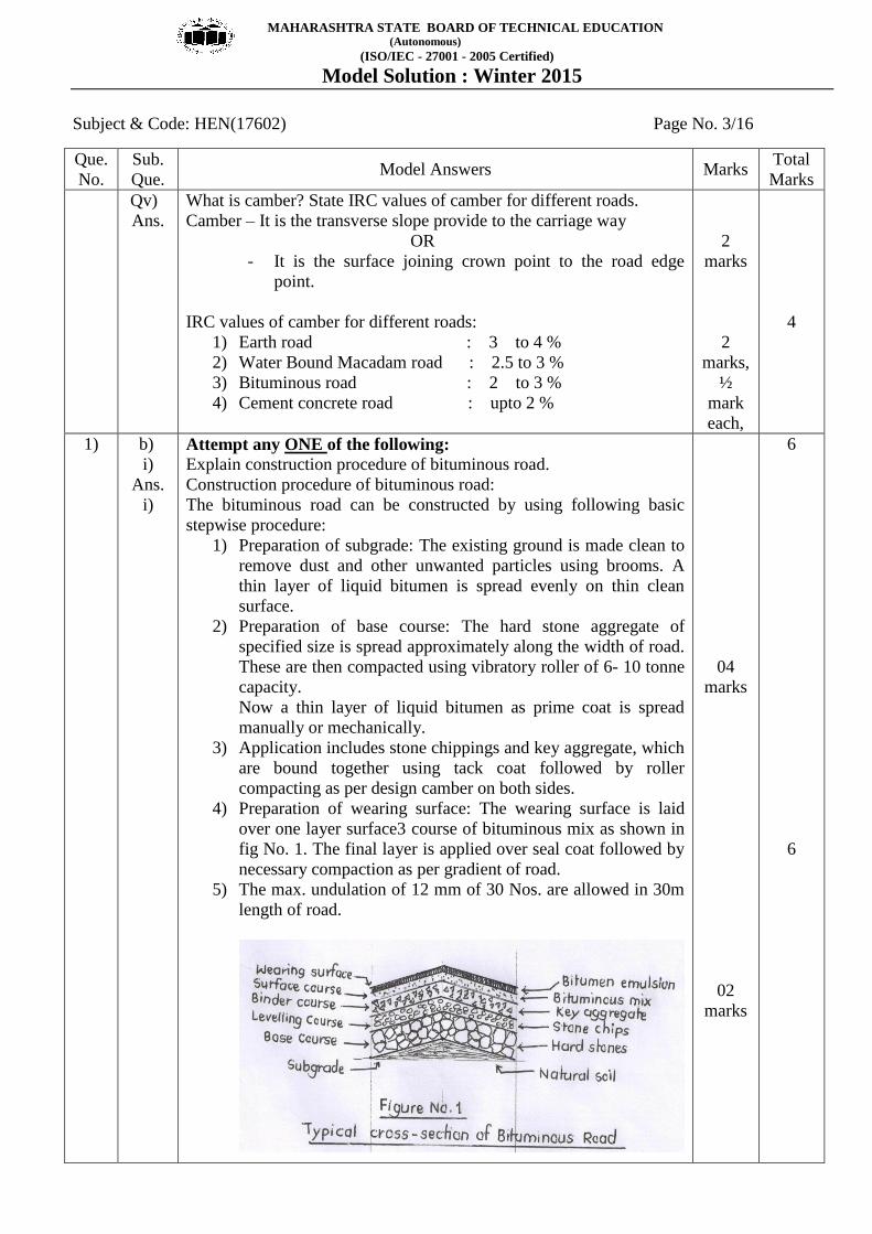
Explain construction procedure of bituminous road.
Construction procedure of bituminous road:
The bituminous road can be constructed by using following basic
stepwise procedure:
1) Preparation of subgrade: The existing ground is made clean to
remove dust and other unwanted particles using brooms. A
thin layer of liquid bitumen is spread evenly on thin clean
surface.
2) Preparation of base course: The hard stone aggregate of
specified size is spread approximately along the width of road.
These are then compacted using vibratory roller of 6- 10 tonne
capacity.
Now a thin layer of liquid bitumen as prime coat is spread
manually or mechanically.
3) Application includes stone chippings and key aggregate, which
are bound together using tack coat followed by roller
compacting as per design camber on both sides.
4) Preparation of wearing surface: The wearing surface is laid
over one layer surface3 course of bituminous mix as shown in
fig No. 1. The final layer is applied over seal coat followed by
necessary compaction as per gradient of road.
5) The max. undulation of 12 mm of 30 Nos. are allowed in 30m
length of road.
04
marks
02
marks
6
6
MAHARASHTRA STATE BOARD OF TECHNICAL EDUCATION (Autonomous)
(ISO/IEC - 27001 - 2005 Certified)
Model Solution : Winter 2015
Subject & Code: HEN (17602) Page No. 4/16
Que.
No.
Sub.
Que. Model Answers Marks
Total
Marks
1)
b)
ii)
Ans:
Calculate the passing sight distance for a two way highway with one
way traffic and having design speed 80 kmph. The rate of acceleration
of fast moving vehicle is 4 kmph/sec and difference in speed between
overtaking vehicle and slow moving vehicle is 20 kmph.
Given: Two way highway with one way traffic
Design speed v = 80 kmph
Rate of acceleration a = 4 kmph/sec.
Difference in speed m = 20 kmph
Find passing sight distance = ?
Solution:
The passing distance for two way highway with one way
traffic = d1 + d2
Therefore to find d1 = 0.56 (v - m)
d1 = 0.56(80 – 20)
d1 = 33.60 m
Now to find d2 = 0.28 (v – m) T +2.S
Here, S = 0.20 (v-m) +6
S = 0.20 (80 - 20) +6
S =18m
And, T √{(14.4S)/a}
T√{(14.4 x 18)/4}
T = 8.05 sec.
Therefore d2 = 0.28 (v – m)T + 2.S
= 0.28 (60 – 20)8.05 + (2 x 18)
d2 = 171.24 m
Hence, passing sight distance (PSD) = d1 + d2
PSD = 33.60 + 171.24
PSD = 204.84m
1 mark
1 mark
1 mark
1 mark
1 mark
1 mark
6
2.
a)
Ans.
Attempt any FOUR of the following
What is land acquisition plan and longitudinal section? Mention their
use.
Land acquisition plan: The plan showing existing village maps or
settlement maps giving the details of property and their survey
number.
USE: it is useful to acquire land for proposed road construction
work.
Longitudinal section: The section is taken along the longitudinal
direction i.e. along alignment of proposed route. It shows
variation of ground surface along alignment at suitable interval of
chainages.
USE: It is useful to know nature of ground surface (i.e. hilly or
valley) in alignment. It helps to decide suitable gradient for
balancing earthwork.
1 mark
1 mark
1 mark
1 mark
16
4
MAHARASHTRA STATE BOARD OF TECHNICAL EDUCATION (Autonomous)
(ISO/IEC - 27001 - 2005 Certified)
Model Solution : Winter 2015
Subject & Code: HEN (17602) Page No. 5/16
Que.
No.
Sub.
Que. Model Answers Marks
Total
Marks
2)
b)
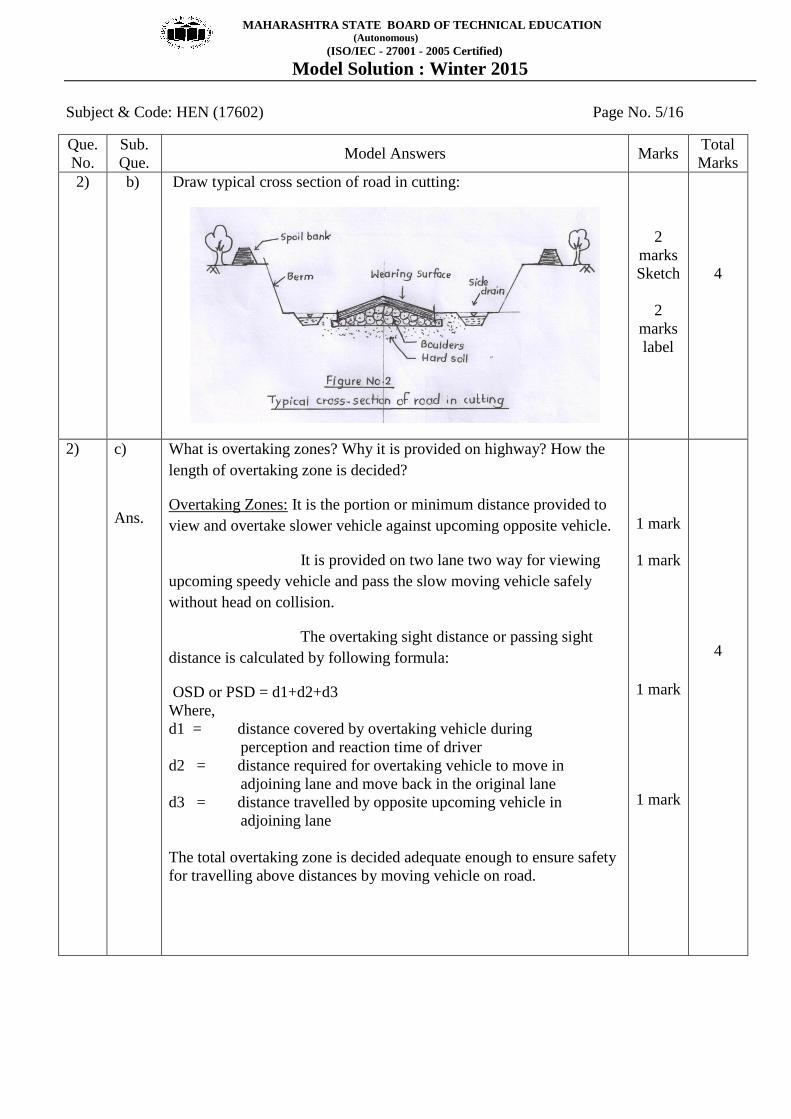
Draw typical cross section of road in cutting:
2
marks
Sketch
2
marks
label
4
2)
c)
Ans.
What is overtaking zones? Why it is provided on highway? How the
length of overtaking zone is decided?
Overtaking Zones: It is the portion or minimum distance provided to
view and overtake slower vehicle against upcoming opposite vehicle.
It is provided on two lane two way for viewing
upcoming speedy vehicle and pass the slow moving vehicle safely
without head on collision.
The overtaking sight distance or passing sight
distance is calculated by following formula:
OSD or PSD = d1+d2+d3
Where,
d1 = distance covered by overtaking vehicle during
perception and reaction time of driver
d2 = distance required for overtaking vehicle to move in
adjoining lane and move back in the original lane
d3 = distance travelled by opposite upcoming vehicle in
adjoining lane
The total overtaking zone is decided adequate enough to ensure safety
for travelling above distances by moving vehicle on road.
1 mark
1 mark
1 mark
1 mark
4

MAHARASHTRA STATE BOARD OF TECHNICAL EDUCATION (Autonomous)
(ISO/IEC - 27001 - 2005 Certified)
Model Solution : Winter 2015
Subject & Code: HEN (17602) Page No.6 /16
Que.
No.
Sub.
Que. Model Answers Marks
Total
Marks
2)
d.
Ans.
State the situations under which following gradient are provided:
i) Limiting
ii) Exceptional
iii) Floating
iv) Average
Situations for providing following gradients:
i) Limiting gradient: It is provided where topography of the area
does not suit ruling gradient due to excessive cost.
ii) Exceptional gradient: It is provided under exceptional
circumstances and for very short length routes.
iii) Floating gradient: It is provided on highly steep sloping
ground for constant speed to vehicle without any tractive
effort
iv) Average gradient: It is provided when ground has moderate
variation and ruling or floating gradient becomes
unsuitable.
1 mark
1 mark
1 mark
1 mark
4
2) e
Ans
Functions of component parts of pavement:
Pavement:
Subgrade: i) To support total layers of pavement
ii) To carry load of pavement (DL) + load of traffic (LL)
Sub – base: i) To increase load carrying capacity of subgrade.
ii) To drain off rainwater & groundwater rise
away from sub grade
Base course: i) To take superimposed traffic load by acting
as foundation of road.
ii) To absorb vibrations produced due to
continuous moving loads.
Base coat: i) To transmit/ transfer load from
wearing surface to base course.
ii) To bind the wearing surface with
compacted base course.
Wearing surface: i) To provide passage for actual
movement of traffic.
ii) To drain off rainwater quickly for avoiding
entry in sub layer.
2
marks
sketch
2
marks functions of any
four
parts
4
MAHARASHTRA STATE BOARD OF TECHNICAL EDUCATION (Autonomous)
(ISO/IEC - 27001 - 2005 Certified)
Model Solution : Winter 2015
Subject & Code: HEN (17602) Page No. 7/16
Que.
No.
Sub.
Que. Model Answers Marks
Total
Marks
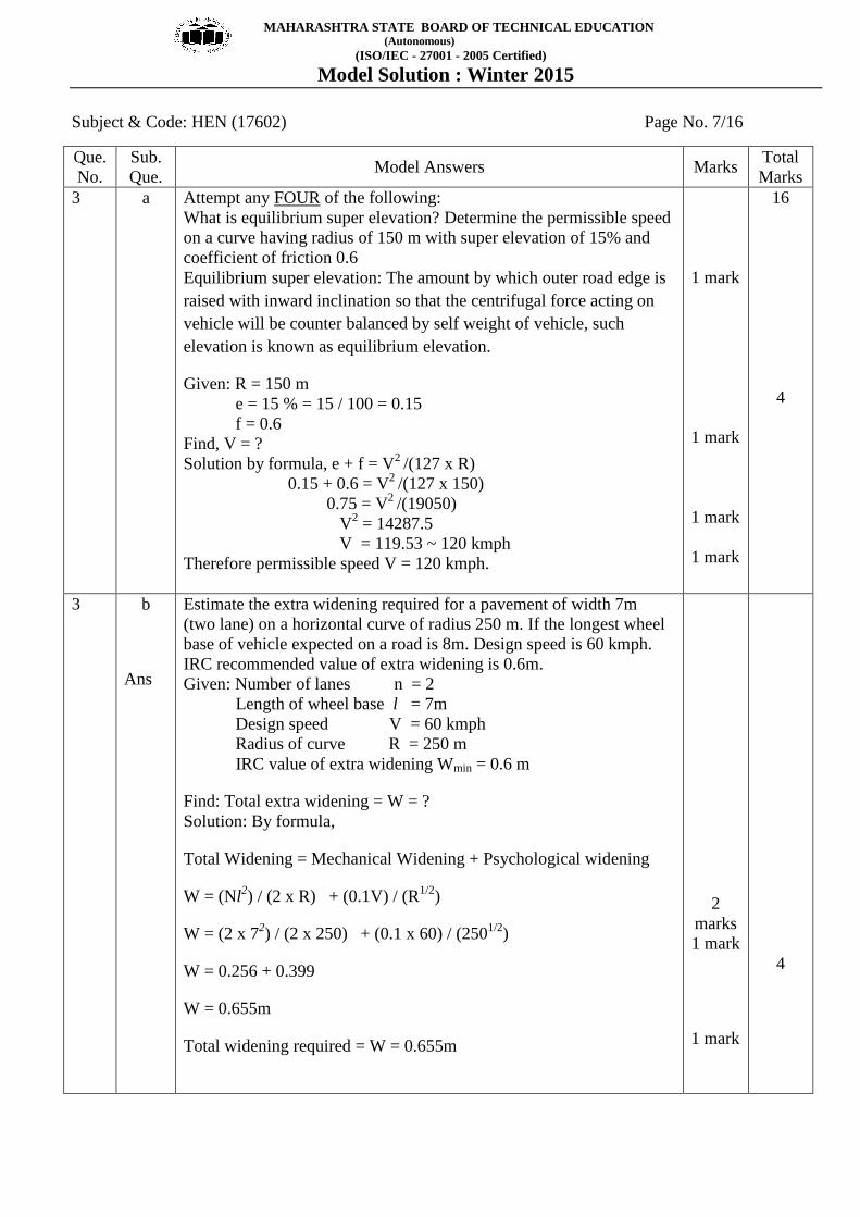
3 a Attempt any FOUR of the following:
What is equilibrium super elevation? Determine the permissible speed
on a curve having radius of 150 m with super elevation of 15% and
coefficient of friction 0.6
Equilibrium super elevation: The amount by which outer road edge is
raised with inward inclination so that the centrifugal force acting on
vehicle will be counter balanced by self weight of vehicle, such
elevation is known as equilibrium elevation.
Given: R = 150 m
e = 15 % = 15 / 100 = 0.15
f = 0.6
Find, V = ?
Solution by formula, e + f = V2
/(127 x R)
0.15 + 0.6 = V2
/(127 x 150)
0.75 = V2
/(19050)
V2 = 14287.5
V = 119.53 ~ 120 kmph
Therefore permissible speed V = 120 kmph.
1 mark
1 mark
1 mark
1 mark
16
4
3 b
Ans
Estimate the extra widening required for a pavement of width 7m
(two lane) on a horizontal curve of radius 250 m. If the longest wheel
base of vehicle expected on a road is 8m. Design speed is 60 kmph.
IRC recommended value of extra widening is 0.6m.
Given: Number of lanes n = 2
Length of wheel base l = 7m
Design speed V = 60 kmph
Radius of curve R = 250 m
IRC value of extra widening Wmin = 0.6 m
Find: Total extra widening = W = ?
Solution: By formula,
Total Widening = Mechanical Widening + Psychological widening
W = (Nl2) / (2 x R) + (0.1V) / (R
1/2)
W = (2 x 72) / (2 x 250) + (0.1 x 60) / (250
1/2)
W = 0.256 + 0.399
W = 0.655m
Total widening required = W = 0.655m
2
marks
1 mark
1 mark
4

MAHARASHTRA STATE BOARD OF TECHNICAL EDUCATION (Autonomous)
(ISO/IEC - 27001 - 2005 Certified)
Model Solution : Winter 2015
Subject & Code: HEN (17602) Page No. 8/16
Que.
No.
Sub.
Que. Model Answers Marks
Total
Marks
3 c
Ans:
Draw the cross section of a typical hill road and label the component
parts.
Typical hill road and the component
parts.:
2
marks
sketch
2
marks
label
4
3 d
Ans
Define soil stabilization with necessity: Explain mechanical soil
stabilization.
Soil Stabilization: The process of improving bearing capacity of
an ordinary road soil by physical, chemical or physiochemical
method is called as soil stabilization
Necessity of soil stabilization:
1) It is useful to increase shear strength of road soil
2) It is necessary to enhance stability of slopes in soil.
3) It helps to reduce material cost by making best use of locally
available material.
4) It becomes necessary to reduce rainwater and groundwater
entry in pavement surface.
Mechanical soil stabilization: In this type, soil stabilization is
done without adding chemicals or add-mixtures. It is done in
low cost roads and sub grades and sub bases of moderately
loaded roads
It is done by adding or removing soil constituents based on
particle size distribution analysis. The heavy roller compaction
is done to densify the soil mass with addition of aggregates if
required.
1 mark
Any 2
points,
½
mark
each
2
marks
4
MAHARASHTRA STATE BOARD OF TECHNICAL EDUCATION (Autonomous)
(ISO/IEC - 27001 - 2005 Certified)
Model Solution : Winter 2015
Subject & Code: HEN (17602) Page No. 9/16
Que.
No.
Sub.
Que. Model Answers Marks
Total
Marks
3 e State the properties of joint sealer. Also state the joint sealer material.
Properties of joint sealer:
1) Joint sealer materials should adhere to the edges of concrete.
2) It should not be fractured anytime
3) It should resist the grit entering in the joint.
4) It should be more durable.
Materials of joint sealer :
1) Bitumen
2) Rubber Bitumen
3) Air blown Bitumen
4) Cork or cork bound bitumen
4
points,
2
marks
4
points,
2
marks
4 a
i)
Ans
Attempt any THREE of the following
Define the following terms:
1) Borrow pits
2) Spoil bank
3) Lead
4) Lift
Definitions:
1) Borrow pits: The trench excavated along the alignment of
road for use of excavated soil for earth road construction,
is known as borrow pits.
2) Spoil bank: it is the storage of surplus soil excavated from
borrow pits, is known as spoil bank.
3) Lead: it is the horizontal distance upto which excavated
material is transported for dumping, for which contractor
does not get paid extra, is known as lead.
4) Lift: It is the vertical distance upto which soil can be
excavated, for which contractor does not get paid extra
payment, is known as lift.
1 mark
1 mark
1 mark
1mark
12
4

MAHARASHTRA STATE BOARD OF TECHNICAL EDUCATION (Autonomous)
(ISO/IEC - 27001 - 2005 Certified)
Model Solution : Winter 2015
Subject & Code: HEN (17602) Page No. 10/16
Que.
No.
Sub.
Que. Model Answers Marks
Total
Marks
4 a
ii)
Ans
State the information rendered by traffic volume study.
Information rendered by traffic volume study:
1) The total number of vehicles crossing the particular road
intersection in a specific period.
2) The idea of relative importance of a particular road and to
classify it.
3) It renders traffic density and traffic capacity, of road which
helps to decide widening, laning or over and under passes.
4) It furnishes the daywise or hourly variation in traffic volume to
know peak hours.
5) It also results in highly traffic dense route at a road
intersection.
6) It gives bifurcation of pedestrians and vehicles at different
localities of a city.
Any 4
points,
1 mark
each
4
4 a
iii)
Ans
Draw the sketches of regulatory sign and warning sign (four each).
Sketches of regulatory signs and warning
signs.
8
signs,
½
mark
each
4

MAHARASHTRA STATE BOARD OF TECHNICAL EDUCATION (Autonomous)
(ISO/IEC - 27001 - 2005 Certified)
Model Solution : Winter 2015
Subject & Code: HEN (17602) Page No. 11/16
Que.
No.
Sub.
Que. Model Answers Marks
Total
Marks
4 a
iv)
Ans
Define “Drainage”. State the types of drainage system. Draw the
sketches showing the different ways through which water enter into
structures.
Drainage: It is the road system in which surface or subsurface water is
collected and disposed off from road structure to any desired location,
is known as drainage.
Types of drainage system
1) Surface drainage system
2) Subsurface drainage system
Different ways through which water enters into structures:
1 mark
1 mark
2
marks,
sketch
4
4 b
i)
Ans
Attempt any ONE of the following:
During the construction of WBM road, what precautions are necessary
for rolling and finishing?
Precautions to be taken for rolling and finishing during construction of
WBM road:
1) Rolling of WBM surface should be done by heavy roller of 8 –
10 ton capacity.
2) Rolling should be done from edge to crown
3) Rolling should be done in strips with overlapping
4) The rolling length should be around 200m
5) Rolling should be done for about 80 passes until refusal
6) Rolling should be done at one and same place
7) Rolling should be done by sprinkling water uniformly and
should not be poured by buckets.
8) Rolling should give uniform finishing, hence it should be
discontinued before crushing of road aggregates.
Any 6
points,
1 mark
each
6
6
MAHARASHTRA STATE BOARD OF TECHNICAL EDUCATION (Autonomous)
(ISO/IEC - 27001 - 2005 Certified)
Model Solution : Winter 2015
Subject & Code: HEN (17602) Page No. 12/16
Que.
No.
Sub.
Que. Model Answers Marks
Total
Marks
4 b
ii)
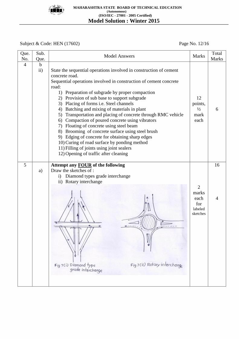
State the sequential operations involved in construction of cement
concrete road.
Sequential operations involved in construction of cement concrete
road:
1) Preparation of subgrade by proper compaction
2) Provision of sub base to support subgrade
3) Placing of forms i.e. Steel channels
4) Batching and mixing of materials in plant
5) Transportation and placing of concrete through RMC vehicle
6) Compaction of poured concrete using vibrators
7) Floating of concrete using steel beam
8) Brooming of concrete surface using steel brush
9) Edging of concrete for obtaining sharp edges
10) Curing of road surface by ponding method
11) Filling of joints using joint sealers
12) Opening of traffic after cleaning
12
points,
½
mark
each
6
5
a) Attempt any FOUR of the following
Draw the sketches of :
i) Diamond types grade interchange
ii) Rotary interchange
2
marks
each
for labeled
sketches
16
4
MAHARASHTRA STATE BOARD OF TECHNICAL EDUCATION (Autonomous)
(ISO/IEC - 27001 - 2005 Certified)
Model Solution : Winter 2015
Subject & Code: HEN (17602) Page No. 13/16
Que.
No.
Sub.
Que. Model Answers Marks
Total
Marks
5 b
Ans
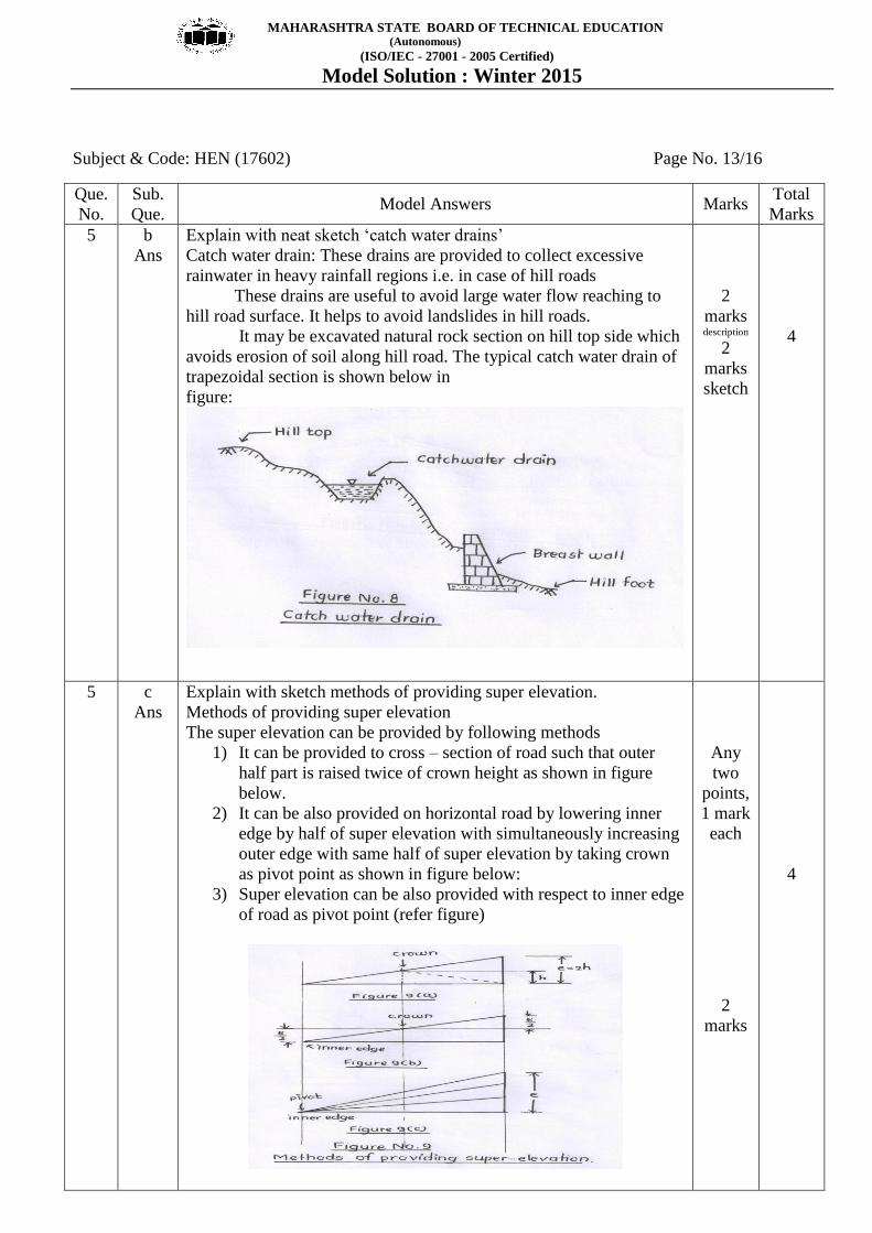
Explain with neat sketch „catch water drains‟
Catch water drain: These drains are provided to collect excessive
rainwater in heavy rainfall regions i.e. in case of hill roads
These drains are useful to avoid large water flow reaching to
hill road surface. It helps to avoid landslides in hill roads.
It may be excavated natural rock section on hill top side which
avoids erosion of soil along hill road. The typical catch water drain of
trapezoidal section is shown below in
figure:
2
marks description
2
marks
sketch
4
5 c
Ans
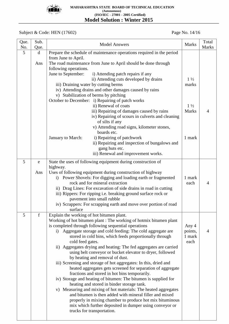
Explain with sketch methods of providing super elevation.
Methods of providing super elevation
The super elevation can be provided by following methods
1) It can be provided to cross – section of road such that outer
half part is raised twice of crown height as shown in figure
below.
2) It can be also provided on horizontal road by lowering inner
edge by half of super elevation with simultaneously increasing
outer edge with same half of super elevation by taking crown
as pivot point as shown in figure below:
3) Super elevation can be also provided with respect to inner edge
of road as pivot point (refer figure)
Any
two
points,
1 mark
each
2
marks
4
MAHARASHTRA STATE BOARD OF TECHNICAL EDUCATION (Autonomous)
(ISO/IEC - 27001 - 2005 Certified)
Model Solution : Winter 2015
Subject & Code: HEN (17602) Page No. 14/16
Que.
No.
Sub.
Que. Model Answers Marks
Total
Marks
5 d
Ans
Prepare the schedule of maintenance operations required in the period
from June to April.
The road maintenance from June to April should be done through
following operations.
June to September: i) Attending patch repairs if any
ii) Attending cuts developed by drains
iii) Draining water by cutting berms
iv) Attending drains and other damages caused by rains
v) Stabilization of berms by pitching
October to December: i) Repairing of patch works
ii) Renewal of coats
iii) Repairing of damages caused by rains
iv) Repairing of scours in culverts and cleaning
of silts if any
v) Attending road signs, kilometer stones,
boards etc.
January to March: i) Repairing of patchwork
ii) Repairing and inspection of bungalows and
gang huts etc.
iii) Renewal and improvement works.
1 ½
marks
1 ½
Marks
1 mark
4
5
e
Ans
State the uses of following equipment during construction of
highway.
Uses of following equipment during construction of highway
i) Power Shovels: For digging and loading earth or fragmented
rock and for mineral extraction
ii) Drag Lines: For excavation of side drains in road in cutting
iii) Rippers: For ripping i.e. breaking ground surface rock or
pavement into small rubble
iv) Scrappers: For scrapping earth and move over portion of road
surface
1 mark
each
4
5 f Explain the working of hot bitumen plant.
Working of hot bitumen plant : The working of hotmix bitumen plant
is completed through following sequential operations
i) Aggregate storage and cold feeding: The cold aggregate are
stored in cold bins, which feeds proportionally through
cold feed gates.
ii) Aggregates drying and heating: The fed aggregates are carried
using belt conveyor or bucket elevator to dryer, followed
by heating and removal of dust.
iii) Screening and storage of hot aggregates: In this, dried and
heated aggregates gets screened for separation of aggregate
fractions and stored in hot bins temporarily.
iv) Storage and heating of bitumen: The bitumen is supplied for
heating and stored in binder storage tank.
v) Measuring and mixing of hot materials: The heated aggregates
and bitumen is then added with mineral filler and mixed
properly in mixing chamber to produce hot mix bituminous
mix which further deposited in dumper using conveyor or
trucks for transportation.
Any 4
points,
1 mark
each
4
MAHARASHTRA STATE BOARD OF TECHNICAL EDUCATION (Autonomous)
(ISO/IEC - 27001 - 2005 Certified)
Model Solution : Winter 2015
Subject & Code: HEN (17602) Page No. 15/16
Que.
No.
Sub.
Que. Model Answers Marks
Total
Marks
6
a
Ans
Attempt any FOUR of the following:
Types of compacting equipment
1) Smooth wheel rollers
2) Sheep foot rollers
3) Pneumatic tyred rollers
4) Self propelled tamping or pad rollers
5) Self propelled compactors
6) Hand operated compactors
7) Plate compactors
8) Spike rollers
Any 4
point,
1 mark
each
16
4
6 b
Ans
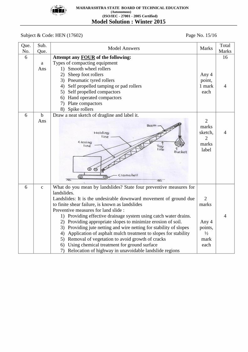
Draw a neat sketch of dragline and label it.
2
marks
sketch,
2
marks
label
4
6 c What do you mean by landslides? State four preventive measures for
landslides.
Landslides: It is the undesirable downward movement of ground due
to finite shear failure, is known as landslides
Preventive measures for land slide :
1) Providing effective drainage system using catch water drains.
2) Providing appropriate slopes to minimize erosion of soil.
3) Providing jute netting and wire netting for stability of slopes
4) Application of asphalt mulch treatment to slopes for stability
5) Removal of vegetation to avoid growth of cracks
6) Using chemical treatment for ground surface
7) Relocation of highway in unavoidable landslide regions
2
marks
Any 4
points,
½
mark
each
4

MAHARASHTRA STATE BOARD OF TECHNICAL EDUCATION (Autonomous)
(ISO/IEC - 27001 - 2005 Certified)
Model Solution : Winter 2015
Subject & Code: HEN (17602) Page No. 16/16
Que.
No.
Sub.
Que. Model Answers Marks
Total
Marks
6 d State the necessity of providing road drainage.
1) Road drainage is necessary to collect surface water in side drains
and to keep road surface in dry condition.
2) It is also required to carry sub surface water away from sub layers
in heavy rainfall regions
3) It helps to reduce occurrence of road defects due to rainwater and
rise of groundwater
4) It is beneficial to minimize landslides and related undesirable
effects.
5) It increases load carrying capacity due to dry condition and
maintained density of sub layers
6) It also results a good durable road with lesser maintenance
as well.
Any 4
points,
1 mark
each
4
6 e
Line Sketch of J.C.B.
2
marks
sketch
2
marks
label
4