mokelumne river, california...mokelumne river hydroelectric project (p-137) description: the...
TRANSCRIPT

Hydropower Project Summary
MOKELUMNE RIVER, CALIFORNIA
MOKELUMNE RIVER HYDROELECTRIC PROJECT (P-137)
Salt Springs Dam on North Fork Mokelumne River
Photo Credit: kids.brittanica.com
This summary was produced by the
Hydropower Reform Coalition
and
River Management Society

Mokelumne, CA
April 2015 Page 2 of 20
MOKELUMNE RIVER, CA
MOKELUMNE RIVER HYDROELECTRIC PROJECT (P-137)
DESCRIPTION: The Mokelumne Project is located on the Mokelumne, North Fork Mokelumne (North
Fork), and Bear Rivers and tributaries of the North Fork in the Sierra Nevada mountain
range of California. Portions of the project occupy lands within the Stanislaus and
Eldorado National Forests, and lands managed by the U.S. Department of the Interior's
Bureau of Land Management (BLM).
Farthest upstream are four natural lakes which have been enlarged by the addition of
dams to Upper Blue Lake, Lower Blue Lake, Twin Lake, and Meadow Lake. The project
has four power developments downstream of these lakes: Salt Springs, Tiger Creek, West
Point, and Electra.
The nine signatories to the Settlement are: U.S. Forest Service (Forest Service), U.S Fish
and Wildlife Service (FWS), BLM, California Dept. of Fish and Game (Cal Fish and
Game), California Dept. of Boating and Waterways (Cal Boating), Friends of the River,
Natural Heritage Institute, American Whitewater, and Foothill Conservancy.
The California State Water Resources Control Board and the East Bay Utility District
were members of the collaborative process during licensing but did not sign the
Settlement.
A. SUMMARY
1. License application filed: 1972 with amendments in 1978, 1981, 1985, and 1996
2. License Issued: October 11, 2001
3. License expiration: October 11, 2031
4. Waterways: Mokelumne, North Fork Mokelumne (and its tributaries), and Bear
Rivers
5. Capacity: 206 megawatt (MW)- increase to 210.7 MW
6. PG&E: Pacific Gas & Electric Company (PG&E)
7. PG&E address: Pacific Gas & Electric Company
245 Market Street
San Francisco, CA 94105
8. Counties: Alpine, Amador, and Calaveras

Mokelumne, CA
April 2015 Page 3 of 20
9. Project Area: The farthest upstream area includes four natural lakes, enlarged by
the addition of dams; Upper Blue Lake (7,300 acre-feet of storage); Lower Blue
Lake (5,091 acre-feet); Twin Lake (1,207 acre-feet); and Meadow Lake (5,656
acre-ft). The outflow from these lakes reaches the North Fork via Deer Creek.
Twin Lake drains into Meadow Creek, which drains into Meadow Lake, and
which finally drains into the North Fork. The project has four power developments
downstream of these lakes: Salt Springs, Tiger Creek, West Point, and Electra.
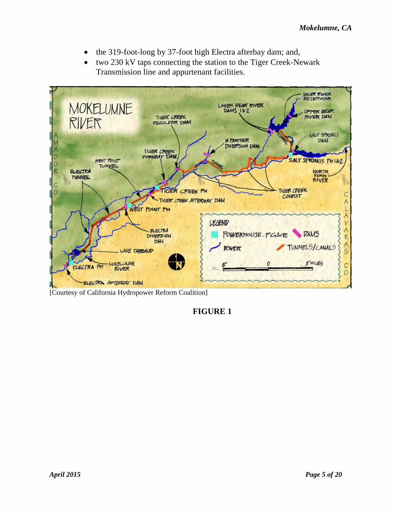
10. Project Facilities: The existing Mokelumne River Project consists of seven storage
reservoirs, four powerhouses, and numerous diversions and conduits [See Figure
1]. The seven storage reservoirs include:
343-acre Upper Blue Lake with a useable storage capacity of 7,300 acre-feet,
and an 837-foot-long, 31-foot-high dam;
198-acre Lower Blue Lake with a useable storage capacity of 5,091 acre-feet,
and a 1,063-foot-long, 40-foot-high dam;
106-acre Twin Lake with a useable storage capacity of 1,207 acre-feet, and a
1,520-foot-long, 22-foothigh dam;
140-acre Meadow Lake with a useable storage capacity of 5,656 acre-feet, and
a 775-foot-long, 77-foot-high clam;
169-acre Upper Bear River reservoir with a useable storage capacity of 6,756
acre-feet, and a 760-footlong, 77-foot-high dam;
727-acre Lower Bear River reservoir with a useable storage capacity of 49,079
acre-feet, and a 979-foot-long, 249-foot-high dam connected by rock to a 865-
foot-long, 145-foot-high second dam; and,
Lake Tabeaud.
The four power developments are Salt Springs, Tiger Creek, West Point, and Electra.
a. Salt Springs Development includes:
a 1,257-foot-long, 328-foot-high dam with a 480-foot-long spillway and 13
radial gates;
the 963-acre Salt Springs reservoir with a useable storage capacity of
141,817 acre-feet;
a 19-foot-long, 10-foot-diameter buried penstock;
a powerhouse with two turbine generators with a combined capacity of 43.5
megawatts (MW);
a 16.5-mile-long, 115 kilovolt (kV) transmission line; and appurtenant
facilities.

Mokelumne, CA
April 2015 Page 4 of 20
b. Tiger Creek Development includes:
the upper Tiger Creek conduit comprised of 14.8 miles of flume, 2.7 miles
of tunnel, and 0.3 mile of penstock;
the lower Tiger Creek conduit, which is a 2.5-mile-long flume receiving
water from six diversion dams and any associated structures, including:
o the 187foot-long Cole Creek diversion dam;
o the 91-foot-long Cole Creek feeder dam, and a 315-foot-long, 3- and
5-foot-diameter penstock;
o the 102-foot-long Bear River feeder dam, and a 528-foot-long, 6-
foot horseshoe tunnel, and 737-footlong flume;
o the 43-foot-long Beaver Creek feeder dam, and a 475-foot-long, 16-
inch-diameter penstock;
o the 64-foot-long East Panther Creek feeder dam, and a 635-foot-
long. 36-in-diameter penstock; and,
o the 58-foot-long West Panther Creek feeder dam and a 3,393-foot-
long penstock.
the 486-foot-long, 100-foot high Tiger Creek regulator dam;
a 13-acre reservoir with a useable storage capacity of 234 acre-feet;
the 900-foot-long, 33-foot-highTiger Creek forebay dam;
a 2.3 acre reservoir with a useable storage capacity of 42 acre feet;
a 96-inch diameter penstock and a 24-inch diameter sluice penstock;
a powerhouse with two turbine generators with a combined capacity of 54.4
MW; and,
a 13.8-mile-long and 23.4-mile-long, 320 kV transmission line and
appurtenant facilities.
c. West Point Development includes:
The 448-foot-long, 100- foot-high Tiger Creek afterbay dam;
a 70-acre reservoir with a useable storage capacity of 2,606 acre-feet;
the 15-foot, 6 inch by 13-foot, 2.7 mile-long West Point tunnel;
a 84- and 120-inch diameter penstock;
a powerhouse with a turbine generator with a capacity of 14.1MW; and,
a 23.5-mile long, 60kV transmission line and appurtenant facilities.
d. Electra Development includes:
the 188-foot-long, by 26-foot-high Electra diversion dam;
the 15-foot, 6 inch by 13-foot, 8 mile-long Electra tunnel
the 636-foot-long, 123-foot high Lake Tabeaud dam;
a 42-acre reservoir with useable storage capacity of 990-acre feet;
the 12-foot by 12-foot, 0.5 mile-long Tabeaud tunnel;
a powerhouse with three turbine generators with a combined capacity of
105.3 MW;
Mokelumne, CA
April 2015 Page 5 of 20
the 319-foot-long by 37-foot high Electra afterbay dam; and,
two 230 kV taps connecting the station to the Tiger Creek-Newark
Transmission line and appurtenant facilities.
[Courtesy of California Hydropower Reform Coalition]
FIGURE 1

Mokelumne, CA
April 2015 Page 6 of 20
B. IMPORTANT PROVISIONS AND REQUIREMENTS IN LICENSE
The license requires numerous enhancements to the existing aquatic and terrestrial
environments, recreation, and cultural resources. Many of the most important license
requirements fall into two categories included in the Appendix which contains the FPA
(Federal Power Act) Section 4(e)/FPA Section 10(a)1 Terms and Conditions submitted
by the Forest Service:
1) Biological Resource Management includes minimum stream flows, pulse flows,
ramping rates, an ecological resource adaptive management program, breaching of
three dams (East Panther, West Panther, and Beaver Creek diversion dams), and
minimum pool levels;
2) Recreation Resource Management includes an implementation plan, review of
recreation developments, recreation streamflows, whitewater boating monitoring
and adjustment of recreation streamflows, and whitewater boating access facilities.
1. Biological Resource Management [See Table 1 for License References]
The license requires thirteen provisions as listed in Table 1 for biological
management.
Table 1: Biological Resource Management References
Appendix
Condition No. Description
5 Minimum streamflows
6 Pulse flows
7 Operation of upper lakes
8 Limitation on short-term power generation water releases during summer
9 Ramping rates
10 Ecological resource adaptive management program
11 Water quality
12 Breaching of East Panther, West Panther, and Beaver Creek diversion dams
13 Minimum pools
14 Mitigation of entrainment
15 Wildlife and sensitive plant protection measures
16 Annual review of biological conditions
17 Noxious weeds
As part of on-going monitoring of all of license provisions, each calendar year by
April 1, PG&E is required to schedule and facilitate a meeting with the Forest
Service to review and discuss the results of implementing these provision
specified in the Conditions as well as to discuss other issues related to preserving
and protecting fish and wildlife values affected by the Project.

Mokelumne, CA
April 2015 Page 7 of 20
Also as part of the license (Condition 12) is the requirement to remove or breach
the Tiger Creek Canal Feeder Diversion Dams (East Panther and West Panther
Creeks) and dismantle certain existing diversion features at Beaver Creek
Diversion Dam as described in the Breaching for East and West Panther
Diversions and Dismantling of Beaver Creek Diversion Plan provided in the
Settlement. This was completed in 2003.
Many of the provisions fall into two main categories: streamflow and associated
lake level regulation, and ecological resource adaptive monitoring and
management.
a. Streamflow
Minimum streamflows, pulse flows, and ramping rates and associated
schedules are specified in their corresponding Conditions (See Table 1) for the
following:
Bear River below Lower Bear River Reservoir Dam;
Cole Creek below Bear River Tunnel Diversion;
North Fork Mokelumne River below Salt Springs Reservoir Dam;
North Fork Mokelumne River below Tiger Creek Afterbay Dam;
North Fork Mokelumne River below Electra Diversion Dam; and
Tiger Creek below Tiger Creek Regulator Dam.
The schedules are affected by the water year type: Wet, Above Normal (AN),
Below Normal (BN), Dry, and Critically Dry (CD). PG&E determines water
year type based on the predicted unimpaired inflow to Pardee Reservoir (Pardee)
and spring forecasting information provided by the PG&E and the California
Department of Water Resources snowpack forecasts each month from February
through May. The water year types are defined in Table 2.
Table 2: Year Type Forecasts for the North Fork Mokelumne River
Year Type MMokelumne River Water Year Forecast
Wet Greater than or equal to 958,700 AF inflow to Pardee
Above Normal (AN) Less than 958,700 AF but greater than or equal to 724,400
AF inflow to Pardee
Below Normal (BN) Less than 724,400 AF but greater than or equal to 518,100
AF inflow to Pardee
Dry Less than 518,100 AF but greater than or equal to 376,100
AF inflow to Pardee
Critically Dry (CD) Less than 376,100 AF inflow to Pardee
AF- acre feet

Mokelumne, CA
April 2015 Page 8 of 20
Each February through May, PG&E is required to make a monthly forecast of the
water year type and operate for that month, beginning on or before the 5th day of
these 4 months (February through May), after forecasting information is available,
based on that forecast. The May forecast is used to establish the final water year
type for the remaining months of the year until the next February. Salt Spring
Reservoir is expected to spill in Wet, AN, and BN years but not expected to spill
in Dry and CD years.
PG&E is required to provide annual pulse flow events by water year type in the
same waterways as required of minimum flows with specified duration and
timing.
For the North Fork Mokelumne below Salt Springs Reservoir and Bear River
below Bear River Reservoir, consideration is given for the timing of the
continuous 5-day pulse event to occur over a weekend during the whitewater
boating season [See Recreation Resource Management].
As part of the operation of the Upper Lakes, releases from Upper Blue Lake,
Lower Blue Lake, Twin Lake, and Meadow Lake are specified to meet targeted
streamflow to maintain natural stream ecology by mimicking the natural
hydrograph with balancing inflows and outflows during the year. Additionally,
water quality including dissolved oxygen and water temperature monitoring is
required to meet the mean daily water temperature of 20°C or less to protect
temperature of cold-water habitat for the following:
Blue Creek between Upper Blue Lake Dam and Lower Blue Lake;
Blue Creek between Lower Blue Lake Dam and Deer Creek;
Meadow Creek between Meadow Lake Dam and North Fork
Mokelumne River;
Cole Creek between Bear River Tunnel Diversion and North Fork
Mokelumne River;
Bear River between Lower Bear River Reservoir Dam and North
Fork Mokelumne River;
Tiger Creek between Tiger Creek Regulator Dam and Tiger Creek
Afterbay; and,
North Fork Mokelumne River between Salt Springs Reservoir Dam
and Tiger Creek Afterbay.

Mokelumne, CA
April 2015 Page 9 of 20
b. Ecological Resource Adaptive Monitoring and Management
This consists of:
1. Formation of an Ecological Resources Committee (ERC);
2. Implementation of a stream ecology monitoring program;
3. Specific adaptive management measures that are implemented if the
ERC and FS determine through the monitoring program and other
scientific information that the applicable ecological resource objectives
will likely not be met without adjustment of the initial streamflows and
other initial protection, mitigation, and enhancement measures; and,
4. A Protection, Mitigation, and Enhancement Fund that is available to
address other items.
The ecological resources adaptive management program provides for an initial
set of minimum streamflows and pulse flows to be implemented for a 5-year
period, followed by two successive 5-year periods with potentially modified
streamflow regimes, and potentially modified streamflow regimes thereafter.
The exception to this 5-year implementation schedule is the potential release of
additional water for water temperature control, which will be available upon
implementation of the initial minimum streamflows. Monitoring is required
during each of these periods to determine if the applicable ecological resource
objectives are achievable and being met. Analysis of the monitoring results
from a given 5-year period will be used to determine any needed changes in
streamflow for the next 5-year periods and thereafter..
Adaptive management decisions will be based on monitoring results and other
scientific information and a determination by the ERC and FS that the
applicable ecological resource objectives will likely not be met without
application of the adaptive management measures. The adaptive management
program allows for streamflow adjustments to be made after each 5-year
monitoring period. It is the intent of the adaptive management program to
maintain consistent streamflow regimes during each 5-year period for the
purposes of scientific study under the ecological resources monitoring program
described in this condition. However, adjustments in streamflow during any 5-
year period are allowed based on monitoring or other scientific information if
the ERC and the FS determine that more frequent streamflow adjustments are
necessary with the goal of meeting the applicable resource objectives as
described in the Settlement.
For purposes of the ecological resources adaptive management program,
each year is defined on a calendar year basis (i.e., January through
December). Year 1 is defined as the first year during which the initial
minimum streamflows required by the license are implemented by May 1.

Mokelumne, CA
April 2015 Page 10 of 20
For example, if the initial minimum streamflows are implemented for the
first time in April, that year is defined as Year 1. If, however, the initial
minimum streamflows are implemented for the first time in June, then the
following calendar year is defined as Year 1.
PG&E is required [Reference: Article 402 of the license] to establish a
tracking account for the purpose of funding resource monitoring beyond that
specified in the Settlement Agreement including monitoring after year 15 of
the license as well as non-flow protection, mitigation, and enhancement
(PM&E) measures beyond those specified. This tracking account (PM&E
Fund) will be established in the amount of $1,500,000. The initial amount
may be increased by up to $250,000 six years after license issuance for the
purpose of funding development of a project reservoir temperature model,
provided the ERC and FS make an affirmative determination, based on the
first five years of monitoring results, that such a model is necessary to
achieve the water temperature criterion stated in Condition No. 11. The
initial amount may also be increased by up to $250,000 six years after
license issuance for the purpose of funding PM&E measures for riparian
restoration in project-affected stream reaches, provided the ERC and FS make
an affirmative determination, based on the first five years of monitoring
results, that such PM&E measures for riparian restoration are necessary to
achieve the applicable Riparian Habitat Objective. The unspent balance of the
PME fund will accrue interest at the 90-day commercial paper rate as
determined by the Federal Reserve Bank of New York, credited on a quarterly
basis.
Mokelumne, CA
April 2015 Page 11 of 20
2. Recreation Resource Management
The license requires fifteen provisions as listed in Table 2 for recreation resource
management.
Table 2: Recreation Resource Management References
Appendix
Condition No. Description
18 Implementation plan
19 Recreation use
20 Review of recreation developments
21 Forest service liaison
22 Salt Springs Reservoir boating safety and litter clean-up
23 Archaeological surveys and evaluations in Mokelumne Canyon
24 Stump removal
25 Fence repair
26 Blue Lakes unit recreation facilities
27 Lower Bear River Reservoir unit recreation facilities
28 Recreation streamflows in BN, AN and Wet water years
29 Recreations streamflows in Dry and CD years
30 Whitewater boating monitoring and adjustment of recreation streamflows
31 Streamflow information
32 Whitewater boating access facilities
The majority of the provisions fall into two main categories: 1) general recreation
such as camping, picnicking and hiking and 2) whitewater boating.
a. General Recreation
The license requires that PG&E meet with the Forest every 5 years to
review Project-related recreation areas on National Forest System lands and
adjoining PG&E fee title property to agree upon rehabilitation and
reconstruction work needed and its timing. The type of rehabilitation/
reconstruction work needed is dependent on the amount and type of use,
current recreation facility policy, condition of facilities, impacts to
surrounding areas, and other factors. Accordingly, PG&E is required to
record recreation use annually at each of the developed campground sites it
operates including:
Upper Blue Lake Dam Campground;
Upper Blue Lake Campground
Middle Creek Campground; and
Lower Blue Lake Campground.
The data collected should determine number of turn-away days and site
occupancy rate during the operating season. When the data indicates a
rising number of turn-away days and the average area occupancy rate in
Mokelumne, CA
April 2015 Page 12 of 20
any site is in excess of 70 percent for 2 consecutive years, the Forest
Service and PG&E will jointly determine whether additional recreation
facilities or other options are necessary, consistent with the carrying
capacity of the area, which is 1,000 persons at one time (PAOT).
PG&E is also required to perform annual random user counts and at least
once every 5 years, complete a survey at the following sites:
Lower Blue Lake Picnic Area;
Lower Blue Lake Dam Fishing Access/Picnic Area;
Lower Blue Lake Dam Boat Launch/Picnic Area;
Twin Lake Picnic Area;
Parking lot near Meadow Lake;
Granite Lake Trailhead; and,
Pacific Crest Trail staging area north of Upper Blue Lake
Campground.
The survey will determine trends of use, the number of days parking
capacity is met or exceeded, and whether resource damage is occurring.
When the data indicate a rising number of turn-away days and the average
area occupancy rate in any site is in excess of 70 percent for 2 consecutive
years, the Forest Service and PG&E will jointly determine whether
additional recreation facilities or other options are necessary, consistent
with the carrying capacity of the area.
The PG&E shall complete a survey at least once every 5 years at Salt
Springs Picnic Area and Blue Hole Trailhead. The survey will determine
trends of use, the number of days parking capacity is met or exceeded, and
whether resource damage is occurring. When the data indicate that the
average occupancy rate during peak days in the high use season is in
excess of 70 percent, the Forest Service and PG&E will jointly determine
whether additional recreation facilities or other options are necessary,
consistent with the carrying capacity of the area.
The license also requires specific upgrades for the following:
1. Salt Springs Reservoir
PG&E is required to allow limited car top boating on Salt Springs
Reservoir and maintain safety related facilities for that use. PG&E is
also required to provide general policing along the shoreline from the
waterline to approximately 100 feet from the water line with a focus on
camping areas to clean up litter.

Mokelumne, CA
April 2015 Page 13 of 20
2. Blue Lakes Unit Recreation Facilities
Improvements range from visitor information signage to additional
picnic, parking areas, and campground expansion. The Unit
facilities include:
Twin Lake Facilities;
Lower Blue Lake Dam Fishing Access;
Lower Blue Lake Dam Boat Launch and Picnic Area;
Lower Blue Lake Picnic Area; and,
Middle Creek Campground.
PG&E is responsible for funding and performing design,
construction, operation, and maintenance of all Project-related
recreation facilities in the Blue Lakes area with the exception of 30
percent of the construction costs of the Blue Lakes kiosk. PG&E is
also required to contribute annually by October 1 the amount of
$8,300 (year 2000 cost basis) for the Forest Service to perform site
policing, maintenance, monitoring, and enforcement of dispersed
public use sites (overnight camping and day use) on National Forest
System lands adjacent to the Project area around Upper and Lower
Blue Lakes, Twin Lake, and Meadow Lake. The costs shall be
escalated based on the U.S. Gross Domestic Product — Implicit
Price Deflator (GDP-IPD).
3. Lower Bear River Reservoir Unit Recreation Facilities
Improvements range from upgrading a number of existing campsites
to meet American with Disabilities guidelines to construction of
additional picnic units and campsites. The Unit facilities include:
Sugar Pine Point Campground;
Pardoes Point Campground and Picnic Area;
Bear River Group Campground; and,
South Shore Campground.
PG&E is responsible for funding and performing construction and
future rehabilitation of all recreation facilities at Lower Bear River
Reservoir within the Project boundary.
Rehabilitation is normally needed every 15-25 years and is defined
as work that is necessary to keep existing facilities serviceable to
meet Forest Service standards. The Forest Service is responsible for
the performance of operation and maintenance of the Unit
campground and picnic areas. PG&E will contribute annually by
October 1 the amount of $8,000 oer tear (year 2000 cost basis) for
the Forest Service to perform monitoring and permit compliance
assurance for the campground concessionaire special use permit for
the existing recreation facilities, including Sugar Pine Point
Mokelumne, CA
April 2015 Page 14 of 20
Campground, the Pardoes Point Campground and Picnic Area, the
Bear River Group Campground, and the South Shore Campground.
The costs shall be escalated based on the U.S. Gross Domestic
Product — Implicit Price Deflator (GPD-IPD).
PG&E will also contribute annually by October 1 the amount of
$8,300 (year 2000 cost basis) for the Forest Service to perform site
policing, maintenance, monitoring, and enforcement of dispersed
public use sites (overnight camping and day use) within the Project
area around Upper and Lower Bear River Reservoirs. The costs
shall be escalated based on the GDP-IPD. The Licensee shall
provide a boat and operator at least once each season (time to be
determined my mutual agreement between PG&E and the Forest
Service) for the Forest Service to perform the site policing.
b. Whitewater Boating
The license specifies recreational whitewater releases and streamflows
adjusted for water year type, streamflow information available to the
public, as well as whitewater boating access facilities. All provisions for
recreation streamflows are subject to the safe operability of the Project
facilities and equipment necessary to provide such streamflows. PG&E is
required to make a good faith effort to maintain the operability of such
Project facilities and equipment and will not schedule discretionary outages
of such Project facilities and equipment in conflict with providing the
recreation streamflows. PG&E will make a good faith effort to make
scheduled recreation streamflow releases on the days when such releases
are forecast to occur.
1. Recreation Streamflows in BN, AN, and Wet Water
PG&E is required to release water stored in Salt Springs Reservoir
and/or Lower Bear River Reservoir to result in streamflows of at
least 900 cfs (700 cfs in BN years) on the following days, times, and
runs in the period beginning two weekends prior to Memorial Day
weekend and ending June 15 and prior to the start of spill at Salt
Springs Reservoir Dam:
a) two non-consecutive weekend days between 10 AM and 12
Noon at the Devils Nose Run whitewater boating put-in;
b) three weekends of two consecutive weekend days (total of six
days) between 10 AM and 2 PM at the Tiger Creek Darn Run
whitewater boating put-in; and,
c) one weekend day between 10 AM and 2 PM at the Ponderosa
Way Run whitewater boating put-in.

Mokelumne, CA
April 2015 Page 15 of 20
If Salt Springs Reservoir begins to spill prior to completion of the
scheduled water release days such that streamflows of at least 900
cfs (700 cfs in BN years) occur at the scheduled days, times, and
reaches without releasing water, no further water releases are
required for recreation.
However, whether resulting from water releases, spill flows,
accretions, or a combination of the three, the actual days, times, and
runs with streamflows of at least 900 cfs (700 cfs in BN years) will
not be less than specified above unless due to circumstances beyond
PG&E's reasonable control. In the event the specified number of
days, times, and runs are not achieved, PG&E will provide 1
weekend day of streamflow of at least 700 cfs between 10 AM and
4 PM at the Electra Run whitewater boating put-in either in July,
August, or September for each specified day not achieved. In
scheduling water releases prior to the start of spill at Salt Springs
Reservoir Dam, PG&E is required to give priority to Memorial Day
weekend and days later in the specified period.
In addition to the streamflows specified above for the Devils Nose,
Tiger Creek, and Ponderosa Way runs, PG&E will provide
streamflows of at least 700 cfs between 10 AM and 4 PM at the
Electra Run whitewater boating put-in an average of three out of
every four weekend days between May I and June 15 and an average
of two out of every four weekend days between June 16 and July 31. 2. Recreation Streamflows in Dry and CD Water Years
In Dry and CD water years, PG&E will provide recreation
streamflows of at least 700 cfs between 10 AM and 4 PM at the
Electra Run whitewater boating put-in an average of one out of
every four weekend days between May 15 and June 30 and a
minimum of 9 weekend days equally spread among the months of
July, August, and September.
In Dry and CD water years, PG&E will provide recreation
streamflows in the Devils Nose, Tiger Creek, and Ponderosa Way
runs matching the days, times, and reaches specified for BN water
years upon a determination by the Ecological Resources Committee
(ERC) and FS, for areas within its jurisdiction, that such streamflows
can be provided without unacceptable environmental impact. If
provided, these recreation streamflows will replace the recreation
streamflows on the Electra Run in July, August, and September
described in the immediately preceding paragraph. The
determination made by ERC and FS shall be based on an

Mokelumne, CA
April 2015 Page 16 of 20
investigation of the potential for ecologically suitable recreation
streamflow based on monitoring identified in Condition No. 10. The
initial evaluation and determination will be made within 3 years of
license issuance. Absent a determination that such streamflows can
be provided, PG&E shall annually request that the subject be
reconsidered by the ERC and FS, for areas within its jurisdiction, for
10 years after the initial determination.
3. Whitewater Boating Monitoring and Adjustment of Recreation
Streamflows
PG&G, in cooperation with FS and BLM, will monitor actual
whitewater boating use of the Devils Nose, Tiger Creek, and
Ponderosa Way runs for the purposes of:
a) determining the adequacy of the 700 cfs specified initially
for these runs in BN years and, to the extent streamflows
in these runs are provided in Dry and CD years, for those
years too;
b) determining the adequacy of the 900 cfs specified initially
for the Devils Nose Run in AN and Wet years; and,
c) determining the appropriateness of the number of days of
recreation streamflows specified for BN, AN and Wet
water years and, to the extent recreation streamflows for
these runs are provided in Dry and CD years, for those
years too.
If, based on actual river boating use of any of the Devils Nose,
Tiger Creek, and Ponderosa Way runs, FS or BLM determines that
700 cfs is inadequate for passage of rafts or inadequate for an
acceptable whitewater boating experience on that run, the
recreation streamflow provided for that run in BN, Dry, and CD
water years will be increased from 700 cfs to a level adequate for
rafts and adequate for an acceptable boating experience, provided
that the required minimum streamflow at the put-in but not exceed
900 cfs (1,000 cfs for Devils Nose Run).
If, based on actual river boating use of the Devils Nose Run, FS
determines that 900 cfs is inadequate for passage of rafts or
inadequate for an acceptable whitewater boating experience on that
run, the recreation streamflow provided for that run in AN and Wet
water years will be increased from 900 cfs to a level adequate for
rafts and adequate for an acceptable boating experience, provided
that the required minimum streamflow at the put-in but not exceed
1,000 cfs.

Mokelumne, CA
April 2015 Page 17 of 20
Each year, PG&E in cooperation with FS and BLM, will survey
actual whitewater boating use of each of the Devils Nose,Tiger
Creek, and Ponderosa Way runs on 4 random unannounced
weekend days in May and June when streamflows are available, if
less than 4) when streamflows of at least 700 cfs are forecast and
available (or on the number of days such streamflows are available,
if less than 4). After each 3-year cycle of surveys, PG&E will
compile the survey data for the 3 most recent years for which data
are available and shall provide copies to FS, BLM, AW, and other
interested agencies and members of the public. If FS or BLM
determine that actual surveyed whitewater boating use on a run
exceeds the "add" trigger point for that run on at least 75% of the
survey days for the 3-year period, the number of days PG&E will
provide recreation streamflows for that run will be increased by 1
day. The trigger points for each run for adding 1 day are:
Devils Nose Run, 27 boats;
Tiger Creek Dam Run, 37 boats;
Ponderosa Way Run, 30 boats.
The maximum number of days for each run are:
Devils Nose Run, 8 weekend days over 4 weekends;
Tiger Creek Dam Run, 10 weekend days over two, 2-day
weekends and two, 3-day weekends (Friday, Saturday and
Sunday);
Ponderosa Way Run, 2 weekend days over two weekends.
The sequence for adding days is to add the maximum number of
non-consecutive days first, then add the consecutive days.
If FS or BLM determines that actual surveyed whitewater boating
use on a run on 75% of the survey days is not at least the "delete"
trigger point for that run, the number of days PG&E will provide
recreation streamflows for that run will be decreased by 1 day,
provided that the number of days recreation streamflows are
provided are not be less than the number of days specified initially
for that run. The trigger points for each run for deleting 1 day are:
Devils Nose Run, 7 boats;
Tiger Creek Dam Run, 9 boats;
Ponderosa Way Run, 7 boats.
The sequence for deleting days is the reverse of the sequence for
adding days.
Boating use surveys may be discontinued by mutual agreement
among PG&E, FS and BLM after consultation with AW and other
interested members of the public. Additionally, the trigger points

Mokelumne, CA
April 2015 Page 18 of 20
for adding or deleting days may be changed by mutual agreement
among PG&E, FS, and BLM after consultation with AW and other
interested members of the public, and with the concurrence of
FERC, based on the carrying capacity of the resource.
The survey protocols and priorities among days of the week for
adding or deleting days will be developed through consultation
among PG&E, FS, BLM, AW, and interested members of the
public. For the purposes of this paragraph, one raft or "cataraft"
with a length of at least 10 feet counts as two boats. If the number
of recreation streamflow days on any of the Devils Nose, Tiger
Creek, or Ponderosa Way runs is increased from the specified
initial number of days, the number of days of recreation
streamflows specified for the Electra Run during July, August, and
September in Dry and CD water years will be adjusted from the
initial 9 days to the total number of recreation streamflow days for
the upper three runs combined.
4. Streamflow Information
PG&E is required to make recreation streamflow information
available to the public via toll-free phone and Internet from April 5
through October 31 each year. The phone information will consist
of a "yes/no" forecast of whether recreation streamflow in the
specified increments is anticipated to be available at the put-in for
each of the Devils Nose, Tiger Creek Dam, Ponderosa Way, and
Electra runs during the specified daytime periods. The flow
increments will be 0 to 700 cfs, 700 to 3,100 cfs (in 800 cfs
increments), and greater than 3,100 cfs. The daytime periods will
be 10 AM to 2 PM for the Devils Nose Run and 9 AM to 3 PM for
the other three runs. Forecasts will be updated each Thursday by 4
PM for the upcoming Friday, Saturday, and Sunday. Internet
information shall consist of:
a) the same forecast recreation streamflow information
available by phone;
b) daily updates of the readings of USGS gages 11314500
(PG&E gage M11), 11316600 (PG&E M38), 11316700
(PG&E gage M46), and 11316670 (PG&E gage M59) ±
100 cfs at 9 AM, 12 Noon, and 4 PM and the estimated
streamflow (or stream gage reading, if available) on the
Electra Run ± 100 cfs at 9 AM, 12 Noon, and 4 PM, as
well as the time and magnitude of the maximum and
minimum flow at each of these gages and the Electra
Run between 9 AM and 4 PM, all for each of the prior 7
days;
Mokelumne, CA
April 2015 Page 19 of 20
c) whenever Salt Springs Reservoir Dam is spilling, real
time hourly updates from 7 AM to 11 AM of the
readings of USGS gages 11314500 (PG&E gage M11),
11316600 (PG&E gage M38), 11316700 (PG&E gage
M46), and 11316670 (PG&Egage M59) ± 100 cfs; and,
d) a forecast by April 5, with an updated forecast by May 5
and weekly updates thereafter through July 31 of the
dates that PG&E anticipates streamflows will be in
excess of 700 cfs due to spills and/or releases at the put-
in for each of the upper three runs during the specified
daytime periods.
Forecasts will be as accurate as reasonably feasible, recognizing
that the forecasts and streamflows cannot be guaranteed and are
subject to change.
5. Whitewater Boating Access Facilities
Construction of access facilities, funded by PG&E include the
following:
Devils Nose Run Put-in and Take-Oout;
Tiger Creek Put-in and Take-out;
Ponderosa Way Put-in and Take-out;
Electra Afterbay Dam Portage; and,
Electra Run Put-in and Take-out.
6. Contributions for River Rangers and Recreation Technician
PG&E is required to contribute annually by January 15 the amount
of $25,000 (year 2000 cost basis) for BLM to provide two persons to
act as River Rangers during the whitewater boating season. PG&E’s
contribution is contingent on the River Rangers providing an
administrative presence on the four whitewater boating runs affected
by the Project, including:
assisting in monitoring the adequacy of recreation
streamflows for an acceptable boating experience;
monitoring whitewater boating use;
evaluating carrying capacity thresholds;
providing public safety information;
general maintenance duties at put-ins and take-outs; and,
other activities upon mutual agreement among PG&E, FS,
and BLM.
PG&E will also contribute annually by October 1 the amount of
$10,000 (year 2000 cost basis) for FS to perform maintenance,
monitoring and reporting activities related to the Devils Nose Run
put-in not otherwise performed by the River Rangers, and contribute
annually by January 15 the amount of $5,000 (year 2000 cost basis)

Mokelumne, CA
April 2015 Page 20 of 20
for BLM to perform maintenance activities at the Electra Run take-
out not otherwise performed by the River Rangers.
C. MAP
There are two convenient ways to become familiar with this project on the Hydropower
Reform Coalition website, www.hydroreform.org.
Go directly to the project page http://www.hydroreform.org/projects/mokelumne-
river-p-137.
To understand the geographical context of the project, visit the On Your River
section of the site. This link (http://www.hydroreform.org/on-your-
river/California) will take you to the section for rivers in California. Zoom in until
you can see Lake Tahoe on the California/Nevada border. P-137 is the second
marker south of Lake Tahoe.