monitoring active crustal faults in washington: two ... hash, focmec can be used simultaneously)...
TRANSCRIPT
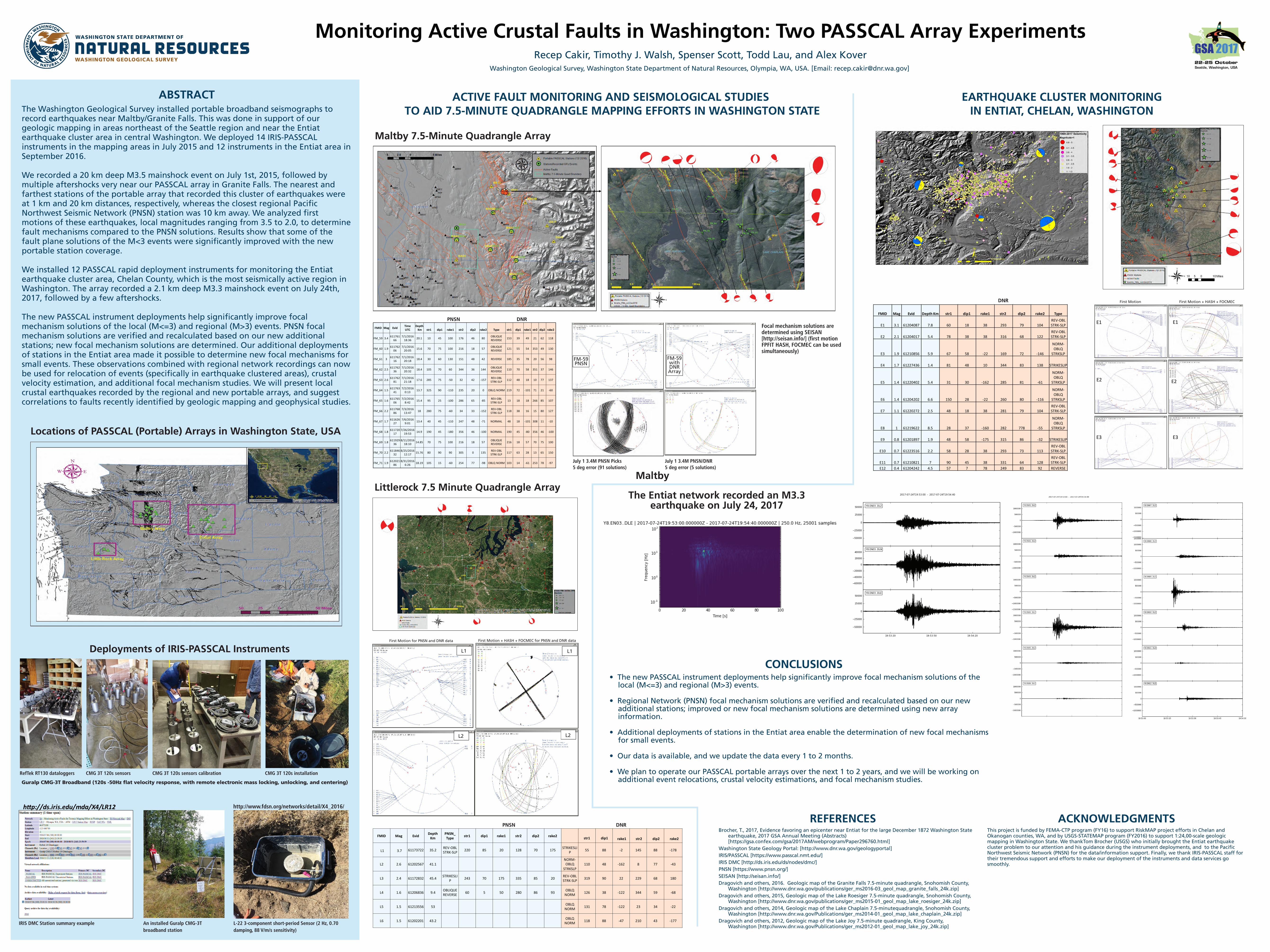
The Entiat network recorded an M3.3 earthquake on July 24, 2017
ABSTRACTThe Washington Geological Survey installed portable broadband seismographs to record earthquakes near Maltby/Granite Falls. This was done in support of our geologic mapping in areas northeast of the Seattle region and near the Entiat earthquake cluster area in central Washington. We deployed 14 IRIS-PASSCAL instruments in the mapping areas in July 2015 and 12 instruments in the Entiat area in September 2016.
We recorded a 20 km deep M3.5 mainshock event on July 1st, 2015, followed by multiple aftershocks very near our PASSCAL array in Granite Falls. The nearest and farthest stations of the portable array that recorded this cluster of earthquakes were at 1 km and 20 km distances, respectively, whereas the closest regional Pacific Northwest Seismic Network (PNSN) station was 10 km away. We analyzed first motions of these earthquakes, local magnitudes ranging from 3.5 to 2.0, to determine fault mechanisms compared to the PNSN solutions. Results show that some of the fault plane solutions of the M<3 events were significantly improved with the new portable station coverage.
We installed 12 PASSCAL rapid deployment instruments for monitoring the Entiat earthquake cluster area, Chelan County, which is the most seismically active region in Washington. The array recorded a 2.1 km deep M3.3 mainshock event on July 24th, 2017, followed by a few aftershocks.
The new PASSCAL instrument deployments help significantly improve focal mechanism solutions of the local (M<=3) and regional (M>3) events. PNSN focal mechanism solutions are verified and recalculated based on our new additional stations; new focal mechanism solutions are determined. Our additional deployments of stations in the Entiat area made it possible to determine new focal mechanisms for small events. These observations combined with regional network recordings can now be used for relocation of events (specifically in earthquake clustered areas), crustal velocity estimation, and additional focal mechanism studies. We will present local crustal earthquakes recorded by the regional and new portable arrays, and suggest correlations to faults recently identified by geologic mapping and geophysical studies.
Locations of PASSCAL (Portable) Arrays in Washington State, USA
Deployments of IRIS-PASSCAL Instruments
ACTIVE FAULT MONITORING AND SEISMOLOGICAL STUDIES TO AID 7.5-MINUTE QUADRANGLE MAPPING EFFORTS IN WASHINGTON STATE
EARTHQUAKE CLUSTER MONITORING IN ENTIAT, CHELAN, WASHINGTON
Monitoring Active Crustal Faults in Washington: Two PASSCAL Array ExperimentsRecep Cakir, Timothy J. Walsh, Spenser Scott, Todd Lau, and Alex Kover
Washington Geological Survey, Washington State Department of Natural Resources, Olympia, WA, USA. [Email: [email protected]]
Maltby 7.5-Minute Quadrangle Array
Littlerock 7.5 Minute Quadrangle Array
CONCLUSIONS• The new PASSCAL instrument deployments help significantly improve focal mechanism solutions of the
local (M<=3) and regional (M>3) events.
• Regional Network (PNSN) focal mechanism solutions are verified and recalculated based on our new additional stations; improved or new focal mechanism solutions are determined using new array information.
• Additional deployments of stations in the Entiat area enable the determination of new focal mechanisms for small events.
• Our data is available, and we update the data every 1 to 2 months.
• We plan to operate our PASSCAL portable arrays over the next 1 to 2 years, and we will be working on additional event relocations, crustal velocity estimations, and focal mechanism studies.
ACKNOWLEDGMENTSThis project is funded by FEMA-CTP program (FY16) to support RiskMAP project efforts in Chelan and Okanogan counties, WA, and by USGS-STATEMAP program (FY2016) to support 1:24,00-scale geologic mapping in Washington State. We thankTom Brocher (USGS) who initially brought the Entiat earthquake cluster problem to our attention and his guidance during the instrument deployments, and to the Pacific Northwest Seismic Network (PNSN) for the data/information support. Finally, we thank IRIS-PASSCAL staff for their tremendous support and efforts to make our deployment of the instruments and data services go smoothly.
REFERENCESBrocher, T., 2017, Evidence favoring an epicenter near Entiat for the large December 1872 Washington State
earthquake, 2017 GSA Annual Meeting (Abstracts) [https://gsa.confex.com/gsa/2017AM/webprogram/Paper296760.html]
Washington State Geology Portal: [http://www.dnr.wa.gov/geologyportal]IRIS/PASSCAL [https://www.passcal.nmt.edu/] IRIS DMC [http://ds.iris.edu/ds/nodes/dmc/]PNSN [https://www.pnsn.org/]SEISAN [http://seisan.info/] Dragovich and others, 2016. Geologic map of the Granite Falls 7.5-minute quadrangle, Snohomish County,
Washington [http://www.dnr.wa.gov/publications/ger_ms2016-03_geol_map_granite_falls_24k.zip] Dragovich and others, 2015, Geologic map of the Lake Roesiger 7.5-minute quadrangle, Snohomish County,
Washington [http://www.dnr.wa.gov/publications/ger_ms2015-01_geol_map_lake_roesiger_24k.zip] Dragovich and others, 2014, Geologic map of the Lake Chaplain 7.5-minutequadrangle, Snohomish County,
Washington [http://www.dnr.wa.gov/Publications/ger_ms2014-01_geol_map_lake_chaplain_24k.zip] Dragovich and others, 2012, Geologic map of the Lake Joy 7.5-minute quadrangle, King County,
Washington [http://www.dnr.wa.gov/Publications/ger_ms2012-01_geol_map_lake_joy_24k.zip]
E1 E1
E2 E2
E3 E3
M2.6 M2.6
M3.7M3.7L1 L1
L2 L2
http://ds.iris.edu/mda/X4/LR12
Maltby
PNSN DNR
First Motion for PNSN and DNR data First Motion + HASH + FOCMEC for PNSN and DNR data
PNSN DNR
DNR First Motion First Motion + HASH + FOCMEC
FMID Mag Evid Time UTC
DepthKm str1 dip1 rake1 str2 dip2 rake2 Type str1 dip1 rake1 str2 dip2 rake2
FM_59 3.4 61176166
7/1/2016 18:36 20.1 10 45 100 176 46 80 OBLIQUE
REVERSE 153 39 49 21 62 118
FM_60 1.9 61176206
7/1/2016 20:05 15.6 70 75 100 216 18 57 OBLIQUE
REVERSE 121 55 54 353 49 130
FM_61 3 61176216
7/1/2016 20:18 18.4 30 60 130 151 48 42 REVERSE 185 35 78 20 56 98
FM_62 2.5 61176236
7/1/2016 20:32 18.4 105 70 60 344 36 144 OBLIQUE
REVERSE 110 70 58 351 37 146
FM_63 2.6 61176281
7/1/2016 21:18 17.6 285 75 -50 32 42 -157 REV-OBL
STRK-SLP 112 48 18 10 77 137
FM_64 1.5 61176341
7/2/2016 0:13 13.7 325 90 -110 235 20 0 OBLQ NORM 219 72 -101 71 21 -60
FM_65 1.6 61176506
7/2/2016 8:42 15.4 95 25 -100 286 65 -85 REV-OBL
STRK-SLP 13 18 18 266 85 107
FM_66 2.2 61176886
7/3/2016 13:47 18 280 75 -60 34 33 -152 REV-OBL
STRK-SLP 118 38 16 15 80 127
FM_67 1.7 61162627
7/6/2016 9:01 13.4 40 45 -110 247 48 -71 NORMAL 48 18 -101 308 11 -10
FM_68 1.8 61172017
7/26/2016 19:53 14.9 190 45 -180 356 46 -100 NORMAL 190 45 -80 356 46 -100
FM_69 1.8 61192936
8/11/2016 18:10 14.85 70 75 100 216 18 57 OBLIQUE
REVERSE 216 18 57 70 75 100
FM_70 2.2 61184632
8/25/2016 12:17 15.76 80 90 90 305 0 135 REV-OBL
STRK-SLP 117 63 28 13 65 150
FM_71 1.9 61202186
8/31/2016 6:26 18.19 105 15 -60 254 77 -98 OBLQ NORM 103 14 -61 253 78 -97
FMID Mag Evid Depth Km
PNSN_Type str1 dip1 rake1 str2 dip2 rake2 str1 dip1 rake1
DNR str2
DNR dip2
DNRrake2
L1 3.7 61173722 35.2 REV-OBL STRK-SLP 220 85 20 128 70 175 STRIKESLI
P 55 88 -2 145 88 -178
L2 2.6 61202567 41.1NORM-OBLQ
STRKSLP110 48 -162 8 77 -43
L3 2.4 61172832 45.4 STRIKESLIP 243 70 175 335 85 20 REV-OBL
STRK-SLP 319 90 22 229 68 180
L4 1.6 61206836 9.4 OBLIQUE REVERSE 60 5 50 280 86 93 OBLQ
NORM 126 38 -122 344 59 -68
L5 1.5 61213556 53 OBLQ NORM 131 78 -122 23 34 -22
L6 1.5 61202201 43.2 OBLQ NORM 118 88 -47 210 43 -177
RefTek RT130 dataloggers CMG 3T 120s sensors CMG 3T 120s sensors calibration CMG 3T 120s installation
Guralp CMG-3T Broadband (120s -50Hz flat velocity response, with remote electronic mass locking, unlocking, and centering)
IRIS DMC Station summary example An installed Guralp CMG-3Tbroadband station
L-22 3-component short-period Sensor (2 Hz, 0.70damping, 88 V/m/s sensitivity)
FMID Mag Evid Depth KmDNR str1
DNR dip1
DNR rake1 str2
DNR dip2
DNR rake2
DNRType
E1 3.1 61204087 7.8 60 18 38 293 79 104REV-OBL STRK-SLP
E2 2.1 61204017 5.4 78 38 38 316 68 122REV-OBL STRK-SLP
E3 1.9 61210856 5.9 67 58 -22 169 72 -146
NORM-OBLQ
STRKSLP
E4 1.7 61227436 1.4 81 48 10 344 83 138 STRIKESLIP
E5 1.4 61220402 5.4 31 30 -162 285 81 -61
NORM-OBLQ
STRKSLP
E6 1.4 61204202 6.6 150 28 -22 260 80 -116
NORM-OBLQ
STRKSLP
E7 1.1 61220272 2.5 48 18 38 281 79 104REV-OBL STRK-SLP
E8 1 61219622 8.5 28 37 -160 282 778 -55
NORM-OBLQ
STRKSLP
E9 0.8 61201897 1.9 48 58 -175 315 86 -32 STRIKESLIP
E10 0.7 61223516 2.2 58 28 38 293 73 113REV-OBL STRK-SLP
E11 0.7 61210821 7 90 45 38 331 64 128REV-OBL STRK-SLP
E12 0.4 61204242 4.5 57 7 78 249 83 92 REVERSE
July 1 3.4M PNSN Picks 5 deg error (91 solutions)
July 1 3.4M PNSN/DNR5 deg error (5 solutions)
Focal mechanism solutions are determined using SEISAN [http://seisan.info/] (first motion FPFIT HASH, FOCMEC can be used simultaneously)
http://www.fdsn.org/networks/detail/X4_2016/
FM-59PNSN
FM-59withDNRArray