monitoring of mining subsidence in a sector of …
TRANSCRIPT
The subsidence of a mining sector is the sinking of the surface, due to the extraction of rocks or
minerals from an underground mine [1]. The detection and monitoring of land subsidence make it possible
to detect temporary changes in the sinking pattern and provide important information on the dynamics of
this process. In addition, estimating where the future subsidence would occur would facilitate decision-
making and the avoidance of damage to mining facilities and the environment [2].
The Interferometric Synthetic Aperture Radar (InSAR) is a remote sensing technique based on the
process and analysis of SAR images which consists of measuring the optical path differences between the
satellite and the earth, in two revisits of the satellite by the same area of study [3].
In this context, one of the techniques commonly used for this type of study in different parts of the
world is differential interferometry (DInSAR), which is a technique based on synthetic aperture radar
satellites that can be used to measure surface displacement in large regions with high spatial resolution.
Under good conditions, displacements can be measured with centimeter to subcentimeter accuracy [4].
By monitoring the subsidence in the El Teniente mine in central Chile using the DInSAR technique
during 2010 and 2015, subsidence was estimated in some sectors of up to -5 cm with TerraSAR-X and
COSMO-SkyMED (X band) imagenes [5]. When using the DInSAR technique with COSMO-SkyMED
images in the same sector, an accumulated movement of -4 cm between 2010 and 2015 was estimated [6].
The objective of this research is to monitor the eventual subsidence that would occur in
the mining sector in central Chile using DInSAR techniques with Sentinel-1 images.
MONITORING OF MINING SUBSIDENCE IN A SECTOR OF CENTRAL CHILE THROUGH THE PROCESSING OF A TIME
SERIES OF SENTINEL 1 IMAGES USING DInSAR.
Paulina Vidal13*, Dominique Derauw2, Alfonso Fernandez-Sarría3, Miguel Peralta4
1Hémera Centro de Observación de la Tierra, Facultad de Ciencias, Universidad Mayor, Chile; 2 Centre Spatial de Liège, Université de Liège, Bélgica;
3 Departamento de Ingeniería Cartográfica, Geodesia y Fotogrametría, Universitat Politècnica de València, España; 4 Escuela de Geografía, Facultad de Arquitectura y Urbanismo, Universidad de Chile, Chile.
INTRODUCTION
RESULTS
MATERIALS AND METHODS
DISCUSSION AND CONCLUSIONS
ACKNOWLEDMENTSREFERENCES
STUDY AREA
The study area corresponds to a mining sector of the Libertador General Bernardo
O'Higgins Region located in the central zone of Chile between 34°1'18'' and 34°12'57''
south latitude and 70°28´18'' and 70° 28´29´´ West longitude (Figure 1). This sector
has a Mediterranean climate (warm summers) with mountain influence [7].
The mining sector corresponds to an underground copper mine with a processing
capacity of 140,000 tonnes per day [8].
1. Ng H.-M, A..; Ge, L.; Du, Z.; Wang, S.; Ma, C. Satellite radar interferometry for monitoring subsidence induced by longwall mining activity using Radarsat-2, Sentinel-1 and ALOS-2 data. Int J Appl Earth Obs Geoinf
2017, 61, 92-103. https://doi.org/10.1016/j.jag.2017.05.009
2. Sarychikhina, O.; Glowacka, E.; Mellors, R.; Vidal, F. S. Land subsidence in the Cerro Prieto Geothermal Field, Baja California, Mexico, from 1994 to 2005. An integrated analysis of DInSAR, leveling and geological data.
J Volcanol Geotherm Res 2011, 204(1-4), 76-90. https://doi.org/10.1016/j.jvolgeores.2011.03.004
3. Ferretti, A., Monti-Guarnieri, A., Prati, C., Rocca, F. 2007. InSAR Principles: Guidelines for SAR Interferometry Processing and Interpretation. ESA Publications, TM-19. ISBN 92-9092-233-8.
4. Wempen, J. M.; McCarter, M. K. Comparison of L-band and X-band differential interferometric synthetic aperture radar for mine subsidence monitoring in central Utah. Int. J. Min. Sci. Technol 2017, 27(1), 159-163.
https://doi.org/10.1016/j.ijmst.2016.11.012
5. Espinosa, E.A & Manso, G.A. Ground Subsidence Model for a Panel Caving Exploitation at el Teniente Mine - Codelco Chile. In American Rock Mechanics Association, 49th U.S. Rock Mechanics/Geomechanics
Symposium, San Francisco, California, 28 June-1 July, 2015.
6. Sánchez, F.; Conde, A.; Salvà, B.; Colombo, D. Use of SAR Radar satellite data to measure ground deformation in underground and open pit mine sites, El Teniente case study, Chile. Proceedings of the First Asia
Pacific Slope Stability in Mining Conference, Brisbane, Australia, 6-8 September, 2016.
7. Sarricolea, P.; Herrera-Ossandón, M. & Meseguer-Ruiz, Ó. Climatic regionalisation of continental Chile. J Maps 2017, 13(2), 66–73. https://doi.org/10.1080/17445647.2016.1259592.
8. Comisión Chilena del Cobre (2014). Inversión en la minería Chilena-Cartera de proyectos 2014-2023.
9. Chen, C. W. and Zebker, H. A. Network approaches to two-dimensional phase unwrapping: intractability and two new algorithms. J. Opt. Soc. Am. A 2000, 17(3), 401-414. https://doi.org/10.1364/JOSAA.17.000401
10. Crosetto, M. & Crippa, B. Quality Assessment of Interferometric SAR DEMs. ISPRS J Photogramm Remote Sens 2000, Vol. XXXIII, Part B1, 46–53.
11. Universidad Mayor (2018). Estudio de Geología, Geomorfología y Peligros Naturales en la cuenca Alta del río Mapocho. Inédito.
¡Poster descargable!
1 PB: Perpendicular baseline2 TB: Temporal baseline
Figure 1. Study area. The red rectangle
shows the study area.
Nine interferograms generated from Sentinel-1 images with VV polarization, both descending
and ascending pairs, were processed between 2014 and 2018. However, the coherence values in the
mining sector under study are less than 0.5 as shown in Figure 3, both in the descending and ascending
pairs and to obtain displacement, coherence values greater than 0.5 should be considered, since these
values are considered a good indicator of the interferometric phase quality [10].
Figure 2. Methodology for the estimation of subsidence in the mining sector.
Figure 3.
Coherence Images
in the study area.
Interferograms in
the study area.
The work was supported by the Centro de
Observación de la Tierra Hémera de la
Universidad Mayor.
Table 1. Characteristics of interferometric pairs used.
06-10-2014 10-01-2017
30-10-2014 03-02-2017
23-10-2014 10-01-2017
16-11-2014 27-02-2017
10-01-2015 05-02-2018
03-02-2015 01-03-2018
03-01-2015 05-01-2018
20-02-2015 29-01-2018
17-01-2016
10-02-2016
48
24
24
21
16
67
69
7
8
9
Descending
Descending
Ascending
Descending
6
130
19
34
24
24
24
48
24
90
3
4
5
Ascending
Descending
Ascending
Descending
Ascending
2
Date Flight
Direction PB TB
1 130
Pair Date Flight
Direction PB TBPair
24
II CONGRESO EN INGENIERÍA EN GEOMÁTICA
CIGEO 2019
MADRID, 26-27 JUNIO
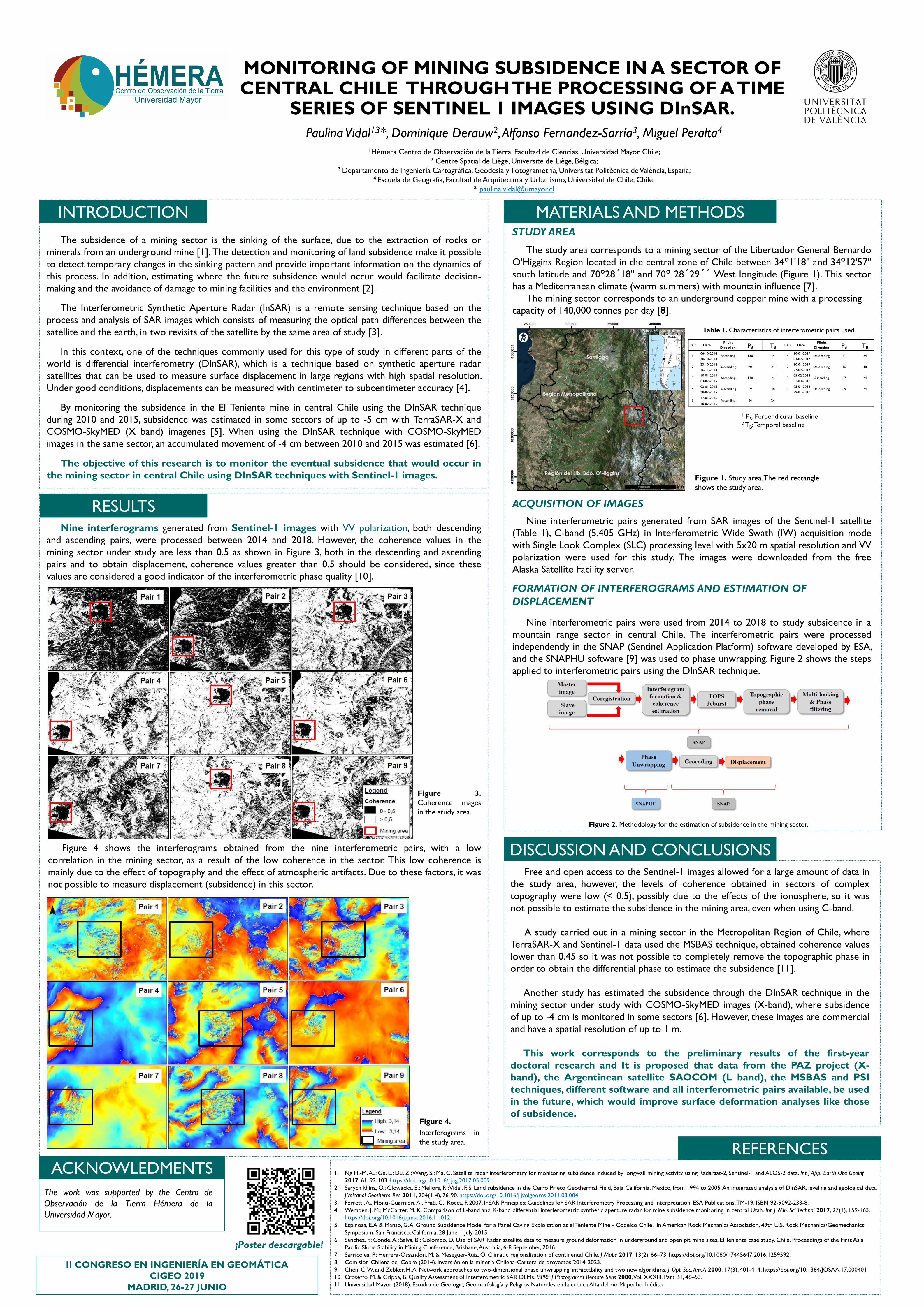
Figure 4 shows the interferograms obtained from the nine interferometric pairs, with a low
correlation in the mining sector, as a result of the low coherence in the sector. This low coherence is
mainly due to the effect of topography and the effect of atmospheric artifacts. Due to these factors, it was
not possible to measure displacement (subsidence) in this sector.
Figure 4.
ACQUISITION OF IMAGES
Nine interferometric pairs generated from SAR images of the Sentinel-1 satellite
(Table 1), C-band (5.405 GHz) in Interferometric Wide Swath (IW) acquisition mode
with Single Look Complex (SLC) processing level with 5x20 m spatial resolution and VV
polarization were used for this study. The images were downloaded from the free
Alaska Satellite Facility server.
FORMATION OF INTERFEROGRAMS AND ESTIMATION OF
DISPLACEMENT
Nine interferometric pairs were used from 2014 to 2018 to study subsidence in a
mountain range sector in central Chile. The interferometric pairs were processed
independently in the SNAP (Sentinel Application Platform) software developed by ESA,
and the SNAPHU software [9] was used to phase unwrapping. Figure 2 shows the steps
applied to interferometric pairs using the DInSAR technique.
Free and open access to the Sentinel-1 images allowed for a large amount of data in
the study area, however, the levels of coherence obtained in sectors of complex
topography were low (< 0.5), possibly due to the effects of the ionosphere, so it was
not possible to estimate the subsidence in the mining area, even when using C-band.
A study carried out in a mining sector in the Metropolitan Region of Chile, where
TerraSAR-X and Sentinel-1 data used the MSBAS technique, obtained coherence values
lower than 0.45 so it was not possible to completely remove the topographic phase in
order to obtain the differential phase to estimate the subsidence [11].
Another study has estimated the subsidence through the DInSAR technique in the
mining sector under study with COSMO-SkyMED images (X-band), where subsidence
of up to -4 cm is monitored in some sectors [6]. However, these images are commercial
and have a spatial resolution of up to 1 m.
This work corresponds to the preliminary results of the first-year
doctoral research and It is proposed that data from the PAZ project (X-
band), the Argentinean satellite SAOCOM (L band), the MSBAS and PSI
techniques, different software and all interferometric pairs available, be used
in the future, which would improve surface deformation analyses like those
of subsidence.