monterey bay sanctuary scenic trail network bay sanctuary... · santa cruz county . regional...
TRANSCRIPT

Santa Cruz County Regional Transportation Commission
Monterey Bay Sanctuary Scenic
Trail Network
Cory Caletti
Program Manager/Senior Transportation Planner


Rail Trail near Depot Park
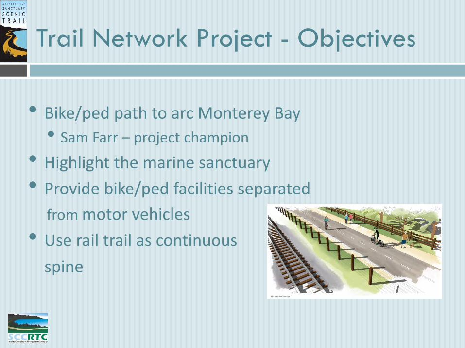
• Bike/ped path to arc Monterey Bay
• Sam Farr – project champion
• Highlight the marine sanctuary
• Provide bike/ped facilities separated
from motor vehicles
• Use rail trail as continuous
spine
Trail Network Project - Objectives

• Expand non-motorized transportation options
• Provide safe bicycle and pedestrian facilities
• Serve multiple users traveling at different speeds
• Serve variety of mobility ranges
• Provide access to key destinations
Trail Network Project - Objectives

Braided Trail System Providing Key Connections
California Coastal Trail
Trail Network System Defined
Davenport
Santa Cruz Capitola
Aptos
Watsonville
Scotts Valley
Coastal Connections
Coastal Rail Trail
Trail Network Project - Objectives
•Develop the project within framework of:
• public right-of-ways
• rail service & agricultural operations
• private property ownership
• separation from motor vehicle traffic
• coastal access

Master Plan – Guiding Document
Corridor Tours
Stakeholder Meetings
Constraints Mapping
Technical Meetings
Public Workshops
Final Plan/EIR

Trail Network Plan Overview
1. Introduction
2. Goals, Objectives, and Policies
3. Master Plan Setting
4. Trail Alignment
5. Trail Design Standards
6. Project Prioritization and Costs
7. Operation and Maintenance
How did we get to this point?
What do we expect to achieve?
What does the trail network area encompass?
Where will the trail go?
How will the trail look?
When will the trail segments be constructed?
How do we manage the trail?

Trail Network – 20 Segments
Waddell Bluffs Greyhound Rock – Cal Poly Bluffs Upper Coast Dairies at Scott Creek Davenport Landing/End of Railroad Tracks Davenport and Wilder Ranch
1
1
2
3
4
5
2
3 4
5
Northern Reach

Trail Network – 20 Segments
Wilder Ranch Trailhead/Shaffer Road Coastal Santa Cruz Santa Cruz Beach Boardwalk Twin Lakes Live Oak/Jade St Park
6
7
8
9
10
Capitola – Sea Cliff Aptos Village Rio Del Mar – Hidden Beach Seascape
11
12
13
14
6 7 8 9 10
11 12
13
14
Central Reach

Trail Network – 20 Segments
Manresa State Beach Harkins Slough Gallighan Slough Watsonville Open Space Trails Walker St/Watsonville Pajaro River
15
16
17
18
19
20
20
16
18 19
15
17
Watsonville Reach

Trail Types – Map Legend

Separated Trails/Paths (Class I)
Multi-Use Paved Path Cycle Track
Rail with Trail Recreational Path
San Luis Obispo Rail Trail Inland Rail Trail in Escondido Rail Trail near Depot Park

On-Road Facilities (Class II & III)
On-Street Bike Route Designated Bike Lane
Class III Class II

Various Other Facilities
Improved Unpaved Trail Unpaved Trail
Boardwalk Sidewalk

Trail Amenity Options
Staging Areas Interpretive Signs
Fencing – various heights, materials for privacy & security
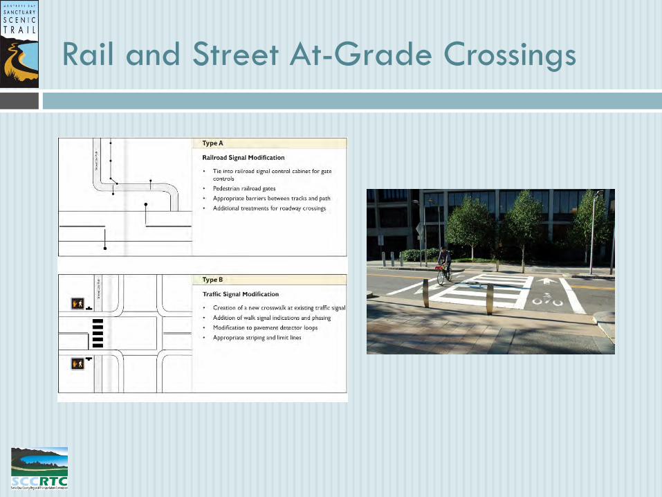
Rail and Street At-Grade Crossings

Rail Trail Bridge Crossings (Conceptual)
Type 1 – New Bridge with both Rail and Multi-Use Path
Type 2 – Cantilevered on Existing Bridge
Type 3 – New Multi-Use Path Bridge

Trail Network Estimated Cost
Estimated Network Cost
$126,724,080
Coastal Rail Trail
$120,960,968
30.3 miles
Coastal Trail Spurs
$5,762,112
18.4 miles

Implementation
• Multiple implementation scenarios
• local jurisdictions – Cities of SC, Wats, Cap; County
• the RTC
• other entity

Trail Network – Where We Are Now
• Master Plan adopted and EIR document certified – Nov 2013
• Funding allocated in Dec, 2013 to 3 segments
• $5.3M available through Congressman Farr & RTC efforts
• Two rail trail segments in Santa Cruz and Watsonville
• One on-road bike/ped improvement between 5th and 7th in Live Oak

Segment 7 – City of Santa Cruz
Natural Bridges to Pacific Ave
Total Project Cost: $5.3 million
Approved Funding: $4.06 million
Distance: 2.4 miles
Delivery Date: Fall 2017

Segment 18 – City of Watsonville
Lee Road, 4,000’ East to City
Slough Trail Connection
Total Project Cost: $1.3 million
Approved Funding: $1.04 million
Distance: 4000 ft
Delivery Date: Spring 2016

Trail Network – What’s Next?
• Seek new funding
• Private partnerships
• Agreements, MOUs, Implementation Plan
• Ensure future trail network uniformity
• Establish trail management duties, future adopt-a-trail programs

Thank You!
For more information about the Trail Network project, contact RTC
Project Manager Cory Caletti
www.sccrtc.org / (831) 460-3200

Thank you! Thank you!