monterey, california 93943 - national weather...
TRANSCRIPT

National Weather Digest
ESTIMATING VISIBILITY OVER THE NORTH PACIFIC OCEANUSING MODEL OUTPUT STATISTICS
Robert J. Renard (1) andWIlliam J. Thompson (2)
Department of MeteorologyNaval Postgraduate SchoolMonterey, California 93943
3. PROCESSING THE DATA AND DEVELOPMENT OFREGRESSION EQUATIONS
The basic set of MOP's consists of 24 diagnostic-prognostic parameters generatedfrom FNOC' s Mass Structure Analysis Modeland the Primitive Equation. Marine Windand Ocean Wave Prediction Models. An additional 79 interactive and derived dynamic and thermal parameters. continuous andbinary. were obtained from this set. Appendix (A) is a selected list of thosemodel output and climatology parametersused in developing the MOS equations.
The first step consisted of interpolatingthe MOP's and derived parameters (via acurvilinear bi-cubic spline routine) fromthe FNOC grid to each ship position. wherethey were matched to the respective visibility code. These interpolated parameters (predictors) were then used in thestepwise multiple linear regression program BMDP2R (7) to derive five equations.tbe predictands of which are parametersindicating the five visibility rangesshown in Table I.
and erroneous reports. are a compilationof information from ships' logs. ships'weather reporting forms. published sbipobservations. automatic observing buoys.teletype reports and data purchased fromforeign meteorological services. Thequality varies from those observationstaken by a deckhand to those of a trainedobserver. Data at 0000 GMT (local daylight) for the summer months July/August1979 served as the dependent/independentdata set. Over 4000 synoptic ship reportswere available for each month.
90-9293-9495-96979B-99
SYNOPTICOBSERVATION
CODE
VISIBILITYRANGE
0.0- 0.49 km0.5- 1.9 km2.0- 9.9 km
10.0-19.0 km20.0-50.0 km
12345
Table I. Visibility categories
REGRESSIONEQUATION
(Visibilitycategory)
1. INTRODUCTION
2. DATA/PARAMETERS
The method of model output statistics (HOS) is usedto develop multiple linear regressicn equations forforecasting the probability of marine visibility infive categories (0-.49, 0.5-1.9, 2-9.9, 10-19 and20-50 kID) at 24-h intervals to 48-h, foe the summerseason, North Pacific Ocean area. Further manipulation of the scheme yields categorical visibilityforecasts for three (0-1.9, 2-9.9, 10-50 Jan) andtto'O (D-9.9, 10-50 kID) visibility categories. Dependent and independent tests are verified usingpercentage correct, bias, Heidke skill score andthreat score. The experiment establishes the credibility of HOS applications over open ocean areas,with levels of skill commensurate to those for HOSvisibility forecasts over land.
The surface ship observational data fromthe North Pacific Ocean were obtained fromthe Naval Oceanography Center Detachment.Asbeville NC. which is co-located with theNational Climatic Data Center (NCDC).These data. Tape Data Family-Il (TDF-Il).which are filtered to exclude duplications
ABSmACT
Although fog and visibility forecastschemes abound for coastal locations. theopen ocean has been largely ignored.These kinds of forecasts are of particularimportance in order to safely executemaritime shipping and naval sea/air operations. Maritime casualties due to fogrelated low visibility are highest in thesummer months (Figure 1) when the combination of extent and density of fog is at amaximum (3.4). Since the ongoing computerized atmospheric prediction models donot output visibility directly. a reasonable approach to forecasting visibility isthrough the use of Model Output Statistics(MOS) (5). For the experiment reported onhere. the North Pacific Ocean (30-60N.145E-130W) was selected as the test basin.with various Fleet Numerical OceanographyCenter (FNOC). Monterey. CA analysis andprediction models supplying the basicModel Output Parameters (MOP) from a 23x12section of FNOC1s Northern Hemisphere63x63 polar stereographic grid. Verification of the developed MOS forecast schemeis compared to that using visibility climatology (3). visibility persistence, anda limited sample of National WeatherService MOS visibility forecasts for thecontinental United States (6).
18

Volume 9 Number 2
existing problem in working with visibilityobservations at sea.
EHFBVISRFTERBVISXU925
57.56001.90541.4265
-40.5343-0.68910.0056
VISIBILITY R2PROBABILITY (percent)
-35.1586-0.9191 EHF 18.643.9857 FTER 2.6
0.0039 RASTDX 1.30.0048 RHRSQ 1.00.5606 BVISX 0.90.0255 RASTDR ~
25.0356.8071-1. 6095 EHF 19.0-1.1414 BVISR 6.228.4439 FTER 1.20.4441 BVISX 0.70.0047 U925 0.5
-0.3126 PS ~28.1
129.1194-0.9573 BVISX 5.0-0.6316 RHX 1.2-0.4581 ASTDRX --!..d.
7.675.6061
0.5649 EHF 14.8-38.1213 FTER 2.2-0.9247 BVISX 1.70.7383 BVISR 1.4
-0.0237 RASTDR 0.80.0041 U925 ~
21. 4
22.85.41.61.2~31.6
Table III. Regression equations for estimating visibility probability. by visibility code-group for the North Pacific Ocean30-60N 145E-130W. Tau 0 h (4079 observations. July 1979). Variables for initialtime listed in order of selection. R2specifies variance explained by eachpredictor. See Appendix A for parameterdescription.
VIS CODEGROUP
Three sets of five equations each: a diagnostic set (tau 0 h) and two prognosticsets (tau 24 and 48 h). were derived (10)from the July 1979 data set (Tables II I.IV and V). Only those predictors thatcontributed at least 0.5' to the explainedvariance of the predictand were retained.The evaporative heat flux (EHF) is prominent in all equations. The majority ofexplained variance was determined by thisone parameter whenever it was the lead ingparameter. Negative (positive) EHF implies that the moisture flux is directeddownward toward (upward from) the sea andis associated with low (high) visibility.It is evident that the visibility class2-9.9 km is the most difficult to specifyfrom the available FNOC predictor parameters.
98-99(20-50 km)
93-94(0.5-1.9 km)
95-96(2-9.9 km)
97(10-19 km)
90-92(0-.49 km)
VISIBILITY SYNOPTICFORECAST OBSERVATIONEQUATION CODE
(1) (2) (3) (4 ) (5)100 25 0 0 0 90100 50 0 0 0 91100 75 25 0 0 92
75 100 50 0 0 9350 100 75 25 0 9425 75 100 50 25 95
0 50 100 75 50 960 25 75 100 75 970 0 50 75 100 980 0 25 50 100 99
Table II. Visibility probability (\)(= predictand) assigned to each synopticship observation as a function of reportedvisibility. for each of the five regressionequations developed.
A comparison of open ocean visibilityforecasting using MOS. in one case with acategorical predictand (8) and in theother case with a probabilistic predictand(9.10). indicated the desirability of thelatter approach. The remainder of thispaper will focus on the probabilistic visibility approach. Table I I indicates thepredictand values assigned to each shipobservation as a function of reported visibility. for each of the five regressionequations developed.
For example. in deriving the equation forspecifying visibility category 3 (seeTable I). observations coded as 95 or 96were assigned a predictand value of 100'.those with codes 94 and 97 a value of 75'.codes 93 and 98 a value of 50\. and soforth. Ideally. the predictand used indeveloping that equation should be 100'for all observations in codes 95 and 96and 0' for all other visibility codes(i.e. 90 to 94 and 97 to 99). But. it iscommonly accepted that visibility observations at sea are inexact at best (i.e.code 95 may be reported when in fact code94 was observed. etc.). The ideal approach was tried first but it was not assuccessful as assigning to the predictandpercentages other than 0' to visibilitycodes outside of the category to Which theequation applies. in this case category(3). Several variations for predictand assignment were tried. such as 80' for code94. 60\ for code 93. 30' for code 92; andsimilarly for codes 97. 98 and 99. Considering all equations. it was most methodical and the success of the technique wasbest when using the quartile reduction approach. that is reducing the predictandvalue by 25' increments in either directionfrom the codes defining the category.Table II entries should not be viewed horizontally--only vertically. and. of course.the percentages should not add up to 100'or any other prescribed value. This is anexperimental quantitative approach to an
19

National Weather Digest
Table IV. Same as Table III except Tau 24h (4095 observations). Number followingparameter indicates initial time (00) orprediction interval (12. 24. 36. 48) in h.
VISIBILITY R2PROBABILITY (percent)
-428.6230-1. 8534 EHF 36 20.927.3651 FTER 00 2.025.8898 FTER 48 1.1
-48.3218 GGTHTA 36 1.00.4235 PS 36 1.00.4132 MBVIS 48 ~
26.6-353.1233
-1.0305 EHF 36 19.30.2561 CLIMO 00 1.7
22.6730 FTER 48 1.3-0.4162 BVISR 00 0.9
0.3658 PS 24 0.60.0146 RASTDX 00 ~
24.4145.7690-1. 3323 BVISX 00 1.5-1.1001 WWW 00 1.7-0.6430 RHX 00 2.0
2.4041 SSANOM 00 0.80.3604 WWW 36 ~
6.6
1) For P/Pt~ 1:
2) For P/Pt < 1. use P/Pt.
Table VI. The most likely visibility category at a location is that one categorywhich is identified by the maximum decision ratio.
16.01.21.00.80.70.6~21.0
560.36280.8640 EHF 36
-26.1329 FTER 00-21.1406 FTER 48
5 . 0147 TSEA 00-3.7253 EX 48-0.4837 PS 36
497.96801.5811 EHF 36
-19.7227 FTER 000.4588 UCOMP 48
40.4127 GGTHTA 36-18.4243 FTER 48-0.4210 PS 48-0.1205 ASDXSQ 00
REGRESSION DECISION THRESHOLD VALUEEQUATION RATIO TAU O. 24. 48 h
(visibilitycategory)
1 p2/Pt 57. 54. 62
2 p2/1.1 Pt 59. 55. 60
3 p2/0.9 Pt 45. 34. 33
4 p2/1.1 Pt 42. 47. 39
5 p2/pt 49. 45. 42
The forecast goal is to identify the onemost likely category of visibility at anylocation for tau O. 24 and 48 h. However.a number of comparisons of the predictandprobabilities (P) computed from each ofthe five regression equations indicated aless-than-desirable focusing of the mostlikely visibility category (i.e. the onecategory to be forecasted). For example.the highest computed P among the five categories did not necessarily exceed theoptimal threshold probability (Pt) forthat category. Here Pt (Table VI). isdefined. for each visibility category andtime interval. as that predictand probability which best separates forecasts ofoccurrence and nonoccurrence of the categorical visibility event. The Pt usedhere maximizes the threat score (AppendixB) for each category. These considerations led to the definition of a decisionratio as a function of P. Pt (Table VI)for each regression equation (visibilitycategory). In the experimental form shownhere. p2/pt acts to suitably identifythe most likely visibility category whenP ~Pt; Const Pt in the denominator servesto finely tune the decision ratio for bestverification.
98-99(20-50 km)
97(10-19 km)
23.71.61.41.21.2~29.9
Table V. Same as Table IV except Tau 48 h(4102 observations).
28.31.81.2~32.0
18.22.20.70.7~22.3
3.01.61.20.9~
7.4
23.22.21.3~27.4
23.02.01.00.6~27.1
R2(percent)
VISIBILITYPROBABILITY
18.6298-1.9898 EHF 240.0213 RASTDX 00
19.9026 FTER 00-0.5685 WWW 3617.9254 FTER 24
32.5351-2.0482 EHF 24-0.5285 BVISR 00
0.0204 RASTDX 0018.4725 FTER 24
137 .1898-1.2913 BVISX 00
-19.4424 FTER 00-0.5658 RHX 00-5.8802 EHF 24-0.6511 WWW 00
61.96111.5293 EHF 24
-0.0210 RASTDX 00-14.9147 FTER 00
0.5736 WWW 36-16.5002 FTER 24
63.52592.8336 EHF 24
-0.0245 RASTDX 000.5113 BVISR 00
-21. 7912 FTER 24
95-96(2-9.9 I<m)
93-94(0.5-1.9 km)
VIS CODEGROUP
90-92(0-.49 km)
VIS CODEGROUP
93-94(0.5-1.9 km)
98-99(20-50 km)
95-96(2-9.9 km)
90-92(0-.49 km)
97(10-19 km)
20

Volume 9 Number 2
Three-category verification results forboth the dependent (July 79) and independent (August 79) 24 h forecasts appear inTable VIII.
Table VIII. Verification matrices. 24 hforecasts. three-category visibility estimates. MOS scheme North Pacific Ocean30-60N 145E-130W July 1979 dependent andAugust 1979 independent data sets.
Compared to the five-category verification. the biases for categories 1a and 3aare much nearer to the desired value of1.0. and percent correct and skill scorehave increased markedly. While theresul ts for categories 1a and 3a showedconsiderable improvement. biases in category 2a indicate that this middle categoryis considerably underforecasted. 48 h MOSforecasts behave similarly.
DEPENDENT TEST JULY 1979VISIBILITY ESTIMATED
CATEGORY (la) (2a) (3a)(la) 651 48 280
OBSERVED (2a) 183 83 299(3a) 329 60 2031TOTAL 1163 191 2610
TOTAL979565
24203964
TOTAL831485
29674283
1.05: 0.30: 1.10740.434: 0.105:0.445:(overall 0.385)0.375: 0.082:0.736
1.19: 0.34: 1.08700.464: 0.159:0.475:(overall 0.417)0.437: 0.123:0.667
THREAT SCORE
THREAT SCORE
BIASPERCENT CORRECT
HEIDKE SKILL SCORE
BIASPERCENT CORRECT
HEIDKE SKILL SCORE
INDEPENDENT TEST AUGUST 1979VISIBILITY ESTIMATED
CATEGORY (la) (2a) (3a)(la) 464 51 316
OBSERVED (2a) 129 48 308(3a) 276 47 2644TOTAL 869 146 3268
TOTAL 610 737 130 1183 1435 4095BIAS 1.13: 1.59: 0.22: 1.69: 0.80PERCENT CORRECT 41HEIDKE SKILL SCORE 0.280: 0.160: 0.154:
0.109: 0.323(overall 0.218)
THREAT SCORE 0.235: 0.160: 0.110:0.176: 0.416
Table VI I. Verification matrix of visibility estimates using MOS. five categories. 24 h forecasts. July 1979 dependent data set. North Pacific Ocean 30-60N145E-130W. (Pt). from Table VI. modifiedas follows: 54. 65. 24. 57. 45 for categories 1-5. respectively.
Even with minor statistical adjustments tothe threshold values (Pt). low verification scores indicate that the initial MOSscheme developed here. which is verifiedto differentiate between five visibilitycategories. is operationally unusable.Table VII illustrates this fact for 24 hMOS visibility forecasts.
From the perspective of using the MOSscheme to forecast Navy carrier flightoperations. it appeared advisable to collapse the five categories into three.Such a scheme approximates the primaryvisibility conditions for the launch andrecovery of fixed-wing aircraft over theopen ocean (11). In carrying out thismodification. the original five regressionequations and decision ratio calCUlationswere retained. but for estimation and verification purposes the visibility categories were recombined in the followingmanner;
CATEGORIES 1 and 2~CATEGORY la (0-1.9km)CATEGORY 3 ~CATEGORY 2a (2.0-9.9km)CATEGORIES 4 and 5~CATEGORY 3a (10-50 km)
Visibility ESTIMATEDCategory ( 1 ) (2 ) (3) (4 ) (5) TOTAL
( 1 ) 219 206 3 49 64 541( 2 ) 139 166 18 71 70 464
OBSERVED (3) 83 130 71 186 118 588( 4 ) 65 90 29 282 232 698( 5 ) 104 145 9 595 951 1804
NWA Charter Corporate Members
ACCU-WEATHER, INC.ALDEN ELECTRONICS, INC.AUDICHRONINTERCON WEATHER CONSULTANTS, INC.KAVOURAS, INC.LIGGETT BROADCAST GROUP
MOUNTAIN STATES WEATHER SERVICESTEXAS A&M UNIVERSITYTHE WEATHER CHANNELWEATHER CENTRAL, INC.WEATHER CORPORATION OF AMERICAWSI CORPORATIONZEPHYR WEATHERTRANS, INC.
21

National Weather Digest
CATEGORIES 1.2 and 3 _ CATEGORY Ib (0-9. 9km)CATEGORIES 4 and 5 _ CATEGORY 2b (lO-50km)
In view of the cont inued problem with thevisibility range 2.0 to 9.9 km. there followed a further recombination of categories 1. 2 and 3. Forecast detail isreduced and verification scores enhanced.
Table IX. verification matrices. 24 and48 h forecast; two-category visibilityestimates. MOS scheme North Pacific Ocean30-60N 145E-130W July 1979 dependent andAugust 1979 independent data sets.
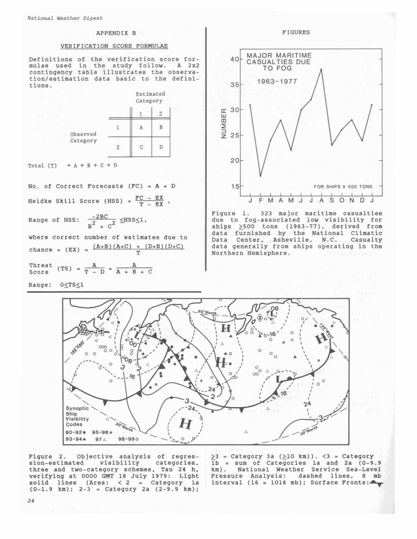
A graphical measure of the utility andcredibility of the two or three categoryscheme is shown by Figure 2. in which ananalysis of the categorized visibilityobservations for 0000 GMT 18 July 1979 iscompared to the 24 hMOS-estimated visibilities.
a peresti
August
AUGUST0.6140.3600.260
JULY0.5980.3270.241
00 h24 h48 h
Heidke skill scores usingparameter for visibility00. 24 and 48h. July and
Table X.sistencemates at1979.
Persistence is an often used forecast comparison scheme. The visibility persistence parameter developed at NPS is dependent on the MQS diagnostic visibility parameter and the observed value of visibility. In particular. visibility valuesfrom the July MOS scheme were used to initialize the polar stereographic grid fieldon a daily basis for that month. Thisfield was then modified by the currentvisibility observations of surroundingships. using an objective analysis basedupon an inverse-distance formula. Thesechanged field values were then re-interpolated back to the original ship positions using a curvilinear bi-cubic splineroutine. Table X indicates the skill ofthe persistence field for initial. 24 and48 h forecast times.
4. VISIBILITY PERSISTENCE AND CLIMATOLOGY
The skill scores are less than desirable.in part because grid-point values are notgood indicators of local visibility conditions whenever there are large variationsin the reported visibility at ship locations surrounding a grid point. Thelarger the gross-mesh size. the greaterthe number of ship reports that are interpolated to each grid point and the greaterthe likelihood of large variations.Nevertheless, if the 'Persistence' parameter developed here is in any way descriptive of persistence, it does indicate thatpersistence is not useful for forecastingopen-ocean visibi Ii ty. As evidence. notethe rapid decrease in skill score for the24- and 48-h forecasts (Table X). A visibility climatology frequency parameterwas also derived for each Marsden square(10 lat x 10 long) using data receivedfrom NCDC Asheville (3). Instead of usingclimatological average visibilities (sincethese averages are biased toward good visibility). weighted values. using a percentage of each visibility category. weretried. In either case. there is an overwhelming tendency for the climatology parameter to over-forecast good visibilityand the results were of little use. eitheralone or in combination with persistenceor the MOS scheme.
0.77; 1.10780.4450.422; 0.736
0.88; 1.08760.4750.499; 0.677
0.84; 1.10730.4250.463; 0.652
0.71: 1.12: 76
0.3690.358; 0.718
ESTIMATED(2b) TOTAL
678 12352548 28703226 4105
ESTIMATED(2b) TOTAL
634 15191924 23152558 3834
ESTIMATED(2b) TOTAL
624 13162644 29673268 4283
ESTIMATED(2b) TOTAL
579 15442031 24202610 3964
(48 h forecast)
(24 h forecast)
1979 (48 h forecast)
1979 (24 h forecast)
(lb)557322879
(lb)692323
1015
(lb)885391
1276
(lb)965389
1354
JULY 1979
AUGUST
AUGUST
JULY 1979
BIASPERCENT CORRECTHEIDKE SKILL SCORETHREAT SCORE
BIASPERCENT CORRECTHEIDKE SKILL SCORETHREAT SCORE
BIASPERCENT CORRECTHEIDKE SKILL SCORETHREAT SCORE
BIASPERCENT CORRECTHEIDKE SKILL SCORETHREAT SCORE
DEPENDENT TEST
VISIBILITYCATEGORY
(lb)OBSERVED (2b)
TOTAL
INDEPENDENT TEST
VISIBILITYCATEGORY
(lb)OBSERVED (2b)
TOTAL
INDEPENDENT TEST
DEPENDENT TEST
VISIBILITYCATEGORY
(lb)OBSERVED (2b)
TOTAL
VISIBILITYCATEGORY
(lb)OBSERVED (2b)
TOTAL
22
Volume 9 Number 2
5. FINAL REMARKS Descriptive Title of Each Parameter
Direct Model Output Parameters
Combination Model Output Parameters
Dynamic/Thermal Parameters Derived fromModel Output Parameters
TAIR-TSEATX-TSEAInfrared ExtinctionParameterInfrared ExtinctionParameterModified IR ExtinctionParameterRelative Humidity fromEAIR & TAIRRelative Humidity fromEX & TXZonal Wind Component
ASTDXASTDXASTDRASTDRHR
ASTDX •ASTDR •RHR •RHR •RHR •
Surface Vapor PressureEvaporative Heat FluxSurface Vapor PressureAdvective Fog ProbabilityFront-Location ParameterSea-Level PressureSea-Surface TemperatureAnomaly from Monthly MeanSurface Air TemperatureSea-Surface TemperatureSurface Air TemperatureZonal Wind 925 mbMarine Wind Speed
BVISX;b.c
U(COMP); c
MBVIS;b.c
RHR;a
RHX;b
ASDXSQASTDRXRASTDRRASTDXRHRSQ
ASTDR;aASTDX;a.bBVISR;a.c
TAIR;aTSEA;aTX;bU925;bVVWW; c
EAIR;aEHF;bEX;bFTER;b.cGGTHETA;bPS;aSSANOM; a
B.
C.
A.
The authors wish to acknowledge the developmental MOS work on marine visibilityforecasting by W. T. Aldinger and H. D.Selsor during their Master-of-Sciencethesis effort (R. J. Renard. advisor) atthe Naval Postgraduate School. The NavalAir Systems Command via the Naval Environmental Prediction Research Facility fundedthe research effort of the authors.
Another measure of the operational skillof the MOS technique proposed here is tocompare the machine generated objectiveMOS forecasts to their subjectively prepared counterparts. MOS forecasts can bearchived readily for future study. as isdone by the NWS for land areas. However.manually prepared forecasts for visibilityat specified ocean locations have not beencollected and processed in the past. but.of course. should be in the future. Published comparisons of the two types offorecasts will be necessary if the operational forecaster is to properly use theMOS guidance and. indeed. improve on it.
ACKNOWLEDGEMENT
Model output statistics. as a forecastscheme. has been in use for nearly adecade in the National Weather Service(NWS). To date. applications have beenexclusively over land. The subject experiment with marine visibility and anotherwith marine fog (12) indicates the applicability of MOS over the open ocean, withverification scores comparable to thosepublished by NWS for MOS over continentalU.S. (See 6 for example.) At the time ofthis writing, the U.S. Navy is developingplans for the extensive use of MOS forecasting over its marine area of responsibility -- the oceans of the world.
APPENDIX A
MODEL OUTPUT PARAMETER (MOP) DESCRIPTIONS
Continuous and binary (limits). direct andderived. Fleet Numerical OceanographyCenter MOP's and climatology used in thedevelopment of the mul tiple I inear regression equations shown in Tables III. IV andV.
Legend: Models a) analysis model;b) Northern Hemisphere primitive equationand c) marine wind models (parametersavailable at 12-h intervals from initialtime to 48 b).
D. Climatology
CLIMO Marine Fog Frequency
23
National Weather Digest
VERIFICATION SCORE FORMULAE
APPENDIX B FIGURES
40 MAJOR MARITIMECASUALTIES DUE
TO FOG
35 1963-1977
cr: 30wCD::;:::J
25z
20
1 2
1 A B
2 C D
ObservedCategory
-A+B+C+D
Definitions of the verification score formulae used in the study follow. A 2x2contingency table illustrates the observation/estimation data basic to the definitions.
EstimatedCategory
Total (T)
No. of Correct Forecasts (FC) 3 A + D 15 FOR SHIPS ~ 500 TONS
Heidke Skill Score (HSS) FC - EXT - EX
J F M A M J J A SON D J
Ranqe of HSS: -2BC-=,"",,"'-=: 5.HS S5.1 ,B
2+ C
2
where correct number of estimates due to
chance _ (EX) _ (A+B) (A+Cl + (D+Bl (D+ClT
Figure 1. 323 major maritime casualtiesdue to fog-associated low visibility forships ~SOO tons (1963-77), derived fromdata furnished by the National ClimaticData Center. Asheville. N.C. Casualtydata generally from ships operating in theNorthern Hemisphere.
Threat (TS) • A__ AScore T - D ~ A + B + C
Ranqe: 05.TS5.1
,•,
"-,,0,
"- , ", ,,, , • '\00 ...I0 I ¢ ..
0 I
• • " "-\0 • "-0
0 • \\\
0 \0 •
00 ,0, 0,,,,
24 ,,,--24... " I 'y
/II 'q•-~Y,
, I ....' ,I ,
" --<t40f'-- \ ,, ...--,.
-~~-p ---- --
"-"
Synoptic .........Ship ...........Visibility 4 .........Codes ,J'~
90-92. 95-96. o'r~93-94& 976 98-990
,--- ...,,,p,,
Figure 2. Objective analysis of regression-estimated visibility categories.three and two-category schemes. Tau 24 h.verifyinq at 0000 GMT 18 July 1979: Liqhtsolid lines (Area: < 2 Cateqory la(0-1. 9 km): 2-3 = Cateqory 2a (2-9.9 km):
24
~3 = Cateqory 3a (~10 km». <3 = CateqoryIb = sum of Cateqories la and 2a (0-9.9km). National Weather Service Sea-LevelPressure Analysis: dashed lines. 8 mbinterval (16 = 1016 mb): Surface Fronts:~
Volume 9 Number 2
6. Carter, G. H., et aI, 1982: Comparative Verification of Guidance and Local Aviation/PublicWeather Forecasts -- No. 12 (April 1981-September1981), TDL Office Note 82-8, National WeatherService, NOAA, 69 pp.
FOOTNOTES AND REFERENCES
1. Robert J. Renard earned his HS in Meteorologyat the University of Chicago in 1952 and his PhDat Florida State University in 1970. He has beena faculty member at the Naval Postgraduate School,Monterey, CA, since 1952 and Chairman of its Department of Meteorology since 1980. His teachingdJ1d research interests are in synoptic and polarmeteorology.
7. University of California, 1979:medical Computer Programs P-Series,and M. B. Brown, editors, UniversityPress, Los Angeles, CA, 880 pp.
BHDP- 79 Biow. J. Dixon,of California
2. William J. Thompson earned his BS in Physics atCalifornia State University Long Beach (Cal) in1975 and his HS in Meteorology from San Jose StateUniversity in 1979. He is currently a researchmeteorologist with the Department of Meteorology,Naval Postgraduate School, Monterey, CA, special
izing in statistical applications utilizing computer methods.
3. Talbot, T. N., and R. J. Renard, 1981: Development of a Prototype North Pacific Ocean SurfaceVisibility Climatology Stratified by ObservationTimes. NPS Report 63-81-002, Department of Meteorology, Naval Postgraduate School, Monterey, CA,85 pp.
4. Naval Weather Service Detachment, Asheville,NC, 1977: U.S. Navy Marine Climatic Atlas of theWorld, Vol II, North Pacific Ocean, NAVAIR 50-lC529, Director, Naval Oceanography and Meteorology,388 pp.
8. Yavorsky, P. G., and R. J. Renard, 1980: Ex
periments Concerning Categorical Forecasts ofOpen-Ocean Visibility Using Model Output Statistics. NPS Report 63-8D-002, Department of Mete
orology, Naval Postgraduate School, Monterey, CA,87 pp.
9. Aldinger, W. T., 1979: Experiments on Estimating Open Ocean Visibili ties Using Model OutputStatistics. M.S. Thesis (R. J. Renard, Advisor),Department of Meteorology, Naval PostgraduateSchool, Monterey, CA, 81 pp.
10. Selsor, H. D., 1980: Further ExperimentsUsing a Model Output Statistics Method in Estimating Open Ocean Visibility. M.S. Thesis (R. J.Renard, Advisor), Department of Meteorology, NavalPostgraduate School, Monterey, CA, 121 pp.
11. Department of the Navy, 1972: NATOPS MANUALCVA/CVS, Office of the Chief of Naval Operations,130 pp.
5. Glahn, H. R., and D. A. Lowry, 1972: The Useof Hodel Output Statistics (MOS) in ObjectiveWeather Forecasting. J. App!. Meteor., 11, pp.1203-1211.
12. Xoziara, M. C., R. J. Renard and W. J. Thompson, 1983: Estimating Marine Fog Probability Usinga Model Output Statistics Scheme, Mon. Wea. Rev.,Ill, pp. 2333-2340.
1984 AffIliated Organizations
-Nali<l~l Wuther Anocialion.Blue Hm ObseT\'alOfy Weather aub·North Jersey Weather Observers·Readlng (PAl H S Wealher Club-Zephyr Weather Transmission Serv.:e
·W.tson. frank.nd Bruce. eon.lIk,ng Mel.
I hereby certify thaI the informalion included in thisapplication is ,)Cclirate and true to the ~Sl of myknowledge.
PlEASE PRINT OR 1YPE
MEMBERSHIP APPLICATION -1984
ASSOCIATION of AMERICAN WEATHER OBSERVERS
1984 -
DATE _NAME _
STREET ADDRESS _
CITY' STATE ZIP _
TELEPHONE Bndo.w:Ic ....... Codcl _
Check appropriale space belowo I hereby apply for membership in the Association ofAmerican Weather Observers. I am not a member of anyorgzmizalion listed at right. Enclosed is S15.oo for 1984dues and 10 issues of the AWO.
r--------------------------------------------------------------------------1,,,,,,,,,,,,,,,,
...ppliu.... Sig:n.Ilture
Association 01 American Wulhel ObselVersP.O. Box4~
Bell.'idere.lllinois6100ll
Make fh«l< payablo to .-.....-. 01~ w........a..-s.nd ...... dlre<1lo,o to tho addle" be\ow onIoj. Thank,~
'"I hereby apply for membership in the Association ofAmerican Weather Observers. I am a member of theorganizalion(s) checked at right. Enclosed in $7.00 lor1984 dues and 10 issues of The AWO.
o,,,,,,,,,,
P1t_ 110I _mbenlIlp numb...- .. d.al< 01 ",",boonl>ip IO!" _ olllw OI"glInioa. ....,.. 4-us to!" IIfCICftOing I_.hodoed Add$5,OO""'Io<""!ln ...~dua :, J
25