monterey state beach - california state parks · pdf filemonterey state beach general plan...
TRANSCRIPT
GENERALPLAN
7WATSONVILLE
MontereyState Beach
PACIFIC
7,10 i’Ii 5ocI:.’l:l1i. 0. 71C-1l,*lI*iC-.
7 il/iIiJ..
Li? Il.’:/CrI: TOo FII:.:.lluILiI.o, /I/,.’II.:L/
.-‘/llI:lioi.-i: IC? Fi’I.: ,;
17.’::
State ParksaUG Reoreaton CommssIorI Approval - August 1987


CONTENTS
Page
SUMMARY . 1
INTRODUCTION . 7
RESPORCE ELEMENT 11Unit Description 13Resource Summary 13Resource Policy Formulation 20
LAND USE AND FACILITIES ELEMENT 27Monterey Beach Area - Existing Conditions 29Monterey Beach Area - Future Plans by the City of Monterey. 30Monterey Beach Area - Proposed Land Use and Facilities. . . 31Sand Dunes Drive Area - Existing Conditions 32Sand Dunes Drive Area - Proposed Land USE and Facilities. . 33Underwater Areas 35
INTERPRETIVE ELEMENT 37Interpretive Period 39Interpretive Themes 39Proposed Interpretation 40
CONCESSIONS ELEMENT 43Potential Concession Activities 45
OPERATIONS ELEMENT 47Existing Situation 49General Plan Implementation 51General Plan Implementation 52
ENVIRONMENTAL IMPACT ELEMENT 53Preface 55Summary 55
Project Description 55Description of the Environmental Setting 55The Significant Environmental Effects of the Proposed
Project 56Mitigation Measures 57Any Significant Environmental Effects That Cannot Be
Avoided if the Proposal Is Implemented 58Alternatives to the Proposed Project 58The Relationship Between Local Short-Term Uses of the
Environment and the Maintenance and Enhancement ofLong-Term Productivity 59
Any Significant Irreversible Environmental Changes ThatWould Be Involved if the Proposed Project Should Be
Implemented 59The Growth-Inducing Impacts of the Proposed Action. . . . 59Comments and Responses to Comments 61
111


SUMMARY
1
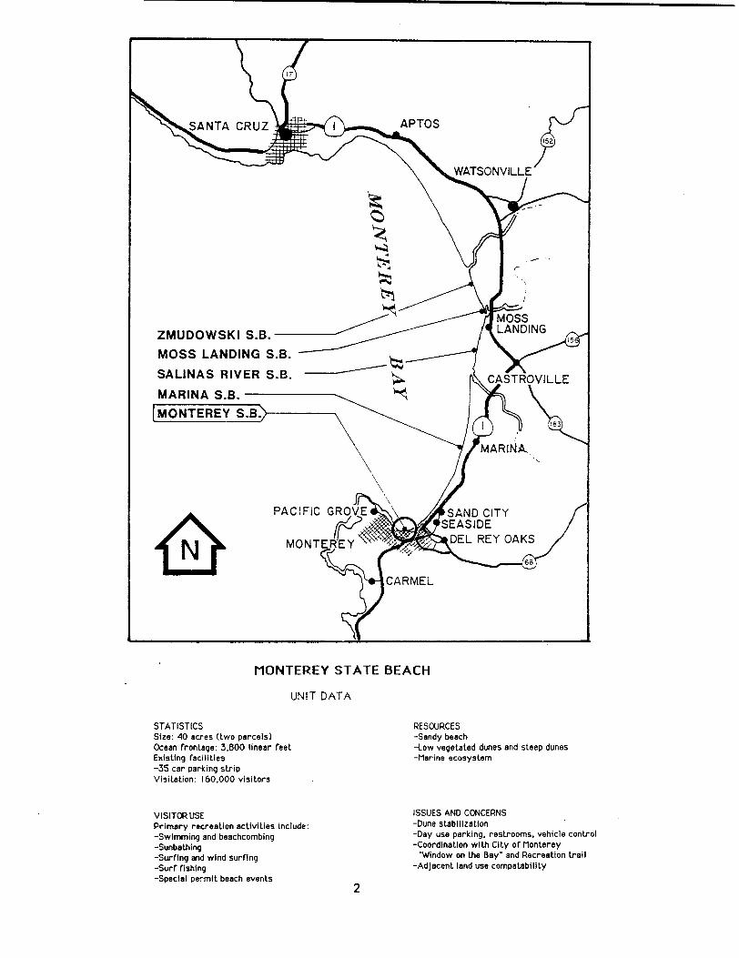
STATISTICSSize: 40 acres two prceIsOcean frontage: 38OO linear feet.ExI5ting faciIitie-35 car parking stripVisitation: 160.000 vi5iLors
UNIT DATA
VISITOR USEPrimary recreation activi lies include:-Swtmminç and be3chcombing-Sunbathing-Surfing and wind surfing-Surf fishing-Special permit beech events
2
RESOURCES-Sandy beech-{ow vegetated dunes and steep dunes-Merine ecosy5tem
ISSUES AND CONCERNS-Dune stabiIiza1ion-Day use parking, restrooms, vehicle control-Coordination with Cily of Monterey
Window on the Bay" and Recreation trail-Adjacent, land U58 compathbilfty
MONTEREY STATE BEACH

MONTEREY STATE BEACH GENERAL PLAN
SUMMARY
This General Plan for Monterey State Beach was prepared as part of an overallgeneral planning process for five state beaches in the northern portion ofMonterey County. The others are Marina, Moss Landing, Salinas River, andZmudowski State Beaches.
A separate General Plan has been developed for each unit so as to clearlypresent the material, and more importantly to aid in the future implementationof this plan.
The plans have been developed through extensive coordination within thevarious departmental divisions and offices, a series of public meetings anduser questionnaires, and interaction with local agencies.
All five of these state beaches are similar in that they consist of a stretchof ocean beach backed by coastal dunes. Each is unique, however, in duneheight, vegetation, human disturbance, and recreation opportunities. Thebeaches themselves are the primary recreation resource, providingopportunities for jogging, fishing, swimming, surfing, horseback riding, and awide variety of other uses.
This collection of beaches serves visitors both from the adjacent communitiesand statewide. With the exception of Monterey State Beach, these unitspresent a rural and somewhat isolated experience for visitors. The City ofMonterey and its collection of cultural and recreational resources drawvisitors statewide. The proposals of the Monterey State Beach General Planreflect that relationship.
Collectively these General Plans provide a wide array of uses; however,individually they will provide only those recreational uses and developmentthat are compatible with the resource values of the unit.
MontereyStateBeach is within the City *of Monterey and consists of twoseparate parcels about one mile apart:
Monterey BeachArea - This southerly 16-acre parcel is locatedimmediately west of the U.S. Naval Postgraduate School near the City ofMontereys harbor. The beach is heavily used during special events, butgenerally has not been subject to heavy use year round. However,recently the City of Monterey’s waterfront development projects therecreation/transportation trail arid Window-to-the-Bay have increasedvisibility and pedestrian access to this state section. Acquisitionefforts for the latter program began as a joint city and state project in1983.
The unit has no facilities or direct legal vehicle access. However, thecity beach adjacent to Monterey State Beach is a staging area for variouswater-related activities which overlap onto the state beach property.
The development of a railroad, sewer lines, and random roads through theyears has greatly disturbed native vegetation and allowed the spread ofexotic species.
3

Key recommendations of this plan for the Monterey Beach Area include:
0 Continued acquisition and planning efforts by the state andCity of Monterey to achieve the objectives of open space andimproved beach access.
o The development of visitor parking and restroom facilitiesoutside the bay view corridor.
o Coordination with the U.S. Navy to consider alternate routesfrom the recreation trail over federal lands, which willsatisfy demands arid objectives for more public access.
o Our department should continue to coordinate with the City ofMonterey to provide the necessary law enforcement, maintenance,visitor control, as well as operating and developmentagreements.
o Stabilization of the dunes.
SandDunes DriveArea - This 24-acre parcel is located in Monterey nearthe City of Seaside. This unit commands an excellent view of theimmediate Monterey city shoreline and is the first beach access visibleto the Highway 1 traveler between Moss Landing and Carmel River StateBeach.
The site has chemical toilets and trash barrels, and Sand Dunes Drive, acity-owned street, provides parking and vehicular access. Frequentpatrols are needed at this portion of the unit because of the extensivedrug and alcohol-related activities and general misuse of the area.
There is very little vegetation left on the scalped and drifting sanddunes that remain on the property, and without vegetation there is a lackof land-based fauna. The primary resource is the sandy beach and thescenic view it provides.
The proposed short-term uses of the area will be similar to the presentuses. The proposals should be a long-term solution to the needs of thepublic for parking, day-use facilities, beach access, and improvedmaintenance and visitor protection. In addition, the natural resourceswill be better protected and esthetics will be improved.
The key recommendations of this plan for the Sand Dunes Drive Areainclude:
o The department should investigate the possibility of obtainingownership transfer or jurisdiction of the portion of Sand DunesDrive within state beach property to improve control and designoptions.
o Develop a 150-car parking lot near the end of Sand Dunes Drivewith some pull-through spaces.
4

o Install vehicle barriers and control gates to restrict vehicleentry into dune areas and to regulate hours of visitor use.
o Install permanent restroom facilities near the new parking lotshould accommodate access for the elderly and disabled personswith boardwalk connections.
o Designate 25 picnic sites at the west end of the parking lot.
o Install two boardwalks for access to the beach from each end ofthe parking lot.
o Restore foredune, native vegetation, and wildlife habitat areas.
o Install interpretive signing to identify and explain sensitiveresource habitat areas, ocean hazards, and to orient visitorsto Monterey Bay with specific emphasis on the peninsulashoreline.
o Future management of this area should consider overnight use aspart of the department’s enroute camping program, provided thatranger surveillance is made available.
5

6

INTRODUCTION
7

8

MONTEREY STATE BEACH GENERAL PLAN
INTRODUCTION
General management and development guidelines in this plan will remain flexiblethrough review and continued updating. The plan will act as the primary sourceof information for future unit management and use. Specific proposals will befurther refined when specific items are funded for implementation.
This plan includes the following elements:
The Resource Element is a summary of the natural, cultural, esthetic, andrecreational resources of the area; it sets management policies forprotection and use of these resources.
The Land Use and Facilities Element describes current and proposed landuses, and describes proposed facilities.
The Interpretive Element describes proposals and programs for publicinformation and interpretation.
The Concessions Element describes the use of concessions in the unit.
The Operations Element describes operational guidelines for the unit.
The General Plan as a whole serves as the draft Environmental ImpactReport. Environmental impact information is presented in the Environmental Impact Element. Further environmental assessment will be performedwhen specific construction or management programs are proposed and, ifsignificant environmental impacts differing from those specified in thisGeneral Plan are found, further environmental documents will be filed.
In preparing the plan, several initial goals and objectives have beenestablished to serve as a general guide:
1. Identify the unit’s cultural and natural resources.
2. Identify existing and potential problems, and provide solutions.
3. Determine land use, unit development, and visitor activities thatare compatible with the purpose of the unit and the surrounding area.
4. Determine the potential environmental impacts of the land uses andvisitor activities.
5. Establish policies for maintenance and operation, protection andpreservation, development, and interpretation of the resources.
6. Establish a sequence of unit development.
7. Provide an information document for the public, the Legislature,department personnel, and other government agencies.
9

10

RESOURCE ELEMENT
Unit Description 13
Resource Summary 13NaturalResources 13Cultural Resources 18Esthetic Resources 20RecreationResources 20
Resource Policy Formulation 20Classification 20Declaration ofPurpose 21Zone of Primary Interest 21ResourceManagementPolicies 22Allowable UseIntensity 26
11

12

MONTEREY STATE BEACH GENERAL PLAN
RESOURCEELEMENT
This ResourceElement was preparedto meet requirementsof state law.* Incompliancewith the Public ResourcesCode, the ResourceElement sets forthlong-rangemanagementobjectives for the natural and cultural resourcesof theunit. Specific actions or limitations required to achieve these objectivesare also set forth in this element; maintenanceoperations and details ofresourcemanagementare left for inclusion in specific resourcemanagementprograms that will be preparedat a later date.
Discussionsabout lands not now owned by the Departmentof Parks and Recreationhave been included. These lands representpotential acquisition opportunities,based on available data. However, the discussionsare intended for planningpurposesand do not representan intention or commitment for acquisition.
Unit Description
Monterey State Beach is within the City of Monterey and is part of the CoastalStrip LandscapeProvince. The 40-acre unit consists of two separateparcelsabout one mile apart: a 16-acre southerly parcel which is immediately west ofthe U.S. Naval PostgraduateSchool, and a 24-acre upcoast parcel which is westof the Monterey Beach Hotel at the west end of Canyon Del Rey Boulevard. Thetotal ocean frontage is 3,800 feet. The nearestState Park System units areMonterey State Historic Park, 1/2 mile west; Marina State Beach, 6 milesnorth; and Asilomar State Beach, 4 miles west. Monterey PeninsulaCollege is1/2 mile south. The Monterey Municipal Wharf is 1,000 feet west of thewestern parcel
ResourceSummary
NaturalResources
Topography
Monterey State Beach is north- and northeast-facing. Dunes in the easternparcel that reach an elevation of 40 to 60 feet are the most prominenttopographic features in this unit. As a result of extensive human impact ondune vegetation, these dunes are largely unstabilized drifting sand.
Meteorology
Northern California experiencesa Mediterraneanclimate with cool, wet wintersand warm, dry summers. The waters of the Pacific Ocean have a profoundmoderatingeffect on temperaturesalong the coast, producing a maritimetemperatureregime with mild temperaturesyear-round. Mean daily maximumtemperaturesfor the months of May through November at Monterey State Beachare in the low to mid 60s and mean daily minimums are in the high 40s. For
* Section 5002.2, Subsection b of Division 5, Chapter 1 of the PublicResourcesCode and Chapter 1, Section 4332 of Title 14 of the CaliforniaAdministrative Code.
13
December through April , mean daily maximums are in the high 50s and mean dailyminimums are in the middle 40s. Mean annual precipitation is estimated at16 inches. Most of this precipitation 83% occurs during the months ofNovember through March.
Windy conditions are the norm around Monterey Bay; the weather station in theCity of Monterey reports wind speeds of 4 to 15 miles per hour about 75% of thetime, and strong winds, 16 to 31 miles per hour, are recorded 5% of the time.Calm winds, less than 4 miles per hour, are recorded about 20% of the time.
Fog, or fog-generated low clouds, occurs during all seasons, but is mostcommon on summer mornings and evenings. The Monterey Bay area has fog 12% ofthe time during July through September. As a consequence of the foggy summersand frequent winter storms, this area only receives about 3,000 hours ofsunshine or about 70% of possible light.
Microclimatic zones, areas that depart from the general climatic factorse.g., insolation, temperature, or soil moisture, are generated at MontereyState Beach by the ocean, the prevailing breeze, the coastal fog, the sandybeach, the sand dune formation, and the adjacent heavily developed urban core.
Water reflects only half as much solar insolation as land; hence, the oceanstores more energy during the day and releases more energy at night. However,because of its lower specific heat, the land warms up and cools down two tothree times as fast as the ocean. These energy storage and temperaturedifferences, together with the prevailing onshore breeze, moderate high andlow temperatures near the coast. When the coastal fog moves inland, itenhances this moderating effect. At first, it produces a sudden chill thatchases visitors from the beach; thereafter, it acts as a thermal blanket,keeping air and soil temperatures almost constant.
Surf and white beach sand reflect about half the solar radiation. This extrahalf-dose of sunshine accounts for the unexpected sunburns of manyinexperienced beach users.
The high reflectivity of beach sand and its lower water-holding capacitycreate a cool , arid habitat in the dunes on the eastern parcel of MontereyState Beach. Both parcels of the state beach are adjacent to the heavilydeveloped urban core of Monterey. This core produces a heat island withsomewhat warmer temperatures than would be found at more rural beaches.
Hydrology
Monterey State Beach is situated within the Monterey Peninsula HydrologicArea, which is within the Central Coastal Hydrologic Basin. The unit issubject to flooding during winter storm surges and high tides and would alsobe flooded during a tsunami. Specific groundwater quality data are notavailable for Monterey State Beach; however, saltwater intrudes wells to theeast of the unit.
14

Geol ogy
Monterey State Beach is within the Salinian block of the southern Coast Rangesgeomorphic province. The Salinian block is a wedge of continental crust-typematerial bounded on the northeast by the San Andreas fault zone about 38 kmnortheast of Monterey State Beach and on the southwest by the Sur-Nacimientofault zone.
The unit contains no bedrock outcrops; it consists entirely of sandy beaches,low foredunes in the western parcel, and higher elevation dune deposits in theeastern parcel. The dune deposits are superposed on older dune material and aseaward-sloping terrace which is below sea level in this location. MioceneMonterey shale lies below the terrace deposits.
The beach has fluctuated in morphology and width over the years, with anarrowing, eroding trend. Structures built on neighboring properties yearsago, behind wide sandy beaches and low dunes, have been threatened when stormwaves and high tides have dramatically eliminated the once-apparent ‘protection.
Soils
Coastal beaches, dune land, and a small area of Baywood loamy sand are theland types and soils occurring at Monterey State Beach.
The coastal beach land type occurs as narrow sandy beaches and adjacent lowsand dunes, consisting of sand, gravel, cobbles, or boulders, or a mixture ofthese. Portions of the coastal beach land typE? are exposed during low tidesand inundated at high tide, Drainage is very poor to excessive; erodibilityis high.
Dune land is a miscellaneous category consisting of sloping to very steepterrain derived from wind-deposited sand. Drainage and permeability are veryrapid. Wind erosion hazard is high. Dune land in this unit is highly eroded.
Baywood loamy sand, 2 to 15% slope, is an excessively-drained soil that hasformed in stabilized sand dunes. The surface layer is typically dark grayishbrown and brown, slightly to medium acid, averaging 21 inches thick. Thesubsurface layer, about 6 inches thick, is pale brown and slightly acid.Permeability is rapid. Shrink-swell potential is low. Erodibility is low.This soil phase is found along the southern and southeastern boundaries of theunit.
Plant Life
The vegetation at Monterey State Beach falls under the classification offoredune community. Species diversity is typically low in the foredunecommunity; however, there is also an extensive exotic flora at Monterey StateBeach.
The common species found on the low sand dunes of Monterey State Beach includesea fig and Hottentot fig Carpobrotus aequilaterus and C. edulis, beach burAmbrosia chamissonis, and sea rocket Cakile edentula. Sea fig andHottentot fig form solid stands throughout most of the back dune area.
15

The development of a railroad, sewer lines, and roads, compounded with heavybeach use and vehicular traffic, has greatly disturbed the native vegetationand allowed colonization by exotic species. Planted Monterey cypressCuppressus macrocarpa, eucalyptus Eucalyptus sp., and Monterey pine Pinusradiata occur in the southerly 16-acre parcel. A few of the common speciesfound in the disturbed areas are black mustard Brassica nigra, New Zealandspinach Tetragonia tetragonioides, bull thistle Circium vitgare, and wildradish Raphanus sativus.
The species list compiled for the unit lists 28 species. Of these, 16 57%are nonnatives.
No rare or endangered plant species are known to occur at Monterey State Beach.
Animal Life
Habitat diversity is very limited at Monterey State Beach due to direct humanimpact and urban encroachment.
Kelp beds offshore provide foraging sites for marine mammals and pelagicbirds. Mammals include the harbor seal, California sea lion, and southern seaotter.
Harbor seals occasionally use the beach as a haul-out area place of rest,and gulls and shorebirds forage along the littoral zone. These birds includeCalifornia and Heermann’s gulls, sandpipers, sanderlings, and killdeer.
Due to its degraded condition, the coastal dune biotic community provides poorwildlife habitat. Birds found here include Brewer’s blackbird andwhite-crowned sparrow.
The California brown pelican, a state and federally listed, endangeredspecies, has been observed foraging offshore at Monterey State Beach. Theendangered Pacific gray whale and other whale and dolphin species have alsobeen seen here.
The federally listed endangered Smith’s blue butterfly SBB may occur i thenorthern portion of this unit. The sand dunes between Sand Dunes Drive andState Highway 1 support coast buckwheat Eriogonum parvifolium, one of twoplant species that are host plants for the butterfly. The adjacent PhillipsPetroleum property is identified as SBB habitat in the SBB recovery plan.
Marine Life
Located within Monterey Bay, the marine environment off Monterey State Beachis within the Central California Seascape Province, a region of characteristicgeological and biological features that extends south from San Francisco Bayto Point Conception.
The marine ecosystem consists of two principal environments, benthic andpelagic. The pelagic environment is the open water from the surface to thesea floor. Benthic environments are on the ocean floor and are defined on thebasis of depth, substrate, and tidal influences. There are two significantbenthic zones at Monterey, intertidal and subtidal
16

The intertidal benthic zone is the sandy beach area between high and lowtides. This zone is limited in biological productivity due to the dailyexposure to the atmosphere and the constantly shifting sand. Nevertheless,some species, primarily burrowing animals, occur here. The most commonburrowing animals are blood worms and the mole crab. Scavangers are alsopresent, primarily beach hoppers. When the tide is in, several fish,including surf perch, diamond turbot, and round stingray, utilize thishabitat. When the tide is out, the major vertebrates are foraging shorebirdssuch as willets and sanderlings.
The subtidal benthic zone extends from the lowest tide line to a depth of30 feet and is composed of a mosaic of unconsolidated sand deposits andoutcrops of Monterey shale. The dominant species that dwells within the sandysubstrate is the polychaete tube worm. Species that dwell on the sandysubstrate include dungeness crab and short-spined sea star. Fish thatcommonly occur in this zone are sanddabs, California halibut, and starryflounder.
The hard shale outcrops support a different set of organisms than theunconsolidated sand. In most areas of exposed shale, the dominant organismsare burrowing bivalves. During winter storms, quantities of borer-penetratedshale are tossed up on the beach, giving evidence of the effect of theseanimals on the erosion of the shale bottom. The shale area provides forattachment sites for the most easterly growing kelp bed found in MontereyBay. No other kelp bed is found along the eastern edges of Monterey Bay fromMonterey State Beach to Soquel Point in Santa Cruz. This kelp forest isdominated by Macrocystis pyrifera.
The pelagic environment contains floating and swimming organisms. Floatingorganisms include phytoplankton, zooplankton, crustaceans, jellyfish, andcopepods. Fish in this zone include surf perch, rockfish, and night smelt.Marine mammals occurring occasionally in this environment include harbor sealsand California sea lions. A number of inshore seabirds such as western grebe,surf scoter, Caspian tern, and gulls also utilize this environment.
The state-listed threatened Guadalupe fur seal may occasionally forage nearMonterey State Beach a small male was found beached in Monterey Bay in 1977.The federally-listed threatened southern sea otter occurs in Monterey Bayand may occasionally be seen from the unit while it migrates between kelpbeds, its preferred habitat. Many of the fish and birds that inhabit themarine environment off Monterey are of ecological, recreational , andcommercial importance.
Ecology
The many small ecosystems occurring in the coastal environments of MontereyBay are interrelated by physical and biological elements.
Streams, bluffs, and cliffs contribute sediments to marine ecosystems. Thesediments are then redistributed by littoral and oceanic currents. As aresult of the current pattern in Monterey Bay, the benthic marine environmentat Monterey State Beach is sandy. Nutrients associated with these sedimentsare important to marine life in the nearshore zone. Upwelling of cold bottom
17
waters, however, provides the greatest source of nutrients. These nutrientsgreatly enhance the biological productivity in nearshore marine ecosystems.Because of the upwelling, Monterey Bay is one of the richest marine basins inCalifornia.
Extensive urban and commercial development has occurred near Monterey StateBeach. Within the unit, heavy use of the beach and dune systems has resultedin a degradation of natural ecosystem values. The greatest threats to theecological integrity of Monterey State Beach appear to be competition fromnonnative vegetation and blowouts in the dunes caused by human disturbance.
At Monterey State Beach, the ecosystems retaining the greatest natural valuesare the supratidal beach and those in the marine environment. The marinesystems are not heavily impacted by visitor use.
Two nearby marine areas have been identified as important natural areas by theCalifornia Natural Areas Coordination Council CNACC and have been designatedby the California Department of Fish and Game as ecological reserves. Theyare the Pacific Grove Marine Gardens Fish Refuge and the Hopkins Marine LifeRefuge. The latter is also recognized as an Area of Special BiologicalSignificance by the California State Water Quality Control Board.
CulturalResources
Archeological Sites
No prehistoric archeological sites were found in Monterey State Beach during arecords check and a complete field survey.
Standing Structures and Historic Sites
There are no existing historic structures at this state beach. The 1880s eraDel Monte Hotel bathhouse and wharf were located in present-day Monterey StateBeach. These structures were removed post-1925. No remains of these featureshave been located.
Ethnographic Background
The Indians who lived along the coast from San Francisco Bay to Monterey Bayare generally referred to as Costanoan, though the name Ohlone has become morepopular in recent years among native descendents. The terms are an abstractionfor a linguistic family of eight distinct languages. Three different languageswere spoken on Monterey Bay: Awaswas from Aptos upcoast to Davenport, Mutsunin the Pajaro and lower Salinas River valleys, and Rumsen from about Marinadowncoast to the Little Sur River.
Political organization was limited to a tribelet level consisting of one ormore villages, served by a chief and council of elders. Each of theapproximately 50 tribelets was like an autonomous nation. Tribeletterritories were apparently well defined and defended, with warfare commonlymentioned in historical accounts. Marine resources provided items for tradeto inland neighbors, primarily mussels, abalone shells, salt, and driedabalone. Pinon pine nuts and obsidian were obtained as imports.
18

Prayers, offerings, dreams, dances, and shamanism were important in Ohlonereligious life. Musical instruments included whistles, flutes, rattles, and amusical bow. Several types of games and gambling were popular. Most houseswere dome-shaped, using thatch to cover a pole framework, and large enough for10 to 15 persons. Animal skins were used for robes on cold days, blankets,and bedding, along with tule mats. Baskets were used for storing householditems, and especially for collecting, processing, and storing food.
Acorns provided the bulk of the diet, supplemented by a variety of other nuts,seeds, berries, roots, and shoots. Animals were hunted, trapped, and fished,including most of the mammals and reptiles in the area, waterfowl and otherbirds, and insects. Extensive burning of brush and grasslands helped toimprove the hunting and gathering potential of their lands while reducing thedanger of wildfires. Beached whales, sea otters, and sea lions were roastedand eaten. Mussels and abalone were gathered, though this resource wasprobably never abundant along the sandy bay from Aptos to Monterey.
The seven missions in Ohlone territory had cataclysmic and devastating effectson the native population and traditional culture. The Indians living aroundMonterey Bay were drawn into missions at Santa Cruz, San Juan Bautista, and -
San Carlos.
Historic Background
Gaspar de Portola’s 1769 expedition, and the Rivera-Palou and Hezeta and Palouexpeditions of 1774 and 1775, initiated Spanish occupation and missionizationof the Monterey Bay area. This missionization activity proved disastrous forthe Native Americans. Mexican secularization of the mission system in 1834further dispersed the remaining Costanoan peoples. Simultaneously with ordersfor mission secularization came requests for Mexican land grants. For themost part, however, the land encompassing the present-day state beach units inMonterey County Monterey, Marina, and the southern portion of Salinas RiverState Beach retained its status as the pueblo lands of Monterey prior tostatehood. When Monterey claimed the pueblo lands as city lands in 1853,present-day Monterey State Beach became part of the 28,000-acre Tract III ofcity lands.
Prior to 1877, David Jacks acquired Tract III. Due to its proximity tohistoric Monterey, the area near Monterey State Beach saw rapid late19th-century development. In 1880, San Francisco capitalists and the SouthernPacific Railroad built the Hotel Del Monte, a 250-acre resort which offeredbeauti ful ly landscaped grounds, a polo field, gol f course, and race track, andthe magnificent Eastlaké bathhouse and wharf which were located in present-dayMonterey State Beach. No visible evidence remains of the bathhouse and wharf.
The State of California purchased 7.58 acres from John Franklin Work, et alon November 7, 1960 and 5.97 acres from Ralph P. Gomez on November 27, 1964 toestablish Monterey State Beach.
19

EstheticResources
The principal scenic resource of this unit is the view of Monterey Bay.Negative scenic features in relation to the natural coastal setting includethe adjacent urban structures, primarily the motel complex adjacent to theeastern parcel and the row of commercial structures bordering the westernparcel
The auditory features of Monterey State Beach encompass the multitude ofvaried sounds -- automobiles, trucks, airplanes, boats, construction noises,sirens, horns, voices, etc. -- that are heard in a major metropolitan center.
Recreation Resources -
The coastal area of Santa Cruz and Monterey counties is one of the majorrecreation destinations in California, accounting for roughly one out of 20recreation trips 4.6% within the state by Californians in 1980. These tripsbrought 5,760,000 recreation visitors to the two counties, not including localresidents and visitors from out of state. In addition to these 1detination"visitors, this area is very popular with persons touring enroute to anotherdestination.
Twenty major recreation activities currently occur at Monterey State Beach.Of these, 11 are strongly dependent on the ocean or ocean beach and six aredependent on other natural resources of the unit. Recreation activities thatare primarily dependent on the ocean or sandy beach -- scuba, skin diving,board surfing, body surfing, wind surfing, swimming, sunbathing, beachcombing,surf fishing, beachball, and volleyball -- are of high statewidesignificance. Painting, photography, bird watching, other nature study,esthetic appreciation, and kite flying are also activities of statewidesignificance at this unit.
The subtidal shale substrate off Monterey State Beach supports an interestingvariety of plants and animals that is an attraction to recreational scuba andsnorkel divers. The area includes sand, smooth shale bottom, and shale shelfhabitat. The shale also provides attachment sites for a kelp bed whichincreases the diversity of animal species in the area.
The shoreline is readily accessible to divers from the beach and from theadjacent harbor. However, divers must carry equipment from the city parkingareas. The waves at Monterey State Beach are smaller than at the state beachto the north. This makes the unit a safer location for launching Hobie Catsand other boats. Scuba divers use this area for beginning practice of beachentry.
Resource PolicyFormulation
Classification
Monterey State Beach has been a unit of the State Park System since 1960. Theunit was classified as a state beach by the State Park and RecreationCommission in November 1962. The Public Resources Code defines a state beachas a type of state recreation unit as follows:
20

5019.56. State Recreation Units. State recreationunits consist of areas selected, developed, and operated toprovide outdoor recreational opportunities. Such unitsshall be designated by the Commission by naming, inaccordance with the provisions of Article 1 commencingwith Section 5001 and this article relating toclassification.
In the planning of improvements to be undertakenwithin state recreation units, consideration shall be givento compatibility of design with the surrounding scenic andenvironmental characteristics.
State recreation units may be established in theterrestrial or underwater environments of the state andshall be further classified as one of the followingtypes: .
d State beaches, consisting of areas with frontageon the ocean, or bays designed to provide swimming,boating, fishing, and other beach-oriented recreationalactivities. Coastal areas containing ecological,geological, scenic, or cultural resources of significantvalue shall be preserved within state wildernesses, statereserves, state parks, or natural or cultural preserves.
DeclarationofPurpose
The purpose of Monterey State Beach is to protect and perpetuate public accessto and enjoyment of the ocean beach. The opportunities for recreationprovided by the beach are the prime resource of this unit.
The function of the California Department of Parks and Recreation at MontereyState Beach shall be to provide and maintain facilities for public access tothe ocean beach and provide the necessary public services to allow forhigh-quality recreational experiences in a natural setting.
Zoneof PrimaryInterest
The zone of primary interest is that area outside the unit where land usechanges could adversely affect the operation of Monterey State Beach. Thiszone includes the areas of the City of Monterey near the unit, especially theSouthern Pacific Railroad right of way, the Monterey Beach Hotel, and theresidential areas adjacent to the unit. The proximity of the U.S. NavalPostgraduate School and the City of Monterey Municipal Wharf makes theoperation of these facilities of concern to the department.
In addition, the department is interested in all lands, no matter how faraway, that through their use and development adversely affect the unit’sresources and features. Air pollution and acid rain are regional problemsthat affect the unit’s resources and may be influenced by changing land useson distant lands. The damming of rivers and the building of breakwaters andother structures along the coast, which disrupts littoral sand movement andmay increase coastal erosion, is another problem affecting the unit.
21

ResourceManagementPolicies
Resource management in the State Park System is governed by laws contained inthe Public Resources Code and the California Administrative Code, and isfurther guided by directives approved by the department’s director and bypolicies approved by the State Park and Recreation Commission. Generalpolicies related to the unit classification and the declaration of purposehave been addressed in previous sections.
Specific departmental Resource Management Directives amplify the legal codesand provide clearer management guidelines. Directives that are especiallypertinent to existing or potential problems related to the management ofresources at Monterey State Beach are:
#15 State Recreation Units; protection of resources#18 State Beaches; avoid using sandy beaches for secondary uses#19 State Beaches; protection of resources#33 Exotic Plant Species#35 Wildlife Protection#46 Environmental Quality#58 Cultural Resource Protection#70 Archeological Sites
Directives #18 and #19 are particularly relevant to planning issues for thestate beaches along Monterey Bay:
18 Insofar as is possible in state beaches, the entirearea of the sandy littorals will be available for recreationuse and visual enjoyment. It is an objective of thedepartment to avoid use of natural sandy beaches forparking or for other supportive or secondary uses.
19 The scenic, natural, and cultural values of statebeaches, including the ecological relationships of thelittoral, tidal, and nearshore areas will be identified,evaluated, and protected so the total quality of therecreation experience may be perpetuated and enhanced.
Following several years of significant storm damage in many coastal State ParkSystem units, a department policy for coastal erosion was adopted onOctober 24, 1984. The intent of the policy is to avoid construction of newpermanent facilities in areas subject to coastal erosion, and to promote theuse of expendable or movable facilities where the expected useful life islimited due to their location in erosion-prone areas. The policy reads asfoil ows:
The Department of Parks and Recreation shall avoidconstruction of new structures and coastal facilities inareas subject to ocean wave erosion, seacliff retreat, andunstable cliffs, unless specific determinations have beenmade that the risk of loss of the facility is clearly offsetby the investment and need for the facility. Measures shallbe taken to minimize human-induced erosion by reducing:
22

concentrated surface runoff from use areas, elevatedgroundwater levels from irrigation and urbanization, andsurface disturbance of blufftop soils. In recognition ofCalifornia’s actively eroding coastline, new structures andfacilities located in areas known to be subject to oceanwave erosion, seacliff retreat, or unstable bluffs shall beexpendable or movable. Structural protection andreprotection of developments shall be allowed only when thecost of protection is commensurate with the value physicaland intrinsic of the development to be protected, and whenit can be shown that the protection will not negativelyaffect the beach or the near-shore environment.
In addition to the policies, directives, and laws that apply statewide, thefollowing resource policies have been prepared for Monterey State Beach:
Monitoring Erosion and Sand Loss
Beach erosion and seacliff retreat have been recognized as serious threats tofacilities and use of coastal units of the State Park System. Better baselineinformation on erosion rates is needed to plan for appropriate land use,resource management, and visitor safety. In the vicinity of Monterey StateBeach, erosion rates have been measured at from 1.0 to 10.3 feet per year.
Policy: A monitoring program shall be established at Monterey StateBeach to document landslides, pavement cracks or building cracks fromdifferential settlement or subsurface movements, and beach elevation andwidth. The program should include the comparison of historical and recentaerial photos, ground photos with explanations, and installation ofpermanent monuments, if necessary. The program should be coordinated withdata collection efforts of the U.S. Geological Survey, U.S. Army Corps ofEngineers, California Department of Boating and Waterways, the Universityof California at Santa Cruz, and the U.S. Naval Postgraduate School.
Sand Repl enishment
The beach at the unit has narrowed in recent years, as severe storms haveremoved some of the buffering sand wedge below the dunes, carrying the beachsand to deep water and possibly into the Monterey submarine canyon. The U.S.Army Corps of Engineers and the California Department of Boating and Waterwaysare embarking on a Monterey Bay erosion study in cooperation with theDepartment of Parks and Recreation, U.C. Santa Cruz, and the U.S. GeologicalSurvey. These studies are primarily data collection efforts; however, theywill be oriented to developing solutions to perceived problems. Onepotentially beneficial solution to increased erosion and loss of land base andvaluable structures would be to supplement the wave-buffering beach withappropriately sized materials from offshore or inland sources.
Policy: The department shall coordinate with the various agenciesstudying storm damage and beach erosion problems of Monterey Bay todevelop regional nonstructural solutions to the erosion problems. Beachreplenishment shall receive serious consideration as an ongoing,nondestructive solution to the problem that will also result in a moresubstantial recreational land base.
23

Shoreline Protection Devices
As wave erosion continues to cut back the beach, private property owners mayrequest permission to build structures on the beach to protect their land, orthe department may consider building devices to attempt to stop theencroachment of the sea. Structural protection measures are not consistentwith the general objectives for resource management within the State ParkSystem. In certain circumstances, however, when the public facility is ofgreater necessity and importance than the natural resources that may benegatively affected, structural protective measures may be appropriate.
Policy: Structural protection measures shall be undertaken only ifnonstructural measures i.e., relocation of facility, setback, redesign,or beach replenishment are not feasible. If a protective structure isconstructed i.e., riprap, seawall, revetment, etc., the structure shallnot:
1 Significantly reduce or restrict beach access;2 Adversely affect shoreline processes and sand supply;3 Significantly increase erosion on adjacent properties;4 Cause harmful impacts on plant, wildlife, or fish habitats;5 Be placed further than necessary from the development requiring
protection; or6 Create a significant visual intrusion.
General Vegetation Management
It is the goal of the department to preserve and perpetuate representativeexamples of natural plant communities common to the unit and the region. Theplant communities at Monterey State Beach have been influenced by road andsewer development, vehicle traffic and off-road parking, heavy recreationaluse, and invasion by exotic species. The net results of such impacts andalterations include the loss of vegetation and sand, unnatural communitystructures, alteration of the extent and distribution of many native species,and the invasion of exotics which create deleterious competition with nativespecies.
Policy: The primary objective of vegetation management shall be tomanage toward a natural condition with a minimum of disruption to naturalprocesses. The secondary objective shall be to restore and perpetuatethe native plant communities that prevailed in the area prior toEuroameri can influences.
Coastal Dune Management
Dune systems are composed of unconsolidated sand that has been transportedfrom the beach environment by strong onshore winds. The dunes are stabilizedwith vegetation. Human activities in the dunes can destroy the vegetation andthereby destabilize the dunes. Typically, once vegetation is removed, a duneblowout forms where steady sand movement makes natural revegetation of thearea very difficult. If human use of the blowout area continues, naturalrevegetation is virtually impossible.
24

Coastal dunes provide important plant and animal habitats. Many species areendemic to this habitat type. The use of coastal areas for residential,agricultural, and industrial purposes has destroyed most of the native coastaldune habitat in California. Heavy recreational use has lowered the quality ofthe dune habitat in many areas. Along Monterey Bay, most of the remainingnatural dune environment is within units of the State Park System. Thecontinued existence of coastal dunes and the species that depend on thishabitat type rests with the effective stewardship of the coastal dune resourceby the department.
Policy: Human activities within the dunes shall be regulated to preventdestruction of the natural dune environment. Hiking, horseback riding,hang gliding, and other recreation uses shall be restricted to designatedareas and routes. Destabilized areas within the dunes shall berevegetated. In order to maintain the genetic integrity and diversity ofCalifornia native plants, revegetation efforts will utilize native plantsfrom local populations.
Rare and Endangered Plants
The Monterey Bay area is rich in rare, endangered, and endemic species. Of18 rare plant species known to occur in the bay’s coastal strand and scrubhabitats, seven have been confirmed to occur at state beaches.
Protection of rare and endangered species habitat is an important objective inthe statewide management of the State Park System. Rare and endangered plantscan be inadvertently destroyed by facility development, maintenance programs,visitor use, or other activities, especially when the exact populationlocations, habitat requirements, and tolerances are not known.
Policy: Rare and endangered plants found within Monterey State Beachboundaries shall be protected and managed for their perpetuation.
Systematic surveys for rare and endangered plants shall be madethroughout the unit. If any rare or endangered species is found, allpopulations shall be mapped and management plans developed for theirprotection and perpetuation.
Prior to any site-specific development or heavy use activities, additionalsurveys shall be made for rare or endangered plants in the areas thatwill be impacted.
Landscaping
Exotic species can detract from the natural appearance of the state beach,naturalize into the wild and displace native species, have less habitat valuefor native wildlife, be more prone to insect attack and disease, and requirepermanent irrigation and greater maintenance costs.
Policy: Landscaping in developed areas should consist of speciesindigenous to the unit. If exotic species are used, these shall bespecies that are incapable of naturalizing in the wild and that would notrequire a permanent irrigation system.
25

AllowableUse Intensity
The California Public Resources Code, Section 5019.5, requires that a landcarrying capacity survey be made prior to the preparation of any developmentplan for any park or recreation area. Section 5001.96 further requires thatattendance be held within limits so established. Allowable use intensity is arefinement of the land carrying capacity concept and is presented as part ofthe Resource Element of the General Plan in fulfillment of the above codesections.
Allowable use intensity is just one of several factors considered in developingthe Land Use Element of the General Plan. Other factors that may also beconsidered in determining land use for any unit of the State Park System areclassification and purpose, recreation needs, design considerations, andsocial carrying capacity or the desired quality of the recreation experience.
Allowable use intensity determinations establish the limits of development anduse an area can sustain without an unacceptable degree of deterioration in thecharacter and value of the scenic, natural, and cultural resources.Determinations are based on analysis and integration of resource managementand protection objectives, resource constraints, and resource sensitivitiesinformation.
Resource management objectives are defined by the Public Resources Code andother law, unit classifications and declarations of purpose, and by specificdeclarations of resource management policy presented in this Resource Element.
Resource constraints are factors that would make visitor use or facilitydevelopment unsafe, economically impractical, or undesirable. They aredetermined by evaluating such factors as erodibility and compaction potentialof soils, geologic hazards, slope stability and relief, hydrologic conditions,potential for pollution of surface waters, and flooding.
Sensitivities are conditions, locations, or values of resources that warrantrestricted use or development to protect resources. Sensitivities areevaluated by considering such factors as the ability of the ecosystem towithstand human impact ecological sensitivity, not only in the short termbut also over a more extended time span; the fragility and significance ofarcheological and historical resources; vegetation characteristics such asdurability, fragility, and regeneration rates; and wildlife considerationssuch as tolerance to human activity, population levels, and stability.Sensitivities may also include scenic resources; rare, threatened, orendangered plants, animals, and habitats; unique or scientifically importantbotanic features; and other resources of regional or statewide significance.
Based on the preceding factors, allowable use intensities for lands withinMonterey State Beach were determined and are shown on the Allowable UseIntensity Map. Two use intensity categories have been developed: moderateand high. The moderate intensity zone is the sandy beach where theenvironment can withstand heavy visitor use but is subject to ocean waveattack. The high use intensity zone consists of highly disturbed sand dunesdominated by exotic plant species.
26

LAND USE AND FACILITIES ELEMENT
Monterey Beach Area - Existing Conditions 29Recreation 29Access 30
Monterey Beach Area - Future Plans by the City of Monterey 30"Monterey Bay Waterfront Park" 30
Monterey Beach Area - Proposed Land Use and Facilities 31Parking 31Restrooms 32Access 32
Sand Dunes Drive Area - Existing Conditions 32Facilities 32Parking 33Sewage 33
Sand Dunes Drive Area - Proposed Land Use and Facilities 33Unit Access 33Parking 33Comfort Station 34PicnicArea 34InterpretiveFacilities 34EnrouteCamping 34DuneRestoration Program 34
Underwater Areas 35
27

28

MONTEREY STATE BEACH GENERAL PLAN
LANDUSE AND FACILITIES ELEMENT
The Land Use and Facilities Element describes the existing facilities andconditions affecting visitor use and activities at Monterey State Beach.Specific recommendations and proposals are included for unit access,circulation, and development of interpretive, operations, and public usefacilities.
It is intended that this General Plan will serve as a long-range, but flexibleguide to future planning and development, consistent with our department’sresource management policies and specific objectives established by this plan.
Monterey State Beach 40 acres consists of two parcels: the southerlyMontereyBeachArea, 16 acres located immediately west of the U.S. Naval
Postgraduate School property across from Lake El Estero; and the upcoastparcel referred to in this plan as the Sand Dunes DriveArea, approximately24 acres located south of the hotel at the west end of Canyon del Rey.
Existing conditions and land use and facility proposals are discussedseparately for the two areas of Monterey State Beach.
MontereyBeach Area - ExistingConditions
This area consists of undeveloped beach and narrow dune strip irrinediately westof the U.S. Navy property. There are no facilities. The portion of the beachbetween state property and Wharf No. 2 is owned by the City of Monterey andSouthern Pacific.
Surrounding developments include the Del Monte Townhouse complex located eastof Park Avenue between the railroad tracks and shoreline, and commercialbuildings on frontage lots along Del Monte Avenue. The visual impact ofdevelopment and the obstruction of views to the bay affect the unit’s currentrecreational values.
Recreation
Recreational activities at the beach do not recognize jurisdictionalboundaries, and beach enthusiasts can move freely across the entire expanse ofsand from the wharf upcoast to the Sand Dunes Drive area. Walking, jogging,shell collecting, and sunbathing are popular recreational pastimes along thebeach. In the beach area near Wharf No. 2, the wave action is altered by thebreakwater. The beach is composed of finer sand particles and is less slopedthan any other Monterey beach to the north. This makes a perfect launch areafor windsurfing and Hobie Cat regattas held four to five times a year,attracting from 100-200 boats depending on the weather.
The beach is heavily used during special events, but generally is not subjectto heavy use year round. This is partly because of limited parking and thefact that the beach is not clearly visible from Del Monte Avenue due to a rowof existing commercial buildings. The mild weather and colder waters, incomparison to southern California beaches, do not make the beach as popular
29

for swimming and sunbathing. However, a number of recent factors, includingwarmer weather and greater interest in jogging and windsurfing, have combinedto draw more visitors to the beach. In addition, the newly completedbicycle-walking trail has attracted many visitors.
Access
There is no vehicle access to this unit. The recreation trail extends fromPacific Grove to Seaside within the old railroad right-of-way and providespedestrians beach access and picnicking on city property. Long-range cityplans include support parking, picnic areas, restrooms, additional trails,and potential light-rail transportation.
At present, available on-street parking for the unit is provided along DelMonte Avenue, city streets, and Wharf No. 2. Illegal access and parking occurat Park Avenue and within the railroad right-of-way and trail corridor nearthe Del Monte townhouse complex.
The proposed city development of the Recreational Trail/TransportationCorridor will provide an integrated circulation system, linking major visitorattractions, open space, and park areas throughout the city. This corridorwill become the primary access for beach users, thereby reducing the parkingneeded to serve this beach exclusively.
Random footpaths circulate through a vegetated dune area of the state beachbetween the townhouses and shoreline. These paths extend beyond the statebeach boundary upcoast into Navy property. The Navy property is postedoff-limits for recreation use, but lacks fencing. An unmarked 60-foot-widestrip of state property between the Navy property and townhouses provideslegal access from the recreation trail to the beach. Most visitors areunderstandably unaware of the ownership boundaries and continue to trespass onadjacent federal and private properties.
MontereyBeach Area - Future Plans by the City ofMonterey
"MontereyBay WaterfrontPark"
Locally known as "Window-to-the-Bay," the Monterey Bay Waterfront Park hasbeen planned since the 1939 City General Plan. Located between Lake El Esteroand Monterey State Beach, a 5.7-acre strip of commercially developed land isenvisioned as a future open space area, opening up views to the state beachand Monterey Bay; hence, the "Window-to-the-Bay." Acquisition began initiallyas a city effort. In 1983, a joint city and state effort was undertakencooperatively, and acquisition proceeded along Del Monte Boulevard. To date,the acquisition has resulted in the removal of a number of buildings, therebyproviding additional open space with views to the bay as well as public accessto Monterey State Beach. The appendix includes two city plans which illustratethe city’s planning concept and priority acquisition areas for future openspace and support-parking projected by the year 2000.
This open space concept is further described in the city’s current planningdocuments as follows:
30
The city desires to re-establish a continuous, visualpark-like setting between El Estero Park and the MontereyBeach Waterfront. A physical connection of the El EsteroPark area to the beach waterfront may be realized by gentlyundulating Del Monte Avenue up a few feet and excavatingunderneath a few feet to create a pedestrian passageway outthrough the beach waterfront area...Principal objectivesinclude retaining the open area in as natural a state aspossible, providing support parking just east of the openwaterfront park area.
The City of Monterey, Parks and Recreation Master Plan,1986, proposed that a design study will be necessary toformalize improvement plans for the Monterey Bay WaterfrontPark in order to identify resource and recreationopportunities within the park site and with respect to theentire stretch of sandy beach from Wharf No. 2 eastward tothe city limits line.
This General Plan recommends that the California Department of Parks andRecreation and City of Monterey continue acquisition and future planningefforts to achieve the objectives of open space and improved beach access.Our department should encourage the city’s plans and the development ofvisitor parking and restroom facilities outside the bay view corridor, andassist with the city’s design study for the Monterey Bay waterfront area toinclude Monterey State Beach.
Monterey Beach Area - Proposed Land Use andFacilities
The City of Monterey’s waterfront development projects, such as therecreation-transportation trail and Window-to-the-Bay, have increased visibleand physical access to state and city beaches. Improved access has increasedlocal use of the beach and recreation trail on city and state-owned properties.
Facilities will be necessary on state beach property, including picnic tables,benches, fire rings, trails, and interpretive signing. Structural improvementssuch as restrooms, shelters, and parking lots are encouraged at locationsoutside the bay view corridor so they do not impact the natural values andimpair the visual access to the beach. The City of Monterey perceives theopen space as a more urban park space. To accomplish this, the actual designand location of facilities will be coordinated between the city and stateduring the city’s design study and in future trail or park development.
Parking
Public parking lots provided near Wharf No. 2 will accommodate a limitedportion of the parking demand for beach use. There is currently no land basefor a parking lot on state beach property. A preferred parking plan should bedeveloped to address the overall parking needs of this area as part of thewaterfront park design study. Preferred visitor parking locations are outsidethe bay view corridor along Del Monte Avenue. Provisions should be includedin this plan to satisfy beach access requirements for the elderly and disabledpersons. It is expected that public transit and bicycle and pedestrian trailsystems will help supplement vehicle parking demands.
31

Restrooms
The state beach property is entirely within the bay view corridor and offerslimited development potential. Our department should continue to coordinatewith the city to study feasible alternatives for facility construction onother than current state-owned properties. It is hoped that preferred sitescan be selected that better satisfy state and city objectives as part of otherrecreation development projects.
The city’s existing restrooms should remain until such time that newfacilities are constructed in nearby locations to serve public beaches and therecreation trail
Access
The City of Monterey’s Local Coastal Plans identify a vertical access point tothe beach along a narrow strip of state property between the Naval PostgraduateSchool property and Del Monte townhouses. This location would provide easybeach access from the existing recreation trail and any future supportfacilities that may be developed along Del Monte Avenue.
The city and state should coordinate with the Navy to consider alternateroutes from the recreation trail that may cross over federal lands and bettersatisfy demands and objectives for public access. A boardwalk connectioncould be designed with sensitivity to native vegetation and existingtopography. This would satisfy the users’ desire to enjoy the vantage pointfrom this property, and would reduce the random trespassing that is likely tocontinue.
SandDunes Drive Area - ExistingConditions
This portion of the unit commands an excellent view of the immediate Montereycity shoreline. It is the first beach access visible to the Highway 1traveler between Moss Landing and Carmel River State Beach. It has thepotential to provide a much needed overview and public orientation to theMonterey Bay’s southern resources. This unit location and the vista alsobecome a front door, welcoming visitors to the city and the excitement of theocean.
Facilities
The site now has few facilities, consisting of chemical toilets and trashbarrels. Sand Dunes Drive, a city-owned street, provides parking and vehicularaccess to state beach property from the Humboldt Street exit off Highway 1.No highway signing is provided on Highway 1 directing visitors to this statebeach. The limited public awareness of this unit, coupled with very marginalfacilities, has contributed to a substandard appearance and a reduced qualityof recreational use. The area appears to be a meeting place where illegalactivities inconsistent with family recreation use occur. A gate at the unitentrance restricts hours of use between 9 a.m. and sunset.
32

Parking
Sand Dunes Drive extends 1,500 feet past the Monterey Beach Hotel into theunit, ending in a graded, unpaved cul-de-sac for parking and turnaround. Thisstreet accommodates parking for approximately 35 cars along the shoulder ofthe road and turnaround.
Dune erosion and sand movement across the road is accelerated by random useand beach access from any point along this road. A large sewer pipe,manholes, and concrete foundations are partially exposed along the beach sideof the road. Sand must be cleared periodically from the roadway by the Cityof Monterey to maintain vehicle access to this area.
Sewage
A single sewage collection line runs through the unit and is under thejurisdiction of the City of Monterey Public Works Department. This lineserves the hotel and is aligned inland of the road behind the dunes. Thesewage line expands in size from 8" to 15" in diameter as it approaches thetreatment plant to the south. The old sewer pipe is still located, andpartially visible, near the edge of the road within the unit and beyond. Theavailability of water and sewer allocations to our department is at presentundetermined for future state beach facilities.
SandDunes Drive Area - Proposed Land Use andFacilities
This area will feature improved vehicle parking and circulation, restrooms,picnic areas, boardwalks, and facilities for public contact, information, andinterpretation.
UnitAccess
Access will continue to be from Sand Dunes Drive, a city street, to the beachand developed facilities. In the design of the future entrance road andparking, road realignment should be considered to establish a visitor contactstation and provide a desirable setback for new facilities. Our departmentshould investigate the possibility of obtaining from the City of Montereyownership transfer or jurisdiction of the portion of Sand Dunes Drive withinstate beach property. This will improve control and design options.
Parking
A large paved parking lot should be developed for 150 cars near the end ofSand Dunes Drive. This parking area should be designed with pull-throughspaces for recreation vehicles and trailers, and ocean view parking. Theexisting roadway should be removed or incorporated into the overall design ofthe parking and beach access facilities. Vehicle barriers and control gateswill be necessary to restrict vehicle entry into dune areas and to regulatehours of visitor use.
33
ComfortStation
Permanent restroom facilities are proposed near the new parking lot and shouldaccomodate access for the elderly and disabled persons with boardwalkconnections. This facility should be connected to the existing sewercollection system, which serves the adjacent hotel and passes through statebeach property.
PicnicArea
A designated picnic area with 25 sites, including tables and barbecues, isproposed at the west end of the parking lot. Two boardwalks are proposed foraccess to the beach from each end of the parking lot. A dune restoration andrevegetation program shall be initiated during the design and placement ofboth picnic and boardwalk facilities.
InterpretiveFacilities
A free-standing exhibit shelter with interpretive panels should be locatednear the parking lot and restrooms. Interpretive signing should be providedwhere necessary to identify and explain sensitive resource habitat areas andorient visitors to Monterey Bay with specific emphasis on the peninsulashoreline. Special signing will also be necessary to inform visitors of oceanhazards.
EnrouteCamping
Day-use parking facilities proposed for this unit may be considered forovernight use as part of our department’s enroute camping program, providedthat ranger surveillance is made available in this area.
DuneRestoration Program
This plan recommends recontouring the sand dune and stabilizing its sandmovement near the unit entrance, and restoring the foredune and nativevegetation between the parking lot and beach. An overall dune restorationprogram will include restoring native vegetation and protecting and enhancingsensitive plant and wildlife habitat areas.
Sand City and Seaside Parcels
The department currently owns scattered parcels mixed with private duneproperties in Sand City. Funding is available to acquire other parcels in theCity of Seaside. These parcels are not contiguous with the Sand Dunes DriveArea or classified as part of Monterey State Beach. Our department shallstrive to meet the objectives of providing increased recreationalopportunities, preserving coastal dune habitat, and providing open space andshoreline access in these areas.
Facility development may include parking, restrooms, and designated beachaccess locations. Future dune restoration programs for Monterey State Beachshould include revegetation of unstable dunes in these areas as well asconsideration of boardwalks, trails, and interpretive signing.
34

Underwater Areas
The marine area offshore from Monterey State Beach supports an interestingvariety of natural resources and is an attraction to recreational divers. Thearea is readily accessible to divers from the beach and adjacent harbor. TheAdvisory Board for Underwater Parks and Reserves has recommended that thisarea be included in the State Park System as an underwater recreation area.
In addition to recreational diving, other water-oriented recreationalactivities occur in this area. Windsurfing, jet skiing, kayaking, and canoeand Hobie Cat racing are becoming increasingly popular activities, creatingpotential conflicts between divers and watercraft.
This plan recommends further study and monitoring of the recreational demandfor specific water-related activities before designation of this area as anunderwater park. Our department shall coordinate with other state and localagencies to preserve underwater resources and will continue to manage thisarea for its current recreational use.
.
35

36

INTERPRETIVE ELEMENT
Interpretive Period 39
Interpretive Themes 39ExpandedThemes 39
Proposed Interpretation 40Facilities 40Visitor Activities 41Interpretive AssociationsandCollections 41
Interpretive Priorities41
37

38

MONTEREY STATE BEACH GENERAL PLAN
INTERPRETIVEELEMENT
InterpretivePeriod
The department will interpret the flow of history at Monterey State Beach fromgeologic times to the present.
InterpretiveThemes
Several themes are appropriate for interpretation at Monterey State Beach.These themes cover both the natural and cultural history as well as therecreational use of the beach. The themes are as follows:
Fluttering jewelsA bill for every purposePlaying in styleUnderneath the sheltering wavesThe resourceful life of the beachStaying safe at the beachBuilding grain-by-grainFishing industry
ExpandedThemes
Flutteringjewels: The Smith’s blue butterfly, a federally listed endangeredspecies, may occur in the portion of Monterey State Beach along Sand DunesDrive. The bright blue wings of the males make them easier to spot than thebrown and red-orange wings of the female, but both can be found near coastbuckwheat plants. The butterfly’s life cycle is closely linked with that ofthe buckwheat growing on the dunes. The larval butterflies feed on the flowerheads, while the adults ingest nectar at the flowers, and use the remainder ofthe plant for resting, sunning, and mating. Without this plant, the Smith’sblue butterfly would soon die out. The strong link between the host buckwheatand the dependent butterfly can serve as an example of the interconnectednessof living organisms in the dunes.
Abill for everypurpose: An understanding of the kinds of food the shorebirdseat at Monterey State Beach can be gained by observing their bills and wherethey are feeding. Those birds who have long bills probe deep into the sandfor the small creatures who live there. Those with short bills peck throughthe windrows of kelp and along the edges of the waves for crustaceans andmarine worms.
Playinginstyle: Inland from Monterey State Beach is the Naval PostgraduateSchool . The predecessor of the Postgraduate School main building wasoriginally opened in 1880 as the Del Monte Hotel . Containing an impressive500-plus rooms, the hotel was a popular resort for the rich and famous peopleof the times. Guests could enjoy golf, swimming, croquet, polo, and othersports. The hotel burned in 1887, but was quickly rebuilt and opened again in1888. Another fire struck in 1924, burning the center portion of the main
39

building. The owners again rebuilt and opened in 1926. During World War II,the hotel was leased by the United States Navy as a cadet training station.The Navy bought the property after the war and has operated it since. The DelMonte Hotel beach house and ocean swimming area were located at present-dayMonterey State Beach.
Underneaththe shelteringwaves: Monterey Bay contains a unique underwaterworld. Offshore of Monterey State Beach are sandy and shale bottom areas andkelp beds, each of which are popular diving areas. The sandy bottom offerssandfish and glimpses of octopi, while the kelp beds have rockfish, seaotters, and the sensation of swimming through a forest. The kelp beds grow onMonterey shale, the only diveable subtidal shale outcroping in south MontereyBay. This soft, drillable rock is host to boring clams and mussels. Two tothree thousand meters thick, the shale is 15-30 million years old.
There is good shoreline access for divers here, making this an attractivetraining area. However, parking is in city parking areas, which requirescarrying equipment in. . Nearby are two marine ecological reserves, the PacificGrove Marine Gardens Fish Refuge and the Hopkins Marine Life Refuge.
Theresourceful life of thebeach: Sandy beaches are sparsely populated incompar’Tson to other parts of the marine environment, but they are not empty.The beach is an unfavorable place for many animals to live, but there arethose that have adapted to surviving on the limited resources. The piles ofbeach wrack kelp, dead and decaying marine life, etc. offer food and shelterfor many kinds of insects and small crustaceans. The sand itself is home tovarieties of clams and crabs. Shorebirds visit the beach to rest, eat, andnest. What seems barren is actually full of life for those who know where tolook.
Stayingsafe at thebeach: Monterey State Beach is a popular recreationbeach. Wind surfing, swimming, and other ocean-oriented sports occur here.But the seemingly quiet waters of the ocean off Monterey State Beach hide ripcurrents and undertows that can turn an afternoon at the beach into a tragedy.
Buildinggrain-by-grain: Sand dunes along Monterey Bay have formed over timeby the combined forces of wind and waves. The sand deposited on the, beachesby the waves is blown inland by the wind until it comes to rest againstvegetation or other obstructions. The grains gradually build up to form dunesthat are very easily eroded. Over time, they have suffered from erosion,ocean wave attack, and human-caused loss of vegetation.
Proposed Interpretation
Facilities
There are currently no interpretive facilities at Monterey State Beach. Thelack of buildable land precludes any extensive interpretive structures.Consequently, minimal interpretive facilities, such as free-standing exhibitshelters, are proposed. Possible locations for exhibit shelters are theaccess points at each part of the beach. A program of seasonally rotatingpanels is strongly suggested.
40

An orientation area, consisting of two or more panels, is proposed for theportion of Monterey State Beach located adjacent to Sand Dunes Drive. Thesepanels would introduce the Monterey District State Parks to visitors and serveto assist them in planning their stay in the Monterey area. Emphasis couldalso be given to other interesting places in the Monterey Area, such as theMonterey Bay Aquarium.
VisitorActivities
Visitor involvement in interpretation at present consists of occasionalpersonal contact with the Visitor Services staff. These contacts will , ofcourse, continue. Casual contacts should be supplemented with guided walks onthe beach on the themes outl i ned above.
Interpretive Associations andCollections
There are currently no interpretive associations or interpretive collectionsassociated with Monterey State Beach.
InterpretivePriorities
1. Construct exhibit shelters.
2. Develop a series of interpretive panels and a suitable seasonalrotation program for them.
3. Institute a series of guided interpretive walks on the themes listedin this element.
41

42

CONCESSIONS ELEMENT
Potential Concession Activities 45
43

44

MONTEREY STATE BEACH GENERAL PLAN
CONCESSIONSELEMENT
At this time there are no concessions at Monterey State Beach. There areadequate commercial developments in adjacent communities and currentrecreational activities at the unit do not generate a need for commercialfacilities. This Concessions Element evaluates the potential for additionalvisitor services and revenues and appropriate concession policies andguidelines consistent with the unit’s classification and the provisions of allelements of this General Plan.
A concession is a general term for a grant of authority by the department toanother party, permitting that party to make specific use of parklands and/orfacilities for a specified period of time.
It is the department’s policy to enter into concession contracts to provideproducts, facilities, programs, and management and visitor services that willenhance visitor use and enjoyment as well as visitor safety and convenience.Such concessions should not create added financial burden on the state and,wherever possible, shall either reduce costs or generate revenues that aid inmaintaining and expanding the State Park System. In carrying out this policy,the department must adhere to the provisions of the Public Resources Code thatforbid certain commercial uses of resources in units of the State Park Systemand that limit the kinds of allowable improvements and activities.
PotentialConcession Activities
Monterey State Beach is close to necessary retail services. Proposedimprovements within this state beach and adjacent city recreation properties,which include parking, restrooms, and trails, may increase the demand on localretailers but will not require the provision of commercial services withinthis unit. However, special event activities compatible with the unit’senvironment can be approved by the appropriate unit manager. The OperationsElement discusses the potential of a development and operating agreement withthe City of Monterey because of overlapping land uses and public need.
Because of the above situation, and because of the lack of available sites forcommercial facilities, no concession facilities are being proposed in thisGeneral Plan. This approach will encourage private efforts when and wherethey are needed, in a manner that is still advantageous to the public withoutadversely affecting State Park System values.
45

46

OPERATIONS ELEMENT
Existing Situation- 49SandDunesDrive Area 50
General Plan Implementation 51Monterey BeachArea 51
General Plan Implementation 52
47

48

MONTEREY STATE BEACH GENERAL PLAN
OPERATIONSELEMENT
This element outlines broad goals for the unit operations in view of the otherelements within the General Plan, and it also identifies existing or potentialoperational problems and strategies for solving them.
ExistingSituation
Operations responsibilities are carried out tinder the on-site guidance of thefirst-line supervisor as directed by a district superintendent. The districtreports to the Monterey regional director. At the district level , operationsare divided into three functions: administration, maintenance, and visitorservices.
The maintenance and operations staff directly responsible for this unit iscentered at Marina State Beach.
The organizational structure of the Monterey District staff associated withNorth Sector Beach units Monterey State Beach, Marina State Beach, SalinasRiver State Beach, Moss Landing State Beach, Zmudowski State Beach is asfol 1 ows:
Supervising RangerAsilomer No. Desches
SPR It
49

Monterey State Beach is divided into two areas, both within the City ofMonterey Coastal Zone. The southern beach portion, called the Monterey BeachArea, is located in the Monterey Harbor Local Coastal Plan LCP Area. Thenorthern segment, the Sand Dunes Drive Area, is within the Del Monte Beach LCPArea near the cities of Seaside and Sand City. The management of these areasrequires unit staff to coordinate with all three cities and their agencies onplanning, unit access, and public use.
The department currently owns scattered parcels’ mixed with private duneproperties in Sand City. These parcels are not contiguous with the Sand DunesDrive Area or classified as part of Monterey State Beach. However, theresource management and visitor safety concerns are integrated with therecreational use and operations of the nearby state beach. Funding isavailable to acquire additional coastal properties in the City of Seaside.Objectives for these parcels, if acquired, include preservation of coastaldune habitat and provision of open space and shoreline access.
The basic responsibilities for the operations staff include law enforcement,resource management, visitor safety, and maintenance. These subjects arediscussed separately for the two areas of Monterey State Beach.
SandDunes Drive Area
Law Enforcement
This area is currently patrolled by state park rangers and Monterey citypolice. More frequent patrols are needed at this portion of the unit becauseof the extensive drug and alcohol-related activities and general misuse of thearea. Our department in 1985 entered into a cooperative agreement with thecity to install a gate at the unit entrance a city street so that the beachcould be closed shortly after sunset and opened at 9:00 a.m. or any time asrequired. The gate has solved almost all the problems related to after-hoursuse, but the general type of user activities has not improved, and use byfamily groups is very limited.
Visitor Safety
The level of ocean use for the state beaches located in Monterey County cannotcurrently justify lifeguard service. However, with increased public use, theSand Dunes Drive area will require additional warning signs and increasedpatrols to prevent a-cidents along this narrow, steep beach, which has a ripcurrent. Increased patrol and public contacts resulting from any newdevelopment will benefit general public safety. The department will keepunder close monitoring the status of aquatic and other safety measures todetermine whether lifeguarding may b.e required in some form.
Activities associated with the 4th of July have required the department toclose the Sand Dunes Drive Area to vehicle access. This was necessary forvtsitor safety as well as resource protection. The beach, however, is stillopen to pedestrian use.
50

Maintenance
Cir department has a Memorandum of Understanding with the Cty of Montereyregarding general maintenance of this property. The state provides groundscleaning, trash collection, and chemical toilet cleaning. As a partner tothis agreement, the city maintains Sand Dunes Drive, which is frequentlycovered by sand. The city has also agreed to provide chemical toilets andcontract for pumping. Neither party was satisfied with the level of contractservice, so a new agreement was developed. The state would pump city-purchasedchemical toilets and the city would annually contribute toward shared operatingexpenses of this unit. This requires ongoing coordination by department stafffor appropriate use of the contribution.
The city-state agreement also includes vehicle patrols by city police severaltimes per day.
General Plan Implementation
Generally, the proposed development will bring about more uniform use andimprove the quality of this unit. This beach’s obscured location and closeproximity to an urban area will continue to contribute to problems such asvandalism, litter and threats to visitor safety, which may lead to a higherlevel of unit maintenance and surveillance.
MontereyBeachArea
Law Enforcement
The close relationship of this area to the City of Monterey requirescooperation between the operations staff and city personnel in order toprovide adequate law enforcement, safe public use, and unit maintenance.
The general area surrounding the unit and the adjacent city bike trail is usedafter hours and patrolled regularly by city police. Until recently, homelesspeople camped on the beach because the beach area was not visible from DelMonte Avenue. The city’s development of the recreation trail and the removalof bUildings blocking the view to the beach have improved unit access andvisibility, which has helped alleviate the camping problem.
Visitor Safety
Public safety is not a major problem in this area because of frequent patrolsand the fact that the area is small and the wave slope in this portion of theunit is very gradual . The city beach adjacent to Monterey State Beach is astaging area for regattts, wind-surfing, and various other water-relatedactivities. Some of these activities overlap onto state beach property andrequire a special use permit and cooperation with the city to provide thenecessary law enforcement, maintenance, and visitor control.
51
Maintenance
Maintenance by the department is limited to routine beach cleanup and garbagepickup. Special events and 4th of July activities require additionalattention.
General PlanImplementation
The Monterey Beach Area and the adjacent city beach will continue to play arole in serving the needs of an increasing number of visitors as well as localresidents for beach access and recreation. However, users are usually notaware of different beach ownership and the different rules and regulations
that may apply on state and city properties. Therefore, it is important thatpublic agencies develop a coordinated operations plan for thismultirecreational resource. The Department of Parks and Recreation shouldenter into an operating and development agreement with the City of Montereyfor this portion of Monterey State Beach. This would allow for development ofcomplementary facilities within the criteria of this General Plan, serve thepublic need for access to the state beach, and better meet the expectations ofthe local coninunity.
52

ENVIRONMENTAL IMPACT ELEMENT
Preface 55
Summary 55
Project Description 55
Description of the Environmental Setting 55AirQuality 56Circulation 56Public Services 56
The Significant Environmental Effects of the ProposedProject 56
Mitigation Measures 57
Any Significant Environmental Effects Which CannotBe Avoided if the Proposal is Implemented 58
Alternatives to the Proposed Project 58
The Relationship Between Local Short-Term Uses ofthe Environment and the Maintenance and
Enhancement of Long-Term Productivity 59
Any Significant Irreversible Environmental ChangesWhich Would be Involved if the Proposed Project
Should be Implemented 59
The Growth-Inducing Impacts of the Proposed Action 59
53

54

MONTEREY STATE BEACH GENERAL PLAN
ENVIRONMENTALIMPACT ELEMENT
Preface
The General Plan, with all its elements, constitutes an environmental impactreport EIR as required by state law Public Resources Code Sections 5002.2and 21000 et seq.. The Environmental Impact Element will comprise "adequate"discussion of the seven topics usually discussed in an EIR.
When a point has been adequately discussed in another part of the GeneralPlan, it is covered in this element by a reference to that discussion, toavoid redundancy.
Summary
Following are the major environmental effects that will result fromimplementation of this project, and major mitigation measures that will reduceor eliminate those environmental effects.
The proposed plan will benefit the environment and public recreationopportunities. These actions will be in concert with the City of Monterey’splans.
The sand dunes in both areas have been heavily damaged. However, in the SandDunes Drive area a habitat for the Smith’s blue butterfly still exists. Topreserve what remains of the sand dunes, the department will attempt torevegetate them with native plant species and control visitor use.
The department will work with the city in the "Window-to-the-Bay" project, andalso to reduce parking and access problems. The department will alsocoordinate with other agencies as appropriate in planning for the future ofMonterey State Beach.
ProjectDescription
The Resource Element, the Land Use and Facilities Element, and to a lesserdegree the other elements in this plan propose how the unit will be used, howresources will be protected, and what facilities will be constructed.
Descriptionof the EnvironmentalSetting
Refer to the Resource Element, in particular, for a description of the naturaland cultural environment of this state beach. The Land Use and FacilitiesElement and, to a lesser degree other elements, also describe the existingnatural environment and human influences on the environment.
In addition to those descriptions of the local environmental setting, thefollowing has been added.
55

AirQuality
Air quality along the Monterey Bay coast is good because of the influx ofclean air off the Pacific Ocean. The Salinas II Monitoring Station recordsfor 1985 indicate that gaseous and particulate pollutants were below state andnational standards on all recorded days. Available records at other centralcoast monitoring stations substantiate these findings.
Circulation
Road access to Monterey State Beach is via Del Monte Avenue in Monterey forthe Monterey Beach area, and the Humboldt Drive exit off State Highway 1 tothe Sand Dunes Drive area. Parking is available on Sand Dunes Drive. TheMonterey Beach area has access from city streets, Municipal Pier No. 2, andthe bikeway trail along the railroad right-of-way. Except for the east end,which is adjacent to U.S. Navy or private properties, access to Monterey StateBeach is across City of Monterey property.
PublicServices -
There are no utilities presently connected to either beach area. In the SandDunes Drive area, restrooms are portable and are pumped out by maintenancepersonnel. Restrooms are provided by the city of its property in the MontereyBeach area.
Fire and rescue protection is handled by department staff and by the City ofMonterey’s police and fire departments.
Typical problems to which the rescue unit and police have responded includecapsized boats and other accidents, and problems such as fights anddrunkenness.
Hospitals in the area are Fort Ord Hospital for military personnel andCommunity Hospital between Monterey and Carmel on the Monterey Peninsula.
TheSignificant Environmental Effects of the ProposedProject
Most of the proposals as described in the Land Use and Facilities Element andthe Resource Element will ameliorate existing adverse conditions at the statebeach. The following describes several possible significant effects to theenvironment that presently exist or may be caused by the project.
SoilsandGeology: Sand dunes in this unit have been greatly disturbed.Construction of facilities and trails in the dune area may add to the denudedand disturbed condition. Sand dune destabilization could cause sand to blowoffsite. Sand dunes contain many plant and wildlife species, both native andexotic, and act as a warehouse for sand to be supplied to beaches. SeeResource Element.
Energy: Construction equipment used for the project will use energy. This isa short-term effect. Long-term energy use includes beach maintenance,emergency and patrol vehicles, and vehicles used by the public to reach theirdesti nations.
56
Vegetation andWildlife: The Resource Element states there are no rare orendangered plant species known to occur at Monterey State Beach. Thestate-listed threatened Guadalupe fur seal and the federally-listedthreatened southern sea otter may occasionally be seen offshore. Thefederally listed endangered Smith’s blue butterfly occurs on the adjacentPhillips Petroleum property and may be present within the state beach.
Vegetation and wildlife have been greatly disturbed by past human activities.Existing native vegetation and wildlife may be inadvertently affected byproposed project construction and, intentionally or unintentionally, by thepublic.
Esthetics: The existing appearance of the street parking, chemical toilets,and trash receptacles in the Sand Dunes Drive area is unattractive. Theproposed project will improve esthetics, as well as other conditions. Thiswill be discussed in the following section on mitigation.
The "Window-to-the-Bay" concept will improve the view for travelers on DelMonte Avenue. This also will be discussed in the mitigation section.
TrafficCirculation: During peak use periods there may be times when thesupply of parking spaces in the Sand Dunes Drive area will be inadequate forthe number of people wanting to use the state beach. This may cause people topark along the city streets, sometimes illegally, leading to indecision,frustration, and traffic congestion. The Monterey Beach Hotel off Sand DunesDrive as well as Park Avenue and other city Streets near the Monterey Beachportion of the unit could be affected by beach users parking in restrictedareas. These occasions would not be considered a significant effect.
RecreationSafety: Improvements will increase the number of times people willbe exposed to certain ocean hazards, including riptides, high tides, andunexpected high waves. Winter storms and rare tsunami conditions areespecially dangerous.
Mitigation Measures
SoilsandGeology: The Resource Element describes how revegetation will helpstabilize the dunes. Areas that have been denuded by past use and projectdevelopment will be replanted with native vegetation.
Trails will be signed and marked. Boardwalks will help protect the dunes andmake it easier for the public to reach the beach.
Sand will be removed from parking lot and roadway and replaced in the dunes oron the beach.
The department will also work with the Corps of Engineers and other agenciesin finding long-range solutions to beach erosion, a regional and statewideproblem see Resource Element policies.
Energy: Use of construction machinery will be minimized in order to conserveenergy.
57

Vegetation andWildlife: Resource policies for plants and animals aspresented in the Resource Element will be followed. Site-specific plantsurveys will be made prior to trail and facility development. Based on thesesurveys, facilities and trails will be located to avoid all sensitiveresources.
The marked trail and boardwalk through the dunes will help protect dunevegetation and wildlife and prevent sand erosion. Interpretive displays willalso educate the public and make them more aware of the biota of this statebeach.
Esthetics: The proposed Sand Dunes Drive area project will improve theesthetics. Facilities and facility appearances will be improved. Additionalpersonnel will help control vandalism and litter. The result will be a moreattractive, safer, and cleaner area for visitors.
Coordination with the City of Monterey will enable the Monterey Beach area tobe developed to its best potential, both functionally and esthetically. Forexample, the "Window-to-the-Bay" concept will open up the view of the bay totravelers along Del Monte Avenue. Facilities will be attractive andcoordinated with the city’s planning for adjacent lands.
Controlling use and revegetating with native plant species will help toprotect the sand dunes from blowouts, making the two beach areas of MontereyState Beach more attractive.
Traffic: The city will be consulted as the department attempts to find bothlong- and shoft-term solutions to the lack of adequate parking for beachusers. The proposed increases in parking and improved circulation for theSand Dunes Drive area will help to ease the situation considerably.
BeachSafety: Unit personnel, with backup help from the city, will helpvisitors who are in difficulty because of injuries or other situations. Signswarning visitors about surf conditions will be prominently displayed.
Interpretive displays and unit personnel will assist with information to thepubl ic.
Any Significant Environmental Effects That Cannot BeAvoidedif the Proposal IsImplemented
Most environmental problems can be effectively mitigated, as described in thisplan. One problem that cannot always be mitigated is the limited parking,which may result in traffic problems on peak use days. These occasions wouldbe infrequent, and would not constitute a significant effect.
Alternativesto the ProposedProject
The preferred alternative is described in this plan. No other alternativeswere considered that significantly differ from the proposed plan.
The "No Project" alternative was also assessed. All of the existing problemsdescribed in the Resource Element and Land Use and Facilities Element wouldprobably be exacerbated by this alternative.
58

TheRelationship Between Local Short-Term Uses of theEnvironmentandthe Maintenance and Enhancement of Long-TermProductivity
The proposed short-term uses of the area will be similar to the present uses.The proposed project should be a long-term solution to the needs of the publicfor parking, day-use facilities, beach access, and improved maintenance andvisitor protection. In addition, the natural resources will be betterprotected.
AnySignificant Irreversible Environmental Changes That Would BeInvolvedif the Proposed Project Should BeImplemented
There would be the commitment of nonrenewable resources such as oil, gasoline,and gravel to construct roads, parking areas, and other facilities.
TheGrowth-Inducing Impacts of the ProposedAction
This project will not increase human population in the area. The number ofparking spaces being proposed is about the same as the number of cars that nowpark in the parking lot along the entrance road on a weekend day. Occasionswhen capacity is reached would be infrequent and not considered a significanteffect.
59

60

- Comments and ResponsesGeneral Plan, and Draft Environmental Impact Report
Monter.ey Bay State Beaches in Morterey CountySCH 86Ol14O1
Reviewcopies were provided to the following, on orsubseguenttoMy,,j9,1987.Thereview period ended Jul,y 3,1987.
State Clearinghouse 10 copiesAssociation of Monterey Bay Area GovernmentsThe Honorable Henry J. Meilo, Member of the SenateThe Honorable Sam Farr, Member of the AssemblyThe Honorable Leon E. Panetta, House of RepresentativesHonorable Karin Strasser Kauffman, Chairman, Monterey Co.
Board of SupervisorsCalifornia Coastal Conservancy, Peter GrenellCalifornia Highway Patrol, J. R. MunsonCalifornia Coastal Commission, Edward BrownMonterey Regional Park District, Board of Directors,Monterey County Planning Director, SalinasMonterey North County Fire, District, Mark Perira, CastrovilieMonterey County Sheriff, SalinasMonterey County Park and Recreation Director’. Ri chard Branda SMonterey, Fred Cohn, City ManagerMonterey, Manager, City PlanningSeaside, City ManagerSeaside, Ernest Franca, City Planning and InspectionMarina, City ManagerMarina, Recreation and Park CommissionMarina, Planning DirectorMr.ina, City Water District, ManagerMoss Landing Harbor District, ManagerMoss Landing Marine Lab, Gary GreeneSand City, Planning Department, Peter ChamberlainPacific Grove, Natural History Museum, Vera YadonSanta Cruz , Bill Ferral , Resource Planning arid ManagementU. S. Army Corps of Engineers, Los AngelesU. S. Army Corps of Engineers San Franci sea, ‘torn Kendal IU. S. Army, Fort Orci , Enivi ronmental Off ice Di re’ tarU. S. Naval Postgraduate School, Monterey, Debora WaxerU . S. Coast. Guard Mont erey Nick Casara CVO 4U. S . Fish and Wi lcIl iCe Service , EndangeredSpecies , SacramenteSierra Club State Park System Task Force, Robert Mark, Pal .ISierra Club State Park Systern Task Force , Murray Rosenthe’rI . Los AngN 1 esSierra Club Local Task Force, Carl Larson, MontPoint Reyes Bird Observatory, Gary Page, Stinson BeachCa.i i fornia Native P1ant. Society, Bruce Cowan, PieI fic GrovePani fin Gas and Electric Co - , Wayne Yamagina, SalinasMarina Chamber- of CommerceElkhorn Slough NES , Mark Si lberstein , Watsonvi lieKit. ty Hawk Spurts , James ,Johris - Mar- ma
61
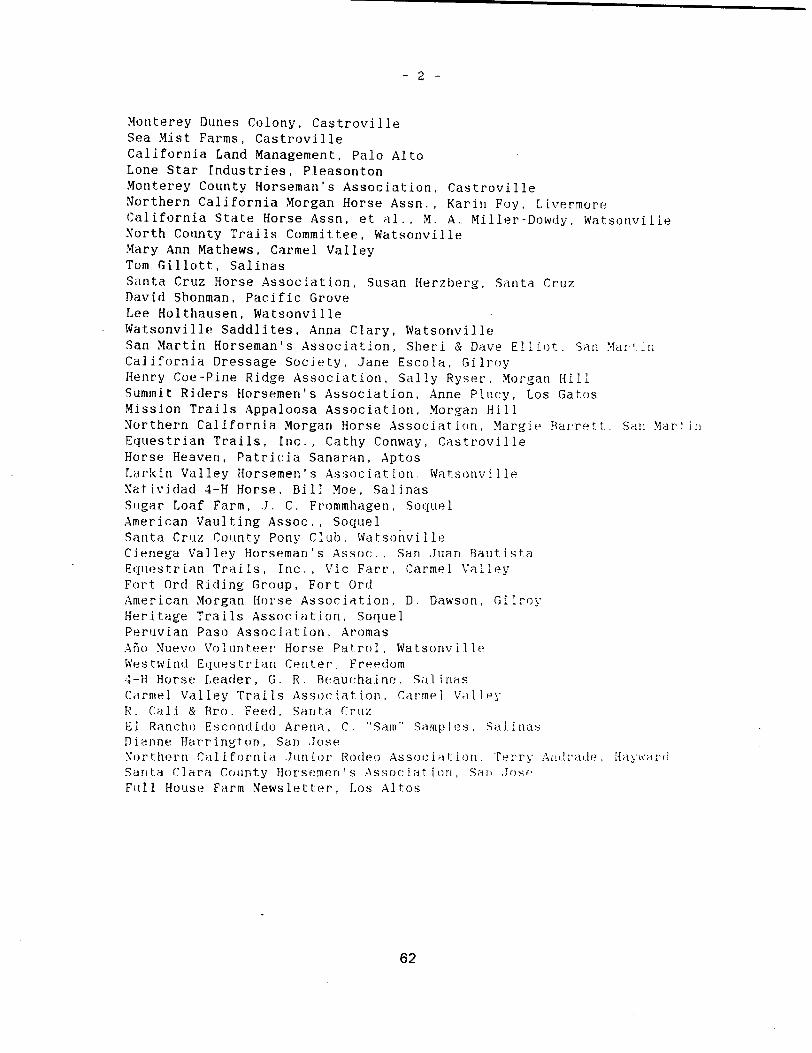
-2-
Monterey Dunes Colony, CastrovilleSea Mist Farms, CastrovilleCalifornia Land Management, Palo AltoLone Star Industries, P.leasontonMonterey County Horseman’s Association, CastrovilleNorthern California Morgan Horse Assn. , Karini Foy, LivermoreCalifornia State Horse Assn, et al. , M. A.. Miller-Dowdy. WatsonvilleNorth County Trails Committee, WatsonvilleMary Ann Mathews, Carmel ValleyTom Gillott, SalinasSanta Cruz Horse Association, Susan Herzberg, Santa CruzDavid Shonman, Pacific GroveLee Holthausen, WatsonvilleWatsonville Saddlites, Anna Ciary, WatsonvilleSan Martin Horseman’sAssociation, Sheri & Dave Elliot. San MarrCalifornia DressageSociety, Jane Escola, GilroyHenry Coe-Pine Ridge Association, Sally Ryser Morgan HillSummit Riders Horsemen’s Association, Anne Plucy, Los GatosMission Trails Appaloosa Association, Morgan HillNorthern California Morgan Horse Association, Margie Barrett, Sari MartinEquestrian Trails, Inc., Cathy Conway, CastrovilleHorse Heaven, Patricia Sanaran, AptosLurkin Valley Horsemen’s Association. WatsonvilieNatividad 4-H Horse, Bill Moe, SalinasSugar Loaf Farm, J. C. Frommhagen, SoquelAmerican Vaulting Assoc. , Soquel -Santa Cruz County Pony Club , Wa t sonyill eCienega Valley Horseman’s Assoc., Sari Juan Rautist.aEquestrian Trails, Inc., Vic Fart’, Cannel ValleyFort Ord Riding Group, Fort OrdAmerican Morgan Horse Association, D. Dawson, GilcoyHeritage Trails Association, SoquelPeruvian Paso Association, AromasAio Nuevo Volunteer Horse Patrol, Watsonivi.l.leWestwinid Equestrian Center , Freedom4-H Horse Leader, 0. R. Beauchaine. Sal nasCamel Valley Trails Association, Car-mel ValleyH - Call & Bro , Feed, Santa CruzEl Rancho Escondido Arena , C - ‘Sam" SanipI es , Sal inasDianne Barrington, Sari JoseNor thorn Cal i forn i a -Juniot Rodeo As socfat! on , Terry An:i mile , Ilyi ci
Sari ta Clara County Horsemen s Assoc-jut ion , Sari ,Joe
Frill House Farm Newsletter, Los Altos
62

noticeannouncing location of copies of doc:uinerits for public review was-iblishedin the following newspapers:
Monterey Peninsula HeraldSalinas Californian
Documentswere available at the following locations for publicrevkw
Dept. of Parks and Recreation Pacific Grove LibraryCentral Coast Region Headquarters Central and Fountain Avenues2211 Garden Road Pacific Grnve CA 93950Monterey, CA 93940
Monterey Ci ty Li hrui’yHarrison Memorial Library 625 Pacific StreetOcean Avenue and Lincoln Street Monterey, CA 9.3940Cannel, CA 93922
Monterey County [.ibrar,’Marina Branch Library Castroville Branch371 Cannel Avenue 11266 Merritt.Marina, CA 93933 lastroville, CA 95012
Seaside Branch Library Main Library, Sa.l iOS
550 Harcourt Avenue John Steinbeck LibrarySeaside, CA 93955 hO West San f.is
Sal Laos. CA 03001
63

Comments were received from the following local, State arid Federal agernHfsand private organizations. No private individuals commented.
Federal Agencies
U. S. Army Corps of EngineersU. S. Department of Interior, Fish and Wildlife Service
State Agencies
California Coastal CommissionCalifornia Department of Transportation, District .5Regional Water Quality Control Board, Central Coast Region
Local Agencies
Monterey County Planning DepartmentCity of Monterey, City ManagerCity of Marina, City Manager
Private Organizations
Point Reyes Bird Observatory
64

Commentsand Responses toComments
Following are the comments received - Euc:Ii comment has been g. cc: , numberand the response to that comment has the same number.
65

66

-
‘ DEPARTMENTOFTHEARMYSAN FRANCISCO DISTRICT, CORPS OF ENGINEERS
211 MAIN STREET
ki /1 SAN FRANC1 94105 - 1905
Envi ronmental Branch
To: Mr. James M. DoyleEnvironmental Review SectionDepartment of Parks and Recreation -
P.O. Box 942896Sacramento, California 94296-0001
Subject: General Plan and DEIR Monterey State Beaches in Monterey County
Your request for comments from this office was received on 21 May 1987by your letter dated 19 May 1987.
r The proposed construction project may require Department of the ArmyAuthorization under Section 10 of the River and Harbor Act of 1899 and/orunder Section 404 of the Clean Water Act. A copy of our pamphlet "U.S.Army Corps of Engineers Permit Program, A Guide for Applicants" isenclosed. For additional information please contact our RegulatoryFunctions Branch at 415-974-0418.
Any impacts on wetlands, threatened or endangered species, othervaluable fish and wildlife resources, or on cultural resources are amongthe important environmental considerations for all Corps permitapplicants. Other areas of environmental concern specific to this projectare: We encourage the proposed coordination with the Corps on erosionmonitoring.
Questions concerning our AB 884 review can be referred to theundersigned at 415-974-0443. Thank you for including us in your reviewprocess.
Roderick A. Chishoim, IIEnvi ronmental BranchPlanning/Engineering Division
Enclosure
67

conservation plan should spec’ify the mitigation measures thepermit applicant e.g., Department of Parks and Recreation, Cityof Marina will undertake and funding mechanismsmade available*to implement such mitigation, and alternatives to the proposedproject that were considered and the reasons why thesealternatives were not implemented by the Department of Parks andRecreation.
Currently, the Marina Coastal Zone Planning Task Force TaskForce of the City of Marina is developing a conservation plan to
5 ultimately accompany a Section 10a permit application. TheCOnt permit, if granted, would allow for the "incidental take" of
Smith’s blue butterfly within identified portions of the MarinaDunes largely to the north of Marina State Beach. Although theMarina State Beach is represented on the Task Force,"incideritaltake" relating to ongoing or proposed activities at the Statebeach has not been considered as part of this conservation planand permit application. Perhaps, the Department of Parks andRecreation would like to include activities on their landspotentially affecting "take" by expanding the scope of thisprocess to ensure compliance with the EndangeredSpecies Act.
Similar conflicts may occur at SalinasRiver State Beach ifdevelopment activities or intensive human uses are allowed inareas where the Smith’s blue butterfly occurs. Questionsrelating to these comments should be addressed to either JimBartel or Ed Lorentzen at 916/978-4866. Thank you for theopportunity to comment on these plans.
Sincerely,
,Lq7o. ;;JGail C. KobetichField Supervisor
Enclosure
cc: David Shonmari, City of Marina, Marina Coastal Zone PlanningTask Force, 211 Hillcrest Avenue, Marina, CA 93933
Chief, Endangered Species, Portland, OR AFWE-SEField Supervisor, Ecological Services, Sacramento, CA ES-S
70

STATE OF C&LIFORNIA-OFFCE OF THE GOVERNOR GEORGE DEUKMEJIAN, Governor
OFFIZE OF PLANNING AND RESEARCH1400 TENTh STREETSACRAMENTO, CA 95814
July 3, 1987
James M. DoyleCA Department of Parks & RecreationP.O. Box 942896Sacramento, CA 94296-0001
Subject: General Plans for Monterey Bay State BeachesSCH# 86011401
Dear Mr. Doyle:
The State .ear-ing house sunitted the above named draft Environmental ImpactReport EIR to selectedstate agencies for review. The review period isclosed and the comments of the individual agencyies isare enclosed.Also, on the enclosed Notice of Ccmpletion, the Clearinghouse has checkedwhich agencies have commented. Please review the Notice of Cccnpletion toensure that your camient package is complete. If the package is not inorder, pleasenotify the State Clearinghouse immediately. Your eight-digitState Clearinghousenumber should be used so that we may reply promptly.
Please note that recent legislation requires that a responsible agencyorother public agency shall only make substantive ccmments on a proj ect whichare within the area of the agency’s expertise or which relate to activitieswhich that agencymust carry out or approve. AS 2583, Ca. 1514, Stats.1984.
These canlients are forwarded for your use in preparing your final EIR. Ifyou need more information or clarification, we suggest you contact thecamienting agencyat your earliest convenience.
Please contact Norma Wood at 916/445-0613 if you have any questionsregarding the environmental review process.
Sincerely,
___
/ /
David C. NunenkampChiefOffice of Permit Assistance
cc: Resourcesigency
Enclosures
‘UL j987 71
,7L73

STATE OF CALIFORNIAGEORGE DEUKME.JIAN, Governor
CALIFORNIA COASTAL COMMISSIONCENTRAl. COAST DISTRICT
701 OCEAN STREET, ROOM 310SANTA CRUZ, CA 95060408 426-7390
June 23. 1987
James DoyleCalifornia Department
of Parks and RecreationP.O. Box 942896Sacramento, CA 94296-0001
Subject: Marina State Beach Preliminary General Plan andMonterey State Beach Preliminary General Plan; StateClearinghouse Notice of Completion 86011401
Dear Mr. Doyle:
We have reviewed referenced plans and have the following comments:
MarinaStateBeach
We support the State Park proposal to designate the major part ofthe dune area at Marina State Beach as a Natural Preserve to protectand perpetuate the resource values of the park. Since federally andstate listed endangered species have been located in the dunes andsince the dunes ecosystem itself is a fragile and easily disruptedhabitat, Coastal Act policy 30240 would apply to the area. Thispolicy protects environmentally sensitive habitat against disruptionand allows only uses dependent on resources within the area, and inareas adjacent to sensitive habitat areas, development is to besited and designed to prevent degradation and to be compatible withthe continuance of such habitat areas.
There appear to be some discrepancies between the area identified asa proposed Natural Preserve and the kinds of uses consideredappropriate Allowable Use Intensity Map and the the Land Use Mapdesignations. The following points should be considered in yourplanning:
1 In addition to the hang glide area shown at the main parkinglot, the Land Use Map shows an indentation into the area of theNatural Preserve and indicates the area to be used for hanggliding. Th.is would appear to conflict with the Category II "Low"use intensity of the Allowable Use Intensity Map which indicatesthat hiking and picnicking in designated areas are the onlyappropriate uses in this category. If your agency determines thatthis area is not category II, it should justify the change in
72
7., 3997

James DoyleJune 23, 1987Page 2
designation and should provide for minimizing disruption of the54 dune, e.g.. providing boardwalks and platforms for the
c.o.t. f recreationalists to reduce destruction of the plant life thatanchors the dune. There is insufficient discussion in the text as
I to the development of the hang glide facilities to fully understandLwhat is being proposed.
r2 Regarding the hiking and picnicking designations the areasindicated for picnicking on the Land Use Map are appropriately
7-1 located. However, in the area adjacent to Lake Court previous fieldsurveys had indicated a significant back dune habitat. There may be
Lsections of this area that should be preserved.
E3 Regarding hiking trails in the preserve, the use of boardwalksis recommended. Boardwalks are shown at either end of the reserve
Ibut it appears that trails will then continue into the dunes. The8..Jexisting boardwalk greatly facilitates access and discourages random
walking over the dunes. We suggest additional boardwalks and thatunguided walks be restricted to boardwalks to protect therestoration and preservation program being undertaken by your
department.
4 We also suggest that in addition to the excellent policiesprovided on shoreline erosion and protective structures that theGeneral Plan’s Bluff Setback Policy correlate development setbackwith erosion rate and life span of project, that is, identify atarget erosion time span e.g. 100 year erosion setback that mustbe met for new permanent development.
Monterey State Beach - Sand Dunes Drivearea
1 No allowable use intensity map was included as the textindicated p.20. The two allowable uses proposed. a high use -
highly disturbed sand dunes and b moderate use - sandy beach, doto
- not appear appropriate to the higher dune area coterminous with theadjacent Ponderosa property. The federally endangered Smith’s bluebutterfly has been surveyed in this area. Though the Land Use Mapproposes restoration of this area, it is not clear that there is a
lon term commitment to manage this area for habitat protection.
fl2 En route camping would provide for a critical public needII consistent with the Coastal Act if appropriate protection of dune
Lhabitat is provided.
j73 To the degree feasible under General Plan proceduralI regulations we would recommend clarification of the status of theSeaside and Sand City parcels and additional information on future
I plans for these and other properties for potential inclusion in theMonterey State Park units.
73

James DoyleJune 23, 1987Page 3
With consideration of the above comments these State Park GeneralPlans provide excellent public recreational opportunities while-protecting the natural resources that make the areas desireable forrecreational use. If you have any questions or if we can be ofassistance, please call.
Sincerely.
cc: Mary GunterNorma Wood. OPR Clearinghouse
1913A
1 Planner
74

STATE OF CALIFORNIA-BUSINESS. TRANSPORTATION AND HOUSING AGENCY GEORGE DEUKMEJIAN, Governor
DEPARTMENT OF TRANSPORTATIONP.O. BOX 8114AN LUIS OBISPO, CA 93403-8114 -Telephone: 805 549-3111TDD 805 549.3259
Date: June 29, 1987Mr. James M. DoyleCalif. Dept. of Parks and RecreationP.O. Box 942896Sacramento, CA 942896-COOl
File: MON-OOl-var.G.P. for Mon. BayState Beaches
SCH#: 86011401
Subject: Intergovernmental Review
Dear Mr. Doyle:
Caitrans District 5 staff has reviewed the above-referenced document. The following comments were generated as a result of thereview:
Caltrans has no particular concerns other than the fact thatexpanded and improved parking at the various state beaches will
Icause incremental increases in traffic turning moves on Route 1. AzI 1you are no doubt aware, Route 1 already operates at a very low level
of service F. Additional traffic just exacerbates the existingproblems.
If you have any questions, please contact me at 805 549-3139.
A. C. CarltonDistrict 5Intergovernmental Review Coordinator
cc: Terry Roberts, State ClearinghouseJMA,VLN,CSW
RECEIVED
lULl 1987
75
7.. L19

State of California The Resources Agency of California
Memorandum
To : State Clearinghouse Date: June 11, 19871400 Tenth Street, Room 121Sacramento, CA 95814
William R. Leonard, Executive OfficerFrom : California Regional Water Quality Control Board
C.ntral Coast R.gion-1 122 Laural LanaSan Lvii 0bhp., CalifornIa 93401
Subject: MONTEREY STATE BEACHES - PRELIMINARY GENERAL PLAN REVIEW
We reviewed preliminary general plans for California StateBeaches located in Monterey County Zmindowski, Moss Landing,Salinas River, Marina, and Monterey. At each facility we notethere is discussion of restroom facilities "proposed", but nodiscussion of where the wastewater goes. Restroom facilitiesshould be sewered wherever sewers are available. If restroomsare constructed using on-site septic tank-leachfield systems,they should be built in accordance with specifications in theBoard’s Resolution No. 83-12 and applicable county criteria.
Very truly yours,
-
‘/ ‘t’..<_-_.-i_./
,-
WILLIAM R. LEONARDExecutive Officer
J FC/ se
stclearhs. ltr2
76

MONTEREY COUNTYPLANNING DEPARTMENT
408 422-9018.P.O. BOX 1208- SAUNAS. CALIFORNIA 93902
ROBERT SUMMON, JR.DIRECTOR OF PI.ANNING
July 1, 1987
Mr. James M. Doyle,’ SupervisorEnvironmental Review SectionDepartment of Parks and RecreationP.O. Box 942896Sacramento, CA 94296-001
Dear Mr. Doyle:
The Department has reviewed the re1iminarv General Plans forthe following State Beaches located in the unincorporated areasof northern Monterey County: Zmudowski, Moss Landing andSalinas River. These documents were analysed with respect tothe proposed land uses and facilties planned for each park unitand the certified North County Land Use Plan LU? of MontereyCounty’s Local Coastal Program. The LU? is the controlling landuse document upon which all State Park General Plans andproposed projects will be evaluated for consistency. Some ofthe detail comments which follow later address consistencyissues. Resolveinent of issues will be facilitated throughCounty and State Coastal Commission consideration of the GeneralPlan Program as an amendment to the certified LU?.
The LU? contains a Public Access Component and provides policyfor the protection of access opportunities, management plans andprograms, priorities for improvements and management for accessand recreational facilities, trails, public safety, habitat andresource protection, visual, land use compatibility, parking andfacilities and signs and maps. The LU? identifies theDepartment of Parks and Recreation as the responsible agency forthe development of access and recreational facilities for thesethree State Park units.
In general, we find the reliminarv General Plans consistentwith the Public Access Component contained in the LU?. However,we note an absence of reference to this controlling land usedocument and policies with the exception of its citation as aselected reference in any of the three plans. The coastalplanning effort in Monterey County has, and continues to be amutual effort among property owners, special interest groups andlocal, state and federal agencies. The Department of Parks and
JUL 6 1987 77
RPD 7 C/,f

Recreation contributed substantial background information tosupport various aspects of the LU? during its preparation andprovided valuable input to assure your management concerns andobjectives were included. Planning Department staff have metseveral times with your staff and have attended public hearingsin this State Beach General Plan Program. We are thereforeconcerned that the preliminary General Plans contain no planninghistory or identification of the planning process in which thispresent Program evolved. - We would recommend an addition sectionon the local planning effort and development of the LU?consistent with the Coastal Act of 1976; the Coastal Commissionplanning effort; as well as State Parks and Recreation GeneralPlan Program and how that Program is part of the comprehensivecoastal planning process. At present, the documents stand aloneand are not reflective of the rich planning process which hasoccurred. The General Plan Program needs to be placed into thecontext of the entire coastal planning process. The followingare specific comments to each of the three park units previouslyidentified:
Zmudowski
1. p.2 Key Recommendations
o Permanent restrooms requiring public sewer andwater are not feasible due to lack of publicservices to the site. Expansion of such publicutilities to this site is also not feasible.Permanent restrooms will require on-site waterand septic systems.
o Equestrian use is not presently provided for in" L the LU?.
o Dune management plans will require County and
L State Coastal Commission review and approval.
o Signing should also include hazardous or
L restricted use warnings; if appropriate.
E5. o Operation and maintenance facilities andovernight camping will require County and State
L Coastal Commission approval.
J6. p.5 Unit Description, 2nd paragragh
o This unit is bordered on the north by the PajaroL_. - River, the east by agricultural fields...
78
p.12 Historic Background, 5th. paragraph, 3rd line
J o "...in 1972, and , 20-acre use permit from the22.
. State Lands Commission." Please clarify, explain
L and/or correct.
8. p.14 Resources Management Policies
- o Resource Management in the State Park System jthe Coastal Zone is governed by laws contained inthe Public Resources Code and the CaliforniaAdministrative Code. Additional state agencies,
23 -such as th.a Coastal Commission, State LandCommission. State Coastal Conservancy, Departmentof Fish and Game and the Department of Boating
Waterways fl have laws and regulations for-resource manaement that must considered inthe deve1oment State Park General Plans alongthe coast.
[. p.16 Shoreline Protective Devices
o Application of this policy assumes some level of21- facility i.e. structure, etc. exists at
Zmudowski. Since no facility exists warrantingstructural protection, this section can bedeleted.
110. p.22 Parking
o Expanded parking will require County review andL approval.
11. p.22 Comfort Station26-1
L o See Comment #1
p.22 Interpretive Facilities
I o Signage will require County review and approvalconsistent with LU? Policy 6.4.J.
27_ll3. p.22 Operations and Maintenance
o Any facilities will require County review andapproval.
14. p.23 Employee Housing
o Any housing or equipment storage will requireCounty review and approval
79

p.27 Proposed Interpretation
1 o If the second senteri’ce under "Facilities" isI correct "...the lack of buildable land precludes
28 any extensive interpretive structures," How canimprovements such as: Employee housing,operations and maintenance facilities and parkingbe proposed in this General Plan?
r16. p.33 General Plan Implementation
I o Upon Parks and Recreation Commission approval ofI the General Plan, the. Department of Parks and
Recreation should submit an amendment applicationI to the LU? for County and State Coastal
2’3-j Commission consideration.
17. Mapping
I 0 Land Use and Facilities and Allowable Use
L Intensity Maps should be amended into the LU?.
[Ts. p.35 EIR
‘30-I o Air Quality. The Monterey Bay Unified AirI Pollution District is presently non-attainment
L for ozone.
MOSS LANDING
19. p.12 Recreation Resources
o Substantial public testimony regarding the use ofMoss Landing State Beach by a significant numberof surfers was given at the May 28, 1986 publichearing in Marina. This section should include a
31 discussion of this highly popular form ofrecreation at Moss Landing.
20. p.14 Resource Management Policies
o See Comment #8.
[Ti. p.15 Shoreline Protective Devices
0 See Comment #9 as it relates to Moss LandingState Beach
80

2. p.23 . Existing Land Use and Facilities, 2nd para.
33-I o Add Monterey County, State Coastal Conservancy,State Lands Commission, Department of Boating andWaterways and the Coastal Commission to the listof responsible agencies having a role in land andwater management around Moss Landing State Beach.
[3. p.35 General Plan Implementation3+-I
L o See Comment #16r o See Comment #22 for agencies involved in land and
water management responsibilities
24. Mapping, see comment #17 regarding Land Use and Use
L Intensity Maps
r25. p.37 EIR36-I
L o Air Quality, see comment #18
SALINAS RIVERp.11 Animal Life
I o The City of Marina and State Coastal ConservancyI have funded a Habitat Conservation Plan HCP for
the Smith’s blue butterfly consistent with the1 Engangered Species Act. The study area includes
I the coastal dunes south of Salinas River WildlifeI Management Area to Marina State Beach.I Information regarding rare and endangered plantsI - and animals developed from the HCP should be
L included in this document.
{7. p.19 Shoreline Protective Devices
o See comment #9 as it relates to Salinas River
L State Beach
p.21 Rare. and Endangered Plants
o - The previously cited HCP in preparation haslocated Chorizanthe pungens Benth. Var. pungensand Erysimuin Menziesii in the study area to the
I . south. It is therefore probable these speciesL also occur at Salinas River State Beach.
p.26 Parking
L o See comment #10
81

flo.. p.27 Comfort Station1-I-I
L o See comment #1
p.28 EmployeeHousing
L - o See comment #14
p.38 General Plan Implementation
o See comment #16
33. Mapping, see comment #17 regarding Land Use and UseIntensity Maps
44_j5. p.42 EIR
L Air Quality, see comment #18
35. p.43 Vegetation and Wildlife
o See comment #27
Thank you for the opportunity to respond to the preliminaryGeneral Plans for Zmudowski, Moss Landing and Salinas RiverState Beaches. We look forward to your responses and inclusionof our comments in the final General Plans. Further, we lookforward to participation in the public hearing process atAsilomar this August.
Sincerely,
/ / /
obert Summon, Jr.Director of Planning -
cc: Supervisor Strasser KauffmanSupervisor Del PieroEdward Y. Brown, Coastal Commission
82

June 19, 1987Mayor:DAN ALBERT
Councilmembers:THERESA CANEPACARL OUTZENCLYDEROBERSON Mr. James Doyle, SupervisorRUTH VREELAND
Environmental Review SectionCity Manager:JOHN DUNN Department of Parks and Recreation
P. 0. Box 2390Sacramento, CA 95811
Re: Monterey State Beach Preliminary General Plan
Dear Mr. Doyle:
On behalf of the City of Monterey, I would like to thank youfor the opportunity to review the Preliminary General Planfor Monterey State Beach.
The Preliminary General Plan has been reviewed by theMonterey Parks and Recreation Commission at their meeting ofJune 2, 1987, and by the Monterey City Council at theirmeeting of June 16, 1987. Each found the documentconsistent with existing City policy and policy documents,and endorsed its passage by the State Parks and RecreationCommission.
Our staff has compiled the following technical commentsrelated to the document:
1. Page20. The allowable use intensity maps were notTo included in the City’s copies of the Preliminary
General Plan.
IT. Page21. In the second paragraph under ExistingI Conditions, it is suggested that the wording beI changed to read, "Obstruction of views to the Bay
47...... from Del MonteAvenue affect the unit’s current
recreational values."
3. Page22. The first sentence under Access shouldread, "There is no legal vehicle access to thisunit." In the next sentence the word "primarily"should be inserted before "within the old railroadright-of-way."
83
7?
‘NTEREY, CP

Mr. James Doyle, SupervisorJune 19, 1987Page Two
The illegal accessesdiscussed in the secondparagraph will be remedied with the installation ofadditional barriers, which is scheduled for July,1987.
4. Page23. It is suggested that the sentence, "TheCity of Monterey perceives the open space as a moreurban park space" be deleted. Although there hasbeen some preliminary discussion regarding thefuture use and design of this open space area, nodecisiOns or policy direction have been set.
E. Page25. A water line and a cable TV line runI concurrently with the sewage collection line
discussed in the document. It is the water line andnot the sewage line that is visible. It should be
I noted that the City is budgeting funds to relocateI these lines because of the potential for futureI - loss. The relocation of these lines will lessen the
City’s need for Sand Dunes Drive for utility access.
4° J. Page26. With the relocation of the sewer line,alternate service for the proposed comfort station
L - may be required. -
7.- Pages 25 and26. The improvements discussed for theSand Dunes Drive area are consistent with the DelMonte Beach LU?, but the LU? does not mention thepossibility of overnight camping. We feel thaten-route camping would be consistent with the
- Coastal Act, and appropriate for this location ifsecurity concerns can be addressed.
Page27. It may be desirable to discuss a potentialrelationship between the underwater recreation areasuggested in the Plan, and a similar area proposedfor the Cannery Row region.
Page39. Any effort to preserve the habitat for theSmith’s Blue Butterfly should be coordinated withother efforts that have occurred, are ongoing, ormay be implemented in surrounding ar-eas.
Page40. The PublicServices section should mentionthe City’s sewer and water lines running through theproperty, and their potential for damage or lossfrom ocean forces.
47-
1-8-
50
51
53
84

Mr. James Doyle, SupervisorJune 19, 1987Page Three
11. Fold-outmap. On sheet 1 of the Land Use andFacilities map, the Recreation Trail is shownincorrectly as passing through the Southern Pacific
Co,f. property adjacent to the City beach. The Trailpresently follows an interim alignment adjacent toDel Monte Avenue. It also may be appropriate toshow the future improvements proposed for the Citybeach in the Harbor LU?, such as the beach craftlaunch area in the area of Wharf #2.
Again, thank you for the opportunity to review thisdocument. Should you have any questions, please contact Mr.Fred Cohn of my office at 408 646-3760.
Sincerely,
City Manager Interim
dt
c Community Development DirectorParks and Recreation DirectorSenior Administrative AnalystCity ClerkMs. Mary Gunter, District Superintendent,
Monterey District
85

:c.c - -_____
/
-4l 4-3’1
July 2, 1987
Mr. James M. Doyle, SupervisorEnvironmental Review SectionsDepartment of Parks and RecreationP. 0. Box 2390Sacramento, CA 95811
Dear Mr. Doyle:
The City Council of the City of Marina had an opportunity to review theMarina State Beach Preliminary General Plan. One of our Councilmembers,Joan Blake, made the following comments after her careful review of it.
{e15 Zone of PrimeInterest
Don’t care for all the "concern" about Water District, and why theconcern over Corp Yard? Ga Hazard? This isn’t clear at all. Also,fail to see how the rest is of so much concern, as Parks primary job
I is for visitor serving reasons, and RV and Motels bring in what Parks
Us about.
Page28 StayingSafe
Swimming? This needs to be striken from para.
Page35 Maintenance - ParaIII56
Dislike user fee - fines for littering should first be tried -
funds should be used only for improvements.
LandUsePlan
One hand says erosion, then Plan shows parking and restrooms inwhat could be considered near danger zone.
Thank you for the opportunity to review the Plan.
Sincerely,
LARRY W. BAGLEYCity Manager
LWB/frc
RE CELY ED
juie 1987
RPD
86
#7

-POINT REYES BIRD OBSERVATORY4990 Shoreline Highway, Stinson Beach,California 94970
- Telephone415 868-1221
June 17, 1987
JamesM. DoyleEnvironmental Review SectionState of CaliforniaDepartmentof Parks and RecreationP.O. Box 2390Sacramento,CA 95811
Dear Mr. Doyle:
[--‘This letter responding to the preliminary general plans for Zmudowskiand Salinas River state beachesaddressesonly protection to nesting SnowyPlovers through the proposed Natural Preserves. I think the steps taken in
both plans are excellent. A particularly valuable approachhas been tolimit accessat Zmudowski Beach to the existing entry points. Since theNatural Preserve at Salinas River State Beach requires the same kind ofprotection, the park system should not open access to the south end of thebeach in the future see page 27. Access at- the south end will make itmuch more difficult to limit human disturbance to the Natural Preserve. Itwill also increase public access to the Salinas River Wildlife Refuge,another important plover breeding site. Access to sensitive areas shouldbe restricted to walk-in traffic only.
Snowy Plovers breed along the entire length of Salinas State Beach. Asbeach use increasesby the public, breeding plovers will become more andmore restricted to the preserves. The total number of plovers using statebeacheswill decreasewith the loss of nesting sites in heavily used areas,thus the preserveswill become essential to protecting this species. 1believe it is particularly important not to allow access to the south endof Salinas River State Beach.
Sincerely,
Gary . PageDirector Coastal and Estuarine Program
87
7-3

88

Response toComments
1. rt does not appear that any of our actions will require a permit fromthe U. S. Army Corps of Engineers. We wish to continue to coordinatewith the Corps on erosion monitoring.
2. Existing State and Federal laws and DPR policies proviIe for prntL’!u:of rare and endangered fauna. One of our objectives for 411 of theseunits is to protect arid restore native dune ecosystems.Mef Lig tI1!;
objective should benefit the native flora and fauna including rare,threatened, arid endangered species. Specific marlage!nerlt ii-tiris tobenefit the black legless lizard and the Smiths blue butterfly ‘!ll Laundertaken as specific needs and funding are identified. DPR f:IrIdel i-i
study of the Smith’s blue butterfly at Marina SB in I98 . copy of thereport was sent to the U.S. Fish and Wildlife Service USFWS Endarrger-’dSpecies Office in Sacramento.
3. The Department believes that if carefully designed and reguJ:itid theland use and facility proposals can he implemented without oiiflictiwwith resource management po1 ides - If corifi 1 ets develop, the rs,iurcamanagement policies will take precedent over land use and facilitiesproposals.
4. I-lang gliding within the proposed Natural Preserve will he severalylimited to a relatively few experienced pilots operiting from a smalllaunch area. No significant impart is predicted.
5. The relatively intense visi tot’ use of the northern area at Mar irta StatBeach will be ii rn I ted to the ocean beach iol the i mmcdi ta I a rthe parking area. Access to the dunes in this area is currently I Lit!
to a designated boardwalk trail . The surrounicli it dune ore-i f-i’v ‘1and officially closed to all public use. These restriciLons s: 11 at’
t inue as long as needed to protc t the ii sted spec’ es aTh i ‘h ourthis area. We do not believe that incidental take of Smith’s blue but -
terfly is likely through the implementation of these plans. We wiikeep the USFWS and the Cal i for-n i-i Department of ‘ i sh arid Oonie C flFirfwniecI about DPR activi ties whi cli may affect sensit lye i-p’ Hi tIand the other units.
6. Please refer to response *4.
7. The land use and facilities map is schematically drawn. Sect.Ion ofsignificant back ilune habi tat rican’ Lake Court. cmi] ci be inn] itde! iii thNettrtral Preserve - Also see response *3
8. We agree that boardwalks greatly fan ii tote access arid li ‘mtrage iiclomwalking over the dunes. The Department is studying the constrnict an andmain tenarice costs of the hoardwalks and their ef font hones:; . The
connecting the two terminuses of the boardwalk would be pustred and -it
some t I me in the fir t urin a hoardwalk nay be runt r’uct ed - I ui-n iHll 1be restricted to boardwalks and designated I: rails in the preserve-
89

-2
9. Pages 18 and 19 in theDepartment’s bluff setbackerosion timespan, but wethe zone of demonstrationmany factors that involveprediction extremely difficult
Marina State Beach General Plan discuss thepolicy. We haven’t identified a target
believe that permanent facilities setback inwould not be threatened for many years. Theshoreline bluff erosion make a target date
10. The allowable use intensity map for Monterey State Beach was inadvertently omitted. The federally endangeredSmiths blue butterfly ;tridother endangered and threatened species will be protected here as wellas in other State Beaches. See responses*2 and 3.
11. We agree that en route camping would provide a critical public need inthe Sand Dunes Drive area of Monterey State Beach. The Department lies acommitment to protect the dunes habitat.. State Park Rangers will enforce rules and regulations concerning restrict*e use in nertoinidesignated areas. Also see response *3.
12. The status of parcels that may be acquired cannot he dlsnunissed in: thjGeneral Plan becauseof the sensitive nature of the proposals.
13. This comment is noted.the traffic problems.
The Department supports possible saint arts ta
14. We agree.now or incondiU ons
will workpossible in
Restrooms willthe future -
permit this.at having waterthe future.
be seweredwhenever sewer lines er aoo ‘ableSeptic tanks and leach lines will he ni-er] ifA. pumpout system wi Ii lie .Jsc’n.i t h’-rc’,’ s’ .
and sewer lines to as many restrooms as
15 . The general plans for these State Beache.swere coocdi na cnd ; 1; 100
State and Federal agencies - We believe the plans ire consistent with
the Local Coastal Plan LCP , event though the text may not ro l:inIe alarge volume of background material on that subject.
16. See response *1-1 -
17 - Equestr i err use has heeni author’ i zed at Zniiinluwsk I , ‘loss to rid i ii, . orrlSal inas River State Beaches- The County LCP honilcl be arnpndd.
13. Comment noted and we will seek approval.
19. Comment noted.
20. See response #18.
21. Corrections, deletions and additions noted.
22 - Tire Depart.merit. has ci lease fruit the State Lands Commi i-si art fin r a 21 - lu
parcel at the mouth of the Pajaro River . This parcel in; operated aspart of Zmudowski State Bearfi - The louse onibln’s tire flepuitmenn t to
protect resources , enforce rules ,ancLregohit ions and ciii ow pithi C c use
90
-3-
23. See resonse *21.
24. This policy was included because shoreline protective devices lia?e beenior may be suggested. Residents of the development: to the north ofZinudowski have built a seawal.l on their property. We feel that thinkpolicy needs to be included and should not he deleted from any of theGeneral Plans.
25. See response *18. -
26. See response *14.
27. See response *18.
28. Please see pages 22 arid 211 in the Zmnidowskr S - B. Cenar’ol P1 urn Theseproposals are conditional to addi tional land and a tiner reql.i I rennnrdrs
29. When the Department proceeds with planning for- irnplennorri-;i ion, tc ;submit plans and maps for approval. See response *l8 -
30. See response *19.
31. See response *21.
32. See response *24.
33. See response *21.
34 . See response 29.
35. See response #21.
36. See response *19.
37. See response *19.
- See response #24 -
39. See response *19.
41. See response *18 -
41. See response *14.
42. See response *18.
43. See resjontse *29 -
- See response #19 -
91

- -4-
45. See response *24.
46. See responses*10 and 21.
47. See response #21.
48. See responses #21 and 19.
49. See responses *19 and 14.
50. See response *11.
51. See response *21.
52. See response #10.
53. See response *21.
54. We disagree. The Department is very concerned about .snrrrnniridi nprap-erties and local activities that could affect State Park System units.For example, traffic to the corporation yard and water’ dJ s tr lot niffen-t.traffic and congestion on Reservation Road and access to Marina StaleBeach. Likewise, the mining of send affects the sand neil eni ahnn.nit toState Beaches. The sewer operation could affect vlsi tar healtli . Manymore examples could be given.
55. We disagree. Swimming, while not a major activity. is a vniirlrecreation activity.
56. See response *19.
57. See response #9. The drawings are schematic unini the jnermunrit Ii 11ties appear closer to the edge of the bluff than in fact they ici 11 he
58 . We agree that the nesting areas for the snowy plover’ riced a;-: mniotection as possible - The proposec.1 fn.rt ire access point: a?. lire SOt tit eno.]of Salinas River State Beach is still a preliminary conisiclor-nit ion. Thiswould he an interpret lye area for visitor’s trid air nbi-eL’Val ion point -Access would be prohibited lurIng i-ens I .1 uc pen’; ants
92

APPENDIX
93

94

-4
j
1
1Ib/// -
o:EHEY BAY
I.. ii -‘-.
‘ ,,, . *." ?"
*
/4-7
____
n - ,-,. . . - -
,//
_______
coHcmPTUL
I . *, , . ,
,
-
______
MOHTREY AY WtTERFR0HT PARK
$ l ‘ - - . -
___
I r- ‘ - -
1< -. ‘ - -‘ -
SourCe city of Monterey Parks and Recreation Master P%an, 1986

96

I ‘
-
, "jR’ 1t1
Li ‘___
!i’--- L_-1
in -"1 ‘
. --I
/
,-‘,‘ --
I! j ,
. ::, / -
PRIORITY ACQUISITION AREA BSUPPORT AREA
PRIORITY ACQUISITION AREA Awuioow TO THE SAY
COMPLETED ACOUISITION
MONTEREY BAYWATERFRONT PARK
CITY OF MONTEREYCOMMUNITY DEVELOPMENT
DEPARTMENT
0 200’ 400 -
M,#,*elp.IWh.,t #2
0
WINDOW TO THE SAY //
/
0‘.4
-__‘_
Source: City of Monterey Parks and Recreation Master Plan, 1986

98

SELECTEDREFERENCES -
California State Park System, Underwater Parks Master Plan, October 1984.
City of Monterey, Parks and Recreation MasterPlan, 1986.
City of Monterey, Del Monte Beach Local Coastal Program, Draft Land UsePlan,February 1984.
Naval Postgraduate School, Hotel Del MonteRevisited, pamphlet, 1986.
Shropshire, Helen and Elstob, Winston, Where California Began, Bonanza Books,New York, 1966.
D-2257R
99


