moravian karst speleological mapping in the northernpart ... · pdf filespeleological mapping...
TRANSCRIPT

1
Speleological Mapping in theNorthernPart of Moravian Karst
Jan Sirotek, Josef WeigelCzech Republic
Czech Speleological SocietyInstitute of Geodesy
FAST, Brno University of Technology
Moravian Karst• Surface: 92 km2
• South Moravia, Nord
of Brno
• Largest cave system
– Amatérská cave
• Tourist caves:
Punkevní with
Macocha Abyss,
Sloupsko-šošuvské,
Kater ínská, Balcarka
„Cave which was not surveyedwas not explored!“
Long tradition of speleological mapping in MK – Kríž, Wankel, Absolon
Cooperation between FAST and CSS
• Training of cavers from CSS
• Manual on cave mapping
• Education on speleological mapping during
surveying master degree as a voluntary
course
• Cooperation on mapping projects in
Amatérská cave and Býcí skála cave
Speleological mapping course
2
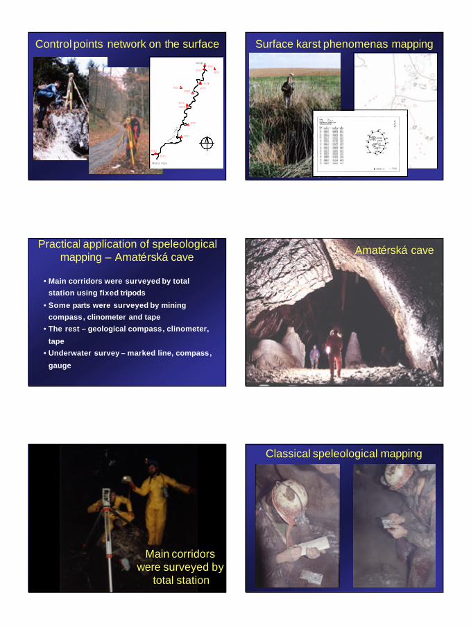
Control points network on the surface
8001
8011
8012
8013
8014
8015
80168017
80188019
80208021
8022
Skalni mlyn
Sloup
Pus t
y zleb
Surface karst phenomenas mapping
Practical application of speleologicalmapping – Amatérská cave
• Main corridors were surveyed by total
station using fixed tripods
• Some parts were surveyed by mining
compass, clinometer and tape
• The rest – geological compass, clinometer,
tape
• Underwater survey – marked line, compass,
gauge
Amatérská cave
Main corridorswere surveyed by
total station
Classical speleological mapping

3
Under water surveying equipment
Device „COMBI“especially developped for cave survey
Specialmap key
Microstationdigital mapSloupskýcorridor
Original 1:500
Karsologicmap
original 1 : 10 000

4
Practicalapplication
Amatérská cave
0 500 m
S
BludišteMilana Šlechty
Sloupský koridor
Predmacošský sifon
Krematorium
Belovodská vetev
Stará Amatérskájeskyne
Vstupní štola
Východnímacošská vetev
Západnímacošská vetev
Podzemn í Punkva
0 50 m
S
3. sifon4. sifon
2. sifon
Šošuvská odbock a
5. sifon?
Vintocká odbock a
Partsbetweensumps
?
?
Chodba mezi 1 a 2. sifonem 1. sifon
Situation
SituationAmatérská caveSloupsko-šošuvskécaves
0 100 m
SŠošuvskáodbocka
Sloupské Vintoky
1. sifon
Vintocká odboc ka
Cernápropast
Stríbrná chodba
4. sifon
2. sifon3. sifon
6. sifon
5. sifon
7. sifon
Komenské hojeskyne
Odtokový sifonPalmová propast
Komín v dómuBezpecnostních smernic
komín
Dóm BSP
Vintocká odbocka

5
Using radiobeacon for determination of theposition of the chimney on the surface
Using radiobeacon for determination of theposition of the chimney on the surface
New entrance
Cavers start to dig the Shaft
„D“ Day – after one year of digging:survey was correct
Situacesumps
New entrance

6
Cavers tried to pump sump 5 and 7
Sloupsko-šošuvskécavesbottompassages
ODTOKOVÝ SIFON
PALMOVÁ PROPAST
KOMENSK ÉHO JESKYN E
CERNÁ PROPAST
VODNÍDÓM
S
0 50 m
???
???
PRÍTOKOVÝ SIFON
???
???Sump 7
dive attack
Historical moment – both systems are connectedafter more than 100 years of exploration

7
Thank you for your attention.
Authors would like to thanks to all their colleaguesand friend from the caving clubs who participated on
the exploration and surveying of Amatérská cave.