moray offshore - marine scotlandmarine.gov.scot/datafiles/lot/morl/environmental_statement/volume...
TRANSCRIPT

�)�)
�)
�)
�)
�)
�)
!.
!.
Moray Firth SAC
East Caithness Cliffs SPA
FIRING PRACTICE AREA (D807)
450000
450000
500000
500000
550000
550000
6400000
6400000
6450000
6450000
2°30
'0"W
3°20
'0"W
58°20'0"N
57°55'0"N
0 10,000 20,000 Meters ¯
KEY
©British Crown Copyright, 2005. All Rights Reserved. SeaZone Solutions Limited, 2005 012009.001
Moray Offshore Renewables Ltd ©
2011. This document is the property of contractors and sub-contractors and shall not be reproduced nor transm
itted without prior written approval.
REF: 8460001-PPW0201-MOR-MAP-008
Produced: PHReviewed: CRApproved: PL
Date: 17/02/2012
Moray OffshoreRenewables Ltd
Moray Offshore Renewables Ltd
Revision: B
Fig 2.1-1 MORLSpatial Constraints
1:400,000Horizontal Scale:
Geodetic Parameters: WGS84 UTM Zone 30N
A3 Chart
MORL Zone Boundary
Windfarm Boundaries
!. MORL Wave Buoy
!. MORL Offshore Met Mast
�) Proposed Hub Location
�) Jacky Platform
�)Proposed Polly Platform Development
�) Beatrice AD platform
�) Beatrice AP platform
�) Beatrice B platform
�) Beatrice C platform
BOWL Proposed Cable Route
RYA Sailing and Cruising Routes
SHEFA-2 Telecommunications Cable
BOWL - MORL Boundary Buffer5 x max hub height (5 x 171m = 855m) on both sides of boundary
O&G Platform HelicopterApproaches (9nm buffer)
SHEFA-2 1000m Buffer
Oil Platforms 500m Buffer
Beatrice Demonstrator 500m Buffer
Archaeological Targets(50m and 100m Buffers)
O&G Wellheads500m Buffer
Special Area ofConservation
Special Protected Area
SHETL Re-route for MORL1200m Buffer
D807 MOD Designation
Beatrice Offshore Wind Farm
Primary Surveillance Radar(PSR) at 140m line-of-sight
Water Depth (LAT,m)
-60
-50
-40
Shipping Density Rank (Anatec)
1 2 3 4 5

�)
MORAY
HIGHLAND
Rattray
Phi
lort
hSt Fergus
Cul
len
Por
tgor
don
Inve
rboy
ndie
Fraserburgh beach
Loss
iem
outh
For
est
San
dend
(S
HE
TL)
PETERHEAD POWER STATION
500000
500000
540000
540000
580000
580000
6400000
6400000
6440000
6440000
1°40
'0"W
2°0'
0"W
2°20
'0"W
2°40
'0"W
3°0'
0"W
3°20
'0"W
58°20'0"N
58°0'0"N
57°40'0"N
0 10,000 20,000 Meters¯
KEY
Contains Ordnance Survey data ©
Crown Copyright & database right 2011.
© SeaZone Solutions Limited, 2005, [012009.001, 022011.009]. This product includes mapping data licensed from Ordnance Survey (Great Britain) with the perm
ission of HMSO. © Crown Copyright, 2006. All rights reserved.
Moray Offshore Renewables Ltd ©
2011. This document is the property of contractors and sub-contractors and shall not be reproduced nor transm
itted without prior written approval.
REF: 8460001-PPW0201-MOR-MAP-009
Produced: PHReviewed: RHApproved: RH
Date: 16/12/2011
Moray OffshoreRenewables Ltd
Moray Offshore Renewables Ltd
Revision: A
Fig 2.1-2 Offshore ExportCable Options Metoc-Hyder
1:400,000Horizontal Scale:
Geodetic Parameters: WGS84 UTM Zone 30N
A3 Chart
�) National Grid Connection
METOC-Hyder Offshore Cable Route Initial Options
METOC-Hyder Offshore Cable Route Corridor
MORL Zone Boundary
MacColl Windfarm
Stevenson Windfarm
Telford Windfarm
ABERDEENSHIRE

�)
MORAY ABERDEENSHIRE
HIGHLAND
RattrayInve
rboy
ndie
Fraserburgh beach
San
dend
(S
HE
TL)
460000
460000
480000
480000
500000
500000
520000
520000
540000
540000
560000
560000
6380000
6380000
6400000
6400000
6420000
6420000
6440000
6440000
6460000
6460000
2°0'
0"W
2°20
'0"W
2°40
'0"W
3°0'
0"W
3°20
'0"W
3°40
'0"W
58°20'0"N
58°0'0"N
57°40'0"N 0 10,000 20,000 Meters¯
KEY
Contains Ordnance Survey data ©
Crown Copyright & database right 2011.
© SeaZone Solutions Limited, 2005, [012009.001, 022011.009]. This product includes mapping data licensed from Ordnance Survey (Great Britain) with the perm
ission of HMSO. © Crown Copyright, 2006. All rights reserved.
Moray Offshore Renewables Ltd ©
2011. This document is the property of contractors and sub-contractors and shall not be reproduced nor transm
itted without prior written approval.
REF: 8460001-PPW0201-MOR-MAP-010
Produced: PHReviewed: CRApproved: CR
Date: 19/05/2012
Moray OffshoreRenewables Ltd
Moray Offshore Renewables Ltd
Revision: B
Fig 2.1-3 Onshore & Offshore Cable Routes - Stage 1
Concept Engineering Study
1:400,000Horizontal Scale:
Geodetic Parameters: WGS84 UTM Zone 30N
A3 Chart
�) National Grid Connection
Onshore Cable Route - Route connections taken to 2nd Stage of Selection
Onshore Cable Route - JP Kenny Preferred Routes
Offshore Cable Route - Landfall Points taken to 2nd Stage of Selection
Offshore Cable Route - JP Kenny Preferred Landfall Points
JP Kenny Preferred Offshore Cable Routes
MORL Zone Boundary
MacColl Windfarm
Stevenson Windfarm
Telford Windfarm
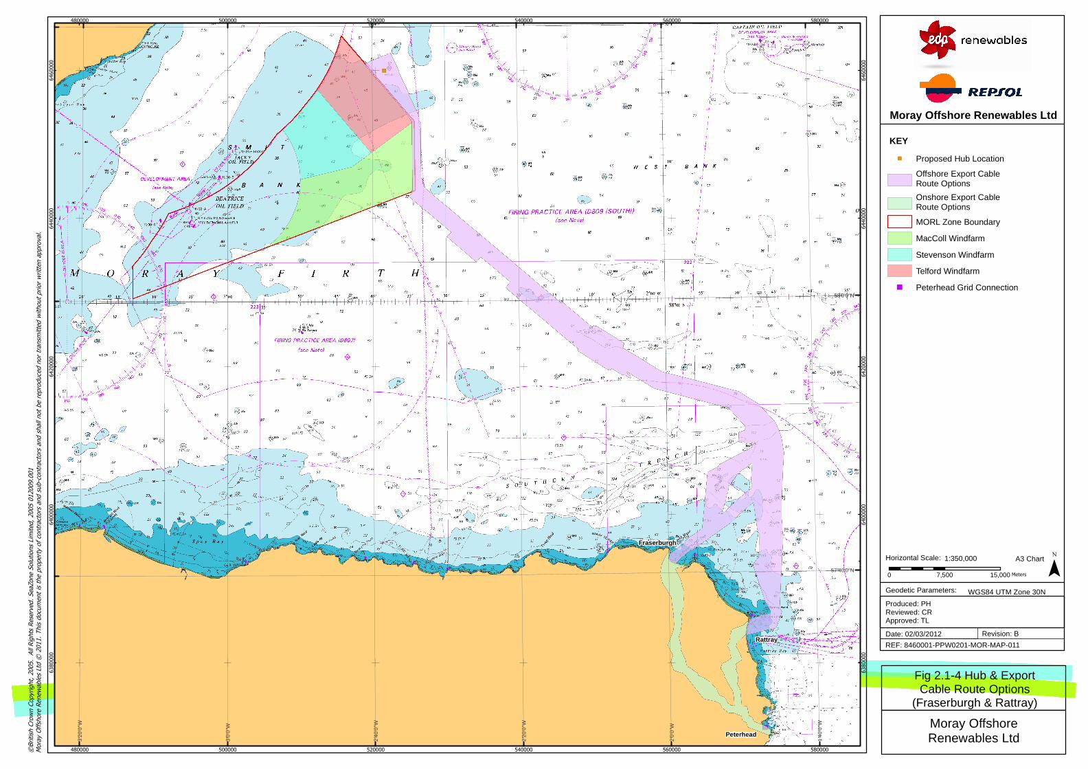
�)
Fraserburgh
Rattray
Peterhead
480000
480000
500000
500000
520000
520000
540000
540000
560000
560000
580000
580000
6380000
6380000
6400000
6400000
6420000
6420000
6440000
6440000
6460000
6460000
1°40
'0"W
2°0'
0"W
2°20
'0"W
2°40
'0"W
3°0'
0"W
3°20
'0"W
58°0'0"N
57°40'0"N0 7,500 15,000 Meters ¯
KEY
©British Crown Copyright, 2005. All Rights Reserved. SeaZone Solutions Limited, 2005 012009.001
Moray Offshore Renewables Ltd ©
2011. This document is the property of contractors and sub-contractors and shall not be reproduced nor transm
itted without prior written approval.
REF: 8460001-PPW0201-MOR-MAP-011
Produced: PHReviewed: CRApproved: TL
Date: 02/03/2012
Moray OffshoreRenewables Ltd
Moray Offshore Renewables Ltd
Revision: B
Fig 2.1-4 Hub & ExportCable Route Options
(Fraserburgh & Rattray)
1:350,000Horizontal Scale:
Geodetic Parameters: WGS84 UTM Zone 30N
A3 Chart
�) Proposed Hub Location
Offshore Export CableRoute Options
Onshore Export CableRoute Options
MORL Zone Boundary
MacColl Windfarm
Stevenson Windfarm
Telford Windfarm
�) Peterhead Grid Connection