mort creek site complex, curtis coast: site report · 2011-08-29 · 90 carter, lilley, ulm and...
TRANSCRIPT
QAR 1999 Vol. 11 85
MORT CREEK SITE COMPLEX, CURTIS COAST: SITE REPORT
MELISSA CARTER, IAN LILLEY, SEAN ULM AND DEBORAH BRIANAboriginal and Torres Strait Islander Studies Unit, University of Queensland,
Brisbane, Queensland, 4072, Australia
This paper reports the results of excavations conducted at the Mort Creek SiteComplex, located in the Rodds Peninsula Section of Eurimbula National Park on thesouthern Curtis Coast, Central Queensland. Cultural and natural marine shell depositswere excavated and analysed as part of an investigation of natural and cultural siteformation processes in the area. Analyses (including foraminifera studies) demonstratea complex site formation history, with interfingering of cultural and natural shelldeposits (cheniers) in some areas of the site. Radiocarbon dating indicates thatAboriginal occupation of the site was initiated before 2,000 cal BP, overlapping withdates obtained for natural chenier deposits.
IntroductionThis paper details the results of excavationsundertaken during January 1995 at the Mort CreekSite Complex on the Central Queensland coast. Inprevious publications the site has been called ‘RoddsPeninsula’ (Lilley et al. 1996) and the ‘RoddsPeninsula Site Complex’ (Carter 1997). The site isregistered as Queensland State File Number KE:A41and Queensland Museum Site Number S866.
The excavations had two primary aims. The firstwas to distinguish areas of non-cultural deposit, suchas cheniers, from shell middens. The second aim wasto determine whether surface indications gave anaccurate picture of the nature and distribution of shelldeposits in the study area. In the laboratory, a furtherresearch aim of these excavations was to test theapplicability of foraminifera analysis, a micro-analytical technique with the potential to helpdistinguish cultural and natural marine shell deposits.
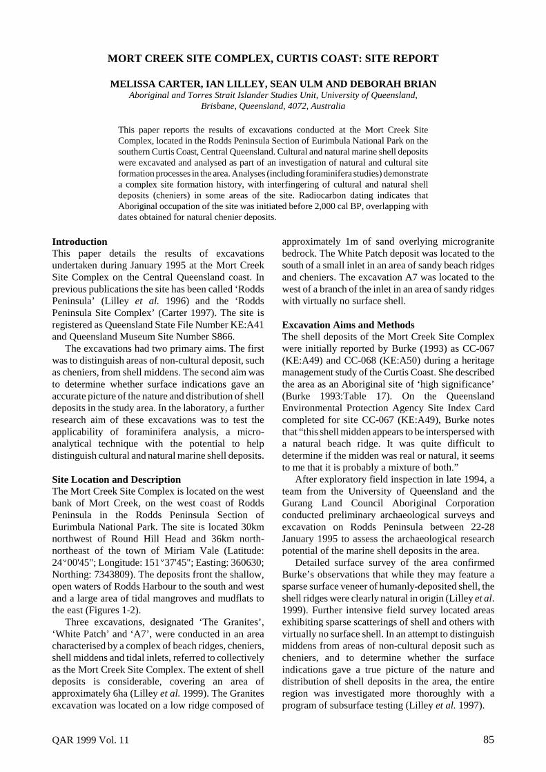
Site Location and DescriptionThe Mort Creek Site Complex is located on the westbank of Mort Creek, on the west coast of RoddsPeninsula in the Rodds Peninsula Section ofEurimbula National Park. The site is located 30kmnorthwest of Round Hill Head and 36km north-northeast of the town of Miriam Vale (Latitude:24�00'45"; Longitude: 151�37'45"; Easting: 360630;Northing: 7343809). The deposits front the shallow,open waters of Rodds Harbour to the south and westand a large area of tidal mangroves and mudflats tothe east (Figures 1-2).
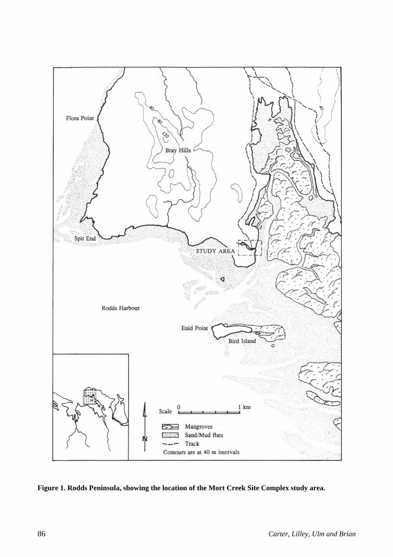
Three excavations, designated ‘The Granites’,‘White Patch’ and ‘A7’, were conducted in an areacharacterised by a complex of beach ridges, cheniers,shell middens and tidal inlets, referred to collectivelyas the Mort Creek Site Complex. The extent of shelldeposits is considerable, covering an area ofapproximately 6ha (Lilley et al. 1999). The Granitesexcavation was located on a low ridge composed of
approximately 1m of sand overlying microgranitebedrock. The White Patch deposit was located to thesouth of a small inlet in an area of sandy beach ridgesand cheniers. The excavation A7 was located to thewest of a branch of the inlet in an area of sandy ridgeswith virtually no surface shell.
Excavation Aims and MethodsThe shell deposits of the Mort Creek Site Complexwere initially reported by Burke (1993) as CC-067(KE:A49) and CC-068 (KE:A50) during a heritagemanagement study of the Curtis Coast. She describedthe area as an Aboriginal site of ‘high significance’(Burke 1993:Table 17). On the QueenslandEnvironmental Protection Agency Site Index Cardcompleted for site CC-067 (KE:A49), Burke notesthat “this shell midden appears to be interspersed witha natural beach ridge. It was quite difficult todetermine if the midden was real or natural, it seemsto me that it is probably a mixture of both.”
After exploratory field inspection in late 1994, ateam from the University of Queensland and theGurang Land Council Aboriginal Corporationconducted preliminary archaeological surveys andexcavation on Rodds Peninsula between 22-28January 1995 to assess the archaeological researchpotential of the marine shell deposits in the area.
Detailed surface survey of the area confirmedBurke’s observations that while they may feature asparse surface veneer of humanly-deposited shell, theshell ridges were clearly natural in origin (Lilley et al.1999). Further intensive field survey located areasexhibiting sparse scatterings of shell and others withvirtually no surface shell. In an attempt to distinguishmiddens from areas of non-cultural deposit such ascheniers, and to determine whether the surfaceindications gave a true picture of the nature anddistribution of shell deposits in the area, the entireregion was investigated more thoroughly with aprogram of subsurface testing (Lilley et al. 1997).
86 Carter, Lilley, Ulm and Brian
Figure 1. Rodds Peninsula, showing the location of the Mort Creek Site Complex study area.
QAR 1999 Vol. 11 87
Figure 2. Mort Creek Site Complex, showing locations of subsurface testing.
Initially the local topography was mapped with anautoset level and stadia rod. To gain broadinformation on the extent and depth of the shelldeposits, a grid of 38 x 75mm auger holes was drilledacross the study region at 50m intervals. The resultsdemonstrated that there were substantial subsurfaceshell deposits over the entire area, including thoseparts where surface shell was largely absent. Toassess the stratigraphy more accurately and to obtaincontrol samples of the deposits, three 50cm x 50cmtest pits were excavated in areas with differentsurface expressions of shell.
The excavations were located to obtain arepresentative sample of the range of shell depositsobserved over the entire study area. The Granitesexcavation was situated in a locale which washypothesised to contain shell midden deposit. Theexcavation known as White Patch was conducted ina place hypothesised to comprise natural beach ridgesand chenier deposits. Displaying no surface shellmaterial, the third site, known as A7, was excavatedto determine the cultural status of the densesubsurface shell deposits which had been revealed byaugering.
The three test pits were excavated by trowel inarbitrary 2-5cm excavation units within stratigraphicunits. Elevations were recorded at the beginning and
end of each excavation unit, using a local datum andstring line and level. Major finds were plotted in situin three dimensions and bagged separately. Mostexcavated sediment was dry-sieved on site through6mm and 3mm mesh, and sieve residues and samplesof fine material which passed through the screenswere retained for laboratory analysis. The basalexcavation units of A7 were wet-sieved in seawaterfrom the adjacent estuary as the moisture content ofthe excavated sand prevented effective dry-sieving.Bulk sediment samples, however, were taken prior towet-sieving. Control samples for foraminiferaanalysis were collected from shelly intertidal depositson the west bank of Mort Creek and from a longchenier fronting Rodds Harbour to the south.
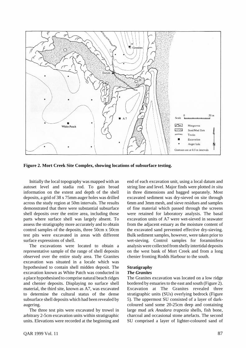
StratigraphyThe GranitesThe Granites excavation was located on a low ridgebordered by estuaries to the east and south (Figure 2).Excavation at The Granites revealed threestratigraphic units (SUs) overlying bedrock (Figure5). The uppermost SU consisted of a layer of dark-coloured sand some 20-25cm deep and containinglarge mud ark Anadara trapezia shells, fish bone,charcoal and occasional stone artefacts. The secondSU comprised a layer of lighter-coloured sand of

88 Carter, Lilley, Ulm and Brian
similar depth containing some shell. SUIII consistedof densely-packed shell fragments some 25-30cmdeep. On the basis of conventional criteria used todistinguish middens, namely the presence of largershells, bone, charcoal and stone artefacts, TheGranites excavation was concluded to have exposeda shell midden overlying a chenier deposit resting onmicrogranite bedrock. More detailed examination ofthe shell assemblage indicated that there was a veneerof culturally-deposited shell on top of the basalchenier (Carter 1997; Lilley et al. 1996). The naturalformation proved to be substantially older than thecultural shells lying directly on its surface (seediscussion below).
White PatchLocated to the south of a small tidal inlet (Figure 2),the White Patch test pit revealed a deposit consistingentirely of densely-packed shell and shell fragments(Figures 3, 6). Excavation demonstrated the presenceof four natural stratigraphic units (SUs). Theuppermost (SUI) consisted of dark-brown organic topsoil, densely packed with shell fragments and somelarge shells including hercules club shell, mud arkand land snail, and ranging from c.10-20cm in depth.SUII exhibited an increase in shell and shell grit, withlittle soil. Sub-unit SUIIA of this layer was distinct,containing shell and shell grit but characterised by agrey soil matrix. SUIII contained densely-packedshell with many large individuals, in a reddish-coloured sandy matrix. An absence of charcoal, boneand stone artefacts was observed during excavation.Also noted by the excavators were patches of odd-smelling, grey-coloured shell amid the more usualpinky-brown coloured material. This was concludedto be evidence for seawater penetration and mineralprecipitation. Based on these characteristics, WhitePatch was determined to be entirely of natural origin,and classified as chenier deposit.
A7A7 is located to the west of a small tidal inlet in anarea with virtually no surface shell (Figure 2). AugerHole 7 (from which the name A7 derives) revealed adense shell layer some 10-15cm thick locatedapproximately 20cm below ground surface (Figures4, 7). The presence of this layer was confirmed byexcavation. As augering had indicated, the uppermoststratigraphic unit (SUI) consisted entirely of soil androot matter. SUII consisted of large shells,predominantly mud ark (Anadara trapezia) andcommercial oyster (Saccostrea commercialis), in amedium- to dark-brown soil matrix. Smaller shellswere also noted. The matrix of this unit wassubstantially sandier and more yellow in colour thanthe matrix observed in the stratigraphic unit above.SUIII exhibited a decrease in the number of largeshells, with a noticeable increase in fragmented shelland shell grit. The matrix of this unit consisted of anorange-red sand. At this point in the excavation of A7(c.90cm) the water table was reached, and excavationceased, as the base of the pit filled with water and thesections threatened to collapse.
Although the A7 excavation looked like a shellmidden in that it contained abundant, seemingly size-selected mud ark, as well as what field observationsuggested might be a shell artefact from the base ofthe dense shell layer (Culbert 1996), classificationproblems remained. The soil matrix of the depositappeared different from the dark, organic sedimentusually associated with middens (Lilley et al. 1999).The deposit also contained little or no charcoal andno other artefacts, and exhibited a much wider varietyof shell species in a greater range of sizes than in TheGranites deposit. On the basis of this ambiguity, A7was seen as a primary candidate for the application offoraminifera analysis to test its utility as an additionalaid in distinguishing middens from natural shelldeposits (Lilley et al. 1999).
Figure 3. White Patch showing densely-packedchenier deposits (Photograph: I. Lilley).
Figure 4. A7 showing dense shell lens dominatedby large mud ark (Photograph: S. Ulm).
QAR 1999 Vol. 11 89
Figure 5. Northern and eastern stratigraphic profiles of The Granites.
Figure 6. Northern and eastern stratigraphic profiles of White Patch.
Figure 7. Northern and western stratigraphic profiles of A7.
90 Carter, Lilley, Ulm and Brian
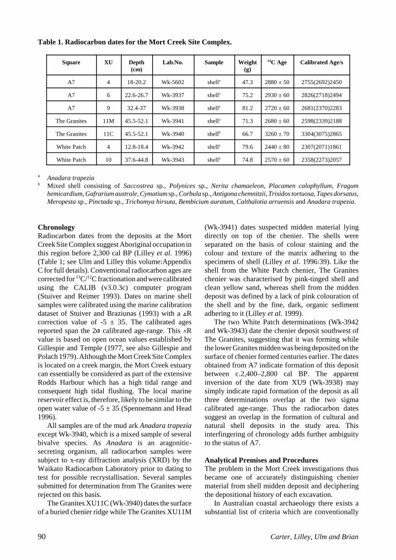
Table 1. Radiocarbon dates for the Mort Creek Site Complex.
Square XU Depth(cm)
Lab.No. Sample Weight(g)
14C Age Calibrated Age/s
A7 4 18-20.2 Wk-5602 shella 47.3 2880 ± 50 2755(2692)2450
A7 6 22.6-26.7 Wk-3937 shella 75.2 2930 ± 60 2826(2718)2494
A7 9 32.4-37 Wk-3938 shella 81.2 2720 ± 60 2681(2370)2283
The Granites 11M 45.5-52.1 Wk-3941 shella 71.3 2680 ± 60 2598(2339)2188
The Granites 11C 45.5-52.1 Wk-3940 shellb 66.7 3260 ± 70 3304(3075)2865
White Patch 4 12.8-18.4 Wk-3942 shella 79.6 2440 ± 80 2307(2071)1861
White Patch 10 37.6-44.8 Wk-3943 shella 74.8 2570 ± 60 2358(2273)2057
a Anadara trapeziab Mixed shell consisting of Saccostrea sp., Polynices sp., Nerita chamaeleon, Placamen calophyllum, Fragum
hemicardium, Gafrarium australe, Cymatium sp., Corbula sp., Antigona chemnitzii, Trisidos tortuosa, Tapes dorsatus,Meropesta sp., Pinctada sp., Trichomya hirsuta, Bembicium auratum, Calthalotia arruensis and Anadara trapezia.
ChronologyRadiocarbon dates from the deposits at the MortCreek Site Complex suggest Aboriginal occupation inthis region before 2,300 cal BP (Lilley et al. 1996)(Table 1; see Ulm and Lilley this volume:AppendixC for full details). Conventional radiocarbon ages arecorrected for 13C/12C fractionation and were calibratedusing the CALIB (v3.0.3c) computer program(Stuiver and Reimer 1993). Dates on marine shellsamples were calibrated using the marine calibrationdataset of Stuiver and Braziunas (1993) with a �Rcorrection value of -5 ± 35. The calibrated agesreported span the 2� calibrated age-range. This �Rvalue is based on open ocean values established byGillespie and Temple (1977, see also Gillespie andPolach 1979). Although the Mort Creek Site Complexis located on a creek margin, the Mort Creek estuarycan essentially be considered as part of the extensiveRodds Harbour which has a high tidal range andconsequent high tidal flushing. The local marinereservoir effect is, therefore, likely to be similar to theopen water value of -5 ± 35 (Spennemann and Head1996).
All samples are of the mud ark Anadara trapeziaexcept Wk-3940, which is a mixed sample of severalbivalve species. As Anadara is an aragonitic-secreting organism, all radiocarbon samples weresubject to x-ray diffraction analysis (XRD) by theWaikato Radiocarbon Laboratory prior to dating totest for possible recrystallisation. Several samplessubmitted for determination from The Granites wererejected on this basis.
The Granites XU11C (Wk-3940) dates the surfaceof a buried chenier ridge while The Granites XU11M
(Wk-3941) dates suspected midden material lyingdirectly on top of the chenier. The shells wereseparated on the basis of colour staining and thecolour and texture of the matrix adhering to thespecimens of shell (Lilley et al. 1996:39). Like theshell from the White Patch chenier, The Graniteschenier was characterised by pink-tinged shell andclean yellow sand, whereas shell from the middendeposit was defined by a lack of pink colouration ofthe shell and by the fine, dark, organic sedimentadhering to it (Lilley et al. 1999).
The two White Patch determinations (Wk-3942and Wk-3943) date the chenier deposit southwest ofThe Granites, suggesting that it was forming whilethe lower Granites midden was being deposited on thesurface of chenier formed centuries earlier. The datesobtained from A7 indicate formation of this depositbetween c.2,400–2,800 cal BP. The apparentinversion of the date from XU9 (Wk-3938) maysimply indicate rapid formation of the deposit as allthree determinations overlap at the two sigmacalibrated age-range. Thus the radiocarbon datessuggest an overlap in the formation of cultural andnatural shell deposits in the study area. Thisinterfingering of chronology adds further ambiguityto the status of A7.
Analytical Premises and ProceduresThe problem in the Mort Creek investigations thusbecame one of accurately distinguishing cheniermaterial from shell midden deposit and decipheringthe depositional history of each excavation.
In Australian coastal archaeology there exists asubstantial list of criteria which are conventionally
QAR 1999 Vol. 11 91
used to distinguish the nature and formation ofcultural and natural shell formations (e.g. Attenbrow1992; Bailey 1994; Gill 1954; McNiven 1996). Someof these criteria include the presence or absence ofcultural materials such as charcoal, bone and stoneartefacts and evidence for size selection in so-called‘economic’ species. For some time, however, it hasbeen recognised that these criteria are not alwaysreliable in accurately distinguishing midden shelldeposits from natural shell deposits such as cheniers(Bailey 1994; O’Connor and Sullivan 1994; Rowland1994; Sullivan and O’Connor 1993). More recently,the technique of foraminifera analysis has been usedto aid in the identification of cultural shell deposits(Gill et al. 1991; Lilley et al. 1999; McNiven 1996).
Foraminifera AnalysisForaminifera (forams) are microscopic organisms thathave calcium carbonate exoskeltons known as ‘tests’.They are ubiquitous and abundant in marineenvironments. By assessing their abundance in shelldeposits, archaeologists can determine the degree towhich seawater was involved in the formation of ashell deposit. Theoretically, this enables natural shellaccumulations, middens re-worked by seawater andin situ shell midden deposits to be distinguished. Thetechnique has been applied to archaeological depositson only three occasions, initially by Gill et al. (1991),then by McNiven (1996) and most recently by Lilleyet al. (1999). Gill et al. (1991) recognised that thepresence or absence of foraminifera in coastal shelldeposits could provide insights into the influence ofthe sea on site formation. As forams are abundant inseawater, they tend to be extremely common insediment laid-down or re-worked by wave action(McNiven 1996). Hence, it was hypothesised,foraminifera tests should be present in any depositlaid down or re-worked by seawater, but not inmiddens which have not been inundated by seawater(Gill et al. 1991). Lilley et al. (1999) note, however,that foraminifera may be present in the matrix of anin situ midden which was deposited on, or coveredby, wind- or water-borne marine sediment or whereseawater has been transported to the site by humans.If this were the case, they suggest that althoughforams will be present, they should be veryconsiderably fewer in number in midden depositsthan in natural marine sediments.
Thus, various hypotheses had to be testedregarding the application of foraminifera analysis tothe Mort Creek Site Complex deposits. First, toprovide initial confirmation of the utility of thetechnique, Lilley et al. (1999) had to demonstrate thatcontrol samples obtained from the beach, the chenierridge samples and the material excavated at WhitePatch contained foraminifera, while a sample
obtained from the midden at The Granites did not.Second, assuming confirmation of the effectivenessof the technique in these relatively unambiguouscases, the status of A7 as a midden could be tested bydetermining whether or not it contained foraminifera(Lilley et al. 1999).
As anticipated, the sediment from the controlsamples and White Patch revealed abundantforaminifera, while that from the upper, definitely-cultural unit of The Granites contained none. Theresults were taken “as preliminary confirmation of thevalidity of foraminiferal analysis as a test of thehuman origins of shell deposits in the study area”(Lilley et al. 1999:13). The sediment analysed fromA7 (extracted from XU5) also had no observableforaminifera content. On the basis of this finding,coupled with the results from the other samples, thepresence of a suspected shell artefact (Culbert 1996)and the apparently size-selected Anadara trapeziashells in the excavation, A7 was concluded to be amidden (Lilley et al. 1999).
To test further these preliminary conclusions, anin-depth analysis of material from each excavationwas conducted (Carter 1997). This investigationemployed two of the major criteria used in Australianmidden studies – species diversity and intra-specificsize. These criteria respectively specify that shellmiddens will contain a restricted range of species,predominantly of larger sizes, whilst naturalaccumulations such as cheniers will contain a largenumber of species, and exhibit a larger proportion ofsmall shells.
SamplingSampling was necessary owing to the large amount ofmaterial extracted from the excavations. The twoelements which influenced the sampling strategy werethe time available for analyses and the nature of thedeposits themselves. The Granites deposit consistedof 13 excavation units, all of which were sorted andanalysed. There were 10 excavation units (XUs) dugat White Patch. Owing to the large volume of shellthat was recovered, the sample of material sortedfrom this test pit included all coarse (6mm) sieveresidues from XUs 1, 5 and 8. These XUs represent asample of each of the three different depositionalunits observed during excavation (Figure 6). Owingto the great bulk of fine sieve (3mm) residuescollected, sorting of a 100% sample was not feasible.Consequently, a random sample of 100g of fine sieveresidue from each of the three selected White PatchXUs was chosen for analysis. The excavation at A7consisted of 14 XUs. No material at all was retainedby the field crew from XUs 1-2, as these unitscontained only sand. The remaining 12 units were allanalysed. All coarse sieve (6mm) residues were
92 Carter, Lilley, Ulm and Brian
sorted. All fine sieve residues were analysed with theexception of residues in excess of 100g, where onlya 100g sample was studied.
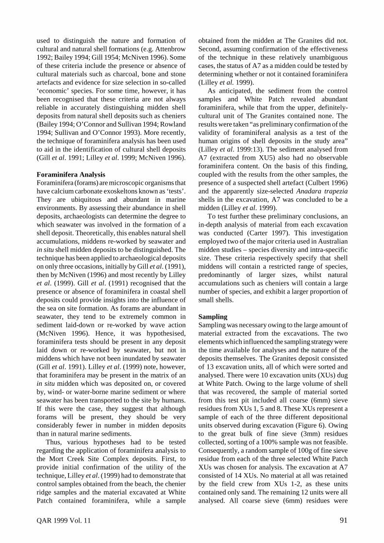
Laboratory ProceduresOwing to several methodological requirements for thesizing of individual shells within species (intra-specific size selection), the NISP (Number ofIdentified Specimens) and weight methods wererejected for the calculation of relative shellfishabundances (see Carter 1997 for more detailedinformation regarding methodology). MNI (MinimumNumber of Individuals) was the method selected forcharacterizing shell abundance. The rationale for thisselection is summarised by Bowdler (1983:140).
For each sampled excavation unit from each area,all molluscs were identified and analysed accordingto species. Each shell was identified using specificdiagnostic features, such as the umbo or hinge of abivalve and the columella (the inner lip of the anterioropening) of gastropods. MNI calculations for eachspecies were conducted using specific structuralelements or parts of a shell. Bivalve MNIs, forexample, were calculated by counting the highest
frequency of right or left umbos or valves. Forgastropods, apertures or opecular openings were usedas diagnostic elements of individual specimens. Table2 defines the classifications of shellfish remainsdevised for analysis of molluscan remains.
For each site and for each excavation unit, thesize-classing of individuals was conducted for allspecies. This was carried out using only whole shells(see Table 2). Seven categories of size-classes wereemployed: 0-10mm, 11-20mm, 21-30mm, 31-40mm,41-50mm and >60mm. Shells were categorised usinga size chart drawn on 1mm graph paper.
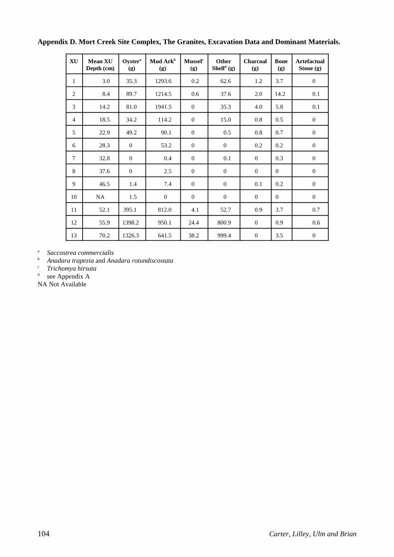
A limited analysis of non-molluscan remains fromeach of the deposits was also conducted. Smallquantities of fish bone, stone artefacts and ochre wereidentified in the top half of The Granites. White Patchcontained a single unburnt fish vertebra and verysmall crab remains as well as unmodified stone andcoral fragments. A7 contained small quantities of fishbone in XUs 3-4. Both The Granites and A7contained small quantities of charcoal. Carter (1997)provides details. A summary of analytical results foreach excavation square is presented here as AppendixB-D.
Table 2. Categories of shellfish remains for the analysis of molluscan remains.
Shell Type Definition
BIVALVES
Whole shell A valve completely (100%) intact displaying the entire valve and umbo
Broken shell Any valve which is not completely intact but displays >50% of the umbo
Fragment Any part of the valve which displays <50% of the umbo
OYSTERS and like species
Whole shell A base or lid completely (100%) intact displaying the hinge
Broken shell A base or lid which is not completely intact but displays >50% of the hinge
Fragment Any part of the valve which displays <50% of the hinge
LARGE GASTROPODSa
Whole shell Any shell which is completely 100% intact and displays the aperture
Broken shell Any part of the shell which displays an aperture >50% complete
Fragment Any part of the shell which displays <50% of the aperture
SMALL GASTROPODSb
Whole shell Any shell which is completely intact (100%) and/or displays 100% of the opercular opening and anterior margin
Broken shell Any part of the shell which displays an opercular opening and anterior margin >50% complete
Fragment Any part of the shell which displays an opercular opening and anterior margin <50% complete
a Includes the whelks (e.g. Pyrazus ebeninus, Cerithidae sp. etc., and also Nassirius sp.)b Includes the small species such as Nerites and cap-shaped gastropods (e.g. Austrocochlea sp., Thalotia sp.).

QAR 1999 Vol. 11 93
Table 3. Number of species per analysed XU in The Granites, White Patch and A7 (NA=Not Available).
Square/XU 1 2 3 4 5 6 7 8 9 10 11 12 13 14
The Granites 9 9 5 4 2 0 0 0 0 1 17 60 62 -
White Patch 53 NA NA NA 62 NA NA 72 NA NA - - - -
A7 NA NA 10 30 30 50 52 45 45 31 46 36 48 46
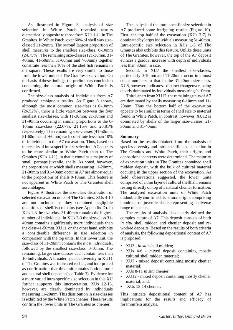
Results of AnalysisSpecies DiversityThe criterion of species diversity refers to the numberof species of shellfish contained in each analysedexcavation unit in each site (Table 3; see Appendix Afor a complete list of identified species).
XUs 1-11 at The Granites contained a smallnumber of species. This is a typical feature of shellmidden deposits (Attenbrow 1992; Bailey 1994;Bowdler 1983). The dominant species identified arecommonly found in middens, such as mud ark(Anadara trapezia), commercial oyster (Saccostreacommercialis), hairy mussel (Trichomya hirsuta) andhercules club shell (Pyrazus ebeninus). These speciesoccur in mud and estuarine habitats (Coleman 1992).
XU11, however, displays a greater speciesdiversity in comparison to the low numbers identifiedin the upper XUs. Further, XUs 12-13 contain verylarge numbers of species. In addition to the fourspecies mentioned above, these units contained thesmall bivalves Garfrarium australe and Corbula sp.,which inhabit littoral muddy sand environments(Lamprell and Whitehead 1992) and small gastropodsincluding Calthalotia arruensis and Neritidae sp.which occur in inshore muddy rocks and mangroveswamps (Coleman 1992; Dance 1992). These verysmall individual molluscs are unlikely to have beentargeted as food resources (cf. Rowland 1994). Theseresults strengthen the proposition that at this location,midden deposits rest directly on top of natural chenierdeposits.
The species identified in White Patch, the depositconcluded unequivocally to be chenier, numberedover 50 in each of the three excavation unitsanalysed. The material comprised a large assortmentof bivalves and gastropods from a range of habitatsincluding littoral sand, rocky intertidal shores, mudflats, mangrove swamps and intertidal sand flats(Coleman 1992; Dance 1992; Lamprell andWhitehead 1992). The presence of such speciesdiversity in White Patch, a feature not found in theundoubted upper shell midden at The Granites,provides additional confirmation that this deposit isa natural chenier formation.
Analysis of A7, the ambiguous deposit, revealedsome interesting results. Only one excavation unit
(XU3) exhibited a species diversity which is typicalof cultural deposits, as exemplified in this case by theupper units of The Granites. This unit contained only10 species including Anadara trapezia, Saccostreacommercialis and Trichomya hirsuta. Each of theremaining units, however, exhibited much greaterspecies diversity (between 30 and 52 species), moretypical of natural shell deposits such as White Patch.The identified species include a wide range ofbivalves and gastropods from a range of habitatsincluding rocky shores, shell debris and mangroves,though mostly from littoral sand. However, there isnotable variation in the species diversity of A7, andoverall, fewer species were identified in this depositthan in White Patch. The results of species diversityanalysis clearly underline the intriguing nature of A7.
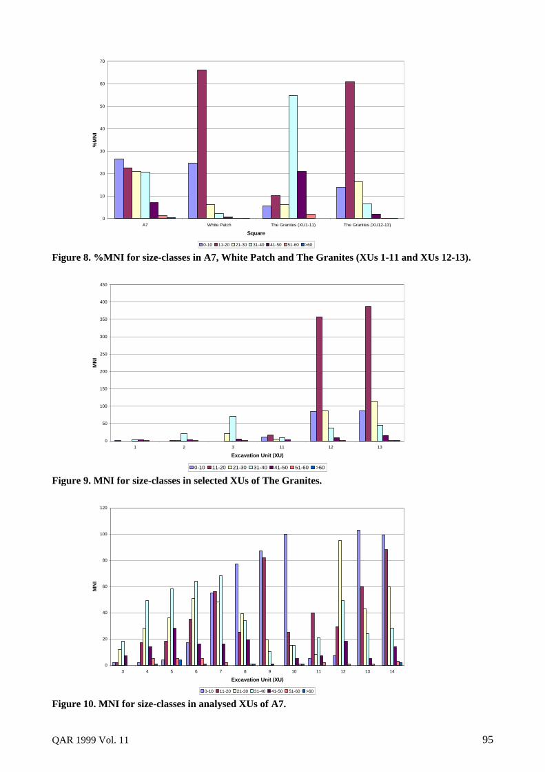
Intra-Specific Size SelectionThe second criterion for analysis of excavated shellused here is the size selection of species contained inthe deposits. For each analysed excavation unit ofeach site, all whole shells were size-classed into thecategories mentioned above. Figure 8 illustrates theresults of this analysis. Results presented for the TheGranites are twofold. XUs 1-11 comprise mostlyshells measuring between 31-40mm (54.87%). Shellsmeasuring 41-50mm form the second largestproportion of molluscan remains. The size-classes 0-10mm and 21-30mm comprise less than 10% of thedeposit, whilst material belonging to 11-20mmconstitutes less than 15%. Overall, most shellsexcavated from these units are large individualsmeasuring greater than 31mm. Shells of this size aregenerally classified by Australian researchers as‘economic’, or elsewhere defined as ‘medium to largeadults’ (Attenbrow 1992).
Results of size selection analysis of XUs 12-13 ofThe Granites, however, demonstrate something quitedifferent (Figure 8, 9). In these lower units, themajority of the shell assemblage consists ofindividuals measuring 11-20mm (53.84%), followedby those measuring 21-30mm (14.94%). Individualsclassed above 31mm constitute less than 20% of theshell deposit. These results clearly confirm theexistence of a chenier at the base of The Granitesexcavated deposit.
94 Carter, Lilley, Ulm and Brian
As illustrated in Figure 8, analysis of sizeselection in White Patch revealed resultsdiametrically opposite to those from XUs 1-11 in TheGranites. In White Patch, over 60% of shell was size-classed 11-20mm. The second largest proportion ofshell measures to the smallest size-class, 0-10mm(24.75%). The remaining size-classes (21-30mm, 31-40mm, 41-50mm, 51-60mm and >60mm) togetherconstitute less than 10% of the shellfish remains inthe square. These results are very similar to thosefrom the lower units of The Granites excavation. Onthe basis of these findings, the preliminary conclusionconcerning the natural origin of White Patch isconfirmed.
The size-class analysis of individuals from A7produced ambiguous results. As Figure 8 shows,although the most common size-class is 0-10mm(26.52%), there is little variation between the foursmallest size-classes, with 11-20mm, 21-30mm and31-40mm occurring in similar proportions to the 0-10mm size-class (22.67%, 21.15% and 20.81%respectively). The remaining size-classes (41-50mm,51-60mm and >60mm) each constitute less than 10%of individuals in the A7 excavation. Thus, based onthe results of intra-specific size selection, A7 appearsto be more similar to White Patch than to TheGranites (XUs 1-11), in that it contains a majority ofsmall, perhaps juvenile, shells. As noted, however,the proportions at which shells measuring 11-20mm,21-30mm and 31-40mm occur in A7 are almost equalto the proportions of shells 0-10mm. This feature isnot apparent in White Patch or The Granites shellassemblages.
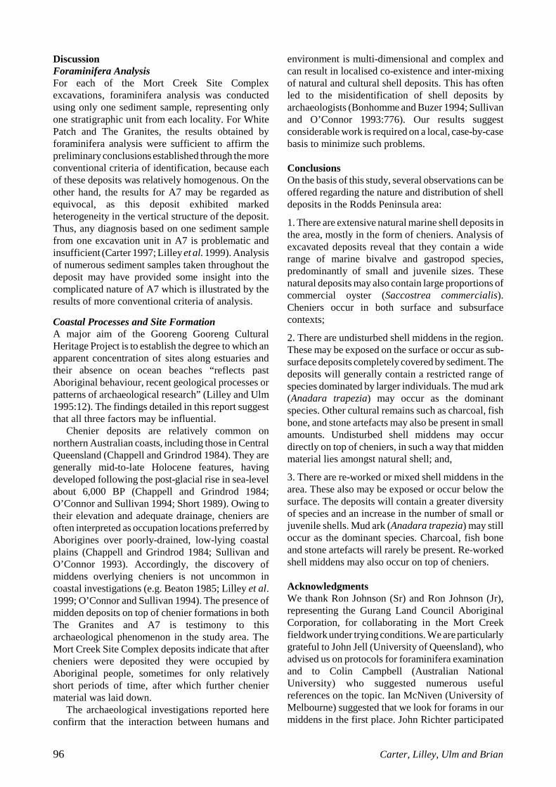
Figure 9 illustrates the size-class distribution ofselected excavation units of The Granites. XUs 4-10are not included as they contained negligiblequantities of shellfish remains (see Appendix D). InXUs 1-3 the size-class 31-40mm contains the highestnumber of individuals. In XUs 2-3 the size-class 31-40mm contains significantly more individuals thanthe class 41-50mm. XU11, on the other hand, exhibitsa considerable difference in size selection incomparison with the top units. In this lower unit, thesize-class of 11-20mm contains the most individuals,followed by the smallest size-class, 0-10mm. Theremaining, larger size-classes each contain less than10 individuals. A broader species-diversity in XU11of The Granites was indicated earlier, and interpretedas confirmation that this unit contains both culturaland natural shell deposits (see Table 3). Evidence fora more varied intra-specific size selection in this XUfurther supports this interpretation. XUs 12-13,however, are clearly dominated by individualsmeasuring 11-20mm. This distribution in size-classesis exhibited by the White Patch chenier. These resultsconfirm the lower units in The Granites as chenier.
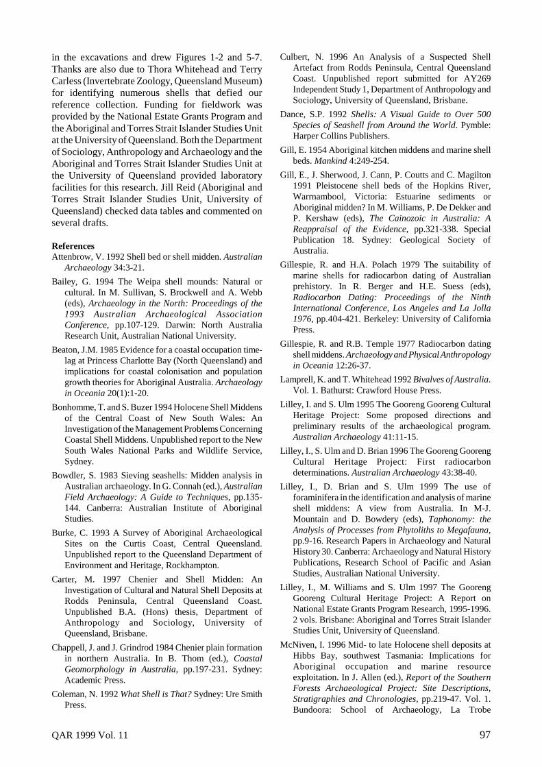
The analysis of the intra-specific size selection inA7 produced some intriguing results (Figure 10).First, the top half of the excavation (XUs 3-7) isdominated by larger individuals measuring 31-40mm.Intra-specific size selection in XUs 1-3 of TheGranites also exhibits this feature. Unlike these unitsof The Granites, however, the top of the A7 depositevinces a gradual increase with depth of individualsless than 30mm in size.
Second, in XU7 the smallest size-classes,particularly 0-10mm and 11-20mm, occur in almostequal numbers to that in the 31-40mm size-class.XU8, however, indicates a distinct changeover, beingclearly dominated by individuals measuring 0-10mm.
Third, apart from XU12, the remaining units of A7are dominated by shells measuring 0-10mm and 11-20mm. Thus the bottom half of the excavationappears to be similar in terms of shell size to materialfound in White Patch. In contrast, however, XU12 isdominated by shells of the larger size-classes, 21-30mm and 31-40mm.
SummaryBased on the results obtained from the analysis ofspecies diversity and intra-specific size selection inThe Granites and White Patch, their origins anddepositional contexts were determined. The majorityof excavation units in The Granites contained shellmidden deposit, with the bulk of cultural materialoccuring in the upper section of the excavation. Asfield observations suggested, the lower unitscomprised of a thin layer of cultural shellfish remainsresting directly on top of a natural chenier formation.The analysed excavation units of White Patchundoubtedly confirmed its natural origin, comprisinghundreds of juvenile shells representing a diverserange of species.
The results of analysis also clearly defined thecomplex nature of A7. This deposit consists of bothin situ shell midden and chenier deposit and re-worked deposits. Based on the results of both criteriaof analysis, the following depositional content of A7is proposed:
• XU3 - in situ shell midden;• XUs 4-6 - mixed deposit containing mostly
cultural shell midden material;• XU7 - mixed deposit containing mostly chenier
material;• XUs 8-11 in situ chenier;• XU12 - mixed deposit containing mostly chenier
material; and,• XUs 13-14 chenier.
This intricate depositional content of A7 hasimplications for the results and efficacy offoraminifera analysis.
QAR 1999 Vol. 11 95
0
10
20
30
40
50
60
70
A7 White Patch The Granites (XU1-11) The Granites (XU12-13)
Square
%M
NI
0-10 11-20 21-30 31-40 41-50 51-60 >60
Figure 8. %MNI for size-classes in A7, White Patch and The Granites (XUs 1-11 and XUs 12-13).
0
50
100
150
200
250
300
350
400
450
1 2 3 11 12 13
Excavation Unit (XU)
MN
I
0-10 11-20 21-30 31-40 41-50 51-60 >60
Figure 9. MNI for size-classes in selected XUs of The Granites.
0
20
40
60
80
100
120
3 4 5 6 7 8 9 10 11 12 13 14
Excavation Unit (XU)
MN
I
0-10 11-20 21-30 31-40 41-50 51-60 >60
Figure 10. MNI for size-classes in analysed XUs of A7.
96 Carter, Lilley, Ulm and Brian
DiscussionForaminifera AnalysisFor each of the Mort Creek Site Complexexcavations, foraminifera analysis was conductedusing only one sediment sample, representing onlyone stratigraphic unit from each locality. For WhitePatch and The Granites, the results obtained byforaminifera analysis were sufficient to affirm thepreliminary conclusions established through the moreconventional criteria of identification, because eachof these deposits was relatively homogenous. On theother hand, the results for A7 may be regarded asequivocal, as this deposit exhibited markedheterogeneity in the vertical structure of the deposit.Thus, any diagnosis based on one sediment samplefrom one excavation unit in A7 is problematic andinsufficient (Carter 1997; Lilley et al. 1999). Analysisof numerous sediment samples taken throughout thedeposit may have provided some insight into thecomplicated nature of A7 which is illustrated by theresults of more conventional criteria of analysis.
Coastal Processes and Site FormationA major aim of the Gooreng Gooreng CulturalHeritage Project is to establish the degree to which anapparent concentration of sites along estuaries andtheir absence on ocean beaches “reflects pastAboriginal behaviour, recent geological processes orpatterns of archaeological research” (Lilley and Ulm1995:12). The findings detailed in this report suggestthat all three factors may be influential.
Chenier deposits are relatively common onnorthern Australian coasts, including those in CentralQueensland (Chappell and Grindrod 1984). They aregenerally mid-to-late Holocene features, havingdeveloped following the post-glacial rise in sea-levelabout 6,000 BP (Chappell and Grindrod 1984;O’Connor and Sullivan 1994; Short 1989). Owing totheir elevation and adequate drainage, cheniers areoften interpreted as occupation locations preferred byAborigines over poorly-drained, low-lying coastalplains (Chappell and Grindrod 1984; Sullivan andO’Connor 1993). Accordingly, the discovery ofmiddens overlying cheniers is not uncommon incoastal investigations (e.g. Beaton 1985; Lilley et al.1999; O’Connor and Sullivan 1994). The presence ofmidden deposits on top of chenier formations in bothThe Granites and A7 is testimony to thisarchaeological phenomenon in the study area. TheMort Creek Site Complex deposits indicate that aftercheniers were deposited they were occupied byAboriginal people, sometimes for only relativelyshort periods of time, after which further cheniermaterial was laid down.
The archaeological investigations reported hereconfirm that the interaction between humans and
environment is multi-dimensional and complex andcan result in localised co-existence and inter-mixingof natural and cultural shell deposits. This has oftenled to the misidentification of shell deposits byarchaeologists (Bonhomme and Buzer 1994; Sullivanand O’Connor 1993:776). Our results suggestconsiderable work is required on a local, case-by-casebasis to minimize such problems.
ConclusionsOn the basis of this study, several observations can beoffered regarding the nature and distribution of shelldeposits in the Rodds Peninsula area:
1. There are extensive natural marine shell deposits inthe area, mostly in the form of cheniers. Analysis ofexcavated deposits reveal that they contain a widerange of marine bivalve and gastropod species,predominantly of small and juvenile sizes. Thesenatural deposits may also contain large proportions ofcommercial oyster (Saccostrea commercialis).Cheniers occur in both surface and subsurfacecontexts;
2. There are undisturbed shell middens in the region.These may be exposed on the surface or occur as sub-surface deposits completely covered by sediment. Thedeposits will generally contain a restricted range ofspecies dominated by larger individuals. The mud ark(Anadara trapezia) may occur as the dominantspecies. Other cultural remains such as charcoal, fishbone, and stone artefacts may also be present in smallamounts. Undisturbed shell middens may occurdirectly on top of cheniers, in such a way that middenmaterial lies amongst natural shell; and,
3. There are re-worked or mixed shell middens in thearea. These also may be exposed or occur below thesurface. The deposits will contain a greater diversityof species and an increase in the number of small orjuvenile shells. Mud ark (Anadara trapezia) may stilloccur as the dominant species. Charcoal, fish boneand stone artefacts will rarely be present. Re-workedshell middens may also occur on top of cheniers.
AcknowledgmentsWe thank Ron Johnson (Sr) and Ron Johnson (Jr),representing the Gurang Land Council AboriginalCorporation, for collaborating in the Mort Creekfieldwork under trying conditions. We are particularlygrateful to John Jell (University of Queensland), whoadvised us on protocols for foraminifera examinationand to Colin Campbell (Australian NationalUniversity) who suggested numerous usefulreferences on the topic. Ian McNiven (University ofMelbourne) suggested that we look for forams in ourmiddens in the first place. John Richter participated
QAR 1999 Vol. 11 97
in the excavations and drew Figures 1-2 and 5-7.Thanks are also due to Thora Whitehead and TerryCarless (Invertebrate Zoology, Queensland Museum)for identifying numerous shells that defied ourreference collection. Funding for fieldwork wasprovided by the National Estate Grants Program andthe Aboriginal and Torres Strait Islander Studies Unitat the University of Queensland. Both the Departmentof Sociology, Anthropology and Archaeology and theAboriginal and Torres Strait Islander Studies Unit atthe University of Queensland provided laboratoryfacilities for this research. Jill Reid (Aboriginal andTorres Strait Islander Studies Unit, University ofQueensland) checked data tables and commented onseveral drafts.
ReferencesAttenbrow, V. 1992 Shell bed or shell midden. Australian
Archaeology 34:3-21.
Bailey, G. 1994 The Weipa shell mounds: Natural orcultural. In M. Sullivan, S. Brockwell and A. Webb(eds), Archaeology in the North: Proceedings of the1993 Australian Archaeological AssociationConference, pp.107-129. Darwin: North AustraliaResearch Unit, Australian National University.
Beaton, J.M. 1985 Evidence for a coastal occupation time-lag at Princess Charlotte Bay (North Queensland) andimplications for coastal colonisation and populationgrowth theories for Aboriginal Australia. Archaeologyin Oceania 20(1):1-20.
Bonhomme, T. and S. Buzer 1994 Holocene Shell Middensof the Central Coast of New South Wales: AnInvestigation of the Management Problems ConcerningCoastal Shell Middens. Unpublished report to the NewSouth Wales National Parks and Wildlife Service,Sydney.
Bowdler, S. 1983 Sieving seashells: Midden analysis inAustralian archaeology. In G. Connah (ed.), AustralianField Archaeology: A Guide to Techniques, pp.135-144. Canberra: Australian Institute of AboriginalStudies.
Burke, C. 1993 A Survey of Aboriginal ArchaeologicalSites on the Curtis Coast, Central Queensland.Unpublished report to the Queensland Department ofEnvironment and Heritage, Rockhampton.
Carter, M. 1997 Chenier and Shell Midden: AnInvestigation of Cultural and Natural Shell Deposits atRodds Peninsula, Central Queensland Coast.Unpublished B.A. (Hons) thesis, Department ofAnthropology and Sociology, University ofQueensland, Brisbane.
Chappell, J. and J. Grindrod 1984 Chenier plain formationin northern Australia. In B. Thom (ed.), CoastalGeomorphology in Australia, pp.197-231. Sydney:Academic Press.
Coleman, N. 1992 What Shell is That? Sydney: Ure SmithPress.
Culbert, N. 1996 An Analysis of a Suspected ShellArtefact from Rodds Peninsula, Central QueenslandCoast. Unpublished report submitted for AY269Independent Study 1, Department of Anthropology andSociology, University of Queensland, Brisbane.
Dance, S.P. 1992 Shells: A Visual Guide to Over 500Species of Seashell from Around the World. Pymble:Harper Collins Publishers.
Gill, E. 1954 Aboriginal kitchen middens and marine shellbeds. Mankind 4:249-254.
Gill, E., J. Sherwood, J. Cann, P. Coutts and C. Magilton1991 Pleistocene shell beds of the Hopkins River,Warrnambool, Victoria: Estuarine sediments orAboriginal midden? In M. Williams, P. De Dekker andP. Kershaw (eds), The Cainozoic in Australia: AReappraisal of the Evidence, pp.321-338. SpecialPublication 18. Sydney: Geological Society ofAustralia.
Gillespie, R. and H.A. Polach 1979 The suitability ofmarine shells for radiocarbon dating of Australianprehistory. In R. Berger and H.E. Suess (eds),Radiocarbon Dating: Proceedings of the NinthInternational Conference, Los Angeles and La Jolla1976, pp.404-421. Berkeley: University of CaliforniaPress.
Gillespie, R. and R.B. Temple 1977 Radiocarbon datingshell middens. Archaeology and Physical Anthropologyin Oceania 12:26-37.
Lamprell, K. and T. Whitehead 1992 Bivalves of Australia.Vol. 1. Bathurst: Crawford House Press.
Lilley, I. and S. Ulm 1995 The Gooreng Gooreng CulturalHeritage Project: Some proposed directions andpreliminary results of the archaeological program.Australian Archaeology 41:11-15.
Lilley, I., S. Ulm and D. Brian 1996 The Gooreng GoorengCultural Heritage Project: First radiocarbondeterminations. Australian Archaeology 43:38-40.
Lilley, I., D. Brian and S. Ulm 1999 The use offoraminifera in the identification and analysis of marineshell middens: A view from Australia. In M-J.Mountain and D. Bowdery (eds), Taphonomy: theAnalysis of Processes from Phytoliths to Megafauna,pp.9-16. Research Papers in Archaeology and NaturalHistory 30. Canberra: Archaeology and Natural HistoryPublications, Research School of Pacific and AsianStudies, Australian National University.
Lilley, I., M. Williams and S. Ulm 1997 The GoorengGooreng Cultural Heritage Project: A Report onNational Estate Grants Program Research, 1995-1996.2 vols. Brisbane: Aboriginal and Torres Strait IslanderStudies Unit, University of Queensland.
McNiven, I. 1996 Mid- to late Holocene shell deposits atHibbs Bay, southwest Tasmania: Implications forAboriginal occupation and marine resourceexploitation. In J. Allen (ed.), Report of the SouthernForests Archaeological Project: Site Descriptions,Stratigraphies and Chronologies, pp.219-47. Vol. 1.Bundoora: School of Archaeology, La Trobe
98 Carter, Lilley, Ulm and Brian
University.
O’Connor, S. and M. Sullivan 1994 Distinguishingmiddens and cheniers: A case study from the southernKimberley. Archaeology in Oceania 29(1):16-28.
Rowland, M.J. 1994 Size isn’t everything: Shells inmounds, middens and natural deposits. AustralianArchaeology 39:118-124.
Short, A. 1989 Chenier research on the Australian coast.Marine Geology 90:345-351.
Spennemann, D.H.R. and M.J. Head 1996 Reservoirmodification of radiocarbon signatures in coastal andnear-shore waters of eastern Australia: The state ofplay. Quaternary Australasia 14(1):32-39.
Stuiver, M. and T.F. Braziunas 1993 Modelingatmospheric 14C influences and 14C ages of marinesamples to 10,000 BC. Radiocarbon 35(1):137-189.
Stuiver, M. and P.J. Reimer 1993 Extended 14C data baseand revised CALIB 3.0 14C age calibration program.Radiocarbon 35(1):215-230.
Sullivan, M. and S. O’Connor 1993 Middens and cheniers:Implications for Australian research. Antiquity 67:776-788.
Ulm, S. and I. Lilley this volume The archaeology of thesouthern Curtis Coast: An overview. QueenslandArchaeological Research 11.
QAR 1999 Vol. 11 99
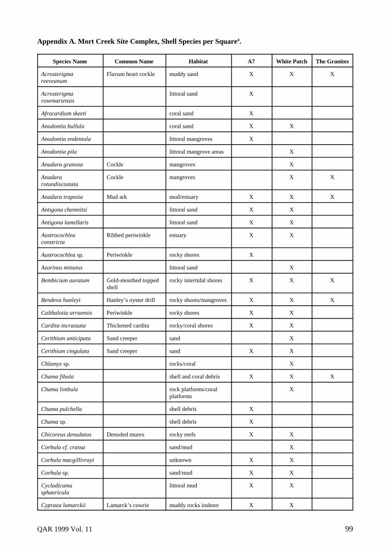
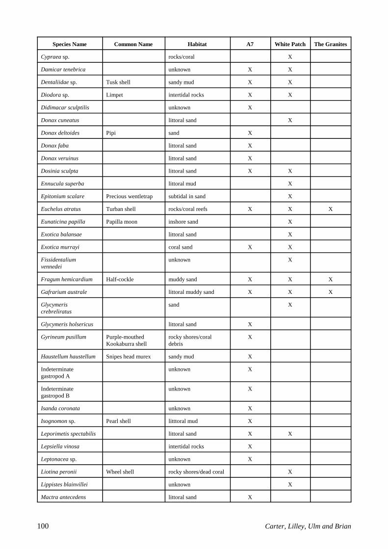
Appendix A. Mort Creek Site Complex, Shell Species per Squarea.
Species Name Common Name Habitat A7 White Patch The Granites
Acrosterigmareeveanum
Flavum heart cockle muddy sand X X X
Acrosterigmarosemariensis
littoral sand X
Afrocardium skeeti coral sand X
Anodontia bullula coral sand X X
Anodontia endentula littoral mangroves X
Anodontia pila littoral mangrove areas X
Anadara granosa Cockle mangroves X
Anadararotundiscostata
Cockle mangroves X X
Anadara trapezia Mud ark mud/estuary X X X
Antigona chemnitzi littoral sand X X
Antigona lamellaris littoral sand X X
Austrocochleaconstricta
Ribbed periwinkle estuary X X
Austrocochlea sp. Periwinkle rocky shores X
Azorinus minutus littoral sand X
Bembicium auratum Gold-mouthed toppedshell
rocky intertidal shores X X X
Bendeva hanleyi Hanley’s oyster drill rocky shores/mangroves X X X
Calthalotia arruensis Periwinkle rocky shores X X
Cardita incrassata Thickened cardita rocky/coral shores X X
Cerithium anticipata Sand creeper sand X
Cerithium cingulata Sand creeper sand X X
Chlamys sp. rocks/coral X
Chama fibula shell and coral debris X X X
Chama limbula rock platforms/coralplatforms
X
Chama pulchella shell debris X
Chama sp. shell debris X
Chicoreus denudatus Denuded murex rocky reefs X X
Corbula cf. crassa sand/mud X
Corbula macgillivrayi unknown X X
Corbula sp. sand/mud X X
Cycladicamasphaericula
littoral mud X X
Cypraea lamarckii Lamarck’s cowrie muddy rocks inshore X X
100 Carter, Lilley, Ulm and Brian
Species Name Common Name Habitat A7 White Patch The Granites
Cypraea sp. rocks/coral X
Damicar tenebrica unknown X X
Dentaliidae sp. Tusk shell sandy mud X X
Diodora sp. Limpet intertidal rocks X X
Didimacar sculptilis unknown X
Donax cuneatus littoral sand X
Donax deltoides Pipi sand X
Donax faba littoral sand X
Donax veruinus littoral sand X
Dosinia sculpta littoral sand X X
Ennucula superba littoral mud X
Epitonium scalare Precious wentletrap subtidal in sand X
Euchelus atratus Turban shell rocks/coral reefs X X X
Eunaticina papilla Papilla moon inshore sand X
Exotica balansae littoral sand X
Exotica murrayi coral sand X X
Fissidentaliumvennedei
unknown X
Fragum hemicardium Half-cockle muddy sand X X X
Gafrarium australe littoral muddy sand X X X
Glycymeriscrebreliratus
sand X
Glycymeris holsericus littoral sand X
Gyrineum pusillum Purple-mouthedKookaburra shell
rocky shores/coraldebris
X
Haustellum haustellum Snipes head murex sandy mud X
Indeterminategastropod A
unknown X
Indeterminategastropod B
unknown X
Isanda coronata unknown X
Isognomon sp. Pearl shell litttoral mud X
Leporimetis spectabilis littoral sand X X
Lepsiella vinosa intertidal rocks X
Leptonacea sp. unknown X
Liotina peronii Wheel shell rocky shores/dead coral X
Lippistes blainvillei unknown X
Mactra antecedens littoral sand X

QAR 1999 Vol. 11 101
Species Name Common Name Habitat A7 White Patch The Granites
Mactra contraria littoral sand X
“Mactra” pellucida littoral sand X X
Mactra cf. pusilla littoral sand X
Mactra cf. sericea littoral sand X X
Marcia hiantina littoral sand X
Melo amphora Baler shell mud flats X
Meropesta nicobarius littoral sand X X
Mocoma candida sublittoral sand X
Monilea callifera Top shell rocky shores X
Morula marginalba Mulberry shell rocky reefs X X
Myadora sp. unknown X
Mysellaspgaleommattacea
unknown X
Nassarius arcularius inshore sand and mud X
Nassarius coronatus Acorn dog whelk sandy flats X X
Nassarius dorsatus Unicolour dog whelk muddy sand X X X
Nerita chamaeleon Nerite rocky shores X X X
Nerita squammata Nerite rocky shores X X X
Nerita sp. Nerite rocky shores X
Nuclana blainvillei unknown X
Nuclana cf. electilis unknown X
Ophicardelus sp. mangrove swamps X
Ostrea sp. intertidal mud X
Paphia crassisulca littoral sand X X
Paphia gallus littoral sand X X
Paphia elongata beach sand X
Pinctada fucata Southern pearl shell littoral mud X
Pinctada sp. Scallop muddy flats X X
Pitar bullatus littoral sand X X
Pitar coxeni littoral sand X
Pitar inconstans littoral sand X X
Pitar nipponica littoral sand X
Pitar subpellucidae littoral sand X
Placamen calophyllum littoral sand X X
Placamen tiara littoral sand X X
Plagiocardium setosum Hairy cockle muddy sand X X
Plicatula sp. Plicate oyster rocks/coral X X

102 Carter, Lilley, Ulm and Brian
Species Name Common Name Habitat A7 White Patch The Granites
Polinices conicus Moon shell intertidal sand flats X
Polinices mestamoides Moon shell littoral sand/coral reefs X X
Polinices sordidus Moon shell intertidal sand flats X
Polinices sp. Moon shell unknown X
Pyrazus ebeninus Hercules club whelk mangrove swamps X X X
Rhinoclavis asper sand X X
Saccostreacommercialis
Oyster mangroves/mud flats/rocky reefs
X X X
Scaeochlamys livida littoral rocks/ shelldebris
X
Semele lamellosa littoral sand X X
Solecurtus sp. littoral sand X
Spisula trigonella littoral sand X
Spisula sp. littoral sand X
Striarca saga unknown X X
Tapes dorsatus littoral sand X X X
Tawera subnodulosa littoral sand X
Tellina gemonia littoral sand X
Tellina radians littoral sand X X
Tellina robusta littoral sand X
Tellina serricostata littoral sand X
Tellina tenuilamellata littoral sand X
Terebra subulata littoral sand X
Terebra sp. Auger shell littoral sand X X X
Thalotia sp. Periwinkle rocky shores X X X
Trapeziumbicarnatum
crevices in coralboulders
X
Trapeziumsublaevigatum
oyster clumps/littoralshell debris
X X
Trichomya hirsuta Hairy mussel tidal estuary X X X
Trisodos tortuosa littoral sand X X
Turritella terebra Waxen screw shell sandy mud X
Velacumantis australis Australian mud whelk estuary/mangroves X X
Vepricardiummultispinosum
littoral sand X
Xanthomelonpachastyla
Land snail land X X
a Species identified in The Granites include XUs 1-3 and XU11. XUs 4-10 and 12-13 are not included so as to allow acomparison between the number of species identified in midden and chenier and in mixed deposits.

QAR 1999 Vol. 11 103
Appendix B. Mort Creek Site Complex, A7, Excavation Data and Dominant Materials.
XU Mean XUDepth (cm)
Oystera
(g)Mud Arkb
(g)Musselc
(g)Other
Shelld (g)Charcoal
(g)Bone(g)
ArtefactualStone (g)
1 NA NA NA NA NA NA NA NA
2 NA NA NA NA NA NA NA NA
3 18.04 45.2 190.8 0.6 181.9 0.1 <0.1 0
4 20.24 128.8 828.2 5.6 165.4 <0.1 0.2 0
5 22.64 137.9 1482.8 7.9 304.9 <0.1 0 0
6 26.74 232.5 1434.2 17.4 360.2 0.1 0 0
7 30.54 182.4 1322.1 13.0 312.6 <0.1 0 0
8 32.44 92.3 837.3 3.9 251.4 <0.1 0 0
9 37.04 148.5 262.7 7.9 270.2 0 0 0
10 46.74 43.2 299.3 6.2 137.1 0 0 0
11 57.94 83.4 438.2 8.7 148.2 0 0 0
12 66.64 132.4 1112.4 4.6 266.2 0 0 0
13 77.34 95.8 337.6 4.4 211.5 <0.1 0 0
14 89.14 203.7 571.3 10.3 256.6 0.1 0 0
a Saccostrea commercialisb Anadara trapeziac Trichomya hirsutad see Appendix ANA Not available
Appendix C. Mort Creek Site Complex, White Patch, Excavation Data and Dominant Materials.
XU Mean XUDepth (cm)
Oystera
(g)Mud Arkb
(g)Musselc
(g)Other
Shelld (g)Charcoal
(g)Bone(g)
ArtefactualStone (g)
1 1.16 531.1 156.4 0.2 455.7 0 0 0
5 21.82 938.2 315.7 19.3 1917.3 0 0 0
8 34.92 1682.3 620.9 0.9 1956.7 0 0 0
a Saccostrea commercialisb Anadara trapezia, Anadara granosa and Anadara rotundiscostatac Trichomya hirsutad see Appendix A
104 Carter, Lilley, Ulm and Brian
Appendix D. Mort Creek Site Complex, The Granites, Excavation Data and Dominant Materials.
XU Mean XUDepth (cm)
Oystera
(g)Mud Arkb
(g)Musselc
(g)Other
Shelld (g)Charcoal
(g)Bone(g)
ArtefactualStone (g)
1 3.0 35.3 1293.6 0.2 62.6 1.2 3.7 0
2 8.4 89.7 1214.5 0.6 37.6 2.0 14.2 0.1
3 14.2 81.0 1941.5 0 35.3 4.0 5.8 0.1
4 18.5 34.2 114.2 0 15.0 0.8 0.5 0
5 22.9 49.2 90.1 0 0.5 0.8 0.7 0
6 28.3 0 53.2 0 0 0.2 0.2 0
7 32.8 0 0.4 0 0.1 0 0.3 0
8 37.6 0 2.5 0 0 0 0 0
9 46.5 1.4 7.4 0 0 0.1 0.2 0
10 NA 1.5 0 0 0 0 0 0
11 52.1 395.1 812.0 4.1 52.7 0.9 3.7 0.7
12 55.9 1398.2 950.1 24.4 800.9 0 0.9 0.6
13 70.2 1326.3 641.5 38.2 999.4 0 3.5 0
a Saccostrea commercialisb Anadara trapezia and Anadara rotundiscostatac Trichomya hirsutad see Appendix ANA Not Available