motor vehicle use map - usda
TRANSCRIPT

MOTOR VEHICLE USE MAPSumter National Forest
Andrew Pickens Ranger District
America’s Great OutdoorsSouth Carolina
ForestUUnniitteedd SSttaatteess DDeeppaarrttmmeenntt ooff AAggrriiccuullttuurree
JAN 1 2021
Service

The U.S. Department of Agriculture(USDA) prohibits discrimination in allits programs and activities on thebasis of race, color, national origin,age, disability, and where applicable,sex, marital status, familial status,parental status, religion, sexualorientation, genetic information,political beliefs, reprisal, or because allor part of an individual's income isderived from any public assistanceprogram. (Not all prohibited basesapply to all programs.) Persons withdisabilities who require alternativemeans for communication of programinformation (Braille, large print,audiotape, etc.) should contactUSDA's TARGET Center at (202) 720-2600 (voice and TDD). To file acomplaint of discrimination, write toUSDA, Director, Office of Civil Rights,1400 Independence Avenue, S.W.,Washington, D.C. 20250-9410, or call(800) 795-3272 (voice) or (202) 720-6382 (TDD). USDA is an equalopportunity provider and employer.
Motor Vehicle Use MapTHE PURPOSE AND CONTENTS
OF THIS MAP The designations shown on this motorvehicle use map (MVUM) were made bythe responsible official pursuant to 36CFR 212.51; are effective as of the dateon the front cover of this MVUM; and willremain in effect until superceded by nextyear's MVUM.
It is the responsibility of the user toacquire the current MVUM.This MVUMshows the National Forest System roads,National Forest System trails, and theareas on National Forest System lands inthe Andrew Pickens Ranger District thatare designated for motor vehicle usepursuant to 36 CFR 212.51. This MVUMalso identifies the vehicle classes allowedon each route and in each area; and anyseasonal restrictions that apply on thoseroutes and in those areas.
Designation of a road, trail, or area formotor vehicle use by a particular class ofvehicle under 36 CFR 212.51 should notbe interpreted as encouraging or invitinguse or implying that the road, trail, orarea is passable, actively maintained, orsafe for travel. Motor vehicledesignations include parking alongdesignated routes and at facilitiesassociated with designated routes whenit is safe to do so and when not causingdamage to National Forest Systemresources. Seasonal weather conditionsand natural events may renderdesignated roads and trails impassablefor extended periods. Designated areasmay contain dangerous or impassableterrain. Many designated roads and trailsmay be passable only by high-clearancevehicles or four-wheel-drive vehicles.Maintenance of designated roads andtrails will depend on available resources,and many may receive little maintenance.
These designations apply only toNational Forest System roads, NationalForest System trails, and areas on NationalForest System lands.
________________________________________District Ranger, Andrew Pickens Ranger District
This motor vehicle use map identifiesthose roads, trails, and areas designatedfor the motor vehicle use under 36 CFR212.51 for the purpose of enforcing theprohibition at 36 CFR 261.13. This is alimited purpose. The other public roadsare shown for information and navigationpurposes only and are not subject todesignation under the Forest Servicetravel management regulation.
OPERATOR RESPONSIBILITIES Operating a motor vehicle on NationalForest System roads, National ForestSystem trails, and in areas on NationalForest System lands carries a greaterresponsibility than operating that vehiclein a city or other developed setting. Notonly must you know and follow allapplicable traffic laws, you need to showconcern for the environment as well asother forest users. The misuse of motorvehicles can lead to the temporary orpermanent closure of any designatedroad, trail, or area. As a motor vehicleoperator, you are also subject to Statetraffic law, including State requirementsfor licensing, registration, and operationof the vehicle in question.
Motor vehicle use, especially off-highway vehicle use, involves inherentrisks that may cause property damage,serious injury, and possibly death toparticipants. Drive cautiously andanticipate rough surfaces and featuressuch as snow, mud, vegetation, andwater crossings common to remotedriving conditions. By your Participation,you voluntarily assume full responsibilityfor these damages, risks, and dangers.Take care at all times to protect yourselfand those under your responsibility.
Much of the Andrew Pickens RangerDistrict is remote. Medical assistancemay not be readily available. Cellulartelephones do not work in many areas ofthe Andrew Pickens Ranger District.Operators should take adequate food,water, first-aid supplies, and otherequipment appropriate for the conditionsand expected weather.
ALWAYS REMEMBER TO RESPECTPRIVATE LAND! PROTECT YOURPRIVILEGE. STAY ON DESIGNATEDROADS, TRAILS, AND IN DESIGNATEDAREAS.
Read and understand this map in itsentirety. If you have questions, pleasecontact the Andrew Pickens RangerDistrict for clarification. As a motor vehicle operator on aNational Forest System road, trail, orarea, you must comply with this map, aswell as all Federal, State, and local lawsand regulations. Compliance with theserules is your responsibility.
Columbia
Charleston
VICINITY MAP

Travel and recreate with minimum impact.
Respect the environment and the rights ofothers.
Educate yourself----plan and prepare beforeyou go.
Allow for future use of the outdoors by leavingit better than you found it.
Discover the rewards of responsiblerecreation.
INFORMATION SOURCES
PROHIBITIONS It is prohibited to possess or
operate a motor vehicle on NationalForest System lands on the AndrewPickens Ranger District other than inaccordance with these designations(36 CFR 261.13). Violators of 36 CFR 261.13 aresubject to a fine of up to $5,000,imprisonment for up to 6 months or both(18 U.S.C. 3571(e)). This prohibitionapplies regardless of the presence orabsence of signs.
This map does not displaynonmotorized uses, over-snow uses, orother facilities and attractions on theAndrew Pickens Ranger District. Obtainforest visitor information from the localnational forest office.
Designated roads, trails, and areasmay also be subject to temporary,emergency closures. As a visitor, youmust comply with signs notifying you ofsuch restrictions. A national forest mayissue an order to close a road, trail, orarea on a temporary basis to protect thelife, health, or safety of forest visitors orthe natural or cultural resources in theseareas. Such temporary and/oremergency closures are consistent withthe Travel Management Rule (36 CFR212.52 (b), 36 CFR 261 subpart B).
The designation "road or trail open toall motor vehicles" does not supersedevehicle size or weight limits imposedthrough State traffic law.
Motor Vehicle Use Map
Francis Marion and Sumter National ForestsSupervisor's Office
4931 Broad River RoadColumbia, SC 29212-6090Telephone: (803) 561-4000
Andrew Pickens Ranger District112 Andrew Pickens Circle
Mountain Rest, South Carolina 29664Phone: (864) 638-9568
On the Web:http://www.fs.usda.gov/scnfs
Emergency Contact:Dial 911
EXPLANATION OF LEGEND ITEMS
Motorized Trail Access:
This symbol indicates a trailhead for accessto a motorized route. Not all motorizedroutes have trailheads and those that domay range from primitive to developed.
Roads Open to Highway Legal Vehicles Only:
These roads are open only to motor vehicleslicensed under State law for general operationon all public roads within the State.
Trails Open to All Vehicles:
These trails are open to all motor vehicles, including both highway legal and nonhighway legal vehicles.
Trails Open to Motorcycles Only:
These trails are open only to motorcycles.Sidecars are not permitted.
Special Vehicle Designation:
This symbol indicates the road or trail is open to classes of vehicles other than those listed above. Refer to the Seasonal and Special Designation Table for further instructions.
Milepost Marker:
This symbol is used to display the beginning and ending mileposts of a road that has a change in the designation but not the symbology.
Short Route Identifier:
This symbol is used for routes that are too short to show an actual symbol type on the map. The symbol contains the number of the road or trail. Users should refer to the corresponding number in the Short Route Table for designation information.
70333
Trails Open to Vehicles 50 inches or Less in Width:
Trails open only to motor vehicles less than 50 inches in width at the widest point on the vehicle.
Dispersed Camping/Game Retrieval(DC/GR):
This symbol is used along with a designatedroad or trail to indicate limited cross-countrymotor vehicle use within a specific distance ofthat route, solely for the purposeof dispersedcamping and/or game retrieval. The dotsindicate where this activity is permitted. Theymay be on the left, right, or both sides of theroute. Refer to the Dispersed Camping/GameRetrieval Table for specifics.
DC/GR, Right SideDC/GR, Left SideDC/GR, Both Sides
Roads Open to All Vehicles:
These roads are open to all motor vehicles, including smaller off-highway vehicles that may not be licensed for highway use (but not to oversize or overweight vehicles under State traffic law).
Trails Open to Wheeled Vehicles 50 inches orLess in Width:
These trails are open only to wheeled, motorvehicles less than 50 inches in width at thewidest point on the vehicle.
Seasonal Designation:
This symbol, used in conjunction with one ofthe other road or trail symbols, indicates thatthe road or trail is open only during certainportions of the year. Refer to Seasonal andSpecial Designation Table for furtherinstructions.
Other Public Roads and Trails:
These symbols are used to show routes the Forest Service does not have jurisdiction over and has not designated for motorized use. These symbols are part of the reference layers showing connections to towns and cities outside the forest boundary.
InterstateHighways, U.S., StateOther Public RoadsOther Public Trails
Areas Open to Cross Country Travel:
These are areas on National Forest System land that allow cross-country travel by motorized vehicles.Specific vehicle classes and seasonal designations may be indicated in the Seasonal and Special Designation Table.

Route Number Special Vehicle Designation Dates Allowed Beginning Mile Post
Ending Mile Post
2658
Roads open to highway legal
vehicles only, with Seasonal
Designation
Seasonal Designation 04/01-01/01 0 1
722
Roads open to highway legal
vehicles only, with Seasonal
Designation
Seasonal Designation 04/01-01/01 4.6 5
735
Roads open to highway legal
vehicles only, with Seasonal
Designation
Seasonal Designation 04/01-10/31 0 0.5
735A
Roads open to highway legal
vehicles only, with Seasonal
Designation
Seasonal Designation 04/01-10/31 0 0.2
745
Roads open to highway legal
vehicles only, with Seasonal
Designation
Seasonal Designation04/01-04/30, 10/01-12/31 0 0.7
Seasonal and Special Vehicle DesignationsLegend

183
59
183
59
183
107
24
28
28
130
130
11
11
123
76
76
Map 1 Map 2
Map 3 Map 4 Map 5
Map 6 Map 7
Map 9
Map 8
Map 10
Toccoa
Clayton
Seneca
MVUM Index
0 52.5
Miles
Forest Boundary
National Forest System Lands
Urban Area

"9
"9
"5
"5
ELLICOTT ROCKWILDERNESS AREA
Chat
toog
a Rive
r
CherryHill
Burrell'sFord
SloanBridge
Chattooga
708
S-37-413
130
702
735
708C
107
709
S-37-325
WH
-8S-
37-5
7
735A
83°4'35"W
83°4'35"W
35°1'15"N
35°1'15"N
310000
310000
3870000 3870000
3880000 3880000
Motor Vehicle Use Map 2021
0 1 2Miles
North American Datum of 1983 (NAD 83)Universal Transverse Mercator, zone 17 FS-873-0812LEGEND
Roads Open to Highway Legal Vehicles Only
Seasonal Designation (See Table) {Used along with road or trail listed above}
Interstate
Other Public Roads
Forest or Unit Boundary
National Forest System LandsNon-National Forest System Landswithin the National ForestWilderness
Lakes and RiversHighways, US, State, County
±FS Campground"9
Picnic Area"5
Motorized TrailheadE
3
21
4
7
5
6
9
8
10
Map 1

LakeJocassee
130
82°57'30"W
82°57'30"W
35°1'15"N35°1'15"N
320000
320000
3870000 3870000
3880000 3880000
Motor Vehicle Use Map 2021
0 1 2Miles
North American Datum of 1983 (NAD 83)Universal Transverse Mercator, zone 17 FS-873-0812LEGEND
Roads Open to Highway Legal Vehicles Only
Seasonal Designation (See Table) {Used along with road or trail listed above}
Interstate
Other Public Roads
Forest or Unit Boundary
National Forest System LandsNon-National Forest System Landswithin the National ForestWilderness
Lakes and RiversHighways, US, State, County
±FS Campground"9
Picnic Area"5
Motorized TrailheadE
3
21
4
7
5
6
9
8
10
Map 2
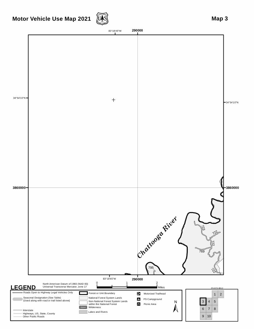
Chattooga
River
722
722
769
723
722
795
83°18'45"W
83°18'45"W
34°54'10"N
34°54'10"N
290000
290000
3860000 3860000
Motor Vehicle Use Map 2021
0 1 2Miles
North American Datum of 1983 (NAD 83)Universal Transverse Mercator, zone 17 FS-873-0812LEGEND
Roads Open to Highway Legal Vehicles Only
Seasonal Designation (See Table) {Used along with road or trail listed above}
Interstate
Other Public Roads
Forest or Unit Boundary
National Forest System LandsNon-National Forest System Landswithin the National ForestWilderness
Lakes and RiversHighways, US, State, County
±FS Campground"9
Picnic Area"5
Motorized TrailheadE
3
21
4
7
5
6
9
8
10
Map 3

"9
"9
Chattooga
River
LongBottom
Ford
Grapevine
782
782
713
719A778
725
736
CH-75
737
722
764
719721
778A
721A
CH-29
S-37-258
CH-40
CH-49
S-37-193
CH-45
CH-33
CH-38
CH
-37CH-39
28
779
721B
2653
721C
28
721
2252
721D
734S-37-196
PU2
PU47
28
784
764
83°11'40"W
83°11'40"W
34°54'10"N
34°54'10"N
300000
300000
3860000 3860000
Motor Vehicle Use Map 2021
0 1 2Miles
North American Datum of 1983 (NAD 83)Universal Transverse Mercator, zone 17 FS-873-0812LEGEND
Roads Open to Highway Legal Vehicles Only
Seasonal Designation (See Table) {Used along with road or trail listed above}
Interstate
Other Public Roads
Forest or Unit Boundary
National Forest System LandsNon-National Forest System Landswithin the National ForestWilderness
Lakes and RiversHighways, US, State, County
±FS Campground"9
Picnic Area"5
Motorized TrailheadE
3
21
4
7
5
6
9
8
10
Map 4

715
705
716
710
724
715A
C-3
7-8
704
762
S-37
-95
S-37-95
CH-5
CH
-50
CH-21
CH-49
S-37
-375
CH-20
107
2603
11
107
107
28
C-37-9
CH-45
724C
CH
-19
S-37-82
780
716
83°4'35"W
83°4'35"W
34°54'10"N
34°54'10"N
310000
310000
3860000 3860000
Motor Vehicle Use Map 2021
0 1 2Miles
North American Datum of 1983 (NAD 83)Universal Transverse Mercator, zone 17 FS-873-0812LEGEND
Roads Open to Highway Legal Vehicles Only
Seasonal Designation (See Table) {Used along with road or trail listed above}
Interstate
Other Public Roads
Forest or Unit Boundary
National Forest System LandsNon-National Forest System Landswithin the National ForestWilderness
Lakes and RiversHighways, US, State, County
±FS Campground"9
Picnic Area"5
Motorized TrailheadE
3
21
4
7
5
6
9
8
10
Map 5
TugalooLake
Chattooga
River
748-2
748K
741
S-37-
96
797
751
753
755
749
748-
3
757
768755F
S-37-102
S-37
-538
S-37-196
S-37-48
PU-48
£¤76
753A
748E
795
798
757A75
3
S-37-339
S-37
-96
755B
PU-52
PU-19
£¤76
757
748-2
752B
PU-5
749A
722
83°18'45"W
83°18'45"W
34°47'5"N
34°47'5"N
290000
290000
3850000 3850000
Motor Vehicle Use Map 2021
0 1 2Miles
North American Datum of 1983 (NAD 83)Universal Transverse Mercator, zone 17 FS-873-0812LEGEND
Roads Open to Highway Legal Vehicles Only
Seasonal Designation (See Table) {Used along with road or trail listed above}
Interstate
Other Public Roads
Forest or Unit Boundary
National Forest System LandsNon-National Forest System Landswithin the National ForestWilderness
Lakes and RiversHighways, US, State, County
±FS Campground"9
Picnic Area"5
Motorized TrailheadE
3
21
4
7
5
6
9
8
10
Map 6

"9
"5
RiverChauga
CassidyBridge
744
744
748
748
793
765
743
742
741
736A
740A
744I
736
744C
738
738A
TU-37
TU-1
S-37
-14
PU-3 S-37-290
TU-35
PU-3
2PU-16
PU-7
CH
-26
750
739D
770
748H
739B
745
2363
748B
748C
744A2658
748
747 726
S-37-436 TU-37
744
2377
S-37-193
£¤76
741
768
748-2
741
726
722
793J
83°11'40"W
83°11'40"W
34°47'5"N
34°47'5"N
300000
300000
3850000 3850000
Motor Vehicle Use Map 2021
0 1 2Miles
North American Datum of 1983 (NAD 83)Universal Transverse Mercator, zone 17 FS-873-0812LEGEND
Roads Open to Highway Legal Vehicles Only
Seasonal Designation (See Table) {Used along with road or trail listed above}
Interstate
Other Public Roads
Forest or Unit Boundary
National Forest System LandsNon-National Forest System Landswithin the National ForestWilderness
Lakes and RiversHighways, US, State, County
±FS Campground"9
Picnic Area"5
Motorized TrailheadE
3
21
4
7
5
6
9
8
10
Map 7

"5YellowBranch
S-37
-36
TU-1
TU-1
28
11
11
28
763
727
728
28
83°4'35"W
83°4'35"W
34°47'5"N
34°47'5"N
310000
310000
3850000 3850000
Motor Vehicle Use Map 2021
0 1 2Miles
North American Datum of 1983 (NAD 83)Universal Transverse Mercator, zone 17 FS-873-0812LEGEND
Roads Open to Highway Legal Vehicles Only
Seasonal Designation (See Table) {Used along with road or trail listed above}
Interstate
Other Public Roads
Forest or Unit Boundary
National Forest System LandsNon-National Forest System Landswithin the National ForestWilderness
Lakes and RiversHighways, US, State, County
±FS Campground"9
Picnic Area"5
Motorized TrailheadE
3
21
4
7
5
6
9
8
10
Map 8
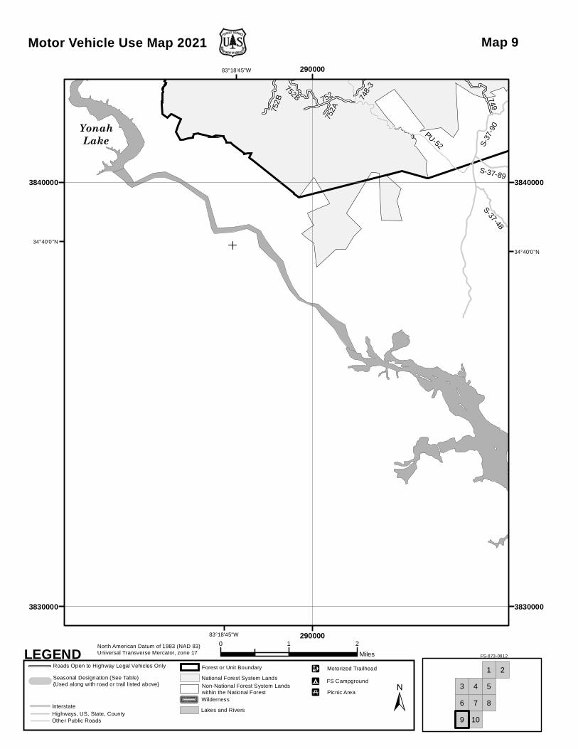
YonahLake
S-37-48
PU-52
S-37-89
S-37
-90
752
752A75
2B
749
748-
3752B
83°18'45"W
83°18'45"W
34°40'0"N
34°40'0"N
290000
290000
3830000 3830000
3840000 3840000
Motor Vehicle Use Map 2021
0 1 2Miles
North American Datum of 1983 (NAD 83)Universal Transverse Mercator, zone 17 FS-873-0812LEGEND
Roads Open to Highway Legal Vehicles Only
Seasonal Designation (See Table) {Used along with road or trail listed above}
Interstate
Other Public Roads
Forest or Unit Boundary
National Forest System LandsNon-National Forest System Landswithin the National ForestWilderness
Lakes and RiversHighways, US, State, County
±FS Campground"9
Picnic Area"5
Motorized TrailheadE
3
21
4
7
5
6
9
8
10
Map 9
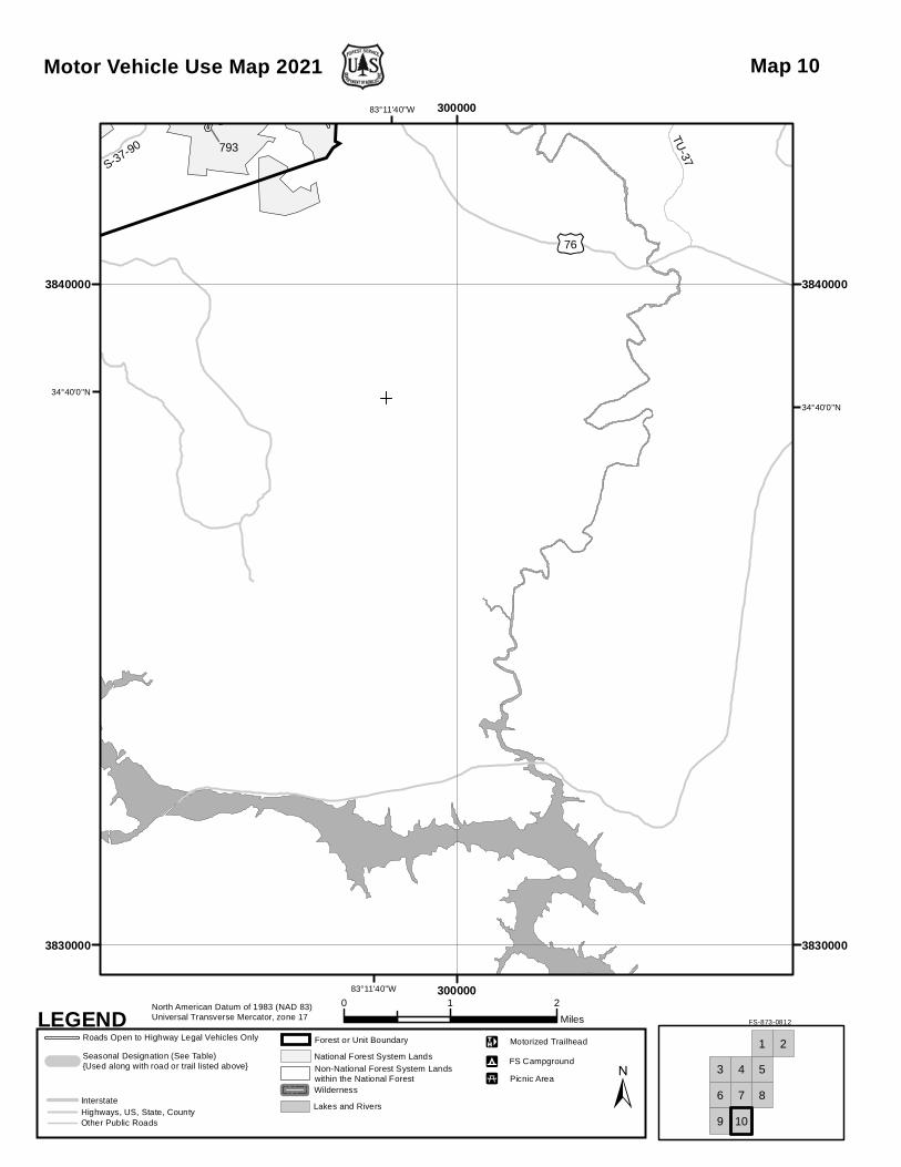
S-37-90
£¤76TU-37
793
793J
83°11'40"W
83°11'40"W
34°40'0"N
34°40'0"N
300000
300000
3830000 3830000
3840000 3840000
Motor Vehicle Use Map 2021
0 1 2Miles
North American Datum of 1983 (NAD 83)Universal Transverse Mercator, zone 17 FS-873-0812LEGEND
Roads Open to Highway Legal Vehicles Only
Seasonal Designation (See Table) {Used along with road or trail listed above}
Interstate
Other Public Roads
Forest or Unit Boundary
National Forest System LandsNon-National Forest System Landswithin the National ForestWilderness
Lakes and RiversHighways, US, State, County
±FS Campground"9
Picnic Area"5
Motorized TrailheadE
3
21
4
7
5
6
9
8
10
Map 10