mr. chris tomberg vermont department of … · 2 south main street, suite 2 randolph, vt 05060 mr....
TRANSCRIPT

2SouthMainStreet,Suite2
Randolph,VT05060
Mr.ChrisTombergVermontDepartmentofEnvironmentalConservationWatershedManagementDivision1NationalLifeDrive,Main2Montpelier,Vermont05620‐3522
October19,2016FileNo.4085.00
Re: StormwaterDischargePermitApplication WindhamLandfillSolarProject EncoreRenewableEnergy/WindhamSolidWasteManagementDistrict SouthBurlington,VermontDearChris:On behalf of theWindham SolidWasteManagementDistrict (WSWMD) of Brattleboro, VermontandEncoreRenewableEnergy(Encore)ofBurlington,Vermont,Sanborn,Head&Associates,Inc.ofRandolph, Vermont has prepared the enclosed Stormwater Discharge Permit Application(Application)fortheproposedWindhamLandfillSolarProject(Project). TheproposedProject islocatedat327OldFerryRoadinBrattleboro,VermontonWSWMD’sclosedlandfill.IncludedwiththeApplicationarethecompletedNoticeofIntent;anarrativedescribingtheProject;completedScheduleAformsandStandardTreatmentPractices(STP)calculationworksheets; thepre‐andpost‐developmentHydroCADmodels;thedesigncalculationsfortheProject;alistofthegeneralassumptionsmadefortheProject;andtheProjectPlans.The Application is provided on the enclosed compact disc as required by the WatershedManagementDivision’sApplicationRequirements forOperationalPermitsdocument. Inadditiontothecompactdisc,enclosedisacheckintheamountof$1,753.60forthefeeassociatedwiththeApplication.Pleaseletusknowifyouhaveanyquestions.Verytrulyyours,SANBORN,HEAD&ASSOCIATES,INC.ChristopherJ.Rivet,P.E.SeniorProjectEngineer
BrianJ.Beaudoin,P.E.ProjectDirector&Associate
CJR/TLP/BJB:jhg Encl. CompactDisc ApplicationFee(check#97449intheamountof$1,753.60)
cc: DerekMoretz,EncoreRenewableEnergy(viaemail) RobertSpencer,WSWMD(viaemail) FrankRuffalo,SkySolarHoldings,Ltd.(viaemail)
P:\4000s\4085.00\SourceFiles\SWDP\20161019TombergPermitLtr.docx

Revised September 2016 Page 1 of 5
Application for Individual Stormwater Permit (INDS)
Submission of this application constitutes notice that the applicant(s) requests authorization to discharge stormwater for their project listed below pursuant to the Chapter 18 or 22 Stormwater Management Rule. To obtain authorization, the applicant must submit a complete and accurate application, as well as all required supporting materials. Submission of an application does not confer coverage under an Individual Permit. Please carefully read all guidance information in the Narrative Template and Application Requirements Document before signing. A. Applicant Information
1. Applicant A:
2a. Address:
2b. Town: 2c. State: 2d. Zip:
3. Phone: 4. Email:
5. Additional Contact Name/Email (if applicable):
�.�Applicant B:
�a. Address:
�b. Town: �c. State: �d. Zip:
�.�Phone: ���Email:
�.�Additional Contact Name/Email (if applicable):��.�Please select either Applicant A or Applicant B:
______ Applicant is the current land owner
______ Applicant will be billed for the annual operating fee and be the primary contact for correspondence with the . Stormwater Program.
The applicant(s) shall be the owner and operator. If the applicant is a business, the business must be registered with the Vermont Secretary of State. If the application is made in connection with a new housing or commercial development, the developer and an owners’ association accepting responsibility for the stormwater management system shall apply as co-permittees [§18-308 (b)(4)]. For projects that require listing more than two applicants, please attach an additional page. B. Application Preparer/Consultant Information (if applicable)
1. Application preparer name:
2. Application preparer company:
3a. Application preparer address:
3b. Town: 3c. State: 3d. Zip:
4. Phone: 5. Email:
6. Additional Contact Name/Email (if applicable):C. Project Information
1. Is this application being submitted in connection with a subdivision (includes, but is not limited to residential andcommercial subdivisions, universities, industrial parks, and ski areas)? Yes No
2. Existing Stormwater Permit/Authorization Number related to this project (if any):
3a. Is this an amendment to an existing Stormwater Permit/Authorization? Yes No 3b. If yes, I have contacted the district analyst to determine application review fees. Yes No
Encore Renewable Energy110 Main Street, 2nd Floor, Suite 2E
Burlington VT 05401(802)-861-3023 [email protected]
Derek MoretzWindham Solid Waste Management District
327 Old Ferry RoadBrattleboro VT 05301(802)-257-0272 [email protected]
Robert Spencer
BA
Christopher J. Rivet, P.E.Sanborn, Head & Associates, Inc.2 South Main Street, Suite 2
Randolph VT 05060(802) 728-3755 [email protected]
Brian J. Beaudoin, P.E. ([email protected])
✔
✔✔

Revised September 2016 Page 2 of 5
4. Have you or will you be submitting a Notice of Intent (NOI) for coverage under a Stormwater Construction Discharge Permit? Yes No
5. Does the project involve activities that are classified as stormwater hotspots? Yes No 6. Why is coverage under the INDS permit required? (Check all that apply) Project discharges to a stormwater impaired watershed
Project located within Lake Champlain Basin. Net zero phosphorus required.
The Site Balancing Procedure is used.
The Linear Transportation Procedure was used.
Alternate Treatment Practice was used.
Other. Please describe ____________________________________________________________________
7. If discharging to a stormwater impaired water, how will the offset be provided? Offset will be:
Purchased from an existing INDO
Provided onsite (Ex. By treating existing untreated impervious surface or removal of existing impervious surface)
Created offsite within the same watershed
Not required as project meets Net-Zero
Other: Please Describe ___________________________________________________________________
8. Project Name:
9a. Mailing Address: 9b. Town: 9c. County:
10. Receiving Water(s):
11. Number of Discharge Points: 12. SPAN: Enter the 11-digit number that is printed on the property tax bill for the applicable parcel(s). Projects that
involve more than 1 parcel shall list all applicable SPANs. __ __ __ - __ __ __ - __ __ __ __ __ __ __ __ - __ __ __ - __ __ __ __ __ __ __ __ - __ __ __ - __ __ __ __ __
__ __ __ - __ __ __ - __ __ __ __ __ __ __ __ - __ __ __ - __ __ __ __ __ __ __ __ - __ __ __ - __ __ __ __ __ Project Coordinates (project center in Decimal Degrees with 6 digits to the right of the decimal):
13a. Latitude 13b. Longitude:
14. Project Description: Briefly describe the project. (If an amendment, please describe the previously permitted project and the proposed change to the previously permitted project.):
✔
✔
✔
Windham Landfill Solar Project327 Old Ferry Road, Brattleboro, VT
Brattleboro Windham
Connecticut River, via existing storm sewer system2
0 8 1 0 2 5 1 5 6 9 4
42.893076 72.539662
The project area includes approximately 26.7 acres of landfill capped area, of which, approximately 4acres will be disturbed due to construction. Construction activities will include the installation of utilities,solar arrays, equipment pads, stormwater control features, and a perimeter fence.

Revised September 2016 Page 3 of 5
D. Manner of Discharge 1. A manner of discharge is required for each discharge point of the project. The manner of discharge shall specify the type of impervious surfaces, the conveyance, and type of treatment proposed to meet applicable treatment standards, and shall describe the stormwater outfall to the specified receiving water. S/N 001: Stormwater runoff from [ list impervious surfaces] via [describe conveyance] to [treatment practices] discharging to [Receiving water]. S/N 001: Stormwater runoff from warehouse building rooftop on Lot 2 and a portion of access road, via sheet flow to grass channel #1, all routed to a wet pond with pre-treatment forebay, discharging by controlled outlet structure and stabilized outfall to Trout Brook. Additional runoff from building rooftop on Lot 3, is disconnected in accordance with Disconnection of Rooftop Runoff Credit, discharging overland to Trout Brook Use the format and example above to provide a written manner of discharge for each discharge point. If more space is needed, provide an additional sheet. E. Plan Set Reference 1. Provide a complete list of all plans applicable to the stormwater management design that have been included with this application. Specify who the plans have been prepared by (e.g. Fairweather Stormwater Design, Inc.) and list the plans using the following format: Sheet [##], “[Sheet Title],” dated [mm/dd/yyyy], last revised [mm/dd/yyyy]; (e.g. Sheet 1, “Existing Condition Plan”, dated 01/15/2014, last revised 02/06/2014).
S/N 001: Stormwater runoff from concrete ballast foundations, equipment pads, and gravel accessways installed in the Project area, via sheet flow to proposed grass-lined open channel treatmentswales, to the existing storm sewer system that ultimately discharges to the Connecticut River.
S/N 002: Stormwater runoff from southern portions of the Project area, via sheet flow to existing swalesthat ultimately discharge to the Connecticut River. There is no new impervious area from the Projectassociated with this discharge location.
Revised September 2016 Page 4 of 5
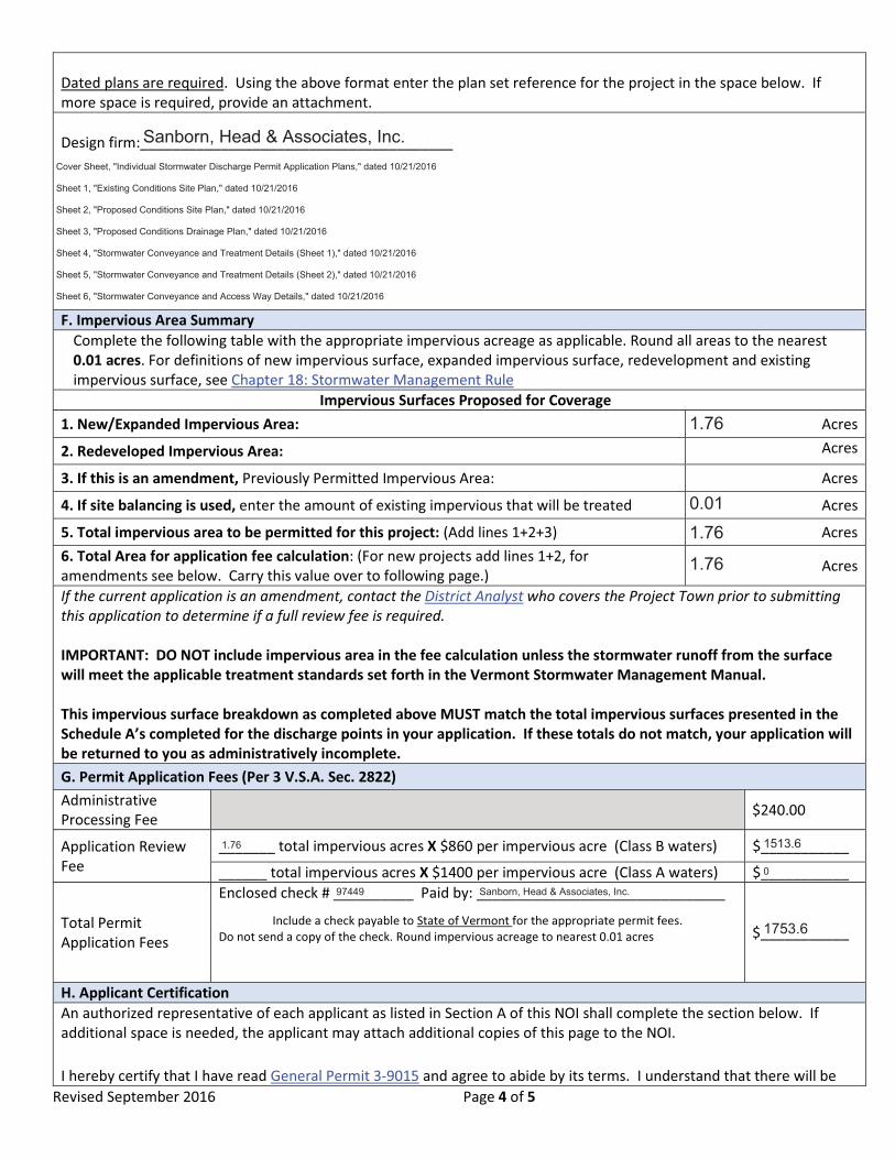
Dated plans are required. Using the above format enter the plan set reference for the project in the space below. If more space is required, provide an attachment. Design firm:_______________________________________ F. Impervious Area Summary
Complete the following table with the appropriate impervious acreage as applicable. Round all areas to the nearest 0.01 acres. For definitions of new impervious surface, expanded impervious surface, redevelopment and existing impervious surface, see Chapter 18: Stormwater Management Rule
Impervious Surfaces Proposed for Coverage 1. New/Expanded Impervious Area: Acres
2. Redeveloped Impervious Area: Acres
3. If this is an amendment, Previously Permitted Impervious Area: Acres
4. If site balancing is used, enter the amount of existing impervious that will be treated Acres
5. Total impervious area to be permitted for this project: (Add lines 1+2+3) Acres 6. Total Area for application fee calculation: (For new projects add lines 1+2, for amendments see below. Carry this value over to following page.) Acres
If the current application is an amendment, contact the District Analyst who covers the Project Town prior to submitting this application to determine if a full review fee is required. IMPORTANT: DO NOT include impervious area in the fee calculation unless the stormwater runoff from the surface will meet the applicable treatment standards set forth in the Vermont Stormwater Management Manual. This impervious surface breakdown as completed above MUST match the total impervious surfaces presented in the Schedule A’s completed for the discharge points in your application. If these totals do not match, your application will be returned to you as administratively incomplete. G. Permit Application Fees (Per 3 V.S.A. Sec. 2822) Administrative Processing Fee $240.00
Application Review Fee
_______ total impervious acres X $860 per impervious acre (Class B waters) $___________
______ total impervious acres X $1400 per impervious acre (Class A waters) $___________
Total Permit Application Fees
Enclosed check # __________ Paid by: _______________________________
Include a check payable to State of Vermont for the appropriate permit fees. Do not send a copy of the check. Round impervious acreage to nearest 0.01 acres
$___________
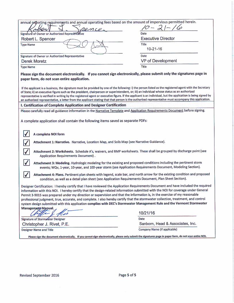
H. Applicant Certification An authorized representative of each applicant as listed in Section A of this NOI shall complete the section below. If additional space is needed, the applicant may attach additional copies of this page to the NOI. I hereby certify that I have read General Permit 3-9015 and agree to abide by its terms. I understand that there will be
Sanborn, Head & Associates, Inc.Cover Sheet, "Individual Stormwater Discharge Permit Application Plans," dated 10/21/2016
Sheet 1, "Existing Conditions Site Plan," dated 10/21/2016
Sheet 2, "Proposed Conditions Site Plan," dated 10/21/2016
Sheet 3, "Proposed Conditions Drainage Plan," dated 10/21/2016
Sheet 4, "Stormwater Conveyance and Treatment Details (Sheet 1)," dated 10/21/2016
Sheet 5, "Stormwater Conveyance and Treatment Details (Sheet 2)," dated 10/21/2016
Sheet 6, "Stormwater Conveyance and Access Way Details," dated 10/21/2016
1.76 1513.6
0
97449 Sanborn, Head & Associates, Inc.
1753.6
1.76
0.01
1.76
1.76

IndividualStormwaterDischargePermitApplicationNarrativePreparedby:ChristopherRivet,P.E.Reviewedby: BrianBeaudoin,P.E.Date:October21,2016IndividualStormwaterDischargePermitApplicationProjectName:WindhamLandfillSolarProject(Project)PropertyOwner/Operator:WindhamSolidWasteManagementDistrictandEncoreRenewableEnergyProjectLocation:Brattleboro,VermontIntroduction:On behalf of the Windham Solid Waste Management District (WSWMD) of Brattleboro,Vermont and Encore Renewable Energy (Encore) of Burlington, Vermont, Sanborn, Head &Associates, Inc.ofRandolph,Vermontpreparedthisstormwaterdischargepermitapplication(Application) to apply for an Individual Stormwater Discharge Permit (INDS) pursuant toChapter18oftheStormwaterManagementRulesfortheabovereferencedProject.DescriptionofProject:TheproposedProject is locatedonaparcelownedbytheWSWMDat327OldFerryRoadinBrattleboro,Vermont.Theparcelconsistsprimarilyofapproximately26acrelandfillthatwasclosedandcappedin1996,acompostingfacility,andMaterialRecyclingFacility(MRF)thatismanagedbytheWSWMD(collectivelycalledtheFacility).TheProjectwillbelocatedprimarilyontheclosedlandfilllocatedalongtheeastendoftheparcel.Itwillconsistoftheinstallationof solar arrays and electrical cable trays on ballast foundations, temporary and permanentgravel access roads, perimeter security fencing, an equipment pad, supportingutilities/infrastructure, and stormwater conveyance and treatment features to treat thestormwaterrunofffromimperviousareasresultingfromtheProject.TheProjectisgenerallyboundedbytheNewEnglandCentralRailroadtrackstothesouthandeast,commercialpropertiestothewest,andOldFerryRoadtothenorth.TheProjectwillhaveaccessfromOldFerryRoadwhichisapublicroadtothenorthoftheFacility.TheFacilitycurrentlyhas twooperationalStormwaterDischargePermits for the imperviousareaassociatedwiththeMRF(Permit#3693‐9010.R)andtheformergreenhouseprojectandassociated structures (Permit #3693‐9015). There is approximately 4.27 acres of existingimpervioussurfacesassociatedwiththeFacilityofwhich2.87acresaretreatedbystormwatertreatmentfeaturesassociatedwiththeStormwaterDischargePermitsmentionedabove. TheproposedProjectwilladdapproximately76,600squarefeet(1.76acres)ofimpervioussurfaceto the Facility, and utilize site balancing procedures. As a result, an Individual StormwaterDischargePermitisrequiredfortheProject.

October21,2016 Page2Attachment1‐Narrative‐revised.docx 4085.00
The Project has been designed with stormwater treatment features so that proposedimpervious surfaces comply with the treatment standards of the Stormwater ManagementManual,VolumeI‐StormwaterTreatmentStandards(VSWMM),datedApril2002.ExistingConditions:ThelandonwhichtheProjectislocatedlargelyconsistsofopenvegetatedgrasslandwithsomewoodedareasandexistingdevelopedareasassociatedwiththeWSWMDtransferstation/MRF.The topography of the Project area generally consists of a knoll associated with the topelevationof theclosed landfill thatslopesawayradially (inalldirections)onterrainrangingfromapproximately1percentto33percentontheeasternslope.Theareaassociatedwiththetransferstationtothenorthofthelandfillgenerallyslopesdownfromsouthtonorth.TheareatothesouthofthelandfillgenerallyslopestothesouthtowardstheConnecticutRiver.The existing impervious area associatedwith the Project parcel is approximately 4.27 acresandconsistsof5buildings/structures,andseveralgravel/pavedsiteaccessroads,associatedwith the MRF and former greenhouse operations area. Stormwater runoff is generallyconveyed by vegetated and riprap lined swales to an existing storm sewer system, whichultimately discharges to the Connecticut River. The Stormwater Discharge Permit for theproposedsolarProjectisbeingappliedforseparatelyfromtheexistingpermits.Currently, there are two stormwater discharge locations associated with the Project area,identifiedasS/N001andS/N002,whicharelocatedattheConnecticutRivertothesouthandnortheast of theFacility, respectively. However, because thedischarge locations are around800 feet from the Project area, points of interest (POI) have been used to demonstratecompliancewiththeVSWMMstandards.TherearesixPOIs,labeledasPOI#1throughPOI#6,associatedwithdischargelocationS/N001.POIs#1through#6arelocatedatinletfeaturesofthe existing storm sewer system on theWSWMD parcel tomodel the stormwater flow thatreaches theseareas. There isonePOI, labeledasPOI#7,associatedwithdischarge locationS/N 002. The discharge locations and POIs are shown on Sheet 1 of the INDS PermitApplicationPlans(Plans)includedinAttachment4.DischargelocationS/N001islocatedattheConnecticutRivertothesouthoftheProjectareaand receives stormwater runoff via an existing storm sewer system with inlet locationsidentifiedasPOI#1throughPOI#6.ThesePOIsarefurtherdescribedasfollows: POI#1receivesrunoffresultingfromprecipitationthatfallsonthewesternandsouthern
portions of the Project area. Stormwater generally sheet flows to the southwest over avegetatedlandfillcapbeforebeingcollectedbyexistingswalesandconveyedtotwocatchbasinsidentifiedasPOI#1.StormwaterthenflowsthroughanexistingstormsewersystemthatdirectlydischargestotheConnecticutRiver.
POI#2receivesrunoffresultingfromprecipitationthatfallsonthenorthwesternportionofthe Project area. Stormwater generally sheet flows to the northwest over a vegetatedlandfill cap before being collected by existing swales and conveyed to a catch basinidentifiedasPOI#2.StormwaterthenflowsthroughanexistingstormsewersystemthatdirectlydischargestotheConnecticutRiver.

October21,2016 Page3Attachment1‐Narrative‐revised.docx 4085.00
POI#3receivesrunoffresultingfromprecipitationthatfallsonthenorthernportionoftheProjectarea. Stormwatergenerallysheet flows to thenorthoveravegetated landfill capandacrossagravelroadtoastormwaterpondidentifiedasPOI#3.StormwaterthenflowstoanexistingstormsewersystemthatdirectlydischargestotheConnecticutRiver.
POI#4receivesrunoffresultingfromprecipitationthatfallsonthenorthernportionoftheProjectarea. Stormwatergenerallysheet flows to thenorthoveravegetated landfill capacrossagravelroadtoastormwaterculvertidentifiedasPOI#4.StormwaterthenentersanexistingstormsewersystemthatdirectlydischargestotheConnecticutRiver.
POI#5receivesrunoffresultingfromprecipitationthatfallsonthenorthernportionoftheProjectarea. StormwatergenerallysheetflowstothenorthwestoveravegetatedlandfillcapbeforebeingcollectedbycatchbasinsandconveyedtoastormwaterpondidentifiedasPOI#5.StormwaterthenentersanexistingstormsewersystemthatdirectlydischargestotheConnecticutRiver.
POI#6receivesrunoffresultingfromprecipitationthatfallsonthenortheasternportionoftheProjectarea.StormwatergenerallysheetflowstothewestoveravegetatedlandfillcapandcontinueswesterlyoveranareausedforcompostingtoastormwaterculvertidentifiedasPOI#6.Stormwaterthencrossesbelowanaccessroadthroughtheculverttothesouthand ultimately enters an existing storm sewer system that directly discharges to theConnecticutRiver.
DischargelocationS/N002isattheConnecticutRivertothenortheastoftheProjectarea.ItreceivesstormwaterrunoffbyachannelidentifiedasPOI#7.POI#7receivesrunoffresultingfrom precipitation that falls on the eastern portion of the Project area that generally sheetflowstotheeastoveravegetatedlandfillcapbeforebeingcollectedbyanexistingswaleandconveyedtoPOI#7.StormwaterthendirectlydischargestotheConnecticutRiver.ExistingsoilinformationwasobtainedfromtheNaturalResourcesConservationServicesWebSoilSurvey(WSS)andas‐builtdataforthelandfillcapsystem.TheWSSindicatesthatthesoilsintheProjectareaaregenerallyidentifiedasQuonsetandWarwicksoils(3E),Windsorloamysand(5B),andAgawamfinesandyloam(10B)withhydrologicsoilgroupclassificationsofA,A,and B, respectively. For modeling purposes, the on‐site soils within the project area werebased on hydrologic soil group D, due to the low permeable (silty) soils that were used toconstructthelandfillcap.RefertoSheet1ofthePlansincludedinAttachment4andFigure2includedinAttachment1forexistingconditionsandsoilsinformation,respectively.ExistingStormwaterSystem:The Project area has some existing stormwater conveyance features consisting of vegetatedand riprap lined swales, vegetated buffers, culverts, ponds, and a storm sewer system thatappear to be in relatively goodworking condition. As previouslymentioned, there are twoexistingoperationalStormwaterDischargePermitfortheFacility.ProposedStormwaterSystem:The proposed stormwater conveyance and treatment system will consist of grass‐linedconveyanceand treatmentswalesand level spreaders thatwill conveyand treat stormwater

October21,2016 Page4Attachment1‐Narrative‐revised.docx 4085.00
runoff fromapproximately0.32acresofexistingimperviousarea,ofwhichonly0.01acres isincludedforpermitcoverageaspartofthisApplication1andapproximately1.76acresofnewimpervious area. Additionally, approximately 0.12 acres of existing impervious areawill beestablishedasvegetatedcover. Proposed impervioussurfaceswill consistof twoequipmentpadsandconcreteballast foundations for thearrayrackingsystemandcable trays. Refer toSheets2and3ofthePlansfortheproposedconditions.There will continue to be two stormwater discharge locations from the Project area at theconclusionof theProject, identifiedas S/N001andS/N002. The receivingwater for thesedischarge locations will continue to be the same locations along the Connecticut River. Asmentionedpreviously,POIshavebeenidentifiedinthevicinityoftheProjectareaboundarytodemonstrate compliance with the VSWMM standards instead of evaluating the dischargelocations at S/N001 and S/N002due to thedistance of thesedischarge locations from theProjectarea.ThePOI’sareshownonSheet3ofthePlansincludedinAttachment4.Thepre‐andpost‐development flows for POIs#1, 2, 3, 4, 5, 6, and7 are included in the stormwatermodelingcalculationsincludedinAttachment3.ThesePOIsarefurtherdescribedasfollows: POI#1(associatedwithS/N001),locatedtothesouthwestoftheProjectarea,willreceive
treatedstormwaterfromapproximately0.95acresofnewimperviousareaassociatedwithconcrete ballast foundations and gravel access ways; and approximately 0.23 acres ofexistingimperviousareaassociatedwithgravellandfillaccessroads.Approximately,0.12acresofexistingimperviousareawillbeestablishedasvegetatedcover. ThestormwaterwillbeconveyedandtreatedpriortodischargingtoPOI#1viaexistingopenchannelgrass‐linedswalesthatwillbemodifiedtoprovidestormwatertreatment.
POI#2(associatedwithS/N001),locatedtothenorthwestoftheProjectarea,willreceivetreatedstormwaterfromapproximately0.60acresofnewimperviousareaassociatedwiththe concrete ballast foundations for the solar arrays and cable trays; and approximately0.09acresofexistingimperviousareaassociatedwithroadways. Thestormwaterwillbeconveyed and treated prior to discharging to POI #2 via existing and proposed openchannel grass‐lined treatment swales and proposed level spreaders. There will beapproximately 264 square feet (less than 0.01 acres) of new impervious area associatedwith the 3 feet (ft) by 1 ft concrete ballast supports for the cable trays thatwill not betreatedduesiteconstraintsandtheproximitytoPOI#2.However,sitebalancingisbeingproposed for this new impervious area through the treatment of 0.09 acres of existingimpervioussurfacesassociatedwith thegravel landfill access roads in this subcatchmentarea. Note that overall, the proposed stormwater system for the Project will treatstormwater runoff from 0.32 acres of existing impervious areas that are currently nottreated.AfterdiscussionswithStormwaterManagementDivisionpersonnel,authorizationtoproceedwiththeproposedsitebalancingwasgrantedonOctober14,2016,asindicatedintheattachedemailcorrespondence.
POI #3 (associated with S/N 001), located to the north of the Project area, will receivestormwaterfromareducedportionofthevegetatedlandfillcap(about0.01acres)andwill
1PerpreviousconversationswiththeVermontStormwaterManagementProgram,the0.43acresofexistingimperviousareabeingtreatedbytheproposedstormwatersystemhasnotbeenincludedontheScheduleAformsshowninAttachment2becauseit isnotreflectedinSectionsFandGoftheNoticeofIntentfortheProject.
October21,2016 Page5Attachment1‐Narrative‐revised.docx 4085.00
nothaveanynewimperviousareaassociatedwithit.ThestormwaterstillwillbeconveyedtoPOI#3viasheetflow.
POI #4 (associated with S/N 001), located to the north of the Project area, will receivestormwaterfromareducedportionofthevegetatedlandfillcap(about0.33acres)andwillnothaveanynewimperviousareaassociatedwithit.ThestormwaterwillbeconveyedtoPOI#4viasheetflow.
POI #5 (associated with S/N 001), located to the north of the Project area, will receivetreatedstormwaterfromapproximately0.14acresofnewimperviousareaassociatedwiththeconcreteballastfoundationsforthesolararraysandcabletrays.ThestormwaterwillbeconveyedandtreatedpriortodischargingtoPOI#5viaaproposedopenchannelgrass‐linedtreatmentswaleandproposedlevelspreader.
POI #6 (associated with S/N 001), located to the west of the Project area, will receivetreatedstormwaterfromapproximately0.06acresofnewimperviousareaassociatedwiththeconcreteballastfoundationsforthesolararraysandcabletrays.ThestormwaterwillbeconveyedandtreatedpriortodischargingtoPOI#6viaaproposedopenchannelgrass‐linedtreatmentswaleandproposedlevelspreader.
POI #7 (associated with S/N 002), located to the east of the Project area, will receivestormwaterfromasouthernportionofthevegetatedlandfillcapandwillnothaveanynewimperviousareaassociatedwithit.ThestormwaterwillbeconveyedpriortodischargingtoPOI#7viaanexistingchannel.
TheConnecticutRiverisdesignatedasacoldwaterfishhabitat.AccordingtoAppendixAPartA of the VermontWater Quality Standards, all wetlands are designated aswarmwater fishhabitatsexceptthosedesignatedascoldwaterfishhabitatsinPartBofAppendixA.AdescriptionofcomplianceforeachofthefiveunifiedsizingcriteriaidentifiedinVolume1oftheVSWMM,includingtreatmentpracticesorwaivers,isasfollows: WaterQualityTreatmentStandard(WQTS):TheWQTSfortheProjectforPOI#1,2,5,and
6 (associated with S/N 001) is met per Table 2.1 of the VSWMM by using grass‐linedtreatment swales (GrassChannelO‐3) thathavebeendesigned to conveyanddetain therequiredwaterqualityvolume(WQv)atavelocityequaltoor lessthan1footpersecondwithaminimumresidencetimeof10minutes.Notethatonecheckwillbeneededinordertomeetthe10minuteminimumresidencetimeforReach205RwhichislocatedinPOI#2.ThecheckdamdesigncalculationisincludedinAttachment3.TheinformationregardingtheWQTSfortheProjectisincludedinAttachments2,3,and4.TheWQTSforPOI#3and4(associatedwithS/N001),andPOI#7(associatedwithS/N002)isnotapplicablebecausenonewimperviousareawillbeassociatedwiththepostdevelopmentstormwaterflowstothePOIs.
ChannelProtectionStandard(CPv):TheCPvstandardforthisProjectforPOI#1,2,5,and6(associatedwithS/N001)iswaivedperwaiver#3inSection1.1.2oftheVSWMM,whichindicatesthatthetreatmentstandardshallbewaivedforsitesthatdirectlydischargetoawaterbodywithadrainageareaequaltoorgreaterthan10squaremiles,andthat is lessthan5%ofthewatershedareaatthesite’supstreamboundary.Asmentionedpreviously,
October21,2016 Page6Attachment1‐Narrative‐revised.docx 4085.00
the site discharges directly to theConnecticutRiver via an existing storm sewer system.TheCPvforPOI#3and4(associatedwithS/N001),andPOI#7(associatedwithS/N002)is not applicable because no new impervious area will be associated with the postdevelopmentstormwaterflowstothePOIs.
GroundwaterRechargeTreatmentStandard(GRTS):TheGRTSforthisProjectforPOI#1,2, 3, 4, 5, 6, and7 (associatedwith S/N001 and002) iswaivedper Section1.1.3 of theVSWMM, which indicates that the treatment standard shall be waived for stormwaterrunoff from hotspot land uses. Table 2.3 in Section 2.6 of the VSWMM lists landfills asstormwaterhotspots.
OverbankFloodProtectionStandard(OFPS):TheOFPSstandardforthisProjectforPOI#1,2, 5, and 6 (associated with S/N 001) is waived per waiver #1 in Section 1.1.4 of theVSWMM,whichindicatesthatthetreatmentstandardshallbewaivedforsitesthatdirectlydischargetoawaterbodywithadrainageareaequaltoorgreaterthan10squaremiles.Asmentionedpreviously,thesitedischargesdirectlytotheConnecticutRiverviaanexistingstormsewer system. TheOFPS forPOI#3and4 (associatedwithS/N001), andPOI#7(associated with S/N 002) is not applicable because no new impervious area will beassociatedwiththepostdevelopmentstormwaterflowstothePOIs.
ExtremeFloodProtectionStandard (EFPS): TheEFPS forPOI#1,2,5, and6 (associatedwithS/N001)iswaivedperwaiver#2inSection1.1.5oftheVSWMM,whichstatesthatthetreatmentstandardcanbewaivedif the imperviousarea is lessthan10acres. TheEFPSwaiverworksheetsforeachdischargelocationareincludedinAttachment2.TheEFPSforPOI #3 and 4 (associated with S/N 001), and POI #7 (associated with S/N 002) is notapplicablebecausenonewimperviousareawillbeassociatedwiththepostdevelopmentstormwaterflowstothePOIs.
P:\4000s\4085.00\SourceFiles\SWDP\Attachment1\Attachment1‐Narrative.docx