mt. baker ranger district 810 state route 20 · pdf file · 2016-12-29mt. baker...
TRANSCRIPT

1
March 6, 2016
Erin Uloth, District Ranger
Mt. Baker Ranger District
810 State Route 20
Sedro-Woolley, WA 98284-1263
RE: Upper Nooksack Access Travel Management Project Draft Plan
Dear District Ranger Uloth,
Thank you for the opportunity to provide comments on the Draft Environmental Assessment (EA) for the “Access
Travel Management (ATM) Project” in the Upper Nooksack region. As non-profit organizations focused on
conservation and recreation with members who live, work and play in the region, we have a strong interest in
current and future management activities on the Mt. Baker – Snoqualmie (MBS) National Forest.
Many of our organizations submitted scoping comments in September 2015. Since those comments we have
noticed that the Middle Fork Nooksack road system has been added to the project area and an additional
alternative has been added for consideration which includes more consideration for identification of road
decommissioning.
After reading through the Draft EA, we offer the following comments:
I. Support for the Stated Purpose and Need of the Project
We are aware of the many challenges the U.S. Forest Service (USFS) faces with its oversized and under-maintained
road system and have worked to help address some of the funding challenges. The agency’s road system was
built decades ago – historically financed nearly 75 percent by federal appropriations - to support large-scale
timber cutting. Today, the road network continues to support forest management activities in addition to a strong
recreation economy, with at least 63 percent of Washingtonians participating in outdoor activities each year
spending $21.6 billion annually on trips and equipment that supports nearly 200,000 jobs1.
Unfortunately, road budgets do not support this increase in demand as funding levels have dropped to 18 percent
of what they were in 1990. We understand that the Forest Service is overwhelmed by significant management
and ecological problems related to this deteriorating infrastructure. We recognize and support the need to make
1 Briceno, T., Schundler, G. 2015. Economic Analysis of Outdoor Recreation in Washington State. Earth Economics, Tacoma,
WA.

2
decisions to adapt to modern-day recreational interests and tribal and cultural needs, while also reducing aquatic
and terrestrial impacts and lining these needs up with realistic budgets. We appreciate your effort in working
toward achieving this balance.
We also feel strongly that despite the existence of a nearly $3 billion road maintenance backlog on the more than
370,000 miles of Forest Service system roads nationwide, significant common ground exists around maintenance
priorities and restoration opportunities. Most Forest Service roads fall into two general categories:
1. Recreational Access Roads: –- roads that provide access to recreational opportunities (e.g., trailheads,
campgrounds, river access, other infrastructure, etc.) and other important National Forest lands for
preserving management, cultural, and/or social access; and
2. Legacy Roads – already closed old, decaying and poorly maintained logging roads that have
significant aquatic risk factors posing threats to watershed and fisheries health (e.g., clogged culverts,
sedimentation, etc.) while not providing significant recreational or other access.
Fortunately, these two general road categories are largely mutually exclusive. For example, most of these
decaying logging roads, due to their lack of maintenance over the years, do not provide significant recreational or
access opportunities, and are relatively non-controversial to close or decommission. A third much smaller
category includes a handful of roads on different forests that do provide potential access but at an engineering,
ecological or financial cost that makes for a robust public debate (e.g., Dosewallips, etc.). Unfortunately, despite
being a minute percentage of the overall road system, these difficult decisions receive the most attention and
often color the public narrative on Forest Service roads.
Many of our organizations have joined with the Washington Department of Ecology through the Washington
Watershed Restoration Initiative to support the more than $300 million investment of federal funding over the
last decade to address the legacy road problem through the Legacy Roads and Trails program. We encourage the
Forest to use the Sustainable Roads Strategy (SRS) and ATM process to embrace the significant common ground
around legacy roads and to preserve and enhance recreational access during this process, while also achieving the
goals of a sustainable road system.
II. Alternative A would be an insufficient response to the Travel Management Rule
As described in your announcement, the purpose of this project is to “align the size of the Forest Service road
system with projected road maintenance budgets.” Further, the MBS will “balance access needs with resource
protection and existing budgets.” This stems from the Travel Management Rule (referred to as “Subpart A”) in
2001.2 The rule directs each National Forest to conduct “a science-based roads analysis,” generally referred to as
the “travel analysis process” or, as the MBS has described, a “Sustainable Roads Strategy.” 3 Forest Service Manual
7712 and Forest Service Handbook 7709.55, Chapter 20 provide detailed guidance on conducting travel analysis.
Based on that analysis, forests must first “identify the minimum road system needed for safe and efficient travel
and for administration, utilization, and protection of National Forest System lands.”4 The Rule further defines the
minimum road system as:
…the road system determined to be needed [1] to meet resource and other management
objectives adopted in the relevant land and resource management plan . . . , [2] to meet applicable
statutory and regulatory requirements, [3] to reflect long-term funding expectations, [and 4] to
2 66 Fed. Reg. 3206 (Jan. 12, 2001); 36 C.F.R. part 212, subpart A
3 36 C.F.R. § 212.5(b)(1)
4 36 C.F.R. § 212.5(b)(1)

3
ensure that the identified system minimizes adverse environmental impacts associated with road
construction, reconstruction, decommissioning, and maintenance.
Forests must then “identify the roads . . . that are no longer needed to meet forest resource management
objectives and that, therefore, should be decommissioned or considered for other uses, such as for trails.”5
While Subpart A does not impose a timeline for agency compliance with these mandates, the Forest Service
Washington D.C. Office, through a series of directive memoranda, ordered forests to complete their Travel
Analysis Process (called the SRS on the MBS) by the end of fiscal year 2015, or lose maintenance funding for any
road not analyzed. The memoranda articulate an expectation that forests, through the Subpart A process,
“maintain an appropriately sized and environmentally sustainable road system that is responsive to ecological,
economic, and social concerns.”
Alternative A represents the no-action alternative in this Environmental Assessment. Choosing Alternative A
would not meet the goals set out in Subpart A in the 2001 Travel Management Rule or the stated purpose and
need of this ATM plan.
III. Prioritize Road Decommissioning without negatively impacting key recreational access opportunities
This ATM plan for Upper Nooksack is an important opportunity to make a significant decision to establish a
sustainable road system moving forward. We feel that the Forest Service should make a concerted effort to
maximize road decommissioning for those roads that do not provide significant recreational access in order to get
the biggest “bang for the buck” with respect to the purpose and need of this plan.
By definition those roads that are lower on the maintenance level scale (1-5) will take more resources to
adequately maintain both near term and annually. In addition, there are additional funds (legacy roads,
stewardship, etc.) that can be applied above to these activities beyond the general road maintenance dollars
referenced in the budget assumptions in the plan.
As forest road users and conservationists, we understand that a strategic reduction in road miles does not
necessarily equate to a loss of access. Some roads are already functionally closed, either due to washouts, lack of
use, or natural vegetation growth. Other roads receive limited use and are costly to maintain. It is our belief that
resources can be better spent on roads providing significant access than to spread resources thinly to all roads.
This is why we support the careful analysis and decision to decommission or close specific roads.
Leading up to the sustainable roads process and this specific ATM plan, the Mt. Baker-Snoqualmie National Forest
(MBSNF) had already identified approximately 85 miles of forest system roads within the project area with an
objective maintenance level (OBL) of “decommission” in the INFRA road database (2012). See Appendix A.
Alternative B proposes to decommission about 6 miles of roads (including about 2 miles previously identified as
OBL decommission). Alternative C includes approximately 41 miles for decommissioning (including about 31 miles
previously identified as OBL decommission).
We understand that not all of the road segments with an OBL of decommission in the INFRA roads database have
gone through a National Environmental Policy Act (NEPA) based process like the current ATM. Our point is not
that all - or even the vast majority of - those roads merit a maintenance level change to decommission as part of
this plan. We expect that the sustainable roads analysis has provided better and more accurate information that
5 36 C.F.R. § 212.5(b)(2). The requirements of subpart A are separate and distinct from those of the 2005 Travel Management
Rule, codified at subpart B of 36 C.F.R. part 212, which address off-highway vehicle use and corresponding resource damage
pursuant to Executive Orders 11,644, 37 Fed. Reg. 2877 (Feb. 9, 1972), and 11,989, 42 Fed. Reg. 26,959 (May 25, 1977).
4
can and should be applied to this question. However, we would expect that more than 6 miles of roads would
meet the criteria of having current or long-term aquatic risks and providing no key recreational access.
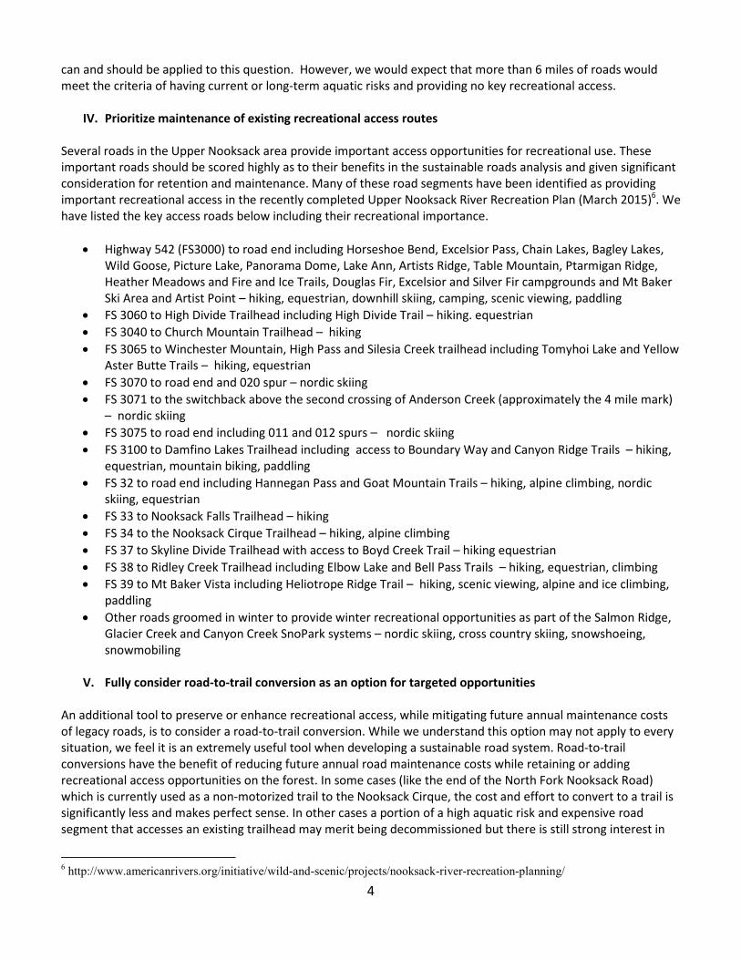
IV. Prioritize maintenance of existing recreational access routes
Several roads in the Upper Nooksack area provide important access opportunities for recreational use. These
important roads should be scored highly as to their benefits in the sustainable roads analysis and given significant
consideration for retention and maintenance. Many of these road segments have been identified as providing
important recreational access in the recently completed Upper Nooksack River Recreation Plan (March 2015)6. We
have listed the key access roads below including their recreational importance.
• Highway 542 (FS3000) to road end including Horseshoe Bend, Excelsior Pass, Chain Lakes, Bagley Lakes,
Wild Goose, Picture Lake, Panorama Dome, Lake Ann, Artists Ridge, Table Mountain, Ptarmigan Ridge,
Heather Meadows and Fire and Ice Trails, Douglas Fir, Excelsior and Silver Fir campgrounds and Mt Baker
Ski Area and Artist Point – hiking, equestrian, downhill skiing, camping, scenic viewing, paddling
• FS 3060 to High Divide Trailhead including High Divide Trail – hiking. equestrian
• FS 3040 to Church Mountain Trailhead – hiking
• FS 3065 to Winchester Mountain, High Pass and Silesia Creek trailhead including Tomyhoi Lake and Yellow
Aster Butte Trails – hiking, equestrian
• FS 3070 to road end and 020 spur – nordic skiing
• FS 3071 to the switchback above the second crossing of Anderson Creek (approximately the 4 mile mark)
– nordic skiing
• FS 3075 to road end including 011 and 012 spurs – nordic skiing
• FS 3100 to Damfino Lakes Trailhead including access to Boundary Way and Canyon Ridge Trails – hiking,
equestrian, mountain biking, paddling
• FS 32 to road end including Hannegan Pass and Goat Mountain Trails – hiking, alpine climbing, nordic
skiing, equestrian
• FS 33 to Nooksack Falls Trailhead – hiking
• FS 34 to the Nooksack Cirque Trailhead – hiking, alpine climbing
• FS 37 to Skyline Divide Trailhead with access to Boyd Creek Trail – hiking equestrian
• FS 38 to Ridley Creek Trailhead including Elbow Lake and Bell Pass Trails – hiking, equestrian, climbing
• FS 39 to Mt Baker Vista including Heliotrope Ridge Trail – hiking, scenic viewing, alpine and ice climbing,
paddling
• Other roads groomed in winter to provide winter recreational opportunities as part of the Salmon Ridge,
Glacier Creek and Canyon Creek SnoPark systems – nordic skiing, cross country skiing, snowshoeing,
snowmobiling
V. Fully consider road-to-trail conversion as an option for targeted opportunities
An additional tool to preserve or enhance recreational access, while mitigating future annual maintenance costs
of legacy roads, is to consider a road-to-trail conversion. While we understand this option may not apply to every
situation, we feel it is an extremely useful tool when developing a sustainable road system. Road-to-trail
conversions have the benefit of reducing future annual road maintenance costs while retaining or adding
recreational access opportunities on the forest. In some cases (like the end of the North Fork Nooksack Road)
which is currently used as a non-motorized trail to the Nooksack Cirque, the cost and effort to convert to a trail is
significantly less and makes perfect sense. In other cases a portion of a high aquatic risk and expensive road
segment that accesses an existing trailhead may merit being decommissioned but there is still strong interest in
6 http://www.americanrivers.org/initiative/wild-and-scenic/projects/nooksack-river-recreation-planning/

5
retaining the recreational access. A road-to-trail conversion of a modest road segment in this category makes
perfect sense.
We were concerned to see that in Section 2.2.3 (pg. 32) the Draft EA seems to dismiss the option of a road-to-trail
conversion as part of this ATM process based on lack of current funds for such activities:
…these road-to-trail conversions were eliminated from further study as the Forest trail
maintenance program does not have the available funds to add these trails to the trail
system.”
This is insufficient reason to fully consider the road-to-trail conversions that were suggested by the public in
scoping (including the end of the North Fork Nooksack Road). Making a decision to authorize a road-to-trail
conversion does not mean that funding must be available in the current of following fiscal year. This ATM plan is
by definition making road maintenance level decisions that look years into the future. Many of the decisions
ultimately made in this plan will not be implemented right away. Consider that the preferred alternative (B)
admits to pursuing a road system that cannot be fully funded. In addition, many of the road-to-trail projects on
other parts of the MBS were made possible through partnerships. While the Forest Service may not currently have
the resources, a decision document that identifies road-to-trail conversions can be used by partners to bring in
additional resources.
We feel strongly that any road-to-trail opportunities should be fully considered before any final decision is made.
VI. Ensure that aquatic risk factors are transparent and are a key factor in any decisions made
Analysis of aquatic risk factors of specific road segments is a critical input to achieving the stated purpose and
need of this project. For example section 1.6 Purpose and Need for the Proposal (pg. 13) of the EA lists the first
need as “Restore and protect the project area’s ecology from impacts of the road system.”
Information from the aquatics risks analysis is particularly important, given the recognition of the Nooksack as a
Tier 1 Key Watershed in the Northwest Forest Plan and its importance for salmon recovery, other wildlife, and a
source of clean water.
According to the “Salmon and Steelhead Habitat Limiting Factors in WRIA 1, The Nooksack Basin” report of July
2002, sedimentation resulting from high road densities and landslides (from both timber harvest and roads) has a
considerable impact to salmonid spawning habitat in the Nooksack Basin. Recommended actions include (p.275):
• “Decommission or treat roads that are at a moderate to high risk of mass wasting potential in the North,
South, and Middle Fork Nooksack sub-basins.
• Decommission or treat orphan roads that are at a moderate to high risk of mass wasting potential.”
According to watershed analyses for Canyon Creek (1995), North Fork Nooksack (1995) and Middle Fork and
South Fork Nooksack (2006) several natural resources needs were identified within the project area:
… There is a need for a reduction of sedimentation, landslides and other catastrophic
failures associated with roads and human infrastructure. For those [roads] needed as part of
the transportation system, there is a need for stabilized and/or upgraded roads and stream
crossings to reduce the risk to riparian and aquatic conditions. (Pg. 13 of EA)
The USFS has also consistently worked to improve aquatic habitat and watershed conditions, most recently under
the “Watershed Condition Framework.” According to the Agency’s assessment of 12 watershed health indicators

6
in the sub-watersheds of the Nooksack, the roads/trails indicator is rated “poor” in Canyon Creek, Glacier Creek,
Hedrick Creek (NF Nooksack River), Twin Lakes (NF Nooksack River), and “fair” in the Headwaters (NF Nooksack
River). This indicator is based on four factors: open road density, road/trail maintenance, road proximity to water
and mass wasting. In order to improve watershed conditions, these factors must be addressed.
The Draft EA identifies that a low, medium or high aquatic risk factor was applied to all road segments (PG. 10 of
the EA). However, the only evidence of this analysis in the EA is the map on Pg. 11. It is confusing and unclear
what combination of aquatic and other risk factors and benefits this map portrays with a scale of 1-12.
We understand that the SRS determined, across the forest, which roads are “high risk” for aquatic and terrestrial
resources. It would have been helpful to have included a table displaying the aquatic risk factors for each
segment of road in the project area. This is one of the most important factors in making decisions relevant to the
stated purpose and need.
VII. Support for a Modified Alternative B
As stated before, we feel that adoption of Alternative A will not meet the Purpose and Need identified for this
action.
We feel that Alternative B takes a number of useful steps to move toward a more sustainable road system but
could go further with respect to some targeted road decommissioning while retaining access to key recreational
opportunities.
Alternative C identifies a number of relevant and appropriate decommissioning opportunities but also makes
additional decisions that impact key recreational infrastructure. For example, Alternative C would negatively
impact existing access to the High Divide and Church Creek Trails by closing or decommissioning roads (FS 3060,
FS 3300) that access these established trailheads. Additionally, existing elements of the Salmon Ridge, Canyon
Creek and Glacier Creek SnoPark systems would be impacted from proposed maintenance level decisions in
Alternative C.
As a result of conversations with planning staff and district leadership, we understand that there is room to
identify different elements of alternatives to add or subtract during the draft plan public comment period. To that
end, our organizations support a modified Alternative B with additional road segments targeted for road
decommissioning that do not have significant impacts on recreational opportunities.
Description of Modified Alternative B
Most of Alternative B would be retained including the following elements which we support:
• Roads that are groomed in winter under agreement with Washington State Sno-Parks Program and the
National Recreational Trails Program would remain basically the same. (Pg. 99 of the EA). To be clear, in
instances where a ML 1 is identified for any road segments that are part of the Sno-Park systems, those
segments should not pull out culverts or bridges if doing so would interfere with the winter recreation
program.
• Alternative B would make minimal changes to the road segments that access trails within the project
area. Recreational opportunities would remain primarily the same. (Pg. 132 of the EA)
• Decommissioning or closing of targeted roads would have the greatest effect of limiting the continued
disturbance under which invasive plants thrive as well as stop the route of entry into new areas
previously un-infested. (Pg. 56 of the EA)
7
• The storage (ML1) or decommissioning (ML0) of forest system roads has tremendous value for the
restoration of ecological functions (Madej 2001; Switalski et al. 2004) that directly benefit fisheries
resources. (Pg. 63 of the EA)
• Alternative B includes stream-crossing restoration activities by either storing or decommissioning official
system roads. The restoration of stream crossings would allow for more natural drainage patterns, which
decreases the amount of water being collected by hardened road surfaces that is delivered to stream
networks. (pg. 70 of the EA)
• Under Alternative B, roads that are stored or decommissioned would nearly eliminate the long-term
production of fine sediment, which would protect downstream water quality and water users. (Pg. 71 of
the EA)
• Both action alternatives would contribute to the long-term reduction of stream temperature by allowing
the reestablishment of effective shade-producing vegetation along stream banks. (pg. 76 of the EA)
• Alternative B would provide for more riparian habitat restoration over the no-action alternative
(Alternative A), which would not restore any riparian reserve areas. (Pg. 77)
We suggest making the following adjustments to Alternative B as laid out in the EA. Each of these additions will
increase or not change the value of the elements listed in the above section.
Adjustment to Proposed Road Decommissioning in Alternative B
Alternative B proposes to decommission the last 0.6 miles of FS RD 3040 which access the Church Mountain
trailhead. As indicated in Section IV of these comments, we do not support eliminating access to this or other
established trailheads. We would support decommissioning the road segment beyond the existing trailhead
(approximately 0.25 miles rather than 0.6 miles) which we have incorporated in our Modified Alternative B.
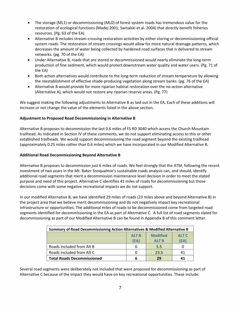
Additional Road Decommissioning Beyond Alternative B
Alternative B proposes to decommission just 6 miles of roads. We feel strongly that the ATM, following the recent
investment of two years in the Mt. Baker Snoqualmie’s sustainable roads analysis can, and should, identify
additional road segments that merit a decommission maintenance level decision in order to meet the stated
purpose and need of this project. Alternative C identifies 41 miles of roads for decommissioning but those
decisions come with some negative recreational impacts we do not support.
In our modified Alternative B, we have identified 29 miles of roads (23 miles above and beyond Alternative B) in
the project area that we believe merit decommissioning and do not negatively impact key recreational
infrastructure or opportunities. The additional miles of roads to be decommissioned come from targeted road
segments identified for decommissioning in the EA as part of Alternative C. A full list of road segments slated for
decommissioning as part of our Modified Alternative B can be found in Appendix B of this comment letter.
Summary of Road Decommissioning Action Alternatives & Modified Alternative B
ALT B
(EA)
Modified
ALT B
ALT C
(EA)
Roads included from Alt B 6 5.5 0
Roads included from Alt C 0 23.5 41
Total Roads Decommissioned 6 29 41
Several road segments were deliberately not included that were proposed for decommissioning as part of
Alternative C because of the impact they would have on key recreational opportunities. These include:
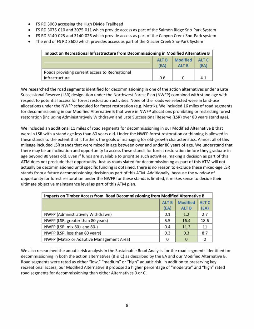
8
• FS RD 3060 accessing the High Divide Trailhead
• FS RD 3075-010 and 3075-011 which provide access as part of the Salmon Ridge Sno-Park System
• FS RD 3140-025 and 3140-026 which provide access as part of the Canyon Creek Sno-Park system
• The end of FS RD 3600 which provides access as part of the Glacier Creek Sno-Park System
Impact on Recreational Infrastructure from Decommissioning in Modified Alternative B
ALT B
(EA)
Modified
ALT B
ALT C
(EA)
Roads providing current access to Recreational
infrastructure 0.6 0 4.1
We researched the road segments identified for decommissioning in one of the action alternatives under a Late
Successional Reserve (LSR) designation under the Northwest Forest Plan (NWFP) combined with stand age with
respect to potential access for forest restoration activities. None of the roads we selected were in land-use
allocations under the NWFP scheduled for forest restoration (e.g. Matrix). We included 16 miles of road segments
for decommissioning in our Modified Alternative B that were in NWFP allocations prohibiting or restricting forest
restoration (including Administratively Withdrawn and Late Successional Reserve (LSR) over 80 years stand age).
We included an additional 11 miles of road segments for decommissioning in our Modified Alternative B that
were in LSR with a stand age less than 80 years old. Under the NWFP forest restoration or thinning is allowed in
these stands to the extent that it furthers the goals of managing for old-growth characteristics. Almost all of this
mileage included LSR stands that were mixed in age between over and under 80 years of age. We understand that
there may be an inclination and opportunity to access these stands for forest restoration before they graduate in
age beyond 80 years old. Even if funds are available to prioritize such activities, making a decision as part of this
ATM does not preclude that opportunity. Just as roads slated for decommissioning as part of this ATM will not
actually be decommissioned until specific funding is obtained, there is no reason to exclude these mixed-age LSR
stands from a future decommissioning decision as part of this ATM. Additionally, because the window of
opportunity for forest restoration under the NWFP for these stands is limited, it makes sense to decide their
ultimate objective maintenance level as part of this ATM plan.
Impacts on Timber Access from Road Decommissioning from Modified Alternative B
ALT B
(EA)
Modified
ALT B
ALT C
(EA)
NWFP (Administratively Withdrawn) 0.1 1.2 2.7
NWFP (LSR, greater than 80 years) 5.5 16.4 18.6
NWFP (LSR, mix 80+ and 80-) 0.4 11.3 11
NWFP (LSR, less than 80 years) 0.3 0.3 8.7
NWFP (Matrix or Adaptive Management Area) 0 0 0
We also researched the aquatic risk analysis in the Sustainable Road Analysis for the road segments identified for
decommissioning in both the action alternatives (B & C) as described by the EA and our Modified Alternative B.
Road segments were rated as either “low,” “medium” or “high” aquatic risk. In addition to preserving key
recreational access, our Modified Alternative B proposed a higher percentage of “moderate” and “high” rated
road segments for decommissioning than either Alternatives B or C.

9
Aquatic Risk Factor (By Percentage) of Road Segments Proposed for Decommissioning
Aquatic Risk Factor from 2015 MBSNF SRS
ALT B
(EA)
Modified
ALT B
ALT C
(EA)
Low Aquatic Risk 85% 35% 43%
Medium Aquatic Risk 0% 1% 1%
High Aquatic Risk 15% 64% 56%
Road-To-Trail Conversion for North Fork Nooksack Road
As stated previously, we feel that road-to-trail conversion is an important tool as part of an ATM. The last 1.9
miles of the North Fork Nooksack Road (FS Road #3400) is a perfect candidate for a road-to-trail conversion. As
stated in the EA the road is already operating as a trail and has not accommodated vehicle traffic for three
decades:
The road has been closed since the bridge at Ruth Creek was removed in the mid-1980s. The
segment of road beyond Ruth Creek has a dual designation as the Nooksack Cirque Trail #750
and is used by hikers to access Nooksack Cirque in North Cascades National Park. Under this
proposal, the segment of Nooksack Cirque Road (FSR 34) beyond (south) Ruth Creek would
not change. Under this proposal, the road segment would be removed from the road system
inventory. (Pg. 132 of the EA)
It is not clear why the section of this road already operating as a trail with a dual designation is not being formally
converted to a trail. If the agency feels that no further action is needed to convert this road segment to a trail
other than decommissioning the road from the system, we support that action. However, we want to ensure that
any culvert removal or other aquatic restoration work would be done. To that end, we have included this 1.9 mile
segment of the North Fork Nooksack Road beyond the North Fork Nooksack Trailhead to be decommissioned in
our Modified Alternative B with continued use as a trail.
Minimum Thresholds for Maintenance Levels 2-5
While the important decisions of which road segments to decommission as part of this plan will have the most
impact, we understand that decisions between objective maintenance levels 2-5 are also important. While we are
not in a position to make specific recommendations on maintenance levels (ML) for every road segment, we do
support a minimum ML for two different categories of road segments access recreational infrastructure
(identified in Section 4 of this letter).
Primary Access Roads
Several roads in the project area are major trunk roads that directly access important recreational infrastructure
or associated secondary roads and spur roads that in turn access trails, campgrounds and viewpoints. These main
stem roads are those that have a four-digit road number ending with two zeros (i.e., 3900). We support a
minimum maintenance level of 3 for the sections of these roads accessing the important recreational
infrastructure identified in Section IV of this letter. The MLs for Alternative A and Alternative B as described in the
EA as well as our recommendation for Modified Alternative B are listed in the table below.

10
Primary Road Maintenance Levels for Modified Alternative B
Primary Road Segment from Section IV
ALT A
(EA)
ALT B
(EA)
Modified
ALT B
FS 3100 to Damfino Lakes Trailhead 3&4 3&4 3&4
FS 3200 to road end 3 3 3
FS 3300 to Nooksack Falls Trailhead 3 3 3
FS 3400 to the Nooksack Cirque Trailhead 3 2 2
FS 3700 to Skyline Divide Trailhead 3 3 3
FS 3800 to Ridley Creek Trailhead 3 2 3
FS 3900 to Mt Baker Vista 3&5 3&5 3&5
While FS RD 3400 meets our general definition of a primary access route, in reality, based on its length and
function it operates more as a secondary route. As a result, we are comfortable retaining a ML 2 for this segment
in our Modified Alternative B.
Our Modified Alternative B is consistent with Alternative B on MLs for primary roads with one exception. We
support maintaining FD RD 3800 as a ML 3 rather than an ML 2 (as proposed in Alternative B) to the Riley Creek
Trailhead. This is a primary road and also provides important equestrian trailer access to several trails.
Secondary Roads
Several roads in the project area that branch off of primary roads provide important recreational access as well.
They are defined by a four digit or seven-digit numbers (i.e., 3060. 3300-040). We support a minimum ML of 2 for
the sections of these roads accessing the important recreational infrastructure identified in Section IV of this
letter.
Secondary Road Maintenance Levels for Modified Alternative B
Secondary Road Segment from Section IV
ALT A
(EA)
ALT B
(EA)
Modified
ALT B
FS 3060 to High Divide Trailhead 3&1 2&1 3&2
FS 3040 to Church Mountain Trailhead 3&1 3&0 3&2
FS 3065 to Winchester Mountain Trailhead 3 3 3
FS 3070 to road end 2 2 2
FS 3071 to the second crossing of Anderson Creek 2 2 2
FS 3075 to road end 2&1 2&1 2&1
In the case of roads where the highlighted access is grooming for winter recreation ML 1 would be acceptable as
the minimum threshold. This is the case for FS 3075.
Our Modified Alternative B is consistent with Alternative B on MLs for secondary roads with two exceptions. First,
as discussed earlier in this comment letter, we do not support the end of FS RD 3040 being decommissioned as it
would orphan trail access to the Church Mountain Trailhead. It should be maintained at a minimum of ML 2 to
continue to provide access to this trailhead. Second, we do not support an ML 1 (CLOSED) for FS RD 3060 as it
would orphan access to the High Divide Trailhead.
VIII. Conclusion
Finally, we would like to reiterate our support for this effort. The road system is becoming more fragile with each
passing storm. We appreciate your attempt to remove unneeded roads, protect natural resources, maintain

11
important access routes, and target limited budgets to the roads we do use. A thoughtful, strategic approach can
achieve positive results and move us closer to the goal of a “Sustainable Road System.”
Sincerely,
Tom Uniack
Conservation Director
Washington Wild
Mark Menlove
Executive Director
Winter Wildlands Alliance
Pam Borso
President
North Cascades Audubon Society
Don Parks
Co-Chair, National Forest Committee
Washington Chapter of the Sierra Club
Richard Simms
Founder
Wild Steelhead Coalition
Marla Nelson
Rewilding Attorney
WildEarth Guardians
Peter Tryon
President
Nooksack Nordic Ski Club
Matt Perkins
Secretary
Washington Climbers Coalition
Eric Brown
Trail Director
Whatcom Mountain Bike Alliance
Andrea Imler
Advocacy Director
Washington Trails Association
Joe Sambataro
National Access Director & NW Regional Director
Access Fund
Eddie Espinosa
Western States Manager
American Alpine Club
Kitty Craig
Washington State Deputy Director
The Wilderness Society
Katherine Hollis
Conservation and Advocacy Director
The Mountaineers
Thomas O’Keefe
Pacific Northwest Stewardship Director
American Whitewater
Yvonne Kraus
Executive Director
Evergreen Mountain Bike Alliance
Mike Davis
President
Mount Baker Club
Walden Haines
President
Back Country Horsemen - Whatcom County Chapter

12
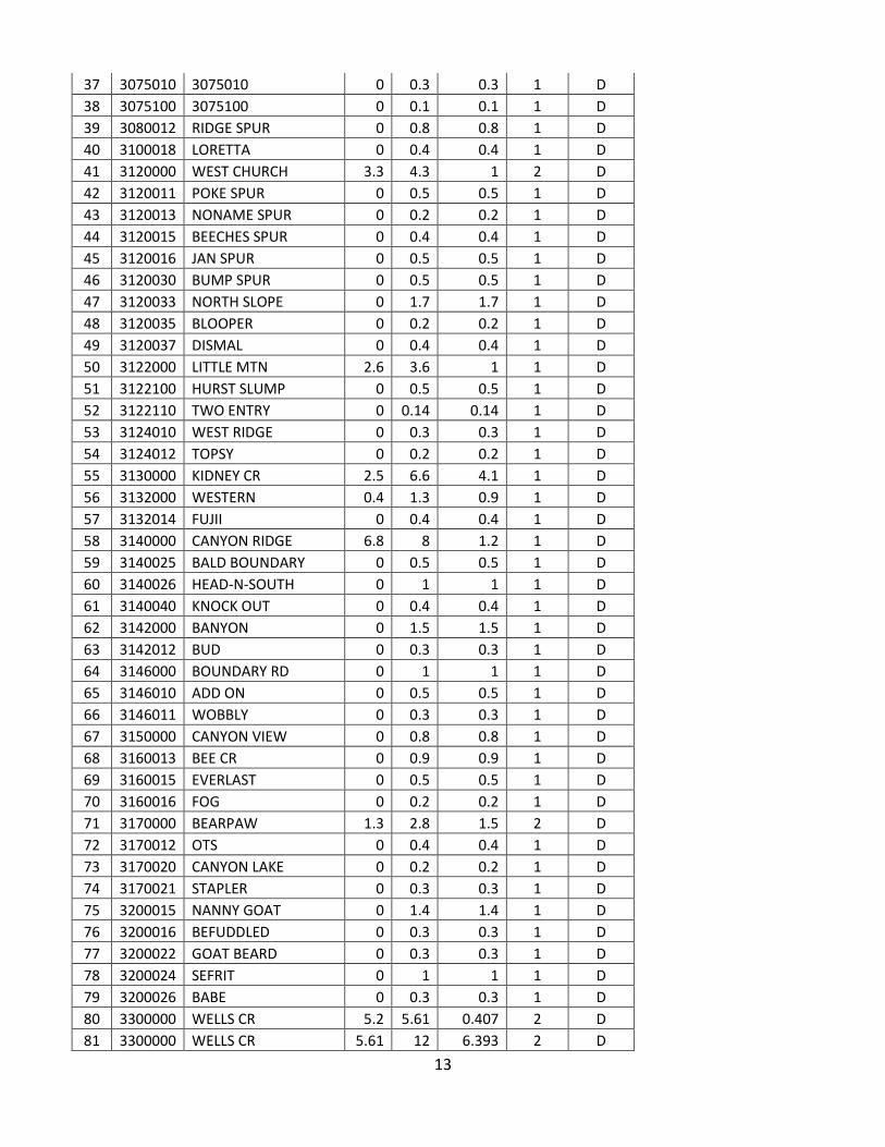
APPENDIX A
MBSNF INFRA Road DB (2012) Objective Maintenance Level DECOMMISSION
# ID NAME BMP EMP
SEG
LENGTH
OPER
MAINT
LEVEL
OBJECT
MAINT
LEVEL
1 3000050 COAL 0.15 0.3 0.15 1 D
2 3000055 HORN 0 0.2 0.2 1 D
3 3000058 NONAME 0 0.1 0.1 1 D
4 3000075 GALONE 0 0.6 0.6 1 D
5 3000076 SYLVESTER 0 0.3 0.3 1 D
6 3000080 GALENA CR 0 0.3 0.3 2 D
7 3010020 DAVIS CR 0 0.6 0.6 1 D
8 3010030 BOTTOMLESS 0 0.4 0.4 1 D
9 3010040 DEEP CR 0.6 1.5 0.9 1 D
10 3010042 HI-LO 0 0.6 0.6 1 D
11 3018000 HUMPY 0.1 1.1 1 1 D
12 3018020 GET UP 0 0.3 0.3 1 D
13 3019000 CONDOMINIUM 0 0.3 0.3 1 D
14 3035000 FOURMILE 0.2 1.2 1 1 D
15 3040000 EAST CHURCH 2.1 2.7 0.6 1 D
16 3040011 POWERLINE 0 0.3 0.3 1 D
17 3040111 POWERLINE 0 0.15 0.15 1 D
18 3060000 WELCOME PASS 0.7 1.2 0.5 1 D
19 3060000 WELCOME PASS 0 0.7 0.7 3 D
20 3065012 BOURNS POND 0.3 0.6 0.3 1 D
21 3065015 WEST SWAMP 0 0.2 0.2 1 D
22 3065019 SLIP OUT SPUR 0 0.2 0.2 1 D
23 3065020 MUD HOLE 0 0.6 0.6 1 D
24 3065021 SLACKLINE 0 0.2 0.2 1 D
25 3065023 KEEP KOOL 0.1 0.3 0.2 3 D
26 3066000 SWAMP CR 0 2 2 1 D
27 3066019 TWO GOATS 0 0.2 0.2 1 D
28 3070000 RAZOR HONE 2.5 3 0.5 2 D
29 3070020 WEST RAZOR 0 0.8 0.8 1 D
30 3070025 EAST RAZOR 0 0.2 0.2 1 D
31 3071000 ANDERSON CR 4.1 4.9 0.8 1 D
32 3071000 ANDERSON CR 2 4.1 2.1 2 D
33 3071017 ANDERSON SPUR 0 0.8 0.8 1 D
34 3071020 BAROMETER CR 0 0.8 0.8 1 D
35 3071025 ADVERSE POINT 0 0.7 0.7 1 D
36 3075000 WHITE SALMON 1.6 1.9 0.3 1 D
13
37 3075010 3075010 0 0.3 0.3 1 D
38 3075100 3075100 0 0.1 0.1 1 D
39 3080012 RIDGE SPUR 0 0.8 0.8 1 D
40 3100018 LORETTA 0 0.4 0.4 1 D
41 3120000 WEST CHURCH 3.3 4.3 1 2 D
42 3120011 POKE SPUR 0 0.5 0.5 1 D
43 3120013 NONAME SPUR 0 0.2 0.2 1 D
44 3120015 BEECHES SPUR 0 0.4 0.4 1 D
45 3120016 JAN SPUR 0 0.5 0.5 1 D
46 3120030 BUMP SPUR 0 0.5 0.5 1 D
47 3120033 NORTH SLOPE 0 1.7 1.7 1 D
48 3120035 BLOOPER 0 0.2 0.2 1 D
49 3120037 DISMAL 0 0.4 0.4 1 D
50 3122000 LITTLE MTN 2.6 3.6 1 1 D
51 3122100 HURST SLUMP 0 0.5 0.5 1 D
52 3122110 TWO ENTRY 0 0.14 0.14 1 D
53 3124010 WEST RIDGE 0 0.3 0.3 1 D
54 3124012 TOPSY 0 0.2 0.2 1 D
55 3130000 KIDNEY CR 2.5 6.6 4.1 1 D
56 3132000 WESTERN 0.4 1.3 0.9 1 D
57 3132014 FUJII 0 0.4 0.4 1 D
58 3140000 CANYON RIDGE 6.8 8 1.2 1 D
59 3140025 BALD BOUNDARY 0 0.5 0.5 1 D
60 3140026 HEAD-N-SOUTH 0 1 1 1 D
61 3140040 KNOCK OUT 0 0.4 0.4 1 D
62 3142000 BANYON 0 1.5 1.5 1 D
63 3142012 BUD 0 0.3 0.3 1 D
64 3146000 BOUNDARY RD 0 1 1 1 D
65 3146010 ADD ON 0 0.5 0.5 1 D
66 3146011 WOBBLY 0 0.3 0.3 1 D
67 3150000 CANYON VIEW 0 0.8 0.8 1 D
68 3160013 BEE CR 0 0.9 0.9 1 D
69 3160015 EVERLAST 0 0.5 0.5 1 D
70 3160016 FOG 0 0.2 0.2 1 D
71 3170000 BEARPAW 1.3 2.8 1.5 2 D
72 3170012 OTS 0 0.4 0.4 1 D
73 3170020 CANYON LAKE 0 0.2 0.2 1 D
74 3170021 STAPLER 0 0.3 0.3 1 D
75 3200015 NANNY GOAT 0 1.4 1.4 1 D
76 3200016 BEFUDDLED 0 0.3 0.3 1 D
77 3200022 GOAT BEARD 0 0.3 0.3 1 D
78 3200024 SEFRIT 0 1 1 1 D
79 3200026 BABE 0 0.3 0.3 1 D
80 3300000 WELLS CR 5.2 5.61 0.407 2 D
81 3300000 WELLS CR 5.61 12 6.393 2 D

14
82 3300018 MAD MIRA 0 0.6 0.6 1 D
83 3300020 EAST COUGAR 0 0.2 0.2 1 D
84 3300025 KITTY 0 0.1 0.1 1 D
85 3300030 KNOB 0 0.1 0.1 2 D
86 3310000 PINUS LAKE 1 3.4 2.4 2 D
87 3310011 ROCK SPUR 0 0.4 0.4 1 D
88 3400000 NO FK NOOKSACK 1 2.9 1.9 1 D
89 3400000 NO FK NOOKSACK 0 1 1 3 D
90 3600000 GROUSE BUTTE 4 5 1 2 D
91 3600011 SUMMIT VIEW 0 0.5 0.5 1 D
92 3600012 CABIN PLUNDER 0 0.1 0.1 1 D
93 3620014 ROCKY POINT 0 0.5 0.5 1 D
94 3620020 BRENDA SPUR 0 0.4 0.4 1 D
95 3630000 ELK HORN 1.4 1.9 0.5 2 D
96 3700025 UPPER BURNT KNOB 0 1 1 1 D
97 3700026 LOWER BURNT KNOB 0 0.3 0.3 1 D
98 3700030 TAIL HOLD 0 0.7 0.7 1 D
99 3700032 TRISH 0 0.7 0.7 1 D
100 3700033 DRY HORSE 0 0.4 0.4 1 D
101 3700035 GOOFED 0 0.3 0.3 1 D
102 3700036 CASCADE CREEK 0 0.5 0.5 1 D
103 3700040 JUMP OFF 0 0.2 0.2 1 D
104 3700050 JUMP OFF 0 0.2 0.2 1 D
105 3800000 MID FK NOOKSACK 4.6 7 2.4 3 D
106 3800000 MID FK NOOKSACK 12.3 14.3 2 2 D
107 3800000 MID FK NOOKSACK 7 12.3 5.3 3 D
108 3800023 RIDLEY CR 0 0.1 0.1 3 D
109 3900012 OLD GLACIER 0 0.3 0.3 1 D
110 3900013 SAMPSON CR 0 0.2 0.2 1 D
111 3900018 LO LO 0 0.5 0.5 1 D
112 3910000 THOMPSON CR 1.9 2 0.1 2 D
113 3910010 LAME DUCK 0 1.3 1.3 1 D
114 3910025 PRIVY 0 0.3 0.3 1 D
115 3910030 COMPTON SPUR 0 0.3 0.3 1 D
116 3910105 SOPHIE 0 0.2 0.2 1 D
117 3912000 THOMPSON RIDGE 0 0.5 0.5 1 D
118 3912020 TOMMY GUN 0 0.4 0.4 1 D
119 3914000 BEAVER CR 0.11 0.7 0.59 2 D
120 3940020 NORTH SMITH 0 0.5 0.5 1 D
TOTAL MILES 85.03

15
APPENDIX B
Comparison of Decommissioned Roads in Modified Alternative B with Other Action Alternatives
ID NAME BMP EMP
SEG
LENGTH
OPER
MAINT
LEVEL
OBJ
MAINT
LEVEL
ALT B
DECOM
MOD
ALT B
DECOM
ALT C
DECOM
NWFP
(Stand
Age)
300025 GARBAGE CUTOFF 0 0.4 0.4 0.4 0.4
3000050 COAL 0.15 0.3 0.15 1 D 0.15 0.15 LSR (80+)
3000050 COAL 0 0.15 0.15 0.15 0.15 LSR (80+)
3000058 NONAME 0 0.1 0.1 1 D 0.1 0.1 0.1 LSR (80+)
3000075 GALONE 0 0.6 0.6 1 D 0.6 0.6 LSR (80+)
3000076 SYLVESTER 0 0.3 0.3 1 D 0.3 0.3 LSR (80+)
3010020 DAVIS CR 0 0.6 0.6 1 D 0.6 0.6 LSR (80+)
3010030 BOTTOMLESS 0 0.4 0.4 1 D 0.4 0.4 LSR (80+)
3010040 DEEP CR 0.6 1.5 0.9 1 D 0.9 LSR (80-)
3010042 HI-LO 0 0.6 0.6 1 D 0.6 LSR (80-)
3017000 YACC CAMP 0 0.1 0.1 0.1 0.1 LSR
3017000 YACC CAMP 0.1 0.4 0.3 0.3 LSR
3018000 HUMPY 0.1 1.1 1 1 D 1.1 LSR (80-)
3018020 GET UP 0 0.3 0.3 1 D 0.3 LSR (80-)
3019000 CONDOMINIUM 0 0.3 0.3 1 D 0.3 0.3 0.3 LSR (80-)
3035000 FOURMILE 0.2 1.2 1 1 D 1 1 LSR (Mix)
3040000 EAST CHURCH 2.1 2.7 0.6 1 D 0.6 0.6 LSR (Mix)
3040011 POWERLINE 0 0.3 0.3 1 D 0.3 0.3 LSR (Mix)
3040111 POWERLINE 0 0.15 0.15 1 D 0.15 0.15 LSR (Mix)
3060000 WELCOME PASS 0.7 1.2 0.5 1 D 0.5 LSR (80+)
3065012 BOURNS POND 0.3 0.6 0.3 1 D 0.3 LSR (80-)
3065019 SLIP OUT SPUR 0 0.2 0.2 1 D 0.2 LSR (80-)
3065020 MUD HOLE 0 0.6 0.6 1 D 0.6 0.6 LSR (Mix)
3065021 SLACKLINE 0 0.2 0.2 1 D 0.2 0.2 LSR (80+)
3065023 KEEP KOOL 0 0.1 0.1 0.1 0.1 LSR (Mix)
3065023 KEEP KOOL 0.1 0.3 0.2 3 D 0.2 0.2 LSR (Mix)
3066000 SWAMP CR 0 2 2 1 D 2 LSOG (80-)
3066019 TWO GOATS 0 0.2 0.2 1 D 0.2 LSR (80-)
3075010 3075010 0 0.3 0.3 1 D 0.3 LSOG (80-)
3075011 SALMON PATTERN 0.3 0.5 0.2 0.2 LSR (80-)
3096000 ALPINE VISTA 0 0.12 0.123 0.123 0.123 AW
3100015 LOWER HURST CREEK 0 1 1 1 1 1 LSR (80+)
3100018 LORETTA 0 0.4 0.4 1 D 0.4 0.4 0.4 LSR (Mix)
3100444 3100444 0 0.2 0.2 0.2 0.2 LSR (Mix)
3140025 BALD BOUNDARY 0 0.5 0.5 1 D 0.5 AW- MHZ
3140026 HEAD-N-SOUTH 0 1 1 1 D 1 AW- MHZ
3140040 KNOCK OUT 0 0.4 0.4 1 D 0.4 0.4 AW- MHZ

16
3140045 NW CORNER 0 0.4 0.4 0.4 0.4 AW- MHZ
3140045 NW CORNER 0.4 0.5 0.1 0.1 0.1 AW- MHZ
3140046 UPTOP 0 0.2 0.2 0.2 0.2 AW- MHZ
3200015 NANNY GOAT 0 1.4 1.4 1 D 1.4 1.4 LSR (Mix)
3200016 BEFUDDLED 0 0.3 0.3 1 D 0.3 0.3 LSR (Mix)
3200024 SEFRIT 0 1 1 1 D 1 LSR (80-)
3200026 BABE 0 0.3 0.3 1 D 0.3 LSR (80-)
3400000 NO FK NOOKSACK 1 2.9 1.9 1 D 1.9 1.9 LSR (Mix)
3600000 GROUSE BUTTE 4 5 1 2 D 1 LSR (80-)
3700000 DEADHORSE 12.5 12.8 0.3 0.3 0.3 0.3 LSR (80+)
3700030 TAIL HOLD 0 0.7 0.7 1 D 0.7 0.7 0.7 LSR (80+)
3700036 CASCADE CREEK 0 0.5 0.5 1 D 0.5 0.5 LSR (Mix)
3700050 JUMP OFF 0 0.2 0.2 1 D 0.5 0.5 LSR (80+)
3800000 MID FK NOOKSACK 12.3 14.3 2 2 D 2 LSR
3900012 OLD GLACIER 0 0.3 0.3 1 D 0.3 0.3 0.3 LSR
3900013 SAMPSON CR 0 0.2 0.2 1 D 0.2 LSR
3900014 THREE RIDGES 0 1 1 1 1 LSR (80+)
3900015 SCAB 0 0.4 0.4 0.4 0.4 LSR (80+)
3900018 LO LO 0 0.5 0.5 1 D 0.5 0.5 LSR (80+)
3910000 THOMPSON CR 1.9 2 0.1 2 D 0.1 0.1 LSR (80+)
3910000 THOMPSON CR 2 2.7 0.7 0.7 0.7 LSR (80+)
3910000 THOMPSON CR 2.7 4.3 1.6 1.6 1.6 LSR (80+)
3910010 LAME DUCK 0 1.3 1.3 1 D 1.3 1.3 LSR (80+)
3910025 PRIVY 0 0.3 0.3 1 D 0.3 0.3 LSR (80+)
3910030 COMPTON SPUR 0 0.3 0.3 1 D 0.3 0.3 0.3 LSR (80+)
3910105 SOPHIE 0 0.2 0.2 1 D 0.2 0.2 LSR (80+)
3912000 THOMPSON RIDGE 0 0.5 0.5 1 D 0.5 0.5 0.5 LSR (80+)
3912020 TOMMY GUN 0 0.4 0.4 1 D 0.4 0.4 0.4 LSR (80+)
3914000 BEAVER CR 0.11 0.7 0.59 2 D 0.59 0.59 LSR (Mix)
3916000 OLD GRADE 0 2.8 2.8 2.8 2.8 LSR (80+)
3940000 SMITH BASIN 0 2.1 2.1 2.1 2.1 LSR (Mix)
3940020 NORTH SMITH 0 0.5 0.5 1 D 0.5 0.5 LSR (Mix)
394022 PALISADES 0 0.7 0.7 0.7 0.7 LSR (Mix)
394025 UPPER SMITH 0 0.5 0.5 0.5 0.5 LSR (Mix)
TOTALS: 5.973 28.863 41.29