mt thirsty mineral resource upgrade amended …the mineral resource is reported above 0.06% cobalt....
TRANSCRIPT
Level 15, 197 St George’s Terrace, Perth, Western Australia 6000 Telephone: (08) 9282 5889 Facsimile: (08) 9282 5866
Website: www.conico.com.au
AUSTRALIAN SECURITIES EXCHANGE ANNOUNCEMENT 4 March 2019
MT THIRSTY MINERAL RESOURCE UPGRADE
AMENDED ANNOUNCEMENT The Company released an announcement to the ASX on 20th February 2019 titled “Mt Thirsty Mineral Resource Upgrade” advising of a Mineral Resource upgrade for the Mt Thirsty project, a 50:50 JV between Barra Resources Ltd and Conico Ltd.
The ASX has subsequently advised the company that additional information is required to fully comply with the ASX listing rules. The amended announcement is presented here.
HIGHLIGHTS
• Mt Thirsty Mineral Resource estimate upgraded to JORC 2012 status
Mineral Resource
Wet Tonnes (Mt)
Dry Tonnes (Mt)
Co (dry %)
Ni (dry %)
Indicated 31.0 22.6 0.116 0.53
Inferred 3.5 2.5 0.099 0.44
Total 34.5 25.1 0.114 0.52
Table 1: Mt Thirsty Mineral Resource summary (0.06% Co cut off).
• Indicated Mineral Resource increases 87% and now represents 90% of the total Mineral Resource
• Indicated classification is eligible for consideration in a JORC 2012 Ore Reserve estimate subject to the completion of a successful PFS and the application of appropriate modifying factors
• Improved density, moisture, domaining and estimation methods
• Further upside with known mineralisation at Mt Thirsty North
Barra Resources Managing Director and CEO Sean Gregory, who is managing the PFS activities on behalf of the MTJV said, “This work modernises the Mt Thirsty Mineral Resource using the best available methods. The MTJV always spends shareholder funds judiciously and this de-risking of the project has been achieved by utilising the existing drilling data, which tier one mining consultant firm Golder Associates has confirmed to be of a suitable standard. This Mineral Resource together with the recent metallurgical results will form the basis of a new optimised mine plan for the PFS which is expected to unlock significant value for the project.”
ASX Announcement 4 March 2019
2
Introduction
The Mt Thirsty Cobalt Nickel Project is located 16km northwest of Norseman, Western Australia (Figure 1).
The project is jointly owned by Barra Resources Limited and Conico Limited, together the Mt Thirsty Joint Venture (MTJV).
The Project contains the Mt Thirsty Cobalt-Nickel Oxide Deposit that has the potential to emerge as Australia’s next cobalt producer.
The MTJV is progressing a Pre-Feasibility Study (PFS) on the project.
Figure 1: Mt Thirsty Project location.
Geology and Interpretation
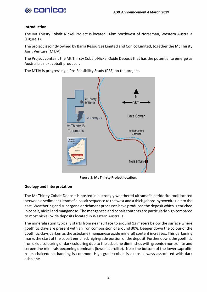
The Mt Thirsty Cobalt Deposit is hosted in a strongly weathered ultramafic peridotite rock located between a sediment-ultramafic-basalt sequence to the west and a thick gabbro-pyroxenite unit to the east. Weathering and supergene enrichment processes have produced the deposit which is enriched in cobalt, nickel and manganese. The manganese and cobalt contents are particularly high compared to most nickel oxide deposits located in Western Australia.
The mineralisation typically starts from near surface to around 12 meters below the surface where goethitic clays are present with an iron composition of around 30%. Deeper down the colour of the goethitic clays darken as the asbolane (manganese oxide mineral) content increases. This darkening marks the start of the cobalt enriched, high-grade portion of the deposit. Further down, the goethitic iron oxide colouring or dark colouring due to the asbolane diminishes with greenish nontronite and serpentine minerals becoming dominant (lower saprolite). Near the bottom of the lower saprolite zone, chalcedonic banding is common. High-grade cobalt is almost always associated with dark asbolane.
ASX Announcement 4 March 2019
3
Figure 2: 3D cut away isometric of the Mt Thirsty deposit looking south west.
Drilling Data
Extensive drilling has been completed on the deposit from 1996-2018 including 696 Air Core (AC) holes, 14 Reverse Circulation (RC) holes, 21 Rotary Air Blast (RAB) holes, and 7 Sonic Core (SC) holes. Grid spacing is sufficiently close for the style of mineralisation at 50m x 40m on the eastern side and 50m x 80m on the western side.
Drill hole cuttings were collected in a cyclone, and subsequently reduced in volume with a sampling tube (for some pre-2009 drilling), riffle or rotary splitter. The cyclone was cleaned between each three metre rod and every metre for wet samples and riffle splitters were cleaned as required. Water injection was kept to a minimum. Over 90% of the holes were sampled at even regular 1m intervals.
Samples were crushed and pulverised, and analysed for Co, Ni, Mn, Zn, Mg, Al & Fe using a four acid digest with an ICP OES finish (method AD02-ICP) by Bureau Veritas’ Kalassay laboratory. These procedures are considered appropriate for the elements and style of mineralisation. Analysis is considered total.
A comparison of the analytical results from twin AC, RC and SC holes was completed. Differences are noted between the various drilling types and are most likely due to sample size and short-scale geological variability inherent in laterite deposits. The bulk of the drilling is AC which, based on population statistics, is slightly conservative compared to RC and SC drilling results.
The quality assurance data associated with the drilling also proved to be suitable.
Density and Moisture Determination
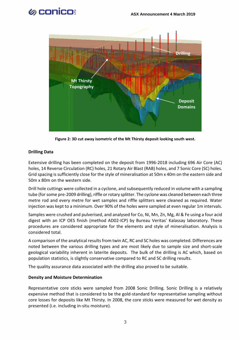
Representative core sticks were sampled from 2008 Sonic Drilling. Sonic Drilling is a relatively expensive method that is considered to be the gold-standard for representative sampling without core losses for deposits like Mt Thirsty. In 2008, the core sticks were measured for wet density as presented (i.e. including in-situ moisture).
Mt Thirsty Topography
Deposit Domains
Drilling
ASX Announcement 4 March 2019
4
In 2018, the MTJV recovered 156 of these core sticks from storage and had them remeasured for dry density. After excluding outliers, 142 samples were analysed in detail. The difference between wet density and dry density is the in-situ moisture. Average densities and moisture contents were applied to each domain in the Mineral Resource independently.
Domaining
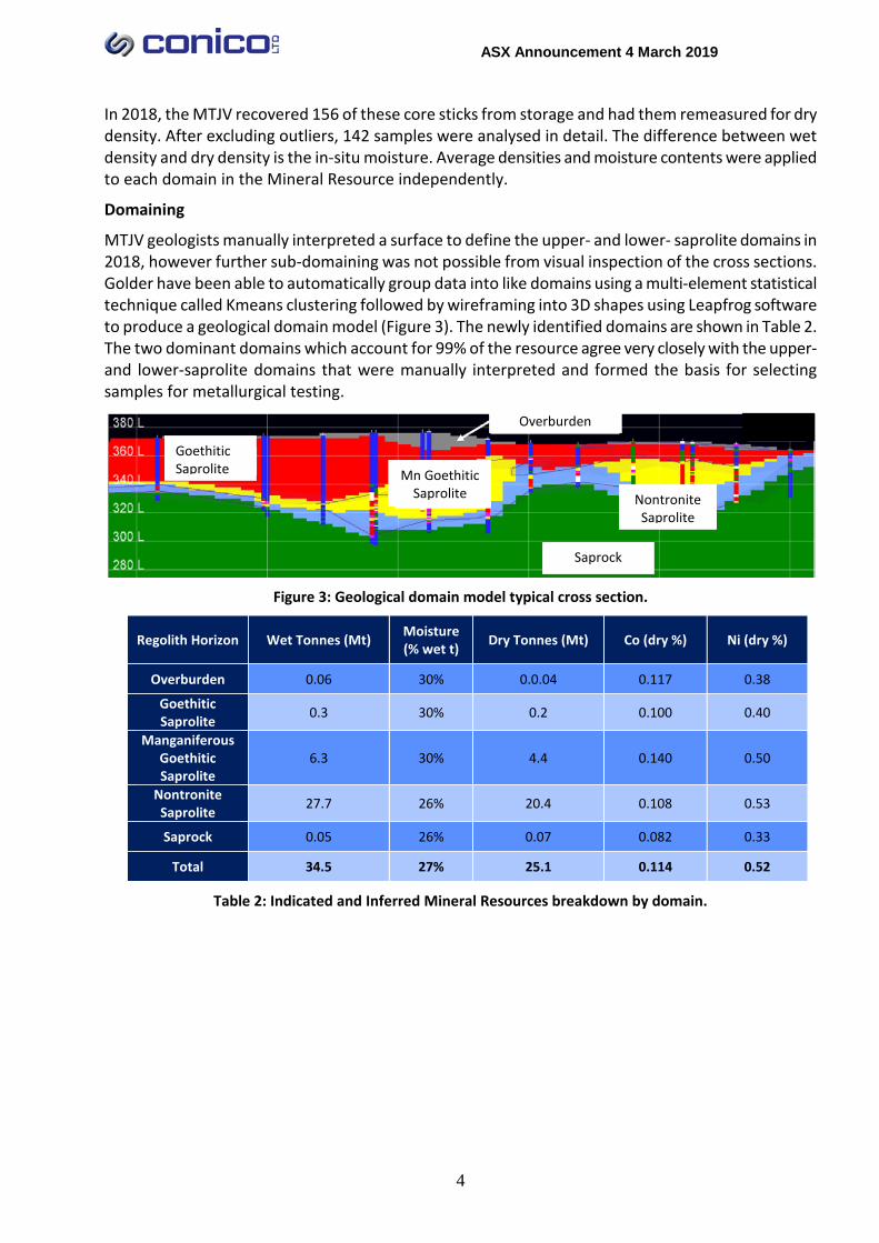
MTJV geologists manually interpreted a surface to define the upper- and lower- saprolite domains in 2018, however further sub-domaining was not possible from visual inspection of the cross sections. Golder have been able to automatically group data into like domains using a multi-element statistical technique called Kmeans clustering followed by wireframing into 3D shapes using Leapfrog software to produce a geological domain model (Figure 3). The newly identified domains are shown in Table 2. The two dominant domains which account for 99% of the resource agree very closely with the upper- and lower-saprolite domains that were manually interpreted and formed the basis for selecting samples for metallurgical testing.
Figure 3: Geological domain model typical cross section.
Regolith Horizon Wet Tonnes (Mt) Moisture (% wet t) Dry Tonnes (Mt) Co (dry %) Ni (dry %)
Overburden 0.06 30% 0.0.04 0.117 0.38
Goethitic Saprolite 0.3 30% 0.2 0.100 0.40
Manganiferous Goethitic Saprolite
6.3 30% 4.4 0.140 0.50
Nontronite Saprolite 27.7 26% 20.4 0.108 0.53
Saprock 0.05 26% 0.07 0.082 0.33
Total 34.5 27% 25.1 0.114 0.52
Table 2: Indicated and Inferred Mineral Resources breakdown by domain.
Overburden
Goethitic Saprolite
Mn Goethitic Saprolite
Saprock
Nontronite Saprolite

ASX Announcement 4 March 2019
5
Grade Estimation
Grade estimates by ordinary kriging were constrained in each of these domains and the high-grade samples were constrained to only influence local blocks. The resulting block model honours local grades in drill holes and weathering geology far better than the previous 2011 estimate (Figure 4).
Figure 4: Comparison between 2011 and 2019 block models coloured by cobalt on section 6447600mN.
The 2019 resource model contains some smoothing (averaging) across ore-waste boundaries. By comparing to the 2011 model it can be quantified as approximately 10% dilution. Golder have advised that this is reasonable for the style of deposit and proposed mining methods. When using the 2019 model for mining studies, Golder have recommended not applying any further dilution other than that which might be caused when aggregating blocks to various mining bench heights.
Classification Criteria
The classification of the Mineral Resource is more sophisticated than drill hole spacing alone, which in this case is considered adequate for both Indicated and Inferred Mineral Resources. In the case of this Mineral Resource, it is the improved confidence in the quality of the data on two fronts that has allowed the classification to be improved,
Firstly, the statistical comparison of different drilling methods has confirmed their suitability for use in an Indicated Mineral Resource. As such, no additional drilling was specifically completed to facilitate this upgrade from the previous JORC 2004 Inferred and Indicated Mineral Resource to the current JORC 2012 Mineral Resource which is now mostly (90%) classified as Indicated.
Secondly, the knowledge of direct physical measurements of wet densities, dry densities and in-situ moisture contents for a large number of samples across all geological domains is a key determinant in achieving higher levels of confidence and therefore the higher resource categories in the application of the JORC code.
The Indicated portion of the Mineral Resource is in the core of the deposit. Around the margins of the deposit, a buffer has been assumed such that 10% of the Mineral Resource is Inferred, consistent with the lower confidence in these areas. An area in the south east of the deposit where RAB drilling is prominent has also been classified as Inferred due to the lower confidence associated with this drilling and sampling method.
Improved matching of blocks and drill holes
ASX Announcement 4 March 2019
6
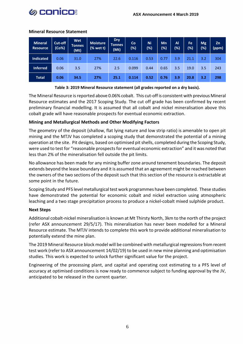
Mineral Resource Statement
Mineral Resource
Cut-off (Co%)
Wet Tonnes
(Mt)
Moisture (% wet t)
Dry Tonnes
(Mt) Co (%)
Ni (%)
Mn (%)
Al (%)
Fe (%)
Mg (%)
Zn (ppm)
Indicated 0.06 31.0 27% 22.6 0.116 0.53 0.77 3.9 21.1 3.2 304
Inferred 0.06 3.5 27% 2.5 0.099 0.44 0.65 3.5 19.0 3.5 243
Total 0.06 34.5 27% 25.1 0.114 0.52 0.76 3.9 20.8 3.2 298
Table 3: 2019 Mineral Resource statement (all grades reported on a dry basis).
The Mineral Resource is reported above 0.06% cobalt. This cut-off is consistent with previous Mineral Resource estimates and the 2017 Scoping Study. The cut off grade has been confirmed by recent preliminary financial modelling. It is assumed that all cobalt and nickel mineralisation above this cobalt grade will have reasonable prospects for eventual economic extraction.
Mining and Metallurgical Methods and Other Modifying Factors
The geometry of the deposit (shallow, flat lying nature and low strip ratio) is amenable to open pit mining and the MTJV has completed a scoping study that demonstrated the potential of a mining operation at the site. Pit designs, based on optimised pit shells, completed during the Scoping Study, were used to test for “reasonable prospects for eventual economic extraction” and it was noted that less than 2% of the mineralisation fell outside the pit limits.
No allowance has been made for any mining buffer zone around tenement boundaries. The deposit extends beyond the lease boundary and it is assumed that an agreement might be reached between the owners of the two sections of the deposit such that this section of the resource is extractable at some point in the future.
Scoping Study and PFS level metallurgical test work programmes have been completed. These studies have demonstrated the potential for economic cobalt and nickel extraction using atmospheric leaching and a two stage precipitation process to produce a nickel-cobalt mixed sulphide product.
Next Steps
Additional cobalt-nickel mineralisation is known at Mt Thirsty North, 3km to the north of the project (refer ASX announcement 29/5/17). This mineralisation has never been modelled for a Mineral Resource estimate. The MTJV intends to complete this work to provide additional mineralisation to potentially extend the mine plan.
The 2019 Mineral Resource block model will be combined with metallurgical regressions from recent test work (refer to ASX announcement 14/02/19) to be used in new mine planning and optimisation studies. This work is expected to unlock further significant value for the project.
Engineering of the processing plant, and capital and operating cost estimating to a PFS level of accuracy at optimised conditions is now ready to commence subject to funding approval by the JV, anticipated to be released in the current quarter.
ASX Announcement 4 March 2019
7
Guy T Le Page Director
Disclaimer The interpretations and conclusions reached in this report are based on current geological and metallurgical theory and the best evidence available to the authors at the time of writing. It is the nature of all scientific conclusions that they are founded on an assessment of probabilities and, however high these probabilities might be, they make no claim for complete certainty. Any economic decisions that might be taken based on interpretations or conclusions contained in this report will therefore carry an element of risk.
This report contains forward-looking statements that involve a number of risks and uncertainties. These forward-looking statements are expressed in good faith and believed to have a reasonable basis. These statements reflect current expectations, intentions or strategies regarding the future and assumptions based on currently available information. Should one or more of the risks or uncertainties materialise, or should underlying assumptions prove incorrect, actual results may vary from the expectations, intentions and strategies described in this report. No obligation is assumed to update forward-looking statements if these beliefs, opinions and estimates should change or to reflect other future developments.
Competent Persons Statements The information in this report that relates to drilling, sampling and assay data is based on and fairly represents information compiled by Michael J Glasson, a Competent Person who is a member of the Australian Institute of Geoscientists. Mr Glasson is an employee of Tasman Resources Ltd and in this capacity acts as part time consultant to Conico Ltd and the MTJV. Mr Glasson holds shares in Conico Ltd. Mr Glasson has sufficient relevant experience to the style of mineralisation and type of deposits under consideration and to the activity for which he is undertaking to qualify as a Competent Person as defined in the JORC Code (2012 Edition). Mr Glasson consents to the inclusion in the report of the matters based on his information in the form and context in which it appears.
The information in this report which relates to Mineral Resources is based on information provided to and compiled by Mr David Reid, who is a full-time employee of Golder Associates Pty Ltd, and a Member of the Australasian Institute of Mining and Metallurgy. Mr Reid has sufficient relevant experience to the style of mineralisation and type of deposits under consideration and to the activity for which he is undertaking to qualify as a Competent Person as defined in the JORC Code (2012 Edition). Mr Reid consents to the inclusion in the report of the matters based on his information in the form and context in which it appears.
ASX Announcement 4 March 2019
8
JORC TABLE 1
JORC Code Assessment Criteria Comment
Section 1 Sampling Techniques and Data Sampling Techniques • The majority of samples have been obtained by drilling
of 686 vertical air core (AC) holes on a close spaced grid to maximum depths of about 100m within Retention Licence R63/4. A further eight holes were drilled by reverse circulation (RC) drilling, and another 21 holes by RAB drilling. An additional seven core holes (sonic drilling) were completed to obtain core for density measurements and to twin existing AC holes. A further seven AC holes were drilled in 2012, three in 2018 and six RC holes in 2016 to provide samples for metallurgical test work. All holes were used in the Mineral Resource Estimate.
• Resource drilling was carried out on a campaign basis between 1996 and 2016, with 375 holes (363 AC, 8 RC, & 7 SC) drilled by Barra Resources Ltd (2006-2008) and 149 AC holes by the Mt Thirsty Joint Venture (Barra Resources Ltd and Conico Ltd) from 2009-2016.
• Sampling details for the earlier AC and RAB holes drilled by Resolute are not well known but the AC holes are believed to have been carried out to industry standards and company reports indicate that they carried out QA/QC checks. Data appears consistent with more recent drilling campaigns.
• Holes were drilled on a regular spaced grid to below the base of the resource in most cases. Grid spacing is 50x40m or closer on the eastern side of deposit and 50x80m on western side. Most holes were sampled at even regular 1m intervals.
• AC drilling was mostly used to obtain 1m samples from which a 2kg split was bagged and sent to the laboratory. The sample was then dried and pulverised and a 40gm sub sample analysed for Co, Ni, Mn, Zn, Mg, Al & Fe using a four acid digest with an ICP OES finish.
Nature and quality of sampling (e.g. cut channels, random chips, or specific specialised industry standard measurement tools appropriate to the minerals under investigation, such as downhole gamma sondes, or handheld XRF instruments, etc.). These examples should not be taken as limiting the broad meaning of sampling. Include reference to measures taken to ensure sample representivity and the appropriate calibration of any measurement tools or systems used. Aspects of the determination of mineralisation that are Material to the Public Report. In cases where ‘industry standard’ work has been done this would be relatively simple (e.g. ‘reverse circulation drilling was used to obtain 1 m samples from which 3 kg was pulverised to produce a 30 g charge for fire assay’). In other cases more explanation may be required, such as where there is coarse gold that has inherent sampling problems. Unusual commodities or mineralisation types (e.g. submarine nodules) may warrant disclosure of detailed information.
Drilling Techniques • AC blade drilling (85mm hole diameter) was mostly used, with minor AC hammer in rare hard bands. Sonic drilling (97.5 mm diameter) was used for twin hole comparison and to recover core for density measurements. No core orientation was deemed necessary in these vertical holes.
Drill type (e.g. core, reverse circulation, open-hole hammer, rotary air blast, auger, Bangka, sonic, etc.), and details (e.g. core diameter, triple or standard tube, depth of diamond tails, face-sampling bit or other type, whether core is oriented and if so, by what method, etc.).
Drill Sample Recovery • Sample recovery was generally excellent in dry powdery clay which hosts the upper portion of the mineralisation. Any intervals with obvious poorer sample recovery were recorded in the logs. These were mostly in greenish puggy clay sections beneath the oxidised zone in the lower portion
Method of recording and assessing core and chip sample recoveries and results assessed. Measures taken to maximise sample recovery and ensure representative nature of the samples.
ASX Announcement 4 March 2019
9
JORC Code Assessment Criteria Comment
Whether a relationship exists between sample recovery and grade and whether sample bias may have occurred due to preferential loss/gain of fine/coarse material.
of the deposit.
• Drill hole cuttings were collected in a cyclone, and subsequently reduced in volume with a sampling tube (pre 2009 Barra drilling), riffle or rotary splitter. The cyclone was cleaned between each three metre rod and every metre for wet samples; riffle splitters were cleaned as required. Water injection was kept to a minimum.
• There is no obvious relationship between grade and sample recovery. Most of the material drilled is strongly weathered, soft and fine grained. No significant sample bias is expected to have occurred due to preferential loss of fine/coarse material.
Logging • Logging is conducted in detail at the drill site by the site geologist, who routinely records weathering, lithology, alteration, mineralisation, or any other relevant features. It is considered to be logged at a level of detail to support appropriate Mineral Resource estimation and mining studies.
• Logging is qualitative in nature.
• The entire length of each hole was logged in 1m intervals.
Whether core and chip samples have been geologically and geotechnically logged to a level of detail to support appropriate Mineral Resource estimation, mining studies and metallurgical studies. Whether logging is qualitative or quantitative in nature. Core (or costean, channel, etc.), photography. The total length and percentage of the relevant intersections logged.
Sub-Sampling Techniques and Sample Preparation • The sonic core was removed from the plastic sleeves and logged. Selected portions were removed and kept intact for SG determinations. The remaining core was then cut in half with the right half side sampled for assaying.
• In the 2006-2007 AC program (320 AC holes) samples were bagged and tube sampled. In subsequent programs all drill chips were split with either a rotary splitter or by hand with a riffle splitter and the remaining sample was placed on the ground. Wet samples were carefully sampled on the ground by hand trowel in representative vertical slices through the entire pile.
• Sample preparation followed industry standard practice of drying, coarse crushing to -6mm, before pulverising to 90% passing 75 micron.
• To meet QAQC requirements duplicates were placed at irregular intervals in the sample stream, usually one or two duplicates per drill hole (approximately every 20-40m). From 2009 certified blanks (OREAS 24P) were also placed in the sample stream at the rate of 1 in 100, at each hundredth sample. Additionally, two different certified standards were also used in the sample stream (OREAS 72A and OREAS 162) at the rate of 2 standards per 100 samples. These were placed at the 25th and 75th number of every hundred
If core, whether cut or sawn and whether quarter, half or all core taken. If non-core, whether riffled, tube sampled, rotary split, etc., and whether sampled wet or dry. For all sample types, the nature, quality and appropriateness of the sample preparation technique. Quality control procedures adopted for all sub-sampling stages to maximise representivity of samples. Measures taken to ensure that the sampling is representative of the in situ material collected, including for instance results for field duplicate/second-half sampling. Whether sample sizes are appropriate to the grain size of the material being sampled.
ASX Announcement 4 March 2019
10
JORC Code Assessment Criteria Comment
samples.
• The Co values in the blank samples were higher than the provided values however they are below 80 ppm; comparatively low compared to the estimated resource values and therefore within acceptable ranges for blank samples. Overall there were only a small number of outliers in the 410 duplicates collected and therefore the duplicate results are also considered satisfactory.
• Material being sampled is generally fine grained, and a 2-3kg sample from each metre is considered adequate.
Quality of Assay Data and Laboratory Tests • Samples were crushed and pulverised, and analysed for Co, Ni, Mn, Zn, Mg, Al & Fe using a four acid digest with an ICP OES finish (method AD02-ICP) by Bureau Veritas’ Kalassay laboratory. These procedures are considered appropriate for the elements and style of mineralisation. Analysis is considered total.
• No geophysical tools have been used.
• The internal laboratory QAQC procedures included analysing its own suite of internal standards and blanks within every sample batch and also adding sample duplicates.
The nature, quality and appropriateness of the assaying and laboratory procedures used and whether the technique is considered partial or total. For geophysical tools, spectrometers, handheld XRF instruments, etc., the parameters used in determining the analysis including instrument make and model, reading times, calibrations factors applied and their derivation, etc. Nature of quality control procedures adopted (e.g. standards, blanks, duplicates, external laboratory checks) and whether acceptable levels of accuracy (i.e. lack of bias) and precision have been established. Verification of Sampling and Assaying • Significant intersections are determined by company
personnel, and checked internally.
• A limited number of twinned RC holes and AC holes twinned by SC holes were drilled. Analysis of paired data representing AC and SC samples with proximity of approximately 5 m or less has given at least preliminary indications that some AC samples are yielding higher Co and Mn values than corresponding samples derived from SC. Population statistics however show the reverse and AC statistics are slightly lower grade on average than RC and SC.
• Individual sample numbers are generated and matched on site with down hole depths. Sample numbers are then used to match assays when received from the laboratory. Verification of data is managed and checked by company personnel with extensive experience. All data is stored electronically, with industry standard systems and backups.
• Data is not subject to any adjustments.
The verification of significant intersections by either independent or alternative company personnel. The use of twinned holes. Documentation of primary data, data entry procedures, data verification, data storage (physical and electronic) protocols. Discuss any adjustment to assay data.
Location of Data Points • Collar locations were determined either by hand held GPS (for 149 AC holes) or differential GPS (for 363 AC holes) and are accurate to approximately +/- 5m or 1m
Accuracy and quality of surveys used to locate drill holes (collar and downhole surveys), trenches, mine workings and other locations used in Mineral Resource estimation.
ASX Announcement 4 March 2019
11
JORC Code Assessment Criteria Comment
Specification of the grid system used. Quality and adequacy of topographic control.
respectively (northing and easting).
• The grid system used is AGD84; AMG Zone 51 to match a previously established grid.
• A DTM and 2.5m spaced topographic contours have been prepared from ortho-photomaps and hole RLs are measured from these. This topographic control is considered quite adequate for the current purposes.
Data Spacing and Distribution • Drill holes are generally spaced on a regular grid of either 40x50m or 80x50m.
• The drill hole spacing is considered more than sufficient to establish the degree of geological and grade continuity for Mineral Resources estimation of this style of mineralisation.
• Most holes were sampled and assayed in 1m intervals and no other compositing has been applied during sample collection and laboratory preparation.
Data spacing for reporting of Exploration Results. Whether the data spacing and distribution is sufficient to establish the degree of geological and grade continuity appropriate for the Mineral Resource and Ore Reserve estimation procedure(s) and classifications applied. Whether sample compositing has been applied.
Orientation of Data in Relation to Geological Structure
• The mineralisation is mostly contained within a flat lying weathering blanket and vertical holes achieve unbiased sampling in most cases.
• A few isolated very thick intersections are believed to be related to weathering down vertical structures and these were interpreted with limited areal extent to minimise bias.
Whether the orientation of sampling achieves unbiased sampling of possible structures and the extent to which this is known, considering the deposit type. If the relationship between the drilling orientation and the orientation of key mineralised structures is considered to have introduced a sampling bias, this should be assessed and reported if material. Sample Security • Samples were either taken directly from the drill site to
the laboratory in Kalgoorlie or delivered to a dedicated cartage contractor in Norseman by company employees and or contractors.
The measures taken to ensure sample security.
Audits and Reviews • The drill hole database was validated by Golder prior to 2011 resource estimation with no significant errors arising. The results of any audits or reviews of sampling
techniques and data.
• Section 2 Reporting of Exploration Results
Mineral Tenement and Land Tenure Status • The exploration results relate to the Mt Thirsty Project, located approximately 16km north west of Norseman, Western Australia. The tenements are owned 50:50 (Mt Thirsty Joint Venture, MTJV) by Conico Ltd (through its subsidiary Meteore Metals Pty Ltd) and Barra Resources Ltd. The project includes Retention Licence R63/4, Exploration Licences E63/1267, and E63/1790 and Prospecting Licence P63/2045. Mining Lease applications have been lodged over R63/4 and E63/1267 and a General Purpose Lease application over E63/1790 and P63/2045. The mineral resource referred to in this announcement is located on R63/4.
Type, reference name/number, location and ownership including agreements or material issues with third parties such as joint ventures, partnerships, overriding royalties, native title interests, historical sites, wilderness or national park and environmental settings. The security of the tenure held at the time of reporting along with any known impediments to obtaining a licence to operate in the area.

ASX Announcement 4 March 2019
12
JORC Code Assessment Criteria Comment
• A 1.75% NSR royalty is payable to a third party on any production from R63/4. The tenements lie within the Ngadju native title claim (WC99/002), and agreements between the claimants and the tenement holders are designed to protect Aboriginal heritage sites and facilitate access. There are no historical or wilderness sites or national parks or known environmental settings that affect the Mt Thirsty Project although the project area is located within the Great Western Woodlands.
• Meteore/Barra have secured tenure over the project area and there are no known impediments to obtaining a licence to operate in the area.
Exploration Done by Other Parties • The Mt Thirsty area was explored for nickel sulphide mineralisation in the late sixties and early seventies by Anaconda, Union Miniere, CRA, WMC/CNGC and others. Although no significant sulphide discoveries were made during that time, limonitic nickel/cobalt mineralisation was encountered but not followed up. In the 1990’s Resolute-Samantha discovered high grade cobalt mineralisation in the oxidised profile above an orthocumulate peridotite. This oxide mineralisation is the subject of this announcement.
Acknowledgment and appraisal of exploration by other parties.
Geology • The Mt Thirsty Cobalt deposit mineralisation has developed as a result of weathering of ultramafic (peridotite) rocks located at the southern end of the Archaean Norseman - Wiluna greenstone belt. Most of the Co and some of the Ni mineralisation is associated with manganese oxides which have formed in the weathering profile.
Deposit type, geological setting and style of mineralisation.
Drill hole information • Not applicable.
A summary of all information material to the understanding of the exploration results including a tabulation of the following information for all Material drill holes:
• Easting and northing of the drill hole collar
• Elevation or RL (Reduced Level-elevation above sea level in metres) of the drill hole collar
• Dip and azimuth of the hole
• Down hole length and interception depth
• Hole length
Data aggregation methods • Not applicable.
• No equivalent values are used. In reporting Exploration Results, weighting averaging techniques, maximum and/or minimum grade truncations (eg. cutting of high grades) and cut-off grades are usually material and should be stated.

ASX Announcement 4 March 2019
13
JORC Code Assessment Criteria Comment
Where aggregate intercepts incorporate short lengths of high grade results and longer lengths of low grade results, the procedure used for such aggregation should be stated and some typical examples of such aggregations should be shown in detail.
The assumptions used for any reporting of metal equivalent values should be clearly stated.
Relationship between mineralisation widths and intercept lengths
• As the mineralisation is generally flat lying and nearly all holes were drilled vertically; down hole width is mostly considered to be true width. These relationships are particularly important in the
reporting of Exploration Results.
If the geometry of the mineralisation with respect to the drill hole angle is known, its nature should be reported.
If it is not known and only the down-hole lengths are reported, there should be a clear statement to this effect (eg. ‘downhole length, true width not known’).
Diagrams • All diagrams contained in this document are generated from spatial data displayed in industry standard mining and GIS packages.
Where possible, maps and sections (with scales) and tabulations of intercepts should be included for any material discovery being reported if such diagrams significantly clarify the report.
Balance reporting • Not applicable.
Where comprehensive reporting of all Exploration Results is not practicable, representative reporting of both low and high grades and/or widths should be practiced to avoid misleading reporting of Exploration Results.
Other substantive exploration data • A number of bulk samples have been collected and extensive metallurgical test work has been completed. There are no potential deleterious or contaminating substances.
Other exploration data, if meaningful and material, should be reported including (but not limited to): geological observations; geophysical survey results; geochemical survey results; bulk samples - size and method of treatment; metallurgical test results; bulk density, groundwater, geotechnical and rock characteristics; potential deleterious or contaminating substances.
Further work • The limits of the resource are almost fully defined and no further drilling for extensions is planned at this stage.
• Approx. 30 early AC holes have been identified as not being drilled deep enough to fully test the mineralised zone on the western side of the deposit and these may be re-drilled in the future.
• RAB drilling (21 holes) covers a small area of the resource. Replacement of these holes with AC is contemplated.
• This mineral resource estimate is adequate for PFS level mining studies. Incorporation of geometallurgical parameters is recommended for DFS and detailed
The nature and scale of planned further work (eg. tests for lateral extensions or depth extensions or large-scale step-out drilling).
Diagrams clearly highlighting the areas of possible extensions, including the main geological interpretations and future drilling areas, provided this information is not commercially sensitive.
ASX Announcement 4 March 2019
14
JORC Code Assessment Criteria Comment
engineering studies.
• Section 3 Estimation and Reporting of Mineral Resources
Database Integrity • An extract from the MTJV’s master AcQuire database was provided to Golder for this study.
• On loading the database for modelling, Golder performed data checks including the verification of:
• Collar depth with final sample depth.
• Collar RLs with topographic data where possible.
• Any overlapping intervals or gaps in the downhole data.
• Grid survey problems.
• Duplicate drill hole numbers and coordinates.
• Duplicate geological and assay intervals.
• Nominal surveys vs. precise surveys.
Measures taken to ensure that data has not been corrupted by, for example, transcription or keying errors, between its initial collection and its use for Mineral Resource estimation purposes. Data validation procedures used.
Site Visits • Golder did not visit site for this resource update.
• Mr M Glasson has visited the site on numerous occasions in his role as consultant geologist including oversight of recent drilling programmes.
Comment on any site visits undertaken by the Competent Person and the outcome of those visits. If no site visits have been undertaken indicate why this is the case. Geological Interpretation • A mineralisation interpretation for the Mt Thirsty Cobalt
deposit was completed by MTJV personnel on hardcopy cross-sections and used to validate 3D computer modelling.
• Sample data analysed using Kmeans clustering to group data into like domains. This is checked against dominant logging codes.
• Kmeans cluster results are loaded into Leapfrog geological modelling software. Interpretation is in section then wireframed into 3D shapes using Leapfrog’s in-built modelling tools.
Confidence in (or conversely, the uncertainty of) the geological interpretation of the mineral deposit. Nature of the data used and of any assumptions made. The effect, if any, of alternative interpretations on Mineral Resource estimation. The use of geology in guiding and controlling Mineral Resource estimation. The factors affecting continuity both of grade and geology.
Dimensions • The deposit has a strike length of approximately 2.5 km and a maximum plan width of about 900m. The portion held by the MTJV is the southern 1.8 km of strike length contained within R63/4.
• The Mineral Resources estimates have been constrained by tenement boundaries.
The extent and variability of the Mineral Resource expressed as length (along strike or otherwise), plan width, and depth below surface to the upper and lower limits of the Mineral Resource.
Estimation and Modelling Techniques • The block dimensions for the Mt Thirsty Cobalt deposit were determined on the basis of drilling density, and mining assumptions.
• Grade estimation was completed using Ordinary Kriging (OK) in Golder proprietary software. Grades were estimated
The nature and appropriateness of the estimation technique(s) applied and key assumptions, including treatment of extreme grade values, domaining, interpolation parameters, and maximum distance of extrapolation from data points. If a computer assisted

ASX Announcement 4 March 2019
15
JORC Code Assessment Criteria Comment estimation method was chosen include a description of computer software and parameters used. The availability of check estimates, previous estimates and/or mine production records and whether the Mineral Resource estimate takes appropriate account of such data. The assumptions made regarding recovery of by-products. Estimation of deleterious elements or other non-grade variables of economic significance (e.g. sulfur for acid mine drainage characterisation). In the case of block model interpolation, the block size in relation to the average sample spacing and the search employed. Any assumptions behind modelling of selective mining units. Any assumptions about correlation between variables. Description of how the geological interpretation was used to control the resource estimates. Discussion of basis for using or not using grade cutting or capping. The process of validation, the checking process used, the comparison of model data to drill hole data, and use of reconciliation data if available.
for Co, Ni, Mn, Fe, Mg, Zn, and Al using 1 m composites. Grade estimation was completed in three passes.
• The regolith horizons were estimated using hard boundaries for all variables.
• Grade estimates were made to the parent block volume of 10 × 25 × 2 m. No sub-celling is used.
• Top cuts or spatial constraints were applied to Ni, Co, Mn, Fe, Mg, and Al to limit extrapolation of high grade samples.
Moisture • The wet tonnages were estimated using wet bulk density.
• The dry tonnages were estimated using dry bulk density.
• All grades are reported on a dry % basis.
• Moisture determinations were completed on 142 samples and averages assigned to all blocks by regolith horizon.
Whether the tonnages are estimated on a dry basis or with natural moisture, and the method of determination of the moisture content.
Cut-off Parameters • Mineral Resources are reported at 0.06% Co cut-off grade.
• The Mineral Resource is reported above 0.06% cobalt. This cut-off is consistent with previous Mineral Resource estimates and the 2017 Scoping Study. The cut off grade has been confirmed by recent preliminary financial modelling. It is assumed that all cobalt and nickel mineralisation above this cobalt grade will have reasonable prospects for eventual economic extraction
The basis of the adopted cut-off grade(s) or quality parameters applied.

ASX Announcement 4 March 2019
16
JORC Code Assessment Criteria Comment
Mining Factors or Assumptions • This Mineral Resource statement assumes mining by conventional shallow open pit techniques. Assumptions made regarding possible mining methods,
minimum mining dimensions and internal (or, if applicable, external) mining dilution. It is always necessary as part of the process of determining reasonable prospects for eventual economic extraction to consider potential mining methods, but the assumptions made regarding mining methods and parameters when estimating Mineral Resources may not always be rigorous. Where this is the case, this should be reported with an explanation of the basis of the mining assumptions made. Metallurgical Factors or Assumptions • Scoping study level metallurgical test work programmes
have been completed. These studies have demonstrated the potential for economic Co and Ni extraction using atmospheric leaching to produce a Ni-Co mixed sulphide product. PFS level test work has been reported to the ASX on 22/10/18 and 15/02/19 and is ongoing.
The basis for assumptions or predictions regarding metallurgical amenability. It is always necessary as part of the process of determining reasonable prospects for eventual economic extraction to consider potential metallurgical methods, but the assumptions regarding metallurgical treatment processes and parameters made when reporting Mineral Resources may not always be rigorous. Where this is the case, this should be reported with an explanation of the basis of the metallurgical assumptions made. Environmental Factors or Assumptions • Golder is not aware of any environmental issues that
would affect the eventual economic extraction of the deposit.
• Spring environmental surveys were completed during 2018. No rare flora or fauna were observed.
Assumptions made regarding possible waste and process residue disposal options. It is always necessary as part of the process of determining reasonable prospects for eventual economic extraction to consider the potential environmental impacts of the mining and processing operation. While at this stage the determination of potential environmental impacts, particularly for a greenfields project, may not always be well advanced, the status of early consideration of these potential environmental impacts should be reported. Where these aspects have not been considered this should be reported with an explanation of the environmental assumptions made.
ASX Announcement 4 March 2019
17
JORC Code Assessment Criteria Comment
Bulk Density • Wet bulk density, moisture, and dry bulk density was assigned to each of the regolith horizons. The wet bulk density values were derived from sonic drill hole samples during earlier modelling exercises.
• Moisture and dry bulk density values are derived from 142 core samples tested by the MTJV in 2018. Examination of results shows some variation in both moisture and dry bulk density as is expected through a laterite deposit.
• Wet bulk density averages 1.9 t/m3 and dry bulk density averages 1.4t/m3 across the deposit.
Whether assumed or determined. If assumed, the basis for the assumptions. If determined, the method used, whether wet or dry, the frequency of the measurements, the nature, size and representativeness of the samples. The bulk density for bulk material must have been measured by methods that adequately account for void spaces (vugs, porosity, etc.), moisture and differences between rock and alteration zones within the deposit. Discuss assumptions for bulk density estimates used in the evaluation process of the different materials.
Classification • Mineral Resources were classified in accordance with the Australasian Code for the Reporting of Identified Mineral Resources and Ore Reserves (JORC, 2012).
• The classification of the Mineral Resource was completed by Golder geologists. The classification of Mineral Resources was considered appropriate on the basis of data density and quality, representativeness of sampling, geological confidence criteria, and estimation performance parameters.
The basis for the classification of the Mineral Resources into varying confidence categories. Whether appropriate account has been taken of all relevant factors, i.e. relative confidence in tonnage/grade estimations, reliability of input data, confidence in continuity of geology and metal values, quality, quantity and distribution of the data. Whether the result appropriately reflects the Competent Person(s)’ view of the deposit. Audits or Reviews • No audits or reviews have been undertaken on this
Mineral Resource estimate. The results of any audits or reviews of Mineral Resource estimates. Discussion of Relative Accuracy/Confidence • The Mineral Resources are an estimate of the global in
situ grades. No production data or tests are available to compare with this resource estimate.
• The relative accuracy is reflected in the Mineral Resource classification discussed above that is in line with industry acceptable standards.
Where appropriate a statement of the relative accuracy and confidence level in the Mineral Resource estimate using an approach or procedure deemed appropriate by the Competent Person. For example, the application of statistical or geostatistical procedures to quantify the relative accuracy of the resource within stated confidence limits, or, if such an approach is not deemed appropriate, a qualitative discussion of the factors that could affect the relative accuracy and confidence of the estimate. The statement should specify whether it relates to global or local estimates, and, if local, state the relevant tonnages, which should be relevant to technical and economic evaluation. Documentation should include assumptions made and the procedures used. These statements of relative accuracy and confidence of the estimate should be compared with production data, where available.