mulligan's hollow report final october 2011 · pdf filemulligan’s hollow master...
TRANSCRIPT

Mulligan’s Hollow Master Plan Update
October 2011
City of Grand Haven
Approved by resolution of Grand Haven City Council
on October 17, 2011.
ACKNOWLEDGEMENTS
Steering Committee City of Grand Haven Julie Beaton, Special Projects Manager Sam Janson, Assistant to the City Manager Sandra Katt, Community Affairs Manager Kristin Keery, City PlannerNorthwest Ottawa Recreation Authority Jill VanderStel, Recreation CoordinatorNorthwest Ottawa Water System Joe VanderStel, Water Filtration Plant ManagerParks and Recreation Board Bruce Baker, Chair Tami Harvey Jon Opitz Steve Rauschert Erin ShibleySki Bowl Stacey Reierson Sean SterzerTri-Cities Family YMCA Dean Buntley, Executive Director Paul BedientCity Council Roger Bergman, Mayor Michael Fritz, Mayor Pro-tem Edward Nieuwenhuis Robert Monetza Dennis ScottAdvisory Participants Renee Freeman, Grand Haven Public Safety Tom Manderscheid, Harbor Transit Pickleball Supporters Curt Walburg, Ski Bowl Association John Carlyle, Tri-Cities Family YMCA Leon Span, Tri-Cities Family YMCA
1
TABLE OF CONTENTS00
INTRODUCTION........................................................................................2-3
CONTEXT........................................................................................................4
PROCESS......................................................................................................5-7
PRELIMINARY PLANS.............................................................................8-16
01
02
03
04
PREPARED FOR: The City of Grand Haven
PREPARED BY: The Johnson Hill Land Ethics Studio Urban Innovations, LLC PHOTOGRAPHY: Greg Holcombe, Dean Buntley, Jessica Neafsey
FINAL PLANS.........................................................................................17-1905
SUMMARY OF IMPROVEMENTS ......................................................20-2106

2
Mulligan’s Hollow is a 90-acre City of Grand Haven park occupying a dunal landscape just east of Lake Michigan, south of the Grand River, and west of downtown Grand Haven. The park is host to a diverse mix of recreational amenities, both passive and active, including hiking trails, ski slopes and a ski lodge, an ice skating rink, a softball field, tennis and basketball courts, a large playground, and a skate park. The Tri-Cities Family YMCA is located immediately adjacent to the park and as a result, Mulligan’s Hollow is also used for many YMCA programs - from large children’s summer camp groups to elderly YMCA activities. On the weekends, the park is also used for church services.
The motivation to update the Mulligan’s Hollow Master Plan was driven by the imminent construction of a new backwash water tank and water transmission main by the Northwest Ottawa Water System (N.O.W.S.). Construction activities and the new position of the tank allow for the reconfiguration of many of the park amenities, which was seen by the City and the numerous stakeholders as an opportunity to confront multiple park issues such as safe pedestrian circulation, amenity expansion and improvements, parking shortages and the like.
The Johnson Hill Land Ethics Studio and Urban Innovations, LLC were hired to undertake the Master Plan Update. This report describes their community driven planning process, the exploration of a variety of design alternatives, and the final decision making that went into both phases of the revised Mulligan’s Hollow Master Plan.
MULLIGAN’S HOLLOW MASTER PLAN UPDATE
INTRODUCTION01
Mulligan’s Hollow context map

3
GRAND RIVERGRAND RIVER
S. HARBOR DRIVE S. HARBOR DRIVE
SHERMAN STREETSHERMAN STREET
Y D
RIV
EY
DR
IVE
MULLIGAN DRIVEMULLIGAN DRIVE
LAKE MICHIGANLAKE MICHIGANNOT TO SCALENOT TO SCALE
DUNCAN WOODS DUNCAN WOODS PARKPARK
LAKE FOREST LAKE FOREST CEMETERYCEMETERY
LAKE AVENUE
LAKE AVENUE
LE
GG
AT
T S
TR
EE
TL
EG
GA
TT
ST
RE
ET
LA
KE
AV
EN
UE
PROSPECT STREET
PROSPECT STREET
EMMET AVENUE
EMMET AVENUE
S. H
AR
BO
R D
RIV
E
S. H
AR
BO
R D
RIV
E
SERVICE SERVICE DRIVEDRIVE
GRAND HAVENGRAND HAVENSTATE PARKSTATE PARK
YMCAYMCA
Aerial of Mulligan’s Hollow

4
CONTEXT02
CULTURAL CONTEXT Mulligan’s Hollow is a city park serving residents of Grand Haven, Grand Haven Township, citizens from the tri-city area of Grand Haven, Spring Lake, and Ferrysburg, and others who are willing to travel to enjoy the park’s unique array of recreational assets, particularly the ski slope and the formal skate park. According to the Northwest Ottawa Recreation Authority (N.O.R.A.), the region is blessed with ample recreational amenities.
ECOLOGICAL CONTEXTMulligan’s Hollow occupies a key location and is a strategic natural resource within the community’s green and open space network. This band of natural, mostly-undeveloped public and private lands stretches southward from Mulligan’s Hollow for over a mile through Duncan Woods and Lake Forest Cemetery as it parallels Lake Michigan and its fore dunes. Key natural lands along the way include Grand Haven State Park, City Beach, the Highland Park neighborhood, and Ottawa County’s Rosy Mound Park, along with various other low density residential neighborhoods. This tapestry of green and open space creates a beautiful community setting, substantial wildlife habitat, and significant recreational opportunities for residents and visitors alike. Formal organized recreational opportunities are especially concentrated within Mulligan’s Hollow.
From an ecological perspective, these natural lands provide an enormous groundwater recharge zone and – through its vast forested dunal area. Furthermore, beside the land-based natural features and qualities within or near the Park, Mulligan’s Hollow lies immediately adjacent to Lake Michigan and the Grand River (Michigan’s largest river) both of which constitute amazing marine assets for complimentary recreational opportunities: power boating, sailing, canoeing, kayaking, kite sailing and surfing, charter fishing and the like.
Mulligan's Hollow
Duncan Woods
Grand HavenState Park
East Grand River Park
Grand HavenCity Beach
Sluka Field
Bicentennial Park
Chinook Pier Park
Linear Park
Escanaba Park
Central Park
Hatton Park
Bolt ParkLighthouse Connector
Park
Klempel Park
JohnstonPark
KlaverPark
Willow Park
Grand River
LakeMichigan
3rd
Ferr
y
Beac
on
Grant
Grif
fin
7th
5th
Fulton
Taylor
Shore
6th
Lake
Waverly
1st
Pine
Beec
htre
e
2nd
Albe
e
A
Pennoyer
Washington
Franklin
Shel
don
Colfax
164t
h
Jackson
D
4th
Clinton
De
Spe
lder
Hop
kins
Park
Columbus
Eaton
Ohio
Hillc
rest
LafayetteM
orel
and
Friant
Oakes
Howard
Harbor
Sherman
8th
E
East
ern
Wis
cons
in
is
Grand
Marion
Slayton
Ottawa
Orchard
Prospect
Legg
att
Arlington
Main
Emmet
Dal
e
Bret
on
Madison
Mercury
Edward
Mul
ligan
Sand
rbar
a
Williams
Adams
Dav
is
Poplar
Gladys
Cob
urn
Monroe
Pow
Kooi
man
Tile
s
Oak
Elliott
Berwyck
Butle
r
Woodlawn
Gidley
Crescent
Highland
Mill
er
Wells
Lovers
Verh
oeks
Nat
han
Beechwood
uart
Bluf
f Cre
ek
Hillo
ck
Pine
Rid
geC
otta
ge
Windrift
Bowman
Elizabeth
Henl
eyta
Beechtree Commons
Madison
Arlington
Woodlawn
Ohio
CrescentOrchard
Beac
on
Grand
Elliott
Waverly
Slayton
Pine
Orchard
Woodlawn
Marion
Ohio
Woodlawn
4th
Colfax
Ottawa
Colfax
Marion
Cob
urn
peld
er
s
Columbus
Franklin
Slayton
Hop
kins
Park
Slayton
l
Oakes
Cut
ler
Madison
View to the north from on top of hill
Green and open space network

5
On March 31, 2011, the Design Team arrived at Mulligan’s Hollow for a full day of community discussion and visioning -- this seen by the Team as the single most critical component to planning success. A kick-off meeting with City staff and the Steering Committee, a site tour, and individual stakeholder interviews in the morning fueled an afternoon design session, during which the Team generated graphics and ideas for a public session and a second steering committee meeting later that evening.
Many suggestions for park improvements, as well as the identification of several key areas of conflict, were discussed during the morning sessions. This information was distilled into a series of illustrations which were intended to express an understanding of the needs and issues and an initial design response towards them. The Design Team presented these graphics to the public to gain an even clearer response about the desired directions to take in regards to safe pedestrian circulation, parking issues, expansion of the ski lodge, potential relocation of the softball field, accommodation of multi-generational park users, potential concession areas, growing demand for pickleball facilities, vehicular circulation and drop-off, sustainable site design, YMCA entrance improvements, drive configuration, and the like.
The following workshop graphics highlight these issues in more detail and outline the community-driven design process that the Team undertook in cultivating their understanding of Mulligan’s Hollow.
PROCESS03
Work session with the Steering Committee
Public presentation Site tour

6
With a basic understanding of the park and its context, the next step in the process was to identify Core Area features/conditions that would be difficult and/or undesirable to change in the near term. Included were existing buildings, recent improvements and favored activity areas (all in orange on the plan). This plan also delineates the limits of “flat” ground at the foot of the adjoining slopes (shown as a dashed line).
Key areas of conflict, i.e. where pedestrian safety is compromised due to vehicular movements, were then identified. The most critical locations include:
• The main entrance to the YMCA.• Mulligan Drive, extending from the YMCA easterly to the
existing tennis court area• The driveway between the YMCA and the softball field• The driveway in front of the Ski Lodge• The existing basketball courts that double as parking in
the off-season• The drive leading to the ice skating area, immediately
adjacent to the play area.• The entrance to the skate park
FIXED SITE FEATURES AND CONFLICT AREAS
Utilizing this information, a number of initial changes were identified to help alleviate the primary conflicts, including the following:
• Improvement of pedestrian circulation• Reorganization of vehicular circulation and parking east
of the YMCA• Shifting of the softball field southerly to create more space
for spectators and pedestrians• Widening of the driveway in front of the lodge to allow
joint use by pedestrians and vehicles• Relocation of the basketball courts to either the area
where the existing water tank will be removed or where the existing tennis courts are located
• Adding another entrance to the skate park on the east side of the park and the provision of parking and a food cart/stand at this location
• Improvement of the entrance identity to the park• Relocation of the ice rink
INITIAL FOCUS AREAS
Fixed site features and conflict areas
Initial focus areas
BASKETBALL COURTS
ICE RINK
SOFTBALLFIELD
KEY CONFLICT ZONES

7
Although some of the aforementioned changes were modified in subsequent phases of the planning process, they provided the initial framework for the development of two early concept alternatives. These concepts were reviewed and discussed with the public on March 31, 2011 and led to the development of the subsequent preliminary plans.
Key components of Concept 1 include the following:
• Realignment of the YMCA drive to remove daily vehicular traffic from directly in front of the main entrance
• Combining both Y drive and Sherman Street into a single intersection at Harbor Drive
• Moving the softball field to the existing tennis courts location
• Moving the basketball courts east of the skate park• Providing additional parking south of the YMCA; north
of the Imagination Station; and at the existing fuel tanks location
• Removing vehicular traffic from the drive in front of the lodge
CONCEPT 1:
The primary differences between Concept 1 and Concept 2 include the following components:
• Maintaining direct vehicular access from Harbor Drive to Mulligan Drive at the present location to allow convenient patron drop-off in front of the YMCA
• Reorienting and upgrading the drive in front of the Ski Lodge for safety and convenience
• Moving the softball field to an off-site location• Keeping the tennis and pickleball courts in the location
where tennis courts are currently located• Relocating the “bunny” hill to the base of the slope, west
of the Ski Lodge
CONCEPT 2:
Concept 2
Concept 1
P
PP
P
P
PP P
P
8
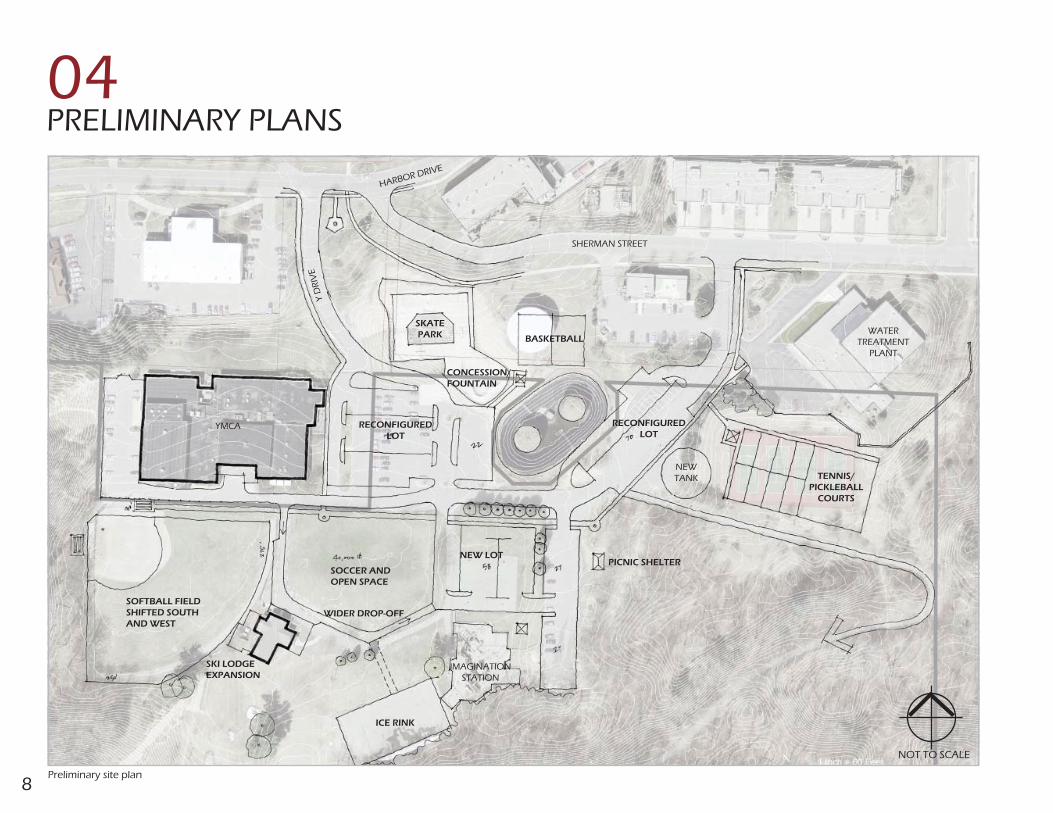
PRELIMINARY PLANS04
YMCA
SOFTBALL FIELD SHIFTED SOUTH AND WEST
SOCCER AND OPEN SPACE
ICE RINK
WIDER DROP-OFF
SKI LODGE EXPANSION
IMAGINATIONSTATION
NEW LOTPICNIC SHELTER
CONCESSION/FOUNTAIN
RECONFIGURED LOT
BASKETBALL
RECONFIGURED LOT
TENNIS/PICKLEBALL
COURTS
NEW TANK
WATERTREATMENT
PLANT
SHERMAN STREET
HARBOR DRIVE
Y D
RIV
ESKATEPARK
Preliminary site plan
NOT TO SCALE

9
One of the major concerns expressed during the working sessions was the conflict between pedestrians and vehicles at numerous locations throughout the park. As such, the master plan recommends the construction of a major pedestrian “spine”, extending from east to west, paralleling Mulligan’s Drive. This spine should be 10’ to 12’ wide to allow pedestrians to comfortably pass without being forced out into the street. Informational kiosks are recommended at the ends of this walkway for two reasons, 1) to provide recognizable markers for this major new component and 2) to provide a place where park activities can be posted. To highlight and bring further attention to this walk, walkway lighting and distinctive plantings could line one or both sides of this walk. Numerous connector walks from the main spine to all of the major activity areas will provide a distinct and complete pedestrian network. The reconfiguration of several of the existing parking lots, including the reorientation of parking angle, will further aid safe and direct pedestrian movement throughout the park.
PEDESTRIAN WALKWAYS
With input from the work session and subsequent meetings, the Design Team developed a suite of sketches showing possible design alternatives for Mulligan’s Hollow. The Preliminary Site Plan shows an elaboration of what were some of the more popular concepts, with several variations shown on the following pages.
The key driving factors behind these alternatives were the need to provide a safe and legible network of pedestrian walkways, create more space for parking while maintaining the natural character and beauty of the site, and to enhance as many of the recreational amenities as possible.
The following text describes the key core area features under design consideration, and the reasoning behind the final recommendations.
DRIVING FACTORS
Pedestrian “spine” along Mulligan Drive
Design Framework
YMCA
SKATE PARK
10’ - 12’ WIDE PEDESTRIAN “SPINE”
MULLIGAN DRIVE
KIOSK KIOSK
RECONFIGURED PARKING
RECONFIGURED PARKING

10
Parking at Mulligan’s Hollow has been stretched to the limit. There are 225 existing spaces and these spaces are filled to overflowing many times, especially at peak times. In addition, beach-goers have found this area to be a convenient parking alternative when the state park lots are full. As a result, parking also occurs in places that were not designed for parking: on the basketball courts and on the existing ice rink.
Numerous parking lot alternatives were examined and evaluated. Some are easy fixes and are recommended to be undertaken as soon as funding can be found. Others require certain other changes to be made for them to be feasible.
FIRST PRIORITY PARKING ENHANCEMENTSThe parking lot east of the YMCA is poorly configured and unsafe. All park traffic entering from Harbor Drive must pass immediately in front of the YMCA, which all YMCA patrons must cross to get to the building. In addition, parking for the skate park is commingled with general parking which increases the potential for accidents between skaters and moving vehicles. Moving the park entrance drive to the east, away from the front door of the YMCA, would help to alleviate both of these problems. While these changes will result in only a minor increase in total parking spaces, they are highly recommended to increase safety and convenience for park users.
Because the basketball courts are centrally located, they are many times used for parking. As such, the court surface is both cracked and worn and ball players are inconvenienced. For these reasons, it is recommended that the courts be relocated and the area where they are presently located be redeveloped into a formal parking lot. In addition, the parking lot located on the east side of the existing basketball courts and the Imagination Station should be slightly reconfigured to be more efficient. These two changes will result in a net increase of approximately 60 parking spaces (52 existing spaces/112 proposed spaces).
22 parking spaces are presently located east of the existing fuel tanks. Reconfiguring this area will result in an additional 11 spaces plus, it will allow a seamless transition into a much larger parking lot once the fuel tanks are removed.
PARKING LOT ENHANCEMENTS
IMAGINATIONSTATION
Existing traffic and parking east of YMCA
Parking lots north and west of Imagination StationParking lot east of the YMCA
Skate Park entrance
MULLIGAN DRIVE
YMCA
SKATEPARK
Winter parking problems
RECONFIGUREDPARKING LOT
Y D
RIV
E
MULLIGAN DRIVE
CURRENT BASKETBALL COURT LOCATION

11
LONGER TERM PARKING ENHANCEMENTSThe softball field happens to be located next to two key activity centers: the YMCA and the Ski Lodge, both of which have insufficient nearby parking during peak use periods. If the softball field were relocated, the area it occupies would be able to accommodate substantial additional convenient parking for users of these two major facilities. Such a move would result in the addition of approximately 150 additional parking spaces. At such time as the fuel tanks are removed, an additional 65 parking spaces can be added to this area.
Although there is a significant grade change between the proposed basketball court location and Sherman Street, room for an additional 29 parking spaces is available if a retaining wall and steps leading up to the proposed basketball courts location are added.
The parking lot located west of the YMCA building is a dead end lot with no way out except to backtrack around the south side of the YMCA building. If an easement could be obtained from the owners of the property to the north (US Coast Guard), a one-way exit drive could be built both to provide better vehicular circulation around the YMCA, and room for an additional 15-20 parking spaces.
Existing Parking Initial Plan Long Range Plan
Spaces Spaces Spaces
West of YMCA 33 Lot A 33 Lot A 33
East of YMCA 99 Lot B 79 Lot B 79
East of play area 53 Lot C 22 Lot D 29
East of fuel tanks 40 Lot E 33 Lot F 18
Lot F 18 Lot G 58
Lot G 58 Lot H 27
Lot H 27 Lot I 27
Lot I 27 Lot J 152
Lot K 15-20
Lot L 120
Total 225 Total 297 Total 558-563
Parking Summary (See pages 18 & 19 for parking lot locations)
SHERMAN STREET
NEWBASKETBALL
COURT
Parking lot in fuel tank area and on Sherman Street
YMCA
SKI LODGE
Parking lot south of YMCA
YMCA
Y D
RIV
E
North loop drive
SEASONAL ICE RINK
CURRENT LOCATION OF SOFTBALL FIELD
ADDITIONAL PARKING
RETAINING WALL
NORTH LOOP DRIVE
U.S. COAST GUARD

12
SOFTBALL FIELD
The softball field is a unique community recreational asset as it is the only lighted field available to adult recreation softball leagues. This makes it both very important for evening games and – because it is downtown - attractive to players and their fans due to its central location and proximity to other downtown attractions for pre- and post-game activities.
During the master planning effort, substantial time and effort was directed toward the present softball field and its future, including its possible move to alternative locations within and outside of Mulligan’s Hollow. Three possibilities were analyzed and discussed in detail.
Softball Field Remains in Its Present Location. A number of minor improvements are recommended if the softball field remains in its present location. Presently spectators and vehicles both share the driveway behind the YMCA. At a minimum, the softball field should be moved to the south sufficiently to allow safe spectator seating adjacent to this driveway. This shift would require that the right field fence be decreased to a distance of 250’ from home plate but by increasing the height of this fence, play would not be significantly affected. Dependent upon the locations of existing lights and trees, a corresponding move to the west would allow much of the existing outfield fence to remain in place. A low fence lining the driveway would reinforce the separation of spectators and vehicles.
Softball Field Moved Within Mulligan’s Hollow. If the softball field were to be moved from its present location to allow for an alternative use of this space, one possibility would be to move it to where the existing tennis courts are located. A field here would be approximately 12’ lower than Mulligan Drive allowing for “stadium” style seating and a grand overview of the playing field. Plenty of convenient parking will be available at such time as the fuel tanks are removed. Outfield distances would need to vary to allow the field to fit with the existing lay of the land but, as with the ball field shift discussed previously, increased fence heights would compensate for these lesser distances. To accommodate this move, the access road to the top of the hill would need to be relocated.
YMCA
SKI LODGE
NEW TANK
WATER TREATMENT
PLANT
Existing softball field with minimal space for spectators
Softball field shifted south and west of current location Softball field relocated south of N.O.W.S building
EXPANDED SPECTATOR SECTION
RETAINING WALL
MULL
IGAN
DRI
VE
RELOCATEDSOFTBALL FIELD

13
Since 2002, winter usage and community enjoyment of Mulligan’s Hollow has greatly increased. As a result, the need for a larger ski lodge, a garage, storage for equipment, additional convenient parking and improved vehicle/pedestrian circulation have become very apparent.
Previously prepared ski lodge building expansion plans depict a larger lounge and attached garage/storage that did not take into account the possibility that the main entrance might be relocated to the west side of the building. It is therefore recommended that the building expansion be confined to an increased lounge area and storage space necessary for ski lodge specific needs (supplies, ski storage, lodge maintenance items, etc.). Storage of larger equipment, snow makers and the like, should be stored remotely to reduce the impact on the open space around the ski lodge.
The Initial Improvements Plan includes a groomer garage on a portion of the existing ice skating area. This will allow ice skating to remain in this location on an interim basis. The Long Range Improvements Plan includes additional indoor and outdoor storage adjacent to the groomer garage.
If the softball field is relocated, room for increased parking as well as a convenient drop-off on the west side of the lodge, becomes an option. This arrangement would also allow for safe bus loading and unloading on the west side of the building. The loop drive that currently serves as the drop-off would revert to a pedestrian-only walkway since vehicles would no longer need to use it as a drive.
Softball Field Moved Off-Site. Another possibility would be for the softball field to be relocated from Mulligan’s Hollow altogether. While this move might be controversial, it would ease the parking needs within the park and allow for a state-of-the-art facility to be built at an alternative location with sufficient parking, bathrooms, etc. Harbor Island, Sluka field, and other locations have been mentioned as possibilities to explore with a preference to keeping the field within city limits. If a new softball complex is considered, it is recommended that the City and NORA coordinate dialogue and discussions with the larger community in the near future.
SKI LODGE
View of ski lodge from top of ski hill
Ski lodge with widened drive Ski lodge with increased parking and storage
SKI LODGE
SEASONAL ICE RINK
SHARED WIDENED DRIVE FOR VEHICLE /
PEDESTRIAN USE
SKI LODGE EXPANSION
SKI LODGE
SKI LODGE EXPANSION
GROOMER STORAGE
SEASONAL ICE RINK
GROOMER STORAGE
SKI AREA STORAGE/MAINTENANCE
ADDITIONAL PARKING

14
BASKETBALL COURTS
Once the existing water tank (the “big blue tank”) is removed, space becomes available for other park uses. This space is an ideal location for the relocated basketball courts, since the core user groups will tend to be similar in age to the users of the skate park. A location for a portable concession stand or vendor wagon plus a drinking fountain would be a welcome addition which would also reduce the need for users to walk to the YMCA or the Ski Lodge for refreshments.
Note that a fence on the north side of the courts will likely be necessary to keep basketballs from rolling down the hill into Sherman Street.
The present rink is viewed as an important but underutilized amenity. While it is easily flooded and partially shaded by the adjacent hill at certain times of the day, it is somewhat remotely located and therefore not as well used as it might be. Relocating this rink to the green space/soccer field in front of the Ski Lodge would make it much more visible, provide an interesting setting for the other winter activities, open up additional space for ski-related activities and improve its proximity to the parking lots. A rink at this location could be equal to or larger than the existing one, if so desired.
An ice rink at this location would probably need to be temporary since this space is used for soccer and other open field games at other times of the year. Temporary natural ice rinks, utilizing short knee walls and plastic liners to create a fairly large ice surface, are commonly installed in many other cities. While a 100’x 200’ area is indicated on the plan, it could be larger or smaller as determined to be necessary (the existing rink is 100’x 170’ in size). Skate rentals could potentially be utilized as a source of revenue.
ICE RINK
Soccer field and seasonal ice rink area
Seasonal ice rink near ski lodge Basketball courts in water tank area
SEASONAL ICE RINK
MULLIGAN DRIVE
SKILODGE
SHERMAN STREET
BASKETBALL COURTS
CONCESSION STAND
SKATEPARK

15
Pickleball has grown dramatically in popularity in the Grand Haven area and around the State over the past few years. Pickleball advocates have listed numerous reasons that pickleball courts are needed in Mulligan’s Hollow and would complement the array of other recreational opportunities. These reasons include the rapid growth of the sport, the lack of facilities in the Grand Haven area and the sheltered location.
Eight pickleball courts (enough for a tournament) can be accommodated at the location of the four existing tennis courts. The surface of the existing four courts can be reconfigured to accommodate 6 pickleball courts and two shared tennis/pickleball courts. Eight pickleball courts and two stand-along tennis courts can be accommodated if the courts are rebuilt and the surface is expanded and angled to the southeast.
While the plans included in this document depict a combination of uses on the existing/rebuilt tennis courts, it is possible for the courts to be striped exclusively for a single use. If the courts are rebuilt, it will be important that they be sized to accommodate both tennis and pickleball in case future priorities change.
As mentioned previously, a possible location for the softball field if it is moved from its current location behind the YMCA would be in this same valley. It is important that if the ball field were to be moved here, an eight court pickleball facility be developed in a comparable location elsewhere in the City.
PICKLEBALL COURTS
The entrance to the skate park is located immediately adjacent to an active parking lot, which means that the potential for accidents between skaters and moving vehicles is great. This situation will be further exacerbated once the park entrance drive is moved away from the entrance to the YMCA. As such, it is recommended that the main skate park entrance be relocated to the east side of the park, near where the basketball courts and a refreshment stand are proposed to be located, and that the existing entrance be retained but be used as a secondary alternative access only.
SKATE PARK
Typical combination tennis/pickleball courtExisting skate park
Pickleball and tennis courts or softball field south of N.O.W.S. building
WATER TANK
WATER TREATMENT PLANT
REBUILT TENNIS/ PICKLEBALL
COURTS
POTENTIAL RELOCATED SOFTBALL FIELD
MULL
IGAN D
RIVE

16
The entrance to Mulligan’s Hollow from Harbor Drive is somewhat confusing due to the close proximity of the Y Drive to Sherman Street. Moving the Sherman Street/Harbor Drive intersection to the west of the Veterans Memorial Plaza and having the Y Drive intersect with it rather than Harbor Drive would make the intersection safer and less confusing. In addition, it would allow for a much more gracious setting for the Veterans Memorial, create additional space to expand the park associated with the memorial, and if desired, provide space for additional civic memorials.
To accomplish this move, a retaining wall will likely be necessary around the northwest end of the skate park. This retaining wall could double as a sign wall and provide a perfect location for a major park identifier sign.
ENTRANCE DRIVE
SHERMAN STREET
Y D
RIV
E
HARBOR DRIVE
SKATE PARK
Entrance drive reconfiguration
Mature trees in picnic area
TRANSIT STOP
A dependable, regularly scheduled bus route through Mulligan’s Hollow would provide a strong alternative way to reach the Park and substantially ease the parking shortage. As such, it is strongly recommended that a transit stop be located in the park at a central location that is convenient for users from all of the activity areas.
VETERAN’S MEMORIAL
RETAINING WALL
Veterans Memorial
PICNICKING
The open lawn areas adjacent to the Imagination Station and the wooded area east of Parking Lots H and I are ideal locations for picnicking and/or relaxing. Additional picnic tables and grills and one or two picnic shelters are recommended for these areas. A few large trees in the open lawn areas and a simple shade structure near the Imagination Station will allow parents to watch their children from sheltered locations. In addition, a vegetated buffer, and possibly a low fence, between Parking Lot G and the Imagination Station is recommended to inhibit children from running into the parking lot.
Centrally located transit stop
SKATE PARK
SEASONAL ICE RINK
YMCA
SKI LODGE
IMAGINATION STATION
MULLIGAN DRIVE
TRANSIT STOP

17
As a highly popular destination for adventure, sport, relaxation, and enjoyment of natural beauty, Mulligan’s Hollow must adapt with the times so that it can be enjoyed by the residents of the City of Grand Haven and Northwest Ottawa County far into the future. The plans on the following pages depict a phased approach to achieving this goal.
CORE AREA IMPROVEMENTS
FINAL PLANS05
CORE STUDY CORE STUDY AREAAREA
MULLIGAN DRIVEMULLIGAN DRIVE
SLOPE PROTECTION AREASLOPE PROTECTION AREA
CRITICAL DUNE BOUNDARYCRITICAL DUNE BOUNDARY
SERVICE DRIVESERVICE DRIVE
POTENTIAL POTENTIAL CONNECTION TO CONNECTION TO DUNCAN WOODS DUNCAN WOODS PARKPARK
TRAIL ACCESS TRAIL ACCESS AREAAREA
POTENTIAL PARKING ZONEPOTENTIAL PARKING ZONE
TRAILTRAIL
TRAILSTRAILS
TRAILHEAD TRAILHEAD LOCATIONLOCATION
GRAND RIVERGRAND RIVER
S. HARBOR DRIVE S. HARBOR DRIVE
SHERMAN STREETSHERMAN STREET
Y D
RIV
EY
DR
IVE
LAKE MICHIGANLAKE MICHIGAN
NOT TO SCALENOT TO SCALE
DUNCAN WOODS DUNCAN WOODS PARKPARK
LAKE FOREST LAKE FOREST CEMETERYCEMETERY
LAKE AVENUE
LAKE AVENUE
LE
GG
AT
T S
TR
EE
TL
EG
GA
TT
ST
RE
ET
LA
KE
AV
EN
UE
LA
KE
AV
EN
UE
PROSPECT STREET
PROSPECT STREET
EMMET AVENUE
EMMET AVENUE
S. H
AR
BO
R D
RIV
E
S. H
AR
BO
R D
RIV
E
GRAND HAVENGRAND HAVENSTATE PARKSTATE PARK
MULLIGAN DRIVEMULLIGAN DRIVE
Slope ProtectionThe protection of the ecological and structural integrity of the slopes in the park is important. The open slope that extends from the observation deck at the end of Emmet Avenue and Prospect Street down to the Ski Lodge is used as an informal access into the park. The foot traffic has further eroded deer paths that criss-cross the slope, exposing the dune sand and making the slope susceptible to erosion. It is recommended that steps be taken to discourage this traffic and stabilize the slope.
Lake AvenueThe portion of the south property line of Mulligan’s Hollow that fronts on Lake Avenue provides an opportunity for secondary access into the park as well as a connection to Duncan Woods Park and Lake Forest Cemetery. Existing parking in this area is haphazard and inefficient. It is recommended that this parking area be formalized to increase parking capacity, improve safety, and more efficiently use this limited land resource. A fence running the length of the park to help keep dogs and other animals from wandering into Lake Avenue would be a good addition as well. Additional study is needed to determine the number of spaces and the layout for this parking.
Trails and Trail IdentificationAt present, there is an extensive informal network of walking trails laced throughout the Mulligan’s Hollow Park property. These trails are primarily used by walkers/hikers, dog walkers, cross country skiers, and State Park visitors.
In order to make these trails more user-friendly (especially for non-local tourists), we recommend these trails be accurately recorded/mapped (GIS plus ground-truthing by local hikers) and that a simple trail signage system, with a trail map, be introduced to provide basic wayfinding directions. This signage could include directional signs installed at key entry points and at key trail intersections within the Park.
Existing parking along Lake Avenue
General park improvements
GENERAL PARK IMPROVEMENTS
During the design process it was pointed out that off-leash dogs and dog waste are a significant problem in the park, particularly in the wooded areas. A defined dog walking area with biodegradable pet waste dispensers is recommended to alleviate this problem.
18
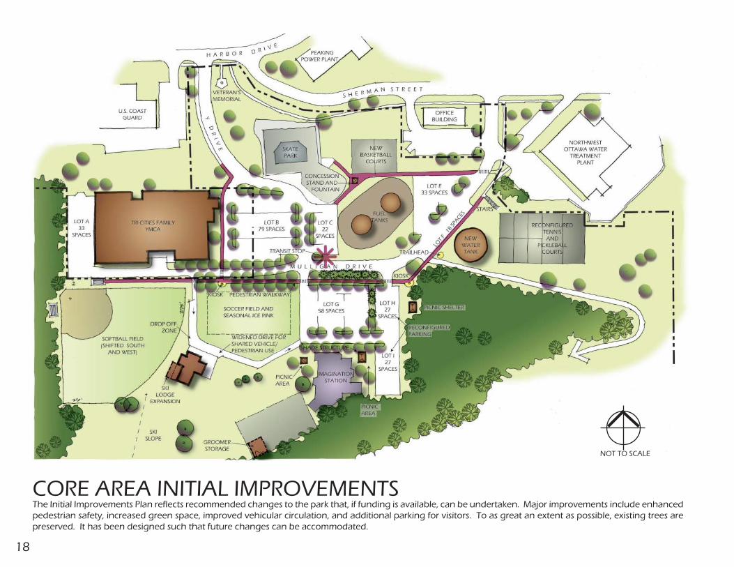
CORE AREA INITIAL IMPROVEMENTS
NOT TO SCALE
The Initial Improvements Plan reflects recommended changes to the park that, if funding is available, can be undertaken. Major improvements include enhanced pedestrian safety, increased green space, improved vehicular circulation, and additional parking for visitors. To as great an extent as possible, existing trees are preserved. It has been designed such that future changes can be accommodated.

19
CORE AREA LONG RANGE IMPROVEMENTS
NOT TO SCALE
The Long Range Improvement Plan illustrates a full build-out scenario that could be accomplished at such time as circumstances and priorities change. Key changes include the consolidation of Y Drive and Sherman Street at Harbor Drive, removal of the fuel tanks, and the relocation of the softball field.

20
SUMMARY OF IMPROVEMENTS06
INITIAL IMPROVEMENTS (0-2 YEARS)Pedestrian Enhancements 10’-12’ wide walkway “spine” 8’ wide connector walks 2 Kiosks Skateboard area including vendor cart area and drinking fountain Walkway trees and plantingsRecreational Enhancements New basketball courts including north fence Shifted softball field including improved sitting areas 1
Refurbished tennis/pickleball courts Relocated ice rink3
Ski Lodge Enhancements Groomer storage building Widened drive and additional drop-off space 4
Traffic Enhancements Y Drive relocation Mulligan Drive relocation Parking lot B including collector walk and trees Parking lot C including trees Parking lot E/F including collector walk and trees
INITIAL IMPROVEMENTS (3-5 YEARS)Recreational Enhancements Picnic shelters Shade shelter 2 Trailhead areas Nature trail signage5
Dog walking area6
Ski Lodge Enhancements Lodge expansion including additional gathering and storage spaceTraffic Enhancements Parking lot G including existing court removal and trees Parking lot H/I including additional trees Parking lot K including loop drive Lake Avenue parking improvements

21
LONG RANGE IMPROVEMENTSHarbor Drive/Sherman Street Intersection Relocation Including Y Drive reconfiguration, retaining wall, and new walksParking lot D including retaining wall and stepsParking lot J including ski lodge drop-off area, softball area removalParking lot L including plantingsSki Lodge Enhancements Including connector walks, new storage building, and storage yardSoftball Field Complete relocation south of the N.O.W.S. treatment plant or off-site 2
Rebuild Tennis/Pickleball Courts
Notes:1. Shifted softball field includes new/relocated fencing, rebuilt infield, and improved
sitting areas.2. Softball field complete relocation does not include demolition, tree removal, grading,
utilities, stadium seating or lighting.3. Relocated ice rink uses natural ice and includes rink liner and short knee wall.4. Widened drive at ski lodge includes paved pedestrian areas and widened/realigned
drive.5. Nature trail signage includes a total of 8 signs located at the beginning and
intersections of trails.6. Dog walking area includes 4 dog waste stations including waste can, sign, and
waste bag holder. Fencing along Lake Avenue included.
October 2011