multi-jurisdictional natural hazards mitigation plan county developed this multi-jurisdictional...
TRANSCRIPT
Prepared for: Lincoln County, Depoe Bay, Lincoln City, Newport, Siletz,Toledo, Waldport, Yachats, Central Lincoln PUD, and Seal Rock Water District
Multi-Jurisdictional Natural Hazards Mitigation Plan Lincoln County
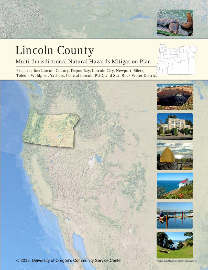
© 2015, University of Oregon’s Community Service Center Photos: Gary Halvorson, Oregon State Archives

LINCOLN COUNTY
MULTI-JURISDICTIONAL
NATURAL HAZARDS MITIGATION PLAN
Prepared for:
Lincoln County
Depoe Bay
Lincoln City
Newport
Siletz
Toledo
Waldport
Yachats
Central Lincoln People’s Utility District
Seal Rock Water District
Prepared by:
Oregon Partnership for Disaster Resilience
Community Service Center 1209 University of Oregon
Eugene, Oregon 97403-1209
June 2015
Revised September 2017

This Natural Hazard Mitigation Plan was prepared by:
With support from:
Planning grant funding provided by:
Federal Emergency Management Agency (FEMA) Pre-Disaster Mitigation Program
Grant: EMS-2014-PC-0005 Sub-grant Application Reference: PDMC-PL-10-OR-2013-001
Additional Support Provided by:
This material is a result of tax-supported research and, as such, is not copyrightable. It may be freely reprinted with the customary crediting of the source.
SPECIAL THANKS & ACKNOWLEDGEMENTS
Lincoln County developed this Multi-jurisdictional Natural Hazards Mitigation Plan (NHMP) through a regional partnership funded by the Federal Emergency Management Agency’s Pre-Disaster Mitigation Competitive Grant Program. FEMA awarded the Lincoln County grant to support the update of the natural hazards mitigation plan. The county’s planning process utilized a four-phased planning process, plan templates and plan development support provided by the Oregon Partnership for Disaster Resilience (OPDR) at the University of Oregon’s Community Service Center. This project would not have been possible without technical and in-kind staff support provided by Lincoln County and the cities of Nyssa, Ontario and Vale.
Partners include:
Lincoln County FEMA Region X
City of Depoe Bay Lincoln City
City of Newport City of Siletz
City of Toledo City of Waldport
City of Yachats
Oregon Military Department – Office of Emergency Management
Community Service Center, Oregon Partnership for Disaster Resilience
Project Steering Committee:
Lincoln County
Representatives from the following organizations served as steering committee members for the Lincoln County natural hazards mitigation planning process.
Convener, Jenny Demaris Emergency Manager, Lincoln County Sheriff’s Office, Emergency Management
Convener, Onno Husing Director of Planning and Development, Lincoln County
Don Baker Fire Chief, North Lincoln Fire and Rescue
Michael Curran Wildland Fire Supervisor, Oregon Department of Forestry
Adam Denlinger General Manager, Seal Rock Water District
Tony Garbarino Sergeant/ Emergency Management Coordinator, City of Newport Police Department
Sue Graves Safety Coordinator, Lincoln County School District
Steve Hodge County Engineer, Lincoln County Road Department
Julie Kay Operations Supervisor, Lincoln County Transit
Curtis Landers Lieutenant, Lincoln County Sheriff’s Office
Kerry deLisser-Shanks EM Assistant, Lincoln County Sheriff’s Office, Emergency Management
Deb Martzahn-Nicholson Planner, City of Lincoln City
Gail Malcolm Project Manager, Central Lincoln PUD
Pery Murray City Recorder, City of Depoe Bay
Neal Myers GIS Supervisor, Central Lincoln PUD
Mark Nicholson Emergency Management Coordinator, City of Lincoln City
Jerry Palmer Lieutenant, Lincoln City Police Department
Frankie Patrick Chief, Yachats Rural Fire Protection District
Ron Potter Volunteer, Seal Rock Rural Fire Protection District
Chris Rampley Fire Prevention Office, City of Newport Fire Department
Hui Rodomsky Associate Planner, Lincoln County Planning and Development
Joshua Shaklee Associate Planner, Lincoln County Planning and Development
Derrick Tokos Community Development Director, City of Newport
Brady Weidner Public Works Manager, City of Depoe Bay
City of Depoe Bay
Convener, Larry Lewis Planner
Pery Murray Budget Officer
Brady Weidner Public Works Manager
Lincoln City
Convener, Mark Nicholson Emergency Preparedness Coordinator
Debra Martzahn-Nicholson Senior Planner
David Moss Emergency Outreach Coordinator
Sandy Gruber GIS
Lila Bradley Public Works Director
Keith Kilian Chief of Police
Jerry Palmer Police Lieutenant
City of Newport
Convener, Derrick Tokos Community Development Director
Mark Miranda Police Chief
Spencer Nebel City Manager
Timothy Gross Public Works Director
Thomas Jackson Fire Department Captain
City of Siletz
Convener, Sheryl Simmons City Recorder
Joshua Shaklee County Planner
Jessica Bondy County Planner
City of Toledo
Convener, William Ewing Fire Chief
Jay Baughman City Manager
Tony Monroe Training Division Chief (Fire)
Arlene Inukai Planning Technician/ Assistant Planner
City of Waldport
Convener, Larry Lewis Planner
Kerry Kemp City Manager
Reda Eckerman City Recorder
City of Yachats
Convener, Larry Lewis Planner
Bob Bennett Public Works and Streets Commission
Walt Weyand Public Works and Streets Commission
Larry Nixon Public Works and Streets Commission
Larry Blanchard Public Works Director
Project Managers:
Michael Howard, AICP, CFM, Program Specialist, Oregon Partnership for Disaster Resilience
Jenny Demaris, Emergency Manager, Lincoln County Sheriff’s Office, Emergency Management
Onno Husing, Director of Planning and Development, Lincoln County
Community Service Center Staff:
Bob Parker, AICP, Director of the Community Service Center and Community Planning Workshop, University of Oregon
Josh Bruce, AICP, Interim Director, Oregon Partnership for Disaster Resilience
Julie Foster, Grants Administrator, Community Service Center
Julie Havens, Office Coordinator, Community Service Center
About the Community Service Center
The Community Service Center (CSC), a research center affiliated with the Department of Planning, Public Policy, and Management at the University of Oregon, is an interdisciplinary organization that assists Oregon communities by providing planning and technical assistance to help solve local issues and improve the quality of life for Oregon residents. The role of the CSC is to link the skills, expertise, and innovation of higher education with the transportation, economic development, and environmental needs of communities and regions in the State of Oregon, thereby providing service to Oregon and learning opportunities to the students involved.
About the Oregon Partnership for Disaster Resilience
The Oregon Partnership for Disaster Resilience (OPDR) is a coalition of public, private, and professional organizations working collectively toward the mission of creating a disaster-resilient and sustainable state. Developed and coordinated by the Community Service Center at the University of Oregon, the OPDR employs a service-learning model to increase community capacity and enhance disaster safety and resilience statewide.
Plan Template Disclaimer
This Natural Hazards Mitigation Plan is based in part on a plan template developed by the Oregon Partnership for Disaster Resilience. The template is structured to address the requirements contained in 44 CFR 201.6; where language is applicable to communities throughout Oregon, OPDR encourages the use of standardized language. As part of this regional planning initiative, OPDR provided copies of the plan templates to communities for use in developing or updating their natural hazards mitigation plans. OPDR hereby authorizes the use of all content and language provided to Jackson County in the plan template.
LINCOLN COUNTY
MULTI-JURISDICTIONAL
NATURAL HAZARDS MITIGATION PLAN
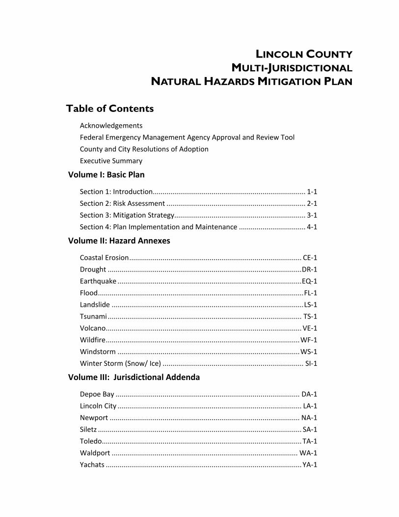
Table of Contents
Acknowledgements
Federal Emergency Management Agency Approval and Review Tool
County and City Resolutions of Adoption
Executive Summary
Volume I: Basic Plan
Section 1: Introduction.............................................................................. 1-1
Section 2: Risk Assessment ....................................................................... 2-1
Section 3: Mitigation Strategy................................................................... 3-1
Section 4: Plan Implementation and Maintenance .................................. 4-1
Volume II: Hazard Annexes
Coastal Erosion ........................................................................................ CE-1
Drought ................................................................................................... DR-1
Earthquake .............................................................................................. EQ-1
Flood ......................................................................................................... FL-1
Landslide .................................................................................................. LS-1
Tsunami ................................................................................................... TS-1
Volcano .................................................................................................... VE-1
Wildfire ................................................................................................... WF-1
Windstorm ............................................................................................. WS-1
Winter Storm (Snow/ Ice) ........................................................................ SI-1
Volume III: Jurisdictional Addenda
Depoe Bay .............................................................................................. DA-1
Lincoln City .............................................................................................. LA-1
Newport ................................................................................................. NA-1
Siletz ........................................................................................................ SA-1
Toledo ...................................................................................................... TA-1
Waldport ............................................................................................... WA-1
Yachats .................................................................................................... YA-1

Volume IV: Mitigation Resources
Appendix A: Action Item Forms ................................................................ A-1
Appendix B: Planning and Public Process ................................................. B-1
Appendix C: Community Profile ............................................................... C-1
Appendix D: Economic Analysis of Natural Hazard Mitigation Projects ... D-1
Appendix E: Grant Programs and Resources ............................................ E-1
Appendix F: Risk MAP Implementation Report ....................................... F-1
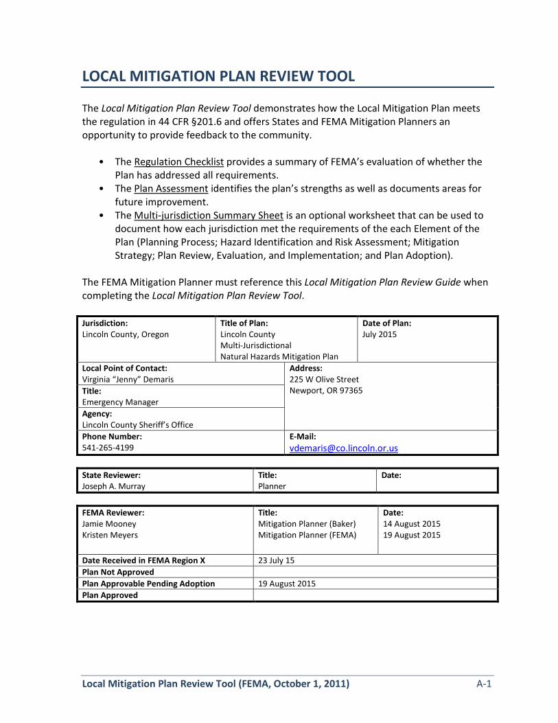
Local Mitigation Plan Review Tool (FEMA, October 1, 2011) A-1
LOCAL MITIGATION PLAN REVIEW TOOL The Local Mitigation Plan Review Tool demonstrates how the Local Mitigation Plan meets the regulation in 44 CFR §201.6 and offers States and FEMA Mitigation Planners an opportunity to provide feedback to the community.
• The Regulation Checklist provides a summary of FEMA’s evaluation of whether the Plan has addressed all requirements.
• The Plan Assessment identifies the plan’s strengths as well as documents areas for future improvement.
• The Multi-jurisdiction Summary Sheet is an optional worksheet that can be used to document how each jurisdiction met the requirements of the each Element of the Plan (Planning Process; Hazard Identification and Risk Assessment; Mitigation Strategy; Plan Review, Evaluation, and Implementation; and Plan Adoption).
The FEMA Mitigation Planner must reference this Local Mitigation Plan Review Guide when completing the Local Mitigation Plan Review Tool. Jurisdiction: Lincoln County, Oregon
Title of Plan: Lincoln County Multi-Jurisdictional Natural Hazards Mitigation Plan
Date of Plan: July 2015
Local Point of Contact: Virginia “Jenny” Demaris
Address: 225 W Olive Street Newport, OR 97365 Title:
Emergency Manager Agency: Lincoln County Sheriff’s Office Phone Number: 541-265-4199
E-Mail: [email protected]
State Reviewer: Joseph A. Murray
Title: Planner
Date:
FEMA Reviewer: Jamie Mooney Kristen Meyers
Title: Mitigation Planner (Baker) Mitigation Planner (FEMA)
Date: 14 August 2015 19 August 2015
Date Received in FEMA Region X 23 July 15 Plan Not Approved Plan Approvable Pending Adoption 19 August 2015 Plan Approved
A-2 Local Mitigation Plan Review Tool (FEMA, October 1, 2011)
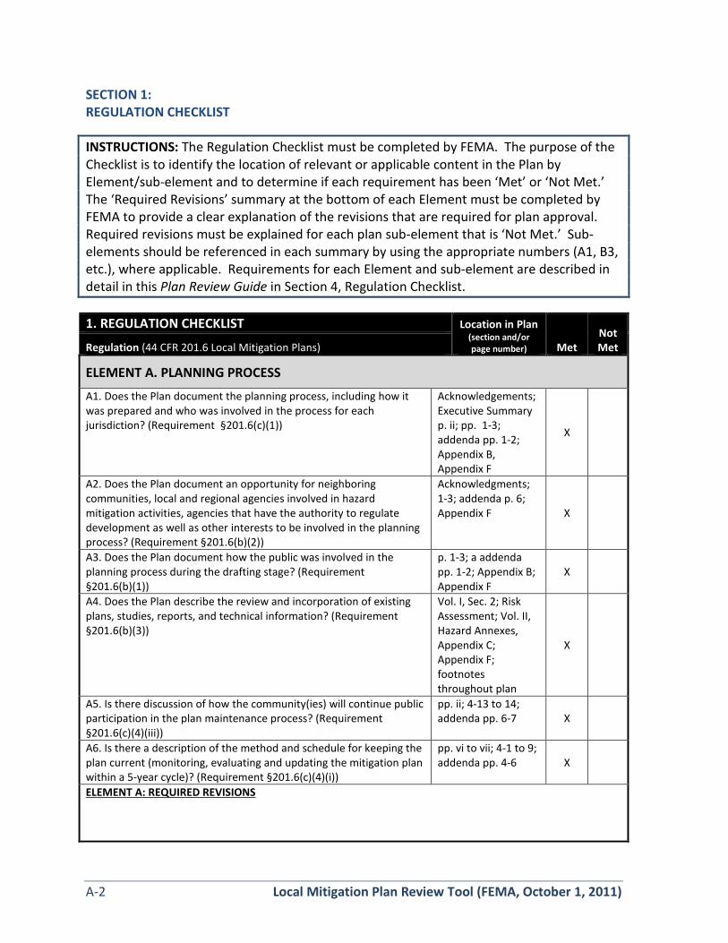
SECTION 1: REGULATION CHECKLIST
INSTRUCTIONS: The Regulation Checklist must be completed by FEMA. The purpose of the Checklist is to identify the location of relevant or applicable content in the Plan by Element/sub-element and to determine if each requirement has been ‘Met’ or ‘Not Met.’ The ‘Required Revisions’ summary at the bottom of each Element must be completed by FEMA to provide a clear explanation of the revisions that are required for plan approval. Required revisions must be explained for each plan sub-element that is ‘Not Met.’ Sub-elements should be referenced in each summary by using the appropriate numbers (A1, B3, etc.), where applicable. Requirements for each Element and sub-element are described in detail in this Plan Review Guide in Section 4, Regulation Checklist. 1. REGULATION CHECKLIST Location in Plan
(section and/or page number) Met
Not Met Regulation (44 CFR 201.6 Local Mitigation Plans)
ELEMENT A. PLANNING PROCESS
A1. Does the Plan document the planning process, including how it was prepared and who was involved in the process for each jurisdiction? (Requirement §201.6(c)(1))
Acknowledgements; Executive Summary p. ii; pp. 1-3; addenda pp. 1-2; Appendix B, Appendix F
X
A2. Does the Plan document an opportunity for neighboring communities, local and regional agencies involved in hazard mitigation activities, agencies that have the authority to regulate development as well as other interests to be involved in the planning process? (Requirement §201.6(b)(2))
Acknowledgments; 1-3; addenda p. 6; Appendix F X
A3. Does the Plan document how the public was involved in the planning process during the drafting stage? (Requirement §201.6(b)(1))
p. 1-3; a addenda pp. 1-2; Appendix B; Appendix F
X
A4. Does the Plan describe the review and incorporation of existing plans, studies, reports, and technical information? (Requirement §201.6(b)(3))
Vol. I, Sec. 2; Risk Assessment; Vol. II, Hazard Annexes, Appendix C; Appendix F; footnotes throughout plan
X
A5. Is there discussion of how the community(ies) will continue public participation in the plan maintenance process? (Requirement §201.6(c)(4)(iii))
pp. ii; 4-13 to 14; addenda pp. 6-7 X
A6. Is there a description of the method and schedule for keeping the plan current (monitoring, evaluating and updating the mitigation plan within a 5-year cycle)? (Requirement §201.6(c)(4)(i))
pp. vi to vii; 4-1 to 9; addenda pp. 4-6 X
ELEMENT A: REQUIRED REVISIONS

Local Mitigation Plan Review Tool (FEMA, October 1, 2011) A-3
ELEMENT B. HAZARD IDENTIFICATION AND RISK ASSESSMENT
B1. Does the Plan include a description of the type, location, and extent of all natural hazards that can affect each jurisdiction(s)? (Requirement §201.6(c)(2)(i))
pp. 2-5 to 7, Volume II, Hazard Annexes; DA-15 to 23, LA-19 to 38, NA-18 to 37, SA-15 to 29, TA-17 to 33, WA-16 to 36, YA-16 to 35
X
B2. Does the Plan include information on previous occurrences of hazard events and on the probability of future hazard events for each jurisdiction? (Requirement §201.6(c)(2)(i))
pp. 2-2 to 18; Volume II, Hazard Annexes; DA-15 to 23, LA-19 to 38, NA-18 to 37, SA-15 to 29, TA-17 to 33, WA-16 to 36, YA-16 to 35
X
B3. Is there a description of each identified hazard’s impact on the community as well as an overall summary of the community’s vulnerability for each jurisdiction? (Requirement §201.6(c)(2)(ii))
pp. 2-9 to 17; Volume II, Hazard Annexes, pp II-30 to 31; DA-15 to 23, LA-19 to 38, NA-18 to 37, SA-15 to 29, TA-17 to 33, WA-16 to 36, YA-16 to 35
X
B4. Does the Plan address NFIP insured structures within the jurisdiction that have been repetitively damaged by floods? (Requirement §201.6(c)(2)(ii))
pp. 2-13 to 16; Volume II, Hazard Annexes, pp FL-5 to 8; DA 23-24, LA 29-30, NA 28-29, SA 22, TA 25-26, WA 26-27, YA 25-26
X
ELEMENT B: REQUIRED REVISIONS
ELEMENT C. MITIGATION STRATEGY
C1. Does the plan document each jurisdiction’s existing authorities, policies, programs and resources and its ability to expand on and improve these existing policies and programs? (Requirement §201.6(c)(3))
pp. 3-2 to 3; 4-3 to 4-9; Volume II, Hazard Annexes; addenda pp. 4-8
X
C2. Does the Plan address each jurisdiction’s participation in the NFIP and continued compliance with NFIP requirements, as appropriate? (Requirement §201.6(c)(3)(ii))
pp. 2-13 to 16; Volume II, Hazard Annexes, pp FL-5 to 8; DA 23-24, LA 29-30, NA 28-29, SA 22, TA 25-26, WA 26-27, YA 25-26
X
C3. Does the Plan include goals to reduce/avoid long-term vulnerabilities to the identified hazards? (Requirement §201.6(c)(3)(i))
pp. 3-2; repeated in executive summary and addenda
X
A-4 Local Mitigation Plan Review Tool (FEMA, October 1, 2011)
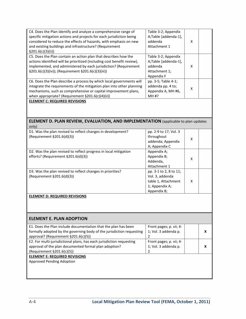
C4. Does the Plan identify and analyze a comprehensive range of specific mitigation actions and projects for each jurisdiction being considered to reduce the effects of hazards, with emphasis on new and existing buildings and infrastructure? (Requirement §201.6(c)(3)(ii))
Table 3-2; Appendix A;Table [addenda-1], addenda Attachment 1
X
C5. Does the Plan contain an action plan that describes how the actions identified will be prioritized (including cost benefit review), implemented, and administered by each jurisdiction? (Requirement §201.6(c)(3)(iv)); (Requirement §201.6(c)(3)(iii))
Table 3-2; Appendix A;Table [addenda-1], addenda Attachment 1; Appendix F
X
C6. Does the Plan describe a process by which local governments will integrate the requirements of the mitigation plan into other planning mechanisms, such as comprehensive or capital improvement plans, when appropriate? (Requirement §201.6(c)(4)(ii))
pp. 3-5; Table 4-1; addenda pp. 4 to; Appendix A, MH #6, MH #7
X
ELEMENT C: REQUIRED REVISIONS
ELEMENT D. PLAN REVIEW, EVALUATION, AND IMPLEMENTATION (applicable to plan updates only) D1. Was the plan revised to reflect changes in development? (Requirement §201.6(d)(3))
pp. 2-9 to 17; Vol. 3 throughout addenda; Appendix A; Appendix C
X
D2. Was the plan revised to reflect progress in local mitigation efforts? (Requirement §201.6(d)(3))
Appendix A; Appendix B; Addenda, Attachment 1
X
D3. Was the plan revised to reflect changes in priorities? (Requirement §201.6(d)(3))
pp. 3-1 to 2, 8 to 11; Vol. 3, addenda table 1, Attachment 1; Appendix A; Appendix B;
X
ELEMENT D: REQUIRED REVISIONS
ELEMENT E. PLAN ADOPTION
E1. Does the Plan include documentation that the plan has been formally adopted by the governing body of the jurisdiction requesting approval? (Requirement §201.6(c)(5))
Front pages; p. vii; 4-1; Vol. 3 addenda p. 2
X
E2. For multi-jurisdictional plans, has each jurisdiction requesting approval of the plan documented formal plan adoption? (Requirement §201.6(c)(5))
Front pages; p. vii; 4-1; Vol. 3 addenda p. 2
X
ELEMENT E: REQUIRED REVISIONS Approved Pending Adoption

Local Mitigation Plan Review Tool (FEMA, October 1, 2011) A-5
ELEMENT F. ADDITIONAL STATE REQUIREMENTS (OPTIONAL FOR STATE REVIEWERS ONLY; NOT TO BE COMPLETED BY FEMA) F1.
F2.
ELEMENT F: REQUIRED REVISIONS

A-6 Local Mitigation Plan Review Tool (FEMA, October 1, 2011)
SECTION 2: PLAN ASSESSMENT A. Plan Strengths and Opportunities for Improvement This section provides a discussion of the strengths of the plan document and identifies areas where these could be improved beyond minimum requirements. Element A: Planning Process Strengths: The plan is well organized and directly addresses the requirements, making it clear to the reviewer how actions were changed or re-prioritized as compared to the previous plan. Very comprehensive. Table C-35 highlighting existing plans and connection to the hazard mitigation plan is exactly what the requirement intends. Great incorporation of RiskMAP information and survey into the plan. Opportunities for Improvement: Since you received zero public comments via the OPDR project page, perhaps the next plan update could consider receiving feedback in different ways, such as attending various in-person meetings in conjunction with other events, or soliciting feedback on the current plan during a time of heightened community awareness, like during a winter flood or severe storm. Element B: Hazard Identification and Risk Assessment Strengths: The comprehensive worksheet provided to jurisdictions allows for a comprehensive risk assessment and mitigation strategy prioritization. Great to see that a mitigation action for Lincoln City is to integrate the NHMP into the Comprehensive Plan.
Opportunities for Improvement: Incorporating the Risk Report information from the Risk MAP process will significantly strengthen and address your hazard profiles. It is also a primary purpose of Risk Reports to be included in the hazard mitigation plan. Since the timing didn’t work out in this case, perhaps adding an appendix to this plan once the Final Risk Report is issued will ensure that that information will be included in the next update.
Element C: Mitigation Strategy Strengths: Table ES-2 clearly shows highest priority action items and clearly delineates those that are new and those that are continuing from the previous plan. Table 4-1 paints a cross-cutting picture of how the NHMP and other community plans intersect in a way that aims to reduce risk.
Opportunities for Improvement: Incorporating costs into individual mitigation actions and attempting a cost benefit would help prioritize according to costs. The only clear prioritization is whether or not the “high priority” box is checked on the worksheet.
Local Mitigation Plan Review Tool (FEMA, October 1, 2011) A-7
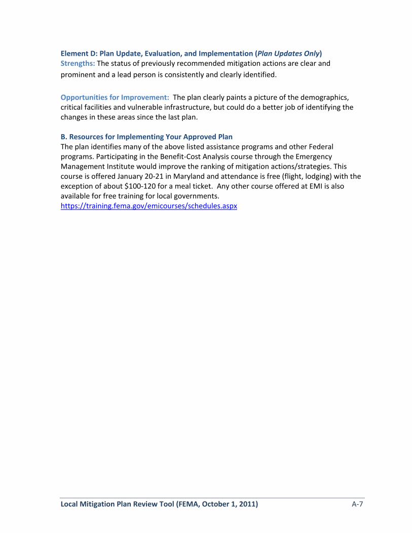
Element D: Plan Update, Evaluation, and Implementation (Plan Updates Only) Strengths: The status of previously recommended mitigation actions are clear and prominent and a lead person is consistently and clearly identified.
Opportunities for Improvement: The plan clearly paints a picture of the demographics, critical facilities and vulnerable infrastructure, but could do a better job of identifying the changes in these areas since the last plan. B. Resources for Implementing Your Approved Plan The plan identifies many of the above listed assistance programs and other Federal programs. Participating in the Benefit-Cost Analysis course through the Emergency Management Institute would improve the ranking of mitigation actions/strategies. This course is offered January 20-21 in Maryland and attendance is free (flight, lodging) with the exception of about $100-120 for a meal ticket. Any other course offered at EMI is also available for free training for local governments. https://training.fema.gov/emicourses/schedules.aspx

SECTION 3: MULTI-JURISDICTION SUMMARY SHEET INSTRUCTIONS: For multi-jurisdictional plans, a Multi-jurisdiction Summary Spreadsheet may be completed by listing each participating jurisdiction, which required Elements for each jurisdiction were ‘Met’ or ‘Not Met,’ and when the adoption resolutions were received. This Summary Sheet does not imply that a mini-plan be developed for each jurisdiction; it should be used as an optional worksheet to ensure that each jurisdiction participating in the Plan has been documented and has met the requirements for those Elements (A through E).
MULTI-JURISDICTION SUMMARY SHEET
# Jurisdiction Name
Jurisdiction Type
(city/borough/ township/
village, etc.)
Plan POC Mailing Address Email Phone
Requirements Met (Y/N) A.
Planning Process
B. Hazard
Identification & Risk
Assessment
C. Mitigation Strategy
D. Plan Review, Evaluation &
Implementation
E. Plan
Adoption
F. State
Require-ments
1 Lincoln County
County Y Y Y Y N N/A
2 Depoe Bay City
Y Y Y Y N N/A
3 Lincoln City City
Y Y Y Y N N/A
4 Newport City
Y Y Y Y N N/A
5 Siletz City
Y Y Y Y N N/A
6 Toledo City
Y Y Y Y N N/A
7 Waldport City
Y Y Y Y N N/A
8 Yachats City
Y Y Y Y N N/A
Note: Missing attendee sign in from town of Siletz Meeting Dec 3 and Feb 20.


-
RESOLUTION NO. 1368
A RESOLUTIO ADOPTI 'G TIlE CITY OF TOLEDO'S REPRESENTATION I THEUPDATES TO THE Ll COLN COU TY MULTI-JURISDICTIONAL NATURAL
HAZARDS MITIGATION PLAN
WHEREAS. the City of Toledo recognizes the threat that natural hazards pose to people.property and infrastructure within our community: and
WHEREAS. undertaking hazard mitigation actions will reduce the potential for hann to people,property and infrastructure from future hazard occurrences: and
\VHEREAS, an adopted aturnl Hazards Mitigation Plan (NHMP) is required as a condition offuture funding for mitigation projects under multiple FEMA pre- and post-disaster mitigationgrant programs; and
WHEREAS, the City of Toledo has fully participated in the FEMA prescribed mitigationplanning process to prepare the Lincoln COlln/y. Multi-Jurisdictional Nalural Ha=ard MitigationPlan. which has established a comprehensive. coordinated planning process to eliminate orminimize these vulnerabilities: and
\VHEREAS, the City of Toledo has identified natural hazard risks and prioritized a number ofproposed actions and programs needed to mitigate the vulnerabilities of the City of Toledo to theimpacts of future disasters within the Lincoln County. Multi-Jurisdictional Natural Ha=ardMitigation Plan: and
WHEREAS. these proposed projects and programs have been incorporated into the LincolnCounty. Multi-Jurisdictional Nawral Ha=ard Mitigation Plan that has been prepared andpromulgated for consideration and implementation by the cities of Lincoln County; and
WHEREAS. the Oregon Office of Emergency Management and Federal EmergencyManagement Agency. Region X officials have reviewed the Lincoln COllnty. Multi-JurisdictionalNawral Ha=ard Mitigation Plan and pre-approved it (dated August 19.2015) contingent uponthis official adoption of the participating governments and entities: and
WHEREAS, the NHMP is comprised of four main elements: Basic Plan, I-Iazard Annex. CityAddenda, and Mitigation Resources. collectively referred to herein as the NI-IMP: and
WHEREAS, the HMP is in an on-going cycle of development and revision to improve it'selTectiveness: and
WHEREAS. City of Toledo adopts the NHMP and direcls the City Manager to develop.approve. and implement the mitigation strategies and any administrative changes to the I-IMP.
OW, THEREFORE, BE IT RESOLVED:
Section 1. The City of Toledo adopts Ihe Lincoln County Mulli-Jurisdictional Natural
Resolution No. 1368September 2. 2015Page I

Hazards MitigaOon Plan as an omcial plan; and
Section 2. The Cit)' of Toledo will submit this Adoption Resolution to the Oregon Officeof Emergency Management and Federal Emergency Management Agency. Region X officials toenable final approval of the Lincoln County Multi-Jurisdiclional Nalural Ha::ards MitigationPlan.
PASSED by the City Council on this
2nd day of September. 2015.
ATTEST:
Resolution No. 1368September 2, 2015Page 2
APPROVED by the Mayor on this
2nd day of September. 2015.
APPROVED:
-


Lincoln County MNHMP July 2015 revised 2017 Page i
EXECUTIVE SUMMARY
Lincoln County developed this Multi-jurisdictional Natural Hazards Mitigation Plan (MNHMP) in an effort to prepare for the long-term effects resulting from natural hazards. It is impossible to predict exactly when these hazards will occur, or the extent to which they will affect the community. However, with careful planning and collaboration among public agencies, private sector organizations, and citizens within the community, it is possible to create a resilient community that will benefit from long-term recovery planning efforts.
The Federal Emergency Management Agency (FEMA) defines mitigation as “. . . the effort to reduce loss of life and property by lessening the impact of disasters . . . through risk analysis, which results in information that provides a foundation for mitigation activities that reduce risk.” Said another way, natural hazard mitigation is a method of permanently reducing or alleviating the losses of life, property, and injuries resulting from natural hazards through long and short-term strategies. Example strategies include policy changes, such as updated ordinances, projects, such as seismic retrofits to critical facilities; and education and outreach to targeted audiences, such as Spanish speaking residents or the elderly. Natural hazard mitigation is the responsibility of the “Whole Community” - individuals, private businesses and industries, state and local governments, and the federal government.
Why Develop this Mitigation Plan?
In addition to establishing a comprehensive community-level mitigation strategy, the Disaster Mitigation Act of 2000 (DMA2K) and the regulations contained in 44 CFR 201 require that jurisdictions maintain an approved NHMP in order to receive federal funds for mitigation projects. Local and federal approval of this plan ensures that the county and listed jurisdictions will remain eligible for pre- and post-disaster mitigation project grants.
Who Participated in Developing the Plan?
The Lincoln County Multi-jurisdictional Natural Hazards Mitigation Plan (MNHMP or NHMP) is the result of a collaborative effort between the county, cities, special districts, citizens, public agencies, non-profit organizations, the private sector and regional organizations. A project steering committee guided the plan development process.
44 CFR 201.6(a)(1) – A local government must have a mitigation plan approved pursuant to this section in order to receive HMGP project grants . . .
44 CFR 201.6 – The local mitigation plan is the representation of the jurisdiction’s commitment to reduce risks from natural hazards, serving as a guide for decision makers as they commit resources to reducing the effects of natural hazards. . . .

Page ii July 2015 revised 2017 Lincoln County MNHMP
The project steering committee included representatives from the following jurisdictions and agencies:
• Lincoln County
• City of Depoe Bay
• Lincoln City
• City of Newport
• City of Siletz
• City of Toledo
• City of Waldport
• City of Yachats
• Central Lincoln People’s Utility District
• Lincoln County School District
• Lincoln County Transit
• North Lincoln Fire and Rescue
• Oregon Department of Forestry
• Seal Rock Rural Fire Protection District
• Seal Rock Water District
The Lincoln County Emergency Manager and Planning and Development Director convened the planning process and will take the lead in implementing, maintaining and updating the plan. Lincoln County is dedicated to directly involving the public in the continual review and update of the natural hazards mitigation plan. Although members of the steering committee represent the public to some extent, the public will also have the opportunity to continue to provide feedback about the plan throughout the implementation and maintenance period.
The county will ensure continued public involvement by posting the Lincoln County Multi-jurisdictional Natural Hazards Mitigation Plan on the county’s website. The plan will also be archived and posted on the University of Oregon Libraries’ Scholar’s Bank Digital Archive.
How Does this Mitigation Plan Reduce Risk?
The natural hazards mitigation plan is intended to assist Lincoln County reduce the risk from natural hazards by identifying resources, information, and strategies for risk reduction. It is also intended to guide and coordinate mitigation activities throughout the county. A risk assessment consists of three phases: hazard identification, vulnerability assessment, and risk analysis, as illustrated in the following graphic.
44 CFR 201.6(c)(1) – Documentation of the planning process used to develop the plan, including how it was prepared, who was involved in the process, and how the public was involved.
44 CFR 201.6(c)(2) – A Risk Assessment that provides the factual basis for activities proposed in the strategy . . .

Lincoln County MNHMP July 2015 revised 2017 Page iii
Figure ES-1 Understanding Risk
Source: Oregon Partnership for Disaster Resilience.
By identifying and understanding the relationship between natural hazards, vulnerable systems, and existing capacity, Lincoln County is better equipped to identify and implement actions aimed at reducing the overall risk to natural hazards.
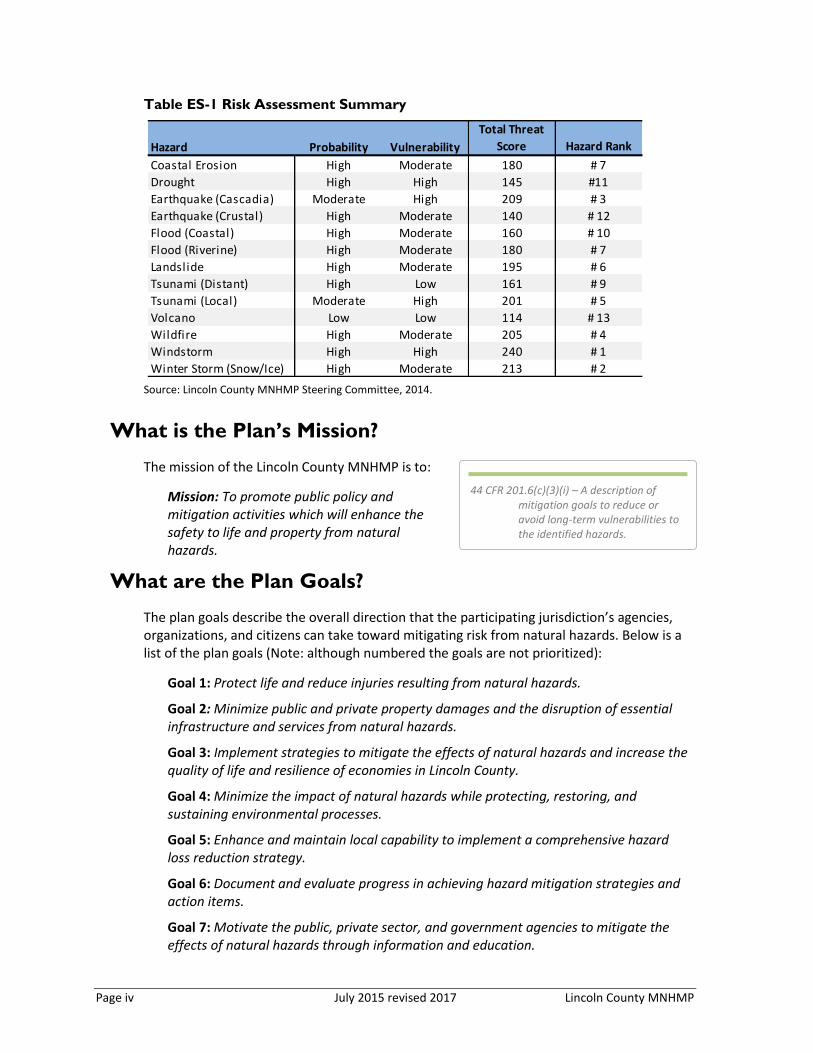
What is the County’s Overall Risk to Hazards?
Lincoln County reviewed and updated their risk assessment to evaluate the probability of each hazard as well as the vulnerability of the community to that hazard. In addition, the steering committees for the participating cities reviewed the recently updated Lincoln County risk assessment to compare risk and vulnerability particular to their jurisdiction (see addenda for more information). Table ES-1 below summarizes hazard probability and vulnerability as determined by the county steering committee (for more information see Section 2, Risk Assessment).
Page iv July 2015 revised 2017 Lincoln County MNHMP
Table ES-1 Risk Assessment Summary
Source: Lincoln County MNHMP Steering Committee, 2014.
What is the Plan’s Mission?
The mission of the Lincoln County MNHMP is to:
Mission: To promote public policy and mitigation activities which will enhance the safety to life and property from natural hazards.
What are the Plan Goals?
The plan goals describe the overall direction that the participating jurisdiction’s agencies, organizations, and citizens can take toward mitigating risk from natural hazards. Below is a list of the plan goals (Note: although numbered the goals are not prioritized):
Goal 1: Protect life and reduce injuries resulting from natural hazards.
Goal 2: Minimize public and private property damages and the disruption of essential infrastructure and services from natural hazards.
Goal 3: Implement strategies to mitigate the effects of natural hazards and increase the quality of life and resilience of economies in Lincoln County.
Goal 4: Minimize the impact of natural hazards while protecting, restoring, and sustaining environmental processes.
Goal 5: Enhance and maintain local capability to implement a comprehensive hazard loss reduction strategy.
Goal 6: Document and evaluate progress in achieving hazard mitigation strategies and action items.
Goal 7: Motivate the public, private sector, and government agencies to mitigate the effects of natural hazards through information and education.
Hazard Probability Vulnerability
Total Threat
Score Hazard Rank
Coastal Erosion High Moderate 180 # 7
Drought High High 145 #11
Earthquake (Cascadia) Moderate High 209 # 3
Earthquake (Crustal) High Moderate 140 # 12
Flood (Coastal) High Moderate 160 # 10
Flood (Riverine) High Moderate 180 # 7
Landslide High Moderate 195 # 6
Tsunami (Distant) High Low 161 # 9
Tsunami (Local) Moderate High 201 # 5
Volcano Low Low 114 # 13
Wildfire High Moderate 205 # 4
Windstorm High High 240 # 1
Winter Storm (Snow/Ice) High Moderate 213 # 2
44 CFR 201.6(c)(3)(i) – A description of mitigation goals to reduce or avoid long-term vulnerabilities to the identified hazards.

Lincoln County MNHMP July 2015 revised 2017 Page v
Goal 8: Apply development standards that mitigate or eliminate the potential impacts of natural hazards.
Goal 9: Mitigate damage to historic and cultural resources from natural hazards.
Goal 10: Increase communication, collaboration, and coordination among agencies at all levels of government and the private sector to mitigate natural hazards.
Goal 11: Integrate local NHMPs with comprehensive plans and implementing measures.
How are the Action Items Organized?
The action items are organized within an action matrix included within Section 3, Mitigation Strategy (full descriptions are provided in Appendix A, Action Item Forms). Included below is a list of the highest priority action items as identified by the steering committees.
Table ES-2 Highest Priority Action Items
Source: Lincoln County Steering Committee, 2015. * - indicates an action that was identified through the Risk MAP process, see Appendix G for additional information. Notes: Action Items for the cities are listed in Volume II. Action items for Special Districts are provided in Volume I, Section 3 - Mitigation Strategy Table 3-2 (pp. 3-11 and 3-12).
De
po
e B
ay
Lin
coln
Cit
y
Ne
wp
ort
Sile
tz
Tole
do
Wal
dp
ort
Yac
hat
s
Multi Hazard #6Integrate the NHMP into County and City
comprehensive plans.MT New X X X X X X X
Multi Hazard #7Prepare long-term catastrophic recovery
plan MT New X X X X X X
Earthquake #2
Identify, inventory, and retrofit critical
facilities (consider both structural and non-
structural retrofit options).
LT Ongoing X X X X X X X
*Earthquake #3
Stay apprised of new earthquake and
landslide data and perform mitigation of
infrastructure where possible to increase
resilience of critical transportation links to
the valley and along the coast during
earthquake events.
LT New X X X X X X X
Landlside #4
Collaborate with the Oregon Department
of Geology and Mineral Industries to work
on landslide risk reduction.
LT New X X X X X X X
Tsunami #1
Relocate critical/ essential facilities that
are within the tsunami inundation zone
and likely to be impacted by tsunami.LT Ongoing X X X
Windstorm #2
Continue and enhance windstorm
resistant construction methods where
possible to reduce damage to utilities and
critical facilities from windstorms. In part,
this may be accomplished by encouraging
electric utility providers to convert
existing overhead lines to underground
lines.
Ongoing Ongoing X X X X X X
Action Item
(2015 NHMP) Proposed Action Title
Timeline
ST=Short-term (1-3 yrs),
MT=Mid-term (4-10 yrs),
LT=Long-term (10+ yrs) Status
Partner Jurisdiction(s)
44 CFR 201.6(c)(3)(ii) – A section that identifies and analyzes a comprehensive range of specific mitigation actions . . .

Page vi July 2015 revised 2017 Lincoln County MNHMP
Data collection, research and the public participation process resulted in the development of the action items. The Action Item Matrix portrays the overall plan framework and identifies linkages between the plan goals and actions. The matrix documents the title of each action along with, the coordinating organization, timeline, and the plan goals addressed. Action items particular to each of the participating cities are included at the end of the action item matrix in Section 3, Mitigation Strategy and in the addenda.
How will the plan be implemented?
The plan maintenance section of this plan details the formal process that will ensure that the Lincoln County MNHMP remains an active and relevant document. The plan will be implemented, maintained and updated by a designated convener. The Lincoln County Emergency Manager and Planning and Community Development Director are the designated conveners and are responsible for overseeing the review and implementation processes. The plan maintenance process includes a schedule for monitoring and evaluating the plan semi-annually and producing a plan revision every five years. This section describes how the communities will integrate public participation throughout the plan maintenance process.
Plan Adoption
Once the plan is locally reviewed and deemed complete the Plan Convener submits it to the State Hazard Mitigation Officer at the Oregon Military Department – Office of Emergency Management (OEM). OEM reviews the plan and submits it to the Federal Emergency Management Agency (FEMA – Region X) for review. This review will address the federal criteria outlined in FEMA Interim Final Rule 44 CFR Part 201.6. Once the plan is pre-approved by FEMA, the county and cities formally adopt the plan via resolution. The Lincoln County MNHMP convener will be responsible for ensuring local adoption of the Lincoln County MNHMP and providing the support necessary to ensure plan implementation. Once the resolution is executed at the local level and documentation is provided to FEMA, the plan is formally acknowledged by FEMA and the county (and participating cities) will re-establish eligibility for the Pre-Disaster Mitigation Grant Program, the Hazard Mitigation Grant Program funds, and the Flood Mitigation Assistance program funds.
The accomplishment of the Natural Hazards Mitigation Plan goals and actions depends upon regular Steering Committee participation and adequate support from county and city leadership. Thorough familiarity with this Plan will result in the efficient and effective implementation of appropriate mitigation activities and a reduction in the risk and the potential for loss from future natural hazard events.
44 CFR 201.6(c)(3)(iii) – An action plan describing how the actions . . . will be prioritized, implemented and administered . . .
44 CFR 201.6(c)(4) – A plan maintenance process . . .
44 CFR 201.6(c)(5) – Documentation that the plan has been formally adopted by the governing body of the jurisdiction . . .
44 CFR 201.6(d) – Plan review [process] . . .

Lincoln County MNHMP July 2015 revised 2017 Page vii
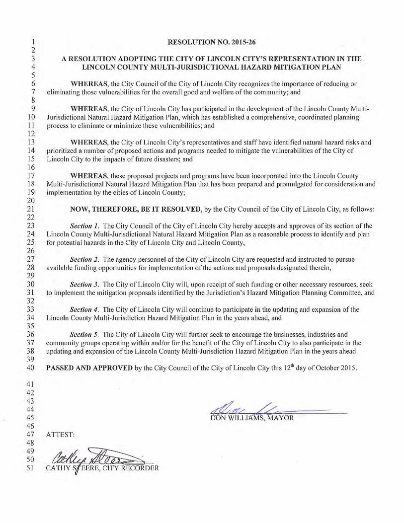
The steering committees for Lincoln County and participating cities each met to review the plan update process and their governing bodies adopted the MNHMP as shown below:
Lincoln County adopted the plan on September 2, 2015
Depoe Bay adopted the plan on October 6, 2015
Lincoln City adopted the plan on October 12, 2015
Newport adopted the plan on September 9, 2015
Siletz adopted the plan on October 12, 2015
Toledo adopted the plan on September 2, 2015
Waldport adopted the plan on October 8, 2015
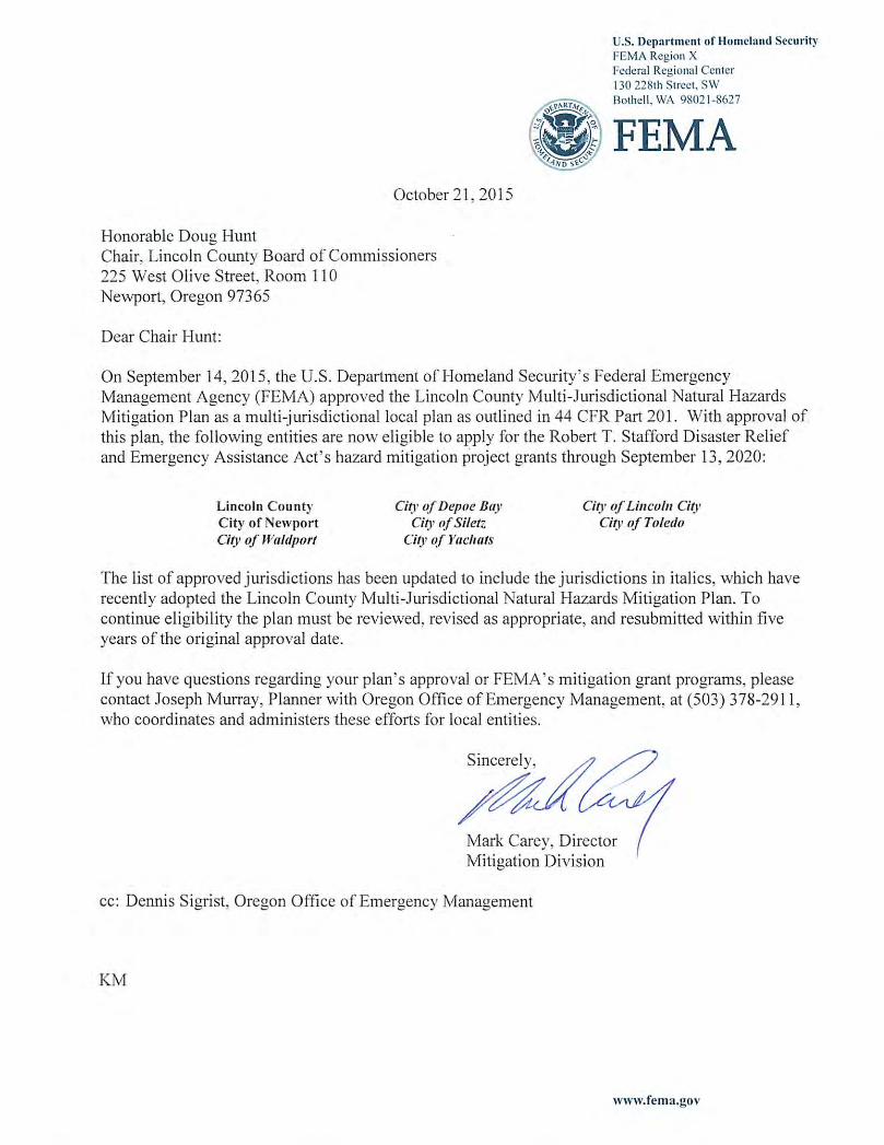
Yachats adopted the plan on October 1, 2015
FEMA Region X approved the Lincoln County MNHMP on September 14, 2015. With approval of this plan, the entities listed above are now eligible to apply for the Robert T. Stafford Disaster Relief and Emergency Assistance Act’s hazard mitigation project grants through September 13, 2020.

Volume I:
Basic Plan

This page left intentionally blank.

Lincoln County NHMP July 2015 revised 2017 Page 1-1
SECTION I:
INTRODUCTION
Section I: Introduction provides a general introduction to natural hazard mitigation planning in Lincoln County. In addition, it addresses the planning process requirements contained in 44 CFR 201.6(b) thereby meeting the planning process documentation requirement contained in 44 CFR 201.6(c)(1). The section concludes with a general description of how the plan is organized.
What is Natural Hazard Mitigation?
The Federal Emergency Management Agency (FEMA) defines mitigation as “. . . the effort to reduce loss of life and property by lessening the impact of disasters . . . through risk analysis, which results in information that provides a foundation for mitigation activities that reduce risk.”1 Said another way, natural hazard mitigation is a method of permanently reducing or alleviating the losses of life, property, and injuries resulting from natural hazards through long and short-term strategies. Example strategies include policy changes, such as updated ordinances, projects, such as seismic retrofits to critical facilities; and education and outreach to targeted audiences, such as Spanish speaking residents or the elderly. Natural hazard mitigation is the responsibility of the “Whole Community” - individuals, private businesses and industries, state and local governments, and the federal government.
Engaging in mitigation activities provides jurisdictions with a number of benefits, including reduced loss of life, property, essential services, critical facilities and economic hardship; reduced short-term and long-term recovery and reconstruction costs; increased cooperation and communication within the community through the planning process; and increased potential for state and federal funding for recovery and reconstruction projects.
Why Develop a Mitigation Plan?
Lincoln County developed this Natural Hazards Mitigation Plan (NHMP) in an effort to reduce future loss of life and damage to property resulting from natural hazards. It is impossible to predict exactly when natural hazard events will occur, or the extent to which they will affect community assets. However, with careful planning and collaboration among public agencies, private sector organizations, and citizens within the community, it is possible to minimize the losses that can result from natural hazards.
In addition to establishing a comprehensive community-level mitigation strategy, the Disaster Mitigation Act of 2000 (DMA2K) and the regulations contained in 44 CFR 201 require that jurisdictions maintain an approved NHMP in order to receive federal funds for mitigation projects. Local and federal approval of this plan ensures that the county and listed cities will remain eligible for pre- and post-disaster mitigation project grants.
1 FEMA, What is Mitigation? http://www.fema.gov/what-mitigation

Page 1-2 July 2015 revised 2017 Lincoln County NHMP
What Federal Requirements Does This Plan Address?
DMA2K is the latest federal legislation addressing mitigation planning. It reinforces the importance of mitigation planning and emphasizes planning for natural hazards before they occur. As such, this Act established the Pre-Disaster Mitigation (PDM) grant program and new requirements for the national post-disaster Hazard Mitigation Grant Program (HMGP). Section 322 of the Act specifically addresses mitigation planning at the state and local levels. State and local jurisdictions must have approved mitigation plans in place in order to qualify to receive post-disaster HMGP funds. Mitigation plans must demonstrate that their proposed mitigation measures are based on a sound planning process that accounts for the risk to the individual and their capabilities.
Chapter 44 Code of Federal Regulations (CFR), section 201.6, also requires a local government to have an approved mitigation plan in order to receive HMGP project grants.2 Pursuant of Chapter 44 CFR, the Natural Hazard Mitigation Plan planning processes shall include opportunity for the public to comment on the plan during review, and the updated NHMP shall include documentation of the public planning process used to develop the plan.3 The NHMP update must also contain a risk assessment, mitigation strategy and a plan maintenance process that has been formally adopted by the governing body of the jurisdiction.4 Lastly, the Natural Hazard Mitigation Plan must be submitted to Oregon Military Department – Office of Emergency Management (OEM) for initial plan review, and then federal approval.5 Additionally, a recent change in the way OEM administers the Emergency Management Performance Grant (EMPG), which helps fund local emergency management programs, also requires a FEMA-approved NHMP.
What is the Policy Framework for Natural Hazards Planning in Oregon?
Planning for natural hazards is an integral element of Oregon’s statewide land use planning program, which began in 1973. All Oregon cities and counties have comprehensive plans and implementing ordinances that are required to comply with the statewide planning goals. The challenge faced by state and local governments is to keep this network of local plans coordinated in response to the changing conditions and needs of Oregon communities.
Statewide land use planning Goal 7: Areas Subject to Natural Hazards calls for local plans to include inventories, policies and ordinances to guide development in or away from hazard areas. Goal 7, along with other land use planning goals, has helped to reduce losses from natural hazards. Through risk identification and the recommendation of risk-reduction actions, this plan aligns with the goals of the jurisdiction’s Comprehensive Plan, and helps each jurisdiction meet the requirements of statewide land use planning Goal 7.
2 Code of Federal Regulations, Chapter 44. Section 201.6, subsection (a), 2015
3 ibid, subsection (b). 2015
4 ibid, subsection (c). 2015
5 ibid, subsection (d). 2015

Lincoln County NHMP July 2015 revised 2017 Page 1-3
The primary responsibility for the development and implementation of risk reduction strategies and policies lies with local jurisdictions. However, resources exist at the state and federal levels. Some of the key agencies in this area include Oregon Military Department – Office of Emergency Management (OEM), Oregon Building Codes Division (BCD), Oregon Department of Forestry (ODF), Oregon Department of Geology and Mineral Industries (DOGAMI), and the Department of Land Conservation and Development (DLCD).
How was the Plan Developed?
The plan was developed by the Lincoln County Natural Hazard Mitigation Plan steering committee and the steering committees for the cities of Depoe Bay, Lincoln City, Newport, Siletz, Toledo, Waldport, and Yachats. The Lincoln County steering committee formally convened on three occasions to discuss and revise the plan. Each of the participating city steering committees met at least once formally. Steering committee members contributed data and maps, and reviewed and updated the community profile, risk assessment, action items, and implementation and maintenance plan.
An open public involvement process is essential to the development of an effective plan. In order to develop a comprehensive approach to reducing the effects of natural disasters, the planning process shall include opportunity for the public, neighboring communities, local and regional agencies, as well as, private and non-profit entities to comment on the plan during review.6 OPDR provided a publicly accessible project website for the general public to provide feedback on the draft NHMP via a web form. Lincoln County provided a press release on their website to encourage the public to offer feedback on the plan update.
In addition, the county participated in a concurrent Risk Mapping Assessment and Planning (Risk MAP) process that allowed jurisdictions, and the general public through a survey instrument, to provide additional input into the counties risks, vulnerabilities, hazards history, and mitigation strategies. See Appendix F for more information.
How is the Plan Organized?
Each volume of the mitigation plan provides specific information and resources to assist readers in understanding the hazard-specific issues facing county and city residents, businesses, and the environment. Combined, the sections work in synergy to create a mitigation plan that furthers the community’s mission to reduce or eliminate long-term risk to people and their property from hazards and their effects. This plan structure enables stakeholders to use the section(s) of interest to them.
Volume I: Basic Plan
Executive Summary
The executive summary provides an overview of the FEMA requirements plans process and highlights the key elements of the risk assessment, mitigation strategy, and implementation and maintenance strategy.
6 Code of Federal Regulations, Chapter 44. Section 201.6, subsection (b). 2015

Page 1-4 July 2015 revised 2017 Lincoln County NHMP
Section 1: Introduction
The Introduction briefly describes the countywide mitigation planning efforts and the methodology used to develop the plan.
Section 2: Risk Assessment
Section 2 provides the factual basis for the mitigation strategies contained in Section 3. (Additional information is included within Appendix C, which contains an overall description of Lincoln County and the cities of Depoe Bay, Lincoln City, Newport, Siletz, Toledo, Waldport, and Yachats.) This section includes a brief description of community sensitivities and vulnerabilities and an overview of the hazards addressed in Volume II of this plan. The Risk Assessment allows readers to gain an understanding of the county’s, and other jurisdictions’, sensitivities – those community assets and characteristics that may be impacted by natural hazards, as well as the county’s, and other jurisdictions’, resilience – the ability to manage risk and adapt to hazard event impacts. Additionally, this section provides information on the jurisdictions’ participation in the National Flood Insurance Program (NFIP).
Section 3: Mitigation Strategy
This section documents the plan vision, mission, goals, and actions (mitigation strategy) and also describes the components that guide implementation of the identified actions. Actions are based on community sensitivity and resilience factors and the hazard assessments in Section 2 and the Hazard Annexes (Volume II).
Section 4: Plan Implementation and Maintenance
This section provides information on the implementation and maintenance of the plan. It describes the process for prioritizing projects, and includes a suggested list of tasks for updating the plan to be completed at the semi-annual and five-year review meetings.
Volume II: Hazard Annexes
The hazard annexes describe the risk assessment process and summarize the best available local hazard data. A hazard summary is provided for each of the hazards addressed in the plan. The summary includes hazard history, location, extent, vulnerability, impacts, and probability.
The hazard specific annexes included with this plan are the following:
• Coastal Erosion
• Drought
• Earthquake
• Flood
• Landslide
• Tsunami
• Volcano
• Wildfire
• Windstorm
• Winter Storm (Snow/ Ice)
Lincoln County NHMP July 2015 revised 2017 Page 1-5
Volume III: Jurisdictional Addenda
Volume III of the plan is reserved for any city or special district addenda developed through this multi-jurisdictional planning process. Each of the cities with a FEMA approved addendum went through an update to coincide with the county’s update. As such, the five-year update cycle will be the same for all of the cities and the county. Note: Although the School District is not included as a special district they were represented on the county steering committee and have provided detailed information on their risks and vulnerabilities and have included action items that define their mitigation strategy within the county and city sections of the plan.
The plan includes city addenda updates for the following jurisdictions:
• City of Depoe Bay
• Lincoln City
• City of Newport
• City of Siletz
• City of Toledo
• City of Waldport
• City of Yachats
In 2017, action items were added for the Central Lincoln People’s Utility District and Seal Rock Water District.
Volume IV: Mitigation Resources
The resource appendices are designed to provide the users of the Lincoln County Natural Hazards Mitigation Plan with additional information to assist them in understanding the contents of the mitigation plan, and provide them with potential resources to assist with plan implementation.
Appendix A: Action Item Forms
This appendix contains the detailed action item forms for each of the mitigation strategies identified in this plan.
Appendix B: Planning and Public Process
This appendix includes documentation of all the countywide public processes utilized to develop the plan. It includes invitation lists, agendas, sign-in sheets, and summaries of steering committee meetings as well as any other public involvement methods.
Appendix C: Community Profile
The community profile describes the county and participating cities from a number of perspectives in order to help define and understand the regions sensitivity and resilience to natural hazards. The information in this section represents a snapshot in time of the current sensitivity and resilience factors in the region when the plan was updated. Sensitivity factors can be defined as those community assets and characteristics that may be impacted by
Page 1-6 July 2015 revised 2017 Lincoln County NHMP
natural hazards, (e.g., special populations, economic factors, and historic and cultural resources). Community resilience factors can be defined as the community’s ability to manage risk and adapt to hazard event impacts (e.g., governmental structure, agency missions and directives, and plans, policies, and programs).
Appendix D: Economic Analysis of Natural Hazard Mitigation Projects
This appendix describes the Federal Emergency Management Agency’s (FEMA) requirements for benefit cost analysis in natural hazards mitigation, as well as various approaches for conducting economic analysis of proposed mitigation activities. The Oregon Partnership for Disaster Resilience developed this appendix. It has been reviewed and accepted by the Federal Emergency Management Agency (FEMA) as a means of documenting how the prioritization of actions shall include a special emphasis on the extent to which benefits are maximized according to a cost benefit review of the proposed projects and their associated costs.
Appendix E: Grant Programs and Resources
This appendix lists state and federal resources and programs by hazard.
Appendix F: Risk Map Implementation Report
Appendix F includes a copy of the Lincoln County Risk MAP implementation report. Lincoln County vulnerabilities were identified through the hazard analysis of the Risk Report, the sector specific meetings, the areas of mitigation interest, and the natural hazard mitigation planning process.
Appendix F also includes the survey instrument and results from the natural hazards community survey implemented by OPDR (2014). The survey aims to: gauge household knowledge of mitigation tools and techniques to assist in reducing the risk and loss from natural hazards, to assess household disaster preparedness, and to assess household knowledge of countywide hazards and hazard mitigation programs.

Lincoln County NHMP July 2015 Page 2-‐1
SECTION 2: RISK ASSESSMENT
This section of the NHMP addresses 44 CFR 201.6(b)(2) -‐ Risk Assessment. In addition, this chapter can serve as the factual basis for addressing Oregon Statewide Planning Goal 7 – Areas Subject to Natural Hazards. Assessing natural hazard risk has three phases:
• Phase 1: Identify hazards that can impact the jurisdiction. This includes an evaluation of potential hazard impacts – type, location, extent, etc.
• Phase 2: Identify important community assets and system vulnerabilities. Example vulnerabilities include people, businesses, homes, roads, historic places and drinking water sources.
• Phase 3: Evaluate the extent to which the identified hazards overlap with, or have an impact on, the important assets identified by the community.
The information presented below, along with hazard specific information presented in the Hazard Annexes and community characteristics presented in the Community Profile Appendix, will be used as the local level rationale for the risk reduction actions identified in Section 3 – Mitigation Strategy. The risk assessment process is graphically depicted in Figure 2-‐1 below. Ultimately, the goal of hazard mitigation is to reduce the area where hazards and vulnerable systems overlap.
Figure 2-1 Understanding Risk
Source: Oregon Partnership for Disaster Resilience.

Page 2-‐2 July 2015 Lincoln County NHMP
What is a Risk Assessment?
A risk assessment consists of three phases: hazard identification, vulnerability assessment, and risk analysis, as illustrated in the following graphic.
Figure 2-2 Three Phases of a Risk Assessment
Source: Planning for Natural Hazards: Oregon Technical Resource Guide, 1998
The first phase, hazard identification, involves the identification of the geographic extent of a hazard, its intensity, and its probability of occurrence. This level of assessment typically involves producing a map. The outputs from this phase can also be used for land use planning, management, and regulation; public awareness; defining areas for further study; and identifying properties or structures appropriate for acquisition or relocation.1
The second phase, vulnerability assessment, combines the information from the hazard identification with an inventory of the existing (or planned) property and population exposed to a hazard, and attempts to predict how different types of property and population groups will be affected by the hazard. This step can also assist in justifying changes to building codes or development regulations, property acquisition programs, policies concerning critical and public facilities, taxation strategies for mitigating risk, and informational programs for members of the public who are at risk.2
The third phase, risk analysis, involves estimating the damage, injuries, and costs likely to be incurred in a geographic area over a period of time. Risk has two measurable components: (1) the magnitude of the harm that may result, defined through the vulnerability assessment, and (2) the likelihood or probability of the harm occurring. An example of a product that can assist communities in completing the risk analysis phase is HAZUS, a risk assessment software program for analyzing potential losses from floods, hurricane winds and earthquakes. In Hazards U.S. – Multi-‐Hazard (HAZUS-‐MH) current scientific and engineering knowledge is coupled with the latest geographic information systems (GIS) technology to produce estimates of hazard-‐related damage before, or after a disaster occurs.
This three-‐phase approach to developing a risk assessment should be conducted sequentially because each phase builds upon data from prior phases. However, gathering data for a risk assessment need not occur sequentially.
1 Burby, Cooperating with Nature (Washington, DC: Joseph Henry Press, 1998), 126. 2 Ibid, 133.
Lincoln County NHMP July 2015 Page 2-‐3
Hazard Analysis Methodology
This NHMP utilizes a hazard analysis methodology that was first developed by FEMA circa 1983, and gradually refined by the Oregon Military Department’s Office of Emergency Management over the years.
The methodology produces scores that range from 24 (lowest possible) to 240 (highest possible). Vulnerability and probability are the two key components of the methodology. Vulnerability examines both typical and maximum credible events, and probability endeavors to reflect how physical changes in the jurisdiction and scientific research modify the historical record for each hazard. Vulnerability accounts for approximately 60% of the total score, and probability approximately 40%.
This method provides the jurisdiction with a sense of hazard priorities, or relative risk. It doesn't predict the occurrence of a particular hazard, but it does "quantify" the risk of one hazard compared with another. By doing this analysis, planning can first be focused where the risk is greatest.
In this analysis, severity ratings, and weight factors, are applied to the four categories of history, vulnerability, maximum threat (worst-‐case scenario), and probability as demonstrated below.
History Weight factor for category = 2
History is the record of previous occurrences. Events to include in assessing history of a hazard in your jurisdiction are events for which the following types of activities were required:
• The EOC or alternate EOC was activated; • Three or more EOP functions were implemented, e.g., alert & warning, evacuation,
shelter, etc.; • An extraordinary multi-‐jurisdictional response was required; and/or • A "Local Emergency" was declared.
LOW = 0 to 1 event in the past 100 years, scores between 1 and 3 points MODERATE = 2 to 3 event in the past 100 years, scores between 4 and 7 points HIGH = 4+ events in the past 100 years, scores between 8 and 10 points
Probability Weight factor for category = 7
Probability is the likelihood of future occurrence within a specified period of time.
LOW = one incident likely within 75 to 100 years, scores between 1 and 3 points MODERATE = one incident likely within 35 to 75 years, scores between 4 and 7 points HIGH = one incident likely within 10 to 35 years, scores between 8 and 10 points
Page 2-‐4 July 2015 Lincoln County NHMP
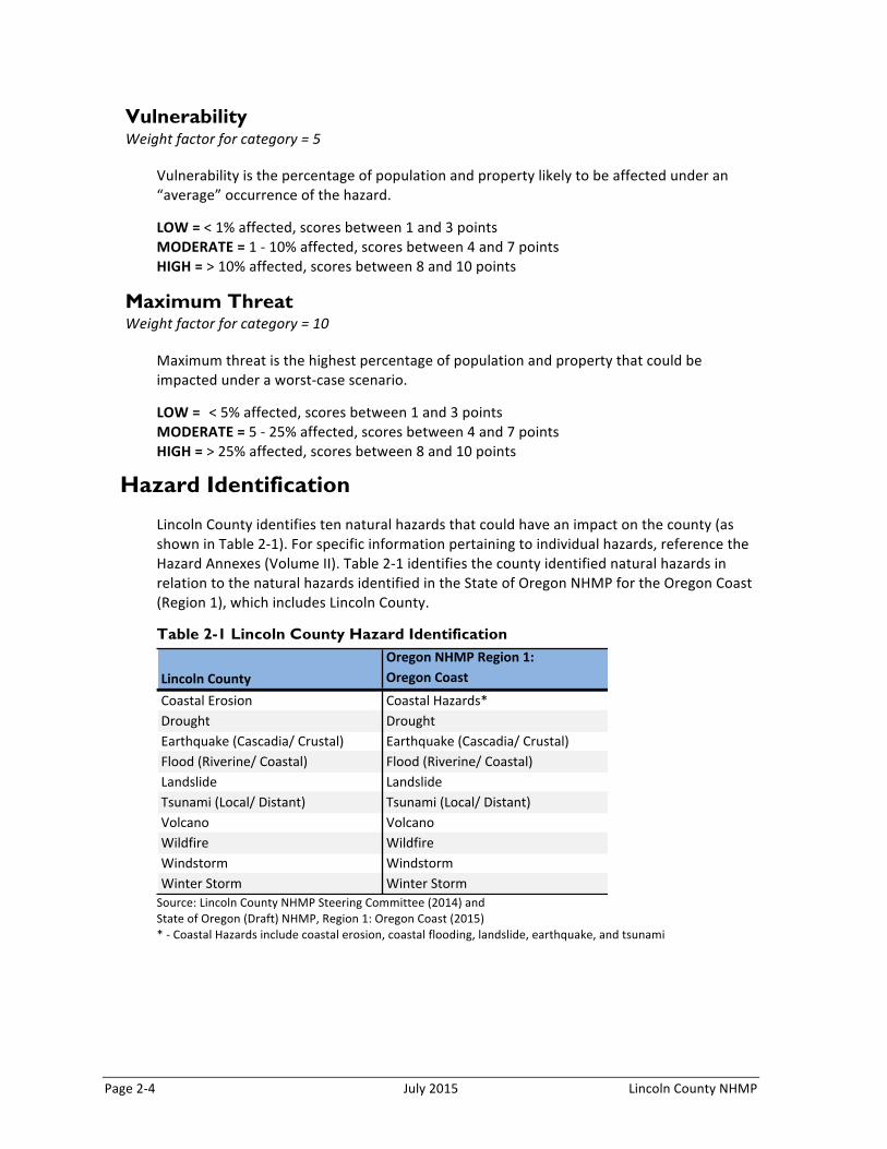
Vulnerability Weight factor for category = 5
Vulnerability is the percentage of population and property likely to be affected under an “average” occurrence of the hazard.
LOW = < 1% affected, scores between 1 and 3 points MODERATE = 1 -‐ 10% affected, scores between 4 and 7 points HIGH = > 10% affected, scores between 8 and 10 points
Maximum Threat Weight factor for category = 10
Maximum threat is the highest percentage of population and property that could be impacted under a worst-‐case scenario.
LOW = < 5% affected, scores between 1 and 3 points MODERATE = 5 -‐ 25% affected, scores between 4 and 7 points HIGH = > 25% affected, scores between 8 and 10 points
Hazard Identification
Lincoln County identifies ten natural hazards that could have an impact on the county (as shown in Table 2-‐1). For specific information pertaining to individual hazards, reference the Hazard Annexes (Volume II). Table 2-‐1 identifies the county identified natural hazards in relation to the natural hazards identified in the State of Oregon NHMP for the Oregon Coast (Region 1), which includes Lincoln County.
Table 2-1 Lincoln County Hazard Identification
Source: Lincoln County NHMP Steering Committee (2014) and State of Oregon (Draft) NHMP, Region 1: Oregon Coast (2015) * -‐ Coastal Hazards include coastal erosion, coastal flooding, landslide, earthquake, and tsunami
Lincoln'CountyOregon'NHMP'Region'1:Oregon'Coast
Coastal'Erosion Coastal'Hazards*Drought DroughtEarthquake'(Cascadia/'Crustal) Earthquake'(Cascadia/'Crustal)Flood'(Riverine/'Coastal) Flood'(Riverine/'Coastal)Landslide LandslideTsunami'(Local/'Distant) Tsunami'(Local/'Distant)Volcano VolcanoWildfire WildfireWindstorm WindstormWinter'Storm Winter'Storm

Lincoln County NHMP July 2015 Page 2-‐5
Coastal Erosion
Coastal erosion is a natural process that continually affects the entire coast. Erosion becomes a hazard when human development, life and safety are threatened. Waves, currents, tides and storms resulting in episodic and recurrent erosion constantly affect beaches, sand spits, dunes and bluffs. Shoreline retreat may be gradual over a season or many years, or it can be drastic, with the loss of substantial upland area during the course of a single storm event. Information on the related coastal hazards (coastal flooding, landslides, earthquake, and tsunami) is covered in the descriptions below and their hazard annex sections within Volume II. The 2015 Draft Oregon NHMP identifies coastal erosion within its coastal hazards annex that also includes coastal flooding, landslides, earthquake, and tsunami; within this NHMP we discuss those hazards within separate annexes.
For more information on Coastal Hazards (including history and extent) see the Coastal Hazards Annex in Volume II.
Drought
A drought is a period of drier than normal conditions that results in water-‐related problems. Drought occurs in virtually every climatic zone, but its characteristics vary significantly from one region to another. Drought is a temporary condition; it differs from aridity, which is restricted to low rainfall regions and is a permanent feature of climate. The extent of drought events depends upon the degree of moisture deficiency, and the duration and size of the affected area. Typically, droughts occur as regional events and often affect more than one city and county.
For more information on the Drought Hazard (including history and extent) see the Drought Annex in Volume II.
Earthquake
Oregon and the Pacific Northwest in general are susceptible to earthquakes from four sources: 1) the off-‐shore Cascadian Fault Zone; 2) deep intra-‐plate events within the subducting Juan de Fuca Plate; 3) shallow crustal events within the North American Plate; and 4) earthquakes associated with volcanic activity.3
The areas most susceptible to ground amplification and liquefaction have young, soft alluvial sediments, found along river and stream channels. The extent of the damage to structures and injury and death to people will depend upon the type of earthquake, proximity to the epicenter and the magnitude and duration of the event.
For more information on the Earthquake Hazard (including history and extent) see the Earthquake Annex in Volume II.

Page 2-‐6 July 2015 Lincoln County NHMP
Flood
Flooding results when rain and snowmelt creates water flow that exceed the carrying capacity of rivers, streams, channels, ditches, and other watercourses. In Oregon, flooding is most common from October through April when storms from the Pacific Ocean bring intense rainfall. Most of Oregon’s destructive natural disasters have been floods.4 Flooding can be aggravated when rain is accompanied by snowmelt and frozen ground; the spring cycle of melting snow is the most common source of flood in the region. The principal types of flood that occur in Lincoln County include: coastal flooding from high tides and ocean storms, and high river flows (within estuaries the two types combine to create flood hazards). Flooding may also occur in combination with a local or distant tsunami event.
For more information on the Flood Hazard (including history and extent) see the Flood Annex in Volume II.
Landslide
A landslide is any detached mass of soil, rock, or debris that falls, slides or flows down a slope or a stream channel. Landslides are classified according to the type and rate of movement and the type of materials that are transported. In a landslide, two forces are at work: 1) the driving forces that cause the material to move down slope, and 2) the friction forces and strength of materials that act to retard the movement and stabilize the slope. When the driving forces exceed the resisting forces, a landslide occurs.
For more information on the Landslide Hazard (including history and extent) see the Landslide Annex in Volume II.
Tsunami
A tsunami generally begins as a single wave but quickly evolves into a series of ocean waves, generated by disturbances from earthquakes, underwater volcanic eruptions, or landslides (includes landslides that start below the water surface and landslides that enter a deep body of water from above the water surface). In these cases the initial tsunami wave mimics the shape and size of the sea floor deformation that causes it. A tsunami from a local source will likely be stronger, higher and travel farther inland (overland and up river) than a distant tsunami (generated from a distant earthquake event such as in Alaska or Japan). The local tsunami wave may be traveling at 30 mph when it hits the coastline and have heights of 20 to 60 feet, potentially higher depending on the coastal bathymetry (water depths) and geometry (shoreline features).
For more information on the Tsunami Hazard (including history and extent) see the Tsunami Annex in Volume II.
4 Taylor, George H. and Chris Hannan. The Oregon Weather Book. Corvallis, OR: Oregon State University Press. 1999

Lincoln County NHMP July 2015 Page 2-‐7
Volcano
The Pacific Northwest lies within the “ring of fire”, an area of very active volcanic activity surrounding the Pacific Basin. Volcanic events occur regularly along the ring of fire, in part because of the movement of the Earth’s tectonic plates. Volcanic events have the potential to coincide with numerous other hazards including ash fall, earthquakes, lava flows, pyroclastic flows, lahars, and debris flows, and landslides.
For more information on the Volcano Hazard (including history and extent) see the Volcano Annex in Volume II.
Wildfire
Wildfires occur in areas with large amounts of flammable vegetation that require a suppression response due to uncontrolled burning. Fire is an essential part of Oregon’s ecosystem, but can also pose a serious threat to life and property particularly in the state’s growing rural communities. Wildfire can be divided into three categories: interface, wildland, and firestorms. The increase in residential development in interface areas has resulted in greater wildfire risk. Fire has historically been a natural wildland element and can sweep through vegetation that is adjacent to a combustible home. New residents in remote locations are often surprised to learn that in moving away from built-‐up urban areas, they have also left behind readily available fire services providing structural protection.
For more information on the Wildfire Hazard (including history and extent) see the Wildfire Annex in Volume II.
Windstorm
A windstorm is generally a short duration event involving straight-‐line winds and/or gusts in excess of 50 mph. Although windstorms can affect the entirety of Lincoln County, they are especially dangerous in developed areas with significant tree stands and major infrastructure, especially above ground utility lines. A windstorm will frequently knock down trees and power lines, damage homes, businesses, public facilities, and create tons of storm related debris.
For more information on the Windstorm Hazard (including history and extent) see the Windstorm Annex in Volume II.
Winter Storm
Severe winter storms can consist of rain, freezing rain, ice, snow, cold temperatures, and wind. They originate from troughs of low pressure offshore that ride along the jet stream during fall, winter, and early spring months. Severe winter storms affecting Lincoln County typically originate in the Gulf of Alaska or in the central Pacific Ocean. These storms are most common from November through March.
For more information on the Winter Strom Hazard (including history and extent) see the Winter Storm Annex in Volume II.
Page 2-‐8 July 2015 Lincoln County NHMP
Federal Disaster and Emergency Declarations
Looking at the past events that have occurred in the county can provide a general sense of the hazards that have caused significant damage in the county. Where trends emerge, disaster declarations can help inform hazard mitigation project priorities.
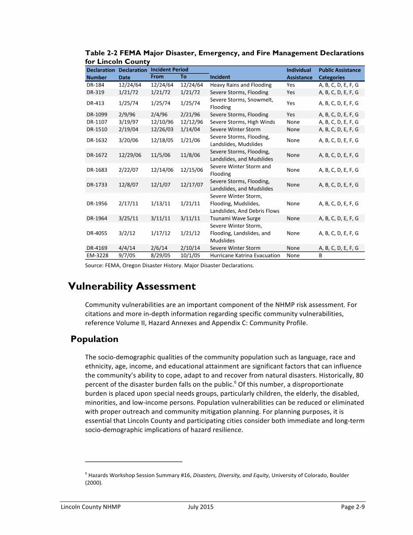
President Dwight D. Eisenhower approved the first federal disaster declaration in May 1953 following a tornado in Georgia. Since then, federally declared disasters have been approved within every state as a result of natural hazard related events. As of January 2015, FEMA has approved a total of 29 major disaster declarations, two emergency declarations, and 58 fire management assistance declarations in Oregon.5 When governors ask for presidential declarations of major disaster or emergency, they stipulate which counties in their state they want included in the declaration. Table 2-‐2 summarizes the major disasters declared in Oregon that affected Lincoln County, since 1964. The table shows that there have been 14 major disaster declarations for the county; 13 have been weather related and one was related to a distant tsunami (related to the Tohoku Earthquake).
An Emergency Declaration is more limited in scope and without the long-‐term federal recovery programs of a Major Disaster Declaration. Generally, federal assistance and funding are provided to meet a specific emergency need or to help prevent a major disaster from occurring. There has been one emergency declaration that has affected Lincoln County (related to Hurricane Katrina Evacuation). Fire Management Assistance is provided after a State submits a request for assistance to the Federal Emergency Management Agency (FEMA) Regional Director at the time a "threat of major disaster" exists. There have not been any fire management assistance declarations for the county.
5 FEMA, Declared Disasters by Year or State, http://www.fema.gov/news/disaster_totals_annual.fema#markS. Accessed January 9, 2015.
Lincoln County NHMP July 2015 Page 2-‐9
Table 2-2 FEMA Major Disaster, Emergency, and Fire Management Declarations for Lincoln County
Source: FEMA, Oregon Disaster History. Major Disaster Declarations.
Vulnerability Assessment
Community vulnerabilities are an important component of the NHMP risk assessment. For citations and more in-‐depth information regarding specific community vulnerabilities, reference Volume II, Hazard Annexes and Appendix C: Community Profile.
Population
The socio-‐demographic qualities of the community population such as language, race and ethnicity, age, income, and educational attainment are significant factors that can influence the community’s ability to cope, adapt to and recover from natural disasters. Historically, 80 percent of the disaster burden falls on the public.6 Of this number, a disproportionate burden is placed upon special needs groups, particularly children, the elderly, the disabled, minorities, and low-‐income persons. Population vulnerabilities can be reduced or eliminated with proper outreach and community mitigation planning. For planning purposes, it is essential that Lincoln County and participating cities consider both immediate and long-‐term socio-‐demographic implications of hazard resilience.
6 Hazards Workshop Session Summary #16, Disasters, Diversity, and Equity, University of Colorado, Boulder (2000).
From To IncidentDR#184 12/24/64 12/24/64 12/24/64 Heavy/Rains/and/Flooding Yes A,/B,/C,/D,/E,/F,/GDR#319 1/21/72 1/21/72 1/21/72 Severe/Storms,/Flooding Yes A,/B,/C,/D,/E,/F,/G
DR#413 1/25/74 1/25/74 1/25/74 Severe/Storms,/Snowmelt,/Flooding
Yes A,/B,/C,/D,/E,/F,/G
DR#1099 2/9/96 2/4/96 2/21/96 Severe/Storms,/Flooding Yes A,/B,/C,/D,/E,/F,/GDR#1107 3/19/97 12/10/96 12/12/96 Severe/Storms,/High/Winds None A,/B,/C,/D,/E,/F,/GDR#1510 2/19/04 12/26/03 1/14/04 Severe/Winter/Storm None A,/B,/C,/D,/E,/F,/G
DR#1632 3/20/06 12/18/05 1/21/06 Severe/Storms,/Flooding,/Landslides,/Mudslides
None A,/B,/C,/D,/E,/F,/G
DR#1672 12/29/06 11/5/06 11/8/06 Severe/Storms,/Flooding,/Landslides,/and/Mudslides
None A,/B,/C,/D,/E,/F,/G
DR#1683 2/22/07 12/14/06 12/15/06 Severe/Winter/Storm/and/Flooding
None A,/B,/C,/D,/E,/F,/G
DR#1733 12/8/07 12/1/07 12/17/07 Severe/Storms,/Flooding,/Landslides,/and/Mudslides
None A,/B,/C,/D,/E,/F,/G
DR#1956 2/17/11 1/13/11 1/21/11Severe/Winter/Storm,/Flooding,/Mudslides,/Landslides,/And/Debris/Flows
None A,/B,/C,/D,/E,/F,/G
DR#1964 3/25/11 3/11/11 3/11/11 Tsunami/Wave/Surge None A,/B,/C,/D,/E,/F,/G
DR#4055 3/2/12 1/17/12 1/21/12Severe/Winter/Storm,/Flooding,/Landslides,/and/Mudslides
None A,/B,/C,/D,/E,/F,/G
DR#4169 4/4/14 2/6/14 2/10/14 Severe/Winter/Storm None A,/B,/C,/D,/E,/F,/GEM#3228 9/7/05 8/29/05 10/1/05 Hurricane/Katrina/Evacuation None B
Declaration0Number
Declaration0Date
Incident0Period Individual0Assistance
Public0Assistance0Categories

Page 2-‐10 July 2015 Lincoln County NHMP
Population Vulnerabilities
• The county is growing at approximately one-‐third (4.7%) the rate of the state (14.5%); the majority of the population growth is within Lincoln City and Newport; deaths are outpacing births and the increase in population is driven by migration.
• Lincoln County is expected to grow at a faster rate (6.4%) than other counties along the Oregon Coast.
• Lincoln County is visited by a high number of tourists each year, the majority stay either in hotels, vacation rentals, or campsites and recreational vehicles.
• As of 2012, more than one-‐fifth of Lincoln County’s population is over the age of 64, a number that is projected to rise to nearly one-‐third by 2020.
• The Lincoln County age dependency ratio7 is 56.7, which is higher than that of the State of Oregon (48.6); the age dependency figure for the county is expected to increase to 77.7 by the year 2020 (largely due to the growth in population over age 64). As of 2012, Siletz (67.5), Waldport (65.3), and Yachats (71.3) have the highest age dependency ratios in the county.
• The cities of Lincoln City (21.7%), Waldport (16.6%), Yachats (16.4%), and Newport (14.8%) have a higher percentage of their populations over age 64 living alone.
• The county ($39,249) has a lower median household income than the state ($46,763); Lincoln City ($27,744) has a much lower median household income.
• The poverty rates for Lincoln City (20.5%) and Siletz (23.0%) are the highest in the county.
• Approximately 33% of owners with a mortgage and 40% renters spend more than 35% of their income on housing; Depoe Bay (44.5%), Lincoln City (46.7%), and Toledo (53.8%) have the highest percentage of renters in that category while Lincoln City (48.4%), Depoe Bay (47.5%), and Yachats (46.3%) have the highest percentage of owners with a mortgage in that category.
Economy
Economic diversification, employment and industry are measures of economic capacity. However, economic resilience to natural disasters is far more complex than merely restoring employment or income in the local community. Building a resilient economy requires an understanding of how the component parts of employment sectors, workforce, resources and infrastructure are interconnected in the existing economic picture. The current and anticipated financial conditions of a community are strong determinants of community resilience, as a strong and diverse economic base increases the ability of individuals, families and the community to absorb disaster impacts for a quick recovery. It is imperative that Lincoln County and the participating cities recognize that economic diversification is a long-‐term issue; more immediate strategies to reduce vulnerability should focus on risk management for the dominant industries.
Economic Vulnerabilities
• According to the Oregon Employment Department, Lincoln County unemployment has decreased since 2009 when it was at 10.5% to 8.2% in 2013. In the event of a
7 Dependency Ratio: the ratio of population typically not in the work force (less than 15, greater than 64)
Lincoln County NHMP July 2015 Page 2-‐11
large—scale disaster, unemployment has the potential to rise when businesses and companies are unable to overcome the ramifications of the hazard event.
• The largest sectors of employment in Lincoln County are Leisure and Hospitality (23.7%), Government (22.1%, predominately local government, 16.1%), Trade, Transportation, and Utilities (19.2%), and Education and Health Services (9.6%).8
• The largest revenue sectors in Lincoln County are Retail Trade ($559 million), Manufacturing ($583 million) and Health Care and Social Assistance ($156 million). In the event of a natural disaster, the manufacturing sector may not be as vulnerable in the short term as other sectors; however, other large industries such as retail and wholesale trade may be significantly affected by a disaster as these basic industries tend to rely on a stable disposable income, which may decline following a disaster.
• The Professional and Business Services (21%), Education and Health Services (17%), and Leisure and Hospitality (13%) industries are expected to have the most growth from 2012 to 2022.9
Environment
The capacity of the natural environment is essential in sustaining all forms of life including human life, yet it often plays an underrepresented role in community resiliency to natural hazards. The natural environment includes land, air, water and other natural resources that support and provide space to live, work and recreate.10 Natural capital such as wetlands and forested hill slopes play significant roles in protecting communities and the environment from weather-‐related hazards, such as flooding and landslides. When natural systems are impacted or depleted by human activities, those activities can adversely affect community resilience to natural hazard events.
Environmental Vulnerabilities
• Dynamic weather, steep terrain, and heavy precipitation across Lincoln County are indicators of hazard vulnerability when combined with the changing climate and severe weather related events. Both wet and dry cycles are likely to last longer and be more extreme, leading to periods of more frequent flooding and more severe drought. Less precipitation in the summers and subsequently lower soil moisture with hotter temperatures will likely increase the amount of vegetation vulnerable to wildfire.
Built Environment, Critical Facilities, and Infrastructure
Critical facilities (i.e. police, fire, and government facilities), housing supply and physical infrastructure are critical during a disaster and are essential for proper functioning and 8 Oregon Employment Department, “2013 Covered Employment and Wages Summary Reports,” Accessed October 2014. 9 Oregon Employment Department “Regional Employment Projections by Industry & Occupation 2012-‐2022”. Accessed October 2014.
10 Mayunga, J. “Understanding and Applying the Concept of Community Disaster Resilience: A capital-‐based approach. Summer Academy for Social Vulnerability and Resilience Building,” (2007).
Page 2-‐12 July 2015 Lincoln County NHMP
response. The lack or poor condition of infrastructure can negatively affect a community’s ability to cope, respond and recover from a natural disaster. Following a disaster, communities may experience isolation from surrounding cities and counties due to infrastructure failure. These conditions force communities to rely on local and immediately available resources.
Housing Vulnerabilities
• It is critical to maintain the quality of built capacity (transportation networks, critical facilities, utility transmission, etc.) throughout the area, as poor infrastructure can negatively affect Lincoln County’s ability to cope, respond, and recover from a natural disaster. Bridges are particularly vulnerable to the effects of earthquakes.
• Mobile home and other non-‐permanent residential structures account for 14.7% of the housing in Lincoln County. In Siletz (46.4%) and Waldport (17.4%) mobile homes account for a significant portion of the community’s housing stock.11 These structures are particularly vulnerable to certain natural hazards, such as windstorms and heavy flooding events.
• Based on U.S. Census data, more than two-‐thirds of the residential housing throughout Lincoln County was built before the current seismic building standards of 1990.12 These older structure are of particular concern due to the probability of a Cascadia earthquake event and the threat of collapse that these buildings will face.
• Approximately one-‐third of residential structures were constructed prior to the local implementation of the flood elevation requirements of the 1970’s (county Flood Insurance Rate Maps –FIRMs-‐ were not completed until the late-‐1970s and early1980s).13 The percentage of households developed prior to the flood elevation and protection requirements is greatest in the cities; the cities of Toledo (76.3%), Siletz (63.9%), and Waldport (63.5%) have the highest percentage of their housing stock builder in this category. Note: the information does not predict the percent of these structures that are built within a special flood hazard area.
• The county has one-‐third of the housing units occupied by renters, versus two-‐thirds homeowners.14 The cities of Lincoln City (51%), Toledo (45%), and Newport (44%) have more than 40% of their housing occupied by renters. Studies have shown that renters are less likely than homeowners to prepare for hazardous events.
• The cities of Toledo (13.5%) and Depoe Bay (10.4%) have the highest percentages of vacant units.
• Seasonal or recreational housing accounts for approximately 25% of the county’s housing stock; Yachats (49.7%), Depoe Bay (32.9%), and Lincoln City (25.5%) have the highest percentages.15
11 U.S. Census Bureau, 2008-‐2012 American Community Survey, Table DP04. 12 Ibid. 13 Ibid. 14 Ibid. 15 Ibid, Table B25004.
Lincoln County NHMP July 2015 Page 2-‐13
Critical Facilities and Infrastructure Vulnerabilities
• Some roads and bridges in the county are highly vulnerable to hazards, specifically earthquakes. Because bridges vary in size, materials, siting, and design, any given hazard will affect them differently. The county and cities should pay considerable attention to roads and bridges that may become obstructed that serve as primary interstate travel routes (Highway 101 is of particular concern), as this will likely have significant impacts on access in and out of the county and region during a earthquake/ local tsunami event. ODOT has jurisdiction over the interstate and highways, but the cities and county may control maintenance in and around the communities.
• There are no power plants within Lincoln County. • There are five high hazard dams located in Lincoln County: Big Creek Reservoir #1
and #2 (of particular concern for Newport), Mill Creek Dam and Olalla Dam (Toledo) and Spring Lake Dam.
• There are three ports in Lincoln County: Newport, Toledo, and Alsea (Waldport).
National Flood Insurance Program (NFIP)
The Lincoln County Flood Insurance Rate Maps (FIRMs) were modernized in December 2009. The table below shows that as of September 2014, Lincoln County (including the incorporated cities) has 2,614 National Flood Insurance Program (NFIP) policies in force (1,204 of these are for properties developed before the initial FIRM). According to data from 2012, the proportion of single-‐family homes (excluding condominiums) that have flood insurance (the market penetration rate) for Lincoln County is 38.5% (1,053 policies out of 2,734 residential properties in the SFHA). There is approximately $624 million of insurance in force within the county; and there have been 327 paid claims for a total pay out of $4.86 million.
The table displays the number of policies by building type and shows that the majority of residential structures that have flood insurance policies are single-‐family homes and that there are 129 non-‐residential structures with flood insurance policies. The last Community Assistance Visit (CAV) for Lincoln County was on April 15, 2004 (the most recent CAV was in Newport on June 29, 2006). The county, and cities, are not members of the Community Rating System (CRS).
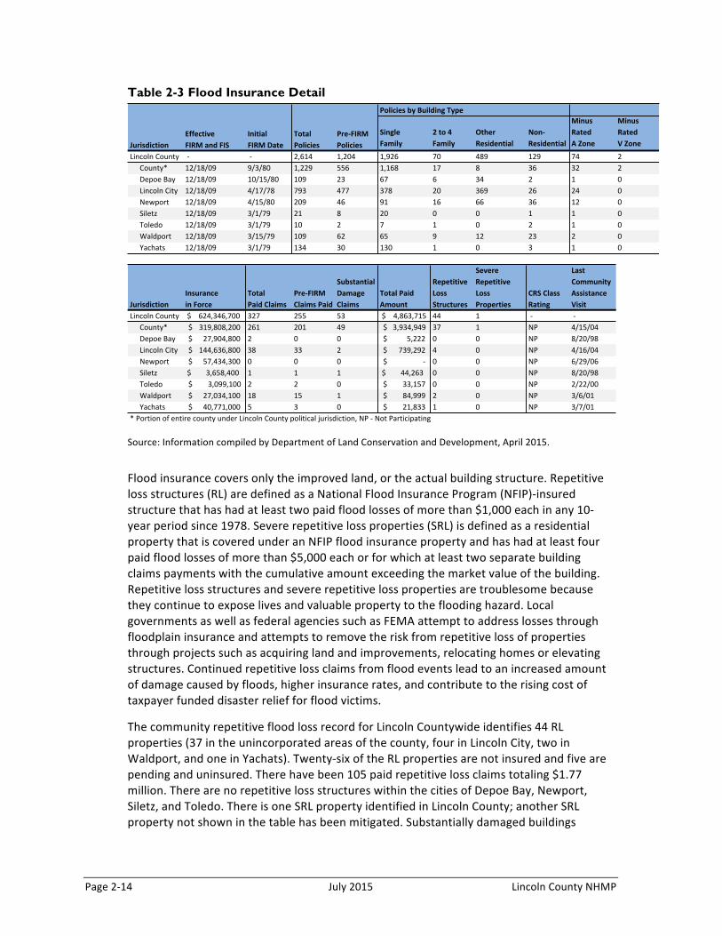
Page 2-‐14 July 2015 Lincoln County NHMP
Table 2-3 Flood Insurance Detail
Source: Information compiled by Department of Land Conservation and Development, April 2015.
Flood insurance covers only the improved land, or the actual building structure. Repetitive loss structures (RL) are defined as a National Flood Insurance Program (NFIP)-‐insured structure that has had at least two paid flood losses of more than $1,000 each in any 10-‐year period since 1978. Severe repetitive loss properties (SRL) is defined as a residential property that is covered under an NFIP flood insurance property and has had at least four paid flood losses of more than $5,000 each or for which at least two separate building claims payments with the cumulative amount exceeding the market value of the building. Repetitive loss structures and severe repetitive loss properties are troublesome because they continue to expose lives and valuable property to the flooding hazard. Local governments as well as federal agencies such as FEMA attempt to address losses through floodplain insurance and attempts to remove the risk from repetitive loss of properties through projects such as acquiring land and improvements, relocating homes or elevating structures. Continued repetitive loss claims from flood events lead to an increased amount of damage caused by floods, higher insurance rates, and contribute to the rising cost of taxpayer funded disaster relief for flood victims.
The community repetitive flood loss record for Lincoln Countywide identifies 44 RL properties (37 in the unincorporated areas of the county, four in Lincoln City, two in Waldport, and one in Yachats). Twenty-‐six of the RL properties are not insured and five are pending and uninsured. There have been 105 paid repetitive loss claims totaling $1.77 million. There are no repetitive loss structures within the cities of Depoe Bay, Newport, Siletz, and Toledo. There is one SRL property identified in Lincoln County; another SRL property not shown in the table has been mitigated. Substantially damaged buildings
Single'Family
2'to'4'Family
Other'Residential
Non7Residential
Minus'Rated'A'Zone
Minus'Rated'V'Zone
Lincoln'County ',' ',' 2,614 1,204 1,926 70 489 129 74 2County* 12/18/09 9/3/80 1,229 556 1,168 17 8 36 32 2Depoe'Bay 12/18/09 10/15/80 109 23 67 6 34 2 1 0Lincoln'City 12/18/09 4/17/78 793 477 378 20 369 26 24 0Newport 12/18/09 4/15/80 209 46 91 16 66 36 12 0Siletz 12/18/09 3/1/79 21 8 20 0 0 1 1 0Toledo 12/18/09 3/1/79 10 2 7 1 0 2 1 0Waldport 12/18/09 3/15/79 109 62 65 9 12 23 2 0Yachats 12/18/09 3/1/79 134 30 130 1 0 3 1 0
Lincoln'County '$''''624,346,700' 327 255 53 '$''''4,863,715' 44 1 ',' ','County* 319,808,200$''''' 261 201 49 3,934,949$'''' 37 1 NP 4/15/04Depoe'Bay 27,904,800$'''''' 2 0 0 5,222$'''''''''' 0 0 NP 8/20/98Lincoln'City 144,636,800$''''' 38 33 2 739,292$''''''' 4 0 NP 4/16/04Newport 57,434,300$'''''' 0 0 0 ,$''''''''''''''''' 0 0 NP 6/29/06Siletz '$''''''''3,658,400' 1 1 1 '$''''''''44,263' 0 0 NP 8/20/98Toledo 3,099,100$'''''''' 2 2 0 33,157$'''''''' 0 0 NP 2/22/00Waldport 27,034,100$'''''' 18 15 1 84,999$'''''''' 2 0 NP 3/6/01Yachats 40,771,000$'''''' 5 3 0 21,833$'''''''' 1 0 NP 3/7/01
Repetitive'Loss'Structures
Severe'Repetitive'Loss'Properties
Total'Paid'Amount
CRS'Class'Rating
Last'Community'Assistance'Visit
*'Portion'of'entire'county'under'Lincoln'County'political'jurisdiction,'NP','Not'Participating'
Pre7FIRM'Policies
EffectiveFIRM'and'FIS
InitialFIRM'Date
Total'PoliciesJurisdiction
Policies'by'Building'Type
JurisdictionInsurancein'Force
Total'Paid'Claims
Pre7FIRM'Claims'Paid
Substantial'Damage'Claims
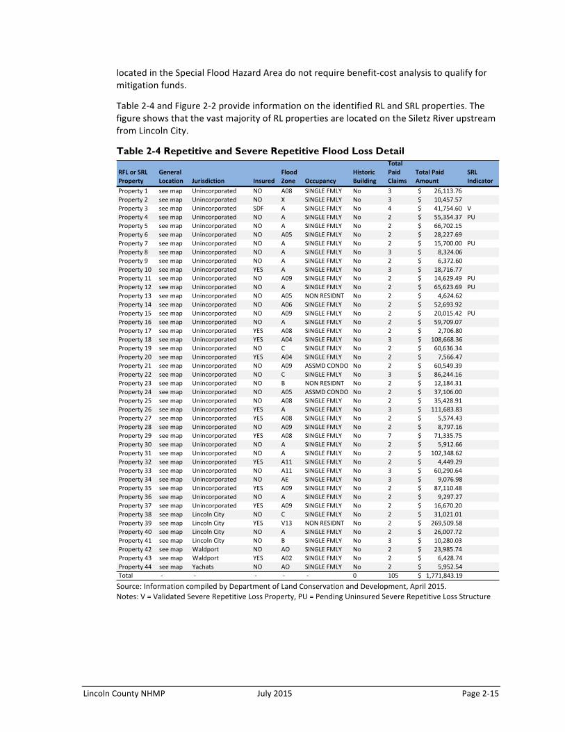
Lincoln County NHMP July 2015 Page 2-‐15
located in the Special Flood Hazard Area do not require benefit-‐cost analysis to qualify for mitigation funds.
Table 2-‐4 and Figure 2-‐2 provide information on the identified RL and SRL properties. The figure shows that the vast majority of RL properties are located on the Siletz River upstream from Lincoln City.
Table 2-4 Repetitive and Severe Repetitive Flood Loss Detail
Source: Information compiled by Department of Land Conservation and Development, April 2015. Notes: V = Validated Severe Repetitive Loss Property, PU = Pending Uninsured Severe Repetitive Loss Structure
RFL$or$SRL$Property
General$Location Jurisdiction
Property(1 see(map UnincorporatedProperty(2 see(map UnincorporatedProperty(3 see(map UnincorporatedProperty(4 see(map UnincorporatedProperty(5 see(map UnincorporatedProperty(6 see(map UnincorporatedProperty(7 see(map UnincorporatedProperty(8 see(map UnincorporatedProperty(9 see(map UnincorporatedProperty(10 see(map UnincorporatedProperty(11 see(map UnincorporatedProperty(12 see(map UnincorporatedProperty(13 see(map UnincorporatedProperty(14 see(map UnincorporatedProperty(15 see(map UnincorporatedProperty(16 see(map UnincorporatedProperty(17 see(map UnincorporatedProperty(18 see(map UnincorporatedProperty(19 see(map UnincorporatedProperty(20 see(map UnincorporatedProperty(21 see(map UnincorporatedProperty(22 see(map UnincorporatedProperty(23 see(map UnincorporatedProperty(24 see(map UnincorporatedProperty(25 see(map UnincorporatedProperty(26 see(map UnincorporatedProperty(27 see(map UnincorporatedProperty(28 see(map UnincorporatedProperty(29 see(map UnincorporatedProperty(30 see(map UnincorporatedProperty(31 see(map UnincorporatedProperty(32 see(map UnincorporatedProperty(33 see(map UnincorporatedProperty(34 see(map UnincorporatedProperty(35 see(map UnincorporatedProperty(36 see(map UnincorporatedProperty(37 see(map UnincorporatedProperty(38 see(map Lincoln(CityProperty(39 see(map Lincoln(CityProperty(40 see(map Lincoln(CityProperty(41 see(map Lincoln(CityProperty(42 see(map WaldportProperty(43 see(map WaldportProperty(44 see(map YachatsTotal (B( (B(
InsuredFlood$Zone Occupancy
Historic$Building
Total$Paid$Claims
Total$Paid$Amount
SRL$Indicator
NO A08 SINGLE(FMLY No 3 26,113.76$((((((((( (((NO X SINGLE(FMLY No 3 10,457.57$((((((((( (((SDF A SINGLE(FMLY No 4 41,754.60$((((((((( VNO A SINGLE(FMLY No 2 55,354.37$((((((((( PUNO A SINGLE(FMLY No 2 66,702.15$((((((((( (((NO A05 SINGLE(FMLY No 2 28,227.69$((((((((( (((NO A SINGLE(FMLY No 2 15,700.00$((((((((( PUNO A SINGLE(FMLY No 3 8,324.06$((((((((((( (((NO A SINGLE(FMLY No 2 6,372.60$((((((((((( (((YES A SINGLE(FMLY No 3 18,716.77$((((((((( (((NO A09 SINGLE(FMLY No 2 14,629.49$((((((((( PUNO A SINGLE(FMLY No 2 65,623.69$((((((((( PUNO A05 NON(RESIDNT No 2 4,624.62$((((((((((( (((NO A06 SINGLE(FMLY No 2 52,693.92$((((((((( (((NO A09 SINGLE(FMLY No 2 20,015.42$((((((((( PUNO A SINGLE(FMLY No 2 59,709.07$((((((((( (((YES A08 SINGLE(FMLY No 2 2,706.80$((((((((((( (((YES A04 SINGLE(FMLY No 3 108,668.36$((((((( (((NO C SINGLE(FMLY No 2 60,636.34$((((((((( (((YES A04 SINGLE(FMLY No 2 7,566.47$((((((((((( (((NO A09 ASSMD(CONDO No 2 60,549.39$((((((((( (((NO C SINGLE(FMLY No 3 86,244.16$((((((((( (((NO B NON(RESIDNT No 2 12,184.31$((((((((( (((NO A05 ASSMD(CONDO No 2 37,106.00$((((((((( (((NO A08 SINGLE(FMLY No 2 35,428.91$((((((((( (((YES A SINGLE(FMLY No 3 111,683.83$((((((( (((YES A08 SINGLE(FMLY No 2 5,574.43$((((((((((( (((NO A09 SINGLE(FMLY No 2 8,797.16$((((((((((( (((YES A08 SINGLE(FMLY No 7 71,335.75$((((((((( (((NO A SINGLE(FMLY No 2 5,912.66$((((((((((( (((NO A SINGLE(FMLY No 2 102,348.62$((((((( (((YES A11 SINGLE(FMLY No 2 4,449.29$((((((((((( (((NO A11 SINGLE(FMLY No 3 60,290.64$((((((((( (((NO AE SINGLE(FMLY No 3 9,076.98$((((((((((( (((YES A09 SINGLE(FMLY No 2 87,110.48$((((((((( (((NO A SINGLE(FMLY No 2 9,297.27$((((((((((( (((YES A09 SINGLE(FMLY No 2 16,670.20$((((((((( (((NO C SINGLE(FMLY No 2 31,021.01$((((((((( (((YES V13 NON(RESIDNT No 2 269,509.58$((((((( (((NO A SINGLE(FMLY No 2 26,007.72$((((((((( (((NO B SINGLE(FMLY No 3 10,280.03$((((((((( (((NO AO SINGLE(FMLY No 2 23,985.74$((((((((( (((YES A02 SINGLE(FMLY No 2 6,428.74$((((((((((( (((NO AO SINGLE(FMLY No 2 5,952.54$((((((((((( ((((B( (B( (B( 0 105 1,771,843.19$((((

Page 2-‐16 July 2015 Lincoln County NHMP
Figure 2-2 Repetitive Loss and Severe Repetitive Loss Properties
Source: Department of Land Conservation and Development, July 2015.
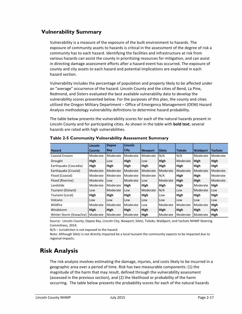
Lincoln County NHMP July 2015 Page 2-‐17
Vulnerability Summary
Vulnerability is a measure of the exposure of the built environment to hazards. The exposure of community assets to hazards is critical in the assessment of the degree of risk a community has to each hazard. Identifying the facilities and infrastructure at risk from various hazards can assist the county in prioritizing resources for mitigation, and can assist in directing damage assessment efforts after a hazard event has occurred. The exposure of county and city assets to each hazard and potential implications are explained in each hazard section.
Vulnerability includes the percentage of population and property likely to be affected under an “average” occurrence of the hazard. Lincoln County and the cities of Bend, La Pine, Redmond, and Sisters evaluated the best available vulnerability data to develop the vulnerability scores presented below. For the purposes of this plan, the county and cities utilized the Oregon Military Department – Office of Emergency Management (OEM) Hazard Analysis methodology vulnerability definitions to determine hazard probability.
The table below presents the vulnerability scores for each of the natural hazards present in Lincoln County and for participating cities. As shown in the table with bold text, several hazards are rated with high vulnerabilities.
Table 2-5 Community Vulnerability Assessment Summary
Source: Lincoln County, Depoe Bay, Lincoln City, Newport, Siletz, Toledo, Waldport, and Yachats NHMP Steering Committees, 2014. N/A – Jurisdiction is not exposed to the hazard. Note: Although Siletz is not directly impacted be a local tsunami the community expects to be impacted due to regional impacts.
Risk Analysis
The risk analysis involves estimating the damage, injuries, and costs likely to be incurred in a geographic area over a period of time. Risk has two measurable components: (1) the magnitude of the harm that may result, defined through the vulnerability assessment (assessed in the previous section), and (2) the likelihood or probability of the harm occurring. The table below presents the probability scores for each of the natural hazards
HazardLincoln,County
DepoeBay
LincolnCity Newport Siletz, Toledo Waldport Yachats
Coastal'Erosion Moderate Moderate Moderate Moderate N/A N/A Moderate ModerateDrought High Low High Low High Moderate High HighEarthquake'(Cascadia) High High High High High High High HighEarthquake'(Crustal) Moderate Moderate Moderate Moderate Moderate Moderate Moderate ModerateFlood'(Coastal) Moderate Moderate Moderate Moderate N/A High High ModerateFlood'(Riverine) Moderate Low Moderate Low Moderate High High ModerateLandslide Moderate Moderate High High High High Moderate HighTsunami'(Distant) Low Moderate Low Moderate N/A Low Moderate LowTsunami'(Local) High High High High Low High High HighVolcano Low Low Low Low Low Low Low LowWildfire Moderate Moderate Moderate Low Moderate Moderate Moderate HighWindstorm High High High High High High High HighWinter'Storm'(Snow/Ice) Moderate Moderate Moderate High Moderate Moderate Moderate High

Page 2-‐18 July 2015 Lincoln County NHMP
present in Lincoln County and for the participating cities. As shown in the table with bold text, several hazards are rated with high probabilities.
Table 2-6 Natural Hazard Probability Assessment Summary
Source: Lincoln County, Depoe Bay, Lincoln City, Newport, Siletz, Toledo, Waldport, and Yachats NHMP Steering Committees, 2014. N/A – Jurisdiction is not exposed to the hazard.
The table below presents the entire updated hazard analysis matrix for Lincoln County. The hazards are listed in rank order from high to low. The table shows that hazard scores are influenced by each of the four categories combined. For local governments, conducting the hazard analysis is a useful step in planning for hazard mitigation, response, and recovery. The method provides the jurisdiction with sense of hazard priorities, but does not predict the occurrence of a particular hazard.
With considerations for past historical events, the probability or likelihood of a particular hazard event occurring, the vulnerability to the community, and the maximum threat or worst-‐case scenario, windstorm, winter storm, Cascadia earthquake, wildfire, and local tsunami rank as the top hazard threats to the county (top tier). Landslide, coastal erosion, flood (riverine and coastal), and distant tsunami rank in the middle (middle tier). Drought, crustal earthquakes, and volcano comprise the lowest ranked hazards in the county (bottom tier).
HazardLincoln,County
DepoeBay
LincolnCity Newport Siletz, Toledo Waldport Yachats
Coastal'Erosion High High High High N/A N/A High HighDrought High High High Low High High High HighEarthquake'(Cascadia) Moderate Moderate Moderate Moderate Moderate Moderate Moderate ModerateEarthquake'(Crustal) High High Moderate Moderate High Moderate Moderate ModerateFlood'(Coastal) High High High High N/A High High HighFlood'(Riverine) High High High High High High High HighLandslide High High High High High High High HighTsunami'(Distant) High High High High N/A High High HighTsunami'Local) Moderate Moderate Moderate Moderate N/A Moderate Moderate ModerateVolcano Low Low Low Low Low Low Low LowWildfire High High Moderate Moderate High High High HighWindstorm High High High High High High High HighWinter'Storm'(Snow/Ice) High High High High High High High High
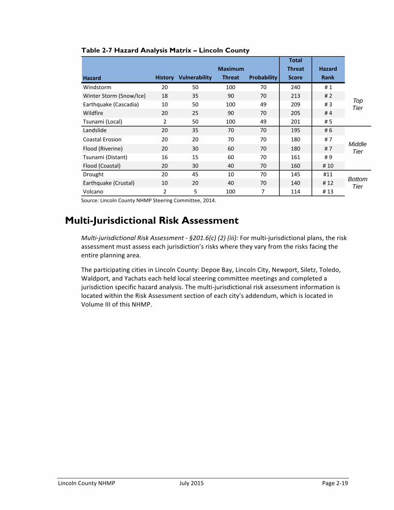
Lincoln County NHMP July 2015 Page 2-‐19
Table 2-7 Hazard Analysis Matrix – Lincoln County
Source: Lincoln County NHMP Steering Committee, 2014.
Multi-Jurisdictional Risk Assessment
Multi-‐jurisdictional Risk Assessment -‐ §201.6(c) (2) (iii): For multi-‐jurisdictional plans, the risk assessment must assess each jurisdiction’s risks where they vary from the risks facing the entire planning area.
The participating cities in Lincoln County: Depoe Bay, Lincoln City, Newport, Siletz, Toledo, Waldport, and Yachats each held local steering committee meetings and completed a jurisdiction specific hazard analysis. The multi-‐jurisdictional risk assessment information is located within the Risk Assessment section of each city’s addendum, which is located in Volume III of this NHMP.
Hazard History VulnerabilityMaximum4Threat Probability
Total4Threat4Score
Hazard4Rank
Windstorm 20 50 100 70 240 #11Winter1Storm1(Snow/Ice) 18 35 90 70 213 #12Earthquake1(Cascadia) 10 50 100 49 209 #13Wildfire 20 25 90 70 205 #14Tsunami1(Local) 2 50 100 49 201 #15Landslide 20 35 70 70 195 #16Coastal1Erosion 20 20 70 70 180 #17Flood1(Riverine) 20 30 60 70 180 #17Tsunami1(Distant) 16 15 60 70 161 #19Flood1(Coastal) 20 30 40 70 160 #110Drought 20 45 10 70 145 #11Earthquake1(Crustal) 10 20 40 70 140 #112Volcano 2 5 100 7 114 #113
Bottom Tier
Top Tier
Middle Tier
Lincoln County NHMP July 2015 revised 2017 Page 3-1
SECTION 3:
MITIGATION STRATEGY
Section 3 outlines Lincoln County’s strategy to reduce or avoid long-term vulnerabilities to the identified hazards. Specifically, this section presents a mission and specific goals and actions thereby addressing the mitigation strategy requirements contained in 44 CFR 201.6(c). The Natural Hazard Mitigation Plan (NHMP) steering committee reviewed and updated the mission, goals and action items documented in this plan. Additional planning process documentation is in Appendix B.
Mitigation Plan Mission
The plan mission states the purpose and defines the primary functions of Lincoln County’s NHMP. It is intended to be adaptable to any future changes made to the plan and need not change unless the community’s environment or priorities change.
The mission of the Lincoln County NHMP is:
To promote public policy and mitigation activities which will enhance the safety to life and property from natural hazards.
The 2015 NHMP update Steering Committee reviewed the 2009 plan mission statement and agreed it accurately describes the overall purpose and intent of this plan. This is the exact wording that was present in the 2009 plan. The Steering Committee believes the concise nature of the mission statement allows for a comprehensive approach to mitigation planning.
Mitigation Plan Goals
Mitigation plan goals are more specific statements of direction that Lincoln County citizens, and public and private partners can take while working to reduce the county’s risk from natural hazards. These statements of direction form a bridge between the broad mission statement and particular action items. The goals listed here serve as checkpoints as agencies and organizations begin implementing mitigation action items.
Public participation was a key aspect in developing the plan goals. Meetings with the project steering committee, stakeholder interviews and public workshops all served as methods to obtain input and priorities in developing goals for reducing risk and preventing loss for natural hazards in Lincoln County.
The 2015 Lincoln County NHMP Steering Committee reviewed the 2009 plan goals in comparison to the Draft State NHMP Goals and determined they would modify their goals to align with the State NHMP goals.
All the plan goals are important and are listed below in no particular order of priority. Establishing community priorities within action items neither negates nor eliminates any goals, but it establishes which action items to consider to implement first, should funding become available. Below is a list of the re-confirmed plan goals:

Page 3-2 July 2015 revised 2017 Lincoln County NHMP
Goal 1: Protect life and reduce injuries resulting from natural hazards.
Goal 2: Minimize public and private property damages and the disruption of essential infrastructure and services from natural hazards.
Goal 3: Implement strategies to mitigate the effects of natural hazards and increase the quality of life and resilience of economies in Lincoln County.
Goal 4: Minimize the impact of natural hazards while protecting, restoring, and sustaining environmental processes.
Goal 5: Enhance and maintain local capability to implement a comprehensive hazard loss reduction strategy.
Goal 6: Document and evaluate progress in achieving hazard mitigation strategies and action items.
Goal 7: Motivate the public, private sector, and government agencies to mitigate the effects of natural hazards through information and education.
Goal 8: Apply development standards that mitigate or eliminate the potential impacts of natural hazards.
Goal 9: Mitigate damage to historic and cultural resources from natural hazards.
Goal 10: Increase communication, collaboration, and coordination among agencies at all levels of government and the private sector to mitigate natural hazards.
Goal 11: Integrate local NHMPs with comprehensive plans and implementing measures.
(Note: although numbered the goals are not prioritized.)
During the steering committee meetings for the participating jurisdictions (Depoe Bay, Lincoln City, Newport, Siletz, Toledo, Waldport, and Yachats) the Lincoln County NHMP mission statement and goal statements were reviewed and agreed upon by each community.
Existing Mitigation Activities
Existing mitigation activities include current mitigation programs and activities that are being implemented by the county in an effort to reduce the community’s overall risk to natural hazards. Documenting these efforts can assist the jurisdiction to better understand risk and can assist in documenting successes. For a comprehensive list of existing mitigation activities for each specific hazard, reference Volume II, Hazard Annexes.
Government Structure
Beyond Emergency Management, most departments within the county and city governance structures have some degree of responsibility in building overall community resilience. Each plays a role in ensuring that jurisdiction functions and normal operations resume after an incident, and the needs of the population are met. For further explanation regarding how
Lincoln County NHMP July 2015 revised 2017 Page 3-3
these departments influence hazard resilience, reference Appendix C, Community Profile and within the city addenda of Volume III.
Existing Plans and Policies
Communities often have existing plans and policies that guide and influence land use, land development, and population growth. Linking existing plans and policies to the NHMP helps identify what resources already exist that can be used to implement the action items identified in the Plan. Plans and policies already in existence have support from local residents, businesses and policy makers.1 A list documenting plans and policies already in place in the county and participating cities can be found in Appendix C, Community Profile and within the city addenda of Volume III.
Community Organizations and Programs
In planning for natural hazard mitigation, it is important to know what social systems exist within the community because of their existing connections to the public. The county and cities can use existing social systems as resources for implementing such communication-related activities because these service providers already work directly with the public on a number of issues, one of which could be natural hazard preparedness and mitigation. Appendix C, Community Profile, provides a comprehensive list of community organizations and programs, and offers a more thorough explanation of how existing community organizations and programs can be utilized for hazard mitigation.
Mitigation Plan Action Items
Action items identified through the planning process are an important part of the mitigation plan. Action items are detailed recommendations for activities that local departments, citizens and others could engage in to reduce risk. They address both multi-hazard (MH) and hazard-specific issues. Action items can be developed through a number of sources. The figure below illustrates some of these sources. A description of how the plan’s mitigation actions were developed is provided below.
1 Raymond J. Burby, “Cooperating with Nature: Confronting Natural Hazards with Land-Use Planning for Sustainable Communities,” (1998).
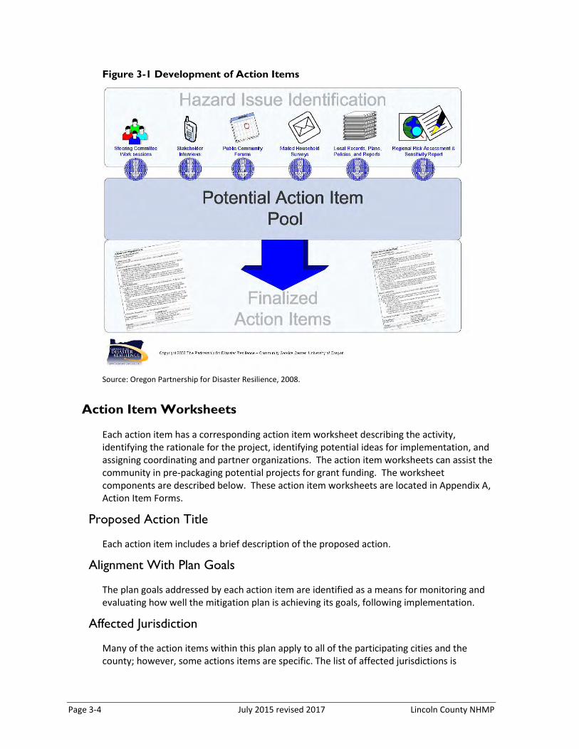
Page 3-4 July 2015 revised 2017 Lincoln County NHMP
Figure 3-1 Development of Action Items
Source: Oregon Partnership for Disaster Resilience, 2008.
Action Item Worksheets
Each action item has a corresponding action item worksheet describing the activity, identifying the rationale for the project, identifying potential ideas for implementation, and assigning coordinating and partner organizations. The action item worksheets can assist the community in pre-packaging potential projects for grant funding. The worksheet components are described below. These action item worksheets are located in Appendix A, Action Item Forms.
Proposed Action Title
Each action item includes a brief description of the proposed action.
Alignment With Plan Goals
The plan goals addressed by each action item are identified as a means for monitoring and evaluating how well the mitigation plan is achieving its goals, following implementation.
Affected Jurisdiction
Many of the action items within this plan apply to all of the participating cities and the county; however, some actions items are specific. The list of affected jurisdictions is
Lincoln County NHMP July 2015 revised 2017 Page 3-5
provided on the right side of the matrix. The action item form in Appendix A provides more detailed information.
Alignment with Existing Plans / Policies
Identify any existing community plans and policies where the action item can be incorporated. Incorporating the mitigation action into existing plans and policies, such as comprehensive plans, will increase the likelihood that it will be implemented.
Rationale or Key Issues Addressed
Action items should be fact-based and tied directly to issues or needs identified throughout the planning process. Action items can be developed at any time during the planning process and can come from a number of sources, including participants in the planning process, noted deficiencies in local capability, or issues identified through the risk assessment. The rationale for proposed action items is based on the information documented in Section II and the Hazard Annexes.
Implementation through Existing Programs
For each action item, the form asks for some ideas for implementation, which serve as the starting point for taking action. This information offers a transition from theory to practice. Ideas for implementation could include: (1) collaboration with relevant organizations, (2) alignment with the community priority areas, and (3) applications to new grant programs.
The ideas for implementation offer a transition from theory to practice and serve as a starting point for this plan. This component of the action item is dynamic, since some ideas may prove to not be feasible, and new ideas may be added during the plan maintenance process. Ideas for implementation include such things as: collaboration with relevant organizations, grant programs, tax incentives, human resources, education and outreach, research, and physical manipulation of buildings and infrastructure. When an action is implemented, more work will probably be needed to determine the exact course of action.
The Lincoln County NHMP includes a range of action items that, when implemented, will reduce loss from hazard events in the County. Within the plan, FEMA requires the identification of existing programs that might be used to implement these action items. Lincoln County and the participating cities currently address statewide planning goals and legislative requirements through their comprehensive land use plans, capital improvements plans, mandated standards, and building codes. To the extent possible, the jurisdictions will work to incorporate the recommended mitigation action items into existing programs and procedures.
Many of the Lincoln County NHMP’s recommendations are consistent with the goals and objectives of the existing plans and policies. Where possible, Lincoln County and the participating cities will implement the NHMP’s recommended actions through existing plans and policies. Plans and policies already in existence have support from local residents, businesses, and policy makers. Many land-use, comprehensive, and strategic plans get
Page 3-6 July 2015 revised 2017 Lincoln County NHMP
updated regularly, and can adapt easily to changing conditions and needs.2 Implementing the NHMP’s action items through such plans and policies increases their likelihood of being supported and implemented.
Coordinating Organization:
The coordinating organization is the public agency with the regulatory responsibility to address natural hazards, or that is willing and able to organize resources, find appropriate funding, or oversee activity implementation, monitoring and evaluation.
Internal and External Partners:
The internal and external partner organizations listed in the Action Item Worksheets are potential partners recommended by the project Steering Committee but not necessarily contacted during the development of the plan. The coordinating organization should contact the identified partner organizations to see if they are capable of and interested in participation. This initial contact is also to gain a commitment of time and/or resources toward completion of the action items.
Internal partner organizations are departments within the county or other participating jurisdiction that may be able to assist in the implementation of action items by providing relevant resources to the coordinating organization.
External partner organizations can assist the coordinating organization in implementing the action items in various functions and may include local, regional, state, or federal agencies, as well as local and regional public and private sector organizations.
Potential Funding Sources
Where possible, identify potential funding sources for the action item. Example funding sources can include: the federal Pre-Disaster Mitigation and Flood Mitigation Assistance Programs; state funding sources such as the Oregon Seismic Rehabilitation Grant Program; or local funding sources such as capital improvement or general funds. An action item may also have multiple funding sources.
Estimated Cost
Where possible, an estimate of the cost for implementing the action item is included.
Timeline
Action items include both short and long-term activities. Each action item includes an estimate of the timeline for implementation. Short-term action items (ST) are activities that may be implemented with existing resources and authorities in one to two years. Long-term action items (LT) may require new or additional resources and/or authorities, and may take from one to five years to implement. Ongoing action items signify that work has begun and will either exist over an indefinite timeline, or an extended timeline.
2 Ibid

Lincoln County NHMP July 2015 revised 2017 Page 3-7
Status
As action items are implemented or new ones are created during the plan maintenance process, it is important to indicate the status of the action item—whether it is new, ongoing, deferred, or complete. Documenting the status of the action will make reviewing and updating mitigation plan easier during the plan’s five-year update, and can be used as a benchmark for progress. Deferred action items have yet to see any significant work begin on the particular action.
Priority
High priority action items are designated in order to clarify the importance of these mitigation actions for the affected jurisdictions.
Action Item Development Process
Development of action items was a multi-step, iterative process that involved brainstorming, discussion, review, and revisions. The majority of the action items were first created during the 2009 NHMP planning process. During that process, the steering committee developed maps of local vulnerable populations, facilities, and infrastructure in respect to each identified hazard. Review of these maps generated discussion around potential actions to mitigate impacts to the vulnerable areas. OPDR provided guidance in the development of action items by presenting and discussing actions that were used in other communities. OPDR also took note of ideas that came up in steering committee meetings and drafted specific actions that met the intent of the committee. All actions were then reviewed by the committee, discussed at length, and revised as necessary before becoming a part of this document.
Action Item Matrix
The action item matrix portrays the overall action plan framework and identifies linkages between the plan goals, partnerships (coordination and partner organizations), and actions. The matrix documents a description of the action, if the steering committee identified the action as high priority, the coordinating organization, partner organizations, timeline, and the plan goals addressed. Refer to Appendix A, Action Items for detailed information about each action item.
Included in the table are Multi-Hazard Actions #7 and #8, Earthquake Action #3, and Tsunami Action #1 which are high priority action items.

Page 3-8 July 2015 revised 2017 Lincoln County NHMP
Table 3-2 Lincoln County Action Items
Source Lincoln County NHMP Steering Committee, updated 2015 * - indicates an action that was identified through the Risk MAP process, see Appendix G for additional information.
De
po
e B
ay
Lin
coln
Cit
y
Ne
wp
ort
Sile
tz
Tole
do
Wal
dp
ort
Yac
hat
s
Multi Hazard #1Consider Local Energy Assurance
Planning for critical areas countywide
Lincoln County Emergency
Management, Public Works
Lincoln County Planning and
Development, Public Works;
Utility Companies, U.S. DOE, OEM
LT New X X X X X X X
Multi Hazard #2
Improve technology capacity of
communities, agencies and
responders needed to adequately
map hazard areas, broadcast
warnings, inform, and educate
residents and visitors of natural
hazard dangers
Lincoln County Emergency
Management
Lincoln County GIS, Cities, Radio,
DOGAMIOngoing Ongoing X X X X X X X
Multi Hazard #3
Develop and implement, or enhance
strategies for debris management
and/or removal after natural hazard
events.
Lincoln County Emergency
Management, Solid Waste
District
Lincoln County Public Works,
ODOT, cities, regional recycling
facilities
ST Ongoing X X X X X X X
Multi Hazard #4
Work with coastal communities,
citizen groups, property owners,
recreation areas, emergency
responders, schools and businesses
in promoting natural hazard
mitigation opportunities.
Lincoln County Planning
and Development,
Emergency Management
Building, Public Works, fire
districts, school districts, builders
associations, developers, property
owners, mortgage companies,
ODF, IBHS, Red Cross, DOGAMI,
FEMA, OEM, DLCD, NOAA
Ongoing Ongoing X X X X X X X
Multi Hazard #5
Encourage purchase of hazard
insurance for business and
homeowners by forming
partnerships with the insurance and
real estate industries.
Lincoln County Emergency
Management
Local insurance agencies,
mortgage companies, insurance
and real estate industries,
DOGAMI, OEM, DLCD
OngoingCompleted
/ OngoingX X X X
Multi Hazard #6 XIntegrate the NHMP into County and
City comprehensive plans.
City and County Community
Development and Planning
City and County Decision making
bodies, Emergency Management;
DLCD, OEM, FEMA, OPDR
MT New X X X X X X X
*Multi Hazard #7 XPrepare long-term catastrophic
recovery plan
Lincoln County Emergency
Management, Planning and
Development
DLCD, OEM, FEMA, North Coast
Regional Solutions TeamMT New X X X X X X
*Multi Hazard #8Tie concept of operations planning
(CONOPS) with mitigation
Lincoln County Emergency
ManagementOEM, DLCD ST New X X X X X X X
Status
Partner Jurisdiction(s)
Action Item
(2015 NHMP) Priority Proposed Action Title Coordinating Organization Partner Organization(s)
TimelineST=Short-term (1-3 yrs ),
MT=Mid-term (4-10 yrs ),
LT=Long-term (10+ yrs )
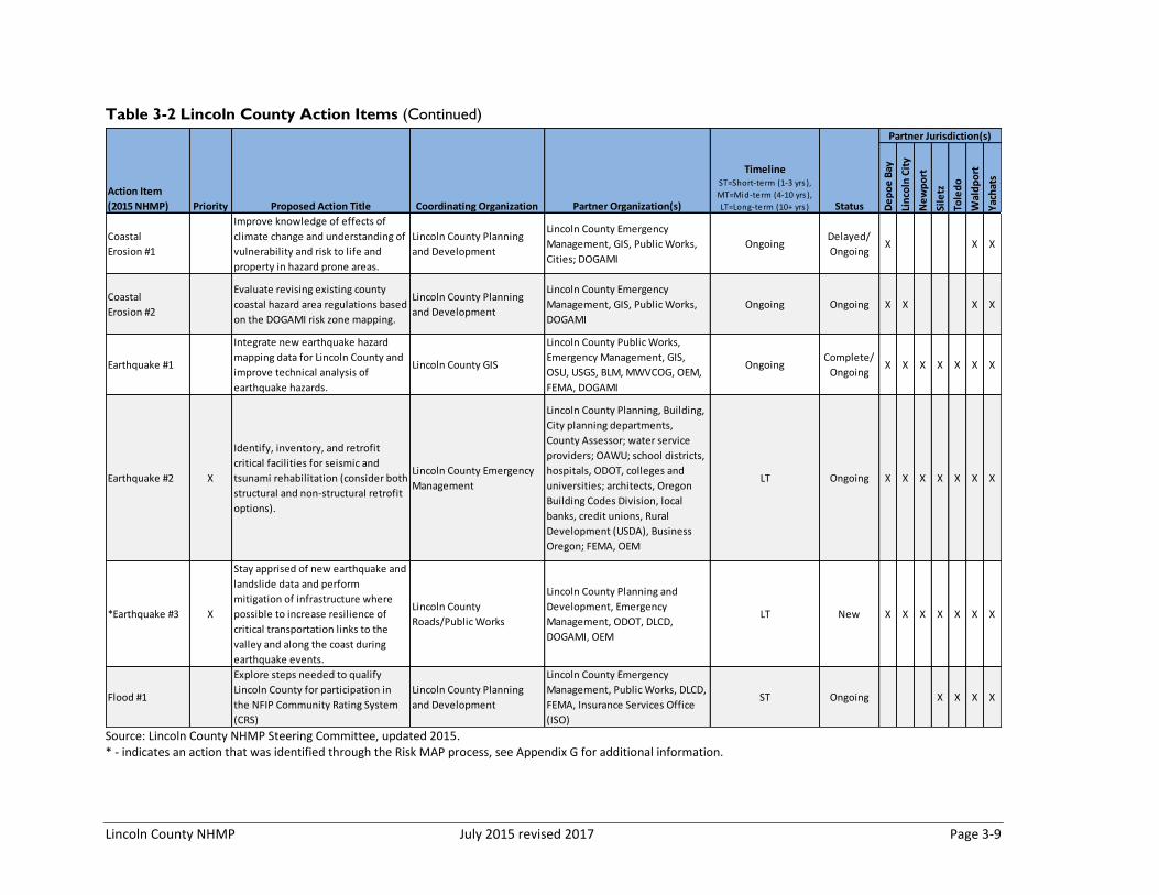
Lincoln County NHMP July 2015 revised 2017 Page 3-9
Table 3-2 Lincoln County Action Items (Continued)
Source: Lincoln County NHMP Steering Committee, updated 2015. * - indicates an action that was identified through the Risk MAP process, see Appendix G for additional information.
De
po
e B
ay
Lin
coln
Cit
y
Ne
wp
ort
Sile
tz
Tole
do
Wal
dp
ort
Yac
hat
s
Coastal
Erosion #1
Improve knowledge of effects of
climate change and understanding of
vulnerability and risk to life and
property in hazard prone areas.
Lincoln County Planning
and Development
Lincoln County Emergency
Management, GIS, Public Works,
Cities; DOGAMI
OngoingDelayed/
OngoingX X X
Coastal
Erosion #2
Evaluate revising existing county
coastal hazard area regulations based
on the DOGAMI risk zone mapping.
Lincoln County Planning
and Development
Lincoln County Emergency
Management, GIS, Public Works,
DOGAMI
Ongoing Ongoing X X X X
Earthquake #1
Integrate new earthquake hazard
mapping data for Lincoln County and
improve technical analysis of
earthquake hazards.
Lincoln County GIS
Lincoln County Public Works,
Emergency Management, GIS,
OSU, USGS, BLM, MWVCOG, OEM,
FEMA, DOGAMI
OngoingComplete/
OngoingX X X X X X X
Earthquake #2 X
Identify, inventory, and retrofit
critical facilities for seismic and
tsunami rehabilitation (consider both
structural and non-structural retrofit
options).
Lincoln County Emergency
Management
Lincoln County Planning, Building,
City planning departments,
County Assessor; water service
providers; OAWU; school districts,
hospitals, ODOT, colleges and
universities; architects, Oregon
Building Codes Division, local
banks, credit unions, Rural
Development (USDA), Business
Oregon; FEMA, OEM
LT Ongoing X X X X X X X
*Earthquake #3 X
Stay apprised of new earthquake and
landslide data and perform
mitigation of infrastructure where
possible to increase resilience of
critical transportation links to the
valley and along the coast during
earthquake events.
Lincoln County
Roads/Public Works
Lincoln County Planning and
Development, Emergency
Management, ODOT, DLCD,
DOGAMI, OEM
LT New X X X X X X X
Flood #1
Explore steps needed to qualify
Lincoln County for participation in
the NFIP Community Rating System
(CRS)
Lincoln County Planning
and Development
Lincoln County Emergency
Management, Public Works, DLCD,
FEMA, Insurance Services Office
(ISO)
ST Ongoing X X X X
Action Item
(2015 NHMP) Priority Proposed Action Title Coordinating Organization Partner Organization(s)
TimelineST=Short-term (1-3 yrs ),
MT=Mid-term (4-10 yrs ),
LT=Long-term (10+ yrs ) Status
Partner Jurisdiction(s)

Page 3-10 July 2015 revised 2017 Lincoln County NHMP
Table 3-2 Lincoln County Action Items (Continued)
Source: Lincoln County NHMP Steering Committee, updated 2015.
De
po
e B
ay
Lin
coln
Cit
y
Ne
wp
ort
Sile
tz
Tole
do
Wal
dp
ort
Yac
hat
s
Flood #2
Update the Lower Siletz Flood
Mitigation Action Plan; develop flood
mitigation action plan(s) for the
lower Alsea and Salmon River, and
Drift Creek and other areas.
Lincoln County Planning
and Development
Lincoln County Emergency
Management, OEM; FEMA Region
X
ST Deferred X X X
Flood #3
Work with affected property owners
to elevate or relocate non-
conforming, pre-FIRM structures in
flood hazard areas
Lincoln County Planning
and Development
Lincoln County Emergency
Management; OEM, DLCD,
DOGAMI; FEMA Region X
Ongoing Ongoing X X X
Flood # 4
Continue compliance with the
National Flood Insurance Program
(NFIP).
Lincoln County Planning
and Development
Lincoln County Public Works,
Emergency Management, Building
Departments, DLCD, FEMA,
DOGAMI, Cities
Ongoing Ongoing X X X X X X X
Landslide #1
Encourage construction, site location
and design that can be applied to
steep slopes to reduce the potential
threat of landslides.
Lincoln County Planning
and Development
Lincoln County Emergency
Management, Building, and Public
Works, DLCD, DOGAMI, Cities
Ongoing Ongoing X X X X X X X
Landslide #2Protect existing development in
landslide-prone areas.
Lincoln County Emergency
Management, Public Works
Lincoln County Planning and
Development, GIS, DLCD, OEM, Ongoing Ongoing X X
Landslide #3
Evaluate and implement mitigation
projects for areas of Highway 101
near Beverly Beach/ Spencer Creek
that is slumping (near milepost 137)
and section near Cape Foulweather
that is prone to flooding (near
milepost 133).
Lincoln County Public
Works
ODOT, North Coast Regional
Solutions Team, DLCDLT New
Landlside #4 X
Collaborate with the Oregon
Department of Geology and Mineral
Industries to work on landslide risk
reduction.
Lincoln County Planning
and Development
Lincoln County Emergnecy
Management, DOGAMI, DLCD,
OEM
LT New X X X X X X X
Tsunami #1 X
Relocate critical/ essential facilities
that are within the tsunami
inundation zone and likely to be
impacted by tsunami.
Lincoln County Emergency
Management
Lincoln County Planning and
Development, DOGAMI, DLCD,
North Coast Regional Solutions
Team, Gleneden Beach Fire
Department, North Lincoln Fire
and Rescue
LT Ongoing X X X
Status
Partner Jurisdiction(s)
Action Item
(2015 NHMP) Priority Proposed Action Title Coordinating Organization Partner Organization(s)
TimelineST=Short-term (1-3 yrs ),
MT=Mid-term (4-10 yrs ),
LT=Long-term (10+ yrs )
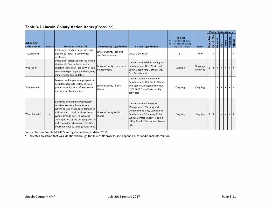
Lincoln County NHMP July 2015 revised 2017 Page 3-11
Table 3-2 Lincoln County Action Items (Continued)
Source: Lincoln County NHMP Steering Committee, updated 2015. * - indicates an action that was identified through the Risk MAP process, see Appendix G for additional information.
De
po
e B
ay
Lin
coln
Cit
y
Ne
wp
ort
Sile
tz
Tole
do
Wal
dp
ort
Yac
hat
s
*Tsunami #2
Implement land use strategies and
options to increase community
resilience
Lincoln County Planning
and DevelopmentDLCD, OEM, FEMA ST New X X
Wildfire #1
Implement actions identified within
the Lincoln County Community
Wildfire Protection Plan (CWPP) and
continue to participate with ongoing
maintenance and updates.
Lincoln County Emergency
Management
Lincoln County GIS, Planning and
Development, ODF, North and
South Lincoln Fire Districts, City
Fire Department
OngoingOngoing/
ModifiedX X X X X X X
Windstorm #1
Develop and implement programs to
keep trees from threatening lives,
property, and public infrastructure
during windstorm events.
Lincoln County Public
Works
Lincoln County Planning and
Development, GIS, Public Works,
Emergency Management, Cities,
USFS, BLM, State Parks, utility
providers
Ongoing Ongoing X X X X X
Windstorm #2 X
Continue and enhance windstorm
resistant construction methods
where possible to reduce damage to
utilities and critical facilities from
windstorms. In part, this may be
accomplished by encouraging electric
utility providers to convert existing
overhead lines to underground lines.
Lincoln County Public
Works
Lincoln County Emergency
Management, Planning and
Development; Ciity Community
Development/ Planning, Public
Works; Central Lincoln People's
Utility District, Consumers Power,
Inc.
Ongoing Ongoing X X X X X X
TimelineST=Short-term (1-3 yrs ),
MT=Mid-term (4-10 yrs ),
LT=Long-term (10+ yrs ) Status
Partner Jurisdiction(s)
Action Item
(2015 NHMP) Priority Proposed Action Title Coordinating Organization Partner Organization(s)
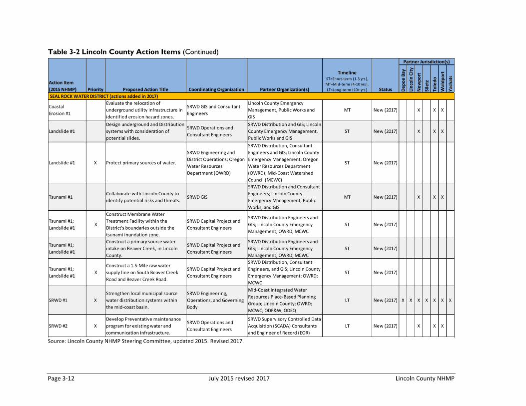
Page 3-12 July 2015 revised 2017 Lincoln County NHMP
Table 3-2 Lincoln County Action Items (Continued)
Source: Lincoln County NHMP Steering Committee, updated 2015. Revised 2017.
De
po
e B
ay
Lin
coln
Cit
y
Ne
wp
ort
Sile
tz
Tole
do
Wal
dp
ort
Yac
hat
s
Coastal
Erosion #1
Evaluate the relocation of
underground utility infrastructure in
identified erosion hazard zones.
SRWD GIS and Consultant
Engineers
Lincoln County Emergency
Management, Public Works and
GIS
MT New (2017) X X X
Landslide #1
Design underground and Distribution
systems with consideration of
potential slides.
SRWD Operations and
Consultant Engineers
SRWD Distribution and GIS; Lincoln
County Emergency Management,
Public Works and GIS
ST New (2017) X X X
Landslide #1 X Protect primary sources of water.
SRWD Engineering and
District Operations; Oregon
Water Resources
Department (OWRD)
SRWD Distribution, Consultant
Engineers and GIS; Lincoln County
Emergency Management; Oregon
Water Resources Department
(OWRD); Mid-Coast Watershed
Council (MCWC)
ST New (2017)
Tsunami #1Collaborate with Lincoln County to
identify potential risks and threats.SRWD GIS
SRWD Distribution and Consultant
Engineers; Lincoln County
Emergency Management, Public
Works, and GIS
MT New (2017) X X X
Tsunami #1;
Landslide #1X
Construct Membrane Water
Treatment Facility within the
District's boundaries outside the
tsunami inundation zone.
SRWD Capital Project and
Consultant Engineers
SRWD Distribution Engineers and
GIS; Lincoln County Emergency
Management; OWRD; MCWC
ST New (2017)
Tsunami #1;
Landslide #1X
Construct a primary source water
intake on Beaver Creek, in Lincoln
County.
SRWD Capital Project and
Consultant Engineers
SRWD Distribution Engineers and
GIS; Lincoln County Emergency
Management; OWRD; MCWC
ST New (2017)
Tsunami #1;
Landslide #1X
Construct a 1.5-Mile raw water
supply line on South Beaver Creek
Road and Beaver Creek Road.
SRWD Capital Project and
Consultant Engineers
SRWD Distribution, Consultant
Engineers, and GIS; Lincoln County
Emergency Management; OWRD;
MCWC
ST New (2017)
SRWD #1 X
Strengthen local municipal source
water distribution systems within
the mid-coast basin.
SRWD Engineering,
Operations, and Governing
Body
Mid-Coast Integrated Water
Resources Place-Based Planning
Group; Lincoln County; OWRD;
MCWC; ODF&W; ODEQ
LT New (2017) X X X X X X X
SRWD #2 X
Develop Preventative maintenance
program for existing water and
communication infrastructure.
SRWD Operations and
Consultant Engineers
SRWD Supervisory Controlled Data
Acquisition (SCADA) Consultants
and Engineer of Record (EOR)
LT New (2017) X X X
TimelineST=Short-term (1-3 yrs ),
MT=Mid-term (4-10 yrs ),
LT=Long-term (10+ yrs ) Status
Partner Jurisdiction(s)
SEAL ROCK WATER DISTRICT (actions added in 2017)
Action Item
(2015 NHMP) Priority Proposed Action Title Coordinating Organization Partner Organization(s)

Lincoln County NHMP July 2015 revised 2017 Page 3-13
Table 3-2 Lincoln County Action Items (Continued)
Source: Lincoln County NHMP Steering Committee, updated 2015. Revised 2017.
De
po
e B
ay
Lin
coln
Cit
y
Ne
wp
ort
Sile
tz
Tole
do
Wal
dp
ort
Yac
hat
s
SRWD #3 X
Develop Emergency Source Water
Interconnection with neighboring
communities.
SRWD Operations,
Consultant Engineers,
Districts and Municipalities
Mid-Coast Integrated Water
Resources Place-Based Planning
Group; City of Newport; City of
Toledo; City of Waldport; Lincoln
County; OWRD; MCWC; ODF&W;
ODEQ
LT New (2017)
Coastal
Erosion #1X
Evaluate the relocation of utility
infrastructure in identified erosion
hazard zones.
CLPUD Systems Engineering
CLPUD Distribution Engineering
and GIS; Lincoln County
Emergency Management, Public
Works and GIS
MT New (2017)
Landslide #1 X
Design Transmission and Distribution
systems with consideration of
potential slides.
CLPUD Engineering and
OperationsCLPUD Distribution Engineering ST New (2017)
Landslide #2 XMonitor and evaluate existing
infrastructure for potential slide risk.
CLPUD Engineering and
Operations
CLPUD Systems Engineering and
Distribution EngineeringST New (2017)
Landslide #4 XCollaborate with Lincoln County to
identify potential threats.CLPUD GIS
CLPUD Distribution Engineering;
Lincoln County Emergency
Management
MT New (2017)
Tsunami #1 XRelocate Northern Operations Center
out of the Tsunami Zone.CLPUD Special Projects All internal CLPUD Departments ST New (2017)
Windstorm #1 XTrim trees and brush from
powerlines to limit outages
CLPUD Engineering and
OperationsCLPUD Operations Ongoing New (2017)
Windstorm #2 XSelectively convert existing
Overhead lines to Underground.
CLPUD Engineering and
Operations
CLPUD Systems Engineering and
Distribution EngineeringOngoing New (2017)
CLPUD #1 X
Strengthen local power and
communication grids through
redundancy and looped systems.
CLPUD Engineering and
OperationsCLPUD Communications Ongoing New (2017)
CLPUD #2 X
Preventative maintenance of
existing power and Comm
infrastructure.
CLPUD Engineering and
OperationsCLPUD Communications Ongoing New (2017)
CENTRAL LINCOLN PEOPLE'S UTILITY DISTRICT (actions added in 2017)
TimelineST=Short-term (1-3 yrs ),
MT=Mid-term (4-10 yrs ),
LT=Long-term (10+ yrs ) Status
Partner Jurisdiction(s)
SEAL ROCK WATER DISTRICT (actions added in 2017)
Action Item
(2015 NHMP) Priority Proposed Action Title Coordinating Organization Partner Organization(s)
Lincoln County NHMP July 2015 Page 4-‐1
SECTION 4: PLAN IMPLEMENTATION AND MAINTENANCE
The common objective of every local mitigation plan is to reduce the community's risk from and exposure to natural hazards before they occur. One of the most effective ways of institutionalize mitigation in the community is to incorporate natural hazard planning into the community’s comprehensive planning activities. In Oregon, comprehensive plans address a wide range of community issues and sectors – from land use and transportation to natural resources and economics. Lincoln County’s Comprehensive plan addresses the following broad categories:
• Land Use and Urbanization • Intergovernmental Coordination • Citizen Involvement • Air, Land and Water Resources • Natural Hazards • Forest, Agriculture, Estuarine, Coastal, Beaches and Dunes, and Open Space • Economy • Transportation • Energy • Housing • Recreation • Public Facilities • Natural Resources • Historic and Cultural Resources
This section outlines a comprehensive approach to implement the mitigation strategies outline in this Multi-‐jurisdictional Natural Hazards Mitigation Plan (NHMP). This implementation strategy is informed by information collected and developed during the NHMP update process and concurrent Lincoln County Risk MAP project. The implementation strategy strives to demonstrate how risk specific data, both natural hazard and community vulnerability, can be integrated in existing programs, projects and policies.
For the purposes of this NHMP, the Plan Implementation and Maintenance section details the formal process that will ensure that the Lincoln County Multi-‐jurisdictional Natural Hazards Mitigation Plan (NHMP) remains an active and relevant document. This section includes a schedule for monitoring and evaluating the plan semi-‐annually, as well as producing an updated plan every five years. Finally, this section describes how the county will integrate public participation throughout the plan maintenance and implementation process.
Implementing the Plan
There are three primary ways mitigation strategies can be implemented at the local level: Policies, Projects, and Processes. Figure 4-‐1 illustrates these categories with examples.

Page 4-‐2 July 2015 Lincoln County NHMP
Figure 4-1 Mitigation Strategy Implementation Categories
Source: Oregon Partnership for Disaster Resilience
The success of the Lincoln County NHMP depends on how well the outlined action items are implemented. In an effort to ensure that the activities identified are implemented, the following steps will be taken. The plan will be formally adopted, a coordinating body will be assigned, a convener shall be designated, the identified activities will be prioritized and evaluated, and finally, the plan will be implemented through existing plans, programs, and policies.
Table 4-‐1 on the following pages demonstrates how the actions will be implemented within Lincoln County. For detailed information on action item implementation see Table 4-‐2.
Plan Adoption
The Lincoln County NHMP was developed and will be implemented through a collaborative process. After the Plan is locally reviewed and deemed complete, the Lincoln County Emergency Services Manager submits it to the State Hazard Mitigation Officer (SHMO) at the Oregon Military Department – Office of Emergency Management (OEM). OEM submits the plan to the Federal Emergency Management Agency (FEMA-‐-‐Region X) for review. This review addresses the federal criteria outlined in the FEMA Interim Final Rule 44 CFR Part 201. Upon acceptance by FEMA, the County will adopt the plan via resolution. At that point the County will gain eligibility for the Pre-‐Disaster Mitigation Grant Program, the Hazard Mitigation Grant Program funds, and Flood Mitigation Assistance program funds. Following adoption by the county, the participating jurisdictions should convene local decision makers and adopt the Lincoln County NHMP.
• The City shall participate in the CRS program • The City shall develop guidelines for the clearing and placement of snow and placement of snow to reduce the likelihood of flooding.
Policy
• Seismically retrofit the "A" Street bridge • Maintain flood prone waterways Project
• Establish a natural hazard mitigation coodinating body • Integrate the NHMP findings into planning and regulatory documents and programs.
Process
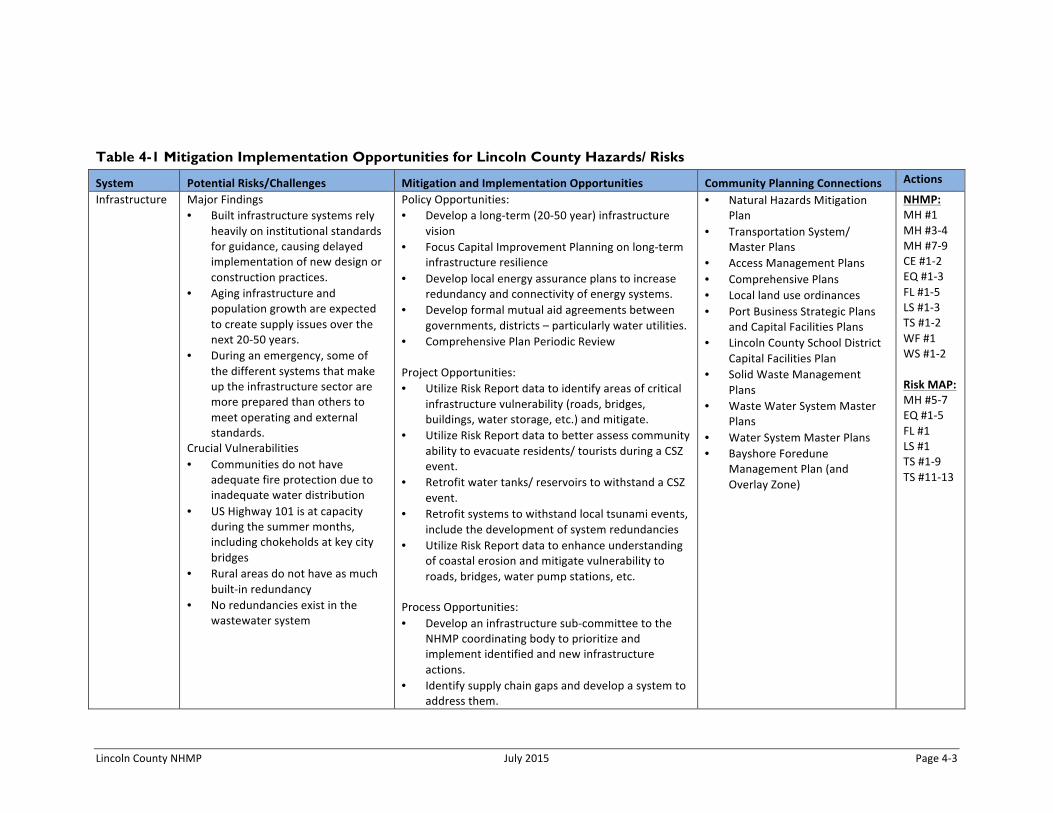
Lincoln County NHMP July 2015 Page 4-‐3
Table 4-1 Mitigation Implementation Opportunities for Lincoln County Hazards/ Risks
System Potential Risks/Challenges Mitigation and Implementation Opportunities Community Planning Connections Actions
Infrastructure Major Findings • Built infrastructure systems rely
heavily on institutional standards for guidance, causing delayed implementation of new design or construction practices.
• Aging infrastructure and population growth are expected to create supply issues over the next 20-‐50 years.
• During an emergency, some of the different systems that make up the infrastructure sector are more prepared than others to meet operating and external standards.
Crucial Vulnerabilities • Communities do not have
adequate fire protection due to inadequate water distribution
• US Highway 101 is at capacity during the summer months, including chokeholds at key city bridges
• Rural areas do not have as much built-‐in redundancy
• No redundancies exist in the wastewater system
Policy Opportunities: • Develop a long-‐term (20-‐50 year) infrastructure
vision • Focus Capital Improvement Planning on long-‐term
infrastructure resilience • Develop local energy assurance plans to increase
redundancy and connectivity of energy systems. • Develop formal mutual aid agreements between
governments, districts – particularly water utilities. • Comprehensive Plan Periodic Review Project Opportunities: • Utilize Risk Report data to identify areas of critical
infrastructure vulnerability (roads, bridges, buildings, water storage, etc.) and mitigate.
• Utilize Risk Report data to better assess community ability to evacuate residents/ tourists during a CSZ event.
• Retrofit water tanks/ reservoirs to withstand a CSZ event.
• Retrofit systems to withstand local tsunami events, include the development of system redundancies
• Utilize Risk Report data to enhance understanding of coastal erosion and mitigate vulnerability to roads, bridges, water pump stations, etc.
Process Opportunities: • Develop an infrastructure sub-‐committee to the
NHMP coordinating body to prioritize and implement identified and new infrastructure actions.
• Identify supply chain gaps and develop a system to address them.
• Natural Hazards Mitigation Plan
• Transportation System/ Master Plans
• Access Management Plans • Comprehensive Plans • Local land use ordinances • Port Business Strategic Plans
and Capital Facilities Plans • Lincoln County School District
Capital Facilities Plan • Solid Waste Management
Plans • Waste Water System Master
Plans • Water System Master Plans • Bayshore Foredune
Management Plan (and Overlay Zone)
NHMP: MH #1 MH #3-‐4 MH #7-‐9 CE #1-‐2 EQ #1-‐3 FL #1-‐5 LS #1-‐3 TS #1-‐2 WF #1 WS #1-‐2 Risk MAP: MH #5-‐7 EQ #1-‐5 FL #1 LS #1 TS #1-‐9 TS #11-‐13

Page 4-‐4 July 2015 Lincoln County NHMP
System Potential Risks/Challenges Mitigation and Implementation Opportunities Community Planning Connections Actions
Public Safety Major Findings • Public Safety (law enforcement,
fire) relies on property tax for funding, which may not sustain needed service over the next 20-‐years
• Resources that function on a day to day basis (volunteer fire departments, interagency mutual aid agreements, specialty teams), would be heavily stressed during long term, widespread events
• Current budget and regulatory unknowns prevent planning beyond a two-‐ to five-‐year timeframe
Crucial Vulnerabilities • Hazards that impact the entire
region reduce the availability of resources from partner agencies and neighboring jurisdictions
• Extended events (more than 12 hours) tap available capacity
• Available fuel is a key limiting factor
Policy Opportunities: • Develop long-‐term public safety planning
(CONOPS) to ensure the availability of resources during a catastrophic event (human, fuel, replacement/ repair parts, etc.)
• Develop a plan to attract and retain career public safety personnel (fire, police, etc.)
• Implement policy to require tourist accommodations to post evacuation routes to assembly areas (e.g., Newport policy).
• Develop stable long-‐term funding strategy Project Opportunities: • Relocate critical and essential facilities out of the
tsunami inundation area. • Relocate mitigate critical and essential facilities
from the flood hazard. Process Opportunities: • Develop an Public Safety sub-‐committee to the
NHMP coordinating body to prioritize and implement identified and new public safety actions.
• Natural Hazards Mitigation Plan
• Capital Improvement Plans • Emergency Operations Plans • Local land use ordinances • Sherriff’s Office Strategic Plan • Regional Economic
Development Strategy
NHMP: MH #2 MH #7-‐9 EQ #1 Risk MAP: MH #1-‐4 MH #6 TS #12-‐13

Lincoln County NHMP July 2015 Page 4-‐5
System Potential Risks/Challenges Mitigation and Implementation Opportunities Community Planning Connections Actions
Social Services Major Findings • Institutional and volunteer
providers do their best to operate on a day to day basis; their ability to respond after a major disaster strikes is limited due to supplies, location of personnel, and lack of services
• Urban migration is especially detrimental to social services and the ability to provide for those in more rural locations
• The social fabric of the system county wide is strong and local leadership is supportive to planning efforts
Crucial Vulnerabilities • An aging population combined
with a patchwork of service providers and lack of services
• Large number of residents vulnerable to disasters with limited ability to shelter them after a disaster
• Medical supplies are limited to a 2-‐5 day supply at any given time
Policy Opportunities: • Develop aid agreements between jurisdictions and
districts to support recovery efforts. Project Opportunities: • Develop communication redundancy for system. • Relocate critical and essential facilities out of the
tsunami inundation area (e.g., mental health clinics, ambulance service, etc.).
• Retrofit critical and essential facilities to address the earthquake hazard.
• Develop redundancies within the social services sector to assure that supplies and personnel are distributed across the county.
• Mitigate repetitive loss properties along the lower Siletz River near Lincoln City.
Process Opportunities: • Develop a Social Services sub-‐committee to the
NHMP coordinating body to prioritize and implement identified and new social services actions.
• Natural Hazards Mitigation Plan
• Community Health Improvement Plan
• Local land use ordinances • Housing strategy • Hospital/Clinics plan • Medical Reserve Corps • Regional Economic
Development Strategy
NHMP: MH #5-‐8 CE #1-‐2 FL #3 TS #2 Risk MAP: MH #2 MH #4 MH #6-‐8 TS #10 TS #12-‐13
Source: 2014 Risk MAP Resilience Workshop

Page 4-‐6 July 2015 Lincoln County NHMP
Convener
The Lincoln County Emergency Manager and Director of Planning and Development will take responsibility for plan implementation and will facilitate the Natural Hazard Mitigation Coordinating body meetings and will assign tasks such as updating and presenting the plan to the rest of the members of the committee. Plan implementation and evaluation will be a shared responsibility among all of the assigned Natural Hazard Mitigation Coordinating Body Members. The conveners’ responsibilities include:
• Coordinate steering committee meeting dates, times, locations, agendas, and member notification;
• Documenting the discussions and outcomes of committee meetings; • Serving as a communication conduit between the steering committee and the
public/stakeholders; • Identifying emergency management-‐related funding sources for natural hazard
mitigation projects; and • Utilizing the Risk Assessment as a tool for prioritizing proposed natural hazard risk
reduction projects.
Coordinating Body
The Lincoln County Conveners will form a Natural Hazard Mitigation Coordinating Body (Steering Committee or Coordinating Body) for updating and implementing the NHMP. The coordinating body responsibilities include:
• Attending future plan maintenance and plan update meetings (or designating a representative to serve in your place);
• Serving as the local evaluation committee for funding programs such as the Pre-‐Disaster Mitigation Grant Program, the Hazard Mitigation Grant Program funds, and Flood Mitigation Assistance program funds;
• Prioritizing and recommending funding for natural hazard risk reduction projects; • Evaluating and updating the Natural Hazards Mitigation Plan in accordance with the
prescribed maintenance schedule; • Developing and coordinating ad hoc and/or standing subcommittees as needed; and • Coordinating public involvement activities.
Members
The following jurisdictions, agencies, and/ or organizations were represented and served on the steering committee during the development of the Lincoln County NHMP (for a list of individuals see the Acknowledgements section of this NHMP):
• Lincoln County • City of Depoe Bay • Lincoln City • City of Newport • City of Siletz • City of Toledo • City of Waldport • City of Yachats

Lincoln County NHMP July 2015 Page 4-‐7
• Central Lincoln Public Utilities District • Lincoln County School District • Lincoln County Transit • North Lincoln Fire and Rescue • Seal Rock Rural Fire Protection District • Yachats Rural Fire Protection District • Lincoln County Search and Rescue • Oregon Department of Forestry
To make the coordination and review of the Lincoln County Multi-‐jurisdictional NHMP as broad and useful as possible, the coordinating body will engage additional stakeholders and other relevant hazard mitigation organizations and agencies to implement the identified action items. Specific organizations have been identified as either internal or external partners on the individual action item forms found in Appendix A. The roles of the internal and external partners are listed below.
Roles (Locals, DLCD, FEMA)
Implementation of the NHMP and Risk MAP (see Appendix G) actions will be led primarily by local initiative through the identified implementation program (Tables 4-‐1 and 4-‐2). FEMA, DLCD and other state agencies (OEM, DOGAMI, Business Oregon) will assist with project development and implementation when asked.
Locals
The conveners (Emergency Management and Planning) will meet monthly to discuss progress towards plan implementation. The local coordinating body as identified in the NHMP process will initiate the process of implementing the identified actions. The actions identified in this report will also be provided as distinct actions within the county’s NHMP. Quarterly, and as needed, the committee will meet to review actions and report on progress. As needed, the local committee will call upon DLCD staff (Risk MAP coordinator, Regional Solutions Team, Oregon Coastal Management program) to provide technical assistance in moving an action forward.
DLCD
The DLCD Risk MAP coordinator shall serve as the state lead on implementing the identified actions (NHMP and Risk MAP). The Risk MAP coordinator will maintain communication with the NHMP conveners at the county and city level to assist with the provision of data and other technical assistance. The Risk MAP coordinator will work with other state staff (OEM, DOGAMI, Business Oregon, Regional Solutions Team, Oregon Coastal Management program) as necessary to assist with the implementation of identified actions. The Risk MAP coordinator will also be the direct line of communication to FEMA staff in reporting progress of action item implementation (Risk MAP identified actions).
In addition, Governor Kitzhaber’s Executive Order No. 11-‐12 signed on December 16, 2011 established 11 Regional Solutions Centers throughout the State of Oregon. State agency staff are co-‐located in Regional Solutions Centers and take a collaborative approach to problem-‐solving to maximize economic and community development opportunities at the

Page 4-‐8 July 2015 Lincoln County NHMP
state, regional and local level. Regional Advisory Committees adopt annual work plans that focus Team members’ attention on projects that will leverage public, private and civic sector resources to address regional priorities. DLCD actively participates in the Regional Solutions framework along with the Oregon Office of Emergency Management, Department of Environmental Quality, Department of Transportation, Business Oregon, the Infrastructure Finance Authority, and others. Key stakeholders include counties, cities, special districts, hospitals, utility providers, fire departments, business and property owners, volunteer groups (e.g., CERT), and citizens. Because the Regional Solutions Team is active in this region, it should be viewed as a potential resource during the implementation phase of this planning effort.1
FEMA
Staff from FEMA will assist on an as needed basis to provide technical assistance with action item implementation. In particular, they will communicate with the DLCD Risk MAP coordinator to report on progress towards implementation of identified actions and provide assistance with federal grant programs.
Implementation through Existing Programs
The NHMP includes a range of action items that, when implemented, will reduce loss from hazard events in the county. Within the plan, FEMA requires the identification of existing programs that might be used to implement these action items. Lincoln County, and the participating cities, currently address statewide planning goals and legislative requirements through their comprehensive land use plans, capital improvement plans, mandated standards and building codes. To the extent possible, Lincoln County, and participating cities, will work to incorporate the recommended mitigation action items into existing programs and procedures.
Many of the NHMP’s recommendations are consistent with the goals and objectives of the participating cities and county’s existing plans and policies. Where possible, Lincoln County, and participating cities, should implement the NHMP’s recommended actions through existing plans and policies. Plans and policies already in existence often have support from local residents, businesses, and policy makers. Many land-‐use, comprehensive, and strategic plans get updated regularly, and can adapt easily to changing conditions and needs. Implementing the NHMP’s action items through such plans and policies increases their likelihood of being supported and implemented.
Examples of plans, programs or agencies that may be used to implement mitigation activities include:
• City and County Budgets • Community Wildfire Protection Plans • Comprehensive Land Use Plans
1 By way of example, Clatsop County and the cities of Gearhart, Seaside and Cannon Beach are served
by the North Coast Regional Solutions Center located in the City of Tillamook. The North Coast Regional Solutions’ adopted 2014-15 Work Plan identifies ‘Resilience Planning’ as one of its priority projects.
Lincoln County NHMP July 2015 Page 4-‐9
• Economic Development Action Plans • Zoning Ordinances & Building Codes
For additional examples of plans, programs or agencies that may be used to implement mitigation activities refer to list of plans in Volume IV -‐ Appendix C, Community Profile and Volume III, Jurisdictional Addenda.
Plan Maintenance
Plan maintenance is a critical component of the NHMP. Proper maintenance of the plan ensures that this plan will maximize the county and participating city’s efforts to reduce the risks posed by natural hazards. This section was developed by the University of Oregon’s Partnership for Disaster Resilience and includes a process to ensure that a regular review and update of the plan occurs. The conveners, coordinating body, and local staff are responsible for implementing this process, in addition to maintaining and updating the plan through a series of meetings outlined in the maintenance schedule below.
Meetings
The conveners will meet monthly to ensure implementation of the NHMP remains on schedule. The Coordinating Body will meet quarterly to complete the following tasks. During at least one meeting per year, the Coordinating Body will:
• Review existing action items to determine appropriateness for funding; • Educate and train new members on the plan and mitigation in general; • Identify issues that may not have been identified when the plan was developed; and • Prioritize potential mitigation projects using the methodology described below.
During at least one other meeting the Coordinating Body will:
• Review existing and new risk assessment data; • Discuss methods for continued public involvement; and • Document successes and lessons learned during the year.
These meetings are an opportunity for the cities and special district to report back to the county on progress that has been made towards their components of the NHMP.
Monthly meetings between the conveners (Lincoln County Emergency Management and Planning and Development) will begin in the month following local adoption (expected October 2015). The Coordinating Body will meet quarterly and is scheduled to occur in October, January, April, and July of each year. During the first quarterly meeting (expected October 2015) the Coordinating Body will re-‐examine and prioritize the proposed actions. The conveners will document the prioritization process (see below for example) and include a timeline for action item completion. In addition, during the first quarterly meeting the Coordinating Body will review the updated Risk Report, data, and areas of mitigation interest. The Coordinating Body will provide any necessary edits to DOGAMI and integrate applicable components of the Risk Report into the NHMP, and consider revisions to existing actions, or develop new actions, to respond to information from the Risk Report. The Coordinating Body will schedule additional time to discuss the data from the Risk Report at future meetings as needed.

Page 4-‐10 July 2015 Lincoln County NHMP
The conveners will be responsible for documenting the outcome of the semi-‐annual meetings in Appendix B. The process the coordinating body will use to prioritize mitigation projects is detailed in the section below. The plan’s format allows the county and participating jurisdictions to review and update sections when new data becomes available. New data can be easily incorporated, resulting in a NHMP that remains current and relevant to the participating jurisdictions.
The Lincoln County Risk Report (see Appendix G for more information) is scheduled to receive an update during 2015 to include data and exposure analysis for the landslide, tsunami, and wildfire hazards and Hazus-‐MH loss estimate for flood and earthquake (Hazus-‐MH considers information beyond real market value including building type, material, and zoning and provides information contingent upon flood depth and earthquake intensity). The NHMP conveners and coordinating body will have an opportunity to review the updates to the Risk Report and to include the new information in the NHMP and also consider new actions to reduce risk.
Project Prioritization Process
The Disaster Mitigation Act of 2000 requires that jurisdictions identify a process for prioritizing potential actions. Potential mitigation activities often come from a variety of sources; therefore the project prioritization process needs to be flexible. Committee members, local government staff, other planning documents, or the risk assessment may be the source to identify projects. Figure 4-‐1 illustrates the project development and prioritization process.

Lincoln County NHMP July 2015 Page 4-‐11
Figure 4-1 Action Item and Project Review Process
Source: Oregon Partnership for Disaster Resilience, 2008.
Step 1: Examine funding requirements
The first step in prioritizing the plan’s action items is to determine which funding sources are open for application. Several funding sources may be appropriate for the county’s proposed mitigation projects. Examples of mitigation funding sources include but are not limited to: FEMA’s Pre-‐Disaster Mitigation competitive grant program (PDM), Flood Mitigation Assistance (FMA) program, Hazard Mitigation Grant Program (HMGP), National Fire Plan (NFP), Community Development Block Grants (CDBG), local general funds, and private foundations, among others. Please see Appendix E, Grant Programs and Resources for a more comprehensive list of potential grant programs.
Because grant programs open and close on differing schedules, the coordinating body will examine upcoming funding streams’ requirements to determine which mitigation activities would be eligible. The coordinating body may consult with the funding entity, Oregon Military Department – Office of Emergency Management (OEM), or other appropriate state or regional organizations about project eligibility requirements. This examination of funding sources and requirements will happen during the coordinating body’s semi-‐annual plan maintenance meetings.
Step 2: Complete risk assessment evaluation
The second step in prioritizing the plan’s action items is to examine which hazards the selected actions are associated with and where these hazards rank in terms of community risk. The coordinating body will determine whether or not the plan’s risk assessment supports the implementation of eligible mitigation activities. This determination will be

Page 4-‐12 July 2015 Lincoln County NHMP
based on the location of the potential activities, their proximity to known hazard areas, and whether community assets are at risk. The coordinating body will additionally consider whether the selected actions mitigate hazards that are likely to occur in the future, or are likely to result in severe / catastrophic damages.
Step 3: Committee Recommendation
Based on the steps above, the coordinating body will recommend which mitigation activities should be moved forward. If the coordinating body decides to move forward with an action, the coordinating organization designated on the action item form will be responsible for taking further action and, if applicable, documenting success upon project completion. The coordinating body will convene a meeting to review the issues surrounding grant applications and to share knowledge and/or resources. This process will afford greater coordination and less competition for limited funds.
Step 4: Complete quantitative and qualitative assessment, and economic analysis
The fourth step is to identify the costs and benefits associated with the selected natural hazard mitigation strategies, measures or projects. Two categories of analysis that are used in this step are: (1) benefit/cost analysis, and (2) cost-‐effectiveness analysis. Conducting benefit/cost analysis for a mitigation activity assists in determining whether a project is worth undertaking now, in order to avoid disaster-‐related damages later. Cost-‐effectiveness analysis evaluates how best to spend a given amount of money to achieve a specific goal. Determining the economic feasibility of mitigating natural hazards provides decision makers with an understanding of the potential benefits and costs of an activity, as well as a basis upon which to compare alternative projects. Figure 4.2 shows decision criteria for selecting the appropriate method of analysis.
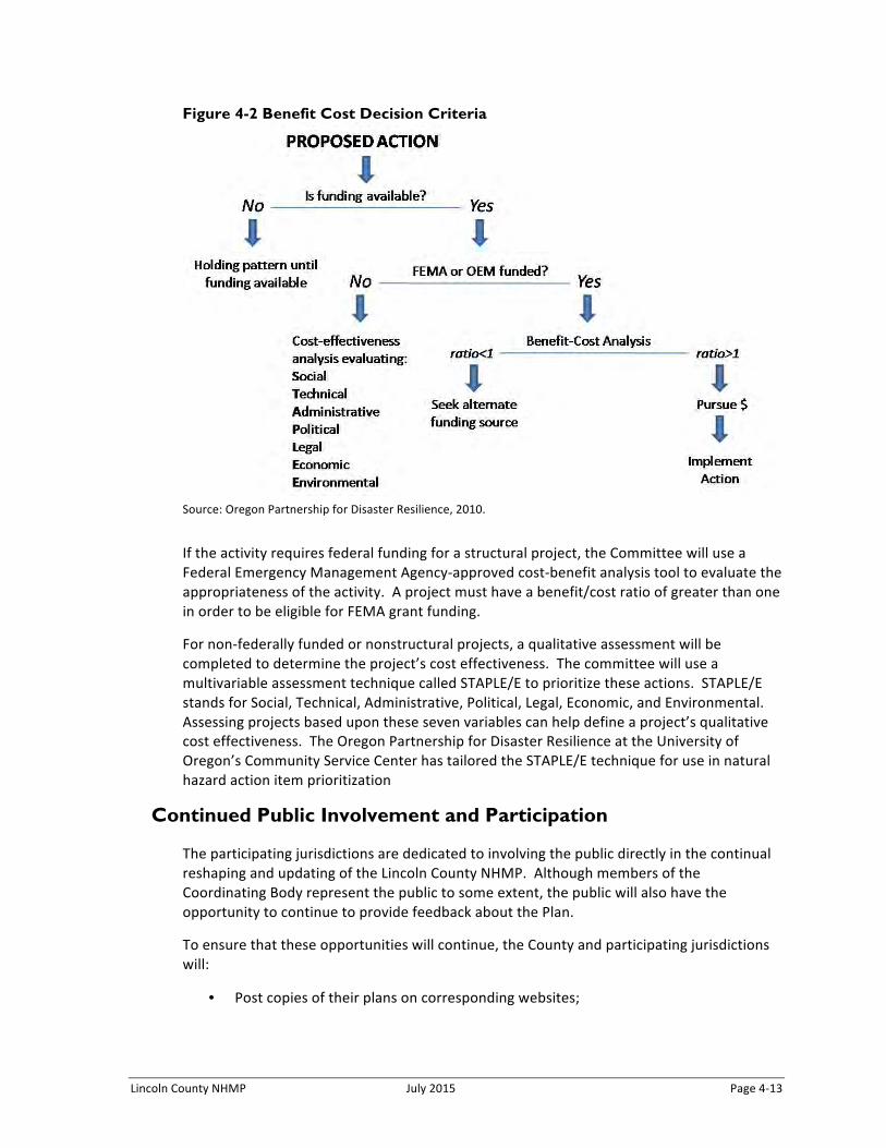
Lincoln County NHMP July 2015 Page 4-‐13
Figure 4-2 Benefit Cost Decision Criteria
Source: Oregon Partnership for Disaster Resilience, 2010.
If the activity requires federal funding for a structural project, the Committee will use a Federal Emergency Management Agency-‐approved cost-‐benefit analysis tool to evaluate the appropriateness of the activity. A project must have a benefit/cost ratio of greater than one in order to be eligible for FEMA grant funding.
For non-‐federally funded or nonstructural projects, a qualitative assessment will be completed to determine the project’s cost effectiveness. The committee will use a multivariable assessment technique called STAPLE/E to prioritize these actions. STAPLE/E stands for Social, Technical, Administrative, Political, Legal, Economic, and Environmental. Assessing projects based upon these seven variables can help define a project’s qualitative cost effectiveness. The Oregon Partnership for Disaster Resilience at the University of Oregon’s Community Service Center has tailored the STAPLE/E technique for use in natural hazard action item prioritization
Continued Public Involvement and Participation
The participating jurisdictions are dedicated to involving the public directly in the continual reshaping and updating of the Lincoln County NHMP. Although members of the Coordinating Body represent the public to some extent, the public will also have the opportunity to continue to provide feedback about the Plan.
To ensure that these opportunities will continue, the County and participating jurisdictions will:
• Post copies of their plans on corresponding websites;
Page 4-‐14 July 2015 Lincoln County NHMP
• Place articles in the local newspaper directing the public where to view and provide feedback; and
• Use existing newsletters such as schools and utility bills to inform the public where to view and provide feedback.
In addition to the involvement activities listed above, Lincoln County will ensure continued public involvement by posting the Lincoln County NHMP on the County’s website (http://www.co.lincoln.or.us). The Plan will also be archived and posted on the University of Oregon Libraries’ Scholar’s Bank Digital Archive (https://scholarsbank.uoregon.edu).
Five-Year Review of Plan
This plan will be updated every five years in accordance with the update schedule outlined in the Disaster Mitigation Act of 2000. The Lincoln County NHMP is due to be updated by September 14, 2020. The convener will be responsible for organizing the coordinating body to address plan update needs. The coordinating body will be responsible for updating any deficiencies found in the plan, and for ultimately meeting the Disaster Mitigation Act of 2000’s plan update requirements.
The following ‘toolkit’ (Table 4-‐2) can assist the convener in determining which plan update activities can be discussed during regularly-‐scheduled plan maintenance meetings, and which activities require additional meeting time and/or the formation of sub-‐committees.
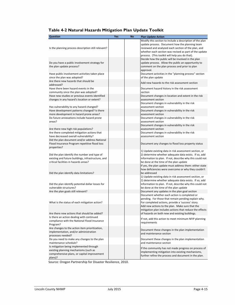
Lincoln County NHMP July 2015 Page 4-‐15
Table 4-2 Natural Hazards Mitigation Plan Update Toolkit
Source: Oregon Partnership for Disaster Resilience, 2010.
Question Yes No Plan.Update.Action
Is#the#planning#process#description#still#relevant?
Modify#this#section#to#include#a#description#of#the#plan#update#process.##Document#how#the#planning#team#reviewed#and#analyzed#each#section#of#the#plan,#and#whether#each#section#was#revised#as#part#of#the#update#process.##(This#toolkit#will#help#you#do#that).
Do#you#have#a#public#involvement#strategy#for#the#plan#update#process?
Decide#how#the#public#will#be#involved#in#the#plan#update#process.##Allow#the#public#an#opportunity#to#comment#on#the#plan#process#and#prior#to#plan#approval.
Have#public#involvement#activities#taken#place#since#the#plan#was#adopted?
Document#activities#in#the#"planning#process"#section#of#the#plan#update
Are#there#new#hazards#that#should#be#addressed?
Add#new#hazards#to#the#risk#assessment#section
Have#there#been#hazard#events#in#the#community#since#the#plan#was#adopted?
Document#hazard#history#in#the#risk#assessment#section
Have#new#studies#or#previous#events#identified#changes#in#any#hazard's#location#or#extent?
Document#changes#in#location#and#extent#in#the#risk#assessment#section
Has#vulnerability#to#any#hazard#changed?Document#changes#in#vulnerability#in#the#risk#assessment#section
Have#development#patterns#changed?#Is#there#more#development#in#hazard#prone#areas?
Document#changes#in#vulnerability#in#the#risk#assessment#section
Do#future#annexations#include#hazard#prone#areas?
Document#changes#in#vulnerability#in#the#risk#assessment#section
Are#there#new#high#risk#populations?Document#changes#in#vulnerability#in#the#risk#assessment#section
Are#there#completed#mitigation#actions#that#have#decreased#overall#vulnerability?
Document#changes#in#vulnerability#in#the#risk#assessment#section
Did#the#plan#document#and/or#address#National#Flood#Insurance#Program#repetitive#flood#loss#properties?
Document#any#changes#to#flood#loss#property#status
Did#the#plan#identify#the#number#and#type#of#existing#and#future#buildings,#infrastructure,#and#critical#facilities#in#hazards#areas?
1)#Update#existing#data#in#risk#assessment#section,#or#2)#determine#whether#adequate#data#exists.##If#so,#add#information#to#plan.##If#not,#describe#why#this#could#not#be#done#at#the#time#of#the#plan#update
Did#the#plan#identify#data#limitations?
If#yes,#the#plan#update#must#address#them:#either#state#how#deficiencies#were#overcome#or#why#they#couldn't#be#addressed
Did#the#plan#identify#potential#dollar#losses#for#vulnerable#structures?
1)#Update#existing#data#in#risk#assessment#section,#or#2)#determine#whether#adequate#data#exists.##If#so,#add#information#to#plan.##If#not,#describe#why#this#could#not#be#done#at#the#time#of#the#plan#update
Are#the#plan#goals#still#relevant? Document#any#updates#in#the#plan#goal#section
What#is#the#status#of#each#mitigation#action?
Document#whether#each#action#is#completed#or#pending.##For#those#that#remain#pending#explain#why.##For#completed#actions,#provide#a#'success'#story.
Are#there#new#actions#that#should#be#added?
Add#new#actions#to#the#plan.##Make#sure#that#the#mitigation#plan#includes#actions#that#reduce#the#effects#of#hazards#on#both#new#and#existing#buildings.
Is#there#an#action#dealing#with#continued#compliance#with#the#National#Flood#Insurance#Program?
If#not,#add#this#action#to#meet#minimum#NFIP#planning#requirements
Are#changes#to#the#action#item#prioritization,#implementation,#and/or#administration#processes#needed?
Document#these#changes#in#the#plan#implementation#and#maintenance#section
Do#you#need#to#make#any#changes#to#the#plan#maintenance#schedule?
Document#these#changes#in#the#plan#implementation#and#maintenance#section
Is#mitigation#being#implemented#through#existing#planning#mechanisms#(such#as#comprehensive#plans,#or#capital#improvement#plans)?
If#the#community#has#not#made#progress#on#process#of#implementing#mitigation#into#existing#mechanisms,#further#refine#the#process#and#document#in#the#plan.