multi-temporal object-oriented classifications and urban...
TRANSCRIPT
MULTI-TEMPORAL OBJECT-ORIENTED
CLASSIFICATIONS AND URBAN
ANALYSIS. CASY STUDY BELO
HORIZONTE - MINAS GERAIS STATE
Dr. Hermann Johann Heinrich KuxMsc. Eduardo Henrique Geraldi Araújo
1st MULTIDISCIPLINARY WORKSHOP ON EXTRACTING
AND CLASSIFYING URBAN OBJECTS FROM HIGH
RESOLUTION SATELLITE IMAGES - 2007

Are our cities well known?
� Observation on the bad use of urban areas:
� Inadequate growth of urban areas with
great potential;
� Lack of information for adequate urban
planning activities.
Motivation for the study

Examples

� Evaluate the performance and characteristics of object-based image classifications as a contribution to urban planning and to sustainable development, by the presentation of a case study: Belo Horizonte, MG, Brazil.
Objective
� Characterization of area under study;
� Object Based Image Analysis, Data preparation and Classification results;
� Conclusions
Summary
� Characterization of area under study;
� Object Based Image Analysis. Data preparation and Classification results;
� Conclusions
Summary
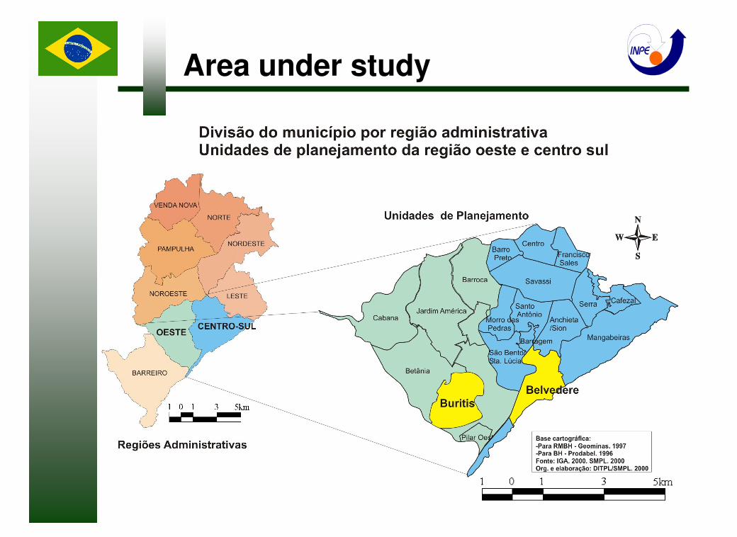
Area under study
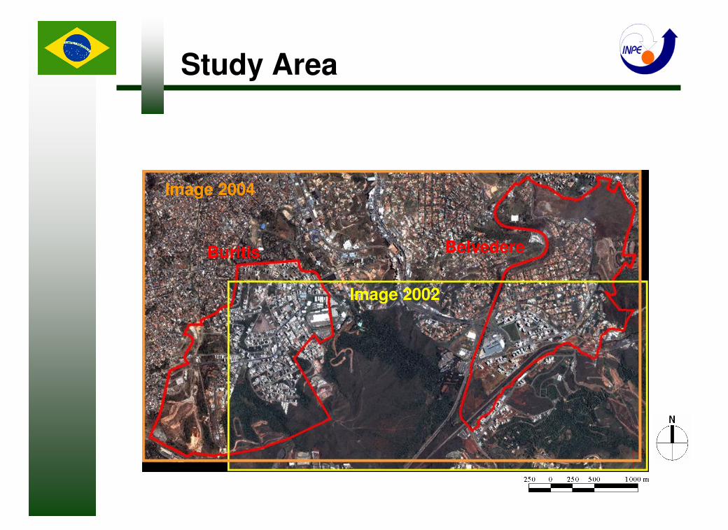
Image 2004
Image 2002
Buritis Belvedere
Study Area
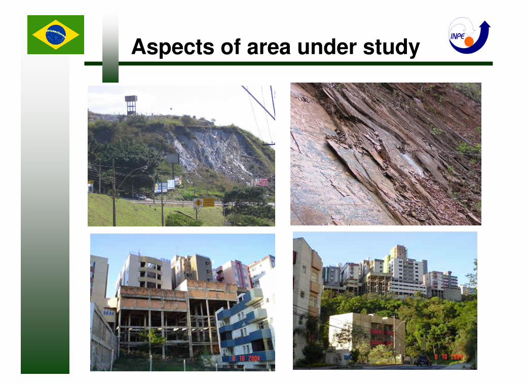
Aspects of area under study

� Characterization of area under study;
� Object Based Image Analysis. Data preparation and Classification results;
� Conclusions
Summary
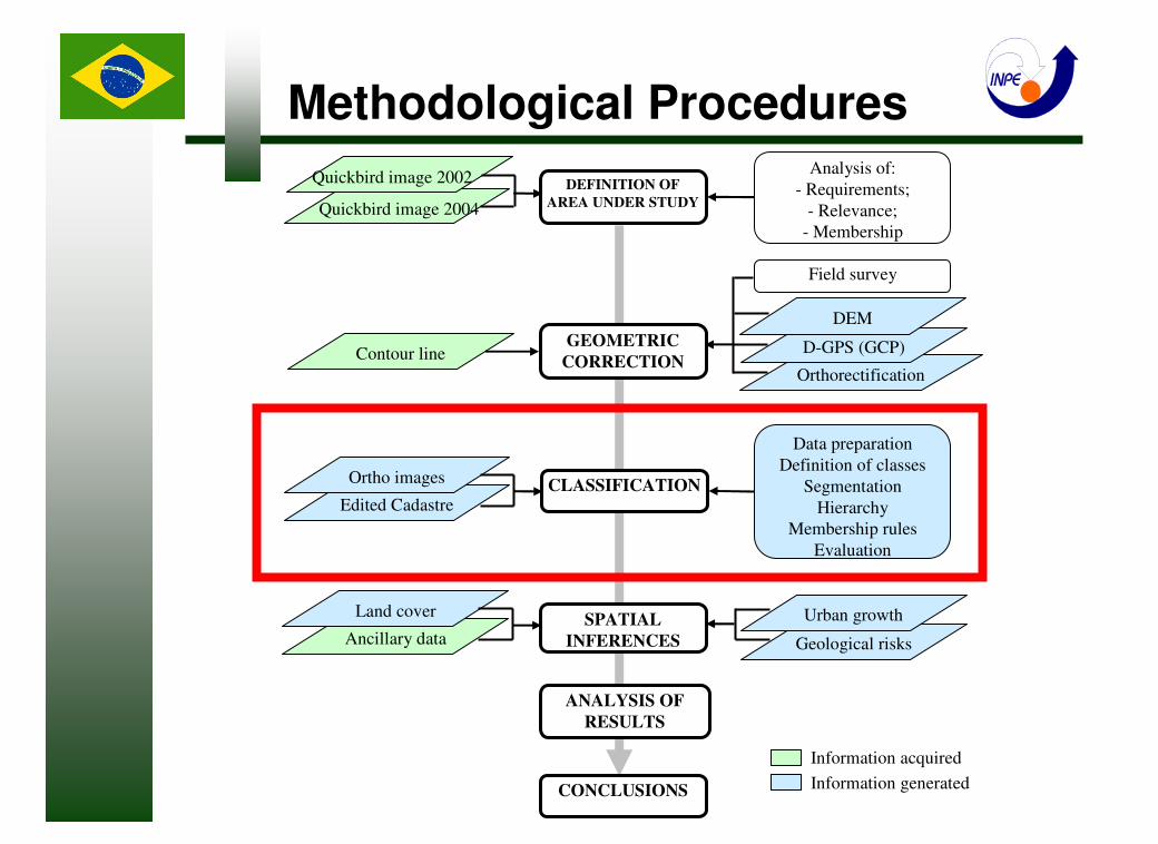
Methodological Procedures
Geological risks
Orthorectification
Analysis of:
- Requirements;
- Relevance;
- Membership
DEFINITION OF
AREA UNDER STUDY
Quickbird image 2002
Information acquired
Quickbird image 2004
Contour lineGEOMETRIC
CORRECTIOND-GPS (GCP)
DEM
Edited CadastreCLASSIFICATION
Data preparation
Definition of classes
Segmentation
Hierarchy
Membership rules
Evaluation
Ortho images
Ancillary data
Land cover Urban growthSPATIAL
INFERENCES
ANALYSIS OF
RESULTS
CONCLUSIONS Information generated
Field survey

Blocks
Streets
Outside
Ortho images and Cadastre
Data Preparation

High brightness. No discrimination of probable building materials. 10) White cover
Cover of large buildings. Presents many variations.9) Gray cover
Roofs, mainly of new asbestos and cement. Quantization level close to 2048.8) Flare
Strong response in the blue and sometimes in the green band. Well defined.7) Swimming pool
Low brightness. Close to high buildings and arboreal vegetation.6) Shadow
Used from urban cadastre to delimit streets, avenues and roads. Linear and
straight forms
5) Asphalt
Earth works, prepared for constructions. No standard. Irregular forms, variable
texture and random localization.
4) Bare soil
Simple square geometry, orange-like color with large tone variation. Smooth
texture. Easily identifiable visually.
3) Ceramics tile
Also strong response in the IR band. Uniform. Texture is smoother than
Arboreal vegetation.
2) Grass
Strong response in the IR band. Texture due to different heights of trees
(shadow). Easily distinguishable from other classes.
1) Arboreal vegetation
Descriptive CharacteristicsName of class
Definition of classes/Examples
Definition of Classes

1 1
2 2
3 3
4 4
55
66
77
88
99
10 10
RGB - 321 RGB - 432 RGB - 321 RGB - 432RGB - 321 RGB - 432
Definition of Classes

Segmentation
Level 2
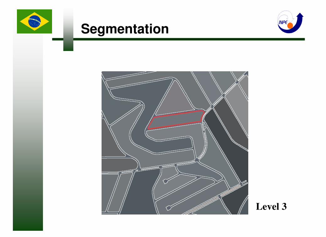
Segmentation
Level 3
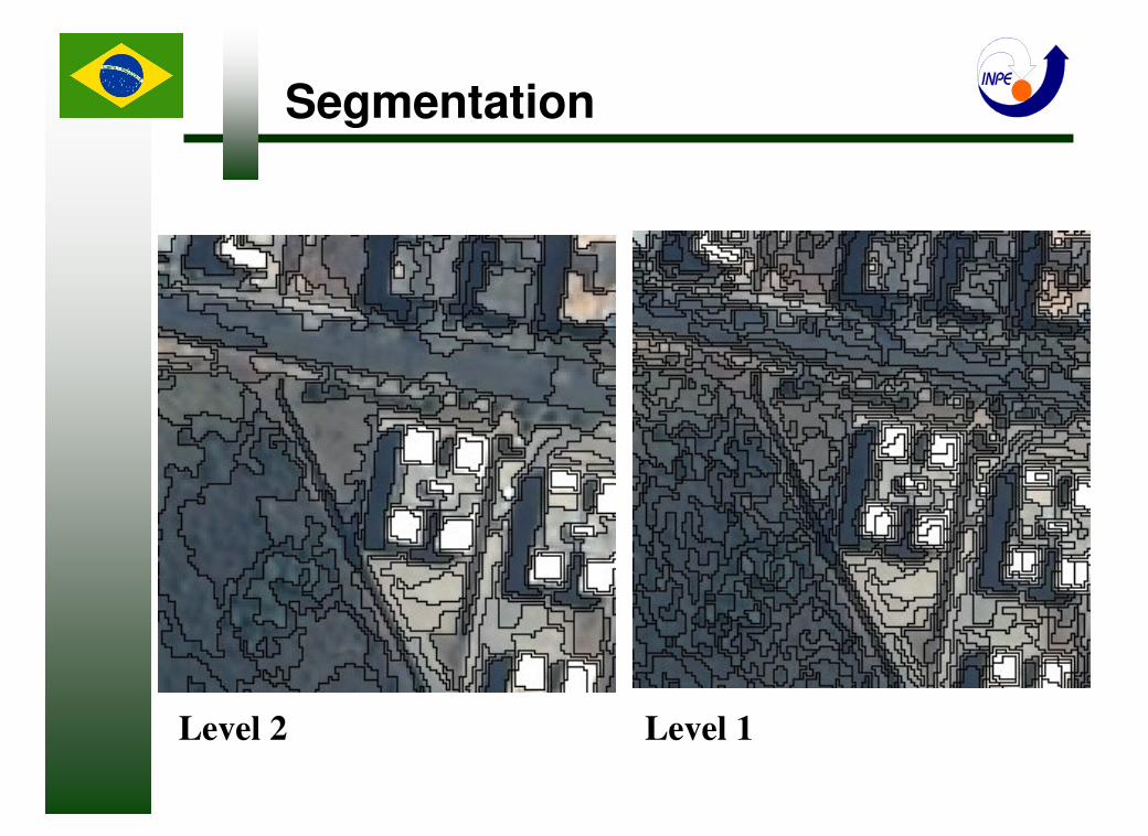
Level 2
Segmentation
Level 1

Hierarchical net
Classes considered
LEVEL 3 StreetsBlocks
No vegetation
AsphaltShadow No Shadow
High brightness No High brightness
FlareWhite cover Red objects No Red objects
Bare soil Ceramics tile Blue objects
Swimming poolGray cover
Vegetation
Grass Arboreal
Blue objects (L1) No Blue Objects (L1)
Ceramics tile (L1)
LEVEL 2
LEVEL 1
Outside area under study
Auxiliary classes

Membership Rules
RGB - 321
RGB - 321 Without NDVI rule With NDVI rule
Without texture rule With texture rule
Arboreal
X
Grass
Bare soil
X
Ceramics

Image ClassificationBelvedere 2004
Overall Kappa: 0,75
Overall Kappa: 0,86
Overall Kappa: 0,77 Overall Kappa: 0,74
Belvedere 2002
Buritis 2004
Buritis 2002
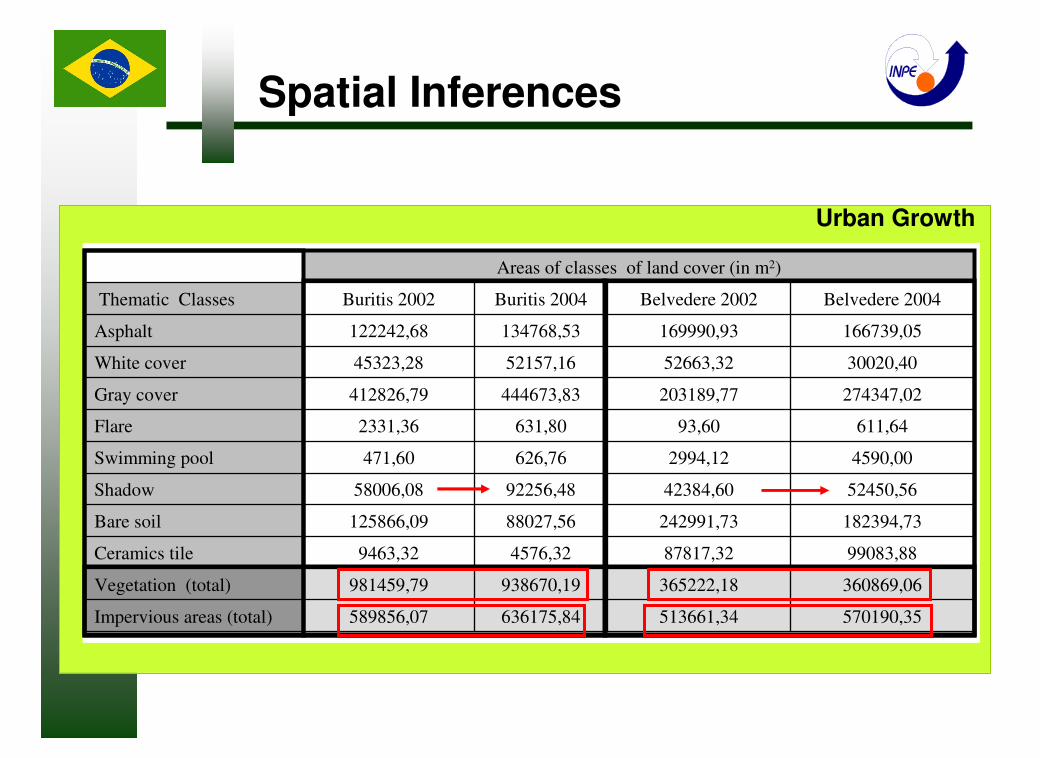
Areas of classes of land cover (in m2)
570190,35513661,34636175,84589856,07Impervious areas (total)
360869,06365222,18938670,19981459,79Vegetation (total)
99083,8887817,324576,329463,32Ceramics tile
182394,73242991,7388027,56125866,09Bare soil
52450,5642384,6092256,4858006,08Shadow
4590,002994,12626,76471,60Swimming pool
611,6493,60631,802331,36Flare
274347,02203189,77444673,83412826,79Gray cover
30020,4052663,3252157,1645323,28White cover
166739,05169990,93134768,53122242,68Asphalt
Belvedere 2004Belvedere 2002Buritis 2004Buritis 2002Thematic Classes
Urban Growth
Spatial Inferences
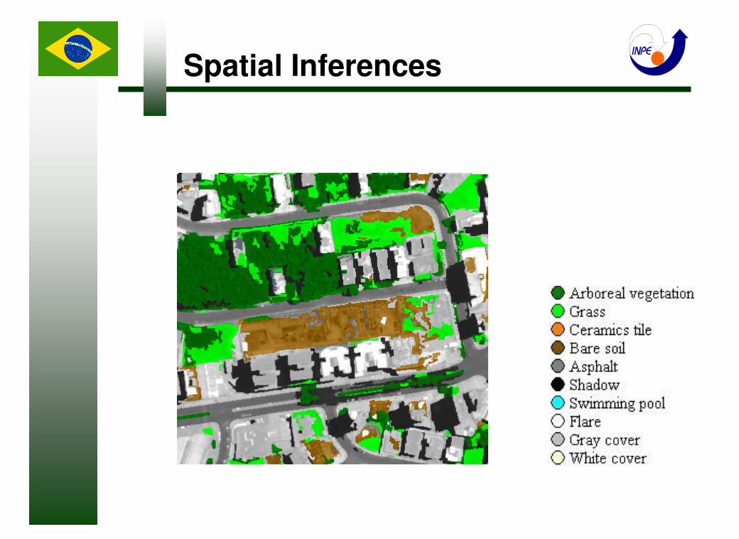
Spatial Inferences
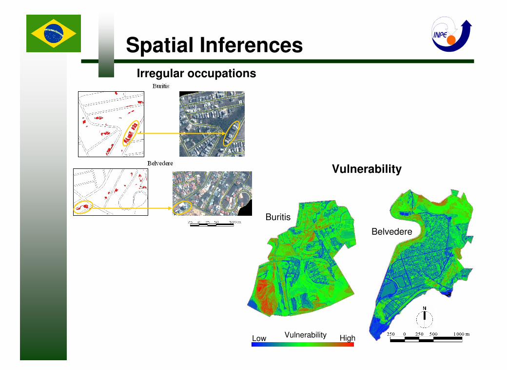
Spatial Inferences
Buritis
Belvedere
Low Vulnerability High
Irregular occupations
Vulnerability
� Characterization of area under study;
� Object Based Image Analysis. Data preparation and Classification results;
� Conclusions
Summary
From the results found we conclude that:
�The evaluation of classifications indicated the possibility to use the land
cover map in this study, especially for the spatial inferences;
�The study showed the possibility to map areas with tendencies of growth
and risks, besides being a reliable information source for urban planning;
�The object-based image analysis methodology is a valid approach for the
classification of such large datasets as the Quickbird satellite images used
in this study. Taking into account the large volume of high resolution
sensor systems and the resulting enormous datasets available in the next
few years, it is advisable to improve this approach by all means, so it
becomes an operational tool for e.g. urban planning agencies, as
indicated in previous application examples.
Conclusions
Conclusions
In order to improve this methodology specifically for urban applications, we
strongly recommend the following further studies:
� To evaluate the use of high-resolution images, obtained at several
incidence angles. Use preferentially complementary angles, so it is possible
to generate stereoscopy to obtain information of land/soil cover in occlusion
areas;
�To test the efficiency on the use of the DSM for the distinction of bare soils
and ceramic tiles;
�To investigate descriptors that are able to discriminate classes of gray
cover like asbestos, metallic roofs and cement, quite frequently used in
Brazil;
�To map objects of several classes which are in the shadow.
Last but not least, to improve the OBIA approach, absolutely indispensable
for the “flood” of data which will become available from the large number of
high-resolution spaceborne sensors to be launched in the next few years.

THANK YOU !