multichannel coherent radar depth sounder for nasa operation ice
TRANSCRIPT

MULTICHANNEL COHERENT RADAR DEPTH SOUNDER
FOR NASA OPERATION ICE BRIDGE
Lei Shi, Christopher T. Allen, John R. Ledford, Fernando Rodriguez-Morales, William A. Blake,
Ben G. Panzer, Stephen C. Prokopiack
Center for Remote Sensing of Ice Sheets (CReSIS)
2335 Irving Hill Road. Lawrence, KS 66046-7612
Phone: 785-864-4729 Fax: 785-864-7753 E-mail: [email protected]
ABSTRACT
The Multichannel Coherent Radar Depth Sounder (MCoRDS) system was developed by the Center for
Remote Sensing of Ice Sheets (CReSIS) at the University of Kansas (KU) to map the thickness and
underlying bed elevation for glaciers in Antarctica on the NASA Operation Ice Bridge (OIB) mission.
Scientists believe that the lubricating effect of liquid water at the bed-ice interface will significantly
increase the glacial flow resulting in more ice being discharged into the ocean. Bed elevation that is
below sea level is particularly susceptible to this effect. Therefore, to better predict the future of ice
sheets in Antarctica, scientists and modelers need to know the current elevations and topography of the
bed beneath several outlet Antarctic glaciers. The MCoRDS system, flown on the NASA DC-8, was
designed to sound these glaciers capturing the surface and bed echoes from both low and high altitude
flights. The ice thickness can be obtained from these measurements and, in conjunction with altimeter
data, the bed elevation can be determined allowing modelers and scientists to better understand the
current status of these glaciers as well as identifying those at risk of speeding up.
MCoRDS is the latest radar depth sounding system in a long line of airborne radars developed at
the University of Kansas [1][2]. It is a chirp pulsed radar system that was operated at a 193.9 MHz
center frequency with a 9.5 MHz bandwidth. Transmission and reception takes place using a 5-element
antenna array mounted on the bottom of the DC-8 aircraft. This array is housed in a customized antenna
fairing designed by KU’s Aerospace Engineering department. During transmission, each of the 5
antennas is driven by a unique waveform digitally produced from a custom multichannel waveform
generator allowing the operator to adjust the timing, frequency, phase, and amplitude of each transmit
waveform. This capability enables control of the transmitted radiation pattern, time-sidelobe
management techniques, and implementation of 0/ modulation to further reduce coherent noise and
increase the system’s signal-to-noise ratio (SNR) [3]. Each transmit channel has the capacity to output
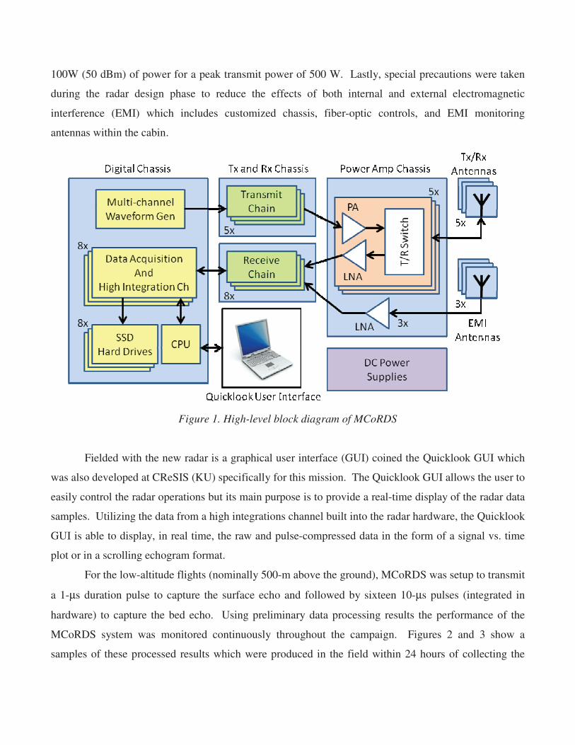
100W (50 dBm) of power for a peak transmit power of 500 W. Lastly, special precautions were taken
during the radar design phase to reduce the effects of both internal and external electromagnetic
interference (EMI) which includes customized chassis, fiber-optic controls, and EMI monitoring
antennas within the cabin.
Figure 1. High-level block diagram of MCoRDS
Fielded with the new radar is a graphical user interface (GUI) coined the Quicklook GUI which
was also developed at CReSIS (KU) specifically for this mission. The Quicklook GUI allows the user to
easily control the radar operations but its main purpose is to provide a real-time display of the radar data
samples. Utilizing the data from a high integrations channel built into the radar hardware, the Quicklook
GUI is able to display, in real time, the raw and pulse-compressed data in the form of a signal vs. time
plot or in a scrolling echogram format.
For the low-altitude flights (nominally 500-m above the ground), MCoRDS was setup to transmit
a 1-μs duration pulse to capture the surface echo and followed by sixteen 10-μs pulses (integrated in
hardware) to capture the bed echo. Using preliminary data processing results the performance of the
MCoRDS system was monitored continuously throughout the campaign. Figures 2 and 3 show a
samples of these processed results which were produced in the field within 24 hours of collecting the
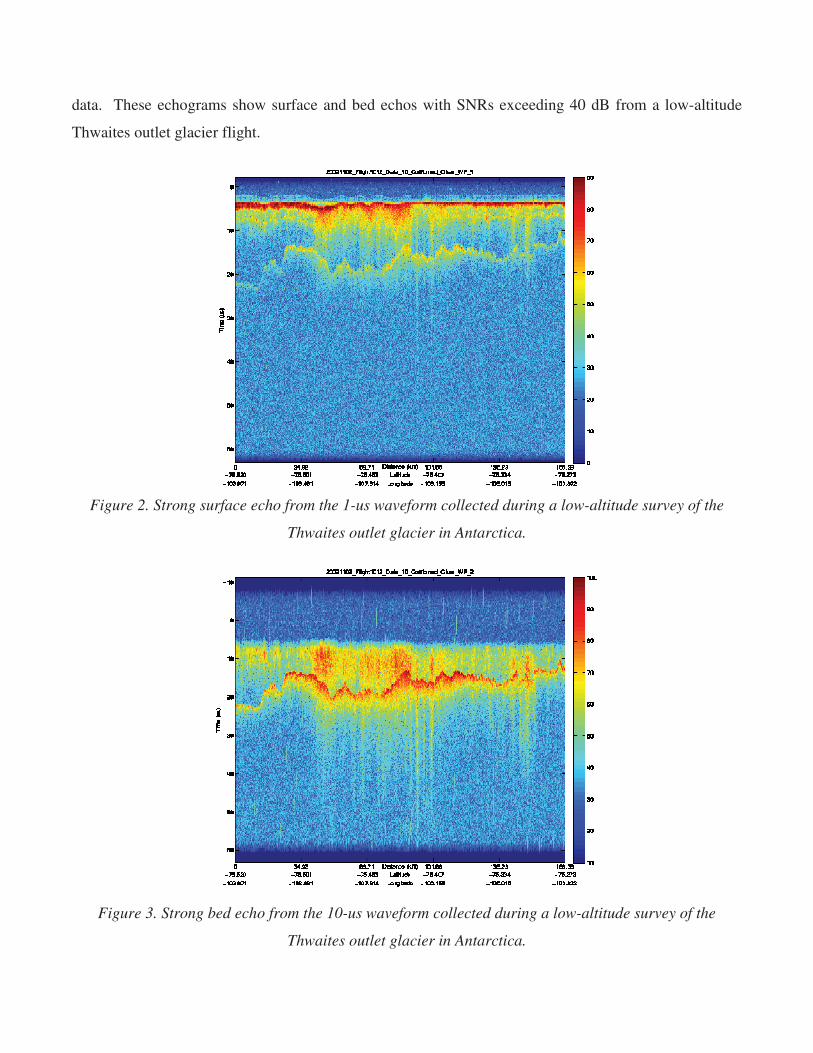
data. These echograms show surface and bed echos with SNRs exceeding 40 dB from a low-altitude
Thwaites outlet glacier flight.
Figure 2. Strong surface echo from the 1-us waveform collected during a low-altitude survey of the
Thwaites outlet glacier in Antarctica.
Figure 3. Strong bed echo from the 10-us waveform collected during a low-altitude survey of the
Thwaites outlet glacier in Antarctica.

Bibliography
[1] S.Gogineni, T. Chuah, C. Allen, K. Jezek, and R.K. Moore, “An Improved Coherent Radar Depth
Sounder,” Journal of Glaciology, vol. 44, no 148, pp. 659-669, 1998.
[2] S. Gogineni, D. Tammana, D. Braaten, C. Leuschen, T. Akins, J. Legarsky, P. Kanagaratnam, J.
Stiles, C. Allen, and K. Jezek, “Coherent Radar Ice Thickness Measurements over the Greenland
Ice Sheets,” Journal of Geophysical Research, vol. 106, no. D24, pp.33,761-33,772, Dec. 2001.
[3] C.T. Allen, S.N. Mozaffar and T.L. Akins, “Suppressing Coherent Noise in Radar Applications
With Long Dwell Times,” IEEE Trans. Geosci. Remote Sens., vol. 2, no 3, pp. 284-286, July
2005.