n5 - scottish qualifications authority · page 07 a question 6 diagram q6: selected land uses land...
TRANSCRIPT

*S8337511*
N5
©
NationalQualicationsSPECIMEN ONLY
Total marks — 80
SECTION 1 — PHYSICAL ENVIRONMENTS — 30 marks
Attempt EITHER question 1 OR question 2
THEN attempt questions 3 to 6.
SECTION 2 — HUMAN ENVIRONMENTS — 30 marks
Attempt ALL questions.
SECTION 3 — GLOBAL ISSUES — 20 marks
Attempt any TWO of the following.
Question 11 — Climate change
Question 12 — Natural regions
Question 13 — Environmental hazards
Question 14 — Trade and globalisation
Question 15 — Tourism
Question 16 — Health
You will receive credit for appropriately labelled sketch maps and diagrams.
Write your answers clearly in the answer booklet provided. In the answer booklet you must clearly identify the question number you are attempting.
Use blue or black ink.
Before leaving the examination room you must give your answer booklet to the Invigilator; if you do not, you may lose all the marks for this paper.
S833/75/11 Geography
Date — Not applicable
Duration — 2 hours 20 minutes
page 02
MARKSSECTION 1 — PHYSICAL ENVIRONMENTS — 30 marks
Attempt EITHER question 1 OR question 2
THEN questions 3 to 6
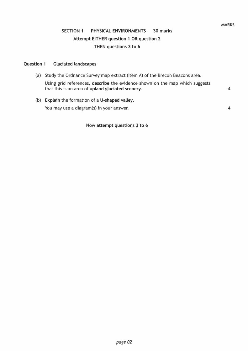
Question 1 — Glaciated landscapes
(a) Study the Ordnance Survey map extract (Item A) of the Brecon Beacons area.
Using grid references, describe the evidence shown on the map which suggests that this is an area of upland glaciated scenery.
(b) Explain the formation of a U-shaped valley.
You may use a diagram(s) in your answer.
Now attempt questions 3 to 6
4
4

page 03
MARKSDo not attempt question 2 if you have already answered question 1
Question 2 — Rivers and valleys
(a) Study the Ordnance Survey map extract (Item A) of the Brecon Beacons area.
Describe the physical features of the Afon (River) Nedd Fechan and its valley between 905175 and 900092. You should use grid references in your answer.
(b) Explain the formation of an ox-bow lake.
You may use a diagram(s) in your answer.
Now attempt questions 3 to 6
4
4

page 04
MARKSQuestion 3
Item Q3: Quote from a local landowner
“This area has the potential for a variety of different land uses, including farming, forestry, recreation/tourism, water storage/supply, industry and renewable energy.”
Study Item Q3 and the Ordnance Survey map extract (Item A) of the Brecon Beacons area.
Choose two different land uses mentioned in Item Q3.
Using map evidence, explain how the area shown on the map extract is suitable for your chosen land uses. 5
page 05
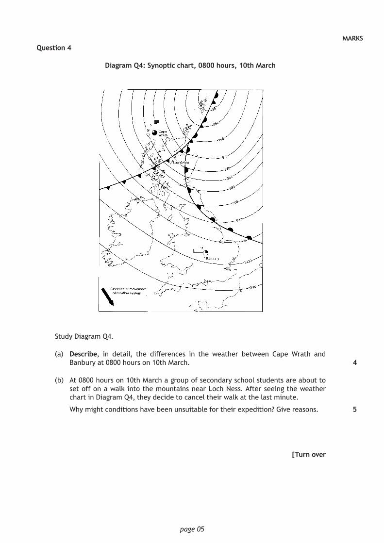
MARKSQuestion 4
Diagram Q4: Synoptic chart, 0800 hours, 10th March
Study Diagram Q4.
(a) Describe, in detail, the differences in the weather between Cape Wrath and Banbury at 0800 hours on 10th March.
(b) At 0800 hours on 10th March a group of secondary school students are about to set off on a walk into the mountains near Loch Ness. After seeing the weather chart in Diagram Q4, they decide to cancel their walk at the last minute.
Why might conditions have been unsuitable for their expedition? Give reasons.
[Turn over
4
5

page 06
MARKSQuestion 5
Diagram Q5: Air masses affecting the British Isles
Tropicalcontinental
Tropicalmaritime
Polarmaritime
Arcticmaritime
Polarcontinental
Look at Diagram Q5.
Describe how a long period with a tropical continental air mass in summer would affect the people of the British Isles. 3

page 07
MARKSQuestion 6
Diagram Q6: Selected land uses
Land uses
Industry
Recreation and tourism
Farming
Forestry
Water storage and supply
Renewable energy
Glaciated upland areas
Coastal areas
Upland limestone areas
River valley areas
Look at Diagram Q6.
(i) For a named area you have studied, explain, in detail, ways in which two different land uses may be in conflict with each other.
(ii) Suggest possible solutions to these conflicts.
[Turn over
5

page 08
MARKSSECTION 2 — HUMAN ENVIRONMENTS — 30 marks
Attempt ALL questions
Question 7
Diagram Q7
89 89
76 76
81
87
20
201604
16
Area X
Area Y
Area
Z
04
Study the Ordnance Survey map extract (Item B) of the Birmingham area and Diagram Q7 above.
(a) Give map evidence to show that part of the Central Business District (CBD) of Birmingham is found in grid square 0786.
(b) Find Area X on Diagram Q7 and the map extract (Item B).
Birmingham airport, a golf course, a business park and a housing area are found in Area X on the rural/urban fringe of Birmingham. Using map evidence explain why such developments are found there.
(c) The Russell family have three young children and are buying a house in Birmingham. They have narrowed down their search to two areas of the city — Area Y (Balsall Heath and Sparkbrook) or Area Z (Highter’s Heath and Drake’s Cross).
Which area, Y or Z, should they choose? Using detailed map evidence, give reasons to support your chosen area.
3
5
6
page 09
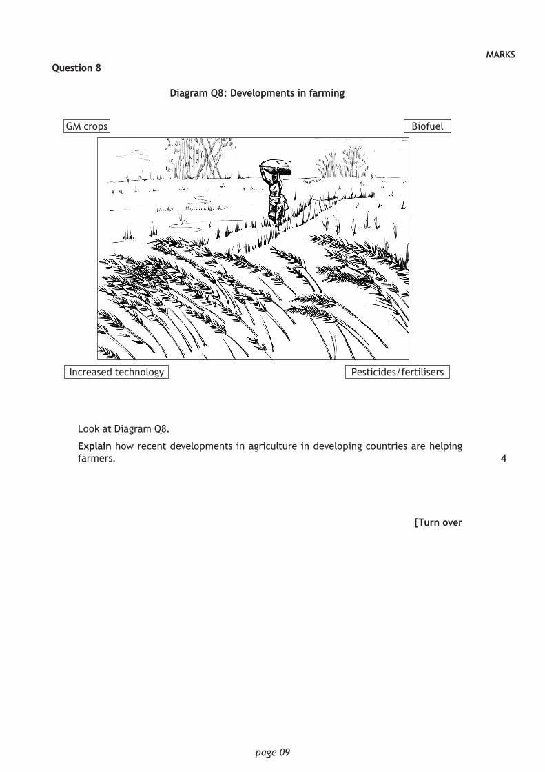
MARKSQuestion 8
Diagram Q8: Developments in farming
GM crops Biofuel
Increased technology Pesticides/fertilisers
Look at Diagram Q8.
Explain how recent developments in agriculture in developing countries are helping farmers.
[Turn over
4

page 10
MARKSQuestion 9
Diagram Q9: Demographic transition model
Stages
1700 1760 1820 1880 1940 2000
50
40
30
20
10
0
Birt
h an
d de
ath
rate
s(p
er 1
000
per
year
)Birth rate
Death rate Total population
Time 1
2
3
4
Look at Diagram Q9.
Countries such as the United Kingdom have experienced significant population change, as shown in Diagram Q9.
Explain why this population change has happened. You must refer to factors affecting birth and death rates in stages 2, 3 and 4 of Diagram Q9.
Question 10
Table Q10: Selected development indicators
Country Life expectancy (yrs)
Access to safe drinking water
(%)
Literacy rate (%)
% of workforce employed in agriculture
Bolivia 69 90 96 32
Chad 50 51 40 80
Finland 81 100 100 4
Mali 56 77 39 80
Netherlands 81 100 100 2
Uganda 55 79 78 40
Study Table Q10.
Choose two of the development indicators shown.
For the two that you have chosen, explain, in detail, why they are useful in helping to show a country’s level of development.
6
6

page 11
MARKSSECTION 3 — GLOBAL ISSUES — 20 marks
Attempt any TWO questions
Question 11 — Climate change (page 10)
Question 12 — Natural regions (page 11)
Question 13 — Environmental hazards (page 12)
Question 14 — Trade and globalisation (page 14)
Question 15 — Tourism (page 15)
Question 16 — Health (page 16)

page 12
MARKSQuestion 11: Climate change
Diagram Q11: Area of Arctic Sea ice (1979–2013)
8
7
6
5
4
3
Mill
ion
squa
re k
m
Year
’80 ’821978 ’84 ’86 ’88 ’90 ’92 ’94 ’96 ’98 ’00 ’02 ’04 ’06 ’08 ’10 ’12 2014
Study Diagram Q11.
(a) Describe, in detail, the changes in the area of Arctic Sea ice.
(b) Melting sea ice is one effect of climate change.
Explain some other effects of climate change.
4
6

page 13
MARKSQuestion 12: Natural regions
Diagram Q12: Recent deforestation rates worldwide
High
Moderate
Low
(a) Study Diagram Q12.
Describe, in detail, deforestation rates worldwide.
(b) Explain the management strategies which can be used to minimise the impact of human activity in the tundra.
[Turn over
4
6

page 14
MARKSQuestion 13: Environmental hazards
Diagram Q13A: Number of volcanic eruptions per decade 1910–2010
Num
ber
of v
olca
nic
erup
tion
s
Decade
1910s 1920s 1930s 1940s 1950s 1960s 1970s 1980s 1990s 2000s 2010s
80
75
70
65
60
55
50
45
40
35
30
25
20
(a) Study Diagram Q13A.
Describe, in detail, the changes in the number of volcanic eruptions between 1910–2010. 4

page 15
MARKSQuestion 13: Environmental hazards (continued)
Item Q13B: Pico de Fogo volcano, Cape Verde
After nearly 20 years of inactivity, the Pico de Fogo awakened with a violent eruption on the 23rd of November 2014.
(b) Look at Item Q13B.
For a volcanic eruption you have studied, explain, in detail, the impacts of the eruption on people and the landscape.
[Turn over
6
page 16
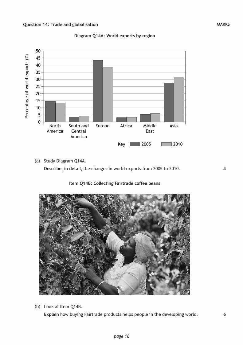
MARKSQuestion 14: Trade and globalisation
Diagram Q14A: World exports by region
50
45
40
35
30
25
20
15
10
5
0
Key 2005 2010
AsiaMiddle East
AfricaEuropeSouth andCentral America
North America
Perc
enta
ge o
f w
orld
exp
orts
(%)
(a) Study Diagram Q14A.
Describe, in detail, the changes in world exports from 2005 to 2010.
Item Q14B: Collecting Fairtrade coffee beans
(b) Look at Item Q14B.
Explain how buying Fairtrade products helps people in the developing world.
4
6

page 17
MARKSQuestion 15: Tourism
Diagram Q15A: Top ten world tourist destinations (millions of visitors per year)
LONDON:Trafalgar Square
15 M35 M
14 M
25 M 12 M
12.9 M
10.6 M
16.6 M14.7 M
13 MGolden Gate
Niagra Falls
WASHINGTON DC:
TOKYO:Disneyland
PARIS:Notre Dame
Disneyland Paris
FLORIDA:Disney World
NEW YORK CITY:Times Square
CALIFORNIADisneyland Park
(a) Study Diagram Q15A.
Describe, in detail, the distribution of the top ten world tourist destinations.
Item Q15B — Mass tourism on an Italian beach
(b) Look at Item Q15B.
Describe the effects of mass tourism on people and the environment.
4
6
[Turn over
jan
kran
endo
nk/s
hutt
erst
ock.
com

page 18
MARKSQuestion 16: Health
Diagram Q16: Ebola cases in selected African countries April–Oct 2014
2500
2000
1500
1000
500
001 Apr 01 May 01 Jun 01 Jul
Month
Ebol
a ca
ses
01 Aug 01 Sep 01 Oct
Liberia
Sierra Leone
Guinea
Ebola Cases in selected African countries April–Oct 2014
(a) Study Diagram Q16.
Describe, in detail, the changes in Ebola cases in the three named African countries.
(b) Explain the causes of either heart disease or cancer or asthma.
[END OF SPECIMEN QUESTION PAPER]
4
6
Acknowledgement of copyrightDiagram Q13B – LivetImages/shutterstock.comDiagram Q14B – Image is reproduced by kind permission of the Fairtrade Foundation. © David Macharia.Diagram Q15B – jan krankendonk/shutterstock.com

N5
©
NationalQualicationsSPECIMEN ONLY
S833/75/11 Geography
Marking Instructions
The information in this publication may be reproduced to support SQA qualifications only on a non-commercial basis. If it is reproduced, SQA should be clearly acknowledged as the source. If it is to be used for any other purpose, written permission must be obtained from [email protected].
Where the publication includes materials from sources other than SQA (ie secondary copyright), this material should only be reproduced for the purposes of examination or assessment. If it needs to be reproduced for any other purpose it is the user’s responsibility to obtain the necessary copyright clearance.
These marking instructions have been provided to show how SQA would mark this specimen question paper.
page 02
General marking principles for National 5 Geography This information is provided to help you understand the general principles you must apply when marking candidate responses to questions in this paper. These principles must be read in conjunction with the detailed marking instructions, which identify the key features required in candidate responses. (a) Marks for each candidate response must always be assigned in line with these general
marking principles and the detailed marking instructions for this assessment. (b) Marking should always be positive. This means that, for each candidate response, marks
are accumulated for the demonstration of relevant skills, knowledge and understanding: they are not deducted from a maximum on the basis of errors or omissions.
(c) If a specific candidate response does not seem to be covered by either the principles or
detailed marking instructions, and you are uncertain how to assess it, you must seek guidance from your team leader.
(d) For credit to be given, points must relate to the question asked. (e) There are six types of question used in this question paper, namely: A Describe . . . B Explain . . . C Give reasons . . . D Match . . . E Give map evidence . . . F Give advantages and/or disadvantages . . . For each of these question types, the following provides an overview of marking principles
and an example of their application. A Questions that ask candidates to Describe . . . (4–6 marks) Candidates must make a number of relevant, factual points. These should be key points.
The points do not need to be in any particular order. Candidates may provide a number of straightforward points or a smaller number of developed points, or a combination of these.
Up to the total mark allocation for this question:
Award 1 mark for each accurate relevant point.
Award further marks for development and exemplification.
Eg Question: Describe, in detail, the effects of two of the factors shown. (Modern factors affecting farming.)
Response: New technology has led to increased crop yields, (1 mark) leading to better profits for some farmers. (Second mark for development)

page 03
B Questions that ask candidates to Explain . . . (4–6 marks) Candidates must make a number of points that make the process/situation plain or clear, for example by showing connections between factors or causal relationships between events or processes. These should be key reasons and may include theoretical ideas. There is no need for any prioritising of these reasons. Candidates may provide a number of straightforward reasons or a smaller number of developed reasons, or a combination of these. The command word ‘explain’ is generally used when candidates are required to demonstrate knowledge and understanding.
Award up to full marks for sufficiently accurate and detailed, fully labelled diagrams. Up to the total mark allocation for this question:
Award 1 mark for each accurate relevant point.
Award further marks for developed explanations.
Eg Question: Explain the formation of a U-shaped valley.
Response: A glacier moves down a main valley which it erodes (1 mark) by plucking, where the ice freezes on to fragments of rock and pulls them away. (Second mark for development)
C Questions that ask candidates to Give reasons . . . (4–6 marks)
Candidates must make a number of points that make the process/situation plain or clear, for example by showing connections between factors or causal relationships between events or processes. These should be key reasons and may include theoretical ideas. There is no need for any prioritising of these reasons. Candidates may provide a number of straightforward reasons or a smaller number of developed reasons, or a combination of these. The command words ‘give reasons’ are generally used when candidates are required to use information from sources.
Up to the total mark allocation for this question:
Award 1 mark for each accurate relevant point.
Award further marks for developed reasons.
Eg Question: Give reasons for the differences in the weather conditions between Belfast and Stockholm.
Response: In Stockholm it is dry but in Belfast it is wet, because Stockholm is in a ridge of high pressure whereas Belfast is in a depression. (1 mark) Belfast is close to the warm front and therefore experiencing rain. (Second mark for development)
D Questions that ask candidates to Match . . . (3–4 marks) Candidates must match two sets of variables by using their map interpretation skills. Up to the total mark allocation for this question:
Award 1 mark for each correct answer. Eg Question: Match the letters A to C with the correct features. Response: A = Forestry (1 mark)

page 04
E Questions that ask candidates to Give map evidence . . . (3–4 marks) Candidates must look for evidence on the map and make clear statements to support their answer.
Up to the total mark allocation for this question:
Award 1 mark for each correct statement. Eg Question: Give map evidence to show that part of Coventry’s CBD is located in grid square 3379.
Response: Many roads meet in this square. (1 mark) F Questions that ask candidates to Give advantages and/or disadvantages . . . (4–6 marks)
Candidates must select relevant advantages or disadvantages of a proposed development and show understanding of their significance to the proposal. Answers may give briefly explained points or a smaller number of developed points. Award marks for accurate map evidence.
Up to the total mark allocation for this question:
Award 1 mark for each accurate relevant point.
Award further marks for developed points.
Eg Question: Give either advantages or disadvantages of this location for a shopping centre. You must use map evidence to support your answer.
Response: There are roads and motorways close by allowing the easy delivery of goods (1 mark) and access for customers, (second mark for development) eg the A46, M6 and M69.

page 05
Marking instructions for each question
Question General marking instructions for this type of question
Max mark
Detailed marking instructions for this question
1. (a) Each answer should be identified with a correct grid reference. 1 mark for a valid point.
4 Corrie with lochan in squares 7921 & 8021 (1)
Scree slopes on south side of corrie (1)
U-shaped valley at 8414 (1)
Pyramidal peak (Pen-y-Fan) at 012215 (1)
Arete at 016213 (1)
Corrie with lochan (Llyn Cwn Llwch) at 0022 (1) Or any other valid point.
(b) 1 mark for a valid point. 2 marks for a developed point. Full marks can be gained for appropriately annotated diagrams. 1 mark for basic diagrams showing progression. Maximum of 1 mark for list of glacial erosion processes.
4 Glacier forms in corrie/north facing slope and moves downhill due to gravity (1)
Eroding sides and bottom of valley (1) through plucking and abrasion (1)
Action makes valley sides steeper and valley deeper (1)
When glacier retreats a deep, steep, flat floored U-shaped valley left behind (1)
Original river in valley now seems too small for wider valley and is known as misfit stream (1)
Or any other valid point.
2. (a) Where specific river or valley features are mentioned they should be identified by an accurate grid reference. 1 mark for a valid point.
4 From point 905175 river is flowing south (1) down steep-sided V-shaped valley (squares 9017 & 9016) (1)
River is joined by tributaries from west such as at 906166 (1)
Confluence at 911153 (1) and from this point river gets wider (1)
Meander at 911152 (1)
At least 3 waterfalls marked in square 9009 (1)
In this square river is flowing south-west (1) Or any other valid point.
page 06
Question General marking instructions for this type of question
Max mark
Detailed marking instructions for this question
(b) 1 mark for a valid point.
2 marks for a developed point.
Full marks can be gained for appropriately annotated diagrams.
1 mark for basic diagrams showing progression.
Maximum of 1 mark for list of river erosion processes.
4 At river meander, water pushed towards outside of bend causing erosion (1), by processes such as corrosion or hydraulic action (1)
Slower flow of water on inside bend causes deposition (1)
Over time erosion narrows neck of meander (1)
In time, usually during a flood, river will cut right through neck (1)
Fastest current is now in centre of river and deposition occurs next to banks (1) eventually blocking off meander to leave ox-bow lake (1)
Or any other valid point.
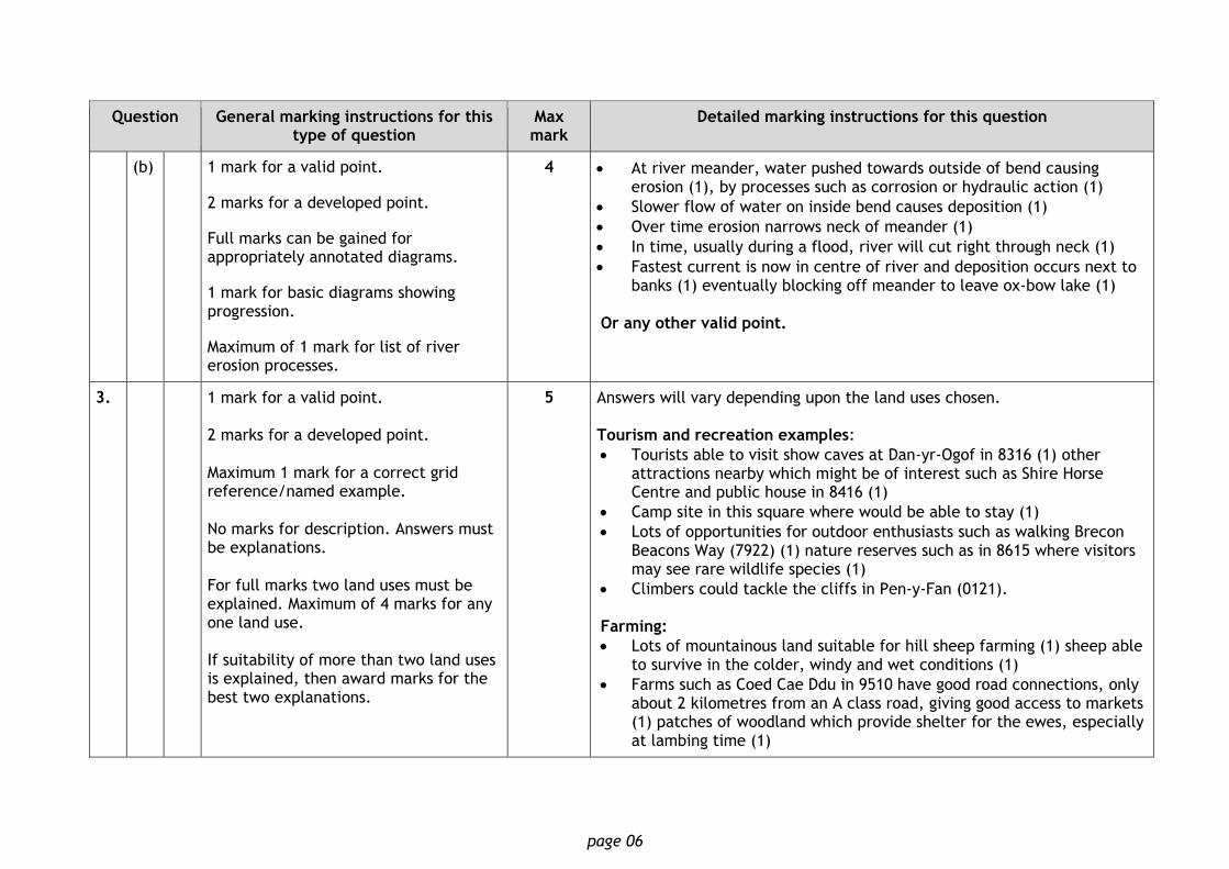
3. 1 mark for a valid point. 2 marks for a developed point. Maximum 1 mark for a correct grid reference/named example. No marks for description. Answers must be explanations. For full marks two land uses must be explained. Maximum of 4 marks for any one land use. If suitability of more than two land uses is explained, then award marks for the best two explanations.
5 Answers will vary depending upon the land uses chosen. Tourism and recreation examples:
Tourists able to visit show caves at Dan-yr-Ogof in 8316 (1) other attractions nearby which might be of interest such as Shire Horse Centre and public house in 8416 (1)
Camp site in this square where would be able to stay (1)
Lots of opportunities for outdoor enthusiasts such as walking Brecon Beacons Way (7922) (1) nature reserves such as in 8615 where visitors may see rare wildlife species (1)
Climbers could tackle the cliffs in Pen-y-Fan (0121). Farming:
Lots of mountainous land suitable for hill sheep farming (1) sheep able to survive in the colder, windy and wet conditions (1)
Farms such as Coed Cae Ddu in 9510 have good road connections, only about 2 kilometres from an A class road, giving good access to markets (1) patches of woodland which provide shelter for the ewes, especially at lambing time (1)

page 07
Question General marking instructions for this type of question
Max mark
Detailed marking instructions for this question
Other farms such as Pwllcoediog (8416) able to benefit from high numbers of visitors by earning extra income from bed and breakfast (1).
Industry:
Limestone areas such as Brecon Beacons are sometimes used for extraction of limestone (1)
Quarries could be built here as there is limestone and an A class road (A4067) nearby for material to be transported (1)
Opencast working shows evidence of industry, grid reference 8211 (1)
Works located at 847107 where land is flat so easy to build on (1) Good communication with two main roads A4109 and A4221 close by, also rail link into works (1) Small settlements close by like Dyffryn Cellwen where workers could be found (1).
4. (a) Award 1 mark for each clear difference described. No marks for explanation.
4 Cape Wrath has north wind whereas Banbury has west wind (1)
35 knots at Cape Wrath but calmer in Banbury at 15 knots (1)
Dry in Banbury but snow showers at Cape Wrath (1)
6 oktas cloud cover at Cape Wrath but only 2 oktas over Banbury (1)
Temperature at Cape Wrath is much colder at 2C, while at Banbury is 11C (1)
(b) 1 mark for a valid point. 2 marks for a developed point.
5 Should not go walking in hills as cold front about to arrive in area (1) which will bring heavy rain showers (1)
Will also cause temperature to drop close to freezing point and could be snow (2)
If not properly equipped could suffer from the cold and get hypothermia (1) especially as isobars are close together resulting in high wind chill (1)
If heavy snow or low cloud they could lose their way easily and need to be rescued (1) these conditions are life threatening and should wait for a better day (1)
Or any other valid point.

page 08
Question General marking instructions for this type of question
Max mark
Detailed marking instructions for this question
5. 1 mark for a valid point. Award marks for effects on people, not for type of weather. No marks for the description of the weather.
3 Tropical continental air mass will bring hot dry weather in summer which could result in droughts (1)
Might need to be hosepipe bans (1)
Grass might wither and die causing problems for livestock farmers (1)
Ice cream sales might rise (1) as people make most of sunny weather and head for beach (1)
Could be very hot and difficult to do physical work outside (1)
Heavy rain from thunderstorms might cause flash floods (1) Or any other valid point.
6. 1 mark for a valid point. 2 marks for a developed point. No marks for description. Answers must explain the conflict. For full marks candidates must give a named area, explain the conflict and suggest a solution. Maximum 4 marks if no named area or no solutions mentioned. Maximum 3 marks if neither a named area nor any solutions mentioned.
5 Answers will vary depending upon the land uses chosen. Examples of problems between tourists and farmers
In Cairngorms, tourists can disrupt farming activities as walkers leave gates open, allowing animals to escape (1)
Tourists’ dogs can worry sheep if let off the lead (1)
Stone walls are damaged by people climbing over instead of using gates/stiles (1)
Solved by putting in kissing gates or stiles so that people don't have to open gates (1) Noisy tourists can disturb sheep especially during breeding season (1)
Farmers may restrict walkers’ access at certain times eg lambing season (1)
Farm vehicles can slow up tourist traffic on roads (1) parked cars on narrow country roads can restrict movement of large farm vehicles (1)
Some of these problems can be resolved by educating public through methods such as publicising Country Code (1)

page 09
Question General marking instructions for this type of question
Max mark
Detailed marking instructions for this question
If conflict between more than two land uses is explained, then award marks for the best two only.
Examples of problems between industry and tourists
Tourists want to see beautiful and unusual scenery of Yorkshire Dales but quarries spoil natural beauty of landscape (1)
Lorries used to remove stone endanger wildlife and put visitors off returning to area (1)
This threatens local tourist-related jobs eg in local restaurants (1)
Large lorries needed to remove quarried stone cause air pollution and dust which spoils atmosphere for tourists (1)
Quarry companies have covered vehicles with tarpaulins to try and reduce amount of dust (1)
Lorries cause traffic congestion on narrow country roads which slows traffic and delays drivers (1)
Some quarries have reduced number of lorries by sending limestone by rail instead (1) Peace and quiet for visitors is disturbed by blasting of rock (1)
Quarry companies limit frequency and times of blasting to try to reduce impact on local communities (1)
Some wildlife habitats may also be disturbed by removal of rock (1) Or any other valid point.
7. (a) 1 mark for a valid point. Do not accept grid-iron street pattern, lack of open space or hospital. No marks for grid references (grid reference is given in the question). No marks for features outwith the square (eg cathedral).
3 Main roads lead into this square (1) there is a bus station (1) and two railway stations (1) tourist information centre (1) several churches (1) museum (1)
Or any other valid point.
page 10
Question General marking instructions for this type of question
Max mark
Detailed marking instructions for this question
(b) 1 mark for a valid point. 2 marks for a developed point. Maximum of 1 mark for an appropriate grid reference. If no reference to the Ordnance Survey map then mark out of three. Do not credit the same point twice (eg the land is flat and suitable for building). Answers must be explanatory. No marks for description.
5 Land is flat so easy to build on (1) space available for expansion (1) eg expansion of motor works at 163823 (1)
Good transports links like M42 allowing people and products access to and from area (1)
Rail link with Birmingham International rail station gives easy access to airport (1)
Many road junctions and intersections connecting area to other areas and less traffic congestion as is away from Birmingham city centre (2)
Land is on edge of Birmingham so will be cheaper encouraging housing estates like Sheldon to be built (1)
Cheaper land allows houses to be bigger with cul-de- sacs, gardens etc. (1) houses can provide a source of labour for the airport, motor works and business park (1)
Or any other valid point.
(c) 1 mark for a valid point. 2 marks for a developed point. Credit positive points about only one area. If response makes positive points about both areas, award marks only for highest scoring area. Maximum of 1 mark for a relevant grid reference.
6 Area Y:
Some quieter roads such as cul-de-sacs which would be peaceful area to live in (1)
Balsall Heath very close to cricket ground (0684) which would be good for recreation (1) and Cannon Hill Country Park (0683) also close by which would give family easy access to pleasant place to walk (1) Children might also enjoy seeing wildlife at Nature Centre in park (1)
Area Y is close to centre of Birmingham which might make it easier for parents to get to work if their jobs are there (1) will also be convenient for shopping as lots of variety in CBD (1)
Appears to be industrial areas in Area Y (8410) which might provide job opportunities for parents, conveniently close to where they will live (1).

page 11
Question General marking instructions for this type of question
Max mark
Detailed marking instructions for this question
Area Z:
Further out of city, land prices will be cheaper and may be able to afford better house (1)
Evidence of lots of modern housing estates with curvilinear road patterns which will be nice environment to live in as will be more garden space (1) and less traffic making it safer for families (1)
Two schools in Area Z which mean children will not have long journey to get there (1)
2 golf course in Area Z, providing recreation opportunities for Russell family (1) and able to get outdoor exercise easily by walking along North Worcestershire Path which passes through Area Z (1)
Good transport links into Birmingham for shopping or jobs via main A435 road which leads into CBD and also nearby Park & Ride (1077) next to station where could travel by train into centre (1)
Lots of open space and areas of woodland make the environment/air quality better than many other parts of city (1).
Or any other valid point.
8. 1 mark for a valid point. 2 marks for a developed point. Do not accept disadvantages.
4 Pesticides reduce disease producing better crops (1) and surplus to trade (1)
Fertilisers increase crop yields (1) leads to better profits for some farmers (1) which can lead to increase in standard of living (1)
Mechanisation means less strenuous work for farmer (1) and is quicker and more efficient (1)
GM crops produce greater yield and are disease resistant so make a greater profit for farmer (1) can reduce cost to farmer of applying pesticides (1) and reduce risk to his health (1)
Growing demand for biofuels means higher crop prices and can result in farmer getting higher income (1) and create employment (1)
Or any other valid point.

page 12
Question General marking instructions for this type of question
Max mark
Detailed marking instructions for this question
9. 1 mark for a valid point. 2 marks for a developed point. Give credit for explanations of changes in birth and death rates as well as the impact of this on overall population. Marks can be awarded for valid points about changes in any of stages 2,3 and 4. Full marks may be earned from explanations about changes in one stage.
6 Stage 2 birth rate was still very high, whereas death rate fell quite quickly - caused rapid rise in total population as people were living longer (1)
Death rates fell because clean water supplies introduced, reducing spread of disease (1) and at same time proper sewage systems being built which meant water supplies no longer contaminated, reducing number of people falling ill and dying (2)
Advances in medicine such as introduction of penicillin helped keep death rates low, as people could be treated for and cured from illnesses which might have killed them in past (2)
Birth rates were still high as people were used to idea many children may not survive until adulthood (1) and also children were required to go out and work because of poverty (1)
Stage 3 birth rates started to drop much faster as people realised infant mortality was falling and no longer needed to have extra children as insurance policy (2)
Standard of living had improved and wasn't necessary to have lots of children to earn income for family any more (1)
Also education about family planning was more common (1) and availability and variety of different methods of contraception was better (1)
Falling birth rate meant that rate of population increase started to slow down (1)
Stage 4 birth rate fallen so low that in some countries is below death rate and so overall population is falling (1)
Japan is example of this (1) Or any other valid point.

page 13
Question General marking instructions for this type of question
Max mark
Detailed marking instructions for this question
10. 1 mark for a valid point. 2 marks for a developed point. Full marks can only be awarded for explanations about two development indicators. Maximum 4 marks for explanations about any one development indicator. If more than two development indicators are explained, award marks for the best two only.
6 Life expectancy:
Very useful development indicator as shows that people in developed countries such as Finland live much longer than in developing countries such as Chad (1)
Likely to be because standard of living in Finland is much better (1) and will be much better hospitals, more doctors and more money to spend on medicine (1) as Finland is wealthy developed country which can afford to pay for all of this (1)
In Chad, people will have very hard physically demanding lives which may lead to shorter life expectancy (1)
They may also live shorter lives on average because of poor nutrition, food shortages and famine (1).
Percentage of workforce employed in agriculture:
Can tell you a lot about a country because if a very high proportion of workforce in agriculture shows less developed country (1)
Whereas in developing countries such as Mali, 80% of workers are employed in farming because mostly subsistence farmers who have to grow own food (1)
Few other places that can get food from or simply can't afford to buy it (2)
Also few other industries for people to get jobs in as country is less developed and there is lack of money to invest in setting up new businesses (2)
Developed countries such as the Netherlands have very efficient farming industries which require very few workers (1); their economy is highly developed meaning most people are employed in many other jobs and industries which are available and which provide higher incomes than farming (2).
Or any other valid point.
page 14
Question General marking instructions for this type of question
Max mark
Detailed marking instructions for this question
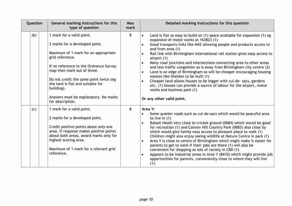
11. (a) 1 mark for a valid point. 2 marks for a developed point. Maximum of 2 marks if no reference to figures.
4 Overall trend is that amount of Arctic Sea ice has decreased between 1979 and 2013 (1) from (around) 7 million square km to (about) 5 million square km (1)
Fluctuation in extent of sea ice in certain years (1) eg amount of sea ice increased from 3.75 million square km in 2012 to 5 million square km in 2013 (1)
Between 2006 and 2007 was a sharp decrease (1) from 6 million square km to 4.25 million square km (1)
Or any other valid point.
(b) 1 mark for a valid point. 2 marks for a developed point. Award marks for explanatory points only, not for description. Credit can still be given for effects linked to melting sea ice. Answers must refer to effects not causes. Effects can be positive or negative.
6 Increased temperatures causing ice caps to melt so Polar habitats beginning to disappear (1)
Melting ice causes sea levels to rise (1) threatening coastal settlements (1)
Increase in sea temperatures causes water to expand, compounding problem of flooding (1)
Global warming could also affect weather patterns, leading to more droughts (1) crop failures and problems with food supply (1)
Flooding, causing the extinction of species (1) and more extreme weather, eg tropical storms (1)
Tourism problems will increase as will be less snow in some mountain resorts (1)
Global warming could threaten development of developing countries as restrictions on fossil fuel use may be imposed to slow rate of increasing CO2 levels (1)
In UK, tropical diseases like malaria may spread as temperatures rise (1)
Plant growth will be affected and some species will thrive in previously unsuitable areas (1)
Higher temperatures may cause water shortages (1)
Or any other valid point.

page 15
Question General marking instructions for this type of question
Max mark
Detailed marking instructions for this question
12.
(a) 1 mark for a valid point. 2 marks for a developed point. Specific countries should be mentioned for full marks, otherwise mark out of 3.
4 High rates of deforestation occur in Brazil, DR Congo and Indonesia (1)
High rates are also prevalent in areas such as Mexico and most of South America (1)
High levels of loss more common in developing countries (1)
Moderate levels common throughout Europe, northern Africa and Canada (1)
Low rates common throughout USA, China, India and Australia (1) Or any other valid point.
(b) 1 mark for a valid point. 2 marks for a developed point. Answers should explain how a particular strategy reduces human impact.
6 Management strategies include:
Habitat Conservation Programmes sometimes established in tundra environments to protect unique home for tundra wildlife (1)
In Canada and Russia, many tundra areas protected through national Biodiversity Action Plan (BAP) (1)
BAP is internationally recognised programme designed to protect and restore threatened species and habitats (1)
Reducing global warming is crucial to protecting tundra environment because heating up of Arctic areas is threatening existence of environment (1)
Most governments have promised to reduce greenhouse gases by signing up to Kyoto Protocol (1)
Many countries have invested heavily in alternative sources of energy such as wind, wave and solar power. These sources of energy are renewable and more environmentally friendly than burning fossil fuels, which increase carbon emissions and global warming (2)
Some oil companies now schedule construction projects for the winter season to reduce environmental impact (1)
Projects work from ice roads, which are built after ground is frozen and snow covered. This limits damage to sensitive tundra (1)

page 16
Question General marking instructions for this type of question
Max mark
Detailed marking instructions for this question
Some oil companies locate polar bear dens using infrared scanners and do not work within 1.6 kilometres of these dens (1)
Number of Arctic research programmes, such as International Association of Oil & Gas Producers’ joint industry programme on Arctic oil spill response technology (1)
This programme attempts to increase effectiveness of dispersants in Arctic waters, oil spill modeling in ice and use of remote sensors above and under water (2)
Many companies operate sophisticated systems to detect leaks (1)
Many companies work with local communities to understand and manage potential local impacts of their work (1)
Many countries have set up national parks such as Arctic National Wildlife refuge in Alaska to protect endangered animals in tundra (1)
Trans-Alaskan pipeline is raised up on stilts to allow Caribou to migrate underneath (1).
Or any other valid point.
13. (a) 1 mark for a valid point. Award marks for use of statistics. Award 1 mark only for an increase or a decrease (trend).
4 Over last 100 years number of eruptions has increased from forty three in 1910s to seventy in 2010s (1)
Apart from decades of 1920s, 1970s and 1990s, amount of volcanic activity in each decade increased (1)
Least number of eruptions was in 1920s with only 31 (1)
Big drop between 1910s and 1920s with a drop of 12 eruptions (1)
Also in 1990s there were 12 fewer eruptions than 1980s (1)
Biggest increase between 1990s and 2000s with 13 more eruptions (1)
Decades with greatest number of eruptions were 1980s, 2000s and 2010s at 66, 67 and 70 (1)
Or any other valid point.

page 17
Question General marking instructions for this type of question
Max mark
Detailed marking instructions for this question
(b) 1 mark for a valid point. 2 marks for a developed point. Award marks for explanatory points only. Mark out of five if no reference to a specific volcano. For full marks both people and landscape should be mentioned. If not mark out of five.
6 For Pico de Fogo volcano
Heat from lava flows set fire to main settlements destroying two villages as well as forest reserve (2) endangering the vegetation and animal habitat (1)
Around 1,500 people forced to abandon homes before lava flow reached villages of Portela and Bangeira on Fogo island (1)
More than 1,000 people evacuated from Cha das Caldeiras region at foot of volcano to ensure safety and prevent injuries (1)
Airport was closed, as ash filled sky, to prevent risk of planes crashing (1)
Buildings and records were destroyed resulting in some of history of area being lost (1)
Roads and transport routes destroyed, affecting tourist industry on island (1)
Volcano destroyed agricultural land which resulted in loss of fertile land (1) decreasing ability of area to produce crops (1) and support local population (1)
Tourism might increase as volcano becomes tourist attraction improving economy of the island (1)
Or any other valid point.
14. (a) 1 mark for a valid point. 2 marks for a developed point. Maximum of 2 marks if no reference to figures.
4 Europe dominated world trade exports with around 43% in 2005. (1)
Dropped to around 38% in 2010. (1) Europe still largest exporter in 2010. (1)
Asia had second largest regional share of world trade with around 27% in 2005 (1), growing to around 31% in 2010. (1)
Africa’s share is low, around 3%, (1) but has grown by about 1%. (1)
North America’s share has dropped from just under 15% in 2005 to around 14% in 2010. (1)
Or any other valid point.

page 18
Question General marking instructions for this type of question
Max mark
Detailed marking instructions for this question
(b) 1 mark for a valid point. 2 marks for a developed point.
6 Farmers paid fair wage for their work (1) and safer working conditions promoted. (1)
Money from fair trade can be used to improve services in local communities (1) such as schools and clinics (1) which improves standard of living (1)
More money goes directly to farmer, cuts out middlemen who take some of profits for themselves (1)
Farmers receive guaranteed minimum price so are not affected as much by price fluctuations (1)
Fair trade encourages farmers to treat workers well and to look after environment (1)
Often fair trade farmers are also organic farmers who do not use chemicals on crops so protect environment (1)
Health care services and education programmes available and tackle problems of HIV/AIDS(1)
Or any other valid point.
15. (a) 1 mark for a valid point. 2 marks for a developed point.
4 USA has six out of ten most popular tourist attractions in world including Niagara Falls and Disneyland (1)
Most visited tourist attraction is Times Square in USA with 35 million visitors per year (1)
Washington D.C. is second most popular tourist destination with 25 million visitors (1)
Trafalgar Square is most popular tourist area in Europe (1)
Notre Dame and Disneyland in Paris are most visited attractions in France with 12 million and 10.6 million visitors a year (2)
Disneyland Tokyo is most visited attraction in Asia (1)
Four out of top ten most popular tourist destinations are Disneyland/Disneyworld parks located on 3 different continents (1)
Or any other valid point.

page 19
Question General marking instructions for this type of question
Max mark
Detailed marking instructions for this question
(b) 1 mark for a valid point. 2 marks for a developed point. Maximum of 4 marks for either effects on people or environment. Ie marks can be allocated to a maximum of 3:3, 4:2 or 2:4.
6 People (positive):
Local people employed to build tourist facilities eg hotels (1) and work in restaurants and souvenir shops (1)
Employment opportunities allow locals to learn new skills (1) eg obtain foreign language (1) and earn money to improve standard of living (1)
Services improved and locals can benefit by using tourist facilities such as restaurants and water parks (1)
Better employment opportunities increase the local Governments’ revenue as wages are taxed (1) so can invest in schools, healthcare and other social services (1)
Locals can experience foreign languages and different cultures (1) and can benefit from improvements in infrastructure eg roads and airports (1).
People (negative):
Tourist-related jobs are usually seasonal therefore some people may not have income for several months (1) eg at beach and ski resorts (1)
Large numbers of tourists can increase noise pollution and upset peace and quiet (1)
Local people may not be able to afford tourist facilities as visitor prices are often higher than local rates (1)
Tourists can conflict with local people due to different cultures and beliefs (1)
There is additional sewage from visitors which increases risk of diseases like typhoid and hepatitis (2).

page 20
Question General marking instructions for this type of question
Max mark
Detailed marking instructions for this question
Environment (positive):
Appearance of some areas can be improved by modern tourist facilities (1)
Some tourists are environmentally conscious and can have positive impact on landscape by donating money to local projects which help protect local wildlife (1) eg nature reserves (1)
Tourist beaches cleaned up to ensure safe for people to use (1) through initiatives like Blue Flag (1)
Seas become less polluted as more sewage treatment plants built to improve water quality (1).
Environment (negative):
Land lost from traditional uses such as farming and replaced by tourist developments (1)
Traditional landscapes/villages spoiled by large tourist complexes (1)
Air travel increases carbon dioxide emissions and contributes to global warming (1)
Traffic congestion on local roads increases air and noise pollution (1)
Tourist facilities such as large high-rise hotels and waterparks spoil look of natural environment (1)
Litter causes visual pollution (1)
Increased sewage from tourists can cause water pollution (1)
Polluted water damages aquatic life and habitats (1). Or any other valid point.
page 21
Question General marking instructions for this type of question
Max mark
Detailed marking instructions for this question
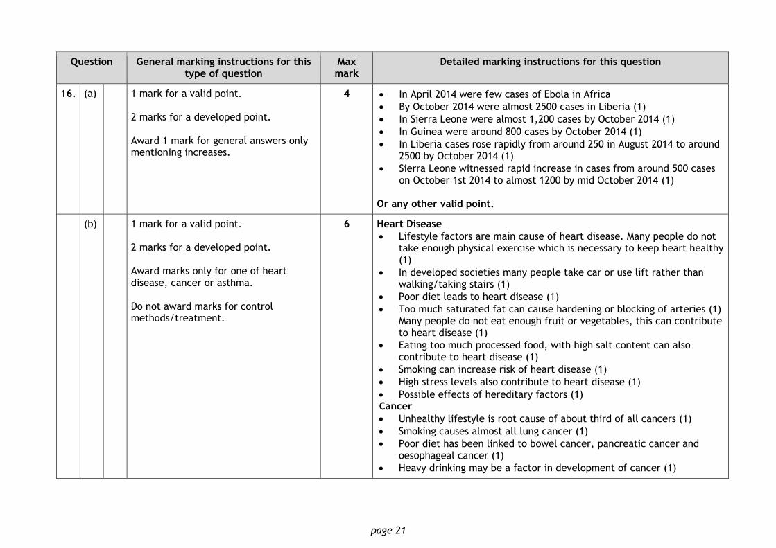
16. (a) 1 mark for a valid point. 2 marks for a developed point. Award 1 mark for general answers only mentioning increases.
4 In April 2014 were few cases of Ebola in Africa
By October 2014 were almost 2500 cases in Liberia (1)
In Sierra Leone were almost 1,200 cases by October 2014 (1)
In Guinea were around 800 cases by October 2014 (1)
In Liberia cases rose rapidly from around 250 in August 2014 to around 2500 by October 2014 (1)
Sierra Leone witnessed rapid increase in cases from around 500 cases on October 1st 2014 to almost 1200 by mid October 2014 (1)
Or any other valid point.
(b) 1 mark for a valid point. 2 marks for a developed point. Award marks only for one of heart disease, cancer or asthma. Do not award marks for control methods/treatment.
6 Heart Disease
Lifestyle factors are main cause of heart disease. Many people do not take enough physical exercise which is necessary to keep heart healthy (1)
In developed societies many people take car or use lift rather than walking/taking stairs (1)
Poor diet leads to heart disease (1)
Too much saturated fat can cause hardening or blocking of arteries (1) Many people do not eat enough fruit or vegetables, this can contribute to heart disease (1)
Eating too much processed food, with high salt content can also contribute to heart disease (1)
Smoking can increase risk of heart disease (1)
High stress levels also contribute to heart disease (1)
Possible effects of hereditary factors (1) Cancer
Unhealthy lifestyle is root cause of about third of all cancers (1)
Smoking causes almost all lung cancer (1)
Poor diet has been linked to bowel cancer, pancreatic cancer and oesophageal cancer (1)
Heavy drinking may be a factor in development of cancer (1)

page 22
Question General marking instructions for this type of question
Max mark
Detailed marking instructions for this question
Some people may be genetically predisposed to some cancers, eg breast cancer (1)
Too much exposure to sun can cause skin cancer (1)
Obesity has also been linked with increased cancer risk (1) Asthma
Infections such as colds or flu affect lungs and narrow airways, making asthma worse (1)
Allergic reactions to dust mites in home can cause asthma (1)
Pollen from plants outside can cause asthma (1)
Traffic fumes in polluted towns and cities can cause asthma (1)
Cigarette smoke can cause asthma (1)
Asthma can be caused or made worse by damp conditions in home (1)
In cases of severe dampness, mould spores may make asthma worse (1) Or any other valid point.
[END OF SPECIMEN MARKING INSTRUCTIONS]