namdini gold deposit, northern ghana
TRANSCRIPT

1
Namdini Gold Deposit, Northern Ghana – 5.1Moz Reserve
Kevin Tomlinson (MAIG, Presenter), Paul Abbott (MGeol Soc SA), Ernest Opoku-Boamah (AIG), Richard Bray (RPGeo, AIG), Ekow Taylor (CP, AUSIMM)
Contact:
Cardinal Resources Limited, Suite 1, 28 Ord Street West Perth, WA 6000
Kevin Tomlinson: [email protected]
Abstract
Namdini represents the first major discovery in Ghana since 2009. The Namdini Mineral Resource represents the largest gold discovery in the Birimian of West Africa this century. Approximately 5.1 million ounces of gold Ore Reserves from a 7.4 million ounces Mineral Resource within a massive single deposit with a strike length of approximately 1.2km and a width of 350m. The deposit is still open at depth and along strike to the north and south and has been drilled to a vertical depth of 475m. The Namdini deposit is located within a large‐scale renewable mining licence granted by the Ghanaian government for an initial 15 years. The bulk of gold production in Ghana is in the southwest from some major gold mines but whilst the northern part is still relatively underexplored, it already has several producing mines there and across the border into nearby Burkina Faso. The producing mine on the Ghana side of the border is, Shaanxi Gold Underground Mine, and the Historical Nangodi Mine which produced 18,620 ounces of gold from 23,600 tonnes, at an average of approximately 23.9 g/t Au during the 1930’s from underground workings exceeding 150m (Ghana Department of Mines records 1938) and across the border into Burkina Faso, the Youga Gold Mine currently owned by Avesoro Jersey (formerly MNG Gold). As of May 2019, Youga’s proven and probable mineral reserves were estimated at 14.74Mt containing 814,900oz of gold grading at 1.72g/t and has recovered a total of over 0.6 million ounces of gold since operations commenced in 2008 and produced 68,407 ounces of gold in 2015 by its precious owners Endeavour Mining The sequence of exploration techniques that discovered Namdini did not follow the usual pattern of modern mineral exploration as work was initiated on a small‐scale mining lease where panning had discovered nuggets. It was thought that no exposure of gold mineralisation would occur in Northern Ghana due to thick younger sedimentary Voltaian rock uncomformably overlaying the Birimian, however, Namdini was discovered where the younger cover ended with a breakaway in the terrain. Once discovered, other contiguous small‐scale licenses were obtained and consolidated into a single license and an RC drilling campaign to test the area was undertaken. To date, some 700 drill holes for approximately 110 kilometres of Resource drilling and 340 drill holes of sterilization totalling 33 kilometres have been completed on the Namdini mining lease. 116,332 Resource samples and 37,007 Sterilisation RC samples have been submitted to SGS‐Tarkwa and Intertek‐Tarkwa for analysis. Regionally, the Namdini Project occurs in Paleo‐Proterozoic Bole‐Nangodi Greenstone Belt of southwest ‐north east trending granite–greenstone belt which host significant gold mineralisation in Ghana and Burkina Faso. Namdini deposit is located in the Northeastern part of Ghana close to the border with Burkina Faso on a major regional shear zone which divides the rock units of the area into Paleoproterozoic Birimian volcanic assemblages to the west and volcaniclastics and metasediments to the east. The volcanic assemblages are comprised of strongly magnetic ultramafics and mafics, mafic basalts and intermediate to felsic dacitic to rhyolitic units. Much of northern Ghana is covered by post‐

2
Birimian Voltaian Basin sediments and within the Birimian rocks is Namdini at the northern limit of the Voltaian Basin sediments exposure. Locally, Namdini sits on a splay off the major regional Bole‐Bolgatanga shear and is comprised of Birimian volcaniclastics and metasediments with younger Voltaian horizontally bedded sandstones overlying the Birimian assemblages in the far south of the license. The volcaniclastics dip approximately 60⁰W and strike at approximately 010⁰. The units are generally greenish grey in colour and medium‐grained to fine‐grained where unaltered. The mineralised rocks are intensely sheared and have a typical creamy to greenish colouration (silica‐carbonate‐ chlorite‐ sericite alteration) due to intense hydrothermal alteration containing sulphides (pyrite and minor arsenopyrite). The volcaniclastics have been intruded by light‐coloured, coarse‐grained, sulphide‐bearing monzonites/tonalites and are considered to be the heat engine that mobilised these gold‐bearing hydrothermal fluids which have altered and mineralised the volcaniclastics. Gold mineralisation is hosted in intensely altered and strongly deformed volcaniclastics,
monzonite/tonalite, diorite and to a much lesser extent, metasedimentary rocks. Structural studies
have shown that gold mineralisation occurred late in the initial deformation phase (D1) prior to a
second phase of further intense deformation (D2). Fine‐grained gold is strongly associated with
sulphides (predominantly pyrite and minor arsenopyrite) which on average is approximately 1% of the
rock mass with overall gold recoveries of over 83% (Life of Mine) and 85% (Starter Pit) for the first
three years.
Structurally, two schools of thought have been proposed; the first states that, foliations produced
during D1 and D2 are well developed in the volcaniclastics and metasedimentary rocks and showed a
consistent asymmetry with S1 striking acutely clockwise of strike of S2. The S1‐S2 asymmetry indicates
the deposit is located in a sinistral D2 shear zone.
Alternatively, the deposit may be located on the limb of a fold that is of a scale larger than the deposit.
The intense S1‐S2 foliation? Is a product of transposition of S1 and the zones of high strain represent
D2 shear zones that have evolved from precursor zones of enhanced S2 fabric development. Foliations
are less well developed in the monzonite/tonalite, with most structures represented by quartz ±
carbonate vein arrays and silica‐sericite fractures/veinlets. Faults are uncommon in general and in the
monzonite/tonalite, faults tend to manifest as zones of enhanced quartz veining or local fracturing.
Parasitic folds are common in the core but were not observed in the field.
Regional Geology
The Namdini gold project is located in northeast Ghana, immediately to the north of the extensive
post‐Birimian, Voltaian sediment cover, which dominates eastern Ghana, as shown in Figure 1. The
Birimian in Ghana is defined by a series of SW‐NE trending granite‐greenstone gold belts, which are
much better exposed in southern and western Ghana, with the gold belts defined from south to north
as the Kibi‐Winneba, Ashanti, Sefwi‐Bibiani, Bui, Bole‐Bolgatanga and Lawra (which trends N‐S).
Namdini lies to the south of the regionally extensive Bole‐Bolgatanga belt separated from the
greenstones by a regionally continuous, intermediate to mafic granitoid complex. There is a possibility
that the sequence of rocks at Namdini form part of the north‐western continuation of the Bui Belt.
Alternatively, the Birimian rocks at Namdini can be considered to be the southern extension of the
Youga greenstone belt in Burkina Faso which are referred to as the Nangodi Greenstone Belt within
north‐eastern Ghana. The Birimian gold belts of Ghana have been extensively studied because of their

3
significant gold endowment (Allibone et al 2002a, 2002b, Allibone et al 2004, Fougerouse et al 2013,
2017, Goldfarb et al 2017).
In summary, the main lithological groupings in the belts are sequences of sedimentary basins
dominated by greywackes and phyllites, overlain by volcanic and sediment sequences of Birimian age,
characterised by interbedded mafic to intermediate volcanic flows, felsic to intermediate tuffs and
fine‐grained sediments. The various belts are interpreted to be fault bounded, both during their
development and post‐deposition. An association of granitic intrusions occurs and have been divided
into two types, Belt‐Type and Basin‐Type. Belt‐Type granites are metaluminous, are often tonalitic
and are most commonly confined to the Birimian greenstone belts (Allibone et al, 2004). The Basin‐
Type granites are peraluminous with higher potassium and rubidium compared to the Belt‐Type
granites and are generally granodiorites. Late stage diorites intrude the existing sequence of
lithologies.
Much of Northern Ghana is covered by post‐Birimian Voltaian Basin sediments and at Namdini this
forms the southern limit of exposure of Birimian rocks. The horizontal Voltaian basin sediments are
in clear angular unconformity with the steeply dipping Birimian granite‐greenstone sequence at
Namdini.
Figure 1: Regional geology of northern Ghana and the location of Namdini
Deposit Model
The Namdini gold deposit has many characteristics typical of mesothermal Birimian gold deposits in
West Africa (Goldfarb et al, 2017). Figure 6 shows the major gold discoveries in West Africa along with

4
the location of Namdini. Gold mineralisation is strongly structurally controlled, with evidence for a
protracted, multi‐phase deformation history. Based upon structural observations (Davis and Cowan,
2016), the timing of the gold mineralisation is late in the first phase of deformation after all host
lithologies were in place and possibly extended into the second intense phase of deformation. The
deposit appears to be located in an oblique, sinistral structure in a regionally extensive deformation
zone (Davis, 2016).
All host lithologies (metasediments, tuffs, metavolcaniclastics, granite/tonalite and diorite) are
intensely deformed and show the same sequence of alteration assemblages. The alteration
assemblages of chlorite‐muscovite‐sericite‐carbonate‐quartz‐sulphides suggests a typical Birimian
metamorphism of lower amphibolite grade. Mineragraphic analysis has shown that very fine‐grained
gold is dominantly associated with, and as inclusions within, disseminated, commonly zoned sulphides
(predominantly pyrite) and to a much lesser extent, silicates. As a result, significant, wide mineralised
intersections of disseminated gold are typical at Namdini especially when assessed at likely levels of
mining selectivity and cut off grades. Free gold and visible gold are rare (Townend, 2015, Townend
and Townend, 2016, Mogoru, 2016).
Figure 2: Major gold deposits of West Africa in respect to Namdini
Local and Deposit Geology
The major regional shear zone divides the rock units of the area into Paleoproterozoic Birimian
volcanic assemblages to the west and volcaniclastics and metasediments to the east (Figure 2).
Volcanic assemblages are comprised of strongly magnetic ultramafics and mafics, mafic basalts and
intermediate to felsic dacitic to rhyolitic units. The volcaniclastic rocks are comprised of
undifferentiated mafic to intermediate tuffs, fine to medium‐grained volcaniclastics and

5
metasedimentary units (thinly foliated phyllites). The volcaniclastics are intruded by granitoids,
mostly coarse‐grained, light‐coloured monzonites and some granites.
The Birimian geology in the area surrounding Namdini is characterised by complex structures, with
abrupt terminations of lithological packages as displayed in Figure 3. The distribution of structures
matches the common distribution of discontinuities due to diapiric granites and the simultaneous
collapse of the overlying dense volcanic and metasedimentary units (Van Kranendonk et al, 2003,
Jackson, 2006).
Figure 3: Deposit Geology of Namdini and its surrounding region.
However, the Namdini lithologies are comprised of a steeply dipping Birimian sequence of
interbedded foliated metasedimentary, metavolcanic and tuffaceous units which have been intruded
by a medium‐grained granitoid and diorite. The southern part of the Namdini project is covered by
flat lying Voltaian Basin clastic sedimentary units that have been deposited unconformably on the
Birimian sequence (Abbott 2013; Davis and Cowan, 2016).
Stratigraphically, from west to east across the drilled extent of the Namdini area the Birimian units
(Figure 3) include;
Interbedded metasediments‐tuffs‐diorites
Volcaniclastics

6
Monzonites/Tonalites (granitoids)
Diorites
Metasediments
The volcaniclastics dip westly at approximately 60⁰ and strike 010⁰ and are generally medium to fine‐
grained and greenish‐grey where unaltered. The mineralised rocks have been sheared with intense
hydrothermal alteration to creamy‐greenish colours (silica‐carbonate‐chlorite‐sericite alteration)
containing sulphides (pyrite and minor arsenopyrite)
Weathering at Namdini is shallow relative to many gold deposits in Ghana and West Africa. Across
the drilled extent of the Namdini deposit, the average depth to the base of strong oxidation is
approximately seven metres while the average depth to fresh bedrock is approximately 15 metres.
The sequence of metavolcanics, meta‐volcaniclastics and diorites have been intensely altered with a
pyrite‐carbonate‐muscovite‐chlorite‐quartz‐sulphide‐titanium oxide assemblage. Alteration is
especially strong in the volcaniclastic rocks. Similarly, the monzonite/tonalite and diorite are
extensively altered and have been overprinted with a silica‐sericite‐carbonate‐sulphide assemblage.
In hand specimen and core, exact identification of the carbonate‐alteration mineralogy is difficult and
is best described as iron‐carbonate. In thin section, iron‐dolomite and ankerite have been noted
(Townend, 2015, Townend and Townend, 2016) although iron‐carbonates are notoriously difficult to
unequivocally identify due to the wide range of compositions noted in orogenic gold systems (Davis
et al, 2001).
Extensive veining is developed in all rock types and is usually dominated by quartz‐carbonate
compositions with variable amounts of sulphide and chlorite (Davis and Cowan, 2016). Figure 4 shows
westerly dipping structures in sheared and highly altered (silica‐carbonate‐chlorite‐sericite)
volcaniclastics with sulphides (pyrite and minor arsenopyrite) from Namdini pit.

7
Figure 4: Westly dipping structures and typical alteration at Namdini.

8
Deposit Structural Setting and Geological History
The geological and mineralisation history has a protracted vein emplacement and overprinting
sequence accompanied by alteration and structure development. The sequence of events can be
essentially divided into pre‐gold, syn‐gold and post‐gold stages in which contractional and rotational
deformation dominated.
Several of the major lithological contacts are considered to be strongly deformed and the loci of
structural discontinuities with the development of sinuous, dominantly strike‐parallel boundary faults
imbricating the sequence. It is considered that part of the original lithological sequence may have
been repeated by this imbrication or thrust event thereby concluding that the Namdini mineralised
system is located in a zone of oblique, sinistral and east‐side‐up shearing that developed during D2.
However, as the initial fabric (S1) is also intensely developed, much of the foliation development is
represented by a composite S1‐S2 fabric (Orefind,2016). The host shear zone developed during D1
has undergone intensive reactivation in the second deformation phase (D2). As a result, the
orientation of mineralised zones is considered to be controlled by D2 structures, with any original
controls being preserved within local D2 low strain zones (Davis and Cowan, 2016).
The majority of textural relationships are indicative of mineralisation in D2 and this likely represents
the period of greatest gold deposition. Structural orientation controls to the geometry of mineralised
zones are overwhelmingly along the NNE‐SSW D2 trends of S2 and L12 intersection lines and indicates
a general NW‐plunge (intersection of S1 and S2). The plane of continuity is parallel to S2 although
there is a 90‐degree spread in L12 plunges in the NW quadrant. NNE‐SSW trends of D2 structures is
the predominant control on gold mineralisation with a secondary N‐S trend indicative of D2
extensional sites.
Phase one (D1) represents early intrusion of granite followed by diorite, multiple episodes of silica,
sericite and carbonate alteration, one main phase of chlorite alteration, several phases (at least two)
of arsenopyrite and pyrite alteration and pervasive foliation development. Phase 2 (D2) is
characterised by late quartz‐chlorite carbonate breccias, veins and stylolites, late planar carbonate
veins, development of a crenulation cleavage and a S1‐S2 composite foliation. The intensity of D2 has
modified many D1 structural features, with rotation and overprinting of D1 structures into the D2
fabric (Davis and Cowan, 2016).
In summary, foliations produced during D1 and D2 are well developed in the metavolcanic
sedimentary rocks and showed a consistent asymmetry, with S1 striking acutely clockwise of strike of
S2. The S1‐S2 asymmetry indicates the deposit is located in a sinistral D2 shear zone. Alternatively,
the deposit may be located on the limb of a fold that is of a scale larger than the deposit. The intense
S1‐S2 is a product of transposition of S1 and the zones of high strain represent D2 shear zones that
have evolved from precursor zones of enhanced S2 fabric development. Foliations are less well
developed in the tonalite, with most structures represented by quartz ± carbonate vein arrays and
silica‐sericite fractures/veinlets. Faults are uncommon in general and in the tonalite, faults tend to
manifest as zones of enhanced quartz veining or local fracturing. Parasitic folds are common in the
core but were not observed in the field. Figure 5 outlines the compiled Namdini deposit structural
setting, geological, alteration and mineralisation sequence.

9
Figure 5: Deposit Structural Setting and Geological History -
Gold Mineralisation
Gold mineralisation is inferred to have occurred late in Phase 1 with some extension into the second
deformation phase and is placed within the host sequence of metavolcaniclastics, granitoids and
diorites surrounded at the hanging wall and footwall by metasediments. Gold is primarily associated
with sulphides, in particular pyrite occurring as inclusions and at the crustal margins but also noted in
phyllite matrix and to a lesser extent in association with ilmenite. Some visible gold occurs in strongly
weathered granite and associated with silica‐sericite shears of sub‐millimetre extents (Figure 6). we
should have some pictures of thin sections here to show how it occurs. The presence of millimetre to
centimetre wide quartz‐carbonate veins commonly folded is distinctive.
Figure 6: Typical occurrences of gold associated with sulphides (scale bar 50 microns)

10
The Namdini deposit is classified as a disseminated sulphide ore body with auriferous pyrite as the
major host of gold and disseminated stockwork mineralisation in late‐kinematic basin‐type granitoids
with native gold quartz veins in shear zones also present.
Due to the characteristic ‘bleaching’ caused by carbonate‐chlorite‐sericite‐sulphide alteration
associated with gold mineralisation, the mineralised zones at Namdini are visible in drill core. Gold
mineralisation can be considered as occurring with a structural and alteration corridor within strongly
deformed and altered metavolcanics, granites/tonalites (Townend and Townend, 2015, 2016), diorites
and to a much lesser extent, metasediments.
In all rock types the mineralisation is accompanied by visible disseminated sulphides of pyrite and
arsenopyrite in both the veins and wall rocks. In diamond core the mineralized zones are visually
distinctive due to the presence of mm‐ to cm‐width quartz‐carbonate veins that are commonly folded
and which possess yellow‐brown sericite‐carbonate selvedges. Petrological examination by Townend
and Townend (2015, 2016) showed gold as primarily associated with sulphides, in particular pyrite
where it commonly occurs as inclusions and on the crystal margins (Figure 6). Figure 7 shows
Characteristic ‘bleaching’ due to carbonate‐chlorite‐sericite‐sulphide alteration of metavolcanics.
Figure 7: Characteristic ‘bleaching’ due to carbonate-chlorite-sericite-sulphide alteration of metavolcanics
Mineral Resources History
On 7 November 2016, Gossage completed a maiden recoverable Mineral Resource estimate for the
Namdini deposit on behalf of Cardinal Resources based on drilling information available up to August
2016. The Mineral Resource was estimated using Multiple Indicator Kriging (MIK) method and
reported according in accordance with the JORC Code (2012). Mineral Resources were reported at a
cut‐off grade of 0.5 g/t Au above a pit shell using a long‐term gold price of US$1,550 per ounce (see
Table 1 and Figure 8).
In February 2017, Cardinal commissioned Roscoe Postle Associates Inc (“RPA”) to complete an
updated Mineral Resource incorporating drilling information to December 2, 2016 consisting of 32,275
m of diamond and reverse circulation drilling, up to and including NMDD061. Geological wireframes
and grade shells at 0.1 g/t Au and 1.0 g/t Au were used to constrain grades estimated using Ordinary
Kriging. The Mineral Resources was categorised into Indicated and Inferred and reported in
accordance with the 2012 Australasian Code for Reporting of Mineral Resources and Ore Reserves
(JORC Code 2012). The Mineral Resources were estimated at a cut‐off grade of 0.5 g/t Au, constrained
by a preliminary open pit shell using a long‐term gold price of US$1,500/Oz.

11
Date Resource Category
Tonnage Mt Grade (g/t Au)
Contained Gold Metal (Moz)
December 2016 Indicated 6.2 1.2 0.24
Inferred 89.9 1.3 3.60
February 2017 Indicated 23.9 1.2 0.93
Inferred 100.1 1.1 3.63
September 2017 Indicated 120 1.1 4.27
Inferred 84 1.2 3.1
March 2018 Indicated 180 1.1 6.5
Inferred 13 1.2 0.5
April 2019 Measured 7.5 1.3 0.32
Indicated 174 1.1 6.21
Inferred 12 1.2 0.46 Table 1: Mineral Resource Reports: December 2016 to April 2019
Figure 8: Namdini Mineral Resource History
In September 2017, Cardinal engaged MPR Geological Consultants Pty Ltd. (MPR) to complete on its
behalf an updated Mineral Resources incorporating an additional 33,406m of drilling since RPA’s
Mineral Resource update in February 2017. MPR updated the Mineral Resource using MIK recoverable
resource estimation method. Indicated Mineral Resource increased to 120Mt tonnes 1.1 g/t Au for 4.3
Moz Au with an Inferred Mineral Resource of 84Mt grading 1.2 g/t Au for 3.1 Moz (Table 1 and Figure
8). Au at a 0.5 g/t Au cut off. The Minerals Resource was reported to JORC 2012 and CIM 2014 using
a 0.5 g/t Au cut‐off grade. This cut‐off grade approximates an operational parameter that the
Company believes to be applicable in accordance with the guidelines of Reasonable Prospects for
Eventual Economic Extraction (“RPEEE”) per the Canadian Institute of Mining, Metallurgy and
Petroleum “CIM Definition Standards for Mineral Resources and Mineral Reserves” (CIM, 2014) and
the Australasian Code for Reporting of Exploration Results, Mineral Resources and Ore Reserves (the
JORC Code 2012. The MPR September 2017 Mineral Resource estimate was the basis of the
Preliminary Economic Assessment of the Namdini Project completed in February 2018.

12
As a result of an additional 15,684m of infill diamond drilling an updated Mineral Resource update
was completed in March 2018 by MPR on behalf of Cardinal Resources since the last Mineral Resource
estimate in September 2017. There was a substantial conversion of Inferred Mineral Resource into
Indicated Mineral Resources resulting in 6.5Moz of gold contained in 180Mt at 1.1g/t Au within the
Indicated category and 0.5Moz of gold contained in 13Mt at 1.2g/t Au. Mineral Resources were
estimated by MIK include a variance adjustment to give estimates of recoverable resources for
selective mining units of 5m by 10m by 2.5 m (east, north, elevation). Mineral Resources constrained
by a pit shell generated at US$1,500/oz at a cut‐off grade of 0.5g/t Au. The Mineral Resources were
reported in accordance with CIM 2014 and the JORC Code 2012 standards.
Current Mineral Resources 2019
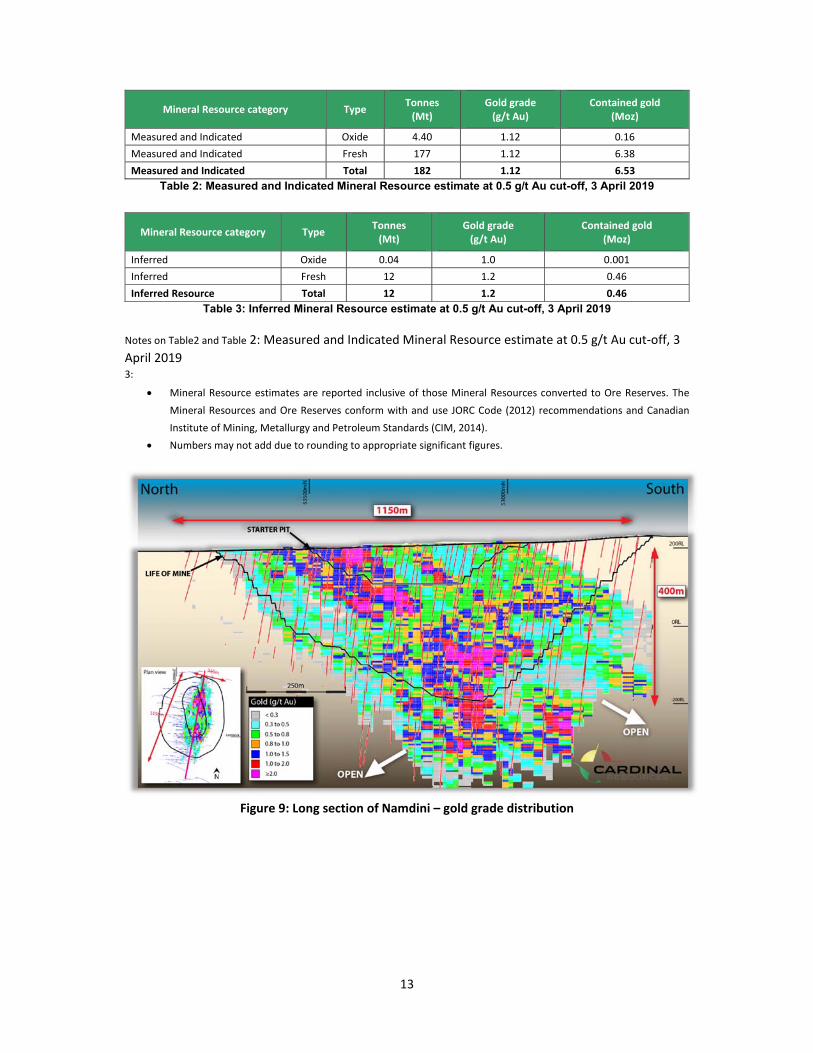
The current Mineral Resource estimates are based on a mineralised domain interpreted on the basis
of composited gold grades. The mineralised domain trends north‐northeast over a strike length of
approximately 1,330m with horizontal widths ranging from around 90m to 400m and averaging
approximately 240m. The domain dips to the west at around 70 degrees and is interpreted to a
constant elevation of ‐650 mRL, which represents an average depth of around 860m, around 175m
below the base of drilling. Figure 9 shows a long section through the Mineral Resource Model.
The current Namdini Mineral Resources were estimated by MIK of 2m downhole composited gold
grades from RC and diamond drilling. Estimated resources include a variance adjustment to give
estimates of recoverable resources for selective mining dimensions of 5m m by 10m by 2.5m assuming
high quality RC grade control drilling, and are reported within an optimal pit shell generated at a gold
price of US$1,950/oz.
Use of an RPEEE shell is an acceptable standard approach used in industry for resource reporting
purposes to ensure that the Mineral Resource is tested for ‘reasonable prospects of eventual
economic extraction’. MPR used an optimistic gold price of US$1,950 /oz and a metal recovery factor
of 78% for the 2019 RPEEE pit shell, compared to 86% for the 2018 RPEEE shell.
There is 15% of the 2019 modelled mineralisation outside the RPEEE shell, which is excluded from the
2019 reported Mineral Resource. The additional drilling has resulted in a negligible change to the
overall RPEEE‐constrained Mineral Resource, compared to the 2018 Mineral Resource, although some
of the Inferred Mineral Resource has been converted to Indicated Mineral Resource, reflecting the
increased confidence from the additional drilling.
Resource model blocks have been classified as Measured, Indicated or Inferred.
Estimated Measured Mineral Resource of 7.5Mt grading 1.3g/t for 0.32Moz of gold at a cut‐
off grade of 0.5 g/t Au (Tables 1 and 2).
Estimated Indicated Mineral Resources of 174 Mt grading 1.1g/t Au for 6.21 Moz of gold at a
cut‐off grade of 0.5 g/t Au (Tables 1 and 2). Estimated Inferred Mineral Resources of 12Mt
grading 1.2 g/t for 0.5Moz of gold. at a cut‐off grade of 0.5 g/t Au (Tables 1 and 3).
Mineral Resource category Type Tonnes (Mt)
Gold grade (g/t Au)
Contained gold (Moz)
Measured Oxide 1.1 1.23 0.04
Measured Fresh 6.4 1.33 0.27
Measured Resource Total 7.5 1.31 0.32
Indicated Oxide 3.3 1.08 0.11
Indicated Fresh 171 1.11 6.10
Indicated Resource Total 174 1.11 6.21
13
Mineral Resource category Type Tonnes (Mt)
Gold grade (g/t Au)
Contained gold (Moz)
Measured and Indicated Oxide 4.40 1.12 0.16
Measured and Indicated Fresh 177 1.12 6.38
Measured and Indicated Total 182 1.12 6.53
Table 2: Measured and Indicated Mineral Resource estimate at 0.5 g/t Au cut-off, 3 April 2019
Mineral Resource category Type Tonnes (Mt)
Gold grade (g/t Au)
Contained gold (Moz)
Inferred Oxide 0.04 1.0 0.001
Inferred Fresh 12 1.2 0.46
Inferred Resource Total 12 1.2 0.46
Table 3: Inferred Mineral Resource estimate at 0.5 g/t Au cut-off, 3 April 2019
Notes on Table2 and Table 2: Measured and Indicated Mineral Resource estimate at 0.5 g/t Au cut‐off, 3
April 2019 3:
Mineral Resource estimates are reported inclusive of those Mineral Resources converted to Ore Reserves. The
Mineral Resources and Ore Reserves conform with and use JORC Code (2012) recommendations and Canadian
Institute of Mining, Metallurgy and Petroleum Standards (CIM, 2014).
Numbers may not add due to rounding to appropriate significant figures.
Figure 9: Long section of Namdini – gold grade distribution

14
Namdini RC and diamond drilling statistics
Below is the summary of drill Statistics to date
Namdini Reverse Circulation and Diamond Drilling
Group Year Number of holes Drill metres
RC Diamond Total RC Diamond Total
Resource
2014 45 - 45 4,815.00 - 4,815.00
2015 44 10 54 5,407.30 1,945.53 7,352.83
2016 18 74 92 3,790.00 16,340.44 20,130.44
2017 44 86 130 9,178.00 42,253.24 51,431.24
2018 6 12 18 1,867.00 3,907.57 5,774.57
2019 39 11 50 4,436.00 2,404.00 6,840.00
Subtotal 151 175 326 29,493.30 66,850.78 96,344.08
Grade Control 316 - 316 13,241.00 - 13,241.00
Metallurgical 3 3 763.92 763.92
Geotech 11 11 3,410.92 3,410.92
Hydro 10 10 538.20 538.20
Sterilisation 333 333 31,975.00 31,975.00
Exploration 2 3 5 500.00 1,140.49 1,640.49
Subtotal 521 19 540 46,254.20 5,315.33 51,569.53
Total 672 194 866 75,747.50 72,166.11 147,913.61
Table 4: Namdini Project Drilling Statistics
Current Ore Reserves 2019
Using a cut‐off grade of 0.5 g/t Au the Measured and Indicated Mineral Resources within the final
stage mine design indicate a total Proved and Probable Ore Reserves estimate of 139Mt grading
1.13g/t Au for a contained 5.05Moz. Table 5shows the breakdown of the estimate Ore Reserves for
the Namdini Project at April 2019. Ore Reserves stated here are in accordance with JORC 2012 and
CIM 2014 reporting standards after the application of appropriate Modifying Factors.
Class Type Ore Tonnes
(Fully Diluted) (Mt) Diluted Contained
Ounces (koz) Grade
(Au g/t)
Proved Oxide 1.03 40.0 1.21
Proved Fresh 6.35 270.9 1.33
Proved Reserves Total 7.38 310.8 1.31
Probable Oxide 3.02 104.6 1.08
Probable Fresh 128.19 4,638.3 1.13
Probable Total 131.21 4,743.0 1.12
Proved and Probable Oxide 4.04 144.6 1.11
Proved and Probable Fresh 134.54 4,909.2 1.13
Proved and Probable Total 138.59 5,053.8 1.13 Table 51: Ore Reserve estimate for the Namdini Project – April 2019

15
Notes on Table 5: The Ore Reserve conforms with and uses the JORC 2012 Code definitions The Ore Reserve is evaluated using a gold price of US$1,300/oz The Ore Reserve is evaluated using a fixed cut-off grade of 0.5g/t Au Ore block grade and tonnage dilution was incorporated through the use of an MIK estimation model that has been demonstrated to incorporate an expected level of equivalent ore loss and dilution for the scale of mining envisaged All figures are rounded to reflect appropriate levels of confidence Apparent differences may occur due to rounding.
For the purposes of the mining study, it was assumed that a ‘dry pit’ will be operated with sufficient
dewatering and control for the geotechnical design of dry slopes.
All tonnage is estimated on a dry basis with expected surface moisture associated with the hauled
rock being less than 3% on average.
The pit optimisation used FS level mining and processing costs, processing recoveries, recommended
geotechnical slope angles and a gold price of US$1,300/oz to determine an optimum pit shell. The
selected pit shell was used as a basis for the final open pit design. A mining schedule, processing
schedule, operating cost model, and overall financial model were developed based on the mineral
inventory contained within the open pit design. The mining model within the Final Pit is reported as
the Ore Reserve. All pit designs have been carried out in accordance with the recommended mining
geotechnical slope parameters for the Namdini Project.
Conclusions Namdini represents the first major gold discovery in Ghana since 2009. The deposit has been traced
for over 1 km along strike with the full extent of mineralisation continuing to be explored with further
drilling. The lack of systematic, modern exploration over Namdini prior to Cardinal, possibly leading
to earlier discovery, is a result of the deposit being located within an area previously reserved solely
for small scale mining since the 1990s. Once gold mineralisation at Namdini was identified from
surface prospecting, consolidation of adjacent small‐scale mining licenses has enabled RC and
diamond drilling to rapidly delineate a major gold deposit. Further systematic exploration within the
belt hosting Namdini is likely to locate further gold discoveries.
References Allibone, A H, McQuaig T C, Harris, D, Etheridge, M, Munroe, S, Byrne, D, Manor, J and Gyapong, W, 2002a. Structural controls on gold mineralisation at the Ashanti Deposit, Obuasi, Ghana, Society of Economic Geologists, Special Publication 9: 65‐93. Allibone, A H, Teasdale, J, Cameron, G, Etheridge, M, Uttley, P, Soboh, A, Appiah‐Kubi, J, Adanu, A, Arthur, R, Mamphey, J, Odoom, B, Zuta, J, Tsikata, A, Pataye, F and Famiyeh, S, 2002b. Timing and structural controls on gold mineralisation at the Bogosu Gold Mine, Ghana, West Africa. Economic Geology, 97: 949‐969. Allibone, A H, Hayden, P, Cameron, G and Duku, F, 2004. Paleoproterozoic gold deposits hosted by albite and carbonate altered tonalite in the Chirano district, Ghana, West Africa. Economic Geology, 99: 479‐497. Amoako, P, Amedofu, S, Akamalu, T, 2004. Processing and interpretation of airborne geophysical data, Airborne Survey of Ghana, 1999‐2000. Geological Survey of Ghana. Blakely, I T, Horan, S D and Altman, K A, 2017. NI43‐101 Technical Report on the Namdini Gold Project, Ghana, West Africa. Roscoe Postle Associates report prepared on behalf of Cardinal Resources Limited. 188p. Davis, B, Hickey, K A and Rose, S, 2001. Superposition of Au mineralisation on pre‐existing carbonate alteration: Structural evidence from the Mulgarrie gold deposit, Yilgarn Craton. Australian Journal of Earth Sciences, 48: 131‐140.

16
Davis, B and Cowan, J, 2016. Structural geological analysis of the Namdini gold deposit, NE Ghana. Orefind consulting report prepared on behalf of Cardinal Resources Limited. 56p. Fougerouse, D, Micklethwaite, S, Miller, J and Ulrich, S, 2013. Multistage mineralization of the giant Obuasi gold deposit, Ghana. Conference paper, 12th SGA Biennial Meeting, Proceedings Vol 3. 4p. Fougerouse, D, Micklethwaite, S, Ulrich, S, Miller, J, Godel, B, Adams, D and McQuaig, T C, 2017. Evidence for Two Stages of Mineralisation in West Africa’s Largest Gold Deposit: Obuasi, Ghana. Economic Geology 112 (1): 3‐22.
Goldfarb, R J, Andre‐Mayer, A S, Jowitt, S M and Mudd, G M, 2017. West Africa: The World’s Premier Paleoproterozoic Gold Province. Economic Geology 112 (1): 123‐143 Golder, 2018. Preliminary Economic Assessment Namdini Gold Project, Ghana, West Africa, National
Instrument 43‐101 Technical Report 1777390 by Golder Associates Pty Ltd: authored by Glenn Turnbull,
Nicolas Johnson, and Marc LeVier (the PEA Report).
Gossage, B, 2017. Namdini Gold Project, Mineral Resource Estimate Study Report. EGRM Consulting Pty Ltd report for Cardinal Resources Limited. 90p. JORC, 2012. Australasian Code for Reporting of Exploration Results, Mineral Resources and Ore Reserves (The
JORC Code 2012 Edition), prepared by the Joint Ore Reserves Committee of the Australasian Institute of Mining
and Metallurgy, Australian Institute of Geoscientists and Minerals Council of Australia (JORC): effective 20
December 2012.
MPR, 2017. Technical Report on Mineral Resource Estimation for the Namdini Gold Project, Ghana, report by
MPR Geological Consultants Pty Ltd to Cardinal Resources Ltd: authored by Nicholas Johnson, 16 October.
MPR, 2018. Technical Report on Mineral Resource Estimation for the Namdini Gold Project, Ghana, report by
MPR Geological Consultants Pty Ltd to Cardinal Resources Ltd: authored by Nicholas Johnson, 18 April.
MPR, 2019. Technical Report on Mineral Resource Estimation for the Namdini Gold Project, Ghana, report by
MPR Geological Consultants Pty Ltd to Cardinal Resources Ltd: authored by Nicolas Johnson, March.
Townend, R, 2015. Preparation of three polished thin sections of three rock samples and petrographic/mineragraphic descriptions with particular regard to gold. Unpublished Townend Mineralogy Laboratory report 23898, prepared for Cardinal Resources Limited. 20p. Townend, R and Townend, D, 2016. Preparation of 10 polished thin sections and petrographic/mineragraphic descriptions of 10 drill cores. Unpublished Townend Mineralogy Laboratory report 23948, prepared for Cardinal Resources Limited. 85p. Van Kranendonk M J, Collins W J, Hickman A and Pawley, M J, 2003. Critical tests of vertical versus horizontal tectonic models for the Achaean East Pilbara granite‐greenstone terrane, Pilbara craton, Western Australia. Precambrian Research 131: 173‐211.