nat regional supplementary procedures (supps) (doc … · nat regional supplementary procedures...
TRANSCRIPT
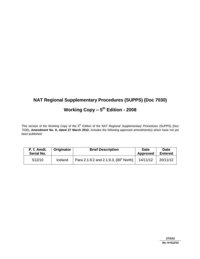
NAT Regional Supplementary Procedures (SUPPS) (Doc 7030)
Working Copy – 5th Edition - 2008
This version of the Working Copy of the 5th Edition of the NAT Regional Supplementary Procedures (SUPPS) (Doc
7030), Amendment No. 6, dated 27 March 2012, includes the following approved amendment(s) which have not yet
been published:
P. f. Amdt. Serial No.
Originator Brief Description Date Approved
Date Entered
S12/10 Iceland Para 2.1.9.2 and 2.1.9.3, (80o North) 14/11/12 20/11/12
27/3/12
No. 6+S12/10


(v) 30/11/07
FOREWORD
1. The ICAO Regional Supplementary Procedures (SUPPS) form the procedural part of the Air Navigation
Plans developed by Regional Air Navigation (RAN) Meetings to meet those needs of specific areas which are not
covered in the worldwide provisions. They complement the statement of requirements for facilities and services
contained in the Air Navigation Plan publications. Procedures of worldwide applicability are included either in the
Annexes to the Convention on International Civil Aviation as Standards or Recommended Practices, or in the
Procedures for Air Navigation Services (PANS).
2. In the development of Regional Supplementary Procedures, the following criteria must be satisfied:
a) Regional Supplementary Procedures should indicate a mode of implementing procedural provisions in
Annexes and PANS, as distinct from a statement or description of required facilities and services as
published in the Air Navigation Plan publications. Regional Supplementary Procedures may also
indicate permissible additions to provisions in Annexes and PANS, subject to the restrictions in b)
and c).
b) Regional Supplementary Procedures must not be in conflict with the provisions contained in the
Annexes or PANS. They must either specify detailed procedural regional options for those provisions
or promulgate a regional procedure of justifiable operational significance, additional to existing
provisions in Annexes or PANS.
c) In the drafting of Regional Supplementary Procedures, variations in the text of procedures with similar
intent applicable to more than one area should be avoided.
3. The Regional Supplementary Procedures do not have the same status as Standards and Recommended
Practices. The latter are adopted by Council in pursuance of Article 37 of the Convention on International Civil Aviation,
subject to the full procedure of Article 90. PANS are approved by the President of the Council of ICAO on behalf of the
Council and SUPPS are approved by the Council; the PANS are recommended to Contracting States for worldwide use,
whilst the SUPPS are recommended to Contracting States for application in the groups of flight information regions to
which they are relevant.
4. PANS were originally developed from common recommendations of regional meetings and were given
worldwide application by the ICAO Council after action thereon by ICAO Divisions. Subsequently, there has been a
gradual evolution of procedures from the regional to the worldwide category as ICAO Divisions have been able to adapt
regionally developed procedures to worldwide requirements. Concurrently, some of the worldwide procedures have
been found suitable for classification as Standards or Recommended Practices and therefore are gradually being
incorporated into the Annexes to the Convention.
5. Application of the Regional Supplementary Procedures in certain areas of the world has been specified
according to groups of flight information regions (FIRs) as shown on page (xiii). The abbreviations on the chart
identifying the groups of flight information regions in which specific sets of SUPPS apply have been chosen in reference
to ICAO region designators, but the limits of the areas of application do not necessarily coincide with the boundaries of
the ICAO regions.
6. Whenever there is a specific relationship between a supplementary procedure and an Annex or PANS,
such relationship has been indicated by reference to the parent document and relevant chapter, appendix, etc. These
references appear above the text, together with the appropriate abbreviation as follows:

(vi) Regional Supplementary Procedures
30/11/07
A — Annexes to the Convention
P — Procedures for Air Navigation Services
Examples: (A2 – Chapter 3) — Refers to Chapter 3 of Annex 2 — Rules of the Air
(P-ATM – Chapters 7 and 9) — Refers to Chapters 7 and 9 of Doc 4444 — Procedures for Air Navigation
Services — Air Traffic Management.
7. The degree of non-application of the Regional Supplementary Procedures or national differences are
notified in Aeronautical Information Publications in accordance with the provisions of Annex 15 — Aeronautical
Information Services (cf. 4.1.1, 4.1.2 c) and Appendix 1).
8. This document is maintained by amendments as required. Any errors or omissions should be brought to
the attention of the Secretary General, ICAO, 999 University Street, Montréal, Quebec, Canada H3C 5H7.
_____________________

(vii) 30/11/07
PROCEDURE FOR THE AMENDMENT OF REGIONAL SUPPLEMENTARY PROCEDURES
(Approved by Council (25-2) 20/5/55, (84-5) 7/3/75, (153-3) 25/2/98)
1. INTRODUCTION
1.1 Regional Supplementary Procedures are normally formulated at regional air navigation meetings and
become effective after review by the Air Navigation Commission and approval by the Council.
1.2 Amendments to Regional Supplementary Procedures may be proposed by a Contracting State or group of
States as set out in Section 2 or by an international organization as set out in Section 3 or may become necessary as a
consequence of action by Council in adopting or amending Standards and Recommended Practices or in approving or
amending Procedures for Air Navigation Services as set out in Section 4.
2. AMENDMENTS PROPOSED BY
A CONTRACTING STATE OR GROUP OF STATES
2.1 If any Contracting State or group of States of a region wishes to propose an amendment to Regional
Supplementary Procedures for that region, it should submit the proposal, adequately documented, to the Secretary
General through the Regional Office accredited to that State. The proposal should include the facts that led the State to
the conclusion that the amendment is necessary.
2.2 The Secretary General will circulate the proposal, adequately documented, with a request for comments to
all provider and user States of the region considered affected, as well as to user States outside the region and
international organizations that may be concerned with the proposal. If, however, the Secretary General considers that
the proposed amendment conflicts with established ICAO policy or that it raises questions which the Secretary General
considers should be brought to the attention of the Air Navigation Commission, the proposal will be first presented,
adequately documented, to the Commission. In such cases, the Commission will decide on the action to be taken.
2.3 If, in reply to the Secretary General’s inquiry to States and selected international organizations, no
objection is raised to the proposal by a specified date, the Secretary General will circulate an amendment memorandum
to Representatives on the Council and to Members of the Air Navigation Commission inviting each recipient to advise,
normally within seven days,* whether formal discussion of the proposed amendment is desired. The memorandum will
explain the proposed amendment, summarize the comments received and include Secretariat comments as appropriate.
If, in reply to the Secretary General’s inquiry to States and selected international organizations, any objection is raised
and if the objection remains after further consultation, the matter will be documented for formal consideration by the Air
Navigation Commission and appropriate recommendations of the Commission to the Council.
2.4 If, at the end of the seven-day period,* there has been no request for discussion of the amendment, it will
be submitted to the President of the Council who is authorized to approve the amendment on behalf of the Council.
* During recess, a period of three weeks will normally be allowed.

(viii) Regional Supplementary Procedures
30/11/07
2.5 If, on the other hand, any Representative on the Council or Member of the Air Navigation Commission
indicates a desire for formal discussion of the proposed amendment, the matter will be documented for formal
consideration by the Commission and appropriate recommendations of the Commission to the Council.
3. AMENDMENTS PROPOSED BY INTERNATIONAL ORGANIZATIONS
3.1 Proposals for the amendment of Regional Supplementary Procedures submitted by international
organizations directly concerned with the operation of aircraft, which may be invited to attend suitable ICAO meetings
and which attended the meeting(s) where the relevant procedures were prepared, will be dealt with in the same manner
as those received from States, except that, before circulating a proposal to States and selected international
organizations pursuant to 2.2, the Secretary General will ascertain whether it has adequate support from the State or
group of States whose facilities, services and procedures will be affected. If such support is not forthcoming, the
proposal will be presented to the Commission, and the Commission will decide on the action to be taken.
4. CONSEQUENTIAL AMENDMENTS
4.1 In the event of an amendment to Regional Supplementary Procedures becoming necessary as a
consequence of action by Council in adopting or amending Standards and Recommended Practices or in approving or
amending Procedures for Air Navigation Services, the amendment will be drafted by the Secretary General.
4.2 The Secretary General will circulate the amendment, together with relevant explanatory material, in a
memorandum to each Member of the Air Navigation Commission inviting each recipient to notify him, normally within
seven days,* whether formal discussion of the proposed amendment is desired.
4.3 If, at the end of the seven-day period,* there has been no request for discussion of the amendment, formal
approval will be given by the Air Navigation Commission acting on behalf of the Council** or, if the Commission is in
recess, by the President of the Council.
4.4 If any Commissioner indicates a desire for formal discussion of the amendment, the matter will be
documented for formal consideration by the Air Navigation Commission. If the Commission concludes that the
amendment is necessary, it is authorized to approve the amendment on behalf of the Council,** in its original form or
modified.
5. PROMULGATION OF APPROVED AMENDMENTS
5.1 Amendments to Regional Supplementary Procedures that have been approved in accordance with the
above procedures will be promulgated in Doc 7030, Regional Supplementary Procedures.
_____________________
* During recess, a period of three weeks will normally be allowed.
** The Air Navigation Commission has been authorized [17-1, Doc 7328-1, (C/853-1)] to approve consequential amendments on
behalf of the Council.

(ix) 25/5/11
No. 4
Glossary
ACAS airborne collision avoidance systems
ACC area control centre
ADLP aircraft data link processor
ADS-B automatic dependent surveillance – broadcast
ADS-C automatic dependent surveillance – contract
AFCS automatic flight control system
AFTN aeronautical fixed telecommunication network
AIM ATFM information message
AIP aeronautical information publication
AIRAC aeronautical information regulation and control
AIS aeronautical information service
ANM ATFM notification message
ANP air navigation plan
ARO air traffic services reporting office
ASDA accelerate-stop distance available
ASE altimetry system error
ASTER ATFM system of the EUR region
ATC air traffic control
ATFM air traffic flow management
ATIS automatic terminal information services
ATM air traffic management
ATS air traffic service
B-RNAV Basic-RNAV (B-RNAV), also referred to as RNAV 5
CAP Code allocation plan
CARSAMMA CAR/SAM monitoring agency
CFMU central flow management unit
CHG modification message
CNL cancellation message
CPDLC controller-pilot data link communications
CRAM conditional route availability message
CTA control area
CTOT calculated take-off time
DAP downlink aircraft parameter
DES de-suspension message
DME distance-measuring equipment
DOF date of flight
EAD European AIS database
EOBT estimated off-block time

(x) Regional Supplementary Procedures
(x) 25/5/11
No. 4
FIR flight information region
FIS flight information service
FL flight level
FLAS flight level allocation scheme
FLS flight suspension message
FPL flight plan
GAT general air traffic
HF high frequency
IFBP in-flight broadcast by pilots
IFF identification friend/foe
IFPS initial flight plan processing system
IFR instrument flight rules
IGA international general aviation
INS inertial navigation system
LAM logical acknowledgement message
MASPS minimum aviation system performance standards
MFA minimum flight altitude
MNPS minimum navigation performance specifications
MSA minimum sector altitude
NOF NOTAM offices
NOTAM notice to airmen
OCA oceanic control area
OTS organized track system
PACOTS pacific organized track systems
PBN performance-based navigation
PIB pre-flight information bulletin
P-RNAV precision-RNAV
RFP replacement flight plan
RNAV area navigation
RNAV 1 An RNAV specification ha ving a lateral navigation accuracy of 1 nautical mile. RNAV 1 approved
aircraft are approved for P-RNAV
RNAV 5 An RNAV specification having a lateral navigation accuracy of 5 nautical miles. RNAV 5 is also
referred to as B-RNAV in the EUR
RNP required navigation performance
RPL repetitive flight plan
RTF radiotelephony

Regional Supplementary Procedures (xi)
(xi) 25/5/11
No. 4
RVR runway visual range
RVSM reduced vertical separation minimum
SAM slot allocation message
SRM slot revision message
SATMA South Atlantic monitoring agency
SAT NAV satellite navigation
SATCOM satellite voice communications
SD standard deviation
SELCAL selective calling
SID standard instrument departure
SIF selective identification feature
SLC slot cancellation message
SLOP strategic lateral offset procedures
SSR secondary surveillance radar
STAR standard instrument arrival
STS special handling
TA transition altitude
TAS true airspeed
TLS target level of safety
TMA terminal control area
TODA take-off distance available
TORA take-off run available
TVE total vertical error
UAC upper area control centre
UIR upper flight information region
VSM vertical separation minimum
VFR visual flight rules
VOLMET meteorological information for aircraft in flight
VOR VHF omnidirectional radio range
WATRS West Atlantic Route System
_____________________


30/11/07
NORTH ATLANTIC (NAT) REGIONAL SUPPLEMENTARY PROCEDURES
These procedures are supplementary to the provisions contained in Annex 2, Annex 6 (Parts I, II and III), Annex 8,
Annex 10, Annex 11, PANS-ATM (Doc 4444) and PANS-OPS (Doc 8168). They do not apply in the local areas
established by the appropriate authorities around Bermuda, Iceland, the Faroe Islands and Santa Maria, and in
Greenland. The area of application of the NAT Regional Supplementary Procedures is included on the Index to
Application of Supplementary Procedures chart.


NAT (i) 30/11/07
TABLE OF CONTENTS
Chapter Page
Flight Rules ................................................................................................... 1 NAT 1-1
Flight Plans ................................................................................................... 2 NAT 2-1
Communications ........................................................................................... 3 NAT 3-1
Navigation ..................................................................................................... 4 NAT 4-1
Surveillance .................................................................................................. 5 NAT 5-1
Air Traffic Services ........................................................................................ 6 NAT 6-1
Safety Monitoring .......................................................................................... 7 NAT 7-1
Air Traffic Flow Management ........................................................................ 8 NAT 8-1
Special Procedures ....................................................................................... 9 NAT 9-1
Phraseology .................................................................................................. 10 NAT 10-1
Search and Rescue ...................................................................................... 11 NAT 11-1
Meteorology .................................................................................................. 12 NAT 12-1
Aeronautical Information Services ................................................................ 13 NAT 13-1
The designations employed and the presentation of the material in
this publication do not imply the expression of any opinion
whatsoever on the part of ICAO concerning the legal status of any
country, territory, city or area or of its authorities, or concerning the
delimitation of its frontiers or boundaries.


NAT 1-1 30/11/07
Chapter 1. FLIGHT RULES
1.1 VISUAL FLIGHT RULES (VFR)
1.1.1 Special application
Nil.
1.2 INSTRUMENT FLIGHT RULES (IFR)
(A2 – Chapters 2 and 5)
Note.— Annex 2, 2.2, permits a flight to operate using either instrument flight rules or visual flight rules
when operated in visual meteorological conditions subject to the limitations listed in Chapter 4 of the Annex. The
following indicates certain additional restrictions.
1.2.1 Special application
1.2.1.1 Flights shall be conducted in accordance with the instrument flight rules when operated at or above flight
level (FL) 60 or 600 m (2 000 ft) above ground, whichever is the higher, within:
a) the New York Oceanic, Gander Oceanic, Shanwick Oceanic, Santa Maria Oceanic, Søndrestrøm and
Reykjavik flight information regions (FIRs); and
b) the Bodø Oceanic FIR when operated more than 185 km (100 NM) seaward from the shoreline.
1.2.2 Flight level changes
Nil.
1.3 AIR TRAFFIC ADVISORY SERVICE
Nil.
_____________________


NAT 2-1
Chapter 2. FLIGHT PLANS
2.1 CONTENT – GENERAL
(A2 – Chapter 3; P-ATM – Chapter 4 and Appendix 2)
2.1.1 Date of flight
Nil.
2.1.2 Area navigation (RNAV) specifications
2.1.2.1 All RNAV 10 (RNP 10) approved aircraft intending to operate in the NAT Region shall insert the letter R in
Item 10a of the flight plan and the A1 descriptor in Item 18 of the flight plan, following the PBN/ indicator.
2.1.3 Required navigation performance (RNP) specifications
2.1.3.1 All RNP 4 approved aircraft intending to operate in the NAT Region shall insert the letter R in Item 10a of
the flight plan and the L1 descriptor in Item 18 of the flight plan, following the PBN/ indicator.
2.1.4 Minimum navigation performance specifications (MNPS)
2.1.4.1 All MNPS-approved aircraft intending to operate in the NAT Region shall insert the letter X in Item 10a of
the flight plan.
2.1.5 Reduced vertical separation minimum (RVSM)-approved aircraft
2.1.5.1 All RVSM approved aircraft intending to operate in the NAT Region, regardless of the requested flight level,
shall insert the letter W in Item 10a of the flight plan.
2.1.6 Non-RVSM-approved aircraft
Nil.
2.1.7 Non-RVSM-approved State aircraft
Nil.
2.1.8 Indication of 8.33 kHz channel spacing capability
Nil.
27/3/12
No. 6

NAT 2-2 Regional Supplementary Procedures
2.1.9 Route
2.1.9.1 General
2.1.9.1.1 Flights conducted wholly or partly outside the organized tracks shall be planned along great circle tracks
joining successive significant points. Flight plans shall be made in accordance with the following.
2.1.9.1.2 Flights operating between North America and Europe shall generally be considered as operating in a
predominantly east-west direction. However, flights planned between these two continents via the North Pole shall be
considered as operating in a predominantly north-south direction.
2.1.9.2 Flights operating predominantly in an east-west direction
2.1.9.2.1 For flights operating at or south of 70°N, the planned tracks shall normally be defined by significant points
formed by the intersection of half or whole degrees of latitude with meridians spaced at intervals of 10 degrees from the
Greenwich meridian to longitude 70°W.
2.1.9.2.2 For flights operating north of 70°N and at or south of 80°N, the planned tracks shall normally be defined by
significant points formed by the intersection of parallels of latitude expressed in degrees and minutes with meridians
normally spaced at intervals of 20 degrees from the Greenwich meridian to longitude 60°W, using the longitudes 000W,
020W, 040W and 060W.
2.1.9.2.3 For flights operating at or south of 80°N, the distance between significant points shall, as far as possible,
not exceed one hour's flight time. Additional significant points should be established when deemed necessary due to
aircraft speed or the angle at which the meridians are crossed, e.g.:
a) at intervals of 10 degrees of longitude (between 5°W and 65°W) for flights operating at or south of 70°N;
and
b) at intervals of 20 degrees of longitude (between 10°W and 50°W) for flights operating north of 70°N and at
or south of 80°N.
2.1.9.2.4 When the flight time between successive significant points referred to in 2.1.9.2.3 is less than 30 minutes,
one of these points may be omitted.
2.1.9.2.5 For flights operating north of 80°N, the planned tracks shall normally be defined by significant points
formed by the intersection of parallels of latitude expressed in degrees and minutes with meridians expressed in whole
degrees. The distance between significant points shall, as far as possible, not exceed 60 minutes flight time.
2.1.9.3 Flights operating predominantly in north-south direction
2.1.9.3.1 For flights whose flight paths at or south of 80°N are predominantly oriented in a north-south direction,
the planned tracks shall normally be defined by significant points formed by the intersection of whole degrees of
longitude with specified parallels of latitude which are spaced at intervals of 5 degrees.
2.1.9.3.2 For flights operating north of 80°N, the planned tracks shall normally be defined by significant points
formed by the intersection of parallels of latitude expressed in degrees and minutes with meridians expressed in whole
degrees. The distance between significant points shall, as far as possible, not exceed 60 minutes flight time.
Source: Proposal for amendment No: EUR/NAT-S 12/10-NAT, approved on 14 November 2012, ICAO Letter Ref:
EUR/NAT 12-0795.TEC (STC/CUP) dated 19 November 2012 refers.
27/3/12
No. 6+S12/10
Regional Supplementary Procedures NAT 2-3
2.1.9.4 Flights operating on an organized track
2.1.9.4.1 For flights conducted along one of the organized tracks from the entry point into the NAT FIRs to the exit
point, the organized track shall be defined in the flight plan by the abbreviation “NAT” followed by the code letter
assigned to the track.
2.1.9.5 Flights operating along fixed ATS routes
2.1.9.5.1 For flights operating along the fixed ATS route network between Canada, the United States, Bermuda and
the CAR Region, the track shall be defined by appropriate reference to this route network.
2.1.10 Estimated times
2.1.10.1 The accumulated estimated elapsed time to each oceanic FIR boundary shall be specified in Item 18 of the
flight plan.
2.1.11 Mach number
2.1.11.1 For turbo-jet aircraft intending to operate within the Bodø Oceanic, Gander Oceanic, New York Oceanic,
Reykjavik, Santa Maria Oceanic and Shanwick Oceanic control areas, the planned true Mach number for any portion of
their flight within these control areas shall be specified in Item 15 of the flight plan.
2.1.12 Alternative flight level
2.1.12.1 For turbo-jet aircraft intending to operate within the Gander Oceanic, New York Oceanic, Reykjavik, Santa
Maria Oceanic and Shanwick Oceanic control areas, requests for a suitable alternative flight level may be included in
Item 18 of the flight plan.
2.1.13 Special handling (STS)
Nil.
2.1.14 Data link services
2.1.14.1 All aircraft planning to operate in the NAT Region and intending to use data link services shall insert the
appropriate descriptor (J2, J5 or J7) in Item 10a of the flight plan to indicate FANS 1/A interoperable equipment.
2.1.15 Automatic Dependent Surveillance – Broadcast (ADS-B)
2.1.15.1 All ADS-B approved aircraft intending to operate in the NAT Region shall insert either the B1 or B2
descriptor as appropriate in Item 10b of the flight plan.
Note.—Eligibility for ADS-B service in the NAT Region is based upon the compliance considerations of
European Aviation Safety Agency (EASA) AMC 20-24 or equivalent.
27/3/12
No. 6

NAT 2-4 Regional Supplementary Procedures
2.1.16 Aircraft Registration
2.1.16.1 All aircraft intending to operate in the NAT Region shall insert the aircraft registration in Item 18 of the flight
plan, following the REG/ indicator.
2.2 CONTENT – AIR TRAFFIC FLOW MANAGEMENT (ATFM)
2.2.1 Runway visual range (RVR)
Nil.
2.2.2 Flight plan addressing and distribution
Nil.
2.2.3 Slot allocation exemptions
Nil.
2.3 SUBMISSION
(A2 – Chapter 3; P-ATM – Chapter 4)
2.3.1 General
2.3.1.1 Flight plans for flights departing from points within adjacent regions and entering the NAT Region without
intermediate stops shall be submitted as early as possible.
2.3.2 Amendments
Nil.
2.4 REPETITIVE FLIGHT PLANS (RPLs)
Nil.
_____________________
27/3/12
No. 6

NAT 3-1 30/11/07
Chapter 3. COMMUNICATIONS
3.1 AIR-GROUND COMMUNICATIONS AND IN-FLIGHT REPORTING
3.1.1 Communications equipment
Nil.
3.1.2 Continuous listening watch in uncontrolled airspace
Nil.
3.1.3 Position reports
(A2 – Chapters 3 and 5; P-ATM – Chapter 4)
3.1.3.1 Unless otherwise required by air traffic services, position reports for flights on routes not defined by
designated reporting points shall be made at the significant points listed in the flight plan.
3.1.3.2 Air traffic services may require any flight operating predominantly in an east-west direction to report its
position at any of the intermediate meridians spaced at intervals of:
a) 10 degrees of longitude south of 70°N (between 5°W and 65°W); and
b) 20 degrees of longitude north of 70°N (between 10°W and 50°W).
3.1.3.3 In requiring aircraft to report their position at intermediate intervals, the air traffic services authorities will be
guided by the requirement to have position information at approximately hourly intervals and also by the need to cater
for varying types of aircraft and for varying traffic and meteorological conditions.
Position and time
3.1.3.4 Verbal position reports shall be identified by the spoken word “Position” transmitted immediately before or
after the aircraft identification.
3.1.3.5 For flights outside the ATS route network, the position shall be expressed in terms of latitude and longitude
as follows:
a) for flights operating in a predominantly east-west direction:
1) latitude in degrees and minutes; and
2) longitude in degrees only;
NAT 3-2 Regional Supplementary Procedures
b) for flights operating in a predominantly north-south direction:
1) latitude in degrees only; and
2) longitude in degrees and minutes.
3.1.3.6 When making position reports, all times should be expressed in four digits, giving both the hour and
minutes.
Time over next position
3.1.3.7 If the estimated time for the next position last reported to air traffic control is found to be in error by
three minutes or more, a revised estimated time over shall be transmitted as soon as possible to the ATS unit concerned.
Transmission
(P-ATM – Chapter 4)
3.1.3.8 Position reports made by aircraft operating within an oceanic control area at a distance of 110 km (60 NM)
or less from the common boundary with an adjacent oceanic control area, including aircraft operating on tracks through
successive points on such boundary, shall also be made to the area control centre serving the adjacent control area.
3.1.3.9 Responsibility for the transmission of position reports to the additional ATS units specified in 3.1.3.8 may
be delegated to the appropriate communications station(s) through local arrangements.
3.1.4 Abbreviated position reports
Nil.
3.1.5 Read-back of VHF channels
Nil.
3.2 MANDATORY CARRIAGE OF 8.33 KHZ CHANNEL SPACING CAPABLE RADIO EQUIPMENT
Nil.
3.3 CONTROLLER-PILOT DATA LINK COMMUNICATIONS (CPDLC)
Area of applicability
3.3.1 All aircraft intending to conduct flights in the airspace defined below shall be fitted with and shall operate
controller-pilot data link communications (CPDLC) equipment:
a) from 7 February 2013, on specified tracks and flight levels within the NAT organized track system (OTS); and
27/3/12
No. 6
Regional Supplementary Procedures NAT 3-3
b) from 5 February 2015, in specified portions of NAT minimum navigation specifications (MNPS) airspace.
Note 1.— The specified tracks and flight level band within the NAT OTS will be published by the States
concerned in national AIPs and identified daily in the NAT track message.
Note 2.— The specified portions of NAT MNPS airspace and aircraft equipment performance requirements
where applicable will be published by the States concerned in national AIPs.
Means of compliance
3.3.2 Operators intending to conduct flights within the airspace specified in 3.3.1 shall obtain CPDLC operational
authorization, where applicable, either from the State of Registry or the State of the Operator. The State of Registry or
the State of the Operator shall verify that the equipment has been certified in accordance with the requirements specified
in RTCA DO-258/EUROCAE ED-100 or equivalent, capable of operating outside VHF data link coverage.
3.3.3 The services provided within the airspace specified in 3.3.1 shall comply with the Oceanic Safety and
Performance Requirements as specified in RTCA DO-306/EUROCAE ED-122 or equivalent.
Note.— Additional guidance can be found in the ICAO Global Operational Data Link Document (GOLD).
3.4 SATELLITE VOICE COMMUNICATIONS (SATCOM)
(A2 – Chapter 3; P-ATM – Chapter 15; P-OPS, Vol. 1)
3.4.1 Within the Bodø Oceanic, Gander Oceanic, New York Oceanic, Reykjavik, Santa Maria Oceanic and
Shanwick Oceanic control areas, aircraft with installed aeronautical mobile satellite (route) services (AMS(R)S) voice
equipment, may use such equipment for additional ATS communications capability, provided the following requirements
are met:
a) the equipment shall be approved by the State of the Operator or the State of Registry;
b) the equipment shall be operated in accordance with the provisions of the respective AlPs;
c) pilots shall operate SELCAL in accordance with Section 3.5.1 or maintain a listening watch on the
assigned HF frequency; and
d) AMS(R)S voice communications should be made to aeronautical stations rather than ATS units unless
the urgency of the communication dictates otherwise.
Note 1.— AMS(R)S voice communication initiated due to HF propagation difficulties does not constitute
urgency. Dedicated AMS(R)S voice telephone numbers (short codes) for air-ground radio facilities and air traffic control
facilities are published in national AlPs where approved
Note 2.— AMS(R)S voice is not a replacement for ADS-C, CPDLC or HF communications, but rather a
means of reducing the risk of communications failure, improving the safety of operations and alleviating HF congestion.
AMS(R)S voice provides an additional discrete communications medium and potential minimum equipment list (MEL)
relief because States approving reduced carriage requirements for HF radio may allow aircraft to operate with only one
serviceable HF radio.
27/3/12
No. 6

NAT 3-4 Regional Supplementary Procedures
3.5 AERONAUTICAL MOBILE SERVICE
3.5.1 Selective calling (SELCAL)
3.5.1.1 While operating in an HF air-ground communications environment, pilots shall maintain a listening watch
on the assigned radio frequency. This will not be necessary, however, if a SELCAL watch is maintained and correct
operation is ensured. Correct SELCAL operation shall be ensured by:
a) the inclusion of the SELCAL code in the flight plan;
b) the issue of a correction to the SELCAL code if subsequently altered due to change of aircraft or
equipment; and
c) an operational check of the SELCAL equipment with the appropriate radio station at or before initial
entry into oceanic airspace. This SELCAL check must be completed successfully before commencing
a SELCAL watch.
Note.— A SELCAL watch on the assigned radio frequency should be maintained, even in areas of the
region where VHF coverage is available and used for air-ground communications.
3.5.2 HF operations
(A10, Vol. II – Chapter 5)
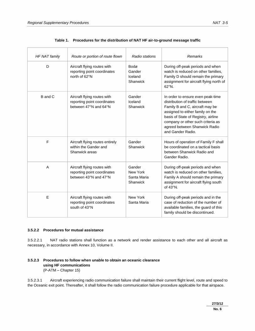
3.5.2.1 Assignment of voice traffic to HF families
3.5.2.1.1 Procedures for the distribution of the NAT HF air-to-ground message traffic of the users on the NAT routes
between the various NAT HF families are indicated in Table 1.
Note.— Use of the NAT-D radiotelephony network frequencies is extended to the Arctic area of the
Anchorage Arctic FIR, via Gander Radio.
3.5.2.1.2 In the event of overloading of a family or for other operational reasons, stations should not assign a frequency
from an alternate family to aircraft flying routes outside the areas defined in Table 1, without prior coordination and
agreement of other network stations, in order to minimize adverse impact on existing sub-network traffic.
27/3/12
No. 6
Regional Supplementary Procedures NAT 3-5
Table 1. Procedures for the distribution of NAT HF air-to-ground message traffic
HF NAT family Route or portion of route flown Radio stations Remarks
D Aircraft flying routes with
reporting point coordinates
north of 62°N
Bodø
Gander
Iceland
Shanwick
During off-peak periods and when
watch is reduced on other families,
Family D should remain the primary
assignment for aircraft flying north of
62°N.
B and C Aircraft flying routes with
reporting point coordinates
between 47°N and 64°N
Gander
Iceland
Shanwick
In order to ensure even peak-time
distribution of traffic between
Family B and C, aircraft may be
assigned to either family on the
basis of State of Registry, airline
company or other such criteria as
agreed between Shanwick Radio
and Gander Radio.
F Aircraft flying routes entirely
within the Gander and
Shanwick areas
Gander
Shanwick
Hours of operation of Family F shall
be coordinated on a tactical basis
between Shanwick Radio and
Gander Radio.
A Aircraft flying routes with
reporting point coordinates
between 43°N and 47°N
Gander
New York
Santa Maria
Shanwick
During off-peak periods and when
watch is reduced on other families,
Family A should remain the primary
assignment for aircraft flying south
of 43°N.
E Aircraft flying routes with
reporting point coordinates
south of 43°N
New York
Santa Maria
During off-peak periods and in the
case of reduction of the number of
available families, the guard of this
family should be discontinued.
3.5.2.2 Procedures for mutual assistance
3.5.2.2.1 NAT radio stations shall function as a network and render assistance to each other and all aircraft as
necessary, in accordance with Annex 10, Volume II.
3.5.2.3 Procedures to follow when unable to obtain an oceanic clearance
3.5.2.3 using HF communications
3.5.2.3 (P-ATM – Chapter 15)
3.5.2.3.1 Aircraft experiencing radio communication failure shall maintain their current flight level, route and speed to
the Oceanic exit point. Thereafter, it shall follow the radio communication failure procedure applicable for that airspace.
27/3/12
No. 6
NAT 3-6 Regional Supplementary Procedures
Note.— In this context, the current flight level is the last cleared level unless the preceding units’ radio
communication failure procedure dictates otherwise. In all cases, aircraft should stay in level flight in the oceanic area.
Current speed should be the initial oceanic Mach number in the flight plan, if the aircraft does not have a speed
clearance.
3.6 AERONAUTICAL FIXED SERVICE
3.6.1 AFTN rationalization
Nil.
3.7 RADIO CHANNELS/FREQUENCIES
Nil.
_____________________
27/3/12
No. 6

NAT 4-1 30/11/07 8/1/09
No. 1
Chapter 4. NAVIGATION
4.1 PERFORMANCE-BASED NAVIGATION (PBN)
Note.— As the North Atlantic (NAT) Region transitions to PBN as contained in the Performance-based
Navigation (PBN) Manual (Doc 9613), the contents of 4.1 will be amended.
4.1.1 Area navigation (RNAV) specifications
4.1.1.1 RNAV 10 (RNP 10)
Note.— RNAV 10 retains the RNP 10 designation, as specified in the Performance-based Navigation (PBN)
Manual (Doc 9613), 1.2.3.5.
Area of applicability
4.1.1.1.1 A lateral separation minimum of 93 km (50 NM) may be applied between flights operating within the control
area of the New York Oceanic FIR.
Means of compliance
4.1.1.1.2 For application of 4.1.1.1.1, operators and civil aviation authorities must follow the provisions listed below.
4.1.1.1.3 The aircraft and operator must be approved RNP 10 or RNP 4 by the State of the Operator or the State of
Registry, as appropriate. RNP 10 is the minimum navigation specification for the application of 93 km (50 NM) lateral
separation.
4.1.1.1.4 States shall ensure, when granting approval for RNP 10 or RNP 4, that operators establish programmes to
mitigate the occurrence of large lateral track errors due to equipment malfunction or operational error.
Note.— The Performance-based Navigation (PBN) Manual (Doc 9613) provides guidance on aircraft,
operations and maintenance programmes for the initial achievement and continued compliance with the authorized
navigation specification.
4.1.1.2 RNAV 5
Nil.
4.1.1.3 RNAV 2
Nil.
4.1.1.4 RNAV 1
Nil.
NAT 4-2 Regional Supplementary Procedures
30/11/07 8/1/09
No. 1
4.1.1.5 Pre-PBN navigation specifications
4.1.1.5.1 Minimum navigation performance specifications (MNPS)
Area of applicability
4.1.1.5.1.1 The MNPS shall be applicable in that volume of airspace between FL 285 and FL 420 within the Oceanic
Control Areas of Santa Maria, Shanwick, Reykjavik, Gander Oceanic and New York Oceanic, excluding the area west of
60°W and south of 38°30N.
Note.— This volume of airspace is referred to as the “MNPS airspace”.
Means of compliance
(A2 – Chapter 5; A6, Part I – Chapters 3, 4 and 7; A6,
Part II – Chapters 3 and 7; A8 – Chapter 8)
4.1.1.5.1.2 Except for those flights specified in 4.1.1.5.1.5, aircraft operating within the volume of airspace specified in
4.1.1.5.1.1 shall have lateral navigation performance capability such that:
a) the standard deviation of lateral track errors shall be less than 11.7 km (6.3 NM);
b) the proportion of the total flight time spent by aircraft 56 km (30 NM) or more off the cleared track shall
be less than 5.3 × 10⁻⁴
; and
c) the proportion of the total flight time spent by aircraft between 93 and 130 km (50 and 70 NM) off the
cleared track shall be less than 1.3 × 10⁻⁴
.
4.1.1.5.1.3 The State of Registry or the State of the Operator, as appropriate, should verify that the lateral navigation
capability of approved aircraft meets the requirements specified in 4.1.1.5.1.2.
Note.— Guidance material of use to those involved in the initial achievement and continued maintenance
of the navigation capability set forth in 4.1.1.5.1.2 has been issued by ICAO under the title Guidance and Information
Material Concerning Air Navigation in the North Atlantic Region (NAT Doc. 001) and will be supplemented and updated
as required and as new material becomes available.
4.1.1.5.1.4 When granting approval for operations in MNPS airspace, States of Registry shall ensure that in-flight
operating drills include mandatory navigation cross-checking procedures which will identify navigation errors in sufficient
time to prevent the aircraft inadvertently deviating from the ATC-cleared route. Guidance on procedures are detailed in
NAT Doc 001 and North Atlantic MNPS Airspace Operations Manual.
4.1.1.5.1.5 Flights not subject to an Oceanic Clearance, which flight plan to route through Brest Oceanic Transition
Area (BOTA) and/or Shannon Oceanic Transition Area (SOTA), are not subject to MNPS approval.
Note 1.— SOTA is defined as that airspace from DINIM (510000N 0150000W) — LESLU (510000N
0080000W) — 483000N 0080000W — BEDRA (490000N 0150000W) to DINIM (510000N 0150000W).
Note 2.— BOTA is defined as that airspace from 483400N 0084500W — 483000N 0080000W — 450000N
0080000W — 450000N 0084500W to 483400N 0084500W.
8/1/09
No. 1
15/10/10
No. 3
Regional Supplementary Procedures NAT 4-3
30/11/07 8/1/09
No. 1
4.1.2 Required navigation performance (RNP) specifications
4.1.2.1 RNP 4
Nil.
4.1.2.2 Basic RNP 1
Nil.
4.1.2.3 Advanced RNP 1
Nil.
4.2 REDUCED VERTICAL SEPARATION MINIMUM (RVSM)
Area of applicability
4.2.1 RVSM shall be applicable in that volume of airspace between FL 290 and FL 410 inclusive in all FIRs of
the NAT Region.
Means of compliance
(A2 – Chapter 5 and Appendix 3; A6, Part I – Chapters 3, 4 and 7;
A6, Part II – Chapters 3 and 7; A8, Part IIIA – Chapter 8, A11 – Chapter 2)
4.2.2 Operators intending to conduct flights within the NAT Region where RVSM is applied shall require an
RVSM approval either from the State of Registry or the State of the Operator. The State of Registry or the State of the
Operator, as appropriate, should verify that the height-keeping performance capability of approved aircraft meets the
requirements specified in Annex 6, Parts I and II.
Note.— Guidance material of use to those involved in the initial achievement and continued maintenance
of the height-keeping performance has been issued by ICAO under the title Guidance and Information Material
Concerning Air Navigation in the North Atlantic Region (NAT Doc. 001) and will be supplemented and updated as
required and as new material becomes available.
_____________________
8/1/09
No. 1
25/8/09
No. 2


NAT 5-1 30/11/07
Chapter 5. SURVEILLANCE
5.1 SECONDARY SURVEILLANCE RADAR (SSR)
(P-ATM – Chapter 8; P-OPS, Vol. I )
5.1.1 Carriage of pressure-altitude reporting SSR transponders
5.1.1.1 All aircraft operating as IFR flights in the NAT Region shall be equipped with a pressure-altitude reporting
SSR transponder.
5.1.2 Code allocation methodology
Nil.
5.1.3 Assignment of SSR codes
Nil.
5.1.4 Operation of pressure-altitude reporting SSR transponders
5.1.4.1 Unless otherwise directed by ATC, pilots of aircraft equipped with SSR flying in NAT FIRs shall retain the
last assigned identity (Mode A) code for a period of 30 minutes after entry into NAT airspace.
5.1.5 Monitoring of SSR-derived information
Nil.
5.2 SSR MODE S
5.2.1 Carriage and operation of SSR Mode S
Nil.
5.2.2 Transition between Mode A/C and Mode S
Nil.

NAT 5-2 Regional Supplementary Procedures
5.3 AIRBORNE COLLISION AVOIDANCE SYSTEMS (ACAS)
5.3.1 Carriage and operation of ACAS II
(A2 – Chapter 3; A6, Part I – Chapter 6; A10, Vol. IV;
A11 – Chapter 2; P-OPS, Vol. I; P-ATM – Chapters 4 and 10)
5.3.1.1 ACAS II shall be carried and operated in the NAT Region by all turbine-engined aeroplanes having a
maximum certificated take-off mass exceeding 5 700 kg or authorized to carry more than 19 passengers.
5.4 AUTOMATIC DEPENDENT SURVEILLANCE – CONTRACT (ADS-C)
Area of applicability
5.4.1 All aircraft intending to conduct flights in the airspace defined below shall be fitted with and shall operate
automatic dependent surveillance – contract (ADS-C) equipment:
a) from 7 February 2013, on specified tracks and on specified flight levels within the NAT organized track
system (OTS); and
b) from 5 February 2015, in specified portions of NAT minimum navigation specifications (MNPS) airspace.
Note 1.– The specified tracks and flight level band within the NAT OTS will be published by the States
concerned in national AIPs and identified daily in the NAT track message.
Note 2.– The specified portions of NAT MNPS airspace and aircraft equipment performance requirements
where applicable will be published by the States concerned in national AIPs.
Means of compliance
5.4.2 Operators intending to conduct flights within the airspace specified in 5.4.1 shall obtain an ADS-C
operational authorization, where applicable, either from the State of Registry or the State of the Operator. The State of
Registry or the State of the Operator shall verify that the equipment has been certified in accordance with the
requirements specified in RTCA DO-258/EUROCAE ED-100 or equivalent, capable of operating outside VHF data link
coverage.
5.4.3 The data link services provided within the NAT airspace shall comply with the Oceanic Safety and
Performance Requirements as specified in RTCA DO306/EUROCAE ED122 or equivalent. Conformance monitoring
shall provide alerts to the controller when reports do not match the current flight plan and the following ADS contracts
shall be used:
a) ADS periodic contracts at an interval consistent with safety requirements and published by the States
concerned in national AIPs; and
b) ADS event contracts that include the following event types:
1) lateral deviation event (LDE) with a lateral deviation threshold of 9.3 km (5 NM) or less;
27/3/12
No. 6

Regional Supplementary Procedures NAT 5-3
2) level range deviation event (LRDE) with a vertical deviation threshold of 90 m (300 ft) or less; and
3) waypoint change event (WCE) at compulsory reporting points.
Note.– Additional guidance can be found in the ICAO Global Operational Data Link Document (GOLD).
5.5 AUTOMATIC DEPENDENT SURVEILLANCE – BROADCAST (ADS-B)
Nil.
_____________________
27/3/12
No. 6

NAT 6-1 30/11/07
Chapter 6. AIR TRAFFIC SERVICES
6.1 AIR TRAFFIC CONTROL (ATC) CLEARANCES
6.1.1 Content
(A11 – Chapter 3; P-ATM – Chapters 4 and 11)
6.1.1.1 An abbreviated clearance shall only be issued by ATS when clearing an aircraft to follow one of the
organized tracks throughout its flight within the NAT control areas or when clearing an aircraft to follow its flight plan
route. In all other circumstances, full details of the cleared track shall be specified in the clearance message.
6.1.1.2 When an abbreviated clearance is issued to follow one of the organized tracks, it shall include:
a) cleared track specified by the track code;
b) cleared flight level(s);
c) cleared true Mach number (if required); and
d) if the aircraft is designated to report meteorological information in flight, the phrase “SEND MET
REPORTS”.
6.1.1.3 On receipt of an abbreviated clearance, the pilot shall read back the contents of the clearance message. In
addition, when cleared to follow one of the organized tracks, the pilot shall read back full details of the track specified by
the code letter, except where alternative procedures using VHF techniques exist which include provision for the
confirmation of cleared track by the pilot.
6.1.1.4 When an abbreviated clearance is issued to follow the flight plan route, it shall only be issued using direct
controller-pilot communication and shall include:
a) the expression “cleared via flight planned route”;
b) cleared flight level(s); and
c) cleared true Mach number (if required).
6.1.1.5 On receipt of an abbreviated clearance, the pilot shall read back the contents of the clearance message. In
addition, when cleared via “flight planned route”, the pilot shall read back full details of the flight plan route.
6.1.1.6 A pilot-in-command shall, if at any time in doubt, request a detailed description of the route from ATS.
6.1.1.7 The ATC-approved true Mach number shall be included in each clearance given to subsonic turbo-jet
aircraft operating within Bodø Oceanic, Gander Oceanic, New York Oceanic, Reykjavik, Santa Maria Oceanic and
Shanwick Oceanic control areas.

NAT 6-2 Regional Supplementary Procedures
30/11/07
6.1.2 Adherence
(A2 – Chapter 3)
6.1.2.1 If an aircraft has inadvertently deviated from the route specified in its ATC clearance, it shall forthwith take
action to regain such route within 185 km (100 NM) from the position at which the deviation was observed.
6.1.2.2 Unable to obtain oceanic clearance using HF voice
6.1.2.2 (P-ATM – Chapter 15)
6.1.2.2.1 Aircraft operating outside VHF coverage that are unable to contact ATC on HF to obtain an Oceanic
clearance shall continue to operate at the last assigned flight level and along the cleared route of flight until
communications are re-established.
Note.— Failure of HF communications often stems from poor signal propagation, frequently because of
sun spot activity, and is likely to simultaneously affect multiple aircraft operating in a particular region. ATM systems
dependent on HF are designed around the assumption that communication may be temporarily interrupted and that
aircraft affected will continue to operate in accordance with the last received and acknowledged clearance, until
communication is restored.
6.2 SEPARATION
6.2.1 Lateral
(A11 – Attachment B; P-ATM – Chapter 5)
6.2.1.1 Minimum lateral separation shall be:
a) 93 km (50 NM) between aircraft meeting the provisions in 4.1.1.1, except minimum lateral separation
between aircraft transitioning from MNPS airspace in the New York Oceanic FIR/CTA to other MNPS
airspace shall be 110 km (60 NM);
Note.— NAT MNPS airspace is defined in 4.1.1.5.1.1.
b) 110 km (60 NM) between aircraft which meet the minimum navigation performance specifications
(MNPS) provided that a portion of the route of the aircraft is within, above, or below MNPS airspace;
c) 167 km (90 NM) between aircraft operating outside the MNPS airspace and at least one aircraft does
not meet the MNPS:
1) between the Iberian Peninsula and the Azores Islands; and
2) between Iceland and points in Scandinavia and in the United Kingdom;
d) 167 km (90 NM) between aircraft not approved RNP 10 or RNP 4 operating outside MNPS airspace
where no portion of the route of the aircraft is within, above, or below MNPS airspace:
1) between the United States/Canada and Bermuda; and
2) west of 55°W between the United States, Canada or Bermuda and points in the CAR Region;
Note.— MNPS airspace is defined in 4.1.1.5.1.1
8/1/09
No. 1
Regional Supplementary Procedures NAT 6-3
30/11/07
e) 223 km (120 NM) between other aircraft;
except that lower minima in 5.4.1.1.2 of the PANS-ATM may be applied, or further reduced in accordance with 5.11
when the conditions specified in the relevant PANS-ATM provisions are met (see 5.4).
6.2.1.2 In the practical application of the minima in 6.2.1.1 a), b), c) d) and e), tracks may be spaced with
reference to their difference in latitude, using one degree instead of 110 km (60 NM); one and one-half degrees instead
of 167 km (90 NM); and two degrees instead of 223 km (120 NM), provided that in any interval of ten degrees of
longitude, the change in latitude of at least one of the tracks does not exceed:
a) three degrees at or south of 58°N;
b) two degrees north of 58°N and south of 70°N; and
c) one degree at or north of 70°N and south of 80°N.
At or north of 80°N, or where the above rates of change of latitude are exceeded, the required lateral separation must be
ensured by reference to the track spacing expressed in nautical miles.
6.2.2 Longitudinal
(P-ATM – Chapter 5)
6.2.2.1 Minimum longitudinal separation between turbo-jet aircraft shall be:
a) 15 minutes; or
b) 10 minutes, provided the Mach number technique is applied whether in level, climbing or descending
flight; and the aircraft concerned have reported over a common point to follow continuously diverging
tracks until some other form of separation is provided; and:
1) at least 10-minute longitudinal separation exists at the point where the tracks diverge; and
2) at least 5-minute longitudinal separation exists where lateral separation is achieved; and
3) lateral separation will be achieved at or before the next significant point (normally ten degrees of
longitude along track(s)) or, if not, within 90 minutes of the time the second aircraft passes the
common point or within 1 112 km (600 NM) of the common point, whichever is estimated to occur
first.
Note.— The minima contained in 6.2.2.1 b) are in addition to those found in the PANS-ATM, 5.4.2.4.
6.2.2.2 Minimum longitudinal separation between non-turbo-jet aircraft shall be:
a) 30 minutes; and
b) 20 minutes in the West Atlantic route system (WATRS) area.
Note.— The WATRS area is defined as beginning at a point 27°00'N/77°00'W direct to 20°00'N/67°00'W
direct to 18°00'N/62°00'W direct to 18°00'N/60°00'W direct to 38°30'N/60°00'W direct to 38°30'N/69°15'W, thence
counterclockwise along the New York Oceanic control area/FIR boundary to the Miami Oceanic control area/FIR boundary,
thence southbound along the Miami Oceanic control area/FIR boundary to the point of beginning.
8/1/09
No. 1

NAT 6-4 Regional Supplementary Procedures
30/11/07
6.2.3 Composite
Nil.
6.2.4 Vertical
6.2.4.1 Between FL 290 and FL 410 inclusive, 300 m (1 000 ft) vertical separation shall be applied in the NAT
Region.
6.2.4.2 At or above FL 450, vertical separation between supersonic aircraft, and between supersonic aircraft and
any other aircraft, shall be considered to exist if the flight levels of the two aircraft differ by at least 1 200 m (4 000 ft).
6.2.5 Radar
Nil.
6.2.6 Reduction in separation minima
(A11 – Chapter 3; P-ATM – Chapter 5)
6.2.6.1 Where, circumstances permitting, separation minima lower than those specified in 6.2.1 and 6.2.2 will be
applied in accordance with the PANS-ATM, appropriate information should be published in AIPs so that users of the
airspace are fully aware of the portions of airspace where the reduced separation minima will be applied and of the
navigation aids on which those minima are based.
6.2.7 Airspace reservations
6.2.7.1 Separation minima between moving temporary airspace reservations
6.2.7.1.1 Lateral separation shall be:
a) 110 km (60 NM) between the closest tracks of any aircraft for which the airspace is reserved, provided
all aircraft or formation flights meet the MNPS; or
b) 223 km (120 NM) between the closest tracks of any aircraft for which the airspace is reserved, except
that in the New York oceanic control area (OCA) west of 60°W, 167 km (90 NM) may be applied.
Note.— A formation flight with at least one of the aircraft in the formation meeting MNPS is deemed to
meet the requirement for the application of 110 km (60 NM) in a).
6.2.7.1.2 Longitudinal separation shall be 60 minutes.
6.2.7.2 Separation minima between stationary temporary airspace reservations
6.2.7.2.1 Lateral separation shall be:
a) 110 km (60 NM) between the boundaries of stationary temporary airspace reservations, provided the
requesting agencies have guaranteed to confine their activities to the requested airspace, except that
in the New York OCA west of 60°W, 84 km (45 NM) may be applied; or
8/1/09
No. 1

Regional Supplementary Procedures NAT 6-5
30/11/07
b) 223 km (120 NM) between the boundaries of the airspace reservations, if no guarantees have been
given, except that in the New York OCA west of 60°W, 167 km (90 NM) may be applied.
6.2.7.3 Separation minima between moving temporary airspace reservations and other aircraft
6.2.7.3.1 Lateral separation shall be:
a) 110 km (60 NM) between the track of an aircraft operating under the control of the ATC unit concerned
and the closest track of any of the aircraft for which the airspace is reserved, provided all aircraft meet
the MNPS requirements and a portion of the route of the aircraft is within, above or below MNPS
airspace; or
b) 110 km (60 NM) between the track of an aircraft operating under the control of the ATC unit concerned
and the track of a formation flight for which the airspace has been reserved, provided at least one
aircraft in the formation and the aircraft operating under the control of the ATC unit meet the MNPS
requirements and a portion of the route of the aircraft is within, above or below MNPS airspace; or
c) 223 km (120 NM) between the track of an aircraft operating under the control of the ATC unit
concerned and the closest track of any of the aircraft for which the airspace is reserved, except that in
the New York OCA west of 60°W, 167 km (90 NM) may be applied.
6.2.7.4 Separation minima between stationary temporary airspace reservations and other aircraft
6.2.7.4.1 Lateral separation shall be:
a) 56 km (30 NM) between the track of an aircraft operating under the control of the ATC unit concerned
or as part of a moving airspace reservation and the nearest limit of the reserved airspace, provided the
aircraft meets the MNPS requirements and a portion of the route of the aircraft is within, above or
below MNPS airspace and the requesting agency has guaranteed to confine its activities to the
requested airspace; or
b) 110 km (60 NM) between the track of an aircraft operating under the control of the ATC unit concerned
or as part of a moving airspace reservation and the nearest limit of the reserved airspace, provided the
aircraft meets the MNPS requirements and a portion of the route of the aircraft is within, above or
below MNPS airspace and the requesting agency has not guaranteed to confine its activities to the
requested airspace; or
c) 110 km (60 NM) between the track of an aircraft operating under the control of the ATC unit concerned
or as part of a moving airspace reservation and the nearest limit of the reserved airspace, when the
aircraft does not meet the MNPS requirements and the requesting agency has guaranteed to confine
its activities to the requested airspace, except that in the New York OCA west of 60°W, 84 km (45 NM)
may be applied; or
d) 223 km (120 NM) between the track of an aircraft operating under the control of the ATC unit
concerned or as part of a moving airspace reservation and the nearest limit of the reserved airspace,
when the aircraft does not meet the MNPS requirements and the requesting agency has not
guaranteed to confine its activities to the requested airspace, except that in the New York OCA west of
60°W, 167 km (90 NM) may be applied.
8/1/09
No. 1
NAT 6-6 Regional Supplementary Procedures
30/11/07
6.3 MINIMUM FLIGHT LEVEL
6.3.1 Establishment
Nil.
6.4 ATS ROUTES
6.4.1 Track systems
6.4.1.1 Establishment and use of organized track system (OTS)
6.4.1.1.1 When necessary in order to permit the optimum use of the airspace, the area control centres serving
Gander Oceanic, New York Oceanic, Santa Maria Oceanic and Shanwick Oceanic control areas may, subject to
coordination with each other and, when appropriate, with Reykjavik area control centre, establish an organized track
system. The procedures in 6.4.1.1.2 and 6.4.1.1.3 shall then be applied.
6.4.1.1.2 Operators conducting scheduled or non-scheduled flight operations at or above FL 280 within Gander
Oceanic, New York Oceanic, Shanwick Oceanic and Santa Maria (North of 30°N) Oceanic control areas shall provide
information to the area control centres concerned regarding the tracks likely to be requested by turbo-jet aircraft during
peak traffic periods. Such information shall be provided as far in advance of the anticipated peak periods as practicable
and as specified in appropriate aeronautical information publications.
6.4.1.1.3 Based on the above information, an OTS may be established. The location of the organized tracks will
depend on traffic demand and other relevant factors. The related organized track messages will be disseminated to
operators by Shanwick Oceanic area control centre for the predominantly westbound flow of air traffic and by Gander
Oceanic area control centre for the predominantly eastbound flow of air traffic. These messages shall be disseminated
at least three hours in advance of each anticipated peak traffic period. Any subsequent change made to the track system
shall be notified to the operators as soon as possible.
6.4.1.2 Mandatory carriage of the OTS message
6.4.1.2.1 All aircraft operating in or above MNPS airspace shall carry a copy of the current OTS message.
6.4.1.3 Flights along the northern or southern boundaries of Gander Oceanic
6.4.1.3 and Shanwick Oceanic flight information regions
6.4.1.3.1 Aircraft operating along tracks through successive points situated on the northern or southern boundaries
of Gander Oceanic and Shanwick Oceanic flight information regions shall be provided with air traffic services by Gander
or Shanwick area control centre as appropriate.
6.4.2 RNAV
Nil.
Regional Supplementary Procedures NAT 6-7
30/11/07
6.5 AERODROME OPERATIONS
6.5.1 Area of applicability
Nil.
6.5.2 Intersection take-off
Nil.
6.5.3 Multiple line-ups on the same runway
Nil.
6.5.4 Visual departures
Nil.
6.5.5 Visual approaches
Nil.
6.5.6 Advanced surface movement guidance and control systems (A-SMGCS)
6.5.6.1 General
Nil.
6.5.6.2 A-SMGCS functions
Nil.
6.5.6.3 A-SMGCS alerts
Nil.
6.5.6.4 A-SMGCS identification procedures
Nil.
25/8/09
No. 2

NAT 6-8 Regional Supplementary Procedures
30/11/07
6.6 RNAV PROCEDURES
6.6.1 General
Nil.
6.6.2 En route
Nil.
6.6.3 Terminal
Nil.
6.6.4 State aircraft
Nil.
6.7 RNP PROCEDURES
6.7.1 General
Nil.
6.7.2 En route
Nil.
6.7.3 Terminal
Nil.
6.7.4 State aircraft
Nil.
6.8 COMPOSITE PROCEDURES
Nil.
25/8/09
No. 2

Regional Supplementary Procedures NAT 6-9
30/11/07
6.9 MNPS PROCEDURES
6.9.1 Aircraft not meeting the requirements of 4.1.1.5.1 shall not be allowed to operate in MNPS airspace.
6.9.2 An operator who experiences reduced navigation performance shall inform air traffic control (ATC) as soon
as practicable.
6.10 RVSM PROCEDURES
6.10.1 General
Nil.
6.10.2 Transition to/from RVSM airspace
Nil.
6.11 ATS COORDINATION
6.11.1 Between units providing area control services
Nil.
6.11.2 RNAV
Nil.
6.11.3 RNP
Nil.
6.11.4 RVSM
Nil.
6.11.5 SSR codes
Nil.
25/8/09
No. 2

NAT 6-10 Regional Supplementary Procedures
30/11/07
6.12 ATS MESSAGES
6.12.1 Flight plan and departure
(P-ATM – Chapter 11)
6.12.1.1 Filed flight plan messages for flights intending to operate within the NAT Region at a distance of 110 km
(60 NM) or less from the northern and southern boundaries of Gander Oceanic and Shanwick Oceanic FIRs shall be
addressed to the ACCs in charge of the NAT FIRs along the route and, in addition, to the ACCs in charge of the nearest
adjacent NAT FIRs.
6.12.1.2 For flights departing from points within adjacent regions and entering the NAT Region without intermediate
stops, filed flight plan messages shall be transmitted to the appropriate ACCs immediately after the flight plan has been
submitted.
6.12.2 Arrival
Nil.
6.12.3 Boundary estimates
Nil.
6.12.4 Computer-assisted coordination
Nil.
6.13 FLIGHT INFORMATION SERVICE (FIS)
6.13.1 Automatic terminal information services (ATIS)
Nil.
6.13.2 SIGMETs
(P-ATM – Chapter 9)
6.13.2.1 SIGMET information shall be transmitted to aircraft by VOLMET broadcast, by a general call to a group of
aircraft, or by directed transmission to individual aircraft, as determined by the appropriate ACC according to the
circumstances, bearing in mind the need to ensure timely receipt of the information by the aircraft and to keep the load
on the HF en-route communications channels to a minimum.
6.13.2.2 SIGMET information passed to aircraft shall cover a portion of the route up to two hours’ flying time ahead
of the aircraft.
25/8/09
No. 2
Regional Supplementary Procedures NAT 6-11
30/11/07
6.13.3 Special air-reports
Nil.
6.13.4 Amended aerodrome forecasts
(P-ATM – Chapter 9)
6.13.4.1 Amended aerodrome forecasts shall be passed to aircraft within 60 minutes from the aerodrome of
destination, unless the information has been made available through other means.
6.13.5 Landing forecasts
Nil.
6.14 ALERTING SERVICE
Nil.
_____________________
25/8/09
No. 2

NAT 7-1
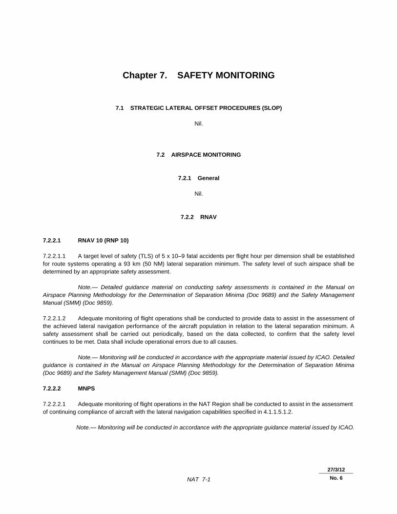
Chapter 7. SAFETY MONITORING
7.1 STRATEGIC LATERAL OFFSET PROCEDURES (SLOP)
Nil.
7.2 AIRSPACE MONITORING
7.2.1 General
Nil.
7.2.2 RNAV
7.2.2.1 RNAV 10 (RNP 10)
7.2.2.1.1 A target level of safety (TLS) of 5 x 10⁻⁹ fatal accidents per flight hour per dimension shall be established
for route systems operating a 93 km (50 NM) lateral separation minimum. The safety level of such airspace shall be
determined by an appropriate safety assessment.
Note.— Detailed guidance material on conducting safety assessments is contained in the Manual on
Airspace Planning Methodology for the Determination of Separation Minima (Doc 9689) and the Safety Management
Manual (SMM) (Doc 9859).
7.2.2.1.2 Adequate monitoring of flight operations shall be conducted to provide data to assist in the assessment of
the achieved lateral navigation performance of the aircraft population in relation to the lateral separation minimum. A
safety assessment shall be carried out periodically, based on the data collected, to confirm that the safety level
continues to be met. Data shall include operational errors due to all causes.
Note.— Monitoring will be conducted in accordance with the appropriate material issued by ICAO. Detailed
guidance is contained in the Manual on Airspace Planning Methodology for the Determination of Separation Minima
(Doc 9689) and the Safety Management Manual (SMM) (Doc 9859).
7.2.2.2 MNPS
7.2.2.2.1 Adequate monitoring of flight operations in the NAT Region shall be conducted to assist in the assessment
of continuing compliance of aircraft with the lateral navigation capabilities specified in 4.1.1.5.1.2.
Note.— Monitoring will be conducted in accordance with the appropriate guidance material issued by ICAO.
27/3/12
No. 6

NAT 7-2 Regional Supplementary Procedures
8/1/09
No. 1
7.2.3 RNP
Nil.
7.2.4 RVSM
7.2.4.1 Adequate monitoring of flight operations in the NAT Region shall be conducted to assist in the assessment
of continuing compliance of aircraft with height-keeping requirements.
_____________________
NAT 8-1 30/11/07
Chapter 8. AIR TRAFFIC FLOW MANAGEMENT (ATFM)
8.1 PROVISION
Nil.
8.2 APPLICATION
Nil.
8.3 EXEMPTIONS FROM ATFM SLOT ALLOCATION
Nil.
8.4 DEPARTURE SLOT MONITORING
Nil.
8.5 PROMULGATION OF ATFM MEASURES
8.5.1 Strategic ATFM measures
Nil.
8.5.2 Amendments to promulgated strategic ATFM measures
Nil.
8.5.3 ATFM circulars and information
Nil.
8.5.4 Pre-flight information bulletin (PIB)
Nil.

NAT 8-2 Regional Supplementary Procedures
30/11/07
8.5.5 Query procedures
Nil.
_____________________

NAT 9-1 30/11/07
Chapter 9. SPECIAL PROCEDURES
9.1 EMERGENCY DESCENT PROCEDURES
(P-ATM – Chapter 15)
9.1.1 Action by the pilot-in-command
9.1.1.1 Descent through the MNPS airspace
9.1.1.1.1 An aircraft that is not MNPS/RVSM-approved and is unable to maintain a flight level above MNPS/RVSM
airspace should descend to a flight level below MNPS/RVSM airspace.
9.1.1.1.2 An aircraft compelled to make a descent through MNPS airspace, whether continuing to destination or
turning back, should, if its descent will conflict with an organized track:
a) plan to descend to a level below FL 280;
b) prior to passing FL 410, proceed to a point midway between a convenient pair of organized tracks
prior to entering that track system from above;
c) while descending between FL 410 and FL 280, maintain a track that is midway between and parallel
with the organized tracks; and
d) contact ATC as soon as practicable and request a revised ATC clearance.
9.1.2 Action by the ATS unit
Nil.
9.2 CONTINGENCY PROCEDURES INCLUDING TURN-BACKS
Nil.
9.3 AIR-GROUND COMMUNICATION FAILURE
(A2 – Chapter 3; P-ATM – Chapter 15; P-OPS, Vol. I)
Note.— The following procedures are intended to provide general guidance for aircraft operating into or
from the NAT Region experiencing a communications failure. These procedures are intended to complement and not
supersede Annex 2, the PANS-ATM and State procedures/regulations. It is not possible to provide guidance for all
situations associated with a communications failure.

NAT 9-2 Regional Supplementary Procedures
30/11/07
General
9.3.1 The pilot shall attempt to contact either another aircraft or any ATC facility and inform it of the difficulty and
request that information be relayed to the ATC facility with whom communications are intended.
Communications failure prior to entering NAT Region
9.3.2 If operating with a received and acknowledged oceanic clearance, the pilot shall enter oceanic airspace at
the cleared oceanic entry point, level and speed and proceed in accordance with the received and acknowledged
oceanic clearance. Any level or speed changes required to comply with the oceanic clearance shall be completed within
the vicinity of the oceanic entry point.
9.3.3 If operating without a received and acknowledged oceanic clearance, the pilot shall enter oceanic airspace
at the first oceanic entry point, level and speed, as contained in the filed flight plan, and proceed via the filed flight plan
route to landfall. That first oceanic level and speed shall be maintained to landfall.
Communications failure prior to exiting NAT Region –
Cleared on filed flight plan route
9.3.4 The pilot shall proceed in accordance with the last received and acknowledged oceanic clearance,
including level and speed, to the last specified oceanic route point, normally landfall, and then continue on the filed flight
plan route. The pilot shall maintain the last assigned oceanic level and speed to landfall and, after passing the last
specified oceanic route point, shall conform with the relevant State procedures/regulations.
Communications failure prior to exiting NAT Region –
Cleared on other than filed flight plan route
9.3.5 The pilot shall proceed in accordance with the last received and acknowledged oceanic clearance,
including level and speed, to the last specified oceanic route point, normally landfall. After passing this point, the pilot
shall conform with the relevant State procedures/regulations and rejoin the filed flight plan route by proceeding, via the
published ATS route structure where possible, to the next significant point ahead as contained in the filed flight plan.
Note.— The relevant State procedures/regulations to be followed by aircraft in order to rejoin its filed flight
plan route are specified in detail in the appropriate national Aeronautical Information Publication.
9.4 DEGRADATION OR FAILURE OF THE RNAV SYSTEM
9.4.1 Action by the pilot-in-command
Nil.
9.4.2 Action by the ATS unit
Nil.
Regional Supplementary Procedures NAT 9-3
30/11/07
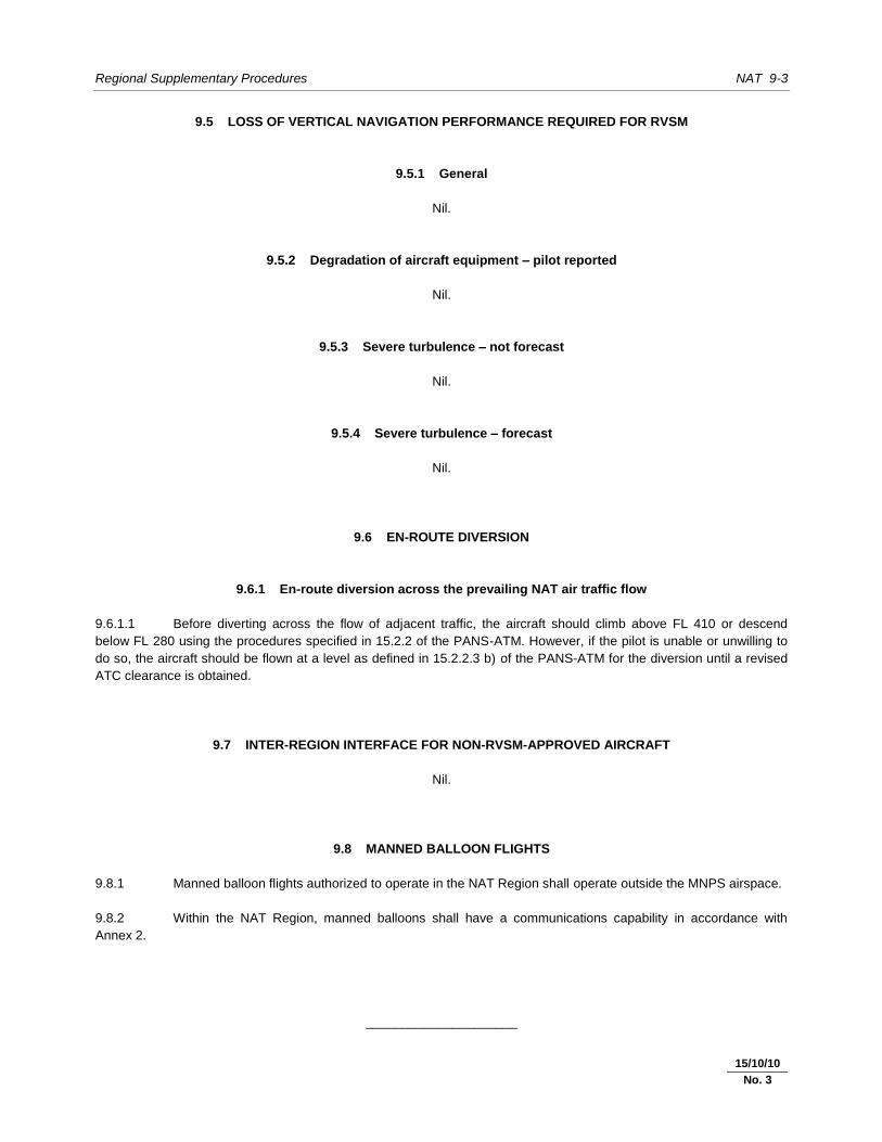
9.5 LOSS OF VERTICAL NAVIGATION PERFORMANCE REQUIRED FOR RVSM
9.5.1 General
Nil.
9.5.2 Degradation of aircraft equipment – pilot reported
Nil.
9.5.3 Severe turbulence – not forecast
Nil.
9.5.4 Severe turbulence – forecast
Nil.
9.6 EN-ROUTE DIVERSION
9.6.1 En-route diversion across the prevailing NAT air traffic flow
9.6.1.1 Before diverting across the flow of adjacent traffic, the aircraft should climb above FL 410 or descend
below FL 280 using the procedures specified in 15.2.2 of the PANS-ATM. However, if the pilot is unable or unwilling to
do so, the aircraft should be flown at a level as defined in 15.2.2.3 b) of the PANS-ATM for the diversion until a revised
ATC clearance is obtained.
9.7 INTER-REGION INTERFACE FOR NON-RVSM-APPROVED AIRCRAFT
Nil.
9.8 MANNED BALLOON FLIGHTS
9.8.1 Manned balloon flights authorized to operate in the NAT Region shall operate outside the MNPS airspace.
9.8.2 Within the NAT Region, manned balloons shall have a communications capability in accordance with
Annex 2.
_____________________
15/10/10
No. 3


NAT 10-1 30/11/07
Chapter 10. PHRASEOLOGY
10.1 RNAV
Nil.
10.2 RNP
Nil.
10.3 SURVEILLANCE
Nil.
10.4 AERODROME OPERATIONS
Nil.
10.5 ATFM
Nil.
_____________________


NAT 11-1 30/11/07
Chapter 11. SEARCH AND RESCUE
11.1 INTERNATIONAL GENERAL AVIATION (IGA)
Nil.
11.1.1 International general aviation (IGA) shall be equipped with functioning two-way radio communications
equipment except that, under special local circumstances, the appropriate authorities may grant exemption from this
requirement.
_____________________


NAT 12-1 30/11/07
Chapter 12. METEOROLOGY
12.1 AIRCRAFT OBSERVATIONS AND REPORTS
Nil.
_____________________
15/10/10
No. 3


NAT 13-1 30/11/07
Chapter 13. AERONAUTICAL INFORMATION SERVICES
13.1 NOTAM ADDRESSING AND DISTRIBUTION
Nil.
13.2 AERONAUTICAL CHART INFORMATION
13.2.1 Visual procedures
Nil.
_____________________