national assessment of - · pdf filenational assessment of shoreline change: puducherry coast...
TRANSCRIPT


National Assessment ofShoreline Change:Puducherry Coast
R. RameshPurvaja Ramachandran
A. Senthil Vel#
National Centre for Sustainable Coastal ManagementMinistry of Environment and Forests
Government of IndiaAnna University, Chennai 600 025
#Society of Integrated Coastal Management (SICOM)Ministry of Environment and Forests
Government of IndiaNew Delhi 110 003
Experts
T. NatarajanS. Thillaigovindarajan
Institute for Ocean ManagementAnna University, Chennai 600 025
Project Team for Puducherry Coast
Cover Page Design, Layout and GraphicsS.A. Swamynathan
Prepared by National Centre for Sustainable Coastal Management
Ministry of Environment and ForestsGovernment of India
www.ncscm.org&
Institute for Ocean ManagementAnna University, Chennai
www.annauniv.edu/iom/home.htm
G. Mary Divya Suganya V.P. Sathiya Bama S. Satish Kumar P.D. Tulasi Bai R. Madhumita K. VetriselvanP. Pandi Selvam P. Rajaram E. Kumaran R. Ganesh K. Balaji S. Elamathi

DISCLAIMER
This report is part of a series of reports that will include text summarizing methods, results, in addition to maps illustrating zones of shoreline change. Zones of shoreline change are being published for the purpose of regional characterization. These maps are not intended to be equated to either as revenue maps of the respective State/ UT/ Government agencies or as the topographic maps of the Survey of India. The maps conform to the National Map Policy dated May 19, 2005 of the Ministry of Science and Technology, Government of India.
These maps are not meant for revenue purposes and should be treated as preliminary scientific products. Further they should not be used for personal claims.
Contact:National Centre for Sustainable Coastal ManagementMinistry of Environment and ForestsGovernment of IndiaKoodal BuildingAnna University, Chennai 600025
Phone: 91 44 2233 0108, 2220 0159, 2220 3408Fax: 91 44 2220 0158Email: [email protected]
© NCSCM, Ministry of Environment and Forests, Government of India, 2011Material from this publication may be used for educational purposes with due acknowledgement. Material from this publication can be used for commercial purposes, after obtaining permission from the NCSCM, Ministry of Environment and Forests.
Citation: Ramesh, R., Purvaja, R., Senthil Vel, A. (2011) National Assessment of Shoreline Change: Puducherry Coast. NCSCM/MoEF Report 2011-01, 57 p., available at http://www. ncscm.org/reports.php
Photo CreditsGoogle & Staff of Institute for Ocean ManagementAnna University, Chennai
Executive Summary
1.0 Introduction 1 1.1 The Coastal region of India 3 1.2 Aim and Objectives 5
2.0 Physical Features and Coastal Pollution 7 2.1 Coastal Geomorphology 8 2.2 Coastal Physical Processes 11 2.2.1 Meteorological Data 11 2.2.2 Oceanographic Data 14 2.2.3 Coastal Sediments 17 2.3 Coastal Pollution 17
3.0 Socio-Ecological Systems 19 3.1 Major Socio-ecological Drivers 19 3.2 Ecologically Sensitive Areas 21 3.3 Fishery Resources 22 3.4 Coastal Livelihood 27
4.0 Human Interventions 28 4.1 Coastal Infrastructure 28 4.2 Landuse 29
5.0 Methods of Shoreline Change Analysis 35 5.1 Data Sources 36 5.2 Rectification / Correction 36 5.3 Image Enhancement 37 5.4 Compilation and QA/QC 37
Contents

5.5 Existing Shoreline Rate-change Calculation Methods 37 5.6 Digital Shoreline Analysis System (DSAS) 42 5.7 Vector-based Shoreline Change Analysis 43 5.8 Maps and Data Products 43
6.0 Results 44 6.1 Erosion/ Accretion Status 45 6.2 Puducherry Coast 45 6.3 Karaikal Coast 46 6.4 Shoreline Change (1972-2010) using Net Shoreline Movement (NSM) 47 and Linear Regression rate (LRR) 6.5 Factors Influencing Shoreline Changes 51 7.0 Conclusions 71
List of Tables1 Coastal Length of India and its Islands 52 Coastal Statistics for India 53 Some critical socioeconomic drivers of the coast 204 Present Status of Fisher Population along Puducherry Coastal Villages 235 Marine Fish Catch along the Puducherry Coast (1985- 2004) 256 Landuse pattern in Puducherry Coastal region 297 Extent of Land Use in the Karaikal Coastal region 328 Data sources consulted and used for analysis of shoreline change 369 Shoreline Change Statistics for Puducherry Coast 4510 Statistics for Karaikal Coast, Puducherry 47

1 India’s Coastal Districts 42 Coastal districts of Puducherry 93 Coastal districts of Karaikal 104 Coastal Geomorphology of Puducherry 125 Coastal Geomorphology Karaikal 136 General schematic of longshore sediment transport 16 and net sediment movement along the coast 7 Trends in pollution levels of coastal waters at Puducherry 188 Location of Major Fishing Villages along the 24 a) Puducherry Coast and b) Karaikal Coast9 Location of major fish landing centres along the Puducherry 24 and Karaikal coasts 10 Types of fishery resources along the Puducherry coast 2611 Annual fish landings (1985 - 2008) at Puducherry coast 2612a Landuse categories of the Puducherry coast – Part 1 3012b Landuse categories of the Puducherry coast - Part 2 3113a Landuse categories of the Karaikal coast - Part 1 3313b Landuse categories of the Karaikal coast - Part 2 3414 Calculation of shoreline change using End Point Rate 3815 Calculation of shoreline change using Net Shoreline Movement 3916 Calculation of shoreline change using Shoreline Change Envelope 4017 Calculation of shoreline change using Linear Regression Rate 4118 Methodology adopted for the shoreline change study 4219 Net Shoreline Movement (m) along the Puducherry Coast 4820 Shoreline change rates for the Puducherry Coastal region. 4921 Net Shoreline Movement (m) along the Karaikal Coast 5022 Shoreline change rates for the Karaikal Coastal region. 5023 Net littoral drift along the coast of Puducherry, India 52
List of Figures

This assessment on the Puducherry Coast represents long-term shoreline change for a period of 38 years from 1972-2010. The report summarizes the methods of analysis and provides explanations regarding long-term trends and zones of change. Shoreline change evaluations are based on comparing five historical shorelines extracted from satellite imageries for the above time period, with recent shoreline derived from LISS III images and limited field surveys. The historical shorelines represent the following periods: 1972 (Survey of India toposheet), satellite imageries of 1990, 2000, 2006 and 2010.
Primary goal of this study is to develop standardized methods for mapping and analyzing shoreline movement so that internally consistent updates can periodically be made to record shoreline erosion and accretion. Appropriate use of remote sensing technology coupled with limited DGPS surveys was integrated in GIS platform to obtain historical shoreline information. For the coast of Puducherry, base maps were prepared on 1:50,000 scale using the toposheet of the Survey of India and onscreen digitization of coastline using various satellite imageries on 1:50,000 scale and stored as four different layers in GIS environment for the years 1990, 2000, 2006 and 2010. The multi-date shorelines served as input into the USGS digital shoreline analysis ‘DSAS’ software to cast various transects along the coastline of Puducherry. A distance of 500m intervals was assigned to calculate the erosion/ accretion statistics in ArcGIS 9.3 software.
Executive Summary

Category of shoreline and symbology
The results obtained were categorized into eight classes of “Zones of erosion/ accretion” as follows:
Of the zones on where the shoreline was eroding, the erosion zones were generally ‘high’ on the northern part of the Puducherry coast where coastal engineering projects have greatly altered the natural shoreline movement. The southern part of the Puducherry coast is largely ‘stable’ or accreting. It could be observed that zones of erosion have increased, possibly related to the construction of the Puducherry Port in the late 1980s and other groyne field structures along this part of the coast subsequent to the construction of the Puducherry Port. Seawalls and/or riprap (seawalls) revetments have been constructed along 6.18 km of this coastal stretch to protect houses and infrastructures from coastal erosion. Along the Puducherry coast, riprap have been raised to protect the coast from high erosion and these areas have been classified as ‘Artificial Coast’. Statistics indicate that 26.2% of the Puducherry coast is managed artificially.
Low to medium erosion is found to occur along ~1 km of the ~24km coast of Puducherry. This represents nearly 4.2% of the total Puducherry coast. Cumulative erosion i.e., sum of high, medium, low erosion and artificial coast is calculated to be 30.3%. This zone should be protected and needs attention. It is also observed that the highly eroding areas of the Puducherry coast have already been considerably protected using riprap, as mentioned above.
Stable coast and accretion (high, medium and low accretion) on the Puducherry coast accounts for 39.2% and 30.4% respectively.

Classification of Coast Extent (km)
Percent of Coast Cumulative (%)
Length of Coastline including river mouths and Ports
23.62
High Erosion Zone Medium Erosion Zone 0.52 2.2 Low Erosion Zone 0.46 2.0 4.2Artificial Coast: Seawalls/ Riprap 6.18 26.2 30.3#
Stable Coast 9.27 39.2 39.2High Accretion Zone Medium Accretion Zone 2.19 9.3 Low Accretion Zone 5.00 21.2 30.4$
Number of Ports/ Harbours 2 Number of Fish Landing Centres 21 Number of Groynes / Breakwaters 7
Shoreline Characteristics and Statistics for Puducherry Coast
#(Sum of High erosion + Medium erosion + Low erosion + Artificial Coast)$(Sum of High accretion + Medium accretion+ Low accretion)
The Karaikal Coast (Puducherry Union Territory) is approximately 17.3 km long including river mouths and port, of which nearly 3.98 km (23%) of the coast is “stable”, where no shoreline change is observed. Approximately 8km (46%) of this coastal stretch is “accreting” (sum of high, medium and low accretion) low and high accretion zones.
Low “erosion” zone accounts for 2.0 km (~11.5%) of the total coastline. The other notable feature of the Karaikal coast is the absence of shoreline protection structures such as seawalls/ riprap along the coast. The Karaikal Port was commissioned in September 2009 which has two breakwaters- the northern and the southern breakwater. Medium erosion is observed on the northern side of the Karaikal Port while medium accretion is observed on the southern side of the Karaikal Port.
Based on the above information and data it is advised that proper precautions be taken prior to erecting any further structures along the vulnerable coastal stretches of Puducherry and Karaikal.

Coastal zones are dynamic interfaces between land and water and are common locations of high-density development. Coasts are subjected to frequent natural hazards; including flooding, storm impacts, coastal erosion, and tsunami inundation. Coastal erosion is a constant problem along most open-ocean shores of India. As coastal populations continue to grow and infrastructures are threatened by erosion, there is an increasing demand for accurate information regarding past and present shoreline changes. There is also a need for a consistent and comprehensive analysis of shoreline movement. To meet these national needs, the Ministry of Environment and Forests, Government of India have initiated an analysis of historical shoreline changes along the east and west coasts of the country. These changing and ephemeral interfaces between water and land are the sites of intense development even though they are frequently subjected to a range of natural hazards. The main purpose of this study is to develop standard replicable methods for mapping and analyzing shoreline movement so that periodic updates regarding coastal erosion and land loss can be made nationally that are systematic and internally consistent. For this study, the “instantaneous high water line” has been considered as the shoreline as it was derived from satellite imagery.
1. Introduction
Coastal region of India
Aims and Objectives
National Assessment of Shoreline Change - Puducherry Coast 2
It is generally agreed that the coast, especially the beaches, are facing severe erosion and the shorelines are changing. These are primarily due to manmade activities such as construction of ports, harbours, groynes, shore protection measures etc. The Central /State Governments and private entrepreneurs also propose to construct several ports and harbours all along the shore in the coming years. These could have irreversible adverse impact on the coast if such infrastructure is constructed without scientific studies. Thus, there is a need to study the cumulative impact of the individual projects on the entire coastline. Based on these facts, the Ministry of Environment and Forests (MoEF) have initiated a scientific study of the impacts of such projects and also make necessary policy changes to ensure the damage to the beaches and coastline is mitigated.
On June 15, 2009, the MoEF constituted a four-member Committee under the Chairmanship of Prof. M S Swaminathan to recommend future steps on the draft Coastal Management Zone (CMZ) Notification, 2008. The Committee recommended that the CMZ Notification, 2008 be lapsed and amendment incorporated as recommended in the CRZ Notification, 1991 for better coastal management. On July 16, 2009, the report of the Swaminathan Committee was released as the “Final Frontier”1. Extracts of paragraphs 7.4 and 7.4.1, 7.4.2 and 7.4.3 from the report are quoted below.
of the Union Ministry of Shipping explained that it was difficult to track all projects, because permissions are given based on their scale and ownership. The Union Ministry of Shipping is involved in ‘major public sector ports, while state governments give clearance to minor ports as well as upgraded ports being proposed by private developers’. Experts are unanimous that each structure would impact the shoreline – particularly the beach formation.
Already, many of these infrastructure projects have caused significant shoreline changes, as in Ennore, Puducherry, Alibag, Digha and Dahej. It is also observed that the shoreline is being impacted adversely by mining projects and by interventions like the building of shore-protection structures like groynes.
Under the existing CRZ and EIA notifications, various port projects are indeed regulated. Under the EIA Notification, the ports which attract cargo-handling capacity need clearance. In other words, the ports which may only involve dredging or disposal of dredged material or shore protection projects, will not be included. The EIA Notification also categorises the clearance required based on the handling capacity of the port – ports waith a handling capacity higher than 5 million tonnes per annum require clearance from the MoEF, while the rest can get clearances from State Environmental Appraisal Authorities. In CRZ 1991, all port projects require clearance from the Central government, but only for components which fall within the land area of CRZ; this is because CRZ 1991 has no jurisdiction in the water area. The Committee was of the view that these developments have all led to serious threats to the coast, as especially beaches face
7.4. Introduce regulations to manage the proliferation of ports along the coasts, with possible impacts on the coastline, by considering cumulative impacts of these developments.
The Committee noted that currently, the shoreline of the country is undergoing a major change because of a large number of port and harbour projects. These projects involve large quantities of dredging, shore protection works, breakwaters and reclamation. The problem is that there is little information of the cumulative impacts of these projects on the coastline. Officials
1 MoEF, (2009). Final Frontier: Agenda to protect the ecosystem and habitat of India’s coast for conservation and livelihood security. Report of the Expert Committee on the draft Coastal Management Zone (CMZ) Notification, constituted by the Ministry of Environment and Forests, under the Chairmanship of Prof.M.S.Swaminathan

severe erosion and shorelines are visibly changing. Given that the Central and state governments propose to construct several ports and harbours all along the shore in the coming years, these projects could have irreversible adverse impacts on the coast. The Committee recommends the following:
7.4.1 The government must immediately study the cumulative impacts of the individual projects on the coastline, pending which there should be a moratorium on expansion of existing ports and initiation of new projects.
7.4.2 The CRZ 1991 should be modified to include the seaward side so that port projects are regulated in terms of their impacts on the sea and its land interface. In the CMZ 2008, an effort was made to regulate all activities related to the development of a port – including ancillary and road and transport-related activities – through an integrated port management plan. The CRZ 1991 should be amended to include this provision.
7.4.3 The amendments proposed in the EIA Notification of January 9, 2009 would require that modernization or expansion proposals without any increase in pollution load and/or without any additional water and/or land requirement will be exempted from environmental clearance. This could lead to major impacts on the coast, as existing minor and major projects could increase in size and impact without any scrutiny or regulation. The Committee recommends that the Ministry should examine this amendment in the EIA notification in the light of its recommendations above.”
7.4.3 The amendments proposed in the EIA Notification of January 9, 2009 would require that modernisation or expansion proposals without any increase in pollution
National Assessment of Shoreline Change - Puducherry Coast3
load and/or without any additional water and/or land requirement will be exempted from environmental clearance.
This could lead to major impacts on the coast, as existing minor and major projects could increase in size and impact without any scrutiny or regulation. The Committee recommends that the Ministry should examine this amendment in the EIA notification in the light of its recommendations above.”
1.1 The Coastal region of India
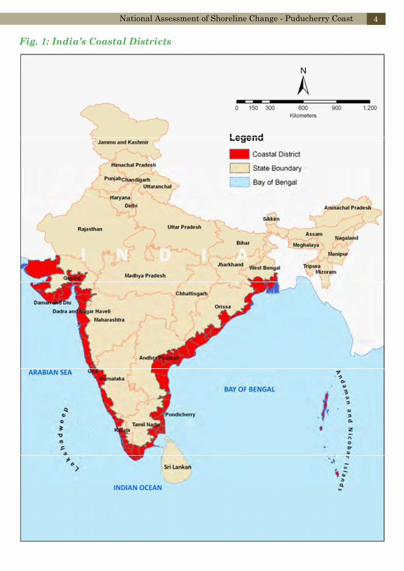
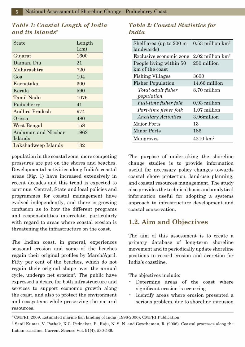
India covers an area of 32,87,263 km2 extending from Himalayas in the North to the Gulf of Mannar in the South. India’s coastline is 8158 km long; of this, the coastline of peninsular India is 6064 km, and the islands of Andaman and Nicobar and Lakshadweep account for 2094 km. Fig. 1 shows the extent of the coastal districts along the east and west coast of India. Tables 1 and 2 provide information on the coastal length of individual States/ Union Territory and the coastal statistics respectively. According to the Indian Naval Hydrographic charts, the mainland coast consists of 43 % sandy beaches, 11 % rocky coast including cliffs, and 46 % mud flats or marshy coast. Notable coastal features of India, comprise the marshy Rann of Kutch in the West and the alluvial Sundarbans Delta in the East, which India shares with Bangladesh. India has two archipelagos - the Lakshadweep coral atolls beyond India’s South-Western coast, and the Andaman and Nicobar Islands, a volcanic island chain in the Bay of Bengal and Andaman Sea. The Indian coastline can be divided into four categories: Gujarat region; West coast; East coastal plains and Andaman, Nicobar and Lakshadweep Islands.
The shorelines and beaches in India serve multi-dimensional needs such as recreational, seaport for maritime commerce, residential and commercial structures. With the growth of
National Assessment of Shoreline Change - Puducherry Coast 4
Fig. 1: India’s Coastal Districts
population in the coastal zone, more competing pressures are put on the shores and beaches. Developmental activities along India’s coastal areas (Fig. 1) have increased extensively in recent decades and this trend is expected to continue. Central, State and local policies and programmes for coastal management have evolved independently, and there is growing confusion as to how the different programs and responsibilities interrelate, particularly with regard to areas where coastal erosion is threatening the infrastructure on the coast.
The Indian coast, in general, experiences seasonal erosion and some of the beaches regain their original profiles by March/April. Fifty per cent of the beaches, which do not regain their original shape over the annual cycle, undergo net erosion3. The public have expressed a desire for both infrastructure and services to support economic growth along the coast, and also to protect the environment and ecosystems while preserving the natural resources.
State Length (km)
Gujarat 1600Daman, Diu 21Maharashtra 720Goa 104Karnataka 300Kerala 590Tamil Nadu 1076Puducherry 41Andhra Pradesh 974Orissa 480West Bengal 158Andaman and Nicobar Islands
1962
Lakshadweep Islands 132
Table 1: Coastal Length of India and its Islands2
2 CMFRI. 2009. Estimated marine fish landing of India (1996-2006), CMFRI Publication3 Sanil Kumar, V. Pathak, K.C. Pednekar, P., Raju, N. S. N. and Gowthaman, R. (2006). Coastal processes along the Indian coastline. Current Science Vol. 91(4), 530-536.
Table 2: Coastal Statistics for India
Shelf area (up to 200 m landwards)
0.53 million km2
Exclusive economic zone 2.02 million km2
People living within 50 km of the coast
250 million
Fishing Villages 3600Fisher Population 14.66 million
Total adult fisher population
8.70 million
Full-time fisher folk 0.93 million Part-time fisher folk 1.07 million Ancillary Activities 3.96millionMajor Ports 13Minor Ports 186Mangroves 4210 km2
National Assessment of Shoreline Change - Puducherry Coast5
The purpose of undertaking the shoreline change studies is to provide information useful for necessary policy changes towards coastal shore protection, land-use planning, and coastal resources management. The study also provides the technical basis and analytical information useful for adopting a systems approach to infrastructure development and coastal conservation.
1.2. Aim and Objectives
The aim of this assessment is to create a primary database of long-term shoreline movement and to periodically update shoreline positions to record erosion and accretion for India’s coastline.
The objectives include:Determine areas of the coast where • significant erosion is occurringIdentify areas where erosion presented a • serious problem, due to shoreline intrusion

National Assessment of Shoreline Change - Puducherry Coast 6
that required action to protect the coastal infrastructureQuantify the rates of erosion/ accretion • along the nation’s coastlineCreate a national database for coastal • erosion and accretion with 1972 as the base yearDevelop a national record of shoreline • positionsContribute to an understanding and • prediction of future shoreline changes and Provide State and local authorities with • information for action to prevent further erosion
This report summarizes historical changes in shoreline, both accretion and erosion, and emphasizes the erosion hazard because of its impacts on natural resources and the economy. The descriptions of coastal land loss for each
region within the Union Territory of Puducherry are provided to enable comprehensive view of coastal processes and key references that can be used to learn further about coastal change in the national context.
It must be emphasized that the zones of change presented in this report represent conditions up to the date of the most recent shoreline data (2010) and therefore are not intended for predicting future shoreline positions or rates of change. Coastal engineering structures that exist nearly all along the Puducherry coast affect the rates of shoreline change, which vary substantially along the coast. However, it is difficult to isolate the influence of structures on the regional shoreline movement/ change, and such an endeavor is beyond the scope of this assessment.
2. Physical Features
Coastal Geomorphology
Coastal Physical Process
Meteorological Data
Oceanographic Data
Coastal Sediments
Coastal Pollution
Puducherry region is situated on the Coromandel coast between 11°45’ and 12°03’ N latitudes and 79°37’ and 79°53’ E longitudes with an area of 293 km2. It is divided into seven communes, viz, Puducherry, Ozhukarai, Bahour, Ariyankuppam, Villiyanur, Nettapakkam and Mannadipet and comprises 164 inhabited villages. The Union Territory of Puducherry consists of four unconnected parts: Puducherry, Karaikal, Yanam on the Bay of Bengal and Mahé on the Arabian Sea. Puducherry and Karaikal are by far the larger ones (Figs. 2 and 3), and are both enclaves of Tamil Nadu. Yanam and Mahé are enclaves of Andhra Pradesh and Kerala, respectively. The Union Territory has a total area of 492 km²: Puducherry 293 km2, Karaikal 160 km2, Mahé 9 km2 and Yanam 30 km2. In this report, shoreline assessment has been undertaken only for the coasts of Puducherry and Karaikal.
There are two major rivers draining this region 1) the Gingee River, which traverses the region diagonally from north-west to south-east and 2) the Ponnaiyar (Penniyar) River, which forms the southern border of the region. The River Gingee also known as the Varahanadi or Sankaraparani has its source in the hills
of Malayanur of Villupuram district, before it joining the Bay of Bengal. The river Ponnaiyar originates from the hills of Karnataka and enters the Puducherry region after flowing through the districts of Dharmapuri, Salem, Vellore and Cuddalore of Tamil Nadu. All the rivers are ephemeral in nature.
Puducherry’s average elevation is at sea level, and a number of sea inlets, referred to as “backwaters” are present. The terrain is gently undulating with prominent high grounds varying from 30 to 45m above Mean Sea Level (MSL) towards interior northwest and northeastern parts of the region. The three major physiographic units generally observed are coastal plain (younger and older), alluvial plain and uplands. The length of coastline of the Union Territory of Puducherry including Karaikal is 41km (Fig 3).
The coast is of open type with estuaries. Though the regional coastline appears to be almost straight, it is a part of a larger concave coast. The coastal erosion or accretion takes place as part of a natural cycle and there is a balance annually and seasonally between accretion and erosion.
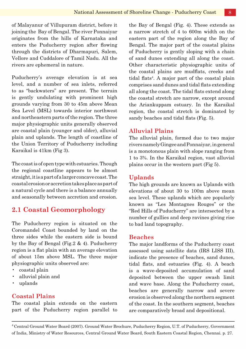
2.1 Coastal Geomorphology
The Puducherry region is situated on the Coromandel Coast bounded by land on the three sides while the eastern side is bound by the Bay of Bengal (Fig.2 & 4). Puducherry region is a flat plain with an average elevation of about 15m above MSL. The three major physiographic units observed are:
coastal plain• alluvial plain and • uplands•
Coastal PlainsThe coastal plain extends on the eastern part of the Puducherry region parallel to
the Bay of Bengal (Fig. 4). These extends as a narrow stretch of 4 to 600m width on the eastern part of the region along the Bay of Bengal. The major part of the coastal plains of Puducherry is gently sloping with a chain of sand dunes extending all along the coast. Other characteristic physiographic units of the coastal plains are mudflats, creeks and tidal flats4. A major part of the coastal plain comprises sand dunes and tidal flats extending all along the coast. The tidal flats extend along the coastal stretch are narrow, except around the Ariankuppam estuary. In the Karaikal region, the coastal stretch is dominated by sandy beaches and tidal flats (Fig. 5).
Alluvial PlainsThe alluvial plain, formed due to two major rivers namely Gingee and Ponnaiyar, in general is a monotonous plain with slope ranging from 1 to 3%. In the Karaikal region, vast alluvial plains occur in the western part (Fig 5).
UplandsThe high grounds are known as Uplands with elevations of about 30 to 100m above mean sea level. These uplands which are popularly known as “Les Montagnes Rouges” or the “Red Hills of Puducherry” are intersected by a number of gullies and deep ravines giving rise to bad land topography.
BeachesThe major landforms of the Puducherry coast assessed using satellite data (IRS LISS III), indicate the presence of beaches, sand dunes, tidal flats, and estuaries (Fig. 4). A beach is a wave-deposited accumulation of sand deposited between the upper swash limit and wave base. Along the Puducherry coast, beaches are generally narrow and severe erosion is observed along the northern segment of the coast. In the southern segment, beaches are comparatively broad and depositional.
National Assessment of Shoreline Change - Puducherry Coast 8
4 Central Ground Water Board (2007). Ground Water Brochure, Puducherry Region, U.T. of Puducherry, Government of India, Ministry of Water Resources, Central Ground Water Board, South Eastern Coastal Region, Chennai. p. 27.

Fig. 2: Coastal districts of Puducherry
National Assessment of Shoreline Change - Puducherry Coast9

Fig 3: Coastal districts of Karaikal
National Assessment of Shoreline Change - Puducherry Coast 10
Barrier Dunes/ Sand DunesBarrier dunes are seen as continuous mounds between Ariyankuppam, Kirumambakkam, Manapattu and Narimedu areas. Dunes are also seen almost on the entire coast except at Manaveli, Pooranankuppam and Manapattu coastal blocks.
Estaurine MouthsEstuarine mouths are prominent at Ariankuppam, north of Pooranankuppam and in the southern segment where both Gingee and Ponnaiyar rivers join the Bay of Bengal.
2.2. Coastal Physical Processes Natural coastal development is determined by the laws of physics. The processes are not restricted by administrative borders and the powers of the wind, waves and current alter the coastline. This section introduces the physical aspects that have direct influence on the coastal environment and thus on its management process. Often some of these physical aspects, related with the coastal system behavior are neglected, leading sometimes to management errors.
2.2.1 Meteorological Dataa) ClimateClimate is the long term average of daily, monthly and seasonal weather. Climate includes the range of temperature, the amount of precipitation, winds and extreme events such as tropical cyclones. Climate varies from place to place across the Earth’s surface because of variations in the amount of the sun’s energy or solar radiation. The climate of India may be broadly described as tropical monsoonal type. Its climate is affected by two seasonal winds, the North- East monsoon and the South-West monsoon. The North-East monsoon, commonly known as the winter monsoon blows from land to sea, whereas the South-West monsoon, known as the summer monsoon blows from sea to land after crossing the Indian Ocean, the Arabian Sea, and the Bay of Bengal.
The South-West monsoon brings most of the rainfall during a year in the country.
The Puducherry region receives its precipitation mainly during the northeast monsoon. May and early part of June constitute the hottest period of the year, with the mean daily maximum temperature at about 37°C and the mean daily minimum temperature at about 27°C. On individual days, the maximum temperature may even reach 43°C. The lowest temperature recorded is of the order of 11.1°C4.
b) RainfallRainfall is derived from moisture taken up by evaporation over the oceans and some tropical lowlands, and transferred to the continents by onshore winds. Wet season persists mainly during the north east monsoon period between October and December. The region receives the rain under the influence of both southwest and northeast monsoons. Most of the precipitation occurs in the form of cyclonic storms caused due to depressions in Bay of Bengal primarily during Northeast monsoon. Rainfall data analysis shows that the normal annual rainfall in the Puducherry region is 1272.7 mm. 62% of the annual normal is received during northeast monsoon and about 26% during the southwest monsoon season, with November receiving maximum rainfall. The heaviest rainfall in 24 hours recorded at Puducherry station was 167.0 mm on 23rd October 1990.
c) WindWind has three vital roles in the coastal zone: (i) it drives ocean currents (ii) generates ocean waves and (iii) blows beach sand inland to form sand dunes. Wind blowing over the ocean moves the surface, forming surface currents, which flow in the direction of wind. At the shore, offshore winds can cause the surface waters to move offshore, with the warmer surface water replaced by cooler water welling up from the seabed, and this can result in a sharp drop in water temperature.
National Assessment of Shoreline Change - Puducherry Coast11

Fig.
4: C
oast
al G
eom
orph
olog
y of
Pud
uche
rry
National Assessment of Shoreline Change - Puducherry Coast 12

Fig.
5: C
oast
al G
eom
orph
olog
y of
Kar
aika
lNational Assessment of Shoreline Change - Puducherry Coast13
During the south-west monsoon between March and September, the wind blows predominantly from the west and south-west directions. From June through August, strong wind is experienced from the south-west direction in the morning, from south during afternoon and from south-east at night. The north-east monsoon begins in October. Wind first blows from the coast then changes to the northern direction in December and gradually decreases in force during January and February. The direction also changes from northeast to east. The average wind velocity during north-east monsoon is 8.7 km hr-1 at 08.30 hr and 12.5 km hr-1. at 17.30 hrs. During summer, winds blow at 10.2 km hr-1 at 08.30 hrs and 18.1 km hr-1 at 17.30 hrs. The maximum wind speed is about 19km hr-1 in this region. The basic wind speed at 10m height for Puducherry coast5 has been estimated to be 50 m sec-1. Estimated longshore sediment transport rates show that the net transport along the east coast of India is towards the north.
d) CyclonesCyclones are low pressure systems which form over oceans and have inward spiraling, moist rising air. The Pondicherry and Karaikal regions are exposed to cyclones and floods. The coast of Puducherry and Karaikal are affected by Cyclones/ Severe Cyclones which originate from the Bay of Bengal and move in a westerly northwesterly direction. Highest wind speed of 189 km/hr and the lowest wind speed of 83 km/hr have crossed the Puducherry coast in the past. Cyclone data over the Bay of Bengal since 1891 indicates that on average, a moderate to severe cyclone hits the Tamil Nadu and Puducherry coasts every two years.
2.2.2 Oceanographic Data
a) TidesTides are the second major source of marine energy that shape coastal landforms. Unlike waves, which depend on winds for their generation, tides occur because the gravitational pull of the Moon and Sun, acting on a rotating Earth, causes a very slight budge in the ocean surface. The Moon, being closer, contributes two-thirds of the tidal force and the more distant Sun the remaining one-third. The period or time between the tides is precise and can be predicted years in advance because the orbital characteristics of all three are quite precise. The Moon or lunar tide has a period of 12.42 hours, while the Sun tide occurs every 24 hours. This results in the two going in and out of phase on a 14 and 28-day cycle, the later known as the “lunar tidal cycle”, or “lunar month”. Tides are highest (spring tides) when the Moon and Sun are aligned and in phase, and when they combine their gravitational pull. Tides are lowest (neap tides) when they are at right angles and 90 degrees out of phase.
For the Puducherry coast, the tidal range is low and the maximum range during a spring tide is around 0.8m. Recorded tide levels at Puducherry with respect to chart datum are:Mean High Water Spring (MHWS):+ 1.30 mMean High Water Neap (MHWN): + 1.00 mMean Low Water Neap (MLWN): + 0.70 mMean Low Water Spring (MLWS): + 0.49 m
b) CurrentsOcean currents refer to the wind driven movement of the ocean surface. The ocean surface is that thin layer of surface water that is warmed by solar radiation to a depth of about 200 meters, below which are the cooler, deep ocean waters, that extend to 4-5 km depths. While ocean currents only occasionally have a direct impact on parts of the coast, they do
National Assessment of Shoreline Change - Puducherry Coast 14
5 Sanil Kumar, V. Pathak, K.C. Pednekar, P., Raju, N. S. N. and Gowthaman, R. (2006). Coastal processes along the Indian coastline. Current Science Vol. 91(4), 530-536

play a major role in coastal climate and ocean temperature. The tidal currents observed in the vicinity of Ariyankuppam River mouth indicate uni-directional current from north to south during flooding as well as ebbing tides and the maximum strength of the current as observed is 0.26 m sec-1.
c) WavesOcean waves are the single most important process affecting the coast. They provide most of the energy to form and shape the shoreline. Ocean waves are a product of winds blowing over the surrounding oceans, and thus are related to atmospheric climate. Wave climate contributes the waves that break daily around the Indian coast, and provide most of the energy to drive coastal evolution. They are therefore highly relevant at a range of time scales. Waves are generated by wind blowing over the ocean surface and wave height and period (the time between successive waves) are directly related to four factors: wind velocity, wind duration, the fetch or length of ocean over which the wind blows and the depth of the ocean. At Puducherry, deepwater waves occur from the south and southwest during the southwest monsoon and from northeast during the northeast monsoon. The wave heights rarely exceed 0.9m during these periods.
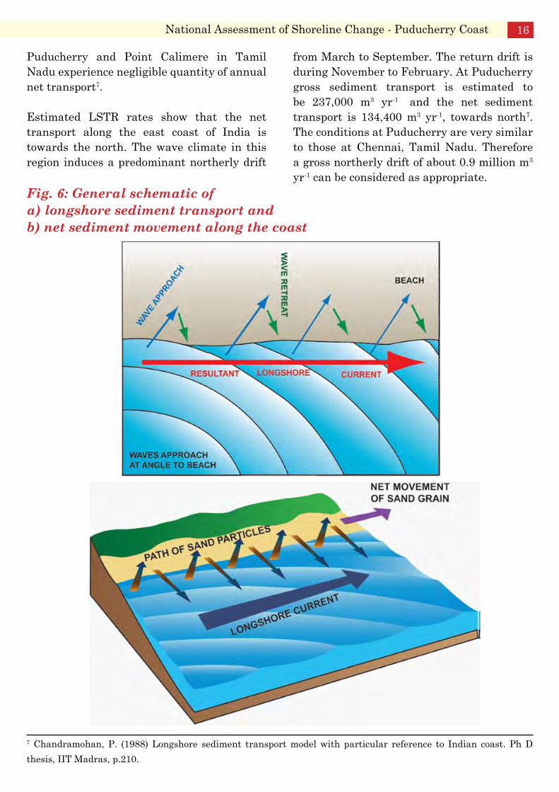
d) Littoral Drift/ Sediment TransportLittoral Drift/ Sediment Transport is a function of nature, level and direction of wave, tide, river or wind energy, and size of the sediment being transported. Sediment size is highly relevant to sediment transportation by waves, currents and wind, and as a consequence most sediments on the open coast are graded by their transportability. Once sediment is delivered to the coast by rivers, waves or shoreline erosion, it may be transported in one of three directions: a) onshore, b) offshore and c) longshore6. The sediment is also part of
a littoral, or coastal, sediment cell, to which sediment may be added or lost. This affects the sediment budget and, as a consequence, the stability of the shoreline.
e) Onshore sediment transport Onshore sediment transport is primarily driven by waves, with the sediment deposited as a beach, then possibly blown further onshore by wind to build coastal dunes. It is also moved by waves and tidal currents to be deposited in tidal inlets and tidal deltas. Sand deposited in dunes and tidal deltas may be permanently lost from the system, resulting in net loss of sediment6.
f) Offshore transport Offshore transport is driven by high-wave conditions, which can generate strong seaward currents and which may deposit the sand so far offshore it is lost from the system6.
g) Longshore transport This relates to the movement of sediment along the coast, particularly in the surf zone and along beaches. Sediment moves along the coast until it reaches a sink: i.e. a place of permanent removal from the transportation system into a beach, dune, tidal delta or offshore6. Sediment deposition/siltation noticed at most of the harbour channels and river mouths are mainly due to their interference to free passage of longshore sediment transport (Fig. 6) Along the east coast, longshore transport is southerly from November to February, northerly from April to September and variable in March and October. Chandramohan (1988) estimated the Longshore Sediment Transport Rate (LSTR) based on ship-reported data. He reported that coasts near Tarangampadi, Karaikal, Nagore, Tuticorin, Virapandiapattinam and Manakkodam behaved like nodal drift points, with an equal volume of transport in either direction annually. The coast between
6 Short, A.D., and Woodroffe, C.D. (2009). The Coast of Australia. Cambridge University Press, 288pp
National Assessment of Shoreline Change - Puducherry Coast15
Puducherry and Point Calimere in Tamil Nadu experience negligible quantity of annual net transport7.
Estimated LSTR rates show that the net transport along the east coast of India is towards the north. The wave climate in this region induces a predominant northerly drift
from March to September. The return drift is during November to February. At Puducherry gross sediment transport is estimated to be 237,000 m3 yr-1 and the net sediment transport is 134,400 m3 yr-1, towards north7. The conditions at Puducherry are very similar to those at Chennai, Tamil Nadu. Therefore a gross northerly drift of about 0.9 million m3 yr-1 can be considered as appropriate.
Fig. 6: General schematic of a) longshore sediment transport and b) net sediment movement along the coast
National Assessment of Shoreline Change - Puducherry Coast 16
7 Chandramohan, P. (1988) Longshore sediment transport model with particular reference to Indian coast. Ph D thesis, IIT Madras, p.210.
2.2.3 Coastal Sediments
Studies indicate that rock is not expected up to –20m below chart datum. Top layers of soil consist of silty-fine sand to medium sand followed by a layer of marine silty-clay. Below this is dense to very dense medium to coarse sand.
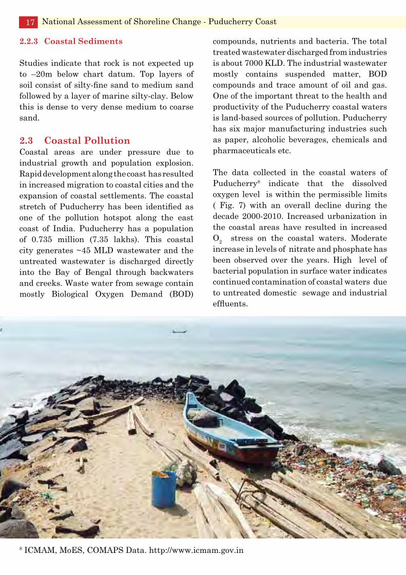
2.3 Coastal PollutionCoastal areas are under pressure due to industrial growth and population explosion. Rapid development along the coast has resulted in increased migration to coastal cities and the expansion of coastal settlements. The coastal stretch of Puducherry has been identified as one of the pollution hotspot along the east coast of India. Puducherry has a population of 0.735 million (7.35 lakhs). This coastal city generates ~45 MLD wastewater and the untreated wastewater is discharged directly into the Bay of Bengal through backwaters and creeks. Waste water from sewage contain mostly Biological Oxygen Demand (BOD)
compounds, nutrients and bacteria. The total treated wastewater discharged from industries is about 7000 KLD. The industrial wastewater mostly contains suspended matter, BOD compounds and trace amount of oil and gas. One of the important threat to the health and productivity of the Puducherry coastal waters is land-based sources of pollution. Puducherry has six major manufacturing industries such as paper, alcoholic beverages, chemicals and pharmaceuticals etc.
The data collected in the coastal waters of Puducherry8 indicate that the dissolved oxygen level is within the permissible limits ( Fig. 7) with an overall decline during the decade 2000-2010. Increased urbanization in the coastal areas have resulted in increased O2 stress on the coastal waters. Moderate increase in levels of nitrate and phosphate has been observed over the years. High level of bacterial population in surface water indicates continued contamination of coastal waters due to untreated domestic sewage and industrial effluents.
National Assessment of Shoreline Change - Puducherry Coast17
8 ICMAM, MoES, COMAPS Data. http://www.icmam.gov.in

Fig. 7: Trends in pollution levels of coastal waters at Puducherry
National Assessment of Shoreline Change - Puducherry Coast 18
3.1 Major Socio-ecological Drivers
The coastline of Puducherry is under major pressure from a range of drivers, which include:
Population growth • Industrialization• Tourism • Aquaculture• Climate change•
These drivers have resulted in state changes such as:
Increased domestic and industrial effluents • causing changes in water quality (both water movements, e.g., flooding and drainage patterns, salinity and sediment loads)Change in coastal geomorphology due to • dredging and changed land use patternsHabitat destruction (particularly of • sensitive environments such as mangroves and backwaters), e.g., the expansion of aquaculture production at the expense of mangrove forestsClimate-related impacts (including sea-• level rise and changes in coastal weather), declining resourcesLoss of biodiversity
3. Socio-Ecological Systems
Major Socio-Ecological Drivers
Ecologically Sensitive Areas
Fishery Resources
Coastal Livelihood
These changes are indicated by:Increased domestic and industrial effluent • causing changes in water qualityChanges in water movements, e.g., flooding, • drainage patterns (run-off/seasonality) and sediment loadsChanges in salinity• Declining oxygen conditions•
National Assessment of Shoreline Change - Puducherry Coast 20
Shoreline changes, especially erosion• Loss of coastal biodiversity•
Economic development has been most active in coastal zones, and is the main driver of change in coastal ecosystems. Offshore mineral exploration and production activities are further sources of pollutants. A few of the most critical socioeconomic drivers of the degradation of the coastlines are given in Table 3.
Table 3: Some critical socioeconomic drivers of the coast
Driver Pressure ImpactAgriculture Reclamation of coastal wetlands•
Use of fertilizers and pesticides• Abstraction of water / large • irrigation schemes
Water quality impairment due to • nutrients resulting in eutrophicationLoss of biodiversity• Reduction in freshwater flow•
Aquaculture Conversion of mangroves, • agricultural lands into aquaculture farmsUse of biocides, nutrients•
Loss of biodiversity• Water quality impairment due to • nutrients resulting in eutrophication
Fisheries Coastal and deep-sea fisheries• Reduction in catch due to over-• exploitation of resources
Forestry Mangrove forest products • harvesting;Large-scale upland deforestation•
Loss of biodiversity• Increased erosion during rains and higher • sediment load in water
Energy Coastal and offshore oil and gas • exploration and operationCoastal power generation• Large inland hydroelectric dams•
Oil pollution• Impaired water quality due to water • release at higher temperatures from power plantsReduction in freshwater flow• Reduction in sediment load•
Industry Coastal industrial plants• Coastal and marine mining (e.g., • sand)Salt extraction• Industrial waste disposa•
Impaired water quality due to release • of untreated/partially treated effluents containing metals and other chemicals
Tourism Coastal hotels and recreation • facilitiesSewage and waste disposal•
Waste discharges and microbial pollution• Change in land use due to constructions, • changes in drainage patternsLoss of biodiversity due to land use • changes
Transportation Waste discharges and microbial • pollutionChange in land use due to • constructions, changes in drainage patternsLoss of biodiversity due to land • use changes
Water quality impairment due to disposal • of dredging spoilsIncreased water turbidity• Water quality impairment due waste • disposalShoreline changes, changes in land use • patterns
The four major impacts of land based activities on the coastal marine environment include:
Changes in freshwater flow/sediment load; 1. siltation/erosion/soil compactionWater quality impairment due to excess 2. nutrientsWater quality impairment due to chemical/3. metal pollutionLoss of biodiversity due to loss of habitat4.
3.2 Ecologically Sensitive Areas
Ecologically significant areas (ESA) are those areas ‘that are ecologically and economically important, but vulnerable even to mild disturbances, and hence demand careful management’. Gadgil et al (2011)9 consider ‘ecologically and economically important’ areas as those areas that are biologically and ecologically ‘rich’, ‘valuable’ and or ‘unique’, and are largely irreplaceable if destroyed. Further, by virtue of their biological richness, they could be potentially of high value to human societies, help in maintaining the ecological stability of the area, and be significant in conserving biological diversity. Similarly, their ‘uniqueness’ may be recognized either by the rarity of the living systems they
National Assessment of Shoreline Change - Puducherry Coast21
9 Gadgil, M., Ranjit Daniels, R. J. Ganeshaiah, K. N. Narendra Prasad, S. Murthy, M. S. R. Jha, C. S., Ramesh, B. R. and Subramanian, K. A. (2011). Mapping ecologically sensitive, significant and salient areas of Western Ghats: Proposed protocols and methodology. Current Science, 100 (2), 175 - 182.
Urbanization Shoreline modification• Waste disposal (e.g., landfills)• Water and sewerage development• Urbanization of coastal areas in • natural or semi-natural state, upland watershedsGroundwater abstraction•
Water quality impairment due to higher • nutrient loads, suspended solids, organic loadsImpact on coastal ecosystems, e.g., coral • reefs, sea grass beds due to suspended solids, higher turbidity, reduced photosynthesisSubsiding cities due to soil compaction• Loss of biodiversity• Water quality impairment due to trace • metals and microbial pollutionHealth impact for coastal people due to • arsenic and fluoride intake
harbour, that are difficult to replace if lost, or by the uniqueness of the services they offer to human society. Their ‘vulnerability’ could be determined by physiographic features that are prone to erosion or degradation under human and other influences such as erratic climate, and on the basis of historical experience. Their significance may lie in their biological value, ecological value, economic value, cultural and historical values, and also in being sensitive to external natural and anthropogenic pressures. Therefore, they need to be conserved taking the local context into account, on the basis of graduated or layered regulations as well as positive incentives depending upon their intrinsic value and extent of resilience.
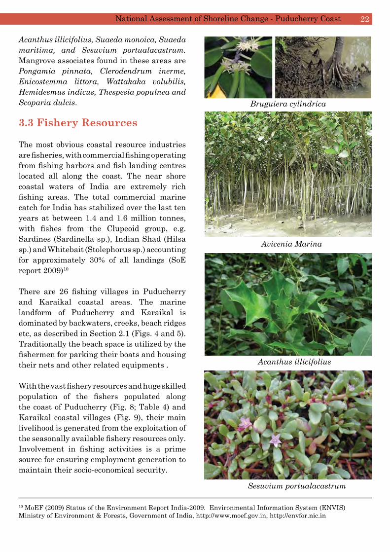
In Puducherry, mangroves exist as fringing vegetation distributed along the banks of the Ariankuppam estuary/backwaters. Though the waterway is a tributary of the river Gingee, freshwater input to this mangrove area is minimal and it mainly receives municipal and agricultural discharges. This tide-dominated estuary opens into the Bay of Bengal. Seven true mangrove floral species belonging to three families have been identified.
The prominent species of mangroves found in this region include Bruguiera cylindrica, Rhizophora apiculata, Avicennia marina,
National Assessment of Shoreline Change - Puducherry Coast 22
Acanthus illicifolius, Suaeda monoica, Suaeda maritima, and Sesuvium portualacastrum. Mangrove associates found in these areas are Pongamia pinnata, Clerodendrum inerme, Enicostemma littora, Wattakaka volubilis, Hemidesmus indicus, Thespesia populnea and Scoparia dulcis.
3.3 Fishery Resources
The most obvious coastal resource industries are fisheries, with commercial fishing operating from fishing harbors and fish landing centres located all along the coast. The near shore coastal waters of India are extremely rich fishing areas. The total commercial marine catch for India has stabilized over the last ten years at between 1.4 and 1.6 million tonnes, with fishes from the Clupeoid group, e.g. Sardines (Sardinella sp.), Indian Shad (Hilsa sp.) and Whitebait (Stolephorus sp.) accounting for approximately 30% of all landings (SoE report 2009)10
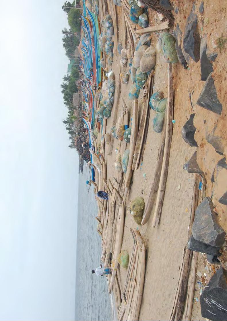
There are 26 fishing villages in Puducherry and Karaikal coastal areas. The marine landform of Puducherry and Karaikal is dominated by backwaters, creeks, beach ridges etc, as described in Section 2.1 (Figs. 4 and 5). Traditionally the beach space is utilized by the fishermen for parking their boats and housing their nets and other related equipments .
With the vast fishery resources and huge skilled population of the fishers populated along the coast of Puducherry (Fig. 8; Table 4) and Karaikal coastal villages (Fig. 9), their main livelihood is generated from the exploitation of the seasonally available fishery resources only. Involvement in fishing activities is a prime source for ensuring employment generation to maintain their socio-economical security.
Bruguiera cylindrica
Avicenia Marina
Acanthus illicifolius
Sesuvium portualacastrum
10 MoEF (2009) Status of the Environment Report India-2009. Environmental Information System (ENVIS) Ministry of Environment & Forests, Government of India, http://www.moef.gov.in, http://envfor.nic.in
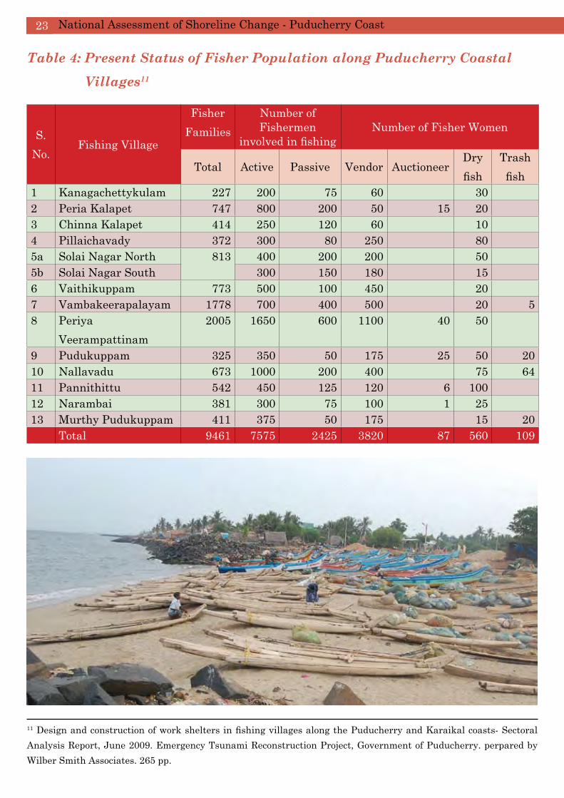
Table 4: Present Status of Fisher Population along Puducherry Coastal Villages11
S. No.
Fishing Village
Fisher Families
Number of Fishermen
involved in fishingNumber of Fisher Women
Total Active Passive Vendor AuctioneerDry fish
Trash fish
1 Kanagachettykulam 227 200 75 60 30 2 Peria Kalapet 747 800 200 50 15 20 3 Chinna Kalapet 414 250 120 60 10 4 Pillaichavady 372 300 80 250 80 5a Solai Nagar North 813 400 200 200 50 5b Solai Nagar South 300 150 180 15 6 Vaithikuppam 773 500 100 450 20 7 Vambakeerapalayam 1778 700 400 500 20 58 Periya
Veerampattinam2005 1650 600 1100 40 50
9 Pudukuppam 325 350 50 175 25 50 2010 Nallavadu 673 1000 200 400 75 6411 Pannithittu 542 450 125 120 6 100 12 Narambai 381 300 75 100 1 25 13 Murthy Pudukuppam 411 375 50 175 15 20 Total 9461 7575 2425 3820 87 560 109
National Assessment of Shoreline Change - Puducherry Coast23
11 Design and construction of work shelters in fishing villages along the Puducherry and Karaikal coasts- Sectoral Analysis Report, June 2009. Emergency Tsunami Reconstruction Project, Government of Puducherry. perpared by Wilber Smith Associates. 265 pp.

National Assessment of Shoreline Change - Puducherry Coast 24Fi
g. 8
: Loc
atio
n of
Maj
or F
ishi
ng V
illa
ges
alon
g th
e a)
Pud
uche
rry
Coa
st a
nd b
) K
arai
kal C
oast
11 (m
aps
not t
o sc
ale)
Fig.
9: L
ocat
ion
of m
ajor
fish
land
ing
cent
res
alon
g th
e P
uduc
herr
y an
d K
arai
kal c
oast
s

Tab
le 5
: Mar
ine
Fish
Cat
ch a
long
the
Pud
uche
rry
Coa
st (1
985-
200
4) 12
Year
s19
8519
8619
8719
8819
8919
9019
9119
9219
9319
9419
9519
9619
9719
9819
9920
0020
0120
0220
0320
04E
lasm
o-br
anch
s46
812
0828
034
816
623
413
226
816
958
611
614
897
456
458
569
358
394
427
393
Clu
peid
s66
1648
4647
7530
1350
8679
6639
2061
8726
6739
8740
0312
446
1405
778
5273
4042
4133
6134
9775
0495
55L
izar
d F
ishe
s16
424
924
659
9812
912
915
910
244
4748
3151
257
1659
282
3913
4F
lyin
g F
ishe
s53
824
119
788
310
5812
245
421
776
051
1318
170
2216
5420
561
879
95P
erch
es14
2889
575
774
042
355
640
437
828
942
738
823
819
615
445
540
632
211
7794
480
6G
oatfi
shes
145
7812
114
934
834
920
680
6640
2511
958
5784
835
993
272
4842
6T
hrea
dfins
2235
3217
2525
2212
246
1517
1921
2919
175
630
Cro
aker
s46
344
947
341
420
615
114
214
610
411
633
020
687
229
227
212
309
272
148
164
Rib
bon
Fis
hes
3812
311
020
8791
2836
9510
225
2122
2839
431
7916
951
73C
aran
gids
1119
575
666
943
676
730
420
333
250
581
847
981
1200
269
478
554
1035
593
466
411
Silv
erbe
llies
1359
1095
871
329
489
418
406
561
461
495
526
373
123
408
411
479
318
1597
249
568
Pom
fret
s32
3550
4542
3711
013
148
979
1421
530
131
745
7M
acke
rels
1249
1502
2203
582
1155
1121
866
1780
3692
1480
3172
2610
3483
1888
2656
1498
1362
3681
1718
2660
Seer
Fis
hes
134
112
144
7682
6190
117
6810
015
321
024
598
555
284
128
530
129
232
Tunn
ies
4712
672
163
144
2430
727
812
848
4727
158
228
419
663
456
734
261
363
Bil
l Fis
hes
3387
527
1422
1452
299
4014
013
4799
2286
4934
Bar
racu
das
7919
4228
554
162
4679
117
6752
7041
3810
137
4821
646
43M
ulle
ts7
3847
81
328
105
815
414
486
3641
2115
68F
lat F
ishe
s24
027
621
514
013
617
630
417
411
214
820
385
8498
117
4294
147
254
137
Cru
stac
eans
1204
947
826
796
564
1249
1090
686
471
1050
1253
556
450
1010
507
450
485
1000
221
704
Mol
lusc
s82
4367
2811
210
923
719
333
3819
020
117
117
221
9917
6322
2217
6976
5
National Assessment of Shoreline Change - Puducherry Coast25
12 S
ourc
e: C
MF
RI,
200
8

National Assessment of Shoreline Change - Puducherry Coast 26
Karaikal region lies at 10º 49’ N and between 79º 43’E and 79º 52’ E and is about 150 km further south of Puducherry, isolated within the Thanjavur District bounded on the east by the Bay of Bengal. It is bound on the north by Nandalar and on the south by the Vettar. The
fishing villages of Karaikal are spread over a total length of ~15 km along the south east coast of India, between Mandapathur fishing village on the north and North Vanjoore on the south (Fig. 8). The distance between the fishing villages varies from 0.3 to 4.2 km11.
Fig. 10: Types of fishery resources along the Puducherry coast
Fig. 11: Annual fish landings (1985 - 2008) at Puducherry coast11

The growth in fish production over the last few decades, mainly driven by large scale mechanization and larger investment, has been phenomenal. Fishing fleets had also exceeded capacities. Regarding the sustainability of the specific fisheries, a remarkable reduction in the share of their percentage contribution in the total landing trend was noticed in the specific fish groups like seer fishes, carangids, Anchovies, Elasmobranches and Pomfrets in the case of Puducherry coastal landing (Table 5; Figs 9 and 10). When analyzing the marine landing trend the contribution of present share is considerably declining in commercially important specific groups like Elasmobranches, Carangids, Indian mackerel and Penaid prawns. This decline may be due to the migration of fishing fleets to the potential fishing grounds available in Tamil Nadu State coastal areas such as Nagapattinam
and nearby villages and hence the fish species caught by the Puducherry fishermen may not be recorded in the Karaikal coastal landing estimates.
3.4 Coastal Livelihood
A livelihood comprises the capabilities, assets (including both material and social resources) and activities required for a means of living. There are multiple opportunities of livelihood for the traditional coastal communities of the Puducherry region. Hence multiple livelihoods are not uncommon. Fishing, felling of mangrove trees and casuarina plantations, industrial employment, cargo and passenger transport, unskilled and semi-skilled work in construction activities, boat building/ repairing etc, are examples of livelihoods, other than fishing activities for the coastal communities11
National Assessment of Shoreline Change - Puducherry Coast27

4. Human Interventions
Coastal Infrastructure
Landuse
4.1 Coastal Infrastructure
Over the past 50 years there has been accelerated migration to the coast, with residential, industrial and tourism development in major coastal cities and regional coastal towns/centres of India reflecting a lifestyle change encapsulated by the term “sea change”. Coastal development until the 1990s was focused on managing nature: sea walls and shore-normal structures called groynes were built on some beaches, raw sewage was pumped out to sea and in places, inappropriate development occurred either too close to the shore or in sensitive ecosystems. A recent change in emphasis has occurred, from reactive “human versus nature” approaches as in the case of coastal protection, to the proactive management of dynamic coastal systems.
The Puducherry Port is planned to accommodate barges, steamboats and large vessels; however, today it serves only as a fishing harbor. The construction of two breakwaters is the principal cause of Puduch¬erry’s coastal erosion. These two breakwaters obstruct the natural south to north drift of sand during the monsoons. Since the opening of mouth of the estuary in 1993, frequent dredging has been engaged to allow large fishing boats for landing. This was intensified since 2000 to construct a new fish landing port east of Thengaithittu.The mouth, being narrow, experiences frequent sand accretion due to wave action, necessitating regular dredging at the mouth.
The minor port in Pondicherry constructed in 1986 consists of a pile supported jetty connected with an offshore breakwater. The length of the northern breakwater is 50m and southern breakwater is about 120m. This breakwater was constructed with the provision of sand bypassing system of about 400,000 m3 yr-1. However, the sand bypassing system has not been utilized appropriately. Because of this, deposition occurred on the south side of the breakwater and erosion on the north side of the northern breakwater. For protection of shoreline erosion, the Puducherry government has built riprap using boulders weighing 0.50 to 1.50 tonnes for a total length of about 8.55 km. In many places along this riprap, the seabed below the riprap is eroded due to severe wave action and ground subsidence.
4.2 Landuse
Landuse/ land cover mapping serves as a basic inventory of land resources for coastal environmental planning and management. The LULC classification for the Puducherry and Karaikal Coasts were based primarily on LISS III data of 2010. Data pertaining to landuse and land-cover are a common requirement for spatial analyses, especially to detect changing landuse in coastal areas, identifying impacts of storm events, and subsequent shoreline
modification. The land use of Puducherry has been mapped under 18 major classes and the most significant results are given below. The dominant landuse categories in 2010 includes Plantation (30.7%); Settlement (26.5%), Agriculture (10.8%) and Settlement with Vegetation (9.2) (Table 6; Figs. 11a and 11b)
Table 6: Landuse pattern in Puducherry coastal region
S. No.
CLASSES Area (km2)
%
1 Agriculture 15.25 10.82 Airport 0.10 0.13 Aquaculture 0.20 0.14 Dune with
Vegetation1.74 1.2
5 Dune without Vegetation
0.86 0.6
6 Fallow Land 4.99 3.57 Land with scrub 6.45 4.68 Land without
Scrub4.49 3.2
9 Mudflat 0.33 0.210 Plantation 43.53 30.711 River 8.52 6.012 Sand 0.04 0.013 Sandy Beach 2.65 1.914 Settlement 37.47 26.515 Settlement with
vegetation13.03 9.2
16 Tank 1.58 1.117 Transportation
(Helipad)0.26 0.2
18 Water Logged Area
0.11 0.1
National Assessment of Shoreline Change - Puducherry Coast29

Fig.
12a
: Lan
duse
cat
egor
ies
of th
e P
uduc
herr
y co
ast –
Par
t 1National Assessment of Shoreline Change - Puducherry Coast 30

Fig.
12b
: Lan
duse
cat
egor
ies
of th
e P
uduc
herr
y co
ast -
Par
t 2National Assessment of Shoreline Change - Puducherry Coast31

The land use and land cover of Karaikal coast has been mapped under 16 major classes and the most significant results are given below. The dominant landuse categories in 2010 include
Table 7: Extent of Land Use in the Karaikal Coastal region
Plantation (47.8%); Settlement with vegetation (18.2%), Fallow Land (13.6%) and Aquaculture (6.6%).
S. No. CLASSES Area (km2) %1 Aquaculture 5.19 6.62 Dune with Vegetation 0.07 0.13 Dune without Vegetation 0.15 0.24 Fallow Land 10.71 13.65 Industry 0.17 0.26 Land with scrub 0.14 0.27 Plantation 37.78 47.88 Port 1.34 1.79 River 2.45 3.110 Salt affected Land 0.27 0.311 Sand 0.59 0.812 Sandy Beach 1.21 1.513 Settlement 3.62 4.614 Settlement with vegeta-
tion14.39 18.2
15 Tank 0.55 0.716 Water Logged Area 0.33 0.4
Total 78.99 100%
National Assessment of Shoreline Change - Puducherry Coast 32

Fig.13a : Landuse categories of the Karaikal coast - Part 1
National Assessment of Shoreline Change - Puducherry Coast33

Fig.13b: Landuse categories of the Karaikal coast - Part 2
Overall extent of the coastal landscape shows the dominance of plantation (31%) and settlements (27%) for the coast of Puducherry and of plantations (48%) and fallow land (14%) for the Karaikal coast
National Assessment of Shoreline Change - Puducherry Coast 34

5. Methods of Shoreline Change Analysis
Data Sources
Rectification/Correction
Image Enhancement
Compilation of QA/ QC
Digital Shoreline Analysis System
Vector-based Shoreline Change
Analysis
Maps and Data Products
5.1 Data Sources
A total of four different data sources were used to obtain historical shorelines for this study (Table 8).
Table 8: Data sources consulted and used for analysis of shoreline change (SoI toposheet is not a sensor)
SENSOR Spatial Resolution (m) and (Accuracy) YEAR MonthLANDSAT - 5 TM 30 1991 August LANDSAT - 7 ETM 30 2000 October LANDSAT - 5 TM 30 2006 September IRS P-6 LISS III 23.5 2010 August
5.2 Rectification/ Correction
The first stage in rectification is the geometric correction to correct the distortion effects due to changes in platform attitude(roll, pitch and yaw), altitude, earth rotation, non-linear response of a detector and the curvature of the earth. Most of these distortions are mathematically corrected but the change in attitude is performed by a procedure called Geometric/Image Rectification. The known Ground Control Points (GCP) of higher accuracy obtained from GPS are utilized to correct the corresponding pixel coordinates in the satellite image. Once the mapping transformation is completed, another procedure called re-sampling is done which matches the image coordinate pixels to real world coordinates and writes a new image on a pixel by pixel
basis based on Nearest Neighbour Algorithm. The major vital aspect of sensor function is resolution which forms the basis for image
interpretation. Resolution is the ability of the image to record fine details in a distinguishable manner. The major characteristics of the image in Visible and Near Infrared image are:
Spatial Resolution:1. The Spatial Resolution defines the pixel size of the satellite image on the ground.
Spectral Resolution: 2. Spectral Resolution refers to the width of the spectral bands as recorded by the sensor. Smaller the spectral width range, the higher will be the spectral resolution
The known higher accuracy planimetric coordinates of Ground Control Points (GCP) are utilized to the corresponding pixel coordinates in the satellite image.
The following spectral bands have been adopted in this study:
Landsat 5 TM, Landsat 7 ETM+:
Spectral Bands Wavelength (µm)
Uses
Band 2 - Green 0.52-0.60 Emphasizes peak vegetation, which is useful for assessing plant vigor
Band 3 – Red 0.63-0.69 Discriminates vegetation slopesBand 4 - Near Infrared 0.77-0.90 Emphasizes biomass content and shorelinesBand 5 – Short-Wave Infrared
1.55-1.75 Discriminates moisture content of soil and veg-etation; penetrates thin clouds
National Assessment of Shoreline Change - Puducherry Coast 36
3. Radiometic Resolution: Radiometric resolution refers to the number of digital grey levels. It is the number of bits required to store the grey values. For example Landsat TM data are quantified to 256 levels corresponding to 8 bits
4. Temporal Resolution: Temporal Resolution refers to the frequency of images that is acquired for a given geographic location (Time Domain)
5.3 Image EnhancementThe rectified and geometrically corrected image was subjected to enhancements in order to improve the quality of image in general to improve the interpretability of the image. Image Enhancement is most useful because when color is displayed on a image it provides adequate information for image interpretation. The study adopts contrast stretching to improve the image for better interpretability.
5.4 Compilation and QA/ QCIn order to verify the accuracy of the demarcated shorelines, various control points were selected on-screen at severely eroding sites, as visually observed from satellite images. Ground control points were selected based on their stability through time and their proximity to the shoreline. Because the points selected were adjacent to the shoreline, they provide a measure of high accuracy near the feature of interest. These sites were then located in the field and the Differential Global Positioning System (DGPS) coordinates were recorded. DGPS coordinates were later compared with the shorelines created in GIS.
5.5 Existing shoreline rate-change calculation methods
Several methods were suggested to estimate the rate of change i.e. End Point Rate (EPR) by Fenster et al (1993)13, Average of Rates (AOR), Linear Regression Rate (LRR), and Jackknife (JK) by Dolan et al (1991)14. Each method has its own advantages and limitations, depending upon various factors such as accuracy in shoreline measurement, temporal variability, number of shoreline positions, total time span of shoreline data acquisition etc. The LRR method for calculating the rate of shoreline change is significant since it minimizes the potential errors and short term variability through the use of statistical approaches (Douglas and Crowell, 2000)15.
All methods used for calculating shoreline rates-of-change involve measuring the differences between shoreline positions through time. Rates of shoreline change are expressed in terms of distance of change per year. Negative values indicate erosion (landward movement of the shoreline); positive values indicate accretion (seaward movement of the shoreline). The following methods are discussed in brief: End Point Rate, Shoreline Movement, Shoreline Change Envelopes and Linear Regression Rate.
13 Fenster, M.S., 2005: Setbacks. In: Encyclopedia of Coastal Science [Schwartz, M.L. (ed.)]. Springer, Dordrecht, the Netherlands, pp. 863-866.14 Dolan, R., M.S. Fenster, and S.J. Holme, 1991: Temporal analysis of shoreline recession and accretion. Journal of Coastal Research, 7(3), 723-744.15 Douglas, B.C. and M. Crowell, 2000: Long-term shoreline position prediction and error propagation. Journal of Coastal Research, 16(1), 145-152.
National Assessment of Shoreline Change - Puducherry Coast37
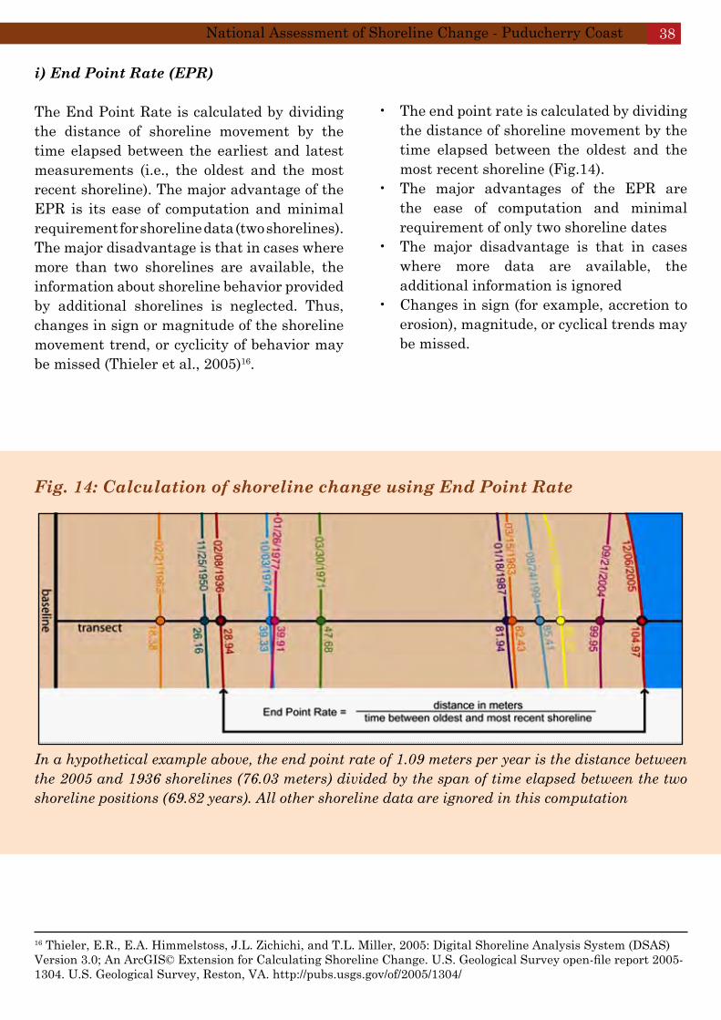
Fig. 14: Calculation of shoreline change using End Point Rate
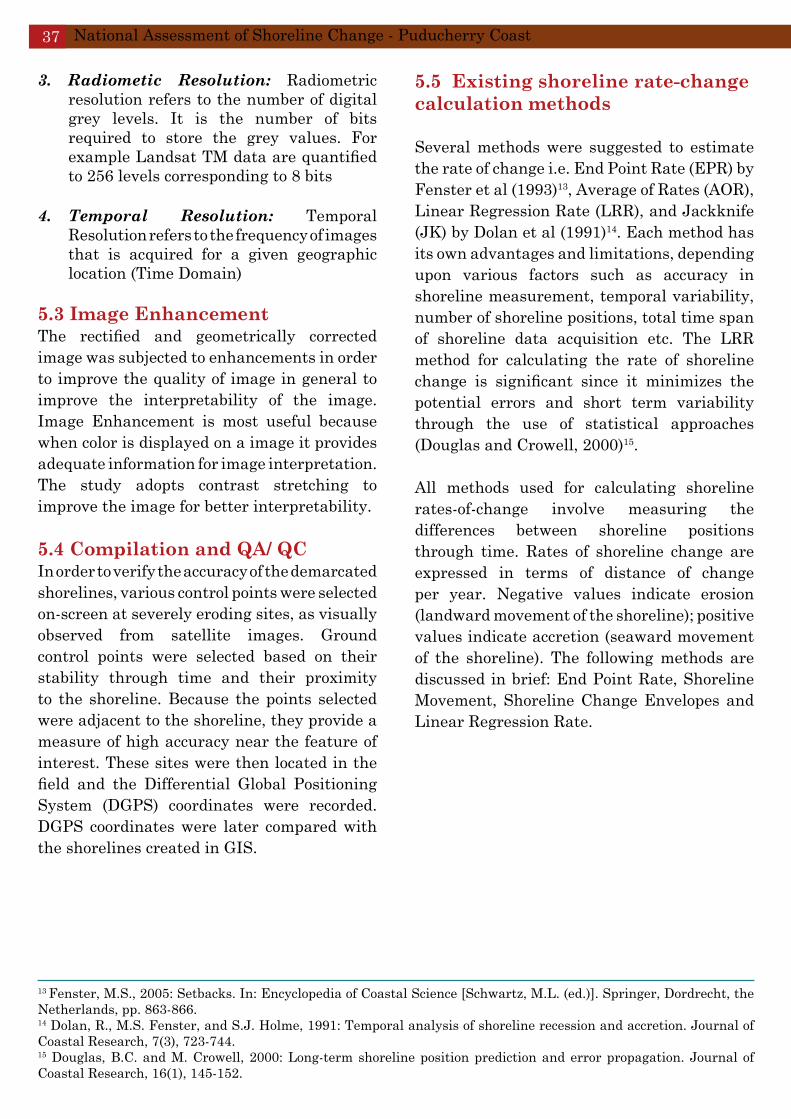
In a hypothetical example above, the end point rate of 1.09 meters per year is the distance between the 2005 and 1936 shorelines (76.03 meters) divided by the span of time elapsed between the two shoreline positions (69.82 years). All other shoreline data are ignored in this computation
i) End Point Rate (EPR)
The End Point Rate is calculated by dividing the distance of shoreline movement by the time elapsed between the earliest and latest measurements (i.e., the oldest and the most recent shoreline). The major advantage of the EPR is its ease of computation and minimal requirement for shoreline data (two shorelines). The major disadvantage is that in cases where more than two shorelines are available, the information about shoreline behavior provided by additional shorelines is neglected. Thus, changes in sign or magnitude of the shoreline movement trend, or cyclicity of behavior may be missed (Thieler et al., 2005)16.
16 Thieler, E.R., E.A. Himmelstoss, J.L. Zichichi, and T.L. Miller, 2005: Digital Shoreline Analysis System (DSAS) Version 3.0; An ArcGIS© Extension for Calculating Shoreline Change. U.S. Geological Survey open-file report 2005-1304. U.S. Geological Survey, Reston, VA. http://pubs.usgs.gov/of/2005/1304/
The end point rate is calculated by dividing • the distance of shoreline movement by the time elapsed between the oldest and the most recent shoreline (Fig.14).The major advantages of the EPR are • the ease of computation and minimal requirement of only two shoreline datesThe major disadvantage is that in cases • where more data are available, the additional information is ignoredChanges in sign (for example, accretion to • erosion), magnitude, or cyclical trends may be missed.
National Assessment of Shoreline Change - Puducherry Coast 38
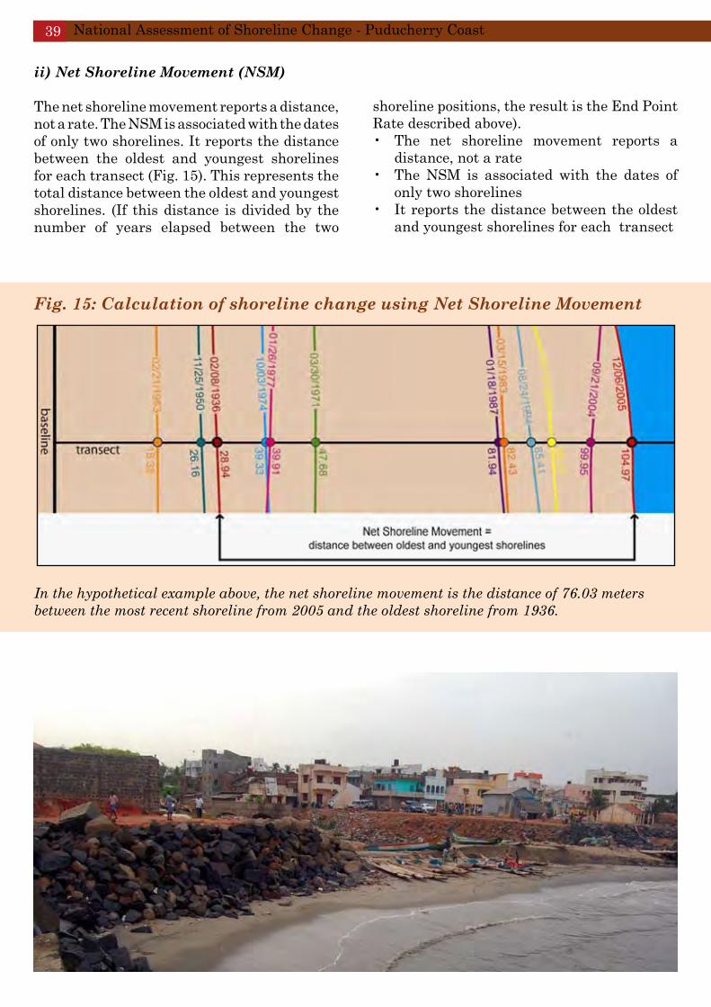
Fig. 15: Calculation of shoreline change using Net Shoreline Movement
In the hypothetical example above, the net shoreline movement is the distance of 76.03 meters between the most recent shoreline from 2005 and the oldest shoreline from 1936.
ii) Net Shoreline Movement (NSM)
The net shoreline movement reports a distance, not a rate. The NSM is associated with the dates of only two shorelines. It reports the distance between the oldest and youngest shorelines for each transect (Fig. 15). This represents the total distance between the oldest and youngest shorelines. (If this distance is divided by the number of years elapsed between the two
shoreline positions, the result is the End Point Rate described above).
The net shoreline movement reports a • distance, not a rateThe NSM is associated with the dates of • only two shorelines It reports the distance between the oldest • and youngest shorelines for each transect
National Assessment of Shoreline Change - Puducherry Coast39
Fig. 16: Calculation of shoreline change using Shoreline Change Envelope
In the hypothetical example above, the shoreline change envelope is the distance between the 2005 and 1963 shorelines of 86.59 meters; this distance is not associated with the age of the shorelines.
iii) Shoreline Change Envelope (SCE) The shoreline change envelope reports a distance, not a rate. The SCE is the distance between the shorelines farthest and closest to the baseline at each transect (Fig. 16). This represents the total change in shoreline movement for all available shoreline positions and is not related to their dates.
The shoreline change envelope reports a • distance, not a rate The SCE is the distance between the • shorelines farthest and closest to the baseline at each transectThis represents the total change in • shoreline movement for all available shoreline positions and is not related to their dates
National Assessment of Shoreline Change - Puducherry Coast 40

iv) Linear Regression Rate (LRR)
A linear regression rate-of-change statistic can be determined by fitting a least squares regression line to all shoreline points for a particular transect (Fig. 17). The rate is the slope of the line. The advantages of linear regression include: 1) all the data are used, regardless of changes in trend or accuracy; 2) the method is purely computational (requires no other analysis such as measurement errors used in the AOR method); 3) it is based on accepted statistical concepts; and 4) it is easy to employ. As pointed out by Dolan et al. (1991), the linear regression method is susceptible to outlier effects, and also tends to underestimate the rate-of-change relative to other statistics, such as EPR.
Fig. 17: Calculation of shoreline change using Linear Regression Rate
The linear regression rate was determined by plotting the shoreline positions with respect to time and calculating the linear regression equation of y = 1.34x – 2587.4. The slope of the equation describing the line is the rate (1.34 m/yr. This is a hypothetical example and not a result of the present study)
A linear regression rate-of-change statistic • can be determined by fitting a least-squares regression line to all shoreline points for a particular transectThe regression line is placed so that the • sum of the squared residuals (determined by squaring the offset distance of each data point from the regression line and adding the squared residuals together) is minimizedThe linear regression rate is the slope of • the line. The method of linear regression includes these features
All the data are used, regardless of • changes in trend or accuracy The method is purely computational • The calculation is based on accepted statistical concepts, and The method is easy to employ•
National Assessment of Shoreline Change - Puducherry Coast41
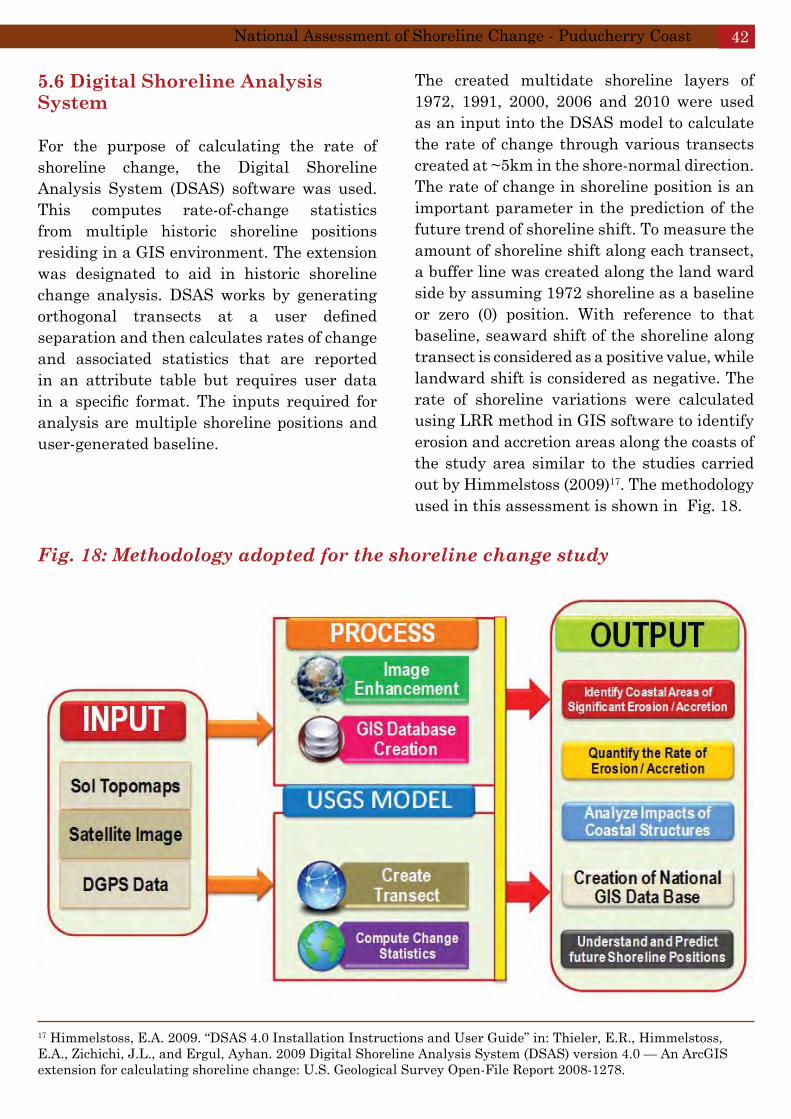
5.6 Digital Shoreline Analysis System
For the purpose of calculating the rate of shoreline change, the Digital Shoreline Analysis System (DSAS) software was used. This computes rate-of-change statistics from multiple historic shoreline positions residing in a GIS environment. The extension was designated to aid in historic shoreline change analysis. DSAS works by generating orthogonal transects at a user defined separation and then calculates rates of change and associated statistics that are reported in an attribute table but requires user data in a specific format. The inputs required for analysis are multiple shoreline positions and user-generated baseline.
Fig. 18: Methodology adopted for the shoreline change study
17 Himmelstoss, E.A. 2009. “DSAS 4.0 Installation Instructions and User Guide” in: Thieler, E.R., Himmelstoss, E.A., Zichichi, J.L., and Ergul, Ayhan. 2009 Digital Shoreline Analysis System (DSAS) version 4.0 — An ArcGIS extension for calculating shoreline change: U.S. Geological Survey Open-File Report 2008-1278.
The created multidate shoreline layers of 1972, 1991, 2000, 2006 and 2010 were used as an input into the DSAS model to calculate the rate of change through various transects created at ~5km in the shore-normal direction. The rate of change in shoreline position is an important parameter in the prediction of the future trend of shoreline shift. To measure the amount of shoreline shift along each transect, a buffer line was created along the land ward side by assuming 1972 shoreline as a baseline or zero (0) position. With reference to that baseline, seaward shift of the shoreline along transect is considered as a positive value, while landward shift is considered as negative. The rate of shoreline variations were calculated using LRR method in GIS software to identify erosion and accretion areas along the coasts of the study area similar to the studies carried out by Himmelstoss (2009)17. The methodology used in this assessment is shown in Fig. 18.
National Assessment of Shoreline Change - Puducherry Coast 42

Shoreline change trend reversals indicate that the shoreline of Puducherry has undergone both erosion and accretion on a long-term basis. All shorelines undergo both erosion and accretion on a seasonal or yearly basis, however, some areas continue to exhibit trend reversals on a longer term basis.
5.7 Vector Based Shoreline Change Analysis The historic shoreline data were segmented for analysis. The criteria used to segment the data were developed within the analysis methods to provide consistent, accurate, and timely temporal shoreline change analysis results. The data were divided into 55 transects for Puducherry coast and 34 transects for the Karaikal coast considering (in part) the following criteria:
A baseline/ buffer line (reference • benchmarks) was created in close proximity to the High Tide Line (HTL) on the landward side at an interval of 500 m between each transect.A minimum of 3 shorelines (required to • develop a rate of change) .Aggregate shorelines of consistent spatial • variability to allow consistent transect “extend” distances.
Once the historic data were segmented into these manageable units, transecting and analysis proceeded within each of the analysis units. Baselines were constructed on the upland side of all historic shorelines to provide a starting point for the transecting operation. Baselines were digitized parallel to the general trend of the historic shorelines so that orthogonally oriented transects originating from the baseline would most closely match transects placed by manual ‘best fit’ methods. Baselines and historic shoreline data coverage created for each analysis segment was given as “INPUT” into the USGS Digital Shoreline Analysis System (DSAS) Model, to generate
transects, perform the analysis and deliver results in ArcGIS geodatabase format.
5.8 Maps and Data Products
A map index for the coastal zone of Puducherry and Karaikal were created and plots conforming to the index were created at 1:50,000 scale in GIS and plotted in the same scale (1:50,000) scale on paper. In addition to plots, an GIS database and query interface were designed to analyze the shoreline change results for any individual transect or series of transects. Linear historic shoreline data as early as 1972 and as recent as 2010 were used and analysis was undertaken to define and execute a procedure for deriving the historic rate of shoreline change using a vector-based methodology. The data were segmented for analysis and then appended to a single State-wide dataset. Custom plots were created and indexed to demarcate shoreline changes and the key results are discussed below.
A total of 8 map indices were generated for the entire coastline of Puducherry (5 map indices) and Karaikal (3 map indices). The individual sheets are described in Chapter 6 in order to provide location-specific erosion/ accretion/ stable coast characteristics.
National Assessment of Shoreline Change - Puducherry Coast43

6. Results
Changes in shoreline through processes of accretion and erosion can be analyzed in a geographic information system (GIS) by measuring differences in past and present shoreline locations. Shoreline change trend reversals indicate that the shoreline of Puducherry has undergone high erosion on a long-term basis (>35 years). The coast along Karaikal has remained more or less stable during this time period. All shorelines undergo both erosion and accretion on a seasonal or yearly basis, however, some areas continue to exhibit trend reversals on a longer term basis. The primary source of sediment to the Puducherry coast is long-shore drift and updrift eroding coasts. Rivers are not considered a primary source of sediment within the modern coastal system, as very little modern river sediment reaches the present-day coast.
Along the more elongate part of the Puducherry coast, the coastline is relatively straight and wave approach is oblique, driving net sediment transport to the North. The coast adjacent to the south breakwater, sediments are trapped on the southern side of the breakwater and, as a result, there is no net sediment movement towards north of the Puducherry Port, causing erosion on the northern side of the north breakwater.

6.1 Erosion/ Accretion Status
The purpose of calculating the average annual rate of shoreline change is to provide an indication of likely future changes. The significant alteration of the sediment budget by the construction of the Puducherry Port in the late 1980s has had significant detrimental effects on the present-day shoreline. For the entire shoreline of Puducherry, the zones of erosion and accretion are in the ratio of 1:1 (Table 9).
Table 9: Shoreline Change Statistics for Puducherry Coast
Classification of Coast Extent (km)
Percent of Coast
Cumulative (%)
Length of Coastline including river mouths and Ports
23.62
High Erosion Zone Medium Erosion Zone 0.52 2.2 Low Erosion Zone 0.46 2.0 Artificial Coast: Seawalls/ Riprap 6.18 26.2 30.3#
Stable Coast 9.27 39.2 39.2High Accretion Zone Medium Accretion Zone 2.19 9.3 Low Accretion Zone 5.00 21.2 30.4$
Number of Ports/ Harbours 2 Number of Fish Landing Centres 21 Number of Groynes/ Breakwaters 7 100.0 100.0
#(Sum of High erosion + Medium erosion + Low erosion + Artificial Coast)$(Sum of High accretion + Medium accretion+ Low accretion)
6.2 Puducherry Coast A total of 5 maps for the coast of Puducherry and 3 maps for the coast of Karaikal were generated. The status of shoreline change for the coastal stretch is also described in individual sheets to provide location-specific erosion/ accretion/ stable/ artificial coastline characteristics. A summary of the temporal change for a stretch of coastline spanning ~41 km (~24 km for Puducherry and ~17km for Karaikal) are given in Sheets 1 through
8. About 47 transects for Puducherry and 35 transects for Karaikal (at 500m interval) have been created and rates of shoreline change have been computed. Based on this, zones of erosion/ accretion have been computed for the Puducherry and Karaikal coasts.
Low to medium erosion is found to occur along ~1 km of the ~24km coast of Puducherry. This represents nearly 4.2% of the total Puducherry coast. Cumulative erosion i.e., sum of high, medium, low erosion and artificial coast is
calculated to be 30.3% (Table 9). This zone should be protected and needs attention. It is also observed that the highly eroding areas of the Puducherry coast have already been considerably protected using seawall/ riprap, as mentioned above.
Stable coast and accretion (high, medium and low accretion) on the Puducherry coast accounts for 39.2% and 30.4% respectively (Table 9). The major results (sheet-wise) are given below and the highlights are also indicated in individual
National Assessment of Shoreline Change - Puducherry Coast45
sheets. In addition to providing zones of shoreline change superimposed on satellite imageries (2010), an attempt has been made to highlight the geomorphological features of the coast.
consists of breakwaters and seawalls that trap sediments moving north, thereby creating erosion along the coastal stretch after the northern breakwater.
Sheet 4: The coast is stable, extending from Sivanathapuram in the north to Manapattu in the south. The coast is accreting in the region adjacent to Puranankuppam. The geomorphology of the coast is dominated by younger coastal plains.
Sheet 5: Stable coast throughout from Kirumambakkam in the north to the mouth of River Gadilam in the south.
Sheet 1: In the stretch between Pudukuppam and Periya Mudaliyarchavadi, the coast is “stable” and/ or accreting. This coast has many fish landing centres and is dominated by tidal flats which tend to accumulate sediments. In addition, dunes are observed along this coastal area, providing stability to the entire coastal stretch.
Sheet 2: Covers the highly eroding coastal stretch between Bommaiyapalayam and Puducherry’s Old Port. The most conspicuous features of this coastal stretch is the presence of coastal protection structures (seawalls/ riprap) and groynes all along the coast. The coastal stretch is classified as an “artificial coast” which has been undergoing high erosion in the past. Nearly 80% of this highly eroding stretch is managed by seawalls/ riprap as a coastal protection measure.
Low erosion is observed in the north of Puducherry’s Old Port due to the presence of groynes. The coastal stretch near Bommaiyapalayam is stable with dune formations. The rest of the coast consists of tidal flats and younger coastal plain.
Sheet 3: The Ariyankuppam, Gingee and Malattar Rivers join the Bay of Bengal in the north and south respectively. Between the Gingee and Ariyankuppam rivers, medium accretion is observed. This extends upto south of Puducherry Port. Zones of low to medium erosion is observedfrom north of the Puducherry Port to Tengattittu. The southern side of the Puducherry Port
6.3 Karaikal Coast
The Karaikal Coast (Puducherry Union Territory) is approximately 17.3 km long including river mouths and port, of which nearly 3.98 km (23%) of the coast is “stable”, where no shoreline change is observed (Table 10). Approximately 8 km (46%) of this coastal stretch is “accreting” (sum of high, medium and low accretion zones) (Table 10).
Low “erosion” zone accounts for 2.0 km (~11.5%) of the total coastline. The other notable feature of the Karaikal coast is the absence of shoreline protection structures such as seawalls/ ripraps. The Karaikal Port was commissioned in September 2009 which has two breakwaters: the northern and the southern breakwater. Medium erosion is observed on the northern side of the Karaikal Port while medium accretion is observed on the southern side of the Karaikal Port.
National Assessment of Shoreline Change - Puducherry Coast 46
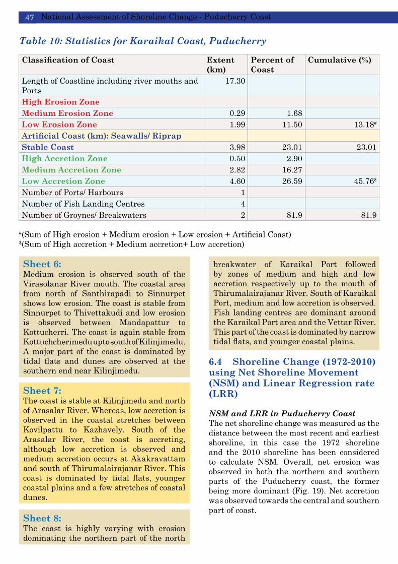
Table 10: Statistics for Karaikal Coast, Puducherry
Classification of Coast Extent (km)
Percent of Coast
Cumulative (%)
Length of Coastline including river mouths and Ports
17.30
High Erosion Zone Medium Erosion Zone 0.29 1.68 Low Erosion Zone 1.99 11.50 13.18#
Artificial Coast (km): Seawalls/ Riprap Stable Coast 3.98 23.01 23.01High Accretion Zone 0.50 2.90 Medium Accretion Zone 2.82 16.27 Low Accretion Zone 4.60 26.59 45.76$
Number of Ports/ Harbours 1 Number of Fish Landing Centres 4 Number of Groynes/ Breakwaters 2 81.9 81.9
#(Sum of High erosion + Medium erosion + Low erosion + Artificial Coast)$(Sum of High accretion + Medium accretion+ Low accretion)
Sheet 6: Medium erosion is observed south of the Virasolanar River mouth. The coastal area from north of Santhirapadi to Sinnurpet shows low erosion. The coast is stable from Sinnurpet to Thivettakudi and low erosion is observed between Mandapattur to Kottucherri. The coast is again stable from Kottuchcherimedu upto south of Kilinjimedu. A major part of the coast is dominated by tidal flats and dunes are observed at the southern end near Kilinjimedu.
Sheet 7: The coast is stable at Kilinjimedu and north of Arasalar River. Whereas, low accretion is observed in the coastal stretches between Kovilpattu to Kazhavely. South of the Arasalar River, the coast is accreting, although low accretion is observed and medium accretion occurs at Akakravattam and south of Thirumalairajanar River. This coast is dominated by tidal flats, younger coastal plains and a few stretches of coastal dunes. Sheet 8: The coast is highly varying with erosion dominating the northern part of the north
breakwater of Karaikal Port followed by zones of medium and high and low accretion respectively up to the mouth of Thirumalairajanar River. South of Karaikal Port, medium and low accretion is observed. Fish landing centres are dominant around the Karaikal Port area and the Vettar River. This part of the coast is dominated by narrow tidal flats, and younger coastal plains.
6.4 Shoreline Change (1972-2010) using Net Shoreline Movement (NSM) and Linear Regression rate (LRR)
NSM and LRR in Puducherry CoastThe net shoreline change was measured as the distance between the most recent and earliest shoreline, in this case the 1972 shoreline and the 2010 shoreline has been considered to calculate NSM. Overall, net erosion was observed in both the northern and southern parts of the Puducherry coast, the former being more dominant (Fig. 19). Net accretion was observed towards the central and southern part of coast.
National Assessment of Shoreline Change - Puducherry Coast47

Fig. 19: Net Shoreline Movement (m) along the Puducherry Coast
Maximum NSM of -104 m has been observed at Tengattittu, near the Puducherry Port. The entire coastal stretch extending from Sodhanaikuppam to Tengattittu is protected by seawalls/ riprap/ groynes because of the negative net shoreline movement.
Linear Regression Rates (LRR) of shoreline change were calculated at each transect (500m) as the slope of the linear regression through all shoreline positions from the earliest (1972) to the most recent (2010). Five shoreline years at each DSAS transect was used for the calculation of long-term (>30 years) rates of change. The single highest LRR for erosion measured for the Puducherry coast is -2.4 m yr-1 Northeast of Tengattittu, while the highest accretion rate is +4.2 m yr-1 at Ariyankuppam (Fig. 20). The high accretion is associated with the construction of the south breakwater of the Puducherry Port. The engineering responses to erosion have altered the natural beach processes and eventually led to artificial shoreline positions.
National Assessment of Shoreline Change - Puducherry Coast 48

Fig. 20: Shoreline change rates for the Puducherry Coastal region. Gray centered bars on the plots indicate the average range of shoreline change for the coast
NSM and LRR in Karaikal Coast The Karaikal coast shows a dominant pattern of erosion in the north and accretion in the southern part of the coastline. The presence of Karaikal Port on the southern end (Kil Vanjiyur) has caused significant erosion on the northern side of the Port. Net shoreline movement towards the land of -96 m has been observed E and SE of Tevanur, while maximum accretion (net movement towards the sea) of +216m has been observed NE of Vadaku Vanjiyur. The net negative shoreline movement of -91m was observed near the Karaikal Port at Kil Vanjiyur (Fig.21).
For the coast of Karaikal, the single highest LRR for erosion, has been observed to be
-3myr-1 at Kil Vanjioor (north of Karaikal Port), while the LRR for highest accretion rate is +6.3 m yr-1 at Vadaku Vanjioor (Fig. 21). The high erosion is associated with the construction of the north breakwater of the Karaikal Port during recent times.
National Assessment of Shoreline Change - Puducherry Coast49

Fig. 21: Net Shoreline Movement (m) along the Karaikal Coast
Fig. 22: Shoreline change rates for the Karaikal Coastal region. Gray centered bars on the plots indicate the average range of shoreline change for the coast
National Assessment of Shoreline Change - Puducherry Coast 50

6.5 Factors influencing shoreline changes
Shoreline retreat is influenced by many factors, including but not limited to wave energy and duration, fetch of water that generates these waves, and other factors as described below. Fetch, often called the fetch length, is a term for the length of water over which a given wind has blown. It is usually associated with coastal erosion by playing a large part in alongshore drift. Fetch length along with the wind speed determines the size of waves produced. The longer the fetch length and the faster the wind speed, the larger and stronger the wave will be, as in the case of Puducherry coast.
Managing this coastal land loss is becoming ever more critical as coastal populations increase. First, it must be understood that not all shorelines are at serious risk to significant erosion, as can be observed from the results along the Puducherry coast. Second, mitigation measures against shoreline erosion can have significant negative impacts on the immediate and adjacent coastal environments (e.g., local fishing areas). Third, installation of hard structures should really be undertaken as a last resort and not as an unnecessary preventative measure. Other factors that influence shoreline change along a coast are provided below.
Other beach erosion factors:
effects of human impact, such as • construction of artificial structuresmining of beach sand• offshore dredging• loss of sediment offshore, onshore, • alongshore and by attritionreduction in sediment supply due to • deceleration cliff erosionreduction in sediment supply from the • sea floor.increased storminess in coastal areas or • changes in angle of wave approach
Coastal shorelines differ markedly in physical characteristics and in vulnerability to erosion. Erosion rate over time at a given point along the shoreline depends on factors such as:
direction of littoral drift• inlet dynamics• sand supply• short- and long-term climate • fluctuationsgradient of submerged ocean or lake • bottomrelative mean sea level• human actions affecting shoreline • processes
In general, the natural factors that influence the coast include:
the sand sources and sinks• regional changes in relative sea level• geological characteristics of the shore• sand size, density and shape• sand-sharing systems of beaches, dunes • and offshore barseffects of waves, currents, tides and • windbathymetry of the offshore sea bottom•
The rate of sediment transport varies from time to time along the coastal region. The study indicates that sediment transport at Puducherry is towards north from March to October and towards South from November to February.
At Puducherry the gross sediment transport is estimated to be 2,37,000 m3 yr-1 and the net sediment transport is 1,34,400 m3 yr-1, towards north (Fig. 21). The conditions at Puducherry are very similar to those at Chennai, Tamil Nadu. Therefore a gross northerly drift of about 0.9 million m3 yr-1 can be considered as appropriate. The influence of fetch, and
National Assessment of Shoreline Change - Puducherry Coast51

therefore the resultant wave energy, can easily be seen in the erosion rates observed in the Puducherry coast. For example, some of the highest erosion zones are found in along the northern side of the Puducherry Port. With rising sea level and possible enhanced storm activity, it is highly probable that shoreline recession will become more severe in the near future.
In summary, the Puducherry coast can be classified from an “artificially managed coast” to “Stable coast”. However, a large portion of the Puducherry coast (~30%) is categorized under the medium to low erosion zone. The northern part of the Karaikal coast, as mentioned earlier is undergoing low (14%) to medium erosion (2%). On the southern part of the Karaikal Port, accretion is observed - high accretion: ~3%, medium accretion: 20% and low accretion: 32%.
It is evident from the shoreline change observed for the Puducherry and Karaikal coasts that the emplacement of shoreline protection structures such as seawalls/ riprap and revetments can result in both active and passive erosion of the beach. In the case of passive erosion, the back beach area is fixed by a structure and the beach in front gradually narrows. Eventually, erosion ceases (until the structure fails) thus indicating a stable shoreline in the shoreline change record. Active erosion associated with shoreline protection structures, refers to the acceleration of shoreline erosion in front of a structure caused by the alteration of wave, tide and current patterns. Other coastal modifications that influence the shoreline change trends are structures, such as groynes and jetties that disrupt alongshore sediment transport. Depending on the timing of emplacement releative to the shoreline database, there is zone of accretion updrift from shore-perpedicular structures and erosion on the down drift side, as observed along the Puducherry and Karaikal Ports (Fig.22)
Fig. 23: Net littoral drift along the coast of Puducherry, India
National Assessment of Shoreline Change - Puducherry Coast 52

PUDUCHERRY - INDEX MAP
National Assessment of Shoreline Change - Puducherry Coast53

National Assessment of Shoreline Change - Puducherry Coast 54
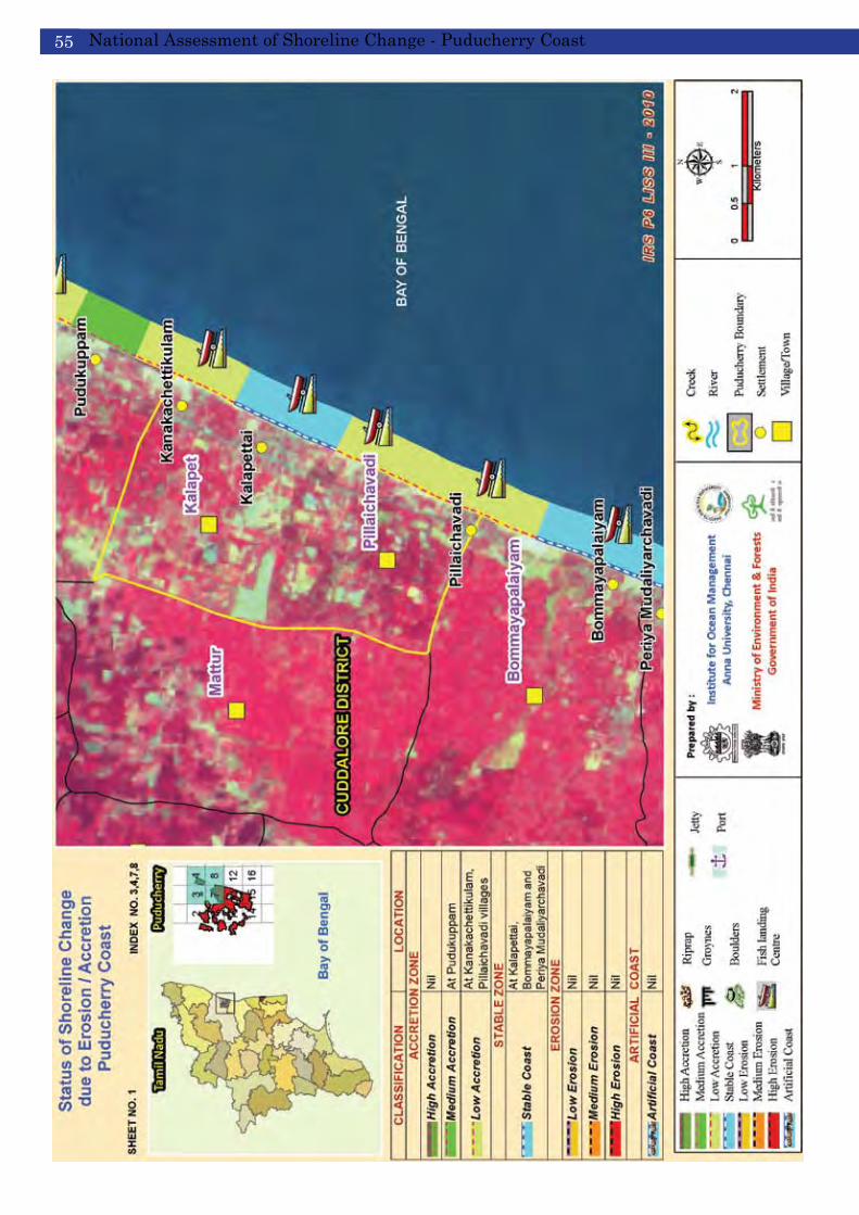
National Assessment of Shoreline Change - Puducherry Coast55

National Assessment of Shoreline Change - Puducherry Coast 56
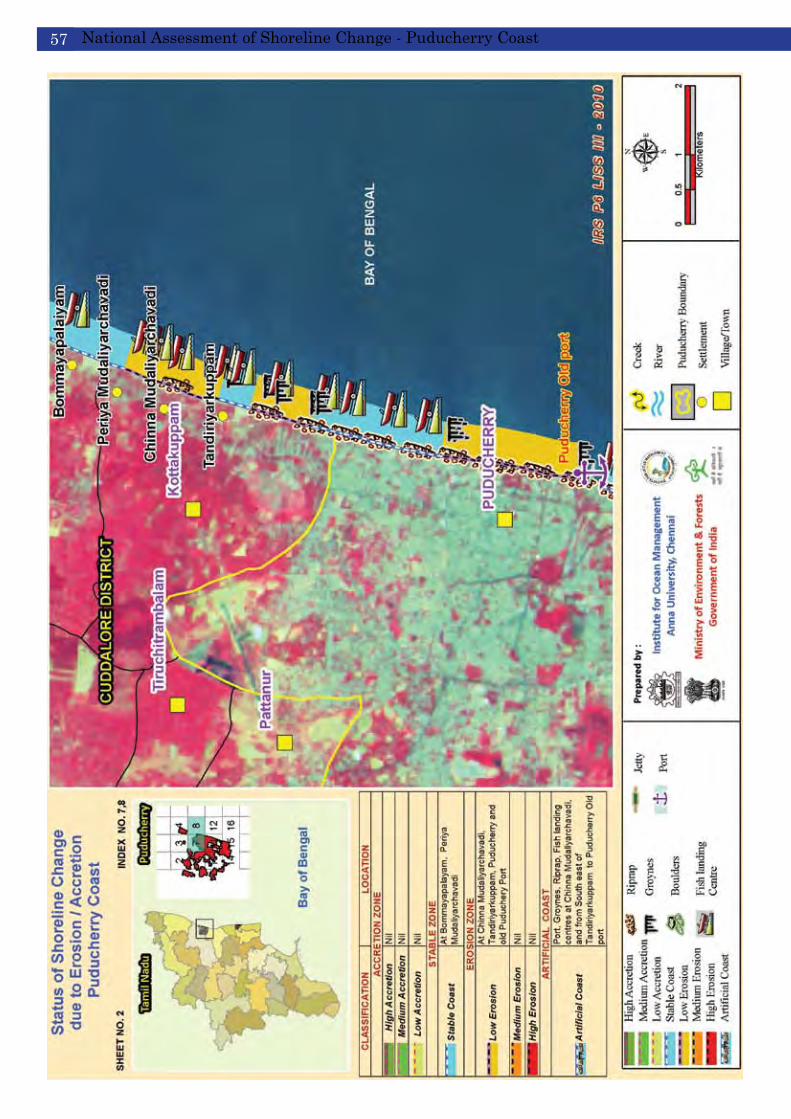
National Assessment of Shoreline Change - Puducherry Coast57

National Assessment of Shoreline Change - Puducherry Coast 58
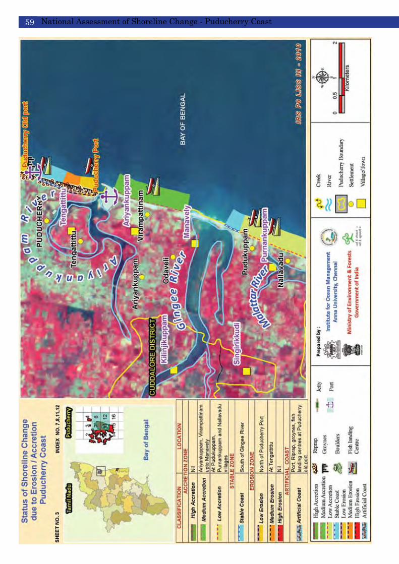
National Assessment of Shoreline Change - Puducherry Coast59
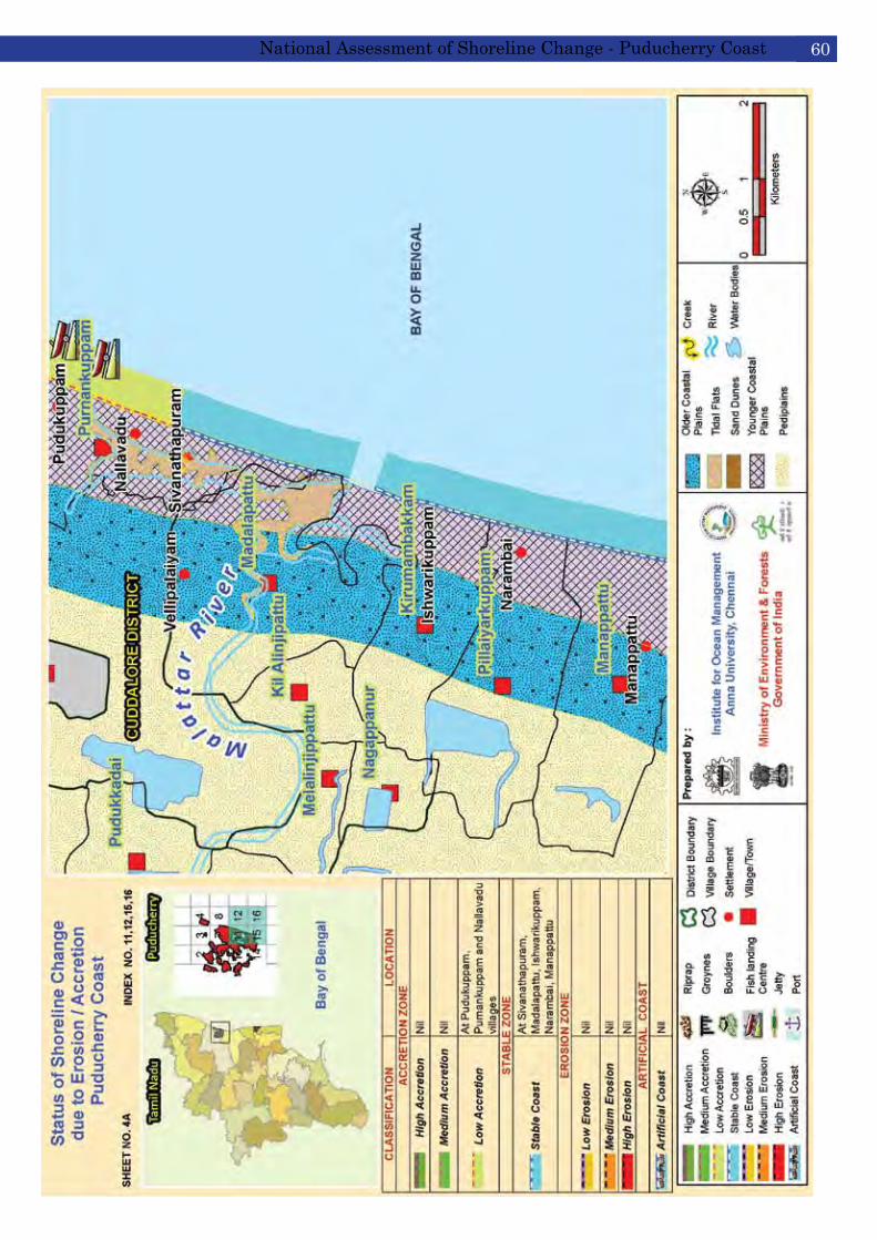
National Assessment of Shoreline Change - Puducherry Coast 60
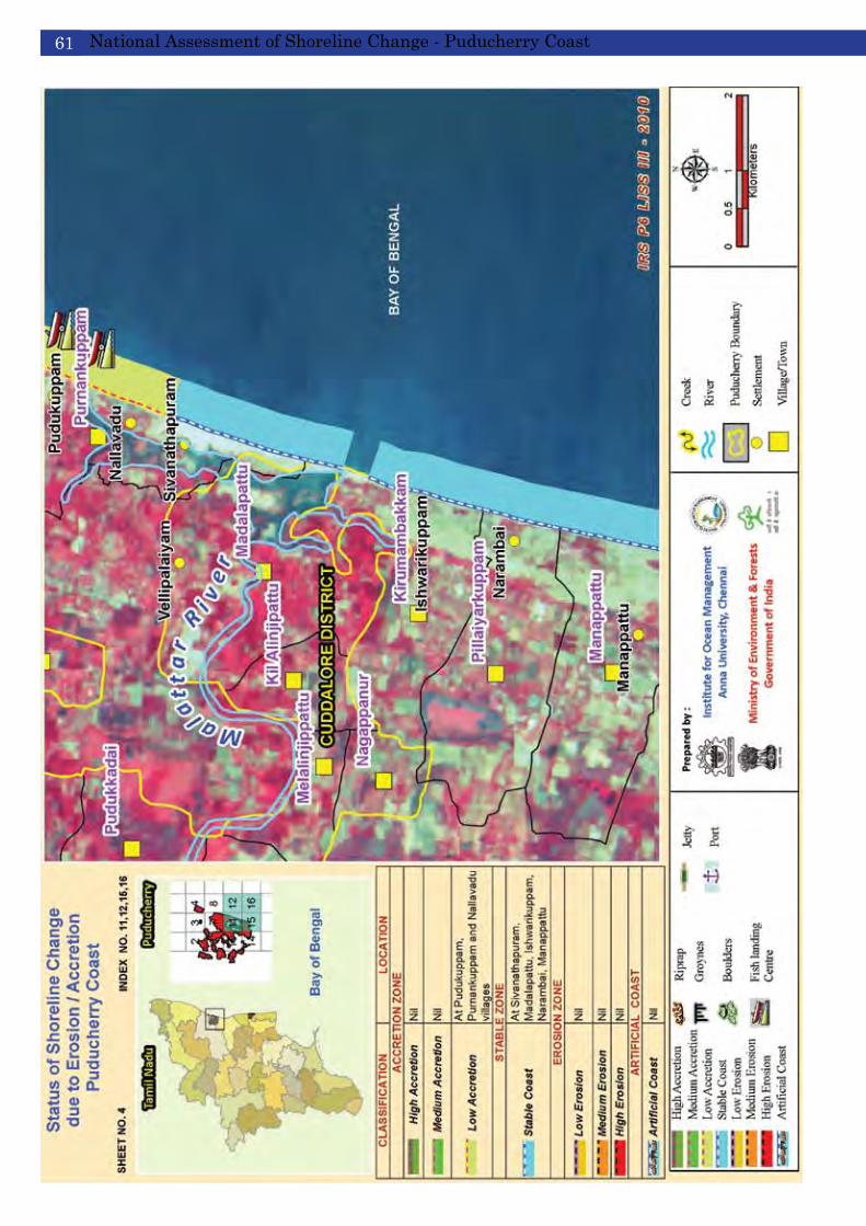
National Assessment of Shoreline Change - Puducherry Coast61

National Assessment of Shoreline Change - Puducherry Coast 62

National Assessment of Shoreline Change - Puducherry Coast63
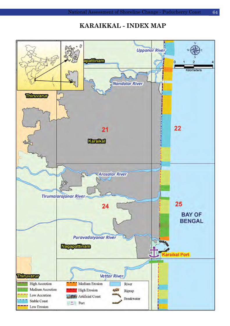
KARAIKKAL - INDEX MAP
National Assessment of Shoreline Change - Puducherry Coast 64
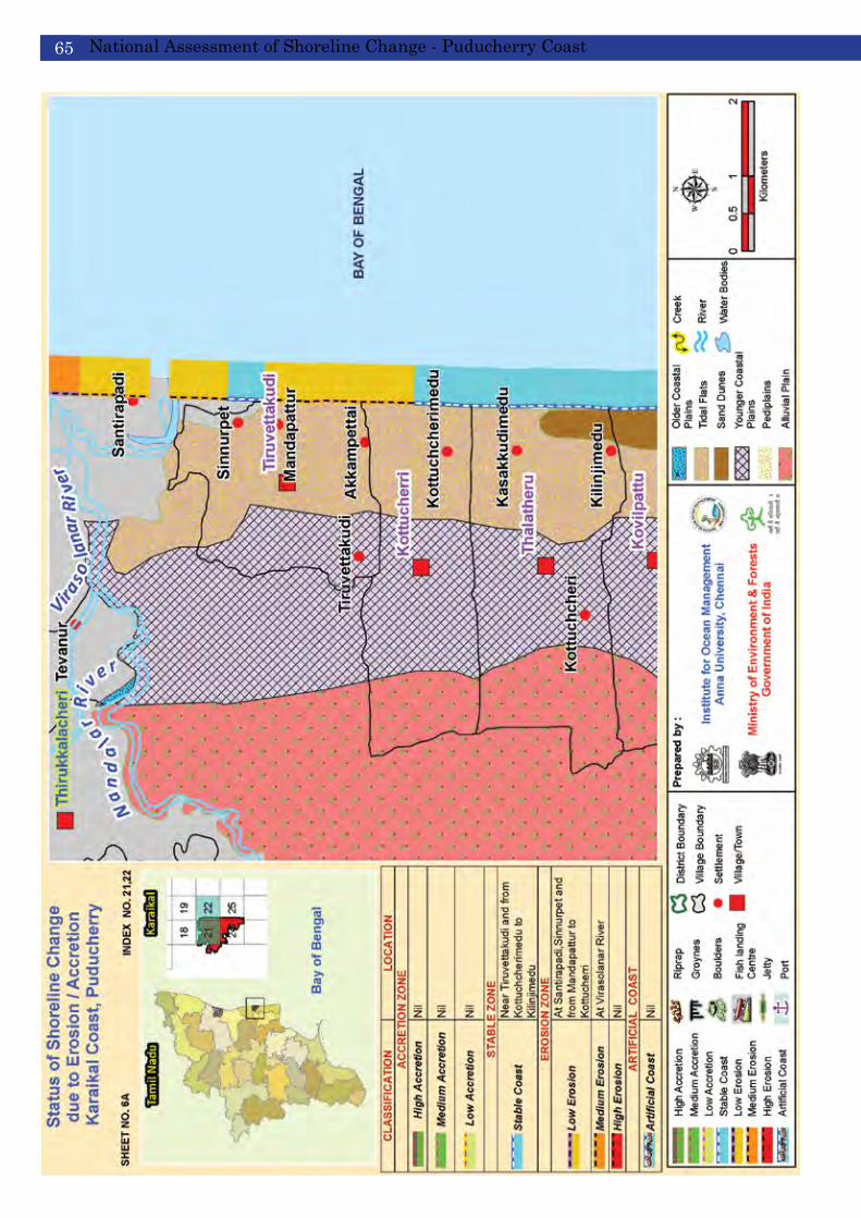
National Assessment of Shoreline Change - Puducherry Coast65

National Assessment of Shoreline Change - Puducherry Coast 66

National Assessment of Shoreline Change - Puducherry Coast67

National Assessment of Shoreline Change - Puducherry Coast 68

National Assessment of Shoreline Change - Puducherry Coast69
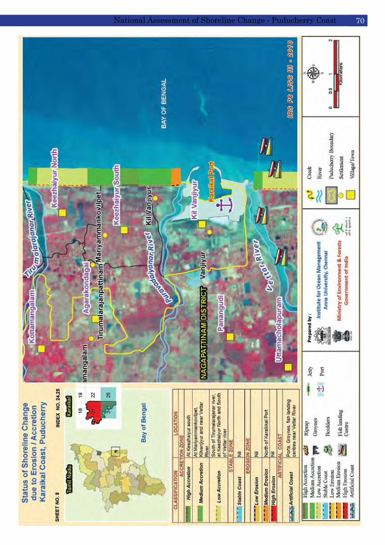
National Assessment of Shoreline Change - Puducherry Coast 70

Erosion of shorelines is an ongoing process in the Puducherry coastal area. This rapid and significant loss of land has led the government to use various stabilization methods to combat erosion. However, little is known of either the short-term and long-term ecological impacts that these hard structures might have on the system, particularly if the processes of climate change and sea-level rise continue. To preserve our coastal, estuarine and marine resources and maximize human utilization, long-term management solutions to shoreline recession must be in harmony with the dynamics of the coastal system.
The present assessment highlights an overall shoreline change (erosion/ accretion/ stable zones) over a time period of 38 years from 1972 - 2010. The inter-seasonal and inter-annual variations are included in the overall computations of shoreline change for the period of study. For site-specific cases, a detailed study is recommended using high resolution satellite imageries following the same methodology as detailed in this report.
7. Conclusions
It is generally accepted that coastlines are constantly changing due to both natural and anthropogenic forces, although the causes of shoreline change are primarily human-induced. Climate change and associated sea level rise will undoubtedly reshape our coasts in the near future. No longer are ocean-fronts the only concern of short-term shoreline change. Shoreline dynamics along sheltered estuaries, ports and other coastal infrastructure have gained more attention and data are needed to better understand and protect the coastal communities, resources and infrastructure. Identifying areas subject to both long- and short-term erosion, and understanding the causes of erosion are important if infrastructure in high hazard coastal areas are to be protected. The combination of long-term shoreline change data analysis, measurements of short-term shoreline movements, an understanding of coastal processes, and knowledge of the effects of seawalls, groynes, and jetties, is essential to proper siting of coastal structures.
The development of national Coastal Regulation Zone (CRZ) notification and new approaches to coastal management have brought a major shift in the way that we view and develop the coast, in parallel with recent increased concern about coastal and marine environments. The principle of integrated coastal management has become increasingly relevant. This involves comprehensive assessment and the setting of objectives, planning and management of coastal systems and resources, taking into account traditional, cultural and historical perspectives and conflicting interests and uses. There is now wide-spread recognition that the coast itself is an extremely valuable natural resource that must be managed and maintained and not degraded by inappropriate development. This move towards proactive, collaborative coastal management and policy development has occurred at national level since 1991 (CRZ 1991) and recently revised through the CRZ 2011.
The Ministry of Environment and Forests, Government of India plans to revise and update rates/ zones of shoreline change every 5 to 10 years. It is also planned to undertake detailed studies to identify the exact causes of erosion/ accretion along the Puducherry and Karaikal coasts, preferably with high resolution satellite imagery.
National Assessment of Shoreline Change - Puducherry Coast 72
