national engineering handbook - part 652 - irrigation ... · pdf filenational engineering...
TRANSCRIPT

NATIONAL ENGINEERING HANDBOOK - PART 652 - IRRIGATION GUIDE Chapter 5 - Selecting an Irrigation Method
(210-vi-NEH, Part 652, Amend. AL1, April 2010) AL5-13(i)
STATE SUPPLEMENTS INDEX PAGE 652.0505 - State Supplement WATER RESOURCES ..................................................................................................................... AL5-13(1) Background ................................................................................................................................ AL5-13(1) EVALUATION THE WATER SUPPLY ............................................................................................. AL5-13(1) Ground Water ............................................................................................................................ AL5-13(1) Surface Waters .......................................................................................................................... AL5-13(4) Flowing Sources ........................................................................................................................ AL5-13(4) Direct Method ......................................................................................................................... AL5-13(4) a. Current Meters .............................................................................................................. AL5-13(4) b. Float Method ................................................................................................................. AL5-13(6) Indirect Method ....................................................................................................................... AL5-13(6) IMPOUNDMENTS ............................................................................................................................ AL5-13(11) RULES OF THUMB .......................................................................................................................... AL5-13(12) WATER LAW .................................................................................................................................... AL5-13(13) SURFACE WATER LAW ................................................................................................................. AL5-13(13) GROUND WATER LAW ................................................................................................................... AL5-13(13) REFERENCES ................................................................................................................................. AL5-13(13)
TABLES
Table AL5-1 Aquifer and Well Characteristics in Alabama .......................................................... AL5-13(2) Table AL5-2 Rules of Thumb for Estimating Minimum Flows and Storage Volumes .................. AL5-13(12)
Required for Irrigation
FIGURES
Figure AL5-1 Principal Aquifers in Alabama: (a) Geographic Distribution, ................................... AL5-13(3) (b) Physiographic Diagram and Divisions, and (c) Generalized Cross-Section (A-A’) 5/
Figure AL5-2 Cross-section Area Division for Measuring Discharge in a Stream. ........................ AL5-13(5) Figure AL5-3 Typical Cross-Section Data for Float Method .......................................................... AL5-13(7) Figure AL5-4 Stream Flow Recession Indexes (G values) and areas where ................................. AL5-13(9)
7-day, 2-year low-flow is less than 0.3 cfs and 7-day, 10-year flow is less than 0.1 cfs. 6/
Figure AL5-5 Map of Average Annual Rainfall Distribution in Alabama .......................................... AL5-13(10)

NATIONAL ENGINEERING HANDBOOK - PART 652 - IRRIGATION GUIDE Chapter 5 - Selecting an Irrigation Method
(210-vi-NEH, Part 652, Amend. AL1, April 2010) AL5-13(1)
652.0505 State Supplement WATER RESOURCES Background In general, the quality and quantity of both surface and ground waters in Alabama are good. The largest source of water for irrigation in the state is surface water which includes irrigation ponds, lakes, reservoirs, streams, creeks, and rivers.1/ Alabama ranks in the top six states in the nation in terms of the total quantity of ground water available on a perennial basis.2/ The Geological Survey of Alabama has estimated that the total perennial yield of ground water supplies in non-Appalachian Alabama (principally the southern half of the state), if developed to their limits, would exceed 5 billion gallons a day. They add that this is many times the present use of water in the region.2/ Despite the general availability of ground water throughout the state, and throughout south Alabama in particular, not all ground water is easily accessible. Problems exist in some areas that could preclude the use of irrigation water from certain underground formations. In addition, where a number of irrigators are located in close proximity to one another, water levels can be drawn down considerably. If these irrigators are located in a coastal county, the potential for salt water intrusion into the freshwater wells becomes a possibility. Surface waters are abundant in Alabama, due in part to the average annual rainfall of about 55 in. per year. However, when irrigation water is most needed, many small streams either dry up or lack the capacity needed to sustain a viable irrigation program. The potential irrigator should thoroughly assess the reliability of each potential surface water supply before deciding to purchase an irrigation system. EVALUATING THE WATER SUPPLY An adequate and dependable supply of good quality water is perhaps the most important factor to consider during initial planning. It is essential that the proposed water supply be able to satisfy the irrigation needs for the crops during most dry years and during the period when crop consumptive use of water is at its peak. Methods for determining the amount of irrigation water needed for specific crops under different field conditions are described in Chapter 9, Irrigation Water Management. Methods for determining water availability at the site are discussed below.
Ground Water In many areas of the state, developing a well for irrigation can be expensive, even to the extent that irrigation is not economically feasible. While some aquifers may be suitable for domestic water supplies, they may be inadequate for irrigation. Table 1-1 and Figure 1-1 provide general guidelines on the potential yield of wells in the various aquifers of the State and on some potential problems that could occur. This information can point to areas where possible problems may exist and provide some general guidance on yield potentials. However, it cannot guarantee that a well with sufficient yield for irrigation water will be found in the designated areas. The landowner should consult a qualified well driller when considering the use of ground water for irrigation. He should advise the well driller of the yield needed based on the area to be irrigated and the crop consumptive use. Knowing this information, and being familiar with the water bearing geologic features in the area, the driller should be able to advise the landowner on the probable depth to an adequate aquifer, the estimated overall cost to establish the well, and the approximate pump and pipe sizes required to effect the desired yield. These factors will influence the economic feasibility of developing the site for irrigation. The well driller should also be able to provide information on the quality of water to be expected at the proposed irrigation site. It should be noted that ground water supplies in some parts of the state have poor water quality. In general, water containing more than 500 mg/l of total dissolved solids (TDS) is considered unsuitable for irrigation. In certain aquifers, TDS exceed 10,000 mg/l and contain high concentrations of iron, manganese, and sulfur. Other potential ground water problems include drawdown of the water table for other users, salt water intrusion in areas near the coast, and land subsidence (settling of the land when too many users deplete an aquifer which provides structural support for the land). The landowner should consult with a qualified driller on these potential problems. Where drastic lowering of the water table may affect other users, the landowner should obtain legal counsel first. (See general guidelines on water law.)
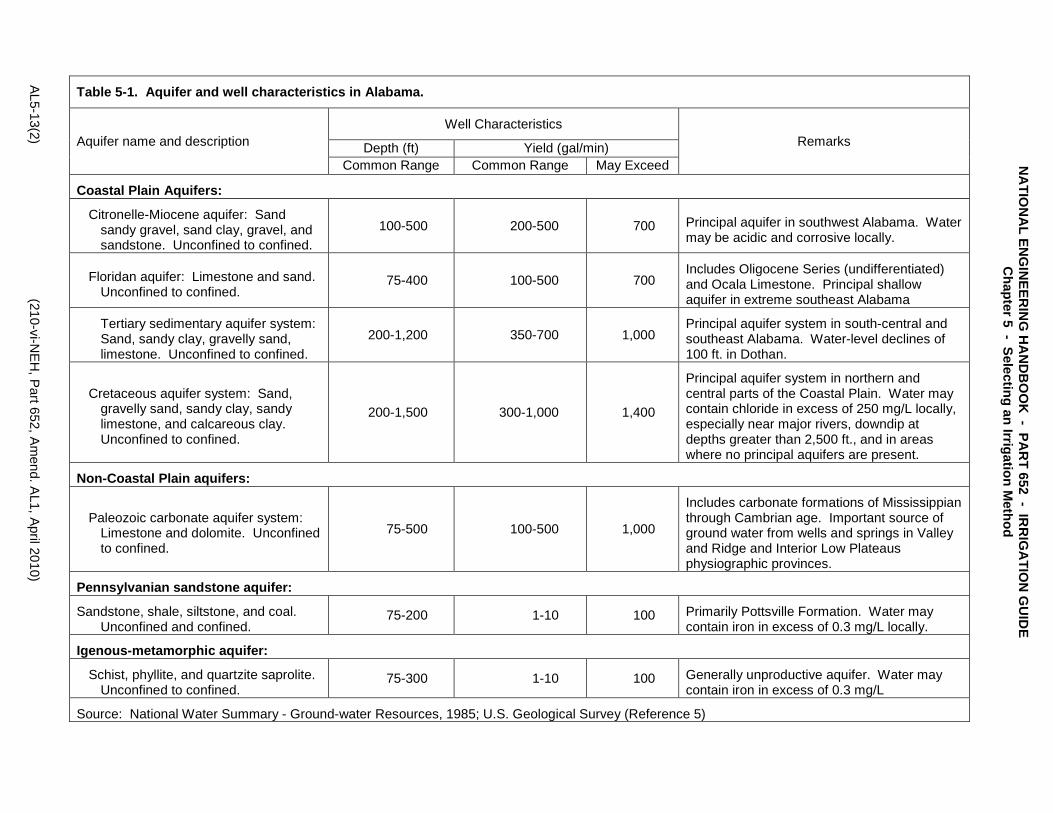
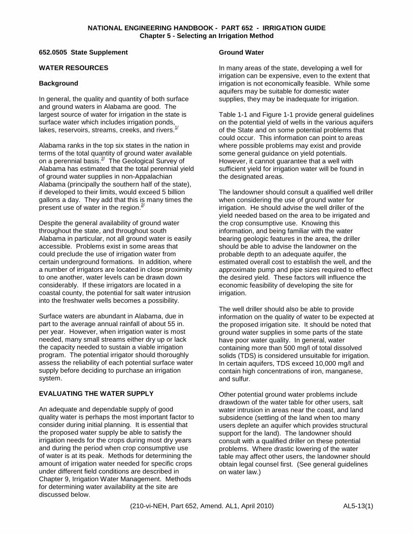
Table 5-1. Aquifer and well characteristics in Alabama.
Aquifer name and description Well Characteristics
Remarks Depth (ft) Yield (gal/min) Common Range Common Range May Exceed
Coastal Plain Aquifers:
Citronelle-Miocene aquifer: Sand sandy gravel, sand clay, gravel, and sandstone. Unconfined to confined.
100-500 200-500 700 Principal aquifer in southwest Alabama. Water may be acidic and corrosive locally.
Floridan aquifer: Limestone and sand. Unconfined to confined.
75-400 100-500 700 Includes Oligocene Series (undifferentiated) and Ocala Limestone. Principal shallow aquifer in extreme southeast Alabama
Tertiary sedimentary aquifer system: Sand, sandy clay, gravelly sand, limestone. Unconfined to confined.
200-1,200 350-700 1,000 Principal aquifer system in south-central and southeast Alabama. Water-level declines of 100 ft. in Dothan.
Cretaceous aquifer system: Sand, gravelly sand, sandy clay, sandy limestone, and calcareous clay. Unconfined to confined.
200-1,500 300-1,000 1,400
Principal aquifer system in northern and central parts of the Coastal Plain. Water may contain chloride in excess of 250 mg/L locally, especially near major rivers, downdip at depths greater than 2,500 ft., and in areas where no principal aquifers are present.
Non-Coastal Plain aquifers:
Paleozoic carbonate aquifer system: Limestone and dolomite. Unconfined to confined.
75-500 100-500 1,000
Includes carbonate formations of Mississippian through Cambrian age. Important source of ground water from wells and springs in Valley and Ridge and Interior Low Plateaus physiographic provinces.
Pennsylvanian sandstone aquifer:
Sandstone, shale, siltstone, and coal. Unconfined and confined.
75-200 1-10 100 Primarily Pottsville Formation. Water may contain iron in excess of 0.3 mg/L locally.
Igenous-metamorphic aquifer:
Schist, phyllite, and quartzite saprolite. Unconfined to confined.
75-300 1-10 100 Generally unproductive aquifer. Water may contain iron in excess of 0.3 mg/L
Source: National Water Summary - Ground-water Resources, 1985; U.S. Geological Survey (Reference 5)
AL5-13(2) (210-vi-NEH
, Part 652, Am
end. AL1, April 2010)
NA
TION
AL EN
GIN
EERIN
G H
AN
DB
OO
K - PA
RT 652 - IR
RIG
ATIO
N G
UID
E C
hapter 5 - Selecting an Irrigation Method
NATIONAL ENGINEERING HANDBOOK - PART 652 - IRRIGATION GUIDE Chapter 5 - Selecting an Irrigation Method
(210-vi-NEH, Part 652, Amend. 1, April 2010 AL5-13(3)
Figure 5-1. Principal Aquifers in Alabama: (a) Geographic Distribution, (b) Physiographic Diagram and Divisions, and (c) Generalized Cross-Section (A-A’), Reference 5.
NATIONAL ENGINEERING HANDBOOK - PART 652 - IRRIGATION GUIDE Chapter 5 - Selecting an Irrigation Method
AL5-13(4) (210-vi-NEH, Part 652, Amend. AL1, April 2010)
NATIO
NA
L ENG
INE
ERIN
G H
AND
BOO
K - PAR
T 652 - IRR
IGATIO
N G
UID
E
Chapter 5 - Selecting an Irrigation M
ethod
Surface Waters Surface waters for irrigation may include flowing sources, such as streams and rivers, or surface impoundments, such as irrigation ponds. Flowing Sources A flowing source, which can produce an adequate volume of good quality water during most dry periods, is generally the least costly source of water for irrigation. An irrigator, contemplating the use of a stream as the supply source, should carefully evaluate the adequacy of flow during low-flow periods and the impact that the withdrawal of large volumes of water will have on downstream users. Downstream users that could be denied water or have a diminished supply may include other irrigators, farmers requiring water for livestock, and individuals or communities that require water for human consumption, sanitation, and fire protection. The disruption of flow in a perennial stream may also have an adverse effect on fish and wildlife. If any doubts arise regarding impacts to other users, the prospective irrigator should seek legal counsel before proceeding with plans to irrigate. (See discussion on water law later in this chapter.) A number of methods are available for determining flow in streams. The book Flow Measuring Flumes for Open Channel Systems by Bos, Replogle, and Clemmens, 1991, is an excellent reference. Some direct and indirect methods that may be used as described below: Direct Methods. These include the use of velocity meters, portable weir plates, portable Parshall flumes, floats, volumetric measurements, and dyes. The major problem with using a single direct measurement to evaluate the adequacy of a stream for irrigation is that it must be made at an extremely dry period of the year. Ideally, the low-flow that occurs only once or twice in 10 years should be used for planning in order to provide a reasonable level of protection for high value crops. Thus, the direct measurement, unless taken at a critically dry time, may grossly overestimate the availability of water in a stream for those dry periods when irrigation is most needed. Direct measurements can, nevertheless, be used in certain situations. They can be used to measure flows from artesian wells and perennial springs, and when indirect measurements cannot be properly applied. They can be used to take several
measurements of stream flow at different stages in an ungauged stream for correlation with flows from a nearby gauged watershed. From these data, long-term low-flows can be estimated. The two direct methods for measuring stream flow that would most likely be used in Alabama by NRCS personnel are the current meter method and the float method. Although other methods could be used, the discussion here is limited to the most common ones. a. Current Meters Various types and sizes of current meters are available. However, the type typically used in Alabama for measuring stream flows is light enough to carry into the stream and would include a probe attached to a wading rod with the single wire leading to a meter. The meter is carried over the shoulder and is used to directly record stream velocity in feet per second. In measuring flow with a meter, the engineer or technician should select a cross-section of the stream having as smooth a bottom as possible. Locations near bridge pilings and at cross-sections with debris or other obstructions should be avoided. In addition, the entire cross-section should be deep enough to completely cover the probe. If the water is too shallow, or the flow too small to use a velocity meter, it may be necessary to use another method. However, if the flow is too low, it would not likely serve as a source for direct pumping for irrigation. Once the cross-section has been selected, a tagline, surveying tape, or surveying rod should be drawn or placed across the stream to determine its width and to provide a way to mark the location of each velocity reading. Velocity (current meter) measurements will then be made at convenient intervals across the stream (i.e., 1 foot, 2 feet, etc.) at a point six-tenths the depth below the water surface. Flow (Q) in cubic feet per second (cfs) is the product of the velocity (v) in feet per second, times the cross-sectional area (a) in square feet. The total flow in a stream is described by the summation of flows determined at several imaginary adjoining partial sections, each one surrounding the point where the velocity is measured. Figure 1-2 illustrates how the distances are measured across the stream and how the partial areas are calculated.
NATIONAL ENGINEERING HANDBOOK - PART 652 - IRRIGATION GUIDE Chapter 5 - Selecting an Irrigation Method
(210-vi-NEH, Part 652, Amend. 1, April 2010) AL5-13(5)
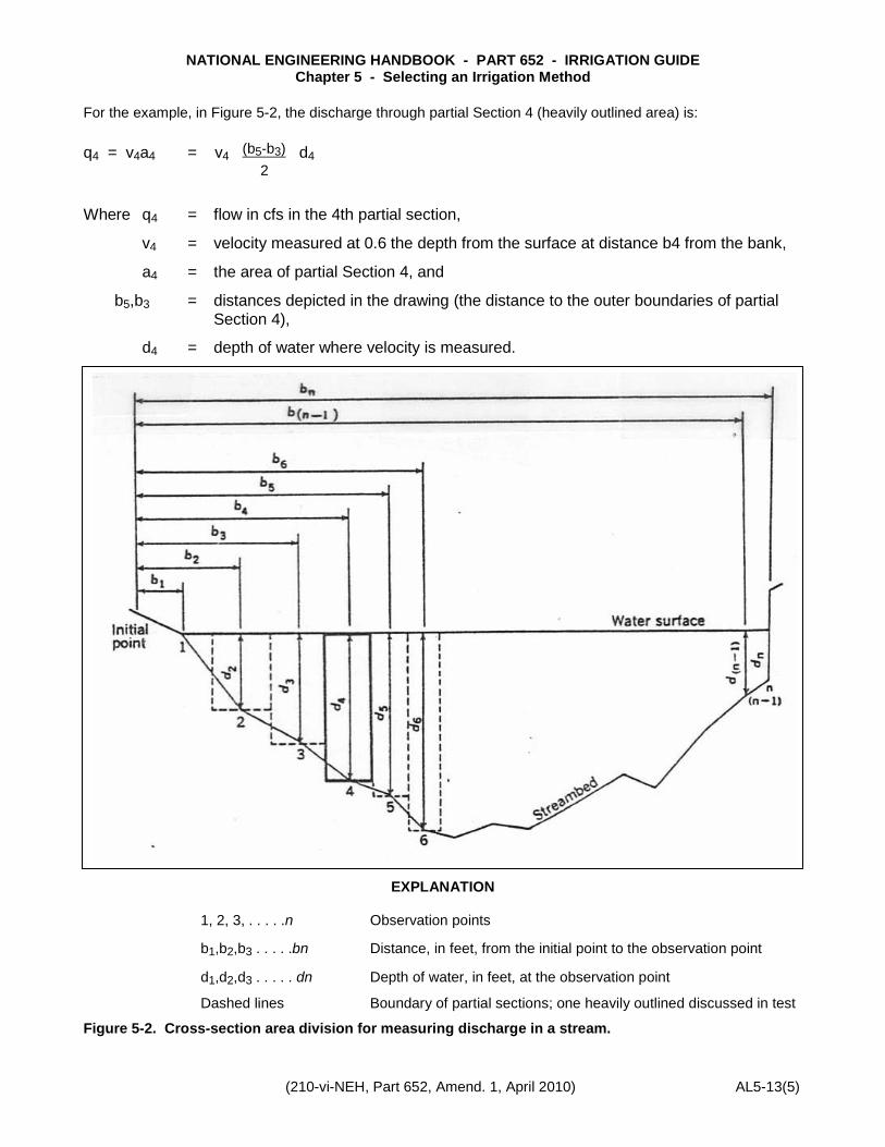
For the example, in Figure 5-2, the discharge through partial Section 4 (heavily outlined area) is: q4 = v4a4 = v4 (b5-b3) d4
2
Where q4 = flow in cfs in the 4th partial section,
v4 = velocity measured at 0.6 the depth from the surface at distance b4 from the bank,
a4 = the area of partial Section 4, and
b5,b3 = distances depicted in the drawing (the distance to the outer boundaries of partial Section 4),
d4 = depth of water where velocity is measured.
EXPLANATION
1, 2, 3, . . . . .n Observation points
b1,b2,b3 . . . . .bn Distance, in feet, from the initial point to the observation point
d1,d2,d3 . . . . . dn Depth of water, in feet, at the observation point
Dashed lines Boundary of partial sections; one heavily outlined discussed in test
Figure 5-2. Cross-section area division for measuring discharge in a stream.
NATIONAL ENGINEERING HANDBOOK - PART 652 - IRRIGATION GUIDE Chapter 5 - Selecting an Irrigation Method
AL5-13(6) (210-vi-NEH, Part 652, Amend. AL1, April 2010)
NATIO
NA
L ENG
INE
ERIN
G H
AND
BOO
K - PAR
T 652 - IRR
IGATIO
N G
UID
E
Chapter 5 - Selecting an Irrigation M
ethod
The total flow throughout the cross-section is the summation of the partial flows; thus, Q = ∑ n-1 (anVn) b. Float Method The flow rate can be estimated by timing the passage of a small float through a measured length of channel. The procedure for estimating rate of flow by the float method is as follows: 1. Select a straight reach of stream with fairly
uniform cross-sections. The length of the reach will depend on the current, but 100 ft. usually will be adequate. A shorter length may be satisfactory for slow flowing streams.
2. Make several measurements of the depth at each of several cross-sections within the reach. At each cross-section, average 3-5 depth readings and multiply the average depth by the stream width to obtain the cross-sectional area at the section. Do this at 3 to 4 stations and determine the average cross-sectional area of the reach. The area should be expressed in terms of square feet.
3. Place a small float in the stream some distance upstream from the upper end of the test section. Determine the number of seconds it takes for the float to travel from the upper end of the section to the lower end. Make several trials to get the average time of travel. Small rounded objects which float nearly submerged make good floats. They are less apt to be affected by wind or to be slowed by striking the side of the channel. Among small objects which make good floats are a capped long-necked bottle partly filled with water, a rounded block of wood, or an orange. A wooden sphere, like a croquet ball, is excellent.
4. Determine the velocity (or speed) of the float in units of feet per second by dividing the length of the section (in feet) by the time (in seconds) required for the float to travel that distance.
5. Determine the average velocity of the stream. Since the velocity of the float on the surface of the water will be greater than the average velocity of the stream, the float velocity must be multiplied by a correction coefficient to obtain a good estimate of the true average stream velocity. The correction factor varies with the type of float used and with the shape and uniformity of the channel. With floats that sink only an inch or two below the water surface, a coefficient of about 0.80 should be used for most unlined farm ditches and natural streams with a relatively uniform flow. A coefficient of 0.85 is appropriate for smooth uniform lined ditches. With floats that extend from the surface to 2/3 or more off the stream depth, the coefficients should be about 0.85 for unlined itches and smooth flowing streams and about 0.90 for lined ditches.
6. Compute the rate of flow. The rate of flow is obtained by multiplying the average cross-sectional area (Item 2) by the average stream velocity (Item 5) (See Figure 5-3). The accuracy of these estimates of flow rates is dependent upon the preciseness with which average cross-sectional areas and float velocities have been determined and upon the selection of the proper correction coefficient.
Indirect Method. The recommended method for evaluating low-flows in Alabama is an indirect one developed by the U.S. Geological Survey in cooperation with the Geological Survey of Alabama. This method allows for the estimation of 7-day, 2-year and 7-day, 10-year low flows for ungauged Alabama streams. The low-flow for each frequency (2-year or 10-year) is determined from equations. These equations do not apply where the watershed is significantly altered by the activities of man or where the flow is influenced by unusual natural inputs such as large artesian wells. In addition, they are not applicable for drainage areas less than five square miles.
When the indirect method is used to determine water availability for irrigation of high value crops, only the 7-day, 10-year low-flow needs to be considered. The equation is:
NATIONAL ENGINEERING HANDBOOK - PART 652 - IRRIGATION GUIDE Chapter 5 - Selecting an Irrigation Method
(210-vi-NEH, Part 652, Amend. 1, April 2010) AL5-13(7)
7Q10 = 0.15 x 10⁻⁵ (G-30) 1.35 (A) 1.05 (P-30) 1.64
Where 7Q10 = estimated 7-day, 10-year low-flow in cu.ft./sec.,
G = stream recession index in days per log cycle of discharge depletion,
A = contributing drainage area in square miles, and
P = mean annual precipitation in inches.
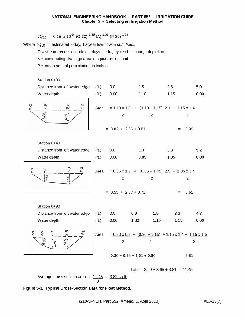
Station 0+00
Distance from left water edge (ft.) 0.0 1.5 3.6 5.0
Water depth (ft.) 0.00 1.10 1.15 0.00
Area = 1.10 x 1.5 + (1.10 + 1.15) 2.1 + 1.15 x 1.4
2 2 2
= 0.82 + 2.36 + 0.81 = 3.99
Station 0+40
Distance from left water edge (ft.) 0.0 1.3 3.8 5.2
Water depth (ft.) 0.00 0.85 1.05 0.00
Area = 0.85 x 1.3 + (0.85 + 1.05) 2.5 + 1.05 x 1.4
2 2 2
= 0.55 + 2.37 + 0.73 = 3.65
Station 0+90
Distance from left water edge (ft.) 0.0 0.9 1.9 3.3 4.8
Water depth (ft.) 0.00 1.80 1.15 1.15 0.00
Area = 0.80 x 0.9 + (0.80 + 1.15) + 1.15 x 1.4 + 1.15 x 1.5
2 2 2
= 0.36 + 0.98 + 1.61 + 0.86 = 3.81
Total = 3.99 + 3.65 + 3.81 = 11.45
Average cross section area = 11.45 = 3.82 sq.ft. 3
Figure 5-3. Typical Cross-Section Data for Float Method.
NATIONAL ENGINEERING HANDBOOK - PART 652 - IRRIGATION GUIDE Chapter 5 - Selecting an Irrigation Method
AL5-13(8) (210-vi-NEH, Part 652, Amend. AL1, April 2010)
NATIO
NA
L ENG
INE
ERIN
G H
AND
BOO
K - PAR
T 652 - IRR
IGATIO
N G
UID
E
Chapter 5 - Selecting an Irrigation M
ethod
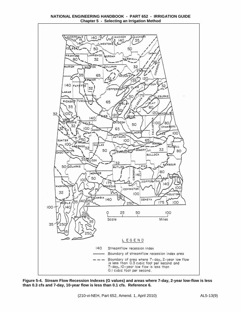
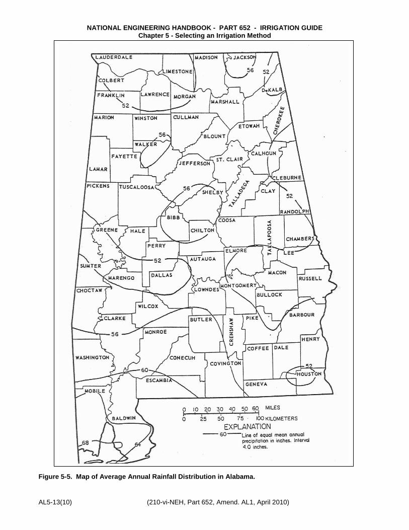
Values for the variable G and P can be determined from Figures 5-4 and 5-5, respectively. Drainage area (A) can be determined from topographic map.
The equation for the 7-day, 2-year low-flow is:
7Q2 = 0.24 x 10⁻⁴ (G-30) 1.07 (A) 0.94 (P-30) 1.51
It should be noted that the estimating method should not be used on streams where the 7Q2 low-flow is less than 0.3 cfs and the 7Q10 low-flow is less than 0.1 cfs. These areas are delineated in Figure 5-4.
Example: A prospective irrigator near Enterprise in Coffee County wants to determine the 7Q10 for a 6 sq.mi. watershed.
From Figure 5-5 or local rainfall data, P = 54 (approximately) and, from Figure 5-4, G = 100. A is given a 6 sq. mi. Therefore, the equation becomes:
7Q10, = 0.15 x 10⁻⁵ (100-30)1.35 (6)1.05 (54-30)1.64
= 0.56 cfs
Or, 0.56 cfs x 448.8 = 251 gpm
NATIONAL ENGINEERING HANDBOOK - PART 652 - IRRIGATION GUIDE Chapter 5 - Selecting an Irrigation Method
(210-vi-NEH, Part 652, Amend. 1, April 2010) AL5-13(9)
Figure 5-4. Stream Flow Recession Indexes (G values) and areas where 7-day, 2-year low-flow is less than 0.3 cfs and 7-day, 10-year flow is less than 0.1 cfs. Reference 6.
NATIONAL ENGINEERING HANDBOOK - PART 652 - IRRIGATION GUIDE Chapter 5 - Selecting an Irrigation Method
AL5-13(10) (210-vi-NEH, Part 652, Amend. AL1, April 2010)
NATIO
NA
L ENG
INE
ERIN
G H
AND
BOO
K - PAR
T 652 - IRR
IGATIO
N G
UID
E
Chapter 5 - Selecting an Irrigation M
ethod
Figure 5-5. Map of Average Annual Rainfall Distribution in Alabama.
NATIONAL ENGINEERING HANDBOOK - PART 652 - IRRIGATION GUIDE Chapter 5 - Selecting an Irrigation Method
(210-vi-NEH, Part 652, Amend. 1, April 2010) AL5-13(11)
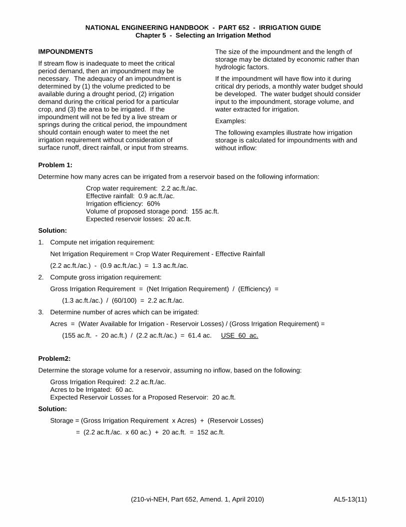
IMPOUNDMENTS
If stream flow is inadequate to meet the critical period demand, then an impoundment may be necessary. The adequacy of an impoundment is determined by (1) the volume predicted to be available during a drought period, (2) irrigation demand during the critical period for a particular crop, and (3) the area to be irrigated. If the impoundment will not be fed by a live stream or springs during the critical period, the impoundment should contain enough water to meet the net irrigation requirement without consideration of surface runoff, direct rainfall, or input from streams.
The size of the impoundment and the length of storage may be dictated by economic rather than hydrologic factors.
If the impoundment will have flow into it during critical dry periods, a monthly water budget should be developed. The water budget should consider input to the impoundment, storage volume, and water extracted for irrigation.
Examples:
The following examples illustrate how irrigation storage is calculated for impoundments with and without inflow:
Problem 1:
Determine how many acres can be irrigated from a reservoir based on the following information:
Crop water requirement: 2.2 ac.ft./ac. Effective rainfall: 0.9 ac.ft./ac. Irrigation efficiency: 60% Volume of proposed storage pond: 155 ac.ft. Expected reservoir losses: 20 ac.ft.
Solution:
1. Compute net irrigation requirement:
Net Irrigation Requirement = Crop Water Requirement - Effective Rainfall
(2.2 ac.ft./ac.) - (0.9 ac.ft./ac.) = 1.3 ac.ft./ac.
2. Compute gross irrigation requirement:
Gross Irrigation Requirement = (Net Irrigation Requirement) / (Efficiency) =
(1.3 ac.ft./ac.) / (60/100) = 2.2 ac.ft./ac.
3. Determine number of acres which can be irrigated:
Acres = (Water Available for Irrigation - Reservoir Losses) / (Gross Irrigation Requirement) =
(155 ac.ft. - 20 ac.ft.) / (2.2 ac.ft./ac.) = 61.4 ac. USE 60 ac.
Problem2:
Determine the storage volume for a reservoir, assuming no inflow, based on the following:
Gross Irrigation Required: 2.2 ac.ft./ac. Acres to be Irrigated: 60 ac. Expected Reservoir Losses for a Proposed Reservoir: 20 ac.ft.
Solution:
Storage = (Gross Irrigation Requirement x Acres) + (Reservoir Losses)
= (2.2 ac.ft./ac. x 60 ac.) + 20 ac.ft. = 152 ac.ft.
NATIONAL ENGINEERING HANDBOOK - PART 652 - IRRIGATION GUIDE Chapter 5 - Selecting an Irrigation Method
AL5-13(12) (210-vi-NEH, Part 652, Amend. AL1, April 2010)
NATIO
NA
L ENG
INE
ERIN
G H
AND
BOO
K - PAR
T 652 - IRR
IGATIO
N G
UID
E
Chapter 5 - Selecting an Irrigation M
ethod
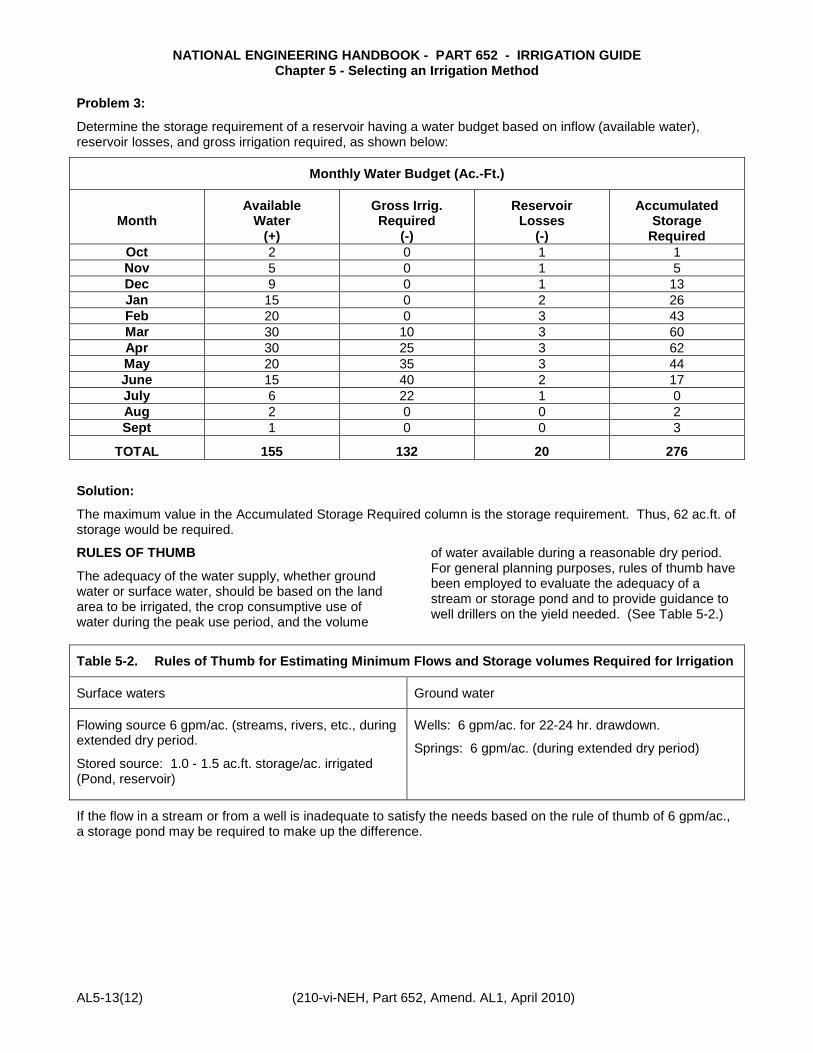
Problem 3:
Determine the storage requirement of a reservoir having a water budget based on inflow (available water), reservoir losses, and gross irrigation required, as shown below:
Monthly Water Budget (Ac.-Ft.)
Month Available
Water (+)
Gross Irrig. Required
(-)
Reservoir Losses
(-)
Accumulated Storage
Required Oct 2 0 1 1 Nov 5 0 1 5 Dec 9 0 1 13 Jan 15 0 2 26 Feb 20 0 3 43 Mar 30 10 3 60 Apr 30 25 3 62 May 20 35 3 44 June 15 40 2 17 July 6 22 1 0 Aug 2 0 0 2 Sept 1 0 0 3
TOTAL 155 132 20 276
Solution:
The maximum value in the Accumulated Storage Required column is the storage requirement. Thus, 62 ac.ft. of storage would be required.
RULES OF THUMB
The adequacy of the water supply, whether ground water or surface water, should be based on the land area to be irrigated, the crop consumptive use of water during the peak use period, and the volume
of water available during a reasonable dry period. For general planning purposes, rules of thumb have been employed to evaluate the adequacy of a stream or storage pond and to provide guidance to well drillers on the yield needed. (See Table 5-2.)
Table 5-2. Rules of Thumb for Estimating Minimum Flows and Storage volumes Required for Irrigation
Surface waters Ground water
Flowing source 6 gpm/ac. (streams, rivers, etc., during extended dry period.
Stored source: 1.0 - 1.5 ac.ft. storage/ac. irrigated (Pond, reservoir)
Wells: 6 gpm/ac. for 22-24 hr. drawdown.
Springs: 6 gpm/ac. (during extended dry period)
If the flow in a stream or from a well is inadequate to satisfy the needs based on the rule of thumb of 6 gpm/ac., a storage pond may be required to make up the difference.
NATIONAL ENGINEERING HANDBOOK - PART 652 - IRRIGATION GUIDE Chapter 5 - Selecting an Irrigation Method
(210-vi-NEH, Part 652, Amend. 1, April 2010) AL5-13(13)
WATER LAW
Irrigators who plan to utilize large volumes of water for irrigation should be aware of the possible legal ramifications of such use, whether the source is ground water or surface water. This is especially true if the source offers only a limited supply of water during critical periods.
“Alabama has few laws related to water rights, and those few are mostly related to conditions of a past time that are not now important.”3/ When conflicts over water rights arise in Alabama, they are generally settled in the courts using common-law procedures based on the doctrine of “riparian rights.” This doctrine is basically the guiding light for water law in the eastern United States, including Alabama. The doctrine is principally applicable to surface waters.
SURFACE WATER LAW
“Under the riparian concept, all owners whose lands actually touch the waterway are entitled to use the water. These rights may not be lost by non-use and the rights are attached only to the ownership of the riparian land. A riparian owner may not convey his water rights, and he may use the water only on his riparian land.”4/
“The modern ‘Riparian Rights Doctrine’ may be referred to as the ‘natural-flow-subject-to-reasonable-use’ doctrine. In other words, the right of every riparian owner is to enjoy the natural flow of the water courses which traverse his land, unimpaired in quality and undiminished in quantity, except to the extent necessarily resulting from a reasonable use of such water courses by other riparian owners. The right to use the water in a reasonable manner is common to all riparian owners.”3/
GROUND WATER LAW
With regard to ground water, the riparian rule would not usually apply unless, possibly, the underground water flows in a clearly defined stream. Underground waters are generally considered
percolating waters. Although several doctrines of law apply to percolating waters, ‘the Alabama courts have announced the reasonable-use rule as to underground deposits of water, adding an element of negligent use as a basis for protection of adjoining landowners.”4/ The reasonable-use doctrine for underground waters appears to be indistinguishable from the reasonable-use rule applied to riparian owners of surface streams. In general, a landowner may withdraw underground water without liability to neighboring landowners when it is used for natural and legitimate uses on his own land. However, he may not, in any unreasonable manner, force or increase the flow to divert water from neighboring lands to some use disconnected with improvements and enjoyment of his own property.3/
REFERENCES 1/ Curtis, Larry M., Ted M. Tyson, and Kenneth G.
Aycock. 1992 Irrigation Survey, Alabama Cooperative Extension Service (1992).
2/ Barksdale, H.C., P. E. LaMoreaux, and D. B. Knowles. Hydrology and Ground Water of Non-Appalachia Alabama, Appendix H to Report for Development of water Resources in Non-Appalachia Alabama; Geological survey of Alabama (1968).
3/ Alabama Development Office. Water Laws of Alabama, Montgomery, Alabama (1974).
4/ Grubbs, D. M. and H. Cohen, Status of Water-Resources Management in Alabama (prepared for ADO by the Natural Resources Center, University of Alabama), Montgomery, Alabama (1970).
5/ U.S. Geological Survey. National Water Summary 1984, Water Supply Paper No. 2275, USGPO, Washington, D.C. (1985).
6/ U.S. Geological Survey. Low-Flow Characteristics of Alabama Streams, Water Supply Paper No. 2083, USGPO, Washington, D.C. (1982)