national forests in derek j.s. ibarguen, district ranger...
TRANSCRIPT

National Forests in
North Carolina
Derek J.S. Ibarguen, District Ranger
828-877-3265
Pisgah Ranger District
1001 Pisgah Highway
Pisgah Forest, NC 28768
TRAVEL ANALYSIS PROCESS
For
COMPARTMENTS 02, 03
USDA Forest Service
Pisgah Ranger District
Pisgah National Forest
August 2012

Table of Contents INTRODUCTION ............................................................................................................................................................................... 3
Step I: Setting up the Analysis ............................................................................................................................................................. 3
1.1 Interdisciplinary Team Members ............................................................................................................................................... 4
1.2 Data Needs ................................................................................................................................................................................. 4
1.3 Scope of Travel Analysis ........................................................................................................................................................... 4
1.4 Scale of Travel Analysis ............................................................................................................................................................ 4
1.5 Inventory of Roads and Motorized Trails in the Travel Analysis Area ..................................................................................... 5
1.6 Appropriate Depth for this Analysis .......................................................................................................................................... 5
1.7 Opportunities to Integrate this Travel Analysis with any Watershed or Landscape Assessment .............................................. 5
STEP II: DESCRIBING THE SITUATIOn ......................................................................................................................................... 5
2.1 Current Land and Travel Management Direction ...................................................................................................................... 6
2.2 Analysis Area ............................................................................................................................................................................ 6
2.2a Map of Analysis Area .......................................................................................................................................................... 6
2.2b Inventory of Roads and Trails used for Motorized Travel .................................................................................................. 6
2.2c Assessment of Motorized and Non-Motorized Uses ........................................................................................................... 8
2.2d Description of Public and Administrative Needs ................................................................................................................ 8
2.2e Assessment of Motorized Recreation Opportunities ........................................................................................................... 8
2.2f Information about Environmental, Social, and Other Issues ................................................................................................ 8
2.2g Summary of Existing Travel Management Decisions ......................................................................................................... 9
2.2h Assessment of Available Resources to Maintain and Operate the Forest Transportation System ...................................... 9
2.2i Summary of Available Applicable Accident and Law Enforcement Data ........................................................................... 9
2.3 Motor Vehicle Use on the Part of the Forest Transportation System Under Analysis and on the Adjacent or Connecting
Authorized Transportation Systems ................................................................................................................................................. 9
2.4 Effects of Motor Vehicle Use on the Portion of the Forest Transportation System Under Analysis ......................................... 9
2.4.1 General Criteria for Roads, Trails, and Areas .................................................................................................................... 9
2.4.2 Specific Criteria for Trails and Areas ............................................................................................................................... 10
2.4.3 Specific Criteria for Roads ............................................................................................................................................... 11
3.1 Identify Key Issues Affecting the Portion of the Forest Transportation System Under Analysis ............................................ 12
3.2 To Identify Key Issues, Determine in the Context of the Analysis .......................................................................................... 12
3.2a Primary Public Concerns Related to Travel Management ................................................................................................. 12
3.2b Primary Management Concerns Related to Travel Management ...................................................................................... 12
3.2c Legal Constraints on Travel Management ......................................................................................................................... 12
3.2d Resources and Skill Available to Conduct Analysis ......................................................................................................... 12
3.3 Data Needed To Analyze Key Issues ....................................................................................................................................... 13
STEP IV: ASSESSING BENEFITS, PROBLEMS, AND RISKS .................................................................................................... 13
4.1 Major Uses and Environmental, Social, and Economic Impacts ............................................................................................. 13
4.1.1 Financial and Economic Values ....................................................................................................................................... 13
4.3 General Criteria for Designating NFS Roads, Trails, and Areas ............................................................................................. 14
STEP V: DESCRIBING OPPORTUNITIES AND SETTING PRIORITIES ................................................................................... 15
5.1 Management Opportunities and Proposals .............................................................................................................................. 15
5.2 Current and Desired Motorized Use ........................................................................................................................................ 17
5.3 Unauthorized Roads and Trails Considered for Designation ................................................................................................... 17
STEP VI: REPORTING ..................................................................................................................................................................... 17
6.1 List of Key Issues .................................................................................................................................................................... 17
6.2 Prioritized List of the Risks and Benefits ................................................................................................................................ 17
6.3 Prioritized List of Opportunities for Addressing those Risks and Benefits ............................................................................. 17
6.4 Prioritized List of Actions or Projects that would Implement the Minimum Road System ..................................................... 17
6.5 List of Proposed Changes Including Additions and Deletions ................................................................................................ 17
Appendix A: Applicable Land and Travel Management Direction ................................................................................................... 19
Appendix B: Generalized Road Maintenance Costs, Pisgah Ranger District .................................................................................... 24
Appendix C: Maps ............................................................................................................................................................................. 25

INTRODUCTION
Process
Pursuant to Forest Service Handbook (FSH) 7709.55, Chapter 20, the Travel Analysis Process (TAP) is a six-step process. The
steps are designed to be sequential with the understanding the process may require feedback and iteration among steps over time as
an analysis matures. The amount of time and effort spent on each step differs by project based on specific situations and available
information. The process provides a set of possible issues and analysis questions, the answers for which are intended to inform
choices about road system management. Decision makers and analysts determine the relevance of each question, incorporating
public participation as deemed necessary. Additional information about the Transportation Analysis Process can be found in FSM
7700.
Travel Analysis Steps:
Step 1: Setting up the Analysis
Step 2: Describing the Situation
Step 3: Identifying Issues
Step 4: Assessing Benefits, Problems, and Risks
Step 5: Describing Opportunities and Setting Priorities
Step 6: Reporting
Products
The product of a Travel Analysis is a report for decision makers and the public that documents the information and analyses used
to identify opportunities and set priorities for the future management of the National Forest Roads System.
Included in the report is a map displaying the inventoried road system for the analysis area and the risks and opportunities for each
road or road segment, identification of the minimum road system needed for safe and efficient travel and for administration,
utilization, and protection of National Forest System (NFS) lands [36 CFR 212.5(b)(1)], and designation of roads, trails and areas
for motor vehicle use [36 CFR 212.51]. A report may also include other maps and tables necessary to display specific priorities
and changes in a road system, and may be updated as needed. There are two types of TAPs – those done at the Forest-level and
those done at a smaller level including the sub-watershed and project-level.
This Report
This report documents the travel analysis for Compartments 02 and 03. Compartments 02 and 03 are on the Pisgah Ranger District
of the Pisgah National Forest, and are located in Buncombe County in North Carolina. This report is being completed in support to
the Gap-based Approach to Oak Regeneration Project (GAORP). This environmental assessment is being completed concurrently.
The GAORP Project Purpose and Need are:
To examine an un-tested silvicultural system and continue testing an existing silvicultural system that are both based on
natural disturbance patterns for their potential to regenerate oak and hickory species on moderate to high productivity sites in
the southern Appalachians.
To measure the effects of disturbance-based silvicultural systems on other ecosystem components such as wildlife, understory
plants, etc.
More information about the GAORP project can be found at (Add SOPA website here)
Only National Forest System (NFS) roads and other roads which occur on NFS lands are considered. All road lengths in this
analysis are derived from GIS and are approximate.
STEP I: SETTING UP THE ANALYSIS
The purpose of this step is to:
1. Establish an Interdisciplinary Team (ID team) that includes specialists from relevant disciplines;
2. Develop a list of data needs, and a schedule for completing the analysis;
3. Identify the appropriate scope of analysis. The scope of analysis refers to the range of potential actions to be considered, for
example, whether only additions to the existing forest transportation system will be considered, whether only the existing
forest transportation system will be analyzed, or whether only motorized trails will be considered for changes;
4. Identify the appropriate scale of analysis;
5. Establish a complete and accurate inventory of NFS roads and NFS trails managed for motor vehicle use in the portion of the
forest transportation system under analysis;

6. Identify the appropriate depth for travel analysis based on the skills and resources available and the complexity and scope of
the issues prompting the analysis;
7. Consider opportunities to integrate travel analysis with any watershed analysis or landscape assessments.
1.1 Interdisciplinary Team Members
The Travel Analysis was conducted by an Interdisciplinary Team (ID Team). The ID Team consisted of the following members:
Core Team:
Jason A. Rodrigue (Forest Silviculturist – IDT co-leader/ Vegetation)
Tara L. Keyser (Research Forester – IDT co-leader/Vegetation)
Cathryn H. Greenberg (Research Ecologist – Wildlife and Fisheries)
W. Henry McNab (Research Forester – Soils and Hydrology)
Tracy Roof (Lead Forestry Technician – Botany)
Extended Team:
Heather Luczak (Assistant Forest Planner – NEPA Support)
Sheryl Bryan (Forest Biologist –BE/BA Support)
Brady Dodd (Forest Hydrologist – Hydrology Support)
Gary Kauffman (Forest Botanist/Ecologist – BE/BA Support)
Stacy Clark (Research Forester – Vegetation Effects)
Dana Mitchell (SRS Research Logging Engineer - Transportation System Design)
Rodney Snedeker (Forest Archeologist – Archeology Support)
1.2 Data Needs
Data needed for the analysis include:
Forest Plan Direction for roads and motorized trails in C02/03;
Inventory of all National Forest System Roads (NFSRs) and motorized use National Forest System Trails (NFSTs) within
C02/03;
Determinations and locations of unauthorized or temporary roads where opportunities to improve compliance with the
Forest Plan exist;
Determination of future needs for access to the area.
1.3 Scope of Travel Analysis
Pursuant to FSH 7709.55, Chapter 20, the objective of this travel analysis is to
“conduct travel analysis to inform decisions related to:
a. Identification of the minimum road system needed for safe and efficient travel and for administration, utilization, and
protection of NFS lands per 36 CFR 212.5(b)(1);
b. Designation of roads, trails and areas for motor vehicle use per 36 CFR 212.51.”
It is not within the scope of this analysis to produce a comprehensive list of every unauthorized or temporary road within the two
compartments. Only authorized roads and those roads which present an opportunity for management action are included.
The scope of this analysis includes:
Identification of authorized roads, trails, and areas designated for motorized use
Identification of the risks and benefits associated with the current authorized Forest transportation system
Identification of areas of special sensitivity or unique resource value that may require specific road management.
Identification of opportunities to improve compliance of the Forest transportation system with the Forest Plan, including:
o Opportunities to add existing temporary and unauthorized roads to the Forest transportation system;
o Opportunities to decommission existing authorized, unauthorized, and temporary roads;
o Opportunities to change Road Maintenance objectives, access levels, and seasonal access restrictions; and
o Opportunities to add, improve, or remove Forest transportation facilities (gates, parking lots, bridges, culverts, etc.);
and
Prioritization of recommended changes, based on available resources, existing management direction, and reasonably
foreseeable activities within the Analysis Area.
1.4 Scale of Travel Analysis
Pursuant to FSH 7709.55, Chapter 21.1, the responsible official must “Determine the appropriate scale [for the TAP] based on the
issues to be addressed.” In order to thoroughly analyze the GAORP Project Area and provide detailed information about the
existing transportation system to facilitate future management decisions, it was determined that a Travel Analysis on a sub-
watershed scale was appropriate. By focusing on Compartments 02 and 03, a XXXXX acre area, the TAP can provide more
detailed and specific data than a watershed- district- or Forest-wide analysis. This information in this TAP is tiered to two other
transportation analyses.
The Baldwin Gap RAP which covered Compartment 01 was completed in 2005. Compartment 01 lays Northeast of
Compartments 02 and 03 but contains portions of the road system described in the GAORP Analysis.
The Compartment 128 Projects RAP which covered Compartment 128 was completed in 2003.Compartment 128 lays to
the East of Compartments 02 and 03. This compartment is also known as Bent Creek Experimental Forest. This RAP
also contains portions of the road system described in the GAORP Analysis.
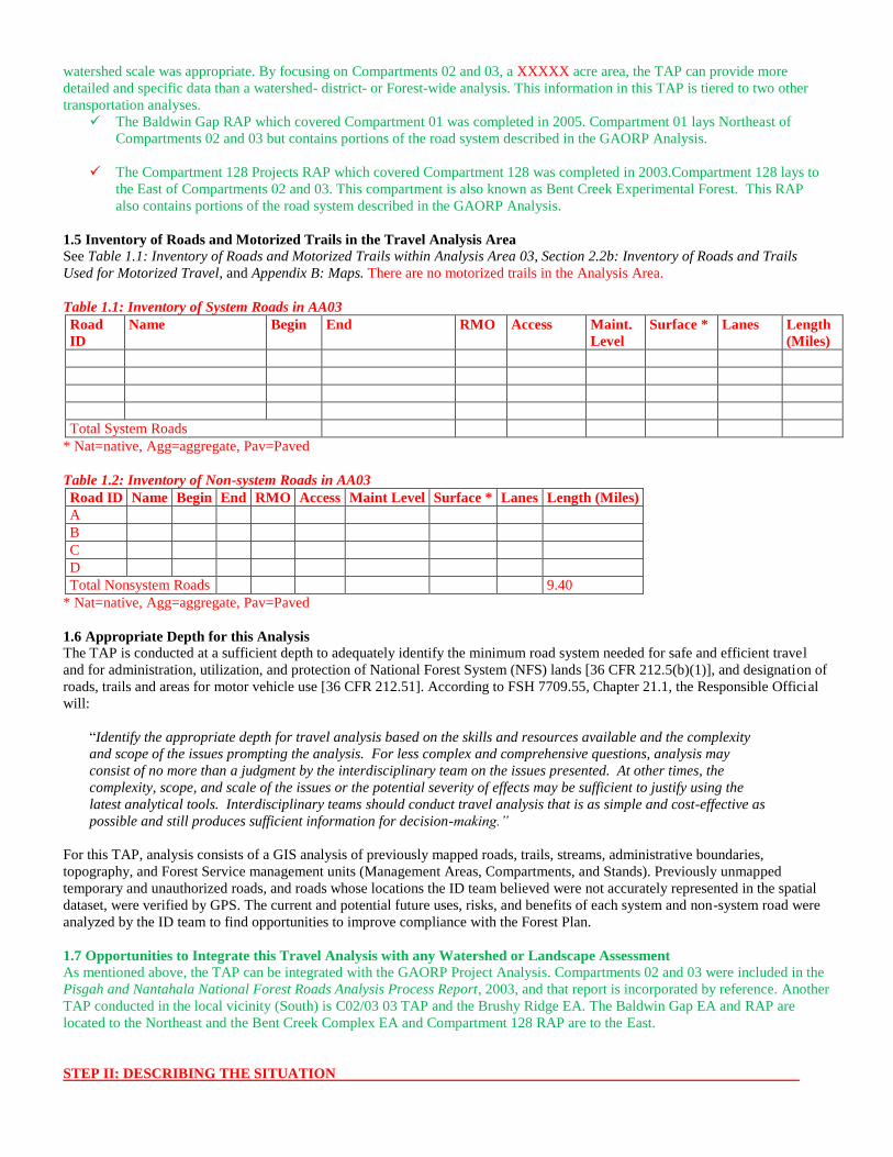
1.5 Inventory of Roads and Motorized Trails in the Travel Analysis Area
See Table 1.1: Inventory of Roads and Motorized Trails within Analysis Area 03, Section 2.2b: Inventory of Roads and Trails
Used for Motorized Travel, and Appendix B: Maps. There are no motorized trails in the Analysis Area.
Table 1.1: Inventory of System Roads in AA03
Road
ID
Name Begin End RMO Access Maint.
Level
Surface * Lanes Length
(Miles)
Total System Roads
* Nat=native, Agg=aggregate, Pav=Paved
Table 1.2: Inventory of Non-system Roads in AA03
Road ID Name Begin End RMO Access Maint Level Surface * Lanes Length (Miles)
A
B
C
D
Total Nonsystem Roads 9.40
* Nat=native, Agg=aggregate, Pav=Paved
1.6 Appropriate Depth for this Analysis
The TAP is conducted at a sufficient depth to adequately identify the minimum road system needed for safe and efficient travel
and for administration, utilization, and protection of National Forest System (NFS) lands [36 CFR 212.5(b)(1)], and designation of
roads, trails and areas for motor vehicle use [36 CFR 212.51]. According to FSH 7709.55, Chapter 21.1, the Responsible Official
will:
“Identify the appropriate depth for travel analysis based on the skills and resources available and the complexity
and scope of the issues prompting the analysis. For less complex and comprehensive questions, analysis may
consist of no more than a judgment by the interdisciplinary team on the issues presented. At other times, the
complexity, scope, and scale of the issues or the potential severity of effects may be sufficient to justify using the
latest analytical tools. Interdisciplinary teams should conduct travel analysis that is as simple and cost-effective as
possible and still produces sufficient information for decision-making.”
For this TAP, analysis consists of a GIS analysis of previously mapped roads, trails, streams, administrative boundaries,
topography, and Forest Service management units (Management Areas, Compartments, and Stands). Previously unmapped
temporary and unauthorized roads, and roads whose locations the ID team believed were not accurately represented in the spatial
dataset, were verified by GPS. The current and potential future uses, risks, and benefits of each system and non-system road were
analyzed by the ID team to find opportunities to improve compliance with the Forest Plan.
1.7 Opportunities to Integrate this Travel Analysis with any Watershed or Landscape Assessment
As mentioned above, the TAP can be integrated with the GAORP Project Analysis. Compartments 02 and 03 were included in the
Pisgah and Nantahala National Forest Roads Analysis Process Report, 2003, and that report is incorporated by reference. Another
TAP conducted in the local vicinity (South) is C02/03 03 TAP and the Brushy Ridge EA. The Baldwin Gap EA and RAP are
located to the Northeast and the Bent Creek Complex EA and Compartment 128 RAP are to the East.
STEP II: DESCRIBING THE SITUATION
The purpose of this step is to:
1. Summarize current land management and travel management direction;
2. For the portion of the forest transportation system under analysis, produce:
a. A map;
b. An inventory of NFS roads and NFS trails and areas on NFS lands managed for motor vehicle use;
c. An assessment of motorized and non-motorized uses;
d. A description of public and administrative access needs;
e. An assessment of motorized recreation opportunities;
f. Information about environmental, social and other issues;
g. A summary of existing travel management decisions;
h. An assessment of available resources to maintain and operate the forest transportation system;
i. A summary of available applicable accident and law enforcement data;
3. Consider motor vehicle use both on the part of the forest transportation system under analysis and on adjacent or connecting
authorized transportation systems;
4. Consider the effects of motor vehicle use on the portion of the transportation system under analysis, using the general and
specific criteria for designating NFS roads, trails, and areas on NFS lands for motor vehicle use (36 CFR 251.55; FSM
7715.5).
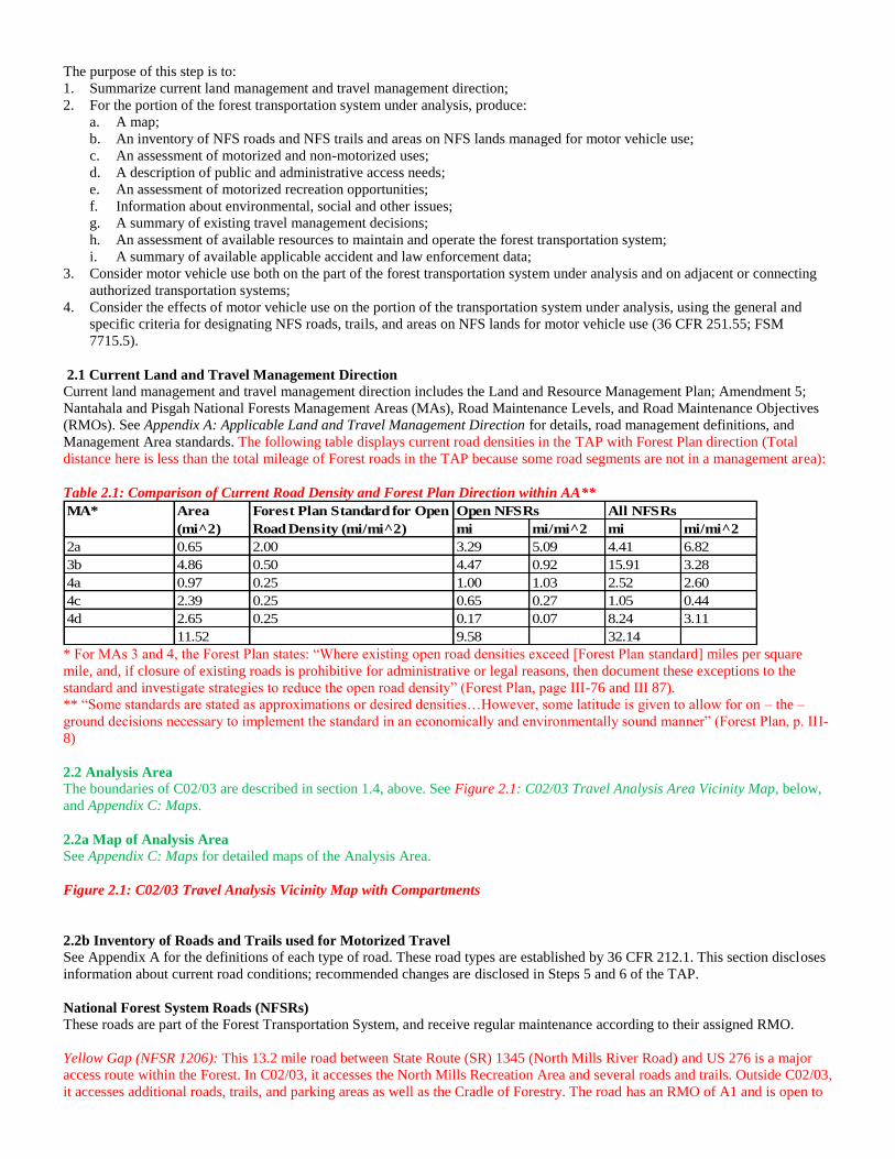
2.1 Current Land and Travel Management Direction
Current land management and travel management direction includes the Land and Resource Management Plan; Amendment 5;
Nantahala and Pisgah National Forests Management Areas (MAs), Road Maintenance Levels, and Road Maintenance Objectives
(RMOs). See Appendix A: Applicable Land and Travel Management Direction for details, road management definitions, and
Management Area standards. The following table displays current road densities in the TAP with Forest Plan direction (Total
distance here is less than the total mileage of Forest roads in the TAP because some road segments are not in a management area):
Table 2.1: Comparison of Current Road Density and Forest Plan Direction within AA**
mi mi/mi^2 mi mi/mi^2
2a 0.65 2.00 3.29 5.09 4.41 6.82
3b 4.86 0.50 4.47 0.92 15.91 3.28
4a 0.97 0.25 1.00 1.03 2.52 2.60
4c 2.39 0.25 0.65 0.27 1.05 0.44
4d 2.65 0.25 0.17 0.07 8.24 3.11
11.52 9.58 32.14
MA* Area
(mi^2)
Forest Plan Standard for Open
Road Density (mi/mi^2)
Open NFSRs All NFSRs
* For MAs 3 and 4, the Forest Plan states: “Where existing open road densities exceed [Forest Plan standard] miles per square
mile, and, if closure of existing roads is prohibitive for administrative or legal reasons, then document these exceptions to the
standard and investigate strategies to reduce the open road density” (Forest Plan, page III-76 and III 87).
** “Some standards are stated as approximations or desired densities…However, some latitude is given to allow for on – the –
ground decisions necessary to implement the standard in an economically and environmentally sound manner” (Forest Plan, p. III-
8)
2.2 Analysis Area
The boundaries of C02/03 are described in section 1.4, above. See Figure 2.1: C02/03 Travel Analysis Area Vicinity Map, below,
and Appendix C: Maps.
2.2a Map of Analysis Area
See Appendix C: Maps for detailed maps of the Analysis Area.
Figure 2.1: C02/03 Travel Analysis Vicinity Map with Compartments
2.2b Inventory of Roads and Trails used for Motorized Travel
See Appendix A for the definitions of each type of road. These road types are established by 36 CFR 212.1. This section discloses
information about current road conditions; recommended changes are disclosed in Steps 5 and 6 of the TAP.
National Forest System Roads (NFSRs)
These roads are part of the Forest Transportation System, and receive regular maintenance according to their assigned RMO.
Yellow Gap (NFSR 1206): This 13.2 mile road between State Route (SR) 1345 (North Mills River Road) and US 276 is a major
access route within the Forest. In C02/03, it accesses the North Mills Recreation Area and several roads and trails. Outside C02/03,
it accesses additional roads, trails, and parking areas as well as the Cradle of Forestry. The road has an RMO of A1 and is open to
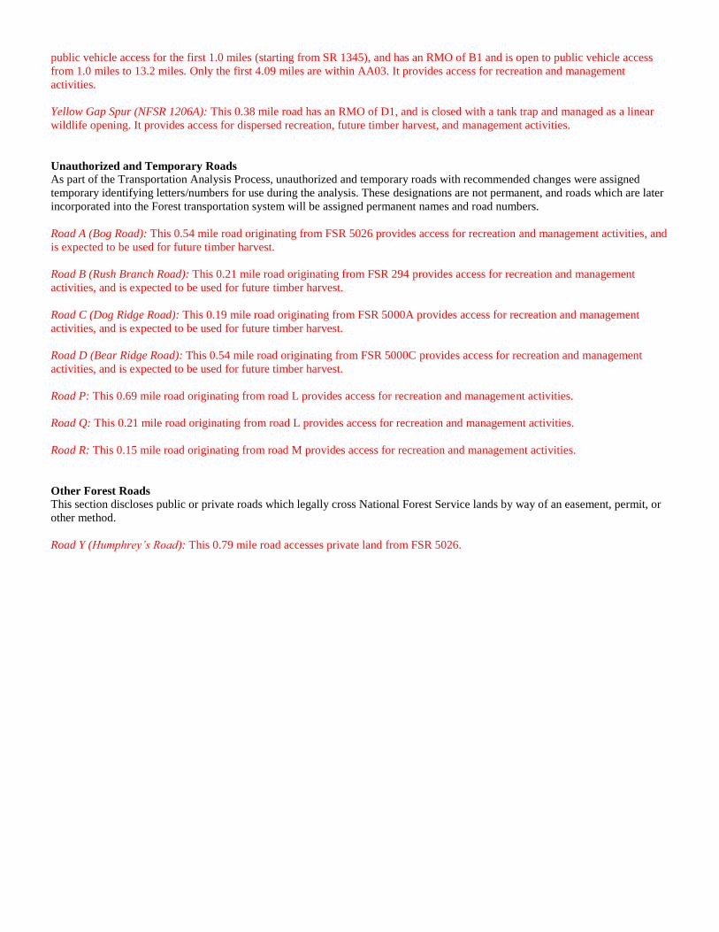
public vehicle access for the first 1.0 miles (starting from SR 1345), and has an RMO of B1 and is open to public vehicle access
from 1.0 miles to 13.2 miles. Only the first 4.09 miles are within AA03. It provides access for recreation and management
activities.
Yellow Gap Spur (NFSR 1206A): This 0.38 mile road has an RMO of D1, and is closed with a tank trap and managed as a linear
wildlife opening. It provides access for dispersed recreation, future timber harvest, and management activities.
Unauthorized and Temporary Roads
As part of the Transportation Analysis Process, unauthorized and temporary roads with recommended changes were assigned
temporary identifying letters/numbers for use during the analysis. These designations are not permanent, and roads which are later
incorporated into the Forest transportation system will be assigned permanent names and road numbers.
Road A (Bog Road): This 0.54 mile road originating from FSR 5026 provides access for recreation and management activities, and
is expected to be used for future timber harvest.
Road B (Rush Branch Road): This 0.21 mile road originating from FSR 294 provides access for recreation and management
activities, and is expected to be used for future timber harvest.
Road C (Dog Ridge Road): This 0.19 mile road originating from FSR 5000A provides access for recreation and management
activities, and is expected to be used for future timber harvest.
Road D (Bear Ridge Road): This 0.54 mile road originating from FSR 5000C provides access for recreation and management
activities, and is expected to be used for future timber harvest.
Road P: This 0.69 mile road originating from road L provides access for recreation and management activities.
Road Q: This 0.21 mile road originating from road L provides access for recreation and management activities.
Road R: This 0.15 mile road originating from road M provides access for recreation and management activities.
Other Forest Roads
This section discloses public or private roads which legally cross National Forest Service lands by way of an easement, permit, or
other method.
Road Y (Humphrey’s Road): This 0.79 mile road accesses private land from FSR 5026.

2.2c Assessment of Motorized and Non-Motorized Uses
Motorized:
The following motorized uses are present in the C02/03:
Public access to trails and facilities within C02/03, particularly Wash Creek Horse Camp and North Mills River recreation
area;
Access to public property (non-USFS) and private property located adjacent to or within C02/02;
Administrative access for management activities, including timber, wildlife, and fire protection;
Access for commercial timber sales;
Public access to recreation opportunities throughout C02/03;
Access to the Blue Ridge Parkway and Bent Creek Experimental Forest; and
Commercial use by outfitters and guides.
Non-Motorized:
The following non-motorized uses are present in the C02/03:
Hiking, biking, and equestrian use;
Dispersed recreation activities, including hunting, fishing, and camping;
Gathering firewood and permitted forest products; and
Commercial use by outfitters and guides.
2.2d Description of Public and Administrative Needs
Public Needs
The following public access needs are present in C02/03:
Access to recreation opportunities on NFS lands, including trails, campgrounds, parking, day use, and dispersed
recreation areas;
Access to Wash Creek Horse camp and North Mills River Recreation Area;
Access to adjacent private property; and
Access to the Blue Ridge Parkway and Bent Creek Experimental Forest.
Administrative needs:
The following administrative access needs are present in C02/03:
NC Wildlife Resource Commission access to Federal/State Game Lands for enforcement and wildlife habitat
management;
Forest Service access for resource management activities, which may include:
o Commercial timber harvest or non-commercial vegetation management;
o Maintenance of roads, structures, wildlife openings, or other facilities;
o Management of wildlife, fish, plant, or bird populations or habitat;
o Identification or inventory of resources;
o Wildfire prevention or prescription burning;
o Law enforcement;
o Other management activities consistent with the Forest Plan, Forest Service directives, and applicable laws and
regulations.
2.2e Assessment of Motorized Recreation Opportunities
There are no trails or areas designated for motorized recreation use within C02/03.
2.2f Information about Environmental, Social, and Other Issues
Environmental, social, and other issues in C02/03 include:
The Forest Transportation System provides access to the Wash Creek Horse Camp, a popular location for equestrian
users;
C02/03 is used for hunting and fishing by local residents;
Horseback riding is common throughout C02/03 and many National Forest System and non-system roads are currently
used;
Roads and trails in C02/03 are used for hiking, biking, and horse riding;
Roads and trails are used to access opportunities for dispersed use, including hunting, fishing, camping, and gathering of
firewood and other permitted forest products.

2.2g Summary of Existing Travel Management Decisions
January 13, 2003, Nantahala and Pisgah National Forests Road Process Report evaluated all 424 open roads in the
current Forest System for the Nantahala and Pisgah National Forests.
January 01, 2008, Motor Vehicle Use Map (MVUM) shows the National Forest System roads, National Forest System
trails, and the areas on NFS lands in the Pisgah National Forest that are designated for motor vehicle use pursuant to 36
CFR 212.51. The MVUM also contains a list of those designated roads, trails, and areas and enumerates the types of
vehicles that are allowed on each route and in each area, and any seasonal restrictions that apply on those routes and in
those areas.
2.2h Assessment of Available Resources to Maintain and Operate the Forest Transportation System
There are several methods for performing road maintenance and operation on roads within C02/03:
Annual Road Maintenance Funds: Annual maintenance funding (CMRD) is used to maintain roads with maintenance
level 3-5. Funds are used for road grading, aggregate replacement, culvert replacement, ditching, mowing, brushing, gate
installation and maintenance, signage and to fund program staffing for the Pisgah District.
Coop Roads Funds from Timber Sale receipts: These funds are generated from timber sales receipts to cover
maintenance of Nation Forest System Roads not included to be maintained in the timber sale contract. Funds are used for
aggregate replacement, road blading, culverts replacement, mowing and signage.
Coop Wildlife Funds: Funds generated from the sale of Federal Game Lands tags and are used to enhance wildlife
habitat including maintaining roads with Road Management Objective of D5 (permanent grass/forb opening). Funds are
used on roads closed to public vehicle traffic, bicycles and horse use.
In addition to the above resources the Pisgah Ranger District has staff and equipment capable of doing light road maintenance such
as dozer grading, aggregate spreading, ditch cleaning, culvert cleaning, gate installation, and signage. Road surfacing is not done
for entire road lengths each year; road is spot graveled where needed as surfacing costs exceed yearly road maintenance budget.
See Section 4.1, Table 5.4, and Appendix B for additional information regarding road maintenance costs.
2.2i Summary of Available Applicable Accident and Law Enforcement Data
Law Enforcement data for the Brushy Ridge Area by Road and Year
Yellow Gap Road (FSR 1206)
2007: 11 cases of alcohol related violations, 4 traffic related violations, 2 drug offenses
2008: 1 case alcohol, 5 traffic, 1 drug offense
2009: 1 case alcohol, 1 traffic, 3 drug offenses
2010: 1 drug offense, 25 incidents of campsite theft
2.3 Motor Vehicle Use on the Part of the Forest Transportation System Under Analysis and on the Adjacent or Connecting
Authorized Transportation Systems
The following motor vehicles uses occur on the Forest Transportation system:
Access between the Blue Ridge Parkway and state, local, and other federal roads;
Access to private property adjacent to C02/03;
Access to Bent Creek Experimental Forest;
Open system roads throughout C02/03 are used by the public for recreation and access to private property;
Many closed roads within C02/03 are used as trails and/or wildlife openings;
Open and closed roads within C02/03 are used by the Forest Service to provide access for management actions;
Access to improved sites, such as North Mills River Rec. Area and Wash Creek Horse Camp; and
Access for commercial timber sales.
2.4 Effects of Motor Vehicle Use on the Portion of the Forest Transportation System Under Analysis
In designating NFS roads, NFS trails, and areas on NFS lands for motor vehicle use, consider, as applicable, both the general and
specific criteria in 36 CFR 212.55(a) through (c). The general criteria in 36 CFR 212.55(a) apply to roads, trails, and areas. The
specific criteria in 36 CFR 212.55(b) apply to trails and areas. The specific criteria in 36 CFR 212.55(c) apply to roads (FSM
7715.5). See Appendix A:
2.4.1 General Criteria for Roads, Trails, and Areas
2.4.1.a: In designating NFS roads, NFS trails, and areas on NFS lands for motor vehicle use, consider effects on NFS natural and
cultural resources, public safety, provision of recreation opportunities, access needs, conflicts among uses of NFS lands, the need

for maintenance and administration of roads, trails, and areas that would arise if the uses under consideration are designated, and
availability of resources for maintenance and administration.
Natural and Cultural Resources: All National Forest Service system roads are assigned an RMO which corresponds to
management direction in the Forest Plan for the Nantahala and Pisgah National Forests. To protect cultural resources,
Heritage Resource inventories are conducted before any major reconstruction or realignment of system roads takes place.
This is done by an Archeologist and reviewed by the NC State Historic Preservation Office (SHPO).
Public Safety: All NFSRs in the NFs-NC are maintained under Federal Highway Administration regulations, which provide
standards for road design and signage. Roads are designated with RMOs which allow for them to be maintained in a manner
consistent with their intended use.
Provision of Recreation Opportunities: Several NFSRs within C02/03 are maintained as open to the public for access to the
North Mills River Recreation Area and other recreation opportunities (see section 2.2b, above). Various roads within C02/03
provide access for hiking, biking, and equestrian use, and dispersed recreation in accordance with management area direction
from the Forest Plan.
Access Needs: The Forest transportation system in C02/03 provides access to adjacent private land, adjacent areas of the
Pisgah National Forest, and access for recreation and management within C02/03.
Conflicts among Users of National Forest System Lands: The transportation system within C02/03 are designed to meet
management objectives spelled out in the Forest Plan with open road management for recreation areas and closed road
management for resource areas. Conflict between different user types (i.e. equestrian and hiking users on the same trail) is
minimized by the appropriate use of RMOs to meet the intended uses of the transportation system.
The need for Maintenance and Administration of Roads, Trails, and Areas that would arise if the uses under consideration
are designated: Each Forest system road is currently maintained for the use designated by the assigned RMO in accordance
with the Forest Plan. For recommended RMO changes and RMOs for roads recommended to be added to the system, see
Tables 5.1 through 5.5. For generalized maintenance cost estimates, see Appendix B: Generalized Road Maintenance Costs,
Pisgah Ranger District.
2.4.1.b: Consider combinations of uses (such as motorized and non-motorized, different vehicle classes, and highway-legal and
non-highway-legal vehicles) on NFS roads and NFS trails. The best way to minimize conflicts among uses may be to provide
separate routes for each use. A decision to allow motorized mixed use on an NFS road must be informed by engineering analysis
(FSH 7709.55, ch. 30).
The Forest transportation system in C02/03 contains both roads that are open to public vehicle use, and roads that are closed to
public vehicle use. Each road is assigned an RMO consistent with its intended use. There are no roads, trails, or areas
designated for Off Road Vehicle (ORV) use within C02/03. All NFS roads in C02/03 allow hiking use, and many allow other
non-motorized uses, including biking and horse riding.
2.4.1.c: While important, the scarcity or abundance of resources to maintain and administer designated roads, trails, and areas
should not be the only consideration in developing travel management proposals. In accordance with FSM 7709.20 and 36 CFR
212.5(b)(1), this TAP “[Identifies the] minimum road system needed for safe and efficient travel and for administration,
utilization, and protection of National Forest System (NFS) lands.”
For information regarding maintenance costs and funding, see Tables 5.4 and 5.5, and Appendix B: Generalized Road
Maintenance Costs, Pisgah Ranger District.
2.4.2 Specific Criteria for Trails and Areas
In addition to the general criteria in FSM 7715.5, paragraph 1, when analyzing motor vehicle use on NFS trails and areas on NFS
lands, consider the effects on the following, with the objective of minimizing:
a. Damage to soil, watershed, vegetation, and other forest resources. Consider best management practices (BMPs) established
by states as a standard for considering effects on these resources;
b. Harassment of wildlife and significant disruption of wildlife habitats;
c. Conflicts between motor vehicle use and existing or proposed recreational uses on NFS lands or neighboring federal lands;
d. Conflicts among different classes of motor vehicle uses on NFS lands or neighboring federal lands.
e. Compatibility of motor vehicle use with existing conditions in populated areas, taking into account sound, emissions, and
other factors, such as traffic-generated dust and the proximity of residences, parks, and schools.

There are no motorized National Forest System trails or areas within C02/03, nor does the TAP recommend any for future
designation.
2.4.3 Specific Criteria for Roads
In addition to the general criteria in FSM 7715.5, paragraph 1, consider the following for NFS roads:
2.4.3.a: Speed, volume, composition, and distribution of traffic on roads
Speed, volume, composition, and distribution of traffic on NFS roads within C02/03 are managed by each road’s RMO. Open
roads are provided with signage in compliance with Federal Highway Administration regulations. Closed roads are used by
USDA Forest Service and North Carolina Wildlife Resources Commission personnel for management and law enforcement.
Contractors also use closed roads for resource work such as timber hauling, reforestation, and timber stand improvement activities.
These users must have current driver licenses; vehicles must meet contract specifications; and they are required to post signage
along the section of road impacted by their work.
2.4.3.b: Compatibility of vehicle class with road geometry and road surfacing.
Consider existing road management objectives before making designations that would add vehicle classes.
NFS arterial and collector roads (at Operational Maintenance Level 3, 4, or 5) may provide primary access to NFS lands
for passenger cars and commercial haulers. It may not be appropriate to make some of these roads part of an NFS road
or NFS trail loop that has off-highway vehicle recreation as a primary objective (FSH 7709.55, ch. 30).
All system roads within C02/03 are assigned RMOs consistent with their intended uses and Forest Plan direction. All roads which
are being considered for designation or changes in access or maintenance in this TAP would also be assigned RMOs consistent
with their new intended uses.

STEP III: IDENTIFYING ISSUES
The purpose of this step is to:
1. Identify key issues affecting the portion of the Forest Transportation System under analysis. Use appropriate public
involvement to identify these issues.
2. To identify key issues, determine in the context of the analysis:
a. The primary public concerns related to travel management;
b. The primary management concerns related to travel management;
c. The primary legal constraints on travel management;
d. The amount of resources and skills available to conduct the analysis;
3. Determine the data needed to analyze the key issues and whether the data are available or must be obtained.
3.1 Identify Key Issues Affecting the Portion of the Forest Transportation System Under Analysis
Issues identified by public and ID team involvement are disclosed in Sections 3.2a and 3.2b below. Public scoping for the GAORP
Project is scheduled for fall of 2012, and the project was listed in the Schedule of Proposed Actions (SOPA) beginning in July
2012. All responses will be considered in formulating issues for the Transportation Analysis.
3.2 To Identify Key Issues, Determine in the Context of the Analysis
Individuals of the ID Team participated in gathering information and in developing draft and final reports. Required information
was gathered through field visits, collective knowledge of ID Team members, review of GIS data, individual Road and Trail
Management Plans, and past Road and Trail Assessments. Road management issues that surfaced during public scoping for the
Brushy Ridge Proposal are considered in this analysis.
Scoping for the project resulted in the following issues related to motorized use in C02/03:
3.2a Primary Public Concerns Related to Travel Management
A. Concern about maintenance costs for system roads.
B. Concern that system and non-system roads contribute to sedimentation and non-native invasive plant dispersal.
C. Concern that constructing additional roads may be detrimental to plant and animal species.
D. Concern about adequate access for recreational activities and to private property.
3.2b Primary Management Concerns Related to Travel Management
E. Concern that the Forest transportation system does not provide adequate access for current and future management
activities, including timber harvest.
F. Concern that existing system and non-system roads do not meet Forest Plan standards for road density.
G. Concern that non-system roads do not sufficiently protect soil, water, and other resources.
H. Concern that existing non-system roads allow opportunities for unauthorized access.
I. Concern that some roads in C02/03 currently have RMOs which are inconsistent with their use.
3.2c Legal Constraints on Travel Management
J. Applicable laws and regulations.
K. Existing agreements with private landowners, including rights-of-way and easements.
L. Lack of authorized access through the Avery Creek community to the Avery Creek area.
3.2d Resources and Skill Available to Conduct Analysis
Resources available to conduct the analysis include:
The ID team for the TAP is identified in section 1.1, above;
NFs-NC INFRA reports, to provide needed information on National Forest system roads, including:
o RMO;
o Maintenance Level;
o Mileage;
o Beginning and ending points to determine connectivity with other transportation systems;
o Current road condition (open or closed);
An ArcGIS specialist capable of producing maps and performing geospatial analysis of C02/03 transportation system;
Field technicians on the Pisgah Ranger District with GPS skills who are available to field check non-system roads within
C02/03;
Pisgah Zone Special Uses Specialist to provide needed information on permits, easements, and rights-of-way within
C02/03.

3.3 Data Needed To Analyze Key Issues
Data needed to analyze key issues include:
An inventory of existing system roads and their uses within C02/03;
– Obtainable from INFRA and existing GIS data;
An inventory of existing temporary and unauthorized roads within C02/03, their condition, and suitability for future
management and recreation access;
– Obtainable from GIS data, specialist knowledge, and satellite/aerial imagery;
Cost of maintenance of current NFS roads within C02/03;
– Annual maintenance costs estimated from NFs-NC Engineering generalized road work data and specialist
knowledge;
Knowledge and location of any wildlife or plant species that may be affected by new road construction and/or
reconstruction;
– Obtained from field surveys for the GAORP Project Biological Evaluation by wildlife, aquatic, and botanical
specialists;
Impacts to possible Historic sites;
– Obtained from an assessment completed by an archeology contractor.
STEP IV: ASSESSING BENEFITS, PROBLEMS, AND RISKS
The purpose of this step is to:
1. Examine the major uses and environmental, social, and economic effects of the portion of the Forest transportation system
under analysis. Analyze the risks and benefits associated with the current situation.
2. Consider the general criteria for designating NFS roads, NFS trails, and areas on NFS lands (36 CFR 212.55(a); FSM
7715.5, para. 1). Consider, with the objective of minimizing, the effects of motor vehicle use on the specific criteria for
designating NFS trails and areas on NFS lands (36 CFR 212.55(b); FSM 7715.5, para. 2), and consider the specific
criteria for designating roads (36 CFR 212.55(c); FSM 7715.5, para. 3).
4.1 Major Uses and Environmental, Social, and Economic Impacts
Table 4.2 summarizes the major uses, social and economic effects, and risks and benefits of each road in C02/03. Economic
effects are described in more detail below.
4.1.1 Financial and Economic Values
Expenses
Table 4.1, below, shows the estimated annual maintenance funding per mile needed to maintain Forest system roads, based on cost
estimates in the Forest Service publication Administrative National Forest System Roads; Annual Maintenance (2001). Total
annual funding requirements for the Forest road system in C02/03 are displayed in Table 5.4, in section 5 below. The Pisgah and
Nantahala National Forest Roads Analysis Process Report (2003) found that the Forest receives only 21% of the funding needed
to meet its annual road maintenance needs. Unfunded maintenance obligations accrue as Deferred Maintenance.
Table 4.1: Average Annual Road Maintenance Costs by Maintenance Level*
Maintenance Level
1 2 3 4 5
Cost/Mile $500 $1,000 $4,500 $7,700 $9,400
Given that the Forest does not receive sufficient funding each year to meet its maintenance obligations, several methods to reduce
maintenance needs are available:
Decommissioning roads;
Converting roads to trails; and
Decreasing maintenance levels on roads.
Decommissioning roads
Decreasing the total number of system road miles will reduce annual maintenance costs. Decommissioning roads often involves an
up-front cost to block access and stabilize the road to prevent erosion or other ongoing resource damage.
Conversion of Roads to Trails
The conversion of roads to trails would reduce the number of miles of roads within the forest and minimize maintenance needs.
Converting roads to trails maintains non-motorized access and the associated recreational values, while reducing costs and limiting
resource impacts.

Decrease Maintenance Levels
Maintenance levels (ML) are determined by considering a variety of factors including; resource program needs (recreation, timber,
etc), environmental and resource protection requirements, user safety, composition of traffic (volume, type, class), surface type,
and user comfort and convenience. The higher the maintenance level the higher the user comfort and required costs for upkeep.
Reducing maintenance levels is one way to reduce the cost of the current system of roads. The greatest cost savings per mile are
achieved by reducing ML 3 and 4 roads to 2 and 3, respectively.
Annual maintenance does not include the cost of responding to emergencies or one-time events, such as storm damage.
Revenues
Timber
Analysis Area 03 contains 5,840 acres of Forest land managed for timber production, which is the Forest’s main source of revenue
in C02/03. The road system provides access to this timber, and additional timber in adjacent AAs. Timber sale revenues are
generally disclosed in the project NEPA documents.
North Mills River Recreation Area
The road system provides access to the North Mills River Recreation Area, a fee-use developed campsite. The North Mills River
Recreation Area has 16 campsites, with a fee of $17/night.
Other Economic Benefits
Forest Service roads support activities including logging, harvesting forest products, recreation, fishing, hunting, firefighting and
other land management practices, which often benefit the local economy by providing jobs and attracting visitors who will
patronize local businesses. These benefits are difficult to quantify at a project scale because they occur over large areas, and are
more properly addressed in a District or Forest level TAP
Table 4.2: Risks and Benefits of Current System and Unauthorized roads, AA03
Road ID 1206
Road Name Yellow Gap Road
Major Use Yellow Gap Road is the main access route in the analysis area, and to adjacent Forest land. It also
accesses the North Mills River Recreation Area.
Social Effects This road provides access to Forest land for a variety of uses, including developed and
undeveloped camping, hunting, fishing and dispersed recreation, timber harvest, and other
management opportunities.
Economic Effects Provides income to regional economy from tourism, timber and permitted forest products, hunting,
and fishing.
Risks High risk of resource damage, high maintenance, law enforcement, and emergency response costs
due to public access.
Benefits Administrative access for management activities. Access for a wide variety of recreational
opportunities.
Road ID 1206A
Road Name Yellow Gap Spur
Major Use Non-motorized trail. Access for hunting, fishing, and dispersed recreation opportunities. Access for
management activities. Linear Wildlife Opening
Social Effects Multiple use non-motorized trail (hiking, biking, equestrian). Provides public access for hunting
and fishing, and dispersed recreation opportunities.
Economic Effects Provides income to regional economy from tourism, hunting, fishing, gathering of permitted forest
products, and timber harvest.
Risks Low risk, low maintenance
Benefits Administrative access for management activities. Recreational access. Wildlife opening.
4.3 General Criteria for Designating NFS Roads, Trails, and Areas
General and specific criteria for designating roads, trails, and areas are disclosed in section 2.4. See Table 4.3: General Criteria for
Designating Roads, below.
Table 4.3: General Criteria for Designating Current System and Unauthorized Roads, AA03
Road ID 1206
Road Name Yellow Gap Road
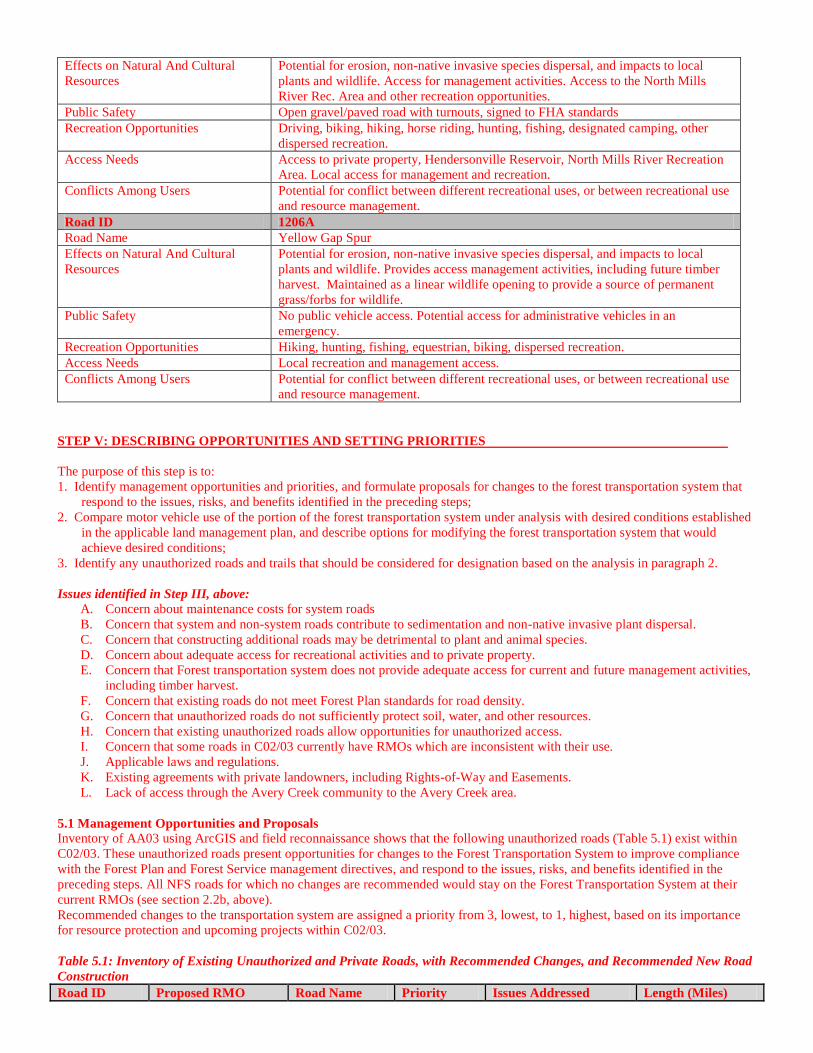
Effects on Natural And Cultural
Resources
Potential for erosion, non-native invasive species dispersal, and impacts to local
plants and wildlife. Access for management activities. Access to the North Mills
River Rec. Area and other recreation opportunities.
Public Safety Open gravel/paved road with turnouts, signed to FHA standards
Recreation Opportunities Driving, biking, hiking, horse riding, hunting, fishing, designated camping, other
dispersed recreation.
Access Needs Access to private property, Hendersonville Reservoir, North Mills River Recreation
Area. Local access for management and recreation.
Conflicts Among Users Potential for conflict between different recreational uses, or between recreational use
and resource management.
Road ID 1206A
Road Name Yellow Gap Spur
Effects on Natural And Cultural
Resources
Potential for erosion, non-native invasive species dispersal, and impacts to local
plants and wildlife. Provides access management activities, including future timber
harvest. Maintained as a linear wildlife opening to provide a source of permanent
grass/forbs for wildlife.
Public Safety No public vehicle access. Potential access for administrative vehicles in an
emergency.
Recreation Opportunities Hiking, hunting, fishing, equestrian, biking, dispersed recreation.
Access Needs Local recreation and management access.
Conflicts Among Users Potential for conflict between different recreational uses, or between recreational use
and resource management.
STEP V: DESCRIBING OPPORTUNITIES AND SETTING PRIORITIES
The purpose of this step is to:
1. Identify management opportunities and priorities, and formulate proposals for changes to the forest transportation system that
respond to the issues, risks, and benefits identified in the preceding steps;
2. Compare motor vehicle use of the portion of the forest transportation system under analysis with desired conditions established
in the applicable land management plan, and describe options for modifying the forest transportation system that would
achieve desired conditions;
3. Identify any unauthorized roads and trails that should be considered for designation based on the analysis in paragraph 2.
Issues identified in Step III, above:
A. Concern about maintenance costs for system roads
B. Concern that system and non-system roads contribute to sedimentation and non-native invasive plant dispersal.
C. Concern that constructing additional roads may be detrimental to plant and animal species.
D. Concern about adequate access for recreational activities and to private property.
E. Concern that Forest transportation system does not provide adequate access for current and future management activities,
including timber harvest.
F. Concern that existing roads do not meet Forest Plan standards for road density.
G. Concern that unauthorized roads do not sufficiently protect soil, water, and other resources.
H. Concern that existing unauthorized roads allow opportunities for unauthorized access.
I. Concern that some roads in C02/03 currently have RMOs which are inconsistent with their use.
J. Applicable laws and regulations.
K. Existing agreements with private landowners, including Rights-of-Way and Easements.
L. Lack of access through the Avery Creek community to the Avery Creek area.
5.1 Management Opportunities and Proposals
Inventory of AA03 using ArcGIS and field reconnaissance shows that the following unauthorized roads (Table 5.1) exist within
C02/03. These unauthorized roads present opportunities for changes to the Forest Transportation System to improve compliance
with the Forest Plan and Forest Service management directives, and respond to the issues, risks, and benefits identified in the
preceding steps. All NFS roads for which no changes are recommended would stay on the Forest Transportation System at their
current RMOs (see section 2.2b, above).
Recommended changes to the transportation system are assigned a priority from 3, lowest, to 1, highest, based on its importance
for resource protection and upcoming projects within C02/03.
Table 5.1: Inventory of Existing Unauthorized and Private Roads, with Recommended Changes, and Recommended New Road
Construction
Road ID Proposed RMO Road Name Priority Issues Addressed Length (Miles)

A D1 Closed Bog Road 1 E, G, H 0.54
Action: Add road to system as NFSR 5027 (Bog Road) to provide access for future management activities. This road
would be used to access suitable stands in the Brushy Ridge Project.
Risk Adding roads to the Forest Transportation System increases maintenance costs.
Importance Moderate; an RMO of D1 requires a low standard of maintenance.
Benefit Provides access to the public for a variety of non-motorized uses.
Importance Low; many alternative non-motorized recreation opportunities already exist in C02/03.
Benefit Provides access for future management activities, including timber harvest.
Importance High; Forest Plan requires that the road system be planned to progressively access all lands suitable for timber
production.
Table 5.2: Inventory of Existing Authorized Roads with Recommended Changes
Road ID Proposed RMO Road Name Priority Issues Addressed Length (Miles)
1206 A2, B1 Open Yellow Gap 2 I 4.09
Action: Change the RMO of the paved part of this road from A1 to A2, consistent with being open year round. Leave
the rest of the road in C02/03 as B1.
Risk RMO no longer supports seasonal closure of the road.
Importance Low; Road is intended for year round use.
Benefit RMO is consistent with current year round use.
Importance Moderate; Maintaining roads at the proper RMO help ensure proper distribution of road maintenance funds and
that the road is maintained to appropriate standards to protect resources and public safety.
Road ID Proposed RMO Road Name Priority Issues Addressed Length (Miles)
1206A D1 Closed Yellow Gap Spur 2 E 0.38
Action: Replace the tank trap blocking access to this road with a gate.
Benefit Gate provides improved accessibility for management actions compared to a tank trap.
Importance High; access to this area is necessary to complete actions proposed in the Brushy Ridge Proposal, and well as to
meet Forest Plan standards for accessing suitable timber.
Road ID Proposed RMO Road Name Priority Issues Addressed Length (Miles)
1206B D1 Closed Allan Cove n/a E 1.10
Action: No changes are recommended to this road.
Road ID Proposed RMO Road Name Priority Issues Addressed Length (Miles)
1206C D1 Closed Mince Cove n/a E 0.33
Action: No changes are recommended to this road.
Table 5.3, below, shows the total miles of road which are recommended for addition to the Forest transportation system,
decommissioning, construction, or other changes.
Table 5.3: Summary of Recommended Changes, AA03
Miles of existing road recommended to add to system 7.74
Miles of recommended new road construction 1.05
Miles of system road recommended to decommission 0.00
Miles of non-system road recommended to decommission 1.66
Miles of system road recommended for RMO changes 8.53
Table 5.4, below, shows the estimated annual maintenance needs of the current and recommended transportation systems. Table
5.5 shows the estimated cost of new road construction to meet the recommended road system.
Table 5.4: Estimated Road Maintenance Costs on Current and Recommended Forest Transportation System, AA03
Current Recommended
Road
#
RMO Mtnc.
Level
Annual Mtnc.
Cost/Mile
Miles Total
Cost
RMO Mtnc.
Level
Annual Mtnc.
Cost/Mile
Miles Total
Cost
1206 A1 5 $9,400 0.92 $8,644 A2 5 $9,400 0.92 $8,644
1206 B1 4 $7,700 3.17 $24,433 B1 4 $7,700 3.17 $24,433
1206A D1 1 $500 0.38 $189 D1 1 $500 0.38 $189

Current Recommended
Road
#
RMO Mtnc.
Level
Annual Mtnc.
Cost/Mile
Miles Total
Cost
RMO Mtnc.
Level
Annual Mtnc.
Cost/Mile
Miles Total
Cost
Total $34 $114,425 44.39 $109,303
Table 5.5: Estimated Cost of Recommended New Road Construction, AA03*
Road ID New RMO New ML Length (Miles) Cost/Mile Total Cost
J D1 or D5 1 0.55 $18,031 $9,993
K D1 or D5 1 0.49 $18,031 $8,889
O D1 or D5 1 0.10 $18,031 $1,887
Total 1.15 $20,768 *See Appendix B for additional information on estimated construction costs
5.2 Current and Desired Motorized Use
See Table 2.1, above. Current mileage of open FS Roads in Management Areas 2A, 3B, 4A, 4C, and 4D exceed Forest Plan
desired road density. The Forest Plan directs that “Where existing open road densities exceed [Forest Plan] miles per square mile,
and, if closure of existing roads is prohibitive for administrative or legal reasons, then document these exceptions to the standard
and investigate strategies to reduce the open road density” (Forest Plan, page III-76 and III 87).
5.3 Unauthorized Roads and Trails Considered for Designation
All known unauthorized roads and trails, including those considered for designation or decommissioning, are disclosed in Table
5.1, above.
STEP VI: REPORTING
The purpose of this step is to document travel analysis in a report including:
1. A list of the key issues;
2. A prioritized list of the risks and benefits associated with changing the part of the forest transportation system under analysis;
3. A prioritized list of opportunities for addressing those risks and benefits;
4. If applicable, a prioritized list of actions or projects that would implement the minimum road system;
5. If applicable, a list of proposed changes to the current travel management direction, including proposed additions to or
deletions from the forest transportation system.
The report provides the basis for developing proposed actions to implement the minimum road system and/or to change existing
travel management decisions. These proposals are subject to appropriate public involvement and environmental analysis under
NEPA before travel management decisions are made. Site specific environmental analysis should build on and incorporate
relevant information developed during travel analysis.
6.1 List of Key Issues
For a list of key issues, see section 3.2.
6.2 Prioritized List of the Risks and Benefits
For a prioritized list of risks and benefits for each action, see Tables 5.1 and 5.2. Risks and benefits are rated by importance to the
affected resource as Low, Moderate, or High.
6.3 Prioritized List of Opportunities for Addressing those Risks and Benefits
See Section 5.1, above, for a prioritized list of management opportunities.
6.4 Prioritized List of Actions or Projects that would Implement the Minimum Road System
See Section 5.1, above, for a prioritized list of actions. These actions would implement the minimum road system, in compliance
with the Forest Plan and applicable travel management regulations.
6.5 List of Proposed Changes Including Additions and Deletions
See Section 5.1, above, a list of proposed changes, including additions and deletions
Table 6.1: Recommended Minimum Road System, AA03

Old Road ID New Road ID Name New ML New RMO Surface Access Length (Miles)
1206 1206 Yellow Gap Road 4 B1 Agg Open 3.17
5 A2 Pav Open 0.92
1206A 1206A Yellow Gap Spur 1 D1 Nat Closed 0.38
Total 42.73
APPENDIX A: APPLICABLE LAND AND TRAVEL MANAGEMENT DIRECTION
Selected Definitions (36 CFR 212.1)
Designated road, trail, or area. A National Forest System
road, a National Forest System trail, or an area on National
Forest System lands that is designated for motor vehicle use
pursuant to §212.51 on a motor vehicle use map.
Forest road and trail funds. Funds authorized or
appropriated for the purpose of carrying out the provisions
of section 205 of the Act of August 27, 1958 (72 Stat. 907),
as amended; 23 U.S.C. 205.
Forest road or trail. A road or trail wholly or partly within
or adjacent to and serving the National Forest System that
the Forest Service determines is necessary for the
protection, administration, and utilization of the National
Forest System and the use and development of its resources.
Forest transportation atlas. A display of the system of
roads, trails, and airfields of an administrative unit.
Forest transportation facility. A forest road or trail or an
airfield that is displayed in a forest transportation atlas,
including bridges, culverts, parking lots, marine access
facilities, safety devices, and other improvements
appurtenant to the forest transportation system.
Forest transportation system. The system of National
Forest System roads, National Forest System trails, and
airfields on National Forest System lands.
Maintenance. The upkeep of the entire forest transportation
facility including surface and shoulders, parking and side
areas, structures, and such traffic-control devices as are
necessary for its safe and efficient utilization.
Motor vehicle. Any vehicle which is self-propelled, other
than:
– A vehicle operated on rails; and
– Any wheelchair or mobility device, including one that is
battery-powered, that is designed solely for use by a
mobility-impaired person for locomotion, and that is
suitable for use in an indoor pedestrian area.
Motor vehicle use map. A map reflecting designated roads,
trails, and areas on an administrative unit or a Ranger
District of the National Forest System.
National Forest System. As defined in the Forest
Rangeland Renewable Resources Planning Act, the
“National Forest System” includes all National Forest lands
reserved or withdrawn from the public domain of the
United States, all National Forest lands acquired through
purchase, exchange, donation, or other means, the National
Grasslands and land utilization projects administered under
title III of the Bankhead-Jones Farm Tennant Act (50 Stat.
525, 7 U.S.C. 1010–1012), and other lands, waters or
interests therein which are administered by the Forest
Service or are designated for administration through the
Forest Service as a part of the system.
National Forest System road. A forest road other than a
road which has been authorized by a legally documented
right-of-way held by a State, county, or other local public
road authority.
Off-highway vehicle. Any motor vehicle designed for or
capable of cross-country travel on or immediately over
land, water, sand, snow, ice, marsh, swampland, or other
natural terrain.
Road. A motor vehicle route over 50 inches wide, unless
identified and managed as a trail.
Road construction or reconstruction. Supervising,
inspecting, actual building, and incurrence of all costs
incidental to the construction or reconstruction of a road.
Road Decommissioning. Activities that result in the
stabilization and restoration of unneeded roads to a more
natural state.
Temporary road or trail. A road or trail necessary for
emergency operations or authorized by contract, permit,
lease, or other written authorization that is not a forest road
or trail and that is not included in a forest transportation
atlas.
Trail. A route 50 inches or less in width or a route over 50
inches wide that is identified and managed as a trail.
Travel management atlas. An atlas that consists of a forest
transportation atlas and a motor vehicle use map or maps.
Unauthorized road or trail. A road or trail that is not a
forest road or trail or a temporary road or trail and that is
not included in a forest transportation atlas.
Management Areas
Land and Resource Management Plan; Amendment 5;
Nantahala and Pisgah National Forests
Management Area 2 (Forest Plan p. III-63) Emphasis is on providing pleasant scenery for people who
experience the forest by driving (or boating) through it. These
areas are intended as scenic travelways through the forest.
Secondarily, this management area provides an environment
of older forests combined with timber management activities
designed to manage the scenery. Open roads through a scenic
forest is the desired condition. Forest management activities
should not be as apparent as in Management Area 1. Wildlife
that are compatible with or that benefit from these conditions,
such as songbirds, grouse, and grey squirrel are likely to be
present. Since many of these areas are along well-traveled
roads, the visitor is likely to encounter numerous other people
and their vehicles.
Management Area 2A
Management Area 2A provides visually pleasing scenery for
forest visitors. Roads are generally open with adjacent forest
land managed to provide that pleasing visual experience.
Timber production is permitted, but modified to meet visual
quality objectives.
Management Ares 2C Management Area 2C also provides visually pleasing scenery.
Roads are generally open with adjacent forest land managed
to provide a quality visual experience. This land is not
suitable for timber production because either timber activities
could not be conducted in a manner to assure a highly visual
experience, or the land is not cost effective in the long term
for timber production. The area, providing for motorized
recreation, will favor wildlife species which prefer older
forest conditions and yet can tolerate some human
disturbance.
General Direction for Management Area 2:
Manage most arterial, collector, and Traffic Service Level
C local roads as open to public vehicular use except for
seasonal closures and closures for resource protection as
determined by site specific analysis
Close all Traffic Service Level D roads to public vehicular
use when management activities are complete except those
roads designated for ORVs.
Plan and construct the transportation system to provide
access for timber and public motorized recreation use.
Provide four-wheel-drive ways that utilize terrain features
to provide varying degrees of difficulty and challenge to
riders and protect water quality.
Maintain roads to accommodate the intended use and to
protect resources.
Specific Forest Plan Standards for MA 2:
Consider changing only upland hardwood, productivity
class IV sites from hardwood to mixed pine hardwood
forest type. Allow such a change of forest type only to meet
visual quality or wildlife habitat needs.
Manage approximately 2 acres of Traffic Service Level C
road per square mile as open to public vehicular use.
Sign all routes designated for use by ORVs
Plan the road system to widely disperse harvest units in
Management Area 2A
Locate all roads on stable locations to protect adjacent
resources and to most effectively serve access needs.
Maintain open Traffic Service Level C roads to a minimum
maintenance level 3
Maintain open Traffic Service Level D roads to a minimum
maintenance level 2
Maintain four-wheel-drive ways to maintenance level 2
Maintain all closed system roads to maintenance level 1
Management Area 3B (Forest Plan p. III-71)
Emphases is on providing for a sustainable supply of timber
but with few open roads and without the disturbance
associated with motorized vehicles. The area provides habitat
needs of wildlife that will benefit from a managed forest with
limited motorized access. Manage in a Roaded Natural 2
condition with emphasis to provide opportunities for non-
motorized uses on closed system roads, such as hiking,
mountain biking, horseback riding, wildlife viewing, access
for fishing and hunting.
General Direction for Management Area MA 3B:
Provide limited access for motorized vehicles.
Close all Traffic Service Level D roads to public vehicular
use when management activities are complete except those
roads designated as four-wheel drive ways.
Plan and construct the transportation system to provide
access for timber.
Maintain roads to accommodate the intended use and to
protect resources. Identify where existing designated four-
wheel drive ways do not meet water quality standards and
develop strategies to bring them into compliance unless
physical conditions preclude complete correction and the
road cannot be legally closed.
Specific Forest Plan Standards for MA 3B:
Manage access through an approximate density of 0.5 miles
of open road per square mile.
Sign all routes designated as four-wheel drive ways.
Plan the road system to progressively access all lands
suitable for timber production.
Locate all roads on stable locations to protect adjacent
resource, and to most cost effectively serve access needs.
Maintain open Traffic Service Level C roads to a minimum
maintenance level 3.
Maintain open Traffic Service Level D roads to a minimum
maintenance level 2.
Maintain four-wheel-drive ways to maintenance level 2.
Maintain all closed system roads to maintenance level 1.
Seed maintenance level 1 roads with appropriate seed
mixtures to provide linear strip openings.
Seed temporary logging roads and skid roads (unclassified
roads) with appropriate seed mixture to provide temporary
linear strip openings, with a goal of restoring these to forest
conditions.
Management Area 4 (Forest Plan p. III-77)
In Management Area 4 most roads are closed to motor
vehicles, and a somewhat remote setting is provided, but with
some timber management in 4A and 4D. In management areas
4A and 4C, emphasis is on managing for quality scenery. In
Management Area 4D, emphasis is on providing high quality
wildlife habitat, particularly for black bear. The preferred
habitat for black bear includes freedom from the disturbance
of motorized vehicles, some areas of older forest, a sustained
supply of hard mast (such as acorns from oaks) and den trees,
and small, widely dispersed openings providing the soft mast
(fruits and berries) typically found in very young forest.
Timber management activities should be designed to provide
these conditions. Management Area 4C tends to be fairly
steep, rugged, often inaccessible terrain usually seen only
from a distance by forest visitors. This land is unsuitable for
timber production but can provide a scenic backdrop for
people viewing the forest from a distance, while also
providing wildlife habitat. The variety of wildlife likely to be
present in the management area include ovenbird, black bear,
and cerulean warbler. The visitor using these areas for
recreation may occasionally encounter other people. Forest
management activities are less likely to be encountered than
in Management Areas 1 or 3.
Management Area 4A (Forest Plan p. III-77)
In Management Area 4A, permit timber production, modified
to emphasize visual quality and wildlife habitat.
Management Area 4C (Forest Plan p. III-77)
In Management Area 4C, emphasize visually pleasing scenery
and habitats for wildlife requiring older forests. This land is
not suitable for timber production at this time in order to meet
visual quality objectives, or the lands are not cost efficient for
timber production.
Management Area 4D (Forest Plan p. III-78)
In Management Area 4d, emphasize high quality habitats for
wildlife requiring older forests and freedom from disturbance
from motorized vehicles. Allow small widely dispersed

openings throughout the management area. Close roads to
motorized vehicles. Early successional habitat is provided in
conjunction with managing suitable timber land in these
areas.
General Direction for Management Area MA 4:
Provide limited access for motorized vehicles.
Close all Traffic Service Level D roads to public vehicular
use when management activities are complete except those
roads designated as four-wheel-drive ways.
Plan and construct the transportation system to provide
access for timber in Management Areas 4A and 4D. In
Management Area 4C, plan and construct the transportation
system to provide access for activities to meet management
area objectives.
Maintain roads to accommodate the intended use and to
protect resources. Identify where existing designated four-
wheel drive ways do not meet water quality standards and
develop strategies to bring them into compliance unless
physical conditions preclude complete correction and the
road cannot be legally closed.
Specific Forest Plan Standards for MA 4:
Manage access through an approximate density of 0.25
miles of open road per square mile. Include four-wheel-
drive ways in this density. Where existing open road
densities exceed 0.25 miles per square mile, and, if closure
of existing roads is prohibitive for administrative or legal
reasons, then document these exceptions to the standard and
investigate strategies to reduce the open road density.
Sign all routes designated as four-wheel drive ways.
Plan the road system to widely disperse harvest units in
Management Areas 4A and 4D
Locate all roads on stable locations, to protect adjacent
resources and to most cost effectively serve access needs.
Maintain open Traffic Service Level C roads to a minimum
maintenance level 3.
Maintain open Traffic Service Level D roads to a minimum
maintenance level 2.
Maintain four-wheel drive ways to maintenance level 2
Maintain all closed system roads to maintenance level 1
Management Area 14 (Forest Plan p. III-163)
This management area consists of the Appalachian National
Scenic Train and its foreground zone as mapped with the
Visual Management System. The Trail generally follows the
crest of the Appalachian Mountains and is characterized by a
predominantly natural appearing environment. Management
emphasis for this area is in accordance with the National
Trails System Act (Public Law 90-543) to protect the Trail for
the conservation and enjoyment of the nationally significant
scenic, historic, natural, and cultural qualities of the land
through which the Trail passes.
General Direction for Management Area 14:
Evaluate proposed roads paralleling or crossing the Trail for
potential undesirable impacts on the Trail and the hiker.
Specific Forest Plan Standards for MA 14:
Analyze all new roads crossing or paralleling the trail
within one mile. Consider:
o Noise levels which would occur at points along the Trail
o Character of the Trail in proximity to the proposed road
o Standards and management of the road
o Trail use in the area
o Experience level Recreation Opportunity Spectrum (ROS
class) established for the Trail in this area
o Cost of alternatives
o Potential for uncontrolled and unlawful motorized access
o Mitigation measures
Minimize the number of roads within 0.5 miles of the Trail
Allow road locations that are the only feasible and prudent
alternative after all impacts have been minimized.
Road Maintenance Levels
Maintenance Level 1:
Basic custodial maintenance is performed to protect the road
investment and to keep damage to adjacent resources to an
acceptable level. Drainage structures and runoff patterns are
maintained. Generally no blading is needed except to remove
ruts. Shoulder maintenance is not required. Routine or
intermittent removal of brush and small trees is not included at
this level of maintenance. Slides may remain if they do not
interfere with drainage. Vegetative cover to prevent soil erosion
is required. Inspect and repair only those structures that cannot
be deferred. Physical closure devices and appropriate signing
are in place and functional.
Maintenance Level 2: Maintenance is performed to allow limited passage of traffic.
Blading is only performed as necessary to provide for planned,
limited traffic and to maintain drainage. Maintain shoulders
only to provide passage to planned traffic. Routine or
intermittent removal of brush and small trees is not included at
this level of maintenance. Slides blocking traffic are removed.
Vegetative cover to prevent soil erosion is required. All
structures are adequately maintained to provide for safe passage
of planned traffic. All route markers, regulatory and warning
signs and devices are in place and usable.
Maintenance Level 3: Requires that the road be open and maintained for safe travel by
a prudent driver in a passenger car. However, user comfort and
convenience is not considered a priority. Perform surface
blading as necessary to provide for safe travel. Some roughness
is tolerated. Replace base course material as necessary, to
provide adequate structural support and provide minimum depth
for economical blading. Shoulders are maintained during
blading operation. Control brush to provide safe site distance.
Repair all slides and slumps. Maintain existing vegetative
cover. Remove hazard trees. All structures are currently
repaired and maintained as needed for safe passage. Route
markers and warning, directional, informational, and regulatory
signs and traffic control devices are in place, neat in appearance,
and functional.
Maintenance Levels 4 and 5: These levels are assigned to provide respectively a moderate and
high degree of user comfort and convenience.
Road Maintenance Objectives (RMOs)
A2 Paved Road; 2 lanes; culverts/ditches. Maintain paved
surface. Maintain shoulders and drainage. Install and maintain
route markers, warning, regulatory, and guide signs. Remove
hazard trees and clean up litter. Renew centerlines, edge stripes,
and other pavement and curb markings. Provide safe travelway
for all vehicles. Very High use (250+ ADT). Design speed
between 30-50 mph. Double lane. Compatible with
management areas 2A and 2C. Open to all traffic. Provide and
maintain as access route for timber harvesting and treatments.
Provide for high degree of user comfort and convenience.
C3
Moderate gravel (4”); one lane with turnouts; culverts/ditches;
blade twice a year. Brush once every 2 years. Maintain
shoulders and drainage. Maintain turnarounds suitable for fire
equipment at the end of dead-end roads. Install and maintain
route markers, warning, regulatory, and guide signs. Remove
hazard trees and clean up litter. Use as 2-WD access for timber
harvesting and fire protection. Compatible with Management
Areas 1B, 2A, 2C, and 9. By exception compatible with MA
14. Open to all traffic. Provide and maintain as access route for
timber harvesting and treatments (entry twice each decade).
Encourage motorized use for recreationists.
D1
Dirt, seeded; one lane with outslope/dips; maintain as Linear
Wildlife Opening. Mow roadbed annually. Brush shoulders
once every three years. Maintain turnarounds suitable for fire
equipment at the end of dead-end roads. Install and maintain
route markers, warning, regulatory, and guide signs. Scarify,
seed, and fertilize roadbed. Provide access for future timber
operations and for fire protection. Compatible with
Management Areas 3B, 4A, 4C, 4D, 14, 15, and 17. By
exception compatible with MA 5. Closed with a gate or other
structure. Allow occasional access for mowing operations and
administrative use and fire protection. Create and maintain as
wildlife habitat. Future access for timber harvesting.
Discourage non-motorized use but do not prohibit.
D2
Dirt, Rutted; one lane with outslopes/dips; maintain as open.
Maintain drainage and silt traps to minimize environmental
damage. Maintain road prism only to the extent to provide
passage for high clearance vehicles. Brush once every 3 years.
Install and maintain route markers, warning, regulatory, and
guide signs. Use to provide a 4-WD experience. Compatible
with Management Areas 1B, 2A, 2C. By exception compatible
with Areas 3B and 4A. Closed with a gate or other structure.
Restricted most of the year. Access can be allowed seasonally
for hunting and other public/administrative activities and fire
protection.. Access route for wildlife habitat management.
Provide and maintain as access route for timber harvesting and
treatments. Entry once each decade. Encourage non-motorized
use such as hiking, biking, and horseback riding.
D3
Spot gravel; one lane with outslope/dips/silt traps; blade once a
year. Brush once every three years. Maintain shoulders and
drainage. Maintain turnarounds suitable for fire equipment at
the end of dead-end roads. Install and maintain route markers,
warning, regulatory, and guide signs. Remove hazard trees.
Use as 2-WD access for administrative, timber harvesting, and
fire protection. Compatible with Management Areas 1B and
4A. By exception compatible with MA 3B. Closed with a gate
or other structure. Restricted most of the year. Access can be
allowed seasonally for hunting and other public/administrative
activities and fire protection. Seasonally open for hunting.
Access route for wildlife habitat management. Provide and
maintain as access route for timber harvesting and treatments
(entry once each decade). Encourage non-motorized use such as
hiking, biking, and horseback riding.
D5
Dirt/seeded; one lane with outslope/dips; maintain as Linear
Wildlife Opening. Mow roadbed annually and brush shoulders
once every three years as funds are available. Maintain
turnarounds suitable for fire equipment at the end of dead-end
roads. Install and maintain route markers, warning, regulatory,
and guide signs. Scarify, seed, and fertilize roadbed. Provide
access for future timber operations and for fire protection.
Compatible with Management Areas 3B, 4A, 4C, 4D, 14, 15,
and 17. By exception compatible with MA 5. Closed with a
gate or other structure. Allow occasional access for mowing
operations and administrative use and fire protection. Create
and maintain as wildlife habitat. Future access for timber
harvesting. Prohibit bikes and horse traffic.
Criteria for Designating Roads and Trails
FSM 7715.5 – Criteria
In designating NFS roads, NFS trails, and areas on NFS lands
for motor vehicle use, consider, as applicable, both the general
and specific criteria in 36 CFR 212.55(a) through (c). The
general criteria in 36 CFR 212.55(a) apply to roads, trails, and
areas. The specific criteria in 36 CFR 212.55(b) apply to trails
and areas. The specific criteria in 36 CFR 212.55(c) apply to
roads.
1. General Criteria for Roads, Trails, and Areas.
a. In designating NFS roads, NFS trails, and areas on NFS
lands for motor vehicle use, consider effects on NFS natural
and cultural resources, public safety, provision of recreation
opportunities, access needs, conflicts among uses of NFS
lands, the need for maintenance and administration of
roads, trails, and areas that would arise if the uses under
consideration are designated, and availability of resources
for maintenance and administration.
b. Consider combinations of uses (such as motorized and
non-motorized, different vehicle classes, and highway-legal
and non-highway-legal vehicles) on NFS roads and NFS
trails. The best way to minimize conflicts among uses may
be to provide separate routes for each use. A decision to
allow motorized mixed use on an NFS road must be
informed by engineering analysis (FSH 7709.55, ch. 30).
c. While important, the scarcity or abundance of resources
to maintain and administer designated roads, trails, and
areas should not be the only consideration in developing
travel management proposals.
2. Specific Criteria for Trails and Areas.
In addition to the general criteria in FSM 7715.5, paragraph 1,
when analyzing motor vehicle use on NFS trails and areas on

NFS lands, consider the effects on the following, with the
objective of minimizing:
a. Damage to soil, watershed, vegetation, and other forest
resources. Consider best management practices (BMPs)
established by states as a standard for considering effects on
these resources;
b. Harassment of wildlife and significant disruption of
wildlife habitats;
c. Conflicts between motor vehicle use and existing or
proposed recreational uses on NFS lands or neighboring
federal lands; and
d. Conflicts among different classes of motor vehicle uses
on NFS lands or neighboring federal lands.
In addition, consider:
e. Compatibility of motor vehicle use with existing
conditions in populated areas, taking into account sound,
emissions, and other factors, such as traffic-generated dust
and the proximity of residences, parks, and schools.
3. Specific Criteria for Roads.
In addition to the general criteria in FSM 7715.5, paragraph
1, consider the following for NFS roads:
a. Speed, volume, composition, and distribution of traffic
on roads; and
b. Compatibility of vehicle class with road geometry and
road surfacing.
(1) Consider existing road management objectives before
making designations that would add vehicle classes.
(2) NFS arterial and collector roads (at Operational
Maintenance Level 3, 4, or 5) may provide primary access
to NFS lands for passenger cars and commercial haulers. It
may not be appropriate to make some of these roads part of
an NFS road or NFS trail loop that has off-highway vehicle
recreation as a primary objective (FSH 7709.55, ch. 30).
7715.6 – Other Considerations
In addition to the general and specific criteria in FSM 7715.5,
the following should be considered in designating roads, trails,
and areas:
1. Existing and future needs of motor vehicle users.
2. Uses on adjacent federal, state, and private lands.
3. Uses exempt from designations, including use by over-
snow vehicles.
4. Non-motorized uses.
5. Unauthorized routes, as appropriate.
6. The Forest Service’s ability to administer and maintain the
routes and areas under consideration.
7. Changes in motor vehicle technology.

APPENDIX B: GENERALIZED ROAD MAINTENANCE COSTS, PISGAH RANGER DISTRICT
Table B.1: Generalized Road Maintenance Costs, Pisgah Ranger District
Generalized Costs for Road Work Public
Works
Timber Sale
Work Cost/Mile Cost/Mile
Road Construction (Balanced Section) (Includes Clearing, Grubbing, Earthwork, Grading, EC &
Seeding)
$20,034 $18,031
Road Reconstruction (Includes Clearing, Grubbing & Grading) $6,946 $6,251
Road Maintenance (Includes Mowing & Grading) $1,970 $1,773
Roadway surfacing (1") $14,878 $13,390
Roadway surfacing (2") $28,929 $26,036
Roadway surfacing (3") $42,980 $38,682
Roadway surfacing (4") $56,890 $51,201
Roadway surfacing (6") $84,922 $76,430
Ditch Construction & Culvert Installation (500' int.)(Includes extra Clearing, Earthwork & Seeding) $15,709 $14,138
Armoring Dips only if road is not otherwise surfaced $11,217 $10,095

APPENDIX C: MAPS