national highways authority of india (mort&h), government ... · widening & upgradation of...
TRANSCRIPT
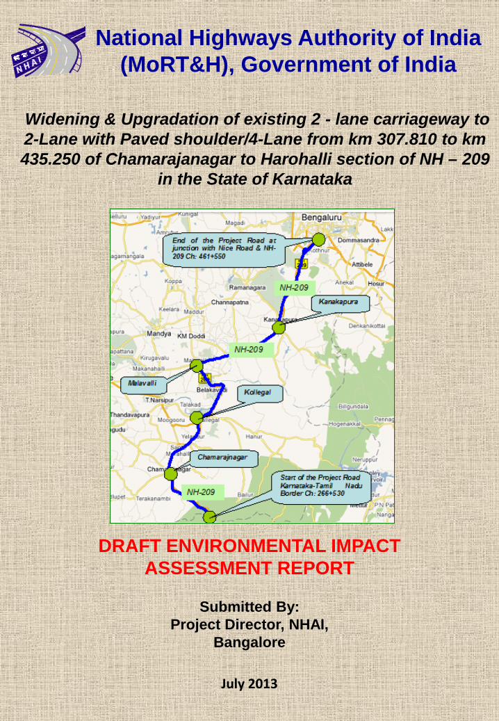
Widening & Upgradation of existing 2 - lane carriageway to 2-Lane with Paved shoulder/4-Lane from km 307.810 to km 435.250 of Chamarajanagar to Harohalli section of NH – 209
in the State of Karnataka
July 2013
National Highways Authority of India (MoRT&H), Government of India
DRAFT ENVIRONMENTAL IMPACT ASSESSMENT REPORT
Submitted By: Project Director, NHAI,
Bangalore
Widening & upgradation of existing 2 - lane carriageway to 4 – lanes from km 307.810 to km 435.250 of Chamarajanagar to Harohalli section of NH – 209 in the state of Karnataka
Proponent: National Highways Authority of India i
Draft EIA Report
Consultant: Feedback Infra Pvt. Ltd July2013
UNCONTROLLED IF PRINTED
TABLE OF CONTENT
0. EXECUTIVE SUMMARY .................................................................................................................... i
0.1 PROJECT BACKGROUND .............................................................................................................. i
0.2 NEED OF THE PROJECT ............................................................................................................... i
0.3 PROJECT ROAD ............................................................................................................................. i
0.4 PROJECT INFLUENCE AREA ........................................................................................................ i
0.5 PROJECT PROPONENT ................................................................................................................. i
0.6 PROPOSED IMPROVEMENTS....................................................................................................... i
0.7 ENVIRONMENTAL IMPACT ASSESSMENT (EIA) STUDY IN THE PROJECT ........................... ii
0.8 POLICY, LEGAL AND ADMINISTRATIVE FRAMEWORK ............................................................ ii
0.8.1 Institutional Setting ...................................................................................................................... ii
0.8.2 Clearances .................................................................................................................................. ii
0.9 BASELINE ENVIRONMENTAL PROFILE ..................................................................................... iii
0.9.1 Physical Environment ................................................................................................................. iii
0.9.2 Biological Environment ............................................................................................................... iv
0.9.3 Social Environment .................................................................................................................... iv
0.10 PUBLIC INTERACTIONS & CONSULTATION ............................................................................... v
0.11 POTENTIAL ENVIRONMENTAL IMPACTS ................................................................................... v
0.11.1 Impacts on Climate...................................................................................................................... v
0.11.2 Impact on Air Quality ................................................................................................................... v
0.11.3 Impact on Noise Levels ............................................................................................................... v
0.11.4 Impact on Water Resources and Quality ................................................................................... vi
0.11.5 Impact on Ecological Resources ................................................................................................ vi
0.11.6 Impact on Land........................................................................................................................... vi
0.11.7 Impact on Human Use Values ................................................................................................... vi
0.12 ANALYSIS OF ALTERNATIVES.................................................................................................... vi
0.13 MITIGATION AVOIDANCE AND ENHANCEMENT MEASURES ................................................. vi
0.14 INSTITUTIONAL REQUIREMENTS AND ENVIRONMENTAL MONITORING PLAN .................. vi
0.15 ENVIRONMENTAL MANAGEMENT PLAN .................................................................................. vii
0.16 CONCLUSIONS ............................................................................................................................ vii
1. INTRODUCTION ................................................................................................................................ 1
1.1 INTRODUCTION ............................................................................................................................. 1
1.2 NEED OF THE PROJECT .............................................................................................................. 1
1.3 PROJECT ROAD ............................................................................................................................ 1
1.4 PROJECT INFLUENCE AREA ....................................................................................................... 2
1.5 PROJECT PROPONENT ................................................................................................................ 2
1.6 SCOPE OF WORK ......................................................................................................................... 2
1.7 PROPOSED IMPROVEMENTS...................................................................................................... 2

Widening & upgradation of existing 2 - lane carriageway to 4 – lanes from km 307.810 to km 435.250 of Chamarajanagar to Harohalli section of NH – 209 in the state of Karnataka
Proponent: National Highways Authority of India ii
Draft EIA Report
Consultant: Feedback Infra Pvt. Ltd July2013
UNCONTROLLED IF PRINTED
1.8 APPROACH TO EIA ....................................................................................................................... 2
1.8.1 Preliminary Environmental Screening ......................................................................................... 3
1.8.2 Review of Applicable Environmental Regulations ....................................................................... 3
1.8.3 Assessment of Baseline Environmental Profile .......................................................................... 3
1.8.4 Consultations ............................................................................................................................... 4
1.8.5 Assessment of Impacts ............................................................................................................... 4
1.8.6 Assessment of Alternatives ......................................................................................................... 4
1.8.7 Mitigations and Enhancement Measures .................................................................................... 4
1.8.8 Environmental Management Action Plans .................................................................................. 4
1.9 STRUCTURE OF THE REPORT .................................................................................................... 5
2. PROJECT DESCRIPTION................................................................................................................. 6
2.1 EXISTING ROAD FEATURES ........................................................................................................ 6
2.1.1 Alignment .................................................................................................................................... 6
2.1.2 Right of way ................................................................................................................................. 7
2.1.3 Road inventory ............................................................................................................................ 7
2.1.4 Traffic .......................................................................................................................................... 7
2.2 PROPOSED ROAD FEATURES .................................................................................................... 7
2.2.1 Alignment .................................................................................................................................... 7
2.2.2 Right of Way ................................................................................................................................ 8
2.2.3 Pavement .................................................................................................................................... 8
2.2.4 Geometric Design Aspects .......................................................................................................... 8
2.2.5 Bypasses and Realignments ..................................................................................................... 10
2.2.6 Service Road / Slip roads .......................................................................................................... 10
2.2.7 Cross Drainage Structures ........................................................................................................ 10
2.2.8 Other Structures ........................................................................................................................ 11
2.2.9 Design of Intersections .............................................................................................................. 11
2.2.10 Traffic Control and Road Safety Features ................................................................................ 11
2.2.11 Enhancement of Inventories ..................................................................................................... 11
2.3 COST ESTIMATE ......................................................................................................................... 11
3. POLICY, LEGAL AND ADMINISTRATIVE FRAMEWORK ............................................................ 13
3.1 INSTITUTIONAL SETTING ........................................................................................................... 13
3.1 THE LEGAL FRAMEWORK .......................................................................................................... 13
3.1.1 Country Level Environmental Legislations ................................................................................ 13
3.1.2 State Level Environmental Legislation ...................................................................................... 14
3.1.3 Other Legislations Applicable to Road Construction Projects .................................................. 15
3.2 CLEARANCE REQUIREMENTS FOR THE PROJECT ............................................................... 15
3.3 CONCLUSION .............................................................................................................................. 15
4. BASELINE ENVIRONMENTAL PROFILE ...................................................................................... 17
4.1 PROJECT AREA ........................................................................................................................... 17

Widening & upgradation of existing 2 - lane carriageway to 4 – lanes from km 307.810 to km 435.250 of Chamarajanagar to Harohalli section of NH – 209 in the state of Karnataka
Proponent: National Highways Authority of India iii
Draft EIA Report
Consultant: Feedback Infra Pvt. Ltd July2013
UNCONTROLLED IF PRINTED
4.2 PHYSICAL ENVIRONMENT ......................................................................................................... 17
4.2.1 Meteorology ............................................................................................................................... 17
4.2.2 Land .......................................................................................................................................... 18
4.2.3 Ambient Air Quality.................................................................................................................... 20
4.2.4 Water ......................................................................................................................................... 22
4.2.5 Noise ......................................................................................................................................... 26
4.3 BIOLOGICAL ENVIRONMENT ..................................................................................................... 27
4.3.1 Forest Areas .............................................................................................................................. 27
4.3.2 Fauna ........................................................................................................................................ 27
4.4 SOCIAL ENVIRONMENT ............................................................................................................. 28
4.4.1 Settlement ................................................................................................................................. 28
4.4.2 Cultural Properties..................................................................................................................... 28
4.4.3 Educational Institutes and Administration Offices ..................................................................... 29
4.4.4 Medical Facilities ....................................................................................................................... 29
4.4.5 Census Profile ........................................................................................................................... 30
4.4.6 Primary Census Profile ............................................................................................................. 30
4.4.7 Linguistic Distribution ................................................................................................................ 32
4.4.8 Cropping Pattern and Crop Productivity ................................................................................... 32
4.4.9 Places of Historical Importance / Cultural Heritage .................................................................. 32
5. PUBLIC INTERACTIONS, CONSULTATIONS .............................................................................. 33
5.1 OBJECTIVES ................................................................................................................................ 33
5.2 CONSULTATION SESSIONS ....................................................................................................... 33
5.2.1 Stake Holders Consultation ....................................................................................................... 33
5.2.2 Consultations during Design ..................................................................................................... 34
5.2.3 Location Specific Consultation Needs....................................................................................... 34
5.3 IDENTIFICATION OF ISSUES ..................................................................................................... 34
5.3.1 Issues Raised During Consultations ......................................................................................... 34
5.4 CONTINUED CONSULTATION .................................................................................................... 34
5.5 KEY FINDINGS OF THE CONSULTATION ................................................................................. 35
5.6 PUBLIC CONSULTATION & HEARING ....................................................................................... 36
5.6.1 Introduction ................................................................................................................................ 36
5.6.2 Public Hearing for the Project ................................................................................................... 36
6. IMPACT ASSESSMENT.................................................................................................................. 37
6.1 GENERAL ENVIRONMENTAL IMPACTS .................................................................................... 37
6.2 PHYSICAL ENVIRONMENT ......................................................................................................... 39
6.2.1 Meteorological Parameters ....................................................................................................... 39
6.2.2 Land .......................................................................................................................................... 39
6.2.3 Air .............................................................................................................................................. 41
6.2.4 Water Resources....................................................................................................................... 42

Widening & upgradation of existing 2 - lane carriageway to 4 – lanes from km 307.810 to km 435.250 of Chamarajanagar to Harohalli section of NH – 209 in the state of Karnataka
Proponent: National Highways Authority of India iv
Draft EIA Report
Consultant: Feedback Infra Pvt. Ltd July2013
UNCONTROLLED IF PRINTED
6.2.5 Noise levels ............................................................................................................................... 47
6.3 BIOLOGICAL ENVIRONMENT ..................................................................................................... 49
6.3.1 Forest Areas .............................................................................................................................. 49
6.3.2 Roadside Plantations ................................................................................................................ 49
6.3.3 Fauna ........................................................................................................................................ 50
6.3.4 Aquatic Ecology......................................................................................................................... 50
6.4 SOCIAL ENVIRONMENT ............................................................................................................. 50
6.4.1 Human Use Values ................................................................................................................... 50
6.4.2 Cultural Properties..................................................................................................................... 52
6.4.3 Quality Of Life Values ............................................................................................................... 53
6.5 CONCLUSION .............................................................................................................................. 55
7. ANALYSIS OF ALTERNATIVES .................................................................................................... 56
7.1 WITH AND WITHOUT PROJECT ALTERNATIVES..................................................................... 56
7.1.1 Without Project Scenario ........................................................................................................... 56
7.1.2 With Project Scenario ................................................................................................................ 56
7.2 JUSTIFICATION FOR SELECTION ............................................................................................. 57
7.3 ALIGNMENT MODIFICATIONS.................................................................................................... 57
7.3.1 Rural Sections ........................................................................................................................... 57
7.3.2 Urban Sections .......................................................................................................................... 58
7.3.3 Bypass and Realignment Locations .......................................................................................... 58
7.3.4 Curve Improvement Locations .................................................................................................. 67
7.4 WIDENING / SERVICE ROAD OPTIONS .................................................................................... 67
7.5 COLD MIX & HOT MIX TECHNOLOGY ANALYSIS .................................................................... 67
7.6 ENVIRONMENTAL CONSIDERATIONS ...................................................................................... 69
7.6.1 Improvement of air and noise quality ........................................................................................ 69
7.6.2 Avoidance of Impact of Sensitive, Cultural and Community Properties .................................... 69
8. MITIGATION, AVOIDANCE AND ENHANCEMENT MEASURES ................................................. 70
8.1 INTRODUCTION ........................................................................................................................... 70
8.2 MITIGATION MEASURES PROPOSED ...................................................................................... 70
8.2.1 Meteorological Parameters ....................................................................................................... 70
8.2.2 Land .......................................................................................................................................... 70
8.2.3 Air Quality – Mitigation .............................................................................................................. 73
8.2.4 Water – Mitigation ..................................................................................................................... 74
8.2.5 Noise - Mitigation....................................................................................................................... 78
8.2.6 Biological Environment .............................................................................................................. 80
8.2.7 Social Environment ................................................................................................................... 84
8.3 ENHANCEMENT .......................................................................................................................... 88
8.3.1 Generic Enhancement Measures for Cultural Properties ......................................................... 88
8.3.2 Specific Enhancement .............................................................................................................. 89
Widening & upgradation of existing 2 - lane carriageway to 4 – lanes from km 307.810 to km 435.250 of Chamarajanagar to Harohalli section of NH – 209 in the state of Karnataka
Proponent: National Highways Authority of India v
Draft EIA Report
Consultant: Feedback Infra Pvt. Ltd July2013
UNCONTROLLED IF PRINTED
9. IMPLEMENTATION ARRANGEMENT ........................................................................................... 90
9.1 INTRODUCTION ........................................................................................................................... 90
9.2 EXISTING ENVIRONMENTAL CELL, NHAI ................................................................................. 90
9.3 IMPLEMENTATION ARRANGEMENTS ....................................................................................... 90
9.3.1 Independent Engineer (IE) ........................................................................................................ 90
9.3.2 Concessionaire .......................................................................................................................... 91
9.3.3 Contractor .................................................................................................................................. 91
9.4 REPORTING SYSTEM ................................................................................................................. 93
9.5 ENVIRONMENTAL CAPACITY BUILDING .................................................................................. 93
10. ENVIRONMENTAL MANAGEMENT PLAN.................................................................................... 96
10.1 ENVIRONMENTAL MANAGEMENT PLAN (EMP)....................................................................... 96
10.1.1 Specific Activities by NHAI ........................................................................................................ 96
10.1.2 Specific Activities by Concessionaire ........................................................................................ 96
10.2 SITE SPECIFIC MANAGEMENT PLAN ....................................................................................... 96
10.2.1 Cultural Properties..................................................................................................................... 96
10.2.2 Sensitive Features..................................................................................................................... 96
10.2.3 Community properties ............................................................................................................... 97
10.3 IMPLEMENTATION OF EMP ....................................................................................................... 97
10.4 ENVIRONMENTAL MONITORING PROGRAMME .................................................................... 114
10.4.1 Monitoring of Earthworks Activities ......................................................................................... 114
10.4.2 Monitoring of Concessionaire / Contractor's Facilities, Plant and Equipment ........................ 114
10.5 BUDGET ..................................................................................................................................... 114
11. BORROW AREAS STUDY............................................................................................................ 118
11.1 IMPACT ASSESSMENT OF BORROW AREAS FOR THE PROJECT ..................................... 118
11.1.1 Quantities Required ................................................................................................................ 118
11.1.2 Proposed Borrow Areas .......................................................................................................... 118
11.1.3 Baseline Environment ............................................................................................................. 121
11.1.4 Procedure for Excavating Borrow Area ................................................................................... 121
11.1.5 Opening of New Borrow Areas ................................................................................................ 122
11.1.6 Impact ...................................................................................................................................... 125
11.1.7 Mitigations, Enhancement & Rehabilitation of Borrow Areas ................................................. 125
12. ADDITIONAL TOR COMPLIANCE ............................................................................................... 129
12.1 THE ADDITIONAL TOR .............................................................................................................. 129
13. DISCLOSURE OF CONSULTANT ................................................................................................ 134
13.1 CONSULTANT’S DETAILS ......................................................................................................... 134
13.2 PROJECT TEAM ........................................................................................................................ 134
13.3 LABORATORY ............................................................................................................................ 134

Widening & upgradation of existing 2 - lane carriageway to 4 – lanes from km 307.810 to km 435.250 of Chamarajanagar to Harohalli section of NH – 209 in the state of Karnataka
Proponent: National Highways Authority of India vi
Draft EIA Report
Consultant: Feedback Infra Pvt. Ltd July2013
UNCONTROLLED IF PRINTED
LIST OF TABLES
Table 1-1: Valued Ecosystem Components .................................................................................................. 3
Table 2-1: Existing Cross Section details ..................................................................................................... 6
Table 2-2: Existing Road Inventory ............................................................................................................... 7
Table 2-3: Widening Options ........................................................................................................................ 7
Table 2-4: Summary of Proposed Horizontal Alignment ............................................................................... 8
Table 2-5: Bypass Locations ....................................................................................................................... 10
Table 3-1: Country Level Environmental Laws & Regulations .................................................................... 13
Table 3-2: Summary of Clearances & NOCs ............................................................................................. 15
Table 4-1: Land Use of the Required Land (in ha) ..................................................................................... 18
Table 4-2: Details of Monitoring Station for Soil.......................................................................................... 19
Table 4-3: Physico-chemical Analysis of Soil Quality ................................................................................. 19
Table 4-4: Air Pollution Receptors Types Identified along the Project Road .............................................. 21
Table 4-5: Details of Monitoring Station for Air Quality ............................................................................... 22
Table 4-6: Ambient Air Quality within Project Corridor ............................................................................... 22
Table 4-7: Details of Water Quality Monitoring Station ............................................................................... 25
Table 4-8: Physical and Chemical Results of Water Samples .................................................................... 25
Table 4-9: Observed Noise Levels along Road .......................................................................................... 26
Table 4-10: Major Settlements along Project Road .................................................................................... 28
Table 4-11: Census Details ......................................................................................................................... 30
Table 4-12: Families within the Proposed Project Corridor ........................................................................ 30
Table 4-13: Social Stratification .................................................................................................................. 31
Table 4-14: Affected Households of Vulnerable Group .............................................................................. 31
Table 4-15: Educational Levels of Families ................................................................................................ 31
Table 4-16: Income Levels .......................................................................................................................... 31
Table 5-1: Public Consultation held at Different Stages of Project ............................................................. 33
Table 5-3: Addressal of General Issues and Concerns under the Project ................................................. 35
Table 6-6: Noise Impacts ............................................................................................................................ 48
Table 6-11: Proposed Land Requirement in the Project ............................................................................. 54
Table 6-13: Ownership Details of Structures Affected Due to the Project .................................................. 54
Table 6-14: Project Affected Families and Persons .................................................................................... 54
Table 7-1: "With and Without" Project Scenarios - A Comparative Assessment ........................................ 56
Table 7-2: Proposed Bypass Locations ...................................................................................................... 58
Table 7-3: Analysis of Alternatives for Kollegal Bypass .............................................................................. 59
Table 7-4: Analysis of Alternatives for Sathegala Bypass .......................................................................... 60
Table 7-5: Analysis of Alternatives for Halaguru Bypass ............................................................................ 61
Table 7-6: Analysis of Alternatives for Kanakapura Bypass ....................................................................... 63
Widening & upgradation of existing 2 - lane carriageway to 4 – lanes from km 307.810 to km 435.250 of Chamarajanagar to Harohalli section of NH – 209 in the state of Karnataka
Proponent: National Highways Authority of India vii
Draft EIA Report
Consultant: Feedback Infra Pvt. Ltd July2013
UNCONTROLLED IF PRINTED
Table 7-7: Major Realignment Locations .................................................................................................... 63
Table 7-8: Analysis of Alternatives for Santhemarahalli Realignment ........................................................ 64
Table 8-1: Summary of Mitigation on Impact on Land ............................................................................... 70
Table 8-2: Mitigation Measures for Soil Contamination ............................................................................. 71
Table 8-3: Details of Stone aggregates Quarries ....................................................................................... 72
Table 8-4: Details of Natural Sand Quarries ............................................................................................... 72
Table 8-5: Summary of Mitigations for Impacts on Air Quality ................................................................... 73
Table 8-6: Summary of Mitigations for Impacts on Water .......................................................................... 74
Table 8-7: Water Resources – Mitigation ................................................................................................... 75
Table 8-8: Sources of Noise Pollution, Impacts and Generic Mitigation Measures ................................... 78
Table 8-9: Specific Noise Mitigation Measures .......................................................................................... 79
Table 8-10: Noise Impact on Sensitive Receptors and Mitigation ............................................................. 79
Table 8-11: Summary of Mitigations for Impacts on Biological Environment ............................................ 80
Table 8-12: Incidental Areas Identified for Plantation ................................................................................. 82
Table 8-13: Species Recommended in Settlement Areas (Within 1 km of Last Dwelling) ......................... 82
Table 8-14: Species Recommended in Rural Areas ................................................................................... 82
Table 8-15: Species Recommended for Median Plantation ....................................................................... 83
Table 8-16: Mitigation for Cultural & Community Properties ...................................................................... 85
Table 9-1: Summary of Reporting of Environmental components and Responsibilities ............................ 93
Table 9-2: Modules for Training ................................................................................................................. 94
Table 10-1: Environmental Management Plan............................................................................................ 98
Table 10-2: Environmental Budget ........................................................................................................... 115
Table 11-1: Details of Borrow areas Proposed ......................................................................................... 118
Table 11-2: Probable Borrow Areas data (to be filled by Concessionaire) ............................................... 123
Table 12-1: Compliance to Additional TOR .............................................................................................. 129
Table 13-1: Project Team .......................................................................................................................... 134
LIST OF FIGURES
Figure 1-1: Location of Project Road ............................................................................................................ 1
Figure 2-1: Photographs of Project Road ..................................................................................................... 6
Figure 2-2: Typical Cross Sections ............................................................................................................... 8
Figure 4-1: Photographs showing Land Use in Project area ...................................................................... 18
Figure 4-2: Seismic Zones of India ............................................................................................................. 20
Figure 4-3: Photographs of Air Quality Monitoring ...................................................................................... 21
Figure 4-5: Photographs of Surface Water Bodies ..................................................................................... 24
Figure 4-6: Flora along the Project Corridor ............................................................................................... 27
Figure 6-1: Impact on Volumetric Capacity of Water Bodies ...................................................................... 46
Figure 7-6: Proposed Yelandur Realignment ......................................................................................... 65
Figure 8-1: Oil interceptor Figure 8-2: Silt Fencing ............................................................................... 77
Widening & upgradation of existing 2 - lane carriageway to 4 – lanes from km 307.810 to km 435.250 of Chamarajanagar to Harohalli section of NH – 209 in the state of Karnataka
Proponent: National Highways Authority of India viii
Draft EIA Report
Consultant: Feedback Infra Pvt. Ltd July2013
UNCONTROLLED IF PRINTED
Figure 8-3: Rain Water Harvesting Structure .............................................................................................. 78
Figure 8-4: Compound Wall and Trees as Noise Barrier ............................................................................ 79
Figure 8-5: Conceptual Landscaping of Incidental Space .......................................................................... 83
Figure 8-6: Thematic landscaping around intersections ............................................................................. 84
Figure 9-1: Proposed Organisation Chart ................................................................................................... 95
Figure 11-1: Borrow Area Location Map ................................................................................................... 119
LIST OF BOXES
Box 9-1: Draft Qualification and Responsibilities of Environmental Officer of Concessionaire .................. 91
Box 9-2: Qualification and Responsibilities of Environmental Officer of Contractor ................................... 92
Box 11-1: Earth Quantities required and to be Utilised ............................................................................. 118
Box 11-2: Borrow Area Plan Format ......................................................................................................... 124
LIST OF ANNEXURE
Annexure 2.1: Details of Bus Bays and Shelters
Annexure 4.1: Water Resources Along the Project Road
Annexure 4.2: Tree Schedule
Annexure 4.3: Cultural/Community Properties along the Project Road
Annexure 4.4: Noise Sensitive Receptors
Annexure 8.1: Guidelines for Identification of Debris Disposal Sites & Precautions
Annexure 8.2: Guideline for Rehabilitation of Dumpsites & Quarries
Annexure 8.3: Guidelines for New Quarry Management
Annexure 8.4: Guidelines for Existing Quarry Management
Annexure 8.5: Quarry Lead Chart
Annexure 8.6: Guidelines for Sediment Control
Annexure 8.7: Tree Plantation Strategy
Annexure 8-8: Traffic Control and Safety during Construction
Annexure 8.9: Guidelines for Sitting and Layout of Construction Camp
Annexure 10.1: Environmental Monitoring Plan

Widening & upgradation of existing 2 - lane carriageway to 4 – lanes from km 307.810 to km 435.250 of Chamarajanagar to Harohalli section of NH – 209 in the state of Karnataka
Proponent: National Highways Authority of India ix
Draft EIA Report
Consultant: Feedback Infra Pvt. Ltd July2013
UNCONTROLLED IF PRINTED
ABBREVIATIONS
Abbreviations Full Form Abbreviations Full Form
AAQ Ambient Air Quality MoEF Ministry of Environment and Forests
AAQMS Ambient Air Quality Monitoring Station NAAQS National Ambient Air Quality Standards
AIDS Acquired Immuno Deficiency Syndrome NGO Non Governmental Organisations
BOQ Bill of Quantities NH National Highway
BPL Below Poverty Line NHAI National Highways Authority of India
CD Cross Drainage Works NOC No-objection Certificate
CF Conservator of Forest NOX Oxides of Nitrogen
CO Carbon Monoxide ODR Other District Roads
CoI Corridor of Impact PAF Project Affected Family
CPCB Central Pollution Control Board PAH Project Affected Household
DFO Divisional Forest Officer PAP Project Affected Person
DLC District Level Committee PD Project Director
DPR Detailed Project Report PF Protected Forest
EIA Environmental Impact Assessment PIU Project Implementation Unit
EMP Environmental Management Plan PPP Public Private Partnership
FGD Focus Group Discussions PWD Public Works Department
GO Government Order R&R Resettlement and Rehabilitation
GoI Government of India RAP Resettlement Action Plan
GoK Government of Karnataka RF Reserved Forest
GWQMS Ground Water Quality Monitoring Station RHS Right Hand Side
HC Hydrocarbons ROW Right of Way
HQ Head Quarters SH State Highways
IE Independent Engineer (also known as Independent Consultant or IC)
SO2 Sulphur Dioxide
IMO Indian Meteorological Organization SOS Strategic Options Study
IRC Indian Roads Congress SPCB State Pollution Control Board
IS Indian Standard PM Particulate Matter
LHS Left Hand Side SWQMS Surface Water Quality Monitoring Station
MDR Major District Roads TDS Total Dissolved Solids


Widening & upgradation of existing 2 - lane carriageway to 4 – lanes from km 307.810 to km 435.250 of Chamarajanagar to Harohalli section of NH – 209 in the state of Karnataka
Client: National Highways Authority of India i
Draft EIA Report
Consultant: Feedback Infra Pvt. Ltd July 2013
UNCONTROLLED IF PRINTED
0. EXECUTIVE SUMMARY
0.1 PROJECT BACKGROUND
National Highways Authority of India (NHAI) has been entrusted to implement the development of
stretches of NH under DPR/KAR/phase – IV B/2010 on BOT Mode / EPC mode. NHAI has decided for
carrying out feasibility study and detailed project preparation for 2-lane with paved shoulders (with
provision of capacity augmentation) / 4 lane standard as per the traffic volume.NHAI has appointed M/s.
Feedback Infra Pvt. Ltd. for providing the required consultancy services for the project in the state of
Karnataka.
0.2 NEED OF THE PROJECT
The demand for the project has emerged primarily from the demand in the increase of existing traffic
numbers plying on the road. However there are other conditions which have led to the demand of the
project. These are
The project road is section of NH 209 connects the urban and semi urban regions outside Bangalore.
NH 209 provides an alternate route to NH 7 and NH 47 from Bangalore to Coimbatore, with a saving of upto 50 km.
Also, due to poor geometrics and inferior riding quality of the road considerable traffic is known to take diversion along SH 17and join project road either in Kanakpura or in Malavalli, who head to the mentioned locations or further ahead, especially from southern and eastern regions of Bangalore and vice-versa. Similarly, traffic towards Mysore from these parts of Bangalore is presently adopting SH 17 as that being a superior facility. But SH-17 at present is congested due to heavy traffic. Hence improvement of NH209 would takeoff considerable traffic from SH-17 and forms an alternative route.
Thus to enable that the project road is able to withstand the pressure of the traffic growth, it has been found that the proposed widening of the existing road to 4 lanes standards is needed.
0.3 PROJECT ROAD
NH-209 starts in the state of Tamil Nadu near Dindigal and ends at Bangalore in Karnataka. The Project
Road is 2 lanes with earthen shoulder from Km 306.600 (proposed Km 307.810) near Chamarajanagar to
Km 438.475 (proposed Km 435.250) Harohalli section of NH 209 in the State of Karnataka. Total existing
length of the project road is 131.875 Km & the proposed length is 127.440 Km Since the project road is an
existing road, the decision to upgrade the road to 2 lane/4 lane with paved Shoulder.
0.4 PROJECT INFLUENCE AREA
The project is located in the districts of Chamarajanagar, Mandya & Ramanagara in Karnataka. The project districts are bounded by Kerala in the South & South-West, Tamilnadu in the South and South-East, Bangalore & Tumkur District in the North, Mysore and Hasan District in the West. The existing Right of Way (RoW) in general varies between 12-30m. The proposed RoW is 30m all throughout for 2 Lane undivided Carriageway with paved shoulder sections and 45m for bypasses & 4 Lane Divided Carriageway sections. The project area is 500 m on either side of the project corridor i.e., a total of 1 Km.
0.5 PROJECT PROPONENT
The project proponent is National Highways Authority of India (NHAI), Government of India.
0.6 PROPOSED IMPROVEMENTS
The existing project highway is presently 2 lanes undivided carriage way. To cater to the future traffic, the project proposes to:
Develop 2 Lanes Undivided/ 4 lanes divided carriageway with paved shoulders and strengthening the existing carriageway by overlays / rehabilitation / reconstruction
In addition to strengthening the existing carriageway, the project would improve the geometric

Widening & upgradation of existing 2 - lane carriageway to 4 – lanes from km 307.810 to km 435.250 of Chamarajanagar to Harohalli section of NH – 209 in the state of Karnataka
Client: National Highways Authority of India ii
Draft EIA Report
Consultant: Feedback Infra Pvt. Ltd July 2013
UNCONTROLLED IF PRINTED
deficiencies through curve improvements and the improvement of the various intersections
The proposed improvement includes repair / rehabilitation of existing cross-drainage (CD) structures on the highway and provision of new CD structures at appreciate locations
To minimise the adverse impacts on the various settlements and to minimise land acquisition 4 bypass, 9 major realignment and 16 minor realignment/curve improvement has been proposed
The proposed works shall be limited to a proposed ROW of 30 m 2 Lanes undivided carriageway with paved shoulder sections and 45m for 4 lanes divided carriageway with paved shoulder sections. It is also proposed to have concentric widening to the extent possible to remove discrimination and local conflicts
No Cattle/ pedestrian/ vehicular underpasses have been proposed.
1 Toll plaza at Km 363.000 (existing) has been proposed
1 Truck Lay byes at Km381.590has been proposed
52 Nos. of Bus-bays with bus shelter and 2Nos. of bus shelters are proposed at various locations
Proper drainage, grade-separation, road furniture, utilities and amenities wherever required shall also be provided
0.7 ENVIRONMENTAL IMPACT ASSESSMENT (EIA) STUDY IN THE PROJECT
The Environmental Impact Assessment study of the project road has been carried out as per terms of reference of NHAI and the approved ToR & guidelines given by the Ministry of Environment & Forests, Govt. of India. The EIA has been included in project preparation to streamline environmental issues in project design.
The study methodology for the EIA employs a simplistic approach in which the important environmental issues have been identified during the Environmental Screening phase. Based on the identification baseline data was generated and then analysed to predict the impacts and quantify them.
The detailed highway designs of project road have been closely coordinated with the preparation of report. The EIA preparation led to the identification of potential environmental impacts. Avoidance, Mitigation and Enhancements measures were then developed and these have been incorporated in the Environmental Management Plan (EMP), design drawings and / or Bills of Quantities as appropriate. Implementation arrangements including responsibilities of all the actors have been streamlined and documented for future guidance.
0.8 POLICY, LEGAL AND ADMINISTRATIVE FRAMEWORK
0.8.1 Institutional Setting
The project has been initiated and is being carried out by the NHAI. The primary responsibility of the project rests with the NHAI in providing encumbrance free ROW to the concessionaire who shall implement the project.
0.8.2 Clearances
As part of the project preparations, the Project Proponent shall take the following clearances and NOCs:
Forest Clearance and Tree felling permission from Divisional Forest Officer / District Administration
Prior Environmental Clearance from MoEF as per Environmental Impact Assessment Notification dated 14
th September 2006 and its subsequent amendments as additional right of way requirement
for improvement of the project road is more than 25m
Apart from the clearances that the project requires to be obtained by the Project Proponent, the concessionaire & contractor shall also obtain the required clearances NOCs & licenses from the various agencies & authorities prior to his work initiation. These are:
NOC and Consents under Air, Water, EP Acts & Noise rules of SPCB for establishing and operating plants from Karnataka SPCB. The NOC shall be made available after the SPCB completes the process of conducting Public Hearing of the project (which shall be carried out as per the Prior Environmental Clearance process)
NOC under Hazardous Waste (Management and Handling) Rules, 1989 from SPCB
PUC certificate for use of vehicles for construction from Department of Transport
Quarry lease deeds and license and Explosive license from Dept. of Geology and Mines & Chief
Widening & upgradation of existing 2 - lane carriageway to 4 – lanes from km 307.810 to km 435.250 of Chamarajanagar to Harohalli section of NH – 209 in the state of Karnataka
Client: National Highways Authority of India iii
Draft EIA Report
Consultant: Feedback Infra Pvt. Ltd July 2013
UNCONTROLLED IF PRINTED
controller of explosives
NOC for ground water extraction for construction and allied works from Ground Water Authority
Apart from the above clearances, the concessionaire also has to comply with the following:
Clearance of Engineer for location and layout of Worker’s Camp, Equipment yard and Storage yard.
Clearance of Engineer for Traffic Management Plan for each section of the route after it has been handed over for construction.
An Emergency Action Plan should be prepared by the contractor and approved by the Engineer for accidents responding to involving fuel & lubricants before the construction starts.
Submit a Quarry Management Plan to the Engineer along with the Quarry lease deeds
0.9 BASELINE ENVIRONMENTAL PROFILE
0.9.1 Physical Environment
Climate
The project area lies in South Interior Karnataka Climatic Zone of the state Karnataka. The climate is characterized by a hot summer and is generally dry expect during monsoon. The climate is distinguished by four seasons i.e. Hot Summer (from March to May), South west monsoon season (from June to September), Post monsoon season (October and November), Cold winter (from December to February). The annual temperature in the project region ranges between 12º to 46ºC. May is the hottest month with a
mean max of 40C. With the advance of south west monsoon into the area, by the middle of June, day temperature drop is observed. By about the first week of October the monsoon, the temperature drops to
about 18C. The monthly temperature range is smallest in August because of overcast conditions and largest in March on the contrary. The humidity of the project area is lowest during the dry season and highest during the monsoon period.
Geology
Karnataka is constituted of rock formations ranging in age from 3300 m.y. to 5 m.y. Barring a narrow coastal strip of about 5000 sq.km of Tertiary and Quaternary sediments and another 31,250 sq.km of Deccan basalts, the remaining area is dominated by Archaean-Proterozoic rocks. Mysore Plateau, geologically constituted of Dharwar Craton comprises of greenstone-granite belts, gneisses and granulites.Greenstone belts essentially consist of meta-volcanosedimentary sequences, surrounded and dissected by Peninsular Gneiss. At the southern end of the craton these give way to granulite suite of rocks. The craton preserves a billion year orogenic history from 3400 m.a. to 2400 m.a. Epicratonic or intracratonic sedimentary basins called Purana Basins occupy the northern segment of the craton whose northern part in turn is concealed by Deccan basalts. Thus younging of lithosequence from south to north is evident.
Soil
The soils of the project districts varies from Medium black soils to Red loamy soils, Red sandy loam soils, Red gravelly soils , Red sandy soils. The soils of the district Chamarajanagar are derived from Granitic gneisses and Charnockite rocks. Red soil is present in upland areas and also noticed at the contact of granites and schist. In Mandya District, The soils range from red sandy loams to red clay loam very thin in ridges and higher elevations and comparatively thick in valley portions. A major part of the district Ramanagara is occupied by red sandy soil (60%), and the remaining by red loamy soil. Red sandy soil
mainly occurs in Channapatna, Kanakapura and Ramanagara taluks in undulating land slopes.
Ambient Air Quality
The air quality in the project area is less polluted. The concentrations of all pollutants are well within the prescribed limits of the National Ambient Air Quality Standards. The maximum
concentration of PM10 is 72.665 g/m3 at Jakkasandra while the minimum concentration is
65.79g/m3 at Mangala. For PM2.5 the maximum reading was found 44.55g/m3 at Uttamballi
(Near Bus Stop), while the lowest recorded value of PM2.5 was 40.26g/m3 Between Halaguru & Honnaganahalli
Noise Quality
The noise monitoring shows that noise levels are marginally higher than the noise standards in 4 locations during day & 6 locations at night. This may be due to mix activities as well as vehicular movement on the road. Noise, though is a major area of concern, at locations of sensitive

Widening & upgradation of existing 2 - lane carriageway to 4 – lanes from km 307.810 to km 435.250 of Chamarajanagar to Harohalli section of NH – 209 in the state of Karnataka
Client: National Highways Authority of India iv
Draft EIA Report
Consultant: Feedback Infra Pvt. Ltd July 2013
UNCONTROLLED IF PRINTED
receptors (educational establishments like schools and colleges, health units etc.) identified quite close to the road.
Water Hydrology and Drainage
According to CGWB based on the stage of ground water development in District Chamarajanagar 100% area in Yalandur taluk falls in safe category. in Chamarajanagar and Kollegal taluk 76% and 40% area fall in safe category respectively. In Mandya District, the stage of development for the whole district was computed as 37.93 %. About 27.14 % area of the district is over exploited, 11.43% area of the district is critical and 62 % of the area is safe. In District Ramanagar, about 45% area of the district is overexploited, 42.5% semi critical and only 12.5% of the area is safe. Surface Water includes drainage channels (rivers, streams, and canals) and stagnant water bodies (lakes, ponds, tanks and other impounded water bodies). A highway project can significantly alter the hydrological setting of the project area by acting as an impediment to the natural drainage system of the region. Seven representative surface water and ground water monitoring stations were selected based on their importance as source of irrigation and water supply, size, future impacts and quantum of water available. By and large, the water quality is satisfactory and the major physical and chemical parameters are within limits set by the Bureau of Indian Standards
2
for drinking water.
0.9.2 Biological Environment
Forest Resources
The alignment of the proposed project road passes through forest areas in 2 locations where requirement for forest land diversion is involved. These forest areas are falling under the jurisdiction of Mandya and Ramanagara Forest Division, Karnataka Forest Dept. No eco-sensitive area covered under Wild Life (Conservation) Act, 1972 (like National Park, Wild life Sanctuary, Biosphere Reserve etc.) is coming within 10Km aerial distance of the project road section.
Trees within ROW
A total of 2431 out of 3000 trees within the proposed ROW are likely to be affected. The predominant tree species are Eucalyptus sp., Prosopis juliflora, Neem (Azadirchta indica) and Acacia nilotica. The other species located within the project corridor are peepal and sissoo besides other miscellaneous species.
Fauna
Domesticated animals like cattle, goats and sheep mainly constitute the faunal population within the project area. All these animals and birds as per IUCN’s conservation status fall in Least Concern category.
0.9.3 Social Environment
Census Profile
The project highway passes through the district of Chamarajanagar, Mandya and Ramanagara in Karnataka. As per the 2011 census, Karnataka has a total population of 6,11,30,704 and the total male and female population in the state is 3,10,57,742 and 3,00,72,962 respectively. The population density per sq km is 319. The literacy rate of the state is 75.60 while the sex ratio is 968. The sex ratio of the project district is more than the state level while the literacy rate is below the state level. Population density of Chamarajnagar and Ramanagara is less than state level while the same is more in Mandya.
The detailed socio-economic analysis of people, structures and property likely to be impacted by the proposed project has been presented in the Report on Resettlement Action Plan.
Workforce in Project area
The people in the village are mostly engaged in the agricultural work and economy is largely based on agriculture. Many people are also working as a labourer in nearby area.
Linguistic Distribution
Kannada is the major language spoken by the majority of the people in the project corridor.
Settlement
There are a total of 44 settlements varying in size and populations along the project corridor.
Widening & upgradation of existing 2 - lane carriageway to 4 – lanes from km 307.810 to km 435.250 of Chamarajanagar to Harohalli section of NH – 209 in the state of Karnataka
Client: National Highways Authority of India v
Draft EIA Report
Consultant: Feedback Infra Pvt. Ltd July 2013
UNCONTROLLED IF PRINTED
Educational Institutes
Some of the educational institutions are located on the edge of the road and is a serious concern from the point of safety. Signage and Safety measures need to be built in the proposed road design at these locations.
Places of Historical Importance / Cultural Heritage
There are no Historical Importance / Cultural Heritage structures on the project road.
Cultural Properties
The project highway traverses through a number of settlements and there are some religious and cultural properties which though not of archaeological significance are nevertheless, significant to the community.
Agriculture Pattern
The major occupation of the project districts is agriculture. Major crops are rice and ground nut. Also coconut, sugarcane, sunflower, cotton and mango plantations are there in few areas.
Highway Amenities
There are number of amenities and utility services located along the highway like Dhaba, hospitals, Petrol Pumps, Bus Stops etc. The location of these amenities along the Highway is an issue of concern as the haphazard siting of these amenities is contributing to congestion of the highway.
Truck Parking Lay-bys & Rest Areas
Truck parking lay-byes are proposed for 1 location at Km 376+550 and 54 Bus Bays/ Shelter has been proposed
Land Use / Acquisition of the Proposed Corridor
A total of 242.62 hectares of land including forest, private and government will be acquired for the construction of bypass, junction improvement and widening etc.
0.10 PUBLIC INTERACTIONS & CONSULTATION
Public Interactions & consultations were conducted during the project preparations. The main purpose of these consultations was to know the community’s reaction to the perceived impact of proposed project on the people at individual and settlement level. The issues of the most concern were related to rehabilitation and resettlements and have been dealt in social assessment report. It was also felt during the public consultation process that most of the people are aware about the project but they did not appreciate environmental problems associated with road projects. However, some people were concerned about environmental issues, mainly air and noise pollution. The other concerns raised at during public consultation were demand for submergence of project road and safety problems. The issues raised by the public have been duly incorporated in project design.
0.11 POTENTIAL ENVIRONMENTAL IMPACTS
The environmental components are mainly impacted during the construction and operational stages of the project and have to be mitigated for and incorporated in the engineering design. Environmental mitigation measures represent the project’s endeavour to reduce its environmental footprint to the minimum possible. These are conscious efforts from the project to reduce undesirable environmental impacts of the proposed activities and offset these to the degree practicable. Enhancement measures are project’s efforts to gain acceptability in its area of influence. They reflect the pro-active approach of the project towards environmental management.
0.11.1 Impacts on Climate
Impact on the climate conditions from the proposed road project widening will not be significant as no major deforestation and / or removal of vegetation is involved for the project.
0.11.2 Impact on Air Quality
There will be rise in PM levels during the construction activities, which shall again be within prescribed limit after the construction activities are over. CO level shall remain within prescribed standards.
0.11.3 Impact on Noise Levels
The impact of noise levels from the proposed project on the neighbouring communities is addressed. It has been concluded that both day and nighttimes equivalent noise levels are within the permissible limits

Widening & upgradation of existing 2 - lane carriageway to 4 – lanes from km 307.810 to km 435.250 of Chamarajanagar to Harohalli section of NH – 209 in the state of Karnataka
Client: National Highways Authority of India vi
Draft EIA Report
Consultant: Feedback Infra Pvt. Ltd July 2013
UNCONTROLLED IF PRINTED
right from start of project life. Noise sensitive receptors have been identified along the project road.
0.11.4 Impact on Water Resources and Quality
The construction and operation of the proposed project roads will not have any major impacts on the surface water and the ground water quality in the area. Contamination to water bodies may result due to spilling of construction materials, oil, grease, fuel and paint in the equipment yards and asphalt plants. This will be more prominent in case of locations where the project road crosses rivers, canals distributaries, etc. Mitigation measures have been planned to avoid contamination of these water bodies.
0.11.5 Impact on Ecological Resources
There is no major loss of vegetation hence adverse impact in terms of availability of nesting sites for the bird doesn’t arise. Furthermore, there is no sensitive ecological area along the existing project roads, so the impact will be insignificant during construction period. But on the long run the project shall have a positive impact due to the compensatory forestation and avenue plantation.
0.11.6 Impact on Land
During the construction of the proposed project, the topography will change due to excavation of borrow areas, stone quarrying, cuts and fills for project road and construction of project related structures etc. Provision of construction yard for material handling will also alter the existing topography. The change in topography will also be due to the probable induced developments of the project. Benefits in the form of land levelling and tree plantations in the vicinity of the project road shall enhance the local aesthetics.
0.11.7 Impact on Human Use Values
The PAPs shall be compensated as per the RAP. Accidents are bound to increase coupled with ribbon development. There shall also be some impacts on cultural or religious properties along the corridor.
0.12 ANALYSIS OF ALTERNATIVES
Detailed analyses of the alternatives have been conducted taking into account both with and without project scenario and the available alignment options. The analysis also dealt with the justification of selections of the proposed alignment and the modifications on it due to environmental considerations, realignment and bypasses and the minimisation of negative impacts. Based on all these alternative studies the present alignment was proposed.
0.13 MITIGATION AVOIDANCE AND ENHANCEMENT MEASURES
Both generic and site specific mitigation and enhancement measures have been planned for identified adverse environmental impacts. The construction workers camp will be located at least 500m away from habitations. The construction yard, hot mix plants, crushers etc. will be located at 500m away from habitations and in downwind directions. Adequate cross drainage structures have been planned to maintain proper cross drainage. In order to compensate negative impacts on flora due to cutting of trees the project plans compensatory plantation in the ratio of 1:2 i.e. for every tree to be cut, two trees will be planted. The project shall also witness the plantation of trees for providing aesthetic beauty and shade. A total of 250 trees are proposed as compensatory afforestation besides transplantation of 6000 trees & planting of 12000 trees for avenue / block plantation. As the space for compensatory afforestation might not be adequate along the project road, this plantation shall be taken up by the forest department, after payment of the cost for raising and maintaining the saplings for three years. The project will take an opportunity to provide environmental enhancement measures to improve aesthetics in the project area. The planned environmental enhancement measures include plantation in available clear space in ROW, enhancement of water bodies etc. In order to avoid contamination of water bodies during construction sedimentation chambers, oils and grease separators, oil interceptors at storage areas and at construction yard have been planned.
0.14 INSTITUTIONAL REQUIREMENTS AND ENVIRONMENTAL MONITORING PLAN
The responsibility of implementing the mitigation measures and all activities under environmental management plan (EMP) lies with the Concessionaire (selected through International Competitive Bidding) through the contractor. All construction activities being taken up by the Contractor under the Concessionaire duly monitored by the Independent Engineer who shall report to the Project Proponent. Presently the Project Proponent is fully equipped to meet the challenges of implementation of the environmental mitigation measures in the EMP.
The implementation of RAP shall be as per the details given in the RAP report. In the pre-construction

Widening & upgradation of existing 2 - lane carriageway to 4 – lanes from km 307.810 to km 435.250 of Chamarajanagar to Harohalli section of NH – 209 in the state of Karnataka
Client: National Highways Authority of India vii
Draft EIA Report
Consultant: Feedback Infra Pvt. Ltd July 2013
UNCONTROLLED IF PRINTED
phase of the project, the Independent Engineer shall review the EMP and RAP to identify environmental and social issues and arrive at a suitable strategy for implementation.
The environmental specialist of the engineer shall be Postgraduate in Environmental Science or Environmental Management or Zoology or Botany or Ecology or Environmental Planning / degree in civil engineering and specialisation in environment and 15 years of experience and a minimum of 5 years in Supervision of implementation of Environmental Management Plan of highway projects.
For effective implementation and management of the EMP, The BOT / Annuity Concessionaire shall contrive to establish a Safety, Health and Environment (SHE) Cell headed by an Environment Officer to deal with the environmental & safety issues of the project. This officer shall interact with the contractor, NHAI, IC and other departments to ensure that the mitigation and enhancement measures mentioned in the EMP are adhered. The Environmental officer of the concessionaire shall be the interface between the Environmental Specialist of IC and the Environmental Officer of the contractor. His prime responsibility shall be to apprise the Environmental Specialist of the IC about the ground conditions. He shall also procure the requisite clearances and the NOCs for the project and shall also strictly supervise that the contractor adheres to the EMP. The officer shall also participate in training programmes and assist the IC in preparing documentation for good practices in environmental protection.
This Environmental Officer should ideally be a Postgraduate in Environmental Science / Environmental Management / Zoology / Botany / Ecology / Environmental Engineer / Environmental Planning. The EO should have 10 years of total experience with a minimum of 3 years in the implementation of EMP of highway projects and an understanding of environmental issues. The environmental officer can also look after the additional charges of safety and health.
The Environmental Officer of the contractor should ideally be a Postgraduate in Environmental Science / Environmental Management / Zoology / Botany / Ecology / Environmental Planning / Environmental Engineer. The Environment Officer should have 5 years of experience with a minimum of 2 years in the implementation of EMP of highway projects and an understanding of environmental, health and safety issues. The Environmental Officer of the contractor shall report directly to the Resident Construction Manager / Project Manager so that the pertinent environmental issues that he raises are promptly dealt with. He shall also have a direct interaction with the Environmental Expert and the Environmental Officer of the IC and the Concessionaire respectively.
The reporting system will operate linearly – contractor who is at the lowest rung of the implementation system reporting to the Concessionaire, who in turn shall report to IC and the project proponent. All reporting by the concessionaire shall be on a quarterly basis, while the reporting time of the contractor shall be decided upon by the concessionaire. The project proponent Site Office will be responsible for setting the targets for the various activities anticipated during construction phase in consultation with the IC and obtaining agreement from the Contractor after mobilisation but before beginning of works on site. The contractor will report from then on regarding the status on each of these. The project proponent’s Site Office will monitor the activities through its own staff or the consultant’s Environmental Specialist after it has obtained the Contractor’s report with the Consultant’s remarks on it during the construction phase. During the operation phase, the supervision as well as reporting responsibilities will lie with the project proponent’s Site Office.
0.15 ENVIRONMENTAL MANAGEMENT PLAN
Project specific environmental management plan have been prepared for ensuring the implementation of the proposed measures during construction phase of the project, implementation and supervision responsibilities, sufficient allocation of funds, timeframes for anticipated activities etc. has been dealt with in this document, which will eventually form a part of the Contract documents between the NHAI and the Concessionaire. The cost for environmental management during construction & operations is INR 24.43 crores.
0.16 CONCLUSIONS
Based on the EIA study and surveys conducted for the Project, it can be safely concluded that associated potential adverse environmental impacts can be mitigated to an acceptable level by adequate implementation of the measures as stated in the EIA Report. Adequate provisions shall be made in the Project to cover the environmental mitigation and monitoring requirements, and their associated costs as suggested in environmental budget. The proposed project shall improve Road efficiency and bring economic growth. In terms of air and noise quality, the project shall bring considerable improvement to possible exposure levels to population.


Widening & upgradation of existing 2 - lane carriageway to 4 – lanes from km 307.810 to km 435.250 of Chamarajanagar to Harohalli section of NH – 209 in the state of Karnataka
Client: National Highways Authority of India 1
Draft EIA Report
Consultant: Feedback Infra Pvt. Ltd July 2013
UNCONTROLLED IF PRINTED
1. INTRODUCTION
1.1 INTRODUCTION
National Highways Authority of India (NHAI) has been entrusted to implement the development of
stretches of NH under DPR/KAR/phase – IV B/2010 on BOT Mode / EPC mode. NHAI has decided for
carrying out feasibility study and detailed project preparation for 2-lane with paved shoulders (with
provision of capacity augmentation) / 4 lane standard as per the traffic volume.NHAI has appointed M/s.
Feedback Infra Pvt. Ltd. for providing the required consultancy services for the project in the state of
Karnataka.
1.2 NEED OF THE PROJECT
The demand for the project has emerged primarily from the demand in the increase of existing traffic
numbers plying on the road. However there are other conditions which have led to the demand of the
project. These are
The project road is section of NH 209 connects the urban and semi urban regions outside Bangalore.
NH 209 provides an alternate route to NH 7 and NH 47 from Bangalore to Coimbatore, with a saving of upto 50 km.
Also, due to poor geometrics and inferior riding quality of the road considerable traffic is known to take diversion along SH 17and join project road either in Kanakpura or in Malavalli, who head to the mentioned locations or further ahead, especially from southern and eastern regions of Bangalore and vice-versa. Similarly, traffic towards Mysore from these parts of Bangalore is presently adopting SH 17 as that being a superior facility. But SH-17 at present is congested due to heavy traffic. Hence improvement of NH209 would takeoff considerable traffic from SH-17 and forms an alternative route.
Thus to enable that the project road is able to withstand the pressure of the traffic growth, it has been found that the proposed widening of the existing road to 4 lanes standards is needed.
1.3 PROJECT ROAD
NH-209 starts in the state of Tamil Nadu near Dindigal and ends at Bangalore in Karnataka. The Project
Road is 2 lanes with earthen shoulder from Km 306.600 (proposed Km 307.810) near Chamarajanagar to
Km 438.475 (proposed Km 435.250) Harohalli section of NH 209 in the State of Karnataka. Total existing
length of the project road is 131.875 Km & the proposed length is 127.440 Km Since the project road is an
existing road, the decision to upgrade the road to 2 lane/4 lane with paved Shoulder.
The location of the project road is presented in Figure 1.1.
Figure 1-1: Location of Project Road

Widening & upgradation of existing 2 - lane carriageway to 4 – lanes from km 307.810 to km 435.250 of Chamarajanagar to Harohalli section of NH – 209 in the state of Karnataka
Client: National Highways Authority of India 2
Draft EIA Report
Consultant: Feedback Infra Pvt. Ltd July 2013
UNCONTROLLED IF PRINTED
1.4 PROJECT INFLUENCE AREA
The project is located in the districts of Chamarajanagar, Mandya & Ramanagara in Karnataka. The project districts are bounded by Kerala in the South & South-West, Tamilnadu in the South and South-East, Bangalore & Tumkur District in the North, Mysore and Hasan District in the West. The existing Right of Way (RoW) in general varies between 12-30m. The proposed RoW is 30m all throughout for 2 Lane undivided Carriageway with paved shoulder sections and 45m for bypasses & 4 Lane Divided Carriageway sections. The project area is 500 m on either side of the project corridor i.e., a total of 1 Km.
1.5 PROJECT PROPONENT
The project proponent is National Highways Authority of India, Government of India.
1.6 SCOPE OF WORK
The scope of EIA as per the ToR submitted to MoEF and the additional ToR received from MoEF. The objectives of the EIA include:
Collection and analysis of baseline environmental data on various components of the environment
Identification of impacts and determination of the magnitude of environmental impacts so that due consideration is given to them during design, construction & operational phases of the road project.
Identification of areas and aspects, which are environmentally or socio-economically insignificant.
Suggestion of mitigation measures and preparation of Environmental Management Plans for enhancing and mitigating the negative impacts and strengthening the beneficial impacts.
Economical assessment of project from the environmental point of view and preparation of environmental budge for implementation of mitigation measures.
Development of the road alignment in such a way that the environment and settlements are affected the least.
Presentation of public consultation and public view on various aspects of environment and the project.
1.7 PROPOSED IMPROVEMENTS
The existing project highway is presently 2 lanes undivided carriage way. To cater to the future traffic, the project proposes to:
Develop 2 Lanes Undivided/ 4 lanes divided carriageway with paved shoulders and strengthening the existing carriageway by overlays / rehabilitation / reconstruction
In addition to strengthening the existing carriageway, the project would improve the geometric deficiencies through curve improvements and the improvement of the various intersections
The proposed improvement includes repair / rehabilitation of existing cross-drainage (CD) structures on the highway and provision of new CD structures at appreciate locations
To minimise the adverse impacts on the various settlements and to minimise land acquisition 4 bypass, 9 major realignment and 16 minor realignment/curve improvement has been proposed
The proposed works shall be limited to a proposed ROW of 30 m 2 Lanes undivided carriageway with paved shoulder sections and 45m for 4 lanes divided carriageway with paved shoulder sections. It is also proposed to have concentric widening to the extent possible to remove discrimination and local conflicts
1 Toll plaza at Km 363.000 (existing) has been proposed
1 Truck Lay byes at Km381.590has been proposed
52 Nos. of Bus-bays with bus shelter and 2Nos. of bus shelters are proposed at various locations
Proper drainage, grade-separation, road furniture, utilities and amenities wherever required shall also be provided
1.8 APPROACH TO EIA
The study methodology for the EIA employs a simplistic approach and analyses the environmental issues identified. The sections below details out the methodology adopted for the assessment of the environment for the project.

Widening & upgradation of existing 2 - lane carriageway to 4 – lanes from km 307.810 to km 435.250 of Chamarajanagar to Harohalli section of NH – 209 in the state of Karnataka
Client: National Highways Authority of India 3
Draft EIA Report
Consultant: Feedback Infra Pvt. Ltd July 2013
UNCONTROLLED IF PRINTED
1.8.1 Preliminary Environmental Screening
A Rapid Assessment Survey (RAS) was undertaken to identify the Valued Ecosystem Components (VECs) and were categorised into various environmental components for screening and to assess their subsequent impacts due to the project as per the table below.
Table 1-1: Valued Ecosystem Components
Sl. No.
Environmental Attributes
Valued Ecosystem Components
1 Topography Terrain (Hilly to Rolling to Plain)
2 Land use Agriculture: (Irrigated, Un-irrigated); Settlements; Forest; Notified Industrial Area / Estate; Grazing; Fallow; No Development zone etc.
3 Water resources Water bodies like rivers, canals, reservoirs, lakes and ponds – Crossings as well as water bodies within 100 m on either side of the existing Centre line
4 Forests & Wild Life
Designated Protected Areas like Biosphere Reserves, Terrestrial or Marine National Parks, Sanctuaries, Tiger / Elephant Reserves, Coastal Regulation Zone etc.) within 15 Km (aerial distances) from the proposed project location boundary
Migratory route / crossing of wild animals and birds crossing project road
Presence of RF, PF other forests within 100m on either side of the existing Centre line
Road side Plantations
Green Tunnels, Strip Plantation
5 Settlements Towns and villages abutting the road corridor
6 Sensitive Receptors Sensitive receptors such as educational and health facilities within COI
7 Drinking water sources
Total number of drinking water sources (wells, hand pumps, community water points / taps etc.) within COI
8 Religious Structures Temples, shrines, mosque, church, gurudwara etc. within COI
10 Cultural Properties Number (total) of cultural properties (protected/ unprotected archaeological monuments) within 500m from the road
11 Market Places Number (total) of weekly market places / haats; grain / fruit / vegetable / fish market; cattle market within COI
12 Common Property Resources
CPRs such as pastures / grazing lands; seating areas of the community; cremation/burial grounds etc. within / along the RoW (All CPRs other than religious structures, drinking water sources and bus stops) within COI
13 Other features Flood Plains; Soil Erosion; stone quarries etc.
1.8.2 Review of Applicable Environmental Regulations
Applicability of various environmental regulations and guidelines was reviewed for the project and its allied activities.
1.8.3 Assessment of Baseline Environmental Profile
The baseline conditions of the project area were studied. Data pertaining to all facets of environment which include physical, ecological, and socioeconomic environment both through primary and secondary sources were collected. Key relevant information sources has been summarised in table below. Ambient air & noise, ground and surface water samples were monitored at various locations identified along the corridor. The monitoring and analysis for each component were carried out as per MoEF and CPCB guidelines. The results of the monitoring were compared with the relevant national standards.
As part of the baseline environmental profile, a detailed tree inventory along the RoW was carried out based on their chainage, species, girth and distance from the carriageway. All trees with a girths size more than 30cm that are falling within the proposed ROW were and marked on the ground. Based on the survey a tree schedule was prepared for submission to the authorities.
In order to quantify the impacts of the project road on various receptors a survey was carried out. The receptors included educational institutes, hospitals, cultural & religious properties and community properties.
Table 1-2: Primary and Secondary Information Sources
Environmental Parameters Information Sources
Project objectives, Technical information on existing road features
Design Report
Inventory of road features like water Bodies, Community structures, environmentally sensitive locations areas, congested locations etc.
Ground Physical surveys
Climatic Condition & Meteorological data SPCB, Envis and other Websites, District Groundwater Brochure of CGWB, Feasibility report, primary data collection
Geology, Seismicity, Soil and Topography State of Environment report published by SPCB, government
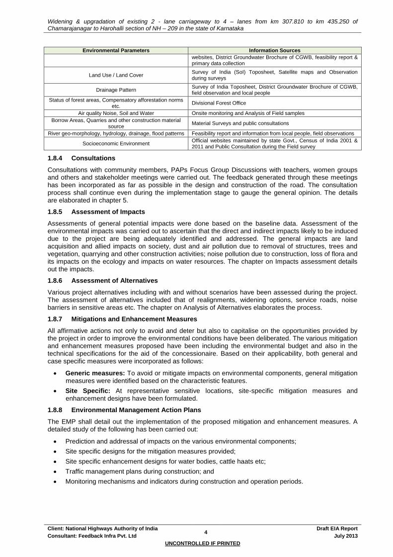
Widening & upgradation of existing 2 - lane carriageway to 4 – lanes from km 307.810 to km 435.250 of Chamarajanagar to Harohalli section of NH – 209 in the state of Karnataka
Client: National Highways Authority of India 4
Draft EIA Report
Consultant: Feedback Infra Pvt. Ltd July 2013
UNCONTROLLED IF PRINTED
Environmental Parameters Information Sources
websites, District Groundwater Brochure of CGWB, feasibility report & primary data collection
Land Use / Land Cover Survey of India (SoI) Toposheet, Satellite maps and Observation during surveys
Drainage Pattern Survey of India Toposheet, District Groundwater Brochure of CGWB, field observation and local people
Status of forest areas, Compensatory afforestation norms etc.
Divisional Forest Office
Air quality Noise, Soil and Water Onsite monitoring and Analysis of Field samples
Borrow Areas, Quarries and other construction material source
Material Surveys and public consultations
River geo-morphology, hydrology, drainage, flood patterns Feasibility report and information from local people, field observations
Socioeconomic Environment Official websites maintained by state Govt., Census of India 2001 & 2011 and Public Consultation during the Field survey
1.8.4 Consultations
Consultations with community members, PAPs Focus Group Discussions with teachers, women groups and others and stakeholder meetings were carried out. The feedback generated through these meetings has been incorporated as far as possible in the design and construction of the road. The consultation process shall continue even during the implementation stage to gauge the general opinion. The details are elaborated in chapter 5.
1.8.5 Assessment of Impacts
Assessments of general potential impacts were done based on the baseline data. Assessment of the environmental impacts was carried out to ascertain that the direct and indirect impacts likely to be induced due to the project are being adequately identified and addressed. The general impacts are land acquisition and allied impacts on society, dust and air pollution due to removal of structures, trees and vegetation, quarrying and other construction activities; noise pollution due to construction, loss of flora and its impacts on the ecology and impacts on water resources. The chapter on Impacts assessment details out the impacts.
1.8.6 Assessment of Alternatives
Various project alternatives including with and without scenarios have been assessed during the project. The assessment of alternatives included that of realignments, widening options, service roads, noise barriers in sensitive areas etc. The chapter on Analysis of Alternatives elaborates the process.
1.8.7 Mitigations and Enhancement Measures
All affirmative actions not only to avoid and deter but also to capitalise on the opportunities provided by the project in order to improve the environmental conditions have been deliberated. The various mitigation and enhancement measures proposed have been including the environmental budget and also in the technical specifications for the aid of the concessionaire. Based on their applicability, both general and case specific measures were incorporated as follows:
Generic measures: To avoid or mitigate impacts on environmental components, general mitigation measures were identified based on the characteristic features.
Site Specific: At representative sensitive locations, site-specific mitigation measures and enhancement designs have been formulated.
1.8.8 Environmental Management Action Plans
The EMP shall detail out the implementation of the proposed mitigation and enhancement measures. A detailed study of the following has been carried out:
Prediction and addressal of impacts on the various environmental components;
Site specific designs for the mitigation measures provided;
Site specific enhancement designs for water bodies, cattle haats etc;
Traffic management plans during construction; and
Monitoring mechanisms and indicators during construction and operation periods.
Widening & upgradation of existing 2 - lane carriageway to 4 – lanes from km 307.810 to km 435.250 of Chamarajanagar to Harohalli section of NH – 209 in the state of Karnataka
Client: National Highways Authority of India 5
Draft EIA Report
Consultant: Feedback Infra Pvt. Ltd July 2013
UNCONTROLLED IF PRINTED
1.9 STRUCTURE OF THE REPORT
The EIA report excluding the first chapter has been structured into the following chapters:
Chapter - 2 Project Description describes the existing features and also discusses the various proposed improvement programmes along the corridor;
Chapter - 3 Policy, Legal and Administrative Framework reviews the existing set-ups relevant to the project, at the National and the State levels;
Chapter - 4 Baseline Environmental Profile describes the entire picture of the existing environmental set up of the project;
Chapter - 5 Public Interactions, Consultations & Public Hearing describes consultations carried out and people's perceptions of the project benefits and the potential impacts;
Chapter - 6 Impacts Assessment identifies and assesses the potential impacts on each of the environmental components due to the proposed project development;
Chapter - 7 Analysis of Alternatives discusses the various alternatives for the project stretch along with the criteria for analysis and evaluation;
Chapter - 8 Mitigation, Avoidance and Enhancement Measures presents the avoidance and mitigation and enhancement measures suggested on each of the environmental components;
Chapter - 9 Implementation Arrangements & Monitoring Schedule gives a brief about the present implementation arrangements for environmental components of the project, compliance monitoring and reporting mechanisms;
Chapter - 10 Environmental Management Plan details both the generic and specific EMPs for the project road. This chapter also includes the Environmental Budget
Chapter - 11 Borrow Areas Study provides the details of the borrow areas required for mining of soil / earth for the project
Chapter - 12 Additional ToR Compliance provides the details of the compliance made to the ToR provided by MoEF;
Chapter - 13 Disclosure of the Consultant provides the details of the consultants engaged along with their capabilities and experiences.


Widening & upgradation of existing 2 - lane carriageway to 4 – lanes from km 307.810 to km 435.250 of Chamarajanagar to Harohalli section of NH – 209 in the state of Karnataka
Client: National Highways Authority of India 6
Draft EIA Report
Consultant: Feedback Infra Pvt. Ltd July 2013
UNCONTROLLED IF PRINTED
2. PROJECT DESCRIPTION
This Chapter describes the project road and discusses the various improvement measures proposed as part of the project. The project description includes details of existing condition of project road, existing and proposed traffic, pavement conditions, road inventory, safety and community facilities.
2.1 EXISTING ROAD FEATURES
2.1.1 Alignment
The highway is mainly having two lane undivided carriageway (with earthen shoulders)
The existing carriageway width varies from 3.75 m to 15m
The existing pavement condition based on visual observation varies from 64.575Km good (48.97 %), 51.800 Km fair (39.28 %) & 15.500Km poor (11.75 %)
The project road is of bituminous surface
Earthen shoulders exist for entire length of the highway almost and the condition of the earthen shoulders varies from good to fair.
There are 140 horizontal curves (75 left hand curves & 65 right hand curves) that have insufficient and 102 vertical curves (Summit Curves- 66, Valley Curve – 36) exist along the project road
Table 2-1: Existing Cross Section details
Carriageway Width (m) Shoulder Width (m) Embankment Height ( m)
3.75 - 15 1 – 2 1.8m LHS and 1.3m RHS (average)
Figure 2-1: Photographs of Project Road

Widening & upgradation of existing 2 - lane carriageway to 4 – lanes from km 307.810 to km 435.250 of Chamarajanagar to Harohalli section of NH – 209 in the state of Karnataka
Client: National Highways Authority of India 7
Draft EIA Report
Consultant: Feedback Infra Pvt. Ltd July 2013
UNCONTROLLED IF PRINTED
2.1.2 Right of way
The right of way along the project stretch varies from 12 to 30m on an average
Although no major encroachments are observed along the project highway, there are some locations near to built-up areas and town limits where some unauthorised structures have been constructed within the ROW.
2.1.3 Road inventory
The road has 6 major and 100 minor intersections
There are 13 bus bays, 43 Bus Shelters, 3 bus stands and no truck lay byes present
Total 3.200Km of covered drain, 9.670 Km of Lined Drain and 119.000Km of unlined drains are present at both of the sides of existing project road section.
The summary of the road inventory is given in the Table 2-2
Table 2-2: Existing Road Inventory
Major
Intersection
Minor
intersection
No. of
major
bridges
No. of
minor
bridges
PUP Flyovers Culverts ROB / RUB
Box
/
slab
Pipe ROB RUB
6 100 4 32 0 0 121 164 0 0
Source: Primary Road Inventory Survey
2.1.4 Traffic
Mixed traffic flow is observed along the highway. The annual average daily traffic at four sections is 10902, 6726, 5040 & 23479 PCUs respectively.
2.2 PROPOSED ROAD FEATURES
2.2.1 Alignment
The length of the project road is 127.440 Km
12 Typical Cross Sections for widening of the project road in urban, rural areas realignment and bypasses have been developed based on guidelines of IRC 73:1980 and are depicted in Figure 2.2.
Table 2-3: Widening Options
Sl. No.
Widening Option Total Length (km)
Remarks
1 Concentric 80.210 To remove disparity and to negate more LA
2 Eccentric 8.720 Due to curve improvement or parallel addition of Bridge / Structure (4.880 Km Ecc. RHS & 3.840 Km Ecc LHS)
3 Bypass 26.390 Kollegal, Sathegala, Kanakapura, Halaguru
4 Realignments/Curve Improvements
12.120 Doddam Udahalli, Santhe Marahalli, Yelandur, Maddur, Malavalli etc
Total 127.440

Widening & upgradation of existing 2 - lane carriageway to 4 – lanes from km 307.810 to km 435.250 of Chamarajanagar to Harohalli section of NH – 209 in the state of Karnataka
Client: National Highways Authority of India 8
Draft EIA Report
Consultant: Feedback Infra Pvt. Ltd July 2013
UNCONTROLLED IF PRINTED
2.2.2 Right of Way
30m ROW has been proposed for 2 Lane undivided Carriageway with paved shoulder sections (TCS 1, 1A, 1B, 2, 2A, 2B, 3).
45m ROW has been proposed for bypasses & 4 Lane Divided Carriageway sections (TCS 6, 6A,6B, 7, 7A)
2.2.3 Pavement
Flexible pavements are proposed for all throughout the road except at the toll plaza where rigid pavement is proposed. This is due to the high cost of construction involved for rigid pavements.
2.2.4 Geometric Design Aspects
All geometric design aspects have been carried out as per the IRC and MoRT&H standards and specifications. Adequate warnings have been provided or maintaining continuity has been emphasised in the design. The details of the minor realignments identified are given in Design Report.
The existing profile has been maintained all throughout the project road.
The design speed has been kept quite consistent, and speed difference between two consecutive curves is not exceeded. All horizontal curves are designed for 80 - 100kmph, as detailed in table below:
Table 2-4: Summary of Proposed Horizontal Alignment
Total No of Curves Radius of Curve (m) Design Speed (Kmph)
0-199 200-499 500-899 900-1999 >2000 15-35 50-65 80 100
344 0 54 64 43 183 - - 84 260
Figure 2-2: Typical Cross Sections

Widening & upgradation of existing 2 - lane carriageway to 4 – lanes from km 307.810 to km 435.250 of Chamarajanagar to Harohalli section of NH – 209 in the state of Karnataka
Client: National Highways Authority of India 9
Draft EIA Report
Consultant: Feedback Infra Pvt. Ltd July 2013
UNCONTROLLED IF PRINTED

Widening & upgradation of existing 2 - lane carriageway to 4 – lanes from km 307.810 to km 435.250 of Chamarajanagar to Harohalli section of NH – 209 in the state of Karnataka
Client: National Highways Authority of India 10
Draft EIA Report
Consultant: Feedback Infra Pvt. Ltd July 2013
UNCONTROLLED IF PRINTED
2.2.5 Bypasses and Realignments
4 bypasses have been proposed for the project for a total length of 26.390 Km.
The project also proposes to have 9 realignments for a total length of 9.370 Km
Table 2-5: Bypass Locations
S.No. Name of Bypass Existing Chainage (Km) Design Chainage (Km) Length (m)
From To From To
1 Kollegal 336.833 346.000 337.560 345.630 8070
2 Sathegala 352.460 361.886 352.100 358.680 6580
3 Halaguru 393.875 397.125 390.810 393.950 3140
4 Kanakapura 419.550 428.075 416.320 424.920 8600
2.2.6 Service Road / Slip roads
No Service Road or Slip road has been proposed.
2.2.7 Cross Drainage Structures
The project road shall have 4 major bridge and 26 minor bridges. The length of the major bridges vary from 60 m to 605 m while the minor bridges’ length vary from 6m to 35m.
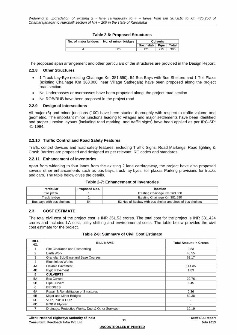
Widening & upgradation of existing 2 - lane carriageway to 4 – lanes from km 307.810 to km 435.250 of Chamarajanagar to Harohalli section of NH – 209 in the state of Karnataka
Client: National Highways Authority of India 11
Draft EIA Report
Consultant: Feedback Infra Pvt. Ltd July 2013
UNCONTROLLED IF PRINTED
Table 2-6: Proposed Structures
No. of major bridges No. of minor bridges Culverts
Box / slab Pipe Total
4 26 121 275 396
The proposed span arrangement and other particulars of the structures are provided in the Design Report.
2.2.8 Other Structures
1 Truck Lay-Bye (existing Chainage Km 381.590), 54 Bus Bays with Bus Shelters and 1 Toll Plaza (existing Chainage Km 363.000, near Village Sathegala) have been proposed along the project road section.
No Underpasses or overpasses have been proposed along the project road section
No ROB/RUB have been proposed in the project road
2.2.9 Design of Intersections
All major (6) and minor junctions (100) have been studied thoroughly with respect to traffic volume and geometric. The important minor junctions leading to villages and major settlements have been identified and proper junction layouts (including road marking, and traffic signs) have been applied as per IRC-SP: 41-1994.
2.2.10 Traffic Control and Road Safety Features
Traffic control devices and road safety features, including Traffic Signs, Road Markings, Road lighting & Crash Barriers are proposed and designed as per relevant IRC codes and standards.
2.2.11 Enhancement of Inventories
Apart from widening to four lanes from the existing 2 lane carriageway, the project have also proposed several other enhancements such as bus-bays, truck lay-byes, toll plazas Parking provisions for trucks and cars. The table below gives the details.
Table 2-7: Enhancement of Inventories
Particular Proposed Nos. location
Toll plaza 1 Existing Chainage Km 363.000
Truck laybye 1 Existing Chainage Km 381.590
Bus bays with bus shelters 54 52 Nos of Busbay with bus shelter and 2nos of bus shelters
2.3 COST ESTIMATE
The total civil cost of the project cost is INR 351.53 crores. The total cost for the project is INR 581.424 crores and includes LA cost, utility shifting and environmental costs. The table below provides the civil cost estimate for the project.
Table 2-8: Summary of Civil Cost Estimate
BILL NO.
BILL NAME Total Amount in Crores
1 Site Clearance and Dismantling 0.83
2 Earth Work 40.55
3 Granular Sub-Base and Base Courses 62.17
4 Bituminious Works
4A Flexible Pavement 114.35
4B Rigid Pavement 1.83
5 CULVERTS
5A Box Culvert 22.76
5B Pipe Culvert 6.45
6 BRIDGES
6A Repair & Rehabilitation of Structures 0.36
6B Major and Minor Bridges 50.38
6C VUP, PUP & CUP -
6D ROB & Flyover -
7 Drainage, Protective Works, Duct & Other Services 10.19
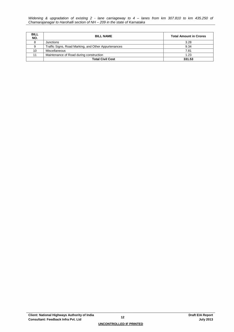
Widening & upgradation of existing 2 - lane carriageway to 4 – lanes from km 307.810 to km 435.250 of Chamarajanagar to Harohalli section of NH – 209 in the state of Karnataka
Client: National Highways Authority of India 12
Draft EIA Report
Consultant: Feedback Infra Pvt. Ltd July 2013
UNCONTROLLED IF PRINTED
BILL NO.
BILL NAME Total Amount in Crores
8 Junctions 3.28
9 Traffic Signs, Road Marking, and Other Appurtenances 9.34
10 Miscellaneous 7.81
11 Maintenance of Road during construction 1.23
Total Civil Cost 331.53

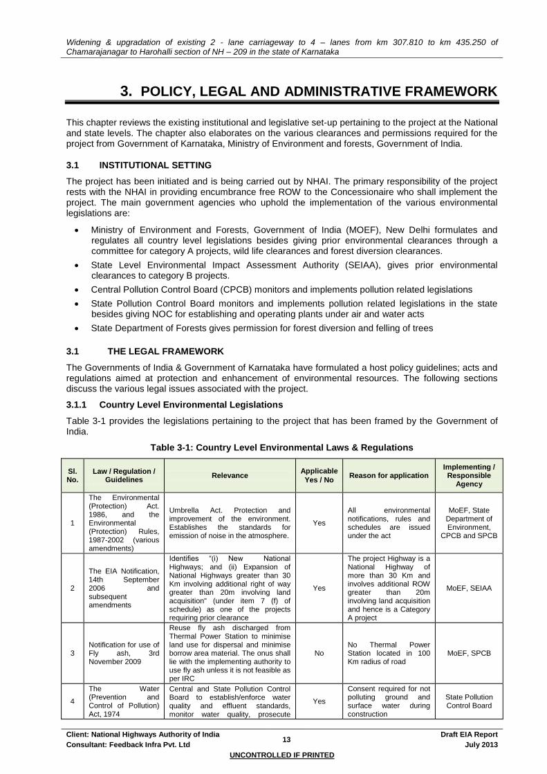
Widening & upgradation of existing 2 - lane carriageway to 4 – lanes from km 307.810 to km 435.250 of Chamarajanagar to Harohalli section of NH – 209 in the state of Karnataka
Client: National Highways Authority of India 13
Draft EIA Report
Consultant: Feedback Infra Pvt. Ltd July 2013
UNCONTROLLED IF PRINTED
3. POLICY, LEGAL AND ADMINISTRATIVE FRAMEWORK
This chapter reviews the existing institutional and legislative set-up pertaining to the project at the National and state levels. The chapter also elaborates on the various clearances and permissions required for the project from Government of Karnataka, Ministry of Environment and forests, Government of India.
3.1 INSTITUTIONAL SETTING
The project has been initiated and is being carried out by NHAI. The primary responsibility of the project rests with the NHAI in providing encumbrance free ROW to the Concessionaire who shall implement the project. The main government agencies who uphold the implementation of the various environmental legislations are:
Ministry of Environment and Forests, Government of India (MOEF), New Delhi formulates and regulates all country level legislations besides giving prior environmental clearances through a committee for category A projects, wild life clearances and forest diversion clearances.
State Level Environmental Impact Assessment Authority (SEIAA), gives prior environmental clearances to category B projects.
Central Pollution Control Board (CPCB) monitors and implements pollution related legislations
State Pollution Control Board monitors and implements pollution related legislations in the state besides giving NOC for establishing and operating plants under air and water acts
State Department of Forests gives permission for forest diversion and felling of trees
3.1 THE LEGAL FRAMEWORK
The Governments of India & Government of Karnataka have formulated a host policy guidelines; acts and regulations aimed at protection and enhancement of environmental resources. The following sections discuss the various legal issues associated with the project.
3.1.1 Country Level Environmental Legislations
Table 3-1 provides the legislations pertaining to the project that has been framed by the Government of India.
Table 3-1: Country Level Environmental Laws & Regulations
Sl. No.
Law / Regulation / Guidelines
Relevance Applicable
Yes / No Reason for application
Implementing / Responsible
Agency
1
The Environmental (Protection) Act. 1986, and the Environmental (Protection) Rules, 1987-2002 (various amendments)
Umbrella Act. Protection and improvement of the environment. Establishes the standards for emission of noise in the atmosphere.
Yes
All environmental notifications, rules and schedules are issued under the act
MoEF, State Department of Environment,
CPCB and SPCB
2
The EIA Notification, 14th September 2006 and subsequent amendments
Identifies “(i) New National Highways; and (ii) Expansion of National Highways greater than 30 Km involving additional right of way greater than 20m involving land acquisition" (under item 7 (f) of schedule) as one of the projects requiring prior clearance
Yes
The project Highway is a National Highway of more than 30 Km and involves additional ROW greater than 20m involving land acquisition and hence is a Category A project
MoEF, SEIAA
3 Notification for use of Fly ash, 3rd November 2009
Reuse fly ash discharged from Thermal Power Station to minimise land use for dispersal and minimise borrow area material. The onus shall lie with the implementing authority to use fly ash unless it is not feasible as per IRC
No No Thermal Power Station located in 100 Km radius of road
MoEF, SPCB
4
The Water (Prevention and Control of Pollution) Act, 1974
Central and State Pollution Control Board to establish/enforce water quality and effluent standards, monitor water quality, prosecute
Yes
Consent required for not polluting ground and surface water during construction
State Pollution Control Board

Widening & upgradation of existing 2 - lane carriageway to 4 – lanes from km 307.810 to km 435.250 of Chamarajanagar to Harohalli section of NH – 209 in the state of Karnataka
Client: National Highways Authority of India 14
Draft EIA Report
Consultant: Feedback Infra Pvt. Ltd July 2013
UNCONTROLLED IF PRINTED
Sl. No.
Law / Regulation / Guidelines
Relevance Applicable
Yes / No Reason for application
Implementing / Responsible
Agency
offenders, and issue licenses for construction/operation of certain facilities.
5 The Air (Prevention and Control of Pollution) Act. 1981
Empowers SPCB to set and monitor air quality standards and to prosecute offenders, excluding vehicular air and noise emission.
Yes
Consent required for establishing and operation of plants and crushers
State Pollution Control Board
6 Noise Pollution (Regulation And Control) Act, 1990
Standards for noise emission for various land uses
Yes
construction machineries and vehicles to conform to the standards for construction
State Pollution Control Board
7 Forest (Conservation) Act, 1980
Conservation and definition of forest areas. Diversion of forest land follows the process as laid by the act
No Diversion of forest land is involved in the project
State Forest Department,
MoEF
8 Coastal Regulatory Zone Notification, 2011
Protect and manage coastal areas No The project area is not within designated coastal zone
MoEF, State Department of Environment
9 Wild Life Protection Act, 1972
Protection of wild life in sanctuaries and National Park
No
Project road is not located within 10 Km radius of any National Park or Wild Life sanctuary
State & National Wild Life Boards
10
Ancient Monuments and Archaeological sites and Remains Act 1958
To protect and conserve cultural and historical remains found.
No No archaeological monuments, area in the project area
Archaeological Survey of India, State Dept. of Archaeology
11 The Motor Vehicle Act. 1988
Empowers State Transport Authority to enforce standards for vehicular pollution. From August 1997 the "Pollution Under Control Certificate is issued to reduce vehicular emissions.
Yes
All vehicles used for construction will need to comply with the provisions of this act.
State Motor Vehicles
Department
12 The Explosives Act (& Rules) 1884 (1983)
Sets out the regulations as to regards the use of explosives and precautionary measures while blasting & quarrying.
Yes
If new quarrying operation is started by the concessionaire / contractor
Chief Controller of Explosives
13 Public Liability And Insurance Act,1991
Protection to the general public from accidents due to hazardous materials
Yes Hazardous materials shall be used for road construction
State Pollution Control Board
14
Hazardous Wastes (Management and Handling) Rules, 1989
Protection to the general public against improper handling and disposal of hazardous wastes
Yes
Hazardous wastes shall be generated due to activities like of maintenance and repair work on vehicles
State Pollution Control Board
15
Chemical Accidents (Emergency Planning, Preparedness and Response) Rules, 1996
Protection against chemical accident while handling any hazardous chemicals resulting
Yes
Handling of hazardous (flammable, toxic and explosive) chemicals during road construction
District & Local Crisis Group
headed by the DM and SDM
16
Mines and Minerals (Regulation and Development) Act, 1957 as amended in 1972
Permission of Mining of aggregates and sand
Yes Permission of Sand Mining from river bed & aggregates
State Department of Mining
17
The Building and Other Construction Workers (Regulation of Employment and Conditions of Service) Act, 1996
Employing Labour / workers Yes Employing Labour / workers
District Labour Commissioner
3.1.2 State Level Environmental Legislation
Clearances for setting up hot-mix plants, batching plants, etc., under the Air and the Water Acts, establishing new quarries and establishment of new tube-wells / bore-holes is from SPCB, State Department of Mining and Sate Ground Water Boards / Authorities respectively.

Widening & upgradation of existing 2 - lane carriageway to 4 – lanes from km 307.810 to km 435.250 of Chamarajanagar to Harohalli section of NH – 209 in the state of Karnataka
Client: National Highways Authority of India 15
Draft EIA Report
Consultant: Feedback Infra Pvt. Ltd July 2013
UNCONTROLLED IF PRINTED
3.1.3 Other Legislations Applicable to Road Construction Projects
The Concessionaire shall ensure that other legislations like Child Labour (prohibition and Regulation) Act; 1986, Minimum Wages Act; 1948, The factories Act; 1948, The Building and Other Construction Workers (Regulation of Employment and Conditions of Service) Act, 1996 etc. are properly followed.
3.2 CLEARANCE REQUIREMENTS FOR THE PROJECT
The summary table showing time requirements for agency responsible for obtaining clearance, and a stage at which clearance will be required is given below:
Table 3-2: Summary of Clearances & NOCs
Sl. No
Type of clearance Statutory Authority Applicability Project stage Time
required Responsibility
1 Prior Environmental
Clearance EAC, MoEF
Falls under 7(f) of EIA notification 2006 & its
amendments
Pre construction
7-12 month
NHAI
2
Permission for Activities near archaeological protected area
Archaeological survey of India / the state
department of Archaeology
Not Applicable Pre
construction - NHAI
3 CRZ Clearance CZMA & SEIAA /
MoEF Not Applicable
Pre construction
- NHAI
4 Clearance for working
/ diversion of sanctuary land
DCF, CWLW, SWLB, NWLB
Not Applicable Pre
construction - NHAI
5 Forest Clearance Forest Dept. and
MoEF Applicable
Pre construction
10-12 months
NHAI
6 Tree felling permission Forest department Felling of trees Pre
construction 1-2
months NHAI
7
NOC And Consents Under Air , Water, EP Acts & Noise rules of
SPCB
State Pollution Control Board
For establishing plants
Construction (Prior to work
initiation)
2-3 months
Concessionaire / Contractor
8
NOC And Consents Under Air , Water, EP Acts & Noise rules of
SPCB
State Pollution Control Board
For operating Hot mix plants, Crushers and
batching plants
Construction (Prior to work
initiation)
1-2 months
Concessionaire / Contractor
9 Permission to store
Hazardous Materials State Pollution Control
Board
Storage and Transportation Of
Hazardous Materials and Explosives
Construction (Prior to work
initiation)
2-3 months
Concessionaire / Contractor
10 Explosive license Chief controller of
explosives Storage of explosive
materials
Construction (Prior to work
initiation)
2-3 months
Concessionaire / Contractor
11
NOC under Hazardous Waste (Management and
Handling) Rules, 1989
State Pollution Control Board
Disposal of bituminous wastes
Construction (Prior to work
initiation)
2-3 months
Concessionaire / Contractor
12 PUC certificate for use
of vehicles for construction
Department of Transport
For all construction vehicles
Construction (Prior to work
initiation)
1-2 months
Concessionaire / Contractor
13 Quarry lease deeds
and license Dept. of Geology and
Mines Quarrying and
borrowing operations
Construction (Prior to work
initiation)
2-3 months
Concessionaire / Contractor
14
NOC for water extraction for
construction and allied works
Ground Water Authority
Ground water extraction
Construction (Prior to work
initiation)
2-3 months
Concessionaire / Contractor
3.3 CONCLUSION
Review of environmental regulations indicates that the project requires Prior Environmental Clearance from MoEF. However, clearance for the diversion of forest land and permission for cutting the trees within the proposed right of way of the project road will be required from the Forest Department. In addition to the above, the concessionaire would require the following NOCs & licenses from the authorities during construction:
NOC And Consents Under Air, Water, EP Acts & Noise rules from Karnataka SPCB for establishing
Widening & upgradation of existing 2 - lane carriageway to 4 – lanes from km 307.810 to km 435.250 of Chamarajanagar to Harohalli section of NH – 209 in the state of Karnataka
Client: National Highways Authority of India 16
Draft EIA Report
Consultant: Feedback Infra Pvt. Ltd July 2013
UNCONTROLLED IF PRINTED
and operating plants
NOC under Hazardous Waste (Management and Handling) Rules, 1989 from Karnataka SPCB
PUC certificate for use of vehicles for construction from Karnataka Department of Transport
Quarry lease deeds and license and Explosive license from State Dept. of Geology and Mines & Chief controller of explosives
NOC for water extraction for construction and allied works from Ground Water Authority
Apart from the above clearances, the Concessionaire also has to comply with the following:
Clearance of Engineer for location and layout of Worker’s Camp, Equipment yard and Storage yard.
Clearance of Engineer for Traffic Management Plan for each section of the route after it has been handed over for construction.
An Emergency Action Plan should be prepared by the Contractor and approved by the Engineer for accidents responding to involving fuel & lubricants before the construction starts.
Submit a Quarry Management Plan to the Engineer along with the Quarry lease deeds


Widening & upgradation of existing 2 - lane carriageway to 4 – lanes from km 307.810 to km 435.250 of Chamarajanagar to Harohalli section of NH – 209 in the state of Karnataka
Client: National Highways Authority of India 17
Draft EIA Report
Consultant: Feedback Infra Pvt. Ltd July 2013
UNCONTROLLED IF PRINTED
4. BASELINE ENVIRONMENTAL PROFILE
This chapter assess the nature, type and dimensions of the study area and describes the physical, biological, culture components along the Road. The baseline data on the environmental components was generated by primary surveys conducted during project preparation, interactions at various levels with local people and other stakeholders. The socio-economic profile has been distilled from the RAP Report.
4.1 PROJECT AREA
The project is located in the districts of Chamarajanagar, Mandya & Ramanagara in Karnataka. The project districts are bounded by Kerala in the South & South-West, Tamilnadu in the South and South-East, Bangalore & Tumkur District in the North, Mysore and Hasan District in the West. The existing Right of Way (RoW) in general varies between 12-30m. The proposed RoW is 30m all throughout for 2 Lane undivided Carriageway with paved shoulder sections and 45m for bypasses & 4 Lane Divided Carriageway sections.The project area is 500 m on either side of the project corridor i.e., a total of 1 Km.
4.2 PHYSICAL ENVIRONMENT
4.2.1 Meteorology
The study of Meteorological and micro meteorological parameters is significant in a road project as these parameters regulate transport and diffusion of pollutants released into the atmosphere. Secondary data has been collected from various sources.
Climate
The project area lies in South Interior Karnataka Climatic Zone of the state Karnataka. The climate is characterized by a hot summer and is generally dry expect during the monsoon. The climate is distinguished by four seasons:
Hot Summer (from March to May),
South west monsoon season (from June to September)
Post monsoon season (October and November)
Cold winter (from December to February).
The following sections describe the key elements of the climate, viz., Temperature, Rainfall, Relative Humidity etc.
Temperature
The annual temperature in the project region ranges between 12º to 46ºC. May is the hottest month with a
mean max of 40C. With the advance of south west monsoon into the area, by the middle of June, day temperature drop is observed. By about the first week of October the monsoon, the temperature drops to
about 18C. The monthly temperature range is smallest in August because of overcast conditions and largest in March on the contrary.
Relative Humidity
The humidity of the project area is lowest during the dry season and highest during the monsoon period.In Chamaraja Nagar it varies between 69 to 85% in the morning and in the evening it ranges from 21% to 70%.
Rainfall
The project districts receive rainfall from Southwest and Northeast Monsoon both. Chamarajanagar district receives rainfall from southwest monsoon from June toSeptember and northeast monsoon from October to December. As per the last three decades (1970-2000) rainfall analysis, the precipitation during southwest monsoon accounts for 61.17% of the total amount of rainfall and during northeast monsoon it is 31.88%. September is the wettest month in the year.
In Mandya About 50%of the rainfall is received during southwest monsoon, 20% during northeast monsoon period and 30% during the summer period. The normal rainfall of the district is 623mm.
The normal rainfall of the district Ramanagara is 854mm and varies from 822 mm at Kanakapura to 868 mm at Magadi. December to March represents very low rainfall months. The pre monsoon period has a
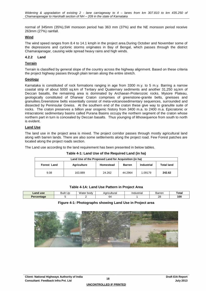
Widening & upgradation of existing 2 - lane carriageway to 4 – lanes from km 307.810 to km 435.250 of Chamarajanagar to Harohalli section of NH – 209 in the state of Karnataka
Client: National Highways Authority of India 18
Draft EIA Report
Consultant: Feedback Infra Pvt. Ltd July 2013
UNCONTROLLED IF PRINTED
normal of 345mm (35%),SW monsoon period has 363 mm (37%) and the NE monsoon period receive 263mm (27%) rainfall.
Wind
The wind speed ranges from 8.4 to 14.1 kmph in the project area.During October and November some of the depressions and cyclonic storms originates in Bay of Bengal, which passes through the district Chamarajanagar, causing wide spread heavy rains and high winds.
4.2.2 Land
Terrain
Terrain is classified by general slope of the country across the highway alignment. Based on these criteria the project highway passes through plain terrain along the entire stretch.
Geology
Karnataka is constituted of rock formations ranging in age from 3300 m.y. to 5 m.y. Barring a narrow coastal strip of about 5000 sq.km of Tertiary and Quaternary sediments and another 31,250 sq.km of Deccan basalts, the remaining area is dominated by Archaean-Proterozoic rocks. Mysore Plateau, geologically constituted of Dharwar Craton comprises of greenstone-granite belts, gneisses and granulites.Greenstone belts essentially consist of meta-volcanosedimentary sequences, surrounded and dissected by Peninsular Gneiss. At the southern end of the craton these give way to granulite suite of rocks. The craton preserves a billion year orogenic history from 3400 m.a. to 2400 m.a. Epicratonic or intracratonic sedimentary basins called Purana Basins occupy the northern segment of the craton whose northern part in turn is concealed by Deccan basalts. Thus younging of lithosequence from south to north is evident.
Land Use
The land use in the project area is mixed. The project corridor passes through mostly agricultural land along with barren lands. There are also some settlements along the project road. Few Forest patches are located along the project roads section.
The Land use according to the land requirement has been presented in below tables.
Table 4-1: Land Use of the Required Land (in ha)
Land Use of the Proposed Land for Acquisition (in ha)
Forest Land Agriculture Homestead Barren Industrial Total land
9.08 163.889 24.262 44.2964 1.09179 242.62
Table 4-1A: Land Use Pattern in Project Area
Land use Built Up Water body Agricultural Industrial Barren Total
Percentage 5 2 64 1 28 100
Figure 4-1: Photographs showing Land Use in Project area

Widening & upgradation of existing 2 - lane carriageway to 4 – lanes from km 307.810 to km 435.250 of Chamarajanagar to Harohalli section of NH – 209 in the state of Karnataka
Client: National Highways Authority of India 19
Draft EIA Report
Consultant: Feedback Infra Pvt. Ltd July 2013
UNCONTROLLED IF PRINTED
Soil
The soils of the project districts varies from Medium black soils to Red loamy soils, Red sandy loam soils, Red gravelly soils , Red sandy soils. The soils of the district Chamarajanagar are derived from Granitic gneisses and Charnockite rocks. Red soil is present in upland areas and also noticed at the contact of granites and schist. In Mandya District, The soils range from red sandy loams to red clay loam very thin in ridges and higher elevations and comparatively thick in valley portions. A major part of the district Ramanagara is occupied by red sandy soil (60%), and the remaining by red loamy soil. Red sandy soil mainly occurs in Channapatna, Kanakapura and Ramanagara taluks in undulating land slopes.
Samples of soil have been collected and are tested for the physical and chemical properties. The sampling and analysis of soil along the project corridor was carried out once during the month of March-April 2013 by Noida Test Laboratories, Greater Noida on behalf of Feedback Infra Pvt. Ltd. Soil samples were collected using Augur Sampler. The samples were homogenized and the quantity was reduced using the coning and quartering method to provide a representative sample for analysis. They were stored in air tight Polythene Bags and analyzed at the laboratory as per standard procedure provided in IS:2720.
Table 4-2: Details of Monitoring Station for Soil
Sl. No. Monitoring Station Code Chainage (Km) Location Sampling Date
1 SQMS 1 347.00 Sargur 30/03/2013
2 SQMS 2 392.00 Thoraikadanahalli 12/04/2013
3 SQMS 3 435.00 Jakkasandra 15/04/2013
Results & Analysis of Soil Quality
The texture of the soil is mostly clayey. Bulk density of soil in the study area varied between 1.06 - 1.18 gm/cm
3. The moisture content was fairly good. The soil samples were almost neutral to slightly alkaline
with the pH range varying within 7.08 to 7.63. Most of the nitrogen is available in the form of nitrates, nitrites, NH4 and organic nitrogen. In the study area, nitrogen level varied within 336 mg/kg to 480 mg/kg. The soil samples were poor to moderate in Organic Carbon content, with the values ranging within 0.42% to 0.61%.
Table 4-3: Physico-chemical Analysis of Soil Quality
S.No. Parameter Unit Sargur (Ch. –
347.00 km) Thoraikadanahalli
(Ch. 392.00 km) Jakkasandra (Ch.
435.00 km)
1. pH(1:5 suspension) - 7.08 7.63 7.33
2. Electrical Conductivity at 25OC (1:5suspension.)
µS/cm 296 310 206
3. Infiltration Rate mm/hr 246 272 258
4. Organic Matter % by mass 0.42 0.61 0.46
5. Sulphate mg/kg 69.6 72.6 52.69
6. Potassium (as K) mg/kg 158.3 159.2 132.6
7. Moisture Retention Capacity % by mass 38.6 31 34
8. Porosity % by mass 41.0 42 42
9. Sand % by mass 34 42 42
10. Clay % by mass 56
47
46
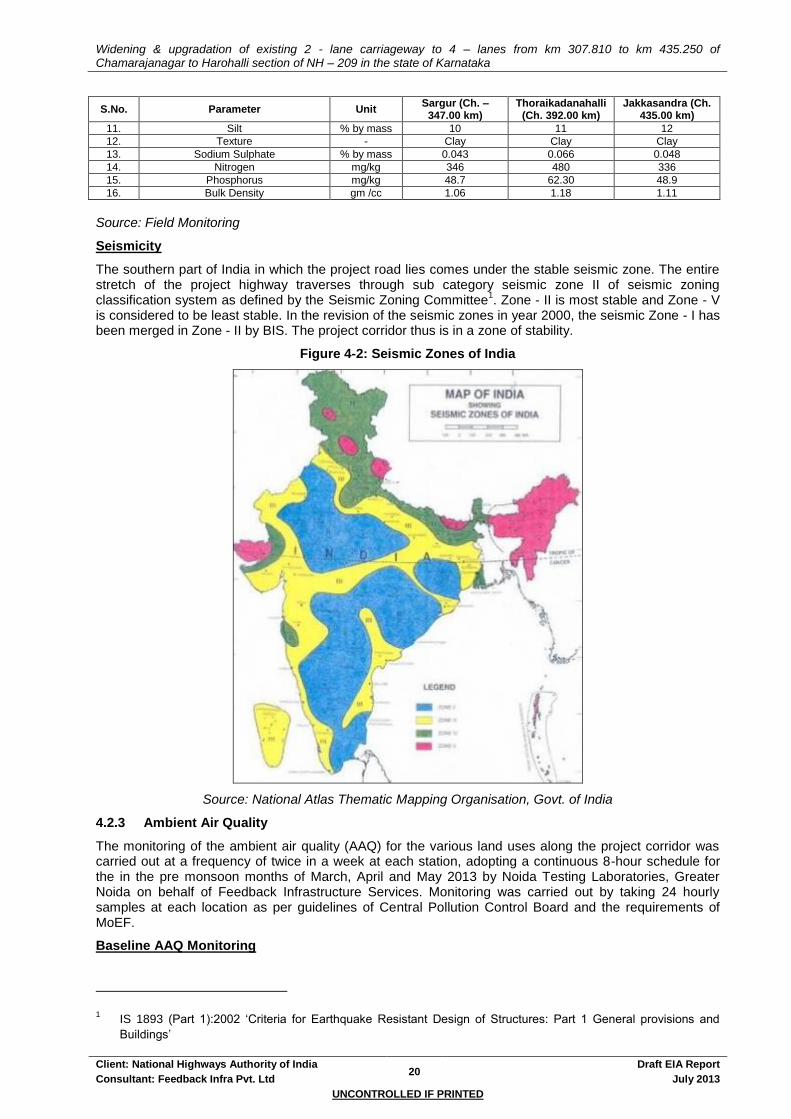
Widening & upgradation of existing 2 - lane carriageway to 4 – lanes from km 307.810 to km 435.250 of Chamarajanagar to Harohalli section of NH – 209 in the state of Karnataka
Client: National Highways Authority of India 20
Draft EIA Report
Consultant: Feedback Infra Pvt. Ltd July 2013
UNCONTROLLED IF PRINTED
S.No. Parameter Unit Sargur (Ch. –
347.00 km) Thoraikadanahalli
(Ch. 392.00 km) Jakkasandra (Ch.
435.00 km)
11. Silt % by mass 10 11 12
12. Texture - Clay Clay Clay
13. Sodium Sulphate % by mass 0.043 0.066 0.048
14. Nitrogen mg/kg 346 480 336
15. Phosphorus mg/kg 48.7 62.30 48.9
16. Bulk Density gm /cc 1.06 1.18 1.11
Source: Field Monitoring
Seismicity
The southern part of India in which the project road lies comes under the stable seismic zone. The entire stretch of the project highway traverses through sub category seismic zone II of seismic zoning classification system as defined by the Seismic Zoning Committee
1. Zone - II is most stable and Zone - V
is considered to be least stable. In the revision of the seismic zones in year 2000, the seismic Zone - I has been merged in Zone - II by BIS. The project corridor thus is in a zone of stability.
Figure 4-2: Seismic Zones of India
Source: National Atlas Thematic Mapping Organisation, Govt. of India
4.2.3 Ambient Air Quality
The monitoring of the ambient air quality (AAQ) for the various land uses along the project corridor was carried out at a frequency of twice in a week at each station, adopting a continuous 8-hour schedule for the in the pre monsoon months of March, April and May 2013 by Noida Testing Laboratories, Greater Noida on behalf of Feedback Infrastructure Services. Monitoring was carried out by taking 24 hourly samples at each location as per guidelines of Central Pollution Control Board and the requirements of MoEF.
Baseline AAQ Monitoring
1 IS 1893 (Part 1):2002 ‘Criteria for Earthquake Resistant Design of Structures: Part 1 General provisions and
Buildings’
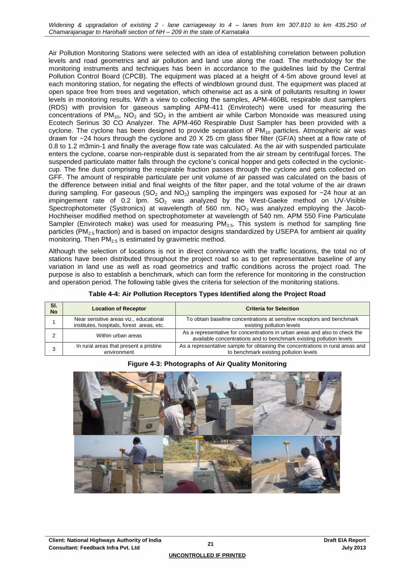
Widening & upgradation of existing 2 - lane carriageway to 4 – lanes from km 307.810 to km 435.250 of Chamarajanagar to Harohalli section of NH – 209 in the state of Karnataka
Client: National Highways Authority of India 21
Draft EIA Report
Consultant: Feedback Infra Pvt. Ltd July 2013
UNCONTROLLED IF PRINTED
Air Pollution Monitoring Stations were selected with an idea of establishing correlation between pollution levels and road geometrics and air pollution and land use along the road. The methodology for the monitoring instruments and techniques has been in accordance to the guidelines laid by the Central Pollution Control Board (CPCB). The equipment was placed at a height of 4-5m above ground level at each monitoring station, for negating the effects of windblown ground dust. The equipment was placed at open space free from trees and vegetation, which otherwise act as a sink of pollutants resulting in lower levels in monitoring results. With a view to collecting the samples, APM-460BL respirable dust samplers (RDS) with provision for gaseous sampling APM-411 (Envirotech) were used for measuring the concentrations of PM10, NO2 and SO2 in the ambient air while Carbon Monoxide was measured using Ecotech Serinus 30 CO Analyzer. The APM-460 Respirable Dust Sampler has been provided with a cyclone. The cyclone has been designed to provide separation of PM10 particles. Atmospheric air was drawn for ~24 hours through the cyclone and 20 X 25 cm glass fiber filter (GF/A) sheet at a flow rate of 0.8 to 1.2 m3min-1 and finally the average flow rate was calculated. As the air with suspended particulate enters the cyclone, coarse non-respirable dust is separated from the air stream by centrifugal forces. The suspended particulate matter falls through the cyclone’s conical hopper and gets collected in the cyclonic-cup. The fine dust comprising the respirable fraction passes through the cyclone and gets collected on GFF. The amount of respirable particulate per unit volume of air passed was calculated on the basis of the difference between initial and final weights of the filter paper, and the total volume of the air drawn during sampling. For gaseous (SO2 and NO2) sampling the impingers was exposed for ~24 hour at an impingement rate of 0.2 lpm. SO2 was analyzed by the West-Gaeke method on UV-Visible Spectrophotometer (Systronics) at wavelength of 560 nm. NO2 was analyzed employing the Jacob- Hochheiser modified method on spectrophotometer at wavelength of 540 nm. APM 550 Fine Particulate Sampler (Envirotech make) was used for measuring PM2.5. This system is method for sampling fine particles (PM2.5 fraction) and is based on impactor designs standardized by USEPA for ambient air quality monitoring. Then PM2.5 is estimated by gravimetric method.
Although the selection of locations is not in direct connivance with the traffic locations, the total no of stations have been distributed throughout the project road so as to get representative baseline of any variation in land use as well as road geometrics and traffic conditions across the project road. The purpose is also to establish a benchmark, which can form the reference for monitoring in the construction and operation period. The following table gives the criteria for selection of the monitoring stations.
Table 4-4: Air Pollution Receptors Types Identified along the Project Road
Sl. No
Location of Receptor Criteria for Selection
1 Near sensitive areas viz., educational institutes, hospitals, forest areas, etc.
To obtain baseline concentrations at sensitive receptors and benchmark existing pollution levels
2 Within urban areas As a representative for concentrations in urban areas and also to check the
available concentrations and to benchmark existing pollution levels
3 In rural areas that present a pristine
environment As a representative sample for obtaining the concentrations in rural areas and
to benchmark existing pollution levels
Figure 4-3: Photographs of Air Quality Monitoring

Widening & upgradation of existing 2 - lane carriageway to 4 – lanes from km 307.810 to km 435.250 of Chamarajanagar to Harohalli section of NH – 209 in the state of Karnataka
Client: National Highways Authority of India 22
Draft EIA Report
Consultant: Feedback Infra Pvt. Ltd July 2013
UNCONTROLLED IF PRINTED
Table 4-5: Details of Monitoring Station for Air Quality
Sl. No.
Monitoring Station Code
Chainage (Km)
Location Land use Height from Ground Level (m)
1 AQMS- 1 313.0 Mangala Industrial, Residential, Rural & other Areas 5.0
2 AQMS- 2 337.0 Uttamballi (Near Bus stop)
Industrial, Residential, Rural & other Areas 2.4
3 AQMS- 3 354.0 Sathyagalla Industrial, Residential, Rural & other Areas 3.6
4 AQMS- 4 378.0 Malavalli/Kyathe Gowdana Dhoddi
Industrial, Residential, Rural & other Areas 3.6
5 AQMS- 5 400.0 Between Halaguru & Honnaganahalli
Industrial, Residential, Rural & other Areas 4.0
6 AQMS- 6 418.0 Shivanahalli Industrial, Residential, Rural & other Areas 3.6
7 AQMS- 7 435.0 Jakkasandra Industrial, Residential, Rural & other Areas 3.0
Source: Field Monitoring
Results & Analysis of Ambient Air Quality
The air quality in the project area is less polluted. The AAQ of the project area is given in Table 4-6. From the table it is evident that concentrations of all pollutants are well within the prescribed limits of the
National Ambient Air Quality Standards. The maximum concentration of PM10 is 72.665 g/m3 at
Jakkasandra while the minimum concentration is 65.79g/m3 at Mangala. For PM2.5 the maximum
reading was found 44.55g/m3 at Uttamballi (Near Bus Stop), while the lowest recorded value of PM2.5
was 40.26g/m3 Between Halaguru & Honnaganahalli.
Table 4-6: Ambient Air Quality within Project Corridor
Monitoring Station Code
Pollutant Concentration
SO2 µg / m
3
NOX µg / m
3
PM2.5 µg / m
3
PM10 µg / m
3
CO mg/m
3
AQMS 1 17.295 28.005 41.86 65.79 <1.15
AQMS 2 21.945 35.015 44.55 69.275 <1.15
AQMS 3 18.36 31.59 44.37 70.46 <1.15
AQMS 4 19.335 27.88 40.37 66.37 <1.15
AQMS 5 20.195 31.41 40.26 66.175 <1.15
AQMS 6 20.6 32.095 42.35 65.805 <1.15
AQMS 7 20.3 32.525 40.415 72.665 <1.15
Standards (Industrial, Residential, Rural & other Areas) 80 80 60 100 4
Standards (Ecologically Sensitive area as Notified by Central Govt.) 80 80 60 100 4
Source: Field Monitoring
4.2.4 Water
Ground Water
Ground Water resources can be categorised on basis of their occurrence as shallow aquifers such as wells, hand pumps and deep aquifers such as tube wells or bore wells. The location of these resources is the prime determinant of the impacts. All along the project road, within the ROW some hand pumps and wells are present. These community owned resources are the major sources of potable water. The details of the various water resources are annexed in Annexure 4.1.
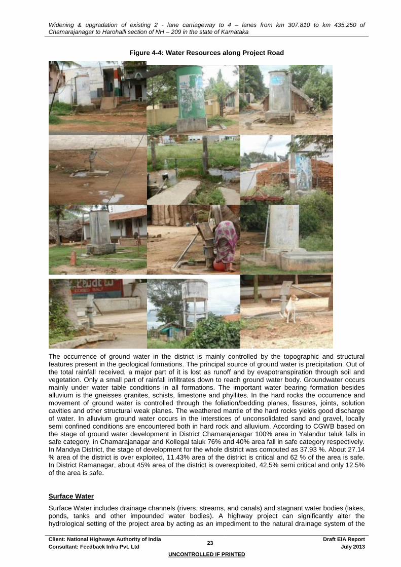
Widening & upgradation of existing 2 - lane carriageway to 4 – lanes from km 307.810 to km 435.250 of Chamarajanagar to Harohalli section of NH – 209 in the state of Karnataka
Client: National Highways Authority of India 23
Draft EIA Report
Consultant: Feedback Infra Pvt. Ltd July 2013
UNCONTROLLED IF PRINTED
Figure 4-4: Water Resources along Project Road
The occurrence of ground water in the district is mainly controlled by the topographic and structural features present in the geological formations. The principal source of ground water is precipitation. Out of the total rainfall received, a major part of it is lost as runoff and by evapotranspiration through soil and vegetation. Only a small part of rainfall infiltrates down to reach ground water body. Groundwater occurs mainly under water table conditions in all formations. The important water bearing formation besides alluvium is the gneisses granites, schists, limestone and phyllites. In the hard rocks the occurrence and movement of ground water is controlled through the foliation/bedding planes, fissures, joints, solution cavities and other structural weak planes. The weathered mantle of the hard rocks yields good discharge of water. In alluvium ground water occurs in the interstices of unconsolidated sand and gravel, locally semi confined conditions are encountered both in hard rock and alluvium. According to CGWB based on the stage of ground water development in District Chamarajanagar 100% area in Yalandur taluk falls in safe category. in Chamarajanagar and Kollegal taluk 76% and 40% area fall in safe category respectively. In Mandya District, the stage of development for the whole district was computed as 37.93 %. About 27.14 % area of the district is over exploited, 11.43% area of the district is critical and 62 % of the area is safe. In District Ramanagar, about 45% area of the district is overexploited, 42.5% semi critical and only 12.5% of the area is safe.
Surface Water
Surface Water includes drainage channels (rivers, streams, and canals) and stagnant water bodies (lakes, ponds, tanks and other impounded water bodies). A highway project can significantly alter the hydrological setting of the project area by acting as an impediment to the natural drainage system of the
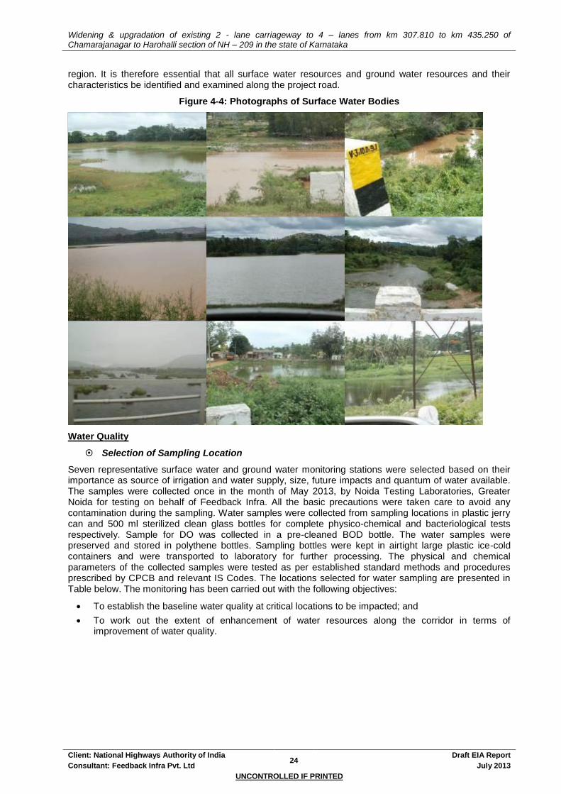
Widening & upgradation of existing 2 - lane carriageway to 4 – lanes from km 307.810 to km 435.250 of Chamarajanagar to Harohalli section of NH – 209 in the state of Karnataka
Client: National Highways Authority of India 24
Draft EIA Report
Consultant: Feedback Infra Pvt. Ltd July 2013
UNCONTROLLED IF PRINTED
region. It is therefore essential that all surface water resources and ground water resources and their characteristics be identified and examined along the project road.
Figure 4-4: Photographs of Surface Water Bodies
Water Quality
Selection of Sampling Location
Seven representative surface water and ground water monitoring stations were selected based on their importance as source of irrigation and water supply, size, future impacts and quantum of water available. The samples were collected once in the month of May 2013, by Noida Testing Laboratories, Greater Noida for testing on behalf of Feedback Infra. All the basic precautions were taken care to avoid any contamination during the sampling. Water samples were collected from sampling locations in plastic jerry can and 500 ml sterilized clean glass bottles for complete physico-chemical and bacteriological tests respectively. Sample for DO was collected in a pre-cleaned BOD bottle. The water samples were preserved and stored in polythene bottles. Sampling bottles were kept in airtight large plastic ice-cold containers and were transported to laboratory for further processing. The physical and chemical parameters of the collected samples were tested as per established standard methods and procedures prescribed by CPCB and relevant IS Codes. The locations selected for water sampling are presented in Table below. The monitoring has been carried out with the following objectives:
To establish the baseline water quality at critical locations to be impacted; and
To work out the extent of enhancement of water resources along the corridor in terms of improvement of water quality.
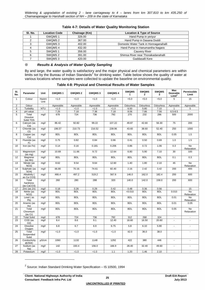
Widening & upgradation of existing 2 - lane carriageway to 4 – lanes from km 307.810 to km 435.250 of Chamarajanagar to Harohalli section of NH – 209 in the state of Karnataka
Client: National Highways Authority of India 25
Draft EIA Report
Consultant: Feedback Infra Pvt. Ltd July 2013
UNCONTROLLED IF PRINTED
Table 4-7: Details of Water Quality Monitoring Station
Sl. No. Location Code Chainage (Km) Location & Type of Source
1 GWQMS 1 326.00 Hand Pump in yeriyur
2 GWQMS 2 367.00 Hand Pump in Dasana Doddi
3 GWQMS 3 402.00 Domestic Water Tank in Honnaganahalli
4 GWQMS 4 432.00 Hand Pump in Hanumantha Nagara
5 SWQMS 1 356.00 Cauvery River
6 SWQMS 2 391.00 Shimsa River near Thoraikadanahalli
7 SWQMS 3 420.00 Gaddasalli Kere
Results & Analysis of Water Quality Sampling
By and large, the water quality is satisfactory and the major physical and chemical parameters are within limits set by the Bureau of Indian Standards
2 for drinking water. Table below shows the quality of water at
various locations where samples were collected to update the baseline on environmental quality.
Table 4-8: Physical and Chemical Results of Water Samples
Sl. No.
Parameter Unit GWQMS 1 GWQMS 2 GWQMS 3 GWQMS 4 SWQMS
1 SWQMS
2 SWQMS
3
Max Desirable
Limit2
Permissible Limit
1 Colour Hazen Unit
<1.0 <1.0 <1.0 <1.0 <5.0 <5.0 <5.0 5 15
2 Odour - Agreeable Agreeable Agreeable Agreeable Odourless Odourless Odourless Agreeable Agreeable
3 Turbidity NTU <1.0 <1.0 <1.0 <1.0 6.50 5.80 7.10 1 5
4 pH value - 7.26 7.18 7.38 7.18 8.06 7.86 7.56 6.5-8.5 -
5 Total Dissolve
Solid TDS
mg/l 678 724 736 792 270 232 286 500 2000
6 Calcium (as Ca)
mg/l 86.42 92.82 99.22 107.22 49.87 42.60 56.30 75 200
7 Chloride (as Cl)
mg/l 196.57 210.73 216.52 239.96 43.60 38.60 52.40 250 1000
8 Copper (as Cu)
mg/l BDL BDL BDL BDL BDL BDL BDL 0.05 1.5
9 Fluoride (as F)
mg/l 0.75 0.82 0.84 0.96 0.41 0.50 0.69 1.0 1.5
10 Iron (as Fe) mg/l 0.14 0.16 0.181 0.206 0.86 0.72 1.06 0.3 No Relaxation
11 Magnesium (as mg)
mg/l 10.69 11.66 9.72 12.64 6.80 5.90 7.10 30 100
12 Magnese (as Mn)
mg/l BDL BDL BDL BDL BDL BDL BDL 0.1 0.3
13 Nitrate (as NO3)
mg/l 8.62 9.54 9.64 12.60 1.40 1.80 2.10 45 No Relaxation
14 Sulphate (as SO4)
mg/l 66.80 70.16 74.61 82.40 2.16 2.42 3.42 200 400
15 Alkalinity ( as Ca CO3)
mg/l 466.4 497.2 519.2 567.6 146.0 162.0 182.4 200 600
16 Total hardness
(as CaCO3)
mg/l 260 280 288 320 140.0 142.0 158.0 200 600
17 Zinc (as Zn) mg/l 0.18 0.26 0.29 0.42 0.48 0.36 0.56 15
18 Nitrite (as NO2)
mg/l BDL BDL BDL BDL <0.010 BDL BDL 0.010 No Relaxation
19 Lead ( as Pb)
mg/l BDL BDL BDL BDL BDL BDL BDL 0.01 No Relaxation
20 Arsenic (as As)
mg/l BDL BDL BDL BDL BDL BDL BDL 0.01 0.05
21 Total Chromium
(as Cr)
mg/l BDL BDL BDL BDL BDL BDL BDL 0.05 No Relaxation
22 Total Solid mg/l 678 724 736 792 312 268 324 - -
23 COD (as O2)
mg/l 8.4 8.6 9.1 12.40 18.60 16.50 20.60 - -
24 Dissolve Oxygen
mg/l 6.8 6.7 6.9 6.75 5.8 6.10 5.90 - -
25 Total Suspended
Solid
mg/l <1.0 <1.0 <1.0 <1.0 42.0 36.0 38.0 - -
26 Conductivity @250C
µS/cm 1060 1132 1148 1292 422 380 446 - -
27 Sodium (as Na)
mg/l 142 150.4 156.0 166.9 28.40 32.40 49.60 - -
28 Potassium mg/l <1.0 <1.0 <1.0 1.1 1.20 1.46 2.10 - -
2 Source: Indian Standard Drinking Water Specification – IS 10500, 1994

Widening & upgradation of existing 2 - lane carriageway to 4 – lanes from km 307.810 to km 435.250 of Chamarajanagar to Harohalli section of NH – 209 in the state of Karnataka
Client: National Highways Authority of India 26
Draft EIA Report
Consultant: Feedback Infra Pvt. Ltd July 2013
UNCONTROLLED IF PRINTED
Sl. No.
Parameter Unit GWQMS 1 GWQMS 2 GWQMS 3 GWQMS 4 SWQMS
1 SWQMS
2 SWQMS
3
Max Desirable
Limit2
Permissible Limit
(as K)
29 Temperature 0C 30 31 31 31 27 29 32 - -
30 Phosphate (as P)
mg/l BDL BDL BDL BDL <0.01 BDL BDL - -
31 BOD (at 270C 3-Days)
mg/l BDL BDL BDL BDL 2.80 2.50 2.90 - -
32 Faecal Coliform
0 Absent/100ml Absent/100ml Absent/100ml Absent/100ml Present Present Present 0 No Relaxation
33 Total Coliform
10 Max
Absent/100ml Absent/100ml Absent/100ml Absent/100ml 164 132 160 10 Max No Relaxation
Source: Field Monitoring
4.2.5 Noise
The monitoring of the ambient noise quality for the various land uses along the project corridor was carried out with the help of hand held noise level meters in the months of March, April and May 2013 by Noida Testing Laboratories, Greater Noida on behalf of Feedback Infrastructure Services.
Selection of Sampling Location
Locations for noise monitoring along the corridor are identified based on the criteria same as those used for air monitoring. In case of noise monitoring locations, sensitive land use gains more importance due to ill effects of noise on schools and hospitals.
Baseline Noise Monitoring
In the present study, sound pressure levels (SPL) have been measured by a sound level meter. The noise levels within the study area were recorded using Sound Level Meter (Pulsar Instruments Plc, Model No. 91). Since loudness of sound is important for its effects on people, the dependence of loudness upon frequency must be taken into account in environmental noise assessment. A-weighted equivalent continuous sound pressure level (Leq) values have been computed from the values of A-weighted sound pressure level measured with the help of noise meter. At each location, noise monitoring has been carried out once during the entire study period (over a period of twenty-four hours to obtain Leq values at uniform time intervals of 1 hour. For each location, day and night time Leq values have then been computed from the hourly Leq values such that comparison could be made with the national ambient noise standards. Day & night time Leq has been computed from the hourly Leq values as per standards.
Results & Analysis of Noise Monitoring
The noise monitoring survey (in table below) shows that noise levels are marginally higher than the noise standards in 4 locations during day & 6 locations at night. This may be due to mix activities as well as vehicular movement on the road. Noise, though is a major area of concern, at locations of sensitive receptors (educational establishments like schools and colleges, health units etc.) identified quite close to the road.
Table 4-9: Observed Noise Levels along Road
Monitoring Station Code
Chainage (Km)
Location
Area Category
(Industrial area, Commercial area, Residential area,
Silence Zone)
Observed Noise Levels in dB (A)
Noise Quality Standards in dB
(A)
Leq Day
Leq Night
Leq Day
Leq Night
N1 306.600 Doddarayapeta Road
Junction (near-Chamarajanagar)
Commercial Zone 60.14 55.19 65 55
N2 313.00 Mangala Commercial Zone 62.52 56.12 65 55
N3 347.00 Sargur Commercial Zone 59.63 55.42 65 55
N4 367.00 Dasana Doddi Commercial Zone 59.62 55.91 55 45
N5 347.0 Thoraikadanahalli Residence Zone 58.03 54.93 55 45
N6 402.00 Near Honnaganahalli
Govt High School Silence Zone 46.77 39.16 50 40

Widening & upgradation of existing 2 - lane carriageway to 4 – lanes from km 307.810 to km 435.250 of Chamarajanagar to Harohalli section of NH – 209 in the state of Karnataka
Client: National Highways Authority of India 27
Draft EIA Report
Consultant: Feedback Infra Pvt. Ltd July 2013
UNCONTROLLED IF PRINTED
Monitoring Station Code
Chainage (Km)
Location
Area Category
(Industrial area, Commercial area, Residential area,
Silence Zone)
Observed Noise Levels in dB (A)
Noise Quality Standards in dB
(A)
Leq Day
Leq Night
Leq Day
Leq Night
N7 418.00 Shivanahalli Residence Zone 58.97 52.15 55 45
N8 435.00 Jakkasandra Residence Zone 56.81 50.61 55 45
Source: Field Monitoring; Note: The area categorisation has been done by the consultants based on the sensitive features and not by the authorities.
4.3 BIOLOGICAL ENVIRONMENT
4.3.1 Forest Areas
The alignment of the proposed project road passes through forest areas in 2 locations where requirement for forest land diversion is involved. These forest areas are falling under the jurisdiction of Mandya and Ramanagara Forest Division, Karnataka Forest Dept. No eco-sensitive area covered under Wild Life (Conservation) Act, 1972 (like National Park, Wild life Sanctuary, Biosphere Reserve etc.) is coming within 10Km aerial distance of the project road section.
Road Side Trees
The baseline study of Flora has primarily taken into account the flora along the roadside, as the direct impact of the road project is on trees in and adjacent to the RoW. No endangered flora has been reported along the roadside. As per ground survey, about 2431 trees located on PROW, are likely to be affected due to the proposed development. However, best effort will be given to spare avoidable trees in implementation phase by not compromising with the safety concern. A detailed inventory of trees with species and girth details will be provided in Final EIA Report
Figure 4-5: Flora along the Project Corridor
4.3.2 Fauna
The baseline study included identification of faunal species native to the study area especially with
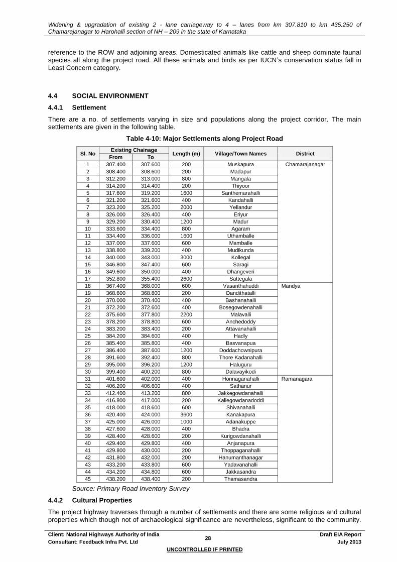
Widening & upgradation of existing 2 - lane carriageway to 4 – lanes from km 307.810 to km 435.250 of Chamarajanagar to Harohalli section of NH – 209 in the state of Karnataka
Client: National Highways Authority of India 28
Draft EIA Report
Consultant: Feedback Infra Pvt. Ltd July 2013
UNCONTROLLED IF PRINTED
reference to the ROW and adjoining areas. Domesticated animals like cattle and sheep dominate faunal species all along the project road. All these animals and birds as per IUCN’s conservation status fall in Least Concern category.
4.4 SOCIAL ENVIRONMENT
4.4.1 Settlement
There are a no. of settlements varying in size and populations along the project corridor. The main settlements are given in the following table.
Table 4-10: Major Settlements along Project Road
Sl. No Existing Chainage
Length (m) Village/Town Names District From To
1 307.400 307.600 200 Muskapura Chamarajanagar
2 308.400 308.600 200 Madapur
3 312.200 313.000 800 Mangala
4 314.200 314.400 200 Thiyoor
5 317.600 319.200 1600 Santhemarahalli
6 321.200 321.600 400 Kandahalli
7 323.200 325.200 2000 Yellandur
8 326.000 326.400 400 Eriyur
9 329.200 330.400 1200 Madur
10 333.600 334.400 800 Agaram
11 334.400 336.000 1600 Uthamballe
12 337.000 337.600 600 Mamballe
13 338.800 339.200 400 Mudikunda
14 340.000 343.000 3000 Kollegal
15 346.800 347.400 600 Saragi
16 349.600 350.000 400 Dhangeveri
17 352.800 355.400 2600 Sattegala
18 367.400 368.000 600 Vasanthahuddi Mandya
19 368.600 368.800 200 Dandithatalli
20 370.000 370.400 400 Bashanahalli
21 372.200 372.600 400 Bosegowdenahalli
22 375.600 377.800 2200 Malavalli
23 378.200 378.800 600 Anchedoddy
24 383.200 383.400 200 Attavanahalli
25 384.200 384.600 400 Hadly
26 385.400 385.800 400 Basvanapua
27 386.400 387.600 1200 Doddachownipura
28 391.600 392.400 800 Thore Kadanahalli
29 395.000 396.200 1200 Haluguru
30 399.400 400.200 800 Dalavayikodi
31 401.600 402.000 400 Honnaganahalli Ramanagara
32 406.200 406.600 400 Sathanur
33 412.400 413.200 800 Jakkegowdanahalli
34 416.800 417.000 200 Kallegowdanadoddi
35 418.000 418.600 600 Shivanahalli
36 420.400 424.000 3600 Kanakapura
37 425.000 426.000 1000 Adanakuppe
38 427.600 428.000 400 Bhadra
39 428.400 428.600 200 Kurigowdanahalli
40 429.400 429.800 400 Anjanapura
41 429.800 430.000 200 Thoppaganahalli
42 431.800 432.000 200 Hanumanthanagar
43 433.200 433.800 600 Yadavanahalli
44 434.200 434.800 600 Jakkasandra
45 438.200 438.400 200 Thamasandra
Source: Primary Road Inventory Survey
4.4.2 Cultural Properties
The project highway traverses through a number of settlements and there are some religious and cultural properties which though not of archaeological significance are nevertheless, significant to the community.
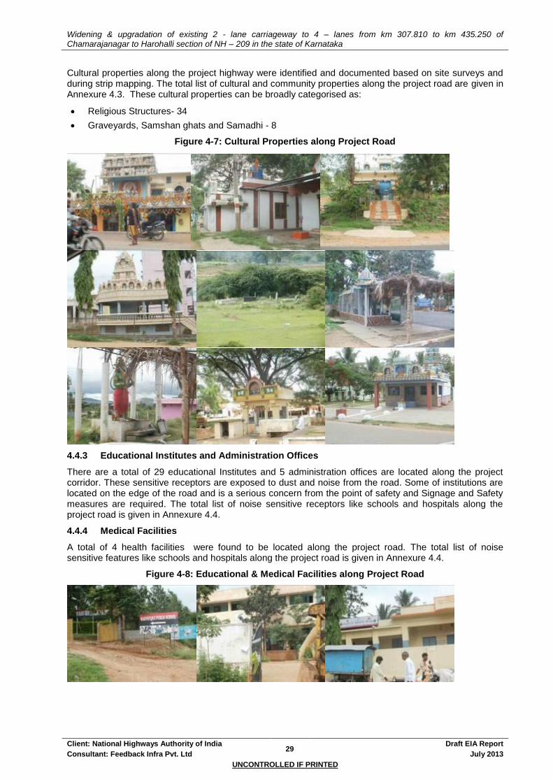
Widening & upgradation of existing 2 - lane carriageway to 4 – lanes from km 307.810 to km 435.250 of Chamarajanagar to Harohalli section of NH – 209 in the state of Karnataka
Client: National Highways Authority of India 29
Draft EIA Report
Consultant: Feedback Infra Pvt. Ltd July 2013
UNCONTROLLED IF PRINTED
Cultural properties along the project highway were identified and documented based on site surveys and during strip mapping. The total list of cultural and community properties along the project road are given in Annexure 4.3. These cultural properties can be broadly categorised as:
Religious Structures- 34
Graveyards, Samshan ghats and Samadhi - 8
Figure 4-7: Cultural Properties along Project Road
4.4.3 Educational Institutes and Administration Offices
There are a total of 29 educational Institutes and 5 administration offices are located along the project corridor. These sensitive receptors are exposed to dust and noise from the road. Some of institutions are located on the edge of the road and is a serious concern from the point of safety and Signage and Safety measures are required. The total list of noise sensitive receptors like schools and hospitals along the project road is given in Annexure 4.4.
4.4.4 Medical Facilities
A total of 4 health facilities were found to be located along the project road. The total list of noise sensitive features like schools and hospitals along the project road is given in Annexure 4.4.
Figure 4-8: Educational & Medical Facilities along Project Road
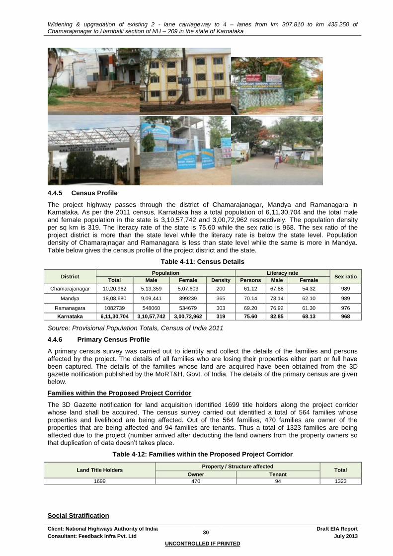
Widening & upgradation of existing 2 - lane carriageway to 4 – lanes from km 307.810 to km 435.250 of Chamarajanagar to Harohalli section of NH – 209 in the state of Karnataka
Client: National Highways Authority of India 30
Draft EIA Report
Consultant: Feedback Infra Pvt. Ltd July 2013
UNCONTROLLED IF PRINTED
4.4.5 Census Profile
The project highway passes through the district of Chamarajanagar, Mandya and Ramanagara in Karnataka. As per the 2011 census, Karnataka has a total population of 6,11,30,704 and the total male and female population in the state is 3,10,57,742 and 3,00,72,962 respectively. The population density per sq km is 319. The literacy rate of the state is 75.60 while the sex ratio is 968. The sex ratio of the project district is more than the state level while the literacy rate is below the state level. Population density of Chamarajnagar and Ramanagara is less than state level while the same is more in Mandya. Table below gives the census profile of the project district and the state.
Table 4-11: Census Details
District Population Literacy rate
Sex ratio Total Male Female Density Persons Male Female
Chamarajanagar 10,20,962 5,13,359 5,07,603 200 61.12 67.88 54.32 989
Mandya 18,08,680 9,09,441 899239 365 70.14 78.14 62.10 989
Ramanagara 1082739 548060 534679 303 69.20 76.92 61.30 976
Karnataka 6,11,30,704 3,10,57,742 3,00,72,962 319 75.60 82.85 68.13 968
Source: Provisional Population Totals, Census of India 2011
4.4.6 Primary Census Profile
A primary census survey was carried out to identify and collect the details of the families and persons affected by the project. The details of all families who are losing their properties either part or full have been captured. The details of the families whose land are acquired have been obtained from the 3D gazette notification published by the MoRT&H, Govt. of India. The details of the primary census are given below.
Families within the Proposed Project Corridor
The 3D Gazette notification for land acquisition identified 1699 title holders along the project corridor whose land shall be acquired. The census survey carried out identified a total of 564 families whose properties and livelihood are being affected. Out of the 564 families, 470 families are owner of the properties that are being affected and 94 families are tenants. Thus a total of 1323 families are being affected due to the project (number arrived after deducting the land owners from the property owners so that duplication of data doesn’t takes place.
Table 4-12: Families within the Proposed Project Corridor
Land Title Holders Property / Structure affected
Total Owner Tenant
1699 470 94 1323
Social Stratification

Widening & upgradation of existing 2 - lane carriageway to 4 – lanes from km 307.810 to km 435.250 of Chamarajanagar to Harohalli section of NH – 209 in the state of Karnataka
Client: National Highways Authority of India 31
Draft EIA Report
Consultant: Feedback Infra Pvt. Ltd July 2013
UNCONTROLLED IF PRINTED
It was observed from primary census data that a total no. of 564 households whose properties are affected due to up gradation of road, Out of the total, 379 belongs to general caste while 132, 49 & 4 families belongs to BC, SC, and ST respectively.
Table 4-13: Social Stratification
Caste No. of Families Percentage
GEN 379 67.20
BC 132 23.40
SC 49 8.69
ST 4 0.71
Total 564 100.00
Source: Primary survey (2013)
Impact on Vulnerable Groups
Households below poverty line (BPL), SC households, ST Households, Women headed households
(WHHs) and physically handicapped (PH) has been considered under this category. Total families
belonging to such vulnerable groups are provided in the table given below:
Table 4-14: Affected Households of Vulnerable Group
Category Total Percentage
BPL 16 15.38
WHH 33 31.73
PH 2 1.92
SC 49 47.12
ST 4 3.85
Total 104 100.00
Source: Primary survey (2013)
Educational Level
It was observed from the census survey data that the education levels amongst the families along the
proposed project corridor are 19.68%, 23.23%, 12.41%, 8.51%, 0.18%, 2.30% and 30.50 % for Primary,
Middle, Inter, Secondary, Diploma, Post Graduates and Illiterates respectively.
Table 4-15: Educational Levels of Families
Sl. No Education Families Percentage
1 Primary 111 19.68
2 Middle 131 23.23
3 Inter 70 12.41
4 Secondary 48 8.51
5 Graduates 18 3.19
6 Diploma 1 0.18
7 Post Graduates 13 2.30
8 Illiterates 172 30.50
Total 564 100.00
Source: Primary survey (2013)
Income Group
It has been found through survey that there are 63.652% of BPL families in the project stretch. People
though were not forthcoming about their actual income level and the enumerators at times had to guess
their income from their surrounding and life style. A huge percentage (32.624%) refused to divulge their
income.
Table 4-16: Income Levels
Sl. No Income (in Rs/ Annum) Families Percentage
1 < 25000 359 63.652
2 25001-50000 15 2.660
3 50001-75000 3 0.532

Widening & upgradation of existing 2 - lane carriageway to 4 – lanes from km 307.810 to km 435.250 of Chamarajanagar to Harohalli section of NH – 209 in the state of Karnataka
Client: National Highways Authority of India 32
Draft EIA Report
Consultant: Feedback Infra Pvt. Ltd July 2013
UNCONTROLLED IF PRINTED
Sl. No Income (in Rs/ Annum) Families Percentage
4 75001-100000 3 0.532
5 100001-150000 0 0.000
6 150001-300000 0 0.000
7 > 300001 0 0.000
8 No information 184 32.624
Total 564 100.00
Source: Primary survey (2013)
4.4.7 Linguistic Distribution
The dialects of Rajasthan vary from district to district. Rajasthan is characterized by rich linguistic diversity. Hindi is the official language of Rajasthan, and majority of the people in Rajasthan speaks various dialects of Hindi. These dialects can be clubbed together under Rajasthani. The eight major dialects of Rajasthan are: Shekhawati, Mewati, Bagri, Dhundhari, Marwari, Harauti, Wagri & Mewari. Some of the known minor dialects of Rajasthani language are Goaria, Dhatki, Loarki, Thali, Romany, Gade Lohar, Sansiboli, Malvi, Gujari or Gojari and Nimadi.
4.4.8 Cropping Pattern and Crop Productivity
The major occupation of the project district is agriculture. The Rabi and Kharif are the two main crop seasons in Rajasthan. The chief Rabi crops are wheat, barley, gram, oil seeds and pulses. The Kharif crops include jowar, bajra, maize, pulses and ground nuts, cash crops like cotton and tobacco are grown.
4.4.9 Places of Historical Importance / Cultural Heritage
There are no Historical Importance / Cultural Heritage structures on the project road though a number of historical importance or cultural heritage locations are present in the project districts.
The detailed socio-economic analysis of people, structures and property likely to be impacted by the proposed project has been presented in the Report on Resettlement Action Plan.

Widening & upgradation of existing 2 - lane carriageway to 4 – lanes from km 307.810 to km 435.250 of Chamarajanagar to Harohalli section of NH – 209 in the state of Karnataka
Client: National Highways Authority of India 33
Draft EIA Report
Consultant: Feedback Infra Pvt. Ltd July 2013
UNCONTROLLED IF PRINTED
5. PUBLIC INTERACTIONS, CONSULTATIONS
As a part of the project preparation and to ensure that the community support is obtained and the project supports the felt needs of the people; public consultations were carried out as an integral component. A continuous involvement of the stakeholders and the affected community was obtained. The feedback in the consultation sessions has led to substantial inputs for the project preparation – including, influencing designs. Consultations involve soliciting people’s views on proposed actions and engaging them in a dialogue. It is a two-way information flow, from project authorities to people and, from people to project authorities. While decision making authority would be retained by the project authority, interaction with people and eliciting feedback allows affected populations to influence the decision making process by raising issues that should be considered in designing, mitigation, monitoring and management plans and the analysis of alternatives.
This chapter documents the issues that are close to the community, their aspirations and their addressal by the project. Information source for the chapter has been the similar documentation as part of the RAP, with the social team conducting these sessions. The objectives of consultation sessions, the procedure adopted and the outputs of the consultation conducted have been briefly described in the following sections.
5.1 OBJECTIVES
The main objective of the consultation process is to minimise negative impacts of the project and to maximise the benefits from the project to the local populace. The objectives of public consultation as part of this project are:
Promote public awareness and improve understanding of the potential impacts of proposed projects;
Identify alternative sites or designs, and mitigation measures;
Solicit the views of affected communities / individuals on environmental and social problems;
Improve environmental and social soundness;
Clarify values and trade-offs associated with the different alternatives;
Identify contentious local issues which might jeopardise the implementation of the project;
Establish transparent procedures for carrying out proposed works;
Inform the affected populace about the entitlement framework and to settle problems with mutual consent; and
Create accountability and sense of local ownership during project implementation.
5.2 CONSULTATION SESSIONS
Consultations were done using various tools including, interviews with government officials, questionnaire-based information with stakeholders etc. The public consultation carried out at the Screening, Feasibility and Environment Assessment stages of the project has been summarised. The Table 5.2 gives the number of Public Consultation Sessions held in the entire Project Corridor.
The extent or the likely level of adverse impacts was one of the major criteria in deciding locations for public consultation sessions. A listing of the various consultation sessions conducted at different locations along the entire project corridor is presented in Table 5-1. These community consultations were held during various times of the design period and were attended by the NHAI staffs, Consultant’s Environmental and Social experts.
Table 5-1: Public Consultation held at Different Stages of Project
Level Type Key Participants
Individual Local level Consultation People along the project corridor
Individual Door to Door Personal Contact People along the project corridor
Village Focus Group Discussion Women, truckers, weaker sections, agriculturist, School teachers
Institutional Stake holder Discussion Line departments
5.2.1 Stake Holders Consultation
The institutional level consultations were held with representatives of institutions having stakes in implementation of the project. The institutions contacted included State Forest Department, State Pollution Control Board etc. In addition to this, officials from other departments were also contacted on several

Widening & upgradation of existing 2 - lane carriageway to 4 – lanes from km 307.810 to km 435.250 of Chamarajanagar to Harohalli section of NH – 209 in the state of Karnataka
Client: National Highways Authority of India 34
Draft EIA Report
Consultant: Feedback Infra Pvt. Ltd July 2013
UNCONTROLLED IF PRINTED
occasions. The contacted officials included revenue officers, industry department etc. Several meetings were held with NHAI Officials and their inputs have been incorporated in the Reports.
5.2.2 Consultations during Design
Consultations were carried out at the design stages to identify:
Location specific social and environmental issues to be addressed through designs;
Socio-economic profile of community along the project route;
Extent of likely social and environmental impact due to the project;
Expectations and reservations of people towards project; and
Resettlement and rehabilitation options.
5.2.3 Location Specific Consultation Needs
Several project road specific consultation needs identified were:
Where owners of property, land and building / structures or their tenants are involved, consultations are required;
Need for improvement of intersection, curves, etc. has to be ascertained from people through consultation process;
The noise sensitive receptors if any are to be identified through public consultation process.
5.3 IDENTIFICATION OF ISSUES
5.3.1 Issues Raised During Consultations
Table 5-2 summarises the issues raised during the FGD. Both specific issues of villages and common issues raised by the villagers have been described. Based on the community consultation the key environmental, health, safety and social issues identified were:
Air Quality
Noise levels
Water pollution
Drinking water sources, water scarcity in non-monsoon months, construction water requirements
Roadside trees, tree plantation
Health issues, such as water borne diseases / HIV / STD
Possession of skills and the training needs
Employment opportunity during civil works
Location of labour camp and hot mix plant sites
Location of dumping sites
Safety issues
Involvement of PAPs in Rehabilitation and Resettlement Plans
Impact on property and land acquisition
Resettlement Options
Enhancement of common property resources
Extension of Government Welfare schemes
5.4 CONTINUED CONSULTATION
As part of the continued consultation program, the following actions are proposed:
Implement the suggestions / recommendations and address those grievances that are technically feasible without compromising on the quality and safety
Continue consultations with the public and stake holders during the various stages of the construction and operation for smooth implementation of the project

Widening & upgradation of existing 2 - lane carriageway to 4 – lanes from km 307.810 to km 435.250 of Chamarajanagar to Harohalli section of NH – 209 in the state of Karnataka
Client: National Highways Authority of India 35
Draft EIA Report
Consultant: Feedback Infra Pvt. Ltd July 2013
UNCONTROLLED IF PRINTED
Table 5-2: Addressal of General Issues and Concerns under the Project
Issue / Concern Addressal under the project
Dust and Air Pollution
Plantation of trees and shrubs along the highway and on median
Turfing on earthen slopes and earthen shoulders
Water spraying to be adopted near the crushers during construction stage.
Increased noise levels
Provision of Noise attenuating wall near sensitive receptors
No-horns signage near schools, colleges and hospitals
Tree plantation and development of green belts along the project corridor abutting settlements to attenuate traffic noise
Traffic Congestion
Improvement of intersections
Provision of Flyovers, bypasses, underpasses etc at suitable locations
Road widening itself will be a major factor to avoid traffic jams
Road safety
Proper highway signals provided as per IRC SP:67
Widening of bridges to avoid accidents
Grade level pedestrian , PUPs & CUPs crossing
Proper lighting at accident prone locations
Cultural properties Care has been taken to preserve sites of cultural heritage as far as possible.
Where unavoidable the religious structures within ROW to be relocated only after consultation with local community.
Fauna and flora
Tree clearing within ROW has been avoided beyond what is directly required for construction activities and or to reduce accidents
Compensatory afforestation would be done as per the directives of the forest department.
Fruit bearing trees and shade trees, to be planted on the roadside.
Roadside Drainage
Rising of road sections and cross drainage structures in areas facing overtopping problems.
Location of structures based on hydrological study
Provision of proper drainage scheme for the settlements
Water bodies In unavoidable cases provision for increasing depth of water bodies to increase its capacity is
made.
Road side amenities Provision of facilities like Rest Areas, Truck stoppage site (lay bye) and bus stops along the
highway
Loss of Livelihood and income restoration option
The PAPs will be compensated as per National R&R policy
RAP to detail out the assistance programme to the needy
Assistance to vulnerable groups
Special provisions have been made in the entitlement framework for assisting vulnerable groups to improve their quality of life.
Employment of locals during construction
Locals will be given preference for employment during the project implementation
5.5 KEY FINDINGS OF THE CONSULTATION
Major findings related to key issues such as general perception about the project; suggestions to mitigate hardships resulting from dislocation and loss of livelihood are presented below:
It was observed that people are not only aware of the project but also welcomed the project in general. However, some PAPs have shown their concern due to acquisition of their properties.
The PAPs in general and specially the legal titleholders were very much concerned about the mode of compensation.
People want that their views should be taken into account in every matter where it counts for new road options
They requested for facilities and amenities like underpasses, bus stand and safer accessibility at points of habitant’s area.
Affected population wanted to know about the exact period when the work will start. Sufficient time should be given before the acquisition in order to avoid any inconvenience
People requested about creation of employment opportunities during road construction and later phases of the project
People suggested that adequate safety measures should be provided such as speed breakers, signage’s etc. near the In brief, it was felt during consultation that regular meeting with the local population / community could easily resolve any dispute between the community people and implementing agency settlements
The RAP shall address the social issues brought to the fore during the public consultations
The EMP – both generic and specific has been designed to address environmental related issues
Widening & upgradation of existing 2 - lane carriageway to 4 – lanes from km 307.810 to km 435.250 of Chamarajanagar to Harohalli section of NH – 209 in the state of Karnataka
Client: National Highways Authority of India 36
Draft EIA Report
Consultant: Feedback Infra Pvt. Ltd July 2013
UNCONTROLLED IF PRINTED
5.6 PUBLIC CONSULTATION & HEARING
5.6.1 Introduction
As per the guidelines of New EIA Notification 2009, “Public Consultation” refers to the process by which the concerns host population and others who have plausible stake in the environmental impacts of the project or activity are ascertained with a view to taking into account all the material concerns in the project or activity design as appropriate. Public consultation process comprises of two parts, viz Public Hearing and written response from stakeholders. The Public Hearing shall be arranged in a systematic, time bound and transparent manner ensuring widest possible public participation at the project site(s) or in its close proximity District wise, by the concerned State Pollution Control Board (SPCB).
5.6.2 Public Hearing for the Project
As per EIA Notification, Public Hearing shall be conducted in project districts.


Widening & upgradation of existing 2 - lane carriageway to 4 – lanes from km 307.810 to km 435.250 of Chamarajanagar to Harohalli section of NH – 209 in the state of Karnataka
Client: National Highways Authority of India 37
Draft EIA Report
Consultant: Feedback Infra Pvt. Ltd June 2013
UNCONTROLLED IF PRINTED
6. IMPACT ASSESSMENT
This chapter assesses the nature, type and magnitude of the potential impacts likely on the various relevant physical, biological and cultural environmental components along the project corridor. For the assessment of impacts, the baseline information based on the field visits and the primary surveys of the various environmental components carried out. The description of the impacts on the individual components has been structured as per the discussion in Chapter 4: Baseline Environmental profile of this report.
The project involves widening to four lanes/two lanes with paved shoulder of Chamarajanagar to Harohalli section of NH – 209 and the impacts are expected to be mostly direct and confined to the Proposed ROW. Only at critical locations where the engineering, environmental and social aspects have warranted a shift from the existing alignment, realignments have been proposed. The impacts on the various environmental components can occur at any of the following stages of the project planning and implementation:
Planning and design stage;
Construction stage; and
Operation stage
6.1 GENERAL ENVIRONMENTAL IMPACTS
Table 6.2 presents the general environmental impacts expected due to the proposed up gradation of the project road. Impacts have been assessed based on the information collected from the screening & scoping of environmental attributes at feasibility stage.
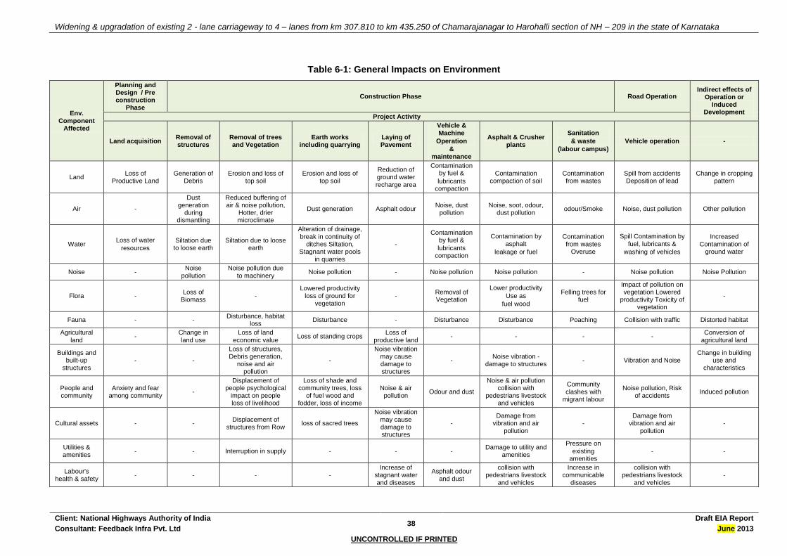
Widening & upgradation of existing 2 - lane carriageway to 4 – lanes from km 307.810 to km 435.250 of Chamarajanagar to Harohalli section of NH – 209 in the state of Karnataka
Client: National Highways Authority of India 38
Draft EIA Report
Consultant: Feedback Infra Pvt. Ltd June 2013
UNCONTROLLED IF PRINTED
Table 6-1: General Impacts on Environment
Env. Component
Affected
Planning and Design / Pre construction
Phase
Construction Phase Road Operation Indirect effects of
Operation or Induced
Development Project Activity
Land acquisition Removal of structures
Removal of trees and Vegetation
Earth works including quarrying
Laying of Pavement
Vehicle & Machine
Operation
& maintenance
Asphalt & Crusher plants
Sanitation
& waste
(labour campus)
Vehicle operation -
Land Loss of
Productive Land Generation of
Debris Erosion and loss of
top soil Erosion and loss of
top soil
Reduction of ground water recharge area
Contamination by fuel &
lubricants compaction
Contamination compaction of soil
Contamination from wastes
Spill from accidents Deposition of lead
Change in cropping pattern
Air -
Dust generation
during dismantling
Reduced buffering of air & noise pollution,
Hotter, drier microclimate
Dust generation Asphalt odour Noise, dust
pollution Noise, soot, odour,
dust pollution odour/Smoke Noise, dust pollution Other pollution
Water Loss of water
resources
Siltation due to loose earth
Siltation due to loose earth
Alteration of drainage, break in continuity of
ditches Siltation, Stagnant water pools
in quarries
-
Contamination by fuel &
lubricants compaction
Contamination by asphalt
leakage or fuel
Contamination from wastes
Overuse
Spill Contamination by fuel, lubricants &
washing of vehicles
Increased Contamination of
ground water
Noise - Noise
pollution Noise pollution due
to machinery Noise pollution - Noise pollution Noise pollution - Noise pollution Noise Pollution
Flora - Loss of
Biomass -
Lowered productivity loss of ground for
vegetation -
Removal of Vegetation
Lower productivity
Use as
fuel wood
Felling trees for fuel
Impact of pollution on vegetation Lowered
productivity Toxicity of vegetation
-
Fauna - - Disturbance, habitat
loss Disturbance - Disturbance Disturbance Poaching Collision with traffic Distorted habitat
Agricultural land
- Change in land use
Loss of land economic value
Loss of standing crops Loss of
productive land - - - -
Conversion of agricultural land
Buildings and built-up
structures - -
Loss of structures, Debris generation,
noise and air pollution
-
Noise vibration may cause damage to structures
- Noise vibration -
damage to structures - Vibration and Noise
Change in building use and
characteristics
People and community
Anxiety and fear among community
-
Displacement of people psychological
impact on people loss of livelihood
Loss of shade and community trees, loss
of fuel wood and fodder, loss of income
Noise & air pollution
Odour and dust
Noise & air pollution collision with
pedestrians livestock and vehicles
Community clashes with
migrant labour
Noise pollution, Risk of accidents
Induced pollution
Cultural assets - - Displacement of
structures from Row loss of sacred trees
Noise vibration may cause damage to structures
- Damage from
vibration and air pollution
- Damage from
vibration and air pollution
-
Utilities & amenities
- - Interruption in supply - - - Damage to utility and
amenities
Pressure on existing
amenities - -
Labour's health & safety
- - - - Increase of
stagnant water
and diseases
Asphalt odour and dust
collision with pedestrians livestock
and vehicles
Increase in communicable
diseases
collision with pedestrians livestock
and vehicles
-
Widening & upgradation of existing 2 - lane carriageway to 4 – lanes from km 307.810 to km 435.250 of Chamarajanagar to Harohalli section of NH – 209 in the state of Karnataka
Client: National Highways Authority of India 39
Draft EIA Report
Consultant: Feedback Infra Pvt. Ltd July 2013
UNCONTROLLED IF PRINTED
The description and magnitude of impacts for the various environmental components as visualised for the project are presented in the following sections.
6.2 PHYSICAL ENVIRONMENT
6.2.1 Meteorological Parameters
The Project Highway is located in a tropical region with marked monsoon effects. Though no change in the macro-climatic setting (precipitation, temperature and wind) is envisaged due to the project, the microclimate is likely to be temporarily modified by vegetation removal and the addition of increased pavement surface. There will be an increase in daytime temperature on the road surface and soil due to loss of shade and big trees, which in turn might lead to formation of heat islands especially along the inhabited sections. In addition, at green tunnel locations, the removal of trees will increase the amount of direct sunlight resulting in higher temperatures along the highway.
This increase in the daytime temperature assumes significance especially to the slow moving traffic, the pedestrians and the first row of residences / receptors along the corridor. Although the impact shall be significant and long term in nature, it is reversible in nature and shall be compensated for by additional plantation of trees. It must be noted that the impact is unavoidable. However, it may be pointed out that the project has taken care to minimise tree felling in the ROW by realigning the road to save trees.
6.2.2 Land
Physiography
Pre construction and Construction Stage
Road construction activities involve alterations in the local physiography and drainage patterns. The impacts on physiography may include destabilisation of slopes due to cut and fill operations. Cut-and-fills will be designed for improvement to the road geometry, and parallel cross drainage structures will be added to improve drainage. There would be no grading of the roadside area and the work would consist of raising the pavement embankments. The highway stretch falls is a gentle rolling plain terrain. In some stretches, some amount of cuts and fills would be necessary to accommodate the new pavement. There may be an impact on the topography as a result of accelerated erosion on the cut-profiles.
Geology and Seismology
Pre-Construction, Construction and Operation Stage
The entire stretch of the project highway traverses through seismic Zone - II as defined by the Indian Standard (IS) 1893-1994 seismic zoning classification system, i.e., a zone of stability. The project does not have any impact on the geological or seismic stability of the area.
Quarries and Crushers
The excavation of quarries and borrow pits used for obtaining rocks, soil and aggregate materials for road construction can cause direct and indirect long - term adverse impacts on the environment. The impacts of quarrying operations could be significant at various stages of road construction and are described stage wise.
Pre Construction Stage
Existing quarries that are already in operation with the required clearances have been recommended for this project. No new quarries are proposed and hence no major impacts, which arise in making new quarries operational, are likely. In case the concessionaire decides in opening new stone quarries he shall follow the guidelines stipulated in Annexure 8.3. A huge quantity of sand would be required for the cement concrete rigid pavement and for the cross-drainage structures proposed. Sand required for the construction will mostly be procured from the river quarries as identified in Table 8.4. As an alternative to borrowing of sand from river bed, the possibility of using stone crusher dust has been explored. Stone dust from crusher can be used for the construction works provided the quantity and the quality produced is certified by the Independent Engineer to be satisfactory for all construction works, else river sand shall be used from the identified quarries. None of the sand quarry sites would require any preventive environmental measures. However, the long leads mean that care would have to be taken to prevent spillage of material and damage to the haul roads during transportation. No additional adverse environmental impact, except those resulting from spillage during transportation, is expected to occur.

Widening & upgradation of existing 2 - lane carriageway to 4 – lanes from km 307.810 to km 435.250 of Chamarajanagar to Harohalli section of NH – 209 in the state of Karnataka
Client: National Highways Authority of India 40
Draft EIA Report
Consultant: Feedback Infra Pvt. Ltd July 2013
UNCONTROLLED IF PRINTED
Construction Stage
A major source of dust during the construction stage is from stone crushing operations from the crusher and the vibrating screen. The dust, in addition to being a health concern also reduces visibility thereby increasing safety concerns. As no new quarry needs to be opened for this project (majority of the material shall be from cut operations, reuse of old materials and existing quarries within the site itself), therefore, no new impacts are likely to arise due to quarrying operations. A properly enforced EMP could improve the working conditions of workers in the existing quarry areas selected for the project.
Though the quarry materials are to be transported over long distances to the construction sites, almost all the quarries identified have proper access roads, therefore, no major impacts during the hauling of materials is envisaged. The issue of dust generation etc along the haul roads needs to be addressed through proper enforcement of dust suppression measures.
Soil Erosion
Pre Construction Stage
The removal of roadside vegetation will cause erosion, and increased run-off would in turn lead to erosion of productive soil. The direct impact of erosion is the loss of embankment soil and danger of stability loss for the road itself. This impact is generally restricted to the ROW. The project has taken care of this issue at the engineering design stage itself, as at design gradients of 1:2, the slopes of the embankments are perceived to be stable for all stretches of road. These sections of the road embankment would need stone pitching or any other suitable turfing.
Construction Stage
Elevated sections of road in all sections, particularly all high embankments along the bridges, ROBs and the bridge approaches would be vulnerable to erosion and need to be provided proper slope protection measures to prevent erosion. Construction of new bridges involves excavation of riverbed and banks for the construction of the foundations and piers. If the residual spoil is not properly disposed off, increased sedimentation downstream of the bridge is likely. Though during construction period, drainage alteration and downstream erosion / siltation is anticipated, due to the improved design and added capacity of the cross-drainage structures, there should be an improvement in the drainage characteristics of the surrounding area. Adequate slope protection measures are proposed as part of engineering design. Removal of trees to facilitate construction will cause erosion problems until the proposed compensatory afforestation plantation is established. Silt fencing to be provided to prevent eroded material from entering watercourses. The regular cleaning of the drains by the Concessionaire will ensure that these structures will not be overloaded or rendered ineffective due to overload.
Operation Stage
No soil erosion is envisaged when the road is in operation as all the slopes and embankments of the project road shall be stabilised through sound engineering techniques. The issue has been addressed at the design stage itself and all slopes have been 1:2, which shall ensure stability of the embankment. Appropriate landscaping measures such as pitching of slopes and turfing shall prevent soil erosion taking place.
Compaction of Soil
Pre-Construction Stage
Compaction of Soil will occur in the pre-construction stage (particularly during site clearance stage) due to movement of heavy machinery and vehicles. Transplantation of trees if carried out shall involve very heavy machinery to uproot trees and haul them to the site of transplantation. Similarly, compaction will take place during setting up of construction camps and stockyards. However, this is a short duration impact. Appropriate measures need to be specified in the Environment Management Plan to minimise the area of soil compaction.
Construction Stage
Compaction shall occur beyond the carriageway and within the vegetated area of the ROW by the movement of vehicles and heavy machinery. Movement of vehicles during road construction is the major cause of soil compactions. This impact is direct and will be the maximum in the ROW. It is necessary to ensure that there is no adverse impact of soil compaction in areas other than the ROW, where vegetation can grow and rain infiltration will take place.
Operation Stage

Widening & upgradation of existing 2 - lane carriageway to 4 – lanes from km 307.810 to km 435.250 of Chamarajanagar to Harohalli section of NH – 209 in the state of Karnataka
Client: National Highways Authority of India 41
Draft EIA Report
Consultant: Feedback Infra Pvt. Ltd July 2013
UNCONTROLLED IF PRINTED
During the operation period compaction will be restricted to the CW itself. Compaction cannot be said to be an impact of the operation stage as the pavement itself is a function of compacted base and sub base.
Contamination of Soil
Pre-Construction Stage
Contamination of oil in the pre-construction stage may be considered a short-term residual negative impact. Soil contamination may take place due to solid waste contamination from the labour camp set up during pre-construction stage. This impact is significant at locations of construction camps; stockyards, hot mix plants etc. will come up in this stage.
Construction Stage
Contamination of soil during construction stage is primarily due to construction and allied activities. The sites where construction vehicles are parked and serviced are likely to be contaminated because of leakage or spillage of fuel and lubricants. Pollution of soil can also occur in hot-mix plants from leakage or spillage of asphalt or bitumen. Refuse and solid waste from labour camps can also contaminate the soil. Contamination of soil during construction might be a major long-term residual negative impact. Unwarranted disposal of construction spoil and debris will add to soil contamination. This contamination is likely to be carried over to water bodies in case of dumping being done near water body locations.
Operation Stage
During the operation stage, soil pollution due to accidental vehicle spills or leaks is a low probability as one of the main objective of the project is to reduce accidents, but potentially disastrous to the receiving environment should they occur. These impacts can be long term and irreversible depending upon the extent of spill. There should be a disaster management plan in case of such major spills occurring.
6.2.3 Air
Air quality along the project corridor will be impacted both during the construction and operation stages of the project.
Construction stage impacts will be of short term and have adverse impacts on the construction workers as well as the settlements adjacent to the road, especially those in the down wind direction.
Operation stage impacts will not be as severe as the construction stage impacts and will be confined generally to a band of width ranging from 50 to 75m from the edge of the last lane on either side of the corridor.
Both the construction and operation stage impacts can be effectively mitigated if the impacts have been assessed with reasonable accuracy in the design stage.
Generation of Dust
Pre Construction Stage
Generation of dust is the most likely impact during this stage due to:
Site clearance and use of heavy vehicles and machinery etc.;
Procurement and transport of raw materials and quarries to construction sites;
The impacts will mostly be concentrated in the PROW. If adequate measures such as sprinkling of water on haul roads around sites where clearance activities are on, covering material trucks especially those carrying sand and fly ash, then the impacts can be reduced to a great extent. It is likely that impacts due to dust generation are felt downwind of the site rather than on the site itself.
Construction Stage
As the project corridor lies in a location where the major air pollution generating sources are stone quarries (particularly in District Chamaraja Nagar) and the construction activities proposed to be carried out during the dry season (when the moisture content would be less), dust generation, particularly due to earthworks will be significant. Dust is likely to be generated due to the various construction activities including:
Stone crushing operations in the crushers;
Handling and storage of aggregates in the asphalt plants;
Concrete batching plants;
Widening & upgradation of existing 2 - lane carriageway to 4 – lanes from km 307.810 to km 435.250 of Chamarajanagar to Harohalli section of NH – 209 in the state of Karnataka
Client: National Highways Authority of India 42
Draft EIA Report
Consultant: Feedback Infra Pvt. Ltd July 2013
UNCONTROLLED IF PRINTED
Asphalt mix plants due to mixing of aggregates with bitumen; and
Construction and allied activities.
Generation of dust is a critical issue and is likely to have adverse impact on health of workers in quarries, borrow areas and stone crushing units. This is a direct adverse impact, which will last almost throughout the construction period. The Environmental Action Plan prepared by the concessionaire should lay emphasis on enforcement of measures such as provision of pollution masks, regular sprinkling of water to suppress dust along haul roads at quarries, crushers and borrow areas to mitigate this impact.
Operation Stage
The negative impacts on air quality during operation stage shall not be significant as that of construction stage. This is due to the reduction in concentration of dust particles.
No dust generation is envisaged during the operation stage as the all road shoulders are proposed to be paved and all slopes and embankments shall be turfed as per best engineering practices.
The air quality shall also improve due to the plantation activity carried out in the ROW during the end of construction phase.
Generation of Exhaust Gases
Pre Construction Stage
Generation of exhaust gases is likely during the pre construction stage during movement of heavy machinery, oil tankers etc. This impact is envisaged to be insignificant during the pre construction stage.
Construction Stage
High levels of SO2, HC and hydrocarbons are likely from hot mix plant operations. Volatile toxic gases are released through the heating process during bitumen production. Although the impact is much localised, it can spread downwind depending on the wind speeds. The Environment Management Action Plan prepared by the Concessionaire needs to ensure adequate measures are taken especially for health safety of workers such as providing them with pollution masks during working hours. Also, the Contractor should ensure that hot mix plants, stockyards, etc. are away from residential areas and residential quarters of all workers. Contractors also should be asked to provide regularly Pollution under Control certificate for their equipments and machinery as per prevalent norms. If adequate measures are taken, then impacts from generated gases can be negligible.
Operation Stage
The major impact on air quality will be due to plying of vehicles. The impacts on air quality will at any given time depend upon traffic volume / rate of vehicular emission within a given stretch and prevailing meteorological conditions. Air pollution impacts arise from two sources: (i) inadequate vehicle maintenance; and (ii) use of adulterated fuel in vehicles. Enforcement standards to meet better vehicle performance in emissions and the improvement of fuel constituents can assist in improving regional air quality.
6.2.4 Water Resources
To facilitate the cross-drainage at water crossings, 4 major bridges, 26 minor bridges and 396 culverts are proposed. The surface water bodies along the project road might be subject to adverse impacts due to the various construction activities as well as during the operation stage of the project. The impacts on water resources have been summarised in table below.
Table 6-3: Likely Impacts on Water Resources during the Construction Stage
Impacts due to Construction Indicators
Loss of water bodies Area of water bodies affected
Loss of other water supply sources Hand pumps, wells etc. affected
Alteration of drainage, run off, flooding No. of cross drainage channels
Depletion of ground water recharge Groundwater in Area rendered inaccessible & impervious
Use of water supply for construction Quantum of water used
Contamination from fuel and lubricants Nature and quantum of contaminators
Contamination from improper sanitation and waste disposal in construction camps
Area of camp / disposal site and proximity to water bodies / channels

Widening & upgradation of existing 2 - lane carriageway to 4 – lanes from km 307.810 to km 435.250 of Chamarajanagar to Harohalli section of NH – 209 in the state of Karnataka
Client: National Highways Authority of India 43
Draft EIA Report
Consultant: Feedback Infra Pvt. Ltd July 2013
UNCONTROLLED IF PRINTED
Alteration of Drainage
Impacts of road construction, which lead to alteration of drainage, are generally widening at culvert or bridge locations. This requires river and or gully training for the period during which the bridge is to be constructed. Alteration of drainage can lead to soil erosion of adjacent areas, disturb local vegetation and impair local ecology.
Pre Construction Stage
No drainage modification of surface flow of rivers / streams is envisaged during pre construction period. However, about 18 ponds are likely to be partially affected due to the proposed development. The details have been presented in Table 6-4.
Construction Stage
Though the constructions along the watercourses are to be carried out in the lean flow periods, as the major rivers are perennial, the construction activities will necessitate the diversion of the waterway. This diversion of flow can significantly harm the aquatic habitat, if any. The waterway will be constricted, increasing velocity downstream of the bridge. This will mean increased sediment load with the flow, thereby allowing less sunlight to penetrate into the water and can reduce growth of micro flora. The impact shall be direct but short term in nature and shall last till the construction period. Short-term increase in runoff during construction may occur due to the removal of trees, vegetative cover and compaction of the surrounding soil during pre construction. Thus the increased sediment load will be a significant impact that needs to be addressed for all water bodies along the corridor and adequate silt fencing measures need to be provided. The design proposes the raising of the embankments from the existing levels to ensure that the finished pavement is above the maximum flood level so as to prevent any impacts due to any water seepage in the pavement. No significant impacts in the drainage pattern due to the raising of the road profile are likely, as the road design itself takes care of the cross-pavement drainage.
Operation Stage
The project involves the widening of carriageway. One of the unavoidable aftermaths of road construction is the increased surface run off. The new lanes, which are essentially a paved impervious surface, will cause increased surface runoff along the roadsides. Increase in surface run-off is due to the creation of impervious surfaces that prevent the flow of water into the ground. Impacts due to surface runoff include increased soil erosion and local flooding or water logging. However, as the proposed lanes has been designed with ditches on both sides to take care of surface runoff local flooding due to the proposed increased runoff shall be taken care of effectively. Surface runoff shall be drained to the nearest cross drainage structure. The engineering design includes design of cross drainage structures, which should take care of the extra flow.
Water Required for the Project
Pre Construction and Construction Stage
The most likely significant impact on water during construction is depletion of water table. Rigid pavements have been suggested at the toll plaza locations only. The cement concrete construction works requires a considerable quantity of potable water for the various activities including construction of the pavement, dust suppression, curing etc. The water requirements for the various construction activities are presented in table below.
The peak demand of water to be used during the construction phase will be around 56 KLD. The demand though is only indicative in nature and shall differ during the lean period of construction. The demand shall be met through availability of ample supply both from surface sources (Like River Cauvery) and ground water. Thus, it is apparent that the water requirement for the project will not be a major impact on the environment. As the ground exploitation is not very prominent in the project districts, the ground water resources may not be impacted due to the project activities. More over surface water sources shall also be utilised (wherever available) for the project activities. To minimise the minor impacts of the project on the water resources, water harvesting structures and ground water recharge measures have been proposed.
Operation Stage
The depletion of water is predominantly restricted to the construction phase. The road operation does not make a demand on the available water resources apart from time to time requirement during works such as maintenance of road side tree plantations.

Widening & upgradation of existing 2 - lane carriageway to 4 – lanes from km 307.810 to km 435.250 of Chamarajanagar to Harohalli section of NH – 209 in the state of Karnataka
Client: National Highways Authority of India 44
Draft EIA Report
Consultant: Feedback Infra Pvt. Ltd July 2013
UNCONTROLLED IF PRINTED
Water Quality
Pre Construction Stage
Water sources including flowing and stagnant water sources are likely to be contaminated due to activities such as setting up workers camp near water sources or transportation of construction material such as sand, borrow material etc without covering it. Due to tree felling soils around the water bodies and surface drainage channels will be exposed during the pre construction stage, during which, the suspended sediments and the associated pollutants can be washed in to these water sources. As soil all along the corridor isn’t of alluvial type, the impacts due to the increased sediment load will not be a significant impact that needs to be addressed for all water bodies along the corridor. Even then adequate silt fencing measures need to be provided. Contamination of groundwater is another likely impact of road construction and allied activities. The groundwater recharge areas may be reduced due to an increase in impervious layers due to the construction. The contamination of the groundwater resources due to the project is likely at the following locations:
Along construction sites, camps involving moving of construction equipments and machinery.
At the various community water bodies and sources of water supply such as hand pumps etc
Along the entire length of the corridor especially around urban areas and productive lands.
Construction camps or stockyards are not to be set up near Rivers, irrigation canals and water bodies to prevent oil spills.
Construction Stage
The impacts on water quality will be of greater concern during the construction stage. Increased sediment load during preparation of the site is the most likely adverse impact. The contamination by fuel and oil from construction vehicles or bitumen from hot-mix plants is less likely and in any case expected to be localised. Discharge from labour camps and vehicle parking areas will have to be treated before discharge into any watercourse. It is during the operation stage that the leakage or spillage from vehicles damaged, overturned or just badly maintained is more likely.
The construction activities around the surface bodies can affect the water quality due to the disposal of solid and liquid wastes from labour camps, fuel and lubricant spills or leaks from construction vehicles, fuel storage and distribution sites and from bitumen or asphalt storage at hot-mix plants.
Also, the raising of the road shall mean that more embankment surface is prone to erosion. However, the engineering design shall ensure protection of embankment slopes. The spoil heaps around the construction sites are also prone to erosion and contribute to the increased sediment load in the near-by water bodies. The major parameter of concern would be the sediment load from the spoils. The major pollutants of concern are suspended solids, oil and grease, lead and other heavy metals.
Concentration of suspended solids is likely to be highest during the construction stage and immediately after the construction when vegetation has not been fully established on the embankment slopes.
Oil and grease form a film on the water surface and hinder the transfer of oxygen into water.
Though the compounds of lead are suspected to be carcinogenic, it is unlikely that leads pollution to have significant effects as 90-95% of lead in run-off is inert, and will be further diluted in the receiving water bodies, where the lead concentrations are minimal.
Discharge from labour camps and vehicle parking areas will have to be treated before discharge into any watercourse. It is during the operation stage that the leakage or spillage from vehicles damaged, overturned or just badly maintained is more likely. The existing levels of contaminants, which can trace their origin to road run-off, indicate that water quality degradation is not a significant impact. Normally groundwater is shielded from the effects of such degradation, but if the discharges from construction camps were disposed off using soak-pits / septic-tanks that were not adequately designed, the consequences would be disastrous since restoration of groundwater quality is a much slower process.
The impacts of run-off laden with sediment may be felt in villages that depend on the fish living in the water-body. Increased sediment load, lesser sunlight, difficulty to settle, etc will make the water more turbid. If the concentrations are higher, smaller fish may be harmed. Large, heavy sediment, particularly with slow moving water may smother algae and eventually alter the nature of the sub-stratum. Excessive sediment loads may also mean disruption to areas where fish lay their eggs. However, it must be noted that these effects are probable only during construction stage. The water quality of surface drainage

Widening & upgradation of existing 2 - lane carriageway to 4 – lanes from km 307.810 to km 435.250 of Chamarajanagar to Harohalli section of NH – 209 in the state of Karnataka
Client: National Highways Authority of India 45
Draft EIA Report
Consultant: Feedback Infra Pvt. Ltd July 2013
UNCONTROLLED IF PRINTED
channels is likely to be impaired as long as the construction period continues. However, measures to divert the passage of pollutants into the river can be adopted to minimise the impact.
Operation Stage
No contamination of any water source is envisaged during the operation period.
Volumetric Capacity of Water Resources affected
A total of 18 water bodies are getting affected due to the proposed project. The following steps have been used for the determination of volumetric capacity of water bodies.
Step-1: Determining area of pond due to road (proposed alignment or widening) encroachment
Step-2: Finding approximate average depth of pond based on topo survey levels and generating contours
Step-3: Finding volume of loss of water due to encroachment by multiplying area and depth
Table 6-4: Volumetric Capacity of Affected Water Resources
Sl. No.
Design Chainage
Side of Pond
Area affected due to Road Encroachme
nt (m2)
Approx Depth
(m)
Volume of Loss of Water
Retaining Capacity
(m3)
Settlement/Village Name
Remarks From To
1 318+930 318+975 Bothside 1709.222 2 3418.444 Santhemarahalli Realignment
2 319+885 319+920 RHS 2464.654 2 4929.308 Santhemarahalli Widening/Built-up
3 320+490 320+530 RHS 595.359 2 1190.718 Santhemarahalli Widening/Agricultural
4 322+080 322+200 RHS 4989.321 2 9978.642 Avala Kandahalli Widening/Built-up
5 327+330 327+380 RHS 3714.465 2 7428.93 Yeriyuru Widening/Built-up
6 327+390 327+420 RHS 656.813 2 1313.626 Yeriyuru Widening/Built-up
7 331+750 331+790 LHS 1188.896 2 2377.792 Madduru Widening/Agricultural
8 346+620 346+675 LHS 3344.982 2 6689.964 Saragur Widening/Built-up
9 346+705 346+740 LHS 1314.174 2 2628.348 Saragur Widening/Built-up
10 349+820 349+860 LHS 3704.925 2 7409.85 Danagere Widening/Agricultural
11 351+330 351+3995 LHS 3078.53 2 6157.06 Sattegala Widening/Agricultural
12 358+505 358+580 Bothside 4052.288 2 8104.576 Belekavadi Sathegala Bypass
14 379+560 379+575 LHS 476.384 2 952.768 Attavanahalli Realignment
15 385+140 385+160 LHS 755.78 2 1511.56 Halsahalli Widening/Agricultural
16 394+940 395+510 LHS 2739.969 2 5479.938 Gundapura Widening/Agricultural
17 399+560 399+580 LHS 191.072 2 382.144 Sasalapura Widening/Agricultural
18 399+705 399+720 RHS 155.463 2 310.926 Sasalapura Widening/Agricultural

Widening & upgradation of existing 2 - lane carriageway to 4 – lanes from km 307.810 to km 435.250 of Chamarajanagar to Harohalli section of NH – 209 in the state of Karnataka
Client: National Highways Authority of India 46
Draft EIA Report
Consultant: Feedback Infra Pvt. Ltd July 2013
UNCONTROLLED IF PRINTED
Figure 6-1: Impact on Volumetric Capacity of Water Bodies
Impact on other Water Supply Sources
The impact on the local water supply sources like hand pumps, natural and manmade water bodies, wells and concrete tanks will be significant as many are directly impacted. These though shall be replaced with new sources at locations near to the existing ones. The project alignment was chosen cautiously to avoid maximum impact on the water resources, however, at some locations the impact is unavoidable as the proposed project is lateral widening of existing road. In such locations the relocations of all these water

Widening & upgradation of existing 2 - lane carriageway to 4 – lanes from km 307.810 to km 435.250 of Chamarajanagar to Harohalli section of NH – 209 in the state of Karnataka
Client: National Highways Authority of India 47
Draft EIA Report
Consultant: Feedback Infra Pvt. Ltd July 2013
UNCONTROLLED IF PRINTED
supply sources has been strongly recommended and the cost of the relocation has been included as part of the project cost.
Table 6-5: Impact on Water Resources
S.No. Chainage Existing (Km)
Distance from Existing C/L Structure Name
Settlement Side Impact
Hand Pump
333.900 6 Hand Pump Mampalli RHS Yes
357.010 10 Hand Pump Satara RHS Yes
367.400 8 Hand Pump Pandithalli RHS Yes
387.210 18 Hand Pump Halasahalli RHS Yes
402.700 30 Hand Pump Honnaganahalli LHS No
409.950 12 Hand Pump Devegowdanadoddi LHS Yes
12 Hand Pump Uttampalya RHS Yes
Over Head Tank (OHT)
321.200 15 OHT Kandarahalli RHS Yes
329.850 15 OHT Maddur RHS Yes
353.200 15 OHT Satara RHS No/Yes
369.000 15 OHT Pandithalli RHS
369.990 15 OHT Vachanahalli LHS Yes
418.320 25 OHT Shivanahalli RHS No
20 OHT Kollegal RHS
10 OHT Kollegal LHS Yes
Water Tap/ Tank
369.000 12 Water Tank Satnur RHS Yes
370.200 25 Water Tank Basavapur LHS
386.880 10 Water Tap/Tank RHS Yes
406.850 10 Water Tap/Tank Tungne LHS Yes
410.900 12 Water Tap/Tank Kanakapura RHS Yes
412.900 15 Water Tap/Tank Jakkegowdanadoddi LHS Yes
413.150 8 Water Tap/Tank Jakkegowdanadoddi LHS Yes
418.300 15 Water Tap/Tank Upkeredoddi LHS Yes
424.800 10 Water Tap/Tank Vachanahalli RHS Yes
427.850 12 Water Tap/Tank Pandithalli RHS
Well
339.800 12 Well RHS Yes
Source: Primary Survey
6.2.5 Noise levels
Though the level of discomfort caused by noise is subjective, there is a definite increase in discomfort with an increase in noise levels. Road noise depends on factors such as traffic intensity, the type and condition of the vehicles plying on the road, acceleration / deceleration / gear changes by the vehicles depending on the level of congestion and smoothness of road surface. The baseline noise levels monitored at various locations along the project road section indicate the baseline levels exceed in some commercial areas as well as residential area. Thus, noise is a major area of concern, especially since a number of sensitive receptors (schools, colleges and hospitals) have been identified to be quite close to the road.

Widening & upgradation of existing 2 - lane carriageway to 4 – lanes from km 307.810 to km 435.250 of Chamarajanagar to Harohalli section of NH – 209 in the state of Karnataka
Client: National Highways Authority of India 48
Draft EIA Report
Consultant: Feedback Infra Pvt. Ltd July 2013
UNCONTROLLED IF PRINTED
The impacts on noise due to the project will be of significance in both the construction as well as the operation stages.
Table 6-61: Noise Impacts
Sl. No.
Phase Source Impact
1 Pre
Construction
Man, material and machinery movement
Establishment of camps, site office, stock yards, construction plants etc.
Short duration
Localised impact
Negligible
2 Construction
Plant site
Crushing, hot mix plants, machineries, batching plants, excavation, grading, paving activities
Work zones
Community residing near the work zones
Plant site: significant impact within 500m
Work zones: temporary and negligible
3 Operation Increase in traffic Negligible impact
Though the noise levels are within the stipulated standard, the noise levels are a concern due to the number of sensitive receptors located along the project road. The impacts on the receptors shall basically relate to increase in noise levels, access and physical damage to the structure. There are 29 educational institutes, 4 administrative offices and 3 health units likely to be partially impacted, while another 1 school1 and 1 health units shall be directly impacted. Even though complaints of noise and vibration are common, most of the receptors are quite far away from the road and hence the noise is dissipated.
Table 6-7: Sensitive Receptors – Impacts
S.No
Distance from C/L
(Existing)
Structure
Name Settlement Side Impact
Educational Institute
1 25 School Chamarajnagar LHS Partial
2 10 School Kandarahalli RHS Partial
3 20 College & School Yelandur LHS Partial
4 10 Teachers Training Institute Yelandur LHS Partial
5 20 School Yelandur LHS Partial
6 9 School Yeriyoor RHS Partial
7 18 School Maddur RHS Partial
8 15 School Uttampalya LHS Partial
9 30 School Kollegal LHS Partial
10 10 School Pandithalli RHS Partial
11 15 School Dassanadoddi LHS Yes
12 15 School Vachanahalli RHS Partial
13 15 Education Institute &Hostel Malavalli LHS Partial
14 25 College Malavalli LHS Partial
15 20 IT & Bed. Malavalli LHS Partial
16 10 School Chonalahalli RHS Partial
17 25 School Basavapur LHS Partial
18 15 High School Halasahalli LHS No
19 8 Primary School Kodehalli LHS Partial
20 12 Govt. High School Honnaganahalli LHS Partial
21 15 Primary School Jakkegowdanadoddi LHS Partial
22 12 Primary School Shivanahalli LHS Partial
23 10 School Pit Shivanahalli RHS Partial
24 25 Education Institute Kanakapura LHS Partial
25 30 School Tungne RHS No
26 50 University Jakkasandra LHS No
27 15 Jan College Jakkasandra LHS Partial
28 10 School Harohalli LHS Partial
29 20 College Kanakapura LHS Partial
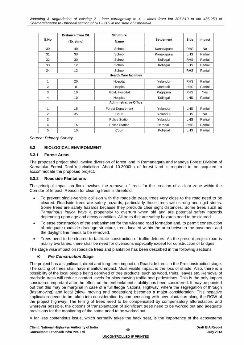
Widening & upgradation of existing 2 - lane carriageway to 4 – lanes from km 307.810 to km 435.250 of Chamarajanagar to Harohalli section of NH – 209 in the state of Karnataka
Client: National Highways Authority of India 49
Draft EIA Report
Consultant: Feedback Infra Pvt. Ltd July 2013
UNCONTROLLED IF PRINTED
S.No
Distance from C/L
(Existing)
Structure
Name Settlement Side Impact
30 40 School Kanakapura RHS No
31 30 School Kanakapura LHS Partial
32 30 School Kollegal RHS Partial
33 12 School Kollegal LHS Partial
34 12 School RHS Partial
Health Care facilities
1 20 Hospital Yelandur RHS Partial
2 8 Hospital Mampalli RHS Partial
3 10 Govt. Hospital Kaglipura RHS Yes
4 10 Hospital Kollegal LHS Partial
Administrative Office
1 15 Forest Department Yelandur LHS Partial
2 35 Court Yelandur LHS No
3 Police Station Yelandur LHS Partial
4 15 Police Station Harohalli RHS Partial
5 10 Court Kollegal LHS Partial
Source: Primary Survey
6.3 BIOLOGICAL ENVIRONMENT
6.3.1 Forest Areas
The proposed project shall involve diversion of forest land in Ramanagara and Mandya Forest Division of Karnataka Forest Dept.’s jurisdiction. About 10.3000ha of forest land is required to be acquired to accommodate the proposed project.
6.3.2 Roadside Plantations
The principal impact on flora involves the removal of trees for the creation of a clear zone within the Corridor of Impact. Reason for clearing trees is threefold:
To prevent single-vehicle collision with the roadside trees, trees very close to the road need to be cleared. Roadside trees are safety hazards, particularly those trees with strong and rigid stems. Some trees are safety hazards because they preclude clear sight distances. Some trees such as Tamarindus indica have a propensity to overturn when old and are potential safety hazards depending upon age and decay condition. All trees that are safety hazards need to be cleared.
To ease construction of the embankment for the widened road formation and, to permit construction of adequate roadside drainage structure, trees located within the area between the pavement and the daylight line needs to be removed.
Trees need to be cleared to facilitate construction of traffic detours. As the present project road is mainly two lanes, there shall be need for diversions especially except for construction of bridges.
The stage wise impact on roadside trees and plantation has been described in the following sections.
Pre Construction Stage
The project has a significant, direct and long-term impact on Roadside trees in the Pre construction stage. The cutting of trees shall have manifold impact. Most visible impact is the loss of shade. Also, there is a possibility of the local people being deprived of tree products, such as wood, fruits, leaves etc. Removal of roadside tress will reduce comfort levels for slow moving traffic and pedestrians. This is the only impact considered important after the effect on the embankment stability has been considered. It may be pointed out that this may be marginal in case of a full fledge National Highway, where the segregation of through (fast-moving) and local (slow- moving and pedestrian) becomes a major consideration. This negative implication needs to be taken into consideration by compensating with new plantation along the ROW of the project highway. The felling of trees need to be compensated by compensatory afforestation, and wherever possible, the options of transplantation of significant trees need to be worked out and adequate provisions for the monitoring of the same need to be worked out.
A far less contentious issue, which normally takes the back seat, is the importance of the ecosystems
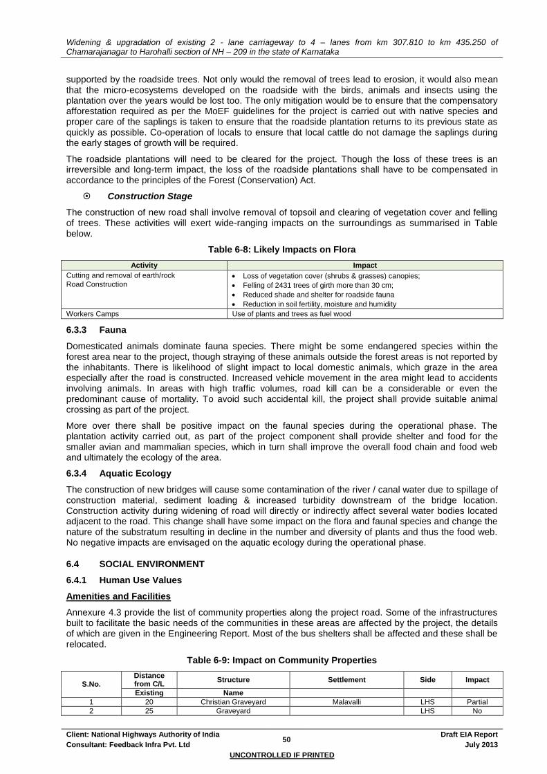
Widening & upgradation of existing 2 - lane carriageway to 4 – lanes from km 307.810 to km 435.250 of Chamarajanagar to Harohalli section of NH – 209 in the state of Karnataka
Client: National Highways Authority of India 50
Draft EIA Report
Consultant: Feedback Infra Pvt. Ltd July 2013
UNCONTROLLED IF PRINTED
supported by the roadside trees. Not only would the removal of trees lead to erosion, it would also mean that the micro-ecosystems developed on the roadside with the birds, animals and insects using the plantation over the years would be lost too. The only mitigation would be to ensure that the compensatory afforestation required as per the MoEF guidelines for the project is carried out with native species and proper care of the saplings is taken to ensure that the roadside plantation returns to its previous state as quickly as possible. Co-operation of locals to ensure that local cattle do not damage the saplings during the early stages of growth will be required.
The roadside plantations will need to be cleared for the project. Though the loss of these trees is an irreversible and long-term impact, the loss of the roadside plantations shall have to be compensated in accordance to the principles of the Forest (Conservation) Act.
Construction Stage
The construction of new road shall involve removal of topsoil and clearing of vegetation cover and felling of trees. These activities will exert wide-ranging impacts on the surroundings as summarised in Table below.
Table 6-8: Likely Impacts on Flora
Activity Impact
Cutting and removal of earth/rock
Road Construction Loss of vegetation cover (shrubs & grasses) canopies;
Felling of 2431 trees of girth more than 30 cm;
Reduced shade and shelter for roadside fauna
Reduction in soil fertility, moisture and humidity
Workers Camps Use of plants and trees as fuel wood
6.3.3 Fauna
Domesticated animals dominate fauna species. There might be some endangered species within the forest area near to the project, though straying of these animals outside the forest areas is not reported by the inhabitants. There is likelihood of slight impact to local domestic animals, which graze in the area especially after the road is constructed. Increased vehicle movement in the area might lead to accidents involving animals. In areas with high traffic volumes, road kill can be a considerable or even the predominant cause of mortality. To avoid such accidental kill, the project shall provide suitable animal crossing as part of the project.
More over there shall be positive impact on the faunal species during the operational phase. The plantation activity carried out, as part of the project component shall provide shelter and food for the smaller avian and mammalian species, which in turn shall improve the overall food chain and food web and ultimately the ecology of the area.
6.3.4 Aquatic Ecology
The construction of new bridges will cause some contamination of the river / canal water due to spillage of construction material, sediment loading & increased turbidity downstream of the bridge location. Construction activity during widening of road will directly or indirectly affect several water bodies located adjacent to the road. This change shall have some impact on the flora and faunal species and change the nature of the substratum resulting in decline in the number and diversity of plants and thus the food web. No negative impacts are envisaged on the aquatic ecology during the operational phase.
6.4 SOCIAL ENVIRONMENT
6.4.1 Human Use Values
Amenities and Facilities
Annexure 4.3 provide the list of community properties along the project road. Some of the infrastructures built to facilitate the basic needs of the communities in these areas are affected by the project, the details of which are given in the Engineering Report. Most of the bus shelters shall be affected and these shall be relocated.
Table 6-9: Impact on Community Properties
S.No. Distance from C/L
Structure Settlement Side Impact
Existing Name
1 20 Christian Graveyard Malavalli LHS Partial
2 25 Graveyard LHS No

Widening & upgradation of existing 2 - lane carriageway to 4 – lanes from km 307.810 to km 435.250 of Chamarajanagar to Harohalli section of NH – 209 in the state of Karnataka
Client: National Highways Authority of India 51
Draft EIA Report
Consultant: Feedback Infra Pvt. Ltd July 2013
UNCONTROLLED IF PRINTED
S.No.
Distance from C/L
Structure Settlement Side Impact
Existing Name
3 20 Graveyard Yelandur LHS Partial
4 25 Graveyard Partial
5 13-10 Graveyard Halagur LHS Partial
6 150 Graveyard Kaglipura LHS No
7 35 Graveyard Chamarajnagar LHS No
8 12 Mission Graveyard Upkeredoddi LHS Yes
Source: Primary Survey
Change in Land Use
The development that the improved road will bring with it will induce a chain reaction towards change in land use. Change In land use will be sparked off as a result of land speculation. The road, which is flanked by agricultural fields, will witness overnight selling of these lands for the prices that they will fetch. Industrialisation of fringe areas of cities is also a possible impact of a road development scheme. The availability of cheap labour and easy access to markets in the city will make roadside areas quite an incentive for the industrialist. Reduced transportation costs and availability of high-class transportation facilities for raw materials and products will be the most important advantage of the improved road. The mushrooming of industrial areas on roadside will mean that the use of whatever infrastructure facilities that may be available will preferentially go to the 'deep pockets' of the industry. This will further strain these almost non-existent services.
Land Speculation
Better connectivity will also mean that the value of roadside properties will rise almost overnight. The encroachment onto the ROW for the road to cash in on this opportunity is an almost universal occurrence, to varying degrees. Encroachment will mean that the future expansion / widening of the road scheme will be problematic and the issues related with easement and eviction will become a real challenge for the NHAI that is already stretched to the limit. However, the damage to encroaching structure, whatever its status, in case of an accident will be far more visible and potentially dangerous impact of such activity. Strict planning laws in conjunction with continuous unbiased monitoring of the development are the only proven strategies against such illegal activities.
Cropping Pattern and Crop Productivity
The proposed project is likely to bring in its wake industrialisation and change in land use. This translates into change of land currently under agriculture to more commercial use. It is envisaged that due to this proposed change the crop productivity in the agricultural belt immediately adjoining the ROW shall decrease. This impact is envisaged only to be valid for the agricultural land immediate to the ROW. Although the spatial impact is likely to be insignificant the impact will be irreversible in nature.
Exploitation of Resource base
Development of a road in areas previously not easily accessible can work like a double-edged sword for the environmental resources in the area. While the road would unlock potential value in the area, stimulate growth and make the environment hospitable, the rapid depletion of natural resources, by means with which these areas cannot cope is a distinct possibility. Development of such vital Infrastructure will lead to over exploitation of the environmental resources (e.g. too much groundwater pumping, indiscriminate wastewater disposal, etc.). While the medium term impacts may not be large enough to be noticed, the long-term implications of such depletion are potentially disastrous. The severe depletion of ground water resources in certain areas are likely if the expanded urban areas continue to use bore wells for their domestic water supply.
Road Safety
The improvement of the project road will entail doubling the existing carriageway to a two-lane section and improve its condition to allow vehicles at design speeds of 80-100 km/hr. Increased vehicular speed mean that the fringe areas of the road are at increased risk from speeding vehicles. The existing facilities and amenities along the road shall be subjected to adverse impacts of road operation. The possibility of accidents is likely to increase. The possibility of this happening is a cause of concern as there are many educational, cultural and health institutes along the road.
Induced Ribbon Development
The development of a road scheme will lead to extension of urban areas especially at the ends of cities

Widening & upgradation of existing 2 - lane carriageway to 4 – lanes from km 307.810 to km 435.250 of Chamarajanagar to Harohalli section of NH – 209 in the state of Karnataka
Client: National Highways Authority of India 52
Draft EIA Report
Consultant: Feedback Infra Pvt. Ltd July 2013
UNCONTROLLED IF PRINTED
and towns through which the road passes. The improved transportation facility provides the linkages that will allow much better access to previously difficult to reach markets (for buyers and sellers). This would mean not only the people from congested areas in cities will want to move to the fringe, but also, people from nearby rural areas would migrate to the city. Urban services are seldom able to keep pace with the growth of a city. The growth of a city beyond the established spread network will mean piecemeal arrangements for services like water supply, wastewater treatment and disposal, and transportation. All the settlements along the project corridor will experience a sudden boom in activity and population around the start of operation of the project corridor. Thus, a ribbon development is envisaged all along the project road.
6.4.2 Cultural Properties
Relocation of Cultural Assets
Cultural properties (shrines, sacred and archaeological structures) lying near the ROW are most susceptible to impacts due to pre construction and construction activities. Clearing of the site during movement of road construction machinery is likely to require a belt of about 4-5m from the edge of the carriageway, which is likely to adversely impact cultural properties. Cultural properties will be subjected to varying degree of impact depending upon their placement in the ROW. Structures, which are close to the proposed CW, are likely to need relocation. The project shall directly impact 14 religious structures which have to be relocated. The construction shall also partially impact 14 religious structures. The access of some of these cultural properties shall also be compromised. 5 cremation sites are likely to be affected. However, best effort shall be given to avoid those sites.
Table 6-10: Impact on Cultural Properties
S.No Distance from
Existing C/L (m)
Structure
Name Settlement Side Impact
Religious Properties
25 Church Vasagapura RHS Partial
8 Mosque Yelandur RHS Partial
8 Temple Yelandur LHS Partial
5 Temple Mampalli RHS Yes
15 Temple Mampalli RHS Partial
15 Temple RHS Yes
45 Temple RHS No
25 Temple Pandithalli RHS Partial
20 Mazaar Malavalli LHS Partial
20 Temple Malavalli RHS Partial
15 Temple Malavalli LHS Partial
70 Temple TK Halli RHS No
45 Church TK Halli LHS No
10 Mosque Halagur RHS Partial
9 Mosque Halagur RHS Partial
8 Temple (small) RHS Yes
20 Temple Honnaganahalli LHS Partial
30 Mazaar/Idgaah Honnaganahalli RHS
30 Temple Satnur RHS Partial
8 Temple (small) Jakkegowdanadoddi RHS Yes
8 Temple (small) K. Doddi LHS yes
10 Temple Shivanahalli LHS Partial
7 Temple (small) Shivanahalli LHS Yes
5 Temple Kanakapura RHS Yes
15 Temple Kanakapura LHS Partial
15 Temple Kanakapura RHS yes
12 Temple (Small) Jakkasandra LHS Yes
7 Temple (small) Harohalli RHS Yes
10 Mosque Kaglipura RHS Yes
25 Temple Kaglipura RHS No
Temple Kaglipura RHS No
15 Temple Kaglipura RHS Yes
12 Temple Kollegal RHS Yes
12 Mazaar Kollegal LHS Yes
Cremation Sites
20 Christian Graveyard Malavalli LHS Partial
25 Graveyard LHS No
20 Graveyard Yelandur LHS Partial
25 Graveyard Partial
13-10 Graveyard Halagur LHS Partial

Widening & upgradation of existing 2 - lane carriageway to 4 – lanes from km 307.810 to km 435.250 of Chamarajanagar to Harohalli section of NH – 209 in the state of Karnataka
Client: National Highways Authority of India 53
Draft EIA Report
Consultant: Feedback Infra Pvt. Ltd July 2013
UNCONTROLLED IF PRINTED
S.No Distance from
Existing C/L (m)
Structure
Name Settlement Side Impact
150 Graveyard Kaglipura LHS No
35 Graveyard Chamarajnagar LHS No
12 Mission Graveyard Upkeredoddi LHS Yes
Source: Primary Survey
6.4.3 Quality Of Life Values
Socio-Economic Profile
The detailed socio-economic analysis of people, structures and property likely to be impacted by the proposed project has been presented in the Resettlement Action Plan.
Public health and safety
Impacts on public health and safety may arise during the phases of pre-construction, construction and operation phases. During the pre-construction and construction phases, dismantling of the structures for ROW clearance and road construction activities may result in the following health hazards:
Breaking and dismantling of properties during pre-construction has psychological impacts on their owners and others associated with them.
Debris generated on account of the above-mentioned activities if not properly disposed might give rise to health problems in the area. However, the structures to be dismantled during pre-construction phase will mainly be of semi-permanent and temporary nature and much of the waste shall be salvageable.
Dismantling of first row of structures (generally commercial) along the highway shall lead to exposure of second row of properties (generally residential) to higher dust, air and noise pollution levels. This is a long-term effect (might extend into the operation phase) and may increase the effected households' medical expenditure.
In case of non-local labour (If so is arranged by the contractor), labour camps are set up at one or more sites adjacent to the alignment, and at some ancillary sites, like aggregate quarries. These labourers hired from outside can have clashes with the local population on account of cultural and religious differences. The influx of a large work force to an area, already hard pressed for basic services (medical services, power, water supply, etc.), can impose additional stress on these facilities.
In and around forest areas if alternative fuels are not made available to the workforce, there is a likelihood that trees / branches will be cut down for cooking or heating purposes.
Unsanitary conditions in the labour camps might also result in impact on health of labourers as well as the local population. Transmission of diseases is also facilitated by the migration of people. During the construction phase work, crews and their dependents may bring with them a multitude of communicable diseases including Sexually Transmitted Diseases (STDs) like AIDS. This is more so if the nature of the project requires more male-workers, who have migrated from other parts of the state or country.
During road construction allied activities like quarrying and crushing operations, traffic diversions, etc., may cause disruption of social and economic life of the local population of the nearby areas. Dust and noise generated in crushing and blasting operations may cause nuisance to the nearby communities. Other problems perceived during construction period is inconvenience to the local people as well as the highway passengers due to traffic jams and congestion, loss of access and other road accident risks, as a result of diversion of traffic and construction work on road.
The traffic amount and speeds are likely to increase throughout the road corridors. The accident risk would tend to increase. Although the design speeds have been kept lower in the major settlement areas, some amount of severance is expected in the rural areas.
Land Acquisition
The new Two lane with paved shoulder/ four lanes NH shall require a 30 & 45m ROW in urban and rural areas. The 45m ROW have been which has been optimised from the standard 60m ROW in view of LA constraints within urban areas. Land requirement estimates have been shown in Table below. Total land required for widening and upgrading the project corridor is 242.62 Ha. which are to be acquired from private and other government land holdings. The bulk of the land is required for widening and up
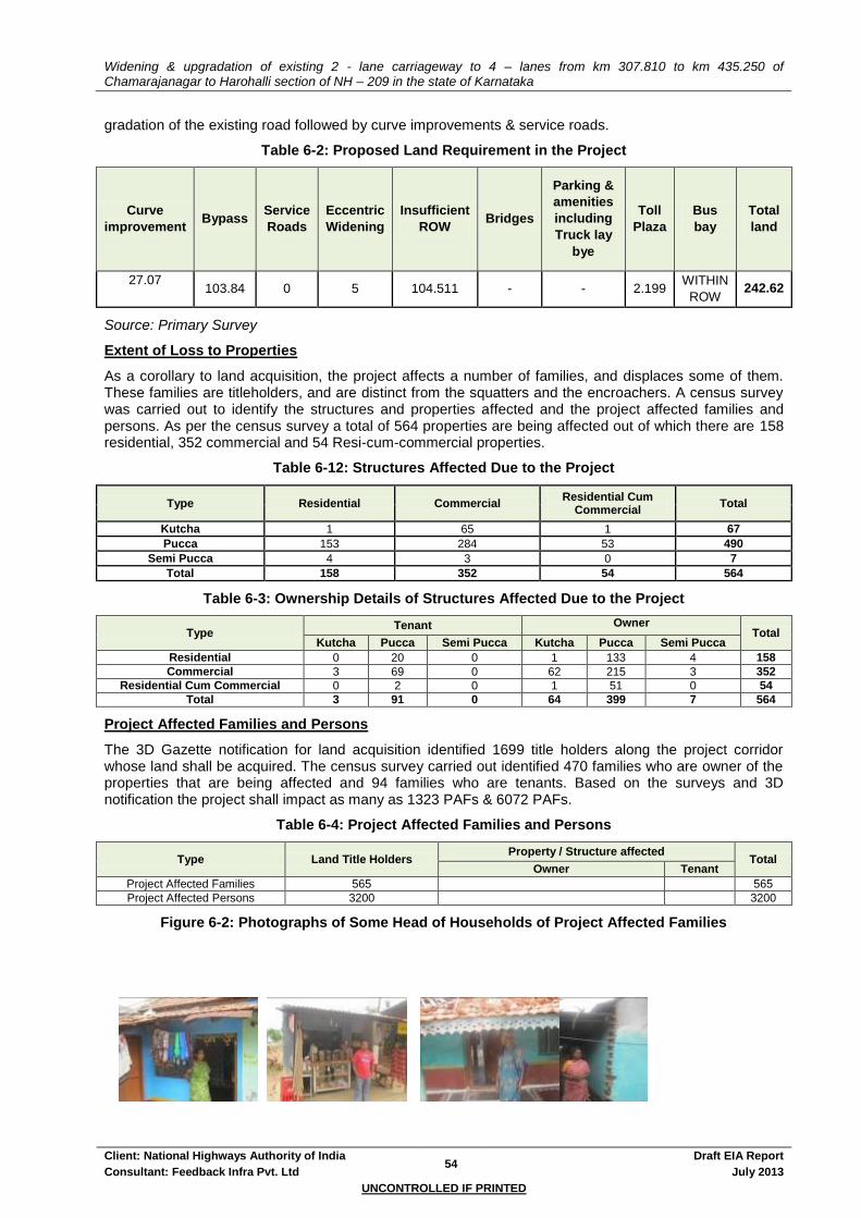
Widening & upgradation of existing 2 - lane carriageway to 4 – lanes from km 307.810 to km 435.250 of Chamarajanagar to Harohalli section of NH – 209 in the state of Karnataka
Client: National Highways Authority of India 54
Draft EIA Report
Consultant: Feedback Infra Pvt. Ltd July 2013
UNCONTROLLED IF PRINTED
gradation of the existing road followed by curve improvements & service roads.
Table 6-2: Proposed Land Requirement in the Project
Curve
improvement Bypass
Service
Roads
Eccentric
Widening
Insufficient
ROW Bridges
Parking &
amenities
including
Truck lay
bye
Toll
Plaza
Bus
bay
Total
land
27.07
103.84 0 5 104.511 - - 2.199
WITHIN
ROW 242.62
Source: Primary Survey
Extent of Loss to Properties
As a corollary to land acquisition, the project affects a number of families, and displaces some of them. These families are titleholders, and are distinct from the squatters and the encroachers. A census survey was carried out to identify the structures and properties affected and the project affected families and persons. As per the census survey a total of 564 properties are being affected out of which there are 158 residential, 352 commercial and 54 Resi-cum-commercial properties.
Table 6-12: Structures Affected Due to the Project
Type Residential Commercial Residential Cum
Commercial Total
Kutcha 1 65 1 67
Pucca 153 284 53 490
Semi Pucca 4 3 0 7
Total 158 352 54 564
Table 6-3: Ownership Details of Structures Affected Due to the Project
Type Tenant Owner
Total Kutcha Pucca Semi Pucca Kutcha Pucca Semi Pucca
Residential 0 20 0 1 133 4 158
Commercial 3 69 0 62 215 3 352
Residential Cum Commercial 0 2 0 1 51 0 54
Total 3 91 0 64 399 7 564
Project Affected Families and Persons
The 3D Gazette notification for land acquisition identified 1699 title holders along the project corridor whose land shall be acquired. The census survey carried out identified 470 families who are owner of the properties that are being affected and 94 families who are tenants. Based on the surveys and 3D notification the project shall impact as many as 1323 PAFs & 6072 PAFs.
Table 6-4: Project Affected Families and Persons
Type Land Title Holders Property / Structure affected
Total Owner Tenant
Project Affected Families 565 565
Project Affected Persons 3200 3200
Figure 6-2: Photographs of Some Head of Households of Project Affected Families

Widening & upgradation of existing 2 - lane carriageway to 4 – lanes from km 307.810 to km 435.250 of Chamarajanagar to Harohalli section of NH – 209 in the state of Karnataka
Client: National Highways Authority of India 55
Draft EIA Report
Consultant: Feedback Infra Pvt. Ltd July 2013
UNCONTROLLED IF PRINTED
6.5 CONCLUSION
Based on the analysis of environmental impacts in the above sections, it can be concluded that the project is anticipated to cause the following environmental impacts:
Partial damage on 5 schools & 1 health unit
Direct & Full impact on 1 school and 1 health unit & these has to be relocated
Loss 5000 trees along the existing project road due to felling
Acquisition of 242.6 ha of land be required for the project
Direct & Full impact on 15 temples and 1 mazar & these has to be relocated
Partial impact on 3 temples
Loss of access to sensitive receptors, cultural properties and amenities
The specific and generic mitigation measures of and the management plan are discussed in details in chapter 9 and 10.


Widening & upgradation of existing 2 - lane carriageway to 4 – lanes from km 307.810 to km 435.250 of Chamarajanagar to Harohalli section of NH – 209 in the state of Karnataka
Client: National Highways Authority of India 56
Draft EIA Report
Consultant: Feedback Infra Pvt. Ltd July 2013
UNCONTROLLED IF PRINTED
7. ANALYSIS OF ALTERNATIVES
The chapter tries to compare feasible alternative to the proposed project with respect to site, technology, design etc. The alternatives examined take into account all possible and feasible options and includes both with and without project scenarios in terms of the potential environmental impacts for the justification of the project. The chapter discusses how environmental parameters were assigned due importance and were carefully considered in the analysis of alternatives.
7.1 WITH AND WITHOUT PROJECT ALTERNATIVES
7.1.1 Without Project Scenario
The existing project road is a two lane national highway with varying pavement width. With present and projected high traffic volumes, the capacity of the present highway is insufficient for handling the high volume of traffic and calls in for improvements to a four lane carriageway. The road has many roadside settlements and the traffic flow is seriously impacted by severe conflicts between the local and the through traffic. This is further compounded by the various land use conflicts, in terms of uncontrolled development along the highway and the encroachments onto the ROW. The population growth, increase in traffic volumes and the economic development along the corridor would continue to occur and will worsen the already critical situation. The existing unsafe conditions and the adverse environmental consequences in terms of the environmental quality along the highway would continue to worsen in the absence of the proposed improvements. Moreover, if it is decided not to proceed with the project, then the attendant reduced socio-economic development of this remote, relatively poorly connected area cannot be justified. Therefore, the no-action alternative is neither a reasonable nor a prudent course of action for the proposed project, as it would amount to failure to initiate any further improvements and impede economic development.
7.1.2 With Project Scenario
The ‘with project scenario’ is found to have a positive impact in the long run on social, environmental, economic and financial issues. This scenario includes the widening to four lanes of the existing two lanes stretch as envisaged in the project objectives. The scenario is economically viable and will improve the existing conditions. It, would thereby, contribute to the development goals envisaged by the Governments of Karnataka and India, and enhance the growth potential of the area.
To avoid the large-scale acquisition of land and properties, the project envisages the four-laning of the highway within minimum additional ROW.
In spite of the various development benefits likely to accrue due to the project, as is the case of every road development project, the project would be accompanied by certain impacts on the natural, social and environmental components. The potential impacts on the various environmental components can be avoided through good environmental practices. Wherever avoidance of negative impact has not been possible, appropriate mitigation and enhancement actions will be worked out to effectively offset the environmental damages inflicted due to the project. A detailed Resettlement and Rehabilitation (R&R) Action Plan has been worked out to improve the well-being and livelihood of the people to be impacted. Comparative assessments of the “with and without” project scenarios are presented in the following Table 7-1.
Table 7-1: "With and Without" Project Scenarios - A Comparative Assessment
Component "With" Project Scenario 'Without" Project Scenario
Highway Geometrics
Divided four-lane carriageway/ two Lane with paved shoulder with geometric improvements
Existing two lane carriageway with poor geometrics
Design Speed 80-100 Kmph 50-60 Kmph in rural Sections, 20-30 Kmph in Urban Sections
Congestion in Settlements
Segregation of local and through traffic by the provision of bypasses or realignment will greatly relieve congestion.
Congestion In urban areas due to mixing of local, pedestrian and through traffic.
Felling of road side trees
Felling of both old and young trees. Old and weak trees near the road edge shall be a road hazard and shall be felled. Double the number of new young and healthy trees to be planted in compensation.
No felling of trees. The old trees may become a safety hazard to the road users with passage of time.
Cattle safety Provision of cattle underpasses to provide safety to both road users and cattle from accidents.
Accidents involving cattle and livestock shall be a concern.
Pedestrian safety
Along the settlement stretches with significant pedestrian traffic, Service road has been provided besides
Pedestrian safety an issue of major concern especially along the settlements and congested
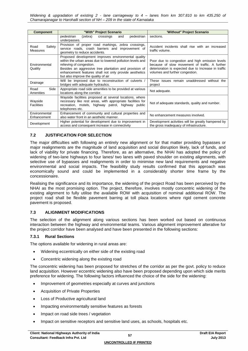
Widening & upgradation of existing 2 - lane carriageway to 4 – lanes from km 307.810 to km 435.250 of Chamarajanagar to Harohalli section of NH – 209 in the state of Karnataka
Client: National Highways Authority of India 57
Draft EIA Report
Consultant: Feedback Infra Pvt. Ltd July 2013
UNCONTROLLED IF PRINTED
Component "With" Project Scenario 'Without" Project Scenario
pedestrian (zebra) crossings and pedestrian underpasses.
sections.
Road Safety Measures
Provision of proper road markings, zebra crossings, service roads, crash barriers and improvement of geometry to reduce accidents.
Accident incidents shall rise with an increased traffic volume.
Environmental Quality
Proposed development improves environmental quality within the urban areas due to lowered pollution levels and relieving of congestion.
Besides an aggressive tree plantation and provision of enhancement features shall not only provide aesthetics but also improve the quality of air
Poor due to congestion and high emission levels because of slow movement of traffic. A further deterioration is expected due to Increase in traffic volumes and further congestion.
Drainage Will be improved due to reconstruction of culverts / bridges with adequate hydraulics.
These issues remain unaddressed without the project
Road Side Amenities
Appropriate road side amenities to be provided at various locations along the corridor.
Not adequate.
Wayside Facilities
Wayside facilities proposed at several locations, where necessary like rest areas, with appropriate facilities for recreation, motels, highway patrol, highway public telephones etc.
Not of adequate standards, quality and number.
Environmental Enhancement
Enhancement of community and cultural properties and also water front in an aesthetic manner.
No enhancement measures involved.
Development Higher potential for development due to improvement in access and consequent increase in connectivity
Development activities will be greatly hampered by the gross inadequacy of infrastructure.
7.2 JUSTIFICATION FOR SELECTION
The major difficulties with following an entirely new alignment or for that matter providing bypasses or major realignments are the magnitude of land acquisition and social disruption likely, lack of funds, and lack of viability for private financing. Therefore, as an alternative, the NHAI has adopted the policy of widening of two-lane highways to four lanes/ two lanes with paved shoulder on existing alignments, with selective use of bypasses and realignments in order to minimise new land requirements and negative environmental and social impacts. The feasibility study results confirmed that this approach was economically sound and could be implemented in a considerably shorter time frame by the concessionaire.
Realising the significance and its importance, the widening of the project Road has been perceived by the NHAI as the most promising option. The project, therefore, involves mostly concentric widening of the existing alignment to fully utilise the available ROW with acquisition of nominal additional ROW. The project road shall be flexible pavement barring at toll plaza locations where rigid cement concrete pavement is proposed.
7.3 ALIGNMENT MODIFICATIONS
The selection of the alignment along various sections has been worked out based on continuous interaction between the highway and environmental teams. Various alignment improvement alterative for the project corridor have been analysed and have been presented in the following sections:
7.3.1 Rural Sections
The options available for widening in rural areas are:
Widening eccentrically on either side of the existing road
Concentric widening along the existing road
The concentric widening has been proposed for stretches of the corridor as per the govt. policy to reduce land acquisition. However eccentric widening also have been proposed depending upon which side merits preference for widening. The following factors influenced the choice of the side for the widening:
Improvement of geometries especially at curves and junctions
Acquisition of Private Properties
Loss of Productive agricultural land
Impacting environmentally sensitive features as forests
Impact on road side trees / vegetation
Impact on sensitive receptors and sensitive land uses, as schools, hospitals etc.
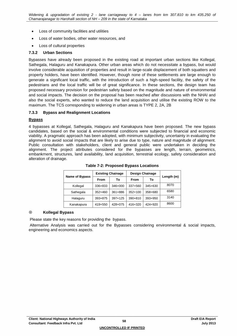
Widening & upgradation of existing 2 - lane carriageway to 4 – lanes from km 307.810 to km 435.250 of Chamarajanagar to Harohalli section of NH – 209 in the state of Karnataka
Client: National Highways Authority of India 58
Draft EIA Report
Consultant: Feedback Infra Pvt. Ltd July 2013
UNCONTROLLED IF PRINTED
Loss of community facilities and utilities
Loss of water bodies, other water resources, and
Loss of cultural properties
7.3.2 Urban Sections
Bypasses have already been proposed in the existing road at important urban sections like Kollegal,
Sathegala, Halaguru and Kanakapura. Other urban areas which do not necessitate a bypass, but would
involve considerable acquisition of properties and result in large-scale displacement of both squatters and
property holders, have been identified. However, though none of these settlements are large enough to
generate a significant local traffic, with the introduction of such a high-speed facility, the safety of the
pedestrians and the local traffic will be of great significance. In these sections, the design team has
proposed necessary provision for pedestrian safety based on the magnitude and nature of environmental
and social impacts. The decision on the proposal has been reached after discussions with the NHAI and
also the social experts, who wanted to reduce the land acquisition and utilise the existing ROW to the
maximum. The TCS corresponding to widening in urban areas is TYPE 2, 2A, 2B
7.3.3 Bypass and Realignment Locations
Bypass
4 bypasses at Kollegal, Sathegala, Halaguru and Kanakapura have been proposed. The new bypass candidates, based on the social & environmental conditions were subjected to financial and economic viability. A pragmatic approach has been adopted, with minimum subjectivity, uncertainty in evaluating the alignment to avoid social impacts that are likely to arise due to type, nature and magnitude of alignment. Public consultation with stakeholders, client and general public were undertaken in deciding the alignment. The project attributes considered for the bypasses are length, terrain, geometrics, embankment, structures, land availability, land acquisition, terrestrial ecology, safety consideration and alteration of drainage.
Table 7-2: Proposed Bypass Locations
Name of Bypass Existing Chainage Design Chainage
Length (m) From To From To
Kollegal 336+833 346+000 337+560 345+630 8070
Sathegala 352+460 361+886 352+100 358+680 6580
Halaguru 393+875 397+125 390+810 393+950 3140
Kanakapura 419+550 428+075 416+320 424+920 8600
Kollegal Bypass
Please state the key reasons for providing the bypass.
Alternative Analysis was carried out for the Bypasses considering environmental & social impacts, engineering and economics aspects.

Widening & upgradation of existing 2 - lane carriageway to 4 – lanes from km 307.810 to km 435.250 of Chamarajanagar to Harohalli section of NH – 209 in the state of Karnataka
Client: National Highways Authority of India 59
Draft EIA Report
Consultant: Feedback Infra Pvt. Ltd July 2013
UNCONTROLLED IF PRINTED
Figure 7-1: Proposed Kollegal Bypass- Alternatives
Table 7-3: Analysis of Alternatives for Kollegal Bypass
Sl.No Description Alternate 1 Alternate 2 Alternate 3
1 Starting Exis km 336.833 and PR 337.560 on NH-209
Exis km 331.164 on NH-209 Exis km 332.466 on NH-209
2 Ending Exis km 346.000 and PR 345.630 on NH-209
Exis km 346.00 on NH-209 Exis km 346.00 on NH-209
3 Route Alignment
LHS RHS LHS
4 Length of Proposed Bypass
8.070 11.37 11.24
5 Length of existing
alignment Bypassed
9.167 11.814 13.122
6 Terrain Passing Through Plain Terrain Passing Through Plain Terrain
Passing Through Plain Terrain
7 Speed 100 km/hr 100 km/hr 100 km/hr
8 Geometrics Smooth horizontal and vertical geometrics is possible
Smooth horizontal and vertical geometrics is
possible
Smooth horizontal and vertical geometrics is possible
No of Curves =3 No of Curves = 3 No of Curves = 3
9 at Grade Junction
Improvement
1.0 Nos- T.Narasipura Kollegal Road, SH79
1.0 Nos- T.Narasipura Kollegal Road, SH-79
1.0 Nos-SH79 towards MM hills
10 Existing Land use pattern
through proposed alignment
Agricultural and Builtup Agricultural, Barren land Mostly Built Up area
11 No of Structures
1 Minor Bridge 1 Minor Bridge 3 Minor Bridges
1 VUP at SH 79 intersection 1 VUP at SH 79 intersection 1 VUP at SH 79 intersection

Widening & upgradation of existing 2 - lane carriageway to 4 – lanes from km 307.810 to km 435.250 of Chamarajanagar to Harohalli section of NH – 209 in the state of Karnataka
Client: National Highways Authority of India 60
Draft EIA Report
Consultant: Feedback Infra Pvt. Ltd July 2013
UNCONTROLLED IF PRINTED
Sl.No Description Alternate 1 Alternate 2 Alternate 3
12 Accessibilty SH79 towards T.Narasipura SH79 towards T.Narasipura SH79 towards MM Hills
Area Required, Hectores
49.2 68.22 67.44
14 Social affected Light Light Moderate
15 Environmental affecting major
Agriculture and Builtup Agriculture and few Builtup Built-Up
16 Recommendation
Recommended Not recommended Not recommended
Sathegala Bypass
Please state the key reasons for providing the bypass.
Alternative Analysis was carried out for the bypass considering environmental & social impacts, engineering and economics.
Figure 7-2: Proposed Sathegala Bypass- Alternatives
Table 7-4: Analysis of Alternatives for Sathegala Bypass
Sl.No. Description Alternate 1 Alternate 2 (Following
Existing) Alternate 3
1 Starting Exis km 352.460 and PR 352.100 Exis km 352.460 Exis km 352.460
2 Ending Exis km 361.886 and PR 358.680 Exis km 361.886 Exis km 361.886
3 Route Alignment RHS Existing Alignment Existing Alignment
4 Length of
Proposed
Bypass
6.58 9.426 7.3
5 Length of
existing
alignment
Bypassed
9.426 9.426 9.426
6 Terrain Passing Through Rolling Terrain Passing Through Rolling
Terrain
Passing Through Rolling
Terrain
7 Speed 100 km/hr 65Kmph 65Kmph
8 Geometrics Smooth horizontal and vertical
geometrics is possible
Smooth horizontal and vertical
geometrics are not possible
Smooth horizontal and
vertical geometrics are not
possible
No of Curves =4 No of Curves =7 No of Curves =2
9 at Grade
Junction
Improvement
0 0 0
10 Existing Land
use pattern
Agricultural/Barren/Forest Agricultural/Barren/Forest Agricultural/Builtup
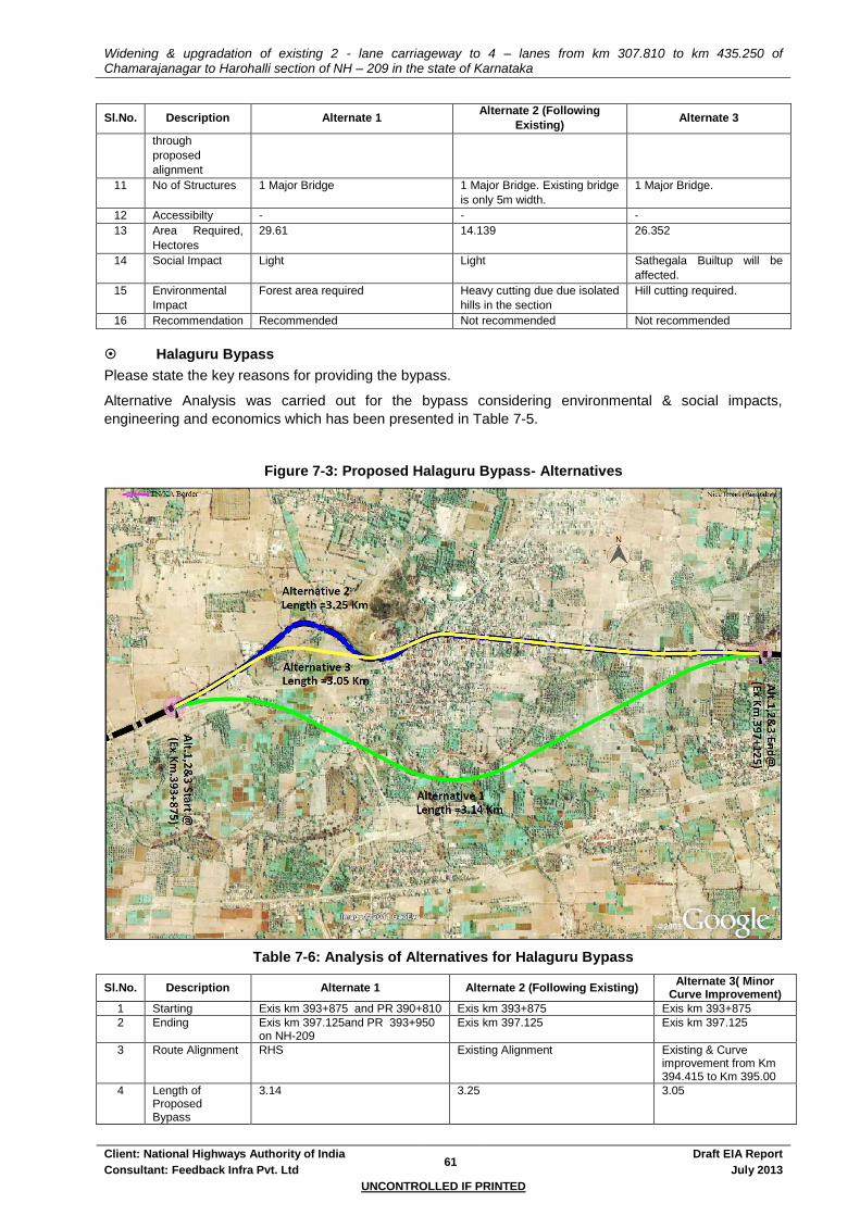
Widening & upgradation of existing 2 - lane carriageway to 4 – lanes from km 307.810 to km 435.250 of Chamarajanagar to Harohalli section of NH – 209 in the state of Karnataka
Client: National Highways Authority of India 61
Draft EIA Report
Consultant: Feedback Infra Pvt. Ltd July 2013
UNCONTROLLED IF PRINTED
Sl.No. Description Alternate 1 Alternate 2 (Following
Existing) Alternate 3
through
proposed
alignment
11 No of Structures 1 Major Bridge 1 Major Bridge. Existing bridge
is only 5m width.
1 Major Bridge.
12 Accessibilty - - -
13 Area Required,
Hectores
29.61 14.139 26.352
14 Social Impact Light Light Sathegala Builtup will be
affected.
15 Environmental
Impact
Forest area required Heavy cutting due due isolated
hills in the section
Hill cutting required.
16 Recommendation Recommended Not recommended Not recommended
Halaguru Bypass
Please state the key reasons for providing the bypass.
Alternative Analysis was carried out for the bypass considering environmental & social impacts,
engineering and economics which has been presented in Table 7-5.
Figure 7-3: Proposed Halaguru Bypass- Alternatives
Table 7-6: Analysis of Alternatives for Halaguru Bypass
Sl.No. Description Alternate 1 Alternate 2 (Following Existing) Alternate 3( Minor
Curve Improvement)
1 Starting Exis km 393+875 and PR 390+810 Exis km 393+875 Exis km 393+875
2 Ending Exis km 397.125and PR 393+950 on NH-209
Exis km 397.125 Exis km 397.125
3 Route Alignment RHS Existing Alignment Existing & Curve improvement from Km 394.415 to Km 395.00
4 Length of Proposed Bypass
3.14 3.25 3.05
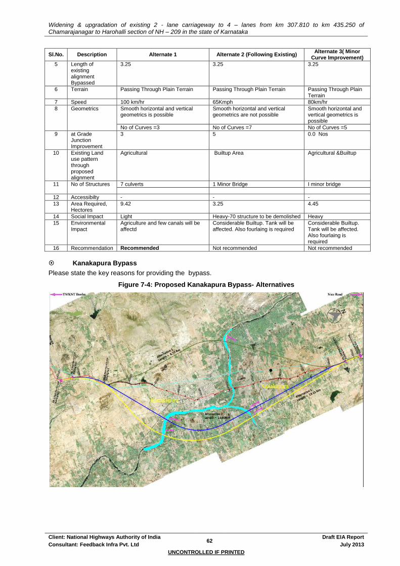
Widening & upgradation of existing 2 - lane carriageway to 4 – lanes from km 307.810 to km 435.250 of Chamarajanagar to Harohalli section of NH – 209 in the state of Karnataka
Client: National Highways Authority of India 62
Draft EIA Report
Consultant: Feedback Infra Pvt. Ltd July 2013
UNCONTROLLED IF PRINTED
Sl.No. Description Alternate 1 Alternate 2 (Following Existing) Alternate 3( Minor
Curve Improvement)
5 Length of existing alignment Bypassed
3.25 3.25 3.25
6 Terrain Passing Through Plain Terrain Passing Through Plain Terrain Passing Through Plain Terrain
7 Speed 100 km/hr 65Kmph 80km/hr
8 Geometrics Smooth horizontal and vertical geometrics is possible
Smooth horizontal and vertical geometrics are not possible
Smooth horizontal and vertical geometrics is possible
No of Curves =3 No of Curves =7 No of Curves =5
9 at Grade Junction Improvement
3 5 0.0 Nos
10 Existing Land use pattern through proposed alignment
Agricultural Builtup Area Agricultural &Builtup
11 No of Structures 7 culverts 1 Minor Bridge I minor bridge
12 Accessibilty - - -
13 Area Required, Hectores
9.42 3.25 4.45
14 Social Impact Light Heavy-70 structure to be demolished Heavy
15 Environmental Impact
Agriculture and few canals will be affectd
Considerable Builtup. Tank will be affected. Also fourlaing is required
Considerable Builtup. Tank will be affected. Also fourlaing is required
16 Recommendation Recommended Not recommended Not recommended
Kanakapura Bypass
Please state the key reasons for providing the bypass.
Figure 7-4: Proposed Kanakapura Bypass- Alternatives

Widening & upgradation of existing 2 - lane carriageway to 4 – lanes from km 307.810 to km 435.250 of Chamarajanagar to Harohalli section of NH – 209 in the state of Karnataka
Client: National Highways Authority of India 63
Draft EIA Report
Consultant: Feedback Infra Pvt. Ltd July 2013
UNCONTROLLED IF PRINTED
Table 7-7: Analysis of Alternatives for Kanakapura Bypass
Sl.No Description Alternate 1 Alternate 2 Alternate 3
1 Starting Exis km 419.550and PR 416.320 on NH-209
Exis km 417.718 on NH-209 Exis km 417.198 on NH-209
2 Ending Exis km 428.075and PR 424.920 on NH-209
Exis km 428.645 on NH-209 Exis km 429.245 on NH-209
3 Route Alignment LHS RHS RHS
4 Length of Proposed Bypass
8.600 11.626 13.146
5 Length of existing
alignment Bypassed
8.525 11.07 12.142
6 Terrain Passing Through Plain Terrain Passing Through Plain Terrain
Passing Through Plain Terrain
7 Speed 100 km/hr 100 km/hr 100 km/hr
8 Geometrics Smooth horizontal and vertical geometrics is possible
Smooth horizontal and vertical geometrics is
possible
Smooth horizontal and vertical geometrics is possible
No of Curves =4 No of Curves = 3 No of Curves = 3
9 at Grade Junction
Improvement
1.0 Nos 0.0 Nos 0.0 Nos
10 Existing Land use pattern
through proposed alignment
Agricultural, Barren land & Builtup Area
Agricultural, Barren land & Builtup Area
Agricultural, Barren land, Water tank & Builtup Area
11 No of Structures 1 Minor Bridge 2 Minor Bridge 2 Minor Bridge
12 Accessibilty Nil Nil Nil
13 Area Required, Hectors
52.2 69.756 78.876
14 Social affected Moderate Light Light
15 Environmental affecting major
Agriculture and Builtup Agriculture and few Builtup Agricultural Land
16 Recommendation Recommended Not recommended Not recommended
Major Realignment
Major realignments have been proposed at the following 3 locations:
Table 7-8: Major Realignment Locations
Realignment Location Existing Chainage (Km) Proposed Chainage (Km)
Existing Length(m) Proposed Length(m) Side From To From To
Santhemarahalli 317.100 318.750 318.320 319.670 1650 1350 Right
Yelandur 323.000 325.580 323.860 326.280 2580 2420 Left
Agaram 333.700 336.900 334.270 336.550 3200 2280 Left
Santhemarahalli Realignment
Please state the key reasons for providing the realignment

Widening & upgradation of existing 2 - lane carriageway to 4 – lanes from km 307.810 to km 435.250 of Chamarajanagar to Harohalli section of NH – 209 in the state of Karnataka
Client: National Highways Authority of India 64
Draft EIA Report
Consultant: Feedback Infra Pvt. Ltd July 2013
UNCONTROLLED IF PRINTED
Figure 7-5: Proposed Santhemarahalli Realignment
Table 7-9: Analysis of Alternatives for Santhemarahalli Realignment
Sl. No.
Description Realignment Following Existing Alignment
1 Starting Design Ch 318+300 Design Ch 318+300
2 Ending Design Ch 319+700 Design Ch 319+910
3 Length of Alignment 1.40 km 1.61 km
4 Terrain Passing Through Plain Terrain Passing Through Plain Terrain
5 Speed 100 km/hr 65 km/hr
6 Geometrics Smooth horizontal and vertical geometrics is
possible Compromise has to be made in
the horizontal alignment
No of Curves = 3 No of Curves = 3
7 Existing Land use pattern through
proposed alignment Agricultural Builtup
8 No of Structures affecting -
10 Govt Building including Panchayat Office, 4 Houses, 6
commercial buildings & 1 temple - totally 21 structures
9 Proposed ROW 30 m 30 m
Area Required, Hectares 4.2 Hec Total area required
4.9Ha(Existing area available 4.0 Ha) = Required area 0.90 Ha
10 Social affected Light High
11 Environmental affecting major Major Agriculture land. One pond will be
affected. Built-up & commercial
12 Merits 1. Design Speed - 100 kmph 1. Land required will be less
2. Land Use on proposed alternative –
Agricultural & Barren land. 2. Savings in acquisition cost and
time
3. Optimal length proposed with 100km/hr speed 3. Length is more or less same as
that of earlier proposal
4. Shorter in Length
5. Avoids built-up
13 Demerits 1. Fertile land to be acquired
1. Compromise to be made in technical aspects. Design speed
will have to be reduced to 65Kmph.
2. Two lane with paved shoulder will suffice 2. Fourlane will be required to
cater local traffic
3. Demolition of several public
buildings
14 Recommendation Recommended Not Recommended

Widening & upgradation of existing 2 - lane carriageway to 4 – lanes from km 307.810 to km 435.250 of Chamarajanagar to Harohalli section of NH – 209 in the state of Karnataka
Client: National Highways Authority of India 65
Draft EIA Report
Consultant: Feedback Infra Pvt. Ltd July 2013
UNCONTROLLED IF PRINTED
Yelandur Realignment
Please state the key reasons for providing the realignment.
Figure 7-1: Proposed Yelandur Realignment
Table 7-9: Analysis of Alternatives for Yelandur Realignment
Sl. No.
Description Realignment Following Existing Alignment
1 Starting Design Ch 323+860 Existing Ch 323+000
2 Ending Design Ch 326+860 Existing Ch 325+580
3 Length of Alignment 2.58 km 2.58 km
4 Terrain Passing Through Plain Terrain Passing Through Plain Terrain
5 Speed 100 km/hr 40- 65 km/hr
6 Geometrics Smooth horizontal and vertical geometrics is possible
Compromise has to be made in the horizontal alignment
No of Curves = 3 No of Curves = 5
7 Existing Land use pattern through proposed alignment
Agricultural Builtup
8 No of Structures affecting - Alignment traverses through heart of Yelandur Taluk. More than 200 building will be affectd
9 Proposed ROW - 30 m
Area Required, Hectares 7.74 Hec Total area required 3.87Ha
10 Social affected Light High
11 Environmental affecting major Agricultural land will be affectd Built-up & commercial
12 Merits 1. Design Speed - 100 kmph 1. Land required will be less
2. Land Use on proposed alternative – Agricultural & Barren
land.
2. Savings in acquisition cost and time

Widening & upgradation of existing 2 - lane carriageway to 4 – lanes from km 307.810 to km 435.250 of Chamarajanagar to Harohalli section of NH – 209 in the state of Karnataka
Client: National Highways Authority of India 66
Draft EIA Report
Consultant: Feedback Infra Pvt. Ltd July 2013
UNCONTROLLED IF PRINTED
Sl. No.
Description Realignment Following Existing Alignment
3. Optimal length proposed with 100km/hr speed
3. Length is more or less same as that of earlier proposal
4. Shorter in Length 4. Design speed will have to be limited to 40kmph
5. Avoids built-up
13 Demerits 1. Fertile land to be acquired 1. Compromise to be made in technical aspects. Design speed will have to be reduced to
65Kmph.
2. Two lane with paved shoulder will suffice
2. Fourlane will be required to cater local traffic
3. Demolition of several public buildings
14 Recommendation Recommended Not Recommended
Agaram Realignment
Please state the key reasons for providing the realignment.
Figure 7-7: Proposed Agaram Realignment
Table 7-10: Analysis of Alternatives for Agaram Realignment
Sl. No.
Description Realignment Following Existing Alignment
1 Starting Design Ch 334+270 Design Ch 333+700
2 Ending Design Ch 336+550 Design Ch 336+900
3 Length of Alignment 2.28 km 3.20 km
4 Terrain Passing Through Plain Terrain Passing Through Plain Terrain
5 Speed 100 km/hr 65 km/hr
6 Geometrics Smooth horizontal and vertical geometrics is possible
Compromise has to be made in the horizontal alignment
No of Curves = 3 No of Curves = 3

Widening & upgradation of existing 2 - lane carriageway to 4 – lanes from km 307.810 to km 435.250 of Chamarajanagar to Harohalli section of NH – 209 in the state of Karnataka
Client: National Highways Authority of India 67
Draft EIA Report
Consultant: Feedback Infra Pvt. Ltd July 2013
UNCONTROLLED IF PRINTED
Sl. No.
Description Realignment Following Existing Alignment
7 Existing Land use pattern through proposed alignment
Agricultural Builtup
8 No of Structures affecting - More than 50 houses will be affectd
9 Proposed ROW 30 m 30 m
Area Required, Hectares 6.84 Hec 7.04 Ha
10 Social affected Light High
11 Environmental affecting major Major Agriculture land. Built-up & commercial
12 Merits 1. Design Speed - 100 kmph Avoids Agricultutal Land
2. Land Use on proposed alternative – Agricultural & Barren land.
3. Optimal length proposed with 100km/hr speed
4. Shorter in Length
5. Avoids built-up
13 Demerits 1. Fertile land to be acquired Demolition of entire Agaram settlement
2. Two lane with paved shoulder will suffice
14 Recommendation Recommended Not Recommended
7.3.4 Curve Improvement Locations
Various locations have been identified along the project corridor, where the poor geometrics warrant a deviation from the existing alignment. Most of these locations are situated in curves both horizontal and vertical. The existing alignment was followed at some locations due to the following reasons:
Minor curves
Reduction in LA
Care though has been taken to minimise the impact on sensitive, cultural and community features like forest areas, schools, hospitals etc.
Curve improvement sections have been presented below.
Table 7-11: Curve Improvement Sections
Sl No Design Chainage (Km) Length in m Side
1 322.79 322.91 120 Left
2 347.2 347.3 100 Left
3 348 348.3 300 Left
4 412.55 412.78 230 Left
5 415.78 415.95 170 Left
6 430.16 430.46 300 Left
7 432.34 432.51 170 Right
7.4 WIDENING / SERVICE ROAD OPTIONS
Widening options:
Two widening options were deliberated. These are concentric, eccentric. In order to reduce the impact of LA concentric widening has been proposed for 80.210 Km. while eccentric widening is proposed for 8.720Km. These eccentric widening are proposed at mainly bridge locations and at places where curve improvement has warranted an eccentric widening.
Service Road:
No Service road has been provided in the project stretch.
7.5 COLD MIX & HOT MIX TECHNOLOGY ANALYSIS
Cold Mix Technology involves cold asphalt which is a high-quality, polymer-modified cold mix asphalt available in batch orders. Hot Mix Technology involves Hot Mix Asphalt (HMA) which is a combination of approximately 95% stone, sand, or gravel bound together by asphalt cement, a product of crude oil.

Widening & upgradation of existing 2 - lane carriageway to 4 – lanes from km 307.810 to km 435.250 of Chamarajanagar to Harohalli section of NH – 209 in the state of Karnataka
Client: National Highways Authority of India 68
Draft EIA Report
Consultant: Feedback Infra Pvt. Ltd July 2013
UNCONTROLLED IF PRINTED
Asphalt cement is heated aggregate, combined, and mixed with the aggregate at an HMA facility. The comparison between the two is given below:
Table 7-12: Analysis of Cold & Hot Mix Technology
Sl. No.
Parameter Cold Mix Hot Mix
1 Description
Street Cold Asphalt is a relatively new product developed in 1995 through the introduction of new polymer technology and research into the manipulation of viscosity and material design, of the various components of an asphalt mix - Street Cold Asphalt is soft and sticky out of the bag, but it quickly hardens after application and the end result is a pavement patch with better strength but similar properties to hot asphalt.
Hot mix asphalt is used primarily as paving material and consists of a mixture of aggregate and liquid asphalt cement, which are heated and mixed in measured quantities.
Hot mix asphalt facilities can be broadly classified as either drum mix plants or batch mix plants, according to the process by which the raw materials are mixed.
In a batch mix plant, the aggregate is dried first, then transferred to a mixer where it is mixed with the liquid asphalt.
In a drum mix plant, a rotary dryer serves to dry the aggregate and mix it with the liquid asphalt cement.
2 Requirements
Cold patch, also known as cold mix or cold asphalt, was first recognized as a way to make road repairs quickly because it can be applied right from the container without heating.
Cold asphalt also doesn’t require any special heavy rolling machines or special applicators as it can be shoveled or poured into a pothole or utility cut and tamped down with a hand tool.
Hot mix asphalt concrete (commonly abbreviated as HMAC or HMA) is produced by heating the asphalt binder to decrease its viscosity, and drying the aggregate to remove moisture from it prior to mixing.
Mixing is generally performed with the aggregate at about 300 °F (roughly 150 °C) for virgin asphalt and 330 °F (166 °C) for polymer modified asphalt, and the asphalt cement at 200 °F (95 °C).
Paving and compaction must be performed while the asphalt is sufficiently hot
3 Use
Cold mix asphalt concrete is produced by emulsifying the asphalt in water with (essentially) soap prior to mixing with the aggregate. While in its emulsified state the asphalt is less viscous and the mixture is easy to work and compact
The emulsion will break after enough water evaporates and the cold mix will, ideally, take on the properties of cold HMAC
Cold mix is commonly used as a patching material and on lesser trafficked service roads
HMAC is the form of asphalt concrete most commonly used on high traffic pavements such as those on major highways, racetracks and airfields
Asphalt concrete has different performance characteristics in terms of surface durability, tire wear, braking efficiency and roadway noise.
4 Merits
Actually less expensive to use over the life of a road repair
Completely seals and patches potholes, utility cuts, edge repairs, and even overlays.
Less expensive for new road construction
5 Demerits Less resilient and more vulnerable to
cracking Expensive
Benefits over Cold Mix and Hot-mix Asphalt Concrete
Durability and strength equivalent to using hot mix
Permanent repair compared to traditional cold-mix which is only a temporary fix
No Priming required
Works even when water is present
Works at low ambient temperatures (hot-mix cannot be used in cold weather as the asphalt will cool to much prior to compacting)
Instantly ready for traffic – and in fact product cures and hardens more quickly with compaction forces. Rapid access over the surface reduces down time where there are time-critical schedules
Limited mess than other brands – product will not stick to or stain hands or shoes even when bucket is freshly opened
No bleeding
No drift of bitumen to the surface requiring surface preparation prior to any further overlay
Reduced labour time and therefore cost
No requirement for special equipment
Environmentally beneficial as it noxious fumes are reduced & wastage avoided

Widening & upgradation of existing 2 - lane carriageway to 4 – lanes from km 307.810 to km 435.250 of Chamarajanagar to Harohalli section of NH – 209 in the state of Karnataka
Client: National Highways Authority of India 69
Draft EIA Report
Consultant: Feedback Infra Pvt. Ltd July 2013
UNCONTROLLED IF PRINTED
Cold Mix technology is more suitable for repair of potholes and cracks on roads, bridges, overlays, parking lots and other asphalt and concrete surfaces. Cold Mix is fast, permanent, easy to use and environmentally preferable cold asphalt product. However for constructing of new roads hot mix technology is better suited. The Concessionaire through his design engineer shall study the use of cold mix technology in more details and utilise the same where ever suitable.
7.6 ENVIRONMENTAL CONSIDERATIONS
The various avoidance measures for minimising the extent of environmental impacts and avoiding of sensitive environmental features have been worked out. The table below provides the measures that have been adopted for offsetting the impacts. A description of the measures has been presented in the following sections.
Table 7-3: Minimisation of Environmental Impacts
Criteria Means
Maintenance of Design Speed for through traffic Improved geometrics
Segregation of through traffic from local traffic Provision for bypasses
Improvement of Road Safety Intersection Improvements; Geometric improvements at curves; Grade separation; underpasses
Adequate drainage Provision of drains
Reduction of Air and Noise Pollution Intersection improvements; site specific attenuation measures; aggressive tree plantations
Displacement of Local Population Limiting to 30 - 45m ROW; Provision of up gradation of skills of PAPs, financial assistance
Minimisation of Direct impact on adjoining settlements Reduced width of the median
Minimisation of Direct Impact on Sensitive Receptors, cultural and religious properties
Public consultations, Service roads and underpasses provided at site specific locations; Good EMP measures
Minimisation of Property acquisition Realignments; Concentric widening
Displacement of Commercial Properties Concentric widening
Minimisation of Loss of Utility Lines Centre line alterations
Minimisation of Tree Loss 569 trees saved from felling by proposed realignments and another through 811 proposed transplantation
Stabilisation of Slope Turfing / Pitching
7.6.1 Improvement of air and noise quality
By improving intersections;
By removing traffic bottlenecks;
By maintaining a steady stream flow of traffic and by segregating slow and fast modes
7.6.2 Avoidance of Impact of Sensitive, Cultural and Community Properties
By lateral shifting of the alignment, many cultural properties have been saved;
Providing noise attenuation measures mainly along schools and hospitals
Avoiding direct impact on sensitive receptors

Widening & upgradation of existing 2 - lane carriageway to 4 – lanes from km 307.810 to km 435.250 of Chamarajanagar to Harohalli section of NH – 209 in the state of Karnataka
Client: National Highways Authority of India 70
Draft EIA Report
Consultant: Feedback Infra Pvt. Ltd July2013
UNCONTROLLED IF PRINTED
8. MITIGATION, AVOIDANCE AND ENHANCEMENT MEASURES
8.1 INTRODUCTION
The negative impacts of road projects can be reduced or minimised only if proper safeguards are put in place during the design and construction stage itself. These can include reducing pollutant discharge from the harmful activities at source or protecting the sensitive receptor. An effective mitigation strategy will utilise a combination of both options to arrive at practically implementable measures. Conscious efforts have been worked out to minimise any adverse impacts on the various environmental and social components. Where the impacts on various environmental components have been unavoidable, mitigation designs have been worked out.
8.2 MITIGATION MEASURES PROPOSED
The mitigation / avoidance / enhancement measures for the various environmental components for the different project packages are described below. These measures have been fully and adequately incorporated in the Environmental Management Plan prepared. The measures are described in the same order as detailed out in the Chapter on Assessment of Impacts.
8.2.1 Meteorological Parameters
Avoidance measures, such as the minimising of the number of trees to be cut etc, have been worked out as part of the design finalisation. However, there will be a significant tree felling due to the project. Though no major change in the macro-climatic setting (precipitation, temperature and wind) is envisaged due to the project, the microclimate is likely to be temporarily modified by vegetation removal, loss of roadside plantations and the addition of increased pavement surface. Compensatory afforestation, planting along the median and landscaping proposed shall help in restoring the green cover along the corridor along with the microclimate conditions that exist before the removal of trees, within 2-3 years.
8.2.2 Land
Land Acquisition, soil erosion and contamination of soil have emerged as major sources of land impact especially in urban areas and nearby watercourses. Due to the proposed road improvements aimed at enhancing the efficiency of road transport system, which will result in economic growth in the region over time.
Table 8-1: Summary of Mitigation on Impact on Land
Sl. No
Particular Impact Reason Mitigation / Enhancement
1. Change in Geology
Direct, long term, negative Impact
Extraction of materials (borrow earth, coarse and fine aggregates)
No blasting is envisaged.
Quarry Development Plan need to be enforced.
2. Change in
Seismology No Negative Impact -
Cross drainage structures are checked and complied with the seismological settings of the region (Zone)
3. Loss of land Direct, long-term negative impact
Land Acquisition, Change in land use pattern
Land acquisition minimised. LA only at locations which require geometric correction and where bypasses are proposed
Design ROW is restricted within 30 m almost throughout the stretch & 45 m for bypasses
4. Generation of
Debris Negative Impact
May contaminate air, water and land, if not disposed properly
Disposed properly to avoid contamination.
5.
Soil Erosion Moderate, direct,
long-term negative impact
Road slopes and spoils
Embankment protection through:
Stone pitching
Turfing
6.
Construction of new bridges and culverts
Quarry and Borrow areas
Residual spoil need to be disposed properly
Silt Fencing need to be provided
Quarries need to be reclaimed
7. Contamination of
Soil Direct, long term negative impact
Scarified bitumen wastes
Oil and diesel spills
Emulsion sprayer and laying of hot mix
Production of hot mix and rejected materials
Residential facilities for the labour and officers
Routine and periodical
Hazardous Wastes (Management and Handling) Rules, 1989 to be enforced.
Oil Interceptor will be provided for accidental spill of oil and diesel
Rejected material will be laid as directed by engineer.
Septic tank will be constructed for waste disposal.

Widening & upgradation of existing 2 - lane carriageway to 4 – lanes from km 307.810 to km 435.250 of Chamarajanagar to Harohalli section of NH – 209 in the state of Karnataka
Client: National Highways Authority of India 71
Draft EIA Report
Consultant: Feedback Infra Pvt. Ltd July2013
UNCONTROLLED IF PRINTED
Sl. No
Particular Impact Reason Mitigation / Enhancement
maintenance
Soil quality monitoring
- Effectiveness / shortfall (if any) Any unforeseen impact
Measures will be revised & improved to mitigate / enhance environment due to any unforeseen impact.
Change in Seismology
No negative impact on the seismological setting of the region is anticipated. Rather, as part of the project all the existing structures will be checked and constructed as per the seismological requirements of the region in conformity to the IS 1893(Part 1):2002.
Erosion
Incorporating appropriate type of treatments of slopes has reduced the potential for erosion of high embankments and bridge fills. The soil is assumed to have an angle of repose corresponding to 1V: 2H. Slope protection is normally required only for slopes steeper than this. The side slopes gentler than this will be turfed with shrubs and grasses as per IRC: 56-1974: Recommended Practices for Treatment of Embankment Slopes for Erosion Control.
Contamination of Soil
Contamination of soil can spoil the soil and can also contaminate the surface as well as ground water sources. Details of the activities from which the contamination can occur are presented below:
Table 8-2: Mitigation Measures for Soil Contamination
Potential impact Mitigation
Scarified Bituminous Wastes
No scarification involved.
In case concessionaire decides to scarify then the material to be reused in the GSB layer.
Non reusable Bituminous wastes to be dumped in 30cm thick clay lined pits with the top 30cm layer covered with good earth for supporting vegetation growth over a period only after obtaining permission of Independent Engineer.
Scarified Non Bituminous Material
Used in the normal GSB layer (not the drainage layer)
Cut material Reused as embankment, median & shoulder fill materials
Excess material to be used for filling up of borrow areas identified by the concessionaire and approved by the Independent Engineer
Construction debris generated from
dismantling of structures
Annexure 8.1 : Guidelines for Identification of Debris Disposal Sites & Precautions needed
Annexure 8.2: Guideline for Rehabilitation of Dumpsites & Quarries will be applicable
Soil Contamination due to accident spills
An emergency response team to be created. The team shall contain members of the district and police administration and also have specialist in remediation. Responsibility of Concessionaire to inform the team to take actions. The roles and responsibility of the members of the ram shall be framed in conjunction with all the parties to address the situation arising out of the accidental spills resulting in situation like water and soil contamination, health hazards in the vicinity of the accident spot, fire and explosions etc.
Soil contamination due to Highway run off
Improvements of design shall lead to less accidents and hence less spillage of oil and grease
Soil Contamination during construction stage from
fuel spills
Fuel storage will be in proper bunded areas.
All spills and collected petroleum products to be disposed off in accordance with MoEF and SPCB guidelines and as per the directions of the Emergency Response team.
Fuel storage and fuelling areas will be located at least 300m from all cross drainage structures and significant water bodies.
Operation of residential facilities for labour
camps, Vehicle parking areas
Vehicle parking area will be made impervious using 75 mm thick P.C.C. bed over 150 mm thick rammed brick bats. The ground will be uniformly sloped towards to adjacent edges towards the road. A drain will take all the spilled material to the oil interceptor
Productive Top Soil
Efforts have been made to minimise the intake of productive lands. As the existing ROW is not sufficient at various locations to accommodate the proposed four-lane cross sections and the need for the provision of several bypasses along the corridor, the project calls in for a land acquisition of 242.7 ha of agricultural, barren, agricultural and private land. To conserve the productive top soil the following measures have been proposed:
The topsoil from all areas of cutting and all areas to be permanently covered shall be stripped to a specified depth of 150mm and stored in stockpiles. At least 10% the temporarily acquired area shall be earmarked for storing top soil.

Widening & upgradation of existing 2 - lane carriageway to 4 – lanes from km 307.810 to km 435.250 of Chamarajanagar to Harohalli section of NH – 209 in the state of Karnataka
Client: National Highways Authority of India 72
Draft EIA Report
Consultant: Feedback Infra Pvt. Ltd July2013
UNCONTROLLED IF PRINTED
The stockpile shall be designed such that the slope does not exceed 1:2 (vertical to horizontal), and the height of the pile be restricted to 2m. To retain soil and to allow percolation of water, silt fencing shall protect the edges of the pile.
The stockpiles shall be covered with gunny bags or tarpaulin.
Such stockpiled topsoil will be returned to cover the disturbed area and cut slopes. Residual topsoil will be distributed on a areas as identified by concessionaire and approved by the Independent Engineer in a layer of thickness of 75mm - 150mm. Top soil shall also be utilised for redevelopment of borrow areas, landscaping along slopes, medians, incidental spaces etc,
During construction, some land will be temporarily needed to create detours, store equipment and material, site construction workers' camp and other amenities. The top 150 mm of soil from these areas will be stripped off and stored in heaps of less than 2 m height. The slope of the pile will be maintained to lesser than 1:4 to reduce removal of sediment with runoff and to enhance percolation through stored soil. The stored soil will be used for:
Covering all disturbed areas including for the rehabilitation of borrow areas
Top dressing of the road embankments and fill slopes
Distribution over barren / unproductive areas, for a depth of 75-100mm, to make these lands productive.
Quarries
Existing quarries that are already in operation with the required environmental clearances have been recommended for this project, and no new quarries have been proposed. The existing quarries are suitable for the requirement of coarse and fine aggregate required for the road works. In case the Concessionaire decides in opening up of new quarries for the project, he shall follow the instructions / procedures as laid out in Annexure 8.3: Guidelines for New Quarry Management. For all existing quarries from where the concessionaire may source his supply of aggregates, Annexure 8.4: Guidelines for Existing Quarry Management shall be followed.
Similarly natural sand quarries have also been identified for the project road. It has been found that the bed of the rivers flowing in the vicinity of the project road contains good quality coarse sand in sufficient quantities Table 8-3 & 4 shows details of quarry areas identified and recommended for the project. It needs however, to be noted that recommendation on use of quarries is a guideline only and has been done to only establish the feasibility of construction.
Table 8-3: Details of Stone aggregates Quarries
Sl. No Quarry Type Village Chainage RHS / LHS Distance to Quarry (Km) Approx Quantity (m3)
1 Quarry Gubbahalli 323+650 RHS 5.3 50000
2 Quarry Asangapura 384+400 LHS 4.5 1000000
3 Quarry with
crusher Sasalapura 405+950 LHS 4.6 300000
4 Quarry Sasalapura 406+450 LHS 6.5 100000
5 Quarry with
crusher Kanakapura 423+200 LHS 4.9 400000
6 Quarry with
crusher Kanakapura 423+200 LHS 7.4 1000000
Source: Primary Survey
Table 8-4: Details of Natural Sand Quarries
Sl. No Location Village Source Distance to Quarry (Km)
1 337+300 Mulloor Kaveri 4.0
2 342+700 Kaveridasapuram Kaveri 4.0
3 342+700 Kaveridasapuram Kaveri 4.7
Source: Primary Survey
Soil Quality Monitoring – Mitigation
The quality of the soil shall be monitored to find out the effectiveness of the mitigation measures and further improvement in designs if required. The monitoring plan shall be functional in construction as well as in operation stages. The frequency, duration and responsibility will be as per the Annexure 10.1: Environmental Monitoring Plan.

Widening & upgradation of existing 2 - lane carriageway to 4 – lanes from km 307.810 to km 435.250 of Chamarajanagar to Harohalli section of NH – 209 in the state of Karnataka
Client: National Highways Authority of India 73
Draft EIA Report
Consultant: Feedback Infra Pvt. Ltd July2013
UNCONTROLLED IF PRINTED
8.2.3 Air Quality – Mitigation
Table 8-5: Summary of Mitigations for Impacts on Air Quality
Sl. No.
Item Impact Reason Mitigation / Enhancement
1. Meteorological
factors and climate Marginal impact
Due to production and laying of hot bituminous mix
Comprehensive afforestation
Avenue plantation
Shrub plantation in the median / island
2. Dust generation Temporary and
location specific
Shifting of utilities, removal of trees & vegetation, transportation of material
Sprinkling of Water
Fine materials to be completely covered, during transport and stocking.
Plant to be installed in down wind direction from nearby settlement.
3. Gaseous pollutants
Moderate impact
Clearing and grubbing materials dumping brushing of the surface access roads to borrow area hot mix plants, Crushers paving of asphalt layers, Labour Camps
Air pollution Norms will be enforced.
Labourers will be provided mask.
Local people will be educated on safety and precaution on access roads, newly constructed embankment etc.
4. Air quality emissions
Moderate impact
Air pollutants from traffic Compliance with future statuary
regulatory requirements
5. Air quality monitoring
Effectiveness shortfall of any unforeseen impact
Measures will be revised & improved to mitigate enhance
Design / Pre construction Stage
At critical sections especially along the congested stretches of the existing highway, removal of bottlenecks and relieving congestion in built-up stretches were incorporated through improved design and improving road geometry and widening of road to smoothen traffic flow.
Construction Stage
Reduction in congestion due to better highway design being one of the objectives, an improvement in ambient air quality is expected to be one of the outcomes of the proposed improvements. However, these may be offset by the projected increase in traffic. Since the project cannot directly influence the adverse impacts of the operation stage, the efforts are concentrated in reducing air pollution during the construction phase. Several provisions can be incorporated within the contract, through the EMP, to ensure that the deterioration in air quality is limited to the maximum extent possible. During the construction stage, there are two major sources of Air pollution:
Construction activities at working zones, which cause primarily dust emission and
Operation of the construction plant, equipments and machinery, which causes gaseous pollutants.
The specific measures include:
Dust Control
All precautions to reduce the level of dust emissions from the hot mix plants, crushers and batching plants and other transportation of materials will be taken up including:
Vehicles delivering loose and fine materials like sand and fine aggregates shall be covered to reduce spills on existing roads
Water will be sprayed on earthworks, temporary haulage and detour roads on a regular basis. During and after compaction of the sub-grade, water will be sprayed at regular intervals to prevent dust generation.
The hot mix plant will be fitted with dust extraction units.
It shall be ensured that the dust emissions from the crusher and vibrating screen at the stone quarries do not exceed the emission standards set by CPCB by covering hoods and incorporation of cyclones.
Emission Control
To ensure the control of exhaust emissions from the various construction activities, the contractor and the concessionaire shall take up the following mitigation measures:
The asphalt plants and the batching plants will be sited at least 1 km in the downwind direction from
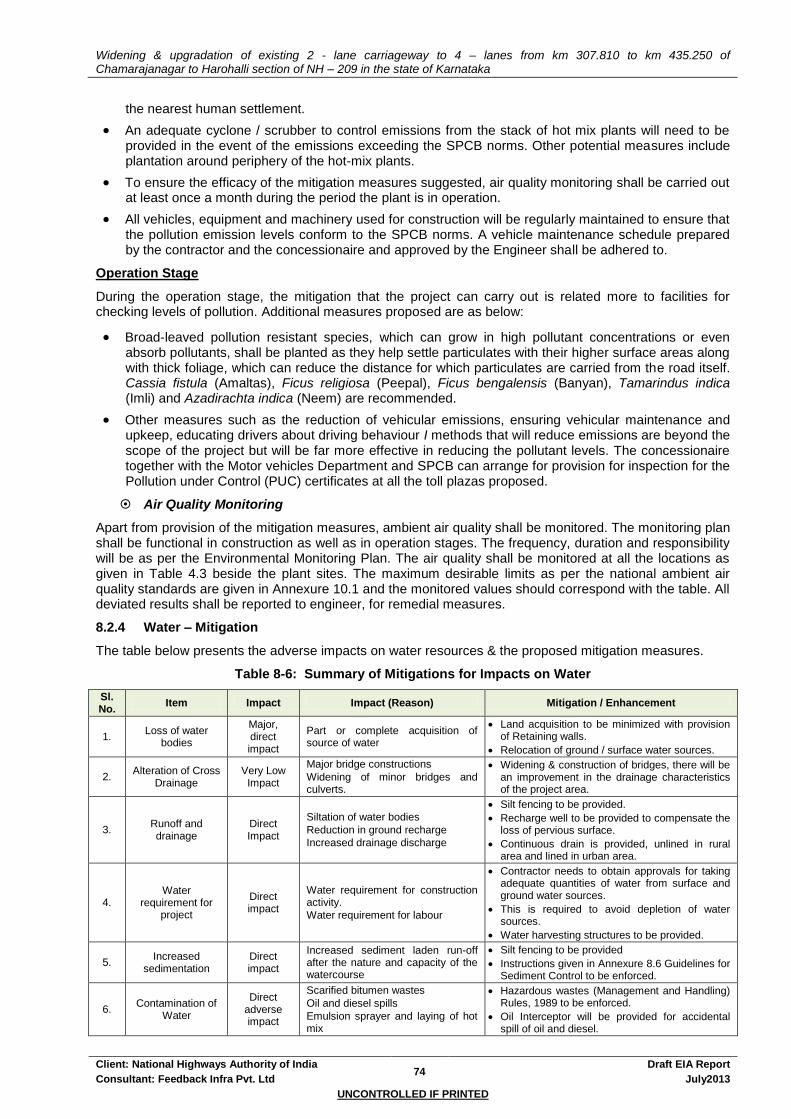
Widening & upgradation of existing 2 - lane carriageway to 4 – lanes from km 307.810 to km 435.250 of Chamarajanagar to Harohalli section of NH – 209 in the state of Karnataka
Client: National Highways Authority of India 74
Draft EIA Report
Consultant: Feedback Infra Pvt. Ltd July2013
UNCONTROLLED IF PRINTED
the nearest human settlement.
An adequate cyclone / scrubber to control emissions from the stack of hot mix plants will need to be provided in the event of the emissions exceeding the SPCB norms. Other potential measures include plantation around periphery of the hot-mix plants.
To ensure the efficacy of the mitigation measures suggested, air quality monitoring shall be carried out at least once a month during the period the plant is in operation.
All vehicles, equipment and machinery used for construction will be regularly maintained to ensure that the pollution emission levels conform to the SPCB norms. A vehicle maintenance schedule prepared by the contractor and the concessionaire and approved by the Engineer shall be adhered to.
Operation Stage
During the operation stage, the mitigation that the project can carry out is related more to facilities for checking levels of pollution. Additional measures proposed are as below:
Broad-leaved pollution resistant species, which can grow in high pollutant concentrations or even absorb pollutants, shall be planted as they help settle particulates with their higher surface areas along with thick foliage, which can reduce the distance for which particulates are carried from the road itself. Cassia fistula (Amaltas), Ficus religiosa (Peepal), Ficus bengalensis (Banyan), Tamarindus indica (Imli) and Azadirachta indica (Neem) are recommended.
Other measures such as the reduction of vehicular emissions, ensuring vehicular maintenance and upkeep, educating drivers about driving behaviour I methods that will reduce emissions are beyond the scope of the project but will be far more effective in reducing the pollutant levels. The concessionaire together with the Motor vehicles Department and SPCB can arrange for provision for inspection for the Pollution under Control (PUC) certificates at all the toll plazas proposed.
Air Quality Monitoring
Apart from provision of the mitigation measures, ambient air quality shall be monitored. The monitoring plan shall be functional in construction as well as in operation stages. The frequency, duration and responsibility will be as per the Environmental Monitoring Plan. The air quality shall be monitored at all the locations as given in Table 4.3 beside the plant sites. The maximum desirable limits as per the national ambient air quality standards are given in Annexure 10.1 and the monitored values should correspond with the table. All deviated results shall be reported to engineer, for remedial measures.
8.2.4 Water – Mitigation
The table below presents the adverse impacts on water resources & the proposed mitigation measures.
Table 8-6: Summary of Mitigations for Impacts on Water
Sl. No.
Item Impact Impact (Reason) Mitigation / Enhancement
1. Loss of water
bodies
Major, direct impact
Part or complete acquisition of source of water
Land acquisition to be minimized with provision of Retaining walls.
Relocation of ground / surface water sources.
2. Alteration of Cross
Drainage Very Low
Impact
Major bridge constructions
Widening of minor bridges and culverts.
Widening & construction of bridges, there will be an improvement in the drainage characteristics of the project area.
3. Runoff and drainage
Direct Impact
Siltation of water bodies
Reduction in ground recharge
Increased drainage discharge
Silt fencing to be provided.
Recharge well to be provided to compensate the loss of pervious surface.
Continuous drain is provided, unlined in rural area and lined in urban area.
4. Water
requirement for project
Direct impact
Water requirement for construction activity.
Water requirement for labour
Contractor needs to obtain approvals for taking adequate quantities of water from surface and ground water sources.
This is required to avoid depletion of water sources.
Water harvesting structures to be provided.
5. Increased
sedimentation Direct impact
Increased sediment laden run-off after the nature and capacity of the watercourse
Silt fencing to be provided
Instructions given in Annexure 8.6 Guidelines for Sediment Control to be enforced.
6. Contamination of
Water
Direct adverse impact
Scarified bitumen wastes
Oil and diesel spills
Emulsion sprayer and laying of hot mix
Hazardous wastes (Management and Handling) Rules, 1989 to be enforced.
Oil Interceptor will be provided for accidental spill of oil and diesel.

Widening & upgradation of existing 2 - lane carriageway to 4 – lanes from km 307.810 to km 435.250 of Chamarajanagar to Harohalli section of NH – 209 in the state of Karnataka
Client: National Highways Authority of India 75
Draft EIA Report
Consultant: Feedback Infra Pvt. Ltd July2013
UNCONTROLLED IF PRINTED
Sl. No.
Item Impact Impact (Reason) Mitigation / Enhancement
Production facilities for the labour and officers.
Routine and periodical maintenance
Rejected material will be laid as directed by IC.
Septic tank will be construction for waste disposal.
7. Water quality
monitoring
Effectiveness / shortfall (if any)
Any unforeseen impact
Measures will be revised and improved to mitigate / enhance environment due to any unforeseen impact.
Loss of Water Resources
Loss of water resources includes removal of private and community water resources like hand pumps, water taps, OHTs, ponds, well etc. The losses have been covered under the utility relocation process. Compensatory water supply sources will be set up before the start of construction with location of the new point as close to the original as possible.
Table 8-7: Water Resources – Mitigation
Sl. No. Structure Settlement Side Impact Mitigation
1 Hand Pump Mampalli RHS Yes Shall be relocated nearby
2 Hand Pump Satara RHS Yes Shall be relocated nearby
3 Hand Pump Pandithalli RHS Yes Shall be relocated nearby
4 Hand Pump Halasahalli RHS Yes Shall be relocated nearby
5 Hand Pump Honnaganahalli LHS No Shall be relocated nearby
6 Hand Pump Devegowdanadoddi LHS Yes Shall be relocated nearby
7 Hand Pump Uttampalya RHS Yes Shall be relocated nearby
8 OHT Doddammahalli LHS Yes Shall be relocated nearby
9 OHT RHS Yes Shall be relocated nearby
10 OHT Yes Shall be relocated nearby
11 OHT Kandarahalli RHS Yes Shall be relocated nearby
12 OHT Maddur RHS Yes Shall be relocated nearby
13 OHT Satara RHS No/Yes Shall be relocated nearby
14 OHT Vachanahalli LHS Yes Shall be relocated nearby
15 OHT Kollegal LHS Yes Shall be relocated nearby
16 Water Tap/Tank Vachanahalli RHS Yes Shall be relocated nearby
17 Water Tank Satnur RHS Yes Shall be relocated nearby
18 Water Tap/Tank Upkeredoddi LHS Yes Shall be relocated nearby
19 Water Tap/Tank Jakkegowdanadoddi LHS Yes Shall be relocated nearby
20 Water Tap/Tank Jakkegowdanadoddi LHS Yes Shall be relocated nearby
21 Water Taps Shivanahalli LHS Yes Shall be relocated nearby
22 Water Tap/Tank Kanakapura RHS Yes Shall be relocated nearby
23 Water Tap/Tank Tungne LHS Yes Shall be relocated nearby
24 Well RHS Yes Shall be relocated nearby
Drainage and Hydrological flow
Various rivers, streams and irrigation canals at different locations have intersected the project corridor. To facilitate the cross-drainage at these water crossings, 426 cross-drainage structures including 4 major bridges, 26 minor bridges, slab and pipe culverts are proposed. The proposed span arrangement and other particulars of the structures are provided in the Design Report.
Mitigation measures will include contractual obligations for relocation of sources of water supply at locations desired by the host community, provision of balancing culverts of adequate capacity where the level of the formation is being raised, and provision for adequately sized drains to prevent flooding etc. All these measures form a part of the good engineering practice and should be part of the design drawings
Widening & upgradation of existing 2 - lane carriageway to 4 – lanes from km 307.810 to km 435.250 of Chamarajanagar to Harohalli section of NH – 209 in the state of Karnataka
Client: National Highways Authority of India 76
Draft EIA Report
Consultant: Feedback Infra Pvt. Ltd July2013
UNCONTROLLED IF PRINTED
themselves.
To ensure efficient flow of surface water and to prevent water logging along the side of the roads, adequate size and number of cross-drainage structures have been provided
Detailed drainage surveys and hydrological investigations have been carried out and suitable design of bridges and culverts proposed
Provision of lined drains at settlement areas and unlined drains at other areas
In addition to the above design requirements, the Contractor and the Concessionaire shall ensure that during construction work the following are taken care of:
Construction work near water channels, irrigation canals and rivers have to be carried out in such a way that flow of water is not blocked and even if it has to be blocked then the contractor and the concessionaire must ensure that the local communities are informed about the same in advance. Work near the water bodies should be carried out in dry season to avoid shortage of water,
Flooding of local drainage channels,
Measures to ensure that remnants from earthwork, stonework and other waste material do not hinder the cross-drainage of rivers, nallahs,
In sections of the road near to watercourses or cross-drainage channels, the construction material waste would be disposed off in a manner not to block the flow of water.
To maintain efficient storm water flow, the roadside drains will be cleaned regularly, especially before the monsoon season.
Protection from Run off
Road run-off is let off into natural drains of adequate capacity from ditches at the end of formation to prevent destabilisation of the embankment. Release of road run-off directly from the ditches can erode edges of the water body into which the run-off is let off. Scouring of banks of flowing water bodies due to high velocity run-off is also a potential danger. To ensure that run-off does not damage the water body it enters, cascading for scour protection through stepped gabion is recommended.
Protecting Water Quality
To prevent any degradation of water quality of the various surface and ground water resources due to the proposed project, the contractor and the concessionaire shall work out the following mitigative measures during the construction period:
Provision of necessary mitigation measures at the various locations proposed in the design to prevent contamination and degradation of water quality.
Construction work close to the streams or water bodies must be avoided during monsoon.
The discharge standards promulgated under the Environmental Protection Act, 1986 will be strictly adhered to.
Impact on the river / nallah system can be minimised if the bridge construction is taken up during the lean flow season and construction work close to the water bodies avoided during monsoon.
The fuel storage and vehicle cleaning area shall be stationed at least 500m away from the nearest drain / water body
The slope of the embankments leading to water bodies shall be modified and re-channelled to prevent entry of contaminants into the water body.
Provision of silt fencing and oil interceptors the details of which are given below
Silt Fencing
Silt fencing will be provided to prevent sediments from the construction site entering into the nearby watercourses. The silt fencing consists of geo textile with extremely small size supported by a wire mesh mounted on a panel made up of angle / wooden frame and post. It is expected a single person will be able to drive the angles by pressing from the top. The frame will be installed at the edge of the water body along which construction is in progress. The number of such units to be installed can be decided depending upon the length of the water body along the side of the road construction.

Widening & upgradation of existing 2 - lane carriageway to 4 – lanes from km 307.810 to km 435.250 of Chamarajanagar to Harohalli section of NH – 209 in the state of Karnataka
Client: National Highways Authority of India 77
Draft EIA Report
Consultant: Feedback Infra Pvt. Ltd July2013
UNCONTROLLED IF PRINTED
Figure 8-1: Oil interceptor Figure 8-2: Silt Fencing
Silt fencing is proposed for a length of 1000m. This is based on the primary survey data and detailed discussions with structure engineers wherein it was found that the length shall be sufficient to cover all minor and major bridge locations and the road side water bodies. Depending on the length of the individual water body, the number of units of silt fencing to be installed is decided by the Independent Engineer.
Oil interceptor
Oil and grease from road run-off is another major concern during construction as well as operation. During construction, discharge of oil and grease is most likely from workshops, oil and waste oil storage locations, vehicle parking areas of the contractor and the concessionaires' camps. A total of 15 oil interceptors shall be provided at all such locations to arrest oil and grease, as per figure 8-2. The arrested products shall be disposed as per MoEF and SPCB guidelines. The location of all fuel storage and vehicle cleaning area will be at least 300 m from the nearest drain / water body.
Disruption to Other Users of Water during Construction
The contractor and the concessionaire will arrange for water required for construction in such a way that the water availability and supply to nearby communities remain unaffected.
If new tube-wells are to be bored, due to the non availability of water required for construction, prior sanctions and approvals by the Ground Water Department has to be obtained by the concessionaire.
Wastage of water during the construction should be minimised.
Construction over and close to any non-perennial streams shall be carried out in the dry season. Construction over irrigation canals should be carried out so as to minimise any disruption to the flows and to ensure that a high quality of water is maintained.
Water Quality Monitoring
Apart from provision of the mitigation measures, water quality shall be monitored to understand the effectiveness and further improvement in designs in reducing the concentration of pollutants. The monitoring plan shall be functional in construction as well as in operation stages. The frequency, duration and responsibility will be as per the Environmental Monitoring Plan. The water quality monitored at all the locations as given in Table 4.7. The maximum desirable limits as per the water quality standards are given in Annexure 10.1 and the monitored values should correspond with the table. All deviated results shall be reported to engineer, for remedial measures. It should be ensured that no construction camps or stockyards are set up near the irrigation canals, rivers and water channels to prevent oil spills.
Rain Water Harvesting
Rainwater harvesting structures all along the proposed alignment as per as per MoEF guidelines and are a cost effective method for recharging of ground water level in the project area. The rainwater-harvesting chamber shall be placed at every 1000m interval c/c with dimensions of 2 x 2 x 0.75m
3 all throughout the
project corridor except at urban areas. A perforated RCC Slab covers the chamber. There is a 20cm filling, which also acts as sediment trap. There is another sediment trap in the bottom from where debris can be removed manually after certain period. A vertical drain (PVC pipe) is then sunk from the bottom of the chamber to a depth which varies as per the water table. However the Rain water harvesting pit should be at least 3 - 5 m. above the highest ground water table. Drains interconnect these chambers.
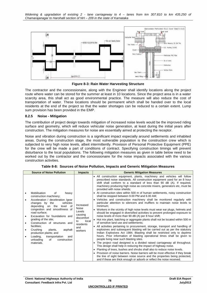
Widening & upgradation of existing 2 - lane carriageway to 4 – lanes from km 307.810 to km 435.250 of Chamarajanagar to Harohalli section of NH – 209 in the state of Karnataka
Client: National Highways Authority of India 78
Draft EIA Report
Consultant: Feedback Infra Pvt. Ltd July2013
UNCONTROLLED IF PRINTED
Figure 8-3: Rain Water Harvesting Structure
The contractor and the concessionaire, along with the Engineer shall identify locations along the project route where water can be stored for the summer at least in 10 locations. Since the project area is in a water scarcity area, this shall act as good environmental practice. The measure will also reduce the cost of transportation of water. These locations should be permanent which shall be handed over to the local residents at the end of the project so that the water shortages can be reduced to a certain extent. Lump sum provision has been provided in the EMP.
8.2.5 Noise - Mitigation
The contribution of project design towards mitigation of increased noise levels would be the improved riding surface and geometry, which will reduce vehicular noise generation, at least during the initial years after construction. The mitigation measures for noise are essentially aimed at protecting the receptor.
Noise and vibration during construction is a significant impact especially around settlements and inhabited areas. During the construction stage, the most vulnerable population is the construction crew which is subjected to very high noise levels, albeit intermittently. Provision of Personal Protective Equipment (PPE) for the crew will be made a part of conditions of contract. Specifying construction timings will prevent disturbance to the local populations. The following mitigation measures as given in table below need to be worked out by the contractor and the concessionaire for the noise impacts associated with the various construction activities.
Table 8-8: Sources of Noise Pollution, Impacts and Generic Mitigation Measures
Source of Noise Pollution Impacts Generic Mitigation Measures
Mobilisation of heavy construction machinery;
Acceleration / deceleration /gear changes by the vehicles depending on the level of congestion and smoothness of road surface;
Excavation for foundations and grading of the site;
Construction of structures and facilities;
Crushing plants, asphalt production plants; and
Loading, transportation and unloading of construction materials.
Increased Noise Levels causing discomfort to local residents and workers
All construction equipment, plants, machinery and vehicles will follow prescribed noise standards. All construction equipment used for an 8 hour shift shall conform to a standard of less than 90 dB (A). If required, machinery producing high noise as concrete mixers, generators etc, must be provided with noise shields;
At construction sites within 500 m of human settlements, noisy construction shall be stopped between 9.00 PM and 6.00 AM;
Vehicles and construction machinery shall be monitored regularly with particular attention to silencers and mufflers to maintain noise levels to minimum;
Workers in the vicinity of high noise levels must wear ear plugs, helmets and should be engaged in diversified activities to prevent prolonged exposure to noise levels of more than 90 dB (A) per 8 hour shift;
Hot mix plant, batching or aggregate plants shall not be located within 500 m of sensitive land use and settlements;
All activities pertaining to procurement, storage, transport and handling of explosives and subsequent blasting will be carried out as per the statutory Indian Explosives Act 1984. Blasting shall be restricted only to daytime hours. Prior information of blasting operational times shall be given to people living near such blasting sites.
The project road designed is a divided raised carriageway all throughout. This design shall help in reducing the impact of highway noise.
Planting of trees, bushes and shrubs shall also to reduce noise levels.
Provision of noise barriers. Noise barriers will be most effective if they break the line of sight between noise source and the properties being protected, and if these are thick enough or adsorb or reflect the noise received.

Widening & upgradation of existing 2 - lane carriageway to 4 – lanes from km 307.810 to km 435.250 of Chamarajanagar to Harohalli section of NH – 209 in the state of Karnataka
Client: National Highways Authority of India 79
Draft EIA Report
Consultant: Feedback Infra Pvt. Ltd July2013
UNCONTROLLED IF PRINTED
Table 8-9: Specific Noise Mitigation Measures
Sl. No.
Item Impact Reason Mitigation / Enhancement
1. Sensitive receptors Direct impact
Increase in noise pollution
Man, material and machinery movements.
Noise barrier to be provided
Traffic calming devises to be used.
No Horn Zone sign Post.
2a. Noise Pollution (Pre-Construction Stage)
Direct impact, short duration
Establishment of labour camps, onsite offices, stock yards and construction plants
Area specific and for short duration.
Machinery to be checked and complied with noise pollution regulations.
Camps to be setup away from the settlements, in the down wind direction
2b. Noise Pollution
(Construction Stage) Marginal Impact
Stone crushing, asphalt production plant and batching plants, diesel generators etc.
Community residing near to the work zones.
Camps to be setup away from the settlements, in the down wind direction.
Noise pollution regulation to be monitored and enforced.
Temporary as the work zones will be changing with completion of construction.
2c. Noise Pollution
(Operation Stage) Marginal Impact
Due to increase in traffic (due to improved facility)
Will be compensated with the uninterrupted movement of heavy and light vehicles
3. Noise Pollution
Monitoring -
Effectiveness / shortfall (if any) Any unforeseen impact
Measures will be revised and improved to mitigate / enhance environment due to any unforeseen impact.
Figure 8-4: Compound Wall and Trees as Noise Barrier
To reduce noise and vibrations, noise barriers in the form of compound wall is proposed. In case of space crunch, the use of concrete screens is also suggested. However the concessionaire shall identify such areas where concrete screens shall be used. The noise barrier wall shall be constructed by excavation of foundation, laying of brick masonry wall up to a height of 2m above ground, plastering and coping as per the direction of the engineer and as laid in the specification. Creepers and paints shall be used in consultation with the affected community to give an aesthetic look. Shade and flowering trees shall be planted within the boundary of the sensitive receptor, between the building line and the compound wall, wherever space shall be available, 5m centre to centre. Figure 8.4 shows the combination of compound wall and trees which shall be used as noise barrier.
Table 8-10: Noise Impact on Sensitive Receptors and Mitigation
Sl. No
Distance from C/L
Existing
Structure Name
Settlement Side Affected
Area Length
Mitigation
1 15 Forest Department Yelandur LHS 150
Noise Barrier shall be provided
2 20 School Yelandur LHS Noise Barrier
3 Police Station Yelandur LHS Noise Barrier
4 15 School Uttampalya LHS 20 Noise Barrier
5 30 School Kollegal LHS 50 Noise Barrier
6 10 School Pandithalli RHS 20 Noise Barrier
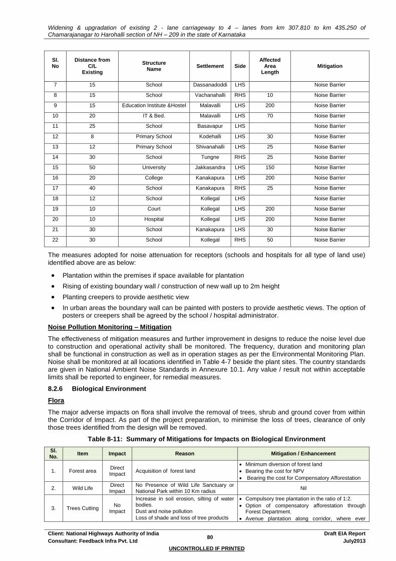
Widening & upgradation of existing 2 - lane carriageway to 4 – lanes from km 307.810 to km 435.250 of Chamarajanagar to Harohalli section of NH – 209 in the state of Karnataka
Client: National Highways Authority of India 80
Draft EIA Report
Consultant: Feedback Infra Pvt. Ltd July2013
UNCONTROLLED IF PRINTED
Sl. No
Distance from C/L
Existing
Structure Name
Settlement Side Affected
Area Length
Mitigation
7 15 School Dassanadoddi LHS Noise Barrier
8 15 School Vachanahalli RHS 10 Noise Barrier
9 15 Education Institute &Hostel Malavalli LHS 200 Noise Barrier
10 20 IT & Bed. Malavalli LHS 70 Noise Barrier
11 25 School Basavapur LHS Noise Barrier
12 8 Primary School Kodehalli LHS 30 Noise Barrier
13 12 Primary School Shivanahalli LHS 25 Noise Barrier
14 30 School Tungne RHS 25 Noise Barrier
15 50 University Jakkasandra LHS 150 Noise Barrier
16 20 College Kanakapura LHS 200 Noise Barrier
17 40 School Kanakapura RHS 25 Noise Barrier
18 12 School Kollegal LHS Noise Barrier
19 10 Court Kollegal LHS 200 Noise Barrier
20 10 Hospital Kollegal LHS 200 Noise Barrier
21 30 School Kanakapura LHS 30 Noise Barrier
22 30 School Kollegal RHS 50 Noise Barrier
The measures adopted for noise attenuation for receptors (schools and hospitals for all type of land use) identified above are as below:
Plantation within the premises if space available for plantation
Rising of existing boundary wall / construction of new wall up to 2m height
Planting creepers to provide aesthetic view
In urban areas the boundary wall can be painted with posters to provide aesthetic views. The option of posters or creepers shall be agreed by the school / hospital administrator.
Noise Pollution Monitoring – Mitigation
The effectiveness of mitigation measures and further improvement in designs to reduce the noise level due to construction and operational activity shall be monitored. The frequency, duration and monitoring plan shall be functional in construction as well as in operation stages as per the Environmental Monitoring Plan. Noise shall be monitored at all locations identified in Table 4-7 beside the plant sites. The country standards are given in National Ambient Noise Standards in Annexure 10.1. Any value / result not within acceptable limits shall be reported to engineer, for remedial measures.
8.2.6 Biological Environment
Flora
The major adverse impacts on flora shall involve the removal of trees, shrub and ground cover from within the Corridor of Impact. As part of the project preparation, to minimise the loss of trees, clearance of only those trees identified from the design will be removed.
Table 8-11: Summary of Mitigations for Impacts on Biological Environment
Sl. No.
Item Impact Reason Mitigation / Enhancement
1. Forest area Direct Impact
Acquisition of forest land
Minimum diversion of forest land
Bearing the cost for NPV
Bearing the cost for Compensatory Afforestation
2. Wild Life Direct Impact
No Presence of Wild Life Sanctuary or National Park within 10 Km radius
Nil
3. Trees Cutting No
Impact
Increase in soil erosion, silting of water bodies.
Dust and noise pollution
Loss of shade and loss of tree products
Compulsory tree plantation in the ratio of 1:2.
Option of compensatory afforestation through Forest Department.
Avenue plantation along corridor, where ever

Widening & upgradation of existing 2 - lane carriageway to 4 – lanes from km 307.810 to km 435.250 of Chamarajanagar to Harohalli section of NH – 209 in the state of Karnataka
Client: National Highways Authority of India 81
Draft EIA Report
Consultant: Feedback Infra Pvt. Ltd July2013
UNCONTROLLED IF PRINTED
Sl. No.
Item Impact Reason Mitigation / Enhancement
possible.
Identification of incidental spaces (ox bow areas) for group plantation.
Transplantation of trees also explored.
4. Vegetation Direct Impact
Increase in soil erosion, silting of water bodies, noise pollution, dust pollution
Clearing and grubbing will be minimised, and sprinkled with water to reduce dust pollution.
Exposed surface like embankment slopes will be protected with stone pitching and turfing.
Open land in and around plant will be vegetated.
5. Cattle
Grazing No
impact No cattle grazing found Nil
Forest Areas - Mitigation
10.3000Ha of forest land has been proposed for diversion to accommodate the proposed project. The forest areas fall the jurisdiction of Ramanagara & Mandya Division of Karnataka Forest Division. Best effort has been made in various stages to minimize the figure to avoid significant impact on forest land. However, for the stretches located near the forest areas, the contractor and the concessionaire shall ensure that the construction activities shall be limited to the proposed ROW, so as to avoid any further impacts on the vegetation. The measures for avoiding / mitigating adverse impacts on the forest stretches are given below:
No construction camp shall be allowed within the designate limits of the forest areas and within 1km from their boundaries.
No earthworks or surfacing permitted along stretches of road within these areas after sundown. No workmen allowed shall be allowed to stay within the areas after sundown except with adequate supervision.
As far as possible, concreting along the stretch of road within the areas to be planned such that work after sundown is avoided or kept to the absolute minimum. Wherever this is unavoidable, the Engineer’s Environmental staff shall remain present at site.
No disposal of debris shall be allowed within these areas except at locations identified during project preparation.
Savings of Trees
Total trees present within the proposed ROW are 3000
Total trees within the proposed alignment and that needs to be felled are 2431
Thus saving of 569 trees of various species above 30cm girth
Transplantation
In order to minimise the negative impact of tree felling, it is proposed to transplant a minimum of 1/3rd
of trees proposed for felling.
Thus 811 trees are proposed for transplantation and the cost has been budgeted.
However, a budget for 4862 (twice the number of 2431 trees likely to be affected) have been considered for compensatory afforestation purpose.
The concessionaire to identify trees that can be transplanted and adopt methodology for transplantation. The methodology shall be approved by the IE and NHAI
Avenue and Block Plantation
Avenue plantation along corridor, where ever possible given to compensate the loss of trees due to felling.
The plantation scheme shall involve a plantation contractor who shall supply and maintain the plantation as per details given in Annexure 8.7: Tree Plantation Strategy.
Native indigenous trees species shall be used as far as practicable, strictly avoiding any exotic (but popular) species like Eucalyptus sp. that can have far-reaching adverse effects on the ecology and water regime of the area.
Endeavour to initiate plantations before the construction is complete so that the trees are at least a year or two old when the project is completed.
The concessionaire shall work out the number of trees to be planted around junctions and for
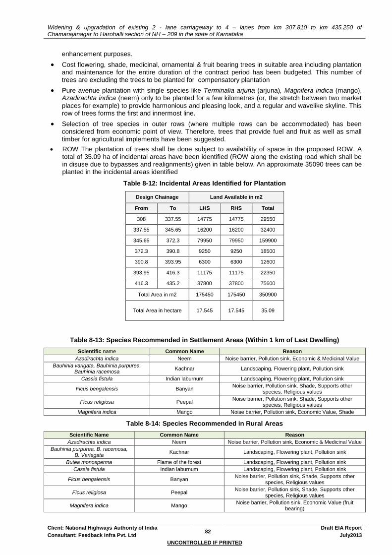
Widening & upgradation of existing 2 - lane carriageway to 4 – lanes from km 307.810 to km 435.250 of Chamarajanagar to Harohalli section of NH – 209 in the state of Karnataka
Client: National Highways Authority of India 82
Draft EIA Report
Consultant: Feedback Infra Pvt. Ltd July2013
UNCONTROLLED IF PRINTED
enhancement purposes.
Cost flowering, shade, medicinal, ornamental & fruit bearing trees in suitable area including plantation and maintenance for the entire duration of the contract period has been budgeted. This number of trees are excluding the trees to be planted for compensatory plantation
Pure avenue plantation with single species like Terminalia arjuna (arjuna), Magnifera indica (mango), Azadirachta indica (neem) only to be planted for a few kilometres (or, the stretch between two market places for example) to provide harmonious and pleasing look, and a regular and wavelike skyline. This row of trees forms the first and innermost line.
Selection of tree species in outer rows (where multiple rows can be accommodated) has been considered from economic point of view. Therefore, trees that provide fuel and fruit as well as small timber for agricultural implements have been suggested.
ROW The plantation of trees shall be done subject to availability of space in the proposed ROW. A total of 35.09 ha of incidental areas have been identified (ROW along the existing road which shall be in disuse due to bypasses and realignments) given in table below. An approximate 35090 trees can be planted in the incidental areas identified
Table 8-12: Incidental Areas Identified for Plantation
Design Chainage Land Available in m2
From To LHS RHS Total
308 337.55 14775 14775 29550
337.55 345.65 16200 16200 32400
345.65 372.3 79950 79950 159900
372.3 390.8 9250 9250 18500
390.8 393.95 6300 6300 12600
393.95 416.3 11175 11175 22350
416.3 435.2 37800 37800 75600
Total Area in m2 175450 175450 350900
Total Area in hectare 17.545 17.545 35.09
Table 8-13: Species Recommended in Settlement Areas (Within 1 km of Last Dwelling)
Scientific name Common Name Reason
Azadirachta indica Neem Noise barrier, Pollution sink, Economic & Medicinal Value
Bauhinia varigata, Bauhinia purpurea, Bauhinia racemosa
Kachnar Landscaping, Flowering plant, Pollution sink
Cassia fistula Indian laburnum Landscaping, Flowering plant, Pollution sink
Ficus bengalensis Banyan Noise barrier, Pollution sink, Shade, Supports other
species, Religious values
Ficus religiosa Peepal Noise barrier, Pollution sink, Shade, Supports other
species, Religious values
Magnifera indica Mango Noise barrier, Pollution sink, Economic Value, Shade
Table 8-14: Species Recommended in Rural Areas
Scientific Name Common Name Reason
Azadirachta indica Neem Noise barrier, Pollution sink, Economic & Medicinal Value
Bauhinia purpurea, B. racemosa, B. Variegata
Kachnar Landscaping, Flowering plant, Pollution sink
Butea monosperma Flame of the forest Landscaping, Flowering plant, Pollution sink
Cassia fistula Indian laburnum Landscaping, Flowering plant, Pollution sink
Ficus bengalensis Banyan Noise barrier, Pollution sink, Shade, Supports other
species, Religious values
Ficus religiosa Peepal Noise barrier, Pollution sink, Shade, Supports other
species, Religious values
Magnifera indica Mango Noise barrier, Pollution sink, Economic Value (fruit
bearing)
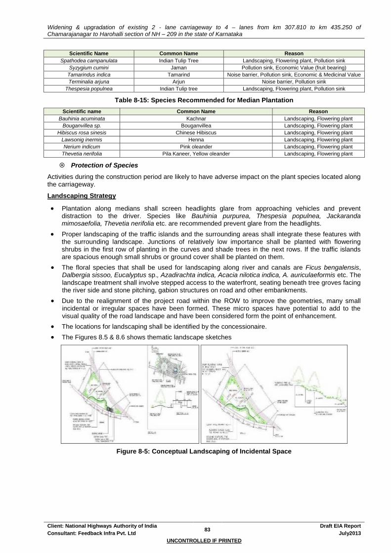
Widening & upgradation of existing 2 - lane carriageway to 4 – lanes from km 307.810 to km 435.250 of Chamarajanagar to Harohalli section of NH – 209 in the state of Karnataka
Client: National Highways Authority of India 83
Draft EIA Report
Consultant: Feedback Infra Pvt. Ltd July2013
UNCONTROLLED IF PRINTED
Scientific Name Common Name Reason
Spathodea campanulata Indian Tulip Tree Landscaping, Flowering plant, Pollution sink
Syzygium cumini Jaman Pollution sink, Economic Value (fruit bearing)
Tamarindus indica Tamarind Noise barrier, Pollution sink, Economic & Medicinal Value
Terminalia arjuna Arjun Noise barrier, Pollution sink
Thespesia populnea Indian Tulip tree Landscaping, Flowering plant, Pollution sink
Table 8-15: Species Recommended for Median Plantation
Scientific name Common Name Reason
Bauhinia acuminata Kachnar Landscaping, Flowering plant
Bouganvillea sp. Bouganvillea Landscaping, Flowering plant
Hibiscus rosa sinesis Chinese Hibiscus Landscaping, Flowering plant
Lawsonig inermis Henna Landscaping, Flowering plant
Nerium indicum Pink oleander Landscaping, Flowering plant
Thevetia nerifolia Pila Kaneer, Yellow oleander Landscaping, Flowering plant
Protection of Species
Activities during the construction period are likely to have adverse impact on the plant species located along the carriageway.
Landscaping Strategy
Plantation along medians shall screen headlights glare from approaching vehicles and prevent distraction to the driver. Species like Bauhinia purpurea, Thespesia populnea, Jackaranda mimosaefolia, Thevetia nerifolia etc. are recommended prevent glare from the headlights.
Proper landscaping of the traffic islands and the surrounding areas shall integrate these features with the surrounding landscape. Junctions of relatively low importance shall be planted with flowering shrubs in the first row of planting in the curves and shade trees in the next rows. If the traffic islands are spacious enough small shrubs or ground cover shall be planted on them.
The floral species that shall be used for landscaping along river and canals are Ficus bengalensis, Dalbergia sissoo, Eucalyptus sp., Azadirachta indica, Acacia nilotica indica, A. auriculaeformis etc. The landscape treatment shall involve stepped access to the waterfront, seating beneath tree groves facing the river side and stone pitching, gabion structures on road and other embankments.
Due to the realignment of the project road within the ROW to improve the geometries, many small incidental or irregular spaces have been formed. These micro spaces have potential to add to the visual quality of the road landscape and have been considered form the point of enhancement.
The locations for landscaping shall be identified by the concessionaire.
The Figures 8.5 & 8.6 shows thematic landscape sketches
Figure 8-5: Conceptual Landscaping of Incidental Space
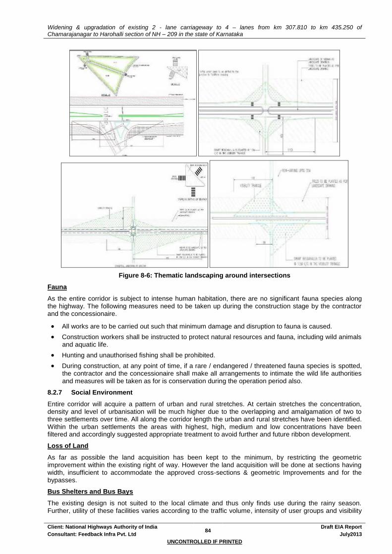
Widening & upgradation of existing 2 - lane carriageway to 4 – lanes from km 307.810 to km 435.250 of Chamarajanagar to Harohalli section of NH – 209 in the state of Karnataka
Client: National Highways Authority of India 84
Draft EIA Report
Consultant: Feedback Infra Pvt. Ltd July2013
UNCONTROLLED IF PRINTED
Figure 8-6: Thematic landscaping around intersections
Fauna
As the entire corridor is subject to intense human habitation, there are no significant fauna species along the highway. The following measures need to be taken up during the construction stage by the contractor and the concessionaire.
All works are to be carried out such that minimum damage and disruption to fauna is caused.
Construction workers shall be instructed to protect natural resources and fauna, including wild animals and aquatic life.
Hunting and unauthorised fishing shall be prohibited.
During construction, at any point of time, if a rare / endangered / threatened fauna species is spotted, the contractor and the concessionaire shall make all arrangements to intimate the wild life authorities and measures will be taken as for is conservation during the operation period also.
8.2.7 Social Environment
Entire corridor will acquire a pattern of urban and rural stretches. At certain stretches the concentration, density and level of urbanisation will be much higher due to the overlapping and amalgamation of two to three settlements over time. All along the corridor length the urban and rural stretches have been identified. Within the urban settlements the areas with highest, high, medium and low concentrations have been filtered and accordingly suggested appropriate treatment to avoid further and future ribbon development.
Loss of Land
As far as possible the land acquisition has been kept to the minimum, by restricting the geometric improvement within the existing right of way. However the land acquisition will be done at sections having width, insufficient to accommodate the approved cross-sections & geometric Improvements and for the bypasses.
Bus Shelters and Bus Bays
The existing design is not suited to the local climate and thus only finds use during the rainy season. Further, utility of these facilities varies according to the traffic volume, intensity of user groups and visibility

Widening & upgradation of existing 2 - lane carriageway to 4 – lanes from km 307.810 to km 435.250 of Chamarajanagar to Harohalli section of NH – 209 in the state of Karnataka
Client: National Highways Authority of India 85
Draft EIA Report
Consultant: Feedback Infra Pvt. Ltd July2013
UNCONTROLLED IF PRINTED
of the moving traffic from the bus stop and comfort conditions within the bus stop. In places where bus stops already exist, changes should be incorporated to increase the utility of these structures:
Bus shelters are proposed near to residences to minimise walking distance.
It should be positioned in straight and level sections of road and should be visible from a long distance in both directions.
Bus bays are proposed as per the recommendations of IRC: 80-1981.
Bus bays with bus shelters are being provided at a total of XX locations. These locations are given in Annexure 2.1.
New bus stops would be provided with shade, benches and railings.
Interpretative signage would be displayed in Hindi and English that could deliver information about the bus numbers, origin & destination and routes of buses.
Rest areas
Roadside rest areas are intended for rest and relaxation intended for long distance travellers, and may occasionally provide facilities for overnight stay also:
Parking facility shall be provided. Vehicle parking lay-by shall be provided at the frontage of these locations.
Based on the location and availability of space landscaping shall comprise of walkways and soft landscaped areas and outdoor seating spaces. Shade and fruit trees as well as flowering shrubs are proposed in the rest areas.
The project proposes to provide the minimum required public conveniences such as toilets and drinking water facilities at each of the rest areas.
Restaurant with outdoor and indoor seating spaces, Fast food joints, General stores, Chemists / medicine shops, STD / PCO and Vehicle repairing shops shall be proposed
The locations of rest areas shall be advertised through signboards and overhead signs in advance.
Truck lay byes
The lay-byes have been proposed where congestion of heavy commercial vehicles was observed. An additional pavement on both sides (but alternating with each other) shall be developed so that the flow of traffic in carriageway is not obstructed. The locations of the proposed truck lay byes are given in table 2-17.
Landscaping shall comprise primarily of shade trees. Ornamental trees, shade trees and shrubs shall be planted in order to develop the area aesthetically. Trees shall be planted to define the length of the lay-by on its outer side as also depending on availability of space
The minimum required public conveniences such as toilets, bathing spaces and drinking water facility shall be proposed at these locations.
Chemists / medicine shops, STD / PCO and Vehicle repairing shops shall be proposed
The locations of rest areas shall be advertised through signboards and overhead signs in advance.
Community / Cultural Resources
The project proposes the relocation I replacement of all community resources likely to be impacted. Apart from replacing these community resources along the highway generic enhancement measures have been worked out for the enhancement of these resources.
Table 8-16: Mitigation for Cultural & Community Properties
Sl. No. Distance from C/L (Existing)
Structure
Name Settlement Side Mitigation
1 25 Church Vasagapura RHS relocation I replacement
2 8 Mosque Yelandur RHS relocation I replacement
3 8 Temple Yelandur LHS relocation I replacement
4 15 Temple Mampalli RHS relocation I replacement
5 25 Temple Pandithalli RHS relocation I replacement
6 20 Temple Malavalli RHS relocation I replacement
7 15 Temple Malavalli LHS relocation I replacement
8 10 Mosque Halagur RHS relocation I replacement
9 9 Mosque Halagur RHS relocation I replacement
10 10 Temple Shivanahalli LHS relocation I replacement

Widening & upgradation of existing 2 - lane carriageway to 4 – lanes from km 307.810 to km 435.250 of Chamarajanagar to Harohalli section of NH – 209 in the state of Karnataka
Client: National Highways Authority of India 86
Draft EIA Report
Consultant: Feedback Infra Pvt. Ltd July2013
UNCONTROLLED IF PRINTED
Sl. No. Distance from C/L (Existing)
Structure
Name Settlement Side Mitigation
11 15 Temple Kanakapura LHS relocation I replacement
12 20 Mazaar Malavalli LHS relocation I replacement
13 5 Temple Mampalli RHS relocation I replacement
14 15 Temple RHS relocation I replacement
15 8 Temple (small) RHS relocation I replacement
16 8 Temple (small) Jakkegowdanadoddi RHS relocation I replacement
17 8 Temple (small) K. Doddi LHS relocation I replacement
18 7 Temple (small) Shivanahalli LHS relocation I replacement
19 5 Temple Kanakapura RHS relocation I replacement
20 15 Temple Kanakapura RHS relocation I replacement
21 12 Temple (Small) Jakkasandra LHS relocation I replacement
22 7 Temple (small) Harohalli RHS relocation I replacement
23 10 Mosque Kaglipura RHS relocation I replacement
24 15 Temple Kaglipura RHS relocation I replacement
25 12 Temple Kollegal RHS relocation I replacement
26 12 Mazaar Kollegal LHS relocation I replacement
Disruption to the Community
Loss of Access
The Concessionaire & Contractor shall provide safe and convenient passage for vehicles, pedestrians and livestock to and from side roads and property access connecting the project road. The construction activities that shall affect the use of side roads and existing access to individual properties shall not be undertaken without providing adequate provisions. The construction works will not interfere with the convenience of the public or the access to, use and occupation of public or private roads whether public or private.
Traffic Control during Construction
Detailed Traffic Control Plans will be prepared prior to commencement of works on any section of the project road by the Concessionaire. These plans shall be approved by the IC and or the site office of the NHAI prior to execution. The traffic control plans will contain details of temporary diversions details of arrangements for construction under traffic and details of traffic arrangement after cessation of work each day.
Temporary diversion (including scheme of temporary and acquisition) will be constructed with the approval of the Engineer. Special consideration will be given in the preparation of the traffic control plan to the safety of pedestrians and workers at night.
The Contractor and the Concessionaire will ensure that the running surface is always properly maintained, particularly during the monsoon so that no disruption to the traffic flow occurs. The temporary traffic detours will be kept free of dust by frequent application of water, if necessary.
The Contractor and the Concessionaire will take all necessary measures for the safety of traffic during construction and provide, erect and maintain such barricades, including signs, markings, flags, lights and flagmen as may be required by the Engineer for the information and protection of traffic approaching or passing through the section of the highway under improvement. Annexure 8.8: Traffic Control and Safety during Construction gives the details of the road safety measured to be adopted during construction.
Risks Associated - Mitigation
The Contractor and the Concessionaire is required to comply with all the precautions as required for the safety of the workmen as per the International Labour Organisation (ILO) Convention No.62 as far as those are applicable to this contract. The contractor and the concessionaire will supply all necessary safety appliances such as safety goggles, helmets, masks, etc., to the workers and staff. The contractor and the concessionaire has to comply with all regulation regarding sage scaffolding, ladders, working platforms, gangway, stairwells, excavations, trenches and safe means of entry and egress.
Risk from Electrical Equipment
Adequate precautions will be taken to prevent danger from electrical equipment. No material or any of the sites will be so stacked or placed as to cause danger or inconvenience to any person or the public. All necessary fencing and lights will be provided to protect the public. All machines to be used in the construction will conform to the relevant Indian Standards (IS) codes, will be free from patent defect, will be

Widening & upgradation of existing 2 - lane carriageway to 4 – lanes from km 307.810 to km 435.250 of Chamarajanagar to Harohalli section of NH – 209 in the state of Karnataka
Client: National Highways Authority of India 87
Draft EIA Report
Consultant: Feedback Infra Pvt. Ltd July2013
UNCONTROLLED IF PRINTED
kept in good working order, will be regularly inspected and properly maintained as per IS provision and to the satisfaction of the Engineer.
Risk at Hazardous Activity
All workers employed on mixing asphaltic material, cement, lime mortars, concrete etc, will be provided with protective footwear and protective goggles. Workers, who are engaged in welding works, would be provided with welder’s protective eye-shields. Stonebreakers will be provided with protective goggles and clothing and will be seated at sufficiently safe intervals. The use of any toxic chemical, if any will be strictly in accordance with the manufacturer’s instructions. The Engineer will be given at least 6 working day’s notice of the proposed use of any toxic chemical. A register of all toxic chemicals delivered to the site will be kept and maintained up to date by the Contractor and the concessionaire. The register will include the trade name, physical properties and characteristics, chemical ingredients, health and safety hazard information, handling and storage procedures, and emergency and first and procedures for the product.
Risk of Lead Pollution
No man below the age of 18 years and mo woman will be employed on the work of painting with products containing lead in any form. No paint containing lead or lead products will be used except in the form of paste or readymade paint. Face masks will be supplied for use by the workers when paint is applied in the form of spray or a surface having lead paint dry rubbed and scrapped.
Risk caused by Force’ Majure
All reasonable precaution will be taken to prevent danger of the workers and the public from fire, flood, frowning, etc. All necessary steps will be taken for prompt first aid treatment of all injuries likely to be sustained during the course of work.
Risk from Explosives
The contractor and the concessionaire will not use explosives except as may be provided in the contract or ordered or authorized by the Engineer. Where the use of explosives is so provided or ordered or authorized, the Contractor and the concessionaire will comply with the requirements of the following sub-clauses of this clause besides the law of the land as applicable. The Contractor and the concessionaire will at all times take every possible precaution and will comply with appropriate laws and regulations relating to the importation, handling, transportation, storage and use of explosives and will, at all times when engaged in blasting operations, post sufficient warning flagmen, to the full satisfaction of the Engineer. The Contractor and the concessionaire will at all times make full liaison with and inform well in advance and obtain such permission as is required from all government authorities, public bodies and private parties whatsoever concerned or affected or likely to be concerned or affected by blasting operations.
Malarial Risk
The Contractor and the concessionaire will, at his own expense, conform to all anti-malarial instructions given to him by the Engineer; including filling up any borrow pits which may have been dug by him. Gravid, blood-laden mosquitoes cannot fly very far, so they generally bite within a kilometre or so of their breeding place. Thus borrow pits and any other water bodies created during the construction process will be situated 1 to 2km away from the human settlements. Pits dug up closer than these will be adequately drained to prevent water logging. Similarly compensatory measures for filling up part of the water bodies situated adjacent to the project corridors will be directed towards deepening of the water bodies concerned. This way the capacity of the water body remains the same, while water surface available for breeding of mosquitoes is reduced. This will have an additional advantage of decreased evaporation losses, which will be important in the water-scarce project corridor.
First Aid
At every workplace, a readily available first and unit including an adequate supply of sterilised dressing material and appliances will be provided as per the Factory Rules. Workplaces remote and far away from regular hospitals will have indoor heath units with one bed for every 250 workers. Suitable transport will be provided to facilitate take injured or ill person(s) to the nearest applicable hospital. At every workplace an ambulance room containing the prescribed equipment and nursing staff will be provided as prescribed.
Potable Water
In every workplace at suitable and easily accessible places a sufficient supply of cold potable water (as per IS) will be provided and maintained. If the drinking water is obtained from an intermittent public water supply then, storage tanks will be provided. All water supply storage will be at a distance of not less than 15m from any latrine, drain or other source of pollution. Where water has to be drawn from an existing well, which is
Widening & upgradation of existing 2 - lane carriageway to 4 – lanes from km 307.810 to km 435.250 of Chamarajanagar to Harohalli section of NH – 209 in the state of Karnataka
Client: National Highways Authority of India 88
Draft EIA Report
Consultant: Feedback Infra Pvt. Ltd July2013
UNCONTROLLED IF PRINTED
within such proximity of any latrine, drain or any other source of pollution, the well will be properly chlorinated before water is drawn from it for drinking water. All such wells will be entirely closed in and be provided with a trap door, which will be dust proof and waterproof. A reliable pump will be fitted to each covered well. The trap door will be kept locked and opened only for cleaning or inspection, which will be done at least once a month.
Hygiene
The Contractor and the concessionaire during the progress of work will provide, erect and maintain necessary (temporary) living accommodation and ancillary facilities for labour to standards and scales approved by the resident engineer. Refer Annexure 8.9: Guidelines For Sitting And Layout Of Construction Camp.
There will be provided within the precincts of every workplace, latrines and urinals in an accessible place, and the accommodation, separately for each for these, as per standards set by the Building and other Construction Workers (regulation of Employment and Conditions of service) Act, 1996. Except in workplaces provided with water-flushed latrines connected with a water borne sewage system, all latrines will be provided with dry-earth system (receptacles) which will be cleaned at least four times daily and at least twice during working hours and kept in a strict sanitary condition. Receptacles will be tarred inside and outside at least once a year. If women are employed, separate latrines and urinals, screened from those for men and marked Woman in vernacular will be provided. There will be adequate supply of water, close to latrines and urinals.
All temporary accommodation must be constructed and maintained in such a fashion that uncontaminated water is available for drinking, cooking and washing. The sewage system for the camp must be properly designed, built and operated so that no health hazard occurs and no pollution to the air, ground or adjacent watercourses take place. Compliance with the relevant legislation must be strictly adhered to. Garbage bins must be provided in the camp and regularly emptied and the garbage disposed off in a hygienic manner. Construction camps are to be sited away from vulnerable people and adequate health care is to be provided for the work force. Unless otherwise arranged for by the local sanitary authority, arrangement for proper disposal of excreta by incineration at the workplace will be made by means of a suitable incinerator approved by the local medical health or municipal authorities. Alternatively, excreta may be disposed off by putting a layer of night soils at the bottom of a permanent tank prepared for the purpose and covering it with 15 cm layer of waste or refuse and then covering it with a layer of earth for a fortnight (by then it will turn into manure). On completion of the works, the whole of such temporary structures will be cleared away, all rubbish burnt, excreta or other disposal pits or trenches filled in and effectively scaled off and the whole of the site left clean and tidy, at the contractor and the concessionaire’s expense, to the entire satisfaction of the Engineer.
8.3 ENHANCEMENT
8.3.1 Generic Enhancement Measures for Cultural Properties
The project strives to improve the experience of highway travelling by strengthening the physical link between the corridor and the cultural properties falling along the road. Depending upon site-specific situations the project strives to improve the access to these properties by providing walkway to the property from the highway. Locally available materials like stone and bricks have been preferred for paving. CC flooring also shall be adopted for ground treatment. At places plantation shall be used in addition to hard landscaping measures to define precinct boundaries.
8.3.1.1 Plantation
Trees not only enrich the visual quality of a space but also act as functional buffer screens to counter pollution, define areas and provide shade. Plantation of trees has been a prime enhancement as well as mitigation measure in the project. Tree bases have been proposed around existing as well as proposed shade trees to form informal seating spaces, which are evidently preferred to the formal seating spaces. At cultural and religious properties locations, trees with religious significance like Ficus religiosa (Pipal) Emblica officinalis (Amia), F. bengalensis (Banyan), Azadirachta indica (Neem), Magnifera indica (mango), and Anthocephalus cadamba (Kadam) shall be planted. Seating arrangement as given below shall be adopted depending upon site conditions.
8.3.1.2 Seating Spaces
Creating formal and / or informal seating spaces and rest areas where feasible and as per the scale of the property in question were tried. In the case of availability of space, cultural properties if coupled with rest areas will prove to be beneficial not only to the highway travellers but also the users of the religious

Widening & upgradation of existing 2 - lane carriageway to 4 – lanes from km 307.810 to km 435.250 of Chamarajanagar to Harohalli section of NH – 209 in the state of Karnataka
Client: National Highways Authority of India 89
Draft EIA Report
Consultant: Feedback Infra Pvt. Ltd July2013
UNCONTROLLED IF PRINTED
structure.
8.3.2 Specific Enhancement
As part of good environmental practices, enhancement measures for water bodies and community properties shall be drawn after consultations with the community. The cost of the enhancement measures has been included in the EMP budget.


Widening & upgradation of existing 2 - lane carriageway to 4 – lanes from km 307.810 to km 435.250 of Chamarajanagar to Harohalli section of NH – 209 in the state of Karnataka
Client: National Highways Authority of India 90
Draft EIA Report
Consultant: Feedback Infra Pvt. Ltd July2013
UNCONTROLLED IF PRINTED
9. IMPLEMENTATION ARRANGEMENT
9.1 INTRODUCTION
This chapter provides an assessment of the existing institutional arrangement within NHAI and, reflects on capacity building / training issues that need to be addressed to ensure timely implementation of EMP. The institutional arrangement proposed for this project has been presented here with newly defined roles and responsibilities. The responsibility of implementing the mitigation measures lies with the NHAI. All construction activities being taken up by the Concessionaire selected through International Competitive Bidding. The Independent Engineer shall monitor the implementation of the work on behalf of NHAI. The Concessionaire will be responsible for planning all Environmental Management Plan (EMP) activities. In the pre-construction phase of the project the concessionaire shall study the EMP to identify environmental issues and arrive at a suitable strategy for implementation.
9.2 EXISTING ENVIRONMENTAL CELL, NHAI
NHAI already has an organisational and institutional capacity at the headquarters created to meet the requirements for implementation of the environmental mitigation measures in the EMP. At present, the Environmental cell within the NHAI is headed by an Environmental Officer of the rank of DGM and reports to CGM, LA at the headquarters. The incumbent officer is only entrusted with the proceedings of the environmental issues of all NHAI projects. He is supported by the field staff of the Project Implementation Units for all administrative purposes. It is envisaged that the Environmental Cell will continue to:
Monitor progress of the implementation of the EMP measures in consonance with the timeline for the project within the allotted budget;
Maintain interaction with the various other statutory bodies like State Pollution Control Board and the SEIAA;
Interact with the Environmental Expert of the Independent Engineer on the state of the environment and mitigation and enhancement measures adopted;
Occasionally inspect the environmental measures being implemented by the Contractor;
Report progress of works, both in terms of physical progress and quality for transmission to statutory authorities such as the Ministry of Environment and Forests as well as the World Bank Group;
Document and disseminate good practices, bottlenecks and their resolution during the implementation of environmental measures.
9.3 IMPLEMENTATION ARRANGEMENTS
The NHAI is responsible for the implementation of the provisions made within the EMP through its site offices. The services of Independent Engineer will be procured to assist the site offices for monitoring the environmental aspects of the project during implementation. The organisation chart for implementation arrangements is shown in Figure – 9.1.
9.3.1 Independent Engineer (IE)
The Independent Engineer, to be procured through ICB shall assist the NHAI with the implementation of project, once the project documents are ready. The Environmental Expert of the IE shall be the key personnel to ensure the successful implementation of EMP provisions. Since ICB procurement is envisaged, the selected consultants are expected to have the necessary professional(s) to tackle the issues that the project is likely to bring up. The Environmental Specialist of the Independent Engineer will be a key position, which can be leveraged to ensure that the Concessionaire complies with the various EMP requirements.
The EMP prepared for the Project road under PPP, needs to be followed during the implementation of the civil works. The EMP is integrated in the technical specification and contract documents. The key responsibility of the Environmental Specialist will be the successful implementation of the EMP. In addition, he / she will update NHAI on the progress of environmental protection and / or enhancement works as envisaged in the EMP. It is envisaged that the responsibilities of the Environmental specialist of the IE will include:
Supervise and monitor the implementation of EMP by the Contractor and the Concessionaire
Review and approve site-specific environmental mitigation / enhancement designs worked out by the Contractor and the Concessionaire based on the EMP prepared during project preparation

Widening & upgradation of existing 2 - lane carriageway to 4 – lanes from km 307.810 to km 435.250 of Chamarajanagar to Harohalli section of NH – 209 in the state of Karnataka
Client: National Highways Authority of India 91
Draft EIA Report
Consultant: Feedback Infra Pvt. Ltd July2013
UNCONTROLLED IF PRINTED
Review and recommend the Contractors’ and Concessionaire’s Implementation Plans for approval (with any changes that may be necessary) to ensure compliance with the environmental provisions of the Contract
Monitor tree plantation programs and the periodic Environmental Monitoring (Air, Noise, Water, etc.) Programs to ensure compliance with the State requirements and the EMP.
Hold regular meetings with NHAI and keep it updated on the progress of site works
Prepare and submit Environmental progress report to NHAI
Develop and organise environmental training programmes to upgrade the skills within the staff of the environmental cell, contractors and the concessionaire
Document and develop good practices during project implementation for wider dissemination
The project will require continuous environmental supervision from the IC’s side. Since the Environmental Specialist for IE projects are deployed on intermittent basis, it is desirable to have the field engineers supervising the construction be trained on environmental aspects, who then shall apprise the Team Leader and the Environmental Specialist of any significant development on environment.
9.3.2 Concessionaire
For effective implementation and management of the EMP, the Concessionaire shall contrive to establish a Safety, Health and Environment (SHE) Cell headed by an Environment Officer to deal with the environmental issues of the project. This officer shall interact with the contractor, NHAI, IC and other line departments to ensure that the mitigation and enhancement measures mentioned in the EMP are adhered. The Environmental officer of the Concessionaire shall be the interface between the Environmental Specialist of IC and the Environmental Officer of the contractor. His prime responsibility shall be to apprise the Environmental Specialist of the IC about the ground conditions. He shall also procure the requisite clearances and the NOCs for the project and shall also strictly supervise that the contractor adheres to the EMP. The environmental officer can also look after the additional charges of safety and health. The Draft Qualification and responsibilities are given in box below:
Box 9-1: Draft Qualification and Responsibilities of Environmental Officer of Concessionaire
Qualifications & Experience
Postgraduate in Environmental Science / Environmental Management / Zoology / Botany / Ecology / Environmental Planning / degree in Civil Engineering with specialisation in environment.
10 years of total experience with a minimum of 5 years in the implementation of EMP of highway projects and an understanding of environmental, health and safety issues.
Prior practical experience in State and National Highways would be an advantage.
Roles & Responsibilities
He / She shall be reporting directly to the Chief Project Manager of the Concessionaire.
Primarily responsible for implementation of the EMP on site and ensuing that the environmental quality is meeting the standards laid down by Central Pollution Control Board and other related authority.
The EO shall implement the EMP by assigning the necessary resources (manpower, money and machinery) and attend such meetings as are required for the effective implementation of the EMP on site.
He shall maintain a “Complain Register” to record any grievances from members of public.
He shall maintain a register of all road side trees planted and present within ROW.
The EO shall be the interface of the concessionaire with the client and the IE.
9.3.3 Contractor
Execution of works will be the responsibility of the contractor. The concessionaire may himself be the executioner of the project or might decide to outsource or hire contractor for highways and structures, who may in turn sublet some part of their work to petty contractors. In case the concessionaire decides to execute the work by himself then the responsibilities of the EO as given in Box 9.1 shall also be performed by the EO of the concessionaire. If the concessionaire decides to outsource the work then the contractors shall employ an Environmental Officer whose qualification and responsibilities shall be as per Box 9.2. The contractor shall be responsible for both the jobs done by the petty contactor (if Sublet) as well by him. In both the cases the concessionaire will implement the environmental measures (either through the contractors or themselves). This has been done with a view to ensure that road construction and
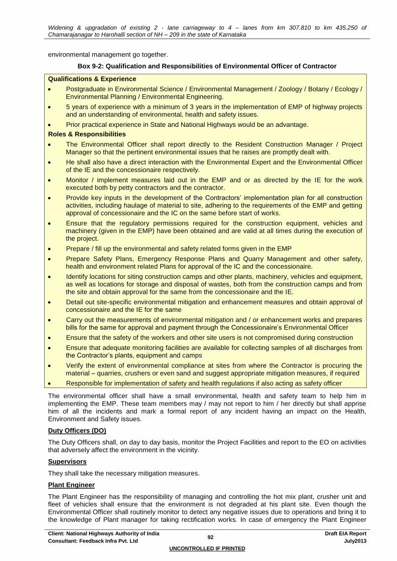
Widening & upgradation of existing 2 - lane carriageway to 4 – lanes from km 307.810 to km 435.250 of Chamarajanagar to Harohalli section of NH – 209 in the state of Karnataka
Client: National Highways Authority of India 92
Draft EIA Report
Consultant: Feedback Infra Pvt. Ltd July2013
UNCONTROLLED IF PRINTED
environmental management go together.
Box 9-2: Qualification and Responsibilities of Environmental Officer of Contractor
Qualifications & Experience
Postgraduate in Environmental Science / Environmental Management / Zoology / Botany / Ecology / Environmental Planning / Environmental Engineering.
5 years of experience with a minimum of 3 years in the implementation of EMP of highway projects and an understanding of environmental, health and safety issues.
Prior practical experience in State and National Highways would be an advantage.
Roles & Responsibilities
The Environmental Officer shall report directly to the Resident Construction Manager / Project Manager so that the pertinent environmental issues that he raises are promptly dealt with.
He shall also have a direct interaction with the Environmental Expert and the Environmental Officer of the IE and the concessionaire respectively.
Monitor / implement measures laid out in the EMP and or as directed by the IE for the work executed both by petty contractors and the contractor.
Provide key inputs in the development of the Contractors’ implementation plan for all construction activities, including haulage of material to site, adhering to the requirements of the EMP and getting approval of concessionaire and the IC on the same before start of works.
Ensure that the regulatory permissions required for the construction equipment, vehicles and machinery (given in the EMP) have been obtained and are valid at all times during the execution of the project.
Prepare / fill up the environmental and safety related forms given in the EMP
Prepare Safety Plans, Emergency Response Plans and Quarry Management and other safety, health and environment related Plans for approval of the IC and the concessionaire.
Identify locations for siting construction camps and other plants, machinery, vehicles and equipment, as well as locations for storage and disposal of wastes, both from the construction camps and from the site and obtain approval for the same from the concessionaire and the IE.
Detail out site-specific environmental mitigation and enhancement measures and obtain approval of concessionaire and the IE for the same
Carry out the measurements of environmental mitigation and / or enhancement works and prepares bills for the same for approval and payment through the Concessionaire’s Environmental Officer
Ensure that the safety of the workers and other site users is not compromised during construction
Ensure that adequate monitoring facilities are available for collecting samples of all discharges from the Contractor’s plants, equipment and camps
Verify the extent of environmental compliance at sites from where the Contractor is procuring the material – quarries, crushers or even sand and suggest appropriate mitigation measures, if required
Responsible for implementation of safety and health regulations if also acting as safety officer
The environmental officer shall have a small environmental, health and safety team to help him in implementing the EMP. These team members may / may not report to him / her directly but shall apprise him of all the incidents and mark a formal report of any incident having an impact on the Health, Environment and Safety issues.
Duty Officers (DO)
The Duty Officers shall, on day to day basis, monitor the Project Facilities and report to the EO on activities that adversely affect the environment in the vicinity.
Supervisors
They shall take the necessary mitigation measures.
Plant Engineer
The Plant Engineer has the responsibility of managing and controlling the hot mix plant, crusher unit and fleet of vehicles shall ensure that the environment is not degraded at his plant site. Even though the Environmental Officer shall routinely monitor to detect any negative issues due to operations and bring it to the knowledge of Plant manager for taking rectification works. In case of emergency the Plant Engineer

Widening & upgradation of existing 2 - lane carriageway to 4 – lanes from km 307.810 to km 435.250 of Chamarajanagar to Harohalli section of NH – 209 in the state of Karnataka
Client: National Highways Authority of India 93
Draft EIA Report
Consultant: Feedback Infra Pvt. Ltd July2013
UNCONTROLLED IF PRINTED
shall immediately notify the Environmental officer for necessary actions.
9.4 REPORTING SYSTEM
Reporting system provides necessary feedback for project management to ensure quality of the works and that the program is on schedule. The rationale for a reporting system is based on accountability to ensure that the measures proposed as part of the Environmental Management Plan get implemented in the project. Reporting system for the suggested monitoring program operates at two levels as:
Reporting for environmental condition indicators and environmental management indicators
Reporting for operational performance indicators at the NHAI site level.
The reporting system will operate linearly – contractor who is at the lowest rung of the implementation system reporting to the Concessionaire, who in turn shall report to IE and the NHAI as per Figure 9-1. All reporting by the concessionaire shall be on a quarterly basis, while the reporting time of the contractor shall be decided upon by the concessionaire. The NHAI Site Office will be responsible for setting the targets for the various activities anticipated during construction phase in consultation with the IE and obtaining agreement from the Contractor after mobilisation but before beginning of works on site. The contractor will report from then on regarding the status on each of these. The NHAI Site Office will monitor the activities through its own staff or the consultant’s Environmental Specialist after it has obtained the Contractor’s report with the Consultant’s remarks on it during the construction phase. During the operation phase, the supervision as well as reporting responsibilities will lie with the NHAI Site Office.
Table 9-1: Summary of Reporting of Environmental components and Responsibilities
Format No.
Item Timing
Independent Engineer NHAI Site Office
Supervision Reporting Overseeing / Compliance
CONTRACTOR MOBILIZATION AND SITE CLEARANCE
M1 Reporting by contractor to IE for dumping locations & construction
and labour camp site
Before start of construction
As required Quarterly As required
M2 Reporting by contractor to IE for
construction and labour camp site Before start of construction
As required Quarterly As required
M3 Target sheet for Tree cutting Before start of
work As required After cutting As required
M4 Reporting for borrow areas Before start of construction
As required Quarterly As required
CONSTRUCTION PHASE
C1 Target sheet for Pollution
Monitoring As per Monitoring
Plan As required After Monitoring As required
C2 Top soil Conservation Before start of
work As required Quarterly As required
OPERATION PHASE
O1 Target sheet for Pollution
Monitoring During Operation As required After Monitoring As required
O2 Redevelopment of Borrow Areas After completion
of usage of Borrow Area
As required After Monitoring As required
O3 Survival Rate of Trees During Operation As required After Monitoring As required
9.5 ENVIRONMENTAL CAPACITY BUILDING
Training of staff will be done at a number of levels. Some short-term training is required for the Environment Manager, other staff members of the Environment Unit and the contractor staff to raise their levels of environmental awareness. The training can be conducted by either some external agency or through the help of in-house expertise of the NHAI and the consultants and help of Pollution Control Board / CRRI / NITHE can be sought in this regard. In the long-term training, special environmental issues will be examined and likely solutions provided to the Environment Unit.
The main focus of future training programmes has to be on implementation with special emphasis on BOT / annuity. Since project preparation is drawing to a close, the officials can concentrate on the progress of the project. Identification of candidate locations for sitting construction camps, disposal of excess cut material etc. would be a priority in the short term. The proposed training should also allow the officials to enhance their skills for effective monitoring of project by understanding the formats developed for reporting. In

Widening & upgradation of existing 2 - lane carriageway to 4 – lanes from km 307.810 to km 435.250 of Chamarajanagar to Harohalli section of NH – 209 in the state of Karnataka
Client: National Highways Authority of India 94
Draft EIA Report
Consultant: Feedback Infra Pvt. Ltd July2013
UNCONTROLLED IF PRINTED
addition, close interaction is required among members of the NHAI responsible for the Environmental and R&R activities since it is envisaged that the two aspects will have a considerable overlap. It is envisaged that the training as part of the project will include training on several issues important for both teams simultaneously. The following modules can be taken up:
Table 9-2: Modules for Training
Sl No.
Timing Target Group Mode of training Short Description Responsibility
1 After finalisation of Contracts for
Civil Works
Members of the NHAI site office, Environmental Specialist of the IE, Concessionaire and the Environmental staff of the Civil Contractor
Lectures, Presentations, Discussions
Overview of responsibilities
The roles and responsibilities of the IE, Concessionaire and the Contractor
Reporting arrangements
Contractual obligations, Environmental Protection and Social Development
External Agency or
NHAI
2. During
implementation
Members of the NHAI site office, Counterpart staff from other departments such as Revenue, Forests, etc.
Lectures, Discussions,
Presentations,
Role Play
Inter-Departmental Co-ordination
Clearance requirements and prescribed procedures
Expectations of other departments – documentation and follow-up
Developing formats for ease of reporting
External Agency,
Consultants, NHAI

Widening & upgradation of existing 2 - lane carriageway to 4 – lanes from km 307.810 to km 435.250 of Chamarajanagar to Harohalli section of NH – 209 in the state of Karnataka
Client: National Highways Authority of India 95
Draft EIA Report
Consultant: Feedback Infra Pvt. Ltd July 2013
UNCONTROLLED IF PRINTED
Figure 9-1: Proposed Organisation Chart
Direct Indirect
State Pollution Control Board /
MoEF
Construction /
Project Manager
(Contractor)
Environmental
Officer
(Contractor)
Team Leader
(Independent Engineer)
Environmental Expert
(Independent Engineer)
Chief Project Manager
(Concessionaire)
Environmental Officer
(Concessionaire)
NHAI
PD / CGM (Env)
NHAI
Mgr (Tech) / DGM (Env)

Widening & upgradation of existing 2 - lane carriageway to 4 – lanes from km 307.810 to km 435.250 of Chamarajanagar to Harohalli section of NH – 209 in the state of Karnataka
Client: National Highways Authority of India 96
Draft EIA Report
Consultant: Feedback Infra Pvt. Ltd July2013
UNCONTROLLED IF PRINTED
10. ENVIRONMENTAL MANAGEMENT PLAN
10.1 ENVIRONMENTAL MANAGEMENT PLAN (EMP)
The Environmental Management Action Plan (EMP) is required to ensure sustainable development of the road during construction and operational phases. EMP is location and time specific. In general, NHAI (with assistance from Contractor / Concessionaire and Independent Engineer) is the responsible entity for ensuring that the mitigation measures are carried out. Mitigation measures for generic impacts are listed in Table 10-1. The list provides reference (MoRT&H specification), implementing organisation and responsible entity.
10.1.1 Specific Activities by NHAI
The role of NHAI in the implementation of EMP involves the following activities:
Permission from Forest / District Administrative Department for felling of trees.
Supervision of the implementations through the IE & the concessionaire
10.1.2 Specific Activities by Concessionaire
The activities to be performed by the concessionaire to implement the EMP shall comprise the following:
Confirm the Tree Cutting Schedule based on the final design and provide modified schedule to NHAI.
Fell the trees after NHAI secures Forest Department permission
Selection of material sources (quarry, water, sand etc). (Refer Annexure 8.3 & 8.4).
Selection, design and layout of construction areas, hot mix and batching plants, labour camps etc. (Refer Annexure 8.9)
Apply for and obtain all the necessary clearances from the agencies concerned after finalising the locations of the sites. (Refer Table 3.2)
Planning traffic diversions and detours including arrangements for temporary land acquisition. (Refer Annexure 8.8)
Plant and maintain 4862 flowering, shade, medicinal, ornamental & fruit bearing trees in suitable area for the entire duration of the contract period. (Refer Annexure 8.7)
Transplant and maintain 811 trees of various girth, height and species for the entire duration of the project period
10.2 SITE SPECIFIC MANAGEMENT PLAN
10.2.1 Cultural Properties
The relocation & mitigation issue of the cultural properties directly or partially impacted are taken up in RAP. Where ever possible the Concessionaire shall try to enhance the aesthetic of the area. In this regard the landscaping strategy suggested in chapter 8 shall be used.
10.2.2 Sensitive Features
Noise barriers in the form of compound walls have been proposed.
The educational institutes (mainly primary and high schools) and hospitals wherein no direct impacts of the road widening shall happen, the existing compound walls shall be raised to a height of 2m.
In case where in there shall be partial impacts, new boundary wall which shall also act as noise barrier shall be constructed to a height of 2 m.
The Concessionaire shall provide Foot over bridge or other facilities near schools & hospitals (if found necessary during construction)

Widening & upgradation of existing 2 - lane carriageway to 4 – lanes from km 307.810 to km 435.250 of Chamarajanagar to Harohalli section of NH – 209 in the state of Karnataka
Client: National Highways Authority of India 97
Draft EIA Report
Consultant: Feedback Infra Pvt. Ltd July2013
UNCONTROLLED IF PRINTED
10.2.3 Community properties
Some community properties are impacted. The relocation / rehabilitation shall be as recommended in the RAP.
New bus shelters along with bus bays are proposed in place of the existing bus shelters which are directly impacted. (Refer Annexure 2.1)
10.3 IMPLEMENTATION OF EMP
The Environmental Officer of the Concessionaire should be available for the entire duration of the project. The Environmental Officer of the Concessionaire shall be primarily responsible for compliance of EMP. The Environmental Specialist of the IE who should ideally be deployed for the entire duration shall monitor the compliance of the EMP. The key issues that require special attention along with the mitigations and enhancement measures to be implemented have been detailed in Table 10-1.

Widening & upgradation of existing 2 - lane carriageway to 4 – lanes from km 307.810 to km 435.250 of Chamarajanagar to Harohalli section of NH – 209 in the state of Karnataka
Client: National Highways Authority of India 98
Draft EIA Report
Consultant: Feedback Infra Pvt. Ltd July 2013
UNCONTROLLED IF PRINTED
Table 10-1: Environmental Management Plan
Environmental Impact / Aspect
Mitigation Measures3 Location
4 Time Frame
5
Responsibility Cross reference
6
Implementation Supervision
DESIGN STAGE
General consideration of Cross section Alternatives
Use TCS 1-6 as per design specifications. During Design Concessionaire / Contractor
NHAI Design Report
Geometric Design The proposed alignment is selected / adjusted (within IRC / MoRT&H specifications)
to minimise land disturbance
to avoid culturally & environmentally sensitive areas – cultural properties, water bodies etc.
During alignment Design
Concessionaire / Contractor
NHAI Design Report
Issues from stakeholder Consultations
Various issues raised were examined & suitably incorporated based on merit & other road safety measures.
During Design Concessionaire / Contractor
NHAI Chapter – 5: Community Consultation
Impact on Cultural Properties
Provide access facilities and / or relocate the affected structure as per the mitigation measures recommended
All along the project road
During alignment Design
Concessionaire / Contractor
NHAI Refer Chapter 8, of this Report
Preservation of trees No tree will be cut beyond toe line.
Identify incidental spaces for plantation of trees
Annexure 8.7 During alignment design
Concessionaire / Contractor
NHAI, Department of
Forest.
Annexure 8.7
Orientation of Implementation Agency
A comprehensive tanning / orientation schedule has been prepared at different stages of NHAI.
During Design NHAI NHAI Annexure 10.1
Road safety issue due to poor geometrics
Design of Geometric improvements as per IRC codes and MoRT&H Specifications
During alignment design
Concessionaire / Contractor
NHAI IRC codes and MoRT&H
Specifications
PRE-CONSTRUCTION STAGE
Implementation of RAP and LA
All requirements of the RAP shall be complete before start of construction stage. The activities broadly include acquisition of structures, cultural properties, relocation of utilities, common property resources etc
The land acquisition will be done as per LA Act, 1894.
Compensation will be paid to PAPs based on the RAP that includes the Entitlement Policy.
Right of Way (ROW)
Before construction
starts
NGOs, Collaborating Agencies, SLAO, NHAI, Grievance Redressal Cells (GRC), District
Revenue authorities
NHAI Resettlement Action Plan (RAP)
3 Some of the mitigation measures are preventive in nature while some others include additional measures in terms of environmental conservation and involve physical and construction work.
4 Unless otherwise stated, the Project Site covers area beyond ROW, such as borrow areas, access roads, service roads and equipment storage sites (MoRT&H: 306.3).
5 Time frame refers to the duration or instant of time when the mitigation measures will be taken.
6 The contract requirements refer to the following:
Ministry of Shipping, Road Transport & Highways, (MoRT&H) Government of India, Specifications for Road and Bridge Works, Specific and general conditions of the contract.
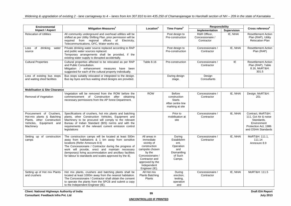
Widening & upgradation of existing 2 - lane carriageway to 4 – lanes from km 307.810 to km 435.250 of Chamarajanagar to Harohalli section of NH – 209 in the state of Karnataka
Client: National Highways Authority of India 99
Draft EIA Report
Consultant: Feedback Infra Pvt. Ltd July 2013
UNCONTROLLED IF PRINTED
Environmental Impact / Aspect
Mitigation Measures3 Location
4 Time Frame
5
Responsibility Cross reference
6
Implementation Supervision
Relocation of Utilities All community underground and overhead utilities will be shifted as per Utility Shifting Plan, prior permission will be required from regional offices of Electricity, Telecommunications, OFC, Water works etc.
Post design to Pre-construction
R&R Officer, Concessionaire /
Contractor
IE, NHAI Resettlement Action Plan (RAP), Utility Relocation Plan
Loss of drinking water source
Private drinking water source replaced according to RAP and public water sources replaced.
Temporary arrangements shall be provided, if the existing water supply is disrupted accidentally.
Post design to Pre-construction
Concessionaire / Contractor
IE, NHAI Resettlement Action Plan (RAP)
Cultural Properties Cultural properties affected to be relocated as per RAP and Public Consultation.
Mitigation / enhancement measures have been suggested for each of the cultural property individually.
Table 8.16 Pre-construction Concessionaire / Contractor
IE Resettlement Action Plan (RAP), Table
8.16, MoRT&H: 301.5
Loss of existing bus stops and waiting shed facilities
Bus stops suitably relocated or integrated to the design. Bus lay byes and bus waiting shed designs are provided.
During design stage.
Design Consultants
Mobilisation & Site Clearance
Removal of Vegetation
Vegetation will be removed from the ROW before the commencement of Construction after obtaining necessary permissions from the AP forest Department.
ROW Before construction
Starts
After centre line marking at site
Concessionaire / Contractor
IE, NHAI Design; MoRT&H: 201
Procurement of Crushers, Hot-mix plants & Batching Plants, other Construction Vehicles, Equipment and Machinery
Specifications of crushers, hot mix plants and batching plants, other Construction Vehicles, Equipment and Machinery to be procured will comply to the relevant Bureau of Indian Standard (BIS) norms and with the requirements of the relevant current emission control legislations
Prior to mobilisation at
site
Concessionaire / Contractor
IE, NHAI Contract, MoRT&H: 111, GoI Air & noise
Standards, Environment
Protection Act, 1986 and OSHA Standards
Setting up of construction camps
The construction camps will be located at least 500m away from habitations & 1 km away from sensitive locations (Refer Annexure 8.9)
The Concessionaire / Contractor during the progress of work will provide, erect and maintain necessary (temporary) living accommodation and ancillary facilities for labour to standards and scales approved by the IE.
All areas in immediate vicinity of
construction campsite chosen
by the Concessionaire / Contractor and approved by the
Independent Engineer (IE).
During Establishm
ent, Operation
and Dismantling
of Such Camps.
Concessionaire / Contractor
IE, NHAI MoRT&H: 111.1, 111.14
Annexure 8.9
Setting up of Hot mix Plants and crushers
Hot mix plants, crushers and batching plants shall be located at least 1000m away from the nearest habitation. The Concessionaire / Contractor shall obtain the consent to operate the plants from the SPCB and submit a copy to the Independent Engineer (IE).
All Hot mix Plants Batching
Plants
During erection, testing,
operation and
Concessionaire / Contractor
IE, NHAI MoRT&H: 111.5

Widening & upgradation of existing 2 - lane carriageway to 4 – lanes from km 307.810 to km 435.250 of Chamarajanagar to Harohalli section of NH – 209 in the state of Karnataka
Client: National Highways Authority of India 100
Draft EIA Report
Consultant: Feedback Infra Pvt. Ltd July 2013
UNCONTROLLED IF PRINTED
Environmental Impact / Aspect
Mitigation Measures3 Location
4 Time Frame
5
Responsibility Cross reference
6
Implementation Supervision
dismantling of such plants
Identification of dumping sites
Location of dumping sites shall be finalized based on the guidelines given in Annexure 8.1 and the Independent Engineer (IE) shall certify that :
These are not located within designated forest areas.
The dumping does not impact natural drainage courses
Settlements are located at least 1 km away from the site.
Throughout the corridor
During mobilisatio
n
Concessionaire / Contractor
IE, NHAI Annexure 8.1
CONSTRUCTION STAGE
Clearances and approvals Secure the following clearances prior to start of construction activity:
Type of clearance Applicability
NOC and consents under Air, Water & Environment Act and noise rules from SPCB
For establishment of construction camp.
NOC and consents under Air, Water & Environment Act and noise rules from SPCB
For operating construction plant, crusher, batching plant etc.
Explosive License from Chief Controller of Explosives
For storing fuel oil, lubricants, diesel etc.
Permission for storage of hazardous chemical from CPCB
Manufacture storage and Import of Hazardous Chemicals
Borrow Area, approval from District Collector, Consent letter, lease agreement with the Owner of land.
Borrow area for excavation of earth
Quarry Lease Deed and Quarry License from State Department of Mines
Quarry operation (for new quarry)
Permission for extraction of ground water for use in road construction activities from State Ground Water Board
Extraction of ground water
Permission for use of water for construction purpose from irrigation department
Use of surface water for construction
Labour license from labour commissioner office
Engagement of Labour
Construction stage (Prior to initiation of any
work).
Time period in getting the
permission is 2-3 months.
NHAI, SPCB, CPCB, Chief Controller of Explosives, District
Collector State Department of Mines, State Ground Water
Board, State Irrigation Department, Labour
Commissioner Officer
Concessionaire /
Contractor
General Conditions of Contract.
Clause 111.3, MoRT&H

Widening & upgradation of existing 2 - lane carriageway to 4 – lanes from km 307.810 to km 435.250 of Chamarajanagar to Harohalli section of NH – 209 in the state of Karnataka
Client: National Highways Authority of India 101
Draft EIA Report
Consultant: Feedback Infra Pvt. Ltd July 2013
UNCONTROLLED IF PRINTED
Environmental Impact / Aspect
Mitigation Measures3 Location
4 Time Frame
5
Responsibility Cross reference
6
Implementation Supervision
Provide a copy of all necessary clearances to the IC
Adhere to all clearance terms and conditions
Obtain written permission from private landholders to conduct construction activities on their land prior to commencing works.
Land
Soil Erosion and Sedimentation control
Main reason of soil erosion is rains. Concessionaire / Contractor should plan the activities so that No naked / loose earth surface is left out before the onset of monsoon, for minimising the soil erosion following preventive measures to be taken such as:
Embankment slopes to be covered, soon after completion.
Next layer / activity to be planted, soon after completion of clearing and grubbing, laying of embankment layer, sub-grade layer, sub-base layer, scarification etc.
Top soil from borrow area, Debris disposal sites; borrow area, construction site to be protected / covered for soil erosion.
Debris due to excavation of foundation, dismantling of existing cross drainage structure will be removed from the water course immediately.
Diversions for bridges will be removed from the water course before the onset of monsoon
Along sections abutting water bodies, stone pitching needs to be carried out.
At the outfall of each culvert, erosion prevention measure, such as the following, will be undertaken,
Throughout Project Corridor,
Service roads and equipment
storage sites, etc.
Upon completion of construction
activities at these sites.
During construction
Concessionaire / Contractor
IE, NHAI MORT&H Specification
305.2.2.2, 306, 307, 308
Loss of agricultural top soil All areas of cutting and all areas to be permanently covered will be stripped to a depth of 150 mm and stored in stockpile.
The stockpile will be designed such that the slope does not exceed 1:2 (vertical to horizontal), and the height of the pile is to be restricted to 2m. Stockpiles will not be surcharged or otherwise loaded and multiple handling will be kept to a minimum to ensure that no compaction will occur. The stockpiles will be covered with gunny bags or tarpaulin. It will be ensured by the Concessionaire / Contractor that the topsoil will not be unnecessarily trafficked either before stripping or when in stockpiles.
Top soil will be safeguard from erosion and will be
All along Project Corridor, where productive land
is acquired
During construction
Concessionaire / Contractor
IE, NHAI MoRT&H: 301.3.2, 301.7, 305.3.3 &
305.3.9

Widening & upgradation of existing 2 - lane carriageway to 4 – lanes from km 307.810 to km 435.250 of Chamarajanagar to Harohalli section of NH – 209 in the state of Karnataka
Client: National Highways Authority of India 102
Draft EIA Report
Consultant: Feedback Infra Pvt. Ltd July 2013
UNCONTROLLED IF PRINTED
Environmental Impact / Aspect
Mitigation Measures3 Location
4 Time Frame
5
Responsibility Cross reference
6
Implementation Supervision
reused as follows:
Covering all borrow areas after excavation is over.
Dressing of slopes of road embankment
Agricultural field, acquired temporarily
Compaction of Soil and Damage to Vegetation
Construction vehicles should operate within the Corridor of Impact avoiding damage to soil and vegetation.
Diversions, access road used will be redeveloped by Concessionaire / Contractor, to the satisfaction of the owner / villagers.
Construction vehicle, machinery and equipment shall move or be stationed in the ROW only. While operating on temporarily acquired agricultural land for any construction activities, top soil will be preserved in stockpiles.
Throughout Project Corridor
and all areas temporarily acquired.
During construction
Concessionaire / Contractor
IE, NHAI MORT&H Specification 112.6,
201.2
Contamination of soil Guidelines of “Hazardous waste (management and handling) rules, 1989 will be enforced.
Vehicle / machinery and equipment operation, maintenance and refuelling shall be carried out in such a fashion that spillage of fuels and lubricants does not contaminate the ground. An “oil interceptor” will be provided for wash down and refuelling areas.
Fuel storage shall be in proper bunded areas. All spills and collected petroleum products shall be disposed off in accordance with MoEF and SPCB guidelines at designated locations.
Plant to be set up 500 m away from surface water body.
Oil interceptor will be installed at construction site.
Septic tank will be constructed for safe disposal of waste.
At fuel storage areas – usually at construction
camps, temporarily
acquired site.
During Constructio
n.
Concessionaire / Contractor
IE, NHAI Chapter-8 of this Report.
1. Quarrying
2. Material sources
Quarry material shall be sourced from approved and licensed aggregate and sand quarries as given in Table 8.3 & 8.4. Copy of licenses to be submitted to the IE.
For operating new quarries, the Concessionaire / Contractor shall obtain materials from quarries only after consent of the DoF or other concerned authorities and only after development of a comprehensive quarry’ redevelopment plan.
Adequate safety precautions shall be ensured during transportation of quarry material from quarries to the construction site. Vehicles transporting the material
Table 8.3 & 8.4 During construction
Concessionaire / Contractor
IE, NHAI Annexure 8.3
MORT&H Specification 111.3,
302, 305.2.2.
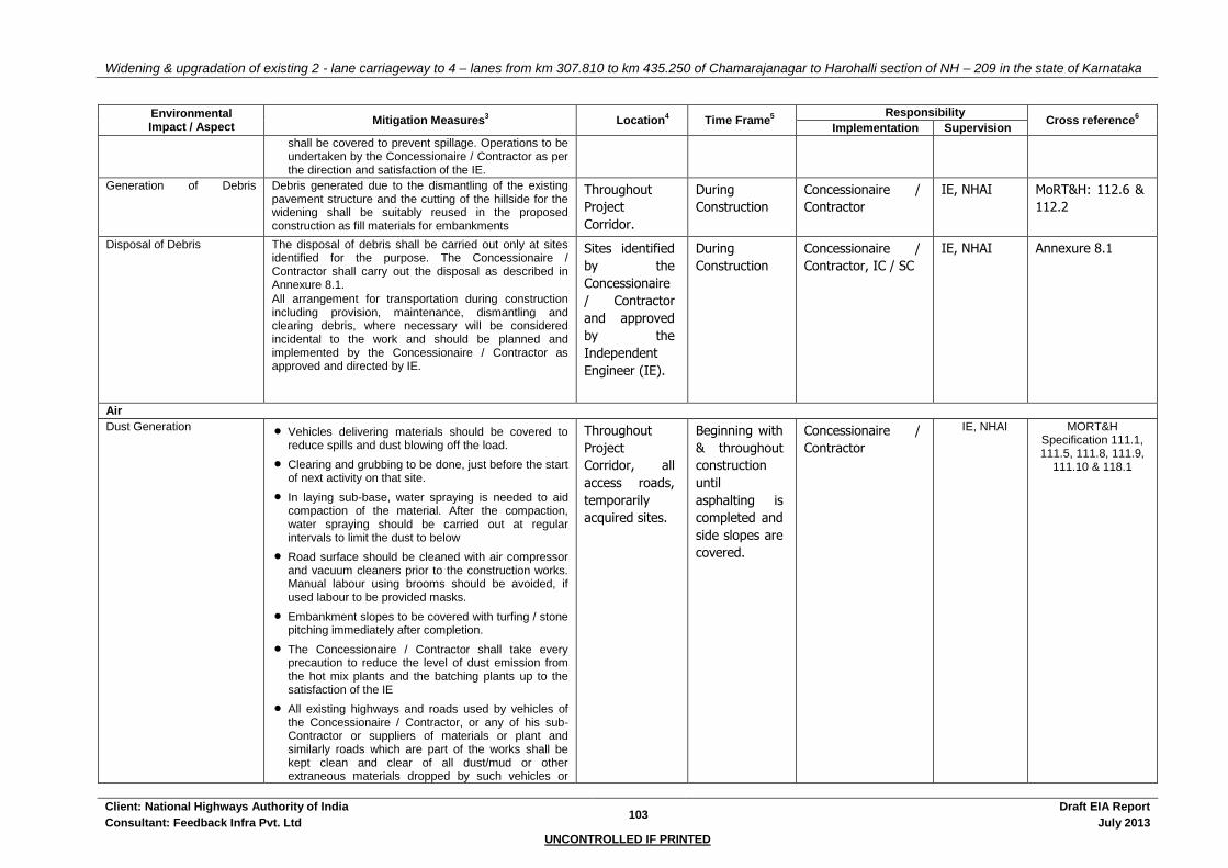
Widening & upgradation of existing 2 - lane carriageway to 4 – lanes from km 307.810 to km 435.250 of Chamarajanagar to Harohalli section of NH – 209 in the state of Karnataka
Client: National Highways Authority of India 103
Draft EIA Report
Consultant: Feedback Infra Pvt. Ltd July 2013
UNCONTROLLED IF PRINTED
Environmental Impact / Aspect
Mitigation Measures3 Location
4 Time Frame
5
Responsibility Cross reference
6
Implementation Supervision
shall be covered to prevent spillage. Operations to be undertaken by the Concessionaire / Contractor as per the direction and satisfaction of the IE.
Generation of Debris
Debris generated due to the dismantling of the existing pavement structure and the cutting of the hillside for the widening shall be suitably reused in the proposed construction as fill materials for embankments
Throughout
Project
Corridor.
During
Construction
Concessionaire /
Contractor
IE, NHAI MoRT&H: 112.6 &
112.2
Disposal of Debris The disposal of debris shall be carried out only at sites identified for the purpose. The Concessionaire / Contractor shall carry out the disposal as described in Annexure 8.1.
All arrangement for transportation during construction including provision, maintenance, dismantling and clearing debris, where necessary will be considered incidental to the work and should be planned and implemented by the Concessionaire / Contractor as approved and directed by IE.
Sites identified
by the
Concessionaire
/ Contractor
and approved
by the
Independent
Engineer (IE).
During
Construction
Concessionaire /
Contractor, IC / SC
IE, NHAI Annexure 8.1
Air
Dust Generation Vehicles delivering materials should be covered to reduce spills and dust blowing off the load.
Clearing and grubbing to be done, just before the start of next activity on that site.
In laying sub-base, water spraying is needed to aid compaction of the material. After the compaction, water spraying should be carried out at regular intervals to limit the dust to below
Road surface should be cleaned with air compressor and vacuum cleaners prior to the construction works. Manual labour using brooms should be avoided, if used labour to be provided masks.
Embankment slopes to be covered with turfing / stone pitching immediately after completion.
The Concessionaire / Contractor shall take every precaution to reduce the level of dust emission from the hot mix plants and the batching plants up to the satisfaction of the IE
All existing highways and roads used by vehicles of the Concessionaire / Contractor, or any of his sub-Contractor or suppliers of materials or plant and similarly roads which are part of the works shall be kept clean and clear of all dust/mud or other extraneous materials dropped by such vehicles or
Throughout
Project
Corridor, all
access roads,
temporarily
acquired sites.
Beginning with
& throughout
construction
until
asphalting is
completed and
side slopes are
covered.
Concessionaire /
Contractor
IE, NHAI MORT&H Specification 111.1, 111.5, 111.8, 111.9,
111.10 & 118.1
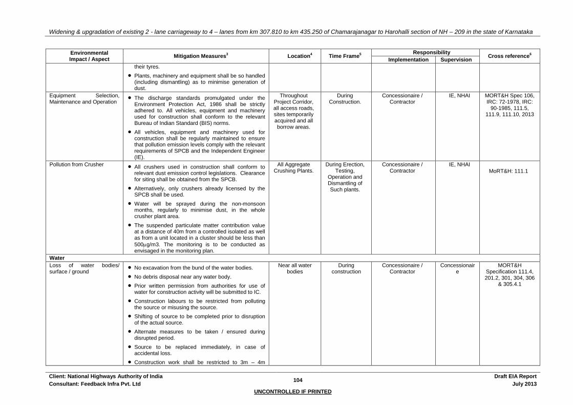
Widening & upgradation of existing 2 - lane carriageway to 4 – lanes from km 307.810 to km 435.250 of Chamarajanagar to Harohalli section of NH – 209 in the state of Karnataka
Client: National Highways Authority of India 104
Draft EIA Report
Consultant: Feedback Infra Pvt. Ltd July 2013
UNCONTROLLED IF PRINTED
Environmental Impact / Aspect
Mitigation Measures3 Location
4 Time Frame
5
Responsibility Cross reference
6
Implementation Supervision
their tyres.
Plants, machinery and equipment shall be so handled (including dismantling) as to minimise generation of dust.
Equipment Selection, Maintenance and Operation
The discharge standards promulgated under the Environment Protection Act, 1986 shall be strictly adhered to. All vehicles, equipment and machinery used for construction shall conform to the relevant Bureau of Indian Standard (BIS) norms.
All vehicles, equipment and machinery used for construction shall be regularly maintained to ensure that pollution emission levels comply with the relevant requirements of SPCB and the Independent Engineer (IE).
Throughout Project Corridor, all access roads, sites temporarily acquired and all borrow areas.
During Construction.
Concessionaire / Contractor
IE, NHAI MORT&H Spec 106, IRC: 72-1978, IRC:
90-1985, 111.5, 111.9, 111.10, 2013
Pollution from Crusher All crushers used in construction shall conform to relevant dust emission control legislations. Clearance for siting shall be obtained from the SPCB.
Alternatively, only crushers already licensed by the SPCB shall be used.
Water will be sprayed during the non-monsoon months, regularly to minimise dust, in the whole crusher plant area.
The suspended particulate matter contribution value at a distance of 40m from a controlled isolated as well as from a unit located in a cluster should be less than
500g/m3. The monitoring is to be conducted as envisaged in the monitoring plan.
All Aggregate Crushing Plants.
During Erection, Testing,
Operation and Dismantling of Such plants.
Concessionaire / Contractor
IE, NHAI
MoRT&H: 111.1
Water
Loss of water bodies/ surface / ground
No excavation from the bund of the water bodies.
No debris disposal near any water body.
Prior written permission from authorities for use of water for construction activity will be submitted to IC.
Construction labours to be restricted from polluting the source or misusing the source.
Shifting of source to be completed prior to disruption of the actual source.
Alternate measures to be taken / ensured during disrupted period.
Source to be replaced immediately, in case of accidental loss.
Construction work shall be restricted to 3m – 4m
Near all water bodies
During construction
Concessionaire / Contractor
Concessionaire
MORT&H Specification 111.4, 201.2, 301, 304, 306
& 305.4.1

Widening & upgradation of existing 2 - lane carriageway to 4 – lanes from km 307.810 to km 435.250 of Chamarajanagar to Harohalli section of NH – 209 in the state of Karnataka
Client: National Highways Authority of India 105
Draft EIA Report
Consultant: Feedback Infra Pvt. Ltd July 2013
UNCONTROLLED IF PRINTED
Environmental Impact / Aspect
Mitigation Measures3 Location
4 Time Frame
5
Responsibility Cross reference
6
Implementation Supervision
width from the existing formation near ponds.
The volume of water storage lost shall be compensated for by excavation of an equal volume of similar depth at closest possible location in the direction of flow and shall be done with the approval of the Independent Engineer (IE).
Alteration of drainage Diversions will be constructed during dry season, with adequate drainage facility, and will be completely removed before the onset of monsoon.
Debris generated due to the excavation of foundation or due to the dismantling of existing structure will be removed from the water course.
Temporary Silt fencing to be provided on the mouth of discharge into natural streams.
Continuous drain (lined / unlined) is suggested / will be provided. Obstruction, if any, will be removed immediately.
Throughout Project Corridor, all access roads,
temporarily acquired sites.
Whenever encountered
during construction
Concessionaire / Contractor
IE, NHAI MORT&H Specification 201.2, 301, 304, 306, 312.
Runoff and drainage Throughout continuous drain is provided.
Lined drain is provided at built-up locations for quick drainage.
Increased runoff due to increased impervious surface is countered through increased pervious surface area through soak pits and rain water harvesting structures.
During Construction
Concessionaire / Contractor
IE, NHAI
Water requirement for project
Concessionaire / Contractor will provide a list of sources (surface / ground) for approval from IE
Prior to use of source Concessionaire / Contractor will take the written permission from authority, to use the water in construction activity, and submit a copy to IE.
During construction only permitted quantity (permission taken) from approved sources will be used.
Concessionaire / Contractor will ensure optimum use of water; discourage labour from wastage of water.
Throughout Project Corridor, all access roads,
temporarily acquired sites.
During Construction
Concessionaire / Contractor
IE, NHAI
Silting / sedimentation Measures suggested under “Soil Erosion and Sedimentation control” will be enforced.
Silt fencing is provided around water bodies.
Construction activities will be stopped near water bodies during monsoon.
Soil trap are suggested / will be provided in all ancillary sites and camps.
Throughout construction
period
Concessionaire / Contractor
IE, NHAI MORT&H Specification 111.4,
306
EP Act, 1986

Widening & upgradation of existing 2 - lane carriageway to 4 – lanes from km 307.810 to km 435.250 of Chamarajanagar to Harohalli section of NH – 209 in the state of Karnataka
Client: National Highways Authority of India 106
Draft EIA Report
Consultant: Feedback Infra Pvt. Ltd July 2013
UNCONTROLLED IF PRINTED
Environmental Impact / Aspect
Mitigation Measures3 Location
4 Time Frame
5
Responsibility Cross reference
6
Implementation Supervision
Contamination of water Measures suggested under “Contamination of soil” will be enforced.
Construction work close to water bodies will be avoided during monsoon.
Labour camps will be located away from water bodies.
Car washing / workshops near water bodies will be avoided.
All areas in immediate vicinity of
construction campsite chosen
by the Concessionaire /
Contractor.
Throughout construction
period, During Establishment, Operation and Dismantling of Labour Camps.
Concessionaire / Contractor
IE, NHAI MORT&H Specification 111.1,
111.4, 111.9, 111.13, 122, 201.2, 201.4,
301.1.3.10, 304.3.3, 306
Noise
Noise from Vehicles, Plants and Equipment
Noise standard at processing sites, eg. Aggregate crushing plants, batching plant, hot mix plant will be strictly monitored to prevent exceeding of noise standards.
Workers in vicinity of loud noise, and workers working with or in crushing, compaction, concrete mixing operations shall wear earplugs and their working time should be limited as a safety measure.
In construction sites within 150 m of sensitive receptors construction will be stopped from 22:00 to 06:00.
Machinery and vehicles will be maintained to keep their noise to a minimum.
Construction of noise barriers at sensitive receptors.
All vehicles and equipment used in construction shall be fitted with exhaust silencers. During routine servicing operations, the effectiveness of exhaust silencers shall be checked and if found to be defective shall be replaced.
Noise limits for construction equipment used in this project (measured at one metre from the edge of the equipment in free field) such as compactors, rollers, front loaders, concrete mixers, cranes (moveable), vibrators and saws shall not exceed 75 dB(A), as specified in the Environment (Protection) Rules, 1986.
Throughout Project Corridor, all access roads, sites temporarily acquired and all borrow areas.
Throughout construction
Concessionaire / Contractor
IE, NHAI MORT&H Specification No. 111, 111.1, 111.13, 111.5
& 111.6
Environment (Protection) Rules,
1986.
Table 8.10: Noise Impact on Sensitive
Receptors and Mitigation.
Noise from Blasting or Pre-splitting Operations
Blasting shall be carried out only with permission of the Independent Engineer (IE). All the statutory laws, regulations, rules etc., pertaining to acquisition, transport, storage, handling and use of explosives shall be strictly followed.
Blasting shall be carried out during fixed hours (preferably during mid-day), as permitted by the Independent Engineer (IE). The timing should be
All Blasting and Pre-splitting
Sites.
During Preparation,
Operation and Closure of Such
Sites.
Concessionaire / Contractor
IE, NHAI MoRT&H: 302.1 & 302.4

Widening & upgradation of existing 2 - lane carriageway to 4 – lanes from km 307.810 to km 435.250 of Chamarajanagar to Harohalli section of NH – 209 in the state of Karnataka
Client: National Highways Authority of India 107
Draft EIA Report
Consultant: Feedback Infra Pvt. Ltd July 2013
UNCONTROLLED IF PRINTED
Environmental Impact / Aspect
Mitigation Measures3 Location
4 Time Frame
5
Responsibility Cross reference
6
Implementation Supervision
made known to all people within 500m (200m for pre-splitting) from the blasting site in all directions. People, except those who actually light the fuse shall be excluded from the area of 200m (50m for pre-splitting) from the blasting site in all directions at least 10 minutes before the blasting.
Flora & Fauna
Loss of trees and Avenue Planting & transplantation
Plant and maintain 64425 flowering, shade, medicinal, ornamental & fruit bearing trees in suitable area for the entire duration of the contract period
Plant and maintain a minimum 58109 ornamental, medicinal & flowering plants and shrubs in the median for the entire duration of the contract period
Transplant and maintain 6410 trees of various girth, height and species for the entire duration of the project period
Cost of plantation included in the EMP Budget.
Concessionaire / Contractor has to make sure that no trees / branches to be fell by labourer for fuel, warmth during winter. Enough provision of fuel to be ensured.
Annexure 8.7 After completion of construction
activities
Concessionaire / Contractor
IE, NHAI Annexure 8.7
MORT&H Specification, 111, 111.5, 201.5, 306,
308
Vegetation clearance Clearing and grubbing should be avoided beyond that which is directly required for construction activities.
Next activity to be planned / started immediately, to avoid dust generation and soil erosion during monsoon.
Turfing / re-vegetation to be started soon after completion of embankment.
During cleaning operations.
During construction
Concessionaire / Contractor
IE, NHAI MORT&H Specification 201.2
Fauna Construction workers must protect natural resources and wild animals.
Hunting will be prohibited.
Nesting grounds & migratory paths will be protected.
During construction
Concessionaire / Contractor
IE, NHAI MORT&H Specification 111.1,
111.6.
Socio – Economic Environment
Public Health and Safety Debris generated will be disposed to the satisfaction of Independent Engineer (IE).
Monitoring of air, water, noise and land during construction and operational phase.
During Construction
Concessionaire / Contractor
IE, NHAI
Accidents The Concessionaire / Contractor will provide, erect and maintain barricades, including signs marking flats, lights and flagmen as required by the Independent Engineer (IE).
During Construction
Concessionaire / Contractor
IE, NHAI
Resettlement Action of People
A comprehensive resettlement action plan has been prepared to improve the standard of living of the affected
During Construction
Concessionaire / Contractor, NHAI
IE, NHAI

Widening & upgradation of existing 2 - lane carriageway to 4 – lanes from km 307.810 to km 435.250 of Chamarajanagar to Harohalli section of NH – 209 in the state of Karnataka
Client: National Highways Authority of India 108
Draft EIA Report
Consultant: Feedback Infra Pvt. Ltd July 2013
UNCONTROLLED IF PRINTED
Environmental Impact / Aspect
Mitigation Measures3 Location
4 Time Frame
5
Responsibility Cross reference
6
Implementation Supervision
population.
Sensitive community and cultural facilities
Precaution to be taken for any accidental loss to community and cultural property
Any loss made shall be the responsibility of the Concessionaire / Contractor and made good by him at his own cost
Through access / identification to be maintained
Endeavour towards enhancement of community and cultural property
Community consultations for any relocation, mitigation measures adopted
During Construction
Concessionaire / Contractor
IE, NHAI Table 8.16
Temporary Loss of Access The Concessionaire / Contractor shall provide safe and convenient passage for vehicles, pedestrians and livestock to and from side roads and property accesses connecting the project road. Work that affects the use of side roads and existing accesses shall not be undertaken without providing adequate provisions to the prior satisfaction of the Independent Engineer (IE).
The works shall not interfere with or cause inconvenience to public or restrict the access to use and occupation of public or private roads, and any other access footpaths to or of properties whether public or private.
Access across the work-zone will be provided for two slots every day during construction (2 hours in the morning and 2 hours in the afternoon). For this purpose the Concessionaire / Contractor shall maintain a strip of pavement across the work zone of such quality that light motor vehicles (LMV) can pass without difficulty or danger of breaking down.
All along the Project corridor
During
Construction
Concessionaire / Contractor
IE, NHAI MoRT&H: 112.7
Road Safety And Construction Safety
Traffic Delays and Congestion
Detailed Traffic Control Plans shall be prepared and submitted to the Independent Engineer (IE) for approval, 5 days prior to commencement of works on any section of road. The traffic control plans shall contain details of arrangements for construction under traffic and details of traffic arrangement after cessation of work each day.
The Concessionaire / Contractor shall ensure that the running surface is always maintained in running condition, particularly during the monsoon so that no disruption to the traffic flow occurs.
All along the Project Corridor.
During
Construction
Concessionaire / Contractor
IE, NHAI
MoRT&H: 112.1 & 112.2

Widening & upgradation of existing 2 - lane carriageway to 4 – lanes from km 307.810 to km 435.250 of Chamarajanagar to Harohalli section of NH – 209 in the state of Karnataka
Client: National Highways Authority of India 109
Draft EIA Report
Consultant: Feedback Infra Pvt. Ltd July 2013
UNCONTROLLED IF PRINTED
Environmental Impact / Aspect
Mitigation Measures3 Location
4 Time Frame
5
Responsibility Cross reference
6
Implementation Supervision
Traffic Control and Safety The Concessionaire / Contractor shall take all necessary measures for the safety of traffic during construction and provide, erect and maintain such barricades, including signs, markings, flags, lights and flagmen as may be required by the Independent Engineer for the information and protection of traffic approaching or passing through the section of the highway under improvement.
All signs, barricades, pavement markings shall be as per the MoRT&H specification. Before taking up construction on any section of the highway, a traffic control plan shall be devised to the satisfaction of the Independent Engineer.
Entire Project site.
During
Construction
Concessionaire / Contractor
IE, NHAI MoRT&H: 112.1 & 112.4
Annexure 8.8
Risk from Operations The Concessionaire / Contractor is required to comply with all the precautions as required for the safety of the workmen as per the International Labour Organisation (ILO) Convention No. 62 as far as those are applicable to this contract.
The Concessionaire / Contractor shall supply all necessary safety appliances such as safety goggles, helmets, masks, etc., to the workers and staff.
The Concessionaire / Contractor has to comply with all regulation regarding safe scaffolding, ladders, working platforms, gangway, stairwells, excavations, trenches and safe means of entry and egress.
No child labour shall be utilized in the project
Entire Project
site.
During
Construction
Concessionaire /
Contractor
IE, NHAI Factory Act
Risk from Electrical Equipment
Adequate precautions will be taken to prevent danger from electrical equipment.
No material or any of the sites will be so stacked or placed as to cause danger or inconvenience to any person or the public.
All necessary fencing and lights will be provided to protect the public.
All machines to be used in the construction will conform to the relevant Indian Standards (IS) codes, will be free from defect, will be kept in good working order, will be regularly inspected and properly maintained as per IS provisions and to the satisfaction of the Independent Engineer (IE).
Entire Project site.
During Construction
Concessionaire / Contractor
IE, NHAI MoRT&H: 106
Risk at Hazardous Activity All workers employed on mixing asphaltic material, cement, lime mortars, concrete etc., will be provided with protective footwear and protective goggles.
Entire Project site.
During
Construction
Concessionaire / Contractor
IE, NHAI
MoRT&H: 111.1
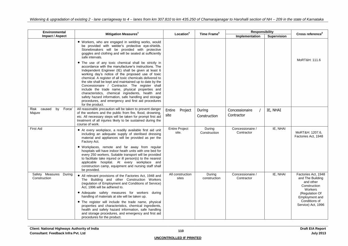
Widening & upgradation of existing 2 - lane carriageway to 4 – lanes from km 307.810 to km 435.250 of Chamarajanagar to Harohalli section of NH – 209 in the state of Karnataka
Client: National Highways Authority of India 110
Draft EIA Report
Consultant: Feedback Infra Pvt. Ltd July 2013
UNCONTROLLED IF PRINTED
Environmental Impact / Aspect
Mitigation Measures3 Location
4 Time Frame
5
Responsibility Cross reference
6
Implementation Supervision
Workers, who are engaged in welding works, would be provided with welder’s protective eye-shields. Stonebreakers will be provided with protective goggles and clothing and will be seated at sufficiently safe intervals.
The use of any toxic chemical shall be strictly in accordance with the manufacturer’s instructions. The Independent Engineer (IE) shall be given at least 6 working day’s notice of the proposed use of toxic chemical. A register of all toxic chemicals delivered to the site shall be kept and maintained up to date by the Concessionaire / Contractor. The register shall include the trade name, physical properties and characteristics, chemical ingredients, health and safety hazard information, safe handling and storage procedures, and emergency and first aid procedures for the product.
MoRT&H: 111.6
Risk caused by Force’ Majure
All reasonable precaution will be taken to prevent danger of the workers and the public from fire, flood, drowning, etc. All necessary steps will be taken for prompt first aid treatment of all injuries likely to be sustained during the course of work.
Entire Project
site
During
Construction
Concessionaire /
Contractor
IE, NHAI
First Aid At every workplace, a readily available first aid unit including an adequate supply of sterilised dressing material and appliances will be provided as per the Factory Act.
Workplaces, remote and far away from regular hospitals will have indoor heath units with one bed for every 250 workers. Suitable transport will be provided to facilitate take injured or ill person(s) to the nearest applicable hospital. At every workplace and construction camp, equipment and nursing staff shall be provided.
Entire Project site.
During
Construction
Concessionaire / Contractor
IE, NHAI MoRT&H: 1207.6,
Factories Act, 1948
Safety Measures During Construction
All relevant provisions of the Factories Act, 1948 and The Building and other Construction Workers (regulation of Employment and Conditions of Service) Act, 1996 will be adhered to.
Adequate safety measures for workers during handling of materials at site will be taken up.
The register will include the trade name, physical properties and characteristics, chemical ingredients, health and safety hazard information, safe handling and storage procedures, and emergency and first aid procedures for the product.
All construction sites
During construction
Concessionaire / Contractor
IE, NHAI Factories Act, 1948 and The Building
and other Construction
Workers (Regulation Of
Employment and Conditions of
Service) Act, 1996

Widening & upgradation of existing 2 - lane carriageway to 4 – lanes from km 307.810 to km 435.250 of Chamarajanagar to Harohalli section of NH – 209 in the state of Karnataka
Client: National Highways Authority of India 111
Draft EIA Report
Consultant: Feedback Infra Pvt. Ltd July 2013
UNCONTROLLED IF PRINTED
Environmental Impact / Aspect
Mitigation Measures3 Location
4 Time Frame
5
Responsibility Cross reference
6
Implementation Supervision
Hygiene Latrines shall be provided with septic tank. The effluents can be diverted for horticulture inside the camps.
The septic tank may be cleaned once in 6 months and filter cleaned after a year.
All temporary accommodation must be constructed and maintained in such a fashion that uncontaminated water is available for drinking, cooking and washing.
Garbage bins must be provided in the camps and regularly emptied and the garbage disposed off in a hygienic manner.
Adequate health care is to be provided for the work force. Unless otherwise arranged for by the local sanitary authority, the local medical health or municipal authorities.
On completion of the works, all such temporary structures shall be cleared away, all rubbish burnt, septic tank and other disposal pits filled in and effectively sealed off and the outline site left clean and tidy, at the Concessionaire / Contractor’s expense, to the entire satisfaction of the Independent Engineer (IE).
All Worker’s Camps
During construction
Concessionaire / Contractor
IE, NHAI
Clearing of Construction of Camps & Restoration
Concessionaire / Contractor to prepare site restoration plans for approval by the Independent Engineer (IE). The plan is to be implemented by the Concessionaire / Contractor prior to demobilisation.
On completion of the works, all temporary structures will be cleared away, all rubbish burnt, excreta or other disposal pits or trenches filled in and effectively sealed off and the site left clean and tidy, at the Concessionaire / Contractor’s expense, to the entire satisfaction of the Independent Engineer (IE).
Residual topsoil will be distributed on adjoining / proximate barren / rocky areas as identified by the Independent Engineer (IE) in a layer of thickness of 75mm - 150mm.
All Workers’ Camps
Concessionaire / Contractor
IE, NHAI
Monitoring at critical locations
The monitoring of Air, land, water and Noise to be carried out identified critical locations as given in Table 4.4, 4.6 & 4.9 besides locations identified by IC along the project corridor.
Concessionaire / Contractor
IE Table 4.4, 4.6 & 4.9 of chapter 4;
Table 11.1: EMP Budget &
Annexure 10.1
OPERATION STAGE
Water quality degradation due to road run-off
Silt fencing, Oil & Grease traps, etc. shall be provided at sensitive water bodies to ensure that the water quality is not impaired due to contaminants from road run-off.
At sensitive water bodies
identified.
During Operational
Stage
NHAI and / or SPCB NHAI As per Monitoring plan in Annexure
10.1

Widening & upgradation of existing 2 - lane carriageway to 4 – lanes from km 307.810 to km 435.250 of Chamarajanagar to Harohalli section of NH – 209 in the state of Karnataka
Client: National Highways Authority of India 112
Draft EIA Report
Consultant: Feedback Infra Pvt. Ltd July 2013
UNCONTROLLED IF PRINTED
Environmental Impact / Aspect
Mitigation Measures3 Location
4 Time Frame
5
Responsibility Cross reference
6
Implementation Supervision
Monitoring shall be carried out as specified in the Monitoring plan
As specified in the monitoring
plan
Contamination of Soil and Water Resources from Spills Accidents
Contingency plans to be in place for cleaning up of spills of oil, fuel and toxic chemicals.
Spill of oil, fuel and automobile servicing units without adequate disposal systems in place to be discouraged.
Accidental spills are potentially disastrous, but its probability is quite low as one of the objectives of this project is to enhance road safety.
The Public will be informed about the regulations on land pollution.
Land pollution monitoring program has been devised for checking pollution level and suggesting remedial measures.
Entire Project corridor.
During Operational
Stage
Concessionaire / Contractor
IE, NHAI
Traffic and Accident Safety Depending on the level of congestion and traffic hazards, traffic management plans will be prepared.
Traffic control measures including speed limits to be enforced strictly.
Road control width to be enforced. Local government bodies and development authorities will be encouraged to control building development along the highway.
All along the Project corridor and surrounding
areas.
During Operational
Stage
Concessionaire / Contractor, Local
Government Bodies, Development Authorities.
NHAI / Concessiona
ire / Contractor
Through Operation Stage.
Accidents involving Hazardous Materials
Compliance with the Hazardous Wastes (Management and Handling) Rules, 1989
Creation of an Emergency Response team
For delivery of hazardous substances, permit license, driving license and guidance license will be required.
Public security, transportation and fire fighting departments will designate a special route for vehicles delivering hazardous material. These vehicles will only be harboured at designated parking lots.
In case of spill of hazardous materials, the relevant departments will be intimated at once to deal with it with the spill contingency plan.
All along the Project corridor and surrounding
areas
During Operational
Stage
Concessionaire / Contractor
NHAI, Motor Vehicles
Department, District
Administration
Road side tree plantation Trees planted along the corridor shall be maintained for a period of three years. Maintenance works include, watering of the saplings, and all necessary measures for survival of the sapling.
The avenue plantation should be completed,
All along the corridor
Immediately from the planting of
sapling
During Operational
Stage
Concessionaire / Contractor
IE, NHAI
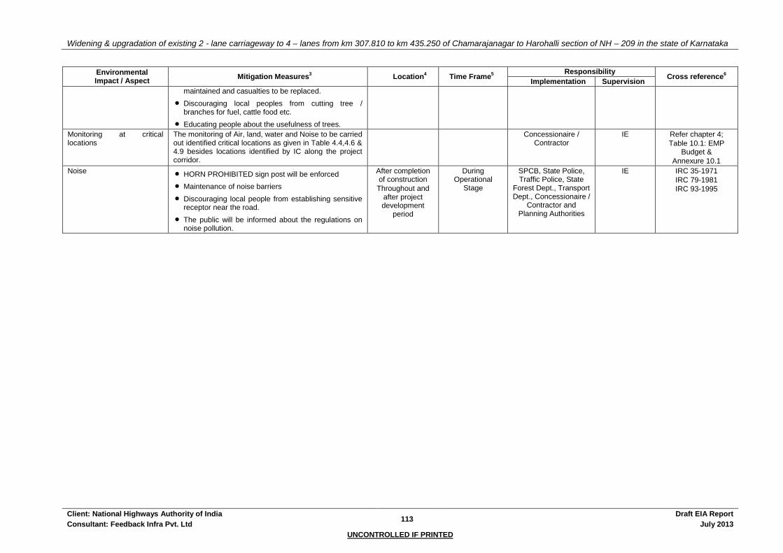
Widening & upgradation of existing 2 - lane carriageway to 4 – lanes from km 307.810 to km 435.250 of Chamarajanagar to Harohalli section of NH – 209 in the state of Karnataka
Client: National Highways Authority of India 113
Draft EIA Report
Consultant: Feedback Infra Pvt. Ltd July 2013
UNCONTROLLED IF PRINTED
Environmental Impact / Aspect
Mitigation Measures3 Location
4 Time Frame
5
Responsibility Cross reference
6
Implementation Supervision
maintained and casualties to be replaced.
Discouraging local peoples from cutting tree / branches for fuel, cattle food etc.
Educating people about the usefulness of trees.
Monitoring at critical locations
The monitoring of Air, land, water and Noise to be carried out identified critical locations as given in Table 4.4,4.6 & 4.9 besides locations identified by IC along the project corridor.
Concessionaire / Contractor
IE Refer chapter 4;
Table 10.1: EMP Budget &
Annexure 10.1
Noise HORN PROHIBITED sign post will be enforced
Maintenance of noise barriers
Discouraging local people from establishing sensitive receptor near the road.
The public will be informed about the regulations on noise pollution.
After completion of construction
Throughout and after project development
period
During Operational
Stage
SPCB, State Police, Traffic Police, State
Forest Dept., Transport Dept., Concessionaire /
Contractor and Planning Authorities
IE IRC 35-1971
IRC 79-1981
IRC 93-1995

Widening & upgradation of existing 2 - lane carriageway to 4 – lanes from km 307.810 to km 435.250 of Chamarajanagar to Harohalli section of NH – 209 in the state of Karnataka
Client: National Highways Authority of India 114
Draft EIA Report
Consultant: Feedback Infra Pvt. Ltd July 2013
UNCONTROLLED IF PRINTED
10.4 ENVIRONMENTAL MONITORING PROGRAMME
The Environmental Monitoring Programme has been detailed out in Annexure 10.1 Successful implementation of the Environmental Monitoring Program is contingent on the following:
The IC is to request the Concessionaire / Contractor to commence all the initial tests for monitoring (i.e. for Air, Water Quality and Noise Levels) early in the Contract to establish 'base' readings (i.e. to assess the existing conditions prior to effects from the Construction activities being felt).
The Independent Engineer is to request the Concessionaire / Contractor to submit for approval a proposed schedule of subsequent periodic tests to be carried out.
Monitoring by the Independent Engineer’s Officer of all the environmental monitoring tests, and subsequent analysis of results.
Where indicated by testing results, and any other relevant on-site conditions, IC to instruct the Concessionaire / Contractor to:
Modify the testing schedule (dates, frequency)
Modify (add to or delete) testing locations
Verify testing results with additional testing as/if required
Require recalibration of equipment, etc., as necessary
Request the Concessionaire / Contractor to stop, modify or defer specific construction equipment, processes, etc., as necessary, that are deemed to have contributed significantly to monitoring readings in excess of permissible environmental "safe" levels.
10.4.1 Monitoring of Earthworks Activities
Most of the environmental problems related to the construction works are anticipated to be associated with the earthworks, particularly for the Quarries and Borrow Areas. Details regarding the guidelines and procedures adopted to minimise the environmental impacts of opening, operating and closing of Quarries and Borrow Areas are presented in Annexure 8.3 & 8.4. Other environmental effects associated with the earthworks include the development of adequate temporary drainage to minimise detrimental effects (e.g. erosion) due to run-off, and safety aspects related to Works implementation.
10.4.2 Monitoring of Concessionaire / Contractor's Facilities, Plant and Equipment
All issues related to negative environmental impacts of the Concessionaire / Contractor's Facilities, Plant and equipment are to be controlled through:
The Concessionaire / Contractor's self-imposed quality assurance plan
Regular / periodic inspection of the Concessionaire / Contractor’s plant and equipment
Monthly appraisal of the Concessionaire / Contractor.
Other environmental impacts are to be regularly identified and noted on the monthly appraisal inspection made to review all aspects of the Concessionaire / Contractor's operation. The officer is to review all monthly appraisal reports, and through the team leader is to instruct the Concessionaire / Contractor to rectify all significant negative environmental impacts.
10.5 BUDGET
The environmental budget for the various environmental management measures proposed in the EMP is detailed in Table 10-1. There are several other environmental issues that have been addressed as part of good engineering practices, the costs for which have been accounted for in the Engineering Cost. Various environmental aspects covered under engineering costs are listed below:
i. Turfing and Pitching of slopes
ii. Construction of slope protection works as retaining walls; breast walls toe walls, drains, and gabions.
iii. Construction of roadside amenities as bus stops etc.
The rates adopted for the budget has been worked out on the basis of market rates and the Schedule of rates.

Widening & upgradation of existing 2 - lane carriageway to 4 – lanes from km 307.810 to km 435.250 of Chamarajanagar to Harohalli section of NH – 209 in the state of Karnataka
Client: National Highways Authority of India 115
Draft EIA Report
Consultant: Feedback Infra Pvt. Ltd July 2013
UNCONTROLLED IF PRINTED
Table 100-2: Environmental Budget
Item No.
Component Description Unit Quanti
ty Unit cost
(INR)
Total cost (INR)
Detail Cost Cost in Crores
1 MITIGATION / ENHANCEMENT COST
1.1 Pre-construction Stage
1.1.1 Land acquisition
Covered in RAP Budget - -
1.1.2 Water Relocation and construction of hand pumps, water storage tanks, OHTs, open wells & water taps as per directions of the Engineer.
Covered in Utility Shifting Budget - -
1.2 Construction Stage
1.2.1 Horticulture Compensatory Re-plantation to offset the loss of trees due to widening of the project corridor in accordance to the relevant forest laws (Minimum of 2 trees planted for every tree cut) including plantation and maintenance at locations & as per directions of the forest department or administrative department
No. 4862 1,000.00 4,862,000.00 0.49
1.2.2 Planting of flowering, shade, medicinal, ornamental & fruit bearing trees in suitable area @ 500 numbers per Km. in settlement areas (single row of 250 trees on each side)
No. 3165 1,000.00 3,165,000.00 0.32
1.2.3 Planting of flowering, shade, medicinal, ornamental & fruit bearing trees in suitable area @ 666 numbers per Km. in rural areas (1 rows of 333 trees on each side)
No. 80660 1,000.00 80,660,000.00 8.07
1.2.4 Tree transplantation of suitable trees as per directions and metholology approved by the engineer
No. 811 10,000.00 8,110,000.00 0.81
1.2.5 Planting of ornamental, medicinal & flowering plants and shrubs in the median @ 666 numbers per Km
No. 4216 100.00 421,600.00 0.04
1.2.6 Half brick circular tree guard as per design provided by the engineer and complete in all respect as per MoRT&H Standard Data book for analysis of rates.
No. 4244 973.00 4,129,412.00 0.41
1.2.7 Bamboo tree guard as per design provided by the engineer and complete in all respect as per MoRT&H Standard Data book for analysis of rates.
No. 28646 300.00 8,593,800.00 0.86
1.2.8 Landscaping and aesthetics of junctions and at other loactions as per design, drawings and direction of the Environmental Engineer / Environmental Specialist of the Engineer
LS 500,000.00 500,000.00 0.05
1.2.9 Slope / Embankment
protection
Turfing of embankment with grasses and herbs. sq. m. (Covered in Engineering Cost) - -
1.2.10 Soil Providing Oil Interceptors as per design and drawing at vehicle parking areas and as per directions of the Environmental Specialist / Environmental Engineer of the Engineer.
Nos. 15 27,000.00 405,000.00 0.04
1.2.11 Flora Cost of transport & distribution of cooking fuel to construction workers to prevent indiscriminate felling of trees
Months 24 15,000.00 360,000.00 0.04
1.2.12 Air Dust Management with sprinkling of water, covers for vehicles transporting construction material Km 127.440
30,000.00 3,823,200.00 0.38
1.2.13 Noise 1) Extension of the existing compound walls and 2) Dismantleling and new construction of compund wall at govt. schools, health units etc. using brick masonry work including excavation, levelling, plastering, coping etc. upto a height of total 2m above ground level complete in all respect as per Technical Specifications and as per the direction of the Engineer.
running m 1800 9,554.16 17,197,490.28 1.72
1.2.14 Water Quality Silt Fencing around soil stockpiled near water bodies and at areas identified by the engineer. m 1000 850.00 850,000.00 0.09
1.2.15 Rainwater Harvesting Structures complete in all respect and confirming to the relevant specifications as directed by the Engineer and as per drawing approved by Engineer.
Covered in Engineering Cost - -
1.2.16 Water harvesting structures for storage of water especailly during summer and also for the use of local populace at 5 locations identified by the engineer and as per directions and drawings approved by the Environmental Specialist / Environmental Engineer of the Engineer.
No. 5 100,000.00 500,000.00 0.05

Widening & upgradation of existing 2 - lane carriageway to 4 – lanes from km 307.810 to km 435.250 of Chamarajanagar to Harohalli section of NH – 209 in the state of Karnataka
Client: National Highways Authority of India 116
Draft EIA Report
Consultant: Feedback Infra Pvt. Ltd July 2013
UNCONTROLLED IF PRINTED
Item No.
Component Description Unit Quanti
ty Unit cost
(INR)
Total cost (INR)
Detail Cost Cost in Crores
1.2.17 Solid Waste Disposal
Disposal of Sewage and other wastes in the construction yard and labour camps as per directions of the Environmental Specialist / Environmental Engineer of the Engineer.
Month 24 8,000.00 192,000.00 0.02
1.2.18 Cultural properties
Relocation of cultural properties Covered in RAP Budget - -
1.2.19 Environmental
Enhancements
Enhancement of water bodies at locations and chainages as per design, drawings and direction of the Environmental Engineer / Environmental Specialist of the Engineer.
LS 500,000.00 500,000.00 0.05
1.2.20 Enhancement of cultural properties including seating arrangements. Covered in RAP Budget - -
1.2.21 Roadside amenities
Construction of Bus Shelters Covered in Engineering Cost - -
1.2.22 Construction of Truck lay-byes Covered in Engineering Cost - -
1.3 Operation Stage
1.3.1 Horticulture Maintenance of ornamental, medicinal & flowering plants and shrubs in the median for the entire duration of the contract period @ 666 numbers per Km
No. 169751 175.00 29,706,425.00 2.97
1.3.2 Maintenance of flowering, shade, medicinal, ornamental & fruit bearing trees in suitable area for the entire duration of the contract period in rural and urban areas
No. 167650 350.00 58,677,500.00 5.87
TOTAL MITIGATION / ENHANCEMENT COST 222,653,427.28 22.27
2 MONITORING COST
2.1 Construction Stage
2.1.1 Air Sampling and monitoring ambient Air Quality and gaseous pollutants as per CPCB Standard Procedures at 10 locations including approved hot mix plant locations, sensitive area and chainages as per direction by Environmental Specialist / Environmental Engineer of the Engineer of the Engineer for thrice a year for 2 years as per the Monitoring Plan given in Annex 10.1.
No. of Samples
1440 1,500.00 2,160,000.00 0.22
2.1.2 Analysis charges of Ambient air from samples collected for NO2, SO2, PM2.5, PM10 & CO as per MoEF charges.
No. of Samples
1440 3,000.00 4,320,000.00 0.43
2.1.3 Water Quality Collection of grab samples of water quality at 10 locations for 2 years at the end of summer / before start of monsoon and post monsoon as per the Monitoring Plan given in Annex 10.1 as per direction of Environmental Specialist / Environmental Engineer of the Engineer.
No. of Samples
20 400.00 8,000.00 0.00
2.1.4 Analysis of water quality at locations in the monitoring plan for pH, Turbidity, total solids, turbidity COD, BOD, DO, Chlorides, Hardness, Oil & Grease, TSS, TDS, Total Coliform, Iron, Fluorides, Nitrates, E. coli, Total coliform and faecal coliform as specified in "Standard Methods for Examination of Water and Wastewater" published by WEF, AWWA and APHA as per direction of Environmental Specialist / Environmental Engineer of the Engineer and as per MoEF rate list.
No. of Samples
20 6,000.00 120,000.00 0.01
2.1.5 Noise Monitoring Noise level at Equipment Yards, Sensitive area and Settlements using hand held noise meters at 11locations as per directions of Environmental Specialist / Environmental Engineer of the Engineer for thrice a year for three years as per the Monitoring Plan given in Annex 10.1.
Nos. 66 2,500.00 165,000.00 0.02
2.1.6 Transportation Cost
Transportation cost for monitoring of noise, air and water during construction period L.S. - 30,000.00 30,000.00 0.00
2.2 Operation Stage
2.2.1 Air Sampling and monitoring ambient Air Quality and gaseous pollutants as per CPCB Standard Procedures at 7 locations including sensitive area and chainages as per direction by Environmental Specialist / Environmental Engineer of the Engineer for once a year for one season for 2 years as per Annex 10.1
No. of Samples
336 1,500.00 504,000.00 0.05
2.2.2 Analysis charges of Ambient air from samples collected for NO2, SO2, PM2.5, PM10 and CO as No. of 336 3,000.00 1,008,000.00 0.10

Widening & upgradation of existing 2 - lane carriageway to 4 – lanes from km 307.810 to km 435.250 of Chamarajanagar to Harohalli section of NH – 209 in the state of Karnataka
Client: National Highways Authority of India 117
Draft EIA Report
Consultant: Feedback Infra Pvt. Ltd July 2013
UNCONTROLLED IF PRINTED
Item No.
Component Description Unit Quanti
ty Unit cost
(INR)
Total cost (INR)
Detail Cost Cost in Crores
per MoEF charges Samples
2.2.3 Water Quality Collection of grab samples of water quality at 7 locations at the end of summer / before start of monsoon for 2 years as per direction of Environmental Specialist / Environmental Engineer of the Engineer
No. of Samples
56 400.00 22,400.00 0.00
2.2.4 Analysis of water quality at locations in the monitoring plan for pH, Turbidity, total solids, COD, BOD, DO, Chlorides, Hardness, Oil & Grease, TSS, TDS, Total Coliform, Iron, Fluorides, Nitrates, E. coli, Total coliform and faecal coliform etc. as specified in "Standard Methods for Examination of Water and Wastewater" published by WEF, AWWA and APHA as per direction of Environmental Specialist / Environmental Engineer of the Engineer and as per MoEF rate list.
No. of Samples
56 6,000.00 336,000.00 0.03
2.2.6 Noise Monitoring Noise level at Sensitive area and Settlements using hand held noise meters at 8 locations identified by the Engineer for 2 years as per directions of Environmental Specialist / Environmental Engineer of the Engineer
Nos. 64 2,500.00 225,000.00 0.02
2.2.7 Transportation Cost
Transportation cost for monitoring of noise, air and water during operation period L.S. - 130,000.00 130,000.00 0.01
TOTAL MONITORING COST 9,028,400.00 0.90
3 MISCELLANEOUS COST
3.1 Training Training L.S. - 250,000.00 250,000.00 0.03
3.2 Advocacy and Policy
Making
Holding meetings for policy planning and subsequent review meetings with Revenue Department, Forest Department, local representatives, NGOs, etc. regarding development controls & other issues.
Year 4 10,000.00 40,000.00 0.00
3.3 Administrative Charges including logistics
Maintenance of vehicle with the Environment Cell, Data processing, administrative support, stationery etc.
Months 24 20,000.00 480,000.00 0.05
3.4 Miscellaneous Items
Digital Camera for the Environment Cell No. 1 5,000.00 5,000.00 0.00
3.5 Portable sound level meter No. 1 250,000.00 250,000.00 0.03
TOTAL MISCELLANEOUS COST 1,025,000.00 0.10
TOTAL COST 232,706,827.28 23.27
Contingency @ 5% on Total Environmental Cost 11,635,341.36 1.16
GRAND TOTAL 244,342,168.64 24.43
Rate per kilometer 1,917,311.43 0.19

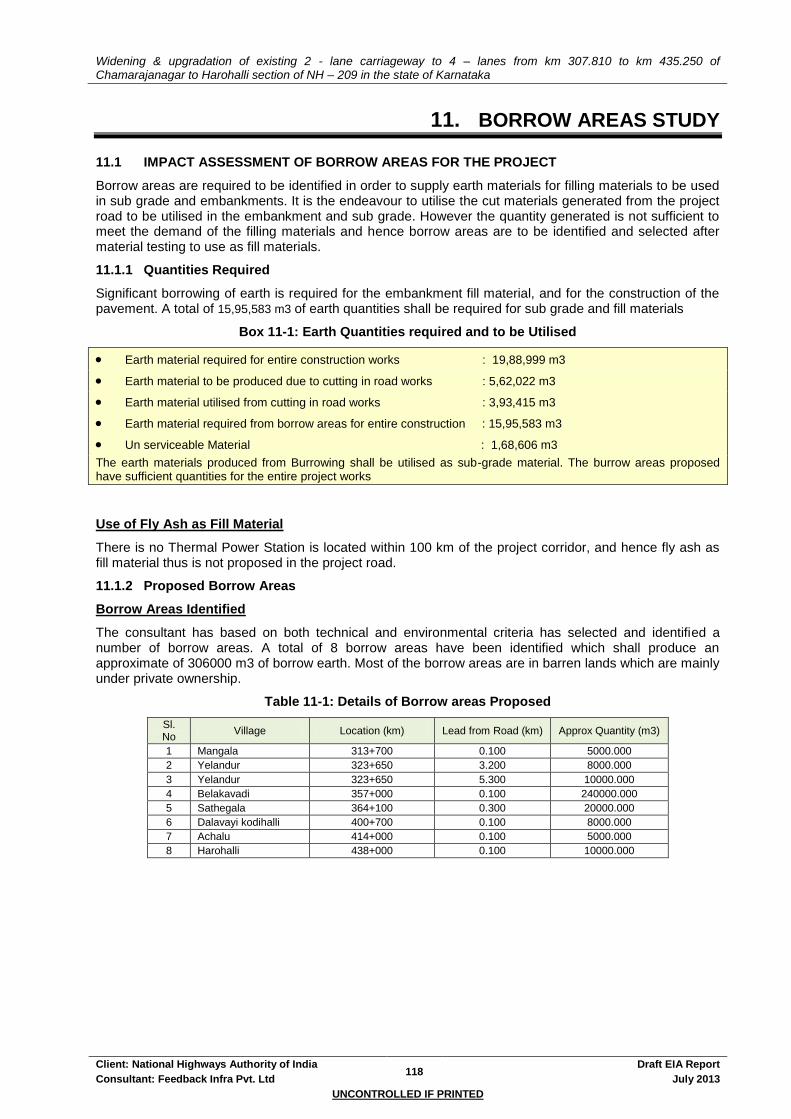
Widening & upgradation of existing 2 - lane carriageway to 4 – lanes from km 307.810 to km 435.250 of Chamarajanagar to Harohalli section of NH – 209 in the state of Karnataka
Client: National Highways Authority of India 118
Draft EIA Report
Consultant: Feedback Infra Pvt. Ltd July 2013
UNCONTROLLED IF PRINTED
11. BORROW AREAS STUDY
11.1 IMPACT ASSESSMENT OF BORROW AREAS FOR THE PROJECT
Borrow areas are required to be identified in order to supply earth materials for filling materials to be used in sub grade and embankments. It is the endeavour to utilise the cut materials generated from the project road to be utilised in the embankment and sub grade. However the quantity generated is not sufficient to meet the demand of the filling materials and hence borrow areas are to be identified and selected after material testing to use as fill materials.
11.1.1 Quantities Required
Significant borrowing of earth is required for the embankment fill material, and for the construction of the pavement. A total of 15,95,583 m3 of earth quantities shall be required for sub grade and fill materials
Box 11-1: Earth Quantities required and to be Utilised
Earth material required for entire construction works : 19,88,999 m3
Earth material to be produced due to cutting in road works : 5,62,022 m3
Earth material utilised from cutting in road works : 3,93,415 m3
Earth material required from borrow areas for entire construction : 15,95,583 m3
Un serviceable Material : 1,68,606 m3
The earth materials produced from Burrowing shall be utilised as sub-grade material. The burrow areas proposed have sufficient quantities for the entire project works
Use of Fly Ash as Fill Material
There is no Thermal Power Station is located within 100 km of the project corridor, and hence fly ash as fill material thus is not proposed in the project road.
11.1.2 Proposed Borrow Areas
Borrow Areas Identified
The consultant has based on both technical and environmental criteria has selected and identified a number of borrow areas. A total of 8 borrow areas have been identified which shall produce an approximate of 306000 m3 of borrow earth. Most of the borrow areas are in barren lands which are mainly under private ownership.
Table 11-1: Details of Borrow areas Proposed
Sl. No
Village Location (km) Lead from Road (km) Approx Quantity (m3)
1 Mangala 313+700 0.100 5000.000
2 Yelandur 323+650 3.200 8000.000
3 Yelandur 323+650 5.300 10000.000
4 Belakavadi 357+000 0.100 240000.000
5 Sathegala 364+100 0.300 20000.000
6 Dalavayi kodihalli 400+700 0.100 8000.000
7 Achalu 414+000 0.100 5000.000
8 Harohalli 438+000 0.100 10000.000
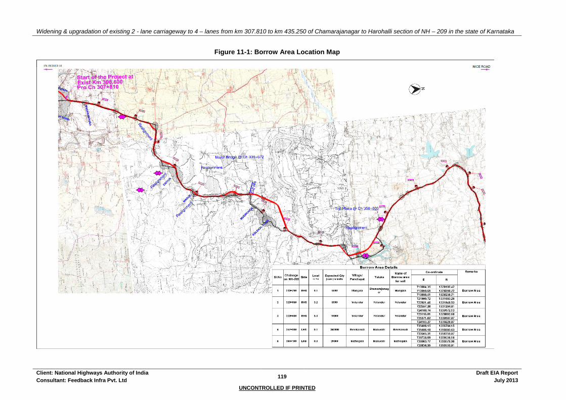
Widening & upgradation of existing 2 - lane carriageway to 4 – lanes from km 307.810 to km 435.250 of Chamarajanagar to Harohalli section of NH – 209 in the state of Karnataka
Client: National Highways Authority of India 119
Draft EIA Report
Consultant: Feedback Infra Pvt. Ltd July 2013
UNCONTROLLED IF PRINTED
Figure 11-1: Borrow Area Location Map

Widening & upgradation of existing 2 - lane carriageway to 4 – lanes from km 307.810 to km 435.250 of Chamarajanagar to Harohalli section of NH – 209 in the state of Karnataka
Client: National Highways Authority of India 120
Draft EIA Report
Consultant: Feedback Infra Pvt. Ltd July 2013
UNCONTROLLED IF PRINTED
Widening & upgradation of existing 2 - lane carriageway to 4 – lanes from km 307.810 to km 435.250 of Chamarajanagar to Harohalli section of NH – 209 in the state of Karnataka
Client: National Highways Authority of India 121
Draft EIA Report
Consultant: Feedback Infra Pvt. Ltd July 2013
UNCONTROLLED IF PRINTED
Selection Criteria
Borrow areas were identified based on a number of selection criteria. These included:
Total amount of borrow area available and quantity that can be made available
Lead distance of the borrow area from the project road
Existing land use including Agricultural / Barren / Scrub / grazing / any other type (priority were given to barren & non agricultural areas)
Ownership of the land
Vegetation / trees to be removed
Erosion / degradation potential
Distance and name of the nearest settlement
Distance from the nearest surface water body
Drainage pattern of the area
Suitability of material for sub grade and embankment use through material testing
Public Opinion (there were no objections or issues raised by the general public during the public hearing on the selection of borrow areas)
Borrow Area Location Map
The borrow area Location map is given in Figure 11-1.
Agreement with Landowners
The Concessionaire will finalise the locations from the list given by Consultant's for procuring materials. Once finalised the Concessionaire shall sign a lease / purchase agreements with the present owner of the land. The concessionaire shall furnish the statement of ownership of the land along with lease / purchase agreements to the IE & NHAI.
11.1.3 Baseline Environment
The air quality in the project area is moderately polluted. The detail air, noise & water quality status shall be updated in the final report. The borrow areas are not located within 10 Km of any Sanctuary & National Park. The borrow areas also do not require any diversion of forest areas. No endangered flora has also been reported.
11.1.4 Procedure for Excavating Borrow Area
To avoid any embankment slippage, the borrow areas will not be dug continuously, and the size and shape of borrow pits will be decided by the Engineer. Redevelopment of the borrow areas to mitigate the impacts will be the responsibility of the Concessionaire. The Concessionaire shall evolve site-specific redevelopment plans for each borrow area location, which shall be implemented after the approval of the Supervision Consultant.
Precautionary measures as the covering of vehicles will be taken to avoid spillage during transport of borrow materials. To ensure that the spills, which might result from the transport of borrow and quarry materials do not impact the settlements, it will be ensured that the excavation and carrying of earth will be done during day-time only. The unpaved surfaces used for the haulage of borrow materials will be maintained properly. Borrowing of earth shall be carried out at locations recommended as follows:
Non-Cultivable Lands: Borrowing of earth will be carried out upto a depth of 2.0 m from the existing ground level. Borrowing of earth shall not be done continuously. Ridges of not less than 8m width shall be left at intervals not exceeding 300 m. Small drains shall be cut through the ridges, if necessary, to facilitate drainage. Borrow pits shall have slopes not steeper than 1 vertical in 4 horizontal.
Productive Lands: Borrowing of earth shall be avoided on productive lands. However, in the event of borrowing from productive lands, under circumstances as described above, topsoil shall be preserved in stockpiles. The conservation of topsoil shall be carried out as described in section of this chapter. At such locations, the depth of borrow pits shall not exceed 45 cm and it may be dug out to a depth of not more than 30 cm after stripping the 15 cm top soil aside.
Elevated Lands: At locations where private owners desire their fields to be leveled, the borrowing shall

Widening & upgradation of existing 2 - lane carriageway to 4 – lanes from km 307.810 to km 435.250 of Chamarajanagar to Harohalli section of NH – 209 in the state of Karnataka
Client: National Highways Authority of India 122
Draft EIA Report
Consultant: Feedback Infra Pvt. Ltd July 2013
UNCONTROLLED IF PRINTED
be done to a depth of not more than 2 m or up to the level of surrounding fields.
Borrow pits along Roadside: Borrow pits shall be located 5m away from the toe of the embankment. Depth of the pit should be such that the bottom of the pit shall not fall within an imaginary line of slope 1 vertical to 4 horizontal projected from the edge of the final section of the bank. Borrow pits should not be dug continuously. Ridges of not less than 8 m width should be left at intervals not exceeding 300 m. Small drains should be cut through the ridges to facilitate drainage.
Borrow pits on the riverside: The borrow pit should be located not less than 15m from the toe of the bank, distance depending on the magnitude and duration of flood to be withstood.
Community / Private Ponds: Borrowing can be carried out at locations, where the private owners (or in some cases, the community) desire to develop lands (mostly low-lying areas) for pisciculture purposes and for use as fishponds.
Borrow Areas near Settlements: Borrow pit location shall be located at least 0.8 km from villages and settlements. If unavoidable, they should not be dug for more than 30 cm and should be drained.
Guidelines for Stripping, Stocking, Preservation of Top Soil
During the excavation of the borrowing material Concessionaire must ensure that the topsoil from all areas of cutting and all areas to be permanently covered shall be stripped to a specified depth of 150mm and stored in stockpiles. At least 10% of the temporarily acquired area shall be earmarked for storing topsoil. The stockpile shall be designed such that the slope does not exceed 1:2 (vertical to horizontal), and the height of the pile is restricted to 2m. Stockpiled will not be surcharged or otherwise loaded and multiple handing will be kept to a minimum to ensure that no compaction will occur. The stockpiles shall be covered with gunny bags or tarpaulin.
It shall be ensured by the Concessionaire that the topsoil will not be unnecessarily trafficked either before stripping or when in stockpiles. Stockpiled topsoil will be returned to cover the disturbed area and cut slopes. Residual topsoil will be distributed on adjoining/proximate barren/rocky areas as identified by the Engineer in a layer of thickness of 75mm-150mm. Top soil shall also be utilized for redevelopment of borrow areas. Landscaping along slopes, medians, incidental spaces etc.
11.1.5 Opening of New Borrow Areas
Siting
Specific locations of borrow areas to be used will be identified by Concessionaire based on the recommendations of the EIA report. In case the contractor or the concessionaire wants to open any new borrow areas other than mentioned in this report, then the selection and recommendations for borrow areas will be based on environmental as well as civil engineering considerations. Location of source of supply of material for embankment or sub-grade and the procedure for excavation or transport of material shall be in compliance with the environmental requirements of the MoEF, NHAI and as specified in IRC: 10-1961.
The Concessionaire shall establish a new borrow areas only with the prior consent of the Independent Engineer (IE) only in cases when:
Lead from existing borrow area & quarries is uneconomical and
Alternative material sources are not available. The Concessionaire shall prepare a Redevelopment Plan for the borrow area and get it approved by the IE.
Certain precautions have to be taken to restrict unauthorised borrowing by the contractor and the concessionaire. No borrow area shall be opened without permission of the Engineer. The borrowing shall not be carried out in cultivable lands, unless and until, it shall be agreed upon by the Engineer that there is no suitable uncultivable land in the vicinity for borrowing or private landowners are willing to allow borrowing on their fields.
The construction schedule and operations plans to be submitted to the IE prior to commencement of work shall contain a detailed work plan for procuring materials that includes procurement; transportation and storage of borrow earth material. The concessionaire shall provide the following:
Selection Criteria for Evaluation of Potential Borrow Areas
A brief statement as to how the site was chosen.
Alternative sites that were considered to be mentioned.

Widening & upgradation of existing 2 - lane carriageway to 4 – lanes from km 307.810 to km 435.250 of Chamarajanagar to Harohalli section of NH – 209 in the state of Karnataka
Client: National Highways Authority of India 123
Draft EIA Report
Consultant: Feedback Infra Pvt. Ltd July 2013
UNCONTROLLED IF PRINTED
Record any public consultations involved while choosing and what the public concerns were, if any.
Existing land use (Agricultural / Barren / Scrub / grazing / any other type)
Vegetation / trees to be removed
Erosion/degradation potential
Distance and name of the nearest settlement
Distance from the nearest surface water body
Drainage pattern of the area
Distance of the nearest Reserve Forest (if any)
Distance of the nearest Sacred Tree (if any)
Distance from the nearest school / hospital / primary health center
Daily / Occasional use of borrow area by the community
Any schemes or avenues for generation of income for adjoining community
Location and Layout
Sketch plans and photographs to be provided along with adequate details:
A map and sketch plan of the area showing the location of the proposed site with respect to the project road, nearby villages and worker accommodation locations along with indicative distances of the different sites from each other and from the road.
A detailed sketch plan of the borrow area showing approach and haulage roads, location etc., indicating which sites will be quarried in which year or phase, location of stock piles, location of guard house, perimeter fence, location of water sources, amenities, and any further details.
Photographs of the site
Table 11-2: Probable Borrow Areas data (to be filled by Concessionaire)
Sample no. Name
of Village
Material type
Site identification Approximate Quantity (Cum)
Available
Land / Terrain
Surrounding
Land / Terrain
Remarks Nearest Chainage
(Km.)
Left / Right
Offset from nearest
Chainage (m)
Length (m)
Breadth (m)
Depth (m)
Total (Cum)
Documentation of Borrow Pit
Following checklist provides guidelines in order to ensure that redevelopment of borrow areas must comply with MoRT&H, Clause 305.2.2.2 and EMP Requirement. The Concessionaire must ensure that following data based must be documented for each identified borrow areas that provide the basis of the redevelopment plan.
Chainage along with offset distance
Area (in Sq m)
Type of Access/width/kutcha/pucca etc from carriageway
Soil Type
Slope / Drainage Characteristics
Water Table of the area or identify from nearest well etc/ask people
Existing Land-use such as barren/agricultural/grazing land
Location/Name/Population of Nearest Settlement/Community & distance from Borrow Area
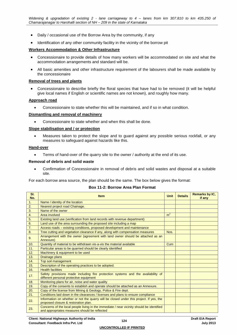
Widening & upgradation of existing 2 - lane carriageway to 4 – lanes from km 307.810 to km 435.250 of Chamarajanagar to Harohalli section of NH – 209 in the state of Karnataka
Client: National Highways Authority of India 124
Draft EIA Report
Consultant: Feedback Infra Pvt. Ltd July 2013
UNCONTROLLED IF PRINTED
Daily / occasional use of the Borrow Area by the community, if any
Identification of any other community facility in the vicinity of the borrow pit
Workers Accommodation & Other Infrastructure
Concessionaire to provide details of how many workers will be accommodated on site and what the accommodation arrangements and standard will be.
All basic amenities and other infrastructure requirement of the labourers shall be made available by the concessionaire
Removal of trees and plants
Concessionaire to describe briefly the floral species that have had to be removed (it will be helpful give local names if English or scientific names are not known), and roughly how many.
Approach road
Concessionaire to state whether this will be maintained, and if so in what condition.
Dismantling and removal of machinery
Concessionaire to state whether and when this shall be done.
Slope stabilisation and / or protection
Measures taken to protect the slope and to guard against any possible serious rockfall, or any measures to safeguard against hazards like this.
Hand-over
Terms of hand-over of the quarry site to the owner / authority at the end of its use.
Removal of debris and solid waste
Confirmation of Concessionaire in removal of debris and solid wastes and disposal at a suitable site.
For each borrow area source, the plan should be the same. The box below gives the format:
Box 11-2: Borrow Area Plan Format
SI. No.
Item Unit Details Remarks by IC,
if any
1. Name / identity of the location
2. Nearest project road Chainage.
3. Name of the owner
4. Area involved m2
5. Existing land use (verification from land records with revenue department)
6. Land use of the area surrounding the proposed site including a map
7. Access roads – existing conditions, proposed development and maintenance
8. Tree cutting and vegetation clearance if any, along with compensation measures Nos.
9. Arrangement with the owner (agreement with land owner should be attached as an Annexure)
10. Quantity of material to be withdrawn vis-a-vis the material available Cum
11. Particular areas to be quarried should be clearly identified
12. Machinery & equipment to be used
13. Drainage plans
14. Top soil management
15. Description of the operating practices to be adopted.
16. Health facilities
17. Safety provisions made including fire protection systems and the availability of different personal protective equipment
18. Monitoring plans for air, noise and water quality
19. Copy of the consents to establish and operate should be attached as an Annexure.
20. Copy of the license from Mining & Geology, Police & Fire dept.
21. Conditions laid down in the clearances / licenses and plans to ensure compliance
22. Information on whether or not the quarry will be closed under this project. If yes, the proposed closure & restoration plan.
23. Concerns of the local people living in the immediate / near vicinity should be identified and appropriates measures should be reflected
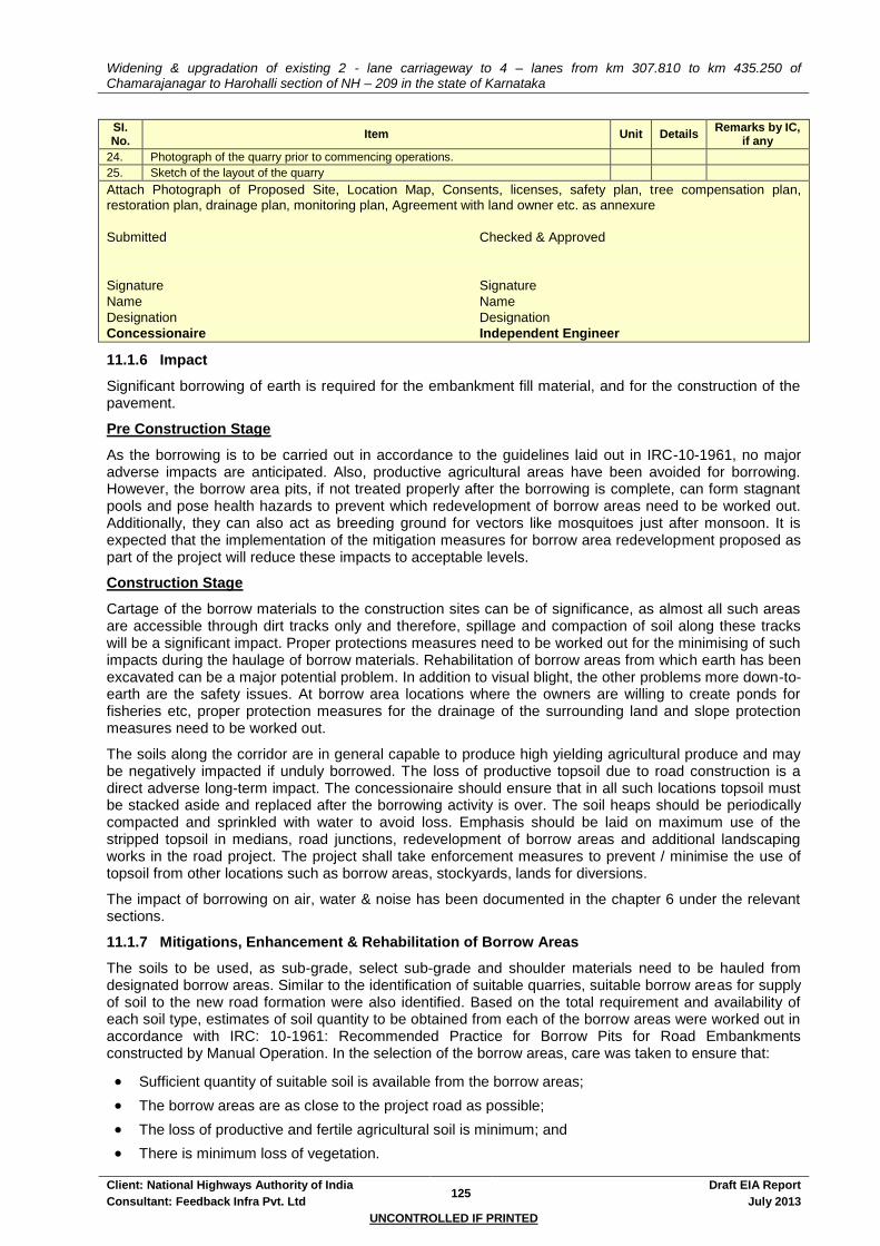
Widening & upgradation of existing 2 - lane carriageway to 4 – lanes from km 307.810 to km 435.250 of Chamarajanagar to Harohalli section of NH – 209 in the state of Karnataka
Client: National Highways Authority of India 125
Draft EIA Report
Consultant: Feedback Infra Pvt. Ltd July 2013
UNCONTROLLED IF PRINTED
SI. No.
Item Unit Details Remarks by IC,
if any
24. Photograph of the quarry prior to commencing operations.
25. Sketch of the layout of the quarry
Attach Photograph of Proposed Site, Location Map, Consents, licenses, safety plan, tree compensation plan, restoration plan, drainage plan, monitoring plan, Agreement with land owner etc. as annexure
Submitted Checked & Approved
Signature Signature
Name Name
Designation Designation
Concessionaire Independent Engineer
11.1.6 Impact
Significant borrowing of earth is required for the embankment fill material, and for the construction of the pavement.
Pre Construction Stage
As the borrowing is to be carried out in accordance to the guidelines laid out in IRC-10-1961, no major adverse impacts are anticipated. Also, productive agricultural areas have been avoided for borrowing. However, the borrow area pits, if not treated properly after the borrowing is complete, can form stagnant pools and pose health hazards to prevent which redevelopment of borrow areas need to be worked out. Additionally, they can also act as breeding ground for vectors like mosquitoes just after monsoon. It is expected that the implementation of the mitigation measures for borrow area redevelopment proposed as part of the project will reduce these impacts to acceptable levels.
Construction Stage
Cartage of the borrow materials to the construction sites can be of significance, as almost all such areas are accessible through dirt tracks only and therefore, spillage and compaction of soil along these tracks will be a significant impact. Proper protections measures need to be worked out for the minimising of such impacts during the haulage of borrow materials. Rehabilitation of borrow areas from which earth has been excavated can be a major potential problem. In addition to visual blight, the other problems more down-to-earth are the safety issues. At borrow area locations where the owners are willing to create ponds for fisheries etc, proper protection measures for the drainage of the surrounding land and slope protection measures need to be worked out.
The soils along the corridor are in general capable to produce high yielding agricultural produce and may be negatively impacted if unduly borrowed. The loss of productive topsoil due to road construction is a direct adverse long-term impact. The concessionaire should ensure that in all such locations topsoil must be stacked aside and replaced after the borrowing activity is over. The soil heaps should be periodically compacted and sprinkled with water to avoid loss. Emphasis should be laid on maximum use of the stripped topsoil in medians, road junctions, redevelopment of borrow areas and additional landscaping works in the road project. The project shall take enforcement measures to prevent / minimise the use of topsoil from other locations such as borrow areas, stockyards, lands for diversions.
The impact of borrowing on air, water & noise has been documented in the chapter 6 under the relevant sections.
11.1.7 Mitigations, Enhancement & Rehabilitation of Borrow Areas
The soils to be used, as sub-grade, select sub-grade and shoulder materials need to be hauled from designated borrow areas. Similar to the identification of suitable quarries, suitable borrow areas for supply of soil to the new road formation were also identified. Based on the total requirement and availability of each soil type, estimates of soil quantity to be obtained from each of the borrow areas were worked out in accordance with IRC: 10-1961: Recommended Practice for Borrow Pits for Road Embankments constructed by Manual Operation. In the selection of the borrow areas, care was taken to ensure that:
Sufficient quantity of suitable soil is available from the borrow areas;
The borrow areas are as close to the project road as possible;
The loss of productive and fertile agricultural soil is minimum; and
There is minimum loss of vegetation.

Widening & upgradation of existing 2 - lane carriageway to 4 – lanes from km 307.810 to km 435.250 of Chamarajanagar to Harohalli section of NH – 209 in the state of Karnataka
Client: National Highways Authority of India 126
Draft EIA Report
Consultant: Feedback Infra Pvt. Ltd July 2013
UNCONTROLLED IF PRINTED
For opening new borrow areas other than those identified the contractor and or concessionaire shall follow section 11.1.5 above. The borrowing shall not be carried out in cultivable lands, unless and until, it shall be agreed upon by the Engineer that there is no suitable uncultivable land in the vicinity for borrowing, or there are private land owners willing to allow borrowing on their fields. Borrowing of earth shall be carried out at locations recommended as follows:
Non-Cultivable lands: Borrowing of earth will be carried out to a depth of 1 m. The borrowing of earth shall not be done continuously and the slope of the edges shall be maintained at not more than 1:4.
Productive lands: Borrowing of earth shall not be carried out on productive lands. However, in the event of borrowing from productive lands, the contractor has to obtain the prior permission of the Engineer. At such locations, the depth of borrow pits shall not exceed 45 cm and if may be dug out to a depth of not more than 30 cm after stripping the 15 cm top soil aside and the topsoil shall be carried out and preserved.
Borrow Areas near Settlements: Borrow pit location shall be located at least 0.8 km from villages and settlements. If unavoidable, they should not be dug for more than 30 cm and should be drained.
To avoid any embankment slippages, the borrow areas will not be dug continuously, and the size and shape of borrow pits will be decided by the Engineer. The borrow pits will be redeveloped by filling and providing 150 mm thick layer of preserved top-soil; by creating shallow pond for water harvesting etc. Replantation of trees along the edges of borrow areas will be carried out.
Precautionary measures as the covering of vehicles will be taken to avoid spillage during transport of borrow materials. To ensure that the spills, which might result from the transport of borrow and quarry materials do not impact the settlements, it will be ensured that the excavation and carrying of earth will be done during day-time only, The unpaved surfaces used for the haulage of borrow materials will be maintained properly.
Rehabilitation
The objective of the rehabilitation programme is to return the borrow pit sites to a safe and secure area, which the general public should be able to safely enter and enjoy. Securing borrow pits sites in a stable condition should be a fundamental requirement of the rehabilitation process. This could be achieved by filling the borrow pit floor to approximately the access road level.
It is important to plan restoration from the outset and coordinate restoration activities. In addition to the bio-diversity issues, land planning considerations are also taken into account when defining a rehabilitation project in order both to preserve the environment and to generate income for the local communities. In this framework rehabilitation often leads to the creation of wetlands and or recreation areas.
Special borrow pit rehabilitation plan shall be specified according to the location and shaping of the mining slopes after exploitation and overburdened dump, with different subsequent uses e.g. forest, meadow, water body etc., the re-greening and replanting methods.
Other criteria which shall be followed for rehabilitation of quarry/ borrow pits are as given below:
Borrow pits can be backfilled with rejected construction wastes and will be given a vegetative cover. If this is not possible, then slopes will be smoothed and depression will be filled in such a way that it looks more or less like the original ground surface.
During works execution, the Concessionaire shall ensure preservation of trees during piling of materials; spreading of stripping material to facilitate water percolation and allow natural vegetation growth; reestablishment of previous natural drainage flows; improvement of site appearance; digging of ditches to collect runoff; and maintenance of roadways where a pit or quarry is declared useable water source for livestock or people nearby. Once the works are completed, and at own expense the concessionaire and Concessionaire shall restore the environment around the work site to its original splits.
Appropriate plant species for the planting programme have to be selected in consultation with ecological consultant and local forest department. Depending on the limitations on the availability of appropriate plant material, harsh growing conditions (lack of irrigation and hot summer) and ongoing quarry rehabilitation operations there may be substantial loss of plantation and the planting programme may have to be continued for over 3–5 years. As plantings are progressively established

Widening & upgradation of existing 2 - lane carriageway to 4 – lanes from km 307.810 to km 435.250 of Chamarajanagar to Harohalli section of NH – 209 in the state of Karnataka
Client: National Highways Authority of India 127
Draft EIA Report
Consultant: Feedback Infra Pvt. Ltd July 2013
UNCONTROLLED IF PRINTED
they should be monitored before undertaking the next stage to ensure maximum plant survival rates.
The borrow pit immediate surroundings shall be developed as a low maintenance reserve, with significant areas of native trees and shrubs and areas of longer grass and tussocks forming the open spaces. Walkways around the borrow site may be constructed. Provision for a future drive-in picnic area and car parking area may be developed.
Guidelines for Enhancement
As far as possible borrow area selected for enhancement shall be on government / community land in the vicinity of settlement. The Concessionaire must ensure that any enhancement design proposed should be workable, maintenance free and preferably worked out in consultation with the community and proposed enhancement materials should be locally available. The borrow area can be developed either of the following:
Vegetative Cover
Vegetative cover must be established on all affected land.
Topsoil must be placed, seeded, and mulched within 30 days of final grading if it is within a current growing season or within 30 days of the start of the next growing season.
Vegetative material used in reclamation must consist of grasses, legumes, herbaceous, or woody plants or a mixture thereof.
Plant material must be planted during the first growing season following the reclamation phase.
Selection and use of vegetative cover must take into account soil and site characteristics such as drainage, pH, nutrient availability, and climate to ensure permanent growth.
The vegetative cover is acceptable if within one growing season of seeding:
The planting of trees and shrubs results in a permanent stand, or regeneration and succession rate, sufficient to assure a 75% survival rate;
The planting results in 90% ground coverage.
The site shall be inspected when the planting is completed and again at one year to ensure compliance with the reclamation plan.
Certificate of Completion of Reclamation
Concessionaires have to obtained certificate of satisfaction from the landowner and submit it to the Engineer before final payment is to done.
Working Plan
The Concessionaire must prepare a working plan before enhancing the identified borrow areas. Following are the inputs that provide the guidelines to the Concessionaire to formulate the working plan:
Access of Property / width of access / material
Orientation of property with respect to the road
Site Slope
Local Drainage / water logging etc if any
Location of nearest culvert etc if any to drain water if required
Any other community resources such as tube well/well etc in vicinity
Location of trees including Species / girth / foliage spread and afternoon shaded area on ground
Surrounding land use; nearby settlements (name of structure/pattern of settlement)
Mark on plan part of the borrow area, most suitable for storing and staking topsoil.
Drawings to be Prepared
The Concessionaire have to prepared the drawings showing both cross-section as well as plan of the

Widening & upgradation of existing 2 - lane carriageway to 4 – lanes from km 307.810 to km 435.250 of Chamarajanagar to Harohalli section of NH – 209 in the state of Karnataka
Client: National Highways Authority of India 128
Draft EIA Report
Consultant: Feedback Infra Pvt. Ltd July 2013
UNCONTROLLED IF PRINTED
identified borrow areas incorporating following inputs:
Contours if any, depth if any
Location of trees, height, foliage spread and afternoon shaded area on ground
Any other existing details at the road / property interface such as signage/railing/etc.
Details of immediate surrounding for at least 5m on either sides
Photographs to Include
The Concessionaire must ensure that photographs are to be taken before and after the excavation of borrow materials and also after the implementation of redevelopment plan, incorporating the following:
Overall View from access side
Any other community resource in the vicinity
All spots to be detailed such as access to borrow pit /cluster of existing trees etc.


Widening & upgradation of existing 2 - lane carriageway to 4 – lanes from km 307.810 to km 435.250 of Chamarajanagar to Harohalli section of NH – 209 in the state of Karnataka
Client: National Highways Authority of India 129
Draft EIA Report
Consultant: Feedback Infra Pvt. Ltd July 2013
UNCONTROLLED IF PRINTED
12. ADDITIONAL TOR COMPLIANCE
12.1 THE ADDITIONAL TOR
The proposal was considered by Expert Appraisal Committee during its 119th meeting held on 20th –
21th December, 2012. The compliance to Additional Terms of Reference as being suggested by
Committee is given hereunder:
Table 12-1: Compliance to Additional TOR
Sl. No.
ToR Points Compliance
1 The Proposal indicates the acquisition of 0.1285 ha Forest land. Necessary stage –I forestry clearance shall be obtained as per OM dated 31.03.2011 and submitted along with final EIA report
The proposed project shall involve diversion of 10.3000ha. forest land in Ramanagara and Mandya Forest Division of Karnataka Forest Dept.’s jurisdiction..
Application for obtaining Forest Clearance has already been made. The application letter has been attached as Appendix-1
2 It is indicated that 2431 trees fall within ROW, however bare minimum trees shall be cut, the information should be provided about their species and whether it also involved any protected or endangered species. Necessary green belt shall be provided on both side of the highway with proper central verge and cost provision should be made for regular maintenance.
24712 trees of various girth sizes present along the project corridor. The project is likely to impact 19230 trees of various species as per joint verifications with forest department. Thus saving 5482 trees of various species.
No endangered / protected species.
Avenue plantation along the project road and in median is proposed & shall be carried out as per IRC: SP: 21-2009 based on availability of land
Incidental area of 35.09 Ha. identified where plantations can take place
Species details for felling is annexed in Annexure 4.3
Necessary prior permissions from the District Collectors and the DCF has been requested for felling
3 Explore the possibilities of cooled mixed technology instead of hot mix technology
Please refer Chapter- 7
4 Any litigation(s) pending against the proposed project and/or any directions or orders passed by any court of law/any statutory authority against the project is to be detailed out.
No litigations are pending against the project road.
5 Submit detailed alignment plan, with details such as nature of terrain (plain, rolling, hilly), land use pattern, habitation, cropping pattern, forest area, environmentally sensitive places, mangroves, notified industrial areas, sand dunes, sea, river, lake, details of villages, teshils, districts and states, latitude and longitude for important locations falling on the alignment by employing remote sensing techniques followed by ground truthing and also through secondary data sources.
Detailed Alignment Plan attached
Terrain along the project road is plain
10.3000ha of forest land will be diverted for the project.
There exist no mangroves along the project corridor.
The project road section doesn’t fall within 10 Km radius of any Wild Life Sanctuary or National Park
The project does not involve any sand dunes, sea etc.
Project Districts: Chamarajanagar, Mandya, Ramanagar
Tehsils: Chamaraja Nagar, Yelanduru, Kollegal in Chamarajanagar District, Malavalli in Mandya District and Kanakapura in Ramanagar District.
6 Describe various alternatives considered, procedures and criteria adopted for selection of the final alternative with reasons.
The project road is a NH and connects the urban and semi urban regions outside Bangalore. Hence question of various alternatives for the project road does not arise.
However to decongest built up areas along the project route bypasses at Kollegal, Sathegala,

Widening & upgradation of existing 2 - lane carriageway to 4 – lanes from km 307.810 to km 435.250 of Chamarajanagar to Harohalli section of NH – 209 in the state of Karnataka
Client: National Highways Authority of India 130
Draft EIA Report
Consultant: Feedback Infra Pvt. Ltd July 2013
UNCONTROLLED IF PRINTED
Sl. No.
ToR Points Compliance
Halaguru and Kanakapura proposed along with realignments. Different alternate route along with widening of existing alignment are compared considering the factors like road length, available ROW, land acquisition, structures to be demolished, project affected families and construction cost.
The details of analysis of alternative are given in Chapter 7.
7 Submit Land use map of the study area to a scale of 1:25000 based on recent satellite imagery delineating the crop lands (both single and double crop), agricultural plantations, fallow lands, waste lands, water bodies, built-up areas, forest area and other surface features such as railway tracks, ports, airports, roads, and major industries etc. and submit a detailed ground surveyed map on 1:2000 scale showing the existing features falling within the right of way namely trees, structures including archaeological & religious, monuments etc. if any.
The land use map based upon recent satellite imagery and on desired scale shall be enclosed in the final report
8 If the proposed road is passing through any hilly area, examine and submit the stability of slopes, if the proposed road is to pass through cutting or embankment / control of soil erosion from embankment
The project road doesn’t passes through any hilly area
9 If the proposed route involves tunneling, the details of the tunnel and locations of tunneling with geological structural fraction should be provided. The case the road passes through a flood plain of the river, the details of micro drainage, flood passages and information on flood periodicity at least of last 50 years in the area should be examined
The project doesn’t involves any tunnelling nor does it passes through any flood plain of rivers
10 The project is located within 10 Km of sanctuary a map duly authenticated by Chief Wild Life Warden showing these features vis-à-vis the project location and the recommendations Chief Wild Life Warden thereon should be furnished at the stage of EC
The project road section is not located within 10 Km of any sanctuary
11 Study regarding the animal bypasses / underpasses etc. across the habitation areas shall be carried out. Adequate cattle passes for the movement of agricultural material shall be provided at the stretches passing though habitation areas
No underpass is provided as there is no major cross traffic movement. Also in agricultural area 2 lane with paved shoulder is proposed.
No cattle pass is provided since it 2 lane with paved shoulder proposed in agricultural area
12 If the proposed route is passing through a city / town, with houses and human habitation on the either side of the road, the necessity for provision of bypasses / diversions / under passes shall be examined and submitted. The proposal should also indicate the location of wayside amenities, which should include petrol station/service centre, rest areas including public conveyance etc.
Bypasses at 4 locations have been proposed for smoother movement of traffic in densely populated areas.
Chainage wise locations of bypass locations are given in Chapter-2 of EIA report.
Details of wayside amenities are provided in Chapter-2
13 Submit details about measures taken for the pedestrian safety and construction of underpasses and foot-over bridges along with flyovers and interchanges.
54 bus bays with bus shelters proposed along with 1 truck lay bye.
1 toll plaza at Existing Chainage Km 363.000 has been proposed.
Apart from these, provisions are proposed for pedestrian safety, in Schedule C (Project Facilities) and Schedule D (Standards & Specifications) of the Concession Agreement signed between the Concessionaire and project Proponent.
14 Assess whether there is a possibility that the proposed project will adversely affect road traffic in the surrounding areas (e.g. by causing increases in traffic congestion and traffic accidents).
During construction period, appropriate traffic management will be adopted to minimize congestion.
During Operation period, the proposed project

Widening & upgradation of existing 2 - lane carriageway to 4 – lanes from km 307.810 to km 435.250 of Chamarajanagar to Harohalli section of NH – 209 in the state of Karnataka
Client: National Highways Authority of India 131
Draft EIA Report
Consultant: Feedback Infra Pvt. Ltd July 2013
UNCONTROLLED IF PRINTED
Sl. No.
ToR Points Compliance
would smooth the traffic jams and congestion and would minimize traffic accidents.
Detailed traffic management plan enclosed as Annexure 8.8
The project shall improve connectivity in the region, enhancing the inter-urban, inter-district and inter-state mobility, and it will attract more traffic in the form of diverted and generated traffic from the influencing areas. Development of project road will not lead to any congestion on other roads in the areas, the measures for traffic control / diversion while construction is proposed.
15 Examine and submit the details of use of fly ash in the road construction, if the project road is located within the 100 Km from the thermal power plant
No thermal power plant located within 100 km from the project road
16 Examine and submit the details of sand quarry, borrow area and rehabilitation.
Details of quarry areas identified for the project is given in Tables 8-3 & 8-4. Quarry chart enclosed as Annexure 8.5. Borrow area details given in chapter 11
17 Climate and meteorology (max and min temperature, relative humidity, rainfall, frequency of tropical cyclone and snow fall); the nearest IMD meteorological station from which climatological data have been obtained to be indicated.
For climate and meteorology data kindly refer Section 4.2.1 of Chapter 4 of EIA. Secondary meteorological data have been obtained from websites
18 The air quality monitoring should be carried out as per the new notification issued on 16
th November, 2009.
Air quality monitoring has been carried out as per new notification for the period October – December 2012. Please refer section 4.2.3 of Chapter 4 of EIA report for monitoring results.
19 Identify project activities during construction and operation phases, which will affect the noise levels and the potential for increased noise resulting from this project. Discuss the effect of noise levels on nearby habitation during the construction and operational phases of the proposed highway. Identify noise reduction measures and traffic management strategies to be deployed for reducing the negative impact if any. Prediction of noise levels should be done by using mathematical modelling at different representative locations.
Impact evaluation and results and proposed mitigation measures are given in section 6.2.5 & 8.2.5 of Chapter 6 & 8 of EIA report. Noise prediction modelling shall be furnished in final EIA Report.
20 Examine the impact during construction activities due to generation of fugitive dust from crusher units, air emissions from hot mix plants and vehicles used for transportation of materials and prediction of impact on ambient air quality using appropriate mathematical model, description of model, input requirement and reference of derivation, distribution of major pollutants and presentation in tabular form for easy interpretation shall be carried out.
Regular water sprinkling system will be adopted to minimize the dust emission.
Raw materials with covered vehicles to avoid fugitive emission;
Modelling shall be furnished in final EIA Report.
21 Also examine and submit the details about the protection to existing habitations from dust, noise, odour etc. during construction stage.
An environment management plan has been proposed to minimize the impact on habitation from dust, noise etc. during construction stage. Please refer Chapter 10 of EIA report.
22 If the proposed route involves cutting of earth, the details of area to be cut, depth of cut, locations, soil type, volume and quantity of earth and other materials to be removed with location of disposal / dump site along with necessary permission.
The borrow materials will be withdrawn as per IRC: 10-1961. The aggregate and sand will be procured from the Govt. approved licensed quarries by paying the cost of material as well as cost for rehabilitation.
The locations of borrow areas are given in chapter 11.
23 If the proposed route is passing through low lying areas, details of fill materials and initial and final levels after filling above MSL, should be examined and submit.
No low lying areas exist along the project road
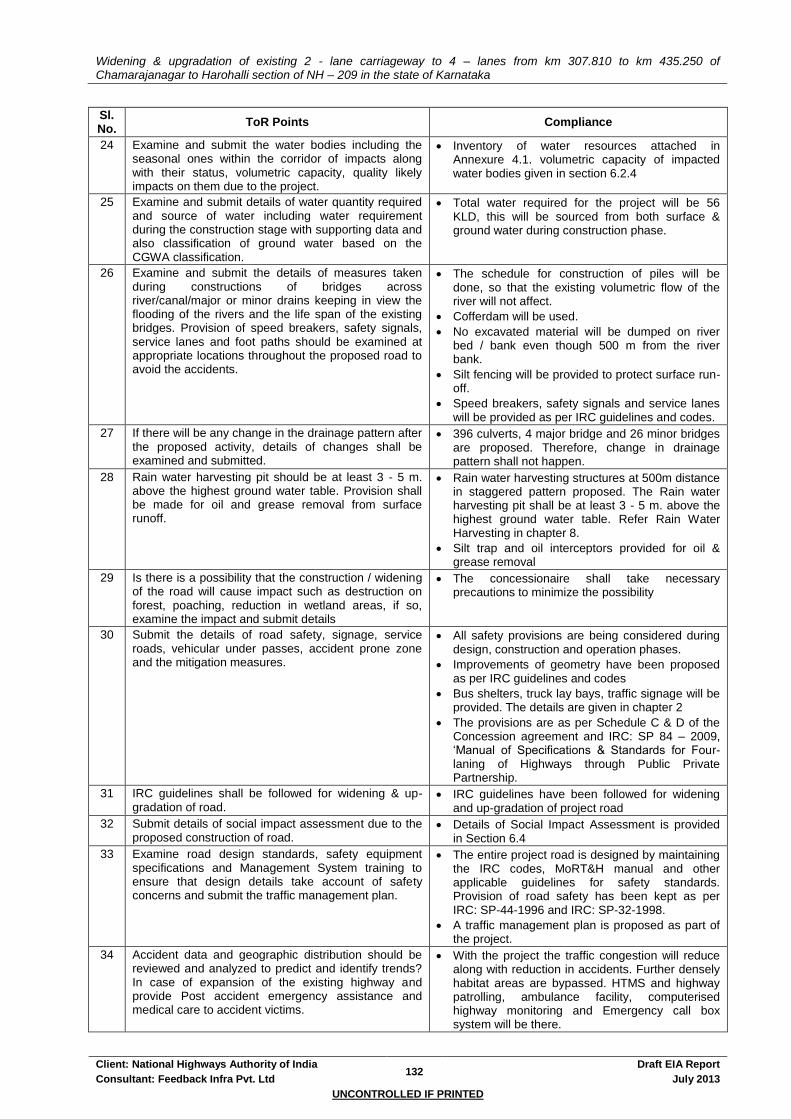
Widening & upgradation of existing 2 - lane carriageway to 4 – lanes from km 307.810 to km 435.250 of Chamarajanagar to Harohalli section of NH – 209 in the state of Karnataka
Client: National Highways Authority of India 132
Draft EIA Report
Consultant: Feedback Infra Pvt. Ltd July 2013
UNCONTROLLED IF PRINTED
Sl. No.
ToR Points Compliance
24 Examine and submit the water bodies including the seasonal ones within the corridor of impacts along with their status, volumetric capacity, quality likely impacts on them due to the project.
Inventory of water resources attached in Annexure 4.1. volumetric capacity of impacted water bodies given in section 6.2.4
25 Examine and submit details of water quantity required and source of water including water requirement during the construction stage with supporting data and also classification of ground water based on the CGWA classification.
Total water required for the project will be 56 KLD, this will be sourced from both surface & ground water during construction phase.
26 Examine and submit the details of measures taken during constructions of bridges across river/canal/major or minor drains keeping in view the flooding of the rivers and the life span of the existing bridges. Provision of speed breakers, safety signals, service lanes and foot paths should be examined at appropriate locations throughout the proposed road to avoid the accidents.
The schedule for construction of piles will be done, so that the existing volumetric flow of the river will not affect.
Cofferdam will be used.
No excavated material will be dumped on river bed / bank even though 500 m from the river bank.
Silt fencing will be provided to protect surface run-off.
Speed breakers, safety signals and service lanes will be provided as per IRC guidelines and codes.
27 If there will be any change in the drainage pattern after the proposed activity, details of changes shall be examined and submitted.
396 culverts, 4 major bridge and 26 minor bridges are proposed. Therefore, change in drainage pattern shall not happen.
28 Rain water harvesting pit should be at least 3 - 5 m. above the highest ground water table. Provision shall be made for oil and grease removal from surface runoff.
Rain water harvesting structures at 500m distance in staggered pattern proposed. The Rain water harvesting pit shall be at least 3 - 5 m. above the highest ground water table. Refer Rain Water Harvesting in chapter 8.
Silt trap and oil interceptors provided for oil & grease removal
29 Is there is a possibility that the construction / widening of the road will cause impact such as destruction on forest, poaching, reduction in wetland areas, if so, examine the impact and submit details
The concessionaire shall take necessary precautions to minimize the possibility
30 Submit the details of road safety, signage, service roads, vehicular under passes, accident prone zone and the mitigation measures.
All safety provisions are being considered during design, construction and operation phases.
Improvements of geometry have been proposed as per IRC guidelines and codes
Bus shelters, truck lay bays, traffic signage will be provided. The details are given in chapter 2
The provisions are as per Schedule C & D of the Concession agreement and IRC: SP 84 – 2009, ‘Manual of Specifications & Standards for Four-laning of Highways through Public Private Partnership.
31 IRC guidelines shall be followed for widening & up-gradation of road.
IRC guidelines have been followed for widening and up-gradation of project road
32 Submit details of social impact assessment due to the proposed construction of road.
Details of Social Impact Assessment is provided in Section 6.4
33 Examine road design standards, safety equipment specifications and Management System training to ensure that design details take account of safety concerns and submit the traffic management plan.
The entire project road is designed by maintaining the IRC codes, MoRT&H manual and other applicable guidelines for safety standards. Provision of road safety has been kept as per IRC: SP-44-1996 and IRC: SP-32-1998.
A traffic management plan is proposed as part of the project.
34 Accident data and geographic distribution should be reviewed and analyzed to predict and identify trends? In case of expansion of the existing highway and provide Post accident emergency assistance and medical care to accident victims.
With the project the traffic congestion will reduce along with reduction in accidents. Further densely habitat areas are bypassed. HTMS and highway patrolling, ambulance facility, computerised highway monitoring and Emergency call box system will be there.

Widening & upgradation of existing 2 - lane carriageway to 4 – lanes from km 307.810 to km 435.250 of Chamarajanagar to Harohalli section of NH – 209 in the state of Karnataka
Client: National Highways Authority of India 133
Draft EIA Report
Consultant: Feedback Infra Pvt. Ltd July 2013
UNCONTROLLED IF PRINTED
Sl. No.
ToR Points Compliance
Accident data and their distribution and cause as part of feasibility study was reviewed. The design of new 4-lane facility is taking care of accident black spots. The facility minimizes accident possibilities with superior design and safety features. Necessary measures have proposed to take care post accident emergency / trauma care; they are listed in the Schedules of the concession agreement.
35 If the proposed project involves any land reclamation, details to be provided for which activity land to reclaim and the area of land to be reclaimed.
Please refer Chapter-6.
36 Details of the properties, houses, businesses etc. activities likely to be effected by land acquisition and their financial loses annually.
A total of 3200 PAPs & 564 PAFs are to be impacted. A total of 564 properties are being affected out of which there are 158 residential, 352 commercial and 54 resi-cum-commercial properties
37 Detailed R&R plan with data on the existing socio-economic status of the population in the study area and broad plan for resettlement of the displaced population, site for the resettlement colony, alternative livelihood concerns/ employment and rehabilitation of the displaced people, civil and housing amenities being offered, etc and the schedule of the implementation of the project specific
Compensation to the project affected families (PAFs) will be as per NPRR 2007 and Govt. of Karnataka and NHAI policies. Separate R&R budget kept.
38 Submit details of Corporate Social Responsibility. Necessary provisions should be made in the budget.
The project is a Government of India project which aims at providing better connectivity and also providing better economic development in the region. Hence CSR details is not applicable for the project
However the Concessionaire shall make necessary provisions for Corporate Social responsibility in their budgetary provisions
38 Estimated cost of the project including environmental monitoring cost and funding agencies, whether governmental or on the basis of BOT etc and provide details of budget provisions (capital & recurring) for the project specific R&R Plan.
The project will be on DBFO basis. Civil cost for the project is INR 331.53crores while the Total Project cost is INR INR 581.424 Crores
EMP budget for INR 24.43 crores is presented in Table 10-2
The LA and R&R cost is budgeted at INR 42.0 Crores.
39 Submit environmental management and monitoring plan for all phases of the project viz. construction and operation.
Kindly refer Chapter 10 for Environment Management Plan of EIA report.

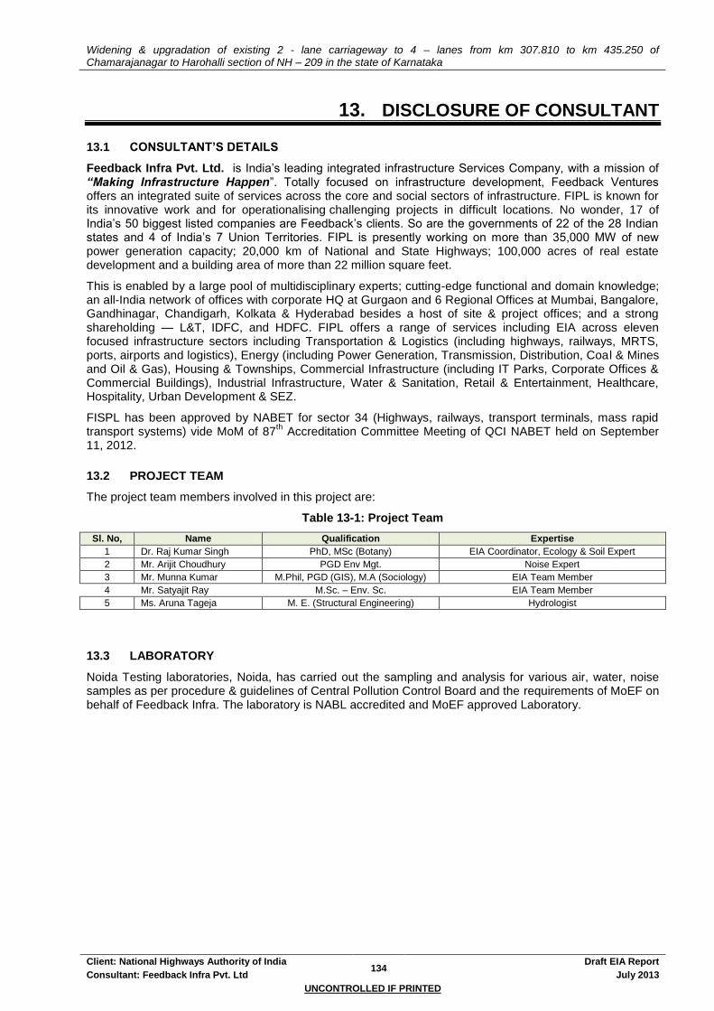
Widening & upgradation of existing 2 - lane carriageway to 4 – lanes from km 307.810 to km 435.250 of Chamarajanagar to Harohalli section of NH – 209 in the state of Karnataka
Client: National Highways Authority of India 134
Draft EIA Report
Consultant: Feedback Infra Pvt. Ltd July 2013
UNCONTROLLED IF PRINTED
13. DISCLOSURE OF CONSULTANT
13.1 CONSULTANT’S DETAILS
Feedback Infra Pvt. Ltd. is India’s leading integrated infrastructure Services Company, with a mission of “Making Infrastructure Happen”. Totally focused on infrastructure development, Feedback Ventures offers an integrated suite of services across the core and social sectors of infrastructure. FIPL is known for its innovative work and for operationalising challenging projects in difficult locations. No wonder, 17 of India’s 50 biggest listed companies are Feedback’s clients. So are the governments of 22 of the 28 Indian states and 4 of India’s 7 Union Territories. FIPL is presently working on more than 35,000 MW of new power generation capacity; 20,000 km of National and State Highways; 100,000 acres of real estate development and a building area of more than 22 million square feet.
This is enabled by a large pool of multidisciplinary experts; cutting-edge functional and domain knowledge; an all-India network of offices with corporate HQ at Gurgaon and 6 Regional Offices at Mumbai, Bangalore, Gandhinagar, Chandigarh, Kolkata & Hyderabad besides a host of site & project offices; and a strong shareholding — L&T, IDFC, and HDFC. FIPL offers a range of services including EIA across eleven focused infrastructure sectors including Transportation & Logistics (including highways, railways, MRTS, ports, airports and logistics), Energy (including Power Generation, Transmission, Distribution, Coal & Mines and Oil & Gas), Housing & Townships, Commercial Infrastructure (including IT Parks, Corporate Offices & Commercial Buildings), Industrial Infrastructure, Water & Sanitation, Retail & Entertainment, Healthcare, Hospitality, Urban Development & SEZ.
FISPL has been approved by NABET for sector 34 (Highways, railways, transport terminals, mass rapid transport systems) vide MoM of 87
th Accreditation Committee Meeting of QCI NABET held on September
11, 2012.
13.2 PROJECT TEAM
The project team members involved in this project are:
Table 13-1: Project Team
Sl. No, Name Qualification Expertise
1 Dr. Raj Kumar Singh PhD, MSc (Botany) EIA Coordinator, Ecology & Soil Expert
2 Mr. Arijit Choudhury PGD Env Mgt. Noise Expert
3 Mr. Munna Kumar M.Phil, PGD (GIS), M.A (Sociology) EIA Team Member
4 Mr. Satyajit Ray M.Sc. – Env. Sc. EIA Team Member
5 Ms. Aruna Tageja M. E. (Structural Engineering) Hydrologist
13.3 LABORATORY
Noida Testing laboratories, Noida, has carried out the sampling and analysis for various air, water, noise samples as per procedure & guidelines of Central Pollution Control Board and the requirements of MoEF on behalf of Feedback Infra. The laboratory is NABL accredited and MoEF approved Laboratory.
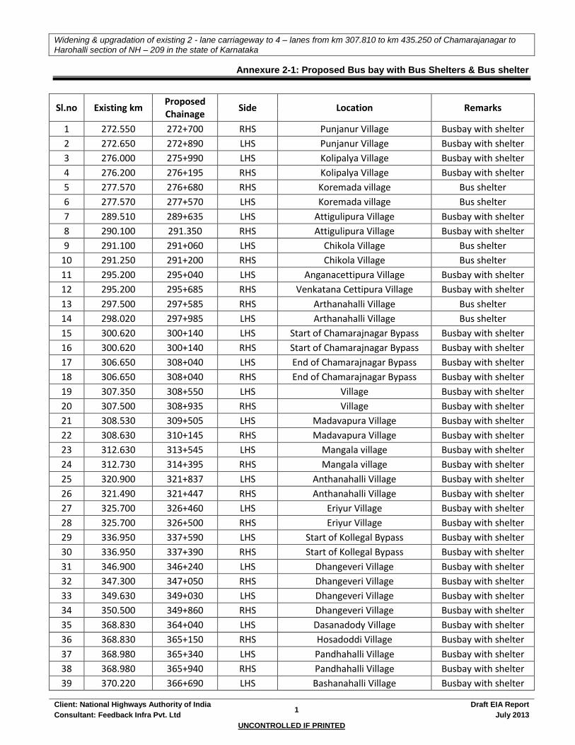
Widening & upgradation of existing 2 - lane carriageway to 4 – lanes from km 307.810 to km 435.250 of Chamarajanagar to
Harohalli section of NH – 209 in the state of Karnataka
Client: National Highways Authority of India 1
Draft EIA Report
Consultant: Feedback Infra Pvt. Ltd July 2013
UNCONTROLLED IF PRINTED
Annexure 2-1: Proposed Bus bay with Bus Shelters & Bus shelter
Sl.no Existing km Proposed Chainage
Side Location Remarks
1 272.550 272+700 RHS Punjanur Village Busbay with shelter
2 272.650 272+890 LHS Punjanur Village Busbay with shelter
3 276.000 275+990 LHS Kolipalya Village Busbay with shelter
4 276.200 276+195 RHS Kolipalya Village Busbay with shelter
5 277.570 276+680 RHS Koremada village Bus shelter
6 277.570 277+570 LHS Koremada village Bus shelter
7 289.510 289+635 LHS Attigulipura Village Busbay with shelter
8 290.100 291.350 RHS Attigulipura Village Busbay with shelter
9 291.100 291+060 LHS Chikola Village Bus shelter
10 291.250 291+200 RHS Chikola Village Bus shelter
11 295.200 295+040 LHS Anganacettipura Village Busbay with shelter
12 295.200 295+685 RHS Venkatana Cettipura Village Busbay with shelter
13 297.500 297+585 RHS Arthanahalli Village Bus shelter
14 298.020 297+985 LHS Arthanahalli Village Bus shelter
15 300.620 300+140 LHS Start of Chamarajnagar Bypass Busbay with shelter
16 300.620 300+140 RHS Start of Chamarajnagar Bypass Busbay with shelter
17 306.650 308+040 LHS End of Chamarajnagar Bypass Busbay with shelter
18 306.650 308+040 RHS End of Chamarajnagar Bypass Busbay with shelter
19 307.350 308+550 LHS Village Busbay with shelter
20 307.500 308+935 RHS Village Busbay with shelter
21 308.530 309+505 LHS Madavapura Village Busbay with shelter
22 308.630 310+145 RHS Madavapura Village Busbay with shelter
23 312.630 313+545 LHS Mangala village Busbay with shelter
24 312.730 314+395 RHS Mangala village Busbay with shelter
25 320.900 321+837 LHS Anthanahalli Village Busbay with shelter
26 321.490 321+447 RHS Anthanahalli Village Busbay with shelter
27 325.700 326+460 LHS Eriyur Village Busbay with shelter
28 325.700 326+500 RHS Eriyur Village Busbay with shelter
29 336.950 337+590 LHS Start of Kollegal Bypass Busbay with shelter
30 336.950 337+390 RHS Start of Kollegal Bypass Busbay with shelter
31 346.900 346+240 LHS Dhangeveri Village Busbay with shelter
32 347.300 347+050 RHS Dhangeveri Village Busbay with shelter
33 349.630 349+030 LHS Dhangeveri Village Busbay with shelter
34 350.500 349+860 RHS Dhangeveri Village Busbay with shelter
35 368.830 364+040 LHS Dasanadody Village Busbay with shelter
36 368.830 365+150 RHS Hosadoddi Village Busbay with shelter
37 368.980 365+340 LHS Pandhahalli Village Busbay with shelter
38 368.980 365+940 RHS Pandhahalli Village Busbay with shelter
39 370.220 366+690 LHS Bashanahalli Village Busbay with shelter

Widening & upgradation of existing 2 - lane carriageway to 4 – lanes from km 307.810 to km 435.250 of Chamarajanagar to
Harohalli section of NH – 209 in the state of Karnataka
Client: National Highways Authority of India 2
Draft EIA Report
Consultant: Feedback Infra Pvt. Ltd July 2013
UNCONTROLLED IF PRINTED
Sl.no Existing km Proposed Chainage
Side Location Remarks
40 370.220 366+900 RHS Bashanahalli Village Busbay with shelter
41 372.230 369+360 RHS Doddy Village Busbay with shelter
42 379.750 376+190 RHS Cholenahalli Village Busbay with shelter
43 379.750 376+830 LHS Cholenahalli Village Busbay with shelter
44 383.500 381+020 RHS Cholenahalli Village Busbay with shelter
45 384.375 381+620 LHS H M Sarkal Village Busbay with shelter
46 384.375 382+130 LHS Basavanapura Village Busbay with shelter
47 385.275 382+350 RHS Basavanapura Village Busbay with shelter
48 387.000 383+860 LHS Basavanapura Village Busbay with shelter
49 387.000 384+160 RHS Basavanapura Village Busbay with shelter
50 390.200 386+915 RHS Basavanapura Village Busbay with shelter
51 391.925 388+450 RHS Kadanahalli Village Busbay with shelter
52 391.925 389+100 LHS Kadanahalli Village Busbay with shelter
53 398.200 395+955 LHS Dalavayikodi Village Busbay with shelter
54 400.200 396+795 RHS Dalavayikodi Village Busbay with shelter
55 401.810 398+475 RHS Honnaganahalli Village Busbay with shelter
56 406.225 403+115 RHS Sathanur Village Bus shelter
57 406.225 403+505 LHS Sathanur Village Bus shelter
58 413.125 409+255 LHS Acchalu village Busbay with shelter
59 413.125 409+555 RHS Jakkegowanadoddi Village Busbay with shelter
60 416.775 413+423 RHS Kallegowdanadoddi Village Busbay with shelter
61 416.775 413+920 LHS Kallegowdanadoddi Village Busbay with shelter
62 419.850 415+600 RHS Sivanahalli Village Busbay with shelter
63 419.850 415+600 RHS Sivanahalli Village Busbay with shelter
64 419.575 416+295 LHS Start of Kanakapura Bypass Busbay with shelter
65 419.675 416+505 RHS Start of Kanakapura Bypass Busbay with shelter
66 427.900 424+915 RHS End of Kanakapura Bypass Busbay with shelter
67 Bypass 425+160 RHS End of Kanakapura Bypass Busbay with shelter
68 428.850 425+700 LHS Kurigowdanahalli Village Busbay with shelter
69 429.650 425+145 LHS Thopagannahalli Busbay with shelter
70 430.150 424+905 RHS Thopagannahalli Busbay with shelter
71 451.540 448+545 LHS Somanahalli Village Busbay with shelter
72 451.540 452+090 RHS Somanahalli Village Busbay with shelter
73 454.350 450+895 LHS Kaggalipura Village Busbay with shelter
74 454.350 451+295 RHS Kaggalipura Village Busbay with shelter
75 458.580 455+465 LHS Lakshmipura Village Busbay with shelter
76 458.580 455+150 RHS Lakshmipura Village Busbay with shelter
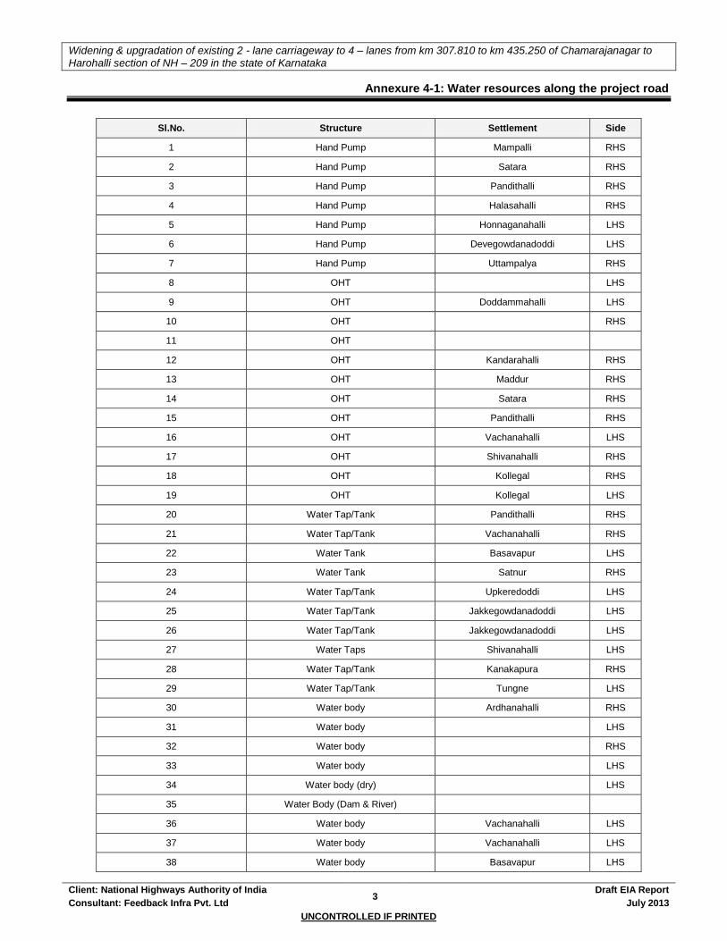
Widening & upgradation of existing 2 - lane carriageway to 4 – lanes from km 307.810 to km 435.250 of Chamarajanagar to
Harohalli section of NH – 209 in the state of Karnataka
Client: National Highways Authority of India 3
Draft EIA Report
Consultant: Feedback Infra Pvt. Ltd July 2013
UNCONTROLLED IF PRINTED
Annexure 4-1: Water resources along the project road
Sl.No. Structure Settlement Side
1 Hand Pump Mampalli RHS
2 Hand Pump Satara RHS
3 Hand Pump Pandithalli RHS
4 Hand Pump Halasahalli RHS
5 Hand Pump Honnaganahalli LHS
6 Hand Pump Devegowdanadoddi LHS
7 Hand Pump Uttampalya RHS
8 OHT LHS
9 OHT Doddammahalli LHS
10 OHT RHS
11 OHT
12 OHT Kandarahalli RHS
13 OHT Maddur RHS
14 OHT Satara RHS
15 OHT Pandithalli RHS
16 OHT Vachanahalli LHS
17 OHT Shivanahalli RHS
18 OHT Kollegal RHS
19 OHT Kollegal LHS
20 Water Tap/Tank Pandithalli RHS
21 Water Tap/Tank Vachanahalli RHS
22 Water Tank Basavapur LHS
23 Water Tank Satnur RHS
24 Water Tap/Tank Upkeredoddi LHS
25 Water Tap/Tank Jakkegowdanadoddi LHS
26 Water Tap/Tank Jakkegowdanadoddi LHS
27 Water Taps Shivanahalli LHS
28 Water Tap/Tank Kanakapura RHS
29 Water Tap/Tank Tungne LHS
30 Water body Ardhanahalli RHS
31 Water body LHS
32 Water body RHS
33 Water body LHS
34 Water body (dry) LHS
35 Water Body (Dam & River)
36 Water body Vachanahalli LHS
37 Water body Vachanahalli LHS
38 Water body Basavapur LHS

Widening & upgradation of existing 2 - lane carriageway to 4 – lanes from km 307.810 to km 435.250 of Chamarajanagar to
Harohalli section of NH – 209 in the state of Karnataka
Client: National Highways Authority of India 4
Draft EIA Report
Consultant: Feedback Infra Pvt. Ltd July 2013
UNCONTROLLED IF PRINTED
Sl.No. Structure Settlement Side
39 Water body Halagur RHS
40 Water ody RHS
41 Water body Kanakapura RHS
42 Water body Harohalli LHS
43 Water ody Kollegal LHS
44 Water body Kollegal RHS
45 Well RHS
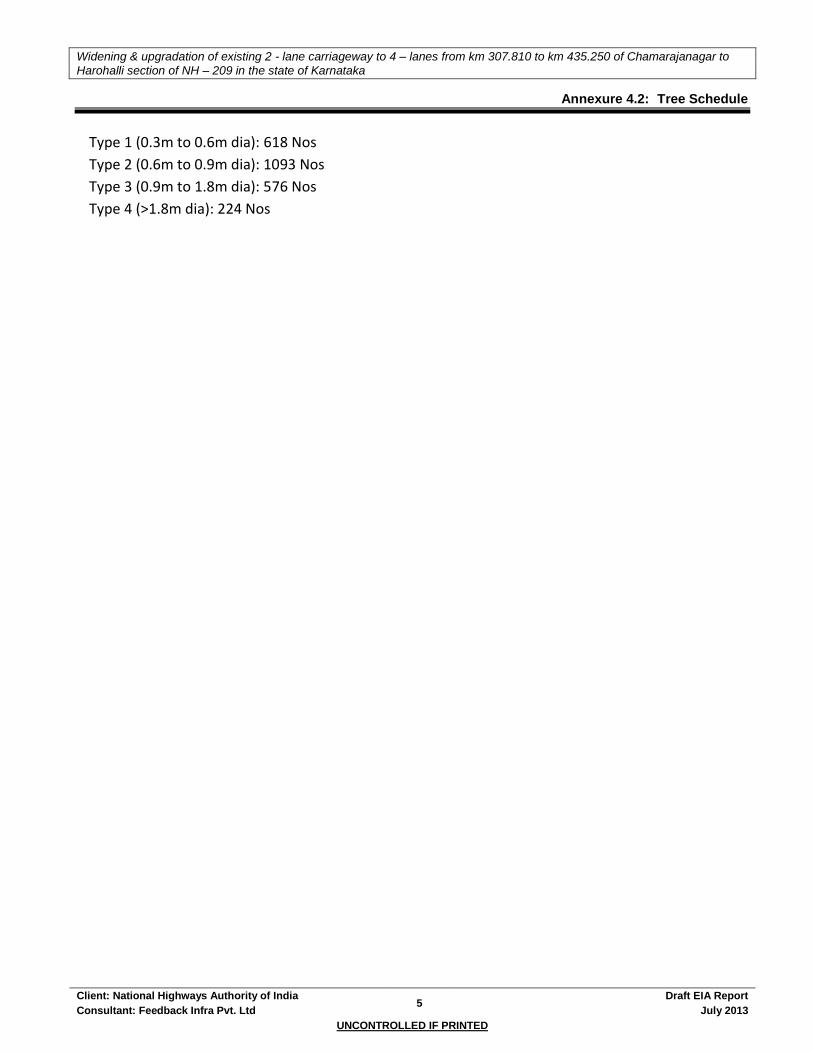
Widening & upgradation of existing 2 - lane carriageway to 4 – lanes from km 307.810 to km 435.250 of Chamarajanagar to
Harohalli section of NH – 209 in the state of Karnataka
Client: National Highways Authority of India 5
Draft EIA Report
Consultant: Feedback Infra Pvt. Ltd July 2013
UNCONTROLLED IF PRINTED
Annexure 4.2: Tree Schedule
Type 1 (0.3m to 0.6m dia): 618 Nos
Type 2 (0.6m to 0.9m dia): 1093 Nos
Type 3 (0.9m to 1.8m dia): 576 Nos
Type 4 (>1.8m dia): 224 Nos
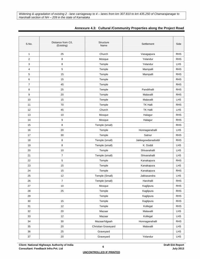
Widening & upgradation of existing 2 - lane carriageway to 4 – lanes from km 307.810 to km 435.250 of Chamarajanagar to
Harohalli section of NH – 209 in the state of Karnataka
Client: National Highways Authority of India 6
Draft EIA Report
Consultant: Feedback Infra Pvt. Ltd July 2013
UNCONTROLLED IF PRINTED
Annexure 4.3: Cultural /Community Properties along the Project Road
S.No. Distance from C/L
(Existing) Structure
Name Settlement Side
1 25 Church Vasagapura RHS
2 8 Mosque Yelandur RHS
3 8 Temple Yelandur LHS
4 5 Temple Mampalli RHS
5 15 Temple Mampalli RHS
6 15 Temple RHS
7 45 Temple RHS
8 25 Temple Pandithalli RHS
9 20 Temple Malavalli RHS
10 15 Temple Malavalli LHS
11 70 Temple TK Halli RHS
12 45 Church TK Halli LHS
13 10 Mosque Halagur RHS
14 9 Mosque Halagur RHS
15 8 Temple (small) RHS
16 20 Temple Honnaganahalli LHS
17 30 Temple Satnur RHS
18 8 Temple (small) Jakkegowdanadoddi RHS
19 8 Temple (small) K. Doddi LHS
20 10 Temple Shivanahalli LHS
21 7 Temple (small) Shivanahalli LHS
22 5 Temple Kanakapura RHS
23 15 Temple Kanakapura LHS
24 15 Temple Kanakapura RHS
25 12 Temple (Small) Jakkasandra LHS
26 7 Temple (small) Harohalli RHS
27 10 Mosque Kaglipura RHS
28 25 Temple Kaglipura RHS
29 Temple Kaglipura RHS
30 15 Temple Kaglipura RHS
31 12 Temple Kollegal RHS
32 20 Mazaar Malavalli LHS
33 12 Mazaar Kollegal LHS
34 30 Mazaar/Idgaah Honnaganahalli RHS
35 20 Christian Graveyard Malavalli LHS
36 25 Graveyard LHS
37 20 Graveyard Yelandur LHS
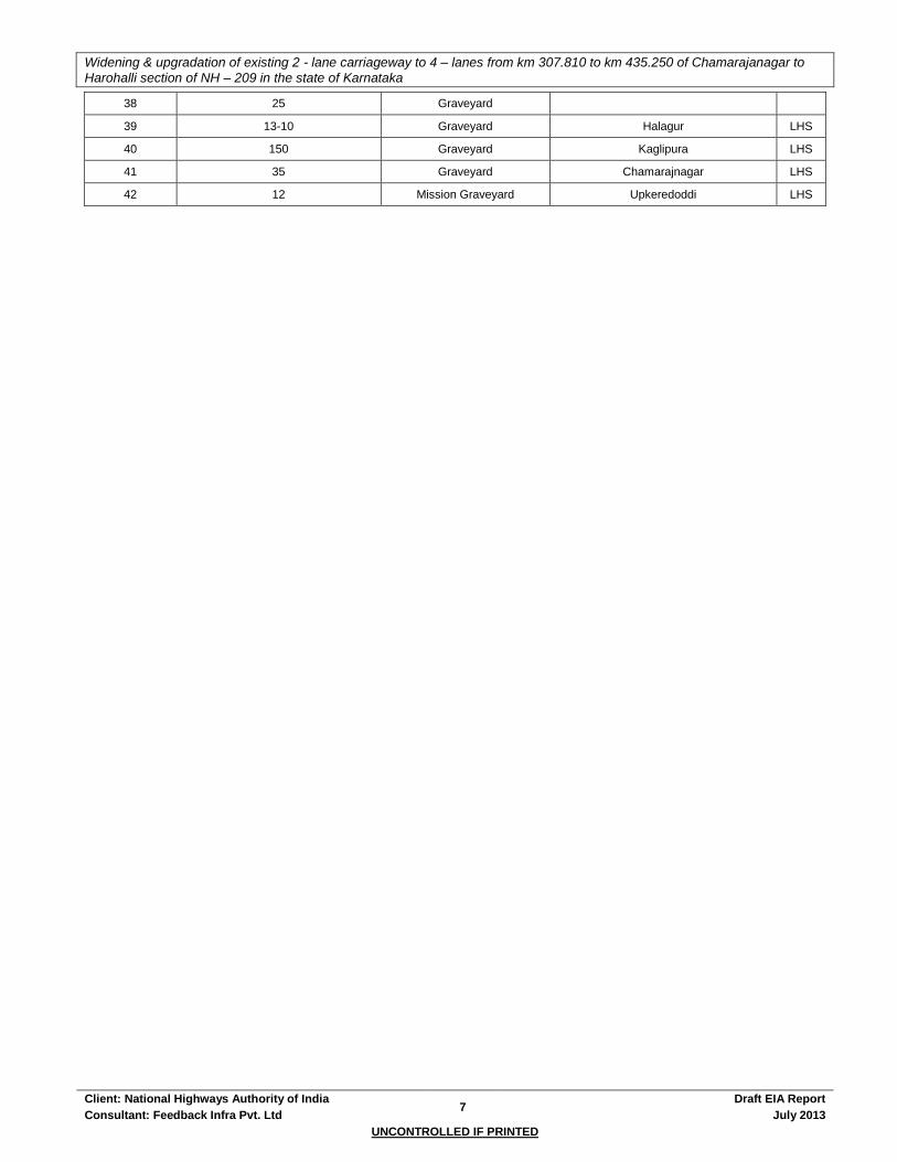
Widening & upgradation of existing 2 - lane carriageway to 4 – lanes from km 307.810 to km 435.250 of Chamarajanagar to
Harohalli section of NH – 209 in the state of Karnataka
Client: National Highways Authority of India 7
Draft EIA Report
Consultant: Feedback Infra Pvt. Ltd July 2013
UNCONTROLLED IF PRINTED
38 25 Graveyard
39 13-10 Graveyard Halagur LHS
40 150 Graveyard Kaglipura LHS
41 35 Graveyard Chamarajnagar LHS
42 12 Mission Graveyard Upkeredoddi LHS
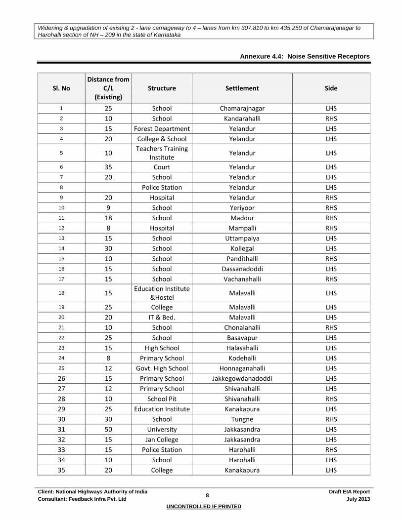
Widening & upgradation of existing 2 - lane carriageway to 4 – lanes from km 307.810 to km 435.250 of Chamarajanagar to
Harohalli section of NH – 209 in the state of Karnataka
Client: National Highways Authority of India 8
Draft EIA Report
Consultant: Feedback Infra Pvt. Ltd July 2013
UNCONTROLLED IF PRINTED
Annexure 4.4: Noise Sensitive Receptors
Sl. No Distance from
C/L (Existing)
Structure Settlement Side
1 25 School Chamarajnagar LHS 2 10 School Kandarahalli RHS 3 15 Forest Department Yelandur LHS 4 20 College & School Yelandur LHS
5 10 Teachers Training
Institute Yelandur LHS
6 35 Court Yelandur LHS 7 20 School Yelandur LHS 8 Police Station Yelandur LHS 9 20 Hospital Yelandur RHS
10 9 School Yeriyoor RHS 11 18 School Maddur RHS 12 8 Hospital Mampalli RHS 13 15 School Uttampalya LHS 14 30 School Kollegal LHS 15 10 School Pandithalli RHS 16 15 School Dassanadoddi LHS 17 15 School Vachanahalli RHS
18 15 Education Institute
&Hostel Malavalli LHS
19 25 College Malavalli LHS 20 20 IT & Bed. Malavalli LHS 21 10 School Chonalahalli RHS 22 25 School Basavapur LHS 23 15 High School Halasahalli LHS 24 8 Primary School Kodehalli LHS 25 12 Govt. High School Honnaganahalli LHS
26 15 Primary School Jakkegowdanadoddi LHS
27 12 Primary School Shivanahalli LHS
28 10 School Pit Shivanahalli RHS
29 25 Education Institute Kanakapura LHS
30 30 School Tungne RHS
31 50 University Jakkasandra LHS
32 15 Jan College Jakkasandra LHS
33 15 Police Station Harohalli RHS
34 10 School Harohalli LHS
35 20 College Kanakapura LHS

Widening & upgradation of existing 2 - lane carriageway to 4 – lanes from km 307.810 to km 435.250 of Chamarajanagar to
Harohalli section of NH – 209 in the state of Karnataka
Client: National Highways Authority of India 9
Draft EIA Report
Consultant: Feedback Infra Pvt. Ltd July 2013
UNCONTROLLED IF PRINTED
Sl. No Distance from
C/L (Existing)
Structure Settlement Side
36 10 Court Kollegal LHS
37 10 Govt. Hospital Kaglipura RHS
38 10 Hospital Kollegal LHS
39 40 School Kanakapura RHS
40 30 School Kanakapura LHS
41 30 School Kollegal RHS
42 12 School Kollegal LHS
43 12 School RHS
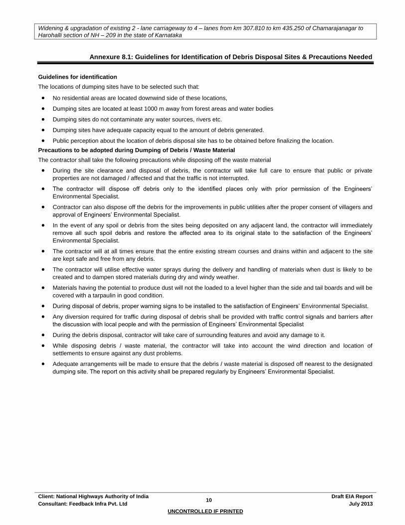
Widening & upgradation of existing 2 - lane carriageway to 4 – lanes from km 307.810 to km 435.250 of Chamarajanagar to
Harohalli section of NH – 209 in the state of Karnataka
Client: National Highways Authority of India 10
Draft EIA Report
Consultant: Feedback Infra Pvt. Ltd July 2013
UNCONTROLLED IF PRINTED
Annexure 8.1: Guidelines for Identification of Debris Disposal Sites & Precautions Needed
Guidelines for identification
The locations of dumping sites have to be selected such that:
No residential areas are located downwind side of these locations,
Dumping sites are located at least 1000 m away from forest areas and water bodies
Dumping sites do not contaminate any water sources, rivers etc.
Dumping sites have adequate capacity equal to the amount of debris generated.
Public perception about the location of debris disposal site has to be obtained before finalizing the location.
Precautions to be adopted during Dumping of Debris / Waste Material
The contractor shall take the following precautions while disposing off the waste material
During the site clearance and disposal of debris, the contractor will take full care to ensure that public or private
properties are not damaged / affected and that the traffic is not interrupted.
The contractor will dispose off debris only to the identified places only with prior permission of the Engineers’
Environmental Specialist.
Contractor can also dispose off the debris for the improvements in public utilities after the proper consent of villagers and
approval of Engineers’ Environmental Specialist.
In the event of any spoil or debris from the sites being deposited on any adjacent land, the contractor will immediately
remove all such spoil debris and restore the affected area to its original state to the satisfaction of the Engineers’
Environmental Specialist.
The contractor will at all times ensure that the entire existing stream courses and drains within and adjacent to the site
are kept safe and free from any debris.
The contractor will utilise effective water sprays during the delivery and handling of materials when dust is likely to be
created and to dampen stored materials during dry and windy weather.
Materials having the potential to produce dust will not the loaded to a level higher than the side and tail boards and will be
covered with a tarpaulin in good condition.
During disposal of debris, proper warning signs to be installed to the satisfaction of Engineers’ Environmental Specialist.
Any diversion required for traffic during disposal of debris shall be provided with traffic control signals and barriers after
the discussion with local people and with the permission of Engineers’ Environmental Specialist
During the debris disposal, contractor will take care of surrounding features and avoid any damage to it.
While disposing debris / waste material, the contractor will take into account the wind direction and location of
settlements to ensure against any dust problems.
Adequate arrangements will be made to ensure that the debris / waste material is disposed off nearest to the designated
dumping site. The report on this activity shall be prepared regularly by Engineers’ Environmental Specialist.
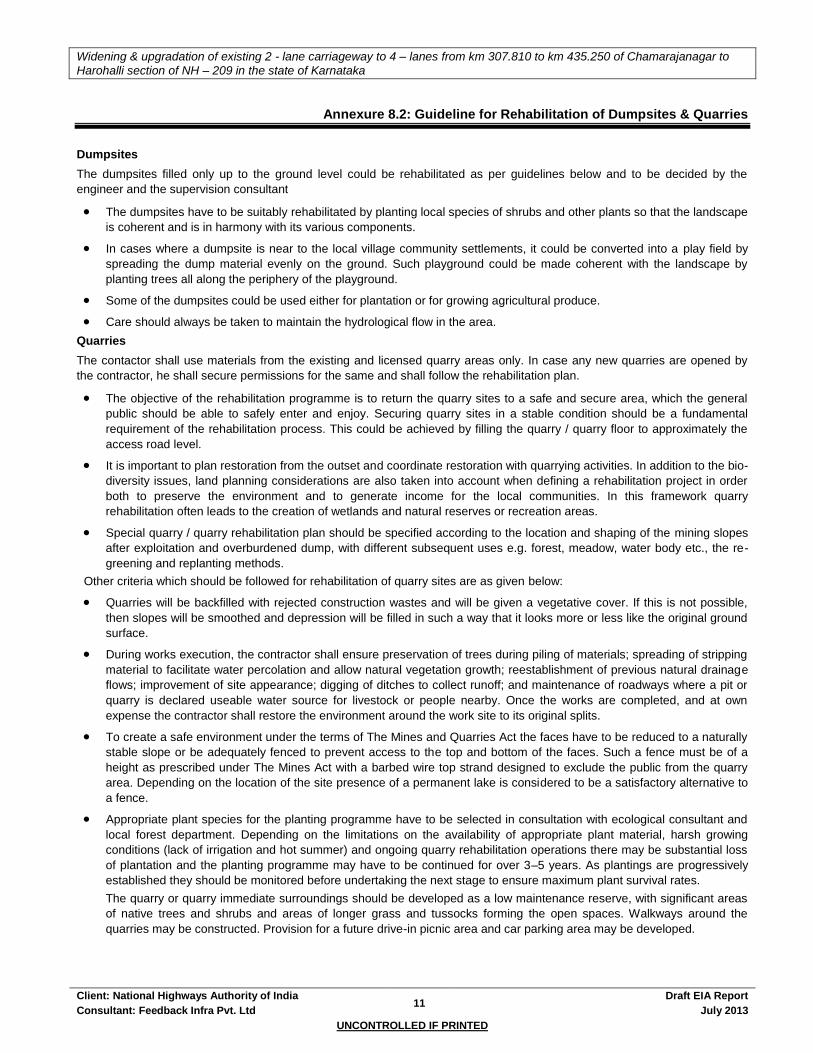
Widening & upgradation of existing 2 - lane carriageway to 4 – lanes from km 307.810 to km 435.250 of Chamarajanagar to
Harohalli section of NH – 209 in the state of Karnataka
Client: National Highways Authority of India 11
Draft EIA Report
Consultant: Feedback Infra Pvt. Ltd July 2013
UNCONTROLLED IF PRINTED
Annexure 8.2: Guideline for Rehabilitation of Dumpsites & Quarries
Dumpsites
The dumpsites filled only up to the ground level could be rehabilitated as per guidelines below and to be decided by the
engineer and the supervision consultant
The dumpsites have to be suitably rehabilitated by planting local species of shrubs and other plants so that the landscape
is coherent and is in harmony with its various components.
In cases where a dumpsite is near to the local village community settlements, it could be converted into a play field by
spreading the dump material evenly on the ground. Such playground could be made coherent with the landscape by
planting trees all along the periphery of the playground.
Some of the dumpsites could be used either for plantation or for growing agricultural produce.
Care should always be taken to maintain the hydrological flow in the area.
Quarries
The contactor shall use materials from the existing and licensed quarry areas only. In case any new quarries are opened by
the contractor, he shall secure permissions for the same and shall follow the rehabilitation plan.
The objective of the rehabilitation programme is to return the quarry sites to a safe and secure area, which the general
public should be able to safely enter and enjoy. Securing quarry sites in a stable condition should be a fundamental
requirement of the rehabilitation process. This could be achieved by filling the quarry / quarry floor to approximately the
access road level.
It is important to plan restoration from the outset and coordinate restoration with quarrying activities. In addition to the bio-
diversity issues, land planning considerations are also taken into account when defining a rehabilitation project in order
both to preserve the environment and to generate income for the local communities. In this framework quarry
rehabilitation often leads to the creation of wetlands and natural reserves or recreation areas.
Special quarry / quarry rehabilitation plan should be specified according to the location and shaping of the mining slopes
after exploitation and overburdened dump, with different subsequent uses e.g. forest, meadow, water body etc., the re-
greening and replanting methods.
Other criteria which should be followed for rehabilitation of quarry sites are as given below:
Quarries will be backfilled with rejected construction wastes and will be given a vegetative cover. If this is not possible,
then slopes will be smoothed and depression will be filled in such a way that it looks more or less like the original ground
surface.
During works execution, the contractor shall ensure preservation of trees during piling of materials; spreading of stripping
material to facilitate water percolation and allow natural vegetation growth; reestablishment of previous natural drainage
flows; improvement of site appearance; digging of ditches to collect runoff; and maintenance of roadways where a pit or
quarry is declared useable water source for livestock or people nearby. Once the works are completed, and at own
expense the contractor shall restore the environment around the work site to its original splits.
To create a safe environment under the terms of The Mines and Quarries Act the faces have to be reduced to a naturally
stable slope or be adequately fenced to prevent access to the top and bottom of the faces. Such a fence must be of a
height as prescribed under The Mines Act with a barbed wire top strand designed to exclude the public from the quarry
area. Depending on the location of the site presence of a permanent lake is considered to be a satisfactory alternative to
a fence.
Appropriate plant species for the planting programme have to be selected in consultation with ecological consultant and
local forest department. Depending on the limitations on the availability of appropriate plant material, harsh growing
conditions (lack of irrigation and hot summer) and ongoing quarry rehabilitation operations there may be substantial loss
of plantation and the planting programme may have to be continued for over 3–5 years. As plantings are progressively
established they should be monitored before undertaking the next stage to ensure maximum plant survival rates.
The quarry or quarry immediate surroundings should be developed as a low maintenance reserve, with significant areas
of native trees and shrubs and areas of longer grass and tussocks forming the open spaces. Walkways around the
quarries may be constructed. Provision for a future drive-in picnic area and car parking area may be developed.

Widening & upgradation of existing 2 - lane carriageway to 4 – lanes from km 307.810 to km 435.250 of Chamarajanagar to
Harohalli section of NH – 209 in the state of Karnataka
Client: National Highways Authority of India 12
Draft EIA Report
Consultant: Feedback Infra Pvt. Ltd July 2013
UNCONTROLLED IF PRINTED

Widening & upgradation of existing 2 - lane carriageway to 4 – lanes from km 307.810 to km 435.250 of Chamarajanagar to
Harohalli section of NH – 209 in the state of Karnataka
Client: National Highways Authority of India 13
Draft EIA Report
Consultant: Feedback Infra Pvt. Ltd July 2013
UNCONTROLLED IF PRINTED
Annexure 8.3: Guidelines for New Quarry Management
1. Management Plan for New Quarry
The contractor shall prepare a quarry management plan for operation of new quarries and submit it to the IC for approval and
necessary actions. The plan shall consist of the following:
1.1 Selection Details
1.1.1 Location and Layout
Sketch plans and photographs to be provided along with adequate details:
A map and sketch plan of the area showing the location of the proposed quarry site with respect to the project road,
nearby villages, crusher plants and worker accommodation locations along with indicative distances of the different
sites from each other and from the road.
A detailed sketch plan of the quarry area showing approach and haulage roads, location of the rock outcrops to be
quarried, indicating which sites will be quarried in which year or phase, location of stock piles, location of guard
house, perimeter fence, location of water sources, amenities, and any further details.
Photographs of the site
1.1.2 Selection Criteria
A brief statement as to how the site was chosen.
Alternative sites that were considered to be mentioned.
Record any public consultations involved while choosing and what the public concerns were, if any.
1.1.3 Agreement with landowners
Statement of ownership of the land along with lease / purchase agreements.
1.1.4 Licenses and permits
Contractor to state the licences and permits that are necessary for operation, and attach them as appropriate.
1.2 Operation
1.2.1 Method of extraction
A brief method statement of extraction indicating the techniques to be used, use of explosives if any, if so how are the
charges laid, how often the blasting shall be done, etc.
Appropriate reference should be made to the contractor’s safety manual.
A copy of the operator’s licence to handle explosives should be submitted to the SC.
1.2.2 Loading and haulage
Contractor to describe the process in a few sentences of loading of rocks fragments; means of transportation to the
crusher, and from the crusher to the site.
1.2.3 Crusher Plant
Type, manufacturer, date of manufacture and principal specifications of the plant, details on testing and
commissioning (by whom, to what standard, and when).
1.2.4 Storage of explosives
Contractor to state where these are to be procured from, where they will be stored and how the supply of explosives
will be kept secure (if they are to be kept off site, state what precautions will be given for transportation).
1.2.5 Products
A list of aggregate sizes and any other products from the quarry. Make sure the sketch map states where these will
be stock piled.
1.2.6 Testing and quality assurance
Refer quality assurance plan of contractor if any.
If not, contractor to provide details of sampling frequency, who takes the does the testing, which standards are to be
complied with, and any further pertinent details.
1.2.7 Water sourcing
Contractor to indicate the operations that shall need water, and its source (an indication on the sketch map will
suffice).
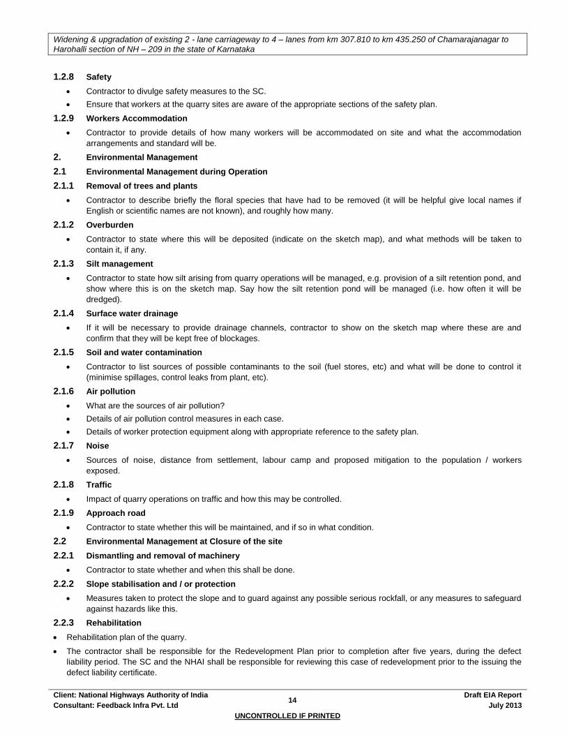
Widening & upgradation of existing 2 - lane carriageway to 4 – lanes from km 307.810 to km 435.250 of Chamarajanagar to
Harohalli section of NH – 209 in the state of Karnataka
Client: National Highways Authority of India 14
Draft EIA Report
Consultant: Feedback Infra Pvt. Ltd July 2013
UNCONTROLLED IF PRINTED
1.2.8 Safety
Contractor to divulge safety measures to the SC.
Ensure that workers at the quarry sites are aware of the appropriate sections of the safety plan.
1.2.9 Workers Accommodation
Contractor to provide details of how many workers will be accommodated on site and what the accommodation
arrangements and standard will be.
2. Environmental Management
2.1 Environmental Management during Operation
2.1.1 Removal of trees and plants
Contractor to describe briefly the floral species that have had to be removed (it will be helpful give local names if
English or scientific names are not known), and roughly how many.
2.1.2 Overburden
Contractor to state where this will be deposited (indicate on the sketch map), and what methods will be taken to
contain it, if any.
2.1.3 Silt management
Contractor to state how silt arising from quarry operations will be managed, e.g. provision of a silt retention pond, and
show where this is on the sketch map. Say how the silt retention pond will be managed (i.e. how often it will be
dredged).
2.1.4 Surface water drainage
If it will be necessary to provide drainage channels, contractor to show on the sketch map where these are and
confirm that they will be kept free of blockages.
2.1.5 Soil and water contamination
Contractor to list sources of possible contaminants to the soil (fuel stores, etc) and what will be done to control it
(minimise spillages, control leaks from plant, etc).
2.1.6 Air pollution
What are the sources of air pollution?
Details of air pollution control measures in each case.
Details of worker protection equipment along with appropriate reference to the safety plan.
2.1.7 Noise
Sources of noise, distance from settlement, labour camp and proposed mitigation to the population / workers
exposed.
2.1.8 Traffic
Impact of quarry operations on traffic and how this may be controlled.
2.1.9 Approach road
Contractor to state whether this will be maintained, and if so in what condition.
2.2 Environmental Management at Closure of the site
2.2.1 Dismantling and removal of machinery
Contractor to state whether and when this shall be done.
2.2.2 Slope stabilisation and / or protection
Measures taken to protect the slope and to guard against any possible serious rockfall, or any measures to safeguard
against hazards like this.
2.2.3 Rehabilitation
Rehabilitation plan of the quarry.
The contractor shall be responsible for the Redevelopment Plan prior to completion after five years, during the defect
liability period. The SC and the NHAI shall be responsible for reviewing this case of redevelopment prior to the issuing the
defect liability certificate.

Widening & upgradation of existing 2 - lane carriageway to 4 – lanes from km 307.810 to km 435.250 of Chamarajanagar to
Harohalli section of NH – 209 in the state of Karnataka
Client: National Highways Authority of India 15
Draft EIA Report
Consultant: Feedback Infra Pvt. Ltd July 2013
UNCONTROLLED IF PRINTED
2.2.4 Hand-over
Terms of hand-over of the quarry site to the owner/authority at the end of its use.
2.2.5 Removal of debris and solid waste
Confirmation of Contractor in removal of debris and solid wastes and disposal at a suitable site.
For each aggregate-cum-quarry sand source, the plan should be the same. The table below gives the format:
SI.
No. Item Unit Details
Remarks by SC,
if any
1. Name / identity of the location
2. Nearest project road Chainage.
3. Name of the owner
4. Area involved m2
5. Existing land use (verification from land records with revenue department)
6. Land use of the area surrounding the proposed site including a map
7. Access roads – existing conditions, proposed development and maintenance
8. Tree cutting and vegetation clearance if any, along with compensation measures Nos.
9. Arrangement with the owner (agreement with land owner should be attached as an
Annexure)
10. Quantity of material to be withdrawn vis-a-vis the material available Cum
11. Particular areas to be quarried should be clearly identified
12. Machinery & equipment to be used
13. Drainage plans
14. Top soil management
15. Description of the operating practices to be adopted.
16. Health facilities
17. Safety provisions made including fire protection systems and the availability of different
personal protective equipment
18. Monitoring plans for air, noise and water quality
19. Copy of the consents to establish and operate should be attached as an Annexure.
20. Copy of the license from Mining & Geology, Police & Fire dept.
21. Conditions laid down in the clearances / licenses and plans to ensure compliance
22. Information on whether or not the quarry will be closed under this project. If yes, the
proposed closure & restoration plan.
23. Concerns of the local people living in the immediate / near vicinity should be identified and
appropriates measures should be reflected
24. Photograph of the quarry prior to commencing operations.
25. Sketch of the layout of the quarry
Attach Photograph of Proposed Site, Location Map, Consents, licenses, safety plan, tree compensation plan, restoration plan,
drainage plan, monitoring plan, Agreement with land owner etc. as annexure
Submitted Checked & Approved
Signature Signature
Name Name
Designation Designation
Contractor Supervision Consultant
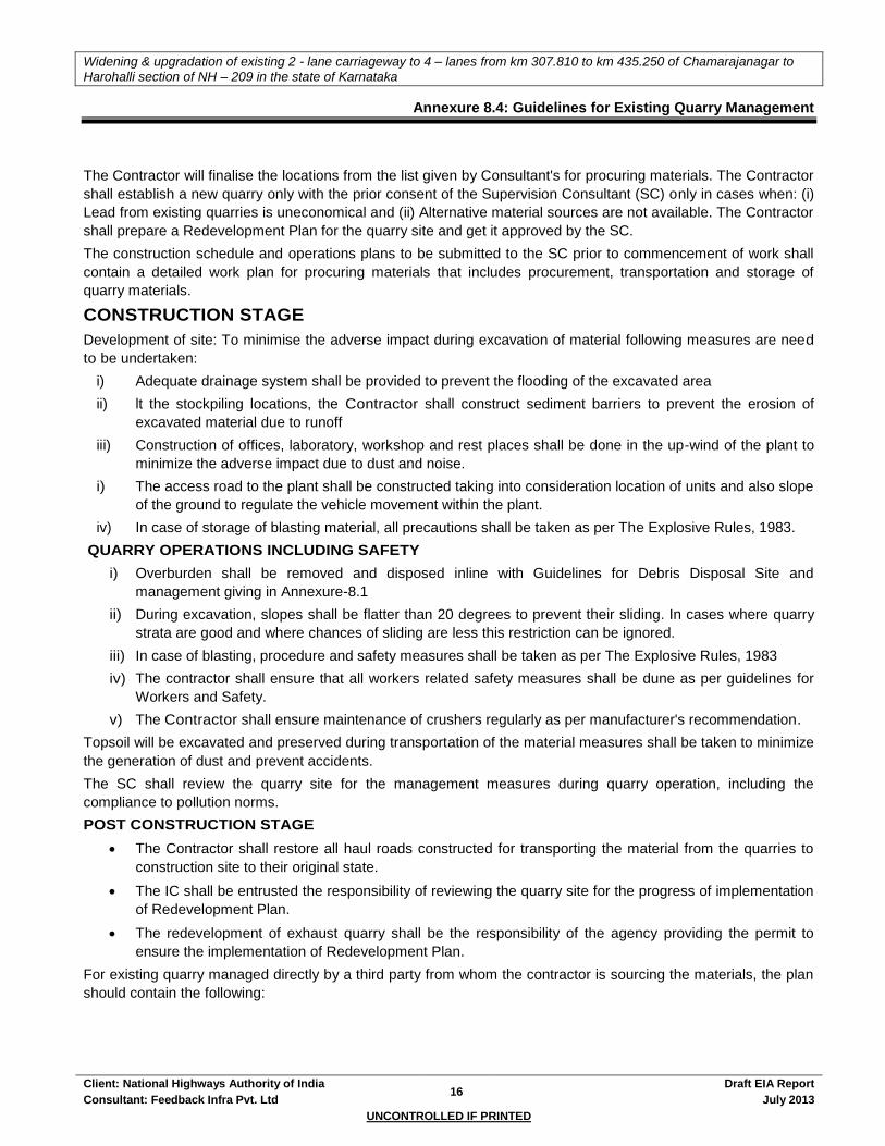
Widening & upgradation of existing 2 - lane carriageway to 4 – lanes from km 307.810 to km 435.250 of Chamarajanagar to
Harohalli section of NH – 209 in the state of Karnataka
Client: National Highways Authority of India 16
Draft EIA Report
Consultant: Feedback Infra Pvt. Ltd July 2013
UNCONTROLLED IF PRINTED
Annexure 8.4: Guidelines for Existing Quarry Management
The Contractor will finalise the locations from the list given by Consultant's for procuring materials. The Contractor
shall establish a new quarry only with the prior consent of the Supervision Consultant (SC) only in cases when: (i)
Lead from existing quarries is uneconomical and (ii) Alternative material sources are not available. The Contractor
shall prepare a Redevelopment Plan for the quarry site and get it approved by the SC.
The construction schedule and operations plans to be submitted to the SC prior to commencement of work shall
contain a detailed work plan for procuring materials that includes procurement, transportation and storage of
quarry materials.
CONSTRUCTION STAGE
Development of site: To minimise the adverse impact during excavation of material following measures are need
to be undertaken:
i) Adequate drainage system shall be provided to prevent the flooding of the excavated area
ii) lt the stockpiling locations, the Contractor shall construct sediment barriers to prevent the erosion of
excavated material due to runoff
iii) Construction of offices, laboratory, workshop and rest places shall be done in the up-wind of the plant to
minimize the adverse impact due to dust and noise.
i) The access road to the plant shall be constructed taking into consideration location of units and also slope
of the ground to regulate the vehicle movement within the plant.
iv) In case of storage of blasting material, all precautions shall be taken as per The Explosive Rules, 1983.
QUARRY OPERATIONS INCLUDING SAFETY
i) Overburden shall be removed and disposed inline with Guidelines for Debris Disposal Site and
management giving in Annexure-8.1
ii) During excavation, slopes shall be flatter than 20 degrees to prevent their sliding. In cases where quarry
strata are good and where chances of sliding are less this restriction can be ignored.
iii) In case of blasting, procedure and safety measures shall be taken as per The Explosive Rules, 1983
iv) The contractor shall ensure that all workers related safety measures shall be dune as per guidelines for
Workers and Safety.
v) The Contractor shall ensure maintenance of crushers regularly as per manufacturer's recommendation.
Topsoil will be excavated and preserved during transportation of the material measures shall be taken to minimize
the generation of dust and prevent accidents.
The SC shall review the quarry site for the management measures during quarry operation, including the
compliance to pollution norms.
POST CONSTRUCTION STAGE
The Contractor shall restore all haul roads constructed for transporting the material from the quarries to
construction site to their original state.
The IC shall be entrusted the responsibility of reviewing the quarry site for the progress of implementation
of Redevelopment Plan.
The redevelopment of exhaust quarry shall be the responsibility of the agency providing the permit to
ensure the implementation of Redevelopment Plan.
For existing quarry managed directly by a third party from whom the contractor is sourcing the materials, the plan
should contain the following:
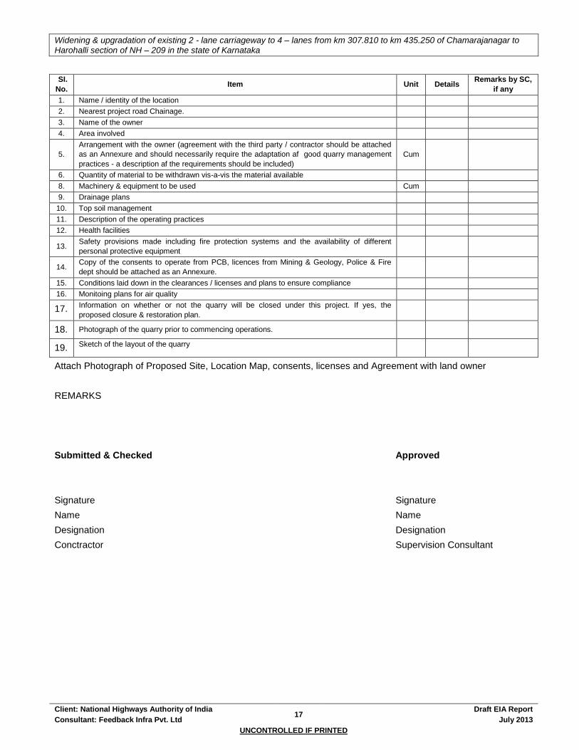
Widening & upgradation of existing 2 - lane carriageway to 4 – lanes from km 307.810 to km 435.250 of Chamarajanagar to
Harohalli section of NH – 209 in the state of Karnataka
Client: National Highways Authority of India 17
Draft EIA Report
Consultant: Feedback Infra Pvt. Ltd July 2013
UNCONTROLLED IF PRINTED
SI.
No. Item Unit Details
Remarks by SC,
if any
1. Name / identity of the location
2. Nearest project road Chainage.
3. Name of the owner
4. Area involved
5.
Arrangement with the owner (agreement with the third party / contractor should be attached
as an Annexure and should necessarily require the adaptation af good quarry management
practices - a description af the requirements should be included)
Cum
6. Quantity of material to be withdrawn vis-a-vis the material available
8. Machinery & equipment to be used Cum
9. Drainage plans
10. Top soil management
11. Description of the operating practices
12. Health facilities
13. Safety provisions made including fire protection systems and the availability of different
personal protective equipment
14. Copy of the consents to operate from PCB, licences from Mining & Geology, Police & Fire
dept should be attached as an Annexure.
15. Conditions laid down in the clearances / licenses and plans to ensure compliance
16. Monitoing plans for air quality
17. Information on whether or not the quarry will be closed under this project. If yes, the
proposed closure & restoration plan.
18. Photograph of the quarry prior to commencing operations.
19. Sketch of the layout of the quarry
Attach Photograph of Proposed Site, Location Map, consents, licenses and Agreement with land owner
REMARKS
Submitted & Checked Approved
Signature Signature
Name Name
Designation Designation
Conctractor Supervision Consultant
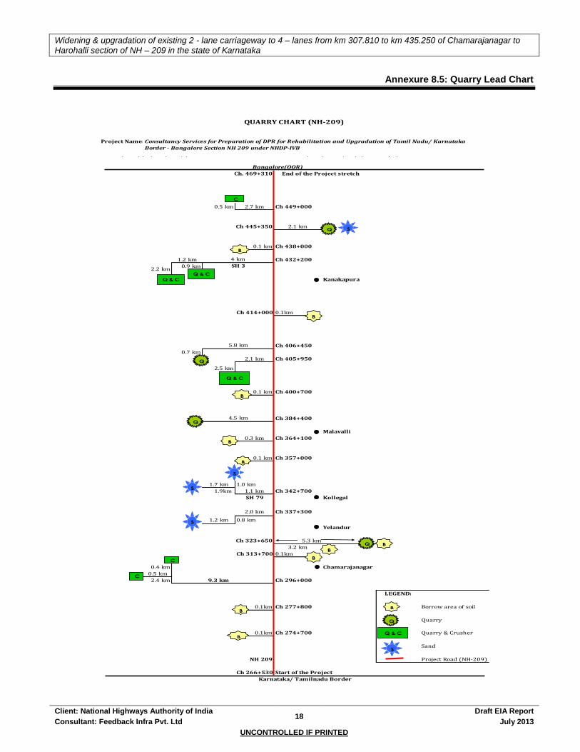
Widening & upgradation of existing 2 - lane carriageway to 4 – lanes from km 307.810 to km 435.250 of Chamarajanagar to
Harohalli section of NH – 209 in the state of Karnataka
Client: National Highways Authority of India 18
Draft EIA Report
Consultant: Feedback Infra Pvt. Ltd July 2013
UNCONTROLLED IF PRINTED
Annexure 8.5: Quarry Lead Chart
Ch. 469+310 End of the Project stretch
0.5 km 2.7 km Ch 449+000
Ch 445+350 2.1 km
0.1 km Ch 438+000
1.2 km Ch 432+200
0.9 km
Kanakapura
Ch 414+000 0.1km
Ch 406+450
0.7 km
2.1 km Ch 405+950
0.1 km Ch 400+700
Ch 384+400
Malavalli
0.3 km Ch 364+100
0.1 km Ch 357+000
1.7 km 1.0 km
1.9km 1.1 km Ch 342+700
SH 79 Kollegal
2.0 km Ch 337+300
1.2 km 0.8 km
Yelandur
Ch 323+650 5.3 km
3.2 km
Ch 313+700 0.1km
0.4 km Chamarajanagar
0.5 km
2.4 km 9.3 km Ch 296+000
LEGEND:
0.1km Ch 277+800 Borrow area of soil
Quarry
0.1km Ch 274+700 Quarry & Crusher
Sand
NH 209 Project Road (NH-209)
Ch 266+530 Start of the Project
2.2 km
5.8 km
2.5 km
4.5 km
QUARRY CHART (NH-209)
Project Name: Consultancy Services for Preparation of DPR for Rehabilitation and Upgradation of Tamil Nadu/ Karnataka
Border - Bangalore Section NH 209 under NHDP-IVB
Bangalore(OOR)
4 km
SH 3
Karnataka/ Tamilnadu Border
B
Q
Q & C
Q
B
B
B
S
Q
Q
Q
Q & C
Q & C
C
S
B
C
S
S
B
C
Q & C
S
B
B
B
B
B

Widening & upgradation of existing 2 - lane carriageway to 4 – lanes from km 307.810 to km 435.250 of Chamarajanagar to
Harohalli section of NH – 209 in the state of Karnataka
Client: National Highways Authority of India 19
Draft EIA Report
Consultant: Feedback Infra Pvt. Ltd July 2013
UNCONTROLLED IF PRINTED
Annexure 8.6: Guidelines for Sediment Control
All materials shall meet commercial grade standards and shall be approved by the Engineer before being used in
the work.
CONSTRUCTION STAGE
Prior to the start of the relevant construction, the Contractor shall submit to the Engineer for approval, his
schedules for carrying out temporary and permanent erosion / sedimentation control works as are applicable for
the items of clearing and grubbing, roadway and drainage excavation, embankment / sub-grade construction,
bridges and other structures across water courses, pavement courses and shoulders. He shall also submit for
approval his proposed method of erosion / sedimentation control on service road and quarries and his plan for
disposal of waste materials. Work shall not be started until the erosion / sedimentation control schedules and
methods of operations for the applicable ' construction have been approved by the Engineer.
The surface area of erodible earth material exposed by clearing and grubbing, excavation, quarry and fill
operations shall be limited to the extent practicable. The Contractor may be directed to provide immediate control
measures to prevent soil erosion and sedimentation that will adversely affect construction operations, damage
adjacent properties, or cause contamination of nearby streams or other watercourses. Such work may involve the
construction of temporary berms, dikes, sediment basins, slope drains and use of temporary mulches, fabrics,
mats, seeding, or other control devices or methods as necessary to control erosion and sedimentation.
The Contractor shall be required to incorporate all permanent erosion and sedimentation control features into the
project at the earliest practicable time as outlined in his accepted schedule to minimize the need for temporary
erosion and sedimentation control measures.
Temporary erosion, sedimentation and pollution control measures will be used to control the phenomenon of
erosion, sedimentation and pollution that may develop during normal construction practices, but may neither be
foreseen daring design stage nor associated with permanent control features on the Project.
Where erosion or sedimentation is likely to be a problem, clearing and grubbing operations should be so
scheduled and performed that grading operations and permanent erosion or sedimentation control features can
follow immediately thereafter if the project conditions permit; otherwise temporary erosion or sedimentation control
measures may be required between successive construction stages. Under no conditions shall a Large surface
area of credible earth material be exposed at one time by clearing and grubbing or excavation without prior
approval of the EO / Engineer.
The Engineer may limit the area of excavation, quarry and embankment operations in progress, commensurate
with the Contractor's capability and progress in keeping the finish grading, mulching, seeding and other such
permanent erosion, sedimentation and pollution control measures, in accordance with the accepted schedule.
Temporary erosion is sometimes caused due to the Contractor's negligence, carelessness or failure to install
permanent controls. Sedimentation and pollution control measures then become necessary as a part of the work
as scheduled or ordered by the Engineer, and these shall be carried out at the Contractor's own expense.
Temporary erosion, sedimentation and pollution control work required, which is not attributed to the Contractor's
negligence, carelessness or failure to install permanent control, will be performed as ordered by the EO /
Engineer.
Temporary erosion, sedimentation and pollution control may include construction work outside the right of way
where such work is necessary as a result of road construction such as quarry operations, service roads and
equipment storage sites.
The temporary erosion, sedimentation and pollution control features installed by the Contractor shall be
maintained by him till these are needed, unless otherwise agreed by the Engineer.

Widening & upgradation of existing 2 - lane carriageway to 4 – lanes from km 307.810 to km 435.250 of Chamarajanagar to
Harohalli section of NH – 209 in the state of Karnataka
Client: National Highways Authority of India 20
Draft EIA Report
Consultant: Feedback Infra Pvt. Ltd July 2013
UNCONTROLLED IF PRINTED
Annexure 8.7: Specifications & Strategy for Tree Plantation, Horticultural and Landscaping Works
1. INTRODUCTION
NHAI has decided to widen and strengthen the Project road within a ROW of 30m in urban areas and 45in rural areas including bypasses and realignments proposed. Due to this purpose, trees are to be felled. To offset this impact, compensatory afforestation programme through tree plantation, median plantation, horticulture and landscaping strategy has been prepared, based upon the experiences of successful implementation of a number of ongoing and completed projects.
2. OBJECTIVE
The main objectives are as follows:
Reducing the impacts of air pollution
Natural noise barrier
Arrest of land erosion
Providing much needed shade during the day time
Prevention of vehicle glare from vehicles coming from opposite direction
Enhancement of aesthetic view of the corridors
Climatic amelioration
Defining of ROW especially at sharp curves during night
3. SPECIES SELECTION
Grasses, shrubs and trees are the main species that are readily available in India. Where possible, the use of non-native species should be avoided since they can out compete and displace native plants leading to loss of native biodiversity. To maximise the chances of success, one should try to select species whose growing conditions roughly match the environmental conditions of the project site. Care should also be taken to select species with root systems that match the nature of the soil movement at the project site. Homogenous avenues of trees should be selected for long stretches as it provides aesthetic qualities in the landscaping. One should also take into account the economic and other social benefits while selecting the species for plantation. During the selection of species preference should be given towards rapid growing and pest and disease resistant species. Shrub species, which are dwarf and pollution hardy, are to be planted in the median to prevent the glare of traffic moving in opposite direction. Flowering, ornamentals plants and climbers can also be planted in urban areas to provide beauty. For this purpose the species identified in Tables 8-10 & 8-11 shall be used.
4. TASKS OF THE CONTRACTOR
As part of this project implementation, the contractor shall plant and maintain 22561 flowering, shade, medicinal, ornamental & fruit bearing trees in suitable area for which cost has been budgeted besides planting and maintenance of 63450 ornamental, medicinal & flowering plants and shrubs in the median for which cost has also been budgeted. The specific roles and responsibilities of the Contractor include:
Identification of the plantation stretches along with NHAI and or Supervision Consultant.
Identification of nursery area and preparation of nurseries
Planting of saplings in the nurseries during the construction period so that the saplings are a minimum 24 months old
Replantation of the 2 year old saplings to the plantation stretches and
Maintenance for three years including watering, removal of weed, litter and debris from the vicinity of the plantation.
Ensure the protection of the tree guards provided to the saplings from trampling and browsing by the cattle.
5. GUIDELINES FOR HORTICULTURE PLANTATION AND LANDSCAPING
5.1. General
5.1.1. Scope
Contractor to furnish all materials, labour and related items necessary to complete the work indicated on drawing and specified herein.
Widening & upgradation of existing 2 - lane carriageway to 4 – lanes from km 307.810 to km 435.250 of Chamarajanagar to
Harohalli section of NH – 209 in the state of Karnataka
Client: National Highways Authority of India 21
Draft EIA Report
Consultant: Feedback Infra Pvt. Ltd July 2013
UNCONTROLLED IF PRINTED
5.1.2. Materials
Plant Materials
Plant Materials shall be well formed and shaped true to type, and free from disease, insects and defects such as knots, sun-scaled, windburn, injuries, abrasion or disfigurement.
All plant materials shall be healthy, sound, vigorous, free from plant diseases, insect's pests, of their eggs, and shall have healthy, well-developed root systems. All plants shall be hardy under climatic conditions similar to those in the locally of the project. Plants supplied shall confirm to the names listed on the plant list given in Table no.1 and 2. Besides these plant species, the Contractor shall supply other species as desired by the landscaping specialist and or the environmental specialist of the engineer. Under no circumstances non native species which might have a negative impact on the ecology of the area shall be permitted. No plant material will be accepted if branches are damaged or broken. All material must be protected from the sun and weather until planted.
Any nursery stock shall have been inspected and approved by the Environmental Specialist of the Engineer.
All plants shall conform to the requirements specified in the plant list. Except that plants larger then specified may be used if approved, but use of such plants shall not increase the contract price if the use of the larger plant is approved, the spread of roots or ball of earth shall be increased in proportion to the size of plant. Deliver plants with legible identification labels.
Top Soil (Good Earth)
Topsoil or good earth shall be a friable loam, typical of cultivated topsoil of the locality containing at least 2% of decayed organic matter (humus). It shall be taken from a well-drained arable site. It shall be free of subsoil, stones, earth skids, sticks, roots or any other objectionable extraneous matter or debris. It shall contain no toxic material. No topsoil shall be delivered in a muddy condition. It shall have pH value ranging in between 6 to 8.5.
Fertiliser
Measurement of sludge shall be in stacks, with 8% reduction for payment. It shall be free from extraneous matter, harmful bacteria insects or chemicals (Subjected to safety norms).
Root System
The root system shall be conducive to successful transplantation. While necessary, the root-ball shall be preserved by support with Hessian or other suitable material. On soils where retention of a good ball is not possible, the roots should be suitably protected in such a way that the roots are not damaged.
5.1.3. Condition
Trees and shrubs shall be substantially free from pests and diseases, and shall and shall be materially undamaged. Torn or lacerated roots shall be pruned before dispatch. No roots shall be subjected to adverse conditions such as prolonged exposure to drying winds or subjection to water logging between lifting and delivery.
5.1.4. Supply and Substitution
Upon submission of evidence that certain materials excluding the plant Species prescribed are not available at time of contract, the Contractor shall be permitted to substitute with an equitable adjustment of price. All substitutions shall be of the nearest equivalent species and variety to the original specified and shall be subjected to the approval of the Environmental Specialist of the SC.
5.1.5. Packaging
Packaging shall be adequate for the protection of the plants and such as to avoid heating or drying out.
5.1.6. Marking
Each specimen of tree and shrub, or each bundle, shall be legibly labelled with the following particulars:
Its name
The name of the supplier, unless otherwise agreed.
The date of dispatch from the nursery.
5.2. Plantation Pattern
The type of plantation would be based upon the requirements and the feasibility of the sites along the project corridor. The availability of the space in the RoW is a major guiding factor for landscaping. The plantation pattern to be followed is:
The first row of plants along the highways will be of small to medium height plants planted at a spacing of 3m c/c and the distance from the second row should be 3m. The second row should be in staggered. The distance from the toe of the

Widening & upgradation of existing 2 - lane carriageway to 4 – lanes from km 307.810 to km 435.250 of Chamarajanagar to
Harohalli section of NH – 209 in the state of Karnataka
Client: National Highways Authority of India 22
Draft EIA Report
Consultant: Feedback Infra Pvt. Ltd July 2013
UNCONTROLLED IF PRINTED
embankment should be 1m minimum and the height should be between 1.5m to 2m.
Flowering shrubs shall be planted in the median in rows as per width availability. Where the width is less than 1.5m grass turfing is to be done. One row of plantation to be done at a spacing of 1.5m c/c.
For special landscaping, embankment slopes and ground cover, herbaceous species to be used. Turfing to be done by grass.
5.3. Tree Planting
5.3.1. Plants and Shrubs
Trees should be supplied with adequate protection as approved. After delivery, if planting is not to be carried out immediately, balled plants should be placed back to back and the ball covered with sand to prevent drying out. Bare rooted plants can be heeled in by placing the roots in prepared trench and covering them with earth, which should be watered into, avoid air pockets round the roots and shrubs shall be planted with the approval of Site Supervision Engineer / Environmental Engineer.
5.3.2. Digging of Pits
Tree pits shall be dug a minimum of three weeks prior to backfilling. The pits shall be 120cms in diameter and 120cms deep. While digging the pits, the topsoil up to a depth of 30cms may be kept aside, if found good (depending upon site conditions), and mixed with the rest of the soil.
If the side of the below, it shall be replaced with the soil mixture as specified further herein. If the soil is normal it shall be mixed with manure; river sand shall be added to the soil if it is heavy. The bottom of the pit shall be forked to break up the subsoil.
5.3.3. Back Filling
The soil back filled watered through end gently pressed down, a day previous to planting, to make sure that it may not further settle down after planting. The soil shall be pressed down firmly by treading it down, leaving a shallow depression all -round for watering.
5.3.4. Planting
No tree pits shall be dug until final tree position has been pegged out for approval. Care shall be taken that the plant sapling when planted is not be buried deeper than in the nursery, or in the pot. Planting should not be carried out in waterlogged soil. Plant trees at the original soil depth; soil marks on the stem is an indication of this and should be maintained on the finished level, allowing for setting of the soil after planting. All plastic and other imperishable containers should be removed before planting. Any broken or damage roots should be cut back to sound growth.
The bottom of the planting pit should be covered with 50mm to 75mm of soil. Bare roots should be spread evenly in the planting pit; and small mound in the centre of the pits on which the roots are placed will aid on even spread. Soil should be placed around the roots, gently shaking the tree to allow the soil particles to shift into the root system to ensure close contact with all roots and prevent air pockets Back fill soil should be firmed as filling proceeds, layer by layer, care being taken to avoid damaging the roots. The balance earth shall be filled in a mixture of 1:3 (1 part sludge to 3 part earth by volume) and 50gms potash, (Mop) 50gms of Super Phosphate and 1 Kg. Neem oil cake. Aldrin or equivalent shall be applied every 15 days in a mixture of 5ml in 5 litres of water.
5.3.5. Staking
Newly planted trees must be held firmly although not rigidly by staking to prevent a pocket forming around the stem and newly formed fibrous roots being broken by mechanical pulling as the tree rocks.
The main methods of staking shall be:
A single vertical shake, 900mm longer than the clear stem of the tree, driven 600mm to 900mm into the soil.
Two stakes as above driven firmly on either side of the tree with a cross bar to which the stem is attached. Suitable for bare- rooted or Ball material.
A single stake driven in at an angle at 45 degrees and leaning towards the prevailing wind, the stem just below the lowest branch being attached to the stake. Suitable for small bare- rooted or Ball material
For plant material 3m to 4.5m high with a single stem a three- wire adjustable guy system may be used in exposed situations.
The end of stake should be pointed and the lower 1 m to 1.2m should be coated with a non-injurious wood preservative allowing at least 150mm above ground level.
5.3.6. Tying
Each tree should be firmly secured to the stake so as to prevent excessive movement. Abrasion must be avoided by using a buffer, rubber or Hessian, between the tree and stake. The tree should be secured at a point just below its lowest branch, and also just above ground level: normally two ties should be used for tree. These should be adjusted or replaced to allow for

Widening & upgradation of existing 2 - lane carriageway to 4 – lanes from km 307.810 to km 435.250 of Chamarajanagar to
Harohalli section of NH – 209 in the state of Karnataka
Client: National Highways Authority of India 23
Draft EIA Report
Consultant: Feedback Infra Pvt. Ltd July 2013
UNCONTROLLED IF PRINTED
growth.
5.3.7. Watering
The Contractor through the Landscape Contractor should allow for the adequate watering in of all newly planted trees and shrubs immediately after planting and he shall during the following growing season, keep the plant material well watered
5.3.8. Fertilising
Fertilising shall be carried out by application in rotation of the following fertilisers, every 15 days from the beginning of the monsoon till the end of winter:
Sludge or organic well-rotted dry farm yard manure: 0.05 cum or tussle.
Urea 25gm.
Ammonium sulphate 25gm.
Potassium sulphate 25gm.
All shrubs, which are supplied pot grown, shall be well soaked prior to planting. Watering in and subsequent frequent watering of summer planted container- grown plants is essential.
5.4. Shrub Planting In Planter Beds
All areas to be planted with shrubs shall be excavated, trenched to a depth of 750mm, refilling the excavated earth after breaking clods and mixing with sludge in ratio 8:1 (8 parts of stacked volume of earth after reduction by 20%: 1 part of stacked volume of sludge after reduction by 8%.)
Tall shrubs may need staking, which shall be provided if approved by the Contracting-consulting engineer, depending upon the conditions of individual plant specimen. For planting shrubs and ground cover shrubs in planters, good earth shall be mixed with sludge in the proportion as above and filled in planters.
Positions of planters shall be planted should be marked out in accordance with the Design drawings. When shrubs are set out, precautions should be taken to prevent roots drying. Planting holes 40cm diameter and 40cm deep should be excavated for longer shrubs. Polythene and other non-perishable containers should be removed and any badly damaged roots carefully pruned. The shrubs should then be set in holes so that the soil level after settlement will be original soil mark on the stem of the shrub. The holes should be back filled to half of its depth and firmed by treading. The remainder of the soil can then be returned and again firmed by treading.
5.5. Grassing
5.5.1. Preparation
During period prior to planting, the ground shall be maintained free from weeds. Grading and preparation of the area shall be completed at least three weeks prior to the actual sowing. Regular watering shall be continued until sowing by dividing the area into portions of approximately 5m squares by constructing small bunds to retain water. These 'bunds' shall be levelled just prior to sowing of grass plants; it shall be ensured that the soil has completely settled.
5.5.2. Soil
The soil itself shall be ensured to the satisfaction of Environmental Specialist / Environmental Engineer to be a good fibrous loam, rich in humus.
5.5.3. Sowing the grass roots
Grass lines will be used to provide a strong surface cover and will be planted over a well prepared surface. Slope treatments using grasses will be allowed to establish properly such that the slopes are not subject to undue stress from erosion and mass movement in its initial stages. The sowing of grasses will create a strengthened surface that will reduce the vulnerability to erosion. Median with a width of 1.5 m will have only grasses to strengthen the surface. The contractor will ensure that the condition of the site is good enough for the successful establishment of grasses.
Grass roots shall be obtained from a grass patch, seen and approved before hand. The grass roots stock received at site shall be manually cleared of all weeds and water sprayed over the same after keeping the stock in place protected from sun and dry winds. Grass stock received at site may be stored for a maximum of three days. In case grassing for some areas is scheduled for a later date fresh stock of grass roots shall be ordered and obtained.
5.5.4. Execution
Small roots shall be dibbled about 5cms apart into the prepared grounds. Grass will only be accepted as reaching practical completion when germination has proved satisfactory and all weeds have been removed. The Contractor through the landscape contractor shall supervise all field operations like preparation of surface, sowing of grasses and quality of grasses seeds used.
Widening & upgradation of existing 2 - lane carriageway to 4 – lanes from km 307.810 to km 435.250 of Chamarajanagar to
Harohalli section of NH – 209 in the state of Karnataka
Client: National Highways Authority of India 24
Draft EIA Report
Consultant: Feedback Infra Pvt. Ltd July 2013
UNCONTROLLED IF PRINTED
Carry out grassing such that a cover of 25 gm of grass seed per sqm of surface is achieved.
Carry out seed sowing before the onset of monsoon [May & June] so as to achieve the desired results. The watering of the surface will be by tankers till the onset of the monsoon.
Ensure that a mulch of prepared and dried out herbs is laid over the whole seeded area after sowing, in a thin layer, so that the grass is not affected by direct sunlight and transpiration loss.
The grasses recommended for are Cynodon dactylon, Cythoclinc purpurea, Solanum nigrum, Xanthium strumerium etc.
5.5.5. Maintenance
As soon as the grass is approximately a 3cm high it shall be rolled with a light wooden roller - in fine, dry weather - and when it has grown to 5 to 8cms, above to ground weeds must be removed and regular cutting with the scythe and rolling must be begun. A top-dressing of an ounce of guano to the square yard or well decomposed well broken sludge manure shall be applied when the grass is sufficiently secure in the ground to bear the mowing machine, the blades must be raised an inch above the normal level for the first two or three cuttings. That is to say, the grass should be cut so that it is from 4 to 5cms in length, instead of the 3cm necessary for mature grass.
In the absence of rain, in the monsoon, the lawn shall be watered every ten days heavily, soaking the soil through to a depth of at least 20cms. Damage failure or dying back of grass due to neglect of watering especially for seeding out of normal season shall be the responsibility of the Landscaping Contractor. Any shrinkage below the specified levels during the contract or defect liability period shall be rectified at the Landscaping Contractor's expense. The Landscaping Contractor is to exercise care in the use of rotary cultivator and mowing machines to reduce to a minimum the hazards of flying stones and brickbats. All rotary mowing machines are to be fitted with safety guards.
5.5.6. Rolling
A light roller shall be used periodically, taking care that the area is not too wet and sodden.
5.5.7. Edging
These shall be kept neat and must be cut regularly with the edging shears.
5.5.8. Fertilising
The area shall be fed once in a month with liquid manure prepared by dissolving 45gms of ammonium sulphate in 5 litres of water.
5.5.9. Watering
Water shall be applied at least once in three days during dry weather. Watering whenever done should be thorough and should wet the soil at least up to a depth of 20cms.
5.5.10. Weeding
Prior to regular mowing the Landscaping Contractor shall carefully remove rank and unsightly weeds.
5.6. Maintenance of Plants
5.6.1. Cultivating
The Contractor through the Landscaping Contractor shall maintain all planted areas within contract boundaries for one year until the area is handed over in whole or in phases. Maintenance shall include replacement of dead plants, watering, weeding, cultivating, control of insects, fungus and other diseases by means of spraying with an approved insecticide or fungicide, pruning, and other horticulture operations necessary for proper growth of the plants and for keeping the sub-contract area neat in appearance
5.6.2. Pruning and Repairs
Upon completion of planting work of the sub-contract all trees should be pruned and all injuries repaired where necessary. The amount of pruning shall be limited to the necessary to remove dead or injured twigs and branches and to compensate for the loss of roots and the result of the transplanting operations. Pruning shall be done in such a manner as not to change the natural habit or special shape of trees.
5.6.3. Tree Guards and Protective Fencing
According to local environment, shrubs shall be protected adequately from vandalism until established. Where the tree guards are necessary, care should be taken to ensure that they do not impede natural movement or restrict growth. The specifications of the tree guard proposed are given below:
The tree guards shall normally be brick in urban and bamboo guards in rural and semi urban areas. The specifications of the cement guards should be as per the relevant IS specification. In certain cases, if required by the IE Circular Iron Tree Guard with Bars shall be provided. The specifications of such tree guard shall be as per relevant IS specification. The IE
Widening & upgradation of existing 2 - lane carriageway to 4 – lanes from km 307.810 to km 435.250 of Chamarajanagar to
Harohalli section of NH – 209 in the state of Karnataka
Client: National Highways Authority of India 25
Draft EIA Report
Consultant: Feedback Infra Pvt. Ltd July 2013
UNCONTROLLED IF PRINTED
shall spell out in details about the cases where such exception shall be. In absence of any proper specification the decision of the Supervision Engineer and or NHAI shall be binding.
5.7. Nursery Stack
Planting should be carried out as soon as possible after reaching the site. Where planting must be a necessity and / or be delayed, care should be taken to protect the plants from pilfering or damage from people / animals. Plants with bare-roots should be heeled-in as soon as received or otherwise protected from drying out, and others set closely together and protected from the wind. If planting is to be delayed for more than a week, packaged plants should be unpacked, the bundles opened up and each group of plants heeled in separately and clearly labelled. If for any reason the surface of the roots becomes dry the roots should be thoroughly soaked before planting.
5.8. Completion
On completion, the ground shall be formed over and left tidy.
6. SPECIAL CONDITIONS AND PARTICULAR SPECIFICATIONS.
Wherever applicable, work shall be done according to specifications in vogue, at the time of invitation of tender.
The Plantation area should avoid the stretches within the settlement area and the Ecological Sensitive area.
The stretches identified should be free from encumbrances and should not lead to impact on any private or community asset. No fresh land acquisition shall be made under the project for the purpose of plantation.
Contractor through the Landscaping Contractor shall make his own arrangement for drawing water from there.
The work included in the schedule of Quantities includes grassing as well as planting of trees and shrubs. The quoted rates shall include execution of these works at different levels and nothing extra shall be paid for any item, for working at these levels
The Landscaping Contractor shall not be entitled to any compensation for any losses suffered by him and/or revision in the rates originally quoted by him.
o On account unforeseen delay in commencing the work, whatever the cause of such delays is.
o On account of reduction in the scope of work.
o On account of suspension of work, or abandon after award of work.
The Contractor shall provide all facilities to Environmental Specialist / Project Engineer and / or his authorized representatives to make frequent inspection of their Nursery and ascertain the process / quality of various categories of trees / plants etc., grown by them.
The quote rate shall include the cost of transportation of tools and plants to and from the site, sales tax, excise duty, octroi, etc. It shall be clearly understood that no claim for any extra payment on account of sales tax, excised duty, octroi etc., shall be entertained after the opening of the tender.
The safe custody and up-keep of various categories of plants brought to site is the sole responsibility of the Contractor and he shall employ sufficient supervisory personnel to ensure the safety of these items.
The site of work may be handed over to the Contractor in phases, as soon as the same are available and the Contractor in turn shall work in these areas forthwith. Nothing extra shall be payable for such phased execution of work.
While excavating / executing the work the Contractor shall ensure that the existing cables / pipe lines / structures / fittings are not damaged and if due to his negligence, these are damaged, the same shall be set right with no extra cost to the clients.
The Contractor shall co-ordinate his work with other agencies employed by the Clients and ensure that the works of other agencies are not hampered in any way during the duration of contract.
The Contractor shall keep the site of works neat and clean during the execution of the work. Any debris found at or near the site of work shall be moved immediately as and when so required by the Environmental Specialist / Project Engineer.
On completion of the work, the site of work shall be thoroughly cleaned and all debris removed before the work is handed over satisfactorily.
The Contractor shall, without any additional charge to the clients, renew or replace any dead or defective plants/grass for a period of 12 months after the certified date of completion.
"General condition of contract and standard contract Forms of shall also form part of the contract.
Widening & upgradation of existing 2 - lane carriageway to 4 – lanes from km 307.810 to km 435.250 of Chamarajanagar to
Harohalli section of NH – 209 in the state of Karnataka
Client: National Highways Authority of India 26
Draft EIA Report
Consultant: Feedback Infra Pvt. Ltd July 2013
UNCONTROLLED IF PRINTED
All Tree saplings should be two years (2) years old before they are planted. The numbers of the plants shall be as specified in the schedule of quantities and shall be straight and symmetrical with a crown and having a persistent main stem. The size of crown shall be in good overall proportion to the height of the tree.
Small trees and shrubs shall be well formed with the crown typical of the species or variety.
General requirements of plants
Plants shall be typical of their species and variety, well-developed branches, and well foliated with fibrous root system. Plants shall be free from defects and injuries. Plants shall not be pruned before planting.
Plants shall be free from defects and injuries.
Plants shall not be freshly dug and nursery grown.
Nursery grown plants shall have been at least once transplanted
Bark shall be free from abrasion.
All trees, soon after planting, shall be properly supported with bamboo stocks to ensure their safety against winds or any other factor, which may affect it adversely.
Protection of "tree to be preserved"
The Contractor through the Landscaping Contractor shall be responsible for the protection of tops, trunks and roots of existing trees on site. Existing trees subject to the construction damage shall be boxed, fenced or otherwise protected before any work is started.
General Requirements of Earth Manure and Fertilisers
EARTH: Good earth shall be agricultural soil of loamy texture, free from kankar, morrum, shingles, rocks, stones, building rubbish and any other foreign matter. The earth shall be free from clods or lumps of sizes bigger than 50mm in any direction. It shall have pH ranging in between 6.5 to 7.5.
MANURE: Manure shall be of well-decayed organic matter obtained in dry state from the Municipal dump or other similar source approved by the Environmental Engineer/ Project Engineer. The manure shall be free from earth, stone or other extraneous matter. Manure shall be supplied, at site well screened.
FERTILISER: If the soil tests indicate pH value not as per the above specification namely in between 6.5 to 7.5, following measures need to be taken.
If pH exceeds 7.5, aluminium sulphate or equivalent fertilizer should be added at the rate of 1 kg per cubic metre to lower the pH by one full point.
If pH is below 6.5, add ground limestone or equivalent fertilizer at the rate of 1 kg per cubic metre to raise pH by one full point.
7. TEAM FOR THE ASSIGNMENT
The Contractor is free to recommend a team commensurate with the requirements of the project.
8. DATA TO BE PROVIDED BY THE CLIENT
Client will provide to the Contractor the map showing settlements and the forest areas

Widening & upgradation of existing 2 - lane carriageway to 4 – lanes from km 307.810 to km 435.250 of Chamarajanagar to
Harohalli section of NH – 209 in the state of Karnataka
Client: National Highways Authority of India 27
Draft EIA Report
Consultant: Feedback Infra Pvt. Ltd July 2013
UNCONTROLLED IF PRINTED
Annexure 8.8: Traffic Control and Safety during Construction
A. TRAFFIC MANAGEMENT PRACTICES
The traffic on roads has increased manifold and most of the roads are expected to operate at their maximum capacity in the
near future. Under the circumstances, the existing methods of maintenance and construction which compromise safety and
cause delay are no longer acceptable and a change in work procedures and method has become inevitable. Under the existing
method of maintenance and reconstruction, the traffic is invariably diverted over unprepared shoulders or forced to use part of
the existing roads under maintenance. This results in the increase in vehicle operating cost and reduction in safety besides
causing environmental pollution. Therefore, the existing work procedure and contract conditions are required to be changed to
provide for proper management of traffic during the execution of work. The traffic management strategies to be used at traffic
control zones must include the following fundamental principles:
(i) Make traffic safety an integral and high priority element of every project
(ii) Avoid inhibiting traffic as much as possible
(iii) Guide drivers in a clear and positive way
(iv) Perform routine inspection of traffic control elements and traffic operations
(v) Give care and attention to roadside safety
B. TRAFFIC CONTROL DEVICES
The primary traffic control devices used in work zones are signs, delineators, barricades, cones, pylons, pavement markings
and flashing lights. The following general rules should apply to all traffic control devices within the traffic control zone.
(i) Comprehension: All traffic control devices should be capable of being easily understood. A particular device must
convey one and only one meaning. Good and clean condition of the device aids comprehension.
(ii) Visibility and Stability: Devices should be within the cone of vision of the driver and be placed such that it allows
adequate time at the average approach speed or the desired speed through the traffic control zone. All traffic control
devices should be clearly visible by day and night, at these speeds and under the usually prevailing climatic conditions.
They should be kept properly aligned and legible at all times. Foliage or any other obstruction should not be allowed to
impede the view of these devices, nor should wind, road dirt or the like be allowed to obscure their face. The traffic
control devices must be able to resist the local wind pressure, rain and the vibrations etc. of the passing traffic but these
should not act as rigid obstacles in the event of a collision;
(iii) Installation and Removal: All traffic control devices should be installed for the minimum required time. Traffic control
devices by their nature are a hindrance to the normal traffic flow and should be removed immediately after the need,
being met by these is fulfilled. Existing devices like signs or lane markings should be removed during the temporary
works and reinstated thereafter or covered while the temporary devices are in operation. The installation and removal of
the temporary traffic control devices and the reinstatement of the pre-existing or new (where the scheme improves the
road) traffic control devices must, therefore, be meticulously supervised to ensure the minimum period when there are
no signs or markings
C. SIGNS
The road construction and maintenance signs fall into the same three major categories as do other traffic signs, that is Regulatory Signs, Warning Signs and Direction (or Guidance) Signs. The IRC: 67 (Code of Practice for Road Signs) provides a list of traffic signs. Where possible, the size, colours and placement of sign shall conform to IRC: 67. The main signs that would be utilized are shown below. This also covers signs that are not included in IRC: 67 but are considered desirable to aid drivers’ comprehension of the route through the road works. Each sign should be well located so that its message is seen and is clear, which will be assisted if the surroundings are devoid of “unnecessary” signs and other clutter. These signs should be of retroreflective sheets of high intensity grade or engineering grade depending upon the importance of the road as directed by the Engineer.

Widening & upgradation of existing 2 - lane carriageway to 4 – lanes from km 307.810 to km 435.250 of Chamarajanagar to
Harohalli section of NH – 209 in the state of Karnataka
Client: National Highways Authority of India 28
Draft EIA Report
Consultant: Feedback Infra Pvt. Ltd July 2013
UNCONTROLLED IF PRINTED
Annexure 8.9: Guidelines for Siting & Layout of Construction Camp
SITING
The contractor based on the following guidelines shall identify the location of the construction site. The construction site shall be located:
The construction camps will be located at least 500 m away from habitations at identified sites. The living accommodation and ancillary facilities for labour shall be erected and maintained to standards and scales approved by the resident engineer.
On non agricultural lands, as far as possible
Not within 1000m of either side of locations of Forest areas.
All sites used for camps must be adequately drained. They must not be subject to periodic flooding, nor located within 300 feet of pools, sink holes or other surface collections of water unless such water surface can be subjected to mosquito control measures.
The camps must be located such that the drainage from and through the camps will not endanger any domestic or public water supply.
All sites must be graded, ditched and rendered free from depressions such that water may get stagnant and become a nuisance.
(B) LAYOUT
A conceptual layout of a typical construction site has been presented in Figure A. The Contractor during the progress of work will provide, erect and maintain necessary (temporary) living accommodation and ancillary facilities for labour to standards and scales approved by the engineer. All temporary accommodation must be constructed and maintained in such a fashion that uncontaminated water is available for drinking, cooking and washing. Safe drinking water should be provided to the dwellers of the construction camps. Adequate washing and bathing places shall be provided, and kept in clean and drained condition. Construction camps are to be sited away from vulnerable people and adequate health care is to be provided for the work force.
Sanitation Facilities: Construction camps shall be provided sanitary latrines and urinals. Sewerage drains should be provided for the flow of used water outside the camp. Drains and ditches should be treated with bleaching powder on a regular basis. The sewage system for the camp must be properly designed, built and operated so that no health hazard occurs and no pollution to the air, ground or adjacent watercourses takes place. Compliance with the relevant legislation must be strictly adhered to. Garbage bins must be provided in the camp and regularly emptied and the garbage disposed off in a hygienic manner
Shelter at Workplace: At every workplace, there shall be provided free of cost, four suitable shelters, two for meals and two others for rest, separately for use of men and women labourers. The height of shelter shall not be less than 3m from floor level to lowest part of the roof. Sheds shall be kept clean and the space provided shall be on the basis of at least 0.5m
2 per head.
Canteen Facilities: A cooked food canteen on a moderate scale shall be provided for the benefit of workers wherever it is considered necessary. The contractor shall conform generally to sanitary requirements of local medical, health and municipal authorities and at all times adopt such precautions as may be necessary to prevent soil pollution of the site.
First aid facilities: At every workplace, a readily available first-aid unit including an adequate supply of sterilized dressing materials and appliances will be provided as per the Factory Rules. Workplaces remote and far away from regular hospitals will have indoor health units with one bed for every 250 workers. Suitable transport will be provided to facilitate taking injured and ill persons to the nearest hospital. At every workplace an ambulance room containing the prescribed equipment and nursing staff will be provided.
Health Care Facilities: Health problems of the workers should be taken care of by providing basic health care facilities through health centres temporarily set up for the construction camp. The health centre should have at least a doctor, nurses, duty staff, medicines and minimum medical facilities to tackle first-aid requirements or minor accidental cases, linkage with nearest higher order hospital to refer patients of major illnesses or critical cases.
The health centre should have MCW (Mother and Child Welfare) units for treating mothers and children in the camp. Apart from this, the health centre should provide with regular vaccinations required for children.
Day Crèche Facilities: At every construction site, provision of a day crèche shall be worked out so as to enable women to leave behind their children. At construction sites where 20 or more women are ordinarily employed, there shall be provided at least a hut for use of children under the age of 6 years belonging to such women. Huts shall not be constructed to a standard lower than that of thatched roof, mud walls and floor with wooden planks spread over mud floor and covered with matting. Huts shall be provided with suitable and sufficient openings for light and ventilation. There shall be adequate provision of sweepers to keep the places clean. There shall be two maidservants (or aayas) in the satisfaction of local medical, health, municipal or cantonment authorities. Where the number of women workers is more than 25 but less than 50, the contractor shall provide with at least one hut and one maidservant to look after the children of women workers. Size of crèches shall vary according to the number of women workers employed.

Widening & upgradation of existing 2 - lane carriageway to 4 – lanes from km 307.810 to km 435.250 of Chamarajanagar to
Harohalli section of NH – 209 in the state of Karnataka
Client: National Highways Authority of India 29
Draft EIA Report
Consultant: Feedback Infra Pvt. Ltd July 2013
UNCONTROLLED IF PRINTED
FIGURE A: TYPICAL LAYOUT OF CONSTRUCTION CAMP
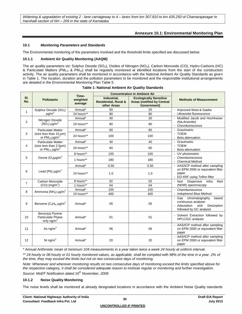
Widening & upgradation of existing 2 - lane carriageway to 4 – lanes from km 307.810 to km 435.250 of Chamarajanagar to
Harohalli section of NH – 209 in the state of Karnataka
Client: National Highways Authority of India 30
Draft EIA Report
Consultant: Feedback Infra Pvt. Ltd July 2013
UNCONTROLLED IF PRINTED
Annexure 10.1: Environmental Monitoring Plan
10.1 Monitoring Parameters and Standards
The Environmental monitoring of the parameters involved and the threshold limits specified are discussed below:
10.1.1 Ambient Air Quality Monitoring (AAQM)
The air quality parameters viz: Sulphur Dioxide (SO2), Oxides of Nitrogen (NOX), Carbon Monoxide (CO), Hydro-Carbons (HC) & Particulate Matters (PM2.5 & PM10) shall be regularly monitored at identified locations from the start of the construction activity. The air quality parameters shall be monitored in accordance with the National Ambient Air Quality Standards as given in Table 1. The location, duration and the pollution parameters to be monitored and the responsible institutional arrangements are detailed in the Environmental Monitoring Plan Table 5.
Table 1: National Ambient Air Quality Standards
Sl. No.
Pollutants Time-
weighted average
Concentration in Ambient Air
Methods of Measurement Industrial,
Residential, Rural & other Areas
Ecologically Sensitive Areas (notified by Central
Government)
1 Sulphur Dioxide (SO2)
µg/m3
Annual* 50 20 - Improved West & Gaeke
- Ultraviolet fluorescence 24 hours** 80 80
2 Nitrogen Dioxide
(NO2) µg/m3
Annual* 40 30 - Modified Jacob and Hochheiser (Na-Arsenite)
- Chemilumiscence 24 hours** 80 80
3 Particulate Matter
(size less than 10 µm) or PM10 µg/m
3
Annual* 60 60 - Gravimetric
- TOEM
- Beta attenuation 24 hours** 100 100
4 Particulate Matter
(size less than 2.5µm) or PM2.5 µg/m
3
Annual* 40 40 - Gravimetric
- TOEM
- Beta attenuation 24 hours** 60 60
5 Ozone (O3)µg/m3
8 hours** 100 100 - UV photometric
- Chemilumiscence
- Chemical Method 1 hours** 180 180
6 Lead (Pb) µg/m3
Annual* 0.50 0.50 - AAS/ICP method after sampling on EPM 2000 or equivalent filter paper
- ED-XRF using Teflon filter 24 hours** 1.0 1.0
7 Carbon Monoxide
(CO) (mg/m3)
8 hours** 02 02 - Non Dispersive Infra Red (NDIR) spectroscopy 1 hours** 04 04
8 Ammonia (NH3) µg/m3
Annual* 100 100 - Chemilumiscence
- Indophenol Blue Method 24 hours** 400 400
9 Benzene (C6H6) µg/m3 Annual* 05 05
- Gas chromatography based continuous analyser
- Adsorption and Desorption followed by GC analysis
10 Benzo(a) Pyrene Particulate Phase
only ng/m3
Annual* 01 01 - Solvent Extraction followed by
HPLC/GC analysis
11 As ng/m3 Annual* 06 06
- AAS/ICP method after sampling on EPM 2000 or equivalent filter paper
12 Ni ng/m3 Annual* 20 20
- AAS/ICP method after sampling on EPM 2000 or equivalent filter paper
* Annual Arithmetic mean of minimum 104 measurements in a year taken twice a week 24 hourly at uniform interval.
** 24 hourly or 08 hourly or 01 hourly monitored values, as applicable, shall be compiled with 98% of the time in a year. 2% of the time, they may exceed the limits but not on two consecutive days of monitoring.
Note: Whenever and wherever monitoring results on two consecutive days of monitoring exceed the limits specified above for the respective category, it shall be considered adequate reason to institute regular or monitoring and further investigation.
Source: MoEF Notification dated 16th November, 2009
10.1.2 Noise Quality Monitoring
The noise levels shall be monitored at already designated locations in accordance with the Ambient Noise Quality standards
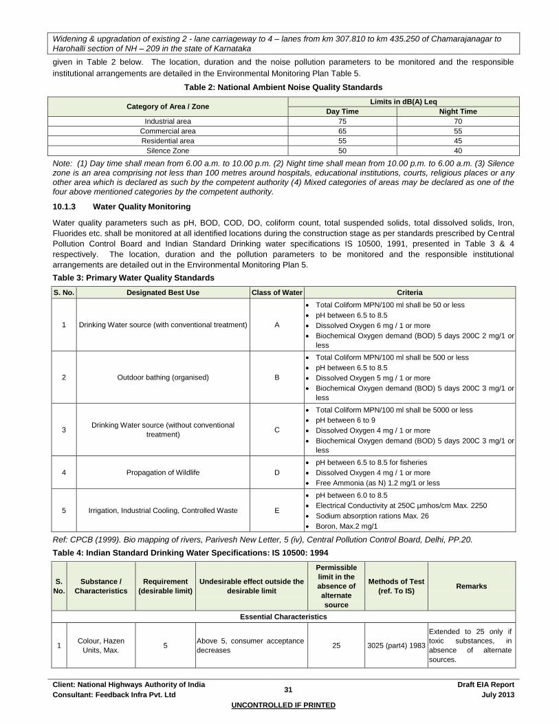
Widening & upgradation of existing 2 - lane carriageway to 4 – lanes from km 307.810 to km 435.250 of Chamarajanagar to
Harohalli section of NH – 209 in the state of Karnataka
Client: National Highways Authority of India 31
Draft EIA Report
Consultant: Feedback Infra Pvt. Ltd July 2013
UNCONTROLLED IF PRINTED
given in Table 2 below. The location, duration and the noise pollution parameters to be monitored and the responsible
institutional arrangements are detailed in the Environmental Monitoring Plan Table 5.
Table 2: National Ambient Noise Quality Standards
Category of Area / Zone Limits in dB(A) Leq
Day Time Night Time
Industrial area 75 70
Commercial area 65 55
Residential area 55 45
Silence Zone 50 40
Note: (1) Day time shall mean from 6.00 a.m. to 10.00 p.m. (2) Night time shall mean from 10.00 p.m. to 6.00 a.m. (3) Silence zone is an area comprising not less than 100 metres around hospitals, educational institutions, courts, religious places or any other area which is declared as such by the competent authority (4) Mixed categories of areas may be declared as one of the four above mentioned categories by the competent authority.
10.1.3 Water Quality Monitoring
Water quality parameters such as pH, BOD, COD, DO, coliform count, total suspended solids, total dissolved solids, Iron,
Fluorides etc. shall be monitored at all identified locations during the construction stage as per standards prescribed by Central
Pollution Control Board and Indian Standard Drinking water specifications IS 10500, 1991, presented in Table 3 & 4
respectively. The location, duration and the pollution parameters to be monitored and the responsible institutional
arrangements are detailed out in the Environmental Monitoring Plan 5.
Table 3: Primary Water Quality Standards
S. No. Designated Best Use Class of Water Criteria
1 Drinking Water source (with conventional treatment) A
Total Coliform MPN/100 ml shall be 50 or less
pH between 6.5 to 8.5
Dissolved Oxygen 6 mg / 1 or more
Biochemical Oxygen demand (BOD) 5 days 200C 2 mg/1 or
less
2 Outdoor bathing (organised) B
Total Coliform MPN/100 ml shall be 500 or less
pH between 6.5 to 8.5
Dissolved Oxygen 5 mg / 1 or more
Biochemical Oxygen demand (BOD) 5 days 200C 3 mg/1 or
less
3 Drinking Water source (without conventional
treatment) C
Total Coliform MPN/100 ml shall be 5000 or less
pH between 6 to 9
Dissolved Oxygen 4 mg / 1 or more
Biochemical Oxygen demand (BOD) 5 days 200C 3 mg/1 or
less
4 Propagation of Wildlife D
pH between 6.5 to 8.5 for fisheries
Dissolved Oxygen 4 mg / 1 or more
Free Ammonia (as N) 1.2 mg/1 or less
5 Irrigation, Industrial Cooling, Controlled Waste E
pH between 6.0 to 8.5
Electrical Conductivity at 250C µmhos/cm Max. 2250
Sodium absorption rations Max. 26
Boron, Max.2 mg/1
Ref: CPCB (1999). Bio mapping of rivers, Parivesh New Letter, 5 (iv), Central Pollution Control Board, Delhi, PP.20.
Table 4: Indian Standard Drinking Water Specifications: IS 10500: 1994
S.
No.
Substance /
Characteristics
Requirement
(desirable limit)
Undesirable effect outside the
desirable limit
Permissible
limit in the
absence of
alternate
source
Methods of Test
(ref. To IS) Remarks
Essential Characteristics
1 Colour, Hazen
Units, Max. 5
Above 5, consumer acceptance
decreases 25 3025 (part4) 1983
Extended to 25 only if
toxic substances, in
absence of alternate
sources.

Widening & upgradation of existing 2 - lane carriageway to 4 – lanes from km 307.810 to km 435.250 of Chamarajanagar to
Harohalli section of NH – 209 in the state of Karnataka
Client: National Highways Authority of India 32
Draft EIA Report
Consultant: Feedback Infra Pvt. Ltd July 2013
UNCONTROLLED IF PRINTED
S.
No.
Substance /
Characteristics
Requirement
(desirable limit)
Undesirable effect outside the
desirable limit
Permissible
limit in the
absence of
alternate
source
Methods of Test
(ref. To IS) Remarks
2 Odour Unobjectionable - - 3025 (parts 5):
1984
A test cold and when
heated. Test at several
dilution
3 Taste Agreeable - - 3025 (part 8):
1984
Test to be conducted
only after safety has
been established
4 Turbidity NTU, Max. 5 Above 5, consumer acceptance
decreases 10
3025 (part 7):
1984
5 PH value 6.5 to 8.5
Beyond this range the water will
not effect the mucous membrane
and /or water supply system
No relaxation 3025 (part 11):
1984
6 Total hardness (as
CaCo3) mg/1, Max. 300
Encrustation in water supply
structures an adverse effect on
domestic use
600 3025 (part 21):
1983
7 Iron (as Fe) mg /l
Max. 0.3
Beyond this limit
taste/appearance are affected
has adverse effect on domestic
uses and water supply structures
and promotes iron bacteria
1 3025 (part 21):
1983
8 Chlorides (as CI)
mg/1 Max. 250
Beyond this limit, taste corrosion
and palatability are affected 1000
3025 (part 32):
1988
9 Residual, free
chloride, mg/1 Min. 0.2
3025 (part 26):
1986
To be applicable only
when water is
chlorinated. Tested at
consumer end. When
protection against viral
infection is required, it
should be Min. 0.5 mg/1
Desirable characteristics
1 Dissolved solids
mg/1 Max. 500
Beyond the palatability
decreases and may cause
gastro intestinal irritation
2000 3025 (part 16):
1986
2 Calcium (as Ca)
mg/1 Max. 75
Encrustation in water supply
structure and adverse effects on
domestic use
200 3025 (Part 16)
1986
3 Magnesium (as Mg)
mg/1, Max. 30
Encrustation in water supply
structure and adverse effects on
domestic use
1.5 16,33,34 of IS
3025: 1964
4 Copper (as Cu)
mg/1 Max. 0.05
Beyond taste, discoloration of
pipes, fitting and utensils will be
caused beyond this
0.3 35 of 3025: 1964
5 Manganese (as Mn)
mg/1, Max.
Beyond this limit
taste/appearance are affected,
has adverse effect on domestic
uses and water supply
structures.
0.3 35 of 3025: 1964
6 Sulphate (as 200
So2), mg/1, Max. 200
Beyond this causes gastro
intestinal irritation when
magnesium or sodium are
present
400 3025(part 24):
1986
May be extended up to
400 provided (as Mg)
does not exceed 30
7 Nitrate (as No2)
mg/l, Max. 45
Beyond this
methaemoglobinemia take place 100
3025 (part24):
1988
To be tested when
pollution is suspected
8 Fluoride (as F)
mg/1, Max. 1
Fluoride may be kept as low as
possible. High fluoride may
cause fluorosis
1.5 23 of 3025:1964 To be tested when
pollution is suspected

Widening & upgradation of existing 2 - lane carriageway to 4 – lanes from km 307.810 to km 435.250 of Chamarajanagar to
Harohalli section of NH – 209 in the state of Karnataka
Client: National Highways Authority of India 33
Draft EIA Report
Consultant: Feedback Infra Pvt. Ltd July 2013
UNCONTROLLED IF PRINTED
S.
No.
Substance /
Characteristics
Requirement
(desirable limit)
Undesirable effect outside the
desirable limit
Permissible
limit in the
absence of
alternate
source
Methods of Test
(ref. To IS) Remarks
9
Phenolic
compounds (as
C6H5OH) mg/1,
Max.
0.001 Beyond this it may cause
objectionable taste and odour 0.002 54 of 3025:1964
To be tested when
pollution is suspected
10 Mercury (as Hg)
mg/1, Max. 0.001
Beyond this the water becomes
toxic No relaxation
(See not mercury
ion analyses)
To be tested when
pollution is suspected
11 Cadmium (as cd),
mg/1, Max. 0.01
Beyond this the water becomes
toxic No relaxation (See note)
To be tested when
pollution is suspected
12 Selenium, (as Se).
mg/1, Max. 0.01
Beyond this the water becomes
toxic No relaxation 28 of 3025:1964
To be tested when
pollution is suspected
13 Arsenic (As) mg/1,
Max. 0.05
Beyond this the water becomes
toxic No relaxation
3025 (part 37);
1988
To be tested when
pollution is suspected
14 Cyanide (as CN)
mg/1, Max. 0.05
Beyond this the water becomes
toxic No relaxation
3025 (part 27)
1988
To be tested when
pollution is suspected
15 Lead (as Pb), mg/1,
Max. 0.05
Beyond this the water becomes
toxic No relaxation (See note)
To be tested when
pollution is suspected
16 Zinc (as Zn) mg/1,
Max. 5
Beyond this limit it can cause
astringent taste and an
opalescence taste and an
opalescence in water
15 39 of 3025:1964 To be tested when
pollution is suspected
17
Anionic detergents
(as MBAS) mg/1,
Max.
0.2 Beyond this it can cause a light
froth in water 1
Methylene-blue
extraction method
To be tested when
pollution is suspected
18 Chromium (as Cr6+)
mg/1, Max. 0.05
May be carcinogenic above this
limit No relaxation 38 of 3025:1964
To be tested when
pollution is suspected
19
Poly nuclear
aromatic hydra
carbons (as PAH)
mg/1, Max.
- May be carcinogenic above this
limit - - -
20 Mineral oil mg/1,
Max. 0.01
Beyond this limit undesirable
taste and odour after chlorination
take place.
0.03
Gas
Chromatography
method
-
21 Pesticides mg/1,
Max. Absent Toxic 0.001 - -
22 Radioactive material - - - 58 of 3025:1964 -
23 Alpha emitters bq/1,
Max. - - 0.1 - -
24 Beta emitter pci/1,
Max. - - 1 - -
25 Aluminium (as Al)
mg/1, Max. 200
Beyond this limit taste becomes
unpleasant 600 13 of 3025:1964 -
26 Aluminium (as Al)
mg/1, Max. 0.03
Cumulate effect is reported to
cause dementia 0.2 31 of 3025:1964 -
27 Boron mg/1, Max. 1 - 5 29 of 3029:1964 -
Source: Indian Standard Drinking Water Specification – IS 10500, 1994
10.2 Environmental Monitoring Plan
The environmental monitoring plan is given below in table 5.
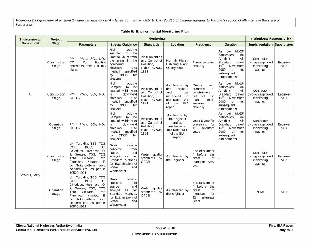
Widening & upgradation of existing 2 - lane carriageway to 4 – lanes from km 307.810 to km 435.250 of Chamarajanagar to Harohalli section of NH – 209 in the state of
Karnataka
Client: National Highways Authority of India Page 34 of 36
Final EIA Report
Consultant: Feedback Infrastructure Services Pvt. Ltd May 2013
UNCONTROLLED IF PRINTED
Table 5: Environmental Monitoring Plan
Environmental Component
Project Stage
Monitoring Institutional Responsibility
Parameters Special Guidance Standards Location Frequency Duration Implementation Supervision
Air
Construction Stage
PM10, PM2.5, SO2, NOX, CO, O3, Fugitive emissions from Hot mix plants
High volume sampler to be located 50 m from the plant in the downwind direction. Use method specified by CPCB for analysis
Air (Prevention and Control of Pollution) Rules, CPCB, 1994
Hot mix Plant / Batching Plant, Quarry sites
Three seasons annually
As per MoEF notification on Ambient Air Standard dated 16
th November
2009 or its subsequent amendments
Contractor through approved
monitoring agency
Engineer, NHAI
Construction Stage
PM10, PM2.5, SO2, NOX, CO, O3
High volume Sampler to be located within 4 m in downwind direction. Use method specified by CPCB for analysis
Air (Prevention and Control of Pollution) Rules, CPCB, 1994
As directed by the Engineer and as mentioned in the Table 10.1 of the EIA report
Moves with progress of construction but not less than three seasons annually
As per MoEF notification on Ambient Air Standard dated 16
th November
2009 or its subsequent amendments
Contractor through approved
monitoring agency
Engineer, NHAI
Operation Stage
PM10, PM2.5, SO2, NOX, CO, O3
High volume Sampler to be located within 4 m in downwind direction. Use method specified by CPCB for analysis
Air (Prevention and Control of Pollution) Rules, CPCB, 1994
As directed by the Engineer
and as mentioned in
the Table 10.1 of the EIA
report
Once a year for one season for 12 alternate years
As per MoEF notification on Ambient Air Standard dated 16
th November
2009 or its subsequent amendments
Contractor through approved
monitoring agency
Engineer, NHAI
Water Quality
Construction Stage
pH, Turbidity, TSS, TDS, COD, BOD, DO, Chlorides, Hardness, Oil & Grease, TSS, TDS, Total Coliform, Iron, Fluorides, Nitrates, E. coli, Total coliform, faecal coliform etc. as per IS 10500:1991
Grab sample collected from source and analyse as per Standard Methods for Examination of Water and Wastewater
Water quality standards by CPCB
As directed by the Engineer
End of summer / before the onset of monsoon every year
-
Contractor through approved
monitoring agency
Engineer, NHAI
Operation Stage
pH, Turbidity, TSS, TDS, COD, BOD, DO, Chlorides, Hardness, Oil & Grease, TSS, TDS, Total Coliform, Iron, Fluorides, Nitrates, E. coli, Total coliform, faecal coliform etc. as per IS 10500:1991
Grab sample collected from source and analyse as per Standard Methods for Examination of Water and Wastewater
Water quality standards by CPCB
As directed by the Engineer
End of summer / before the onset of monsoon for 12 alternate years
- NHAI NHAI
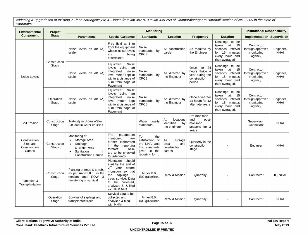
Widening & upgradation of existing 2 - lane carriageway to 4 – lanes from km 307.810 to km 435.250 of Chamarajanagar to Harohalli section of NH – 209 in the state of
Karnataka
Client: National Highways Authority of India Page 35 of 36
Final EIA Report
Consultant: Feedback Infrastructure Services Pvt. Ltd May 2013
UNCONTROLLED IF PRINTED
Environmental Component
Project Stage
Monitoring Institutional Responsibility
Parameters Special Guidance Standards Location Frequency Duration Implementation Supervision
Noise Levels
Construction Stage
Noise levels on dB (A) scale
Free field at 1 m from the equipment whose noise levels are being determined.
Noise standards by CPCB
At construction yards
As required by the Engineer
Readings to be taken at 15 seconds interval for 15 minutes every hour and then averaged
Contractor through approved
monitoring agency
Engineer, NHAI
Noise levels on dB (A) scale
Equivalent Noise levels using an integrated noise level meter kept at within a distance of 5 m from edge of Pavement
Noise standards by CPCB
As directed by the Engineer
Once for 24 hours thrice a year during the construction period
Readings to be taken at 15 seconds interval for 15 minutes every hour and then averaged.
Contractor through approved
monitoring agency
Engineer, NHAI
Operation Stage
Noise levels on dB (A) scale
Equivalent Noise levels using an integrated noise level meter kept within a distance of 5 m from edge of Pavement
Noise standards by CPCB
As directed by the Engineer
Once a year for 24 hours for 12 alternate years
Readings to be taken at 15 seconds interval for 15 minutes every hour and then averaged.
Contractor through approved
monitoring agency
Engineer, NHAI
Soil Erosion Construction
Stage
Turbidity in Storm Water
Silt load in water courses
Water quality standards
At locations identified by the engineer
Pre-monsoon and post-monsoon seasons for 3 years
Supervision Consultant
NHAI
Construction Sites and
Construction Camps
Construction Stage
Monitoring of:
Storage Area
Drainage arrangements
Sanitation in Construction Camps
The parameters mentioned are further elaborated in the reporting formats. These are to be checked for adequacy.
To the satisfaction of the NHAI and the standards given in the reporting form.
As storage area and construction camps
Quarterly in the construction stage
- Engineer NHAI
Plantation & Transplantation
Construction Stage
Planting of trees & shrubs as per Annex 8.6 in the median and ROW & monitoring of survival
Plantation should start by the end of 2
nd year before
monsoon so that the saplings & trees survive. Data to be collected, analysed & & filed with IE & NHAI
Annex 8.6, IRC guidelines
ROW & Median Quarterly - Contractor IE, NHAI
Operation Stage
Survival of saplings and transplanted trees
Survival data to be collected and analysed & filed with NHAI
Annex 8.6, IRC guidelines
ROW & Median Quarterly - Contractor NHAI
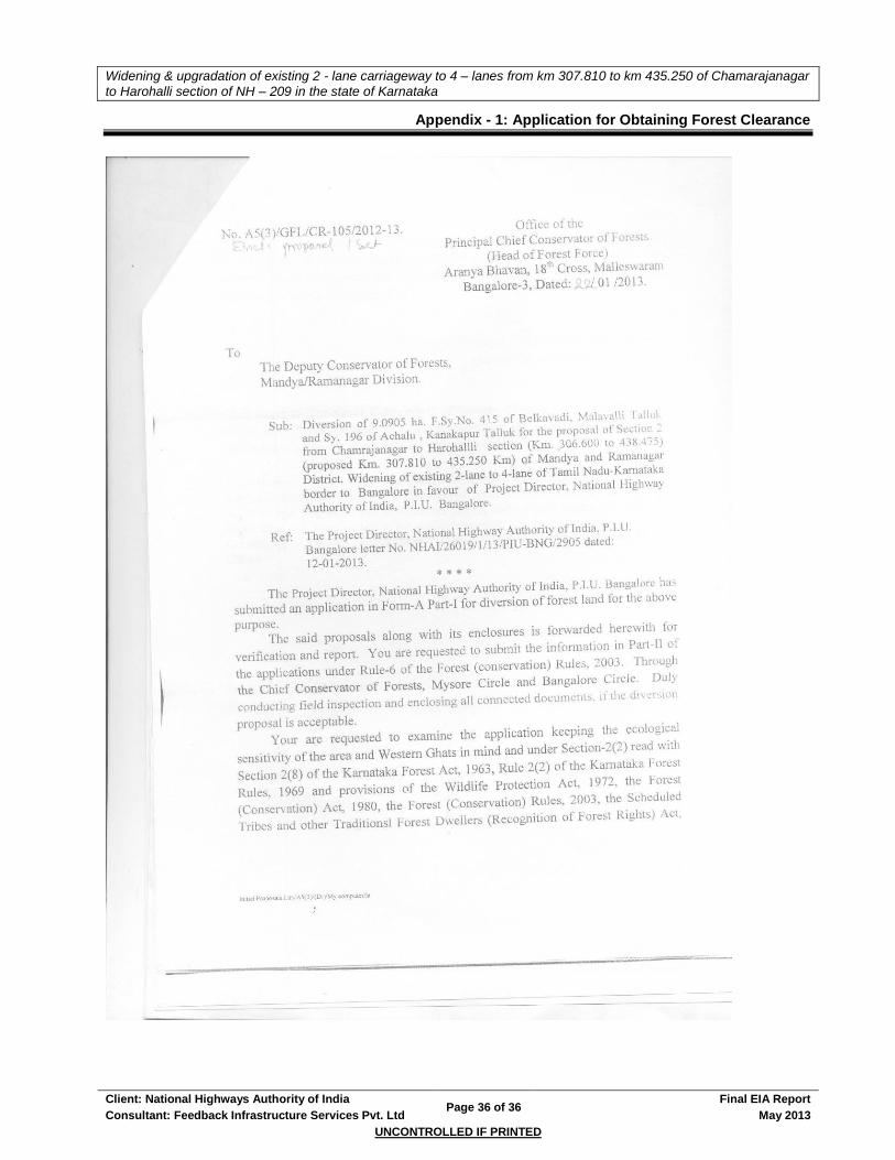
Widening & upgradation of existing 2 - lane carriageway to 4 – lanes from km 307.810 to km 435.250 of Chamarajanagar
to Harohalli section of NH – 209 in the state of Karnataka
Client: National Highways Authority of India Page 36 of 36
Final EIA Report
Consultant: Feedback Infrastructure Services Pvt. Ltd May 2013
UNCONTROLLED IF PRINTED
Appendix - 1: Application for Obtaining Forest Clearance