national land use zoning - nlcs
TRANSCRIPT

i
རྒྱལ་ཡོངས་ས་ཆ་བེད་སོྤད་བཅད་མཚམས།ལག་ལེན་ལམ་སོན་༢༠༡༨ ཅན་མ།།
National Land Use Zoning Implementation Guidelines 2018
National Land Commission SecretariatRoyal Government of Bhutan

ii

iii
Contents
ACRONYMS vi
1. EXECUTIVE SUMMARY 1
2. INTRODUCTION 3
3. GUIDING PRINCIPLES 5
4. PURPOSE OF THE GUIDELINE 6
5. OBJECTIVES OF NLUZ 6
6. IMPLEMENTATION STRATEGY 7
7. NLUZ FRAMEWORK 12
8. MONITORING & EVALUATION 22
9. Annexure 23
REFERENCES 28

iv

v
Foreword
Bhutan is a small land locked and mountainous country sandwiched between India and China. Its rugged terrain with limited arable land calls for sustainable and prudent use of the scarce land resource for various developmental activities. While the Bhutanese should uphold the Constitutional requirement of a minimum of 60% of total land area to be maintained under forest cover for all times, we must make optimal use of land for socio-economic development purposes.
There is an urgent need to assess the present and future needs of land by evaluating its capability to meet the competing demand for its uses. Without compromising both the former and the latter, we must strive towards adopting sustainable options in choosing those that bring about the desired socio-economic and environmental well-being of our citizenry. To meet this end the National Land Use Zoning (NLUZ) exercise shall be a crucial part of our national interventions.
A guideline is formulated for NLUZ exercise with the purpose to consolidate the stakeholders’ collaborations and cooperation in bringing about a common consensus in making priorities and delineating zones for different land uses according to its best suitability and capability. It is to foster better coordination amongst the implementing agencies and establish succinct approach in the National Land Use Zoning project. This guideline will facilitate the coordinating agency and other stakeholders in planning, implementing, monitoring and evaluation of NLUZ and serve as a reference in future to guide for any land use zoning exercises. The outcome of the NLUZ would provide a scientific basis for good land governance and facilitate the derivation of spatial vision for the country’s overall development.
However, as the National Land Use Zoning exercise is first of its kind beyond the Local Area Plans in major urban areas, there may have subtle inadvertent oversights in the guideline due to human considerations. Nonetheless, for any situation of contraventions, the national interest shall always be placed highest priority over individual wants and sectoral preferences and conflicts in land uses.
In order to successfully complement NLUZ exercise and to come up with a harmonious and mutually inclusive strategy for optimum utilization of the limited and priceless land, I solicit far-reaching collaboration, cooperation and commitment from the cross-sectorial agencies including the grassroots participation.
TASHI DELEK!
(Pema Chewang)Secretary

vi
ACRONYMS AKRA Agency Key Result AreasDEM Digital Elevation ModelEDP Economic Development Policy FYP Five Year PlanGDP Gross Domestic ProductGNH Gross National HappinessGNHCS Gross National Happiness Commission SecretariatSRF State Reserve ForestIPCC Intergovernmental Panel on Climate ChangeINDC Intended Nationally Determined ContributionJICA Janpan International Cooperation Agency LDN Land Degradation NeutralityLULC Land Use Land CoverMCDA Multi Criteria Decision Analysis M&E Monitoring & EvaluationMoAF Ministry of Agriculture and ForestsMoEA Ministry of Economic Affairs NECS National Environment Commission SecretariatNKRA National Key Result AreasNLCS National Land Commission Secretariat NLUZ National Land Use Zoning NSB National Statistical BureauNSDI National Spatial Development Infrastructure NSSC National Soil Services CentrePA Protected AreasPMO Project Management OfficeRS Remote SensingSGNH Strategic Gross National Happiness THPP Targeted Household Poverty ProgramTWG Technical Working GroupUN United NationsNHLC NLUZ High Land Committee Meeting

1
1. EXECUTIVE SUMMARYThe National Land Use Zoning (NLUZ) exercise will enable establishment of a harmonized national land use system. It will revalidate and delineate the existing National Parks, Biological Corridors, Agriculture Land, Industrial Areas, Human Settlements, Heritage Sites and others based on consultation with concerned sectors. The exercise will identify and designate dysfunctional and functional land for developmental activities. Further, online geo-database and maps of national zoning will be developed to facilitate spatial decision-making process. Besides providing sound basis for the determination of land use ordinances and enforcement, it will also provide impetus to the people to make optimum, judicious and sustainable use of the limited land resource.
The NLUZ will not only address above issues and concerns but will eventually establish spatially enabled land governance system for an integrated socio-economic development. A systematic land governance would ensure food security, economic self-reliance, and most importantly the optimal use of limited land resources for sustainable socio-economic development in the country. This in turn would reduce dependency, and secure and strengthen national sovereignty.
The NLUZ exercise in summary will constitute three phases for the entire cycle as follows:
Phase I (2017 – 2019)i. Establish Project Management Office (PMO); ii. Development of NLUZ implementation guidelines;iii. Conduct stakeholder consultation and adoption of NLUZ guidelines; iv. Parameterize each land uses by the concerned agencies based on the
capability/ suitability assessment and submit to NLCS/ PMO; v. Carry out Land Use Land Cover (LULC) mapping lead by MoAF & NLCS; andvi. Implement pilot exercises at least in two Dzongkhags.
Phase II (2019– 2021)i. Review pilot exercises; ii. Based on the pilot exercises, zoning for entire country shall be carried out and
produce national zoned maps;iii. Develop draft National Land Use Strategy; and iv. Submit for approval of the Royal Government.
Phase III (2021 – 2023)i. Review the Land Act 2007 and other relevant land use acts/ policies/ rules
and regulations to incorporate and harmonize the provisions of NLUZ; ii. Submit for amendment of the Land Act 2007 as appropriate, andiii. Advocate, publicize and sensitize about the NLUZ and amended acts/ policies/
rules and regulations.

2
Considering the importance of NLUZ for the country, National Land Commission Secretariat (NLCS) had initiated and convened the first High Level Consultation (HLC) meeting to discuss on the matter. This was followed by stakeholder consultations to seek further directions and way forward. The general consensus of the consultation has fostered urgent need to take up NLUZ. Accordingly, the TWG was formed and the concept paper was developed. The concept paper was presented to the 14th Gross National Happiness Commission (GNHC) meeting. The commission meeting approved the proposal and directed NLCS to undertake NLUZ as a project.
As highlighted in Phase I of the NLUZ exercise, this guideline is developed to ensure better coordination amongst the stakeholders in the implementation of NLUZ. The guideline includes implementation arrangements with corresponding roles and responsibilities of the stakeholders. Further, it details out the implementation strategy, framework cycle, action plan and monitoring and evaluation processes.

3
2. INTRODUCTIONBhutan has 664,000 acres (7% of the total land area) of arable land, out of which about 500,000 acres have been utilized and registered on freehold with a balance of approximately 164,000 acres. Further, about 8,344 acres of state land has been leased out for socio-economic developmental activities, such as, mining, commercial, business, and pasture (tsamdro) developments. In addition, there is an ever-increasing pressure on limited land from accelerated socio-economic development activities taking place in the country, such as, construction of farm roads, electricity transmission/distribution lines, industries and urbanization (BSOE NEC 2016).
The scarcity of arable land is a huge concern for the country, which was explicitly highlighted by His Majesty the King during the 109th National Day on 17th December, 2016. Thus, an efficient and judicious use of the limited land by the key stakeholders through proper integrated zoning has become so crucial for an overall sustainability and to safeguard the national food security by enhancing food production in the country.
The National Action Program (NAP) to Combat Land Degradation mentions “at the macro-level and as a cross-sectoral issue, the policy perspective on national land use and management is presently lacking (NAP, 2010). Consequently, the conflicts of land uses between various sectors persist and in many instances, defy land capability.” It states that programs and activities for proper land use and management have remained compartmentalized within various sectors. There is also a lacuna in the institutional setting with respect to the overall coordination and management of the technical aspects of land use. For instance, random and haphazard development within the vicinity of heritage sites at times results in losing of important cultural heritage to other socio-economic development uses. At the moment, in the absence of proper zonation of areas for specific purpose, it has been extremely difficult for the competent agencies to regulate such developments. NLUZ has been initiated as one of the major collaborative activities in the 11th FYP and will be spilled-over to the 12th FYP as one of the key cross-sectorial performance indicators. NLCS in close consultation with GNHCS shall lead the coordination of this particular program.
This exercise shall broadly ensure nationwide spatial integration and establish coherent zoning ordinances to facilitate and boost the SmartGrowth of the country, without undermining the carrying capacity of the land and its environment. The NLUZ can be used for monitoring, multi-disciplinary policy making and suitability mapping of the scarce resource of land in the country.
2.1. RationaleOn 16th September 2014, during the grant of land kidu in Zhemgang Dzongkhag, His Majesty the King emphasized that the land is central to the lives of the people since

4
it is the primary sources of food, shelter and clothing. His Majesty went on to state that the land provides security of inheritance to individuals and families which in turn would augment the socio-economic development and wellbeing of the nation. This overarching concern is upheld in numerous national and international obligations in the light of land as being the most important component of the environment in addition to its indispensability as the critical factors of production. The Intergovernmental Panel on Climate Change (IPPC) states that the mountainous countries will experience a decline in crop yield due to increase in water stress (either too much or too little) and land degradation (IPCC, 2007). Recognizing soil as the largest terrestrial soil organic carbon (SOC) storage, Bhutan’s Intended Nationally Determined Contribution (INDC) mentions that the soil and land development as a means to both mitigate and adapt to climate change and ensure continuous ecosystem services (INDC, 2015).
According to the National Biodiversity Strategies and Action Plan (NBSAP), the incomplete physical zonation of the Protected Areas (PA) has resulted in an ad hoc zoning of services/facilities and resource extraction, at times, challenging the conservation objectives and policies and therefore recommends to complete zonation of the PA by 2018 (NBSAP 2014).
The State of the Environment 2016 recommends identification and prioritization of critical forests, habitats, and watersheds; completion of land capability mapping at the earliest to identify areas that can sustainably support various uses such as agriculture or other development activities; and demarcation of boundaries of all PA on the ground by the end of 11th FYP.
Further the following policies and legal provisions emphasize the need for NLUZ exercise:
i. Article 5 (b) of the Constitution of the Kingdom of Bhutan 2008 states, “The Government shall ensure a minimum of 60% of total land area is maintained under forest cover for all time.”;
ii. The Economic Development Policy of the Kingdom of Bhutan 2016 requires NLC to prepare a national land use plan for State Reserve Forest Land outlining use of land for optimal use by 2018 and all relevant sectors are mandated to provide sectoral parameters to NLC by 2017;
iii. The Bhutan National Adaptation Program of Action (NAPA) 2006 entails clear zoning of vulnerable areas of natural hazards;
iv. Section 303 of the Land Act of Bhutan 2007 requires assessment of present and future needs by evaluating the land’s capability to supply them; identifying and resolving conflicts between competing uses, between the needs of individuals and those of community, and between the needs of the present generations and those of future generations; and seeking sustainable options and choosing those that bring about the desired economic, social and environmental wellbeing of the citizens of Bhutan; and

5
v. Bhutan National Human Settlement Strategy 2017, aims to ensure an integrated and regionally balanced development of settlements, both rural and urban inclusive of environmental conservation, preservation of culture and decentralization to promote participatory development.
Despite these mandates and provisions enshrined in various national documents, socio-economic development activities continue to take place in a sporadic manner impacting the state of natural environment. This is however largely due to lack of proper NLUZ put in place in the country. Therefore, in order to have a more sustainable socio-economic development, it is imperative to have a sound NLUZ system put in place to judiciously harness our limited land resources, based on their potential, to provide various ecosystem services for the well-being of the present and future generations.
Moreover, an essential point of take-off for NLUZ at present is to take advantage of the comprehensive national cadastral data/information that NLCS houses along with the completion of the 1: 25,000 scale topography base mapping with JICA’s support. These two elements shall be the basis for comprehensive Land Use Land Cover (LULC) mapping to undertake the NLUZ exercise. Further, the Geo – Information (GI) Policy of Bhutan is also being drafted by the NLCS in collaboration with the Centre for GIS Coordination (CGISC) and advisory support from the Netherlands, which will be the overall policy framework for the National Spatial Data Infrastructure (NSDI) in the country.
3. GUIDING PRINCIPLESThis guideline has been developed based on the following six main principles:
a. Optimize the use of different land resources based on their capability/potential;
b. Minimize land degradation, ensure sustainable agriculture, reduce climate change, and enhance ecosystem services through appropriate land use system;
c. Ensure constitutional requirement of 60% forest cover at all times;
d. Safeguard food and nutrition security;
e. Enhance socio-economic development while ensuring environment wellbeing;
f. Ensure sustainable land resource and environment management to enhance resilience to climate change;
g. Promote sustainable and regional balanced socio-economic development; and
h. Promote Smart Growth, habitats and preserve heritage sites.
6
4. PURPOSE OF THE GUIDELINE
a. To foster better coordination amongst the implementing agencies;
b. To establish clear approach in implementing NLUZ project;
c. To facilitate PMO and other stakeholders in planning, implementing, monitoring and evaluation of NLUZ; and
d. To serve as future reference and guide for any land use zoning exercises.
5. OBJECTIVES OF NLUZBroadly the objectives of NLUZ embrace the overall objectives of Strategic Gross National Happiness (SGNH) that underlines better quality of life for the people, a strong and competitive economic position, and an environment of the highest quality.Specifically, the NLUZ inspires to achieve the following objectives:
a. To establish a harmonized national land use system in the country;
b. To revalidate and delineate designated areas, viz. wetlands, parks and protected areas, biological corridors, agriculture land, human settlements, industrial e states, heritage sites and many more for better management;
c. To designate dysfunctional and functional land for any categories of development;
d. To establish sound online database and maps of national zoning to facilitate scientific based decision-making process;
e. To make optimum, rational and sustainable use of limited land by discouraging competition and avoiding land use conflicts;
f. To provide scientific basis for land governance;
g. To facilitate the establishment of land use ordinances and enforcement; and
h. To optimize the use of different land resources based on their potential.
7
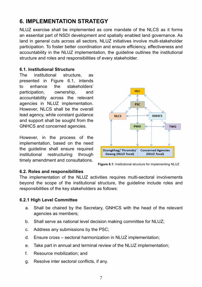
6. IMPLEMENTATION STRATEGYNLUZ exercise shall be implemented as core mandate of the NLCS as it forms an essential part of NSDI development and spatially enabled land governance. As land in general cuts across all sectors, NLUZ initiatives involve multi-stakeholder participation. To foster better coordination and ensure efficiency, effectiveness and accountability in the NLUZ implementation, the guideline outlines the institutional structure and roles and responsibilities of every stakeholder.
6.1. Institutional StructureThe institutional structure, as presented in Figure 6.1, intends to enhance the stakeholders’ participation, ownership, and accountability across the relevant agencies in NLUZ implementation. However, NLCS shall be the overall lead agency, while constant guidance and support shall be sought from the GNHCS and concerned agencies.
However, in the process of the implementation, based on the need the guideline shall ensure required institutional restructuring through timely amendment and consultations.
6.2. Roles and responsibilitiesThe implementation of the NLUZ activities requires multi-sectoral involvements beyond the scope of the institutional structure, the guideline include roles and responsibilities of the key stakeholders as follows:
6.2.1 High Level Committee
a. Shall be chaired by the Secretary, GNHCS with the head of the relevant agencies as members;
b. Shall serve as national level decision making committee for NLUZ;
c. Address any submissions by the PSC;
d. Ensure cross – sectoral harmonization in NLUZ implementation;
e. Take part in annual and terminal review of the NLUZ implementation;
f. Resource mobilization; and
g. Resolve inter sectoral conflicts, if any.
Figure 6.1: Institutional structure for implementing NLUZ
8
6.2.2 Project Steering Committee
a. Shall be chaired by the Secretary, NLC with the nominees from the relevant agencies as members;
b. The committee shall meet on quarterly basis and as deemed necessary by the chair;
c. Shall endorse annual work plan and budget;
d. Guide and ensure effective functioning of PMO;
e. Review, resolve and act on the PMO submission;
f. Decide on human resource development for the NLUZ;
g. Endorse submission of the PMO that merits HLC’s approval;
h. Quarterly review of the NLUZ implementation; and
i. Resolve inter-sectoral conflicts, if any.
6.2.3. National Land Commission Secretariata. Provide necessary support to PMO for its smooth functioning;
b. Develop Terms of Reference for the PMO and seek endorsement from PSC;
c. Provide dedicated manpower, office space and support facilities;
d. Develop the national land use strategy; and
e. Develop national land use rules & regulations (ordinances).
6.2.4 Gross National Happiness Commission Secretariata. Spearhead spatial envisioning exercises and align with the national goals
and vision;
b. Endorse additional land use themes (zones), if need be, beyond what is prescribed in this guideline;
c. Explore donor support and carry out budgeting; and
d. Conduct/ lead/ coordinate the Evaluation of NLU.
6.2.5 ProjectManagementOfficeThe PMO will be based at the NLCS (Figure 6.2.5) and will be coordinating the implementation of NLUZ activities with the following mandate:
a. Coordinate HLC, PSC and TWG meetings as and when required;
b. Coordinate field monitoring and ensure effective implementation of the zoning exercises;
c. Submit quarterly progress report to PSC;d. Ensure fund position in close liaise with the funding agency and relevant stakeholders;

9
e. Work closely with the agencies and zoning focal persons on information/ data consolidation and reporting.
f. Besides, PMO shall execute the following key technical activities:
i. Receive, review and finalize sectoral land use parameters involving the TWG and concerned agencies;
ii. Sensitize/ stakeholder consultation on NLUZ;
iii. LULC production in collaboration with the Ministry of Agriculture and Forests.
iv. Acquisition of satellite imageries, topographical and agro-metrological data; and
v. Coordinate data processing, in-situ data collection (field work), modeling and classification, field validation and mapping.
6.2.6 Concerned Agenciesa. Ensure TWG participation;
b. Identify agency NLUZ focal person, preferably from PPD;
c. Carry out land use parameterization based on the capability/ suitability assessment at agency level and submit to PMO/ NLCS;
d. Ensure sharing existing land use datasets to PMO/ NLCS;
e. Take part in NLUZ coordination meeting, including resolving negotiation for competing/ conflicting land use cases as and when called for; and
f. Ensure annual budgeting for NLUZ related activities at the agency level.

10
6.2.7 Dzongkhag Administration & Thromdea) Support for the field work in implementing NLUZ data collection and validation
exercises;
b) Participate in land use parameterization exercises carried out by concerned agencies;
c) Participate in negotiation for competing/ conflicting land uses;
d) Ensure local government level sensitization and awareness on NLUZ and NLUZ implementation; and
e) Support grassroots awareness on NLUZ implementation.
6.2.8 Gewog Administrationa) Support and take part in NLUZ field work;
b) Ensure community participation on NLUZ activities, including land use parameterization; and
c) Participate in negotiation for competing/ conflicting land uses.
6.2.9 NLUZ Technical Working Groupa. TWG meeting shall be chaired by Project Chief;
b. Convene TWG meeting as and when necessary;
c. Develop, harmonize, consult and present NLUZ related strategies and guidelines;
d. Technical advices for PMO the effective implementation of NLUZ; and
e. Participate in PSC as observers.
6.3 Capacity DevelopmentThe existing NLCS staffs would carry out the NLUZ as part of the organizational mandates. However, there is additional need for new recruitment, preferably on contract basis to form dedicated team for PMO. As indicated in the Figure 6.2.5, nearly 15 Surveyors and 8 support staffs need to be recruited on contract basis. At managerial and professional level, the existing relevant staff of NLCS shall multitask. Given that the NLUZ is being initiated for the first time there will be capacity gaps at all levels, be it managerial, technical or at operational levels. As such, in the due course of NLUZ implementation, it will be important to have appropriate capacity development supports.

11
It is therefore recommended to implement the following capacity development plan: Sl. Field of capacity
development Target group Agency No. Course
level (Min.) Institute/ country
1 National spatial envisioning & best practices
Policy & Research staffs
NLCS, GNHCS & TWG
10 Certificate/ study tour
Unspecified
2 Zoning ordinance/ Land use regulations
Policy & Research staffs
NLCS 2 Certificate Unspecified
3 Formulation of national land use strategy
Policy & Research staffs
NLCS, GNHCS & concerned agencies
10 Study tour Unspecified
4 Land use parameterization & land use negotiation
Survey engineers, LR & policy personnel
NLCS & PMO
5 Certificate Unspecified
5 Land Use Land Cover mapping
GIS/ RS & Survey engineers
MoAF & NLCS
4 Certificate Unspecified
6 Topographical and agro-metrological data analysis
Survey engineers & CID
NLCS & PMO
4 Certificate Unspecified
7 Land capability assessment
Soil analysts NSSC, MoAF
3 Training Unspecified
8 Multi-Criteria Decision Analysis (MCDA)
Survey engineers & CID
NLCS 4 Certificate Unspecified
9 In-situ data collection and data processing, modeling & classification Survey engineers, surveyors & CID
NLCS & PMO 4 Certificate Unspecified
10 Zone mapping Survey engineers & mappers
NLCS & PMO
4 Certificate Unspecified
11 Geo-spatial analysis Survey Engineers
NLCS 3 Certificate Unspecified
12 Rationalizing zones Survey engineers, LR & Policy personnel
NLCS & concerned agencies
7 Study tour Unspecified
13 Conflict resolution Policy personnel & lawyers
NLCS & concerned agencies
2 Study tour Unspecified

12
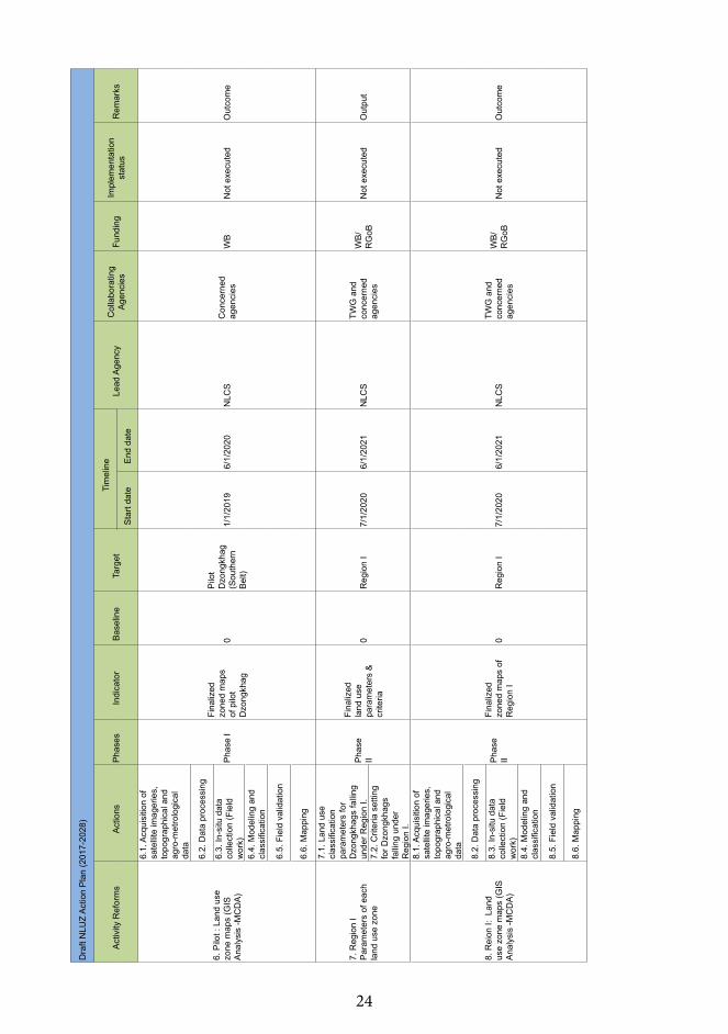
6.4. Action Plan & BudgetingThe action plan (annexure 1) which is developed in consultation with GHNCS shall be the basis for the consultation with the concerned agencies. The action plan shall be referenced for the budgeting estimation. The abstract of overall budgeting/ costing as indicated in the table below subsumes the NLUZ activities under broad reforms heading. 7. NLUZ FRAMEWORK
Figure 6.4: Key reforms and time frames for NLUZ implementationSl Reforms Costing
(US$)Timeline2017-2018
2018-2019
2019-2020
2020-2021
2021-2022
2022-2023
1 Road map/ NLUZ implementation guidelines
22,000.00
2 Project Management Office 299,200.00 3 Procurement of satellite imagery 821,820.00 4 Capacity development 374,000.00 5 Land Use Land Cover (LULC) 1,962,205.88 6 Parameters of each land use zone 27,500.00 7 Pilot Implementation 1,455,882.35 8 Land use zone maps 220,000.00 9 Harmonized land use strategy 294,800.00 10 National Spatial vision 118,800.00 11 Review Land Act 2007 and
Policies132,000.00
12 Enforcement 440,000.00 13 Monitoring & Evaluation 22,000.00 Total 6,190,208.24
7.1 Framework CycleThe Figure 7.1 shows the NLUZ framework cycle consisting seven stages in total and every stage corresponds to a lead agency. The stages are defined as follows:
7.1.1 Parameterization of land uses and Land Use Land Cover Mapping7.1.1.1. Land use parameterization Despite the sectors have defined land use parameters built either within the sector specific rules and regulations or any legitimate guidelines, there are incidences of land use conflicts arising

13
within and amongst the sectors, especially due to competing interests for land uses. For the purpose of NLUZ exercises, the following parameters shall be used as an illustration under the four main land use themes, viz. social, economic, culture and environment:
a. Social i. Alienable land (State land) » Adopt Use Right System (URS) parameters.
ii. Institutional Infrastructure (Education, Health, other institutions) » Road accessibility, » Slope till 30% most suitable, and stability. » Away from hazardous zone and polluting setups.
iii. Private agriculture areas » Soil suitability, water source.
iv. Human settlement (urban, rural, semi-urban, peri-urban) » Slope gradient (30%) » Demography » Land suitability » Water source availability
The Bhutan National Human Settlement Strategy 2017 shall determine the technical parameters of human settlements.
v. Transportation & communication » Road right – of – way » Power transmission buffer
The Road Master Plan 2007 – 2027 shall determine the technical parameters for the nationwide transport and communication.
vi. Waste and sewer management.The location of sanitary landfill or open dump site shall be determined through the following parameters:
» Within a distance in or around human settlement that poses environment and health hazards;
» Near water catchment areas » Near rivers, wetlands, water bodies or ground water source » Unstable or landslide prone areas » Notified areas as habitat of endangered flora and fauna » Within motorable distance of 3kms from Dzong or other monuments of
culture or historical importance

14
However, the Waste Prevention and Management Regulation, 2012 is considered to derive the parameters.
vii. Restricted areas (military areas, airfields, etc.) Refer identified areas as per Thram (cadastral database) shall be used for NLUZ mapping exercises.
b. Economic i. Commercial agriculture farming » Soil quality (depth, percentage of stones, subsoil texture, water retaining
capacity, erodibility and drainage, NSSC 2005) to support sustained production;
» Slope below 450 gradient capable of farming; » Slope below 170 gradient capable of supporting farm mechanization; » Potential for assured irrigation for Chhuzhing; and » Based on land capability classification and suitability evaluation.
Besides these, Interim Guideline on Lease of GRF for Commercial Agriculture 2011 shall be referred to derive the parameters.
ii. Industrial areas (industrial parks, mini industrial estates, service centre, special economic zones, dry-ports) » Access to infrastructure » Water source » Stable area » Away (to be defined in dataset) from human settlements (except service
centres)
iii. Hydropower The 2003 – 2022 Power System Master Plan (PSMP) and revised PSMP 2040 shall be the basis to derive the parameters.
iv. Mining Parameters shall be derived based on the geological maps; and Mines and Minerals Act 1995.
v. TourismParameters beyond the cultural and environment inclusion shall be submitted to NLCS prior to NLUZ exercises.
c. Culture i. Heritage sites (as described in the Cultural heritage bill) » Cultural sites » Archaeological sites

15
» Heritage buildings » Core and buffer zone for the designated heritage buildings and cultural
sites.
Parameters shall be derived based on the Draft Cultural Heritage bill and its subsequent, rules and regulation.
d. Environmenti. Heritage forestsii. Community forestiii. National Parksiv. Wildlife Sanctuariesv. Biological Corridorsvi. Strict Nature Reservevii. Ramsar sites and wetlands areaviii. Forest Management Unitsix. Degraded Watershed and Catchment areasx. Forest Plantationxi. Nature Recreation sites (eg. Kuenselphodrang nature park) xii. Permanent Forestry Research and Monitoring Plotsxiii. Key Biodiversity Areas (Outside Protected Areas, eg. Roosting area of
Black Necked Crane/White bellied Heron)Parameters on the above shall be derived based on the following legislations in place:
» Forests and Nature Conservation Act of Bhutan 1995; and; » Forests and Nature Conservation Rules and Regulations of Bhutan 2017; » National Forest Policy of Bhutan 2011; » National Strategy for Community Forestry, The Way Head 2010; » Vision and Strategy for Nature Conservation Division 2003; » Bhutan Biological Conservation Complex; » The Water Act of Bhutan 2011; » The Water Regulation of Bhutan 2014; and » Forest Plantation Strategy.
viii. Environmental Buffers » River/stream buffer » Buffer from degraded areas » International Boundary buffers
ix. Bare area (rocky outcrops) » Shall refer LULCM 2017.
An exhaustive parameterization shall be carried out and compiled as references for NLUZ exercises, in addition to the above parameters. However, for any additional
16
land uses that required beyond the scope of the agreed parameters, it shall be determined through detail sectoral consultation and research conformation.
7.1.1.2 Land Use Land Cover Mapping Form a working group comprising of GIS experts from relevant agencies and prepare modalities to carry out LULC mapping that is specific to the need of NLUZ exercise, using scale of 1: 25,000 topographical base mapping with high resolution images which is underway with JICA support.
The steps as indicated under part a. of the Figure 7.2 highlights the inputs for the LULC mapping for NLUZ exercise.
7.1.2 Data coordination and managementIn this stage, the following tasks shall be carried out:
» Data acquisition from the concerned agencies and collection from the field;
» Data processing or preparation; » Classification of land use data based on Food and Agriculture Organization
(FAO) standards; and » Data validation upon field works and random sampling.
7.1.3 MappingBased on the spatial and non-spatial data acquired from the concerned agencies, Multi – Criteria Decision Analysis (MCDA) shall be applied. The spatial and non-spatial categories of data are broadly classified as follows:
» Spatial o LULC maps o Demography (PHCB 2017)o Cadastral information o Road network maps o Topographical maps o Digital Elevation Model (DEM)o Heritage siteso Biological corridorso Administrative boundarieso Metrology datao Soil datao Hazard mapso Utility maps

17
» Non-spatial o Output from the parameterization exercises by the concerned
agencies o Comprehensive Development Plan & Human Settlement Strategyo Agriculture Land Development guidelines;o National Spatial Policyo Sectoral policies/ guidelines/ strategies/ acts/ rules & regulations/ by-
laws.o Literature review for international good practices in deriving the
parameters.
The part b. of Figure 7.2 highlights the abstract inputs for this stage.
A general flowchart is developed in line with the framework cycle, mainly to build technical clarity for the implementation of NLUZ activities. However, methodology (7.2) shall spell out detail technical steps, mainly pertaining to analysis with AHP (Analytical Hierarchical Process) of GIS-MCDA.
7.1.4 Development of national land use strategyEstablish a working group led by NLCS with the members from the concerned agencies (NLCS, MoAF, MoWHS, MoEA, GNHCS, NEC, MoHCA and other relevant agencies). The group shall develop a draft strategy and carry out wider consultation amongst the stakeholders.
The strategy shall include the following key aspects: » Strategize land uses amongst the sectors and agencies in line with the
prevailing legislations, policies and the NLUZ outcomes;
Figure 7.2: NLUZ general technical flowchart

18
» While making optimal utilization of limited land resources, the strategy shall ensure there is no adverse impact on the environment wellbeing;
» Ensure proper utilization of land as per its bearing capacity and the potentials;
» Ensure resolving the conflict of land uses; and » Rationalize the zones for various land uses.
7.1.5 Zoning ordinances and enforcementIn this stage, the land use rules and regulations shall be formulated as a part of zoning ordinances. In order to formulate the rules and regulations, the Land Act 2007 and related legislations and polices shall be reviewed based on the inferences derived from the NLUZ exercises and propose for amendments. The formulated zoning ordinance or rules and regulations thereafter shall be submitted to the government for endorsement.
The endorsed rules and regulations shall be enforced by NLCS and the concerned agencies, including local government.
7.1.6 Evaluation of NLUZThis shall be executed as detailed under the Monitoring & Evaluation part of this guideline.
7.1.7 National spatial envisioningBhutan needs a spatial vision to inform development planning and policy in general and to facilitate strategic land uses for the entire sectors. The nationwide zoning exercise shall form the basis to rationalize the national spatial envisioning, in order to;
» Tackle inherited spatial divisions – the division that perpetuated exclusion and distorted growth patterns;
» Unlock development potential – unlock development potential through spatially enabled targeted interventions;
» Guide and inform infrastructure investment and prioritization – spatial investment framework to support growth and inform the long-term infrastructure investment strategy;
» Manage contemporary economic and demographic shifts – support economic dynamics by concentrating productive activity, entrepreneurs, workers and consumers in a place without congestion; and
» Facilitate coordination between parts of government and other agents – used to bring different actors and interests together to define a common future, binding all spheres and sectors.
Taking into account some of international perspectives, the overall spatial vision shall conform to the following normative principles:

19
» Righteousness – The policy of confining particular agencies to limited space (ghettoization and segregation) and the unfair allocation of public resources between areas must be reversed.
» Sustainability – Sustainable patterns of consumption and production should be supported, and ways of living promoted that do not damage the natural environment.
» Resilience – Vulnerability to environmental degradation, resource scarcity and climatic shocks must be reduced.
» Conservation – Biological and ecological systems is protected and conserved reasonably.
» Quality – The aesthetic and functional features of infrastructure and the built environment need to be improved to create more livable, vibrant and valued community.
» Efficiency – Productive activity and jobs should be supported, and burdens on business minimized. Efficient commuting patterns and circulation of goods and services should be encouraged, with regulatory procedures that do not impose unnecessary costs on the development.
Besides these, concepts of spatial policy under Strategy Gross National Happiness 2008 shall be considered to undertake the spatial envisioning exercise. The formulated national spatial vision shall then be included under the overall national development vision for sound spatial integration.
7.2. METHODOLOGY Remote Sensing (RS) and Geographical Information System (GIS) are fundamental tools for the inventory and analysis of natural resources for planning, management and development. The technologies of RS give comprehensive information of land use/ land cover and can determine the change in land use/land cover over a period of time. The combination of RS & GIS technologies has immensely helped in environmental and water management, planning and community development, natural resources management, assessing disaster/ hazard areas, and of course, in the field of land use zoning. It considers various factors or criteria for the analysis, visualization and presentation to support the spatially enabled decision-making processes. One of the widely used methods with these fundamental technologies in spatially enabled land-use decision making process is spatial Multi Criteria Decision Analysis (MCDA). For NLUZ as well, GIS-MCDA method adopting widely used decision-making process called the Analytical Hierarchy Process (AHP) which considers primary importance of stakeholder involvement and their demands.
7.2.1. Analytical Hierarchy Process (AHP) BackgroundThe AHP is a theory of measurement through pairwise comparisons and relies on the judgment of experts to derive priority scales. It is a solution to the findings that lacks common, understandable and ease-to-implement methodology for a complex decision (Bhushan & Rai,2004; Saaty, 2008). The AHP helps structure

20
the decision-makers’ thoughts and can help in organizing the problem in a manner that is simple to follow and analyze. It fosters popular participation, especially engaging the stakeholders, community leaders, experts and the general public (Malzewski,1999). Broad areas in which the AHP is applied includes alternative selection, resource allocation, forecasting, business process re-engineering, quality function deployment, public policy decisions, healthcare and many more (Bhushan and Rai,2004). As this tool being simple and powerful, it is widely used in the field of business, government, social studies, research and development, mainly for the reasons: 1) ease of implementation, 2) theoretically proven concept and 3) market-tested and accepted methodology capable of producing results that agree with perceptions and expectations. In general, the AHP is a systematic approach to give decision-making on experience, intuition and heuristics structure of a well-defined methodology derived from sound mathematical principles.
7.2.2. AHP steps The AHP principally decomposes the problems into a hierarchy of sub-criteria problems which can be more easily comprehended and subjectively evaluated. Then the subjective evaluation is converted into numerical values processed to rank each alternative on a numerical scale. The AHP methodology can be summarized and explained as follows:
Step 1: The unstructured problem is decomposed into a hierarchy of goals, criteria, sub-criteria and alternatives.
Step 2: Relative ratings form expert or decision makers are collected using pair-wise comparison between different criteria or alternatives. The comparison is done on a qualitative scale ranging from 1 to 9. Experts can rate the comparison as equal, marginally strong, strong, very strong, and extremely strong (Refer Table below: Gradation Scale for qualitative comparison of alternatives).
Numerical Value Verbal Meaning
1 Equally important2 Equally to moderately more important3 Moderately more important4 Moderately to strongly more important5 Strongly more important6 Strongly to very strongly more important7 Very strongly more important8 Very strongly to extremely more important9 Extremely more important
Step 3: The pairwise comparison scales generated at step 2 is then use as input in the pairwise comparison matrix with diagonal elements.
21
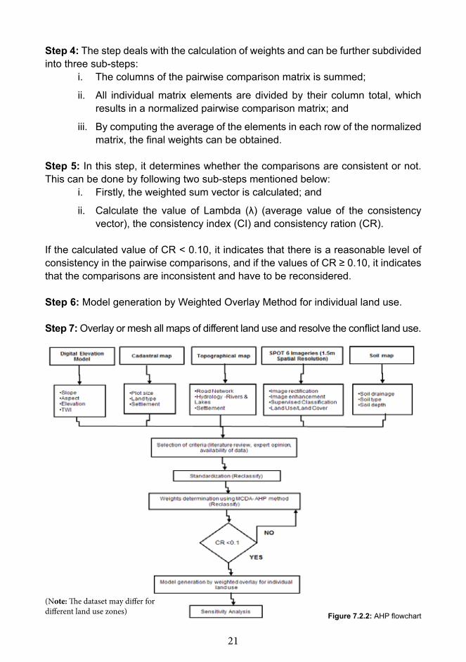
Step 4: The step deals with the calculation of weights and can be further subdivided into three sub-steps:
i. The columns of the pairwise comparison matrix is summed;
ii. All individual matrix elements are divided by their column total, which results in a normalized pairwise comparison matrix; and
iii. By computing the average of the elements in each row of the normalized matrix, the final weights can be obtained.
Step 5: In this step, it determines whether the comparisons are consistent or not. This can be done by following two sub-steps mentioned below:
i. Firstly, the weighted sum vector is calculated; and
ii. Calculate the value of Lambda (λ) (average value of the consistency vector), the consistency index (CI) and consistency ration (CR).
If the calculated value of CR ˂ 0.10, it indicates that there is a reasonable level of consistency in the pairwise comparisons, and if the values of CR ≥ 0.10, it indicates that the comparisons are inconsistent and have to be reconsidered.
Step 6: Model generation by Weighted Overlay Method for individual land use.
Step 7: Overlay or mesh all maps of different land use and resolve the conflict land use.
(Note: The dataset may differ for different land use zones) Figure 7.2.2: AHP flowchart
22
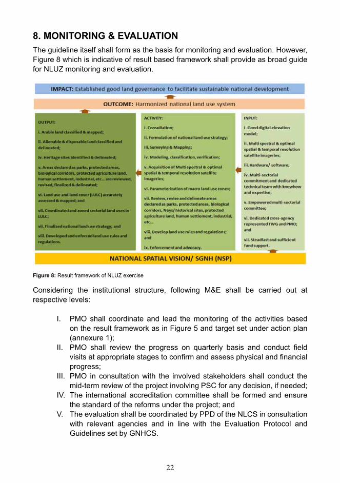
Considering the institutional structure, following M&E shall be carried out at respective levels:
I. PMO shall coordinate and lead the monitoring of the activities based on the result framework as in Figure 5 and target set under action plan (annexure 1);
II. PMO shall review the progress on quarterly basis and conduct field visits at appropriate stages to confirm and assess physical and financial progress;
III. PMO in consultation with the involved stakeholders shall conduct the mid-term review of the project involving PSC for any decision, if needed;
IV. The international accreditation committee shall be formed and ensure the standard of the reforms under the project; and
V. The evaluation shall be coordinated by PPD of the NLCS in consultation with relevant agencies and in line with the Evaluation Protocol and Guidelines set by GNHCS.
Figure 8: Result framework of NLUZ exercise
8. MONITORING & EVALUATIONThe guideline itself shall form as the basis for monitoring and evaluation. However, Figure 8 which is indicative of result based framework shall provide as broad guide for NLUZ monitoring and evaluation.

23
9. A
nnex
ure
Ann
exur
e 1:
NLU
Z A
ctio
n Pl
anD
raft
NLU
Z A
ctio
n P
lan
(201
7-20
28)
Act
ivity
Ref
orm
s A
ctio
nsP
hase
sIn
dica
tor
Bas
elin
eTa
rget
Tim
elin
eLe
ad A
genc
yC
olla
bora
ting
Age
ncie
sFu
ndin
gIm
plem
enta
tion
stat
usR
emar
ksS
tart
date
End
dat
e
1. R
oad
map
ping
1.1.
Dra
fting
NLU
Z im
plem
enta
tion
guid
elin
es
Pha
se I
Fina
lized
dr
aft o
n N
LUZ
guid
elin
es0
19/
20/2
017
10/3
0/20
17G
NH
CS
& N
LCS
TWG
&
Con
cern
ed
agen
cies
0N
ot e
xecu
ted
Out
put
1.2.
Con
sulta
tion
on
NLU
Z gu
idel
ines
&
final
izat
ion
Pha
se I
Fina
lized
N
LUZ
guid
elin
es0
19/
20/2
017
12/3
0/20
17G
NH
CS
& N
LCS
TWG
&
Con
cern
ed
agen
cies
0N
ot e
xecu
ted
Out
put
2. P
roje
ct
Man
agem
ent O
ffice
2.1.
Est
ablis
hmen
t P
MO
Pha
se I
PM
O
esta
blis
hed
0N
A1/
1/20
1812
/1/2
018
NLC
SW
MD
, D
oFP
S /
GN
HC
S
Wor
ld
Ban
k (W
B)
On-
goin
g
2.2.
HR
recr
uitm
ent
and
capa
city
bu
ildin
g
2.3.
Pro
cure
men
ts
3. L
and
Use
Lan
d C
over
(LU
LC)
3.1.
Dat
a ac
quis
ition
&
fiel
d da
ta
colle
ctio
n
Pha
se I
Rev
alid
ated
/ fin
aliz
ed L
ULC
m
ap0
Ent
ire
coun
try1/
1/20
196/
1/20
20N
LCS
TWG
&
Con
cern
ed
agen
cies
WB
Not
exe
cute
dLU
LC
Map
3.2.
Dat
a pr
oces
sing
3.3.
Imag
e cl
assi
ficat
ion
3.4.
Dat
a va
lidat
ion
4. P
aram
eter
s of
eac
h la
nd u
se
zone
+A13
:M21
4.1.
Lan
d us
e cl
assi
ficat
ion
para
met
ers
for
one
Dzo
ngkh
ag
(Sou
ther
n B
elt)
Pha
se I
Fina
lized
la
nd u
se
para
met
ers
&
crite
ria
0P
ilot
(Sou
ther
n B
elt)
1/1/
2019
6/1/
2020
NLC
SN
LCS
&
GN
HC
SW
BN
ot e
xecu
ted
Out
put
4.2.
Crit
eria
set
ting
for o
ne D
zong
khag
(S
outh
ern
Bel
t)
5. P
ilot
Impl
emen
tatio
n
5.1.
Pilo
t exe
rcis
es
in a
t lea
st tw
o D
zong
khag
sP
hase
IC
ompl
eted
an
d as
sess
ed
pilo
t exe
rcis
es0
11/
1/20
196/
1/20
20N
LCS
C
once
rned
ag
enci
es0
Not
exe
cute
dO
utpu
t
24
Dra
ft N
LUZ
Act
ion
Pla
n (2
017-
2028
)
Act
ivity
Ref
orm
s A
ctio
nsP
hase
sIn
dica
tor
Bas
elin
eTa
rget
Tim
elin
eLe
ad A
genc
yC
olla
bora
ting
Age
ncie
sFu
ndin
gIm
plem
enta
tion
stat
usR
emar
ksS
tart
date
End
dat
e
6. P
ilot :
Lan
d us
e zo
ne m
aps
(GIS
A
naly
sis
-MC
DA
)
6.1.
Acq
uisi
tion
of
sate
llite
imag
erie
s,
topo
grap
hica
l and
ag
ro-m
etro
logi
cal
data
Pha
se I
Fina
lized
zo
ned
map
s of
pilo
t D
zong
khag
0
Pilo
t D
zong
khag
(S
outh
ern
Bel
t)
1/1/
2019
6/1/
2020
NLC
SC
once
rned
ag
enci
esW
BN
ot e
xecu
ted
Out
com
e
6.2.
Dat
a pr
oces
sing
6.3.
In-s
itu d
ata
colle
ctio
n (F
ield
w
ork)
6.4.
Mod
elin
g an
d cl
assi
ficat
ion
6.5.
Fie
ld v
alid
atio
n
6.6.
Map
ping
7. R
egio
n I
Par
amet
ers
of e
ach
land
use
zon
e
7.1.
Lan
d us
e cl
assi
ficat
ion
para
met
ers
for
Dzo
ngkh
ags
falli
ng
unde
r Reg
ion
I.P
hase
II
Fina
lized
la
nd u
se
para
met
ers
&
crite
ria
0R
egio
n I
7/1/
2020
6/1/
2021
NLC
STW
G a
nd
conc
erne
d ag
enci
es
WB
/R
GoB
Not
exe
cute
dO
utpu
t7.
2. C
riter
ia s
ettin
g fo
r Dzo
ngkh
ags
falli
ng u
nder
R
egio
n I.
8. R
eion
I: L
and
use
zone
map
s (G
IS
Ana
lysi
s -M
CD
A)
8.1.
Acq
uisi
tion
of
sate
llite
imag
erie
s,
topo
grap
hica
l and
ag
ro-m
etro
logi
cal
data
Pha
se
II
Fina
lized
zo
ned
map
s of
R
egio
n I
0R
egio
n I
7/1/
2020
6/1/
2021
NLC
STW
G a
nd
conc
erne
d ag
enci
es
WB
/R
GoB
Not
exe
cute
dO
utco
me
8.2.
Dat
a pr
oces
sing
8.3.
In-s
itu d
ata
colle
ctio
n (F
ield
w
ork)
8.4.
Mod
elin
g an
d cl
assi
ficat
ion
8.5.
Fie
ld v
alid
atio
n
8.6.
Map
ping

25
Dra
ft N
LUZ
Act
ion
Pla
n (2
017-
2028
)
Act
ivity
Ref
orm
s A
ctio
nsP
hase
sIn
dica
tor
Bas
elin
eTa
rget
Tim
elin
eLe
ad A
genc
yC
olla
bora
ting
Age
ncie
sFu
ndin
gIm
plem
enta
tion
stat
usR
emar
ksS
tart
date
End
dat
e
9. R
egio
n II
Par
amet
ers
of e
ach
land
use
zon
e
9.1.
Lan
d us
e cl
assi
ficat
ion
para
met
ers
for
Dzo
ngkh
ags
falli
ng
unde
r Reg
ion
II.P
hase
II
Fina
lized
la
nd u
se
para
met
ers
&
crite
ria
0R
egio
n II
7/1/
2021
6/1/
2022
NLC
STW
G a
nd
conc
erne
d ag
enci
es
WB
/R
GoB
Not
exe
cute
dO
utpu
t9.
2. C
riter
ia s
ettin
g fo
r Dzo
ngkh
ags
falli
ng u
nder
Reg
ion
II.
10. R
egio
n II:
Lan
d us
e zo
ne m
aps
(GIS
A
naly
sis
-MC
DA
)
10.1
. Acq
uisi
tion
of
sate
llite
imag
erie
s,
topo
grap
hica
l and
ag
ro-m
etro
logi
cal
data
Pha
se
II
Fina
lized
zo
ned
map
s of
R
egio
n II
0R
egio
n II
7/1/
2021
6/1/
2022
NLC
STW
G a
nd
conc
erne
d ag
enci
es
WB
/R
GoB
Not
exe
cute
dO
utco
me
10.2
. Dat
a pr
oces
sing
10
.3. I
n-si
tu d
ata
colle
ctio
n (F
ield
w
ork)
10.4
. Mod
elin
g an
d cl
assi
ficat
ion
10.5
. Fie
ld v
alid
atio
n
10.6
. Map
ping
11. R
egio
n III
P
aram
eter
s of
eac
h la
nd u
se z
one
11.1
. Lan
d us
e cl
assi
ficat
ion
para
met
ers
for
Dzo
ngkh
ags
falli
ng
unde
r Reg
ion
III.
Pha
se
II
Fina
lized
la
nd u
se
para
met
ers
&
crite
ria
0R
egio
n III
7/1/
2022
6/1/
2023
NLC
STW
G a
nd
conc
erne
d ag
enci
es
WB
/R
GoB
Not
exe
cute
dO
utpu
t11
.2. C
riter
ia s
ettin
g fo
r Dzo
ngkh
ags
falli
ng u
nder
Reg
ion
III.
12. R
egio
n III
: La
nd
use
zone
map
s (G
IS
Ana
lysi
s -M
CD
A)
12.1
. A
cqui
sitio
n of
sa
telli
te im
ager
ies,
to
pogr
aphi
cal a
nd
agro
-met
rolo
gica
l da
ta
Pha
se
II
Fina
lized
zo
ned
map
s of
R
egio
n III
0R
egio
n III
7/1/
2022
6/1/
2023
NLC
STW
G a
nd
conc
erne
d ag
enci
es
WB
/R
GoB
Not
exe
cute
dO
utco
me
12.2
. Dat
a pr
oces
sing
12
.3. I
n-si
tu d
ata
colle
ctio
n (F
ield
w
ork)
12.4
. Mod
elin
g an
d cl
assi
ficat
ion
12.5
. Fie
ld v
alid
atio
n
12.6
. Map
ping

26
Dra
ft N
LUZ
Act
ion
Pla
n (2
017-
2028
)
Act
ivity
Ref
orm
s A
ctio
nsP
hase
sIn
dica
tor
Bas
elin
eTa
rget
Tim
elin
eLe
ad A
genc
yC
olla
bora
ting
Age
ncie
sFu
ndin
gIm
plem
enta
tion
stat
usR
emar
ksS
tart
date
End
dat
e
13. P
repa
ratio
n of
ha
rmon
izat
ion
of
land
use
stra
tegy
13.1
. Sta
keho
lder
co
nsul
tatio
n
Pha
se
III
Har
mon
izat
ion
of la
nd u
se
stra
tegy
pr
epar
ed
0E
ntire
co
untry
7/1/
2023
6/1/
2024
NLC
STW
G a
nd
conc
erne
d ag
enci
es
WB
/R
GO
BN
ot e
xecu
ted
13.2
. Res
olve
co
nflic
ts
13.3
. Rat
iona
lize
zone
s
13.4
. Dra
fting
na
tiona
l lan
d us
e st
rate
gy13
.5. P
rese
nt la
nd
use
stra
tegy
and
se
ek a
ppro
val f
rom
N
LC
13.6
. Con
duct
pu
blic
con
sulta
tion
at v
ario
us le
vels
(g
ener
al p
ublic
, LG
s, M
Ps,
NC
s,
Civ
il so
ciet
ies,
E
xper
ts, M
inis
tries
&
agen
cies
.)
14. N
atio
nal S
patia
l vi
sion
14.1
. Org
aniz
e en
visi
onin
g w
orks
hop
whe
re
maj
or s
take
hold
ers
pres
ent l
and
rela
ted
issu
es a
nd th
eir
spat
ial v
isio
n.
Pha
se
III
Fina
lized
N
atio
nal
Spa
tial V
isio
n do
c re
f. N
LUZ
0E
ntire
co
untry
7/1/
2024
6/1/
2025
GN
HC
S, N
LCS
an
d ot
hers
TWG
&
Con
cern
ed
agen
cies
WB
/R
GO
BN
ot e
xecu
ted
14.2
. Alig
n se
ctor
ial
spat
ial v
isio
n w
ith
natio
nal g
oals
and
vi
sion
14
.3. F
inal
ize
list
of m
ajor
land
use
th
emes
(Zon
es)
: Agr
icul
ture
, bi
olog
ical
cor
ridor
, re
ligio
us a
nd
herit
age
site
s,
fore
st, h
uman
se
ttlem
ents
, in
dust
rial a
reas
, etc
)

27
Dra
ft N
LUZ
Act
ion
Pla
n (2
017-
2028
)
Act
ivity
Ref
orm
s A
ctio
nsP
hase
sIn
dica
tor
Bas
elin
eTa
rget
Tim
elin
eLe
ad A
genc
yC
olla
bora
ting
Age
ncie
sFu
ndin
gIm
plem
enta
tion
stat
usR
emar
ksS
tart
date
End
dat
e
15. R
evie
w L
and
Act
20
07
15.1
. Con
duct
stu
dy
and
nece
ssar
y am
endm
ents
on
Land
Act
200
7
Pha
se
III
Rev
iew
ed a
nd
nece
ssar
y am
endm
ents
pr
opos
ed
0E
ntire
co
untry
7/1/
2025
6/1/
2026
NLC
S
TWG
and
co
ncer
ned
agen
cies
WB
/R
GO
B
Not
exe
cute
d
15.2
. Sub
mit
for
the
amen
dmen
t as
app
ropr
iate
an
d ac
cord
ingl
y ad
voca
te, p
ublic
ize
and
sens
itize
.
Pha
se
III
Nec
essa
ry
amen
dmen
ts
appr
oved
and
se
nsiti
zed
0E
ntire
co
untry
PM
O &
C
once
rned
ag
enci
esN
ot e
xecu
ted
16. E
nfor
cem
ent
16.1
. Enf
orce
men
t of
Nat
iona
l Lan
d U
se S
trate
gy
Pha
se
III
Enf
orce
men
t m
echa
nism
es
tabl
ishe
d0
Ent
ire
coun
try
7/1/
2026
6/1/
2017
NLC
SP
MO
&
Con
cern
ed
agen
cies
WB
/R
GO
B
Not
exe
cute
d
16.2
. Enf
orce
men
t of
am
endm
ent o
n La
nd A
ct
Pha
se
III
Enf
orce
men
t m
echa
nism
es
tabl
ishe
d0
Ent
ire
coun
tryN
ot e
xecu
ted
17. M
onito
ring
&
Eva
luat
ion
17.1
. The
PM
O,
PP
D (N
LCS
) and
th
e co
ncer
ned
agen
cies
sha
ll m
onito
r the
ac
tion
plan
s an
d its
indi
cato
rs o
n pe
riodi
c ba
sis.
Pha
se
III
Freq
uenc
y of
mon
itorin
g ca
rrie
d ou
t0
Qua
rterly
7/1/
2020
6/1/
2028
PM
O,P
PD
(NLC
S)
Con
cern
ed
agen
cies
WB
/R
GO
BN
ot e
xecu
ted
17.2
. GN
HC
sha
ll ev
alua
te th
e po
licy
impa
ct a
t nat
iona
l le
vel i
n lin
e w
ith th
e E
valu
atio
n P
roto
col
and
Gui
delin
es.
Pha
se
III
Freq
uenc
y of
eva
luat
ion
carr
ied
out
0A
fter t
he
proj
ect
6/30
/202
06/
1/20
28N
LCS
,GN
HC
S
TWG
and
C
once
rned
ag
enci
es
Not
exe
cute
d
28
REFERENCESDoA, 2015. Agriculture statistics for 2015.Ministry of Agriculture and Forests, Thimphu.
DoA, 2017. Agriculture Land Development 2017. Ministry of Agriculture and Forests, Thimphu.
IPCC, 2007. Climate Change 2007: Impacts, Adaptation and Vulnerability. Working Group II Contribution to the 4th Assessment Report. Cambridge Univ. Press, Cambridge, UK
LCMP, 2010.Land cover mapping project. National Soil Services Centre, Ministry of Agriculture and Forests, Semtokha, Thimphu.
National Planning Commission, 2015. National Development Plan 2030. Republic of South Africa.
NEC, 2006. Bhutan National Adaption Programme of Action. Royal Government of Bhutan, Thimphu.
NLCS, 2016. Draft Use Right Strategy 2016. Royal Government of Bhutan, Thimphu.
NSB,2016. Statistical yearbook of Bhutan 2016.Thimphu.
NSSC, 2010. National Action Program to Combat Land Degradation. Royal Government of Bhutan, Thimphu.
Bhushan, N., & Rai, K. ,2004. Strategic Decision Making – Applying the Analytic Hierarchy Process. London: Springer.
Malczewski, J., 1999. GIS and Multicriteria Decision Analysis. John Wiley&Sons Inc., New York.
Saaty, T.L., 2008. Decision making with the analytic hierarchy process. Int. J. Services Sciences, Vol 1, No.1, pp. 83-98.

29

30
National Land Commission Kawang Jangsa
Thimphu BhutanPost Box: 142
PABX: 00975-02-321217www.nlcs.gov.bt