national register of historic places registration form€¦ · see instructions in national...
TRANSCRIPT

NPS Form 10-900 OMB No. 1024-0018 (Expires 5/31/2012)
United States Department of the Interior National Register Listed National Park Service August 6, 2013
National Register of Historic Places Registration Form
This form is for use in nominating or requesting determinations for individual properties and districts. See instructions in National Register Bulletin, How to Complete the National Register of Historic Places Registration Form. If any item does not apply to the property being documented, enter "N/A" for "not applicable." For functions, architectural classification, materials, and areas of significance, enter only categories and subcategories from the instructions. Place additional certification comments, entries, and narrative items on continuation sheets if needed (NPS Form 10-900a).
1. Name of Property
historic name Santa Fe Trail – Rice County Segment 2
other names/site number Fry Ruts, KHRI #159-116
2. Location
street & number Avenue P, 0.75mi west of 30th Rd not for publication
city or town Little River vicinity
state Kansas code KS county Rice code 159 zip code 67491
3. State/Federal Agency Certification
As the designated authority under the National Historic Preservation Act, as amended,
I hereby certify that this x nomination _ request for determination of eligibility meets the documentation standards for registering properties in the National Register of Historic Places and meets the procedural and professional requirements set forth in 36 CFR Part 60.
In my opinion, the property x_ meets _ does not meet the National Register Criteria. I recommend that this property be considered significant at the following level(s) of significance:
x national statewide local
SEE FILE Signature of certifying official/Title Date
State or Federal agency/bureau or Tribal Government
In my opinion, the property meets does not meet the National Register criteria.
Signature of commenting official Date
Title State or Federal agency/bureau or Tribal Government
4. National Park Service Certification
I hereby certify that this property is:
entered in the National Register determined eligible for the National Register
determined not eligible for the National Register removed from the National Register
other (explain:) _________________
Signature of the Keeper Date of Action
X

Santa Fe Trail – Rice County Segment 2 (Fry Ruts) Rice County, Kansas Name of Property County and State
2
5. Classification
Ownership of Property (Check as many boxes as apply.)
Category of Property (Check only one box.)
Number of Resources within Property (Do not include previously listed resources in the count.)
Contributing Noncontributing
x private building(s) 0 0 buildings
public - Local district 1 0 sites
public - State x site 0 0 structures
public - Federal structure 0 0 objects
object 1 0 Total
Name of related multiple property listing (Enter "N/A" if property is not part of a multiple property listing)
Number of contributing resources previously listed in the National Register
Historic Resources of the Santa Fe Trail (2012) 0
6. Function or Use
Historic Functions
(Enter categories from instructions.)
Current Functions
(Enter categories from instructions.)
TRANSPORTATION/road-related AGRICULTURE/agricultural field
7. Description
Architectural Classification
(Enter categories from instructions.) Materials
(Enter categories from instructions.)
N/A foundation: N/A
walls: N/A
roof: N/A
other: N/A

Santa Fe Trail – Rice County Segment 2 (Fry Ruts) Rice County, Kansas Name of Property County and State
3
Narrative Description
Summary Paragraph
The Santa Fe Trail – Rice County Segment 2, also known as Fry Ruts after the family who owns them,
is located in eastern Rice County in central Kansas, approximately 6.5 miles southwest of Windom. This site is in the NW ¼ of Section 23, Township 20 South, Range 6 West, just south of Avenue P and about 0.75 miles west of 30th Road. The site contains one contributing resource, as defined in the Historic Resources of the Santa Fe Trail revised multiple property nomination: one Transportation Site (Trail Segment subtype) in the form of swales. This resource comprises 13.02 acres. ________________________________________________________________________________________________________________________
Narrative Description
The Santa Fe Trail – Rice County Segment 2 is located along the main route of the Santa Fe Trail, whose location in Rice County was approximated by the General Land Office (GLO) survey in the summer of 1866 (Figure 1). Specifically, this segment is part of the route that led southwest from the lower crossing of the Little Arkansas River, located a little less than one mile to the northeast of this site.
Landscape1
This site lies within the Great Bend Lowland division of the Arkansas River Lowlands section of the Central Lowland province of the Interior Plains of North America.2 The Great Bend Lowland is an undulating plain of little relief extending in a 10-40 mile wide band along the great northerly bend of the Arkansas River from around Dodge City on the west through Great Bend and Wichita to Arkansas City on the east. It is a poorly drained area of sand dunes and sandy plains, among which are found salt marshes, ponds, and sloughs. The surface materials consist almost entirely of sands and gravels eroded from the Rocky Mountains during the Pleistocene and carried downstream by alluvial action of the Arkansas River, which flows through the area and to the east in a shallow channel bounded by a wide, flat, poorly drained river valley. The river is not confined to a single channel, but instead has a number of channels with intervening islands, which is a braided pattern characteristic of an aggrading or depositing stream. The Little Arkansas River is a tributary of the Arkansas River. Most of the stream flow of the Arkansas is underground; water is usually only barely visible on the surface except during times of flooding.
The vegetation of the Great Bend Lowland in prehistoric and early historic times apparently consisted of sand prairie cut through by a thin band of floodplain forest or savanna along the Arkansas River and a few of its tributaries. Archeologist Waldo Wedel noted that the "low grass-grown banks" of the Arkansas upstream of the Little Arkansas seem to have been "largely treeless except for occasional cottonwoods" and in his view this was probably true for most of the region west and south of the main stream.3 The potential natural vegetation of the prairie mainly included big and little bluestem (Andropogon gerardii and Schizachyrium scoparium), sandreed (Calamovilfa longifolia), and switchgrass (Panicum virgatum L.), with the forested areas containing hackberry (Celtis occidentalis), cottonwood (Populus deltoids), willow (Salix spp.), and elm (Ulmus spp.) along with various shrubs and bushes.4 The trees declined markedly in terms of numbers of species and overall abundance as one moved from east to west. Tall trees, dense undergrowth, and many lianas were present in the extreme east, but the forests became narrower and lower westward, and often less dense, the ground covered by an impoverished version of bluestem prairie, creating a savanna effect. And due to the shifting sand bottom of the Arkansas River channel, timber was often absent for long stretches. When Township 20 South, Range 6 West was surveyed in 1866, the surveyors described the landscape thus:
1 The following two paragraphs are adapted from standard language used in reports written by Kansas State
Historical Society, Cultural Resources Division, Archeology Department. 2 W.E. Schoewe, “The Geography of Kansas, Part II: Physical Geography,” Transactions of the Kansas Academy
of Science 52, no. 3 (1949): 292-296. 3 Waldo R. Wedel, “An Introduction to Kansas Archeology,” Smithsonian Institution, Bureau of American
Ethnology, Bulletin (1959): 12. 4 A.W. Kuchler, “A New Vegetation Map of Kansas,” Ecology 55, no. 3 (1974): 597.

Santa Fe Trail – Rice County Segment 2 (Fry Ruts) Rice County, Kansas Name of Property County and State
4
The land in this Township, with the exception of the extreme Southern portion, which is sandy and barren, is of good quality and well suited to farming or grazing. The Township is watered by Little Arkansas river, a stream about fifty links wide, running South Easterly through the Eastern portion; and along the banks of which, timber of a poor quality is found. The varieties of Timber are Box Elder, Elm, and Cottonwood.5
Though cottonwoods are still prevalent along the Little Arkansas River, no trees are present at this site in Section 23. The landscape of this trail segment is uncultivated prairie, which is now used for pasture. The site is surrounded by cultivated areas, but it has never been cultivated itself.
The Santa Fe Trail – Rice County Segment 2 is part of the main Santa Fe Trail route through central Kansas. Located a little less than one mile southwest of the Little Arkansas River, the swales are directly associated with the Little Arkansas River Crossing, particularly the lower crossing. Running in a northeast to southwest direction, the swales generally follow the GLO survey line as it leads from the lower Little Arkansas River crossing. Entering the site from the northeast, travelers would have followed this path for approximately another 305 meters (1000 feet), where the route would rejoin the trail leading from the upper crossing. This site is the westernmost section of the route from the lower crossing.
The segment is located in an open landscape whose topographic elevation gradually rises as it leaves the Little Arkansas River corridor. The nominated site is fairly level, having an average elevation of about 478.5 meters (1570 feet). The nominated site hugs the northern side of a hill which rises to an elevation of approximately 485 meters (1590 feet).
The landscape offers natural boundaries for the site. The hill to the south of the trail segment acts as a natural southern boundary. The eastern boundary is created by a fence that separates the site from cultivated land. The western boundary is determined by a fence along the section line. The north and south boundaries are 50 meters (164 feet) beyond the edge of the last visible swale.
Trail Segment
The Santa Fe Trail – Rice County Segment 2 is an example of a Transportation Site (Trail Segment subtype), as defined in the revised multiple property nomination. The four visible swales begin about 60 meters (197 feet) southwest of the eastern boundary and extend toward the creek in a southwesterly direction. Spanning a corridor of about 45 meters (147 feet), this segment curves southwesterly for approximately 86 meters (282 feet) where it is interrupted by a north-south two-track road. Picking back up on the west side of this road, the segment continues southwest, following the north side of the hill for an additional 184 meters (604 feet) to the intermittent drainage. The swales are partially obscured on the immediate west side of the drainage, but they become more evident as they head southwesterly for about 100 meters (328 feet) toward a south-southwest two-track road. The swales are more pronounced on the west side of this access road, approximately continuing for another 100 meters (328 feet) before becoming indistinct (Figure 2). In total, this segment spans approximately 635 meters (2083 feet).
8. Statement of Significance
5 “Field Notes for Township 20 South, Range 6 West 6
th P.M.” (Leavenworth: General Land Office, 1866), Kansas
Historical Society (Topeka): Florence McGlasson Gabelmann Memorial Library, microfilm, 20s6wn.

Santa Fe Trail – Rice County Segment 2 (Fry Ruts) Rice County, Kansas Name of Property County and State
5
Applicable National Register Criteria (Mark "x" in one or more boxes for the criteria qualifying the property for National Register listing.)
x A Property is associated with events that have made a
significant contribution to the broad patterns of our history.
B Property is associated with the lives of persons
significant in our past.
C Property embodies the distinctive characteristics
of a type, period, or method of construction or represents the work of a master, or possesses high artistic values, or represents a significant and distinguishable entity whose components lack individual distinction.
x D Property has yielded, or is likely to yield, information important in prehistory or history.
Criteria Considerations (Mark "x" in all the boxes that apply.)
Property is:
A
Owned by a religious institution or used for religious purposes.
B removed from its original location.
C a birthplace or grave.
D a cemetery.
E a reconstructed building, object, or structure.
F a commemorative property.
G less than 50 years old or achieving significance
within the past 50 years.
Areas of Significance
(Enter categories from instructions.)
Transportation
Commerce
Period of Significance
1821-1866
Significant Dates
n/a
Significant Person
(Complete only if Criterion B is marked above.)
n/a
Cultural Affiliation
n/a
Architect/Builder
n/a
Period of Significance (justification) The period of significance begins with the initiation of trail traffic by William Becknell in 1821 and ends with the arrival of the railroad in Junction City in 1866, which spelled the end of trail traffic east of Great Bend, as trail traffic then continued southwest from Junction City along the Butterfield Overland Despatch route to Fort Zarah. Criteria Considerations (explanation, if necessary) N/A
Santa Fe Trail – Rice County Segment 2 (Fry Ruts) Rice County, Kansas Name of Property County and State
6
Statement of Significance Summary Paragraph
The Santa Fe Trail – Rice County Segment 2 (Fry Ruts) is nationally significant as part of the Historic Resources of the Santa Fe Trail revised multiple property nomination under Criterion A for its association with transportation and commerce along the Santa Fe Trail from 1821 to 1866. This site is also nationally significant under Criterion D for its potential to yield information about this route. This segment retains a good degree of integrity in terms of location, setting, feeling, and association. The site also materially reflects important historic events outlined in the historic contexts: International Trade on the Mexican Road, 1821-1846; The Mexican-American War and the Santa Fe Trail, 1846-1848; Expanding National Trade on the Santa Fe Trail, 1848-1861; The Effects of the Civil War on the Santa Fe Trail, 1861-1865; and the Santa Fe Trail and the Railroad, 1865-1880, as well as The Santa Fe Trail in Kansas. ________________________________________________________________________________________________________________________
Narrative Statement of Significance (Provide at least one paragraph for each area of significance.)
The Santa Fe Trail – Rice County Segment 2 is a site that contains remnants from the main route of the Santa Fe Trail, which was active from 1821 until 1880, though the association of this site with the Santa Fe Trail ends in 1866 with the coming of the railroad.
Located about one mile (1.60 kilometers) southwest of the Little Arkansas River, the swales are directly associated with the lower crossing of the Little Arkansas River. As the trail approached the Little Arkansas, it split into two routes. Coming from Council Grove (approximately 90 miles east), the route to the lower crossing diverged from the route to the upper crossing about four miles from the river. According to the GLO maps, the two routes converged immediately west of this nominated site in Section 23.
The reason for the two routes is most likely due to the condition of the crossings at the time of travel. When approaching the crossing the scout leading the wagon train needed to determine which crossing was best to use at the time (generally based on water flow and the weather).6 The scout would then direct the wagon train to whichever crossing was safest and least difficult to cross. The two crossings were one quarter mile apart.
William Becknell initiated trade with Santa Fe in 1821 and most likely crossed the Little Arkansas River that year. Certainly, though, the Little Arkansas River was crossed from the initiation of wagon traffic over the trail in 1822 to the advancement of the railroad to Junction City in 1866. Travelers bound for Santa Fe would take the train to Junction City then continue southwest along the Butterfield Overland Despatch route to Fort Ellsworth, then southwest on a connecting road to Fort Zarah, where they resumed the main trail. This new route from Junction City spelled the end of long-distance trail traffic east of Fort Zarah (near present-day Great Bend). The Little Arkansas, at least at the beginning of the Santa Fe trade, was a fairly reliable source of water, grass, and wood, as Sibley Expedition surveyor Joseph C. Brown noted in his 1825 journal.7 Famed Santa Fe Trail traveler, Josiah Gregg crossed the Little Arkansas in the 1830s.8 During the Mexican-American War in the mid-1840s, the Army of the West crossed the river and encamped there.9 The gold “fever” of the late 1850s saw several travelers crossing the Little Arkansas on their way to Colorado. By this time, there was “little timber on the river and but little watter [sic].”10
6 Marc Simmons, Following the Santa Fe Trail: A Guide for Modern Travelers, 3
rd ed. (Santa Fe: Ancient City
Press, 2001), 111. 7 William E. Connelley, A Standard History of Kansas and Kansans, Volume 1 (Chicago: Lewis Publishing Co.,
1918), 97. 8 Josiah Gregg, ed. Milo Milton Quaife, Commerce of the Prairies (Chicago: The Lakeside Press, 1926), 44-45.
9 Abraham Robinson Johnston, Marcellus Ball Edwards, and Phillip Gooch Ferguson, Marching with the Army of
the West 1846-1848, Ralph P. Bieber, ed. (Glendale, California: The Arthur H. Clark Co., 1936), 126-127, 302; and William E. Connelley, Doniphan’s Expedition and the Conquest of New Mexico and California (Topeka: Wm. E. Connelley, 1907), 158-159.
10 Louise Barry, “The Ranch at Little Arkansas Crossing,” Kansas Historical Quarterly 38 (Autumn, 1972): 288.

Santa Fe Trail – Rice County Segment 2 (Fry Ruts) Rice County, Kansas Name of Property County and State
7
Though ample records are available that document the use of the Little Arkansas Crossing throughout its period of significance, few records exist that illuminate who traversed which crossing route. The one known exception at this point is Brown’s 1825 map, indicating that the Sibley Expedition crossed at the lower crossing. Regardless, the prominence of these nominated swales indicates that the lower crossing was used frequently.
Archeological Potential
This segment may have the potential to yield important archeological information. Archeological prospection, geophysical survey, and metal detector survey of similar trail segments have been shown to reveal associated artifact assemblages, sometimes buried and sometimes not, that can inform on the use of the trail during its period of significance. Though no such surveys have been undertaken on this trail segment, there is every reason to believe that the presence of such an assemblage is possible. These swales and their contributing land area have the potential to yield important information to understanding the use and nature of this road, including patterns of use and change over time, evolving trade patterns, cultural interactions, and possibly even be able to narrow the dates of use. Study of both the remnant trail segment and adjacent archeological features can provide valuable insight into the evolving patterns of historic development in this region. This site likely contains data which may be vital to any wider study of the 19th-century trade and economic development. Further investigation could address key questions regarding trade and transportation variability and change. Excavation could also provide additional social data including better estimates of the frequency of use during various phases of history, the role played by various ethnic and social groups, and the nature of trail users, material culture and the production, distribution, and consumption of commodities.11
Summary
The Santa Fe Trail – Rice County Segment 2 is one of the remaining examples of the route taken by Santa Fe Trail traffic heading from the lower crossing of the Little Arkansas River. The route was documented by the General Land Office surveyors in 1866—the year the Santa Fe Trail in this part of Rice County ceased to be used for overland transportation to New Mexico. This segment is eligible for the National Register of Historic Places because of its association with the commerce and transportation of the Santa Fe Trail and for its potential to yield information about the trail’s use.
11
Kansas State Historical Society, Historic Resources of the Santa Fe Trail Multiple Property Documentation Form (Revised). August 2012, F116. Citation covers paragraph.

Santa Fe Trail – Rice County Segment 2 (Fry Ruts) Rice County, Kansas Name of Property County and State
8
9. Major Bibliographical References
Bibliography (Cite the books, articles, and other sources used in preparing this form.) Barry, Louise. “The Ranch at Little Arkansas Crossing,” Kansas Historical Quarterly 38 (Autumn, 1972): 287-294. Connelley, William E. A Standard History of Kansas and Kansans, Volume 1. Chicago: Lewis Publishing Co., 1918. Connelley, William E. Doniphan’s Expedition and the Conquest of New Mexico and California. Topeka: Wm. E. Connelley,
1907. “Field Notes for Township 20 South, Range 6 West 6
th P.M.” Leavenworth: General Land Office, 1866. Kansas
Historical Society (Topeka): Florence McGlasson Gabelmann Memorial Library, microfilm, 20s6wn. Gregg, Josiah. Commerce of the Prairies. Milo Milton Quaife, editor. Chicago: The Lakeside Press, 1926. Johnston, Abraham Robinson; Marcellus Ball Edwards; and Phillip Gooch Ferguson. Marching with the Army of the West
1846-1848. Ralph P. Bieber, editor. Glendale, California: The Arthur H. Clark Co., 1936. Kansas State Historical Society, Historic Resources of the Santa Fe Trail Multiple Property Documentation Form
(Revised). August 2012. Kuchler, A.W. “A New Vegetation Map of Kansas,” Ecology 55, no. 3 (1974): 597. Schoewe, W.E. “The Geography of Kansas, Part II: Physical Geography,” Transactions of the Kansas Academy of
Science 52, no. 3 (1949): 292-296. Simmons, Marc. Following the Santa Fe Trail: A Guide for Modern Travelers. 3
rd ed. Santa Fe: Ancient City Press, 2001.
Schmidt, L. Stephen and Richard Hayden. The Survey and Maps of the Sibley Expedition 1825, 1826, & 1827, Santa Fe
Trail Association Grant Report, August 2011[electronic copy on-line]; available from Santa Fe Trail Association Online, <http://www.santafetrail.org/about-us/scholarly-research/sibley-survey> (accessed 4 December 2012).
Wedel, Waldo R. “An Introduction to Kansas Archeology.” Smithsonian Institution, Bureau of American Ethnology,
Bulletin (1959): 12.

Santa Fe Trail – Rice County Segment 2 (Fry Ruts) Rice County, Kansas Name of Property County and State
9
Previous documentation on file (NPS): Primary location of additional data:
preliminary determination of individual listing (36 CFR 67 has been x State Historic Preservation Office requested) Other State agency previously listed in the National Register Federal agency
previously determined eligible by the National Register Local government
designated a National Historic Landmark University recorded by Historic American Buildings Survey #____________ Other
recorded by Historic American Engineering Record # __________ Name of repository: Kansas State Historical Society recorded by Historic American Landscape Survey # ___________
Historic Resources Survey Number (if assigned): n/a
10. Geographical Data
Acreage of Property 35.45 (Do not include previously listed resource acreage.) Latitude/Longitude Coordinates See attached map. Datum = WGS84
A 38.300841 -97.961773 C 38.302018 -97.953900
Latitude Longitude Latitude Longitude
B 38.303459 -97.953890 D 38.298587 -97.961775
Latitude Longitude Latitude Longitude Verbal Boundary Description (Describe the boundaries of the property.) This irregularly shaped 35.45-acre site is located in the NW ¼ of Section 23, Township 20 South, Range 6 West. The eastern boundary is created by a fence between the site and cultivated land. The western boundary is determined by a fence along the section line. The north and south boundaries are 50 meters (164 feet) beyond the edge of the last visible swale. Boundary Justification (Explain why the boundaries were selected.) This boundary was selected to include the extant trail segment, along with a 50-meter (164-foot) buffer around as much of the segment as possible, as required in the revised multiple property nomination. No visible trail segments are visible (or are expected to remain) beyond the east and west boundaries.
11. Form Prepared By
name/title John R. Barry & Amanda K. Loughlin
organization Kansas Historical Society date August 2012
street & number 6425 SW 6th Ave telephone 785-272-8681
city or town Topeka state KS zip code 66615-1099
e-mail [email protected]
Santa Fe Trail – Rice County Segment 2 (Fry Ruts) Rice County, Kansas Name of Property County and State
10
Additional Documentation
Submit the following items with the completed form:
• Maps: A USGS map (7.5 or 15 minute series) indicating the property's location.
A Sketch map for historic districts and properties having large acreage or numerous resources. Key all photographs to this map.
• Continuation Sheets
• Additional items: (Check with the SHPO or FPO for any additional items.)
Photographs:
Submit clear and descriptive photographs. The size of each image must be 1600x1200 pixels at 300 ppi (pixels per inch) or larger. Key all photographs to the sketch map.
Name of Property: Santa Fe Trail – Rice County Segment 2 (Fry Ruts) City or Vicinity: Windom vicinity County, State: Rice County, Kansas Photographer: John Barry Date Photographed: 29 June 2012 Description of Photograph(s) and number: 1 of 6: Looking NE along swale. 2 of 6: Looking south from swale at landscape. 3 of 6: Looking west along swale toward two-track road. 4 of 6: Looking west from two-track road at swales. 5 of 6: Looking NE from mound to south of segment. 6 of 6: Looking SW from mound to south of segment.
Property Owner:
(Complete this item at the request of the SHPO or FPO.)
name On file with SHPO.
street & number telephone
city or town state zip code Paperwork Reduction Act Statement: This information is being collected for applications to the National Register of Historic Places to nominate properties for listing or determine eligibility for listing, to list properties, and to amend existing listings. Response to this request is required to obtain a benefit in accordance with the National Historic Preservation Act, as amended (16 U.S.C.460 et seq.). Estimated Burden Statement: Public reporting burden for this form is estimated to average 18 hours per response including time for reviewing instructions, gathering and maintaining data, and completing and reviewing the form. Direct comments regarding this burden estimate or any aspect of this form to the Office of Planning and Performance Management. U.S. Dept. of the Interior, 1849 C. Street, NW, Washington, DC.

Santa Fe Trail – Rice County Segment 2 (Fry Ruts) Rice County, Kansas Name of Property County and State
11
Figure 1.
Santa Fe Trail – Rice County Segment 2 (Fry Ruts) 1866 GLO Survey lines. Arrow is pointing to location this segment. Kansas Historical Society Archeological Inventory map. Figure 2.
Santa Fe Trail – Rice County Segment 2 (Fry Ruts) Rice County, Kansas Name of Property County and State
12
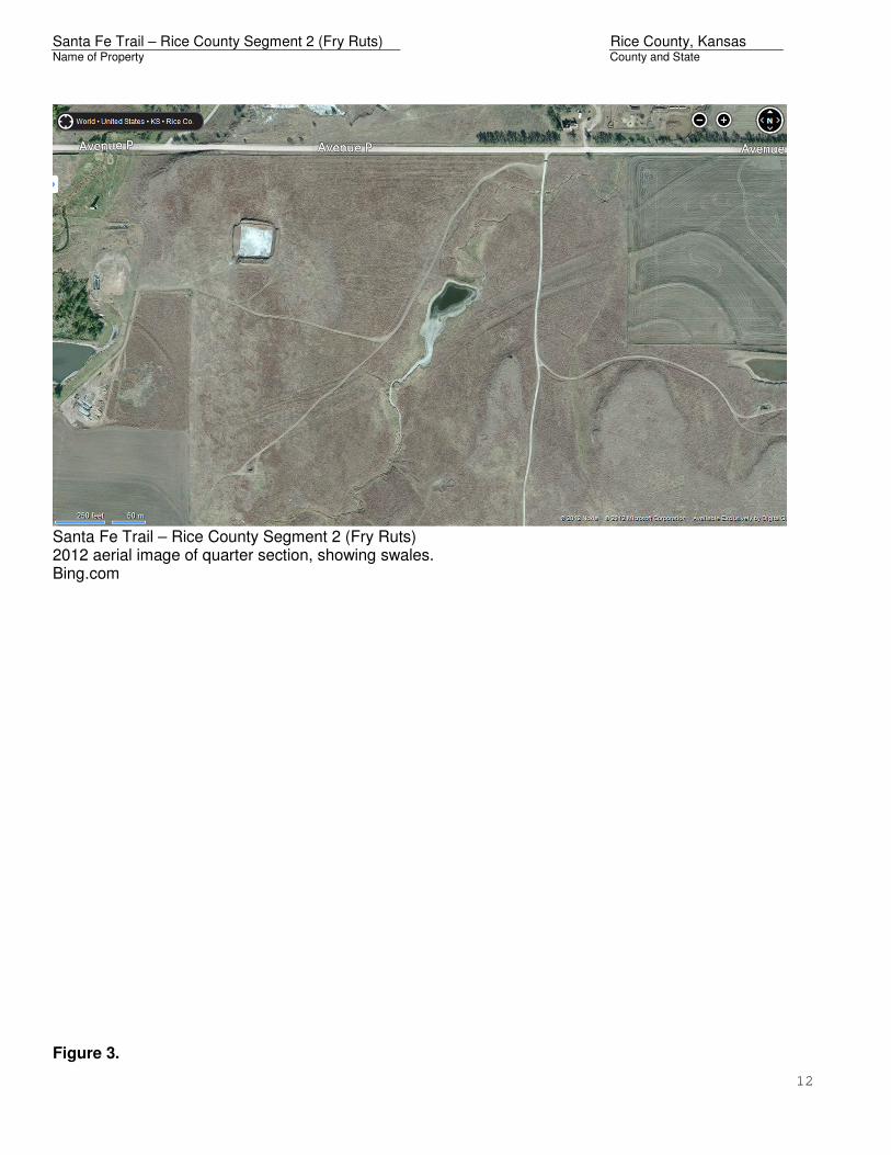
Santa Fe Trail – Rice County Segment 2 (Fry Ruts) 2012 aerial image of quarter section, showing swales. Bing.com Figure 3.

Santa Fe Trail – Rice County Segment 2 (Fry Ruts) Rice County, Kansas Name of Property County and State
13
L. Stephen Schmidt and Richard Hayden, “Field Book Page 27,” in “Appendix G: Plots of the Survey Route on Modern Maps,” The Survey and Maps of the Sibley Expedition 1825, 1826, & 1827, Santa Fe Trail Association Grant Report, August 2011[electronic copy on-line]; available from Santa Fe Trail Association Online, <http://www.santafetrail.org/about-us/scholarly-research/sibley-survey/Appendix_G.pdf> (accessed 4 December 2012). Schmidt & Hayden overlaid Brown’s survey maps onto modern road maps. Photograph Key Plan.
Sibley’s Survey Route & Location of “Little Arkansas Cr.”
Location of nominated swales.

Santa Fe Trail – Rice County Segment 2 (Fry Ruts) Rice County, Kansas Name of Property County and State
14
Numbers correspond to photographs.
1 2
3 4
5 6

Santa Fe Trail – Rice County Segment 2 (Fry Ruts) Rice County, Kansas Name of Property County and State
15
Boundary Map.
Santa Fe Trail – Rice County Segment 2 (Fry Ruts) Little River vicinity, Rice County, Kansas
1866 GLO survey lines go through section.
Hatched area represents nominated boundary. Black dots within hatched area represent GPS coordinates taken during site visit.
Site Coordinates Datum = WGS84
Total acreage: 35.45 acres

Santa Fe Trail – Rice County Segment 2 (Fry Ruts) Rice County, Kansas Name of Property County and State
16
Contextual Map.