national tsunami hazard mitigation program the geological ...€¦ · u.s. geological survey ... it...
TRANSCRIPT

Surviving a Tsunami—Lessons from Chile, Hawaii, and Japan
Circular 1187
U.S. Department of the InteriorU.S. Geological Survey
National Tsunami Hazard Mitigation ProgramPrepared in cooperation with Universidad Austral de Chile, the University of Tokyo, the University of Washington, the Geological Survey of Japan, the Pacific Tsunami Museum, the National Oceanic and Atmospheric Administration, and the International Tsunami Information Center.
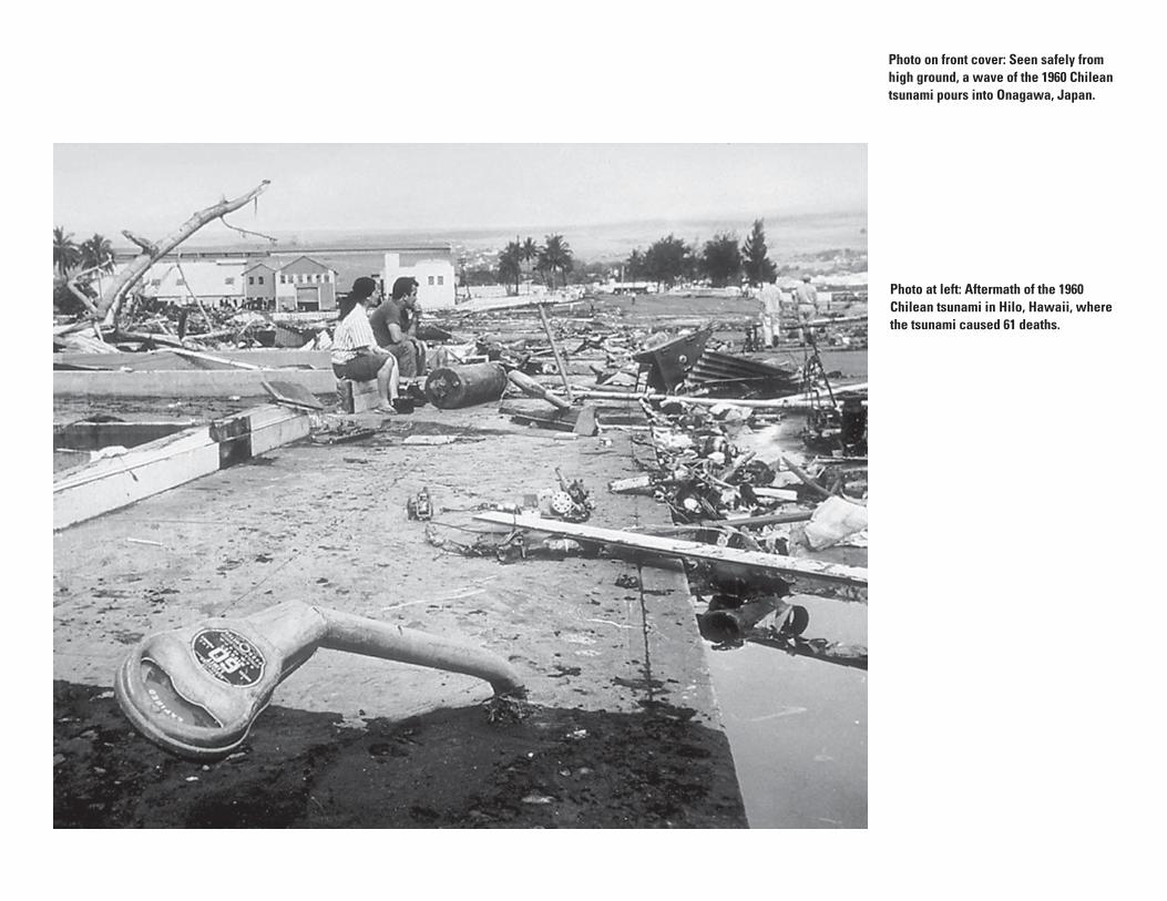
Photo at left: Aftermath of the 1960 Chilean tsunami in Hilo, Hawaii, where the tsunami caused 61 deaths.
Photo on front cover: Seen safely from high ground, a wave of the 1960 Chilean tsunami pours into Onagawa, Japan.

U.S. Department of the InteriorU.S. Geological Survey
Compiled by Brian F. Atwater, Marco Cisternas V., Joanne Bourgeois, Walter C. Dudley, James W. Hendley II, and Peter H. Stauffer
Circular 1187
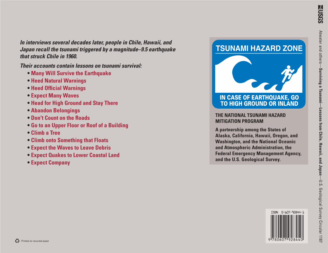
Actions that saved lives, and actions that cost lives, as recounted by eye wit ness es to the tsunami from the largest earthquake ever mea sured—the magnitude 9.5 earth quake in Chile on May 22, 1960.
Surviving a Tsunami—Lessons From Chile, Hawaii, and Japan

U.S. Department of the In te ri orGale A. Norton, Sec re tary
U.S. Geological SurveyP. Patrick Leahy, Acting Director
For sale by U.S. Geological Survey Information ServicesBox 25286, Denver Federal CenterDenver, CO 80225
This report and any updates to it are available online at:http://pubs.usgs.gov/circ/c1187/
Versión en español: U.S. Geological Survey Circular 1218, http://pubs.usgs.gov/circ/c1218/
For additional information write to:U.S. Geological SurveyBox 25046, Mail Stop 421, Denver Federal CenterDenver, CO 80225-0046
Additional USGS publications can be found at;http://geology.usgs.gov/products.html
For more information about the USGS and its products:Telephone: 1–888–ASK–USGS (1–888–275–8747)World Wide Web: http://www.usgs.gov/
Any use of trade, product, or fi rm names in this publication is for descriptive purposes only and does not imply en dorse ment by the U.S. Government.
Produced in the Western Region, Menlo Park, CaliforniaManuscript approved for publication, August 5, 1999Layout, design and illustrations by Sara Boore and Susan Mayfi eld
CONTENTSIntroduction.......................................................................................................................... 1
The 1960 Tsunami and the Earthquake in Chile That Caused It................................... 2
Similar Tsunamis, Similar Strategies for Survival.......................................................... 3
Lessons learned
Many Will Survive the Earthquake........................................................................... 4
Heed Natural Warnings.............................................................................................. 5
Heed Offi cial Warnings.............................................................................................. 6
Expect Many Waves................................................................................................... 7
Head for High Ground and Stay There..................................................................... 8
Abandon Belongings.................................................................................................. 10
Don't Count on the Roads.......................................................................................... 11
Go to an Upper Floor or Roof of a Building.............................................................. 12
Climb a Tree.................................................................................................................. 13
Climb onto Something that Floats............................................................................. 14
Expect the Waves to Leave Debris.......................................................................... 15
Expect Quakes to Lower Coastal Land.................................................................... 16
Expect Company.......................................................................................................... 16
Credits and Sources........................................................................................................... 17
U.S. Geological Survey, Reston, Virginia: 1999Reprinted 2001; revised and reprinted 2005
Cataloging-in-Publication data are on fi le with the Library of Congress (URL http://www.loc.gov/).

1
IntroductionThis book contains true stories that illustrate how to survive—and how not to
survive—a tsunami. It is meant for people who live, work, or play along coasts that tsu- na mis may strike. Such coasts surround most of the Pacifi c Ocean but also include some coastal areas of the Atlantic and Indian Oceans.
Although many people used to call tsunamis “tidal waves,” they are not related to tides but are rather a se ries of waves, or “wave trains,” usually caused by changes in the level of the sea fl oor during earthquakes. Tsunamis have also been caused by the eruption of coastal and island volcanoes, sub ma rine land slides, and oceanic impacts of large meteor-ites. As happened in Sumatra in 2004, tsunamis can reach heights of 50 feet, not just on the coast but miles inland as well.
The stories in this book were selected from interviews with people who survived a Pacifi c Ocean tsunami in 1960. Many of these people, including the nurse at right, contended with the waves near their source, along the coast of Chile. Others faced the tsunami many hours later in Hawaii and Japan. Most of the interviews were done de-cades later in the 1980’s and 1990’s.
The stories provide a mixed bag of lessons about tsunami survival. Some illustrate actions that reliably saved lives—heeding natural warnings, abandoning belongings, and going promptly to high ground and staying there until the tsunami is really over. Others describe taking refuge in buildings or trees or fl oating on debris—tactics that had mixed results and can be recommended only as desperate actions for people trapped on low ground.
Palmira Estrada, a nurse who survived the 1960 tsunami in Maullín, Chile, talks with interviewer Marco Cisternas in 1989. Behind them stands a hospital that was evacuated during the tsunami. The waters of the tsunami washed against the building.
Surviving a Tsunami—Lessons From Chile, Hawaii, and Japan
1Facultad de Agronomía, Pontifi cia Universidad Católica de Valparaíso, Casilla 4-D, Quillota, Chile.2Department of Earth and Space Sciences, University of Washington, Seattle, WA 98195-1310.3Pacifi c Tsunami Museum, P.O. Box 806, Hilo, HI 96721.
Compiled by Brian F. Atwater, Marco Cisternas V.1, Joanne Bour geois2, Walter C. Dudley3, James W. Hendley II, and Peter H. Stauffer

2
TSUNAMI—A SERIES OF WAVES, OR “WAVE TRAINS,” USUALLY CAUSED BY A SEISMIC SHIFT OF THE SEA FLOOR
Vertical Slice Through a Subduction ZoneOne of the many tectonic plates that make up Earth’s outer shell descends, or “subducts,” under an adjacent plate. This kind of boundary between plates is called a “subduction zone.” When the plates move suddenly in an area where they are usually stuck, an earthquake happens.
A. Between Earth quakesStuck to the sub duct ing plate, the overriding plate gets squeezed. Its leading edge is dragged down, while an area behind bulges upward. This movement goes on for decades or cen tu ries, slowly building up stress.
B. During an Earth quakeAn earthquake along a subduction zone hap pens when the leading edge of the overriding plate breaks free and springs seaward, rais ing the sea fl oor and the water above it. This uplift starts a tsunami. Meanwhile, the bulge behind the leading edge collapses, thinning the plate and lowering coastal areas.
C. Minutes LaterPart of the tsunami races toward nearby land, growing taller as it comes in to shore. An oth er part heads across the ocean toward distant shores.
Most of the events described in this book were caused by a series of waves widely known as the “1960 Chilean tsunami.” The tsunami began during the largest earth quake ever mea-sured (mag ni tude 9.5). This quake oc curred along the coast of Chile on May 22, 1960.
In Chile, the earth quake and the tsu na mi that followed took more than 2,000 lives and caused property damage es ti mat ed at $550 million (1960 dollars). From Chile the tsu na mi radiated outward, killing 61 people in Hawaii and 138 in Japan.
The 1960 Chile earthquake rup tured a fault zone along which a slab of sea fl oor is de scend ing, or “subducting,” beneath the adjacent South American Continent. Such “subduction zones” are formed where two of the tectonic plates that make up the Earth’s outer shell meet. Earthquakes occur when the fault ruptures, suddenly releasing built-up energy. During the 1960 Chile earthquake, the western margin of the South American Plate lurched as much as 60 feet relative to the sub duct ing Nazca Plate, in an area 600 miles long and more than 100 miles wide.
The Giant Chilean Earthquake and Tsunami of 1960
The 1960 Chilean tsunami radiated outward from a subduction zone along the coast of Chile. Its waves reached Hawaii in 15 hours and Japan in 22 hours.

3
As shown by wave heights observed in Japan, subduction-zone earthquakes in Chile and Cascadia have caused tsunamis that were large even after crossing the Pacifi c Ocean.
Similar Tsunamis, Similar Strategies for Survival
Long times between tsunamis can erase memories of how to survive them. The 1960 Chile tsunami was the fi rst large tsunami at Valdivia and Maullín since 1575. Except for Native Amer i can legends, memory of the 1700 Cascadia tsunami is limited to written records in Japan.
Both the 1960 Chile earthquake and the 1700 Cascadia earthquake were caused by sudden rup-tures of long segments of subduction zones. Each of these quakes generated a tsunami that not only struck nearby coastal areas but also caused damage in coastal areas as far away as Japan.
Like Chile, many other areas worldwide are located near subduction zones similar to the one that produced the 1960 Chile earthquake and its tsunami. One of these areas is Casca-dia—southern British Columbia, Washington, Oregon, and northern Cal i for nia.
Recently, it has been discovered that the Cascadia Subduction Zone, like the sub duc -tion zone off Chile, has a history of producing earthquakes that triggered tsu na mis. The most recent of these earthquakes, in 1700, set off a tsunami that struck Japan with waves about as big as those of the 1960 Chilean tsunami in Japan. However, modern Cascadia has had little experience with tsunamis and almost no experience with tsunamis gen- er at ed close to home. Because of this, people in Cascadia need to look elsewhere for guidance about tsunami survival.
Perhaps the most basic guidance for people in Cascadia comes from the account on the following page. Many people in Cascadia may think that “The Big One”—an earth quake of magnitude 9—will kill them before its tsunami rolls in. So, why bother to prepare for such a tsunami? In the account, all the people in and near the town of Maul-lín, Chile, survived the biggest earthquake ever measured. The deaths in the area came later, during the tsunami that followed the quake.
0 100 MILES
0 100 KILOMETERS

4
Many Will Survive the EarthquakeIn coastal areas, the largest subduction zone earthquake may kill fewer people than the tsunami that follows.
José Argomedo sur vived the 1960 Chile earthquake, which he initially mistook for nu cle ar war.
Mr. Argomedo was 22 years old and living on a farm outside Maullín, Chile, where he got news of the world from his radio. Early in May 1960, the big news was the tension be tween the United States and the Soviet Union—a Soviet missile had downed an Amer i can spy plane.
On May 18, the Soviet leader, Nikita Khruschev, suggested treating the Unit ed
States like a cat that had stolen cream. “Wouldn’t it be better,” he said, “to take the Amer i can ag gres sors by the scruff of the neck also and give them a little shak ing?”
A few days later, on the afternoon of May 22, while out riding his horse, Mr. Argomedo felt more than a little shak ing. As the ground beneath him shook hard for several minutes, he got down from his horse. Mr. Argomedo thought the Cold War had turned hot. However, like every-one else in the area of Maullín, Quenuir,
Many houses in Maullín, Chile, withstood the magnitude 9.5 Chile earthquake of May 22, 1960. The ensuing tsunami caused most of the damage shown in this photo, taken between May 23 and June 3, 1960.
and La Pasada (see photo, p. 14), he was actually living through a mag ni tude 9.5 earth quake, the largest ever mea sured.
Mr. Argomedo was on high ground during the hours that fol lowed the earth- quake. However, many other residents of the area were not, and 122 were killed by the ensuing tsunami.

5
On Sunday, May 22, 1960, Jovita Riquelme took her 5-year-old daughter to Mass in Queule, Chile (see map, p. 3). During Mass, the priest talked about earthquakes. A swarm of quakes as large as magnitude 8 had oc curred 100 miles to the north the previous day.
Later that Sunday, the magnitude 9.5 mainshock of the 1960 Chile earth quake rocked the region. After the shaking ended, many people from Queule decided to head
Though a mile from the sea, most of Queule, Chile, was over run and washed away by the tsunami that followed the 1960 Chile earthquake. Many residents of Queule fl ed to the safe ty of high ground soon after the earth quake, but Jovita Riquelme lost her daugh ter and husband to the tsunami because the family remained at their house on low ground near
Heed Natural WarningsAn earthquake may serve as a warning that a tsunami is coming, and so may a rapid fall or rise in coastal waters.
to nearby hills. From their stories it is not known why they chose to do this, but their only known warning was the minutes of shak ing or, perhaps, chang es in the level of the Río Queule or the nearby Pacifi c Ocean (see also stories on p. 8, 10, 11).
Heeding natural warnings by going to high ground prob a bly saved hun-dreds of lives in Queule. How ev er, Mrs. Riquelme’s family remained at their house on low ground near the Río Queule. The
Río QueuleRío QueuleBEFOREBEFORE
Trees
Río QueuleTrees
AFTER
tsu na mi that fol lowed the earthquake caught the Riquelme family there. Dur ing the con fu sion caused by the waves, Mrs. Riquelme lost her daughter, and her hus- band was badly injured. Her hus band died of his injuries, and the body of her daugh- ter was found 3 days after the tsu na mi.
Not far to the north of Queule, Vitalia Llanquimán lived outside the village of Mehuín. Soon after the earthquake shak- ing stopped, a man on horseback told her
that the sea had re ced ed from shore. At fi rst, Mrs. Llanquimán was not alarmed by this news, but her hus band took it as a warning that the sea, when it came back, might surge inland. Carrying their two young est children, the cou ple hurried up a nearby hill, where they safely remained during the tsunami.
the Río Queule. From the height of debris tangled in the branches of trees that remained standing after the 1960 tsunami, Wolfgang Weischet, then a geographer at the Universidad Austral de Chile in nearby Valdivia, estimated that water from the tsunami was as much as 13 feet deep in Queule. Mr. Weischet took these before and after photos.

6
In Hilo, Hawaii (see map at left), the 1960 Chilean tsunami left 61 people dead and 282 seriously injured. Although warning sirens sounded more than 3 hours before the fi rst waves arrived, the meaning of these signals was not clear. Among those who evacuated in response to the sirens was 16-year-old Carol Brown. However, after hearing that the fi rst waves were small and that the danger had passed, many people, including Carol and her brother Ernest, returned to homes in Hilo, only to be caught by the largest wave of the tsunami. The photo at right shows Carol Brown
To Päpa‘ikou
Wailuku RiverBridge Hilo Electric
Powerplant(Waiäkea)
NN
Area flooded by1960 Tsunami
0
0
0.5 MILES
0.5 KILOMETERS
H I L O B A Y
Path ofincomingtsunami
H I L OH I L O
There was plenty of time for evac- u a tion in Hilo, Hawaii, as the Chilean tsunami raced across the Pacifi c Ocean on May 22, 1960. At 6:47 p.m. Hawaiian time, the U.S. Coast and Geodetic Survey issued an offi cial warning that waves were expected to reach Hilo at about midnight. Around 8:30 p.m., coastal sirens in Hilo sounded and continued to sound in ter mit -tent ly for 20 minutes.
When the fi rst wave, only a few feet high, arrived just after midnight, hun-dreds of people were still at home on low ground in Hilo. Others, thinking that the danger had passed, returned to Hilo before
the highest wave of the tsunami struck at 1:04 a.m. on May 23 (see diagram on facing page). One of those who came back too soon was 16-year-old Carol Brown.
Carol was at her family’s house on low ground in Hilo when the warning sirens sounded. Carol’s parents took valuables to a relative’s house in Päpa‘ikou, a few miles northwest of Hilo, while Carol and her brother Ernest checked on a niece who was babysitting outside of town.
Later, Carol and Ernest returned to Hilo after hearing on the radio that tsu-nami waves had already come into town and were only 7 feet high. On the way
back, they met a police offi cer who told them that the danger had passed. Carol and Ernest went to a sister’s house in a low part of town. Around 1:00 a.m., they began to hear a low rumbling noise that soon became louder and was ac com pa nied by sounds of crashing and crunching. Mo-ments later, a wall of water hit the house, fl oating it off its foun da tion. When the house came to rest, Hilo was dark because the powerplant had been knocked out by the same wave.
Carol and her family survived the 1960 Chilean tsunami without serious injury. However, 61 other people in Hilo died
and another 282 were badly hurt. These losses occurred, in part, because the warning sirens in Hilo on the evening of May 22, 1960, were interpreted dif fer -ent ly by different people. Although nearly ev ery one heard the sirens, only about a third of them thought it was a signal to evacuate without further notice. Most thought it was only a preliminary warn-ing to be followed later by an evacuation signal. Others in Hilo were unsure of how seriously to take the warn ings, because several previous alerts had been followed by tsunamis that did little damage.
Heed Offi cial WarningsPlay it safe, even if warnings seem ambiguous or you think the danger has passed.
(wearing the white dress) and members of her family in Papa‘ikou shortly after the 1960 tsunami.

7
Midnight
Wave that devastatedpart of Hilo
Water-level measurement
Firstwave oftsunami
Approximatelow tide level
12:30 am
144
2
3
0
-1
-2
1
12
10
8
6
4
2
0
-2
-4
-6
1 am 1:30 am 2 am
TSUNAMI OF MAY 23, 1960, ON THE ISLAND OF HAWAII
?W
AV
EH
EIG
HT,
INF
EE
T
WA
VE
HE
IGH
T,IN
ME
TE
RS
Expect Many WavesThe next wave may be bigger, and the tsunami may last for hours.
The 1960 Chile earthquake produced a series of tsunami waves that crossed the Pacifi c Ocean. This record shows measurements of water levels beneath the Wailuku River Bridge made by seis-mologist Jerry Eaton and his companions during the fi rst few hours of the tsunami in Hilo, Hawaii.
Just after 10 p.m. on May 22, 1960, seismologist Jerry Eaton and four com- pan ions assembled at the U.S. Geological Survey’s Hawaiian Volcano Observatory on the Island of Hawai‘i. Gathering cam-eras, notebooks, fl ashlights, and steel mea-suring tapes, they piled into a Ford station wagon for the 30-mile ride down to Hilo. There they hoped to measure the 1960 Chilean tsunami, which was expected to arrive at about midnight.
The men had good reason to measure this tsunami. Hawai‘i had been struck in the past by deadly tsunamis, including ones from Chile in 1837 and 1877 and one from
the Aleutian Islands in 1946 that in Hilo alone killed 98 people. Mea sure ments of past tsunamis are commonly used to help identify areas at risk from future tsunamis. Measurements had been made in Hawaii of Aleutian tsunamis, but little was known about the heights of tsunamis from Chile.
In Hilo, Mr. Eaton and his companions stopped to clear their plans with the police and then drove to the Wailuku River Bridge, on the shore of Hilo Bay (see map on facing page). They knew that the 1946 Aleutian tsunami had destroyed the bridge there. The men set up an observation post on the new bridge and began measuring
the water level beneath it. Just in case, they also planned their own evacuation route, a short sprint to high ground.
Just after midnight, the water under the bridge rose to 4 feet above normal—the fi rst wave of the tsunami had arrived. At 12:46 a.m., the second wave washed under the bridge at a level 9 feet above normal. By 1:00 a.m., the water beneath the bridge had dropped to 7 feet below normal. Mr. Eaton recalls that they then heard an ominous noise, a faint rumble like a distant train, that came from the darkness far out in Hilo Bay. Two minutes later, they began to see the source of
the noise, a pale wall of tumbling water, caught in the dim lights of Hilo. The wave grew in height as it moved steadily toward the city, and the noise became deafening.
By 1:04 a.m., the men on the bridge re-alized that they should run the few hundred feet to high ground. Turning around, they watched the 20-foot-high, nearly vertical front of the wave hit the bridge, and water splashed high into the air. After this wave had passed and they thought it was safe, Mr. Eaton and his companions returned to the bridge and continued to record the water level during several more waves of the tsunami (see diagram below).
The town clock of Waiakea, a Hilo suburb, stopped at 1:04 a.m. when the biggest wave of the 1960 Chilean tsunami struck Hawai‘i. The clock, still showing that time, now stands as a monument to the 1960 tsunami (see inset).

8
CHILEANHigh tide High tide
CHILEANTSUNAMILow tide
WAT
ER
LEV
EL,
INF
EE
T Tide gauge disabled
PhotosA–C
Waves noticedby fireman
D
6 a.m.20
WAT
ER
LEV
EL,
INM
ET
ER
S
0
10
6
0
3
Midnight6 p.m.Noon
Front of first large wave
Front oftrain station
4:40 a.m.
A
Front of first large wave
4:40 a.m.
A
Front oftrain station
Window still intact
4:45 a.m.
Train station
B
Window still intact
4:45 a.m.
Train station
B
Head for High Ground and Stay ThereMove uphill or at least inland, away from the coast.
Going to high ground and staying there helped save lives during the 1960 Chilean tsunami, not only in Chile but also in Onagawa, Japan (see map, p. 3). Dam ag ing waves in Onagawa, some of which carried battering rams of fl oat- ing wood, reached heights of 14 feet. Such waves kept arriving for several hours. Elsewhere, in Japan the tsunami
killed 122 people, but in Onagawa no one died, probably because many peo ple there went to high ground. Some arrived there by 4:45 a.m., as the fi rst large wave entered town. They had been alerted by fi reman Kimura Kunio. Mr. Kimura, on early morning watch beside the town’s harbor, had no ticed unusual mo tion of the water.
Tide-Gauge Record for May 23 and 24, 1960, at Onagawa, Japan
Endo Fukuei (left, in 1999) recalls the fi re man’s warning that spurred citizens of Onagawa, Japan, to ward high ground as the 1960 Chilean tsunami reached the town’s harbor. Some residents gathered on a hillside as the fi rst large wave poured into town (photos A-C at right). Almost 3 hours later, crowds re mained on this hillside as another wave arrived (D). Waves shown in the photos were recorded by a tide gauge in the Onagawa harbor (see below).

9
Window pushed in
4:50 a.m.
Debris inswirling water
C
Window pushed in
4:50 a.m.
Debris inswirling water
C
Front of new wave
Window gone
7:30 a.m.
Water line from 4:55 a.m.
D
Front of new wave
Window gone
7:30 a.m.
Water line from 4:55 a.m.
D
In Miyako, Japan, north of Onagawa (see map, p. 3), people went to high ground to escape the 1700 Cascadia tsunami (see p. 3, 15, 16). Their fl ight is reported in this book of government records from 1700. The same records say that in Miyako this tsunami destroyed 13 houses, set off a fi re that burned 20 more, and caused authorities to issue rice to 159 people. At right, the character for “high ground” in the entry about the 1700 tsunami.
People in Miyako, Japan, also went to high ground to escape the 1960 Chilean tsunami. Takanohashi Go (right), outside his family‘s grocery store in 1999, recalls the 1960 tsunami with fi reman Yamazaki Toshio. As a middle-school student, Mr. Takanohashi ran uphill and escaped the tsunami’s waves as they reached the store.
10
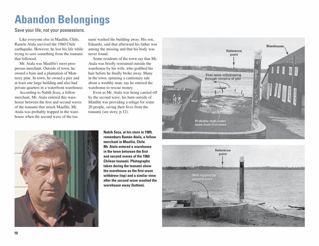
Like everyone else in Maullín, Chile, Ramón Atala survived the 1960 Chile earthquake. However, he lost his life while try ing to save something from the tsunami that followed.
Mr. Atala was Maullín's most pros- per ous merchant. Outside of town, he owned a barn and a plantation of Mon-terey pine. In town, he owned a pier and at least one large build ing and also had private quarters in a wa ter front ware house.
According to Nabih Soza, a fellow mer chant, Mr. Atala en tered this ware- house be tween the fi rst and second waves of the tsunami that struck Maullín. Mr. Atala was probably trapped in the ware- house when the second wave of the tsu-
Nabih Soza, at his store in 1989, remembers Ramón Atala, a fellow merchant in Maullín, Chile. Mr. Atala entered a warehouse in the town between the fi rst and second waves of the 1960 Chilean tsunami. Photographs taken during the tsunami show the warehouse as the fi rst wave withdrew (top) and a similar view after the second wave washed the warehouse away (bottom).
Abandon BelongingsSave your life, not your possessions.
na mi washed the build ing away. His son, Eduardo, said that afterward his fa ther was among the miss ing and that his body was never found.
Some residents of the town say that Mr. Atala was briefl y re strained outside the ware house by his wife, who grabbed his hair before he fi nally broke away. Many in the town, spinning a cau tion ary tale about a wealthy man, say he en tered the ware house to res cue money.
Even as Mr. Atala was being carried off by the sec ond wave, his barn outside of Maullín was pro vid ing a ref uge for some 20 people, saving their lives from the tsu na mi (see story, p.12).
11
River
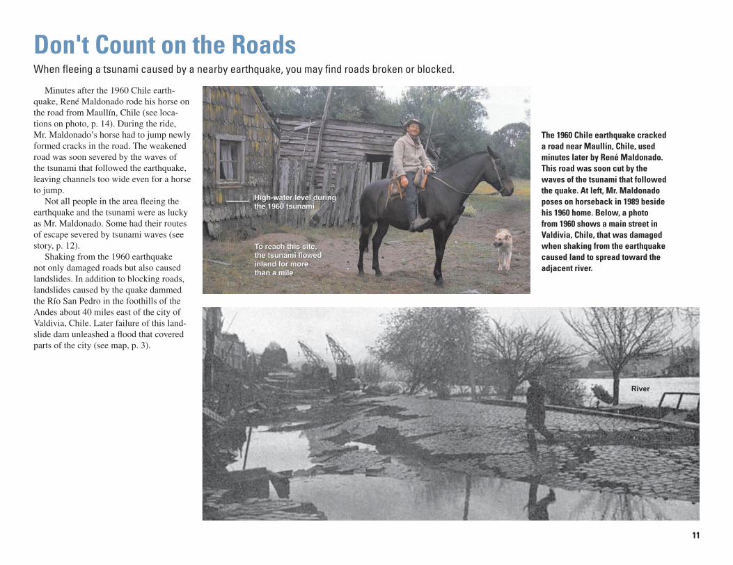
Minutes after the 1960 Chile earth- quake, René Maldonado rode his horse on the road from Maullín, Chile (see loca-tions on pho to, p. 14). During the ride, Mr. Maldonado’s horse had to jump newly formed cracks in the road. The weak ened road was soon severed by the waves of the tsunami that followed the earth quake, leaving channels too wide even for a horse to jump.
Not all people in the area fl ee ing the earthquake and the tsunami were as lucky as Mr. Maldonado. Some had their routes of escape severed by tsunami waves (see story, p. 12).
Shaking from the 1960 earthquake not only damaged roads but also caused landslides. In addition to blocking roads, landslides caused by the quake dammed the Río San Pedro in the foothills of the Andes about 40 miles east of the city of Valdivia, Chile. Lat er failure of this land- slide dam un leashed a fl ood that cov ered parts of the city (see map, p. 3).
The 1960 Chile earthquake cracked a road near Maullín, Chile, used minutes later by René Maldonado. This road was soon cut by the waves of the tsunami that followed the quake. At left, Mr. Maldonado poses on horseback in 1989 beside his 1960 home. Below, a photo from 1960 shows a main street in Valdivia, Chile, that was damaged when shaking from the earthquake caused land to spread toward the adjacent river.
Don't Count on the RoadsWhen fl eeing a tsunami caused by a nearby earth quake, you may fi nd roads broken or blocked.

12
The family of José Navarro, farm ing on a low peninsula near Maullín, Chile, had only one quick route to high ground after the 1960 Chile earth quake. The route was eastward along an unpaved road, across a bridge over a tidal stream, to uplands called Chuyaquén. Although a neighbor quickly took that route, the Navarro family stayed in their home, beside another tidal stream (see photo at lower right).
Some minutes after the earthquake, the Navarro family saw the waters of the
stream recede. Never before had they seen so much of the streambed ex posed. By then, the fi rst wave of the tsunami that followed the quake was approaching but still out of view to the west (see locations on photo, p.14).
Only when they saw a low wall of wa- ter less than a mile away did the Navarros head for high ground. The fam i ly needed to cover half a mile just to reach the bridge that their neighbor had used. They got far enough to see the fi rst tsunami wave destroy it in front of them.
Mrs. and Mr. Navarro, joined by a daughter, stand for a 1989 photo on the porch of their post-tsunami home on high ground near Maullín, Chile. The 1960 Chilean tsunami destroyed their former home, which was located on low ground by a tidal stream. Photo at right shows reference points for their fl ight to safety during the fi rst two waves of the tsunami.
Go to an Upper Floor or Roof of a BuildingOnly if trapped and unable to reach high ground, go to an upper story of a sturdy building or get on its roof.
As the fi rst wave receded, they looked for something to climb. Nothing near them stood more than a few feet high, except for their 9-year-old ap ple trees and several wind breaks of cypress. Three quarters of a mile to the south, however, was a barn. This was among the prop- er ties of Ramón Atala, who was about to be carried away by the second wave in Maullín (see story, p. 10).
Although Mr. Navarro’s wife and chil dren headed for the barn, Mr. Navarro did not go with them. He thought he’d re-
trieve a few things from the family house. How ev er, when he heard shouts from the di rec tion of Maullín, he took them as a warning of a second wave and went directly to the barn.
The second wave reached the barn just as Mr. Navarro joined his family there. Along with 14 others, the Navarro fam-ily spent the night in the loft of Ramón Atala’s barn, safe above the tsunami waters that ran be neath them.
Path ofincomingtsunami
Navarro home
Bridge taken out by first wave
Ramón Atala’s barnand pine plantation
to Chuyaquén uplands
Photograph taken December 1961
Navarro home
Bridge taken out by first wave
Ramón Atala’s barnand pine plantation
to Chuyaquén uplands
Photograph taken December 1961
Río Maullín
0 0.5 MILE
0.5 KILOMETER
0.5 MILE
0.5 KILOMETER0
N
13
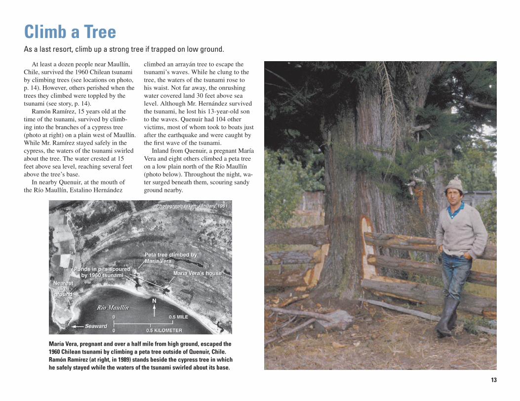
María Vera, pregnant and over a half mile from high ground, escaped the 1960 Chilean tsunami by climbing a peta tree outside of Quenuir, Chile. Ramón Ramírez (at right, in 1989) stands beside the cypress tree in which he safely stayed while the waters of the tsunami swirled about its base.
At least a dozen people near Maullín, Chile, survived the 1960 Chilean tsunami by climbing trees (see locations on photo, p. 14). How ev er, others per ished when the trees they climbed were top pled by the tsunami (see story, p. 14).
Ramón Ramírez, 15 years old at the time of the tsunami, survived by climb- ing into the branches of a cypress tree (photo at right) on a plain west of Maullín. While Mr. Ramírez stayed safe ly in the cypress, the waters of the tsu na mi swirled about the tree. The water crest ed at 15 feet above sea level, reaching several feet above the tree’s base.
In nearby Quenuir, at the mouth of the Río Maullín, Estalino Hernández
Climb a TreeAs a last resort, climb up a strong tree if trapped on low ground.
climbed an arrayán tree to escape the tsunami’s waves. While he clung to the tree, the wa ters of the tsunami rose to his waist. Not far away, the onrushing water covered land 30 feet above sea level. Although Mr. Hernández survived the tsunami, he lost his 13-year-old son to the waves. Quenuir had 104 other victims, most of whom took to boats just after the earth quake and were caught by the fi rst wave of the tsunami.
Inland from Quenuir, a pregnant María Vera and eight others climbed a peta tree on a low plain north of the Río Maullín (pho to below). Throughout the night, wa-ter surged beneath them, scouring sandy ground nearby.

14
Climb onto Something that FloatsIf swept up by a tsunami, look for something to use as a raft.
Navarro home (p. 12)
Silva-Vera home (p. 15)
Casa Grande (p. 16)
NellyGallardo
José Argomedo (p. 4)
ArmandaCubate
QUENUIR(p. 13,15)
MAULLÍN (p. 4,10)
Tree climbed by Ramón Ramírez (p. 13)
Tree climbedby María Vera (p. 13)
Broken road (p. 11)
Maldonado home (p. 11)
LA PASADA (p. 15)
30
55
1520
10
15
15
Navarro home (p. 12)
Silva-Vera home (p. 15)
Casa Grande (p. 16)
NellyGallardo
José Argomedo (p. 4)
ArmandaCubate
QUENUIR(p. 13,15)
MAULLÍN (p. 4,10)
LA PASADA (p. 15)
Tree climbed by Ramón Ramírez (p. 13)
Tree climbedby María Vera (p. 13)
Pacific Ocean
Río Maullín
N
105
2
15
Inland limit of tsunami
Photograph taken 1944
Broken road (p. 11)
Maldonado home (p. 11)
Maximum height of tsunami,in feet above sea level
Deaths from tsunami
10
105
PacificOcean
View inphoto
N
Lowmarshyplain
0 5 MILES
0 5 KILOMETERSLow
sandy plain
Highground Río Maullín
As marked on this 1944 photo of the mouth of the Río Maullín, Chile, the 1960 Chilean tsunami fl owed 2 miles inland from the beach at right foreground. In much of this fl ooded area, the tsunami reached a height of 15 feet above sea level. After being swept up by the tsunami, Nelly Gallardo fl oated on a wooden rail and Armanda Cubate took refuge on a roof (see far right in photo below). They survived the tsunami, but 15 other people near them died.
Drifting wood saved Nelly Gallardo during the 1960 tsunami. The parent earthquake struck while she was near the shore west of Maullín, Chile. Soon after the shaking stopped, Ms. Gallardo headed inland on low ground, where waters of the fi rst wave reached her knees. Turn-ing back toward the shore to check on her house, she soon met the second wave, which swept her off her feet and defeated her attempts to swim. The next thing she
recalls is a fl oating pole. It was a wooden rail, of the kind used for tying up horses, and Ms. Gallardo struggled to ride it. After a few hours, at dusk, currents carried the rail and rider into an arrayán tree. The tree’s branches held Ms. Gallardo and two others through the night.
The roof of her family house served as a life raft for Armanda Cubate, her 4-year-old nephew Nelson, and fi ve others. The house, on low ground west of Maullín,
withstood the 1960 earth quake. The house also withstood the fi rst two waves of the tsu na mi that followed the quake, but the third wave swept it away. This wave also toppled a nearby tree that Ms. Cubate’s father had climbed to es cape the tsu-nami. Both he and Ms. Cubate’s mother drowned in the tsu na mi. Survivors on the roof later pulled the mother’s body from the wa ter.

15
El maremoto fue tan grande que hasta los muertos sacó de sus tumbas (“The tsu na mi was so big that it even took the dead from their graves”). This saying comes from Quenuir, Chile, a village at the mouth of the Río Maullín (see lo ca -tions on photo, p. 14). The tsunami that followed the 1960 Chile earth quake killed 105 people from Quenuir—a quarter of the village’s pop u la tion. In addition to this loss of the living, Quenuir lost many of its dead. The vil lage cem e tery was located on sandy ground that the tsunami washed away. Debris from the cemetery came
to rest more than 3 miles upriver. There, just outside La Pasada, Tulio Ruiz found cross es and a full casket.
The 1960 tsunami also deposited sand along the Río Maullín, some of it on land owned by Juan Vera. He and his wife, María Isolina Silva, lived on low ground 2 miles east of Maullín. The 1960 earth- quake found Mrs. Silva at home and her husband on a near by hillside. Their house col lapsed, but Mrs. Sil va es caped and soon joined her hus band on high ground. Together they watched the tsu na mi overrun their fi elds and carry away the
The 1960 Chilean tsunami deposited a sand layer on fi elds owned by Juan Vera near Maullín, Chile. When this picture of Mr. Vera was taken in 1989, the sand layer was still visible in a streambank (upper right photo). A similar sand layer from the 1700 Cascadia tsunami covers the remains of a Native American fi shing camp exposed in a bank of Oregon’s Salmon River (lower right photo; see map, p. 3, for location).
Expect the Waves to Leave DebrisA tsunami will leave behind sand, the remains of houses, and bodies.
remains of their house. The next day, Mr. Vera found a lay er of sand several inches thick on much of the land the tsunami had over run.
Many houses were carried inland by the 1960 tsunami. After fl eeing to high ground near Queule, more than 100 miles north of Maullín (see map, p. 3, and pho-tos, p. 5), Filberto Henríquez saw houses fl oat ing away from the town. He recalls that some of the houses, with their stoves still smoking, looked like ships. Remains of houses from Queule end ed up as much as a mile in land (ac cord ing to a report by
Wolfgang Weischet; see p. 5), but Margar-ita Liempí’s house was de pos it ed intact; even her drinking glasses were un bro ken.
At Mehuín, near Queule, Jacinto Reyes buried some of the tsunami vic tims. Among them were the parents of two girls who were found in black ber ry bushes, scratched but alive. Not all the tsunami victims were found quickly. About 10 days after the tsunami, Mr. Reyes hap- pened upon bodies stuck in sand and being eaten by birds.

16
The 1960 Chile earthquake not only triggered a tsunami that killed Ramón Atala (see story, p. 10), but it also changed his Monterey pine plan ta tion outside of Maullín, Chile, into a salt marsh (see photo at right). The pines, grown for timber, covered low ground around Mr. Atala’s barn (see story, p. 12). During the earth quake, this land was lowered. Be cause tides were then able to inundate the plantation, the ground became too wet and salty for the trees to survive.
What happened to Mr. Atala’s plan- ta tion happened at many places along Chile’s coast. When a 600-mile-long
Expect Quakes to Lower Coastal LandA large earthquake can leave nearby coastal areas lowered, allowing tidal water to fl ood them.
Expect CompanyShelter your neighbors.
In the fi rst weeks after the 1960 Chile earthquake and tsunami, Yolanda Mon-tealegre provided shelter for 40 families in Casa Grande, her large home on the out skirts of Maullín, Chile (see lo ca tions on photo, p. 14). Ms. Montealegre left her house minutes after the earthquake and reached high ground in time to watch the arrival of the sec ond wave of the tsunami that fol lowed the quake. The next morning, she found Casa Grande in good shape, its ground fl oor dry. The families she soon took in were among the es ti mat ed 1 million Chileans left tem po rari ly home less by the earthquake and tsunami.
stretch of the South American tectonic plate was thinned during the 1960 earthquake, nearby land was lowered as much as 8 feet (see diagram B, p. 2). The sea was then able to cover coastal pastures, farms, and forests.
Coastal areas were also lowered and submerged in Cascadia after the 1700 Cascadia earthquake (see p. 3, 15). These areas include the Native American fi sh ing camp shown on page 15. After being in un dat ed by the 1700 tsunami, this fi sh ing camp became a tidal fl at or a tidal marsh.
The 1960 Chile earthquake lowered the land beneath both this slaughterhouse and the large home nearby on the outskirts of Maullín, Chile. The slaughterhouse then became fl ooded by high tides, but Casa Grande, the home of Yolanda Montealegre, escaped fl ooding because it was on slightly higher ground. After the earthquake and the tsunami that followed it, Ms. Montealegre sheltered 40 families there.
17
People Interviewed[Listed alphabetically by father’s last
name. Numerals give age in 1960, omitted if age not recorded. Bold type denotes peo ple named in this booklet or shown in one of its photographs.]
Maullín, Quenuir, and La Pasada, Chile
Ricardo Aguila (34), Juan Reinaldo Aguila R. (36), Carlos Andrade (12), José Argomedo Hernández (22), José Norberto Asencio Cárcamo (45), Elisa Asencio Téllez (19), Eduardo Atala B. (42), Reinaldo Cárcamo (52), Hernán Cárcamo Gómez (33),Víctor Chávez Villegas (56), Armanda Cubate (38),Nelson H. Cubate O. (4), PalmiraEstrada Estrada (27), Nelly Gallardo (23), René Garcia Sílva (39), Hermó-genes Gómez Rival, Adelina Gómez Rival (44), Feliza del Rosario Hernándes Paredes (39), Estalino Hernández (54),Gaspar Hernández, Tulio Hernández, René Leichtle Krebs (43), René Maldo-nado (30), Alejandrino Mancilla, An-tonio Segundo Mancilla (22), Bernarda Mancilla S. (23), Yolanda Montealegre Mücke (40), Rodrigo Mo rales, Fidel Navarro (50), Os car Navarro Navarro (34), José Miguel Navarro Sil va (44),Enoc Ojeda (20), José B. Ojeda Muñoz (40), Julia Paredes Toledo (54), RamónRamírez Solís (15), Braulio Reyes, Jorge Ruiz (34), Tulio C. Ruiz (23),José Rupertino Sánchez Gallardo (15), René Serón (36), María Isolina Silva (29), Domitila Solís (50), Pedro Soto Soto (62), Nabih Soza (23), Gastón Ex-equiel Toledo Arria (22), José Elizardo
Torralbo (27), María Vera (42), Guill-ermina Vera Mansilla (39), and JuanVera Mancilla (34), father of An ge la Vera Reyes.
Mehuín and Queule, Chile
Erna Espinosa, Elsira Flores, FilbertoHenríquez Jaramillo (32), Hernán Liempí (11), Margarita Liempí (18),Vitalia Llanquimán, Señor and Señora Moraga, Gilberto Nahuelpán Liempí (25), Jovita Riquelme (45), Daniel Na-huelpán Rumillanca (32), Alberto Perón Antilco (23), Jacinto Reyes Reyes (54),Alejandro Villagrán Rojas (25), Andrea of Mehuín, Erasmo of Mehuín (23), and Diodema of Mehuín (35).
Onagawa and Miyako, Japan
Endö Fukuei (40), Kimura Tsuneo (28), Moriai Miya (40), Moriai Mutsuhara (22), Takanohashi Gö (12), Yamasaki Nori (26), and Yamazaki Toshio.
Hilo, Hawaii
Carol D. Brown (16) and Jerry P.Eaton (33).
Book PreparationInterviews (C, Chile; J, Japan)
Brian Atwater (C, J), Joanne Bour- geois (C), José Ulloa Cortés (C), Marco A. Cisternas Vega (C), Héctor Jiménez Núñez (C), Marcelo López Bermedo (C), Musumi Satoko (J), Mary Ann Reinhart (C), Adriana Sandoval Lagos (C), Tsuji Yoshinobu (J), Ueda Kazue (J), and David K. Yamaguchi (J).
Interviews (Hawaii)
Adapted from stories of tsunami sur-vivors in Tsunami! by Walter C. Dudley and Min Lee, 1998 (University of Hawaii Press), and supplemented with 1999 in- ter views done by Walter C. Dudley, Peter H. Stauffer, and James W. Hendley II.
Photographs taken before 1989
Fuerza Aérea de Chile, Servicio Aerofotogramétrico (p.12, image 16019), Griffi n (1984) (inside back cover), Ilustre Municipalidad de Maullín (p. 4, 10, 16), Pacifi c Tsunami Mu se um (p. 6, 7, inside front cover), Saint-Amand (1963) (p. 5, 11), Uni ver si ty of Tokyo (p. 8, 9), and U.S. Defense Map ping Agency (p. 13, im-age 503-333; p. 14, image 552.R.13).
Critical reviews
Sally Atwater, Jan Bono, Steven R. Brantley, Eddie Bernard, Gary Brown, George Crawford, Lori Dengler, Rich Eisner, Stephanie Fritts, Eric Geist, Hel-en Gibbons, Frank Gonzolez, Dick Hage-meyer, T.J. Harmon, Imamura Fumihiko, Chris Jonientz-Trisler, Hal Mofjeld, Alan Nelson, Dave Oppenheimer, Jim Phipps, George Priest, Barbara Thurman, Vasily Titov, and John Vollmer.
Funds for publication
The National Tsunami Hazard Mit i -ga tion Program, a partnership among the States of Alaska, California, Ha waii, Or e gon, and Washington, and the Na tion al Oceanic and Atmospheric Ad min is tra tion, the Federal Emer gen cy Man age ment Agen cy, and the U.S. Geo log i cal Survey.
Other assistance
Mario Pino (Universidad Austral de Chile); Carolina Villagrán (Universidad de Chile); Sergio Barrientos (Comprehensive Test Ban Treaty Organization); Maullín Gracilaria research team (Universidad Austral de Chile).
Isoda Hisako, Kishimoto Kiyo, and Satake Kenji (Geological Survey of Japan); Murakami Yoshikanei, SatöHiroshi, and Watanabe Tokie (University of Tokyo, Earth quake Research Institute); Abe Motomu (Town of Onagawa); and Ota Yoko.
For Additional Information1960 Chilean earthquake and tsunami
Cisternas, M., Atwater, B.F., Torrejón, F., Sawai, Y., Machuca, G., Lagos, M., Eipert, A., Youlton, C., Salgado, I., Kamataki, T., Shishikura, M., Rajen-dran, C.P., Malik, J.K., Rizal, Y., and Husni, M., 2005, Predecessors to the giant 1960 Chile earthquake: Nature, v. 437, p. 404-407.
Dudley, W.C., and Lee, M., 1998, Tsu- na mi!: University of Hawaii Press, 362 p.
Eaton, J.P., Richter, D.H., and Ault, W.U., 1961, The tsunami of May 23, 1960, on the Island of Hawaii: Seismological So ci ety of America Bulletin, v. 51, no. 2, p. 135-157.
Griffi n, Wallace, 1984, Crescent City's dark disaster: Crescent City Printing Co., 188 p.
Japan Meteorological Agency, 1961, The
Credits and Sources

18
report on the tsunami of the Chilean earthquake, 1960: Japan Me te o r-o log i cal Agency Technical Report 8, 389 p.
Lachman, R., Tatsuoka, M., and Bonk, W.J., 1961, Human behavior during the tsunami of May 1960: Science, v. 133, p. 1405-1409.
Lomnitz, C., 1970, Major earthquakes and tsu na mis in Chile during the period 1535 to 1955: Geologische Rund-schau, v. 59, p. 938-960.
Plafker, G., and Savage, J.C., 1970, Mech a -nism of the Chilean earthquakes of May 21 and 22, 1960: Geological Society of America Bulletin, v. 81, p. 1001-1030.
Saint-Amand, P., ed., 1963, Special is-sue—ocean o graph ic, geologic, and en gi neer ing studies of the Chilean earthquakes of May 1960: Seis mo -log i cal So ci ety of America Bulletin, v. 53, no. 6, p. 1123-1436.
Servicio Hidrográfi co y Oceanográfi co de la Armada de Chile, 2000, El maremoto del 22 de Mayo de 1960 en las costas de Chile (2d ed.): Valparaíso, SHOA, 72 p.
Shepard, F.P., MacDonald, G.A., and Cox, D.C., 1950, The tsunami of April 1, 1946: Scripps In sti tu tion of Ocean og -ra phy Bulletin, v. 5, p. 391-528.
The Committee for Field Investigation of the Chilean Tsunami of 1960, 1961, Report on the Chilean tsunami of May 24, 1960, as observed along the coast of Japan: Tokyo, Maruzen Co., 397 p.
1700 Cascadia earthquake and tsunami
Atwater, B.F., and Hemphill-Haley, E., 1997, Recurrence intervals for great earthquakes of the past 3,500 years at northeastern Willapa Bay, Wash- ing ton: U.S. Geo log i cal Survey Pro- fes sion al Paper 1576, 108 p.
Atwater, B.F., Yelin, T.S., Weaver, C.S., and Hendley, J.W., II, 1995, Avert-ing suprises in the Pacifi c Northwest: U.S. Geo log i cal Survey Fact Sheet 111-95, 2 p.
Atwater, B.F., Musumi-Rokkaku, S., Satake, K., Tsuji, Y., Ueda, K., and Yamagu-chi, D.K., 2005, The orphan tsunami of 1700—Japanese clues to a parent earthquake in North America: U.S. Geological Survey Professional Paper 1707, published jointly with University of Washington Press, Seattle, 133 p. [http://pubs.usgs.gov/pp/pp1707/].
Clague, J.J., 1997, Evidence for large earth quakes at the Cascadia sub duc -tion zone: Reviews of Geophysics, v. 35, p. 439-460.
Satake, K., Shimazaki, K., Tsuji, Y., and Veda, K., 1996, Time and size of a giant earth quake in Cascadia inferred from Japanese tsunami record of Janu-ary 1700: Nature, v. 379, p. 246-249.
Satake, K., Wang, K., and Atwater, B.F., 2003, Fault slip and seismic moment of the 1700 Cascadia earthquake inferred from Japanese tsunami descriptions: Journal of Geophysical
Research, v. 108, 2325, doi:10.1019/2003JB002521.
Tsuji, Y., Ueda, K., and Satake, K., 1998, Jap a nese tsunami records from the January 1700 earthquake in the Casca-dia sub duc tion zone: Zisin, v. 51, p. 1-17 [in Japanese with En glish abstract, fi gures, and fi gure captions].
Other sources
In the comparison of tsunami heights in Japan (p. 3), heights for the 1960 tsu na mi are known to the nearest foot or better. They come from reports by the Japan Me- te o ro log i cal Agency (1961), and they were compiled by Satake and others (2003) and Atwater and others (2005).
Nikita Khrushchev (p. 4) was re- fer ring to the U-2 mission of Francis Gary Powers. His remarks come from a news conference after cancellation of a sum mit meeting with Dwight Eisen-hower in Paris. A partial tran script was printed in the New York Times of May 19, 1960. East-West tension was still the lead sto ry on May 23, but on that day the front page of the Times also carried an initial wire-service account of the May 22, 1960, Chile earth quake and tsunami. The tsunami remained front-page news on May 24 and May 25—second only to stories about U.S. and Soviet spying and a U.S. missile-detection satellite—as tsu-nami loss es were reported from Ha waii and Ja pan.
Tsunami heights and deaths on page 14 come from interviews and sur veys done in 1988 and 1989. The heights are rounded to the nearest 5 feet, but some points pre cise ly identifi ed by sur vi vors were sur veyed to the nearest foot. The fi gure of 105 fa tal i ties from Quenuir comes from René Serón. As a civil ser- vant in 1960, Mr. Serón kept records of births, deaths, and other offi cial mat ters in Quenuir. In 1989, he recalled that the pretsunami town had about 50 houses, a church, a cemetery, and 400 to 450 in hab it ants.
Tsunami-hazard information on theWorld Wide Web
http://www.tsu na mi.gov/http://walrus.wr.usgs.gov/tsunami/http://www.pmel.noaa.gov/tsunami/Faq/http://pubs.usgs.gov/pp/pp1707/http://sarvis.dogami.state.or.us/
earthquakes/coastal/tsubrochures.htmhttp://www.dnr.wa.gov/geology/hazards/
tsunami/evac/

Waterfront area in Crescent City, Cal i for nia, fl ooded by the 1960 Chilean tsunami. Here, the tsunami caused more than $30,000 in damage, in clud ing the sinking of two boats. However, damage was much more severe 600 miles to the south in the Los Angeles area, where the tsunami killed one person and caused from $500,000 to $1,000,000 in damage, in clud ing the sinking of 30 boats.
In interviews several decades later, people in Chile, Hawaii, and Japan recall the tsunami triggered by a magnitude–9.5 earth quake that struck Chile in 1960.
Their accounts contain lessons on tsunami survival:• Many Will Survive the Earthquake• Heed Natural Warnings• Heed Offi cial Warnings• Expect Many Waves• Head for High Ground and Stay There• Abandon Belongings• Don't Count on the Roads• Go to an Upper Floor or Roof of a Building• Climb a Tree• Climb onto Something that Floats• Expect the Waves to Leave Debris• Expect Quakes to Lower Coastal Land• Expect Company
Atw
ater and others—Surviving a Tsunam
i—Lessons from
Chile, Haw
aii, and Japan—U
.S. Geological Survey Circular 1187
THE NATIONAL TSUNAMI HAZARDMITIGATION PROGRAM
A partnership among the States of Alaska, California, Hawaii, Oregon, and Washington, and the National Oceanic and Atmospheric Administration, the Federal Emergency Management Agency, and the U.S. Geological Survey.