national weather service research and development needs ... · national weather service research...
TRANSCRIPT
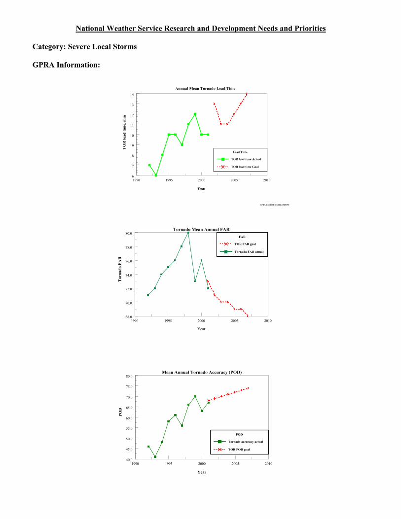
National Weather Service Research and Development Needs and Priorities Category: Severe Local Storms GPRA Information:
Annual Mean Tornado Lead Time
Year
1990 1995 2000 2005 2010
GPRA_REVISED_FEB02_DM.PDW
6
7
8
9
10
11
12
13
14
TO
R le
ad ti
me,
min
Lead Time
TOR lead time Actual
TOR lead time Goal
Year
1990 1995 2000 2005 2010
Tornado Mean Annual FAR
68.0
70.0
72.0
74.0
76.0
78.0
80.0
Tor
nado
FA
R
FAR
TOR FAR goal
Tornado FAR actual
1990 1995 2000 2005 2010
Year
Mean Annual Tornado Accuracy (POD)
40.0
45.0
50.0
55.0
60.0
65.0
70.0
75.0
80.0
POD
POD
Tornado accuracy actual
TOR POD goal

Statement of Need: Research and development are needed to improve warning, forecast accuracy and lead times for severe local storms (e.g., large hail, severe thunderstorms, weak tornadoes, and lightning). Priority: Justification: Each year, hundreds of lives and billions of dollars are lost due to severe storms, floods and other natural events. However, research and development is needed to meet GPRA goals in this category. The current linear lead time trend does not favor reaching the goal within the next decade. The 2001 tornado lead time goal was 12 minutes. Actual performance was 10 minutes. By 2008, the tornado lead time goal increases to 15 minutes. The 2001 tornado probability of detection (POD) goal was .68. Actual performance was .67. By 2008, the POD goal increases to .74. The 2001 tornado mean annual false alarm ratio (FAR) goal was .74. The actual performance exceeded the goal (.72). By 2008, the FAR goal decreases to .64. (See Figures 1-3 for more detail.) General Research and Development Objectives: Advances in forecasting severe weather must encompass many related technologies. This includes the assimilation of dissimilar sensor data (e.g., TDWR with WSR-88D) to more accurately identify conditions conducive to F0/F1 type tornadoes and strengthening numerical and subjective techniques to improve the short-range forecasts out to 36 hours. New sensors and networks to for improved storm detection and model initialization must be developed, as well as new forecast techniques which incorporate advanced warning decision support systems and improved visualization techniques for forecasters. Basic research is needed to improve the fundamental understanding of severe weather phenomena including the genesis and intensity of tornadoes, large hail, strong convective winds, lightning, heavy precipitation, and elevated and low top convection. Development of improved, and better utilization of current, dissemination tools is also key to better warn the public of impending severe weather events. Specific Research and Development Objectives: Observations $ Develop new sensors to observe severe weather events such as lightning, cloud microphysical and
land surface properties, and vertical distributions of moisture. $ Develop and deploy observational networks and sensors with sufficient resolution to increase
detection and improve model initialization. $ Improve wide-area convergence boundary detection. Data Assimilation/Numerical Prediction $ Develop techniques to assimilate TDWR, WSR-88D and dual polarization radar data, and other
remote sensing data into high resolution models. $ Improve model physics and resolution toward realistic simulation and prediction of intense vortices
or their proxies. $ Develop methods to analyze and assimilate new sources of data in real time. $ Improve parameterizations and coupling of land surface, cloud microphysical, and turbulent
processes and their interactions with severe local storms. $ Improve models of gravity wave dynamics and interaction with storm-scale processes (e.g.,
convection and QPF). $ Develop a probabilistic system for tornadogenesis. Forecast Techniques $ Develop accurate techniques to integrate complementary sensor technology output (e.g., radar,
satellite, lightning) to detect/identify storm features leading to, and associated with, the

development of weak (F0 and F1) tornadoes characteristic of semi-tropical environments. $ Develop advanced decision support systems. $ Improve visualization techniques. Enabling Technologies/Dissemination $ Optimize forecast office technologies to reduce the time required to generate and disseminate
warnings. $ Enable multi-platform (e.g., phone, internet) automated dissemination of warnings and watches
without adding to forecaster workload. $ Improve display systems to handle larger volumes of data. $ Facilitate use of existing collaboration tools for local emergency personnel. $ Enhance data compression and other techniques to improve the delivery of data to display systems. Fundamental Understanding $ Improve the understanding of severe weather phenomena, including the genesis and intensity of
tornadoes, large hail, strong convective winds, lightning, heavy precipitation and elevated nocturnal and low top convection.
$ Improve understanding of specific precursor environment signatures of severe local storms. Training $ Develop methods to increase sharing of successful techniques across field offices. $ Improve weather event training simulators. Human Factors $ Identify optimal severe weather warning formats and schedules based on human factors research
showing greatest mitigation value. $ Optimize operational resource management of severe weather data and models in order to
maximize meteorological situational awareness of forecasters and reduce warning triggering times.

National Weather Service Research and Development Needs and Priorities Category: Tropical Storms GPRA Information:
48-hr Error, kt
HUR 48-hr Intensity Err, kt
Hurr 48-hr Int Fit
HUR 48-hr Intensity Goal, kt
48-hr Atlantic Hurricane Intensity Error
Year
1990 1995 2000 2005 2010
GPRA_REVISED_FEB02_DM.PDW
15.2
15.4
15.6
15.8
16.0
16.2
16.4
HU
R 4
8-hr
Inte
nsity
, kt
Year
1990 1995 2000 2005 2010128
130
132
134
136
138
140
142
Hur
rica
ne 4
8-hr
Tra
ck E
rror
, nm
GPRA_REVISED_FEB02_DM.PDW
48-hr Track Error
HUR 48-hr Track Error GOAL, nm
Statement of Need: Research and development activities are needed to improve the lead time and accuracy of warnings and forecasts of track, intensity, ocean waves, and storm surge and associated flooding related to tropical storms. Priority: Justification: With the tremendous increase in population along the high risk areas of our shoreline, more people than ever are vulnerable to the impact of tropical storms. On average each year, there are 10 tropical storms (6 of which become hurricanes). Earlier and improved predictions of storm track,

intensity, and associated precipitation are necessary to minimize loss of life and property. General Research and Development Objectives: The current research and development needs related to tropical storms can be broadly listed as follows: (1) improved specification of subgrid and mesoscale thermodynamical and dynamical processes; (2) more intensive use of targeted observations of storms and their surrounding environment to define initial conditions for hurricane models, improve depiction of the general circulation of the tropics, and increase the density of localized data over sparse areas; (3) better quantification of the modifying effects of terrain on land falling tropical storms regarding specific variables such as flooding, precipitation distribution and intensity, and winds; (4) isolating and quantifying the role of underlying atmospheric variability on tropical cyclone genesis on a spectrum of temporal scales ranging from several hours to multi-decadal; (5) improved guidance by way of more accurate forecasting of trajectory, intensity, storm surge, and wave and swell forecasting remote from the storm; (6) improved understanding of the coupling between inner core structure and dynamics with overall system evolution, and (7) development of improved coupled ocean-hurricane forecast models. Specific Research and Development Objectives: Observations $ Improve tropical storm environment analysis using ad hoc routine observations, e.g., G-IV
soundings; pilot-less aircraft; RAOBs; satellite derives winds, and others. $ Improve tropical storm inner core analysis [using upgraded G-IV instrumentation]. $ Develop optimal data collection targeting strategies [Adaptive Observing Techniques] enabling
selectivity of probing interests to satisfy different users/localities. $ Improve utility of remote sensing data through higher spatial and temporal coverage and increased
timeliness of products. $ Improve observational data coverage over oceans to improve tropical storm specification and
forecasts. $ Validate observed storm intensity parameters provided by the Tropical Prediction Center. Data Assimilation/Numerical Prediction $ Improve numerical forecasting of specific forecast problems, such as interactions between upper-
level troughs and tropical cyclones, track forecasts near mountainous areas, and extra tropical transition.
$ Develop a hurricane data assimilation system (HDAS). $ Improve model physics for hurricane core and tropical environment. $ Improve QPF storm models at mesoscales. $ Provide model output uncertainties of track, QPF, and intensity (ensemble). $ Develop capability to forecast storm size, intensity, and tropical cyclogenesis. $ Improve use of satellite data in global and hurricane forecast systems. Forecast Techniques $ Develop statistically-based real-time "guidance on guidance" for storm track, including multi-
model consensus approaches, "super-ensembling", more accurate objective intensity estimation techniques, etc., in probabilistic and other formats.
$ Provide objective information on the situational strengths and weaknesses of the available numerical models related to hurricane track and intensity forecasts, including model error distributions, particularly in the 3-5 day time frame.
$ Continue development, assessment and operational implementation of the Emanuel tropical cyclone intensity forecast scheme.
$ Continue development of real-time storm surge models. $ Develop high accuracy guidance for storm genesis forecasts (e.g. POD > 80% and FAR < 20% for

36h forecasts. Enabling Technologies/Dissemination $ Develop approaches to improve access to international real-time data for use by forecasters and
other critical users. $ Improve/enhance use of collaboration tools for better interoffice communication during tropical
weather threats. Fundamental Understanding $ Better quantify impact of land falling tropical cyclones and associated severe weather on heavy
precipitation, flooding, and flash flooding. $ Improve understanding of intraseasonal and decadal scale variabilities on tropical storm activity,
and seasonal hurricane outlooks. $ Improve understanding of how inner-core structure/dynamics affect intensity change. $ Improve understanding of changes in tropical cyclone size and related parameters, including
combined sea heights. $ Improve understanding of tropical cyclone genesis. $ Improve understanding on tropical cyclone precipitation amount and distribution. $ Improve understanding and specification of air-sea interaction controlling or modifying storm
intensity and track Training $ Establish archives of relevant seminars and colloquia available to forecasters. Human Factors $ Optimize watch and warning formats and schedules to maximize mitigation value based on human
factors research. $ Better understand societal options in response to hurricanes and their consequences. $ Reduce workload inefficiencies during pre-storm and storm conditions within forecast offices.

National Weather Service Research and Development Needs and Priorities Category: Fire Weather GPRA Information: N/A Statement of Need: Research and development activities are needed to improve prediction of the conditions conducive for the rapid development of wildfires, including the dispersion of smoke. Priority: Justification: The 2000 fire season was the worst in 50 years with over 91,000 wildfires and 7.2M acres burned. Improvements are necessary to achieve NWS Strategic Plan goals (2005) of specifying forecast confidence on all fire weather forecast products and improving forecast accuracy by 30% from a (still unspecified) baseline level. Advances in this area will also contribute to forecast accuracy for transport of other airborne contaminants. General Research and Development Objectives: Research and development are needed to establish a seamless suite of NWS fire-weather products and services uniformly across the Nation and to develop an improved basis for modeling/predicting fire weather and wildfire behavior. Specifically, basic and applied research is needed to 1) develop advanced approaches for integrating/coupling the impact of fuels distribution, land surface conditions and complex terrain, with synoptic and local-scale weather, for short-term out to seasonal time frames; and 2) improve verification strategies for fire weather and smoke dispersion. Specific Research and Development Objectives: Observations $ Improve observational coverage and data assimilation for remote areas and specific incidents. Data Assimilation/Numerical Prediction $ Develop/improve methods for modeling/predicting coupling of wildfire behavior, fuels and
meteorological systems. $ Develop an initial numerical forecast capability for fire weather and port to NWS offices. Forecast Techniques $ Improve prediction accuracy and verification methods for fire weather and smoke
transport/dispersion. $ Develop decision assistance package to improve identification and prediction of fire weather
events. Enabling Technologies/Dissemination $ Improve interactive capabilities for data exchange (observations, models, guidance) at incident
support locations. Fundamental Understanding $ Improve understanding of coupling between fuels distribution, land surface conditions and
complex terrain, with synoptic and local-scale weather, for short-term out to seasonal time frames. Training � Provide forecasters with training on methods agencies use to fight fires.

Human Factors $ Determine the best way to interact with government fire fighting officials at all levels and
understand their forecast and data needs.

National Weather Service Research and Development Needs and Priorities Category: Air Quality GPRA Information: N/A Statement of Need: Research and development activities are needed to better understand the impact of chemical variability, including prediction, transport, and dispersion of atmospheric contaminants. Priority: Justification: The next generation numerical prediction system, WRF, will contain chemical modules in place of current operational dispersion prediction systems. These models are limited chemically to a small number of constituents and dynamically to distances > 10 km and are not dynamically coupled to numerical weather prediction models. Research to improve prediction of air quality (emphasis on tropospheric ozone) and dispersion of other contaminants will overcome the limitations in chemistry and transport scale, embed predictions of transport/dispersion within the meteorological prediction framework, and will aid in mitigating threats to life and property. General Research and Development Objectives: Research is needed to improve fundamental understanding of the impact of chemical variability on hydrometeorologic systems and climate, along with the best observational strategies for key chemical constituents. This includes the impact of aerosols on weather and climate. Basic and applied research is needed to develop and assess optimal observing systems for both detection and prediction of transport and dispersion of atmospheric contaminants. Applied research is needed to develop forecast techniques and products for key chemical indicators needed for air quality forecasts, from short-range to seasonal outlooks. Although better forecasts and warnings of air quality/chemistry contribute to NWS= mission, no operational requirements currently exist for forecasting air quality. Work to baseline forecast skill will begin in 2002. If implementation is warranted, routine air quality forecasting requires research to demonstrate prospective skill. Specific Research and Development Objectives: Observations $ Detect chemical variability in atmospheric, hydrologic, and climatologic systems and its impact
upon these systems. $ Develop observing systems to detect sources and sinks of pollutants (for air quality forecasting)
and trace gases. Data Assimilation/Numerical Prediction $ Predict chemical variability in atmospheric, hydrologic, and climatologic systems and its impact
upon these systems. $ Predict transport and dispersion of atmospheric contaminants at multiple scales. $ Support locally run mesoscale models which include chemical predictions and transport and
dispersion output. $ Develop new seasonal forecast products for health, e.g., for air quality, air stagnation, disease,
excess heat and cold. Forecast Techniques $ Develop guidance products for forecasters and use by other customers

Enabling Technologies/Dissemination � Enable locally run mesoscale models to provide air quality results. � Make centrally run models and acquired data available on office display systems. Fundamental Understanding $ Determine causes and impact of chemical variability on hydrometeorologic systems and climate. Training � Provide forecaster training on dispersion theory and interpretation of dispersion model output.

National Weather Service Research and Development Needs and Priorities Category: Winter Weather GPRA Information:
Time: Tue Feb 12 12:37:26 2002
Winter Storm Warning Accuracy
1990 1995 2000 2005 2010
Year
80
85
90
95
100
105
Acc
urac
y (P
OD
)
POD
Winter storm POD Goal
Winter Storm accuracy actual
Winter Storm Mean Annual Lead Time
Year
1990 1995 2000 2005 2010
GPRA_REVISED_FEB02_DM.PDW
8
10
12
14
16
18
lead
tim
e, h
ours
Lead Time
WS lead time Actual
WS lead time Goal
Statement of Need: Research and development activities are needed to improve prediction of winter weather-related phenomena, including precipitation type, storm track, and intensity. Priority: Justification: Inaccurate forecasts of winter weather phenomena can cause havoc on transportation, public safety, and the local economy. To mitigate these impacts, research and development is needed to improve the accuracy and lead time for approaching winter weather conditions. Although GPRA goals in this category (i.e. winter storm warning accuracy and lead time) were met in 2001, continued R&D is necessary to meet these goals in following years, such as the 2007 goals of 90% and 16 hours for accuracy and lead time, respectively.

General Research and Development Objectives: Research is needed to develop (1) better models and forecast techniques of the development, intensification, and expected path of extratropical cyclones (e.g, Nor=easters and midwest storms associated with lee side cyclogenesis), (2) improved techniques of the timing, extent, and intensity of freezing and frozen precipitation events, (3) methodologies to predict the type, duration, and severity of arctic outbreaks, (4) improved snow and wind forecasts associated with arctic front intrusions, especially those associated with complex terrain, and (5) remote sensing techniques for observing snowfall and snow depth. Specific Research and Development Objectives: Observations $ Develop sensors that accurately detect different precipitation types (e.g. snow, freezing rain, ice
pellets, etc.). $ Develop methods to optimize mesoscale observation systems and transmit data to NCEP. $ Continue investigations of targeted observation strategies. Data Assimilation/Numerical Prediction $ Improve numerical weather prediction of explosive extratropical cyclogenesis. $ Improve cloud physics in numerical models for droplet/ice crystal growth, drizzle, snow, graupel,
and rain. $ Improve assimilation of satellite data in real-time, especially over ocean and coastal regions (e.g.,
SST) and other remotely sensed data over land. $ Develop application of ensemble forecasts for predicting winter storm track/intensity and
precipitation amount and type. Forecast Techniques $ Develop diurnal lightning and cloud climatologies stratified by weather regime to better predict the
onset, spatial coverage, and duration of precipitation, especially under weak synoptic forcing. $ Develop methodologies to better predict the type, duration, and severity of arctic outbreaks
resulting in damaging freezes. $ Improve snow and wind forecasts associated with arctic front intrusions into complex terrain. $ Develop better forecasts of the development, intensification, acceleration and expected path of
strong mid-west winter storm systems associated with lee side cyclogenesis. $ Develop improved techniques for the prediction of freezing and frozen precipitation events,
including timing, areal extent, intensity, and amount. $ Provide further enhancements to ensemble forecasting techniques. $ Develop forecaster assistance tool on AWIPS similar to SAFESEAS. $ Develop expert systems to forecast snowbands and heavy snowfall amounts. $ Develop techniques for probabilistic forecasts of severity of large-scale winter storms. Enabling Technologies/Dissemination $ Develop methods to receive and display ensemble data on AWIPS. $ Improve/enhance use of collaboration tools for better interoffice communication during winter
weather events. Fundamental Understanding $ Improve understanding of mesoscale processes that lead to heavy winter precipitation events. $ Develop better understanding of precipitation patterns in winter storms. Training

� Provide training for the interpretation of model output and tools to assess model initialization. Human Factors � Determine communication techniques for inter-office coordination. � Determine the most effective products to improve customer usage and response.

National Weather Service Research and Development Needs and Priorities Category: Marine Weather and Ocean Conditions GPRA Information:
Accuracy (POD)
Actual
Time: Tue Feb 12 12:41:47 2002
POD
Marine accuracy goal
Marine POD Fit
Marine accuracy actual
POD
Marine POD Fit
Marine accuracy actual
Marine accuracy goal
1990 1995 2000
Year
2005 2010
Marine (wind/wave) Forecasts
40.0
45.0
50.0
55.0
60.0A
ccur
acy
POD
Marine accuracy actual
Marine accuracy goal
Statement of Need: Research and development activities are needed to improve prediction of marine conditions, including fog, wind, waves, ocean currents, coastal water levels (particularly at bay and estuary entrances), and storm surge. Priority: Justification: As more and more people live and work along the coast or high seas, the NWS must improve marine (wind, current, water level, and wave) forecasts necessary to sustain marine commerce and to protect the public from severe marine weather conditions. Although the 2001 wind/wave accuracy fell just below the GPRA goal of .53, continued research and development is needed to meet more ambitious wind/wave accuracy goals in coming years, such as the goal of .62 accuracy in 2007. General Research and Development Objectives: Research is needed to extend and improve the accuracy of marine (wind and wave) forecasts. Keys to improving knowledge of oceanographic features and coastal wave phenomena are: 1) Higher spacial and temporal resolution observing systems of oceanographic boundaries, such as the Gulf Stream north wall, and atmospheric boundary layer wind, temperature and moisture properties; 2) Improved understanding and data assimilation of oceanographic data into meteorological and coastal ocean forecasting numerical models; 3) Improved understanding of air-sea interactions, including small lakes and basins (e.g. estuaries) as well as marine chemical contributions to the atmosphere and impact to meteorological phenomena; 4) Improved understanding of storm surge and breaking waves. Specific Research and Development Objectives: Observations $ Determine the requirements for optimal in situ observations (i.e. how many buoys or CMANs are
needed and where).

$ Develop alternatives to high cost/maintenance fixed buoys. $ Continue development and evaluation of new observations systems, such as coastal profilers, buoy
mounted profilers, and satellites. $ Develop capability to transmit observations to users, including NCEP. Data Assimilation/Numerical Prediction $ Develop a next-generation storm surge guidance model, including guidance on breaking waves,
and featuring higher resolution input (e.g., lidar) and output. $ Develop or adapt a current wave model to the nearshore areas that do not have any forecast
guidance. $ Improve NWP of hazardous mesoscale marine conditions, including near the Gulf Stream. $ Improve numerical weather prediction of marine boundary layer. $ Improve numerical coastal ocean forecasting capabilities and ocean data assimilation techniques in
coastal ocean models. $ Improve coupling between ocean-atmosphere models. $ Develop capability for numerical model prediction of wave steepness. Forecast Techniques $ Improve techniques to accurately forecast water levels, ocean currents, waves, and storm surge
inundation and coastal flooding. $ Continue to develop SAFESEAS as a forecaster decision assistance tool, including coastal floods,
wind, waves, and freezing spray. $ Develop techniques for beach/coastal erosion forecasts. $ Develop automated tsunami forecast techniques based on the PMEL model. $ Develop capability for generation of probabilistic forecasts of Marine and Coastal weather
conditions. $ Develop capability for integrated monitoring and verification of observations, guidance, numerical
model forecasts, and derived satellite observations. Enabling Technologies/Dissemination $ Develop a data delivery system to provide forecast offices with real-time satellite products. $ Develop an affordable system for alerting mobile mariners of pending severe weather. $ Develop dissemination capabilities for inexpensive user access to graphical products by vessels at
sea. Fundamental Understanding $ Improve understanding of estuarine and ocean chemistry. $ Improve understanding of meso-scale oceanic processes in coastal zones. Training � Provide training on model use and interpretation. � Provide training on use of remote sensors. Human Factors � Develop capability for audio and video coordination tools for use in graphical and gridded product
coordination between national centers and WFOs.

National Weather Service Research and Development Needs and Priorities Category: Quantitative Precipitation Information GPRA Information:
Annual 1-inch Liquid Equivalent Area QPF
Time: Tue Feb 12 12:44:47 2002
QPF POD
Day-3 1-in QPF GOAL
Day-3 1-in QPF
Day-3 QPF POD Fit
Year
1990 1995 2000 2005 2010
GPRA_REVISED_FEB02_DM.PDW
0.150
0.200
0.250
0.300
0.350
0.400
Day
-3 1
-in Q
PF P
OD
, per
cent
Statement of Need: Research and development activities are needed to improve the quantification and reduce biases of observed and forecasted precipitation over time and space scales ranging from minutes and several square miles up to months and national scales. Priority: Justification: Flash flood and river flooding events result in the largest loss of life and damage to infrastructure compared to all other severe meteorological events. Improved quantitative precipitation estimates can improve our ability to numerically model stream flows and improve our ability to monitor long-term climate changes and precipitation trends. Improved quantitative precipitation forecasts improve our ability to provide warnings to the public and improve the management of water resources among our diverse customer base. Existing analysis and forecasting techniques require enhancement to meet GPRA goals in this category for increased flash flood warning lead times. General Research and Development Objectives: Quantitative precipitation information (QPI) includes quantitative precipitation estimates (QPE) and quantitative precipitation forecasts (QPF). QPI research and development objectives are summarized in these two broad areas: 1) improved multisensor quantitative precipitation estimation tools and products, and 2) improved quantitative precipitation forecasting techniques and models for extreme precipitation events including those that occur in complex terrain. Specific Research and Development Objectives: Observations $ Improve rainfall and snowfall estimation techniques that utilize a diverse set of observations from
rain gauges, WSR-88D, satellite and related data (e.g., lightning, numerical model analyses, surface and upper air observations) to produce optimal regional and national multisensor rainfall estimates.
$ Develop probabilistic and/or ensemble QPE algorithms and products using WSR-88D and other sensors that provide uncertainty information to forecasters and for use by ensemble hydrologic

forecasting models. $ Develop improved remote sensing techniques for observing snowfall and snow depth. $ Improve optimal utilization of dual-polarization weather radar measurements to improve rainfall
estimates. $ Develop and improve validation techniques for rainfall estimates. $ Improve WSR-88D radar scan strategies to support a variety of high-impact meteorological
phenomena (e.g., flash flood-producing storms, high-based intermountain convection, low echo centroid storms, and shallow precipitating clouds).
$ Improve automated and semi-automated quality control techniques to identify bad rain gauge data and/or regions of false radar echoes that lead to poor rainfall estimates.
Data Assimilation/Numerical Prediction $ Improve assimilation of radar and satellite data into numerical weather prediction models to
improve short-term (0-6 hours) forecasting of existing and incipient flash-flood-producing storms. $ Improve assimilation of QPEs and QPFs into numerical hydrologic prediction models to improve
model forecasts. $ Couple hydrologic and atmospheric prediction models. $ Incorporate gravity wave processes in precipitation enhancement in models. $ Improve initialization and prediction of explicit cloud microphysics and convective processes in
models. $ Improve operational data assimilation and model physical parameterizations using QPF as a metric. Forecast Techniques $ Improve convective-scale numerical weather prediction models. $ Improve techniques for short-term 0-3 hour nowcasting of rainfall using WSR-88D, satellite, and
other measurements to improve warning lead-times for short-fuse flash flood events. $ Improve forecasting of the onset of the monsoon season and flash flooding in the desert Southwest. $ Improve techniques to generate and display real-time rainfall analyses. $ Continue development of improved rainfall estimation techniques utilizing dual-polarization radar
technology on the WSR-88Ds. $ Develop techniques for specification of QPE uncertainty through ensemble analysis. Enabling Technologies/Dissemination $ Evaluate the scientific value of next-generation phased-array radars for quantitative precipitation
estimation and forecasting. Fundamental Understanding $ Improve understanding of the precipitation process--including cloud microphysical processes and
interactions, precipitation efficiency and distribution, and transport of water in all phases in stratiform clouds and convective systems during all seasons.
$ Improve understanding of the impacts of varying microphysical precipitation processes on radar and satellite measurements of precipitation.
$ Improve understanding of the unique geomorphic influences and complex terrain on weather problems such as type, amount, duration, and intensity of precipitation and resultant flash flooding.
$ Improve understanding of local orographic precipitation processes and how to forecast them. Training � Develop training on dual polarization radar. Human Factors � Develop better understanding of interaction between forecast offices, river forecast centers, and the

NCEP/Hydrometeorological Prediction Center. � Determine a better means of conveying rainfall information to users.

National Weather Service Research and Development Needs and Priorities Category: Flood Forecasting GPRA Information:
FF lead time Goal
FF Leadtime Fit
FF lead time actual
FF Lead Time
Annual Mean Flash Flood Lead-Time
10
20
30
40
50
60
Lea
d-T
ime,
min
1990 1995 2000 2005 2010
Year
Annual Average Flash Flood Accuracy (POD)
1990 1995 2000 2005 2010
Year
40
50
60
70
80
90
FF a
ccur
acy
(PO
D),
perc
ent
FF POD Goal
FF accuracy actual
POD
Statement of Need: Research and development activities are needed to improve lead times and accuracy of forecasts for flash flooding and large scale river flooding and conditions and to quantify the uncertainty in NWS river forecasts Priority: Justification: Improving the prediction and accuracy of flood forecasting will have a significant socio-economic impact on the Nation. Flooding causes $4.5B in damages per year, is involved in 75% of all Presidential disaster declarations, and claims an average of 130 lives per year. General Research and Development Objectives: Two primary scientific research and development needs include 1) developing improved hydrologic models and forecast techniques such as distributed

models to better account for the spatial variability of precipitation and physiographic features and ensemble techniques to quantify hydrologic forecast uncertainty, and 2) developing innovative hydrologic products and display techniques such as flood inundation maps. New physically-based approaches need to be investigated for rainfall-runoff and snowmelt models and the estimation of potential evaporation. Research is needed to assimilate hydrometeorological observations into the forecast process to obtain better initial conditions and to downscale numerical weather prediction model data for input. Improved hydraulic modeling techniques are also needed to quantify the movement of runoff, sediment, pollutants, and flood waves in major river systems, including those with levees. Research is also needed to quantify the effects on river flows of ice jams, mud, and debris. Specific Research and Development Objectives: Observations $ Develop improved methods for observing soil moisture and temperature $ Investigate utility of observations of river flow velocity and other variables from space-borne
platforms. Data Assimilation/Numerical Prediction $ Develop comprehensive modeling of land surface hydrology and improved hydrological forecasts
in all seasons, and improved seasonal temperature and precipitation forecasts in the warm season $ Develop a physically-based soil moisture accounting model for hydrology with better coupling to
atmospheric models. Also, investigate how to incorporate physically-based frozen ground algorithms into more advanced physically-based rainfall-runoff models.
$ Continue to develop ensemble techniques for QPF and work toward reducing QPF bias of numerical forecast systems.
Forecast Techniques $ Develop better hydrologic forecast models and products that fully utilize high resolution digital
spatial datasets (e.g., WSR-88D rainfall estimates, digital elevation, and land use data) to produce improved forecasts for river and flash flooding.
$ Develop tools to accurately estimate and forecast the uncertainty of hydrologic products (both observation- and forecast-based products) for all time domains.
$ Develop new techniques to estimate daily values of potential evaporation which impact hydrograph simulations.
$ Continue development of methods to objectively quantify the accuracy and skill of deterministic and ensemble river forecasts, as well as the observed data used as input into the models, including multisensor radar rainfall estimates.
$ Develop methods to downscale predictions from numerical weather prediction models to a scale appropriate for river forecasting.
$ Improve flood forecasting along rivers prone to ice jams. $ Develop techniques to utilize GIS data sets in operational hydrologic forecasts, such as determining
the impacts of potential dam failures. $ Develop improvements to operational unsteady-flow dynamic routing models (e.g., FLDWAV)
used by the River Forecast Centers for understanding the complexities of dynamic routing, performing calibrations, and producing forecasts.
Enabling Technologies/Dissemination � Enhanced data handling techniques are required to efficiently use gridded data for operational
distributed modeling. � Enhance computer processing capabilities to handle finer scale hydrologic, hydraulic, and flood
forecast mapping applications for real time operations.

� Facilitate use of existing collaboration tools for local emergency personnel. � Develop improved user-friendly products and map display techniques for hydrologic forecasts
including flood inundation maps
Fundamental Understanding $ Investigate how best to use newly available energy forcing data in models of snow accumulation
and melt processes for hydrologic prediction systems. $ Investigate the effects of moveable stream beds on the routing of flood hydrographs in major river
channels.

National Weather Service Research and Development Needs and Priorities Category: Aviation Weather GPRA Information:
Annual Aviation (200-1/2) FAR
LIFR FAR
Aviation200-1/2 FAR goal
Aviation FAR actual
AVN LIFR FAR Fit
Year
1990 1995 2000 2005 2010
GPRA_REVISED_FEB02_DM.PDW
46
47
48
49
50
51
52
53
FAR
IFR POD
Aviation 200-1/2 POD goal
Aviation 200-1/2 POD actual
AVN LIFR Fit
Annual Mean Aviation Low IFR (200-1/2) Accuracy
Year
1990 1995 2000 2005 2010
GPRA_REVISED_FEB02_DM.PDW
10.0
15.0
20.0
25.0
30.0
POD
Statement of Need: Research and development activities are needed to improve aviation safety and economic efficiencies with more accurate observations and forecasts Priority: Justification: Weather is leading cause of delays within National Airspace System (NAS) (70% annually). Airline Transport Association estimates a $6B loss to the economy/annually and this percentage has not changed over past 10 years. On average, 200 general aviation pilots are killed in weather related accidents. GPRA and Strategic Plan goals for aviation forecast accuracies are not being met.

General Research and Development Objectives: Better observing and monitoring systems are needed to detect vertical moisture, cloud layers, and in-cloud icing potential and volcanic ash. Basic and applied research is needed to improve treatment of drizzle-size droplets in clouds that lead to aircraft icing through improved parameterization and/or explicit microphysics techniques. Forecast techniques must be developed to improve operational forecasts of low clouds, fog, visibility, temperature, winds and humidity in all regimes, including complex terrain and the marine environment. Basic and applied research is required regarding tropospheric turbulence and the tracking and dispersion of volcanic ash. The observational-predictive challenge is complicated by requiring a range of space-time scales, including fine spatial and temporal resolution. Salient science and technology issues include (in random order): (1) greater use of dissimilar observations (e.g, ACARS, WSR-88D); (2) increased knowledge of boundary layer processes in generating and dissipating turbulence; (3) improved in-cloud turbulence diagnostics and forecasting; and, (4) improved characterization of jet-stream shear-induced turbulence. Convective weather requirements tied to aviation are discussed with convective weather needs Specific Research and Development Objectives: Observations $ Develop improved methods to detect, and monitor in-cloud icing potential. $ Develop methods to detect and monitor the existence of in-cloud and clear-air turbulence . $ Boundary layer mechanical wind shear (turbulence). $ Convection: Develop global detection and monitoring techniques with time scales of one hour or
less. $ Develop improved methods to detect and track volcanic ash. Data Assimilation/Numerical Prediction $ Improve the treatment of drizzle-size droplets in clouds that lead to aircraft icing through improved
parameterization and/or explicit microphysics techniques that are both economical and support cloud initialization using existing observational data sets, including the Automated Surface Observing System, radar, and satellite data.
$ Improve numerical model performance in western complex terrain with emphasis on improving model forecast of low clouds and visibilities.
$ Improve modeling performance on the dispersion of volcanic ash. $ Improve initialization/parameterizations of turbulence processes in and above the planetary
boundary layer. $ Improve numerical forecasts of clouds, jet level winds and wind shear, and precipitation. Forecast Techniques $ Develop techniques for forecasting the time of formation and burn off of IFR and LIFR conditions
to within one hour for different geographical locations. $ Develop methods to measure slant range visibility and mid-layer haze layers, leading to the
development of forecast algorithms. $ Develop algorithms/methods to forecast in-cloud turbulence and improve/develop algorithms
forecasting clear-air turbulence in the mid and upper levels. $ Develop methods to predict icing potential to include severity $ Develop numerical and subjective techniques to improve the accuracy of convective forecasts in
the 2-6 hour time scale. $ Develop hybrid forecasting techniques to predict location for convective storms, icing potential,
and clear air turbulence. Enabling Technologies/Dissemination $ Develop communications to support the instantaneous transmission of observed and forecast

information that is routinely updated $ Develop an automated and interactive forecast system that steps an individual through a forecast
process focused on aviation operations and associated critical meteorological parameters. Fundamental Understanding $ Enhance understanding of the triggering mechanisms associated with clear-air turbulence events. Training $ Develop new distant learning training modules for forecasters to enable understanding of applied
forecast techniques of weather parameters critical to aviation operations Human Factors $ Given advances in speed of communications, accuracies of NWP, and the automation of weather
products, determine the best division of labor in human resources towards the development of aviation generated products.

National Weather Service Research and Development Needs and Priorities Category: Climate Analysis and Prediction GPRA Information:
US Seasonal Temperatures
Year
1990 1995 2000 2005 2010
GPRA_REVISED_FEB02_DM.PDW
20
21
22
23
24
25
Hei
dke
Skill
Sco
re
Skill
Heidke Skill GOAL
Temp Heidke Skill Actual
Statement of Need: Research and development activities are needed to improve prediction of intraseasonal to interannual climate variability and their impacts on weather variability. Priority: Justification: Prediction of intraseasonal to interannual climate variability and the resulting environmental change has strong implications for the national economy, human health, and the quality of life. Research and development is needed to meet NWS climate performance measures for improved climate forecasts (Accuracy/%) of ENSO events and seasonal temperature. In addition, the public sector (i.e.: energy, agriculture, and shipping communities) have increasing needs for accurate seasonal to inter-annual prediction of temperature and precipitation to optimize their operations. General Research and Development Objectives: Research is needed to improve the understanding and prediction of climate variability. Improved understanding of the coupling between atmospheric and hydrologic/oceanic processes will provide the physical basis for significant advances in climate forecast accuracy. Specific basic and applied research needs include advanced methods for: 1) evaluating the distribution and global balance of surface fluxes of heat, momentum, and moisture; 2) ensemble approaches for coupled systems for climate prediction; 3) assessing the linkage between climate variability and weather (including weather extremes). The application of significant intellectual energy should be directed at three major unsolved problems: 1) Improving predictive capability at the intraseasonal time scale (especially weeks 2-4); 2) Developing skill in predicting North American warm season precipitation. Emphases here are placed on the North American monsoon as well as drought monitoring, assessment and outlooks; and 3) Determining predictability in the Arctic Oscillation/North Atlantic Oscillation. NWS needs to enhance modeling capability and develop the infrastructure to support these goals with research on improved physical parameterizations as well as model ensemble techniques. Applied research should also address verification techniques for climate models, including threats assessments and weather-climate linkages.

Specific Research and Development Objectives: Observations $ Improve land-based cooperative weather and climate reference networks that include sensible
weather plus soil, vegetation, urban air quality condition parameters. $ Improve satellite and in-situ measurements of climate, ocean, land-use, greenhouse gases and
aerosols. $ Improve measurements of ocean conditions including Fixed/Drifting/ARGO buoys, Ocean
profilers and observing ship expansions. Data Assimilation/Numerical Prediction $ Evaluate coupled ocean-atmosphere systems focusing on climate drift and the distribution and
balance of surface fluxes of heat, momentum and moisture globally. $ Improve the ability of climate models to capture the linkage between climate variability and the
statistics of weather (including weather extremes). $ Improve data assimilation and coupling of atmospheric chemistry and ecosystem changes with
climate. $ Improve the ability of climate models to resolve the diurnal cycle of winds, moisture and
convection as an important prerequisite to skillful prediction on intraseasonal time scales. $ Improve ocean data assimilation techniques. $ Develop ensemble forecast systems for Week 2 to seasonal/interannual time scales. $ Improve prediction of sub-seasonal phenomena such as the MJO. $ Develop a regional climate modeling capability. Forecast Techniques $ Develop physically based techniques to improve the prediction skill of intraseasonal to interannual
precipitation and temperature, including regional climate prediction systems. $ Improve objectivity and verification techniques for U. S. and international threats assessments,
including droughts, floods, storms, hurricanes, cold, and heat. $ Develop improved drought monitoring and seasonal drought outlook techniques. $ Develop improved and collaborative methods for diagnosing, evaluating and comparing climate
model output. $ Improve climate uncertainty analysis that influences forecast errors. Enabling Technologies/Dissemination $ Develop better communication to the public of intraseasonal to interannual probabilistic outputs
and their associated uncertainties. $ Provide access to individual ensemble member predictions. Fundamental Understanding $ Improve understanding of coupling between atmosphere/ocean systems. $ Determine effects of atmospheric/oceanic coupling and ensemble systems on climate variability. $ Evaluate changes in the middle and upper atmosphere in response to natural and anthropogenic
influences that have impact on the lower atmosphere. $ Improve understanding of linkages between climate variability and regional impacts. $ Develop improved physical parameterizations of convection, radiation and their interactions as a
prerequisite to skillful prediction of intraseasonal precipitation and temperature patterns. Training $ Develop training on climate uncertainty analysis and its uses in intraseasonal to interannual

prediction. Human Factors $ Develop more aggressive and coordinated outreach/feedback of regional/local users’ needs for
climate services. $ Develop stronger partnerships between weather and climate modeling communities at NCEP.