natural terr,estrial cover classification: … terr,estrial cover classification: assumptions and...
TRANSCRIPT
GAP ANALYSIS TECHNICAL BULLETIN 2
Natural Terr,estrial Cover Classification: Assumptions and Definitions
February 1993
Michael D. Jemings U.S. Fish and Wildlife Service
Idaho Cooperative Fish and Wildlife Research Unit University of Idaho
Moscow, Idaho 83843 USA
INTRODUCTION The purpose of this paper to further discuss
the assumptions and definitions used for the natural terrestrial cover component of the National Gap Analysis land and water cover classification system for the United States. A full description of the Gap Analysis concept and process is described by Scott and others (1993).
The overall cover classification system for Gap Analysis consists of three primary categories, each of which is subsequently classified according to the following systems (in a few cases with some modifications):
a) natural terrestrial cover is classified by the United Nations Educational, Scientific, and Cultural Organization (UNESCO, 1973) system (as modified for the United States by Driscoll and others (1983, 1984) and by this bulletin, see below);
b) natural aquatic cover is classified by the system of Cowardin and others (1979); and
c) cultural, or developed, cover is classified by the system of Anderson and others (1976).
The Gap Analysis cover classification system has been constructed to both fit with other major land inventory projects, such as the U.S. Environmental Protection Agency's Environmental Monitoring and Assessment Program, and to serve the needs of the National Gap Analysis mission. The first three levels of the classification system are presented in Table 1. A discussion of assumptions and definitions for the natural terrestrial cover component of this classification system follows.
CLASSIFICATION OF EXISTING NATURAL TERRESTRIAL COVER
Gap Analysis seeks to map the extent and distribution of existing vegetation and barren areas in order to: a) determine species and natural community representation within areas being managed for biodiversity conservation; b) provide spatial data that can be used to model wildlife habitat distributions; and c) provide a
single temporal data set for later comparison. To do this, areas of similar plant species
composition and structure must be delineated, identified, classified and labeled. For natural terrestrial cover the Gap Analysis project has chosen the UNESCO (1973) format, with the addition of lower levels and class distinction criteria parallel to those developed by Driscoll and others (1983, 1984; an Interagency Agreement related to classifications and inventories of natural resources, between USDA Forest Service and Soil Conservation Service, and USDI Bureau of Land Management, Fish and Wildlife Service and Geological Survey). Furthermore, although our primary concern with natural terrestrial cover is vegetation, we have added barren as a class- level category to the UNESCO format (Table 1). For an example of the UNESCO format see Table 2.
This classification scheme is used because it offers an accepted and useful hierarchical grouping that is based primarily on the physiognomic, or the structural expression of plant cover relative to environment as well as groupings by floristic composition. The physiognomic and floristic classification approach is important for Gap Analysis because it can be related to animal habitat in terms of plant species assemblages, vegetation structure, climate, and plant morphology. For a thorough discussion of the UNESCO classification scheme and the physiognomic approach to vegetation classification (including a key to Raunkiaer plant life forms) see Mueller- Dombois and Ellenberg (1974). See Appendix A for a chart showing the vegetation classifications to the formation level for the United States. Generating a classification listing to the cover type level for the entire United States, similar to the one Bourgeron and Engelking (1992) did for the western states is a Gap Analysis goal being pursued in cooperation with The Nature Conservancy.
U.S. Fish and Wildli/e Service Gap Analysis Program Technical Bulletin 2 1
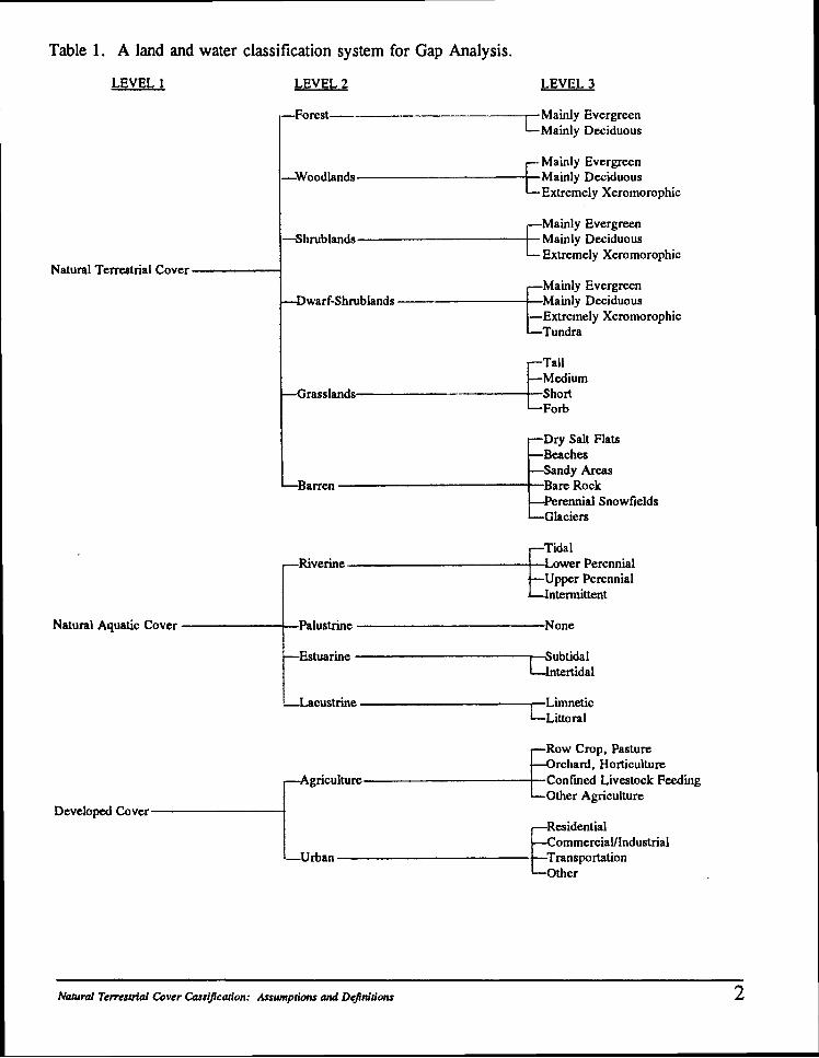
Table 1. A land and water classification system for Gap Analysis.
LEVEL 1 LEVEL 2 LEVEL 3
--Forest-- Mainly Evergreen -Mainly Deciduous
Mainly Evergreen -Woodlands ~ a i n l ~ Deciduous
L ~ x t r e m e l ~ Xeromomphic
Mainly Evergreen -Shrublands Mainly Deciduous
Extremely Xeromorophic Natural Terrestrial Cover
Mainly Evergreen warf-Shrublands Mainly Deciduous
-Extremely Xeromorophic C Tundra
Grasslands Short
ry Salt Flats Beaches
andy Areas
erennial Snowfields
ower Perennial ,--fiverim d r Upper Perennial
ntermittent
Natural Aquatic Cover Palustrine None
t Estuarine p u b t i d a l ntertidal
Row Crop, Pasture rchard, Horticulture
Agriculture
---I Confined Livestock Feeding 4 Other Agriculture
Developed Cover Residential
ommerciau Industrial -Urban Transportation
the r
Natural Temesm'al Cover Cassification: Assumptions and Definitions 2
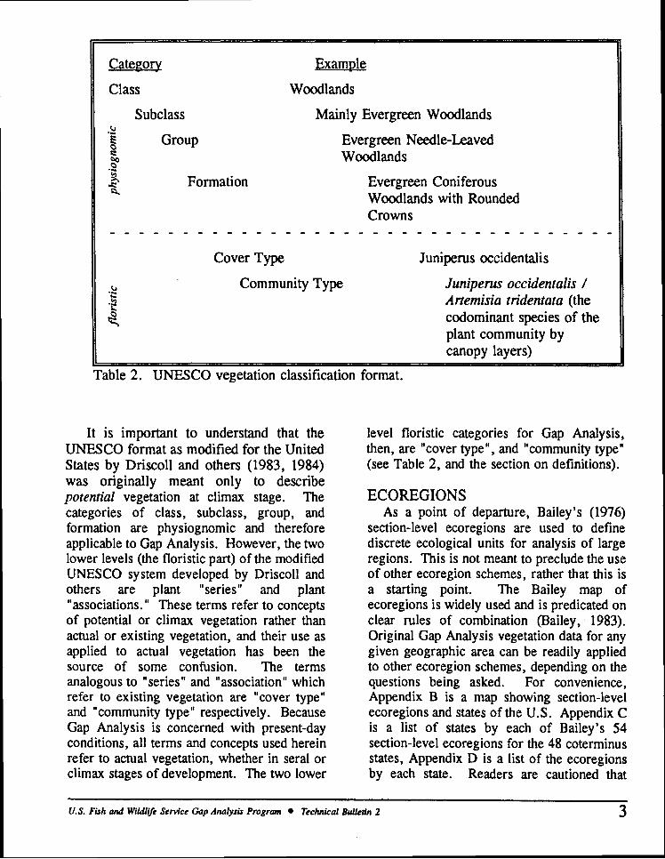
Class Woodlands
Subclass Mainly Evergreen Woodlands
Evergreen Needle-Leaved Woodlands
Evergreen Coniferous Woodlands with Rounded Crowns
~ Cover Type Juniperus occidentalis
Community Type Juniperus occidentalis / Artemisia tridentata (the codominant species of the plant community by canopy layers)
I' '1 Table 2. UNESCO vegetation classification format.
It is important to understand that the UNESCO format as modified for the United States by Driscoll and others (1983, 1984) was originally meant only to describe potential vegetation at climax stage. The categories of class, subclass, group, and formation are physiognomic and therefore applicable to Gap Analysis. However, the two lower levels (the floristic part) of the modified UNESCO system developed by Driscoll and others are plant "series" and plant "associations. " These terms refer to concepts of potential or climax vegetation rather than actual or existing vegetation, and their use as applied to actual vegetation has been the source of some confusion. The terms analogous to "series" and "association" which refer to existing vegetation are "cover type" and "community type" respectively. Because Gap Analysis is concerned with present-day conditions, all terms and concepts used herein refer to actual vegetation, whether in sera1 or climax stages of development. The two lower
level floristic categories for Gap Analysis, then, are "cover type", and "community type" (see Table 2, and the section on definitions).
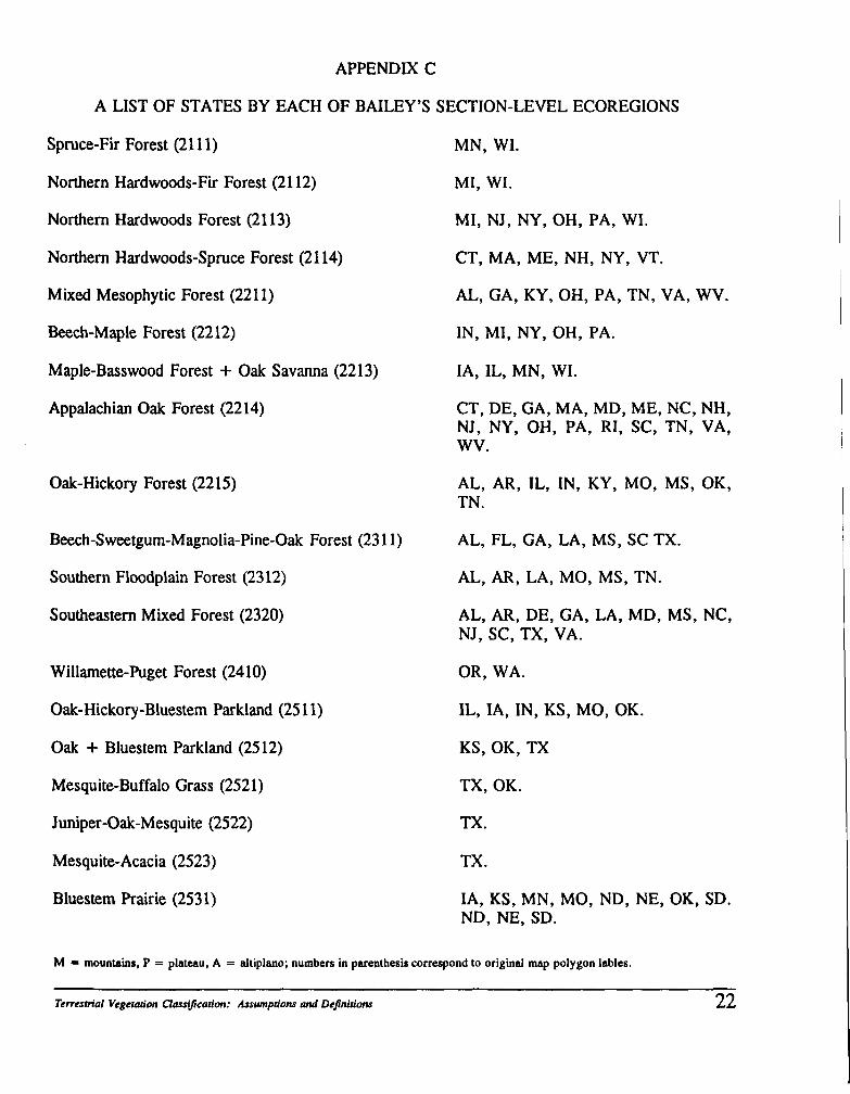
ECOREGIONS As a point of departure, Bailey's (1976)
section-level ecoregions are used to define discrete ecological units for analysis of large regions. This is not meant to preclude the use of other ecoregion schemes, rather that this is a starting point. The Bailey map of ecoregions is widely used and is predicated on clear rules of combination (Bailey, 1983). Original Gap Analysis vegetation data for any given geographic area can be readily applied to other ecoregion schemes, depending on the questions being asked. For convenience, Appendix B is a map showing section-level ecoregions and states of the U.S. Appendix C is a list of states by each of Bailey's 54 section-level ecoregions for the 48 coterminus states, Appendix D is a list of the ecoregions by each state. Readers are cautioned that
U.S. Fish and WiIdliJe Service Gap Analysis Program Technical Bulletin 2 3
Bailey is currently revising the ecoregion map of the United States, based on better information and on an improved understanding of the integrated relationships among climate, land surface, vegetation, and scale, resulting partially from work done to map ecoregions of the continents (Bailey, 1989; personal communication).
ASSUMPTIONS A. All references and applications are made to actual land cover rather than historic land cover or potential climax vegetation.
B. Classifications of natural systems are imprecise; there will always be zones of transition and variants, and vegetation boundaries may not be discrete.
C. The criteria used to define classification categories (e.g., tree savannah = tree canopy cover of 11-25 % over grassland) are general. They are meant as data quality objectives (DQOs, see definitions) as a means for grouping and discussing discrete cover types, from coarse categories such as grasslands to finer categories such as short-grass comniunities composed of bunch grasses.
D. In order to create useful categories across both biotic and geographic scales, it is necessary to use both subdivisions and aggregations. Subdivision begins with a whole and divides it into smaller units according to similarities. Aggregation begins with a set of individual objects and groups them according to similarities. For example, classifications at the regional or landscape level (e.g., evergreen coniferous woodlands with rounded crowns) are based on the physioenomic subdivisions of class, subclass, group, and formation. Classifications at the minimum mapping unit level (e.g., Juniperus occidentalislArtemisia tridentata) are based on a floristic aggregation of associated plant species up to the community type level (Table 2; see definitions).
E. The classification system should fit within and among existing accepted national and international land cover classification systems (e.g., UNESCO and The Nature Conservancy for mapping vegetation, U.S. Fish and Wildlife Service classification of wetlands and deepwater habitats, U.S. Geological Survey classification of land use and land cover).
F. The classification scheme is open- ended. Categories may be added to any of the hierarchical levels (e. g., class, subclass, group, formation) as long as the additions are truly an equivalent category within the given classification level.
G. The classification scheme is intended to be the super-structure upon which information can continuously be placed for meaningful analysis and interpretation. It is assumed that: (a) vegetation patterns will be forever changing; and (b) better and more detailed information will continually be developed and entered into Gap Analysis databases.
H. Although Landsat Thematic Mapper (TM) imagery and its spectral classifications are used as a base map, TM imagery is not the sole source of information for the vegetation classification. Because substantial amounts of ancillary data are used (i.e., air photos, expert knowledge, agency records, digital elevation models, field reconnaissance), the classification system and the overall map products are considered "platform independent" --that is, not constrained or defined only by what can be resolved from TM processing.
I. Because the minimum mapping unit (MMU) is 100 hectares, cover type occurrences smaller than this will not be resolved. If greater resolution is desired for certain objects of interest the MMU may be smaller, for example, an MMU of 40 hectares is often used to resolve riparian areas.
Natural Ternsoid Cover Classiic(~~'on: Assumptiom and DeJnitiom
J. A variety of attributes may be attached to a given label or polygon that are not displayed in map format for Gap Analysis purposes. These attributes are kept in a data layer's attribute table, general information concerning transformations is kept in the data layer's data dictionary.
K. Map products will be useful for purposes other that Gap Analysis alone.
DEFINITIONS The following six definitions of class,
subclass, group, formation, cover type and community type are for the six hierarchical levels of Gap Analysis natural terrestrial cover classification system (Table 2). The class level corresponds to Level 2 (Forests, Woodlands, etc ...) of the overall cover classification scheme shown in Table 1. Subclass corresponds to Level 3 shown in Table 1. Group corresponds to Level 4 (not show in Table l ) , formation to Level 5, cover type corresponds to Level 6, and communty type corresponds to Level 7 of the overall land cover classification system. The following is intended to provide meanings for the classification's terrestrial vegetation hierarchical categories.
Class: Made up of six primary categories for classifying terrestrial cover (e.g., "Woodlands" in Table 2). The first five of these classes represent vegetation cover, the sixth class represents bare ground. The separations between classes representing vegetation are based on the spacing and height of dominant vegetative growth form (see Appendix A). The criteria given are DQOs +I- 5 %. I. Forests: Areas dominated by trees with a total canopy cover of 61 % or more, tree crowns usually interlocking. 11. Woodlands: Areas dominated by trees with a total canopy cover of 26-60 %, most tree crowns not touching each other. An herbaceous or shrub understory, or both, are usually present. An open stand of trees,
sometimes called "open forest. " 111. Shrublands: Areas dominated by shrubs that generally exceed 0.5 meter in height when mature, with a total canopy cover of 26 % or more. A tree canopy cover of 26 % or less may be present. IV. Dwarf-Shrublands: Areas dominated by shrubs rarely exceeding 0.5 meters in height when mature with a total canopy cover of 26 % or more. A tree or larger shrub canopy cover of 26 % or less may be present. This class is sometimes called heaths or heath-like. V. Grasslands: Areas dominated by grass, grass-like, or forb vegetation with a tree or shrub component not exceeding 26 % cover. VI. Barren: Areas where vegetation cover is less than 5 %. This includes dry salt flats, beaches, sandy areas, bare rock, perennial snowfields, and glaciers.
Subclass: Categories within each class comprised of areas in which the main vegetation is morphologically similar. For the classes of forests, woodlands, shrublands and dwarf-shrublands the similarities are based on:
I. evergreen; 11. deciduous; and
111. xeromorphic characteristics.
For the class of grasslands the similarities are based on: I. grass-like plants A. tall, more than 1.0 meter in height; B. medium, from 0.5 to 1.0 meter in height; C. short, less than 0.5 meter in height;
11. forbs.
Group: Categories within each subclass which may be based on any of the following: I. for forests, woodlands, shrublands: A. climate, e.g., tropical, temperate,
subpolar; B. morphology, e.g., broad-leaved
sclerophylous, needle-leaved. 11. for dwarf-shrublands:
A. cover
U.S. Fish and WiIdliJe Service Gap Analysis Program Technical Bulletin 2 5
1. closed canopy in which more than 60 % of the area is covered by dwarf- shrubs
2. open canopy in which 26 to 60 % of the area is covered by dwarf-shrubs;
B. associated forms of vegetation, e.g., mixed with herbaceous plants;
C. climate, e.g., cold, drought; D. morphology, e.g., evergreen,
deciduous. 111. for grasslands:
A. tree or shrub canopy less than 10 % for areas dominated by graminoids;
B. tree canopy or shrub canopy 11 - 25 % for areas dominated by graminoids, e.g., tree or shrub savannah;
C. alpine and subalpine occurrence; D. areas dominated by forbs more than 1
meter in height; E. areas dominated by forbs less than 1
meter in height.
Formation: Categories within each group comprised of areas in which the vegetation similarities are based on any of the following criteria. I. tree size and crown shape: A. giant forests are those more than 50
meters in height having 1. rounded crowns, e.g. Pinus ponderosa 2. conical crowns, e.g. Pseudotsuga
menziesii 3. narrow cylindro-conical crowns, e.g.,
Abies lasiocarps; B. non-giant forests are those 5-50 meters
in height having 1. rounded crowns, e.g. Pinus
ponderosa 2. conical crowns, e.g. Pseudotsuga
menziesii 3. narrow cy lindro-conical crowns, e.g.,
Abies lasiocarps; 11. life zone:
A. temperate lowland B. montane C. alpine D. boreal
111. substrate:
A. alluvial B. serpentine
IV. kinds of associated vegetation, e.g., A. broad-leaved forest with evergreen
needle-leaved trees B. with or without succulents
V. amount and kind of understory, e.g., creeping or matted dwarf-shrubland.
Cover Type: A group of plant community types having the same primary dominant species and similar physiognomy; an aggregation of plant community types.
Community Type: An assemblage of plant species that interact at the same time and place, of defined species composition, and physiognomy, regardless of sera1 stage; usually named by combining the name of the species that dominates the canopy layer with the name of the species that dominates lower vegetation layers (e.g., Juniperus occidentalis /Arternisia tridentata) .
Other terms used in the classification of terrestrial vegetation for Gap Analysis and their definitions follow.
Data Quality Objectives: The accuracy and precision objectives for data representation of location and object attributes.
Dominant or Codominant: Pertaining to the plant species having the greatest relative canopy cover.
Forb: A non-graminoid herb.
Natural Community: A discrete group of plant and animal species that reoccur across a landscape.
Natural Vegetation: Vegetation that is regenerating without cultivation regardless of previous disturbance; not restricted to undisturbed climax vegetation.
Shrubs: Woody perennial plants, usually with
Nclatral Tenvsm'al Cover Classification: Assumptions and Dejhitions
multiple stems, 0.5-5 meters in height at maturity.
Trees: Woody perennial plants, usually single stemmed with definite crown shape and reaching a height of five meters in height when mature.
Xeromorphic: Plants morphologically adapted to dry conditions such as with extremely scleromorphic or strongly reduced leaves, green branches without leaves or succulent stems, some with thorns.
REFERENCES Anderson, J.R., E.E. Hardy, J.T. Roach, and
R.E. Witmer. 1976. A land use and land cover classification system for use with remote sensor data. U.S. Geological Survey Professional Paper 964, U .S. Government Printing Office, Washington, D.C. 28pp.
Bailey, R.G. 1976. Ecoregions of the United States. U.S. Forest Service and U.S. Fish and Wildlife Service. Map b: Description of the ecoregions of the U.S., R.G. Bailey, U.S. Department of Agriculture, 1980, Miscellaneous Publication No. 1391,77pp.
Bailey, R.G. 1983. Delineation of ecosystem regions. Environmental Management, 7(4):365-373.
Bailey, R.G. 1989. Ecoregions of the continents. Environmental Conservation, 16(4):310.
Bourgeron, P.S., and L.D. Engelking. 1992. Preliminary compilation of a series level classification of the vegetation of the western United States using a physiognomic framework. Idaho Cooperative Fish and Wildlife Research Unit, University of Idaho, Moscow. ~ S P P
Cowardin, L.M., V. Carter, F.C. Golet, and E.T. LaRoe. 1979. Classification of wetlands and deepwater habitats of the United States. U.S. Fish and Wildlife Service Office of Biological Services No.
7913 1. U.S. Government Printing Office, Washington, D.C., stock number GPO 024- 010-00524-6. 103pp.
Driscoll, R.S., D.L. Merkel, J.S. Hagihara, and D.L. Radloff. 1983. A component land classification for the United States: status report. U.S Department of the Interior, Bureau of Land Management Technical Note 360, call number BLM-YA- PT-83-001-4340, Denver. 30pp.
Driscoll, R.S., D.L. Merkel, D.L. Radloff, D.E. Snyder, and J.S. Hagihara. 1984. An ecological land classification framework for the United States. U.S.D.A. Forest Service, Miscellaneous Publication 1439, Washington, D.C. 56pp.
Mueller-Dombois, D., and H. Ellenberg. 1974. Aims and methods of vegetation ecology. John Wiley & Sons, New York. 547pp.
Scott, J.M., F. Davis, B. Csuti, R. Noss, B. Butterfield, C. Groves, H. Anderson, S. Caicco, F. D'Erchia, T.C. Edwards Jr., J. Ulliman, and R.G. Wright. 1993. Gap Analysis: Protecting biodiversity using geographic information systems. Wildlife Monograph 123, in press. 141pp.
United Nations Educational, Scientific and Cultural Organization. 1973. International classification and mapping of vegetation. Paris. 35pp.
ACKNOWLEDGEMENTS Many thanks to the following for their help with the development of this Technical Bulletin: Blair Csuti Frank Davis Ken Driese Charles Grymes Donley Kinser Joe Miller Robert Pfister Roland Redmond J. Michael Scott Denise Shaw Chris Stout Dennis White and one anonymous reviewer.
U.S. Fish and Wildlife Senice Gap Analysis Program Technical Bulletin 2 7
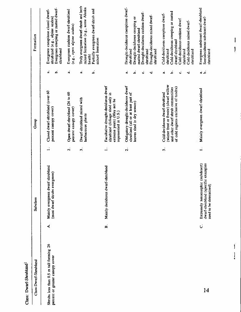
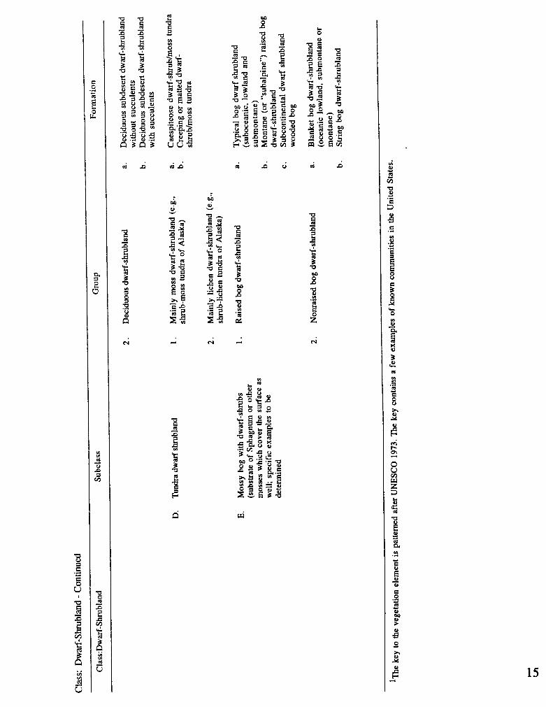
APPENDIX A
A KEY TO NATURAL TERRESTRIAL VEGETATION FORMATIONS'
' ~ r o m Driscoll, R.S., D.L. Merkel, D.L. Radloff, D.E. Snyder, and J. S. Hagihara. 1984. An ecological land classification framework for the United States. U.S.D.A. Forest Service, Miscellaneous Publication 1439, Washington, D.C. p. 21.
Natural Ternstrial Cover Classification: Assumptions and Definitions 8
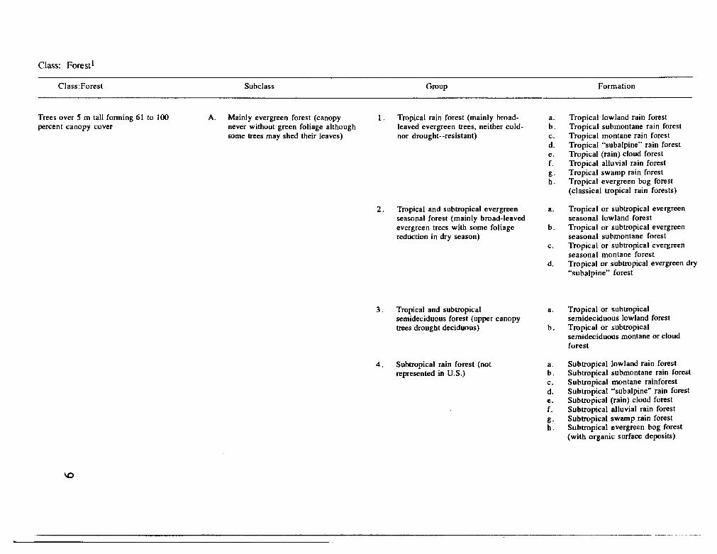
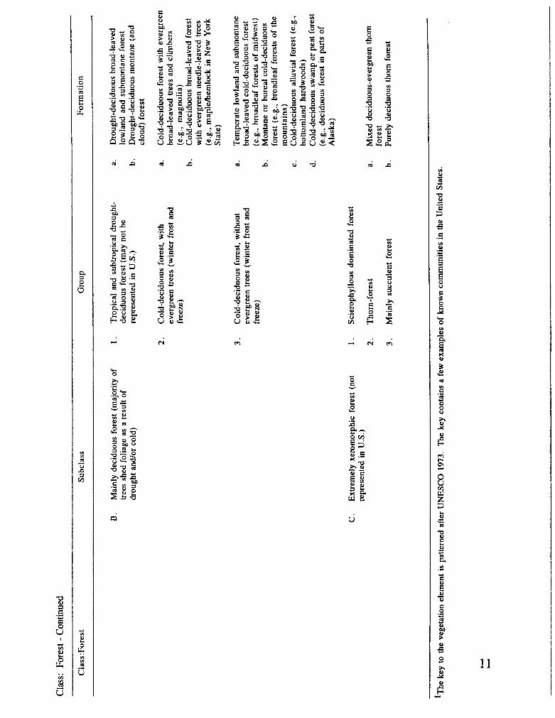
Class: ~orestl
Subclass Group Formation
Trees over 5 m tall forming 61 to 100 A. Mainly evergreen forest (canopy 1 . Tropical rain forest (mainly broad- a. percent canopy cover never without green foliage although leaved evergreen trees, neither cold- b.
some trees may shed their leaves) nor drought--resistant) c. d. e. f. g. h.
2. Tropical and subtropical evergreen a. seasonal forest (mainly broad-leaved evergreen trees with some foliage b. reduction in dry season)
C.
3. Tropical and subtropical semideciduous forest (upper canopy trees drought deciduous)
4. Subtropical rain forest (not represented in U .S .)
Tropical lowland rain forest Tropical submontane rain forest Tropical montane rain forest Tropical "subalpine" rain forest Tropical (rain) cloud forest Tropical alluvial rain forest Tropical swamp rain forest Tropical evergreen bog forest (classical tropical rain forests)
Tropical or subtropical evergreen seasonal lowland forest Tropical or subtropical evergreen seasonal submontane forest Tropical or subtropical evergreen seasonal montane forest Tropical or subtropical evergreen dry "subalpine" forest
Tropical or subtropical semideciduous lowland forest Tropical or subtropical semideciduous montane or cloud forest
Subtropical lowland rain forest Subtropical submontane rain forest Subtropical montane rainforest Subtropical "subalpine" rain forest Subtropical (rain) cloud forest Subtropical alluvial rain forest Subtropical swamp rain forest Subtropical evergreen bog forest (with organic surface deposits)
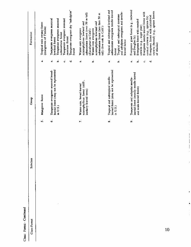
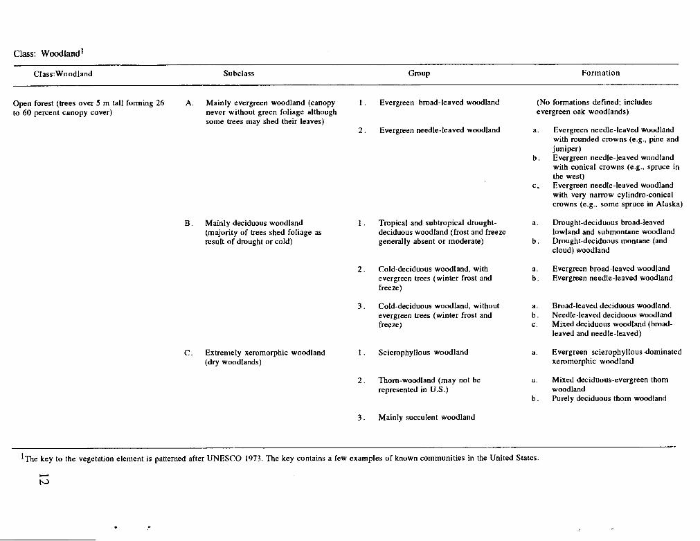
Class: woodland1
Class:Woodland Subclass Group Formation
Open to 60
forest (trees over 5 m tall forming 26 A. Mainly evergreen woodland (canopy 1 . Evergreen broad-leaved woodland (No formations defined; includes percent canopy cover) never without green foliage although evergreen oak woodlands)
some trees may shed their leaves) 2 . Evergreen needle-leaved woodland a. Evergreen needle-leaved woodland
with rounded crowns (e.g., pine and juniper)
b . Evergreen needle-leaved woodland
B . Mainly deciduous woodland 1 . Tropical and subtropical drought- (majority of trees shed foliage as deciduous woodland (frost and freeze result of drought or cold) generally absent or moderate)
2 . Cold-deciduous woodland, with evergreen trees (winter frost and freeze)
3 . Cold-deciduous woodland, without evergreen trees (winter frost and freeze)
C . Extremely xeromorphic woodland 1 . Scierophyllous woodland (dry woodlands)
2 . Thorn-woodland (may not be represented in U.S.)
3 . Mainly succulent woodland
with conical crowns (e.g., spruce in the west)
c, Evergreen needle-leaved woodland with very narrow cylindro-conical crowns (e.g., some spruce in Alaska)
a. Drought-deciduous broad-leaved lowland and submontane woodland
b . Drought-deciduous montane (and cloud) woodland
a. Evergreen broad-leaved woodland b . Evergreen needle-leaved woodland
a. Broad-leaved deciduous woodland. b . Needle-leaved deciduous woodland c. Mixed deciduous woodland (broad-
leaved and needle-leaved)
a. Evergreen scierophyllous-dominated xeromorphic woodland
a. Mixed deciduous-evergreen thom woodland
b . Purely deciduous thom woodland
l ~ h e key to the vegetation element is patterned after UNESCO 1973. The key contains a few exainples of known communities in the United States.
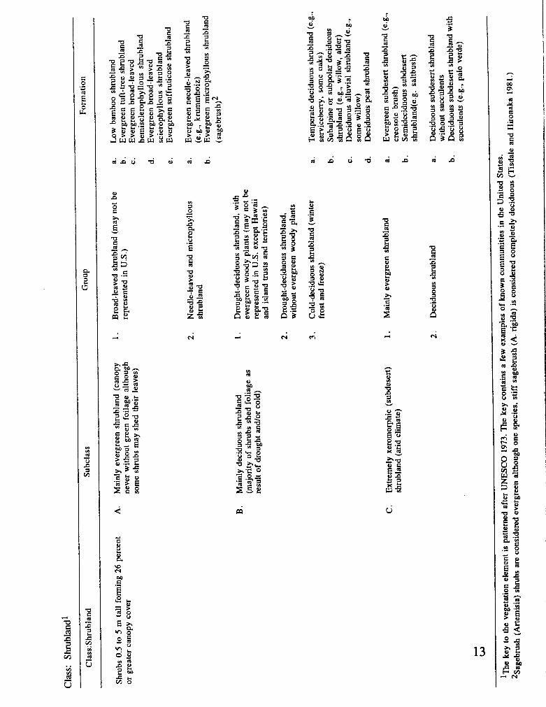
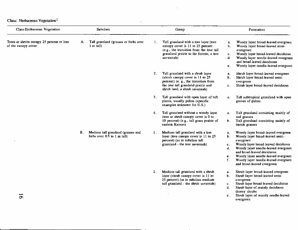
Class: Herbaceous Vegetation l
C1ass:fIerbaceous Vegetation Subclass Group Formation
Trees or shrubs occupy 25 percent or less A. Tall grassland (grasses or forbs over 1 . Tall grassland with a tree layer (tree of the canopy cover 1 m tall) canopy cover is 11 to 25 percent
(e.g., the transition from the true tall grassland prairie to the forests; a tree savannah)
B . Medium tall grassland (grasses and forbs over 0.5 to 1 m tall)
2 . Tall grassland with a shrub layer (shrub canopy cover is 11 to 25 percent) (e. g.. the transition from the true tall grassland prairie and shrub land; a shrub savannah)
3 . Tall grassland with open layer of tuft plants, usually palms (specific examples unknown for U.S.)
4. Tall grassland without a woody layer (tree or shrub canopy cover is 0 to 10 percent) (e.g., tall grass prairie of eastern Kansas)
1. Medium tall grassland with a tree layer (tree canopy cover is 11 to 25 percent) (as in subclass tall grassland - the tree savannah)
2 . Medium tall grassland with a shrub layer (shrub canopy cover is 11 to 25 percent) (as in subclass medium tall grassland - the shrub savannah)
Woody layer broad-leaved evergreen Woody layer broad-leaved semi- evergreen Woody layer broad-leaved deciduous Woody layer needle-leaved evergreen and broad-leaved deciduous Woody layer needle-leaved evergreen
Shrub layer broad-leaved evergreen Shrub layer broad-leaved semi- evergreen Shrub layer broad-leaved deciduous
Tall subtropical grassland with open groves of palms
Tall grassland consisting mainly of sod grasses Tall grassland consisting mainly of bunch grasses
Woody layer broad-leaved evergreen Woody layer broad-leaved semi- evergreen Woody layer broad-leaved deciduous Woody layer needle-leaved evergreen and broad-leaved deciduous Woody layer needle-leaved evergreen Woody layer needle-leaved evergreen and broad-leaved evergreen
Shrub layer broad-leaved evergreen Shrub layer broad-leaved semi- evergreen Shrub layer broad-leaved deciduous Shrub layer of mainly deciduous thorny shrubs Shrub layer of mainly needle-leaved evergreen
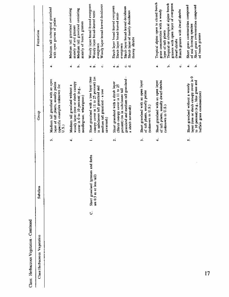
s: Herbaceous Vegetation - Continued - --
C1ass:Herbaceous Vegetation Subclass Group Formation
6 . Mesophytic grassland(a1pine and a. Sod grass communities usually subalpine meadows)(e.g., bluegrass dominated by hemicrtophytes and hairgrass communities) b. Alpine and subalpine meadows of the
higher latitudes
7 . Short grassland tundra (grass tundra a. Bunch forming short grassland of Alaska) tundra
b. Sod forming short grassland tundra
D. Forb-dominated vegetation 1 . Tall forbs (forbs over 1 m tall) (tall a. Mainly perennial flowering forbs, (herbaceous communities with forb forb meadows, Utah mountains) and ferns cover exceeding 50 percent) b . Fern communities especially in
humid climates c. Mainly annual forbs
2 . Low forbs (forbs 1 m or less tall) (Aleutian forb meadows, Alaska)
a. Mainly perennial flowering forhs, and ferns
b. Mainly annual forbs
he key to the vegetation element is patterned after UNESCO 1973. The key contains a few examples of known communities in the United States.
APPENDIX B
A MAP OF BAILEY'S (1976) SECTION-LEVEL ECOREGIONS OF THE UNITED STATES
U.S. Fish and Wildlife Service Gap Analysis Program Technical Bulletin 2 19
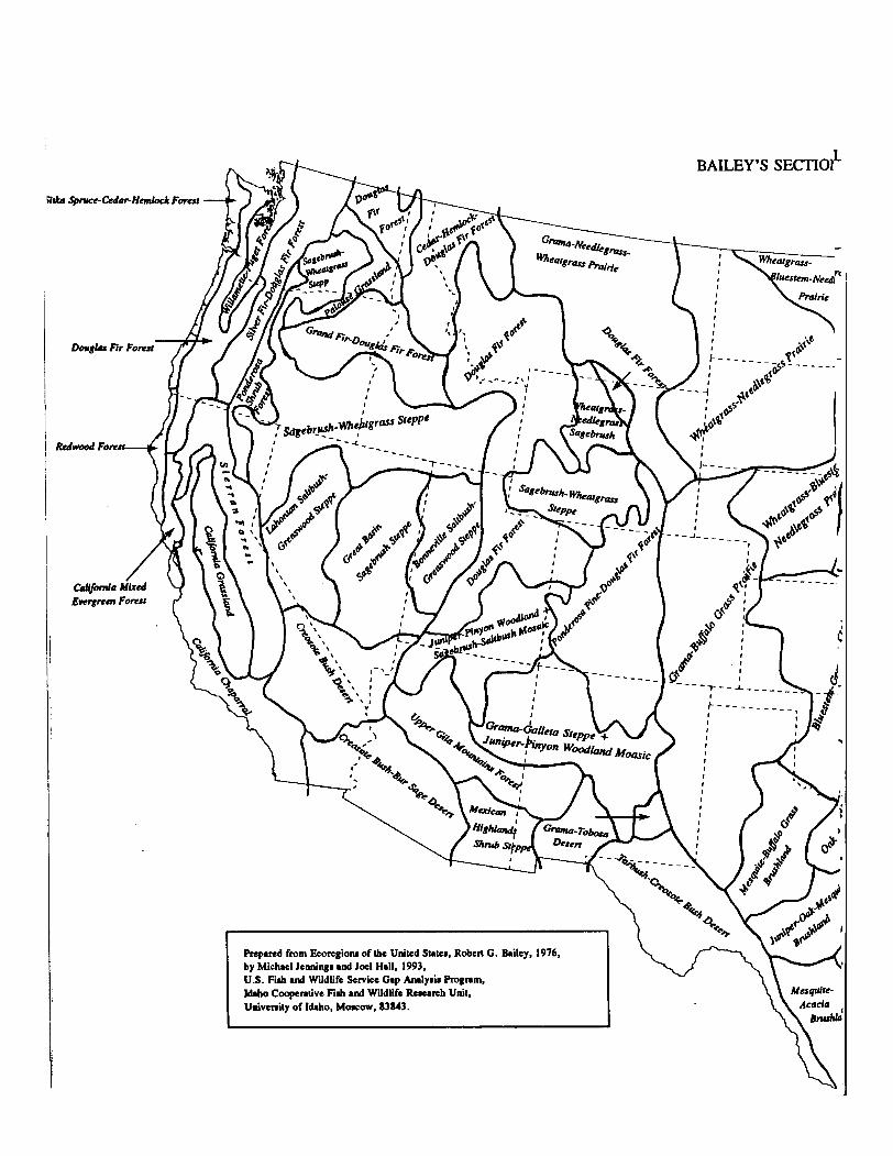
BAILEY'S SECI~O?-
Rcparcd from Ecorcgiona of the United Srrtcr, Robcr( G. Bailey, 1976, by Michael lenninga and Joel Hall, 1993, U.S. Fiah and Wildlife Service Gap Anrlyaia Rognm, Idaho Coopenlive F i l and Wildlife Research Unit, Univenity of Idaho, Moocow, 83843.
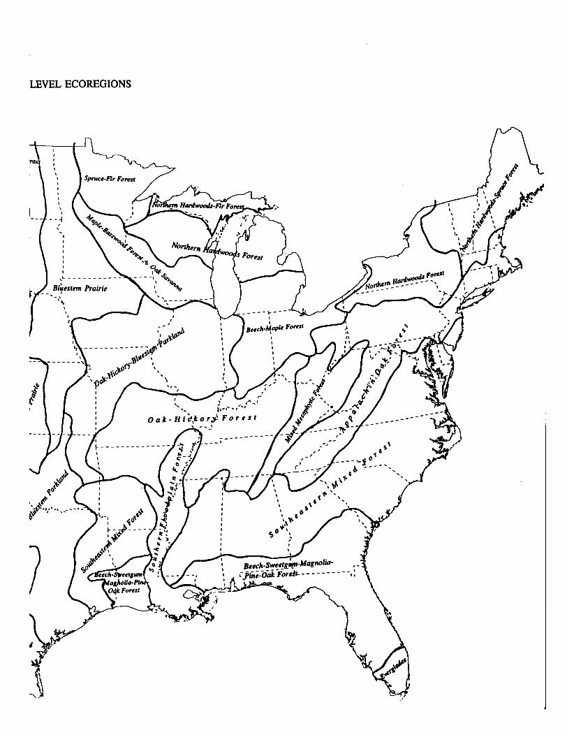
ILEVEL ECOREGIONS
APPENDIX C
A LIST OF STATES BY EACH OF BAILEY'S SECTION-LEVEL ECOREGIONS
Spruce-Fir Forest (21 1 1) MN, WI.
Northern Hardwoods-Fir Forest (21 12) MI, WI.
Northern Hardwoods Forest (21 13) MI, NJ, NY, OH, PA, WI.
Northern Hardwoods-Spruce Forest (21 14) CT, MA, ME, NH, NY, VT.
Mixed Mesophytic Forest (221 1) AL, GA, KY, OH, PA, TN, VA, WV.
Beech-Maple Forest (22 12) IN, MI, NY, OH, PA.
Maple-Basswood Forest + Oak Savanna (22 13) IA, IL, MN, WI.
Appalachian Oak Forest (22 14)
Oak-Hickory Forest (22 15)
CT, DE, GA, MA, MD, ME, NC, NH, NJ, NY, OH, PA, RI, SC, TN, VA, wv.
AL, AR, IL, IN, KY, MO, MS, OK, TN.
Beech-Sweetgum-Magnolia-Pine-Oak Forest (23 1 1) AL, FL, GA, LA, MS, SC TX.
Southern Floodplain Forest (23 12) AL, AR, LA, MO, MS, TN.
Southeastern Mixed Forest (2320) AL, AR, DE, GA, LA, MD, MS, NC, NJ, SC, TX, VA.
Willarnette-Puget Forest (2410) OR, WA.
Oak-Hickory-Bluestem Parkland (25 11) IL, IA, IN, KS, MO, OK.
Oak + Bluestem Parkland (25 12) KS, OK, TX
Mesquite-Buffalo Grass (252 1) TX, OK.
Juniper-Oak-Mesquite (2522) TX.
Mesquite-Acacia (2523) TX.
Bluestem Prairie (2531) IA, KS, MN, MO, ND, NE, OK, SD. ND, NE, SD.
M = mountains. P = plateau. A = altiplano; numbers in parenthesis correspond to original map polygon lables.
Terresmmal Yegemion Clars1~cation: Assumptions and Definitions
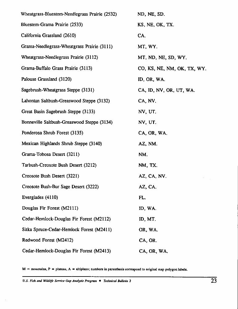
Wheatgrass-Bluestem-Needlegrass Prairie (2532)
Bluestem-Grama Prairie (2533)
California Grassland (2610)
Grama-Needlegrass-Wheatgrass Prairie (31 1 1)
Wheatgrass-Needlegrass Prairie (31 12)
Grama-Buffalo Grass Prairie (3 113)
Palouse Grassland (3 120)
Sagebrush-Wheatgrass Steppe (3131)
Lahontan Saltbush-Greaswood Steppe (3132)
Great Basin Sagebrush Steppe (3133)
Bonneville Saltbush-Greaswood Steppe (3134)
Ponderosa Shrub Forest (3 135)
Mexican Highlands Shrub Steppe (3140)
Grama-Tobosa Desert (32 1 1)
Tarbush-Creosote Bush Desert (3212)
Creosote Bush Desert (3221)
Creosote Bush-Bur Sage Desert (3222)
Everglades (4 1 10)
Douglas Fir Forest (M2111)
Cedar-Hemlock-Douglas Fir Forest (M2112)
Sitka Spruce-Cedar-Hemlock Forest (M2411)
Redwood Forest (M2412)
Cedar-Hemlock-Douglas Fir Forest (M2413)
ND, NE, SD.
KS, NE, OK, TX.
CA.
MT, WY.
MT, ND, NE, SD, WY.
CO, KS, NE, NM, OK, TX, WY.
ID, OR, WA.
CA, ID, NV, OR, UT, WA.
CA, NV.
NV, UT.
NV, UT.
CA, OR, WA.
AZ, NM.
NM.
NM, TX.
AZ, CA, NV.
AZ, CA.
FL.
ID, WA.
ID, MT.
OR, WA.
CA, OR.
CA, OR, WA.
M = mountains. P = plateau, A = altiplano; numbers in parenthesis correspond to original map polygon labels.
U.S. Fish and WiIdliJe Sem'ce Gap Analysis Program Technical Bulletin 2 23
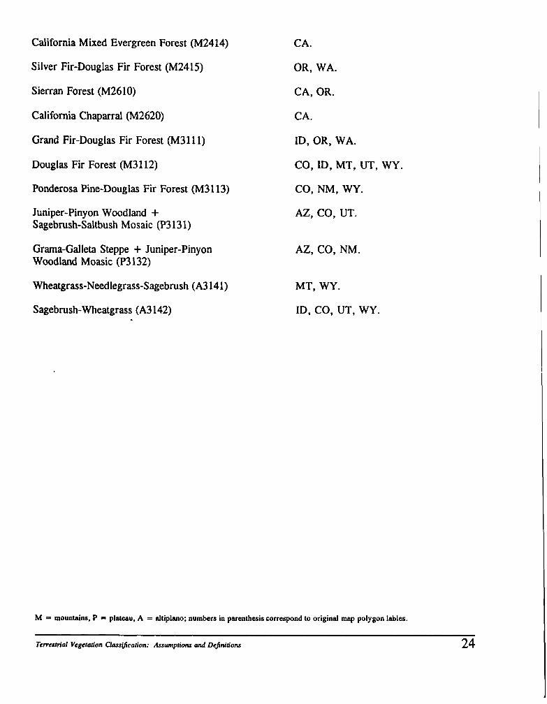
California Mixed Evergreen Forest (M2414)
Silver Fir-Douglas Fir Forest (M2415)
Sierran Forest (M2610)
California Chaparral (M2620)
Grand Fir-Douglas Fir Forest (M3111)
Douglas Fir Forest (M3112)
Ponderosa Pine-Douglas Fir Forest (M3113)
Juniper-Pinyon Woodland + Sagebrush-Saltbush Mosaic (P3 13 1)
Grarna-Galleta Steppe + Juniper-Pinyon Woodland Moasic (P3 132)
Wheatgrass-Needlegrass-Sagebrush (A3 141)
Sagebrush-Wheatgrass (A3 142)
CA.
OR, WA.
CA, OR.
CA.
ID, OR, WA.
CO, ID, MT, UT, WY.
CO, NM, WY.
AZ, CO, UT.
AZ, CO, NM.
MT, WY.
ID, CO, UT, WY.
M = mountains. P = plateau, A = altiplano; numbers in parenthesis correspond to original map polygon lables.
Terrestrial Vegetation Clmsificarion: Assumptions and Definitions 24
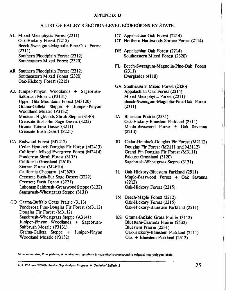
APPENDIX D
A LIST OF BAILEY'S SECTION-LEVEL ECOREGIONS BY STATE.
AL Mixed Mesophytic Forest (221 1) Oak-Hickory Forest (2215) Beech-Sweetgum-Magnolia-Pine-Oak Forest (23 1 1) Southern Floodplain Forest (23 12) Southeastern Mixed Forest (2320)
AR Southern Floodplain Forest (23 12) Southeastern Mixed Forest (2320) Oak-Hickory Forest (2215)
AZ Juniper-Pinyon Woodlands + Sagebrush- Saltbrush Mosaic (P313 1) Upper Gila Mountains Forest (M3120) Grarna-Galleta Steppe + Juniper-Pinyon Woodland Moasic (P3 132) Mexican Highlands Shrub Steppe (3140) Creosote Bush-Bur Sage Desert (3222) Grarna-Tobosa Desert (321 1) Creosote Bush Desert (3221)
CA Redwood Forest (M2412) Cedar-Hemlock-Douglas Fir Forest (M2413) California Mixed Evergreen Forest (M2414) Ponderosa Shrub Forest (3 135) California Grassland (2610) Sierran Forest (M2610) California Chaparral (M2620) Creosote Bush-Bur Sage Desert (3222) Creosote Bush Desert (3221) Lahontan Saltbrush-Greaswood Steppe (3 132) Sagegrush-Wheatgrass Steppe (3 13 1)
CO Grama-Buffalo Grass Prairie (31 13) Ponderosa Pine-Douglas Fir Forest (M3113) Douglas Fir Forest (M3 1 12) Sagebrush-Wheatgrass Steppe (A3141) Juniper-Pinyon Woodlands + Sagebrush- Saltbrush Mosaic (P3131) Grama-Galleta Steppe + Juniper-Pinyon Woodland Moasic (P3132)
CT Appalachian Oak Forest (2214) CT Northern Hardwoods-Spruce Forest (21 14)
DE Appalachian Oak Forest (2214) Southeastern Mixed Forest (2320)
FL Beech-Sweetgum-Magnolia-Pine-Oak Forest (23 1 1) Everglades (41 10)
GA Southeastern Mixed Forest (2320) Appalachian Oak Forest (2214) Mixed Mesophytic Forest (221 1) Beech-Sweetgum-Magnolia-Pine-Oak Forest (23 1 1)
IA Bluestem Prairie (2531) Oak-Hickory-Bluestem Parkland (251 1) Maple-Basswood Forest + Oak Savanna (22 13)
ID Cedar-Hemlock-Douglas Fir Forest (M2112) Douglas Fir Forest (M2 1 11 and M3 112) Grand Fir-Douglas Fir Forest (M3111) Palouse Grassland (3120) Sagebrush-Wheatgrass Steppe (3 13 1)
IL Oak-Hickory-Bluestem Parkland (25 1 1) Maple-Basswood Forest + Oak Savanna (22 13) Oak-Hickory Forest (2215)
IN Beech-Maple Forest (2212) Oak-Hickory Forest (2215) Oak-Hickory-Bluestem Parkland (25 11)
KS Grama-Buffalo Grass Prairie (31 13) Bluestem-Gramma Prairie (2533) Bluestem Prairie (2531) Oak-Hickory-Bluestem Parkland (251 1) Oak + Bluestem Parkland (2512)
M = mountains, P = plateau, A = altiplano; numbers in parenthesis correspond to original map polygon labels.
U.S. Fish and WiIdli/e Sem'cr Gap Analysis Program Technical Bulletin 2
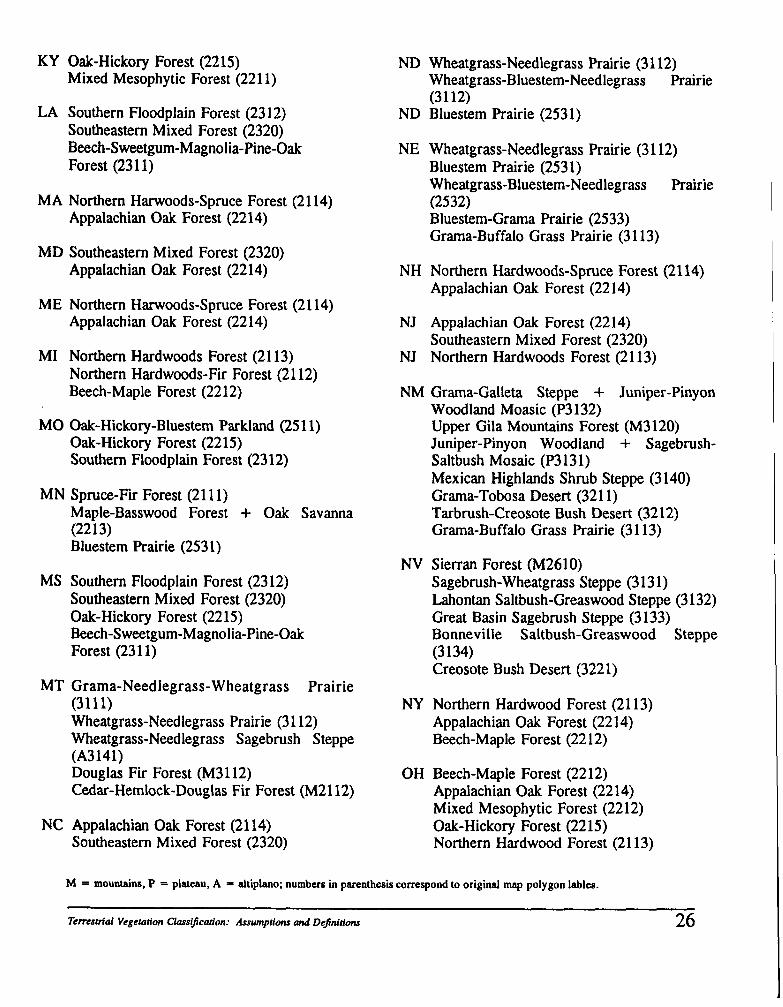
KY Oak-Hickory Forest (2215) Mixed Mesophytic Forest (221 1)
LA Southern Floodplain Forest (23 12) Southeastern Mixed Forest (2320) Beech-Sweetgum-Magnolia-Pine-Oak Forest (23 1 1)
MA Northern Harwoods-Spruce Forest (21 14) Appalachian Oak Forest (2214)
MD Southeastern Mixed Forest (2320) Appalachian Oak Forest (2214)
ME Northern Harwoods-Spruce Forest (21 14) Appalachian Oak Forest (2214)
MI Northern Hardwoods Forest (21 13) Northern Hardwoods-Fir Forest (21 12) Beech-Maple Forest (2212)
MO Oak-Hickory-Bluestem Parkland (251 1) Oak-Hickory Forest (22 15) Southern Floodplain Forest (23 12)
MN Spruce-Fir Forest (21 1 1) Maple-Basswood Forest + Oak Savanna (22 1 3) Bluestem Prairie (253 1)
MS Southern Floodplain Forest (23 12) Southeastern Mixed Forest (2320) Oak-Hickory Forest (22 15) Beech-Sweetgum-Magnolia-Pine-Oak Forest (23 1 1)
MT Grama-Needlegrass-Wheatgrass Prairie (31 11) Wheatgrass-Needlegrass Prairie (31 12) Wheatgrass-Needlegrass Sagebrush Steppe (A3141) Douglas Fir Forest (M3112) Cedar-Hemlock-Douglas Fir Forest (M2112)
NC Appalachian Oak Forest (21 14) Southeastern Mixed Forest (2320)
ND Wheatgrass-Needlegrass Prairie (3 1 12) Wheatgrass-Bluestem-Needlegrass Prairie (31 12)
ND Bluestem Prairie (2531)
NE Wheatgrass-Needlegrass Prairie (3 1 12) Bluestem Prairie (253 1) Wheatgrass-Bluestem-Needlegrass Prairie (2532) Bluestem-Grama Prairie (2533) Grama-Buffalo Grass Prairie (3 1 13)
NH Northern Hardwoods-Spruce Forest (21 14) Appalachian Oak Forest (2214)
NJ Appalachian Oak Forest (2214) Southeastern Mixed Forest (2320)
NJ Northern Hardwoods Forest (2113)
NM Grama-Galleta Steppe + Juniper-Pinyon Woodland Moasic (P3 132) Upper Gila Mountains Forest (M3 120) Juniper-Pinyon Woodland + Sagebrush- Saltbush Mosaic (P3 131) Mexican Highlands Shrub Steppe (3140) Grama-Tobosa Desert (321 1) Tarbrush-Creosote Bush Desert (3212) Grama-Buffalo Grass Prairie (31 13)
NV Sierran Forest (M2610) Sagebrush-Wheatgrass Steppe (3 13 1) Lahontan Saltbush-Greaswood Steppe (3132) Great Basin Sagebrush Steppe (3133) Bonneville Saltbush-Greaswood Steppe (3 134) Creosote Bush Desert (3221)
NY Northern Hardwood Forest (21 13) Appalachian Oak Forest (2214) Beech-Maple Forest (2212)
OH Beech-Maple Forest (22 12) Appalachian Oak Forest (2214) Mixed Mesophytic Forest (2212) Oak-Hickory Forest (2215) Northern Hardwood Forest (21 13)
M = mountains, P = plateau. A = altiplano; numbers in parenthesis correspond to original map polygon lables.
Temsniol Vegetation Chsification: Assumptions and Dejnitions 26
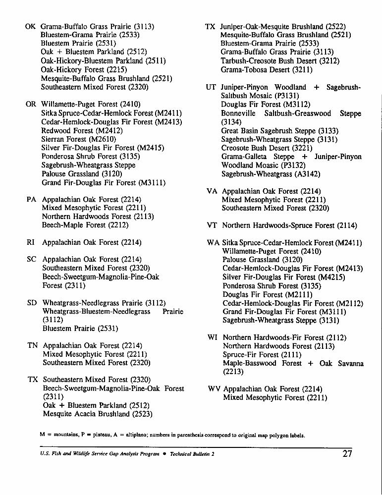
OK Grama-Buffalo Grass Prairie (3113) Bluestem-Grama Prairie (2533) Bluestem Prairie (253 1) Oak + Bluestem Parkland (2512) Oak-Hickory-Bluestem Parkland (251 1) Oak-Hickory Forest (2215) Mesquite-Buffalo Grass Brushland (2521) Southeastern Mixed Forest (2320)
OR Willamette-Puget Forest (2410) Sitka Spruce-Cedar-Hemlock Forest (M2411) Cedar-Hemlock-Douglas Fir Forest (M2413) Redwood Forest (M2412) Sierran Forest (M2610) Silver Fir-Douglas Fir Forest (M2415) Ponderosa Shrub Forest (3135) Sagebrush-Wheatgrass Steppe Palouse Grassland (3 120) Grand Fir-Douglas Fir Forest (M3111)
PA Appalachian Oak Forest (2214) Mixed Mesophytic Forest (221 1) Northern Hardwoods Forest (21 13) Beech-Maple Forest (2212)
RI Appalachian Oak Forest (2214)
SC Appalachian Oak Forest (2214) Southeastern Mixed Forest (2320) Beech-Sweetgum-Magnolia-Pine-Oak Forest (23 1 1)
SD Wheatgrass-Needlegrass Prairie (31 12) Wheatgrass-Bluestem-Needlegrass Prairie (31 12) Bluestem Prairie (253 1)
TN Appalachian Oak Forest (2214) Mixed Mesophytic Forest (221 1) Southeastern Mixed Forest (2320)
TX Southeastern Mixed Forest (2320) Beech-Sweetgum-Magnolia-Pine-Oak Forest (23 1 1)
TX Juniper-Oak-Mesquite Brushland (2522) Mesquite-Buffalo Grass Brushland (2521) Bluestem-Grama Prairie (2533) Grama-Buffalo Grass Prairie (31 13) Tarbush-Creosote Bush Desert (3212) Grama-Tobosa Desert (321 1)
UT Juniper-Pinyon Woodland + Sagebrush- Saltbush Mosaic (P3 131) Douglas Fir Forest (M3112) Bonneville Saltbush-Greaswood Steppe (3 134) Great Basin Sagebrush Steppe (3133) Sagebrush-Wheatgrass Steppe (3 13 1) Creosote Bush Desert (3221) Grama-Galleta Steppe + Juniper-Pinyon Woodland Moasic (P3 132) Sagebrush-Wheatgrass (A3 142)
VA Appalachian Oak Forest (2214) Mixed Mesophytic Forest (221 1) Southeastern Mixed Forest (2320)
VT Northern Hardwoods-Spruce Forest (21 14)
WA Sitka Spruce-Cedar-Hemlock Forest (M2411) Willamette-Puget Forest (2410) Palouse Grassland (3 120) Cedar-Hemlock-Douglas Fir Forest (M2413) Silver Fir-Douglas Fir Forest (M4215) Ponderosa Shrub Forest (3 135) Douglas Fir Forest (M2111) Cedar-Hemlock-Douglas Fir Forest (M2112) Grand Fir-Douglas Fir Forest (M3111) Sagebrush-Wheatgrass Steppe (3 13 1)
WI Northern Hardwoods-Fir Forest (21 12) Northern Hardwoods Forest (21 13) Spruce-Fir Forest (21 11) Maple-Basswood Forest + Oak Savanna (22 13)
WV Appalachian Oak Forest (2214) Mixed Mesophytic Forest (221 1)
Oak + Bluestem Parkland (2512) Mesquite Acacia Brushland (2523)
M = mountains, P = plateau, A = altiplano; numbers in parenthesis correspond to original map polygon labels.
--
U.S. Fish and WiIdliJe Service Gap Analysis Program Technical Bulletin 2 27
WY Sagebrush-Wheatgrass (A3 142) Wheatgrass-Needlegrass-Sagebrush (A3 141) Wheatgrass-Needlegrass Prairie (3 1 12) Grarna-Buffalo Grass Prairie (3 1 13) Ponderosa Pine-Douglas Fir Forest (M3 1 13) Douglas Fir Forest (M3 1 12)
M = mountains, P = plateau, A = altipleno; numbers in parenthesis correspond to original map polygon lables.
Temsmmal Vegeration Clasajication: Assumptions and Defintions 28