nature management and data management
DESCRIPTION
Nature management and Data management. Gudrun Wallentin Florian Fischer Austrian Academy of Sciences Research Unit GIScience. Nature and Data – an old issue?. Alexander v. Humboldt 1769 - 1859. Integrated Management. Protection of biotopes . Protection of species . - PowerPoint PPT PresentationTRANSCRIPT

Nature management andData management
Nature management andData management
Gudrun WallentinGudrun WallentinFlorian FischerFlorian Fischer
Austrian Academy of SciencesAustrian Academy of SciencesResearch Unit GIScienceResearch Unit GIScience

Nature and Data – an old issue?
Alexander v. Humboldt 1769 - 1859
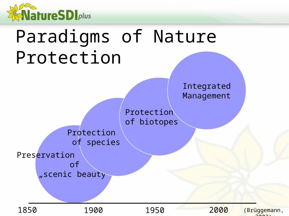
Preservation of
„scenic beauty“
Protection of species
Protection of biotopes
IntegratedManagement
Paradigms of Nature Protection
1850 19501900 2000 (Brüggemann, 2003)

Paradigm Shift for PA Management
1962 2003central administration
individual PAstrict categories
part of a system,corridor
various involved parties, alliances
protection as single purpose
managed like an island
embedded in the region
additional social and economic purposes
state financed scenic beauty increasingly cultural, scientific, economic reasons
financed by diverse resources
managed by experts, academics
preservation also: renaturation, rehabilitation
interdisciplinary teams, cooperation
planning without the local population
reactive management,short planning interval
adaptive management, long-term perspective
management for / including the local population

Integrated Management needs……an integrated view across various
themes ( Spatial information)
…easy solutions to exchange and process spatial information

What is special about spatial?Spatial information integrates
informationen from various themes by geo-reference
Spatial informationen allows a differentiated and comparative view on PAs

Five goals of PA managementNature ProtectionRecreationEducationResearchSustainable Development

Nature protection All activities that conserve or enhance the state and the dynamics of natural landscapes
Need for spatial informationSurvey and monitor the state of species and biotopes.(as-is analysis)Defining „nature-priority“ areas, e.g. Nature2000 network (spatial planning)
Need for spatial information I

Recreation All activities that facilitate or intensify the recreational value of a protected area
Need for spatial information Directing the visitor distribution to maximise the recreational value, and to minimise detrimental impact (visitor management)
Need for spatial information II

Education All activities directed towards a visitor that inform, rise awareness and stimulate critical thinking to evoke nature-friendly behaviour
Need for spatial informationVisualisation is a commonly understandable, often used and powerful tool in environmental education (geovisualisation)
Need for spatial information III

Research All activities to document and monitor the state of a protected area and to contribute to decision making and problem solving
Need for spatial informationProtected areas are an explicitly spatial approach to nature conservation. Thus research activities in protected areas mostly have and can be connected by its geo-component (location matters).
Need for spatial information IV

Sustainable development All activities that contribute to a sustainable coexistence of man and nature in the region of a protected area
Need for spatial information Bringing everything together: top down or with public participation (location connects domain expertise)
Need for spatial information V

Need for Datamanagement in PAs Describing the status-quo Planning and zonation of Protected Areas Management to meet conservation targets Decision-making to assist public authorities,
stake-holders and politicians in their work (e.g. EIA) Monitoring to document changes and control the
success of management measures Information/Involvement of the public
(participation) e.g. database for Biodiversity in the „Haus der Natur“, Salzburg
Reporting to financiers, state authorities, other managers, Alpine Convention, EU
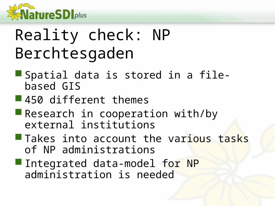
Reality check: NP Berchtesgaden Spatial data is stored in a file-based GIS 450 different themes Research in cooperation with/by external
institutions Takes into account the various tasks of NP
administrations Integrated data-model for NP
administration is needed

NP Berchtesgaden – Data-Structure Need to incorporate
spatio-temporal data Enhancement of
attribute data Easy exchange of
data

Reality check: NP Bavarian Forest Information flow to different
research institutions Information flow between
research and practitioner and the general public
Basic geodata from the BavarianMapping Agency
Aim: Use GIS in all areas of management, also for non-specialists
Processing and distribution of research results for different markets (researchers, forest practitioners, politics, general public) is not without problems.
Operating System
GIS-Hardware (z.B. Digitizer)
GIS-Software
GIS Add ons
Geodatabase
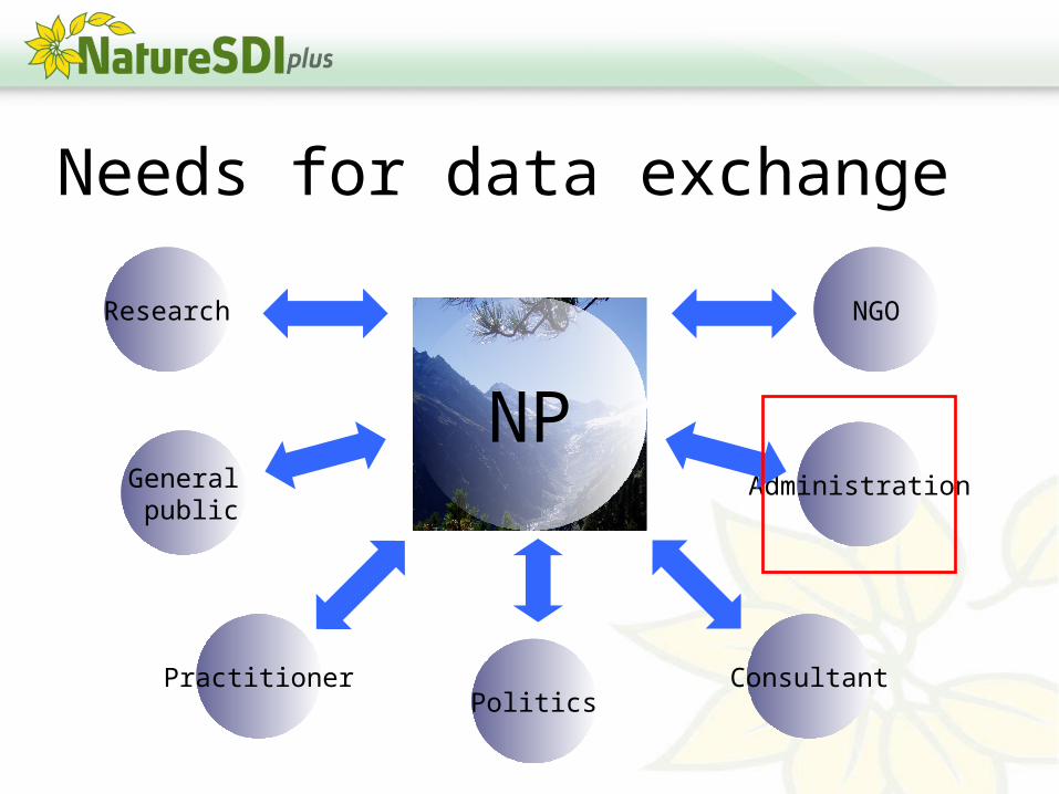
Needs for data exchange
NPResearch
General public
Practitioner Consultant
Administration
NGO
Politics

The administrative perspective
Administration
NP
NP
NP NP NP
NP
NP

Affordances on spatial data in nature-management Accessibility to information about nature for everybody Availability of free data to ensure public access to
public data Data Harmonisation to combine and compare data
from different sources and across borders Semantic data modelling to add meaning to the
provided data Geoprocessing tools to retrieve information from data Adaptive level of scale and detail to answer the
question at hand Usability of the geoportal to facilitate the effective use
also for non-experts Time series to monitor change Possibility of interaction to enable public participation

Problems of data exchange and data retrieval Different formats and different vendors Lost in conversion & lost in translation Search for available data is almost
impossible for external partnersData qualityData usability
Data transfer by email, compact disk? Regular integration of external data in own
GIS system is necessary Updating and versioning

INSPIRE Implementation – a chance Geo-Webservices Standards Harmonisation of data sets Common Application Schemes
Individually extensibleMatching on different user needs
Geoportal (as Geospatial One-Stop)
