navajo nm: an administrative history · navajo nm: an administrative history navajo administrative...
TRANSCRIPT
Navajo NM: An Administrative History
Navajo
Administrative History
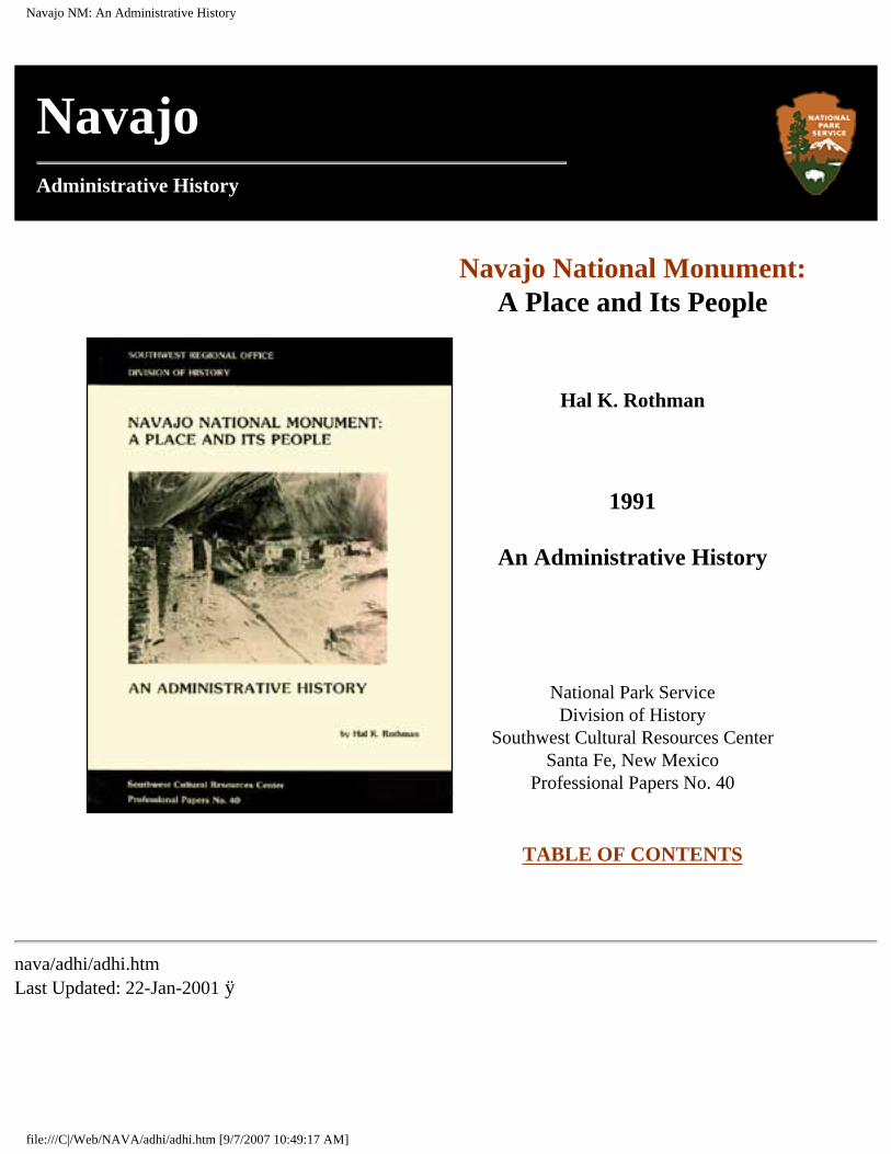
Navajo National Monument:
A Place and Its People
Hal K. Rothman
1991
An Administrative History
National Park Service Division of History
Southwest Cultural Resources Center Santa Fe, New Mexico
Professional Papers No. 40
TABLE OF CONTENTS
nava/adhi/adhi.htm Last Updated: 22-Jan-2001 ÿ
file:///C|/Web/NAVA/adhi/adhi.htm [9/7/2007 10:49:17 AM]
Navajo NM: An Administrative History (Table of Contents)
Navajo
Administrative History
TABLE OF CONTENTS
List of Figures
Acknowledgements
Executive Summary
Chapter I: From Prehistory to the Twentieth Century
Chapter II: Founding Navajo National Monument
Chapter III: The Life of A Remote National Monument 1912-1938
Chapter IV: "Land-Bound": 1938-1962
Chapter V: The Modern Era
Chapter VI: "Partners in the Park": Relations With the Navajo People
Chapter VII: Archeology at Navajo
Chapter VIII: Threats To The Park
Bibliographic Essay
Appendix 1: Important Dates for Navajo National Monument
file:///C|/Web/NAVA/adhi/adhit.htm (1 of 3) [9/7/2007 10:49:18 AM]
Navajo NM: An Administrative History (Table of Contents)
Appendix 2: Superintendents and Their Tenure
Appendix 3: Visitation Totals
Appendix 4: Pertinent Legislation A. Monument proclamation 1909 B. Boundary adjustment 1912 C. Memorandum of Agreement 1962 D. Maps
Index (omitted from on-line edition)
LIST OF FIGURES
Figure 1. The controversial inscription at Inscription House ruin, circa 1915 Figure 2. This photo from 1909 shows how Betatakin appeared to the first parties that arrived in the canyon Figure 3. The old entrance road could be difficult to traverse Figure 4. The new custodian's residence built in 1939 was the first permanent housing at Navajo Figure 5. There were so few buildings at Navajo that the custodian had to have his office in the living room Figure 6. Superintendent John Aubucon looks over the first museum display in the original ranger cabin Figure 7. Inscription House as Jimmie Brewer saw it in 1941 Figure 8. The congested parking are in this 1949 photo reflects the dramatic increase in visitation in the post-World War era Figure 9. The grader was an essential part of keeping the dirt road to the monument open Figure 10. This photo of the new Visitor Center and its surroundings suggests the degree of change that resulted from its construction Figure 11. Navajo Medicine Men prepare to bless the New Visitor Center. From left to right are: Hubert Laughter, Ben Gilmore, Floyd Laughter, and Mailboy Begay Figure 12. Before the Visitor Center, this converted storage shed served as the contact station for visitors at Navajo National Monument Figure 13. Visitors load their horses for a trip to Keet Seel Figure 14. Food or corn grinding place in Betatakin Ruins. Photo by Luke E. Smith, 1921 Figure 15. Betatakin Ruins (hillside house), near Kayenta, Arizona Figure 16. Betatakin Ruins, May 1921. Photos by Luke E. Smith Figure 17. Keet Seel in 1914, after Richard Wetherill's visits, but before stabilization work had been
file:///C|/Web/NAVA/adhi/adhit.htm (2 of 3) [9/7/2007 10:49:18 AM]
Navajo NM: An Administrative History (Table of Contents)
performed Figure 18. CWA workers helped to stabilize Keet Seel in the 1930s Figure 19. Erosion in front of Keet Seel, 1934 Figure 20. Arroyo below Keet Seel, 1976
nava/adhi/adhit.htm Last Updated: 22-Jan-2001 ÿ
file:///C|/Web/NAVA/adhi/adhit.htm (3 of 3) [9/7/2007 10:49:18 AM]
Navajo NM: An Administrative History (Acknowledgments)
Navajo
Administrative History
ACKNOWLEDGMENTS
Any work of history about a specific place requires the cooperation and understanding of the people of that place. First and foremost, I would like to thank Superintendent Clarence N. Gorman and his staff at Navajo National Monument. My contact person there, Bruce Mellberg, provided untold assistance. He dug up maps, called my attention to obscure pieces of information, closely read the manuscript, and generally served as an extra set of eyes and ears. Such dedication makes the task of the historian much easier. Others at the monument, including Noberto Ortega, John Laughter, Delbert Smallcanyon, Flora Ortega, and Rose James also provided much appreciated assistance. Superintendent Gorman kindly translated interviews for me, and conducted a number of additional ones in my absence. Former park personnel including Bob Black, Hubert Laughter, Floyd Laughter, Seth Bigman, Eddie Clitso, Eddie Watson, and John Loliet all graciously allowed themselves to be interviewed. Former superintendents and rangers Frank Hastings, Bill Binnewies, Robert Holden, P. J. Ryan, and Bud Martin offered their views by letter, phone, or in person. Special thanks are due to John Cook, Art White, and Charlie Voll, all of whom put up with interviews that went on far too long. Jeffrey Dean of the Laboratory of Tree Ring Research also granted an interview, providing much enlightening information about Anasazi life at the monument. Scott Travis allowed me to make use of a draft verison of his work. Southwest Regional Historian Neil Mangum helped at every opportunity, providing information, attending to administrative details, and generally allowing me to be a historian. Many thanks to all of these people.
My partner, Richard B. McCaslin, also deserves credit for his work. He did the bulk of the documentary research on this project, traveling to Texas, Colorado, and Arizona in zealous pursuit of the details of this story. Rick is a true professional whose commitment to history is unsurpassed. Kami Patterson read and copyedited a draft of this manuscript. Joe Lennihan and Cathy Hoover drove me 200 miles over ice-covered roads in a snowstorm to assure that I would make it to the monument to meet my interviewees. I did, and as time passes, the drive seems less harrowing. Many thanks to all of you as well.
Finally, one person has had more influence on me than any other. My wife, Lauralee, has put up with an absent and distracted husband asking strange questions of her for the better part of two years. I appreciate her patience, which I have surely taxed, her curiosity, and her willingness to listen. Late in this project, our daughter, Talia, was born. Someday I hope to reward the two of them by taking them on
file:///C|/Web/NAVA/adhi/adhi0a.htm (1 of 2) [9/7/2007 10:49:19 AM]
Navajo NM: An Administrative History (Acknowledgments)
a trip to Keet Seel.
TABLE OF CONTENTS
nava/adhi/adhi0a.htm Last Updated: 22-Jan-2001
file:///C|/Web/NAVA/adhi/adhi0a.htm (2 of 2) [9/7/2007 10:49:19 AM]
Navajo NM: An Administrative History (Executive Summary)
Navajo
Administrative History
EXECUTIVE SUMMARY
Located in northeastern Arizona, Navajo National Monument is anomalous among national park areas. The monument contains three distinct and non-contiguous sections, administered from one headquarters. The three sections of the monument, Betatakin, Keet Seel, and Inscription House, are surrounded by the Navajo reservation. Dating from the 13th century C. E., they contain the primary representation of the Kayenta Anasazi within the national park system. Yet because of their location and the distance between the three areas, Navajo National Monument is an inholding on the Navajo reservation.
This condition has created a level of interdependence unequaled elsewhere in the national park system. The monument and its neighbors depend on each other for mutual sustenance. The park provides a range of services not otherwise available as well as significant employment opportunities to the people of the Shonto region. Through a complex series of formal agreements and customs, local Navajos support the park and participate in its activities.
Like many other smaller southwestern national monuments, Navajo developed slowly. At its inception, the Park Service had few resources, most of which were used to improve national parks. Navajo National Monument had only a volunteer custodian from its establishment in 1909 until 1938. New Deal development bypassed the monument, and despite the construction of basic facilities, at the end of the 1950s Navajo remained a remote place, inaccessible to most of the traveling public.
The initiation of the MISSION 66 program in the 1950s and an extensive road construction program by the Navajo Nation ended the historic isolation of the monument. MISSION 66 planned an extensive development for Navajo, but the plans were held in abeyance until an adequate area of land on which to build a visitor center could be acquired. A complicated series of attempts to arrange a transfer of land followed, resulting in the Memorandum of Agreement of May 1962. This allowed the Park Service to add 240 acres for development of facilities.
The addition of the land transformed the monument. Beginning in 1962, a comprehensive capital development program ensued. The physical plant of the monument was constructed, and Navajo National Monument became a modern park area. Its ability to offer services increased dramatically, and
file:///C|/Web/NAVA/adhi/adhi0b.htm (1 of 2) [9/7/2007 10:49:20 AM]
Navajo NM: An Administrative History (Executive Summary)
with the completion of paved roads to the Visitor Center in 1965, the number of visitors increased exponentially. Navajo had the facilities, but its resources remained limited.
The result of the transformation made the interdependence of the monument and its neighbors even more important. As the funding available to the park leveled off, the monument became more and more of an outpost. Good relations with the people of the area were critical, and a string of superintendents worked to assure harmonious interaction. By the 1980s, the monument had become an important cog in its neighborhood, a fixture in the sociocultural and economic structure of the Shonto region.
While the distance between the three areas posed administrative problems, the real threat to Navajo National Monument came from the lack of resources available to the Park Service. As the 1990s began, the federal deficit and the economic climate in the U.S. limited the funding the monument received and consequently the level of service that it could offer visitors. With fragile archeological resources that required both protection and maintenance, the monument had an expensive mission. Without adequate support, the Park Service could not genuinely perform the duties assigned in the authorizing legislation.
TABLE OF CONTENTS
nava/adhi/adhi0b.htm Last Updated: 22-Jan-2001
file:///C|/Web/NAVA/adhi/adhi0b.htm (2 of 2) [9/7/2007 10:49:20 AM]
Navajo NM: An Administrative History (Chapter 1)
Navajo
Administrative History
CHAPTER I: FROM PREHISTORY TO THE TWENTIETH CENTURY
The road to Navajo National Monument winds its way up from Highway 160, the artery connecting Tuba City and Kayenta, Arizona. Up and up the car seems to travel, slowly gaining altitude. Often in the winter, the turnoff in the valley will be free of snow. Up the nine miles to the monument, the snow becomes thicker and thicker, testimony to the dependence on the natural environment and the difficulty that characterizes life in this region. These relationships epitomize the modern and prehistoric story of Navajo National Monument.
Located in the heart of the western section of the Navajo reservation, Navajo National Monument comprises three sections, none of which are contiguous. The main section, referred to by the name of the cliff dwelling it was established to protect, Betatakin, includes 160 acres of government land and a 244.59-acre section of land used under the terms of an agreement with the Navajo Nation. The Keet Seel section, about eight miles cross-country from Betatakin, contains one of the most important large Pueblo ruins in the Southwest within its 160-acre boundary. Inscription House, the third section and also named for its primary ruin, is forty miles away in Nitsin Canyon. [1]
The Colorado Plateau, the setting for the monument, has an unusual impact on people. It is haunting, for the region contains some of the most threatening and striking landscape in the U.S. Rugged and beautiful, its stark outlines and muted colors reflect the difficulty of human endeavor in this unforgiving region. Encompassing part of each of the four corners states, the plateau contains a number of smaller physiographic provinces. One of these, the Navajo section, contains the Shonto Plateau, which surrounds the canyon systems that make up Navajo National Monument. [2]
The Colorado Plateau has a unique geologic history that defines the character of the land and consequently the nature of human life upon it. To the modern human eye, the land appears barren, without promise. It offers few of the features that people of the modern world covet. Its rugged nature required the application of massive modern technologies to even partially subdue, and that endeavor remains far from complete. To the untrained, the plateau and its components are a mystery. Yet in its
file:///C|/Web/NAVA/adhi/adhi1.htm (1 of 3) [9/7/2007 10:49:21 AM]
Navajo NM: An Administrative History (Chapter 1)
landscape is a record of the natural environments that preceded the present.
During the lower to middle Triassic period about 225 million years ago, the portion of the Colorado Plateau that contains Navajo National Monument was a vast basin into which the drainage from surrounding highlands flowed. Within the next twenty million years, the plateau was transformed from a shallow sea into a great inland desert not unlike the modern Sahara Desert. Deposits of wind-blown sand piled into enormous dunes that covered the region, forming a massive sandstone layer more than 300 feet in depth.
At the beginning of the subsequent Jurassic period, a brief wetter era was supplanted by the sudden reappearance of arid, desert-like conditions. Navajo Sandstone, as much as 1,000 feet deep in fossilized cross-bedded sand dunes, was the primary feature of this time. Apparently supporting little biotic life, this 25-million-year era ended with the emergence of a new regime, characterized by extensive tidal flats that periodically covered the landscape.
During that new era, the 125 million years that composed the remainder of the Jurassic and Cretaceous periods, large faunal life and a complex animal community appeared. Attracted by the abundance of small animals and plants, dinosaurs and other large creatures began to inhabit the swampy fringes of the region. As the end of the Jurassic Period neared, a more temperate climate appeared.
A marine environment followed the temperate one, inundating tidal flats with advancing beaches and shallow seas. The late Mesozoic environments, characterized by Dakota sandstone and Mancos Shale, played a significant role in shaping modern landscapes throughout the region. This era created layers of deposits, one atop the other, many of which are in evidence across the Colorado Plateau.
The geologic structure of the region changed dramatically after the series of deposits. In a geologic instant, region-wide orogenic uplift caused the creation of plateaus and monoclinal folds, which in turn changed as a result of volcanism and erosion. The existing river drainages, home to most prehistoric habitation, were the result, and the general outline of the modern plateau was formed.
The area that became Navajo National Monument represents many of these moments in the geologic past. Its lowest elevations show the Wingate Formation, the 300-foot-deep sandstone formed during the time nearly 200 million years when the region was a great inland desert. The red and purple sandstones of the Moenave and Kayenta formations are also present in the monument, as is the Navajo Sandstone of the beginning of the Jurassic period, more than 190 million years ago. These are the rocks so exquisitely shaped by wind, rain, snow, and sun. [3]
In geologic time in the American Southwest, Navajo National Monument represents a middle period between the much older Grand Canyon environment and the younger Mesa Verde Group. Tsegi Canyon itself has eroded into a series of Triassic-Jurassic rock layers, making it look more open and less vertical than nearby places such as Canyon de Chelly. The principal formations within the monument all have differing degrees of resistance to erosion, which helped create the relatively open look of Tsegi Canyon
file:///C|/Web/NAVA/adhi/adhi1.htm (2 of 3) [9/7/2007 10:49:21 AM]
Navajo NM: An Administrative History (Chapter 1)
as well as the rock shelters in which Keet Seel and Betatakin ruins stand. Most of the rock shelters in the monument are at the base of the Navajo sandstone layer, the opposite of such places as Mesa Verde, where alcoves form on the upper reaches of Cliff House Sandstone. [4]
Tsegi Canyon is the primary drainage of the eastern part of the Shonto Plateau. The canyon contains three major branches and countless side branches, all cut deeply into the Navajo sandstone characteristic of the area. Betatakin and Keet Seel are located in two of the arteries of the canyon, while the side canyons contain numerous other prehistoric ruins.
CONTINUE >>>
nava/adhi/adhi1.htm Last Updated: 22-Jan-2001
file:///C|/Web/NAVA/adhi/adhi1.htm (3 of 3) [9/7/2007 10:49:21 AM]
Navajo NM: An Administrative History (Chapter 2)
Navajo
Administrative History
CHAPTER II: FOUNDING NAVAJO NATIONAL MONUMENT
The establishment of Navajo National Monument was a direct result of the professionalization of science in the U.S. and the move by Anglo-Americans in the late nineteenth century to settle the Southwest. As more and more people came to the region, the subsurface and above ground ruins of prehistoric cultures fell prey to callous and avaricious hands. Prehistoric pots were smashed for sport and the walls and building stones of ruins were dismantled for use in newer structures. In the era of the end of American perception of a westward frontier, it seemed to many that the remnants of an important cultural heritage were being wantonly destroyed.
Nowhere was this feeling stronger than among the denizens of the subfields of anthropology and archeology. Beginning with the founding of the Bureau of Ethnology in 1879, interest in American prehistory grew in influential circles. By the 1890s, with the end of the frontier accepted as dogma, concern for the preservation of the past gained momentum. For aspiring professionals in the twin fields of anthropology and archeology, the preservation of antiquities offered a crucible in which to prove the value of their work to the scientific community and the public at large. [1]
The study of prehistoric and American Indian people had great value to Americans at the end of the nineteenth century. Since the end of the Civil War, American society had been transformed by industrialization, seemingly overrun with immigrants, and appeared to have lost much of the democratic virtue the founding fathers envisioned. The last decade of the century embodied a search for order that became the Progressive movement. Using the theories of Lewis Henry Morgan, the founder of modern anthropology in the U.S., anthropologists and archeologists could present the scholarly study of Indians and their prehistoric antecedents as affirmation that the world had not gone haywire. In the long view, they asserted, this evolutionary stage, however dislocating and uncomfortable, provided evidence of the superiority of the American achievement. [2]
Simultaneously, a rush to conserve the natural resources of the American West began. The general acceptance of the end of the frontier meant that the idea of scarcity entered the American lexicon. A nation with no more room to expand had to more wisely use the resources available to it. The "wear-out-
file:///C|/Web/NAVA/adhi/adhi2.htm (1 of 2) [9/7/2007 10:49:22 AM]
Navajo NM: An Administrative History (Chapter 2)
the-farm-and-move-on" ideal of the nineteenth century ceased to be acceptable as legislators and officials in government agencies began to pay closer attention to the management of resources. Legislation such as Amendment 24 of the General Revision Act of 1891, which allowed the president to establish forest reserves (national forests) from the public domain with the stroke of a pen, was one kind of result. Stepped-up efforts by the General Land Office of the Department of the Interior to survey and assess the resources of federal lands in the Southwest and West was another.
This move resulted in greater awareness of the vast quantity of prehistoric remains in the Southwest at the very moment federal officials began to implement systematic programs to manage and administer western resources. Conservation, the idea of wise use, gained a strong following in the federal bureaucracy long before it emerged as a priority of Theodore Roosevelt's administration. Under this loose rubric, there was also room for the preservation of prehistory. Beginning in the 1890s, there were piecemeal efforts to preserve individual ruins. One such measure authorized the Casa Grande Ruin Reservation in 1889. With the influence of prominent easterners and the power of John Wesley Powell, head of the Bureau of American Ethnology, an entity established to promote understanding of native cultures, the move to preserve prehistory gathered momentum. Anthropologists and archeologists hurried to the Southwest to experiment with their waiting crucible.
Ironically, at the beginning of an era stressing the management of natural resources by trained experts, there were no laws that protected other kinds of treasure in the West. Experts similar to those who clamored for regulations in forestry and hydrology competed vigorously for access to prehistoric artifacts and structures to enhance the position of their institution among its peers. Blind to conflict of interest and resulting depredation, federal and private excavators hurried to enhance their personal reputations. While natural resources required scientific management to insure fair distribution and continued availability, non-renewable cultural resources were pillaged wholesale. Issues of public good had not yet emerged from the chaos of the transition to an industrial society.
CONTINUE >>>
nava/adhi/adhi2.htm Last Updated: 22-Jan-2001
file:///C|/Web/NAVA/adhi/adhi2.htm (2 of 2) [9/7/2007 10:49:22 AM]
Navajo NM: An Administrative History (Chapter 3)
Navajo
Administrative History
CHAPTER III: THE LIFE OF A REMOTE NATIONAL MONUMENT 1912-1938
In the first decade of the twentieth century, proclamation of a national monument had none of the connotations of the modern park system. A proclamation was an announcement to law-abiding citizens that an area was reserved. It contained no clauses concerning development or funding, staffing, or use. A reserved area meant exactly that: an area protected from land patents, mineral claims, and other forms of officially authorized settlement.
A kind of protection best described as "warning sign" preservation developed as a result of the proclamations of this era. [1] Despite the hullabaloo surrounding Navajo National Monument, the interest of scientists, the Smithsonian Institution, and the formal structure of government science, no formal system of protection arose. John Wetherill remained the nominal custodian, and while he took an active interest in the fate of the ruins of the Tsegi Plateau, he was also involved in numerous other activities. Like the vast majority of national monuments, Navajo remained subject to the wind and rain, the depredations of passers-by, and the intermittent interest of officialdom. Ignored by the federal bureaucracy, places like Navajo National Monument were best protected by their remote location.
In the middle of the western Navajo reservation, far from the railroads and roads that increasingly traversed the West, Navajo National Monument was out of the mainstream of the twentieth century. As yet poorly mapped and surveyed, it was inaccessible to the principal arteries of travel, the nearest of which was the railroad spur from Williams, Arizona, to the Grand Canyon, built at the beginning of the century. Yet from Flagstaff or the Grand Canyon to the Marsh Pass area was still a significant distance--more than one hundred miles. In addition, trails to the region were poorly marked. Most of the people that used them knew the way and had little reason to place signs for outsiders. Only the hardiest and most adventuresome of mainstream Americans endured the long trip from civilization to the ruins. Archeologists composed the majority of visitors, for they had more or less free run of the monument. Most other visitors who did make the trip had a pre-existing interest in archeology. Few people simply wandered up to the monument in this era.
file:///C|/Web/NAVA/adhi/adhi3.htm (1 of 3) [9/7/2007 10:49:24 AM]
Navajo NM: An Administrative History (Chapter 3)
This inaccessibility and lack of formal protection characterized Navajo National Monument for the subsequent quarter of a century. The federal agencies responsible for the monument, including the National Park Service, allocated few resources for Navajo. There was no live-in caretaker, nor were structures or quarters constructed. Formal interpretation did not exist, nor did the kind of infrastructure that brought people to a park area. As a result, Navajo remained among the least developed national monuments, an example of both the advantages and drawbacks of warning sign preservation.
In 1912, the General Land Office retained responsibility for Navajo National Monument and the other places in the monument category. Perennially understaffed and possessed of a reputation for corruption, the GLO had a vast range of management responsibilities in the West. Its special agents reported on conditions in the monuments as well as on land claims, homestead patents, the disposition of natural resources, and a range of other activities. [2] In the view of the bureau, individual national monuments were far from positions of primacy in the system.
As a result, much of the interest in Navajo emanated from the Smithsonian Institution, the Bureau of American Ethnology, and the archeologists interested in the region. Neil Judd, Byron Cummings' nephew and assistant, took a job at the U. S. National Museum in Washington, D. C., bringing him in contact with the leading people in federal science and building links between what had formerly been the western archeological community and the powers in Washington. [3] As the divergent viewpoints in archeology came closer together and younger scientists like Judd bridged remaining gaps, the distinctions drawn by people like William B. Douglass became less important. A decrease in competition and rivalry resulted.
GLO special agents in the West also paid closer attention to the resources in their care after 1910. Their job had evolved from pointing out the salient features of the western landscape to suggesting ways for its utilization. By 1916, two different special agents, Roy G. Mead in 1914 and W. J. Lewis in 1916, had visited the monument and filed reports on the conditions there.
The reports showed the situation and predicament of Navajo National Monument. Betatakin and Keet Seel showed signs of excavation, while Inscription House appeared to be in the poorest condition of the three. Mead recognized that the differences in construction materials and the open nature of the ruins there contributed to the situation at Inscription House. Both Keet Seel and Betatakin were protected from the elements by the natural overhangs above them.
Cummings appeared to be the person responsible for most of the excavations at Keet Seel and Betatakin. In 1914, Mead attributed work at both to Cummings, who held permits from the Department of the Interior, but also suggested that even the first-rate custodial care provided by John Wetherill was not enough to protect the ruins. Because he was not on the premises, Wetherill could only deter vandalism when he visited the area. At other times, anyone who happened by could do as they pleased.
Mead also articulated visitation as an objective. This followed from Fewkes' suggestion in 1910 that either Betatakin or Keet Seel be reserved as a type ruin. Mead suggested that ladders be installed at both
file:///C|/Web/NAVA/adhi/adhi3.htm (2 of 3) [9/7/2007 10:49:24 AM]
Navajo NM: An Administrative History (Chapter 3)
Betatakin and Keet Seel and construction of a "goat-proof" fence for the base of the cliff below Inscription House. There was also need for guest registers to keep track of the people who visited the ruin. [4] In the eyes of federal agents charged with evaluating land, despite the remote location of the monument, it had potential.
When he visited Navajo late in June 1916, W. J. Lewis came to similar conclusions. The national monument was a "permanent institution," he declared, designed for educational purposes. The monument had to be accessible and useful for those purposes. This required better marking of trails to the ruins and a sign indicating that these ruins were within the boundaries of a federal reserve. The worsening condition of walls in the ruins led Lewis to suggest Cummings, who had served as his guide, as the logical man to supervise restoration at Navajo. He also recommended some trail work to make the Tsegi Canyon trails easier for visitors. [5]
Ironically, one of the issues that Lewis' report pointed out was how poorly the boundaries of the monument protected the wide range of cultural resources in the area. Other important sites were not reserved. Typical of these were Twin Caves ruin and Bat Woman cave, excavated by Cummings in 1912 and 1913. Cummings indicated to Lewis that the two areas were worthy of inclusion in the monument, and Lewis advocated the addition. The limits of the haphazard original proclamation were once again apparent.
Even in 1916, three non-contiguous ruins in one monument meant that any management of Navajo would be fraught with complications. Centralized administration and protection were difficult, for forty miles separated Inscription House from Betatakin and Keet Seel, eight miles apart. Despite the creation of one monument for the three ruins, their fate was linked mostly on paper. Each would require separate trails, approaches, and ultimately protection. Even John Wetherill could not effectively supervise all three at any one time. He informed Lewis that he was powerless to prevent vandalism to the ruins.
Lewis also clearly articulated visitation as an objective for the monument. He perceived a trip to the monument as a benefit for high school or college classes. He advocated printing descriptive fliers for each unit of the monument, an early form of interpretation, and leaving them by the register for visitors to take. "It would seem," Lewis concluded his report, "that a month spent in this vicinity by a class would be the finest kind of educational experience." [6]
CONTINUE >>>
nava/adhi/adhi3.htm Last Updated: 22-Jan-2001
file:///C|/Web/NAVA/adhi/adhi3.htm (3 of 3) [9/7/2007 10:49:24 AM]
Navajo NM: An Administrative History (Chapter 4)
Navajo
Administrative History
CHAPTER IV: "LAND-BOUND:" 1938-1962
Between the end of the 1930s and the early 1960s, the pace of change on the western part of the Navajo reservation began to accelerate. More and more of the accouterments of the outside world were available, and with the exception of the war years, the steady stream of visitors increased. Roads began to traverse the region, and both the monument and the people around it began to experience more of the outside world than they ever had before. The isolation that previously characterized the monument diminished, and the modern world intruded on it in many ways.
As the pace of life on the western Navajo Reservation quickened, a growing sense that the monument was more than surrounded became common among its superintendents. Both in the regional office and at the park, NPS personnel realized that the location and lack of space at the monument constricted their ability to manage and protect it. Park managers felt increasingly "land-bound," in the words of long-time superintendent Art White, hampered by the non-contiguous nature of the monument and its dependence on the surrounding Navajo people. As development reached northeastern Arizona, the NPS at Navajo was forced to respond in a reactive manner.
The NPS response was gradual, limited by funding and the historically low priority of the monument in the park system. A slow alleviation of the lack of accessibility began the process of bringing Navajo National Monument to the attention of the public. Post-war road building programs brought automobiles within easy reach of the monument, forcing park managers to address the problems engendered by rising levels of travel throughout the Southwest. Yet the limitations on staffing and programming remained, and superintendents felt the pressure of being asked to do more with less. Area Navajos became an increasingly important asset for the monument as the area developed.
Yet the actions of the Park Service were responses to situations rather than proactive measures. By the middle of the 1950s, superintendents and regional office officials recognized the need for preparation for the coming changes in northeastern Arizona. Little notice of this need followed at the national level, even after the beginning of MISSION 66, the system-wide capital improvement program inaugurated in 1956. As a result, the planned and executed developments at Navajo lagged behind the need for facilities, creating a situation typical in the park system prior to the 1930s: NPS developments responded
file:///C|/Web/NAVA/adhi/adhi4.htm (1 of 4) [9/7/2007 10:49:25 AM]
Navajo NM: An Administrative History (Chapter 4)
to immediate needs and did not lay the basis for long-term planning.
The arrival of James W. and Sallie Brewer late in 1938 began a new era at Navajo National Monument. Trained by Frank Pinkley and previously posted to Aztec Ruins National Monument in New Mexico, the Brewers were the first NPS professionals to manage Navajo. John Wetherill had served in his day; he guided the few hardy archeologists and travelers to the ruins. But the needs of the late 1930s were more comprehensive, and the Brewers brought Pinkley's training and philosophy to the last of the volunteer-run southwestern monuments.
The conditions they found were primitive. When they came, the only structure at Betatakin was Milton Wetherill's boarded tent, stocked with provisions he had left. Wetherill had been the only person to spend a winter in the canyon. The Brewers quickly decided that they could not follow Milton Wetherill's lead and passed their first winter in one of the large stone hogans at Shonto Trading Post the first winter. They cooked in a tent, for Harry Rorick did not permit cooking in the hogans. When the trail to the monument was free of snow, Jimmie Brewer frequently made the ten-mile trip in an old beat-up pickup truck. But heavy snows closed the trail in January and February, and the middle of March arrived before Brewer could make his way back.
By the middle of April, the Brewers settled at the monument. The first headquarters was a tent by Tsegi Point. Water came in a 55-gallon drum from Shonto. When it did not suffice, they went to a nearby seep discovered by Navajo mules. A horse named Messenger, left to the Brewers by John Wetherill, provided the primary means of transportation. Many evenings when the 55-gallon barrel was empty, Sallie Brewer rode Messenger to the seep for more water. Laundry posed another problem. Sallie Brewer later reported that at Navajo she "learned to wash clothes in strained, reheated dishwater." [1]
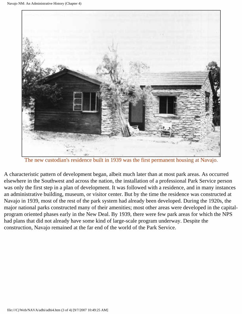
Part of the lure of the position had been the promise of a new residence, to be built the first year the Brewers were at Navajo. The tent was near the site of the proposed residence. Indian CCC labor built a two-room cabin in 1939, the same year they drilled a well, the first CCC work since the CWA project in 1933-34. The one-bedroom house was "beautiful," according to Sallie Brewer, who fondly recalled moving into it, but the complicated canyon sump-vertical pipe hole-rim pump-storage tank water system did not begin to function for another year. [2]
file:///C|/Web/NAVA/adhi/adhi4.htm (2 of 4) [9/7/2007 10:49:25 AM]
Navajo NM: An Administrative History (Chapter 4)
The new custodian's residence built in 1939 was the first permanent housing at Navajo.
A characteristic pattern of development began, albeit much later than at most park areas. As occurred elsewhere in the Southwest and across the nation, the installation of a professional Park Service person was only the first step in a plan of development. It was followed with a residence, and in many instances an administrative building, museum, or visitor center. But by the time the residence was constructed at Navajo in 1939, most of the rest of the park system had already been developed. During the 1920s, the major national parks constructed many of their amenities; most other areas were developed in the capital-program oriented phases early in the New Deal. By 1939, there were few park areas for which the NPS had plans that did not already have some kind of large-scale program underway. Despite the construction, Navajo remained at the far end of the world of the Park Service.
file:///C|/Web/NAVA/adhi/adhi4.htm (3 of 4) [9/7/2007 10:49:25 AM]
Navajo NM: An Administrative History (Chapter 4)
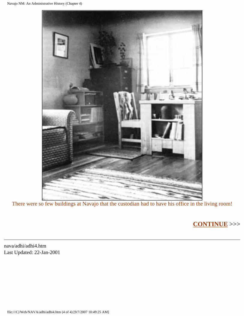
There were so few buildings at Navajo that the custodian had to have his office in the living room!
CONTINUE >>>
nava/adhi/adhi4.htm Last Updated: 22-Jan-2001
file:///C|/Web/NAVA/adhi/adhi4.htm (4 of 4) [9/7/2007 10:49:25 AM]
Navajo NM: An Administrative History (Chapter 5)
Navajo
Administrative History
CHAPTER V: THE MODERN ERA
The signing of the Memorandum of Agreement at Navajo National Monument was the pivotal moment in the history of the monument. It terminated the set of problems that existed prior to the acquisition of the 240 acres allowed under its terms, but created entirely new issues in its wake. The memorandum began the transformation of Navajo into a modern park area, complete with capital facilities, large numbers of visitors, and most of the amenities of the rest of the park system. The memorandum also restructured the relationship between the park and the Navajo Nation, highlighting and changing the close relationship between the park and the people of the western reservation.
This agreement served as the catalyst for the implementation of the MISSION 66 program at the monument. By effectively enlarging the monument by 240 acres on the rim of Betatakin Canyon, the memorandum provided space in which the Park Service could construct the kind of park facilities that had become typical in the park system. Perhaps rushed by the need to get the proposed program underway during the halcyon days of MISSION 66, the interim agreement was less than the Park Service wanted. But it had the impact that all agreed was essential. An ostensibly temporary move, it offered permanent advantages.
The memorandum also formalized existing ties with the Navajo Nation, in effect putting the park on the same level as the Navajo people. The implementation of MISSION 66 at the monument injected large amounts of money into the region and provided numerous economic and employment opportunities for Navajo people and others. As the catalyst for increased visitation, the memorandum also helped transform the economy of the region.
Navajo National Monument had always been dependent on the people who lived nearby. The agreement formalized that relationship at the exact moment that Navajo people began to feel a greater sense of empowerment. As a result, the NPS sometimes felt the animosity directed at mainstream America in general, complicating relations between two increasingly interdependent communities. After 1962, the Park Service had to move carefully.
With the rapid advent of MISSION 66, the monument experienced rapid growth that almost overnight
file:///C|/Web/NAVA/adhi/adhi5.htm (1 of 4) [9/7/2007 10:49:27 AM]
Navajo NM: An Administrative History (Chapter 5)
gave the park modern facilities and responsibilities. The change in level of management was difficult because of the figurative distance that had to be covered. A rapid transition to modern park management fraught with difficult decisions in a changing administrative climate followed.
When MISSION 66 for Navajo National Monument debuted, it offered a comprehensive program of development for the monument. The prospectus instituted direction in a manner that had never before been attempted at Navajo. The detailed proposal planned an entire range of visitor facilities and services, construction, maintenance, and staff. But in the era before the Memorandum of Agreement, the program was a wish list. Chief among the needs articulated in the prospectus was more land. Only when it was acquired could development progress. [1]
The implementation of MISSION 66 at Navajo had begun slowly. Because of the clear sense among park people at the national, regional, and local levels that there was not enough room at the monument to begin a comprehensive program, the Memorandum of Agreement accelerated a process that had been previously stifled. The rapid growth and development of the monument was a result. So was a marked upgrading of the services and facilities available at Navajo National Monument.
Conditions at the monument before the beginning of MISSION 66-funded development had changed little since the 1930s. Former Ranger Bud Martin recalled that during his stay in the early 1960s, a diesel generator supplied electrical power for the park. The situation for park employees was typical of remote areas. The only residences for park personnel were the stone superintendent's house, built in 1939, one hogan, and three old small trailers. Martin, his wife, and two children lived in one 27-foot trailer. "We considered it an adventure," he wryly remarked many years later. [2]
Visitor facilities were as rudimentary. The visitor center was a small one-room cabin just below the superintendent's house. Most of the time it was unmanned, and if no one was there when visitors arrived, there was a written greeting that told them they could see the ruins if they walked the Sandal Trail. A shelf held a pair of binoculars visitors could borrow, but after someone walked off with them, the practice was discontinued. There was no need for law enforcement at the time, and the one gun on the premises was a World War I-issue pistol, most likely not fired since, that was locked in the safe. Postcards were for sale; anyone who wanted one could just take it and leave the money. People could also sign up for a tour down to the ruins, but as Art White recalled, "the rationale then was that anybody that would drive out over that goddamn road had to really want to get to [the ruins] . . . if they were that interested in it, they weren't going to tear it up." A six-unit campground existed, the only accommodations available at the monument. The trading post at Shonto was the only place to stay.
One object of visitor attention was the home-made shower at the monument. Monument personnel and visitors showered in a canvas-covered area made of upright poles that had two fifty-five gallon drums of water heated by the sun. There was a hand-held nozzle that stemmed from the barrels with holes poked in it to increase the flow of the water. By the early 1960s, most needed little other than the shower to remind them of the remote situation of Navajo National Monument. [3]
file:///C|/Web/NAVA/adhi/adhi5.htm (2 of 4) [9/7/2007 10:49:27 AM]
Navajo NM: An Administrative History (Chapter 5)
Even after the Memorandum of Agreement, MISSION 66 began slowly. Although spending for development began at Navajo in 1962, 1964 was the first year in which the appropriation was large enough to make an impact on the park. Prior to 1964, MISSION 66 expended just $30,000 at Navajo. Most of the funding went for small-scale projects, such as house trailers in which permanent and seasonal rangers could live. Getting even that relatively small amount took energy and persistence. Art White consistently turned in blank pieces of paper as his reports on activities at the monument. He correctly assumed that this would catch someone's attention. But a coercive maneuver did more good. When Eivind T. Scoyen, associate director of the Park Service, made a southwestern swing in the early 1960s, White took the opportunity to make a pitch for Navajo. Scoyen tried to avoid making a visit across the newly paved highway, but White prevailed upon Regional Director Thomas J. Allen to bring Scoyen to Navajo. Unhappy about the visit, Scoyen arrived in a bad mood. But White carefully arranged a tour and a walk to Betatakin for the assistant director. After Scoyen visited, more than $1.5 million for Navajo appeared in the next NPS appropriation. Many of White's peers expressed admiration for White's prowess and surprise at his success. [4]
The real expenditures followed 1964. Between 1964 and 1966, the monument received and spent more than $1.5 million of MISSION 66 money. As the development program moved forward, its cornerstone, the new visitor center, became more than a gleam in the superintendent's eye. A 9.3 mile approach road from the east was planned to finally give the monument a paved access road. Other projects included employee residences and trailers, a power system and a utility building, and water and sewer systems. The combination of facilities, amenities, and resources altered the very nature of the experience of visitors to Navajo National Monument.
One factor was the marked increase in visitation that resulted from the paved roads through the western reservation. Prior to 1960, it was a long trek to Navajo National Monument. It was too far from civilization, over which cars had to travel too many washboard-like dirt roads. But pavement to within fifteen miles of Betatakin Canyon nearly doubled the number of visitors. In 1959, recorded visitation totaled 3,053; only two years later, in 1961, the number reached 6,175. In 1963, visitation reached 10,832, only to nearly double again to 20,401 after the opening of the new paved approach road (U.S. 564) in 1965. [5]
Responding to the increase in visitors required tremendous growth in the number of staff members. The hiring of Smokey Lehnert in 1958 inaugurated a period of rapid growth. At the time, the superintendent and ranger usually could expect two seasonal rangers in the summers. In 1965, merely seven years later, there were five full-time permanent staff people, including the superintendent, the chief ranger, two more rangers, an administrative assistant, and laborers. There were also four seasonal rangers each summer, providing an ample staff for the level of visitation.
The development of the monument was a process that went through stages. The acquisition of land through the Memorandum of Agreement inaugurated the transformation, and the construction of the primary capital facilities, the visitor center and the paved approach road, followed soon after. The final stage involved incorporating the changes into the day-to-day activities of the monument.
file:///C|/Web/NAVA/adhi/adhi5.htm (3 of 4) [9/7/2007 10:49:27 AM]
Navajo NM: An Administrative History (Chapter 5)
The agreement was only a catalyst for change, not its cause. Plans to develop the monument predated the acquisition. Both the visitor center and the paved approach road were in the works before the memo; both were dependent on the acquisition of land. The need for a real visitor center had been expressed in 1952 when John J. Aubuchon first created a museum at the monument. [6] Throughout the 1950s, Art White recognized that the encroachment of the modern world would change the level of service that the Park Service had to deliver. The prior efforts of the staff at Navajo contributed to recognition of the need. But the list of agency priorities, the limited resources with which to meet them, and the lack of space at Navajo in which development could be implemented slowed the process.
CONTINUE >>>
nava/adhi/adhi5.htm Last Updated: 22-Jan-2001
file:///C|/Web/NAVA/adhi/adhi5.htm (4 of 4) [9/7/2007 10:49:27 AM]
Navajo NM: An Administrative History (Chapter 6)
Navajo
Administrative History
CHAPTER VI: PARTNERS IN THE PARK: RELATIONS WITH THE NAVAJO
The Memorandum of Agreement at Navajo National Monument formalized a longstanding pattern of interaction between the park and the people of the Shonto region. After the beginning of development at the park and the change in the Navajo economy as a result of the stock reduction programs of the 1930s, the ties between area Navajos and the Park Service became stronger. A symbiotic relationship developed, in which Navajos gained economically from the park, which in turned received the benefits of Navajo labor as well as the ability to offer visitors a picture of Navajo life.
The ties long preceded the Memorandum of Agreement signed in 1962. John and Louisa Wade Wetherill had initiated the close relationship. As traders in Navajoland, they earned the trust of the people of the area. Louisa Wade Wetherill became particularly interested in the Navajo people and their culture. Fluent in their language, she became an expert on Navajo culture. In the living room of the Wetherill trading post in Kayenta, John Wetherill discussed the prehistory of the Southwest, while Louisa Wade Wetherill held forth on the Navajo. Even her children knew not to contradict her on this subject. [1]
After the Park Service began full-time administration of the monument, there were significant attempts to portray Navajo life and culture at the monument. Exhibits reflecting Navajo themes were common, inspiring positive responses from visitors. In 1952, Superintendent John J. Aubuchon reported that the Navajo exhibit in the corner of the contact station was extremely popular. John Cook recalled an emphasis on Navajos in the interpretation programs of the monument in the late 1950s and early 1960s, something augmented by the presence of Navajo seasonal employees and rangers. Trained in anthropology, Art White was knowledgeable in the ways of the Navajo people. His tenure at the monument allowed him to pursue this interest. [2]
The Park Service also followed liberal policies towards the Navajo. Long before the Native American Religious Freedom Act of 1977 made the practice into law, Navajo medicine men came into the monument to collect plants for healing and ceremonial use. The Park Service allowed them access as a
file:///C|/Web/NAVA/adhi/adhi6.htm (1 of 2) [9/7/2007 10:49:28 AM]
Navajo NM: An Administrative History (Chapter 6)
courtesy, with superintendents from James W. Brewer to Frank Hastings acknowledging the importance of religious practices to area people. This kind of cooperative arrangement served as a model for later efforts between the Park Service and Native Americans at other park areas. [3]
By 1962, a pattern of inclusion at the monument had developed. The Navajo people in the vicinity of the monument had become partners in the park. They made up a significant portion of its labor force, recognized the park as a source of economic support, and generally and loosely supported its objectives. The monument and its staff were able to reciprocate by offering the accouterments of modern society to the people of the region. Bob Black used the road grader to grade the road to Shonto on a regular basis; in the winter, the park's snowplow could be found plowing the way to various hogans in the region. In reality, Navajo National Monument was three small islands among the Navajo. In a harsh land, cooperation and adaptation assured the survival of all. [4]
The Memorandum of Agreement created a formal structure that defined the responsibilities of both the Park Service and the Navajo Nation. In exchange for the use of 240 acres of Navajo land on the rim of Betatakin Canyon, the Navajo Nation acquired specific privileges at the monument. One of the most important of these was control of an approximately 450-square foot area in which crafts, pottery, and other gift items could be sold. This assured an economic relationship between the park and the Navajo that transcended the employer-employee pattern typical before the agreement. Navajos developed a proprietary interest in the park.
CONTINUE >>>
nava/adhi/adhi6.htm Last Updated: 22-Jan-2001
file:///C|/Web/NAVA/adhi/adhi6.htm (2 of 2) [9/7/2007 10:49:28 AM]
Navajo NM: An Administrative History (Chapter 7)
Navajo
Administrative History
CHAPTER VII: ARCHEOLOGY AT NAVAJO
Navajo National Monument was established as part of the push to preserve the remnants of the pre-Columbian past scattered across the western landscape. Reserved as a series of archeological sites rather than as a management entity, the monument was subjected to a range of influences from its inception. Archeologists of different backgrounds sought to excavate the region even before the monument was established. An awkward pattern of excavation and explanation of the prehistory of the Tsegi canyon area followed.
Archeologists who sought to learn the prehistoric story of the Kayenta Anasazi from the monument faced other problems. Navajo National Monument had been reserved to protect above ground ruins, not as a way to protect the remains of a culture group. The proclamation of the monument resulted from the fear that ruins would be damaged, not from any sense of the pieces of the past it held. As a result, the monument included episodes of the past, not a comprehensive picture, and archeologists and aficionados who sought to understand these ruins often had to rely on work done outside its boundaries. Synthesizing the information for the purposes of the monument was a difficult and complicated task.
The process of rediscovering the prehistory of the Tsegi Canyon vicinity also fell prey to jurisdictional issues. The boundaries of the monument limited the area in which archeologists had influence. Excavation proceeded in an erratic fashion, shaped as much by the availability of locales as by the objectives of scientists and institutions. As was typical of the experience of the agency in this area, the Park Service found itself powerless. The agency had influence over only a small part of the region and control of even less. Unable to regulate archeological efforts, the Park Service concentrated on preserving the ruins of the monument.
The study of prehistory was in its infancy at the turn of the twentieth century. Following 1840, archeology moved toward becoming a respectable field of study in the U.S. Prior to the middle of the nineteenth century, the field had been largely speculative. In the subsequent decades, proto-archeologists developed a descriptive style, designed to taxonomize the sites they found before them. As they began to be exposed to the ruins of the Southwest after 1880, this descriptive approach seemed sufficient. With so many places to inventory and catalog, most archeologists were content to record what they saw. [1]
file:///C|/Web/NAVA/adhi/adhi7.htm (1 of 4) [9/7/2007 10:49:29 AM]
Navajo NM: An Administrative History (Chapter 7)
Yet there was an intellectual dimension to the archeological profession at the turn of the century. In the late 1870s, Lewis Henry Morgan, regarded as the father of American anthropology, posited a series of stages of cultural evolution. Neo-Darwinian and ethnocentric in their hierarchical nature, Morgan's theories were as applicable to prehistory as to existing tribes. Among the many Morgan influenced was Adolph F. A. Bandelier, the scion of a Swiss-American banking family from Illinois. Bandelier became obsessed by southwestern history and prehistory, walking the region to historic and prehistoric villages and publishing major works. While the majority of Bandelier's work was taxonomic in character, it helped fill many intellectual gaps and spurred others to investigate further. [2]
An institutional base for the study of the prehistoric and historic past also emerged after 1875. Archeology in the U.S. prior to that time had focused on Europe and the Middle East, with much of its effort expended on religious themes. But the opening of the West extended new opportunities to the coming generation of scholars, and they developed an infrastructure to support their efforts. Journals such as the American Antiquarian, founded in 1878, and American Anthropologist, which commenced publication a decade later, played important roles, as did the Anthropology section of the American Association for the Advancement of Science, the Archaeological Institute of America, and other similar organizations. [3]
Perhaps the most important element in the emergence of an institutional base was the support of the federal government. This resulted from the surveys of the American West that begin with Lewis and Clark in 1804, continued intermittently until a spate of military surveys in the 1840s and 1850s, and grew in size and scope following the Civil War. John Wesley Powell, one of the leading explorers of the post-Civil War era, played an instrumental role in the founding of the Bureau of Ethnology, a branch of the Smithsonian Institution, in 1879. With the charismatic Powell as its head, the bureau explored the prehistory and history of the West in an effort to use the past to justify the direction in which American society had traveled. In this view, anthropology and archeology were supposed to carry redemption to what had become an industrial and callow society. [4]
Standing between institutionally based science and its objectives were amateurs with an interest in the remains of prehistory. The best known of these was Richard Wetherill, the rancher from Mancos, Colorado, who knew the Southwest like the back of his hand. Wetherill dug where he pleased, for no law restricted his behavior. Besides the Keet Seel ruin, Wetherill was the first Anglo to excavate the Mesa Verde area, Pueblo Bonito in Chaco Canyon, Grand Gulch, Utah, and a host of other southwestern sites. [5]
Linking together a number of the currents in American society at the beginning of the twentieth century, institutional scientists vilified Wetherill. A growing self-consciousness pervaded American society as the nation began to recognize its inherent limitations. The idea of scarcity, never before a feature of the New World psyche, came to the fore as Americans realized that their continent was finite. A backlash against European culture also erupted as Americans tried to convince themselves that the natural grandeur of the continent equaled European cultural history. Wetherill seemed a threat in both areas; his
file:///C|/Web/NAVA/adhi/adhi7.htm (2 of 4) [9/7/2007 10:49:30 AM]
Navajo NM: An Administrative History (Chapter 7)
first "client" was Gustav Nordenskiold, a Swedish baron's son who made a vast collection in the ruins of Mesa Verde and took it home with him. This led jingoistic scientists to revile Wetherill for expropriating American prehistory for European benefit. As Wetherill explored various sites and made collections of pots and artifacts, he transferred part of the past from public to private hands. In an era that slowly came to recognize scarcity as a reality, his behavior bordered on heresy. [6]
But Wetherill himself was heir to a long tradition in the history of archeology. He was the talented amateur, like Heinrich Schliemann and a host of other eighteenth- and nineteenth-century archeologists. Wetherill made numerous discoveries, at least one of which, his recognition of pre-pueblo phases of southwestern life called Basketmaker culture, revolutionized archeological thinking. Wetherill's real crime was that he remained an unaffiliated individual in an era of growing emphasis on credentials and institutional affiliation. [7]
His work differed little from that of most of the archeological profession at the turn of the century. Archeological research meant making collections of prehistoric artifacts. Museums and other similar institutions competed for control of the field as they sought to acquire prehistoric relics. Some institutions developed close relationships with people on the fringes of the profession. The close ties between Richard Wetherill, a number of private sponsors, and the American Museum of Natural History in New York typified the nature of such contact. The thin line between pot-hunting and recognizable science was easily erased.
The chaos this situation engendered led to legislative and practical responses. Beginning in 1900, a number of bills designed to protect prehistory from unsanctioned excavation were proposed. After six years, the movement to preserve prehistory reached its zenith in 1906, when "An Act for the Preservation of American Antiquities," more commonly known as the Antiquities Act, and a bill to establish Mesa Verde National Park became law. The Antiquities Act allowed the president to reserve historic, prehistoric, or natural areas from the public domain as national monuments. Finally, the rudiments of a system to protect prehistoric resources was in place. [8]
But the results of nearly three decades of a general lack of protection had been disastrous. From the Rio Grande Valley to southern Arizona, ruins had been pillaged wholesale. In search of artifacts, professional and amateur collectors had overturned walls, ripped through ruins, and dug nearly every easily accessible prehistoric locale. Collectors and souvenir-hunters alike gorged themselves on whatever they could find. The archeological community watched in horror.
The western portion of the Navajo reservation was exempt from much of this activity. Few Anglos ventured into the heart of Navajo country before the turn of the century, and those who did often found themselves unwelcome. Occasional clashes between Navajos and intruders in their land occurred well into the 1910s. The gradual settlement process that followed the course of the river basins and railroads of the region was largely absent on the reservation. Richard Wetherill was an exception. Besides his forays to Keet Seel in 1894-95 and 1897, he visited a number of other ruins in the area.
file:///C|/Web/NAVA/adhi/adhi7.htm (3 of 4) [9/7/2007 10:49:30 AM]
Navajo NM: An Administrative History (Chapter 7)
When John Wetherill moved his trading post from Oljato to Kayenta in the fall of 1909, the ruins of the western reservation and Tsegi Canyon in particular came within the reach of the archeological community. Yet the opening of this area occurred in the aftermath of the passage of the Antiquities Act, allowing an increasingly interested federal government a greater measure of control over the disposition of these ruins than any prior group. As a result of Richard Wetherill's excavation at Chaco Canyon, Congress developed laws to protect ruins. As William B. Douglass battled to stop the Cummings expedition in 1909, a system that could protect ruins, albeit in a rudimentary fashion, was in place.
This defined the history of excavation of the ruins of Navajo National Monument. After Richard Wetherill's preliminary efforts at Keet Seel, every major excavation that occurred at the ruins had been authorized by someone in the federal government. In 1909, Hewett and Cummings requested and received permits, and Fewkes was a representative of the Smithsonian Institution. The result was a more orderly process than occurred nearly everywhere else in the Southwest. While federally authorized excavators could be careless and haphazard, they were part of an official system that required some measure of accountability.
But the ruins in the Tsegi were reserved because they were seemingly untrammeled visible evidence of prehistory, not because they represented a comprehensive prehistoric community or time period. They were episodes, not a chronological sequence, limiting their importance as individual subjects of study. Nor were they reserved to provide a comprehensive picture of the past of the region. Understanding the prehistory of the monument meant studying the entire Colorado Plateau.
CONTINUE >>>
nava/adhi/adhi7.htm Last Updated: 22-Jan-2001
file:///C|/Web/NAVA/adhi/adhi7.htm (4 of 4) [9/7/2007 10:49:30 AM]
Navajo NM: An Administrative History (Chapter 8)
Navajo
Administrative History
CHAPTER VIII: THREATS TO THE PARK
In the 1980s and early 1990s, the threats to Navajo National Monument varied in character and intensity. There were different kinds of potentially adverse effects, the majority of which threatened the resources of the monument. Increases in visitation and the impact of visitors on the ruins, pot-hunting and unauthorized use of the detached areas, and vandalism formed one primary category. Park staff felt the pressure to maintain the preservation portion of the mandate of the Park Service. Outside threats to the park by entities beyond the control of the Park Service and not generally subject to its entreaties were another kind of threat. Resource development by private firms on the Navajo Reservation had potential to cause a range of direct and indirect changes to the monument. In addition, such uses affected the potential of the monument to attract visitors.
Another threat to the future of the monument was internal. Following on the heels of a decade of limited funding, growing restlessness among Park Service people, and the general tightening of federal spending as a result of the budget deficit and the savings and loan scandals of the late 1980s, the staff at Navajo National Monument found themselves with insufficient resources to meet the various demands on the park. The result was a climate in which confidence in the level of care the agency could offer declined. The inability to serve its constituency as well as it had in the past left the Park Service weakened, with declining morale, as many saw the new conditions negating the gains the agency made in the 1980s.
The concept of outside threats to the park system was a phenomenon of the post-Second World War era. Prior to the war, the majority of park areas were far from centers of population, and while places like Carlsbad Caverns were surrounded by ticky-tacky businesses, most parks were immune to such intrusion. Western parks faced a greater threat from inholdings, private lands located within national park areas, than from development outside park boundaries. [1]
But the development of the West in the postwar era and the growth in its population led to much greater pressure on park resources. During the first decade following the war, Americans flocked to visit their national parks in numbers far greater than before. The response of the Congress and the Park Service, MISSION 66, was designed to facilitate capital development to meet the needs of visitors, but it did little to address another consequence of the increase: the growing dependence of local economies on park
file:///C|/Web/NAVA/adhi/adhi8.htm (1 of 3) [9/7/2007 10:49:31 AM]
Navajo NM: An Administrative History (Chapter 8)
visitors. Well into the 1970s, the agency took a narrow view of its responsibilities, regarding events within park boundaries as its primary and many times exclusive province.
By the 1970s, changing perceptions of American society contributed to more aggressive vigilance on the part of the Park Service. Beginning in the 1960s, the conservation movement in the United States took a more holistic approach to preservation. Its concerns stretched beyond the protection of the park system into the beautification of ordinary landscapes. By the middle of the 1970s, this ethos had spread. Many within the agency took a broader view of the demands of management. For those in resource management, this translated into a concern for lands beyond the borders of park areas. [2]
The conditions at many national park areas merited concern. Local economies depended on revenue from park visitors, and as economic impact studies showed, outside dollars in a community were spent an average of seven times before they left it. Concessions within park areas were limited or controlled, but as the economic climate in some urban areas and much of the rural West forced people to consider new economic alternatives, local communities and individuals looked to the NPS and its well-oiled visitation machine as an economic panacea. The result was the proliferation of privately owned stores, restaurants, and motels near and in many cases adjacent to park areas. Many of these did not meet Park Service standards. Exploitive in nature and characterized by a brand of hucksterism that dated from an earlier, more naive time, they detracted from the experience of visitors. Nor could most travelers discern between what the agency sanctioned and what it did not. Eyesores and negative influences on visitor experience, out-of-park facilities also became a public relations problem.
The threat of industrial development loomed even larger. The end of the Second World War ignited industrial development in the West; the famed Colorado River Storage Project that led to the successful effort to stop the Echo Park dam was only the beginning of much broader and more comprehensive development. The construction of interstate highways during the Eisenhower administration helped facilitate growth, as did the rapid increase in population throughout the region and a greatly increased emphasis on development of its resources. Many park managers watched with dismay as industrial development and intensive natural resource use began to occur in the vicinity of park areas. [3]
The threat appeared greatest from two separate but interrelated activities, the production of fossil fuels and mineral extraction and development. In the Four Corners region, this was a particularly strong threat, for after the Second World War, development of the area increased exponentially. The growing interest of the Navajo Nation in development contributed to the fears of the Park Service. By the 1970s, mineral extraction activity in the Southwest was greater than any other region of the country with important national park areas. [4]
The Park Service and its support organizations were aware of the problem. By the middle of the 1970s, the National Parks and Conservation Association (NPCA) and other groups that supported the park system expressed concern for the lands surrounding park areas. In 1972, the National Parks for the Future study group pointed out the need for protection from outside threats. In 1976, NPS Director Gary E. Everhardt declared that the most severe threats the system faced were external and they were at their
file:///C|/Web/NAVA/adhi/adhi8.htm (2 of 3) [9/7/2007 10:49:31 AM]
Navajo NM: An Administrative History (Chapter 8)
most serious in the desert Southwest, where "existing electric generating plants powered by local coal supplies have already created haze and smog in the once clear desert air." At the end of the decade, the NPCA published its adjacent lands study, in which many park superintendents remarked that they felt that they lacked the level of authority to deal with threats beyond their boundaries. The NPCA called for remedies such as an end to federal funding of projects with adverse impacts on adjacent park areas. [5]
By 1980, this position had become an integral part of agency policy. Park Service documents such as the State of the Parks 1980 report to Congress focused on external threats such as commercial enterprises and industrial development outside park boundaries with the potential to affect park units. According to the study, more than fifty percent of threats to park areas came from outside park boundaries. The Park Service began to develop ways to identify and counteract the broadening range of potential threats. The issue became prominent on the agenda of the agency, and individual park units stepped up responses to new threats. [6]
Although it faced many of the same threats as other park areas, Navajo National Monument remained an anomaly. Unlike many park areas, it lacked the sheer dimensions to insulate itself from nearby development. As a series of disconnected islands in the heart of the western reservation, Navajo faced three times the potential threat of contiguous parks. In addition, its de facto dependence on the administration of the reservation areas that surrounded it also complicated any Park Service response to threats to its resources.
The problems at the monument were compounded by the lack of continuity between the three sections of the monument. In reality, Navajo National Monument was an inholding on the Navajo reservation, precariously dependent on the decisions that affected the land around it. Grazing, mineral development, use of water, and other economic uses of land around all had a significant impact on the resources of the monument. But the Park Service could not simply oppose any growth outside park boundaries. The people of the region were poor by modern standards, and economic development meant that an increase in the local standard of living was likely. To wantonly oppose development meant alienating the community that surrounded the monument. With the widespread feeling of interdependence that characterized park-Navajo relations in the vicinity of the monument, a sense that the monument impeded the local economy could be disastrous.
CONTINUE >>>
nava/adhi/adhi8.htm Last Updated: 22-Jan-2001
file:///C|/Web/NAVA/adhi/adhi8.htm (3 of 3) [9/7/2007 10:49:31 AM]
Navajo NM: An Administrative History (Bibliographic Essay)
Navajo
Administrative History
BIBLIOGRAPHIC ESSAY
In recent years, the National Park Service and its holdings have been the subject of a growing number of important studies. Still first among these is Alfred Runte, National Parks: The American Experience (Lincoln: University of Nebraska Press, 1987) 2nd ed., an excellent study that covers the evolution of the park system since its inception. Ronald A. Foresta, America's National Parks and Their Keepers (Washington, D.C.: Resources for the Future, 1984) is a close look at NPS policy in the modern era. Although dated and marred by inconsistent footnotes, John Ise, Our National Park Policy: A Critical History (Baltimore: Johns Hopkins University Press, 1961) remains a seminal work. The only extant biography of Stephen T. Mather, Robert Shankland, Steve Mather of the National Parks 3rd ed. (New York: Alfred A. Knopf, 1970), also has stood well the test of time. Hal Rothman, Preserving Different Pasts: The American National Monuments (Urbana: University of Illinois Press, 1989) tells the story of the Antiquities Act of 1906 and the national monuments it spawned. Growing numbers of park areas have been the subject of individual histories; for the purposes of an archeological park area, the most useful of these is Duane A. Smith, Mesa Verde National Park: Shadows of the Centuries (University of Kansas Press, 1988). More specialized studies of current topics have also begun to appear. John C. Freemuth, National Parks and the Politics of External Threats (Lawrence: University of Kansas Press, 1991) is the first of what will be a significant genre.
The history of archeology in the Southwest has attracted the attention of many scholar in recent years. The best general works on the history of archeology are C. W. Ceram, Gods, Graves, and Scholars: The Story of Archeology, (New York: Alfred A. Knopf, 1979) and Gordon R. Willey and Jeremy A. Sabloff, A History of American Archeology (London: Thames and Hudson, 1974). Curtis M. Hinsley, Jr., Savages and Scientists: The Smithsonian Institution and the Development of American Anthropology 1846-1910 (Washington, D. C.: Smithsonian Institution Press, 1981) and Robert Rydell, All the World's A Fair: Visions of Empire at American International Expositions, 1876-1916 (Chicago: University of Chicago Press, 1984) help establish the context for the rise of archeology and its cultural importance in the late nineteenth and early twentieth centuries. C. W. Ceram, The First American: A Story of North American Archaeology, (New York: Harcourt, Brace, Jovanovich, Inc., 1971) is an anecdotal account of the personalities and circumstances of the first two generations of American archeology. Interesting and lively, it provides the kind of context that helps a study such as this.
file:///C|/Web/NAVA/adhi/adhib.htm (1 of 3) [9/7/2007 10:49:32 AM]
Navajo NM: An Administrative History (Bibliographic Essay)
The histories of people and places that include Navajo National Monument are many and varied. Frank McNitt, Richard Wetherill: Anasazi (Albuquerque: University of New Mexico Press, 1957) is a significant work. Among many other topics, McNitt offers insights into Wetherill's activities at Keet Seel. Frances Gillmor and Louisa Wade Wetherill, Traders to the Navajo: The Story of the Wetherills of Kayenta (Albuquerque: University of New Mexico Press, 1934) provides a romanticized account of the activities of John and Louisa Wade Wetherill. Neil M. Judd, Men Met Along the Trail: Adventures in Archaeology (Norman: University of Oklahoma Press, 1968) offers a first-hand account of many of the early explorations of Navajo National Monument, while Byron L. Cummings, Indians I have Known (Tucson: Arizona Silhouettes, 1952) adds to the picture. Elizabeth Compton Hegemann, Navaho Trading Days (Albuquerque: University of New Mexico Press, 1963) provides important context, as does William Y. Adams Shonto: A Study of the Role of the Trader in a Modern Navajo Community (Washington, D.C.: Government Printing Office, 1963) Bureau of American Ethnology Bulletin 188.
The Navajo have been the subject of extensive work by historians and anthropologists. Among the most important studies are Richard White, The Roots of Dependency: Subsistence, Environment, and Social Change Among the Choctaws, Pawnees, and Navajos (Lincoln: University of Nebraska Press, 1984), the seminal Clyde Kluckhorn and Dorothea Leighton, The Navaho (Cambridge: Harvard University Press, 1946), and Alfonso Ortiz ed. Handbook of North American Indians: Volume 10 Southwest (Washington, D. C.: Smithsonian Institution, 1983), which contains a number of excellent studies of Navajo life, people, and ritual. Peter Iverson, The Navajo Nation (Westport, CT: Greenwood Press, 1981) provides an excellent look at the Navajo in the post-Second World War era. Lawrence Kelly, The Navajo Indians and Federal Indian Policy (Tucson: University of Arizona Press, 1968) and Donald L. Parman, The Navajo and the New Deal (New Haven: Yale University Press, 1976) cover federal policy toward the Navajo between 1900 and 1940. Other studies of the Navajo and their interaction with Anglo-Americans include Frank McNitt, The Indian Traders (Norman: University of Oklahoma Press, 1962) and Lynn R. Bailey, The Long Walk: A History of the Navajo Wars, 1848-68 (Los Angeles: Westernlore Press, 1964). Navajo people have begun to write down their own history, often using existing documentary sources augmented by legend and oral tradition to interpret the events of the past in a different light. Two excellent examples of such work are Bill P. Acrey, Navajo History: The Land and the People (Shiprock, NM: Department of Curriculum Materials Development, 1988) and Raymond Friday Locke, The Book of the Navajo (Los Angeles: Mankind Publishing Company, 1989) 4th edition.
The Spanish era in the Southwest has also been closely studied by scholars. Edward H. Spicer, Cycles of Conquest: The Impact of Spain, Mexico, and the United States on the Indians of the Southwest 1533-1960 (Tucson: University of Arizona Press, 1962) is the most wide-ranging and interpretive. Jack D. Forbes, Apache, Navaho, and Spaniard (Norman: University of Oklahoma Press) and Elizabeth A. H. John, Storms Brewed in Other Men's Worlds: The Confrontation of Indians, Spanish, and French in the Southwest, 1540-1795 (Lincoln: University of Nebraska Press, 1975) are two comprehensive narrative accounts, and Joseph P. Sánchez, The Rio Abajo Frontier 1540-1692: A History of Early Colonial New Mexico (Albuquerque: The Albuquerque Museum, 1987) adds much to the story of the era before the reconquest. Frank McNitt, Navajo Wars: Military Campaigns, Slave Raids and Reprisals (Albuquerque: University of New Mexico Press, 1972) reveals the tensions of the eighteenth and nineteenth centuries.
file:///C|/Web/NAVA/adhi/adhib.htm (2 of 3) [9/7/2007 10:49:32 AM]
Navajo NM: An Administrative History (Bibliographic Essay)
But in any administrative history, the most important sources are the records of the park and the memories of the people who worked there. The National Archives, the Federal Records Centers in Ft. Worth and Denver, the Western Archeological and Conservation Center in Tucson, and the Museum of Northern Arizona are among the many places where the records of the monument can be found. Navajo National Monument has been fortunate to have a staff that cared about the place and the people that surrounded it. From John Cook to P. J. Ryan, these people shared memories and corrected misconceptions. Without their reflections, interest and concern, the rich story of Navajo National Monument could not be told.
TABLE OF CONTENTS
nava/adhi/adhib.htm Last Updated: 22-Jan-2001
file:///C|/Web/NAVA/adhi/adhib.htm (3 of 3) [9/7/2007 10:49:32 AM]
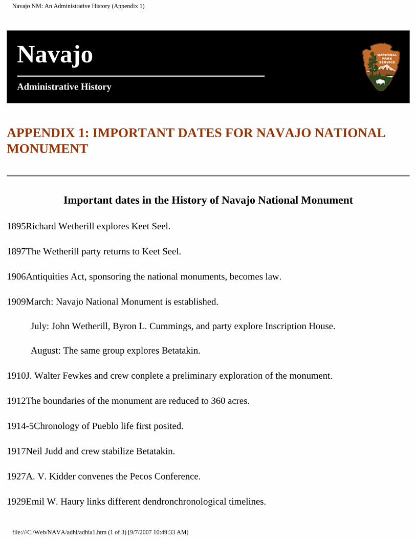
Navajo NM: An Administrative History (Appendix 1)
Navajo
Administrative History
APPENDIX 1: IMPORTANT DATES FOR NAVAJO NATIONAL MONUMENT
Important dates in the History of Navajo National Monument
1895�Richard Wetherill explores Keet Seel.
1897�The Wetherill party returns to Keet Seel.
1906�Antiquities Act, sponsoring the national monuments, becomes law.
1909�March: Navajo National Monument is established.
July: John Wetherill, Byron L. Cummings, and party explore Inscription House.
August: The same group explores Betatakin.
1910�J. Walter Fewkes and crew conplete a preliminary exploration of the monument.
1912�The boundaries of the monument are reduced to 360 acres.
1914-5�Chronology of Pueblo life first posited.
1917�Neil Judd and crew stabilize Betatakin.
1927�A. V. Kidder convenes the Pecos Conference.
1929�Emil W. Haury links different dendronchronological timelines.
file:///C|/Web/NAVA/adhi/adhia1.htm (1 of 3) [9/7/2007 10:49:33 AM]

Navajo NM: An Administrative History (Appendix 1)
1930-1�First road from Shonto Trading Post approaches the monument.
1933�Civil Works Authority (CWA) stablization at Keet Seel.
1933�First year of Rainbow Bridge-Monument Valley survey.
1934�Milton Wetherill becomes first seasonal at Navajo.
1938�John Wetherill retires as custodian.
1939�Custodian's residence built.
1948�Seth Bigman becomes first Navajo interpretive ranger at the monument.
1949�More than 1,000 visitors come to Navajo for the first time.
1954�First major exhibit in the museum in the contact station.
1956�MISSION 66 first funded by Congress.
1958�Navajo Nation road-building program begins.
1959�Paving begins on the road from Tuba City to Kayenta.
1962�May: Memorandum of Agree ment with the Navajo Nation is signed, allowing the beginning of major development at Navajo.
September: Tuba City-Kayenta highway is dedicated.
1965�New Visitor Center opened; paved approach road completed; annual visitation reaches 20,000.
1966�June: Dedication of the Visitor Center.
1966-1969�Burst of innovative archeological work at Navajo. Jeffrey Dean, Keith Anderson, and Polly Schaafsma's work changes thinking about prehistoric life at the monument.
1967�Cross-canyon trail begun.
1968�Inscription House closed to the public.
file:///C|/Web/NAVA/adhi/adhia1.htm (2 of 3) [9/7/2007 10:49:33 AM]
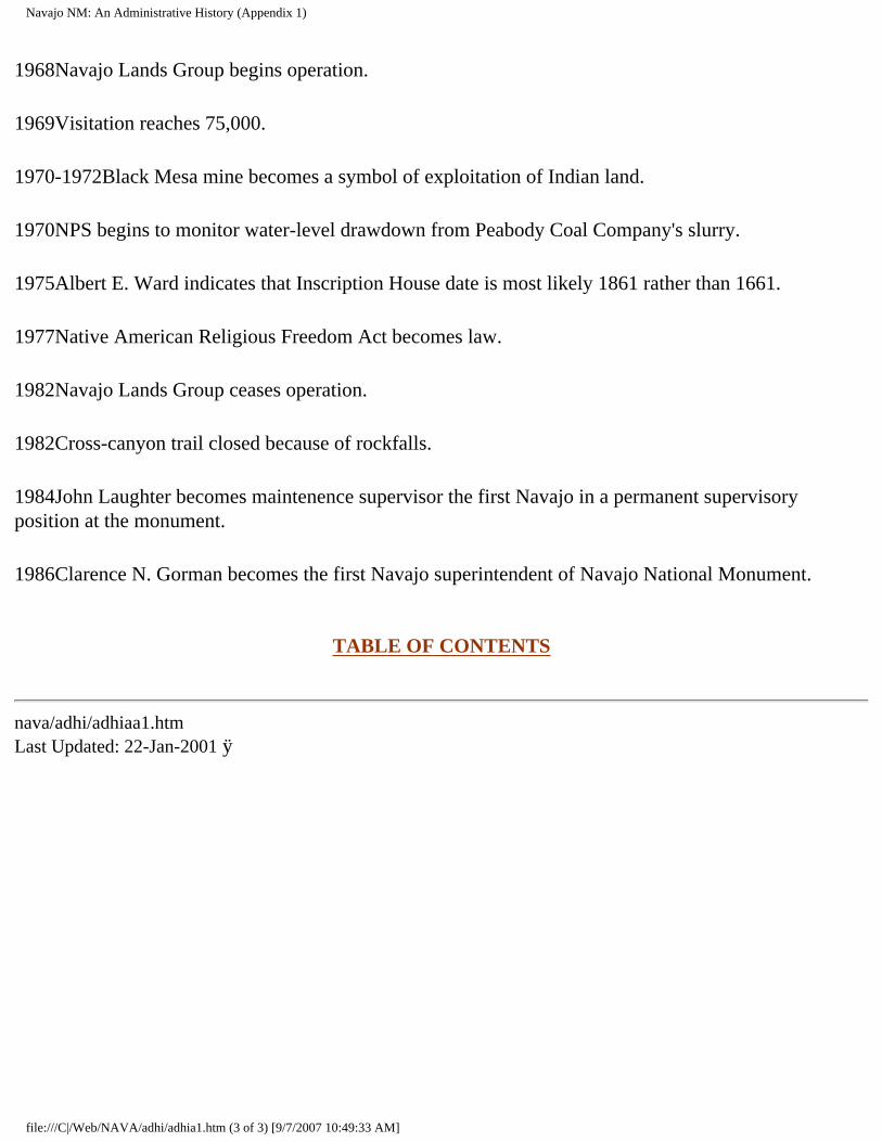
Navajo NM: An Administrative History (Appendix 1)
1968�Navajo Lands Group begins operation.
1969�Visitation reaches 75,000.
1970-1972�Black Mesa mine becomes a symbol of exploitation of Indian land.
1970�NPS begins to monitor water-level drawdown from Peabody Coal Company's slurry.
1975�Albert E. Ward indicates that Inscription House date is most likely 1861 rather than 1661.
1977�Native American Religious Freedom Act becomes law.
1982�Navajo Lands Group ceases operation.
1982�Cross-canyon trail closed because of rockfalls.
1984�John Laughter becomes maintenence supervisor the first Navajo in a permanent supervisory position at the monument.
1986�Clarence N. Gorman becomes the first Navajo superintendent of Navajo National Monument.
TABLE OF CONTENTS
nava/adhi/adhiaa1.htm Last Updated: 22-Jan-2001 ÿ
file:///C|/Web/NAVA/adhi/adhia1.htm (3 of 3) [9/7/2007 10:49:33 AM]
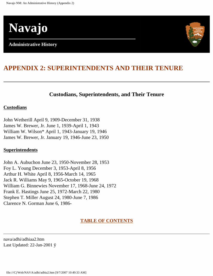
Navajo NM: An Administrative History (Appendix 2)
Navajo
Administrative History
APPENDIX 2: SUPERINTENDENTS AND THEIR TENURE
Custodians, Superintendents, and Their Tenure
Custodians
John Wetherill April 9, 1909-December 31, 1938 James W. Brewer, Jr. June 1, 1939-April 1, 1943 William W. Wilson* April 1, 1943-January 19, 1946 James W. Brewer, Jr. January 19, 1946-June 23, 1950
Superintendents
John A. Aubuchon June 23, 1950-November 28, 1953 Foy L. Young December 3, 1953-April 8, 1956 Arthur H. White April 8, 1956-March 14, 1965 Jack R. Williams May 9, 1965-October 19, 1968 William G. Binnewies November 17, 1968-June 24, 1972 Frank E. Hastings June 25, 1972-March 22, 1980 Stephen T. Miller August 24, 1980-June 7, 1986 Clarence N. Gorman June 6, 1986-
TABLE OF CONTENTS
nava/adhi/adhiaa2.htm Last Updated: 22-Jan-2001 ÿ
file:///C|/Web/NAVA/adhi/adhia2.htm [9/7/2007 10:49:33 AM]
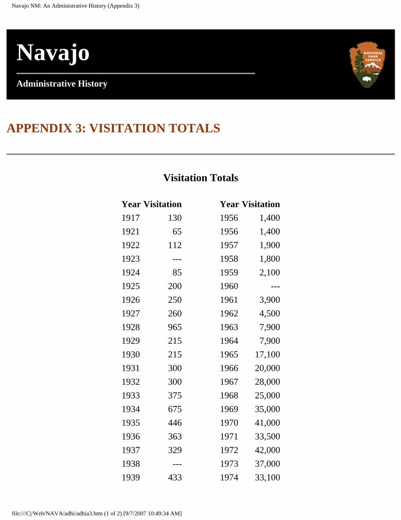
Navajo NM: An Administrative History (Appendix 3)
Navajo
Administrative History
APPENDIX 3: VISITATION TOTALS
Visitation Totals
Year Visitation Year Visitation1917 130 1956 1,4001921 65 1956 1,4001922 112 1957 1,9001923 --- 1958 1,8001924 85 1959 2,1001925 200 1960 ---1926 250 1961 3,9001927 260 1962 4,5001928 965 1963 7,9001929 215 1964 7,9001930 215 1965 17,1001931 300 1966 20,0001932 300 1967 28,0001933 375 1968 25,0001934 675 1969 35,0001935 446 1970 41,0001936 363 1971 33,5001937 329 1972 42,0001938 --- 1973 37,0001939 433 1974 33,100
file:///C|/Web/NAVA/adhi/adhia3.htm (1 of 2) [9/7/2007 10:49:34 AM]
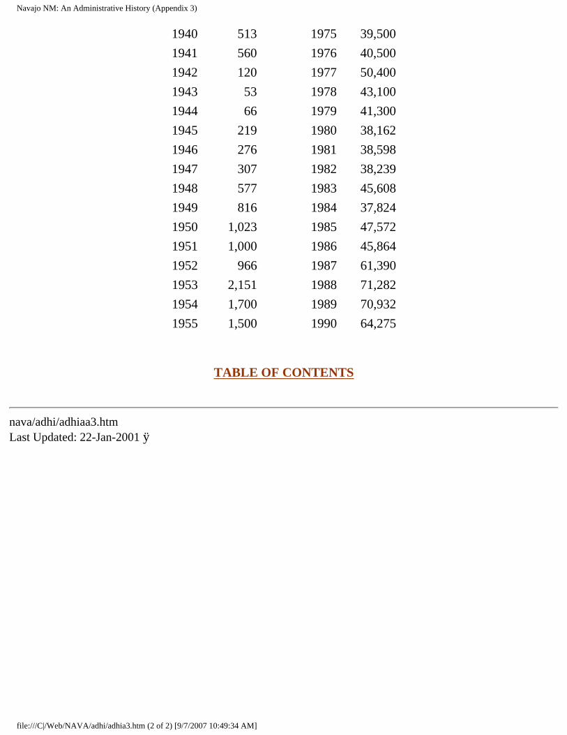
Navajo NM: An Administrative History (Appendix 3)
1940 513 1975 39,5001941 560 1976 40,5001942 120 1977 50,4001943 53 1978 43,1001944 66 1979 41,3001945 219 1980 38,1621946 276 1981 38,5981947 307 1982 38,2391948 577 1983 45,6081949 816 1984 37,8241950 1,023 1985 47,5721951 1,000 1986 45,8641952 966 1987 61,3901953 2,151 1988 71,2821954 1,700 1989 70,9321955 1,500 1990 64,275
TABLE OF CONTENTS
nava/adhi/adhiaa3.htm Last Updated: 22-Jan-2001 ÿ
file:///C|/Web/NAVA/adhi/adhia3.htm (2 of 2) [9/7/2007 10:49:34 AM]
Navajo NM: An Administrative History (Appendix 4)
Navajo
Administrative History
APPENDIX 4: PERTINENT LEGISLATION
A. Monument proclamation 1909 B. Boundary adjustment 1912 C. Memorandum of Agreement 1962 D. Maps
A. Monument proclamation 1909
NAVAJO NATIONAL MONUMENT, ARIZONA.
By the President of the United States of America,
A Proclamation
WHEREAS, a number of prehistoric cliff dwellings and pueblo ruins, situated within the Navajo Indian Reservation, Arizona, and which are new to science and wholly unexplored, and because of their isolation and size are of the very greatest ethnological, scientific and educational interest, and it appears that the public interest would be promoted by reserving these extraordinary ruins of an unknown people, with as much land as may be necessary for the proper protection thereof:
Now, therefore, I, WILLIAM H. TAFT, President of the United States of America, by virtue of the power in me vested by Section two of the Act of Congress approved June 8,
file:///C|/Web/NAVA/adhi/adhia4.htm (1 of 13) [9/7/2007 10:49:35 AM]
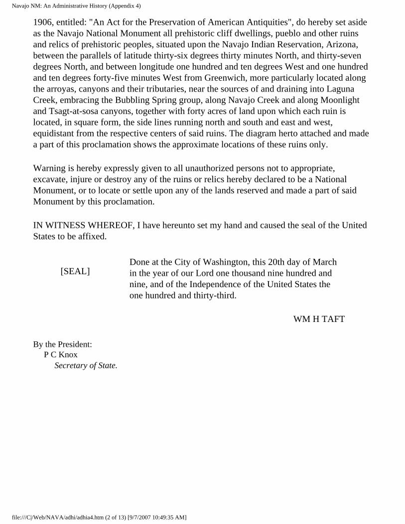
Navajo NM: An Administrative History (Appendix 4)
1906, entitled: "An Act for the Preservation of American Antiquities", do hereby set aside as the Navajo National Monument all prehistoric cliff dwellings, pueblo and other ruins and relics of prehistoric peoples, situated upon the Navajo Indian Reservation, Arizona, between the parallels of latitude thirty-six degrees thirty minutes North, and thirty-seven degrees North, and between longitude one hundred and ten degrees West and one hundred and ten degrees forty-five minutes West from Greenwich, more particularly located along the arroyas, canyons and their tributaries, near the sources of and draining into Laguna Creek, embracing the Bubbling Spring group, along Navajo Creek and along Moonlight and Tsagt-at-sosa canyons, together with forty acres of land upon which each ruin is located, in square form, the side lines running north and south and east and west, equidistant from the respective centers of said ruins. The diagram herto attached and made a part of this proclamation shows the approximate locations of these ruins only.
Warning is hereby expressly given to all unauthorized persons not to appropriate, excavate, injure or destroy any of the ruins or relics hereby declared to be a National Monument, or to locate or settle upon any of the lands reserved and made a part of said Monument by this proclamation.
IN WITNESS WHEREOF, I have hereunto set my hand and caused the seal of the United States to be affixed.
[SEAL]
Done at the City of Washington, this 20th day of March in the year of our Lord one thousand nine hundred and nine, and of the Independence of the United States the one hundred and thirty-third.
WM H TAFT
By the President: P C Knox Secretary of State.
file:///C|/Web/NAVA/adhi/adhia4.htm (2 of 13) [9/7/2007 10:49:35 AM]
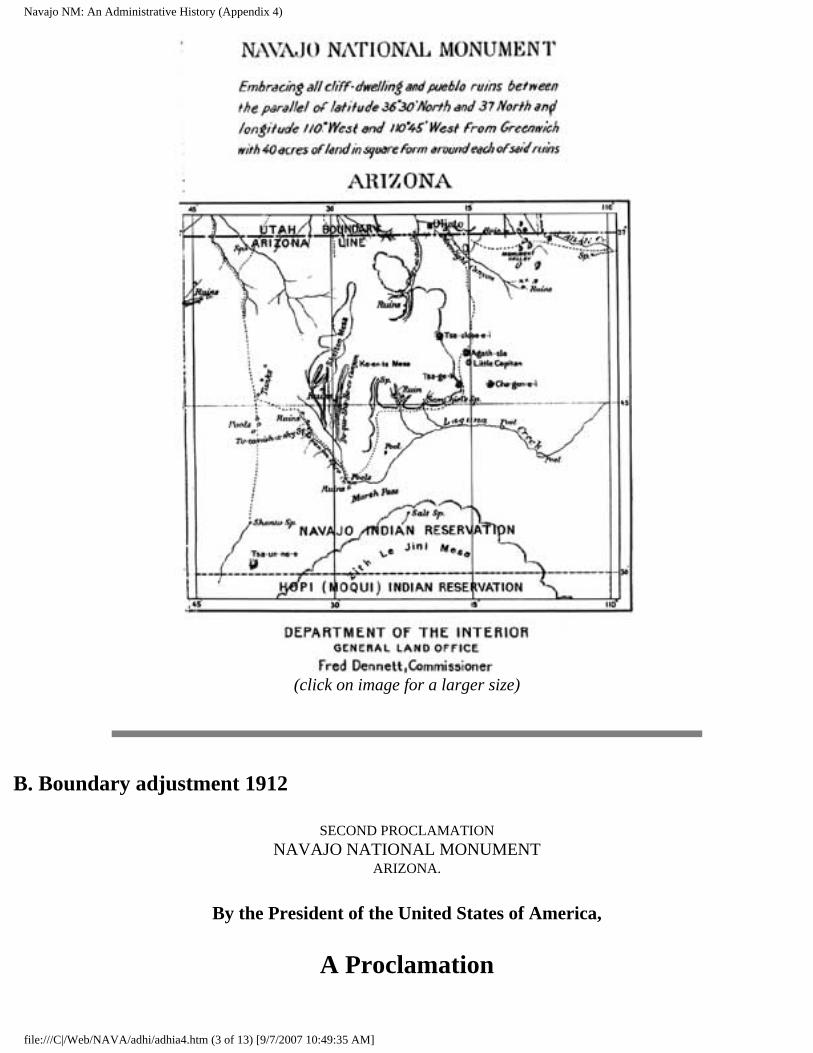
Navajo NM: An Administrative History (Appendix 4)
(click on image for a larger size)
B. Boundary adjustment 1912
SECOND PROCLAMATION NAVAJO NATIONAL MONUMENT
ARIZONA.
By the President of the United States of America,
A Proclamation
file:///C|/Web/NAVA/adhi/adhia4.htm (3 of 13) [9/7/2007 10:49:35 AM]
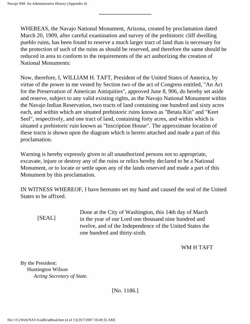
Navajo NM: An Administrative History (Appendix 4)
WHEREAS, the Navajo National Monument, Arizona, created by proclamation dated March 20, 1909, after careful examination and survey of the prehistoric cliff dwelling pueblo ruins, has been found to reserve a much larger tract of land than is necessary for the protection of such of the ruins as should be reserved, and therefore the same should be reduced in area to conform to the requirements of the act authorizing the creation of National Monuments:
Now, therefore, I, WILLIAM H. TAFT, President of the United States of America, by virtue of the power in me vested by Section two of the act of Congress entitled, "An Act for the Preservation of American Antiquities", approved June 8, 906, do hereby set aside and reserve, subject to any valid existing rights, as the Navajo National Monument within the Navajo Indian Reservation, two tracts of land containing one hundred and sixty acres each, and within which are situated prehistoric ruins known as "Betata Kin" and "Keet Seel", respectively, and one tract of land, containing forty acres, and within which is situated a prehistoric ruin known as "Inscription House". The approximate location of these tracts is shown upon the diagram which is hereto attached and made a part of this proclamation.
Warning is hereby expressly given to all unauthorized persons not to appropriate, excavate, injure or destroy any of the ruins or relics hereby declared to be a National Monument, or to locate or settle upon any of the lands reserved and made a part of this Monument by this proclamation.
IN WITNESS WHEREOF, I have hereunto set my hand and caused the seal of the United States to be affixed.
[SEAL]
Done at the City of Washington, this 14th day of March in the year of our Lord one thousand nine hundred and twelve, and of the Independence of the United States the one hundred and thirty-sixth.
WM H TAFT
By the President: Huntington Wilson Acting Secretary of State.
[No. 1186.]
file:///C|/Web/NAVA/adhi/adhia4.htm (4 of 13) [9/7/2007 10:49:35 AM]
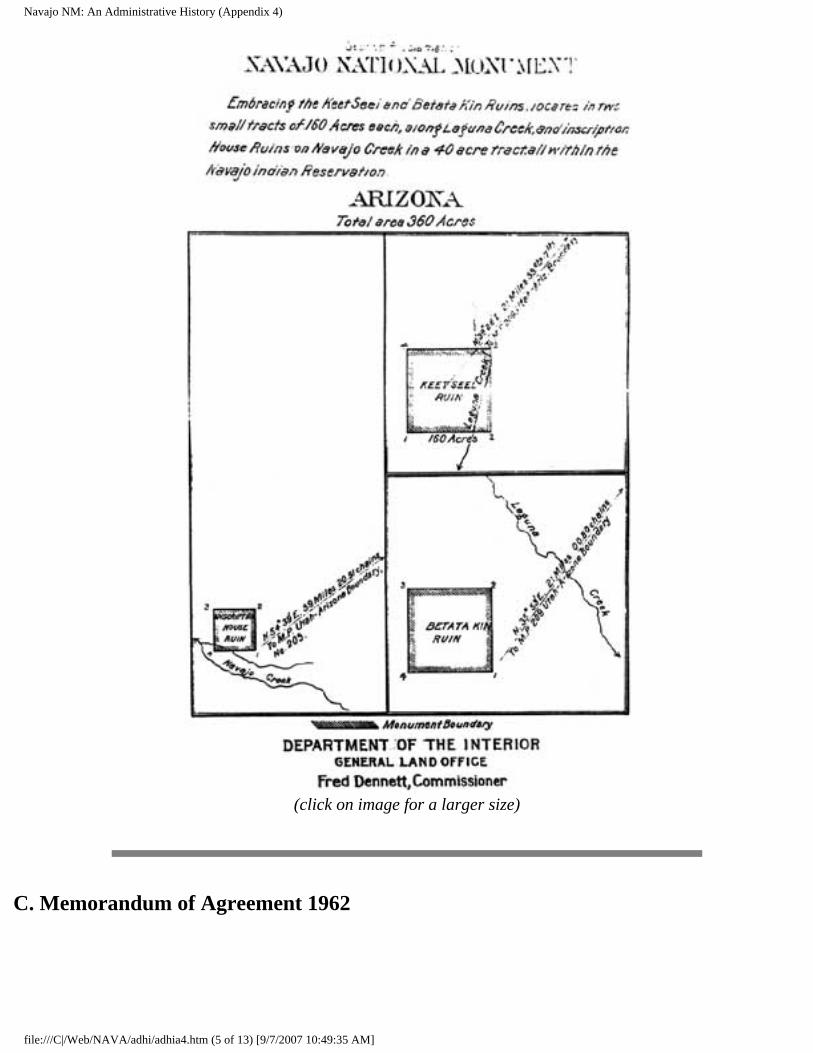
Navajo NM: An Administrative History (Appendix 4)
(click on image for a larger size)
C. Memorandum of Agreement 1962
file:///C|/Web/NAVA/adhi/adhia4.htm (5 of 13) [9/7/2007 10:49:35 AM]
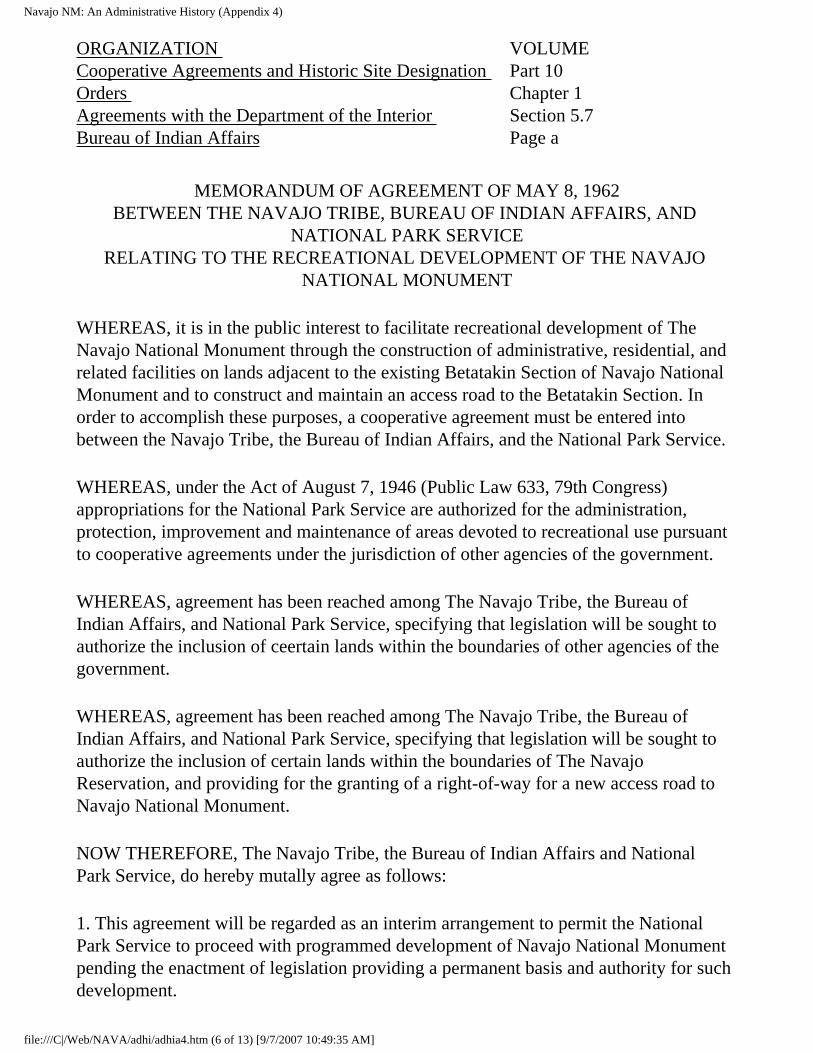
Navajo NM: An Administrative History (Appendix 4)
ORGANIZATION Cooperative Agreements and Historic Site Designation Orders Agreements with the Department of the Interior Bureau of Indian Affairs
VOLUME Part 10 Chapter 1 Section 5.7 Page a
MEMORANDUM OF AGREEMENT OF MAY 8, 1962 BETWEEN THE NAVAJO TRIBE, BUREAU OF INDIAN AFFAIRS, AND
NATIONAL PARK SERVICE RELATING TO THE RECREATIONAL DEVELOPMENT OF THE NAVAJO
NATIONAL MONUMENT
WHEREAS, it is in the public interest to facilitate recreational development of The Navajo National Monument through the construction of administrative, residential, and related facilities on lands adjacent to the existing Betatakin Section of Navajo National Monument and to construct and maintain an access road to the Betatakin Section. In order to accomplish these purposes, a cooperative agreement must be entered into between the Navajo Tribe, the Bureau of Indian Affairs, and the National Park Service.
WHEREAS, under the Act of August 7, 1946 (Public Law 633, 79th Congress) appropriations for the National Park Service are authorized for the administration, protection, improvement and maintenance of areas devoted to recreational use pursuant to cooperative agreements under the jurisdiction of other agencies of the government.
WHEREAS, agreement has been reached among The Navajo Tribe, the Bureau of Indian Affairs, and National Park Service, specifying that legislation will be sought to authorize the inclusion of ceertain lands within the boundaries of other agencies of the government.
WHEREAS, agreement has been reached among The Navajo Tribe, the Bureau of Indian Affairs, and National Park Service, specifying that legislation will be sought to authorize the inclusion of certain lands within the boundaries of The Navajo Reservation, and providing for the granting of a right-of-way for a new access road to Navajo National Monument.
NOW THEREFORE, The Navajo Tribe, the Bureau of Indian Affairs and National Park Service, do hereby mutally agree as follows:
1. This agreement will be regarded as an interim arrangement to permit the National Park Service to proceed with programmed development of Navajo National Monument pending the enactment of legislation providing a permanent basis and authority for such development.
file:///C|/Web/NAVA/adhi/adhia4.htm (6 of 13) [9/7/2007 10:49:35 AM]
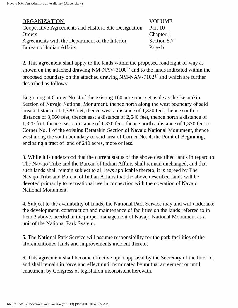
Navajo NM: An Administrative History (Appendix 4)
ORGANIZATION Cooperative Agreements and Historic Site Designation Orders Agreements with the Department of the Interior Bureau of Indian Affairs
VOLUME Part 10 Chapter 1 Section 5.7 Page b
2. This agreement shall apply to the lands within the proposed road right-of-way as shown on the attached drawing NM-NAV-31001/ and to the lands indicated within the proposed boundary on the attached drawing NM-NAV-71021/ and which are further described as follows:
Beginning at Corner No. 4 of the existing 160 acre tract set aside as the Betatakin Section of Navajo National Monument, thence north along the west boundary of said area a distance of 1,320 feet, thence west a distance of 1,320 feet, thence south a distance of 3,960 feet, thence east a distance of 2,640 feet, thence north a distance of 1,320 feet, thence east a distance of 1,320 feet, thence north a distance of 1,320 feet to Corner No. 1 of the existing Betatakin Section of Navajo National Monument, thence west along the south boundary of said area of Corner No. 4, the Point of Beginning, enclosing a tract of land of 240 acres, more or less.
3. While it is understood that the current status of the above described lands in regard to The Navajo Tribe and the Bureau of Indian Affairs shall remain unchanged, and that such lands shall remain subject to all laws applicable thereto, it is agreed by The Navajo Tribe and Bureau of Indian Affairs that the above described lands will be devoted primarily to recreational use in connection with the operation of Navajo National Monument.
4. Subject to the availability of funds, the National Park Service may and will undertake the development, construction and maintenance of facilities on the lands referred to in Item 2 above, needed in the proper management of Navajo National Monument as a unit of the National Park System.
5. The National Park Service will assume responsibility for the park facilities of the aforementioned lands and improvements incident thereto.
6. This agreement shall become effective upon approval by the Secretary of the Interior, and shall remain in force and effect until terminated by mutual agreement or until enactment by Congress of legislation inconsistent herewith.
file:///C|/Web/NAVA/adhi/adhia4.htm (7 of 13) [9/7/2007 10:49:35 AM]
Navajo NM: An Administrative History (Appendix 4)
ORGANIZATION Cooperative Agreements and Historic Site Designation Orders Agreements with the Department of the Interior Bureau of Indian Affairs
VOLUME Part 10 Chapter 1 Section 5.7 Page c
7. The National Park Service agrees that in consideration for the execution of this agreement by The Navajo Tribe that it will assist in every manner possible in supporting legislation providing for the conveyance to The Navajo Tribe by the Bureau of Reclamation of a certain area at Antelope Creek, Coconino County, State of Arizona, to be utilized by The Navajo Tribe as a recreational facility.
8. The Navajo Tribe reserves the right, during the term of this agreement, to operate an arts and crafts enterprise with Navajo National Monument, notwithstanding the Maintenance of facilities thereon by the National Park Service.
SUBMITTED:Date: May 29, 1961 (SGD) Paul Jones
THE NAVAJO TRIBEDate: Sep 21, 1961 (SGD) James F. Canan
BUREAU OF INDIAN AFFAIRSDate: Dec 12, 1961 (SGD) Thomas J. Allen
NATIONAL PARK SERVICERECOMMENDED:(SGD) John O. Crow
ACTING COMMISSIONER, BUREAU OF INDIAN AFFAIRS
May 8, 1962
Date
(SGD) Thomas J. Allen
REGIONAL DIRECTOR, NATIONAL PARK SERVICE
January 16, 1962
Date
(SGD) Conrad L. Wirth
DIRECTOR, NATIONAL PARK SERVICE
May 8, 1962
Date
file:///C|/Web/NAVA/adhi/adhia4.htm (8 of 13) [9/7/2007 10:49:35 AM]
Navajo NM: An Administrative History (Appendix 4)
APPROVED: By Secretary Udall by his memorandum of January 8, 1962 to Director, National Park Service.
(Copy of Secretary Udall's memorandum of January 8, 1962, attached)1/
Date
1/ On file in the Washington Office.
Release No. 29
SECRETARY OF THE INTERIOR
June 1962
D. Maps
file:///C|/Web/NAVA/adhi/adhia4.htm (9 of 13) [9/7/2007 10:49:35 AM]
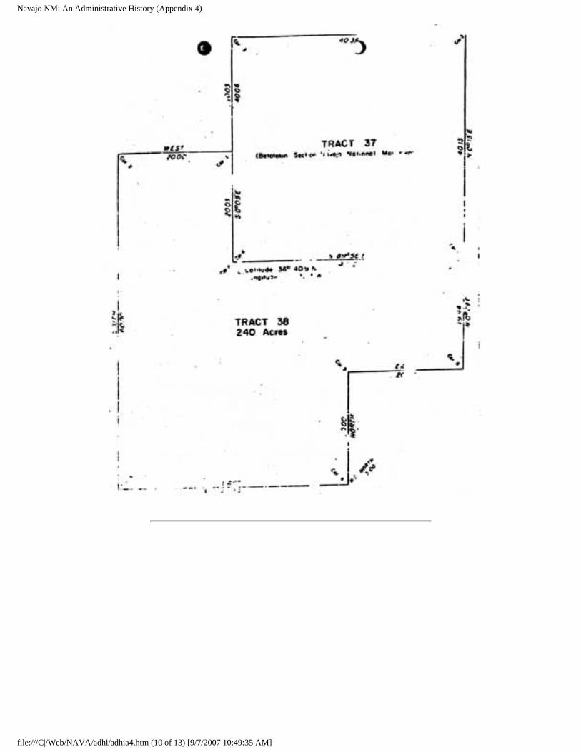
Navajo NM: An Administrative History (Appendix 4)
file:///C|/Web/NAVA/adhi/adhia4.htm (10 of 13) [9/7/2007 10:49:35 AM]
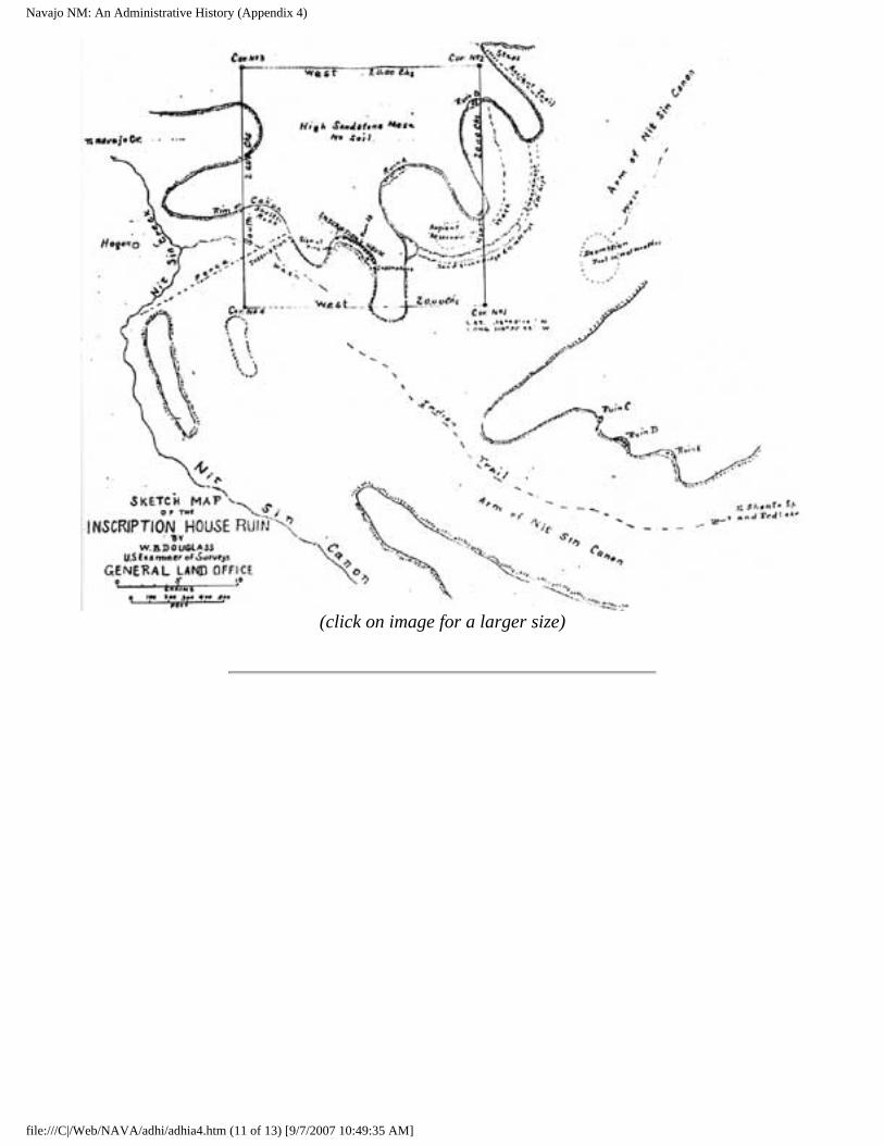
Navajo NM: An Administrative History (Appendix 4)
(click on image for a larger size)
file:///C|/Web/NAVA/adhi/adhia4.htm (11 of 13) [9/7/2007 10:49:35 AM]
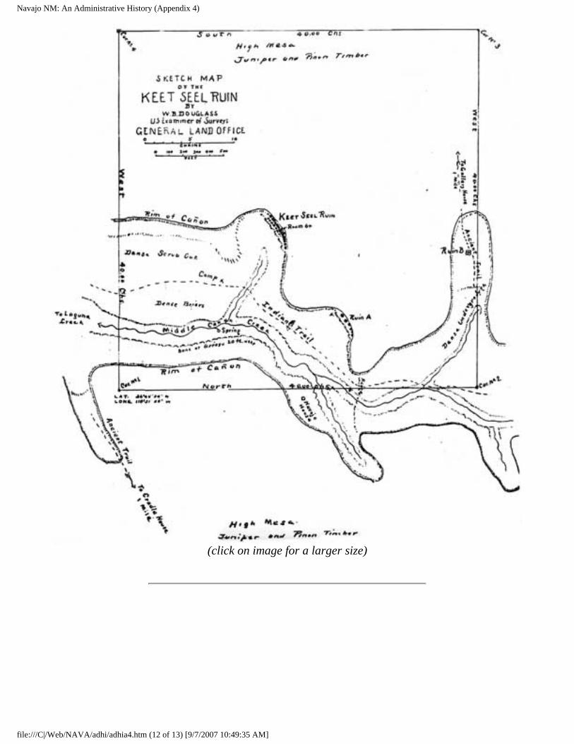
Navajo NM: An Administrative History (Appendix 4)
(click on image for a larger size)
file:///C|/Web/NAVA/adhi/adhia4.htm (12 of 13) [9/7/2007 10:49:35 AM]
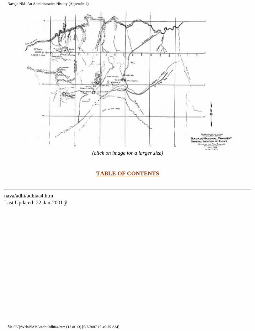
Navajo NM: An Administrative History (Appendix 4)
(click on image for a larger size)
TABLE OF CONTENTS
nava/adhi/adhiaa4.htm Last Updated: 22-Jan-2001 ÿ
file:///C|/Web/NAVA/adhi/adhia4.htm (13 of 13) [9/7/2007 10:49:35 AM]
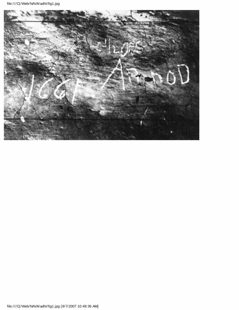
file:///C|/Web/NAVA/adhi/fig1.jpg
file:///C|/Web/NAVA/adhi/fig1.jpg [9/7/2007 10:49:36 AM]
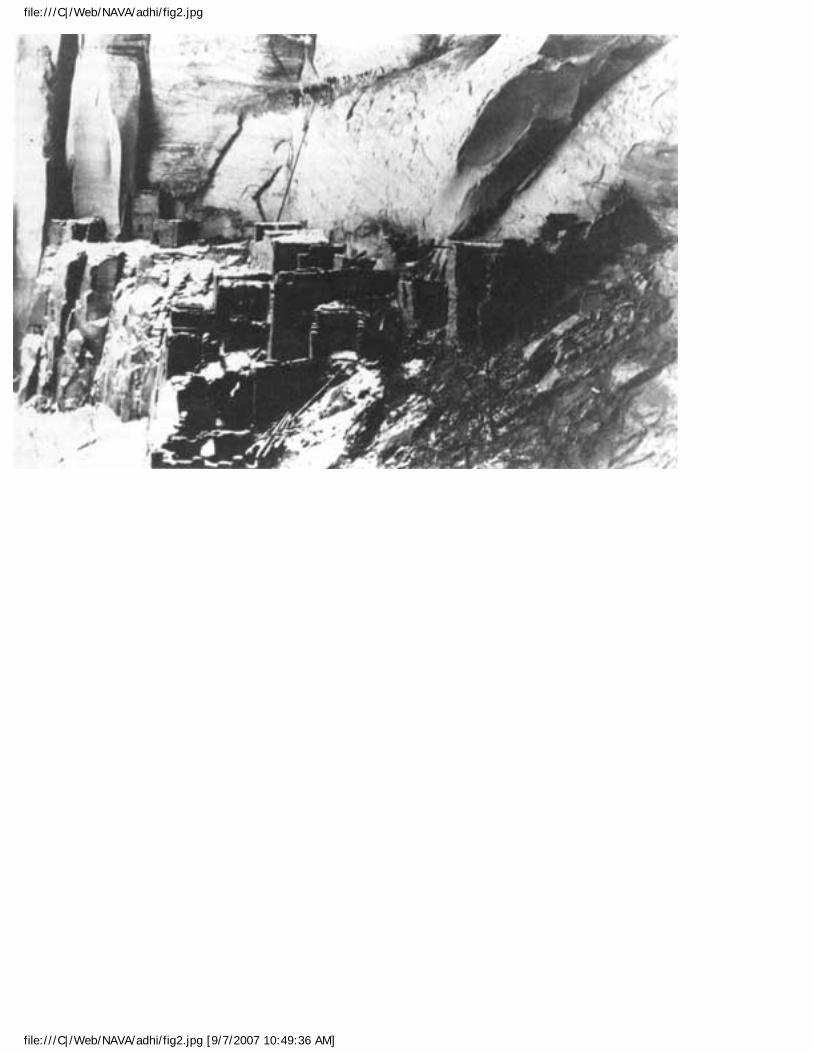
file:///C|/Web/NAVA/adhi/fig2.jpg
file:///C|/Web/NAVA/adhi/fig2.jpg [9/7/2007 10:49:36 AM]
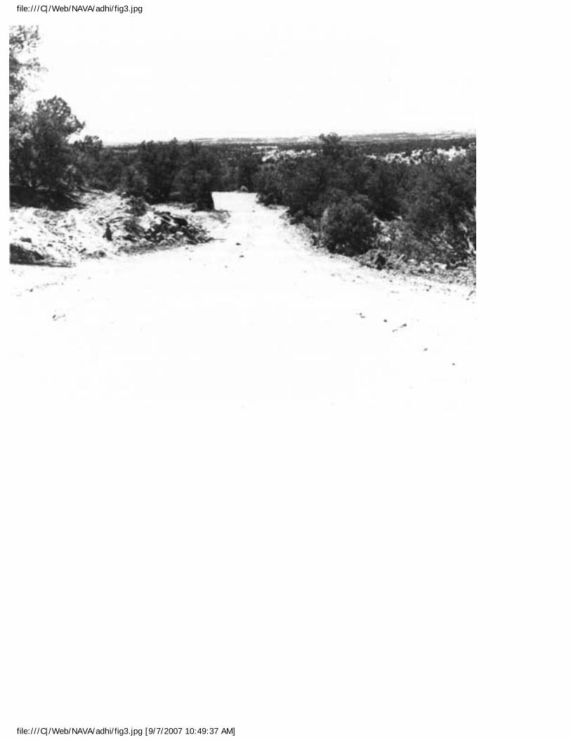
file:///C|/Web/NAVA/adhi/fig3.jpg
file:///C|/Web/NAVA/adhi/fig3.jpg [9/7/2007 10:49:37 AM]
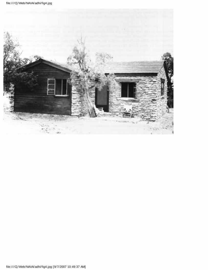
file:///C|/Web/NAVA/adhi/fig4.jpg
file:///C|/Web/NAVA/adhi/fig4.jpg [9/7/2007 10:49:37 AM]
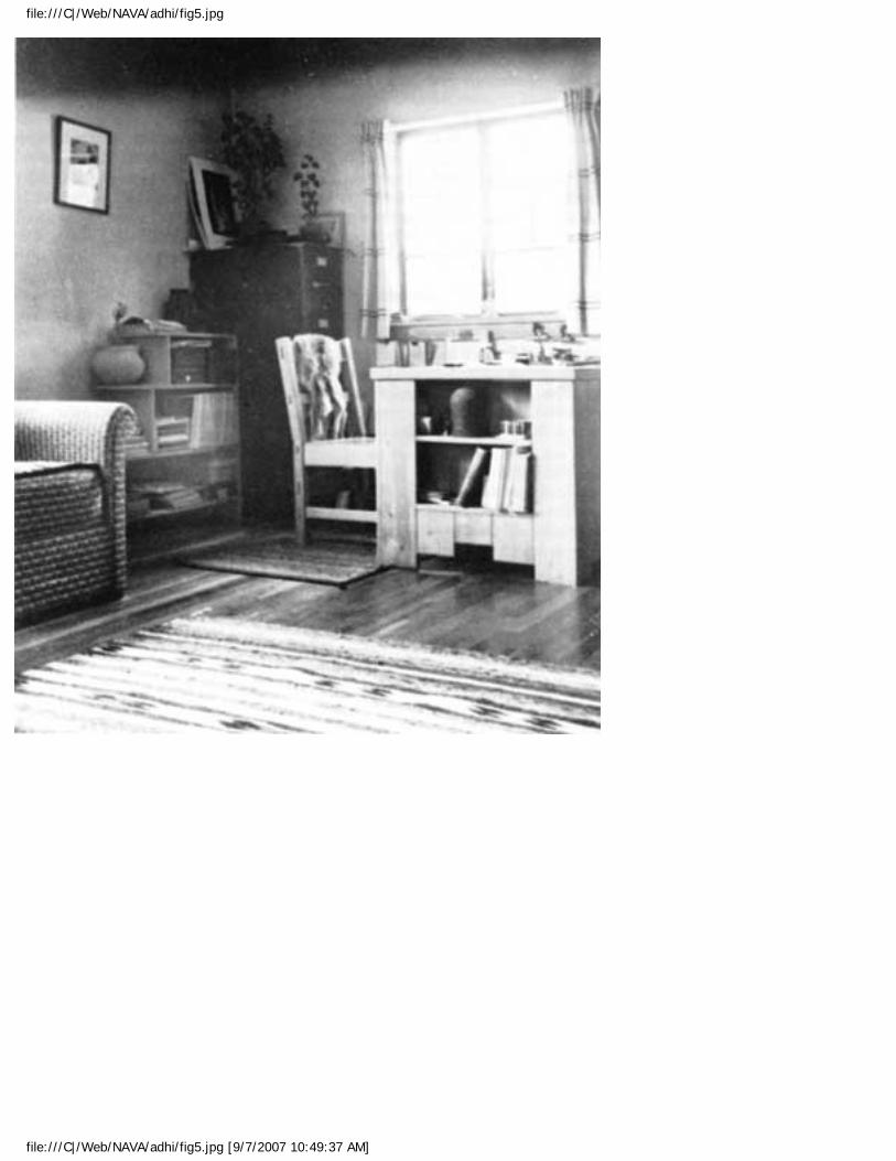
file:///C|/Web/NAVA/adhi/fig5.jpg
file:///C|/Web/NAVA/adhi/fig5.jpg [9/7/2007 10:49:37 AM]
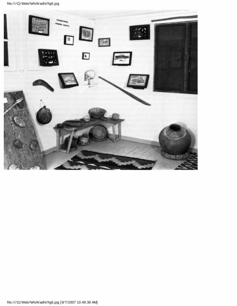
file:///C|/Web/NAVA/adhi/fig6.jpg
file:///C|/Web/NAVA/adhi/fig6.jpg [9/7/2007 10:49:38 AM]
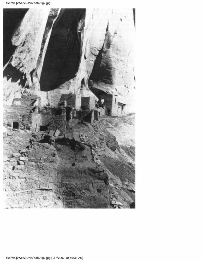
file:///C|/Web/NAVA/adhi/fig7.jpg
file:///C|/Web/NAVA/adhi/fig7.jpg [9/7/2007 10:49:38 AM]
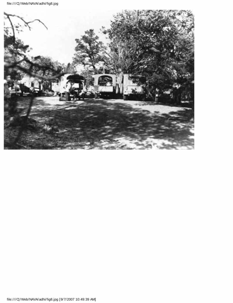
file:///C|/Web/NAVA/adhi/fig8.jpg
file:///C|/Web/NAVA/adhi/fig8.jpg [9/7/2007 10:49:39 AM]
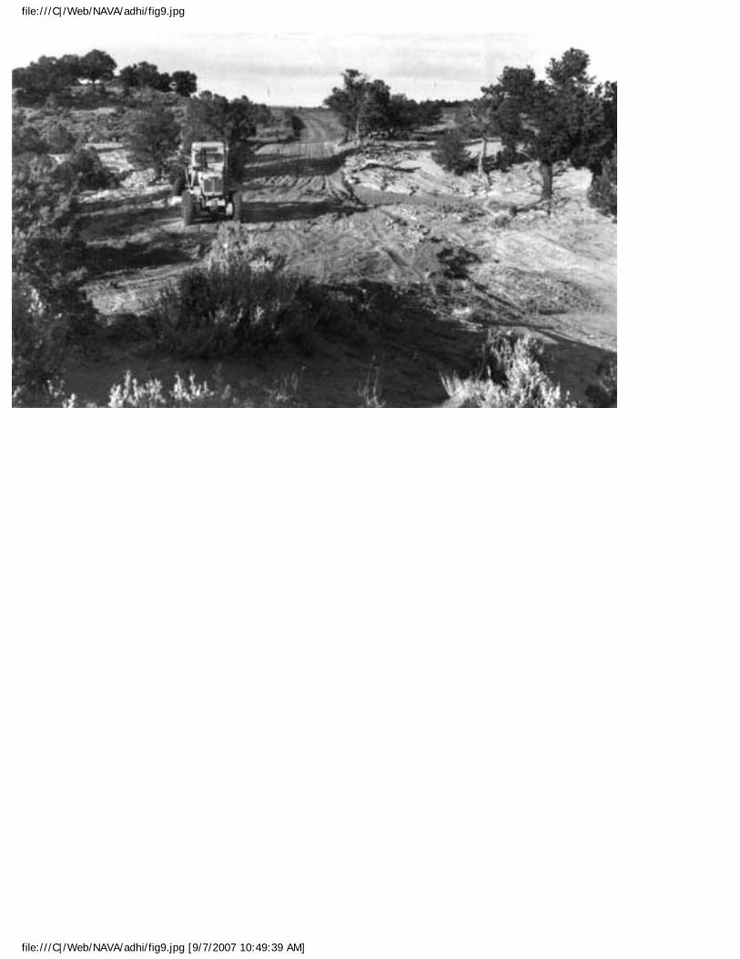
file:///C|/Web/NAVA/adhi/fig9.jpg
file:///C|/Web/NAVA/adhi/fig9.jpg [9/7/2007 10:49:39 AM]
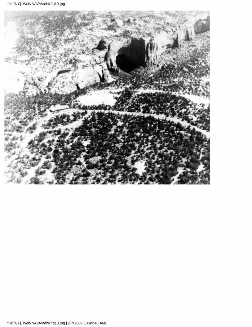
file:///C|/Web/NAVA/adhi/fig10.jpg
file:///C|/Web/NAVA/adhi/fig10.jpg [9/7/2007 10:49:40 AM]
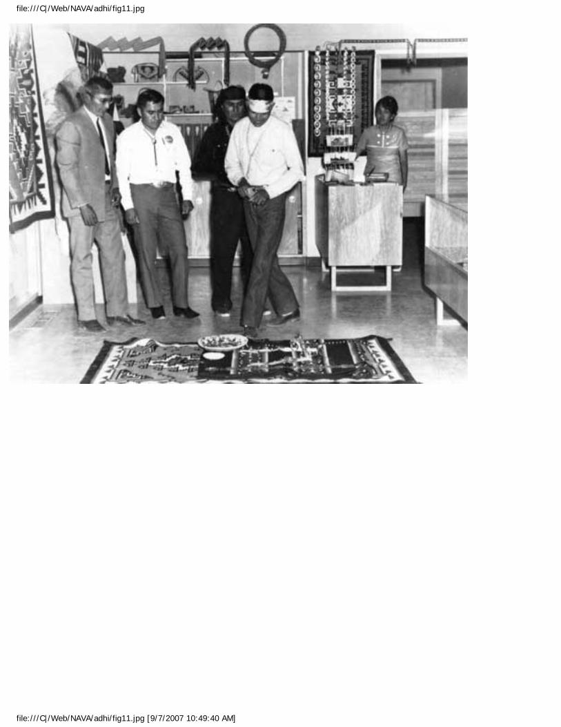
file:///C|/Web/NAVA/adhi/fig11.jpg
file:///C|/Web/NAVA/adhi/fig11.jpg [9/7/2007 10:49:40 AM]
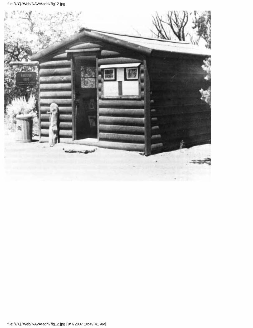
file:///C|/Web/NAVA/adhi/fig12.jpg
file:///C|/Web/NAVA/adhi/fig12.jpg [9/7/2007 10:49:41 AM]
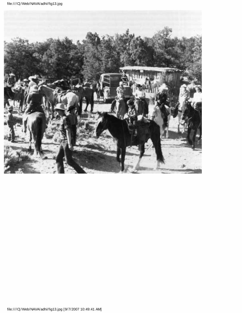
file:///C|/Web/NAVA/adhi/fig13.jpg
file:///C|/Web/NAVA/adhi/fig13.jpg [9/7/2007 10:49:41 AM]
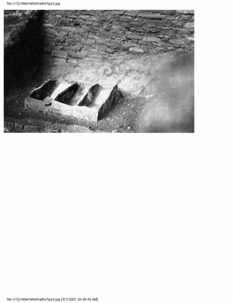
file:///C|/Web/NAVA/adhi/fig14.jpg
file:///C|/Web/NAVA/adhi/fig14.jpg [9/7/2007 10:49:43 AM]

file:///C|/Web/NAVA/adhi/fig15.jpg
file:///C|/Web/NAVA/adhi/fig15.jpg [9/7/2007 10:49:43 AM]
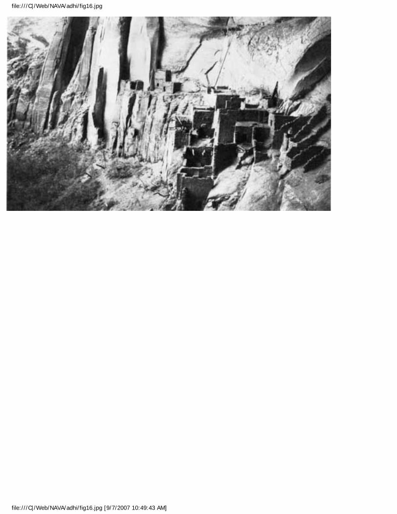
file:///C|/Web/NAVA/adhi/fig16.jpg
file:///C|/Web/NAVA/adhi/fig16.jpg [9/7/2007 10:49:43 AM]
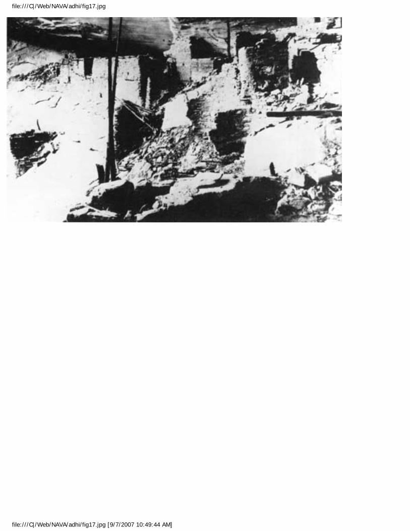
file:///C|/Web/NAVA/adhi/fig17.jpg
file:///C|/Web/NAVA/adhi/fig17.jpg [9/7/2007 10:49:44 AM]
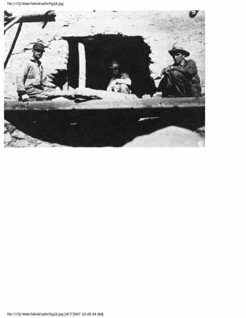
file:///C|/Web/NAVA/adhi/fig18.jpg
file:///C|/Web/NAVA/adhi/fig18.jpg [9/7/2007 10:49:44 AM]
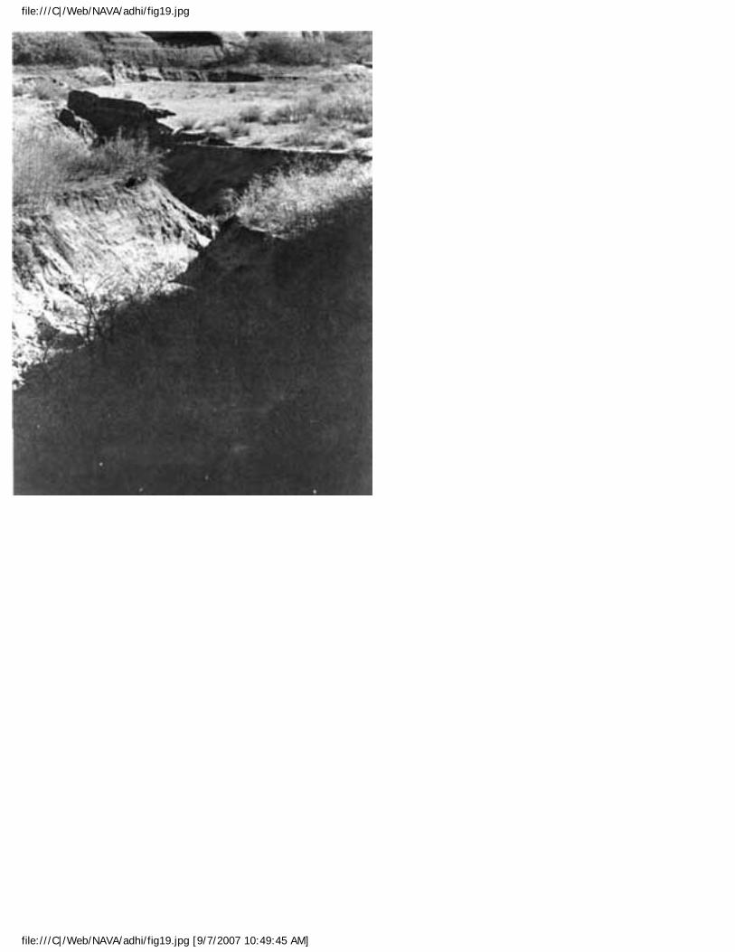
file:///C|/Web/NAVA/adhi/fig19.jpg
file:///C|/Web/NAVA/adhi/fig19.jpg [9/7/2007 10:49:45 AM]
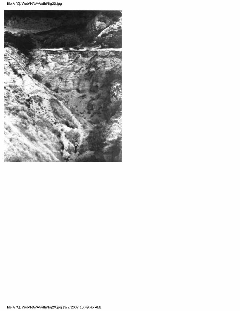
file:///C|/Web/NAVA/adhi/fig20.jpg
file:///C|/Web/NAVA/adhi/fig20.jpg [9/7/2007 10:49:45 AM]
Navajo NM: An Administrative History (Endnotes)
Navajo
Administrative History
ENDNOTES
CHAPTER 1
1. "Statement for Management: Navajo National Monument," (Navajo National Monument: National Park Service, 1987), 3-4.
2. Scott E. Travis, "Draft Archeological Survey of Navajo National Monument," January 5, 1990. This document is not paginated.
3. Ibid; see also Donald L. Baars, The Colorado Plateau: A Geologic History (Albuquerque: University of New Mexico Press, 1983), 175-221.
4. Ibid; Jeffrey S. Dean, "Ts'e Yaa Kin: Houses Beneath the Rock," Exploration: Annual Bulletin of the School of American Research, 2-13.
5. Jonathan Haas, "The Evolution of the Kayenta Anasazi," Exploration: Annual Bulletin of the School of American Research, 14-23.
6. Travis, "Draft Survey."
7. Ibid; Haas, "Evolution of the Kayenta Anasazi," 14-23;
8. Travis, "Draft Survey."
9. Ibid.
file:///C|/Web/NAVA/adhi/adhie.htm (1 of 25) [9/7/2007 10:49:51 AM]
Navajo NM: An Administrative History (Endnotes)
10. Dean, "House Beneath the Rock," 2-13; Jeffrey S. Dean, Chronological Analysis of Tsegi Phase Sites in Northeastern Arizona (Tucson: University of Tucson, 1969).
11. David Brugge, "Navajo Prehistory and History to 1850," in Alfonso Ortiz ed. Handbook of North American Indians: Volume 10 Southwest (Washington, D. C.: Smithsonian Institution, 1983), 489-501.
12. Ibid; Travis, "Draft Survey."
13. Elizabeth A. H. John, Storms Brewed in Other Men's Worlds: The Confrontation of Indians, Spanish, and French in the Southwest, 1540-1795 (Lincoln: University of Nebraska Press, 1975), 58-154; Urs Bitterli, Cultures in Conflict: Encounters Between European and Non-European Cultures, 1492-1800, (Stanford: Stanford University Press, 1989), 20-51; Alfred W. Crosby, Ecological Imperialism: The Biological Expansion of Europe, 900-1900 A. D. (Cambridge: Cambridge University Press, 1986), .
14. Raymond Friday Locke, The Book of the Navajo (Los Angeles: Mankind Publishing Company, 1989) 4th edition, 153-54; John, Storms Brewed in Other Men's Worlds, 29-33, Jack D. Forbes, Apache, Navaho, and Spaniard (Norman: University of Oklahoma Press), 55-63.
15. Locke, Book of the Navajo, 157-58; John, Storms Brewed in Other Men's World, 47-50.
16. Ibid.
17. Forbes, Apache, Navaho, Spaniard, 110; Frank McNitt, Navajo Wars: Miltary Campaigns, Slave Raids and Reprisals (Albuquerque: University of New Mexico Press, 1972) 12-13.
18. Edward H. Spicer, Cycles of Conquest: The Impact of Spain, Mexico, and the United States on the Indians of the Southwest 1533-1960 (Tucson: University of Arizona Press, 1962), 1-15, 210-13; Brugge, "Navajo Prehistory and History to 1850," 489-501; Locke, Book of the Navajo, 186-87.
19. Joseph P. S&aucute;nchez, The Rio Abajo Frontier 1540-1692: A History of Early Colonial New Mexico (Albuquerque: The Albuquerque Museum, 1987) 1-142; Spicer, Cycles of Conquest, 21-23, 210-29; John, Storms Brewed in Other Men's Worlds, 233-35.
20. Locke, Book of the Navajo, 196, 202-204.
21. Ibid, 203-05; Robert A. Roessel, Jr., "Navajo History, 1850-1923," in Alfonso Ortiz ed. Handbook of North American Indians: Volume 10 Southwest (Washington, D. C.: Smithsonian Institution, 1983), 506-23.
file:///C|/Web/NAVA/adhi/adhie.htm (2 of 25) [9/7/2007 10:49:51 AM]
Navajo NM: An Administrative History (Endnotes)
22. Ibid; Locke, Book of the Navajo, 199-361. The Long Walk, as the policy of forced removal of Navajos to eastern New Mexico was known to the Dinè, was the pivotal moment in Navajo history. Many define time in terms the exile: events happened before or after the Bosque Redondo. As a result, Navajos ceased to be a military enemy of New Mexico Territory and instead began the long process of finding their place within a hostile socio-cultural structure. Aptly referred as the last Navajo war, the events that led up to the removal reflected the policies of the era: Indians had to become civilized or be threatened with extinction. While the reservations established for Indians were ostensibly designed to teach agriculture, practices there revealed a concerted effort to make Indians accept white ways of living. This removed any threat of Indian depredation of western communities, freed their land for use by settlers and others, and showed the power and force of the American military. Assimilation was not yet a goal of Indian policy. Keeping Indians away from settlers, ranchers, and communities was. See Lynn R. Bailey, The Long Walk: A History of the Navajo Wars, 1848-68 (Los Angeles: Westernlore Press, 1964); Frank McNitt, Navajo Wars: Military Campaigns, Slave Raids, and Reprisals (Albuquerque: University of New Mexico Press, 1972); and Bill P. Acrey, Navajo History: The Land and the People (Shiprock, NM: Department of Curriculum Materials Development, 1988), for more.
23. Locke, Book of the Navajo, 376-90; Roessel, "Navajo History 1850-1923," 506-23.
24. Richard White, The Roots of Dependency: Subsistence, Environment, and Social Change Among the Choctaws, Pawnees, and Navajos (Lincoln: University of Nebraska Press, 1984), 215.
25. White, Roots of Dependency, 215-49.
26. Ibid, 216-19; Lawrence Kelly, The Navajo Indians and Federal Indian Policy (Tucson: University of Arizona Press, 1968), 22-25.
27. Frank McNitt, The Indian Traders, (Norman: University of Oklahoma Press, 1962), 68-86.
CHAPTER 2
1. Hal Rothman, Preserving Different Pasts: The American National Monuments (Urbana: University of Illinois Press, 1989), 9-15.
2. Curtis M. Hinsley, Jr., Savages and Scientists: The Smithsonian Institution and the Development of American Anthropology 1846-1910 (Washington, D. C.: Smithsonian Institution Press, 1981), 125-44; Robert Rydell, All the World's A Fair: Visions of Empire at American International Expositions, 1876-1916 (Chicago: University of Chicago Press, 1984), 2-8.
file:///C|/Web/NAVA/adhi/adhie.htm (3 of 25) [9/7/2007 10:49:51 AM]
Navajo NM: An Administrative History (Endnotes)
3. Rothman, Preserving Different Pasts, 34-51.
4. Frank McNitt, Richard Wetherill: Anasazi (Albuquerque: University of New Mexico Press, 1957), 79-83; Sallie Brewer Van Valkenburgh, "Some Sources of Information on Archeological Investigations and Stabilizations, Navajo National Monument," July 1963, Navajo National Monument files, Western Archeological and Conservation Center, Tucson, Arizona.
5. C. W. Ceram, Gods, Graves, and Scholars: The Story of Archeology, (New York: Alfred A. Knopf, 1979), 30-67; Gordon R. Willey and Jeremy A. Sabloff, A History of American Archeology (London: Thames and Hudson, 1974), 21-41.
6. McNitt, Anasazi, 153-63.
7. White, Roots of Dependency, 243-47; Clyde Kluckhorn and Dorothea Leighton, The Navaho (Cambridge: Harvard University Press, 1946), 79-80.
8. Neil M. Judd, Men Met Along the Trail: Adventures in Archaeology (Norman: University of Oklahoma Press, 1968), 29-30.
9. Judd, Men Met Along the Trail, 30; Frances Gillmor and Louisa Wade Wetherill, Traders to the Navajo: The Story of the Wetherills of Kayenta (Albuquerque: University of New Mexico Press, 1934), 47-54, 61-62.
10. Elizabeth Compton Hegemann, Navaho Trading Days (Albuquerque: University of New Mexico Press, 1963), 227.
11. Gordon R. Willey, Portraits in American Archaeology: Remembrances of Some Distinguished Americanists (Albuquerque: University of New Mexico Press, 1988), 3-24; Judd, Men Met Along the Trail, 3-4.
12. Judd, Men Met Along the Trail, 7-33.
13. Judd, Men Met Along the Trail, 22; John Wetherill, "Keet Zeel," March 20, 1934, file H-14, Navajo National Monument library; for more on Hewett's activities, see Hal K. Rothman, On Rims and Ridges: The Los Alamos Area Since 1880 (Lincoln: University of Nebraska Press, 1992); and Edgar L. Hewett Papers, Box 22, Museum of New Mexico History Library, Santa Fe.
14. William B. Douglass to Commissioner of the General Land Office, March 3, 1909, Navajo National Monument file, Series 6, Record Group 79, National Archives.
file:///C|/Web/NAVA/adhi/adhie.htm (4 of 25) [9/7/2007 10:49:51 AM]
Navajo NM: An Administrative History (Endnotes)
15. Ibid., John Wetherill to William B. Douglass, March 7, 1909; William B. Douglass to Commissioner of the General Land Office, March 8, 1909, Navajo National Monument file, Series 6, Record Group 79, National Archives.
16. Ibid., William B. Douglass to Commissioner of the General Land Office, March 22, 1909, Navajo, Series 6, RG 79, NA.
17. U.S. Statutes at Large 36: 2491 (1909); Rothman, Preserving Different Pasts, 48.
18. Douglass to Commissioner of the General Land Office, March 3, 1909; March 22, 1909, Navajo, 6, RG 79, NA.
19. John Wetherill to William B. Douglass, March 7, 1909, Navajo, 6, RG 79, NA; Judd, Men Met Along the Trail, 38; Gillmor and Wetherill, Traders to the Navajo, 71-97.
20. Rothman, Preserving Different Pasts, 76-80; Beatrice Chauvenet, Hewett and Friends: A Biography of Santa Fe's Vibrant Era (Santa Fe: Museum of New Mexico Press, 1983), 82.
21. Byron L. Cummings, Indians I have Known (Tucson: Arizona Silhouettes, 1952), 25-26; Judd, Men Met Along the Trail, 36.
22. John Wetherill, "Betata Kin," (no date), Library, Navajo National Monument. Much later, Neil Judd incorrectly recalled the discovery of Betatakin as occurring around July 5, 1909 in Men Met Along the Trail, 86-87. All the other accounts from the time suggest that the discovery occurred on August 9. In his memoirs, Judd probably confused the discovery of Inscription House in early July with that of Betatakin in August.
23. Gillmor and Wetherill, Traders to the Navajo, 163; Robert J. Holden, "A History of Navajo National Monument", (unpublished typescript), 11; Neil M. Judd, "The Excavation and Repair of Betatakin," Proceedings of the United States National Museum (Washington, D. C.: Government Printing Office, 1930).
24. Neil M. Judd, "The Discovery of Rainbow Bridge," National Parks Bulletin 9 (1927): 6-16; Judd, Men Met Along the Trail, 41-42; Gillmor and Wetherill, Traders to the Navajo, 169-71.
25. Gillmor and Wetherill, Traders to the Navajo, 169-71; Judd, Men Met Along the Trail, 41-42; Cummings, Indians I Have Known, 39-45; Neil Judd, "The Discovery of Rainbow Bridge," National Parks Bulletin 9 (1927): 6-16; Byron L. Cummings to John and Louisa Wetherill, October 8, 1909, Byron L. Cummings Collection, Arizona Historical Society, Tucson.
file:///C|/Web/NAVA/adhi/adhie.htm (5 of 25) [9/7/2007 10:49:51 AM]
Navajo NM: An Administrative History (Endnotes)
26. William B. Douglass to Commissioner of the General Land Office, March 3, 1909; John Wetherill to William B. Douglass, March 7, 1909; William B. Douglass to Commissioner of the General Land Office, March 8, 1909; William B. Douglass to Commissioner of the General Land Office, March 22, 1909, John Wetherill to S. V. Proudfit, Acting Commissioner of Indian Affairs, August 24, 1909; William B. Douglass to William Henry Holmes, September 13, 1909, Navajo, Series 6, RG 79, NA.
27. Rothman, On Rims and Ridges, .
28. S. V. Proudfit to John Wetherill, August 9, 1909; John Wetherill to S. V. Proudfit, August 24, 1909, Navajo, Series 6, RG 79, NA.
29. William Henry Holmes to William B. Douglass, August 19, 1909; William B. Douglass to William Henry Holmes, September 13, 1909, Navajo, Series 6, RG 79, NA.
30. Transcription of an interview with Byron Cummings, July 1942, interviewer unknown, H14, historical file, Navajo National Monument Library; Byron L. Cummings, fieldbook, 68, 123-24, Byron L. Cummings Collection, Arizona Historical Society, Tucson.
31. William B. Douglass to William Henry Holmes, September 13, 1909, Navajo, Series 6, RG 79, NA; Willey, Portraits in American Archaeology, 8; Roy G. Mead, Report to the Commissioner of the General Land Office, May 29, 1914, Navajo, Series 6, RG 79, NA.
32. Frank Pierce to Secretary of the Smithsonian Institution, May 6, 1910, Navajo,Series 6, RG 79, NA; Jesse Walter Fewkes, Preliminary Report on a Visit to the Navaho National Monument Bureau of American Ethnology Report 50 (Washington, D. C.: Government Printing Office, 1911).
33. Judd, Men Met Along the Trail, 3, 99-100; H. C. Rizer to Secretary of the Interior, September 30, 1909; Carmi A. Thompson to H. C. Rizer, October 7, 1909, Navajo, Series 6, RG 79, NA; Gillmor and Wetherill, Traders to the Navajo, 193.
34. Clarence H. Jordan to Commissioner of the General Land Office, January 27, 1912; Frank Pierce to Walter L. Fisher, January 25, 1912; Carmi A. Thompson to Frank Pierce, January 26, 1912; Clarence Jordan to Chief Clerk, Department of the Interior, January 27, 1912; Clarence Jordan to Secretary of the Interior, February 9, 1912; Carmi A. Thompson to Frank Pierce, February 14, 1912; Frank Pierce to Clarence Jordan, February 16, 1912, Navajo, Series 6, RG 79, NA.
35. Acting Secretary of the Interior to Clarence H. Jordan, March 5, 1912; Acting Secretary of the Interior to the President, March 14, 1912, Navajo, Series 6, RG 79, NA; U.S. Statutes at Large 37: 1733 (1912).
file:///C|/Web/NAVA/adhi/adhie.htm (6 of 25) [9/7/2007 10:49:51 AM]
Navajo NM: An Administrative History (Endnotes)
CHAPTER 3
1. Rothman, Preserving Different Pasts, 74-89.
2. Ibid, 74-75.
3. Judd, Men Met Along the Trail, 46-54.
4. Roy G. Mead, "Report to the Commissioner of the General Land Office," May 29, 1914, Navajo, Series 6, RG 79, NA.
5. W. J. Lewis to Commissioner of General Land Office, July 15, 1916, Navajo, Series 6, RG 79, NA.
6. Ibid.
7. Rothman, Preserving Different Pasts, 83-84.
8. John Ise, Our National Park Policy: A Critical History (Baltimore: Johns Hopkins University Press, 1961), 185-93; Runte, National Parks, 98-104; Robert Shankland, Steve Mather of the National Parks 3rd ed. (New York: Alfred A. Knopf, 1970), 51-53, 100-06.
9. Hal Rothman, "A Regular Ding-Dong Fight: Agency Culture and Evolution in the NPS-USFS Dispute 1916-1937," Western Historical Quarterly 20 (May 1989):141-62.
10. Ronald A. Foresta, America's National Parks and Their Keepers (Washington, D. C.: Resources for the Future, 1984), 18-30.
11. Rothman, Preserving Different Pasts, 89-116.
12. Joseph J. Cotter to John Wetherill, April 13, 1916; Horace M. Albright to John Wetherill, April 27, 1917; F. W. Griffith to John Wetherill, August 6, 1917; F. W. Griffith to John Wetherill, August 16, 1917, Navajo, Series 6, RG 79, NA.
13. John Wetherill to F. W. Griffith, August 18, 1917, Navajo, Series 6, RG 79, NA.
14. Charles D. Walcott to Robert B. Marshall, December 18, 1916, Navajo, Series 6, RG 79, NA.
file:///C|/Web/NAVA/adhi/adhie.htm (7 of 25) [9/7/2007 10:49:51 AM]
Navajo NM: An Administrative History (Endnotes)
15. Henry Ashurst to Franklin K. Lane, January 30, 1917; Byron L. Cummings to Henry Ashurst, no date; Byron L. Cummings to Marcus A. Smith, January 25, 1917; Marcus A. Smith to Secretary of the Interior, January 30, 1917; Joseph J. Cotter to Henry F. Ashurst, February 5, 1917; Joseph J. Cotter to Marcus A. Smith, February 5, 1917; Charles D. Walcott to Bo Sweeney, February 7, 1917; Charles D. Walcott to Bo Sweeney, Navajo, Series 6, RG 79, NA; Henry F. Ashurst to Byron L. Cummings, January 30, 1917; Joseph J. Cotter to Henry F. Ashurst, February 5, 1917; Charles D. Walcott to Byron L. Cummings, February 27, 1917, Byron L. Cummings Collection, Arizona State Museum, Tucson.
16. Judd, Men Met Along the Trail, 85.
17. Ibid., 85-86.
18. Ibid., 86-93; Neil Judd to William Henry Holmes, November 6, 1917, Navajo, Series 6, RG 79, NA.
19. Rothman, Preserving Different Pasts, 89-118.
20. Ibid., 119-40.
21. Judd, Men Met Along the Trail, 42-43, 86.
22. McNitt, Anasazi, 79-80; Seasonal Ranger Turpen to Superintendent, Navajo, May 26, 1971, File H14, Navajo National Monument Library; Fewkes, A Preliminary Visit to Navajo, 5-9; Hegemann, Navaho Trading Days, 225.
23. Fred S. Garing, untitled memoir, May 1971, Navajo National Monument Library; Hegemann, Navaho Trading Days, 224.
24. Diary of M. D. Thomas, File H1815, Navajo National Monument.
25. Hegemann, Navaho Trading Days, 274-75, 293.
26. Frank Pinkley to Harry Rorick, May 22, 1931, Navajo, Series 6, RG 79, NA; Rothman, Preserving Different Pasts, 114-15, 178-82.
27. Elizabeth Rorick to Horace Albright, July 26, 1931, Navajo, Series 6, RG 79, NA. Elizabeth Rorick and Elizabeth Compton Hegemann are the same person. Compton was her maiden name, and she took the name of each of her husbands. Nor was she self-conscious about her frequent changes of name. She closed her 1931 letter to Albright: "I think you remember me, but as the Mrs. Harrison of several years ago--in Navajo costume."
file:///C|/Web/NAVA/adhi/adhie.htm (8 of 25) [9/7/2007 10:49:51 AM]
Navajo NM: An Administrative History (Endnotes)
28. Hegemann, Navaho Trading Days, 251.
29. Agnes M. Cleaveland to Arno B. Cammerer, October 11, 1933; A. E. Demaray to Frank Pinkley, January 18, 1934; A. E. Demaray to Frank Pinkley, January 20, 1934; Frank Pinkley to Horace M. Albright, January 25, 1934, Navajo, Series 6, RG 79, NA; Irwin Hayden to Frank Pinkley, February 16, 1934, Frank Pinkley to Arno B. Cammerer, June 30, 1934, Navajo National Monument file, Western Archeological and Conservation Center.
30. Frank Pinkley to Arno B. Cammerer, February 9, 1934, Navajo, Series 7, RG 79, NA.
31. Walter Atwell to Frank Pinkley, March 9, 1934, Navajo, Series 7, RG 79, NA.
32. Gladwell Richardson and Phillip Reed Rulon ed., Navajo Trader (Tucson: University of Arizona Press, 1986), 93-94.
33. Ansel Hall to Frank Pinkley, January 20, 1930; Frank Pinkley to Ansel Hall, February 12, 1930, File 000 General, Navajo National Monument Library.
34. Ise, Our National Park Policy 255-61; Horace Albright memo to Arno B. Cammerer, Arthur E. Demaray, W. B. Lewis, and George Moskey, March 15, 1930, Navajo, Series 6, RG 79, NA.
35. Roger Toll to Horace M. Albright, March 13, 1931; Roger Toll, "Report on the "Proposed Navajo National Park," April 29, 1931, 000 General, Navajo National Monument Library.
36. Horace Albright to Charles J. Rhoads, June 12, 10931; Horace Albright to Robert S. Yard, June 15, 1931; O-32, Proposed National Parks, Navajo, RG 79, NA.
37. Charles J. Rhoads to Horace M. Albright, June 19, 1931, 0-32, Navajo, RG 79, NA; White, Roots of Dependency, 218-19, 248-49.
38. Conrad L. Wirth, memo, August 8, 1931; Brooks memo for George A. Moskey, November 4, 1931; George A. Moskey, memo to Conrad L. Wirth, November 19, 1931; Horace M. Albright to Charles J. Rhoads, December 5, 1931; Charles J. Rhoads to Horace M. Albright, December 11, 1931, 0-32, Navajo, RG 79, NA.
39. Donald L. Parman, The Navajo and the New Deal (New Haven: Yale University Press, 1976), 1-41; Conrad L. Wirth, memo to H. C. Bryant, April 24, 1933; "Proposed Navajo National Park," attached to Wirth memo, 0-32, Navajo, RG 79, NA; 72nd Congress, P. L. 403, An Act to Permanently Set Aside Certain Lands in Utah as an Addition to the Navajo Reservation and for Other Purposes.
file:///C|/Web/NAVA/adhi/adhie.htm (9 of 25) [9/7/2007 10:49:51 AM]
Navajo NM: An Administrative History (Endnotes)
40. Horace M. Albright as told to Robert Cahn, The Birth of the National Park Service: The Founding Years 1913-1933, 275, 282-97; "Proposed Navajo National Park," attached to Wirth memo, 0-32, Navajo, RG 79, NA.
41. M. R. Tillotson to Horace M. Albright, September 20, 1933, 0-32, Navajo, RG 79, NA.
42. Parman, Navajo and the New Deal, 42-48, 133-59; White, Roots of Dependency, 252-89.
43. Rothman, Preserving Different Pasts, 162-69.
44. Holden, "A History of Navajo National Monument," 17.
45. Frank Pinkley to Arno B. Cammerer, June 20, 1934, Navajo, Series 7, RG 79, NA.
46. Robert H. Rose to Arno B. Cammerer, July 28, 1934, File 000, General, Navajo National Monument Library.
47. John Wetherill to Frank Pinkley, May 29, 1938, Navajo National Monument file, Western Archeological and Conservation Center, Tucson; John Wetherill profile, File H1815, Navajo National Monument Library.
48. "Southwestern National Monuments Monthly Report," March 1938, 204-05; "Southwestern National Monuments Monthly Report," April 1938, 294-96.
CHAPTER 4
1. Sallie Brewer Van Valkenburgh to Robert Holden, February 11, 1965, File H14, Navajo National Monument.
2. Ibid.
3. Frank A. Kittredge to Arno B. Cammerer, May 28, 1934, Navajo National Monument File, Western Archeological and Conservation Center.
4. Frank A. Kittredge to Arno B. Cammerer, April 7, 1934; J. E. Balmer, Superintendent Western Agency, to John Wetherill, December 23, 1933; A. E. Demaray to Frank A. Kittredge, June 16, 1934, Navajo National Monument files, Western Archeological and Conservation Center.
file:///C|/Web/NAVA/adhi/adhie.htm (10 of 25) [9/7/2007 10:49:51 AM]
Navajo NM: An Administrative History (Endnotes)
5. W. B. McDougall, "Special Report: Beaver Habitat at Navajo National Monument," August 28, 1939; Natt N. Dodge to James W. Brewer, December 5, 1939; Hilary A. Tolson to Hugh Miller, no date, Navajo files, Western Archeological and Conservation Center.
6. Charles A. Richey, "Report of Inspection of Navajo National Monument," November 9, 1940, File 600, National Monument Library.
7. James L. Brewer to Byron L. Cummings, August 14, 1942, Byron L. Cummings Collection, Arizona Historical Society.
8. Holden, "Administrative History," 22; William Wilson to Newton P. Drury, June 30, 1944; William Wilson to Newton P. Drury, August 3, 1945, Navajo, File A26, Western Archeological and Conservation Center Library, Tucson.
9. Eric Goldman, The Crucial Decade--and After: America 1945-1960 (New York: Random House, 1956) 4-5, 12-15; Bernard DeVoto, "The National Parks" Fortune 35 (June 1947): 120-21; Runte, National Parks, 156-61.
10. James L. Brewer, "Memorandum for the Director," June 8, 1948, Navajo, Report 1a1, Navajo National Monument; "Calendar Year Visitation Statistics," A3015: Reports, Travel, Monthly, Navajo National Monument.
11. James Brewer to Newton P. Drury, March 4, 1949; James Brewer to Newton P. Drury, July 11, 1949; John M. Davis to James Brewer, June 3, 1948, Navajo, File, A26, WACC.
12. James Brewer to Superintendent, November 18, 1940, Navajo National Monument file, WACC; Charles A. Richey, "Report of Inspection of Navajo National Monument," November 9, 1940, File 600, National Monument Library.
13. Bob Black, interview with Hal Rothman, translated by Clarence N. Gorman, January 5, 1991; Rothman, Preserving Different Pasts, 140-44.
14. Holden, "Administrative History," 24-25; Rothman, Preserving Different Pasts, 180-84; Hugh Miller to John M. Davis, May 8, 1953, H3015, Navajo National Monument.
15. Hubert Laughter, interview with Hal Rothman, translated by Clarence N. Gorman, January 5, 1991; John Aubuchon to John M. Davis, March 15, 1953, Navajo, D32, Grounds, Denver Federal Records Center.
file:///C|/Web/NAVA/adhi/adhie.htm (11 of 25) [9/7/2007 10:49:51 AM]
Navajo NM: An Administrative History (Endnotes)
16. James W. Brewer, "Navajo National Monument Monthly Report," September 23, 1942; William W. Wilson to M. R. Tillotson, July 21, 1944; James W. Brewer to Erik Reed, April 12, 1948, Navajo National Monument file, WACC; John Aubuchon to John M. Davis, March 15, 1953, Navajo, D32 Grounds, Denver Federal Records Center; Davis to Aubuchon, May 13, 1953; Aubuchon to Davis, June 17, 1953, Navajo, H30 Archeological and Historical Structures, Denver Federal Records Center; Gordon R. Vivian to John M. Davis, August 17, 1954, Navajo, H2215 Archeological and Historical Research, Denver Federal Records Center.
17. John J. Aubuchon to John M. Davis, June 17, 1953; M. R. Tillotson to John M. Davis, July 2, 1953, Navajo, H30 Archeological and Historic Structures, Denver Federal Records Center.
18. John J. Aubuchon, "Report on Diorama of Keet Seel Ruin, Navajo National Monument, no date, Navajo National Monument file, Southwest Regional Office Interpretation Library, Santa Fe.
19. Interpretation, 069.5, NAVA 1247, Navajo National Monument archive; Hal Rothman interview with Hubert Laughter, translated by Clarence N. Gorman, January 5, 1991.
20. Ise, Our National Park Policy, 546-50; Rothman, 222-23.
21. Peter Iverson, The Navajo Nation (Westport, CT: Greenwood Press, 1981), 56-57.
22. Superintendent's Monthly Narrative, March 1958, Navajo National Monument Library.
23. Sanford Hill to Hugh Miller, July 5, 1957, Navajo, D30: Roads and Trails; Edward B. Danson to Hugh Miller, November 25, 1958, Navajo, D3415: Buildings; "MISSION 66 Prospectus: Navajo National Monument, April 20, 1956," A9815: MISSION 66 Programs, Denver Federal Records Center.
24. Buddy Martin interview with Hal Rothman, Durango, Colorado, August 10, 1990.
25. Art White to Hugh Miller, August 28, 1960, D3415 Buildings: Construction and Maintenance, Denver Federal Records Center.
26. Buddy Martin interview with Hal Rothman, August 10, 1990.
27. Art White interview with Richard B. McCaslin, June 9, 1990; Bob Black interview with Hal Rothman, translated by Mary Lou Smith and Clarence N. Gorman, January 5, 1991.
28. Superintendent's Monthly Report, March 1958, Navajo; Hugh Miller to John M. Davis, May 25, 1956, Navajo, A9815: MISSION 66, Denver Federal Records Center.
file:///C|/Web/NAVA/adhi/adhie.htm (12 of 25) [9/7/2007 10:49:51 AM]
Navajo NM: An Administrative History (Endnotes)
29. James L. Brewer to Frank Pinkley, December 1, 1938, 000 General, Denver Federal Records Center.
30. Bill P. Acrey, Navajo History, 281-85.
31. Superintendent's Monthly Report, July 1958, Navajo.
32. Remarks of Meredith M. Guillet at Southwest Region Superintendent's Conference, March 24, 1965, A82 Special Events, Denver Federal Records Center; Bob Black interview, January 5, 1991; Superintendent's Monthly Report, June 1958, Navajo.
33. Superintendent's Monthly Report, July 1961.
34. Superintendent's Monthly Report, July 1958; Holden, "Administrative History," 26.
35. Superintendent's Monthly Report, March 1958; June 1958; April 1960, Navajo.
36. "Superintendent's Monthly Narrative Report," November 1959.
37. Superintendent's Monthly Report, March 1961; Thomas Allen to Conrad L. Wirth, December 12, 1961, A82: MISSION 66, Denver Federal Records Center.
38. Superintendent's Monthly Report, November 1961.
39. Superintendent's Monthly Report, July 1962, Navajo.
40. Daniel Beard to Regional Director, April 29, 1966, L1415, Navajo National Monument.
40. Gayle E. Manges to Regional Director, January 28, 1991; Frank F. Kowski to Raymond Nakai, May 26, 1969; Frank F. Kowski to William McPherson, May 20, 1969; Frank F. Kowski to Director, May 12, 1969, John Cook memo to Frank F. Kowski, March 7, 1969, A3815(RD) Southwest Regional Office, Santa Fe.
CHAPTER 5
1. National Park Service, MISSION 66 Prospectus, Navajo National Monument, April 20, 1956, Navajo, A9815: MISSION 66, Denver Federal Records Center.
file:///C|/Web/NAVA/adhi/adhie.htm (13 of 25) [9/7/2007 10:49:51 AM]
Navajo NM: An Administrative History (Endnotes)
2. Bud Martin interview with Hal Rothman, August 10, 1990.
3. Ibid; Art White interview with Richard B. McCaslin, June 10, 1990; 728.992 Visitor Shower text, NPS History file, Navajo National Monument.
4. Art White interview, June 10, 1990.
5. Calendar Year, A3015: Reports, Travel, Monthly, September 30, 1965; Jack R. Williams to Frank H. Carson, January 27, 1966, Navajo, A3815: Public Relations with Federal, State, and Local Agencies, Denver Federal Records Center.
6. Dale S. King to John J. Aubuchon, October 24, 1952, Navajo, D6215 Museum exhibit activities, Navajo National Monument.
7. Acrey, Navajo History, 284; Guillet, "Remarks," March 24, 1965; Sanford Hill to Hugh Miller, July 5, 1957, D30: Roads and Trails, Denver Federal Records Center.
8. E. L. Holmes report, May 29, 1964, D3415 Buildings: Construction and Maintenance, Denver Federal Records Center; Art White interview, June 10, 1990.
9. Press Release, Visitor Center Dedication, no date; A8215: Special Events, Denver Federal Records Center; Superintendent's Monthly Narrative for July 1965, August 4, 1965, A2823, Navajo National Monument.
10. Robert Holden, telephone conversation with Hal Rothman, May 24, 1990; White interview, June 10, 1990.
11. Press release, Visitor Center dedication, no date; Edward B. Danson to Jack R. Williams, June 30, 1966, A8215: Special Events-Dedications.
12. Jack R. Williams to George Hartzog, June 28, 1966, Navajo National Monument, A8215; Jack R. Williams to Regional Director, January 5, 1968, Navajo National Monument, A6423; Jack R. Williams to Regional Director, January 5, 1968, Navajo A6423.
13. Holden conversation with Rothman; Art White to Daniel B. Beard, July 27, 1963, D22: Public Works Acceleration Program, Denver Federal Records Center.
14. Charles B. Voll, John Cook, Richard B. Hardin, Rodney E. Collins, and Albert Schroeder, "Management Appraisal of Navajo National Monument, December 9-10, 1969," 2, Navajo, A5427, Management Appraisals, Navajo National Monument.
file:///C|/Web/NAVA/adhi/adhie.htm (14 of 25) [9/7/2007 10:49:51 AM]
Navajo NM: An Administrative History (Endnotes)
15. Robert Holden telephone conversation; Art White interview; P. J. Ryan telephone conversation with Hal Rothman, May 25, 1990; Bud Martin interview; William G. Binnewies to Acting Regional Chief, Interpretation and Visitor Services, September 13, 1969; Doug Hubbard to Director Southwest Region, August 26, 1970; Monte E. Fitch to William G. Binnewies, September 1, 1970, Navajo National Monument, K1815-OI.
16. Robert S. Luntey to George Miller, February 8, 1968; George Miller to George Hartzog, February 16, 1968, D18, Navajo National Monument.
17. Art White interview; Robert Holden telephone conversation; Bud Martin interview.
18. John Cook to Frank F. Kowski, July 31, 1968, A2215-01, Navajo; John Ochsner to Chief, Denver Service Center, "Report on a Field Trip to Navajo National Monument," April 3, 1967, Navajo, A2623, Denver Federal Records Center.
19. William G. Binneweis to Frank F. Kowski, September 22, 1969, Navajo A6423-A.
20. Art White interview; Albert E. Ward to Chief, Arizona Archeological Center, May 16, 1973, H2215 Navajo-Inscription House, Navajo National Monument Library.
21. John B. Aubuchon to General Superintendent, September 29, 1952, Navajo National Monument file, Western Archeological and Conservation Center, Tucson.
22. Superintendent's Monthly Narrative, April 1961, Navajo National Monument.
23. Art White interview; Bud Martin interview.
24. Charles B. Voll interview with Hal Rothman, December 5, 1989.
25. Voll et. al., "Management Appraisal," December 9-10, 1969.
26. Art White interview.
27. Charles B. Voll interview.
28. Frank Hastings to Hal Rothman, February 25, 1991.
29. William G. Binneweis to Director, December 21, 1970, Navajo, A6435, Southwest Regional Office
file:///C|/Web/NAVA/adhi/adhie.htm (15 of 25) [9/7/2007 10:49:51 AM]
Navajo NM: An Administrative History (Endnotes)
Interpretation Library, Santa Fe.
30. Navajo National Monument Backcountry Management Plan, 1974, H2215 Resource Management Plans, Navajo.
31. Ibid.
32. Frank E. Hastings to Regional Director, Southwest Region, July 6, 1978, F5419, Navajo National Monument.
33. Ronald R. Switzer and Edward D. Carlin, "Management Evaluation, Navajo National Monument," August 24-26, 1982, A5427; Dan Murphy, "Trip Report," August 7, 1980, Navajo, A5425, Southwest Regional Office Interpretation Library.
34. Noberto Ortega interview with Hal Rothman, January 5, 1991; John Loliet interview; see also Bernard Shanks, "The Endangered Ranger" National Parks 65 1-2 (January-February 1991): 32-36.
35. Frank Hastings to Hal Rothman, February 25, 1991.
36. Ibid.
37. Foresta, America's National Parks and Their Keepers, 84-93.
38. Flora Ortega interview with Hal Rothman, February 22, 1990; Switzer and Carlin, "Management Evaluation;" John Laughter interview, January 5, 1991; John Loliet interview.
39. Clarence N. Gorman interview.
40. Bob Black interview; Superintendent's Monthly Narrative, 1989-1990, A2823, Navajo.
41. Jack R. Williams to Adolph Maloney, March 3, 1966, A44 Navajo. This letter to the president of the Tuba City Chapter was a prototype for the presidents of the Oljato, Kayenta, Shonto, and Dinnehotso chapters.
42. David M. Gaines to Chief, Division of Planning and Design, Southwest Region, October 28, 1982, Navajo, A5427, Southwest Regional Office Interpretation Library; Gorman interview.
43. John Laughter interview; Clarence N. Gorman interview; Bruce Mellberg interview with Hal Rothman, January 5, 1991.
file:///C|/Web/NAVA/adhi/adhie.htm (16 of 25) [9/7/2007 10:49:51 AM]
Navajo NM: An Administrative History (Endnotes)
44. Chief, Division of Protection and Visitor Use Management, Southwest Region to Associate Regional Director, Park Operations, April 21, 1981, A7615, Navajo National Monument; Frank Osterwald to Charles B. Voll, April 28, 1982, Navajo, D-30, SWRO Interpretation Library.
45. Switzer and Carlin, "Management Evaluation;" Charles Voll to Robert I. Kerr, May 3, 1982, D-30, Navajo.
46. Clarence N. Gorman interview.
47. John E. Cook to Regional Director, Southwest Region, July 31, 1968, A6435, Navajo National Monument; Navajo National Monument, Revised Statement for Management, Major Issues Section, no date, Navajo National Monument file, Regional Historian's Office, Southwest Regional Office.
48. Bruce Mellberg interview; Clarence N. Gorman interview.
49. Travis, "Draft Archeological Survey;" Superintendent's Monthly Report, January 1963, Navajo National Monument.
50. Hubert Laughter interview; John Loliet interview; P. J. Ryan telephone conversation; Bud Martin interview.
51. Frank Hastings to Hal Rothman, February 25, 1991.
52. John Loliet interview.
CHAPTER 6
1. Compton, Navaho Trading Days, 236.
2. Dale S. King to John J. Aubuchon, October 24, 1952, Navajo, D6215: Museum Exhibit Activities, Denver Federal Records Center; John Cook interview with Hal Rothman, April 24, 1990; Bud Martin interview.
3. Clarence N. Gorman interview; John Cook interview.
4. Bob Black interview; Superintendent's Monthly Narrative, 1956-1962, A2823, Navajo.
file:///C|/Web/NAVA/adhi/adhie.htm (17 of 25) [9/7/2007 10:49:51 AM]
Navajo NM: An Administrative History (Endnotes)
5. Acrey, Navajo History, 201-04; Mary Shepardson, "Development of Navajo Tribal Government," 624-35; Peter Iverson, "The Emerging Navajo Nation," 636-41, in Alfonso Ortiz ed., The Handbook of North American Indians: 10 Southwest (Washington, D. C.: Smithsonian Institution, 1983).
6. John Cook to Regional Director, November 30, 1967, L1425, Navajo National Monument.
7. Hubert Laughter interview; Holden, "Administrative History," 24; Bob Black interview; no author, "Seth Bigman Completes First Season as Interpretive Ranger," Inside Interior (November 1948), 6.
8. Hubert Laughter interview.
9. Delbert Smallcanyon interview with Hal Rothman, translated by Clarence N. Gorman, January 5, 1991.
10. John Laughter interview with Hal Rothman, January 5, 1991.
11. John Laughter interview; Hubert Laughter interview; Bob Black interview; and Delbert Smallcanyon interview.
12. Switzer and Carlin, "Management Appraisal;" Clarence N. Gorman interview; John Laughter interview.
13. Acrey, Navajo History, 35-44, 73-81; Raymond Friday Locke, The Book of the Navajo (Los Angeles: Mankind Publishing Company, 1989) fourth edition, 35-61; McNitt, The Indian Traders, 270-76; White, Roots of Dependency, 236-49.
14. William G. Binnewies telephone conversation with Hal Rothman, May 30, 1990.
15. Ibid.
16. James L. Brewer, "Memorandum for the Regional Director," December 25, 1947, Navajo, P90: Wage Board Matters, Denver Federal Records Center.
17. James L. Brewer to Luis Gastellum, January 15, 1948, Navajo, P90: Wage Board Matters, Denver Federal Records Center.
18. Acrey, Navajo History, 296; Roland Richert to Regional Administrative Officer, August 28, 1958, Navajo National Monument files, P90: Wage Board Matters, Denver Federal Records Center; Meredith Guillet to Regional Director, March 4, 1964, Navajo National Monument L3035.
file:///C|/Web/NAVA/adhi/adhie.htm (18 of 25) [9/7/2007 10:49:51 AM]
Navajo NM: An Administrative History (Endnotes)
19. Acrey, Navajo History, 284; Iverson, "The Emerging Navajo Nation," 636.
20. Reports of the Golden Eagle incident, Golden Eagle file, Navajo National Monument A7623: Accidents, Injuries, and Death.
21. Harold Timmons to Frank Hastings, February 8, 1974, Navajo A3817.
22. Frank Hastings to Regional Director, February 11, 1974, Navajo, A3817.
23. William G. Binneweis telephone conversation.
24. Frank Hastings to Hal Rothman, February 25, 1991; Binnewies telephone conversation; Art White interview with Richard B. McCaslin, June 11, 1990.
25. P. J. Ryan telephone conversation.
26. Delbert Smallcanyon interview with Hal Rothman, translated by Clarence N. Gorman, January 5, 1991; John Cook interview with Hal Rothman, April 24, 1990.
27. John Laughter interview.
28. Mary Lou Smith comments as she translated Bob Black's interview, January 5, 1991; Concessioners, Horse, NPS History file, Navajo National Monument Archive.
29. Mary Whitle to Arthur H. White, November 13, 1962, Navajo National Monument, A36; Edd and Bertha Austin, "Early History of Navajo National Monument," transcript of oral history interviews with Larry Isaacs, no date, H18, Navajo National Monument.
30. Shankland, Steve Mather of the National Parks, 7, 92-99, 120-27.
31. P. J. Ryan telephone conversation;
32. P. J. Ryan telephone conversation; William G. Binnewies telephone conversation; Carl M. Hinckley to Stewart L. Udall, June 17, 1966; Jack R. Williams to Regional Director, September 2, 1966; Mildred Heflin to Jack Williams, August 28, 1966; Thomas M. Newell to Kevin McKibben, July 26, 1967; Barbara Horton to Frank F. Kowski, April 15, 1968, Navajo National Monument, H36.
33. Harold Timmons to Clarence Gorman, April 13, 1973, Navajo National Monument, A36.
file:///C|/Web/NAVA/adhi/adhie.htm (19 of 25) [9/7/2007 10:49:51 AM]
Navajo NM: An Administrative History (Endnotes)
34. P. J. Ryan telephone conversation.
35. Frank Hastings to Fannie Etcitty, September 6, 1979, A44: Arts and Crafts Shop, Navajo National Monument.
36. Art White to Peter McDonald, March 18, 1980; Frank E. Paul to Art White, June 6, 1980; Robert Wilson to Fannie Etcitty, June 16, 1980, A44: Arts and Craft Shop, Navajo.
37. Switzer and Carlin, "Management Appraisal."
38. Cloyd Kump to Associate Regional Director for Park Operations, Southwest Regional Office, August 11, 1988; Clarence Gorman to John Cook, September 9, 1988, A44: Arts and Craft Shop, Navajo.
39. Delbert Smallcanyon interview; Bob Black interview.
40. P. J. Ryan telephone conversation; Delbert Smallcanyon interview; Hubert Laughter interview.
41. Gayle E. Manges to Regional Director, August 31, 1988, NPS.SA.0461, Navajo, Regional Historian's file, Santa Fe.
42. Hubert Laughter interview; William G. Binnewies telephone conversation.
CHAPTER 7
1. Willey and Sabloff, American Archaeology, 42-87.
2. Charles H. Lange and Carroll L. Riley eds., The Southwestern Journals of Adolph F. Bandelier 1880-1882 (Albuquerque: University of New Mexico Press, 1966), 1-17.
3. Rothman, Preserving Different Pasts, 11-18; Willey and Sabloff, American Archaeology, 48-52.
4. Curtis M. Hinsley, Jr., Savages and Scientists, 190-230; William H. Goetzmann, Army Exploration in the American West 1803-1863 (New Haven: Yale University Press, 1959), covers exploration prior to 1860; William H. Goetzmann, Exploration and Empire: The Explorer and the Scientist in the Winning of the American West (New York: Alfred A. Knopf, 1966) covers the great surveys of the post-Civil War era.
file:///C|/Web/NAVA/adhi/adhie.htm (20 of 25) [9/7/2007 10:49:51 AM]
Navajo NM: An Administrative History (Endnotes)
5. McNitt, Anasazi, 160-66; Rothman, Preserving Different Pasts, 18-22.
6. Rothman, Preserving Different Pasts, 18-22.
7. C. W. Ceram, Gods, Graves, and Scholars, 30-67, 241-336.
8. Rothman, Preserving Different Pasts, 34-51.
9. J. Richard Ambler, Archeological Assessment Navajo National Monument (Santa Fe: Southwest Cultural Resources Center, 1985) No. 9, 23.
10. Ambler, Archeological Assessment, 24-27; Travis, "Draft Archeological Survey."
11. Ambler, Archeological Assessment,, 25.
12. Ibid, 26.
13. Ambler, Archeological Assessment, 26-27; Willey and Sabloff, American Archeology, 118; C. W. Ceram, The First American: A Story of North American Archaeology, (New York: Harcourt, Brace, Jovanovich, Inc., 1971), 126-32.
14. Ambler, Archeological Assessment, 25.
15. McNitt, Anasazi, 80-84.
16. Ibid, 160-62.
17. Willey, Portraits in American Archeology, 1-28.
18. S. V. Proudfit to John Wetherill, August 9, 1909; John Wetherill to S. V. Proudfit, August 24, 1909; William Henry Holmes to William B. Douglass, August 19, 1909; William B. Douglass to William Henry Holmes, September 13, 1909, Navajo, Series 6, RG 79, NA.
19. Fewkes, Report on Navajo National Monument, 10-35.
20. Judd, Men Met Along the Trail, 85-103.
21. Ibid, 88-94.
file:///C|/Web/NAVA/adhi/adhie.htm (21 of 25) [9/7/2007 10:49:51 AM]
Navajo NM: An Administrative History (Endnotes)
22. Ibid, 89-90.
23. Rothman, Preserving Different Pasts, 119-31.
24. Ambler, Archeological Assessment, 25-27; Travis, "Survey of Navajo National Monument."
25. Rothman, Preserving Different Pasts, 127-29.
26. Ambler, Archeological Assessment, 31.
27. Holden, "Administrative History," 17; Ambler, Archeological Assessment, 29.
28. John Wetherill to Frank Pinkley, February 19, 1934; March 13, 1934, Navajo National Monument file, Western Archeological and Conservation Center.
29. Charles Steen, "Stabilization of Inscription House, Navajo National Monument, August, 1940" (Santa Fe: National Park Service, 1940).
30. Andrew L. Christenson, "The Last of the Great Expeditions: The Rainbow Bridge/Monument Valley Expedition, 1933-38," Plateau, 58 4, 1-32; Travis, "Survey of Navajo National Monument."
31. Irwin Hayden to Harold S. Colton, March 2, 1934; Irwin Hayden to Frank Pinkley, March 13, 1934; Irwin Hayden to Frank Pinkley, March 20, 1934, Navajo National Monument file, WACC; Lyndon Hargrave to Ansel F. Hall, March 5, 1934; Frank Pinkley to Arno B. Cammerer, February 7, 1934, NA, RG 79, Navajo National Monument, Series 7.
32. Jesse L. Nusbaum to Frank Pinkley, February 10, 1934; Ansel F. Hall, Memorandum to (Harold L.) Bryant, March 13, 1934, NA, RG 79, Navajo National Monument, Series 7; Frank Kittredge to Arno B. Cammerer, June 20, 1934, Navajo National Monument file, WACC.
33. Roland S. Richert, "Stabilization Records, Betatakin Ruin, Navajo National Monument," 1958, Navajo National Monument; Roland S. Richert, "Stabilization Records, Keet Seel Ruin, Navajo National Monument," 1958, Navajo National Monument.
34. Ibid.
35. Ambler, Archeological Assessment, 31.
36. Ibid, 32.
file:///C|/Web/NAVA/adhi/adhie.htm (22 of 25) [9/7/2007 10:49:51 AM]
Navajo NM: An Administrative History (Endnotes)
37. Jeffrey S. Dean, Chronological Analysis of Tsegi Phase Sites In Northeastern Arizona (Tucson: University of Arizona Press, 1969).
38. Jeffrey S. Dean, "Chronological Analysis of Tsegi Phase Sites In Northeastern Arizona," (Unpublished doctoral dissertation, University of Arizona, 1967), iii, xxiv-xxv, 654-676.
39. Jeffrey S. Dean interview with Richard B. McCaslin, June 11, 1990.
40. Albert E. Ward, Inscription House: Two Research Reports, (Flagstaff: Museum of Northern Arizona Technical Series #16, 1975).
41. Art White interview with Richard B. McCaslin, June 9, 1990; Jeffrey S. Dean interview with Richard B. McCaslin, June 11, 1990.
42. Ibid.
43. Frank Hastings to Hal Rothman, February 25, 1991.
44. Ambler, Archeological Assessment, 34.
45. Ibid., 79.
CHAPTER 8
1. Ise, Our National Park Policy, 534-56.
2. Runte, National Parks, 197-208.
3. Ise, Our National Park Policy, 557-72; Nash, Wilderness and the American Mind, 215-19; Runte, National Parks, 172-196.
4. John C. Freemuth, National Parks and the Politics of External Threats (Lawrence: University of Kansas Press, 1991), 5.
5. Ibid, 19.
file:///C|/Web/NAVA/adhi/adhie.htm (23 of 25) [9/7/2007 10:49:51 AM]
Navajo NM: An Administrative History (Endnotes)
6. Foresta, America's National Parks and Their Keepers, 22528, 232-37; Freemuth, External Threats, 21.
7. Acrey, Navajo History, 287-89.
8. Marjane Ambler, Breaking the Iron Bonds: Indian Control of Energy Development (Lawrence: University of Kansas Press, 1990), 58-60.
9. Hubert Laughter interview with Hal Rothman, translated by Clarence Gorman, January 5, 1991.
10. Ambler, Breaking the Iron Bonds, 222-24.
11. E. H. McGavock to Gerard S. Witucki, October 20, 1970, Navajo National Monument, L54 NAVA/USGS.
12. Milford Fletcher to Frank Hastings, July 16, 1979, N3619, Navajo National Monument; Ambler, Indian Energy, 223.
13. Frank Hastings to Deputy Regional Director, November 20, 1979, Regional Historian's File, Southwest Regional Office, Santa Fe.
14. Ambler, Breaking the Iron Bonds, 222-24.
15. Terri Martin, "How Can We Protect Southwestern National Parks, National Parks and Conservation Magazine, March 1980, 4-9.
16. Samuel P. Hays, Beauty, Health, and Permanence: Environmental Politics in the United States, 1955-1985 (Cambridge: Cambridge University Press, 1987), 121-22.
17. Frank Hastings to Deputy Regional Director, November 20, 1979.
18. Ibid.
19. Regional Director to Superintendent, Navajo, February 12, 1979, Navajo National Monument, H3615.
20. William C. Malm and John V. Molenar, "Visibility Measurements in National Parks in the Western United States," Journal of the Air Pollution Control Association 34 9 (September 1984), 899-904.
21. Terri Martin, "How Can We Protect Southwestern National Parks, National Parks and Conservation
file:///C|/Web/NAVA/adhi/adhie.htm (24 of 25) [9/7/2007 10:49:51 AM]
Navajo NM: An Administrative History (Endnotes)
Magazine, March 1980, 4-9; John E. Cook to Regional Director, January 6, 1970, Navajo National Monument file L24, Fort Worth Federal Records Center.
22. White, Roots of Dependency, 228-29; Frank Kittredge to Director, April 7, 1934, Navajo National Monument file, WACC.
23. Frank Hastings to Deputy Regional Director, November 20, 1979.
24. Frank Hastings to Hal Rothman, February 25, 1991.
TABLE OF CONTENTS
nava/adhi/adhie.htm Last Updated: 22-Jan-2001
file:///C|/Web/NAVA/adhi/adhie.htm (25 of 25) [9/7/2007 10:49:51 AM]
Navajo NM: An Administrative History (Chapter 1)
Navajo
Administrative History
CHAPTER I: FROM PREHISTORY TO THE TWENTIETH CENTURY (continued)
The history of human habitation in the Colorado Plateau and Navajo National Monument area dates back as much as 10,000 years. At that time, nomadic hunters stalked game in the region. Little solid evidence for extensive habitation before 8,000 B.C. exists, but in the following 500 years, proto-Anasazi groups began to spread from their core areas to the region. From the evidence offered by a site near Navajo Mountain called Dust Devil Cave dated roughly 6,000 B.C., archeologists believe that the people of the region lived in small bands, practiced a hunting and gathering regimen, and had only rudimentary technologies. They moved about seasonally, following game and the maturation of edible plants and harvesting them as they became ripe. These people lived in temporary brush shelters or lean-tos, moving frequently and leaving their abodes behind. [5]
This expansion put people in the vicinity of Navajo National Monument. Evidence from Dust Devil Cave suggests that proto-Anasazi Archaic people lived near the monument in this period, but as yet there are no discoveries of this vintage within the boundaries of Navajo National Monument. Yet that proximity suggests a central position for the region in the life of prehistoric peoples.
This transient nomadic lifestyle persisted for more than 5,000 years, until the domestication of maize. By 500 B.C., the cultivated grain played an important role in the life of prehistoric people. Over the subsequent 1,000 years, the product increased in its significance to the people of the area, becoming a staple of regional diet. As a result, the way people there lived was gradually transformed.
During this extended period, the people of the region--labeled Basketmaker II by archeologists--remained a small, highly mobile population that used a diverse resource base to survive. Wild and early domesticated plants such as flint corn and squash were staples. Their structures were slab-lined and subterranean, located in caves or shelters. These Basketmaker II groups had material goods such as baskets, weapons, clothing, textiles, and other similar items. To make such goods, they used a wide range of materials.
file:///C|/Web/NAVA/adhi/adhi1a.htm (1 of 4) [9/7/2007 10:49:52 AM]
Navajo NM: An Administrative History (Chapter 1)
Mobility was a critical feature of life for Basketmaker II groups. Movement sustained them both by providing a variety of food sources and by allowing interaction with other groups. They moved in small groups that occasionally met with larger ones for trade, social interaction, and marriage as dictated by the rules of their culture. The widespread distribution of their sites reveals that Basketmaker II people were not yet completely sedentary, but were moving in that direction. [6]
At this stage, archeological evidence suggests that the beginning of a religious and decision-making structure had already developed. Shamanistic cults existed within these societies, and artistic figures seem to indicate a ceremonial structure as well. The various groups were increasingly linked into larger-scale decision-making entities, adding cohesiveness to the structure of their society.
By 500 C. E., most of the people in northeastern Arizona lived much of the year in one or two places. The nomadic hunting and gathering life was becoming a memory as people began to live in semi-permanent villages. The growing importance of cultivation played a major role in this transformation. As they became agricultural people, this culture group no longer needed to move from place to place in search of food. The moves they made were seasonal rather than cyclic, from a summer homestead to a winter one and back again. These Basketmaker III people were far more rooted to place than their predecessors. Movement became directed at systematic resource use rather than for reasons of exchange and kinship.
A larger population, changes in climatic regimes, and more sophisticated organizational strategies all supported the changes. Architecture became more sophisticated, enabling the establishment of villages. Pithouse structures, roofed with a four-post support system, became common. These structures included ventilation shafts, hearths, living areas, and room for food storage. Surrounding pithouses were work and activity areas, storage facilities, and other features.
Systematic agriculture also made a wider range of foods, including more domesticated plants, available. Beans, varieties of squash, corn, and cotton were typical. Amaranth and piñon, both wild resources, were also staples. Basketmaker III people may have kept domesticated turkeys and they hunted rabbits, some small rodents, deer, and antelope. Sedentary living offered a more broad and certain supply of food than did nomadic life. [7]
During this era, Basketmaker III people began to inhabit the area that would become Navajo National Monument. Subsurface dwellings at Turkey Cave date from this era, and Inscription House may contain similar sites. Yet occupation of the monument area was not yet systematic or widespread.
By 700 A.D., major changes in the way the people of northeastern Arizona lived were again underway. These mirrored a similar evolution elsewhere in the Southwest. Increasing populations, growing village size, social integration, and more complicated and complex agricultural systems typified this era. Populations spread geographically south of the San Juan River into the Tsegi drainage and on Black Mesa west to Red Lake. Called Pueblo I by archeologists, this phase had levels of technology and the kinds of structures that were common throughout the Southwest. Much above-ground building of
file:///C|/Web/NAVA/adhi/adhi1a.htm (2 of 4) [9/7/2007 10:49:52 AM]
Navajo NM: An Administrative History (Chapter 1)
masonry storerooms, generally attached to existing pithouses, was typical of the era. [8]
Within the boundaries of the monument, there is significant evidence of habitation during the Pueblo I phase. Turkey Cave shows remains of this vintage, while Inscription House and Keet Seel may also contain similar evidence. The people of the monument area were clearly Anasazi, but the localized subcultures that characterized later periods had not yet developed.
After 900 A.D., the uniform population typical of the previous 200 years became more diverse. Smaller, regionally distinct communities began to appear, characterized by three- to five-room Pueblos. The cultural subgroup that came to live in vicinity of the monument had been labeled the Kayenta Anasazi. Village sizes differed as they spread over a larger area. Experiments in the utilization of new environments and resources were common. Extensive agricultural systems and complex trade networks also typified the time period. Trade goods and ceramic technologies proliferated as the forms, size, and variety of pottery and the range of domestic household goods greatly expanded. Surprisingly, the monument area has less evidence of this phase than the times before or after.
During the 1100s A. D., populations again began to grow after a decline at the end of the Pueblo II phase. As a result, greater experimentation characterized this era. In agriculture and storage, new techniques were introduced as a way to offset the impact of a declining physical environment, increasing population, and loss of some trade partners. A large area northwest of Navajo National Monument was abandoned, as its people retreated toward what is now the monument. This increase in population density spurred technological advance, but placed great strain on the natural resource base of the Pueblo III communities. [9]
The Tsegi Phase in the 13th century was the pinnacle of Pueblo III civilization. Tsegi phase occupation centered in the area surrounding the monument, with settlements ranging in size from small villages to large communities containing more than one hundred rooms. Even more intense agriculture characterized this phase, with terracing and irrigation common. Yet the level of technology could do little to offset growing population and an increasingly used-up environment. The subsequent decline was swift. The combination of growing population, declining environment, and organizational crisis was too much for the communities, and gradually they pulled back to the south and east, founding new communities in the drainages of major rivers.
The major ruins in the monument date from the Tsegi Phase, and as such present in detail one moment in the prehistoric past. They show a moment of consolidation between 1250 and 1300 A.D., sustained by the level of technological sophistication previously reached and the ability to work the land to provide subsistence and surplus. Most of the construction within the monument and in the surrounding area occurred in this brief period. Where there were suitable rock shelters, scores of dwellings were constructed. But the last tree-rings in cut timbers date to 1286 A.D., strongly suggesting that both Keet Seel and Betatakin were abandoned soon after.
The departure of the Kayenta Anasazi most likely had many interrelated causes. A combination of a less
file:///C|/Web/NAVA/adhi/adhi1a.htm (3 of 4) [9/7/2007 10:49:52 AM]
Navajo NM: An Administrative History (Chapter 1)
bountiful environment and changes in the social structure of the communities played major roles. Geologic and dendrochronological evidence indicates the beginning of an episode of arroyo cutting, which would have destroyed much of the limited agricultural land in the region. An extended drought may have been a causative factor as well. To the people of Tsegi Canyon area, life there seemed tenuous. The agriculture that sustained them ceased to be dependable, and the Kayenta Anasazi appear to have chosen to relocate to places with more stable sources of water. After 1,300 A.D., the Tsegi Canyon area was abandoned until a new group of people settled in the region. [10]
CONTINUE >>>
nava/adhi/adhi1a.htm Last Updated: 22-Jan-2001
file:///C|/Web/NAVA/adhi/adhi1a.htm (4 of 4) [9/7/2007 10:49:52 AM]
Navajo NM: An Administrative History (Chapter 2)
Navajo
Administrative History
CHAPTER II: FOUNDING NAVAJO NATIONAL MONUMENT (continued)
Many people dug in ruins in search of profit, but one man came to epitomize the exploitation of American prehistory. Richard Wetherill, a rancher from Mancos, Colorado, discovered Cliff Palace Ruin while in search of a stray calf in the Mesa Verde region of southwestern Colorado in December 1888. His appetite whetted, Wetherill found many more such places in the weeks and months that followed. He lived a hardscrabble existence prior to his discovery, eking out a living for his extended family with the less-than-profitable family enterprise, the Alamo Ranch. By all accounts an intelligent if stubborn and iconoclastic person, Wetherill became obsessed with the lost civilization he found. He excavated first for his own edification, later for commercial ends. In 1892, he and Gustav Nordenskiold of Sweden made a collection of artifacts that returned to Europe with Nordenskiold. Jingoistic Americans pointed to this as purposeless despoliation of the American past for the gratification of European sensibilities, and Wetherill became the focus of the anger of different groups. Unconcerned with the clamor of easterners and unaffected by derogatory remarks, he ignored their complaints and continued to dig.
A complicated web soon encompassed Wetherill. Because he was a westerner and was familiar with the desert Southwest, he had much to offer anyone interested in making collections from ruins. Wetherill's services were for sale, and among those who hired him were Talbot and Frederic Hyde, the heirs to a soap fortune who donated what they found to the American Museum of Natural History in New York. In the eyes of many in the scientific community, this relationship gave the museum an unfair advantage in the race to assemble museum collections. Institutions and individuals allied with Wetherill had better access, and those who did not assailed them for that advantage.
As anthropologists and archaeologists developed scientific standing, Wetherill became a threat to their future. To proto-professionals with something to prove, Wetherill became anathema. He had both the knowledge and the desire to thwart them. Wetherill knew the location of more southwestern ruins than any living Anglo, and he neither hesitated to dig nor deferred to the scientists of his time. With motives inspired in part by fear and jealousy, anthropologists and archaeologists were outraged by Wetherill's actions. To protect its growing interests, the scientific community galvanized against him. Scientists redefined their terminology to create a category for Wetherill. After Wetherill excavated Chaco Canyon,
file:///C|/Web/NAVA/adhi/adhi2a.htm (1 of 4) [9/7/2007 10:49:54 AM]
Navajo NM: An Administrative History (Chapter 2)
another extraordinary prehistoric area, the derogatory label of "pot-hunter" was attached to his name.
The specter of Richard Wetherill haunted American archeology. As a result of his widespread digging and the cottage industry that developed around it, the scientific community pressed for legislation to protect American antiquities. After a six-year battle, "An Act for the Preservation of American Antiquities," more commonly known as the Antiquities Act, became law in 1906. This allowed the president to create from public land a new category of reserved areas, the national monuments. Like the provisions to reserve forest land, the Antiquities Act gave the chief executive unchecked power over the federal domain.
Despite its amorphous nature, the Antiquities Act proved a useful tool for the preservation of lands in the West. Although also used to reserve great natural areas such as the Grand Canyon and the Olympic Mountains, it was well-suited for archeological preservation. Between its passage in 1906 and the end of 1908, it became the authorizing legislation for eight national monuments, three of which were archeological in character. One of these, Chaco Canyon National Monument, was established at least in part to thwart Richard Wetherill's homestead claim at Pueblo Bonito, the largest of the ruins. [3]
Wetherill and his family also had a history on the Tsegi Plateau. The Wetherills first visited the region early in 1893. Although the clan traveled through Marsh Pass, they did not stop. Two years later in December 1894 and January 1895, another Wetherill family group came to the western reservation. The group of eight men and twenty animals split into three. One team, comprising Richard Wetherill, his brother Al, and brother-in-law Charlie Mason, came south from Utah through Monument Valley to Marsh Pass. From Marsh Pass, they followed Laguna Creek up Tsegi Canyon, excavating the small mounds they found along the way. When the three reached the finger-like canyons of the Tsegi, Richard Wetherill chose one of the central branches, unaware that it led toward a spectacular prehistoric ruin.
The choice seemed at first a mistake. As the party followed the streambed as it gradually rose through the canyon, they saw no sign of human habitation. A chain of lagoons and waterfalls spread out over a few miles offered essentials for life, and wild ducks among the reeds and grasses meant an opportunity to hunt. But in search of prehistoric sites, the party appeared to have little luck.
Richard Wetherill's lead mule, Neephi, was responsible for a change in their fortunes. One night, the mule broke his hobbles and wandered off. In the morning, Wetherill followed. In a serendipitous repeat of his good fortune half a decade before at Mesa Verde, he rounded a turn in the canyon and suddenly in front of him appeared a large eye-shaped cave with a large cliff dwelling stretching from side to side. The cave was enormous, the structures within every bit as impressive. Again Wetherill had stumbled on one of the prizes hidden in the wilds of the Southwest.
With this previously unexcavated gem at their disposal, the party decided to stay. They spent four or five days at the ruin, later called Keet Seel, "broken pottery" in the Navajo language, performing a preliminary survey of the rooms and noting a number of features. Yet in keeping both with his personal interest and the dominant mode of thought concerning ruins at the time, Wetherill perceived an
file:///C|/Web/NAVA/adhi/adhi2a.htm (2 of 4) [9/7/2007 10:49:54 AM]
Navajo NM: An Administrative History (Chapter 2)
extraordinary opportunity to make a collection of artifacts. When the party returned, he contacted his benefactors, the Hyde brothers, and made plans for an expedition. But the expedition never materialized, as Talbot Hyde's interest in Chaco Canyon superseded Richard Wetherill's desire to work in the Tsegi. [4]
The commercial dimension of his work in archeology was important to Wetherill, but he also fell in the tradition of talented amateurs that has characterized the archeological profession. Like Heinrich Schliemann, the discoverer of Troy, Wetherill had no training but great interest. Unlike Schliemann, he lacked a personal fortune. Avid in his interest, he also needed to make a living from his work. [5]
As a result, Richard Wetherill had to depend on his backers. He was not wealthy and could not afford either an unsuccessful or an unsupported expedition. Despite his desire to excavate and understand the prehistoric Southwest, he was an economic being. He worked on the projects the people who supported his work chose. With a wide range of backers and explorers who sought to make collections, Wetherill dug many other archeological sites. He could afford to wait to return to Keet Seel. Of all the potential excavators roaming the Southwest, he was the only one who knew where it--and hundreds of other places like it--were.
In 1897, as part of an expedition with both intellectual and commercial objectives, Richard Wetherill brought another party to Keet Seel. Rumors that the Field Columbian Museum planned a winter exhibition into the Grand Gulch area in southern Utah prompted Wetherill to try to organize his own. Again he contacted the Hyde brothers; again their interest in Tsegi Canyon did not match his own. But George Bowles, the scion of a wealthy eastern family, and his tutor, C. E. "Teddy" Whitmore, arrived in Mancos with the desire to have an adventure. Richard Wetherill was only too pleased to direct their interest toward Grand Gulch, Utah, and Keet Seel.
The expedition began its work in search of basketmaker relics in Grand Gulch. Wetherill's prior discovery of these pre-pueblo people whetted his desire to document their existence. After fulfilling this intellectual pursuit, Wetherill divided his party and headed toward Marsh Pass. He sought to return to Keet Seel, where he promised his sponsors they would find more pottery than their animals could carry out. They dug throughout the ruin, making a large collection.
At the end of their stay, Bowles and Whitmore were kidnapped and held for ransom by a nearby band of Paiute or possibly Navajo Indians. Wetherill had to send to Bluff City, Utah, for silver to buy back the prisoners. The exchange was made, and within a few hours, the two haggard young men returned to the camp after nearly four days in captivity, their appetite for adventure satiated. [6]
CONTINUE >>>
nava/adhi/adhi2a.htm
file:///C|/Web/NAVA/adhi/adhi2a.htm (3 of 4) [9/7/2007 10:49:54 AM]

Navajo NM: An Administrative History (Chapter 2)
Last Updated: 22-Jan-2001
file:///C|/Web/NAVA/adhi/adhi2a.htm (4 of 4) [9/7/2007 10:49:54 AM]
Navajo NM: An Administrative History (Chapter 3)
Navajo
Administrative History
CHAPTER III: THE LIFE OF A REMOTE NATIONAL MONUMENT 1912-1938 (continued)
The situation at Navajo was typical for national monuments during the 1910s. No agency had specific responsibility for such places, and administration remained piecemeal. Special agents visited when they could, but many other responsibilities fell their way. Once or twice a year was all they could manage. Recognizing this, Lewis recommended that John Wetherill be designated a U.S. Deputy Marshal as acknowledgement of the level of responsibility the famed Indian trader accepted. Without funding, staff, or protection, most of the early national monuments simply wallowed, vulnerable to natural and human depredation. [7]
The creation of the National Park Service in August 1916 seemed a remedy for the predicament. After four years of active lobbying, the new bureau came into existence to manage the existing national parks and the national monuments under the jurisdiction of the Department of the Interior. Stephen T. Mather, a graduate of the University of California and a Chicago public relations wizard who made a fortune in borax, became its first director. It seemed that the conditions for park areas such as Navajo National Monument would improve. [8]
The Park Service took on the personality of its new director and his alter ego, a young Californian named Horace M. Albright. As befitting an entity tied more to the emerging consumer culture than the receding Progressive era, the bureau was aggressive from the start. To survive, it had to carve a niche among the other agencies that administered natural resources. Foremost among these was the United States Forest Service in the Department of Agriculture. The Park Service and the Forest Service became instant rivals, for they shared elements of their missions and most of their constituencies. As a result, Park Service policy until the New Deal was shaped by the reality of its conflict with the Forest Service. [9]
The conflict prompted the NPS to become a dynamic, promotion-oriented agency. Mather recognized that national parks had strong symbolic connotations for Americans and he worked to bring the attributes of the system to the attention of the public. Almost instantly, the Park Service began to
file:///C|/Web/NAVA/adhi/adhi3a.htm (1 of 4) [9/7/2007 10:49:56 AM]
Navajo NM: An Administrative History (Chapter 3)
distribute pamphlets, photographs, and books about the national parks. Mather pressed for better campgrounds and more comprehensive railroad service, and the American public took notice. The preservation/use dichotomy was inherent at the founding of the Park Service, and Mather leaned heavily toward use. [10]
Mather's commitment to visitation meant that areas with considerable public appeal and tied into networks of transportation were the most likely candidates for development. The railroads were the primary means to bring visitors to parks, and Mather quickly began to develop a park-to-park highway that would include all of the major national parks in the West. The result was a dramatic fifteen-year period of growth that saw the acquisition of most of the major national parks in the Southwest. Grand Canyon, Zion, Bryce Canyon, and Carlsbad Caverns national parks were all established during Mather's tenure, as were numerous national monuments that furthered this strategy. [11]
Navajo National Monument was not among the parks promoted by the Park Service before the advent of the New Deal in 1933. Far from any of the passenger railroads in the Southwest and not fortuitously located between any of the major national parks, Navajo remained outside the scope of agency development. Despite a growing emphasis on development throughout the system in the 1920s, only the structure of the Park Service reached Navajo. Its resources did not. "Hosteen" John Wetherill learned to cope with what must have seemed a flood of paperwork to a man who chose to live far from the reach of bureaucracy. Beginning in the spring of 1917, the Park Service requested information on him for its personnel file, an annual report on conditions, and estimates for essential projects. [12]
To a man who not only lacked a budget or quarters and had never been paid even the dollar per month to which he was entitled, this new agency seemed impressive. Wetherill strove to respond, reporting that Cummings had done some excavating in the past year under his permit, as had a number of unauthorized Bureau of Indian Affairs employees from Tuba City, about fifty miles to the south. The conditions of the ruins remained "much the same," he laconically reported, adding that the only improvement he required was a register for visitors to sign. [13] Despite his savvy nature, Wetherill had yet to learn the importance of stating his case for the budget process.
Throughout the first decade of National Park Service administration, the only funds appropriated for Navajo National Monument came from the Smithsonian Institution and the Bureau of American Ethnology. W. J. Lewis' recommendations for further excavation received the attention of high level staff at the Department of the Interior, where officials referred it to the Smithsonian. A $3,000 appropriation that had to be expended by the end of fiscal 1916-17 resulted. Neil Judd had gone to work at the National Museum in 1911, and he became the leading candidate in place of Lewis's suggestion of Cummings. The anti-university bias that Douglass had helped to instill in Department of the Interior nearly a decade before remained strong. Smithsonian officials were not sure that they could allow anyone who was not directly affiliated with the federal government to head a government-financed expedition. As an employee of the National Museum, Judd had the appropriate credentials. Yet Charles D. Walcott, an internationally known geologist and Secretary of the Smithsonian, wanted Cummings to be involved in the project. [14]
file:///C|/Web/NAVA/adhi/adhi3a.htm (2 of 4) [9/7/2007 10:49:56 AM]
Navajo NM: An Administrative History (Chapter 3)
Despite the efforts at compromise, Cummings avidly sought the position. He asked both Arizona senators, Marcus A. Smith and Henry Ashurst, to lobby on his behalf. Ashurst was particularly influential; he sat on the Senate Indian Affairs committee, through which the appropriation had come in 1916. As the pressure mounted, Smithsonian officials turned to Judd. He was both Cummings' former student and nephew, and he seemed a perfect selection. The choice of Judd would not offend Cummings or anyone else in western archeology. [15]
Smithsonian officials had to act quickly. The appropriation had to be spent before June 30, 1917, and Cummings clearly had influential backers. They had to choose quickly or risk losing the funding. By the end of February 1917, they were out of time. Walcott selected Judd, who later recounted that he was surprised to be selected. [16]
Judd had about two weeks notice to pack and head west. In early March 1917, he was informed by a bureau representative full of demands about reports and procedures that he was to head the expedition. Judd barked at the man, who "had never been west of the Alleghenies," to tell him that one report would have to suffice. It did. Judd left Washington, D.C., by train on March 16, arriving in Flagstaff three days later. He hired three laborers off the street, piled them into an automobile, and drove to Tuba City, about seventy-five miles from the railroad depot. John Wetherill and his teamster, Chischili-begay, met them there with a four-horse freight wagon. A two-day trip to Kayenta ensued, and from there the party rode to Betatakin on horseback with a pack team. They arrived at the ruin on March 27 to find two feet of snow.
Judd made the decision to limit the excavation to Betatakin. Although the appropriative legislation indicated work should be performed on all three ruins, Judd recognized that since he had to expend the funds by the end of the fiscal year on June 30, he could not do a credible job on all three. As a result, he chose Betatakin because he perceived it as the most accessible to visitors. [17]
Despite American entry into World War I, Judd and his crew continued to work until June. A few days after Woodrow Wilson's declaration of war, a Navajo agency policeman from Tuba City arrived in Betatakin with induction notices from the draft board. Judd and his crew were the only strangers in the county, and made excellent targets. Yet temporary work did not an address make, and after considerable explanation, the work continued. Food was in short supply that spring, and the weather was often bad. The temperature dropped well below freezing every night for the first three weeks, snow and hail storms occurred commonly until the start of June, and sandstorms followed them. Even Wetherill's trading post was low on provisions. Judd had to walk the twenty miles to Kayenta to scrounge food on three separate occasions. By early June, the work was completed, and the crew returned to Flagstaff. [18]
CONTINUE >>>
file:///C|/Web/NAVA/adhi/adhi3a.htm (3 of 4) [9/7/2007 10:49:56 AM]

Navajo NM: An Administrative History (Chapter 3)
nava/adhi/adhi3a.htm Last Updated: 22-Jan-2001
file:///C|/Web/NAVA/adhi/adhi3a.htm (4 of 4) [9/7/2007 10:49:56 AM]
Navajo NM: An Administrative History (Chapter 4)
Navajo
Administrative History
CHAPTER IV: "LAND-BOUND:" 1938-1962 (continued)
Ecological problems as a result of human use were a constant issue at the monument. Erosion, the prehistoric threat to populations in Tsegi Canyon, had made a dramatic reappearance since the end of the nineteenth century. In the thirteenth century, it helped drive the Kayenta Anasazi out of the region. In the twentieth century, overgrazing in the region was the cause. In the spring and summer of 1934, erosion had become a serious problem at the monument. Much of the shrubbery was dead or dying, and grass that had previously been ample had become scarce. [3]
By the middle of the 1930s, NPS officials began to search out remedies for the problem. Fencing seemed a good alternative, but Navajos from the area objected and threatened to cut the fence every night. Fencing had a different cultural connotation to the Navajo, particularly as the sheep reduction programs of the BIA gathered momentum. But the problem was real. Chief Engineer Frank A. Kittredge noted that the flat valley in front of Keet Seel had eroded to a depth of more than seventy feet for a three-mile stretch over the previous fifty years. He suggested a series of check dams as a response that would promote the natural rebuilding of the arroyo floor. [4]
Another proposal later in the decade involved an attempt to use nature to rectify the problem. In 1939, Regional Office Wildlife Technician W. B. McDougall concluded that the introduction of beavers into Betatakin and Keet Seel canyons might check erosion. The plans to add a new species to the region proceeded until Regional Director Hillory A. Tolson suspended them, pointing out that no proof of beavers living in the canyons during historic or prehistoric times existed and such an introduction of exotics was against NPS policy. Erosion continued as a primary threat to the condition of the ruins of the Tsegi Canyon area. [5]
By 1940, conditions for the staff at Navajo had begun to improve. Brewer marked the road to the monument on both sides of the trading post, and despite occasions on which the signs disappeared--presumably as firewood for Navajos in the vicinity--the trail was clearly marked. Using his pick-up, Brewer dragged the final ten miles from Shonto to the monument, keeping it in fine condition in good weather. Rain or melting snow turned the road to soup, for it had no drainage system. Travel became
file:///C|/Web/NAVA/adhi/adhi4a.htm (1 of 3) [9/7/2007 10:49:57 AM]
Navajo NM: An Administrative History (Chapter 4)
nearly impossible. The limitations of the budget made much of his effort cosmetic. Visitors and Park Service inspectors complimented Brewer on the condition in which he kept his monument, but development of the monument required greater support from the Park Service. [6]
In 1940, Navajo remained the most isolated monument with permanent personnel in the Southwest. Yet for a generation of park managers from Brewer to Art White, this quality became a major attraction. In the isolation, they could live a life apart from the noise and aggravation of the urbanized world. A position at Navajo gave them the ability to pursue interests in fields like anthropology and ethnology and to live near and among native people only marginally exposed to the modern world. For a certain kind of person, the custodian or superintendent position at Navajo National Monument held great attraction.
The location of the residence did little to improve the service visitors received at the monument. The cabin overlooked Betatakin Canyon, a position from which the custodian could see anyone who came up the trail from Shonto. Rumor suggested that the cabin was on Navajo land, but Brewer made a point of asserting the claim of the Park Service. But the descent to the ruins began at Tsegi Point, about a mile and one half farther to the west on the rim across a Navajo allotment. The rim of that side of the canyon was out of NPS jurisdiction. Visitors who made the trip found that they had to backtrack to reach first the headquarters cabin and then the trailhead. In Frank Pinkley's domain, this sort of situation was extremely rare. Pinkley built the southwestern monuments by accommodating visitors. This inopportune location was uncharacteristic of the Park Service. It showed how the management of Navajo National Monument differed from myriad other park areas.
As it did throughout the park system and the nation, the Second World War interrupted life at the monument. At the end of the New Deal, it seemed that Navajo would finally derive some benefit from the system-wide capital improvements of the decade. But the change in national emphasis that followed the attack on Pearl Harbor curtailed the development of facilities. Shortages of rubber limited vacation travel, and archeological exploration seemed unimportant in comparison to the war effort. Visitation diminished and nearly disappeared. From a high of 566 in 1941, visitation declined to a low of 45 in 1943. During all of July 1942, Brewer reported only one visitor. He told Byron L. Cummings he planned to "put up a sign on the Kayenta road offering a set of dishes to all visitors." [7]
The only visible improvement at the monument during the war was the addition of a fence up the canyon from Betatakin ruin that made the area "impervious" to Navajo stock. James Brewer left the monument to join the Seabees. William Wilson, a ranger from Wupatki who had also run the Rainbow Bridge lodge, served as his temporary replacement. Wilson doubled as the custodian of Saguaro National Monument near Tucson as well. He spent the winter of 1944-45 at Saguaro, leaving Bob Black, a local Navajo and the owner of the land adjacent to the Betatakin section, in charge of the ruin. The war accentuated the isolated character of the monument. [8]
CONTINUE >>>
file:///C|/Web/NAVA/adhi/adhi4a.htm (2 of 3) [9/7/2007 10:49:57 AM]
Navajo NM: An Administrative History (Chapter 4)
nava/adhi/adhi4a.htm Last Updated: 22-Jan-2001
file:///C|/Web/NAVA/adhi/adhi4a.htm (3 of 3) [9/7/2007 10:49:57 AM]
Navajo NM: An Administrative History (Chapter 5)
Navajo
Administrative History
CHAPTER V: THE MODERN ERA (continued)
The construction of the Keet Seel diorama and the positive response of visitors made clear that museum interpretation at Navajo was desirable. But without more land, there was no place to put a visitor center at Navajo. It remained a low priority until after the signing of the Memorandum of Agreement. Then it accelerated, moving rapidly through the design and construction phases.
The approach road followed a similar pattern. In the mid-1950s, the Bureau of Public Roads recommended the construction of an approach road. The first step in the process was the acquisition of a right-of-way from the Navajo Nation. The Park Service sought it at the same time negotiations about the memorandum of agreement began. The negotiations were a long and time-consuming process, but the Park Service finally received permission in 1962. The increasing recognition of value of tourism by the Navajos was one important factor in securing the right-of-way. The election of Raymond Nakai as Tribal Chairman in 1962 also helped. Nakai advocated economic development and was willing to pursue alliances that would further such goals. [7]
As the beginning of the construction of the Visitor Center approached, excitement at the monument increased. The Ganado Construction Company of Ganado, Arizona, was retained to build the structure. From the starting date of November 13, 1963, the company was given 270 days to complete the structure. Despite deep snow and extremely cold weather, the company finished the job on June 4, 1964, more than two months ahead of schedule. The new Visitor Center was positively received. "It is a good job well done," federal inspector E. L. Holmes remarked late in May 1964. "The government has a good building." The visitor center "went up pretty damn fast," Art White later remarked. "We had a good contractor." [8]
The development of the road followed a similar pattern. Acquiring the right-of-way took much longer than building the road itself. With MISSION 66 money for the road, the project proceeded smoothly. The James Hamilton Construction Company of Gallup, New Mexico, served as the contractor, and the road came closer and closer to the monument. On July 24, 1965, the visitor center, the new approach road, and the new campground opened. Navajo had, in the words of its new superintendent Jack R.
file:///C|/Web/NAVA/adhi/adhi5a.htm (1 of 5) [9/7/2007 10:49:58 AM]
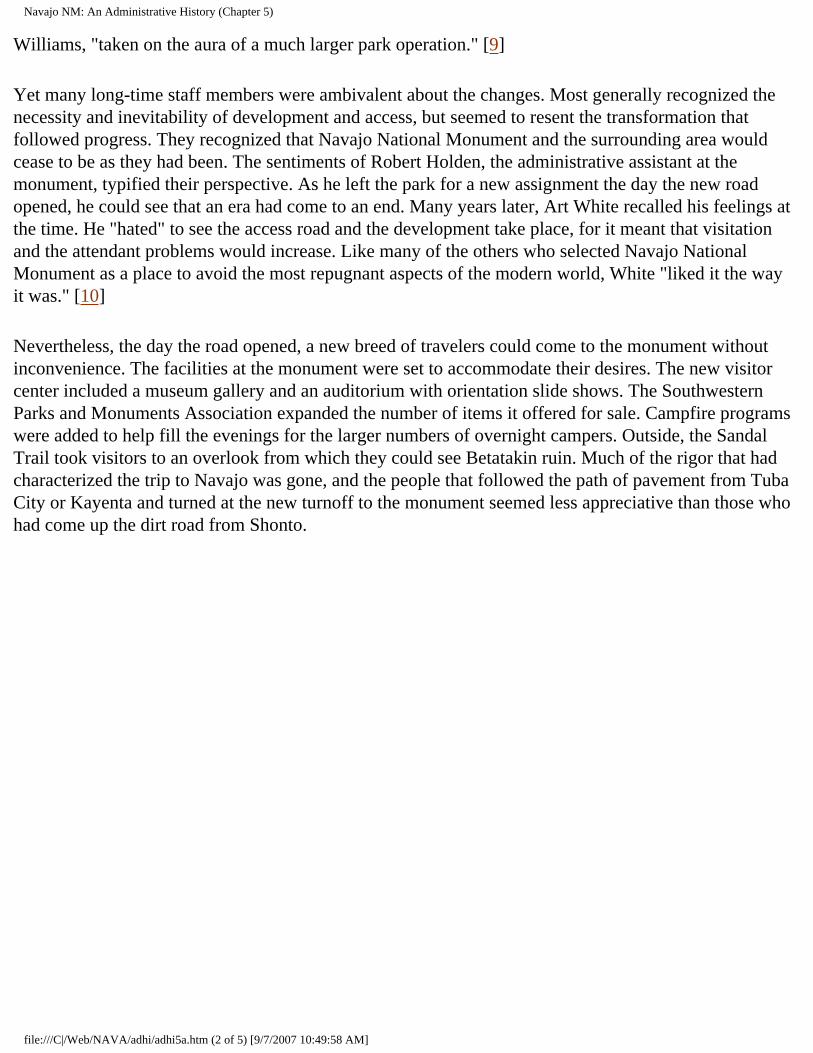
Navajo NM: An Administrative History (Chapter 5)
Williams, "taken on the aura of a much larger park operation." [9]
Yet many long-time staff members were ambivalent about the changes. Most generally recognized the necessity and inevitability of development and access, but seemed to resent the transformation that followed progress. They recognized that Navajo National Monument and the surrounding area would cease to be as they had been. The sentiments of Robert Holden, the administrative assistant at the monument, typified their perspective. As he left the park for a new assignment the day the new road opened, he could see that an era had come to an end. Many years later, Art White recalled his feelings at the time. He "hated" to see the access road and the development take place, for it meant that visitation and the attendant problems would increase. Like many of the others who selected Navajo National Monument as a place to avoid the most repugnant aspects of the modern world, White "liked it the way it was." [10]
Nevertheless, the day the road opened, a new breed of travelers could come to the monument without inconvenience. The facilities at the monument were set to accommodate their desires. The new visitor center included a museum gallery and an auditorium with orientation slide shows. The Southwestern Parks and Monuments Association expanded the number of items it offered for sale. Campfire programs were added to help fill the evenings for the larger numbers of overnight campers. Outside, the Sandal Trail took visitors to an overlook from which they could see Betatakin ruin. Much of the rigor that had characterized the trip to Navajo was gone, and the people that followed the path of pavement from Tuba City or Kayenta and turned at the new turnoff to the monument seemed less appreciative than those who had come up the dirt road from Shonto.
file:///C|/Web/NAVA/adhi/adhi5a.htm (2 of 5) [9/7/2007 10:49:58 AM]
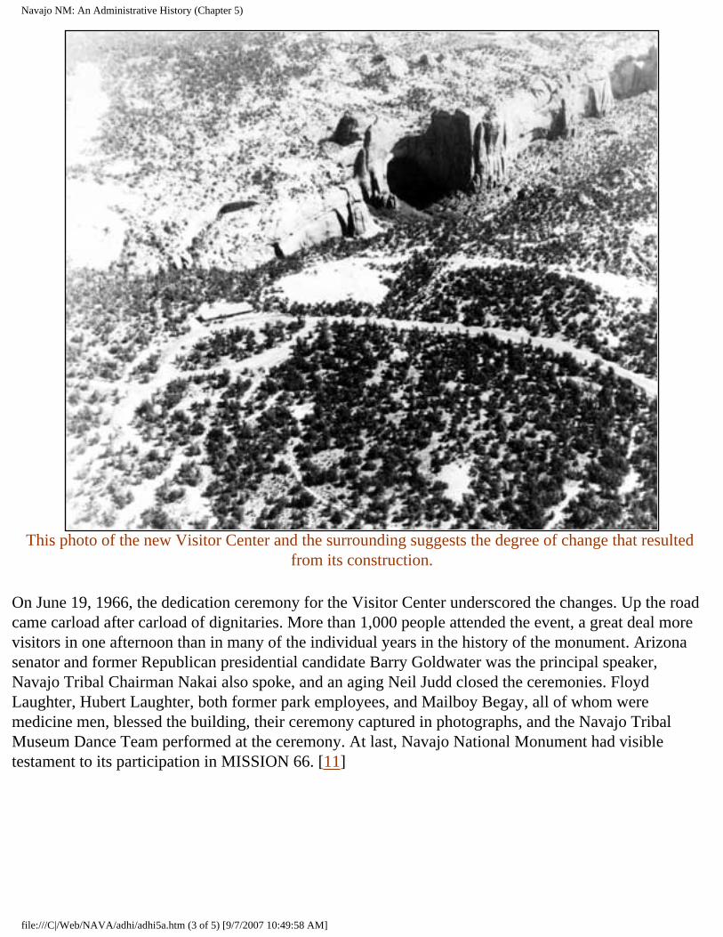
Navajo NM: An Administrative History (Chapter 5)
This photo of the new Visitor Center and the surrounding suggests the degree of change that resulted
from its construction.
On June 19, 1966, the dedication ceremony for the Visitor Center underscored the changes. Up the road came carload after carload of dignitaries. More than 1,000 people attended the event, a great deal more visitors in one afternoon than in many of the individual years in the history of the monument. Arizona senator and former Republican presidential candidate Barry Goldwater was the principal speaker, Navajo Tribal Chairman Nakai also spoke, and an aging Neil Judd closed the ceremonies. Floyd Laughter, Hubert Laughter, both former park employees, and Mailboy Begay, all of whom were medicine men, blessed the building, their ceremony captured in photographs, and the Navajo Tribal Museum Dance Team performed at the ceremony. At last, Navajo National Monument had visible testament to its participation in MISSION 66. [11]
file:///C|/Web/NAVA/adhi/adhi5a.htm (3 of 5) [9/7/2007 10:49:58 AM]
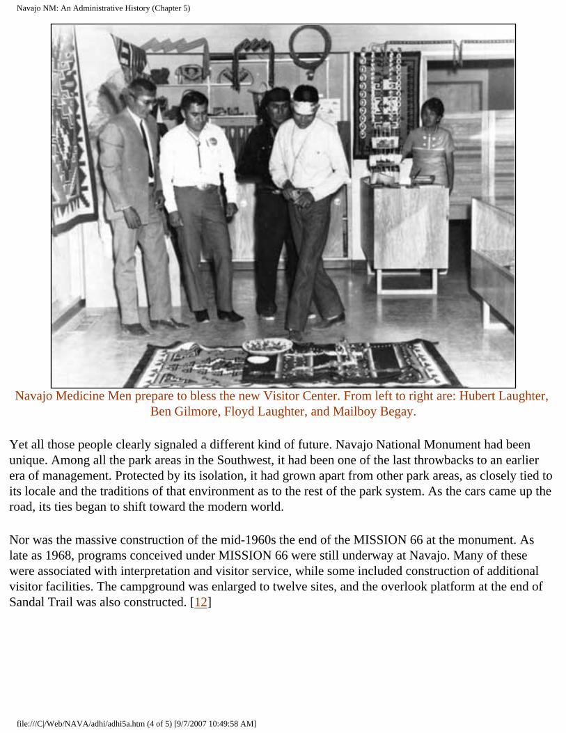
Navajo NM: An Administrative History (Chapter 5)
Navajo Medicine Men prepare to bless the new Visitor Center. From left to right are: Hubert Laughter,
Ben Gilmore, Floyd Laughter, and Mailboy Begay.
Yet all those people clearly signaled a different kind of future. Navajo National Monument had been unique. Among all the park areas in the Southwest, it had been one of the last throwbacks to an earlier era of management. Protected by its isolation, it had grown apart from other park areas, as closely tied to its locale and the traditions of that environment as to the rest of the park system. As the cars came up the road, its ties began to shift toward the modern world.
Nor was the massive construction of the mid-1960s the end of the MISSION 66 at the monument. As late as 1968, programs conceived under MISSION 66 were still underway at Navajo. Many of these were associated with interpretation and visitor service, while some included construction of additional visitor facilities. The campground was enlarged to twelve sites, and the overlook platform at the end of Sandal Trail was also constructed. [12]
file:///C|/Web/NAVA/adhi/adhi5a.htm (4 of 5) [9/7/2007 10:49:58 AM]
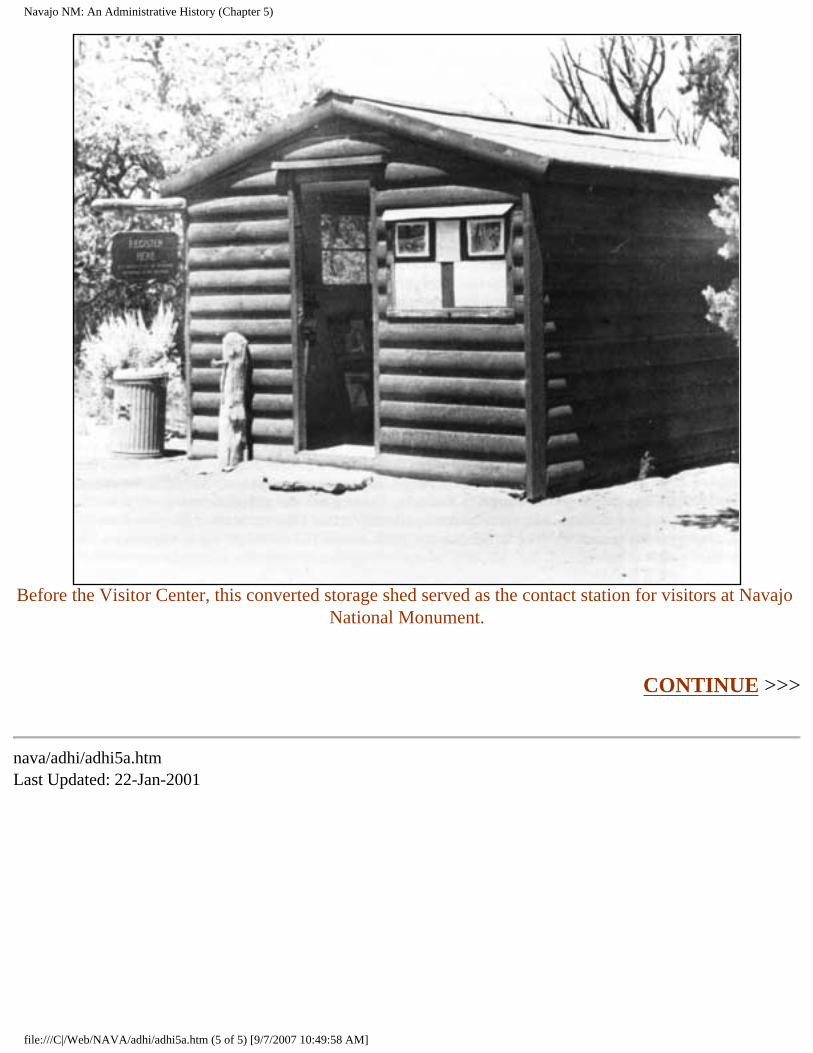
Navajo NM: An Administrative History (Chapter 5)
Before the Visitor Center, this converted storage shed served as the contact station for visitors at Navajo
National Monument.
CONTINUE >>>
nava/adhi/adhi5a.htm Last Updated: 22-Jan-2001
file:///C|/Web/NAVA/adhi/adhi5a.htm (5 of 5) [9/7/2007 10:49:58 AM]
Navajo NM: An Administrative History (Chapter 6)
Navajo
Administrative History
CHAPTER VI: PARTNERS IN THE PARK: RELATIONS WITH THE NAVAJO (continued)
As a result of cultural and social changes in the U.S., the NPS had to address the needs of the Navajo Nation in a more comprehensive fashion after the signing of the agreement. At the establishment of the monument in 1909, individual Navajos had little say about the disposition of the area. After the development of the tribal council governing structure in the 1920s, Navajos gained active and outspoken leadership that defended their interests. In the aftermath of the civil rights movement, Navajo people became willing to assert their rights in a manner never previously associated with them. In the late 1960s, the Navajo tribe changed their official designation to "Navajo Nation" to reflect the unique status of American Indians in the U.S. This nationalism emerged as an effort by the Navajo people to gain greater control over their social, economic, and political lives and culminated in the initial election of Peter McDonald as tribal council chairman in 1970. [5] The result of this empowerment challenged the Park Service in new ways.
Park officials had to learn a new pattern of sensitivity toward Navajo needs. In some instances, they found the changes frustrating, for accommodating people with a distinctly different value system was not easy. The level of consensus among the Navajo necessary to achieve NPS goals was often elusive, but Park Service officials with a great deal of experience in the region such as John Cook, former chief ranger of Navajo National Monument, helped smooth the transition. In one instance in 1967, NPS officials at the regional and national levels reviewed the possibility of condemnation as a means to land acquisition. Cook, then superintendent at Canyon de Chelly, pointed out that "the bad associated with condemnation will be far reaching." [6] This measure of understanding and respect for the Navajo perspective was new in government-Indian relations. The NPS slowly learned to address the needs of the Navajo Nation within a more equitable and less paternal system than had existed previously.
The transformation of the Navajo labor force at the monument reflected the changing relationships. Because the monument had so little funding, seasonal labor was intermittent before the 1930s. Most of the Navajos who worked at the monument before the 1930s were associated with the various archeological expeditions. The New Deal provided money for the first seasonal laborers, among them
file:///C|/Web/NAVA/adhi/adhi6a.htm (1 of 3) [9/7/2007 10:50:00 AM]
Navajo NM: An Administrative History (Chapter 6)
Bob Black, who began in a seasonal capacity in 1935 and remained at the park for thirty-one years. In 1948, Seth Bigman, one of the many Navajo who fought in the Second World War, became the first Navajo seasonal ranger at the monument. He served two years. Bigman was followed by Hubert Laughter, another Navajo war veteran whom Bob Black recruited for the monument. Laughter also served as an interpretive ranger at the monument during his three-year stay. [7]
The Navajos who worked at the monument all had close ties to the Shonto area and strong cultural reasons for staying close to home. Generations apart, their life stories had many parallels. A veteran of World War II, Hubert Laughter returned to the western reservation with a Purple Heart and the desire to make a life. He found a job in Winslow, Arizona, as an airplane mechanic, but because his wife was from a very traditional Navajo family that did not want the couple to leave the reservation, he stayed in the Shonto area. The job at the park seemed a solution to the problem of being caught between two worlds. It offered him economic opportunity at home--although his family long debated whether he should take the job at the park. [8]
A generation later, Delbert Smallcanyon followed a similar pattern. He first came to the monument in 1968 as a stone mason on the cross-canyon trail. Born around 1920 in the Navajo Mountain area, he tended sheep for his family well into adulthood. He first left the reservation to work for the railroad during the Second World War, and later followed it from place to place, working in Montana, Salt Lake City, Chicago, and elsewhere in the West. This pattern of seasonal movement typified the experience of many Navajos of his generation. He left his home only because his family needed the income from his labor. He did not enjoy the work, its pressures, nor the places he went. It was his duty. His paychecks became the means to sustain his family after the local subsistence economy ceased to provide sustenance.
A permanent job close to home seemed a wonderful opportunity that allowed him to maintain a traditional lifestyle. Each day he came over from Navajo Mountain to the park, returning after a full day's work. The job at the park allowed him to remain in his homeland, live a traditional lifestyle and support his family--economically sustained by his job at the park. [9]
With the signing of the Memorandum of Agreement and the expansion of the staff at the monument, there was greater opportunity for Navajos who sought work at the park. They soon recognized that permanent ranger positions were generally filled by career Park Service employees. This prompted a number of younger Navajos to enter the Park Service, among them Clarence N. Gorman. But maintenance positions were available for local people, as were a range of seasonal positions. By the middle of the 1960s, the maintenance staff was exclusively Navajo except for the maintenance supervisor. In the middle of the 1980s, John Laughter took over this position, the first Navajo in a permanent supervisory capacity at the monument. This also cemented the Navajo character of the maintenance staff. [10]
John Laughter's supervisory position was an important transition for the monument. Prior to coming to the park, he worked for a general contractor as a heavy equipment operator. In 1974, Frank Hastings hired him to work on the maintenance crew. After a decade in maintenance, during which he took all the
file:///C|/Web/NAVA/adhi/adhi6a.htm (2 of 3) [9/7/2007 10:50:00 AM]
Navajo NM: An Administrative History (Chapter 6)
Park Service training courses he could, Laughter was appointed foreman. As the first Navajo in a position of leadership at the monument, Laughter expressed a sense of pride in his work that was reflected in the work of his staff.
Navajos of different generations appeared to have a different view of the park and its workings. In the 1980s and 1990s, older Navajos expressed gratitude for having jobs at the park. The combination of proximity to their homes and good pay made the positions very desirable. They did their work well, seemingly unaware of the context in which they labored. Younger Navajos understood the mission of the park more clearly than did their elders, and they recognized how important the monument was to the economy of the entire western reservation. They could see the many ramifications of its economy on the lives of themselves and their families. [11]
Yet until the middle of the 1980s, structural problems with the distribution of employment at Navajo National Monument remained. In 1982, five of the nine permanent employees at the monument were Navajo. Three Anglos worked at the park, along with one Hispano. Yet all of the Anglos and the Hispano had higher GS ranks than did the five Navajos, leaving a skewed structure that reflected the slow process of the changing patterns of leadership in the American and federal work forces. After John Laughter became maintenance supervisor and the subsequent appointment of Clarence Gorman as superintendent, the historic limitations ended. By 1990, the monument had eleven full- and part-time employees. Eight, including the superintendent, the head of maintenance, and the entire maintenance department, were Navajo. The park more accurately reflected the demography of the area. [12]
CONTINUE >>>
nava/adhi/adhi6a.htm Last Updated: 22-Jan-2001
file:///C|/Web/NAVA/adhi/adhi6a.htm (3 of 3) [9/7/2007 10:50:00 AM]
Navajo NM: An Administrative History (Chapter 7)
Navajo
Administrative History
CHAPTER VII: ARCHEOLOGY AT NAVAJO (continued)
The initial generation of archeologists were not well equipped to unravel the mysteries of the past. They brought the assumptions and techniques of their era to a world that functioned by a different set of rules in both past and present. Influenced strongly by Morgan and other late nineteenth-century thinkers, they saw through an ethnocentric prism that limited their ability to understand the methods and motives of prehistoric people. Most had little academic training in their chosen field, but acquired their knowledge while doing fieldwork. Nor were the techniques of their time particularly sophisticated. Faced with thousands of ruins, this initial generation acted as had Bandelier more than three decades before. They described what they saw, drew maps of ruins and rooms, and provided essential basic information. But few did more than take field notes, and little of such work was published in a timely fashion for the use of other scholars. Field techniques and procedures were not yet standardized. A largely incomplete set of data resulted. While many excavations occurred on the Colorado plateau, little consensus about the patterns of prehistoric life followed.
The condition of surface ruins after an excavation was incidental to the progress of archeology in this era. More concerned with the artifacts they found and their broad generalizations about the prehistoric past, most of the first generation of archeologists used ruins for their own purposes. Like the pot-hunters they feared, they too tore through ruins, digging hastily and capriciously. There was little thought or care to the long-term survival of the ruins they excavated.
During the initial era of inquiry, which lasted well into the 1930s, archeologists explored northeastern Arizona. They mapped some of the ruins in the region, performing preliminary excavations and beginning the long and complex process of assembling data. As occurred elsewhere in the world, the initial generation to explore the region faced the problems of being first. Limited by the techniques of their time, little funding, lack of prior knowledge and context in which to locate their discoveries, and their cultural outlook, many found little information but used it to speculate wildly and generalize broadly. [9]
By the end of the 1910s, a new style of archeological practice was coming to the fore. Initiated by Nels V. Nelson and Alfred V. Kidder, archeologists began to adapt the stratigraphic techniques of nineteenth-
file:///C|/Web/NAVA/adhi/adhi7a.htm (1 of 5) [9/7/2007 10:50:01 AM]
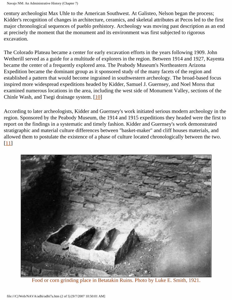
Navajo NM: An Administrative History (Chapter 7)
century archeologist Max Uhle to the American Southwest. At Galisteo, Nelson began the process; Kidder's recognition of changes in architecture, ceramics, and skeletal attributes at Pecos led to the first major chronological sequences of pueblo prehistory. Archeology was moving past description as an end at precisely the moment that the monument and its environment was first subjected to rigorous excavation.
The Colorado Plateau became a center for early excavation efforts in the years following 1909. John Wetherill served as a guide for a multitude of explorers in the region. Between 1914 and 1927, Kayenta became the center of a frequently explored area. The Peabody Museum's Northeastern Arizona Expedition became the dominant group as it sponsored study of the many facets of the region and established a pattern that would become ingrained in southwestern archeology. The broad-based focus inspired more widespread expeditions headed by Kidder, Samuel J. Guernsey, and Noel Morss that examined numerous locations in the area, including the west side of Monument Valley, sections of the Chinle Wash, and Tsegi drainage system. [10]
According to later archeologists, Kidder and Guernsey's work initiated serious modern archeology in the region. Sponsored by the Peabody Museum, the 1914 and 1915 expeditions they headed were the first to report on the findings in a systematic and timely fashion. Kidder and Guernsey's work demonstrated stratigraphic and material culture differences between "basket-maker" and cliff houses materials, and allowed them to postulate the existence of a phase of culture located chronologically between the two. [11]
Food or corn grinding place in Betatakin Ruins. Photo by Luke E. Smith, 1921.
file:///C|/Web/NAVA/adhi/adhi7a.htm (2 of 5) [9/7/2007 10:50:01 AM]
Navajo NM: An Administrative History (Chapter 7)
With a chronology posited, Kidder and Guernsey explored further. If the different temporal phases existed, archeologists thought they could describe and detail the differences. The Peabody Museum backed expeditions in 1916 and 1917, out of which came Guernsey and Kidder's Basket Maker Caves of Northeastern Arizona, published in 1921. In the 1990s, this work remained a major reference on Basketmaker II material culture. Further work between 1920 and 1923 added architectural detail and broadened the quantity of artifacts that substantiated the new generalizations. [12]
During the 1920s, a range of institutions and individuals sent expeditions to northeastern Arizona. Many archeologists learned their trade in the area, and a kind of mini-boom in interest resulted. But only a few of the expeditions pursued the advancement of knowledge. Many others sought to make collections for museum cases or personal edification. Charles L. Bernheimer sponsored an expedition nearly every year in the 1920s, as did the Public Museum of the City of Milwaukee. These collecting forays did little to advance the state of knowledge about prehistory in the region. Other work resulted in advancement of the chronological sequences that Kidder and Guernsey pioneered. Harold S. Gladwin, Arthur Woodward and Irwin Hayden, and Monroe Amsden conducted excavations that yielded much new contextual information that helped unravel the story of Navajo National Monument.
A major advancement in the ability to discern prehistoric information occurred in this era, shaking up the present and laying a basis for the future. Astronomer Arthur E. Douglas of the University of Arizona had long studied southwestern tree-ring growth to aid his sun spot research. By the late 1920s, he had surveyed both living trees and prehistoric timbers preserved in ruins. In 1929, he had two long chronological sequences, one dating from the twentieth century back into the late prehistoric period, about 1,300 C.E., the other a floating chronology not linked in time to the first. That summer, Emil W. Haury, a young archeologist, discovered a piece of charred wood that established the basis for a link between the two timelines. In one brief moment, chronological dating of prehistoric sites became empirical. This set the stage for a major revolution in the way archeologists perceived the past as well as in their ability to base chronology on much more than educated speculation. [13]
file:///C|/Web/NAVA/adhi/adhi7a.htm (3 of 5) [9/7/2007 10:50:01 AM]
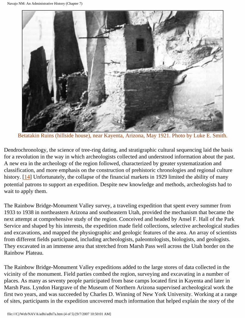
Navajo NM: An Administrative History (Chapter 7)
Betatakin Ruins (hillside house), near Kayenta, Arizona, May 1921. Photo by Luke E. Smith.
Dendrochronology, the science of tree-ring dating, and stratigraphic cultural sequencing laid the basis for a revolution in the way in which archeologists collected and understood information about the past. A new era in the archeology of the region followed, characterized by greater systematization and classification, and more emphasis on the construction of prehistoric chronologies and regional culture history. [14] Unfortunately, the collapse of the financial markets in 1929 limited the ability of many potential patrons to support an expedition. Despite new knowledge and methods, archeologists had to wait to apply them.
The Rainbow Bridge-Monument Valley survey, a traveling expedition that spent every summer from 1933 to 1938 in northeastern Arizona and southeastern Utah, provided the mechanism that became the next attempt at comprehensive study of the region. Conceived and headed by Ansel F. Hall of the Park Service and shaped by his interests, the expedition made field collections, selective archeological studies and excavations, and mapped the physiographic and geologic features of the area. An array of scientists from different fields participated, including archeologists, paleontologists, biologists, and geologists. They excavated in an immense area that stretched from Marsh Pass well across the Utah border on the Rainbow Plateau.
The Rainbow Bridge-Monument Valley expeditions added to the large stores of data collected in the vicinity of the monument. Field parties combed the region, surveying and excavating in a number of places. As many as seventy people participated from base camps located first in Kayenta and later in Marsh Pass. Lyndon Hargrave of the Museum of Northern Arizona supervised archeological work the first two years, and was succeeded by Charles D. Winning of New York University. Working at a range of sites, participants in the expedition uncovered much information that helped explain the story of the
file:///C|/Web/NAVA/adhi/adhi7a.htm (4 of 5) [9/7/2007 10:50:01 AM]
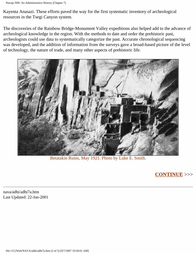
Navajo NM: An Administrative History (Chapter 7)
Kayenta Anasazi. These efforts paved the way for the first systematic inventory of archeological resources in the Tsegi Canyon system.
The discoveries of the Rainbow Bridge-Monument Valley expeditions also helped add to the advance of archeological knowledge in the region. With the methods to date and order the prehistoric past, archeologists could use data to systematically categorize the past. Accurate chronological sequencing was developed, and the addition of information from the surveys gave a broad-based picture of the level of technology, the nature of trade, and many other aspects of prehistoric life.
Betatakin Ruins, May 1921. Photo by Luke E. Smith.
CONTINUE >>>
nava/adhi/adhi7a.htm Last Updated: 22-Jan-2001
file:///C|/Web/NAVA/adhi/adhi7a.htm (5 of 5) [9/7/2007 10:50:01 AM]
Navajo NM: An Administrative History (Chapter 8)
Navajo
Administrative History
CHAPTER VIII: THREATS TO THE PARK (continued)
One classic instance of the problems occurred with the emergence of an extractive natural resource-based economy for the Navajo Nation. Resource development of the reservation had begun with an oil boom in the 1920s, but little growth followed. During the 1950s, oil production again increased dramatically. In 1950, there were fifty-one producing wells on the reservation; a decade later, the number had grown to 860. This spurt helped further more comprehensive development programs, as federal legislation that promoted such goals became one of the cornerstones of the New Frontier and Great Society programs of the 1960s. In 1965, the Tribal Council decided to explore systematic development of the minerals of the reservation. Among the projects was the Black Mesa Mine, a coal mining operation near Navajo National Monument. [7]
From its inception, Black Mesa Mine was controversial. In 1964, the Peabody Coal Company negotiated a lease with the Navajo Nation for 40,000 acres on the reservation; two years later, an agreement with the Navajo and Hopi tribes added 25,000 acres of the Joint Use Area that the two shared. Black Mesa was a sacred place to traditional Navajo and Hopi peoples, but the need for cash to fund the affairs of the tribes was great. By the middle of the 1960s when Peabody Coal requested the lease, the oil and gas revenues of the Navajo Nation had begun a steep decline since the salad days of the late 1950s and early 1960s. This source of revenue paid most of the expenses of the tribal government. Beginning in 1954, oil and gas revenue made up no less than fifty percent of tribal income for the next seventeen years. Faced with growing expenses and declining revenue, the Navajo Nation found the proposal enticing. The $2 million per annum for thirty-five years that the company offered seemed a phenomenal amount of money, and with coaxing from the Department of the Interior and the Bureau of Indian Affairs, the lease was signed.
In the early 1970s, Black Mesa Mine became a cause celebre for the emerging environmental movement. Members of the Hopi tribe sued the Secretary of the Interior for approving the lease. Although the suit was overturned on a technicality, it attracted the attention of the national press. The result was a polarizing public debate in the charged climate of the early 1970s that left the impression of naive Indians victimized by a rapacious company. [8] As was generally the case in such situations, reality was much more complex.
file:///C|/Web/NAVA/adhi/adhi8a.htm (1 of 3) [9/7/2007 10:50:02 AM]
Navajo NM: An Administrative History (Chapter 8)
The two mines Peabody Coal Company developed in the vicinity of Navajo National Monument had a significant impact on the lives of local Navajo people. The coal mining operation was one of the few on-reservation industries that hired many people. The jobs it provided paid well, particularly by the standards of the area. By the early 1990s, some of the jobs at the mine paid in the $20 per hour range. They enabled many local people to achieve a standard of living previously unavailable in the region. [9]
The coal mining operation had socio-economic and environmental consequences. The 1966 agreement allowed the company to establish a slurry to convey pulverized coal to the Mojave Power Plant on the banks of the Colorado River in Nevada. This became the first instance in which the Navajo and Hopi tribes were paid for the use of their water. The Navajo Nation agreed to provide more than 3,000 acre-feet of water each year. For this constant supply, Peabody Coal paid five dollars per acre-foot. The initial agreement created a source of cheap water for the company, but later renegotiations raised the cost significantly in an effort to limit use by the coal company. [10]
The sale of 3,000 acre-feet of ground water each year and the fact that no water from the Colorado River was used in the slurry meant that there was an impact on the water table in the vicinity of the monument. The water traveled one way--from Black Mesa to the Colorado River--providing jobs and income for Navajo and Hopi people in the area but creating a long-term threat to their survival. An economic backbone for the region had been developed, but it too had costs.
For Navajo National Monument, the slurry posed a potential problem. Drawdown of the water table could result from the consistent extraction of water beneath Black Mesa and the rest of the region. The monument depended on its wells, sunk into the same aquifer as the slurry. The Peabody Coal slurry had the potential to become a long-term threat to the monument.
Even before the emphasis on out-of-park threats in the Park Service, Navajo National Monument prepared to assess the impact of the slurry. Monitoring efforts began in 1970, when the U.S. Geological Survey made preliminary calculations in response to a request from the Park Service. USGS studies predicted a drawdown of nearly 100 feet at Kayenta by the end of the 1990s, with lesser impact on the vicinity of the monument. The study projected that at Shonto, the decline would be between five and ten feet. The figures for Betatakin were similar. [11]
But the well at Betatakin left little room for a decline in the water table. Even the small drop in the aquifer had the potential to affect the monument. Its staff and visitors were dependent on the water, as were the many Navajos who filled their fifty-five gallon drums at the pump in the monument. The Park Service needed to closely monitor the situation.
A monitoring process was established to assess the impact. The USGS and the Navajo Nation began their own monitoring in 1970, and the Park Service received reports from them throughout the 1970s. Late in the decade, there had been no apparent impact at the monument. A gentle downward slope towards Black Mesa seemed to retard the impact of the slurry on the monument, and seasonal increases
file:///C|/Web/NAVA/adhi/adhi8a.htm (2 of 3) [9/7/2007 10:50:02 AM]
Navajo NM: An Administrative History (Chapter 8)
in water drawn off for agricultural irrigation and school and local use in Kayenta offered the only consistent decrease in the level of any of the monitored wells. But in some places the water table had fallen as much as seventy feet by the late 1980s, and the projections of some federal scientists suggested a drop of nearly 200 feet by 2030. Vigilance for the park remained a necessity. [12]
The potential for drawdown remained strong. In 1979, Superintendent Frank Hastings assessed the problem as a long-term threat that could deprive Betatakin Canyon of water in the twenty-first century. The 1,000-year-old biotic community in the canyon depended on the water that Peabody Coal had leased into the twenty-first century. "It is probable," he wrote, "that the pumping will have an effect on the flora and fauna of the canyon." [13]
As in many similar instances at Navajo National Monument, the Park Service had little control over the fate of the water. In this situation, the agency was only a peripheral participant. The NPS had not been privy to the lease, nor were its needs considered by either Peabody or the Navajo Nation during negotiations. In cases such as this, the Park Service could only watch. In 1987, when the Navajo and Hopi tribes increased the price for the slurry water from $5 to $600 per acre-foot, with a doubling of the charge for usage over 2,800 acre-feet per year, park officials certainly applauded. [14] But despite the limits on the threat that the increased cost assured, Navajo National Monument remained potentially vulnerable to the activities of the Peabody Coal Company.
CONTINUE >>>
nava/adhi/adhi8a.htm Last Updated: 22-Jan-2001
file:///C|/Web/NAVA/adhi/adhi8a.htm (3 of 3) [9/7/2007 10:50:02 AM]
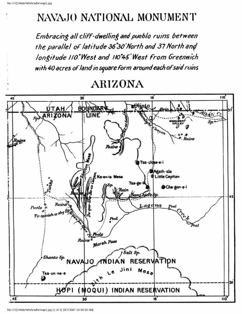
file:///C|/Web/NAVA/adhi/map1.jpg
file:///C|/Web/NAVA/adhi/map1.jpg (1 of 2) [9/7/2007 10:50:03 AM]
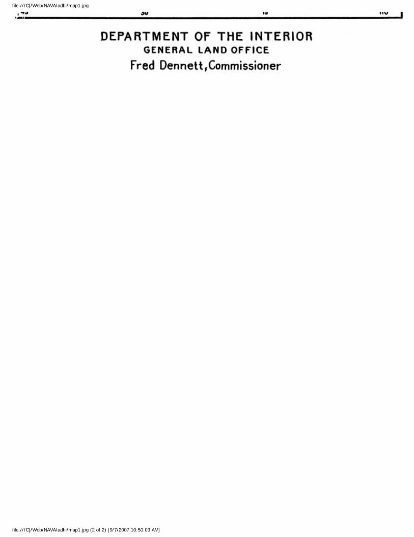
file:///C|/Web/NAVA/adhi/map1.jpg
file:///C|/Web/NAVA/adhi/map1.jpg (2 of 2) [9/7/2007 10:50:03 AM]
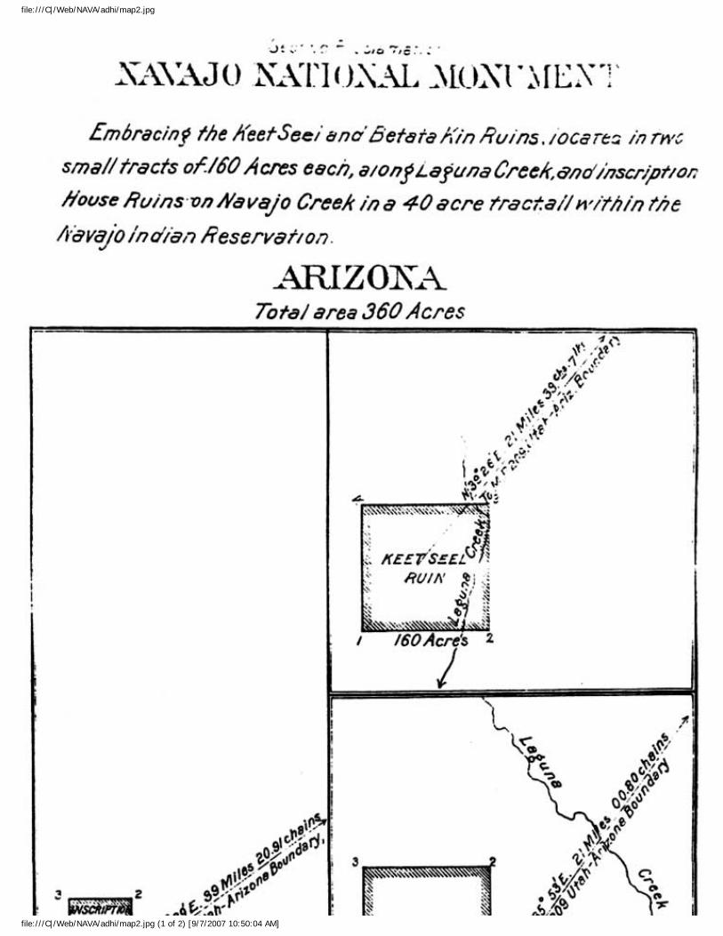
file:///C|/Web/NAVA/adhi/map2.jpg
file:///C|/Web/NAVA/adhi/map2.jpg (1 of 2) [9/7/2007 10:50:04 AM]
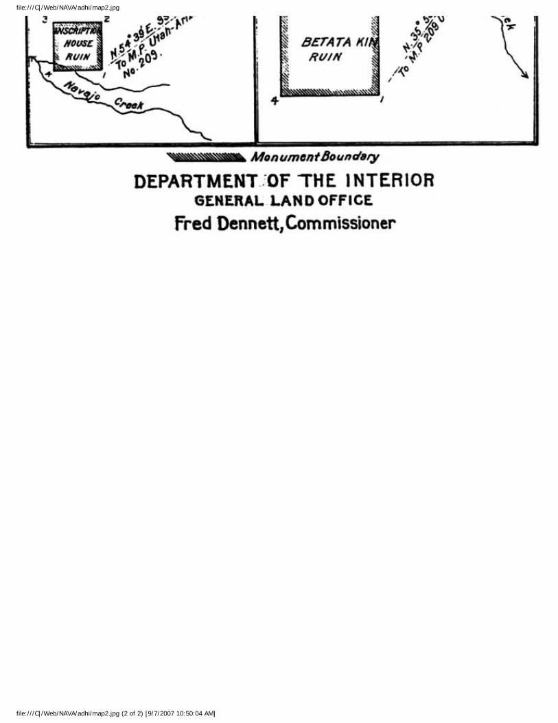
file:///C|/Web/NAVA/adhi/map2.jpg
file:///C|/Web/NAVA/adhi/map2.jpg (2 of 2) [9/7/2007 10:50:04 AM]
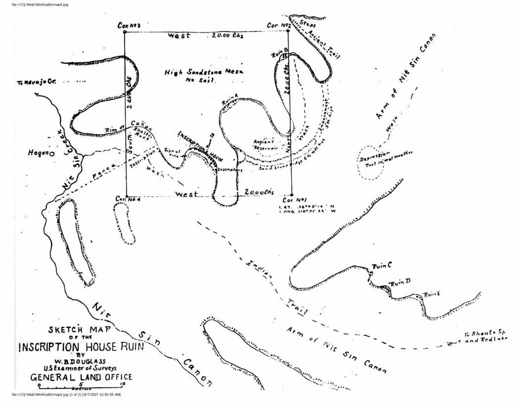
file:///C|/Web/NAVA/adhi/map4.jpg
file:///C|/Web/NAVA/adhi/map4.jpg (1 of 2) [9/7/2007 10:50:05 AM]
file:///C|/Web/NAVA/adhi/map4.jpg
file:///C|/Web/NAVA/adhi/map4.jpg (2 of 2) [9/7/2007 10:50:05 AM]
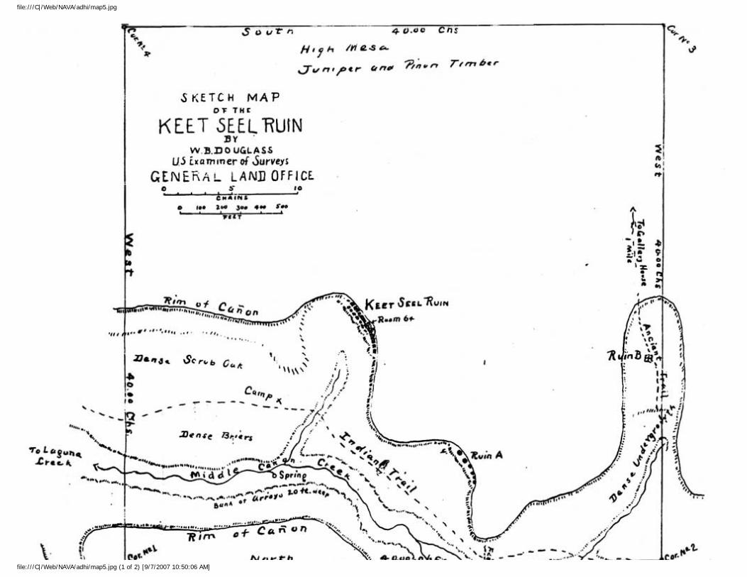
file:///C|/Web/NAVA/adhi/map5.jpg
file:///C|/Web/NAVA/adhi/map5.jpg (1 of 2) [9/7/2007 10:50:06 AM]

file:///C|/Web/NAVA/adhi/map5.jpg
file:///C|/Web/NAVA/adhi/map5.jpg (2 of 2) [9/7/2007 10:50:06 AM]
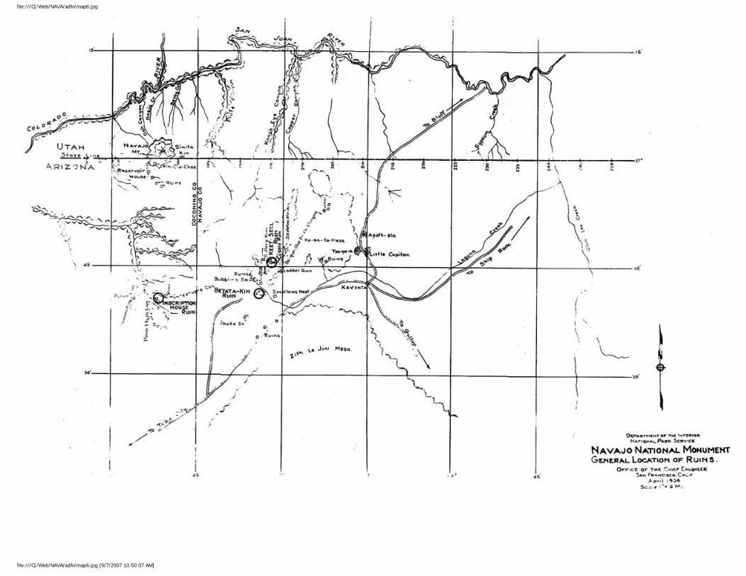
file:///C|/Web/NAVA/adhi/map6.jpg
file:///C|/Web/NAVA/adhi/map6.jpg [9/7/2007 10:50:07 AM]
Navajo NM: An Administrative History (Chapter 1)
Navajo
Administrative History
CHAPTER I: FROM PREHISTORY TO THE TWENTIETH CENTURY (continued)
The exact moment of the arrival of the Navajo people in the Southwest remains the subject of dispute. The standard view of archeologists and anthropologists suggests that when the Spanish arrived from the south in the 1540s, the Navajo were in the process of migrating into the region from the north. An Athapascan people, they had come from the area around what is now the Canadian border, gradually moving south over a period of hundreds of years. Estimates from this school of thought for the beginning of Navajo influx into the Southwest suggest a time between 1400 and 1525 A.D. Clearly the process was ongoing when the Spanish arrived. [11] In this sense, the point of contact between the two cultures was the meeting point between two different migrant groups, each with different cosmologies, values, and technologies, one slightly ahead of the other in chronological appearance. Both strangers to the region, they arrived nearly simultaneously. The subsequent three hundred years involved working out the nature and extent of the relationship between the two groups.
Navajo oral tradition and tree-ring dating suggest an earlier arrival than does much of modern archeology and anthropology. According to this view, at least some Navajo people or their forerunners were in the region at the same time as the Pueblos. Tree-ring dates from western Colorado show the construction of hogan-type dwellings in the 1100s A.D. that show Navajo-like characteristics and a Navajo homestead south of Gallup, New Mexico, has been dated to approximately 1380 A.D. In addition, a Navajo legend places the arrival of the Dinè, as the Navajo refer to themselves, in the vicinity of Chaco Canyon between roughly 900 and 1130 A.D. Nevertheless when the Spanish arrived, the Navajo were already well ensconced on the Colorado Plateau and their numbers were growing. [12]
The arrival of the Spanish produced a classic confrontation between denizens of the new and old worlds. The Spaniards possessed technology, biological characteristics, and domesticated animals with which the Navajo had no previous experience. The Navajo were better adapted to life in the harsh environment that was and is the Southwest. They knew its edible plants and hidden water sources and had adjusted to life in an unforgiving environment. Until the coming of the Americans, the collision was a stalemate. [13]
file:///C|/Web/NAVA/adhi/adhi1b.htm (1 of 4) [9/7/2007 10:50:09 AM]
Navajo NM: An Administrative History (Chapter 1)
The first Spaniards to record contact with the Navajo were not typical explorers in search of gold. Antonio de Espejo, a fugitive fleeing a murder charge who financed an expedition to find two missing priests and thereby redeem his name, led a small group of men that traveled widely across the Southwest. Early in the spring of 1583, the party set off from Zia Pueblo towards Zuñi Pueblo. As they circumvented Mount Taylor, one of the sacred mountains of the Navajo, they met what they called "Indios Serranos," mountain Indians, who were most likely Navajos. These people were peaceful and later engaged in trade with the Spaniards. [14]
But any positive feelings engendered by the initial meeting did not last. Subsequent events set a far less optimistic tone for Navajo-Spanish relations. In 1598, don Juan de Oñate set out from New Spain to colonize New Mexico. Persuading Indians to accept Christian missionaries was an important component of his plan of colonization. While some of the Pueblos reconciled themselves at least temporarily to new forms of worship, others were not so accepting. On December 4, 1598, Acoma Pueblo, the Sky City, revolted against the Spanish.
Acoma was no stranger to warfare with the Spanish. The pueblo had previously fought a pitched battle with Espejo's men, winning decisively. After an incident caused by a lack of cross-cultural communication, the Acomas seized eighteen Spaniards including one of Oñate's nephews, who were in the Sky City to requisition supplies. The nephew and ten other Spaniards were killed, along with a number of Indian servants. Four other Spaniards jumped off the 375-foot mesa into sand dunes below and escaped to carry the news to Oñate. [15]
Retribution was swift and furious, establishing the tone of relations for the next 250 years. Oñate sent a force of seventy men, headed by the slain nephew's brother, to exact revenge and show the strength of the Spanish. In a two-day battle, the Spanish scaled the mesa and burned the Pueblo. Indian casualties in battle were estimated at 800. Another 500 women and children and seventy or eighty warriors were captured. Many of the captives were cut to pieces and thrown from the mesa. The rest were tried and sentenced to punishments of servitude of various lengths. Adult males also had one foot chopped off. Two Hopi Indians involved in the revolt had their right hands chopped off and were sent back to their people as an example. The word spread quickly through the region. In one intense moment, the Navajo and the Spaniards had learned to intensely dislike each other. [16]
From then on, Spanish-Navajo relations were strained. Unlike the smaller, less mobile Pueblos, the Navajo were not easily subdued. Regarding themselves as bearers of civilization, the Spanish found their desire to hegemonize thwarted. They could not bring these independent Indians under their control, but could capture a sufficient number of Navajo to compel a similar response. Despite a seemingly endless series of treaties and arrangements, the Spanish and the Navajos regarded each other as enemies. Initially conflict was military; later it became economic. But one feature of the conflict was consistent: Europeans and their descendants sought to regulate the Navajo way of life, the lands available to the Navajo, and to a lesser degree, their trade with the outside world. They also sought to convert any and all captive Navajos to Christianity and the Spanish way of life.
file:///C|/Web/NAVA/adhi/adhi1b.htm (2 of 4) [9/7/2007 10:50:09 AM]
Navajo NM: An Administrative History (Chapter 1)
The acquisition and mastery of the horse by the Navajo compounded the problems of the Spanish. By 1610, the Navajos could use horses to further their objectives. Horses offered them a mobility that made them more lethal opponents of the Spanish, a range that made no part of New Mexico safe, and a cultural identity that accentuated Navajo autonomy. By the end of the reconquest of New Mexico in the 1690s, the Spanish recognized that the Navajo were and would remain beyond their reach. [17]
By 1820, the Navajos became the most feared enemy of the colony. The horse transformed the Navajos into a powerful adversary almost equal to the Spanish. Along with Utes and Comanches, Navajos incessantly raided the colony in the late seventeenth and eighteenth centuries, forcing the weak, often debilitated, and contentious leadership of Spanish New Mexico to become enmeshed in a cumbersome and poorly followed set of treaty arrangements. The Spanish formed uncomfortable alliances with all the tribes in the region, at various times finding themselves using the Navajo in campaigns against other Indians and conversely fighting alongside other Indians against the Navajo. Animosity between different groups of Indians also contributed to an already complex situation. Spanish slave raids, particularly one that resulted in the massacre of hundreds of Navajo women and children in Canyon del Muerto in 1805, heightened existing tensions, and the Navajos became raiders on a large scale. [18]
Yet the Spanish colony of New Mexico remained weak. The Spaniards lacked the resources and the wherewithal to establish a powerful entity at the northern tip of their empire in the Americas. Their religious, cultural, and economic mission never achieved success with the Navajo. The only effort to establish a mission to Christianize the Navajo lasted merely two years. Nor was New Mexico as economically profitable for the Spanish as were other parts of their empire in the New World. As a result, administration of the colony was half-hearted throughout the eighteenth century, leaving it open to challenges to Spanish authority. By 1800, the Spanish empire had crumbled. Fewer and fewer of its resources were allocated for the New Mexico colony.
The abundance of complex and repeated agreements between the Navajos and the Spanish colony of New Mexico attested to the precariousness of the position of the Spanish. They lacked the numbers and power to enforce their will on the Navajo. Clearly fear was a major element in the Spanish view of Navajos; the establishment of the genizaro--detribalized Indian--community at Abiquiu as a buffer between the "Indios Barbaros" and the colony revealed the vulnerability of Spanish New Mexico.
Despite its limitations, the Spanish empire in northern New Spain persisted into the nineteenth century. Although the periphery was seldom strong, it did hold for an extended period. New Mexico, at least along the Rio Grande, remained a part of the Spanish empire and Spanish culture and religion melded with that of the Pueblos. But extending hegemony beyond the river valley proved too much. The Navajos played an important role in denying further Spanish expansion.
The Spaniards faced many problems in their efforts to deal with the Navajos. Among the most important was identifying individuals who could speak for the Navajo people. In one such effort, a colonial governor offered to provide four silver-tipped canes and medals to Navajos who were willing and able to assume that role. In addition, the Spanish often paid Navajos to fight with them against other Indians,
file:///C|/Web/NAVA/adhi/adhi1b.htm (3 of 4) [9/7/2007 10:50:09 AM]
Navajo NM: An Administrative History (Chapter 1)
arbitrarily designating the leaders of these accomodationists as the leaders of the Navajo people. [19]
But unlike the effort made with the Pueblos, the Spanish made few attempts to offer the Navajo the "benefits" of their society. When compared to the town-dwelling, agricultural Pueblos, by Spanish standards, the Navajos seemed backward. The Navajos were not subject to comprehensive missionary efforts as were the Pueblos, nor were there efforts to rid the Navajo of their culture and make them Spanish. Only Navajo captives were brought into the realm of Spanish culture and life. The Spanish simply could not subject the Navajo to their cultural will.
As a result, the Navajo retained autonomy and remained largely beyond Spanish control. As the letters of governors of the colony show, the Spaniards spent a lot of time worrying about what the Navajos would do next. The Spanish empire in the New World crumbled in the late eighteenth and early nineteenth century, and the problems of one of the most remote outposts of New Spain attracted little attention. Spanish authorities had more important problems to address, and without support, officials in New Mexico could do little to change or stop the Navajo. They lacked the resources and the power. An adversarial view became codified in the perspective of the Spanish. Navajos became the feared adversary--the enemy.
CONTINUE >>>
nava/adhi/adhi1b.htm Last Updated: 22-Jan-2001
file:///C|/Web/NAVA/adhi/adhi1b.htm (4 of 4) [9/7/2007 10:50:09 AM]
Navajo NM: An Administrative History (Chapter 1)
Navajo
Administrative History
CHAPTER I: FROM PREHISTORY TO THE TWENTIETH CENTURY (continued)
If anything, the Mexican territory of New Mexico was even weaker than the Spanish colony. From its founding in 1821, Mexico lacked the economic resources to sustain its northern frontier. Texas in particular and to a lesser degree New Mexico were invaded by U.S. economic interests almost from the moment of Mexican independence. The Mexican government could do little to stop the Navajos, who preyed on the weakened and nearly defenseless territory. The Navajos relentlessly attacked New Mexico, appropriating crops, stealing livestock, and taking captives. The situation became so dire that in 1845, Governor Manuel Armijo wrote: "the war with the Navajo is slowly consuming us." When Brig. Gen. Stephen Watts Kearny arrived in Santa Fe in 1846 to proclaim the beginning of the American era, the best thing he had to offer the people of New Mexico was protection from Navajo raids. "The Navajos come down from the mountains and carry off your sheep and your women whenever they please," he told Santa Feans on August 22, 1846. "My government will correct all this." [20]
It was a promise the U.S. military intended to keep, particularly after a band of Navajo stole a flock of American army horses. The Navajos had almost free run of New Mexico; the great chief Narbona exercised his curiosity about the Americans by viewing the American troops at Fort Marcy near Santa Fe from a secret vantage point in the nearby mountains. But Kearny made a promise. By treaty or war, the Americans sought to bring a measure of order to New Mexican-Navajo relations that had never before existed.
Although the Navajo and the Americans signed a treaty at the end of 1846, it proved insufficient to maintain peace. The Taos Rebellion of 1847 complicated cross-cultural relations in New Mexico, and by the summer of 1847, the treaty had become a bad memory. The Navajos had lost respect for American soldiers, while Spanish-speaking New Mexicans incessantly reminded the Americans of General Kearny's promise in 1846. The result was more than a decade of war designed to compel Navajo submission. [21]
This effort culminated in the efforts of Brig. Gen. James H. Carleton, who attacked the Navajos in their
file:///C|/Web/NAVA/adhi/adhi1c.htm (1 of 4) [9/7/2007 10:50:10 AM]
Navajo NM: An Administrative History (Chapter 1)
own land and removed them to a "reservation" in eastern New Mexico. Smitten with gold fever and using the Civil War as an excuse, Carleton proceeded against the Navajo. In the summer of 1863, he railed against the Navajo to his superiors, brought Christopher (Kit) Carson from Taos to lead 1,000 men to the Dinehtah, the Navajo homeland, and gave the Navajo until July 20, 1863, to surrender. A war with no quarter began, in which Carson and his men destroyed Navajo livestock and crops. The scorched earth policy succeeded. By the middle of February of 1864, more then 1,200 Navajo had surrendered. The Americans had kept their promise to the people of New Mexico, albeit at the expense of the Navajo. [22]
Some of the Navajo escaped capture and fled west, to the Navajo Mountain and Shonto Plateau areas. Many settled in the area, forming an independent and uncowed group of Navajo, committed to their pre-reservation style of life. Not exposed to Anglo culture and the degrading removal to the Bosque Redondo near Fort Sumner in the Pecos Valley and subsequent attempts to anglicize the Navajo and make them dependent, these Navajos retained an autonomy that helped sustain traditional culture. After the Navajos returned from the Bosque Redondo in 1868, the people of the western reservation were distinguished by their independence and fidelity to traditional Navajo ways. Settled as an evasive maneuver from a conqueror, the western reservation became a bastion of cultural conservatism, the home of the most traditional Navajos. These "longhairs" had a different set of experiences than those who were sent away, and it shaped their outlook. They survived the conflict with the Americans, suffering only geographic relocation as a price. Their freedom, cultural autonomy, and economy were not taken from them.
Nor did they face much encroachment from Arizona Territory. The little development in the middle and late nineteenth century centered on the south-central part of the territory. The area around Navajo Mountain offered grazing and mining opportunities, but because of the Navajo influx, it had the reputation of being hostile territory. In the late nineteenth century, a number of Anglo-Americans explored the area, but they did so carefully. They recognized that they were in the homeland of people who took a dim view of their presence.
After the "Long Walk" to Fort Sumner and the subsequent four-year stay at the Bosque Redondo, the threat of the Navajo as a physical adversary ended. But the military defeat of the Navajo did not mean that efforts to integrate them into the society of the New Mexico Territory began. The Treaty of Bosque Redondo, which allowed the Navajos to return home, cemented a new order. While the Navajos were compelled to give up raiding and other predatory practices as part of the agreement to return to the Dinehtah, the only concession to their need to develop a self-sufficient economy was the assignment of 160-acre parcels of the newly created reservation to heads of families and 80-acre tracts for single people, as well as $100 worth of seed and implements the first year, $25 the following two years, and $10 per year for the subsequent ten years for Navajos engaged in farming. The Navajo young were required to attend school, and informal provisions for the return of Navajos held by New Mexicans were established. The Navajo were home, but needed to find a viable way to reconstitute their culture and livelihood. [23]
file:///C|/Web/NAVA/adhi/adhi1c.htm (2 of 4) [9/7/2007 10:50:10 AM]
Navajo NM: An Administrative History (Chapter 1)
On their return to their homeland, the Navajo had to adapt to the new order imposed by the Americans. Much of their historic economy and way of living had been eliminated. Raiding the settlements protected by the Americans was out of the question. It was this practice that inspired the wrath of the American military, and the memory of exile in the Bosque Redondo loomed large in Navajo consciousness. Navajos instead built an economy based less on agriculture and much more on livestock and crafts such as jewelry- and rug-making. Even the people of the Shonto Plateau and the Navajo Mountain area experienced these changes, although their distance from Indian agencies and other institutions of American government and society limited the impact. [24]
Always important in the Navajo economy, sheep became the basis of sustenance for many in the post-Bosque Redondo era. Adaptable and innovative, the Navajo responded to their new situation by developing a livestock-based economy. In the 1880s, the livestock economy flourished, making the Navajo prosperous by their own standards. But this attempt at self-sufficiency also put many of the Navajo in conflict with some of the most powerful interests in the New Mexico Territory. [25]
After 1846, the Territory of New Mexico was transformed. A loosely knit cabal often referred to as the "Santa Fe Ring" dominated both the political and economic affairs of the territory. Many of its members, such as Thomas Benton Catron, later U.S. senator from New Mexico and the person for whom Catron County is named, made great fortunes and wielded vast influence. Even those who were sometimes supportive of Hispano and Indian interests, such as territorial governor and judge L. Bradford Prince, were far more sympathetic toward the Pueblos than the Navajo. Almost all of the leaders of the ring were involved in the livestock industry and most had some ties to the various railroads that sought to traverse New Mexico in the 1870s and 1880s. The result was that the most powerful forces in the territory had needs that came in direct conflict with the growing and increasingly prosperous Navajo livestock economy.
In the resolution of the so-called "Checkerboard lands" dispute between 1885 and 1910, powerful territorial interests and the Navajos developed a pattern of economic competition to replace the military adversity of the pre-Bosque Redondo era. The attitude of the Americans toward the Navajo had not changed; despite the fact that Navajos resided in the jurisdiction of the U.S., they were still regarded as opponents. The checkerboard resulted from the overlap of the alternating sections of land given to the railroads with executive order additions to the Navajo reservation and public domain lands. Compounding the problem were historical patterns of use. Navajos settled in the contested areas after their return from the Bosque Redondo and grazed animals in the area. The Indians sought to make the area an executive order addition to the reservation, but the discovery of Artesian water made the status of the lands worth contesting. Efforts by leading members of the territory helped assure delays, and the situation was never clearly adjudicated. [26]
In Arizona, the Navajos faced a similar situation. Encroaching grazing interests pushed farther north in the state, threatening Navajo sheep range along the southern rim of the reservation. Pressure increased as the network of trading posts spread across the reservation, embroiling Navajos in the cash economy and subtly encouraging more emphasis on craft-making. Little of this reached the Navajo Mountain area,
file:///C|/Web/NAVA/adhi/adhi1c.htm (3 of 4) [9/7/2007 10:50:10 AM]
Navajo NM: An Administrative History (Chapter 1)
located in the heart of the western reservation. No trading posts were located in the area before 1900, and the contested public domain areas that skirted the reservation protected the people of its heartland from outside grazing pressures. In the vicinity of Navajo Mountain, Navajos retained a historic pattern of living. [27]
At the turn of the twentieth century, the Navajos were people in transition, saved by their adaptability. They had survived the Bosque Redondo and developed new strategies to replace what they had lost. The livestock industry initially flourished, but the period of relative prosperity came to a halt in early 1890s as a result of an extended drought. The Navajo population continued to grow. This led to increasing pressure on the resources of the region and economy of the Navajo people.
Yet there were splits within the Navajo community. Those who experienced the Bosque Redondo had a different outlook than those who fled to the area around Navajo Mountain. The people of the area that would become Navajo National Monument remained largely unaffected by the Anglo world. Apart from it geographically, their cultural independence was protected by difficult terrain and the lack of Anglo institutions in northeastern Arizona. This area was one of the last places to be surveyed and mapped, much of which did not occur until after 1910. In the early twentieth century, few Anglos dared traverse the area.
The Navajos were also a culture recently exposed to the curiosity of the American mainstream. Beginning in the 1890s, Americans recognized that their continent had limits, geographic and otherwise. Without a frontier into which to expand, Americans perceived their future as different from their past. An effort to save remnants of the cultural and historical past was closely tied to emergence of the idea of utilitarian conservation, best described as the greatest good for the greatest number of people from each resource. Railroads began to promote the historic and prehistoric Southwest, miners and others began to explore the remote regions of the reservation, and anthropologists and archeologists visited the Southwest. In this milieu, the first explorations of what would become Navajo National Monument took place.
TABLE OF CONTENTS CHAPTER 2 >>>
nava/adhi/adhi1c.htm Last Updated: 22-Jan-2001
file:///C|/Web/NAVA/adhi/adhi1c.htm (4 of 4) [9/7/2007 10:50:10 AM]
Navajo NM: An Administrative History (Chapter 2)
Navajo
Administrative History
CHAPTER II: FOUNDING NAVAJO NATIONAL MONUMENT (continued)
Despite the activities of Richard Wetherill and other explorers, the four corners area remained remote. The Navajo reservation dominated the region, and even as railroads were constructed and places such as the Grand Canyon began to attract the attention of American travelers, the amenities that brought American visitors skirted the boundaries of the reservation. The northeastern corner of the Arizona Territory remained out of the mainstream. Archeological work continued, but it remained one of the few places in the continental U.S. that had not been surveyed. Well into the first decade of the new century, few people had any idea what was out there among the sandstone mesas.
But commercial culture began to make inroads into even the most remote areas of the Navajo reservation. In the years following 1880, trading posts started to emerge on the reservation, offering Navajos a new way to survive. After the return from Bosque Redondo in 1868, the Navajo subsistence economy narrowed. Raiding other tribes and the New Mexico Territory were forbidden, and the American military stood by to enforce its edict. Soon after, another Navajo subsistence method, hunting wild game, ceased to be effective. Tremendous growth in the number of livestock eliminated much wild range, and without it, Navajos needed another source of sustenance to protect against crop failure. Traders who paid for Navajo rugs and blankets provided a final measure of protection against failure of other methods of survival. [7]
Among the traders who engaged in this commerce with the Navajo were Richard Wetherill's brother John, his wife Louisa Wade Wetherill, and their partner, Clyde Colville. In March 1906, they established a trading post near Oljato, Utah, after a feast John Wetherill prepared to assuage the fears of Old Hoskininni and his son Hoskininni-Begay, the acknowledged leaders of the Navajo people in the immediate area east of Navajo Mountain. From the door of their "jacal" home of posts and mud and adjacent one-room trading post, it was more than 150 roadless miles to the nearest railway stop in Gallup, New Mexico, and nearly as far to Flagstaff, Arizona. [8] This enterprise was an outpost, far from any ties to industrial society.
file:///C|/Web/NAVA/adhi/adhi2b.htm (1 of 2) [9/7/2007 10:50:11 AM]
Navajo NM: An Administrative History (Chapter 2)
Nor was the experience new to John and Louisa Wade Wetherill or Clyde Colville. The Wetherills had opened their own trading post a few years before at Ojo Alamo, a few miles north of Pueblo Bonito in Chaco Canyon. There Louisa Wade Wetherill began to befriend the Navajo people and learn their language. Clyde Colville arrived from the East, broke, in search of adventure, and crowned with a derby hat. The tall, thin, and quiet man worked as a clerk at Ojo Alamo, and he and the Wetherills became partners for life. [9]
Because of the distance between Oljato and the nearest trading posts, all more than sixty miles away, the trading post allowed the Wetherills time to pursue their interests. Like the rest of the Wetherill clan, John Wetherill was consumed with prehistory. The Anasazi and their abandoned communities continued to be uppermost in his mind. The people around them, the Navajo, remained the fascination of Louisa Wade Wetherill, who by 1906 spoke their language fluently. They each had their area of expertise, and neither would cross the other. Even their children knew to respect the staked-out claim of their mother. [10]
CONTINUE >>>
nava/adhi/adhi2b.htm Last Updated: 22-Jan-2001
file:///C|/Web/NAVA/adhi/adhi2b.htm (2 of 2) [9/7/2007 10:50:11 AM]
Navajo NM: An Administrative History (Chapter 2)
Navajo
Administrative History
CHAPTER II: FOUNDING NAVAJO NATIONAL MONUMENT (continued)
As the area attracted the attention of explorers and government representatives, the trading post at Oljato became a center for Anglo travelers to the region. John Wetherill had a store of knowledge about prehistoric sites nearly equal to that of his brother Richard and was available as a guide or outfitter for expeditions. Among them were two figures critical in the establishment of Navajo National Monument, Byron L. Cummings, then of the University of Utah, and William B. Douglass, Examiner of Surveys for the General Land Office of the Department of the Interior.
The diminutive and round-faced Byron L. Cummings was one of the most distinguished and revered figures in the first generation of American archaeology. He grew up in New York and New Jersey, coming to the University of Utah in 1893 to accept a position as Professor of Classics. By 1905, he had become dean of the faculty, and began to pursue his interest in archeology. In 1906, he initiated his first excavation. [11] Like another prominent western archeologist of his time, Edgar L. Hewett, Cummings was self-trained. Only his university affiliation protected him from the charges of pot-hunting leveled at Richard Wetherill.
William B. Douglass represented the Progressive ideology that had swept the country since Theodore Roosevelt became president in 1901. This movement, with its twin goals of equity and efficiency, sought to restore a measure of order to a society that had rapidly changed since the onset of industrialization. Douglass was a field employee of the General Land Office, the branch of the federal government responsible for the management of public lands and which had started to take an interest in the cultural and natural features of the western landscape, and he embodied the growing trend towards regulation evident in American society. He perceived unprotected ruins and resources to be at risk from the uncaring and malicious actions of those who placed their own welfare ahead of that of the American people. Like many progressives, Douglass believed that he and his professional peers were entitled to make rules, but the very regulations they made applied only to other people.
This self-serving perspective characterized government officials for many who lived in the West. Despite a number of prominent western leaders such as U.S. senator Francis Newlands of Nevada, most
file:///C|/Web/NAVA/adhi/adhi2c.htm (1 of 4) [9/7/2007 10:50:13 AM]
Navajo NM: An Administrative History (Chapter 2)
westerners regarded federal efforts to regulate the use of western resources as intrusive. They lived in an open land, many thought, and any restriction impeded their ability to earn a living.
Within a year of each other, Cummings and Douglass began to explore the western Navajo reservation. In 1907, Cummings and his party prepared a topographic map of White Canyon, the area that included three natural bridges that became Natural Bridges National Monument in the spring of 1908. Shortly afterward, the GLO sent William B. Douglass back to resurvey the area in an effort to more precisely define its boundaries. He spent most of the summer and fall at that task. Two men with different objectives were in each other's proximity.
In the summer of 1908, Byron L. Cummings continued his archeological work in the southeastern Utah-northeastern Arizona region. Upper Montezuma Canyon was the focus of the expedition, and a small excavation at Alkali Ridge introduced Alfred V. Kidder, who became a leader in the field, to archeology. After the field work ended, Cummings and John Wetherill planned to explore the ruins of northeastern Arizona. Wetherill could not come along because of a dispute between Navajos from Oljato and the U.S. Cavalry. Cummings and two students, one of whom was his nephew Neil Judd, later an important archeologist in his own right, headed for Tsegi Canyon. Although the party never reached the area, it visited numerous ruins on the way. But the Tsegi area intrigued Cummings and he planned to return the next year. [12]
The peripatetic Edgar L. Hewett also visited the region in the summer of 1908. As the head of the School of American Archeology in Santa Fe, the only southwestern arm of the Archaeological Institute of America, and the author of the Antiquities Act, Hewett wielded tremendous power in the Southwest. He regularly applied for excavation permits for a dozen or more sites in the region, visiting most of them only once a season. Among his travels in 1908, he joined up with the Cummings expedition at Alkali Ridge and a few days after a group of miners visited Keet Seel, went there with John Wetherill. [13]
A growing gulf between Hewett and Cummings on one side and Douglass on the other was beginning to emerge. It stemmed from questions about access to ruins. Hewett and Cummings were westerners who understood the ways of the twentieth century. They recognized that they would have to cooperate with the institutions of American society if they were to excavate. The furor over the activities of Richard Wetherill, in which Hewett played a prominent role, certainly showed that there was no future in challenging the system. After successfully labeling Wetherill a pot-hunter, Hewett sought to consolidate his position in the archeological world. Offering expeditions, training students, and making collections for museums was the best way to achieve this goal.
In the view of people like Douglass, this went against the best interests of science. Collections were being taken from government land by anyone who happened along, and despite the cessation of Richard Wetherill's activities, Douglass could see no reason that Hewett, Cummings, or anyone else should continue the same practice. He lamented the number of collections made on federal land, arguing that if ruins were to be reserved, it ought to occur before the subsurface treasures were taken and parceled out to the highest bidder. In his view, there was little difference between the results of one of Wetherill's
file:///C|/Web/NAVA/adhi/adhi2c.htm (2 of 4) [9/7/2007 10:50:13 AM]
Navajo NM: An Administrative History (Chapter 2)
forays and Hewett's expeditions.
Douglass envisioned a system that offered accredited government scientists the first opportunity to explore and catalog ruins. This perspective reflected the values of the federal resource bureaucracy during the Progressive era. Rather than let the greedy appropriate artifacts for their own edification, such places should be preserved for the benefit of all Americans. From Douglass' perspective, this was a much better solution than simply allowing anyone with university affiliation to take what they wanted from the public domain.
After Douglass finished in White Canyon in October 1908, he continued to search out important features for preservation. From his base in Bluff, Douglass headed for Oljato in early December. He hoped to find John Wetherill and hire him as a guide. Wetherill could not leave the trading post, for the weather was bad and supplies there were low. Douglass engaged Sam Chief, a Navajo medicine man reputed to speak two languages. Later Douglass discovered "to [his] sorrow they were both Navajo." [14]
The two men became enmeshed in a serious communications problem. Douglass wanted to see specific ruins, but Sam Chief thought any ruin would suffice. When Douglass was able to make his objective clear, Sam Chief told him that because of the heavy snow, they would have to wait. When other Navajos they met corroborated Sam Chief's contentions, Douglass decided to try to wait it out. Clyde Colville persuaded him that the snow would remain until spring. Douglass gave up and returned to Bluff to wait for the end of winter.
But Douglass did acquire a wealth of information about natural bridges and ruins on this abbreviated trip. Mike's Boy, a Paiute Indian known as a guide, told him of a bridge near Navajo Mountain and of a number of ruins in the Tsegi Canyon area. Douglass had Mike's Boy show him the approximate location of the ruins and the bridge on a map, which he then sent to Washington, D.C.
This map became the basis for the original boundaries of Navajo National Monument. Aware of the ease with which national monuments could be established, Douglass set out to reserve the important ruins of the western reservation. In an exchange of telegraph and letters, he persuaded the Commissioner of the General Land Office to request the proclamation of a new reserved area--sight unseen. [15]
Douglass had not yet been to the ruins of the Tsegi. He had only the description of location and appearance given him by Mike's Boy and corroborated by John Wetherill. Yet in Douglass' view, the threat of depredation was sufficiently great to demand such a proclamation. Seemingly unaware of Richard Wetherill's prior visits, Douglass saw the ruins of Tsegi Canyon as one of the last archeological areas that had not yet been looted. To assure that it stayed that way, he advocated referring the request of anyone who wanted to excavate or visit to the Smithsonian Institution before allowing them to proceed. The specter of Richard Wetherill still loomed large over American archeology and the federal land management bureaucracy.
Douglass also made rudimentary arrangements for protection of the new monument. There were only
file:///C|/Web/NAVA/adhi/adhi2c.htm (3 of 4) [9/7/2007 10:50:13 AM]
Navajo NM: An Administrative History (Chapter 2)
two ways to get to the ruins. Travelers could come down through John Wetherill's trading post at Oljato and follow the roughly forty miles of trail or they could follow a wagon road from Gallup, New Mexico. John Wetherill's trading post was the only stopping place for miles in any direction; he had selected its location for precisely that reason. Douglass could not see how anyone could expect to find the ruins without Wetherill's help. He enlisted Wetherill as a volunteer custodian, a so-called "dollar-a-year-man," who in reality received one dollar each month. [16]
CONTINUE >>>
nava/adhi/adhi2c.htm Last Updated: 22-Jan-2001
file:///C|/Web/NAVA/adhi/adhi2c.htm (4 of 4) [9/7/2007 10:50:13 AM]
Navajo NM: An Administrative History (Chapter 2)
Navajo
Administrative History
CHAPTER II: FOUNDING NAVAJO NATIONAL MONUMENT (continued)
On March 20, 1909, President William Howard Taft signed into law proclamation 873, creating Navajo National Monument, the twentieth national monument created since the passage of the Antiquities Act less than three years before. The 160-square-mile unsurveyed monument was not unusual during this time period. There were a number of precedents for such a seemingly arbitrary use of presidential authority. Since the executive power to create national forests was abrogated in 1907, the Antiquities Act had become a more widely used tool. Only weeks before, in his last hours in office, Theodore Roosevelt tweaked Congress's nose by establishing nearly 700,000 acres of the Olympic Peninsula in Washington State as Mount Olympus National Monument. In comparison to such actions, the reservation of an area outside the path of commercial development, as yet mostly unsurveyed, and containing important archeological ruins, did not seem excessive. [17]
But other than Wetherill's part-time post, there were no other provisions for care of Navajo or any of the other national monuments. As a typical piece of Progressive era legislation, the Antiquities Act embodied the preconceptions of its time. The framers of the act thought that passage of law would assure compliance on the part of citizens. They failed to include measures to fund protection. Consequently, care was uneven.
Douglass had a number of reasons for insisting on immediate proclamation of the monument. He feared the arrival of Cummings' expedition, which he termed a "pseudo-scientific party with strong political backing" in the coming months. Douglass was certain they planned to make a large collection from the ruins, using untried and poorly trained students. He expected the ruins of Tsegi Canyon to be among the last undisturbed ruins discovered, and in his view, their value to archeological science was too great to leave them to a group interested mainly in collecting artifacts.
As a result, he arbitrarily requested the reservation of an area even he recognized was far larger than necessary to protect the ruins. Douglass knew that the government had no real way to protect remote places without formal reservation. The large quantity of land was necessary because he had not yet been to the Tsegi Canyon area. But he could not afford to wait, for the party of excavators was on the way.
file:///C|/Web/NAVA/adhi/adhi2d.htm (1 of 7) [9/7/2007 10:50:15 AM]
Navajo NM: An Administrative History (Chapter 2)
[18]
The result was a monument far too large for permanence that excluded the then undiscovered ruin of Inscription House. Douglass followed the descriptions of locations he had as of early March 1909. The general reservation would suffice as a protective measure until he could visit the area and determine what ought to be in the monument and what could be released to the public domain.
Although he was more than forty miles away, John Wetherill made an effective custodian. Like his older brother, he knew the trails better than any other Anglos around, and he remained the main outfitter and guide for anyone who sought to find ruins or even needed supplies. The trading post at Oljato was a meeting place for travelers, explorers, the military, and area Navajos. If anyone visited the monument from the north, they would have to pass through Oljato.
Wetherill was also closely tied into the Navajo grapevine. Both he and Louisa Wade Wetherill were almost honorary members of the tribe; in 1906, Hoskininni had claimed Louisa Wade Wetherill as his granddaughter because of her fluency in the Navajo language and upon his death, he willed her his thirty-two slaves. American law abolishing slavery had little impact on the actions of Navajos who barely acknowledged of the existence of Anglo-Americans. Even if someone left Gallup for the ruins without coming in contact with one of Wetherill's friends or business contacts, by the time they reached Marsh Pass, the Wetherills or Clyde Colville would know of their arrival.
John Wetherill took his responsibilities as custodian seriously. When he accepted the job, he requested permission to compel unauthorized excavators to cease or be arrested. The ruins were important to him, and perhaps influenced by the cessation order handed his brother at Chaco Canyon, John Wetherill worked with the burgeoning federal bureaucracy. [19]
The summer of 1909 was busier than he expected. Thwarted by circumstances the previous year, Cummings and his crew returned to northern Arizona for a third summer. They headed for Tsegi Canyon. John Wetherill served as their guide. He did not object because the expedition held a permit issued to the School of American Archeology, Edgar L. Hewett's branch of the Archaeological Institute of America. Hewett visited in the course of the summer, something of a surprise considering the number of permits he held as well as the field schools he ran at Frijoles Canyon and Puye near the Rio Grande in north central New Mexico. [20]
That summer, the Cummings party set up at the site they knew best: Keet Seel, the place of the broken pottery. After working there until July, John and Louisa Wade Wetherill took Cummings, his eleven-year-old son Malcolm, their children Ben and Ida Wetherill, and a student photographer from the University of Utah named Stuart Young forty miles to the west, toward Nitsin Canyon. There Pinieten, a Navajo who regarded the area as his own, offered the party hospitality. Following Wetherill's guidance, they found another set of ruins. Curious about the ruins, the three children did some exploring of their own. Scratching away debris from the walls of one of structures, they discovered an inscription that appeared to read: Anno Domini 1661. Excited at the thought that the Spanish might have preceded them
file:///C|/Web/NAVA/adhi/adhi2d.htm (2 of 7) [9/7/2007 10:50:15 AM]
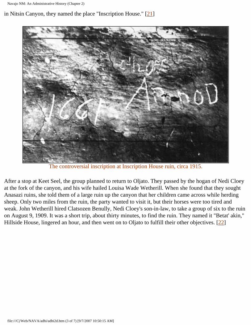
Navajo NM: An Administrative History (Chapter 2)
in Nitsin Canyon, they named the place "Inscription House." [21]
The controversial inscription at Inscription House ruin, circa 1915.
After a stop at Keet Seel, the group planned to return to Oljato. They passed by the hogan of Nedi Cloey at the fork of the canyon, and his wife hailed Louisa Wade Wetherill. When she found that they sought Anasazi ruins, she told them of a large ruin up the canyon that her children came across while herding sheep. Only two miles from the ruin, the party wanted to visit it, but their horses were too tired and weak. John Wetherill hired Clatsozen Benully, Nedi Cloey's son-in-law, to take a group of six to the ruin on August 9, 1909. It was a short trip, about thirty minutes, to find the ruin. They named it "Betat' akin," Hillside House, lingered an hour, and then went on to Oljato to fulfill their other objectives. [22]
file:///C|/Web/NAVA/adhi/adhi2d.htm (3 of 7) [9/7/2007 10:50:15 AM]
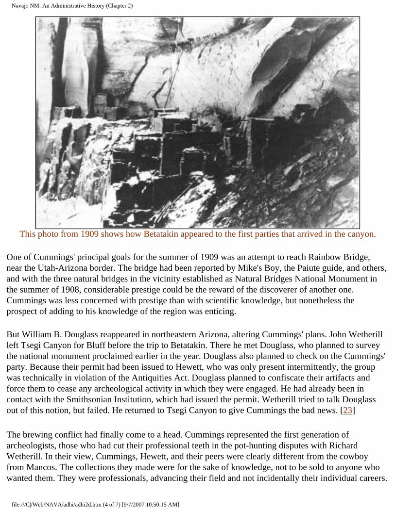
Navajo NM: An Administrative History (Chapter 2)
This photo from 1909 shows how Betatakin appeared to the first parties that arrived in the canyon.
One of Cummings' principal goals for the summer of 1909 was an attempt to reach Rainbow Bridge, near the Utah-Arizona border. The bridge had been reported by Mike's Boy, the Paiute guide, and others, and with the three natural bridges in the vicinity established as Natural Bridges National Monument in the summer of 1908, considerable prestige could be the reward of the discoverer of another one. Cummings was less concerned with prestige than with scientific knowledge, but nonetheless the prospect of adding to his knowledge of the region was enticing.
But William B. Douglass reappeared in northeastern Arizona, altering Cummings' plans. John Wetherill left Tsegi Canyon for Bluff before the trip to Betatakin. There he met Douglass, who planned to survey the national monument proclaimed earlier in the year. Douglass also planned to check on the Cummings' party. Because their permit had been issued to Hewett, who was only present intermittently, the group was technically in violation of the Antiquities Act. Douglass planned to confiscate their artifacts and force them to cease any archeological activity in which they were engaged. He had already been in contact with the Smithsonian Institution, which had issued the permit. Wetherill tried to talk Douglass out of this notion, but failed. He returned to Tsegi Canyon to give Cummings the bad news. [23]
The brewing conflict had finally come to a head. Cummings represented the first generation of archeologists, those who had cut their professional teeth in the pot-hunting disputes with Richard Wetherill. In their view, Cummings, Hewett, and their peers were clearly different from the cowboy from Mancos. The collections they made were for the sake of knowledge, not to be sold to anyone who wanted them. They were professionals, advancing their field and not incidentally their individual careers.
file:///C|/Web/NAVA/adhi/adhi2d.htm (4 of 7) [9/7/2007 10:50:15 AM]
Navajo NM: An Administrative History (Chapter 2)
Douglass took a different view. While he understood the difference in intent, he saw the effect of one of Richard Wetherill's excavations and one of Cummings' as the same. In both cases, prehistoric structures were less important than subsurface artifacts; nor was documentation available to the interested public. Excavators made little effort to preserve the sites they dug. From Douglass' perspective, these kinds of excavations of federal property amounted to vandalism, no matter who was behind them. In effect, Douglass applied the "pot-hunter" label to the very people who coined the phrase. With both he and Cummings in the area, trouble was certain to ensue.
John Wetherill cast himself as the peacemaker. He knew better than anyone that there were enough prizes to go around as well as the consequences of fighting the growing power of federal officials interested in western land and resources. He reasoned that the two men could resolve their differences if they met face to face. Aware of the trip to Rainbow Bridge, Douglass asked to join the group. Although he arrived at Oljato after the group left for the bridge, Cummings returned for Douglass, and representatives of two distinctly different perspectives on the disposition of American prehistory traveled together to find yet another unique feature of the southwestern landscape.
It must have been a tense trip, for Wetherill was never successful in his attempt to orchestrate an accord between Douglass and Cummings. The group pushed forward under the guidance of Nashja-begay, a Paiute guide in Cummings' employ, seeing the bridge in the distance on August 14, 1909. Douglass sought to be the first white underneath the bridge, an honor that Neil Judd, another of the members of the party, felt should go to Cummings. John Wetherill made the issue a moot point when he spurred his horse ahead of Douglass and the others and passed under the arch first. [24]
The trip to Rainbow Bridge has become more myth than history, but much of the story is not in dispute. Clearly Wetherill and Cummings resented the appearance of Douglass, whose ability to force the expedition to cease their work was of utmost concern. Douglass behaved in a heavy-handed, self-important manner. Judd, Cummings, and Louisa Wade Wetherill all portray Douglass as an interloper who sought to supersede other, more knowledgeable explorers more worthy of credit. Cummings' account, published long after Douglass' death, openly disparaged Douglass. Cummings asserted that Douglass not only attempted to usurp credit for discoveries, he patronized the members of the expedition after imposing on their hospitality. "Of what thin material some men are made," Cummings wrote the Wetherills in reference to Douglass after hearing of the latter's claim that he discovered Rainbow Bridge. Only Judd grudgingly allowed Douglass respect for his desire to protect the ruins from depredation. The rest perceive him as self-serving bureaucrat, and in the lore of the early days of American archeology, William B. Douglass became the villain. [25]
Yet a more balanced look at the evidence suggests that the territoriality that characterized American archeology was a major contributing factor to the disdain showered on William B. Douglass. Despite the evident hospitality shown him by Cummings and Wetherill, Douglass believed his duty compelled him to stop the expedition. He clearly advocated preservation of ruins and natural features for the benefit of the public and exploration by accredited scientists. What made him wary was the emphasis on collecting that pervaded any expedition with which Edgar L. Hewett was connected. He recognized that Hewett, to
file:///C|/Web/NAVA/adhi/adhi2d.htm (5 of 7) [9/7/2007 10:50:15 AM]
Navajo NM: An Administrative History (Chapter 2)
whom the permit for excavating the new national monument had been issued, had already manipulated the system for his personal benefit. Douglass had serious and legitimate concerns about the intentions of the Cummings party. He had the power to make the expedition change its practices and the inclination to use it. [26]
In perspective, the rivalry between Cummings and Douglass was more a clash of cultural perspectives than a nasty government man taking credit from archeologists and local people. Douglass was a forerunner of the ordered, regulated society that would become codified in the founding of the National Park Service seven years later. He sought strictures on individual activity, no matter who performed archeological work or how respected their credentials. Ironically, like Hewett, Douglass was incapable of following the very rules to which he held others. His later excavations on Chacoma Peak and at Ojo Caliente revealed the same kind of collecting for which he chastised Hewett and Cummings in 1909. [27]
Nor could Douglass legitimately censure Cummings for collecting artifacts. Archeological science was in its infancy, and describing ruins, collecting artifacts for museums, and making wild generalizations about prehistoric life was standard practice. What worried Douglass was the disposition of the artifacts and the condition of the sites after a foray. He recognized that the government needed to protect the structures from which the artifacts came as well the pottery and the baskets of prehistory.
From Rainbow Bridge, the explorers went in different directions. Neil Judd took William B. Douglass and his surveyors to Betatakin and Keet Seel, where they began to map the newly established national monument, while Cummings and John Wetherill explored the canyons south of Navajo Mountain with Dogeye-begay, another guide. Judd left Douglass at Keet Seel with a map of Betatakin and the Bubbling Spring ruins and returned to Oljato to meet up with Cummings.
Douglass' efforts to halt the excavation began to pay off. Waiting for John Wetherill at Oljato was a letter from S. V. Proudfit, the Acting Commissioner of Indian Affairs. Proudfit inquired about unauthorized excavations within the boundaries of the national monument. "There is no one excavating on the Navajo National Monument except Prof. Cummings and party," Wetherill immediately replied, "and they are doing so under the permit issued to Edgar L. Hewett." [28]
For Wetherill, this was an enlightening moment. He was well aware of his brother's problems with the Department of the Interior and he depended on his income as a guide. He was also an enthusiastic explorer, a trait he shared with the rest of his family. When he accepted appointment as the custodian of the monument, he cast his lot with Douglass and the Department of the Interior. No matter how fondly he felt toward Cummings, he knew well the price of thwarting the Department of the Interior. By 1909, his iconoclastic brother had paid it in full.
The scientific establishment in Washington, D. C., also lined up with Douglass. Since the passage of the Antiquities Act in 1906, the federal bureaucracy had jealousy guarded its power to permit excavation. Scientists affiliated with the Smithsonian Institution and the Bureau of American Ethnology saw themselves as the best professionals to initiate surveys of protected ruins. Part of important federal
file:///C|/Web/NAVA/adhi/adhi2d.htm (6 of 7) [9/7/2007 10:50:15 AM]
Navajo NM: An Administrative History (Chapter 2)
bureaus, they did not need to make collections to assure future support of their work. Douglass' reports spurred the interest of Dr. J. Walter Fewkes and Dr. Walter Hough, two eminent Americanists, and by the end of the summer of 1909, plans had begun for a preliminary expedition the following year. William Henry Holmes, who succeeded Powell as the head of BAE, supported Douglass as the surveyor tried to compel excavatory work to cease. [29] A power struggle had begun.
Cummings was on sabbatical from the University of Utah, and his permit was still valid. In the fall and winter of 1909, he continued to work in the region, returning to Tsegi Canyon and excavating Betatakin. Arriving in a snowstorm, the party looked through the talus material below the ruin for burials and found none, but were more successful in the ruin itself. They found four four-stop reed flutes and a number of turquoise ear pendants set in wood. The party left in haste when Nedi Cloey arrived with horses to take them out before a serious snowstorm, and they left their discoveries stored in one of the rooms of the ruin. The relics were never seen again. [30]
CONTINUE >>>
nava/adhi/adhi2d.htm Last Updated: 22-Jan-2001
file:///C|/Web/NAVA/adhi/adhi2d.htm (7 of 7) [9/7/2007 10:50:15 AM]
Navajo NM: An Administrative History (Chapter 2)
Navajo
Administrative History
CHAPTER II: FOUNDING NAVAJO NATIONAL MONUMENT (continued)
Cummings' foray signaled the end of undocumented excavation in the monument. The following year, the BAE sent Fewkes to make a written record of the treasures of the new monument. Cummings stayed away. Like Hewett, Cummings lacked formal training in archeology. He too recognized that either federal affiliation or further training would be essential to preserve his position in the changing world of science. Between 1905 and 1908, Hewett acquired a Ph.D. from the University of Geneva. After he left Tsegi Canyon, Cummings went to Berlin to study archeology. Only in 1912 did Cummings return to Betatakin. [31] Fewkes replaced him as the primary excavator of Navajo National Monument. Federally sanctioned science had triumphed over its university-based equivalent.
In this respect, an effort to control who had access to federally reserved ruins succeeded. Douglass, Holmes, and Fewkes paved the way for "responsible" rather than individualistic science--people and activities sanctioned by the Smithsonian and the Bureau of American Ethnology that had more than collecting artifacts as their objective. Combined with the revolutionary application of stratigraphy by Nels V. Nelson in the Galisteo Basin later in the decade, archeology began to move away from the romantic approach of Hewett and Cummings toward a more empirical style. Alfred V. Kidder carried the new mode even further in his excavations at Pecos. The field was changing, and the new way of doing archeology limited the significance of the work of people such as Hewett and Cummings. As a result, the struggle over access at Navajo National Monument and many similar instances in the Southwest degenerated into power struggles between people in the region in proximity to the ruins and representatives of federal agencies with the ability to sanction but not to enforce.
Sanctioned scientists became the beneficiaries of the monument proclamation. A structure for the process of excavating federal ruins had been established. After the confused situation at Navajo National Monument, federal officials watched more carefully the permits they issued as BAE scientists sought to make at least preliminary explorations before those interested in making collections got their chance.
The first of two Fewkes expeditions arrived in September 1909. Fewkes had spent the summer at Mesa Verde working at Cliff Palace, but as the tension increased in northeastern Arizona, Holmes needed a
file:///C|/Web/NAVA/adhi/adhi2e.htm (1 of 4) [9/7/2007 10:50:17 AM]
Navajo NM: An Administrative History (Chapter 2)
first-hand account from a dependable professional. Despite his experience in land matters, Douglass did not have the credibility of someone familiar with archeological excavation. Fewkes was close at hand, and received orders to inspect the monument that had become the source of all the trouble.
It was a brief visit that Fewkes made, although he and his party visited most of the ruins in the area. They traveled to Betatakin and Keet Seel, visited numerous smaller ruins, and made the forty-mile trek to Nitsin Canyon and Inscription House. Yet this was clearly a preliminary trip, for little or no excavation was accomplished and Fewkes spent only a short time in each place.
The following spring, Fewkes returned to the area for further work, permit in hand, made out in his name. After the second visit, Fewkes made comprehensive descriptions of each of the ruins, his view of their place in American prehistory, as well as the approaches to this remote part of northeastern Arizona. These were included in Preliminary Report on a Visit to the Navaho National Monument, Fewkes' account of the trip that was published as Bureau of American Ethnology report #50 in 1911.
Fewkes' report was precisely the kind of document that William B. Douglass thought was essential for the protection of prehistoric ruins in the Southwest. Officials at the Smithsonian Institution and the BAE concurred. Here was a document that chronicled the condition of the site and its attributes, written before wholesale excavation took place. Despite its overly descriptive nature, it was a practice federal officials sought to encourage. [32]
At the close of his report, Fewkes proposed a plan for the monument. He suggested the excavation, restoration, and preservation of either Keet Seel or Betatakin as a "type ruin," presumably for visitors and scientists. The selection seemed ideal. Both Keet Seel and Betatakin were spectacular places with much appeal to anyone who saw them. They inspired a romantic vision of prehistory that meshed with the dominant tone of the time period.
The boundaries of the monument also needed adjustment, for in his haste to prevent unauthorized excavation, Douglass had actually facilitated the establishment of a 160-square-mile monument. Fewkes recommended the addition of Inscription House to the monument. It had been left out of the original proclamation, for whites did not find it until after the monument was established. By coincidence, Betatakin, also not yet discovered, had been included in the original proclamation.
Fewkes' trip and subsequent report brought many more visitors to the region, most of whom hired John Wetherill as a guide. In the fall of 1909, the Wetherills and Clyde Colville moved their trading post south to Kayenta, Arizona, much closer to the ruins of the Tsegi area. Dr. T. Mitchell Prudden, a physician with an intense interest in archeology and an important list of publications in the field, visited the monument with Wetherill in 1910. Herbert E. Gregory of Yale University, a geologist who assisted the U.S. Geological Survey during the summers and was reputed to be able to outwalk a horse in desert sand, attempted to map the region in 1910. Gregory reported that besides the ruins of the Tsegi, there were additional ruins of interest in the vicinity of Navajo Mountain. But Department of the Interior officials decided that the existing monument was sufficient. [33]
file:///C|/Web/NAVA/adhi/adhi2e.htm (2 of 4) [9/7/2007 10:50:17 AM]
Navajo NM: An Administrative History (Chapter 2)
The increase in activity in the area contributed to the adjustment of the boundaries of the monument. With the surveying of the 160 square miles, even the most ardent advocates of preservation recognized that too much land had been reserved if the purpose of the monument was to protect archeological areas. William B. Douglass was the first to recognize this reality, and the work of Herbert Gregory confirmed Douglass' observations.
Other pressures came to bear on the Department of the Interior and the General Land Office. Although the land in the region was marginal at best, livestock interests in Arizona sought to lease portions of the monument for grazing and prospecting. One particularly persistent attorney, Clarence H. Jordan of Holbrook, Arizona, made the case for his client, Kenneth M. Jackson. Jordan and Jackson were aware that the monument existed to preserve prehistory, for they promised that the cattle enterprise would not damage the ruins. They also suggested that livestock grazing and preservation were compatible. But after an exchange between Secretary of the Interior Walter L. Fisher and his subordinates, Jordan's proposal was turned back. [34]
The pressure for the grazing permit was an issue that the Department of the Interior wanted to avoid. National monuments were new, and federal officials did not want animosity towards the idea. They were also aware Navajo National Monument was far too large. With some inside maneuvering, General Land Office officials put together a measure for the President's signature that added Inscription House to the monument, but reduced the total area of the monument to two 160-acre sections surrounding Betatakin and Keet Seel and a 40-acre tract around Inscription House. On March 14, 1912, President William H. Taft signed the document. The reduced size of the monument eliminated grazing, the Jordan-Jackson proposals, and most of the potential for antagonizing local constituencies. [35]
The Navajo National Monument that resulted was as much a product of the times in which it was established as of a desire for preservation. Fear of depredation inspired the original proclamation, but no one from the government had yet seen the ruins. Competition between different groups within the scientific community played a significant role in shaping the original boundaries. Establishment of the monument ostensibly eliminated the threat of untrained, unaffiliated "pot-hunters." A rivalry among scientists representing different kinds of archeology ensued.
When it was finally pared down to a more reasonable size for its purpose, the monument was awkward and gerrymandered. Visitation had no place in the thinking of the people who redrew the boundaries of the monument. They sought to preserve ruins, apparently assuming that the remote nature of the monument would protect it forever. As a result, three non-contiguous areas did not seem unwieldy. But the 1912 revision attempted to fuse three discrete and unconnected entities with forty miles between them and histories and patterns of their own into one unit. Subsequent management would always be difficult.
Navajo was the classic remote monument. There was no easy way to get there, nor did it fit in any of the schemes for tourism that appeared during the first two decades of the twentieth century. As a remote
file:///C|/Web/NAVA/adhi/adhi2e.htm (3 of 4) [9/7/2007 10:50:17 AM]
Navajo NM: An Administrative History (Chapter 2)
place, it could not command the resources of federal administrators. No visitors accidentally discovered it and returned with their friends. It had no advocates or constituents save archeologists, no one who could argue that it merited the attention of the federal bureaucracy. As a result, it remained outside of the mainstream of General Land Office and later National Park Service policy and direction. A pattern of exclusion that haunted the monument until the 1960s existed at its founding.
<<< CHAPTER 1 TABLE OF CONTENTS CHAPTER 3 >>>
nava/adhi/adhi2e.htm Last Updated: 22-Jan-2001
file:///C|/Web/NAVA/adhi/adhi2e.htm (4 of 4) [9/7/2007 10:50:17 AM]
Navajo NM: An Administrative History (Chapter 3)
Navajo
Administrative History
CHAPTER III: THE LIFE OF A REMOTE NATIONAL MONUMENT 1912-1938 (continued)
But that appropriation was the only allocation of federal money for Navajo for more than another decade. The monument remained far outside the mainstream of Park Service efforts. During the 1920s, the agency developed its focus on the "crown jewel" national parks, places such as Yellowstone and Yosemite. The agency spent the 1920s developing facilities for visitors at these flagship parks, and a two-tiered park system developed. The places with the most attractive and spectacular scenery also had roads, hotels, and amenities; the rest of the system lacked comfortable trappings and appropriations. [19] Generally national monuments were low on the list, and few places were lower than Navajo National Monument. Located in a remote and seemingly inhospitable corner of the Navajo reservation, it had few of the attributes that Americans sought when they looked at their park system.
Even the advent of a system of management for park areas in the Southwest did little to help Navajo. In 1924, Frank "Boss" Pinkley, the custodian of Casa Grande National Monument in south central Arizona, became the superintendent of the southwestern national monuments. Self-trained, aggressive, folksy, and an avid fan of archeology and archeologists, Pinkley shaped a domain by the force of his will. Between 1924 and the early 1930s, he developed a strategy to promote the national monuments under his jurisdiction, brought hundreds of thousands of visitors to the region, began the professionalization of park management in the Southwest, and brought a spirit of camaraderie to the volunteer custodians in his far-flung domain.
Pinkley was an archeology buff, and the monuments with prehistoric themes benefited most from his administration. He knew most of the first and second generations of southwestern archeologists, from Fewkes and Hewett to Kidder, and had great respect for their work. With so many prehistoric areas in his domain, Pinkley directed much of the attention of southwestern national monuments group toward them.
Among his many important programs, Pinkley focused on standardizing service for visitors and creating a permanent paid professional staff. From his headquarters at Casa Grande, Pinkley provided leadership
file:///C|/Web/NAVA/adhi/adhi3b.htm (1 of 7) [9/7/2007 10:50:19 AM]
Navajo NM: An Administrative History (Chapter 3)
and guidance, holding seminars, evaluating interpretation programs, and training his staff to work at other park areas. By the late 1920s, small amounts of money for custodians began to appear in the annual budget, and Pinkley slowly replaced "dollar-a-year" volunteers with people he had trained himself. Most of them administered small archeological areas such as Aztec Ruins National Monument in New Mexico. In line with Pinkley's philosophy, these areas were usually close to the main arteries of travel through the region. [20]
But at Navajo National Monument, little changed throughout the 1920s. John Wetherill remained as volunteer custodian. He lived in the tent he pitched there each spring and spent as much time as he could at the ruins, but found himself eternally distracted by the trading post and his guide business. While many of the southwestern monuments were developed and prepared for an onslaught of visitation, Navajo National Monument remained as it had always been: a far-away place that attracted mostly those already aware of its attributes.
Despite Frank Pinkley's desire to promote archeological areas, Navajo National Monument remained peripheral even to the southwestern monuments group. Long after development became common among the archeological areas of the Southwest, Navajo lacked any of the amenities Pinkley and the Park Service had elsewhere for visitors. Pinkley had little reason to invest his few resources in a plan without the infrastructure to attract visitors. As a result, it had no link to the modern world, a reality that was both an advantage and a disadvantage.
One factor that made Navajo unwieldy was that for administrative purposes, the monument was an artificial construct. There were three ruins at Navajo, and the long travel between the ruins crossed reservation land and made simultaneous care of the three impossible. No matter how effective the Navajo grapevine, John Wetherill could not be in all three places at once. Often he was not at any of them. Each of the three ruins was an attraction in its own right, and there was no individual primary feature at the monument. Travelers might focus on any of Betatakin, Keet Seel, or Inscription House. There were no resources to support administration, and a visitor might never realize that each ruin was part of a national monument.
Nor was the monument divorced from its surroundings either figuratively or literally. The area around the monument and Navajo Mountain was considered the most traditional part of the reservation. Conservative Navajo "long-hairs" dominated in the area, and their contact with the Anglo world was limited. As late as 1909, many had never met a white; into the 1910s there were still Indian "attacks" on trading posts and Indian agents. [21] Navajos avoided contact with the outside world, and as a result roads and maps of the area were limited. William B. Douglass had surveyed the area, but most of his markers were lost. As late as the end of the 1910s, there were no accurate cartographic descriptions. The tenor of the region in which it was located greatly influenced the growth of the monument. Its isolation prevented the kind of travel that usually generated dollars from Washington, D. C.
Access also remained a major problem. No roads had been built through the area, limiting travel to the existing trails. The trail through Marsh Pass was purported to be an old military wagon road from the
file:///C|/Web/NAVA/adhi/adhi3b.htm (2 of 7) [9/7/2007 10:50:19 AM]
Navajo NM: An Administrative History (Chapter 3)
1850s; wags felt it was still in about the same condition seventy-five years later. The most commonly used way to arrive at Navajo National Monument was to follow the path from Marsh Pass that Richard Wetherill first took in the 1890s. This approach followed Laguna Creek to Tsegi Canyon, which wound its way toward Betatakin up one branch and to Keet Seel along another. Coming first from Oljato and later from nearby Kayenta, both north of the monument, John Wetherill institutionalized the path. He took Cummings, Judd, and others that way; in turn they showed others such as William B. Douglass, who Judd took to the area after the discovery of Rainbow Bridge. By 1910, this was the way nearly every Anglo-American arrived at Betatakin or Keet Seel. [2]
This principal access route was neither dependable nor easy. The trip along the main trail from Flagstaff could take as much as six days--under the best of circumstances--and any inclement weather made the ordeal even worse. Marsh Pass could be as much as a day from Kayenta alone, although Wetherill and Clyde Colville improved much of that stretch after 1910. As late as 1910, there was no road into the Tsegi at all. The Fewkes party had to build its own through one of the washes, then about fifteen or twenty feet deep. Fewkes had his men use a slip scraper to construct this trail to convey the buckboard wagon in which his wife rode. She was "not one to walk," Fred S. Garing, who worked as a laborer on the expedition, later recalled. The party went first to Betatakin, then to Keet Seel, and later made the forty-mile trip to Inscription House. [23]
Fewkes' trail cemented the main route to reach the ruins. It certainly suited John Wetherill. The trail led almost directly from his trading post at Kayenta, and as a result, he could keep a close watch on Betatakin and Keet Seel. It also helped his guide business, although his style of driving did not. Wetherill was known to stop his car at the bottom of every steep rise, put it in low gear, push the accelerator to the floor, and never slack off until he reached the top. Cummings also used this trail for his frequent trips to the area, and it became the favored way selected by archeologists. By 1914, it was clearly if roughly demarcated. Although in earlier accounts, the difficulty of the trip elicited comment, by 1914 it seemed no more difficult than any other part of the journey to a remote corner of the reservation.
file:///C|/Web/NAVA/adhi/adhi3b.htm (3 of 7) [9/7/2007 10:50:19 AM]
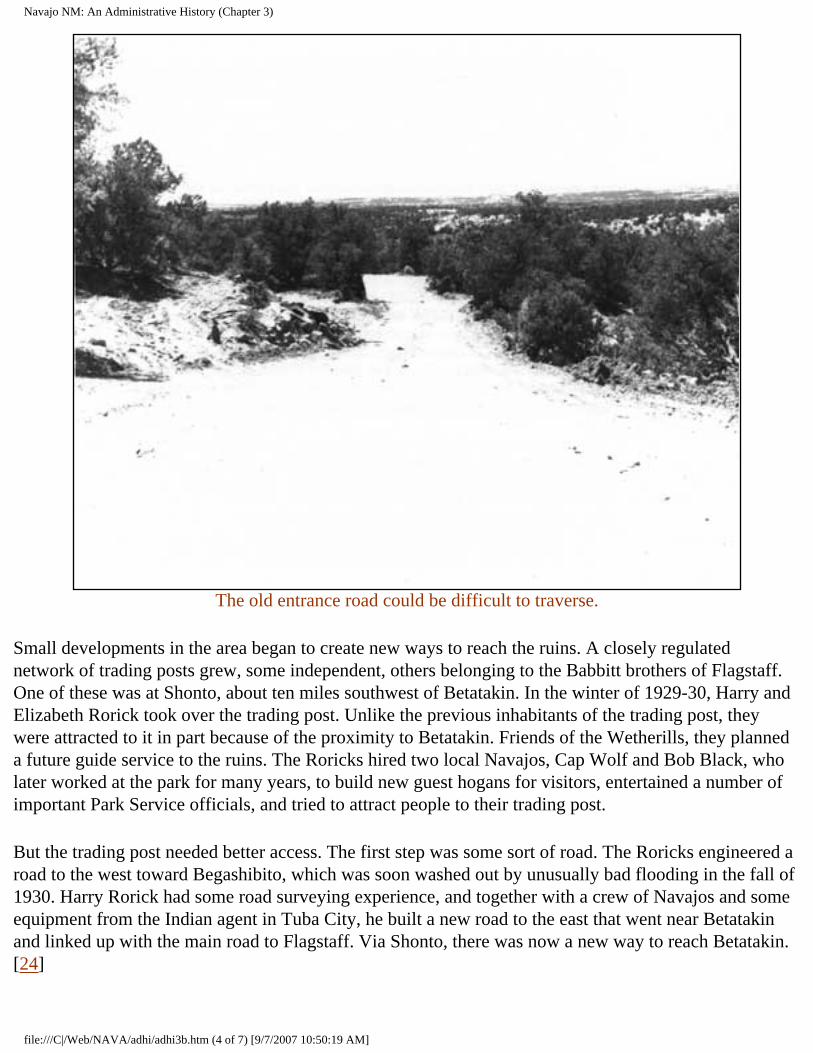
Navajo NM: An Administrative History (Chapter 3)
The old entrance road could be difficult to traverse.
Small developments in the area began to create new ways to reach the ruins. A closely regulated network of trading posts grew, some independent, others belonging to the Babbitt brothers of Flagstaff. One of these was at Shonto, about ten miles southwest of Betatakin. In the winter of 1929-30, Harry and Elizabeth Rorick took over the trading post. Unlike the previous inhabitants of the trading post, they were attracted to it in part because of the proximity to Betatakin. Friends of the Wetherills, they planned a future guide service to the ruins. The Roricks hired two local Navajos, Cap Wolf and Bob Black, who later worked at the park for many years, to build new guest hogans for visitors, entertained a number of important Park Service officials, and tried to attract people to their trading post.
But the trading post needed better access. The first step was some sort of road. The Roricks engineered a road to the west toward Begashibito, which was soon washed out by unusually bad flooding in the fall of 1930. Harry Rorick had some road surveying experience, and together with a crew of Navajos and some equipment from the Indian agent in Tuba City, he built a new road to the east that went near Betatakin and linked up with the main road to Flagstaff. Via Shonto, there was now a new way to reach Betatakin. [24]
file:///C|/Web/NAVA/adhi/adhi3b.htm (4 of 7) [9/7/2007 10:50:19 AM]
Navajo NM: An Administrative History (Chapter 3)
The Roricks worked to promote Shonto as an alternative route to reach Betatakin. Elizabeth Rorick had ties to the National Park Service and Harry Rorick at one time worked for Fred Harvey's tourist service operation. In late April or early May 1931, Harry Rorick started his push to bring Shonto to the attention of the Fred Harvey Company. He took E. M. Ennis, second-in-charge of the Harvey operation at the Grand Canyon, and Ray Williams, the official photographer for the Harvey company, to Betatakin for a camping trip. Rorick was trying to sell them on the idea of a Shonto-based Indian Detour side trip from the Grand Canyon.
The trip was enjoyable, but it had serious consequences. After the party left, John Wetherill found the campsite covered with trash. Worse, Ennis had carved his name into a tree on the approach to Betatakin. Wetherill communicated this to Frank Pinkley at Casa Grande, who promptly exploded.
Pinkley had spent more than twenty years trying to teach the traveling public to behave, and wanton behavior like this from ostensibly responsible people was too much. In typical fashion, Pinkley fired off a missive to Rorick demanding an apology, threatening legal action, and generally assailing the character of anyone who would behave in this fashion. Pinkley often overreacted in such situations, for he had an evident proprietary feeling for each of the southwestern monuments, a lack of regard for those who had no respect for government property, and a quick temper. [25]
But Pinkley had not counted on Elizabeth C. Rorick's response. Before her marriage to Rorick, she had been married to Michael Harrison, who worked for the Park Service at the Grand Canyon. She knew a number of influential bureau people, including Horace Albright, who became director of the NPS in 1929. Elizabeth Rorick contacted Albright, explaining that Pinkley made a mistake attributing the mess in the canyon to Harry Rorick's party and acknowledging Ennis' name carving. She also stressed the Roricks' desire to work closely with the Park Service to promote the region, using the magic Harvey name. [26] The Park Service relented, and the new approach to Betatakin became acceptable to the agency.
Clearly the road from Shonto worried John Wetherill. It intruded on his dominance of hospitality in the region and made the level of protection he could offer the monument inadequate. The trading post at Kayenta would cease to be a necessary stop for visitors to Tsegi Canyon. The new road had the potential to threaten John Wetherill's livelihood, and his response showed how clearly he recognized the challenge. Wetherill suggested that the road would encourage more grazing of the canyon floor, and made it a point to alert the agency to every instance of vandalism that occurred when travelers came from Shonto. Park Service officials recognized Wetherill's position for what it was, and the road from Shonto grew in importance.
Ironically, the change in direction of approach provided Keet Seel with de facto protection that it never before enjoyed. Coming from the west to the closed end of Tsegi Canyon above Betatakin made Keet Seel a remote destination. Not only did visitors have to descend from the mesa, they had to ride another seven miles and successfully negotiate a change in canyon branch. Most of the travelers who reached Shonto were not equal to the task. In contrast the trip from Kayenta gave travelers a nearly equal chance
file:///C|/Web/NAVA/adhi/adhi3b.htm (5 of 7) [9/7/2007 10:50:19 AM]
Navajo NM: An Administrative History (Chapter 3)
to see Betatakin or Keet Seel. Coming from Marsh Pass, they faced two different forks of the same canyon and could visit either ruin with equal difficulty. The change in direction made Keet Seel more remote, and for some visitors, it was less impressive than Betatakin. In the 1920s, one remarked, it "was a let-down to me after Betatakin." [27] Less spectacular and more thoroughly excavated, Keet Seel began to recede from the primary position it occupied beginning in the 1890s.
Yet the emergence of the Shonto route as the primary approach to Betatakin was fraught with problems. The trail was poorly marked, and a number of visitors, including Agnes Morley Cleaveland, who later became a noted southwestern author, lost their way. The increase in visitation that John Wetherill did not supervise or know of led to instances of vandalism, and clearly more protection was essential. Stock also wandered into the Betatakin area, damaging the ruins and accelerating existing erosion. The Roricks wanted trail markers between Shonto and the ruins, and visitors such as Cleaveland echoed their sentiments. [28]
Frank Pinkley found himself in a difficult situation. The Roricks had created a new approach that bypassed John Wetherill, and in fact was a far more convenient to way to reach Betatakin. Pinkley felt he needed to carefully address this situation, for Wetherill and the Roricks were in economic competition. Pinkley did not want to create any appearance that the Park Service favored Wetherill because he served as custodian of the ruins. Pinkley also appreciated the hospitality that the Roricks offered visitors and felt that their activities helped promote the monument. Their service was far less expensive than Wetherill's and the trip was shorter as well. Pinkley opted to study the situation before committing NPS resources to fence trails. [29]
The situation was further complicated by the construction of a new road to the rim of Tsegi Canyon by the Forestry Service of the Bureau of Indian Affairs. The road stretched from the Shonto Trading Post to what is now called Tsegi Point, and Park Service engineers planned a trail to Betatakin. Its construction meant that visitors could bring their cars within a mile of the ruins. John Wetherill misunderstood the descriptions given him by BIA and the NPS engineers. He thought the road would end above Betatakin at the south end of the canyon and the trail would proceed to the ruin from there. Walter Atwell, one of the leading NPS field engineers, visited the region. He and Wetherill traversed the canyon and found the new road and stakes for the trail. The location posed fewer problems for Wetherill. It did not offer an easier way for stock to reach the ruins, nor did it favor the Roricks' enterprise over his own. [30]
But the new approach and the embryonic development program suggested the inauguration of major change in the patterns of visitation at the ruins of Tsegi Canyon. While accommodating visitors had been an objective for Navajo even during GLO administration of the ruins, the numbers had never seemed a threat. Despite the rugged conditions, the advent of tourism at Shonto required a response, particularly because the Park Service emphasized service in the 1920s and the New Deal made creating an infrastructure possible. Faced with growing numbers of visitors, the agency needed to take action.
Farther to the west at Inscription House, a similar process occurred. In 1926, Samuel I. Richardson left Rainbow Lodge to build a new trading post on Red Mesa. Called Inscription House Trading Post after
file:///C|/Web/NAVA/adhi/adhi3b.htm (6 of 7) [9/7/2007 10:50:19 AM]
Navajo NM: An Administrative History (Chapter 3)
the ruins in the canyon below, the new post replicated the advantages of Oljato, Kayenta, and Shonto before it. It was distant enough from the nearest posts to have an intrinsic local trade of its own and it held the added attraction of the ruin in the canyon. Richardson blasted out a four-foot wide trail through stone from the mesa to the ruins below and began to set up a cottage industry similar to that of Richard Wetherill in the late nineteenth century. Numerous parties of archeologists and buffs, some from respected museums, packed down the trail, and in the late 1920s, at least one hundred mule-loads of artifacts came out. Yucca sandals, pottery and baskets, turquoise, shellbeads, and bracelets, fabrics woven of human and dog hair, wooden fetishes, and many other artifacts were taken for public and private collections. [31]
Richardson's activities attracted the attention of Park Service personnel. Richardson was open about his actions, and visiting agency people heard rumors of numerous unauthorized collections. In early 1930, Ansel F. Hall, Chief Naturalist of the Park Service, brought the situation to Frank Pinkley's attention. According to Hall, who spent the summer of 1929 in the Navajo National Monument area, Richardson had been involved in pot-hunting since his days at Rainbow Lodge and had sold much of what he found to the Heard Museum in Phoenix. Hall acquired the information in confidence and had not been able to confirm it. Pinkley checked out the rumor with the Heard Museum, where officials unequivocally denied the charge. Pinkley was inclined to believe them, for he thought Richardson knew well the rules governing illegal pot-hunting. Tourists comprised a large percentage of his business at both Rainbow Lodge and Inscription House, and Pinkley thought that Richardson recognized that he depended on Park Service cooperation. Pinkley promised to remain vigilant, but found little to confirm Hall's suspicions. [32]
CONTINUE >>>
nava/adhi/adhi3b.htm Last Updated: 22-Jan-2001
file:///C|/Web/NAVA/adhi/adhi3b.htm (7 of 7) [9/7/2007 10:50:19 AM]
Navajo NM: An Administrative History (Chapter 3)
Navajo
Administrative History
CHAPTER III: THE LIFE OF A REMOTE NATIONAL MONUMENT 1912-1938 (continued)
Again the disadvantages of a non-contiguous monument without full-time staffing were apparent. Richardson spent more time at Inscription House than did anybody in the Park Service, and even John Wetherill, with all his knowledge of the region, could do little to prevent Richardson's actions. To people like Richardson, the fruits of prehistory were theirs to harvest; their value system reflected the first-come, first-served ethos of the settlement of the West. Despite the existence of laws like the Antiquities Act, there was little that could be done without an investment of capital and workpower. But the agency still had far too few resources to adequately protect every park and monument, and there were many other park areas ahead of Navajo on the list of NPS priorities.
At this time, national park status was the prize that assured the survival of a park area, and during Horace Albright's administration, acquisition of new park lands was the critical feature of NPS policy. The best way to improve the chances of Navajo National Monument was to elevate it to park status, acquiring new land in the process. During the early years of the depression, Albright successfully made an efficient-management-by consolidation argument on a number of occasions. A number of new and enlarged park areas resulted. By the early 1930s, Navajoland, as the reservation area had been labeled, and the Navajo National Monument area looked like good candidates for such a proposal.
There were major problems to be surmounted in this process, the most significant of which was the presence of Navajo people in the area sought for a national park. Since its inception, the Park Service had focused on scenic parks. The acquisitions of the 1910s and 1920s, from Zion to Grand Teton national parks, all had spectacular natural features. Most were isolated, high mountain areas, where few people lived. But with the authorization of eastern parks areas in the mid-1920s, the NPS found itself displacing people in the Great Smoky Mountains and the Shenandoah region. In one instance at Cades Cove, Tennessee, park rangers and local people engaged in a pitched gun battle when the NPS tried to take over land it acquired through the power of eminent domain. The situation reflected poorly on the NPS, and influential people tried to persuade Albright to change policy. By 1930, Albright had adroitly switched his goals, considering the incorporation of people native to a region in new parks. [33]
file:///C|/Web/NAVA/adhi/adhi3c.htm (1 of 4) [9/7/2007 10:50:21 AM]
Navajo NM: An Administrative History (Chapter 3)
The result was an attempt to create a national park in the vicinity of Navajo National Monument. Early in 1931, Roger Toll, the superintendent of Yellowstone National Park and the primary inspector of proposed park areas in the West, arrived to inspect the Navajo reservation. Toll spent a night at Shonto with the Roricks, visited numerous park areas, and produced a report recommending the establishment of Navajo National Park. His proposal suggested that the park should encompass Monument Valley, Canyon de Chelly, and a number of other features in the region. Navajo and Rainbow Bridge national monuments were to be included in a detached section of the proposed park. Toll believed the State of Arizona would support the idea and the Indian Service could be persuaded. Typical of the attitudes of the time, he made no mention of the desires of the Navajo people. [34]
The Park Service geared up for a push to create a new national park. Albright gave Toll's report to Charles Rhoads, the Commissioner of Indian Affairs, contacted Robert S. Yard, the driving force behind the National Parks Association, and made plans for a western swing. During the 1920s and early 1930s, this approach typified the acquisition efforts of the Park Service. [35]
Rhoads instantly decided against the project, but that did not thwart the NPS. Rhoads felt that the Navajos needed more, not less land, to offset the growing problem of overgrazing on the reservation. The reservation lands given them after Bosque Redondo did not encompass the traditional boundaries of Navajo inhabitation, and in the 1880s, Navajos began to live on public domain land. Initially this posed little problem, but by the 1930s, a number of changes had come together to create an untenable situation. Some of the best land around the reservation fell into the hands of Anglo and Mexican-American cattlemen and sheepmen. Simultaneously, the Navajo population increased, as did the quantity of their stock. By 1930, a larger number of Navajo and their animals had to subsist on a smaller, more thoroughly used area of land. From Rhoads' perspective, to give up some of that land base for a national park was folly. [36]
This failed to deter Albright, who persisted with the park plan. Albright intended to incorporate the Indians in the park, not expropriate their land, and the proposal was important enough to pursue. Conrad L. Wirth, who entered the Park Service through the New Deal and served as its director from 1951 to 1964, wrote a strong memo supporting Toll's proposal, and despite opposition from Harold C. Bryant, the head of the NPS Division of Education, and Washington B. Lewis, Albright continued. The proposal gathered momentum in the NPS after agency counsel George A. Moskey suggested an agreement with the Navajo similar to the one that helped establish Canyon de Chelly National Monument. In that instance, the Navajo Council sought to manage concessions at the monument. Albright contacted Rhoads again in December 1931, but Rhoads immediately asked him to forgo the project until the Navajo were in a better situation. Albright retreated, but only temporarily. In classic Park Service style, he waited for a better moment. [37]
The need for more land for the Navajo was acute, and Rhoads made a boundary extension of the reservation his priority. At the end of the Hoover administration in the midst of the depression, Congress voted to add the "Paiute Strip" in southern Utah to the reservation. The addition included Rainbow Bridge and much of the Navajo Mountain area. The bill itself was a compromise, passed after
file:///C|/Web/NAVA/adhi/adhi3c.htm (2 of 4) [9/7/2007 10:50:21 AM]
Navajo NM: An Administrative History (Chapter 3)
negotiation between the state of Utah and Bureau of Indian Affairs. It contained one clause important to the Park Service: "It is agreed that the scenic tracts [in the addition] are to be developed by the National Park Service with the cooperation of the Indian Service." [38]
Albright and the Park Service interpreted this clause as a signal to proceed. By early 1933, the proposal again had life as the NPS tried to capitalize on the activist role of government that was the hallmark of the New Deal. The ascension of Franklin D. Roosevelt to the presidency played a major role in the rebirth of the proposal. Albright was close to Harold L. Ickes, Roosevelt's crusty Secretary of the Interior, and was able to develop high-level support for his projects. Efficiency was the watchword in the federal government. The glib Albright easily convinced many people that consolidating a number of small monuments in one park would trim expenses. In addition, the success of nearby Grand Canyon and Zion national parks strengthened his argument. Navajo people could benefit economically and have their way of life protected simultaneously. Indian Service officials told Wirth that the Navajo would approve as long as the conditions under which the park was established were similar to those at Canyon de Chelly. [39]
During the summer of 1933, the park seemed a certainty. The Bureau of Indian Affairs supported the proposal, and its officials believed that the tribal council would pass the bill at its next meeting. But on July 8, the Navajo Council postponed consideration of the bill until the fall meeting. Park Service officials anxiously awaited the meeting. Minor R. Tillotson, superintendent at Grand Canyon, even volunteered to attend the meeting to present the proposal. [40]
At the meeting in Tuba City in October, the new Commissioner of Indian Affairs, noted reformer John Collier, put forward a comprehensive set of programs to change the basic nature of the Navajo economy. Under a program to protect rangelands from overgrazing, Collier mandated a stock reduction program for the Navajo. Despite opposition, Collier persuaded the Tribal Council to acquiesce. In return, he promised to deliver a boundary extension for the Navajos that would encompass at least part of the railroad checkerboard lands and other parts of the public domain where Navajos lived.
These programs were well-intentioned, but in the end they did vast damage to the Navajo economy. Collier's stock reduction program started as soon as the funds arrived. The number of livestock Navajos owned was dramatically reduced as the BIA sought to make policy that assured the long-range health of the Navajo economy by protecting grazing land for the future. Unfortunately, the program impoverished many Navajos in the short-term, putting many of them in desperate straits. Most were destitute, some starved, and many had to alter their lifestyle in response to the program.
The stock reduction was supposed to assure further expansion of the reservation, but in this effort, Collier failed. In 1933-34, he pushed for an extension of the reservation. The historic roots of the extension dated from the first decade of the twentieth century, when similar efforts to expand the boundaries had been initiated. But in the 1930s, vocal constituencies, generally local Anglo sheep and cattle interests, protested the proposal. The legislative delegations from New Mexico and Arizona fought the bills, and the extension was never granted.
file:///C|/Web/NAVA/adhi/adhi3c.htm (3 of 4) [9/7/2007 10:50:21 AM]
Navajo NM: An Administrative History (Chapter 3)
The Navajos were confounded. No event since the exile to the Bosque Redondo in the 1860s was more demoralizing than the enforced stock reduction plan. Collier had been their advocate for more than a decade, but in one seemingly capricious and poorly communicated action, he destroyed all the good will he previously established. The Navajos became suspicious of any government program as the effects of the stock reduction and the failure to gain land in New Mexico loomed as a threat to the Navajo way of life.
The NPS tried to ride on the tails of increased federal involvement on the reservation to get the park established. The New Deal gave federal agencies greater power than they previously had and agencies such as the Park Service sought to convert that power into tangible gains. Navajo National Park was not designed to create a landscape without people as had earlier national parks; instead it proposed to incorporate the Navajo into a living, breathing national park that would use the largess of the modern world to protect the Navajo way of life.
This seemingly patronizing approach typified the paradox for Indians and other minorities contained within the New Deal. Federal programs proposed the use of science to restore degraded environments, but simultaneously insisted that Navajos and others use those environments in a limited way. Similar programs for Anglo-American farmers had no such requirement. Instead they promoted a wise technologically based use for the twin objectives of yield and profit. For Navajos, science was to allow a return to old ways. The park proposal would only add a formal structure that froze the Navajos in a moment in time.
The park project failed. Navajo suspicion of federal actions first stymied the proposal and finally squashed it. Collier's efforts to help the Navajo retain subsistence through federal programs aroused anti-park sentiment. When he could not deliver the promised boundary extension, the trust the Navajo had in him diminished. Nor could Collier himself support the park proposal. After failing to deliver on his promise, he could not be party to further restrictions on Navajo land. Without affirmation from either the Navajo people or Collier, the NPS had no chance of success. [41]
CONTINUE >>>
nava/adhi/adhi3c.htm Last Updated: 22-Jan-2001
file:///C|/Web/NAVA/adhi/adhi3c.htm (4 of 4) [9/7/2007 10:50:21 AM]
Navajo NM: An Administrative History (Chapter 3)
Navajo
Administrative History
CHAPTER III: THE LIFE OF A REMOTE NATIONAL MONUMENT 1912-1938 (continued)
Although it failed to genuinely help the Navajo, the New Deal provided vast benefits for most of the park system. Under the aggressive Ickes, the Department of the Interior took the lead in the implementation of New Deal programs. The importance of the Park Service grew tremendously as it became a primary venue for labor-intensive programs. The agency nearly doubled its holdings as a result of Roosevelt's reorganization of the federal government in August 1933. All of the new areas and many of the old needed the investment of capital and labor that the New Deal made possible.
For the archeological monuments of the Southwest, the New Deal was the answer to Frank Pinkley's long-held dream. Finally the resources that had been lacking throughout the 1920s were available, and Pinkley put them to use. Across the Southwest, roads and trails, museums, administrative offices, ranger quarters, and an entire array of other kinds of facilities were constructed. At Bandelier National Monument in New Mexico, a mini-city built of indigenous materials arose as a result of the New Deal camp there, and nearly every other archeological area benefited in some way. [42]
But again, Navajo National Monument was overlooked. No Civilian Conservation Corps camp was located there, nor were extensive roads and trails constructed. The monument was too far from the principal avenues of visitor travel to merit a significant outlay of money and labor. Instead, Navajo received a minuscule portion of the available resources. A Civil Works Administration crew under the direction of Irwin Hayden was its primary benefit from the New Deal. In 1933-34, the crew stabilized rooms at Keet Seel, the extent of the reach of the New Deal to this remote corner of the Navajo reservation. [43]
For the Park Service, the New Deal was the pinnacle of its existence until that point. Nearly every park area with some visitation potential was developed under the auspices of the New Deal, as the agency was able to fulfill even the most far-fetched wish-lists. The nearly total absence of Navajo from the development of the New Deal shows how far down on the list of priorities the monument was located. In Frank Pinkley's previously neglected domain, Navajo was passed over in the greatest moment of
file:///C|/Web/NAVA/adhi/adhi3d.htm (1 of 4) [9/7/2007 10:50:22 AM]
Navajo NM: An Administrative History (Chapter 3)
government largess thus far.
But even in the heady days of the New Deal, it was a long way from using CWA money to stabilize ruins to hiring a full-time paid custodian. Ever prepared, Frank Pinkley developed a plan for Navajo similar to those he designed for other southwestern national monuments. Vandalism, growing numbers of unsupervised visitors, erosion, and fencing all required action. Pinkley's solution to all the problems was a full-time, on-site professional custodian. "We must have someone in charge to show these visitors around and protect these valuable ruins from them," Pinkley informed Arno B. Cammerer, who had succeeded Albright in 1933. Because the monument was divided into non-contiguous sections, Pinkley warned that one person would not be sufficient and a second to share the duties and provide relief was essential. So was a building at the head of the canyon above Betatakin.
But Navajo was unique. Besides the distance between its sections, the Park Service had little control over the lands in between. About twelve Navajos lived in the canyon, one of whom appeared to control land usage. Pinkley proposed to treat him as the leader and negotiate a deal. In exchange for removing their cattle and sheep from Tsegi Canyon, Pinkley wanted to offer the Indians the right to place a hogan above Betatakin and charge travelers a toll for crossing their land. This arrangement would preserve the special qualities of the place and treat Navajo people in the area in an equitable fashion. But it required personnel. [44]
The plan and budget that Pinkley had his staff put together for Navajo was impressive. It included the two full-time positions as well as equipment, animals, residences, and a water and sewer system. The $19,300 recommended for expenditure far exceeded the total the NPS spent at Navajo between 1916 and 1934. [45] The program was more evidence that the New Deal changed the scope of agency expectations. By the pre-1933 standards of the agency, it was extravagant. In the reality of expenditures authorized by New Deal programs, it was distinctly possible. Yet despite the cost, the program established only a skeletal protection structure.
In 1934, John Wetherill received a part-time seasonal ranger for the first time. His nephew, Milton Wetherill, was the choice, and for the following four summers, he served as ranger, ranger-historian, and laborer at the monument. Milton Wetherill proved more than satisfactory. Possessed of a seemingly hereditary interest in the ruins, he worked on projects ranging from the flora and fauna of Betatakin to stabilization and the study of prehistory in the region. As John Wetherill neared retirement, his nephew seemed a logical selection to succeed him.
By 1938, the end of his career as custodian was near for John Wetherill. The road from Shonto had supplanted his outfitting business for the canyon, making the trading post an ineffective place from which to guard the ruins. Wetherill was extremely busy during the summers of the 1930s, for he traveled extensively with the annual Rainbow Bridge-Monument Valley archeological expedition in each of the summers following 1933. He turned seventy in 1934, and in the changed climate, he recognized that he could not easily offer all the monument needed. When asked to take a physical examination to continue as custodian in 1938, he wrote Frank Pinkley: "turn my position over to someone who can draw a salary.
file:///C|/Web/NAVA/adhi/adhi3d.htm (2 of 4) [9/7/2007 10:50:22 AM]
Navajo NM: An Administrative History (Chapter 3)
There are plenty of men who need the work. . . . hoping you can get a good man in here for your best monument." [46]
Despite the symmetry of Milton Wetherill replacing his uncle, government regulations prevented the succession. Frank Pinkley desperately sought full-time status for the position at Navajo, and Milton Wetherill expected to take the Civil Service examination, pass it, and receive a permanent position. But Wetherill did not score well enough on the exam, and the position went to William F. V. Leicht. Both John and Milton Wetherill assisted Leicht, who arrived in the midst of bad weather, and within a month, he had established himself in the tent that served as his quarters. Frank Pinkley encouraged Milton Wetherill to continue as a temporary employee while preparing to retake the qualification exam. [47] Later in 1938, the first custodian trained by Frank Pinkley arrived at Navajo National Monument. Leicht came to Navajo from another government division and left for a position with the Bureau of Reclamation at Boulder Dam. James W. Brewer Jr., a permanent Park Service employee trained by Pinkley and posted for a probationary period to Aztec Ruins, followed him. Brewer was a product of the process Pinkley established for southwestern national monument service. He knew how to do things "the Boss's way." Brewer and his wife, Sallie, arrived in November 1938 and stayed the winter in one of the big stone hogans at the Roricks' trading post at Shonto. Brewer made frequent trips to the canyon when the road was passable. The change in administration and direction of approach was complete.
Between 1912 and 1938, Navajo National Monument was left out of most of the development of the park system. During the Mather-Albright years, the monument remained marginal except when it was part of a national park proposal. From the perspective of a visitor-oriented agency, Navajo had little potential. Its historic problems remained; it was too remote, too inaccessible, and without allocation of extensive resources and the development of the Navajo reservation for travelers, its potential remained too limited for the investment of scarce resources.
Even in Frank Pinkley's southwestern national monument group, set up to administer similar places, Navajo remained peripheral. Too many places with greater potential for visitors existed. The transportation networks in the Southwest determined much of the pattern of NPS development. Navajo was out of the main flow of traffic--by rail or road. The monument was also hampered by its dependence on the lands around it. In island-like sections, the fate of Navajo was more closely linked to that of the western Navajo reservation than to similar park areas.
The arrival of Brewer inaugurated a phase characterized by professional management. Navajo was one of the last of Pinkley's park areas to receive a permanent, full-time, in-residence staff person. This late development foreshadowed future problems. In other areas of management, Navajo also lagged behind much of the park system. But after 1938, the forces that acted on it increased in intensity.
<<< CHAPTER 2 TABLE OF CONTENTS CHAPTER 4 >>>
file:///C|/Web/NAVA/adhi/adhi3d.htm (3 of 4) [9/7/2007 10:50:22 AM]
Navajo NM: An Administrative History (Chapter 3)
nava/adhi/adhi3d.htm Last Updated: 22-Jan-2001
file:///C|/Web/NAVA/adhi/adhi3d.htm (4 of 4) [9/7/2007 10:50:22 AM]
Navajo NM: An Administrative History (Chapter 4)
Navajo
Administrative History
CHAPTER IV: "LAND-BOUND:" 1938-1962 (continued)
The era following the Second World War saw the greatest increase in visitation in the history of the national park system. After four years of war, rationing, and a lack of consumer goods and vacation time, Americans had plenty of cash. Pent-up consumer demand permeated American society, including travel and leisure. With money they saved during the war and in the new automobiles for which they paid outrageous prices afterwards, Americans wanted to see their land--particularly their national parks. The construction of highways like Route 66, also the subject of a popular song, facilitated travel. At a time when Americans could travel from coast to coast by car, popular culture encouraged the experience. Gallivanting around in an automobile had become the American way; in the postwar era, many more people could enjoy the opportunity to travel by car. Trains ceased to be a primary mode of transportation for park visitors; by the 1950s, more than ninety-eight percent arrived in private automobiles. [9]
The impact of most of the increase in travel bypassed Navajo National Monument. At the end of a dirt trail, the monument remained remote from most travelers. Paved roads had not yet traversed the western Navajo reservation, and the visitors who came to places like the Grand Canyon to the southwest or Bryce Canyon and Zion national parks to the northwest could still not reach Navajo without great individual effort. Only those with a special interest in prehistory made the long and arduous journey past Shonto Trading Post to the little cabin atop Betatakin Canyon.
For a park without measurable resources, distance from civilization proved an advantage. As it had since 1909, the remote location of the monument precluded the kinds of management problems that prompted calls to close the national parks. Visitors inundated the national park areas they could reach, leaving trash and debris, damaging resources, and swamping park staff and facilities. Popularity was what the Park Service wanted, but too much of it drained the system. At Navajo, park officials did not need to worry. Even though the first motor coach to reach the monument stopped only two miles from the monument and visitation increased from the artificially low totals accumulated during the war to 705 in 1946-47 and 2,303 in 1956, the numbers were not sufficient to alter the routine to which Brewer and his seasonal Navajo staff were accustomed. [10]
file:///C|/Web/NAVA/adhi/adhi4b.htm (1 of 4) [9/7/2007 10:50:24 AM]
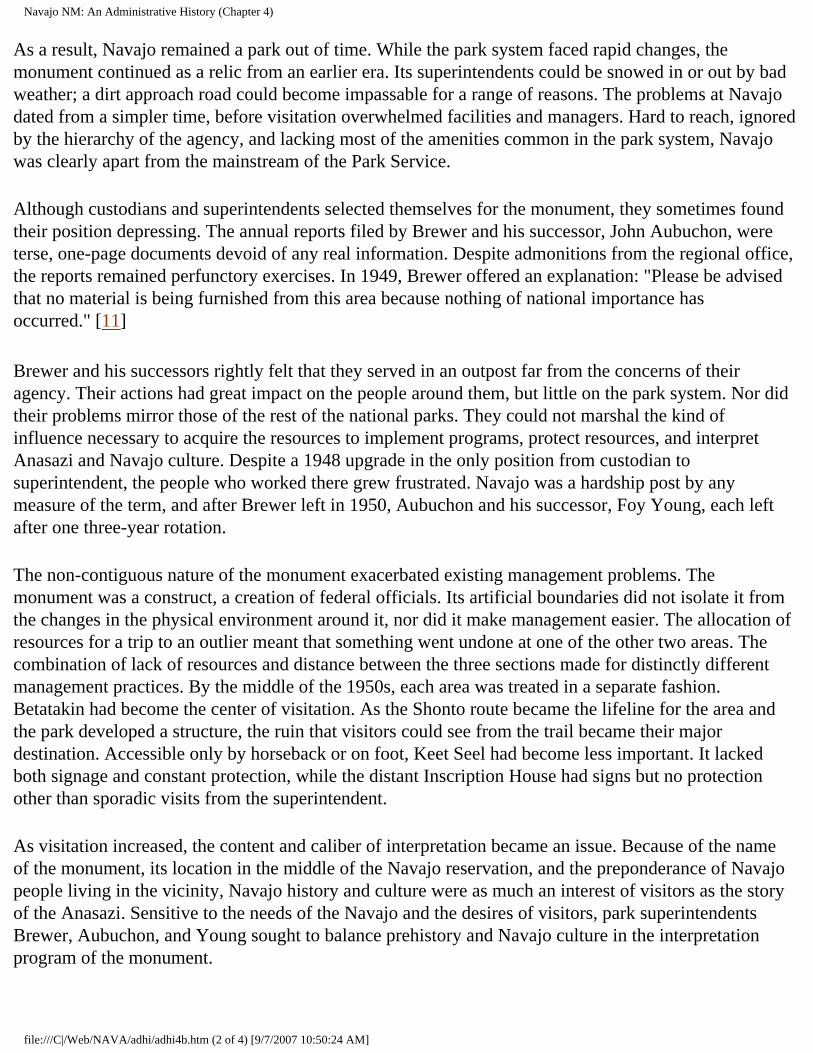
Navajo NM: An Administrative History (Chapter 4)
As a result, Navajo remained a park out of time. While the park system faced rapid changes, the monument continued as a relic from an earlier era. Its superintendents could be snowed in or out by bad weather; a dirt approach road could become impassable for a range of reasons. The problems at Navajo dated from a simpler time, before visitation overwhelmed facilities and managers. Hard to reach, ignored by the hierarchy of the agency, and lacking most of the amenities common in the park system, Navajo was clearly apart from the mainstream of the Park Service.
Although custodians and superintendents selected themselves for the monument, they sometimes found their position depressing. The annual reports filed by Brewer and his successor, John Aubuchon, were terse, one-page documents devoid of any real information. Despite admonitions from the regional office, the reports remained perfunctory exercises. In 1949, Brewer offered an explanation: "Please be advised that no material is being furnished from this area because nothing of national importance has occurred." [11]
Brewer and his successors rightly felt that they served in an outpost far from the concerns of their agency. Their actions had great impact on the people around them, but little on the park system. Nor did their problems mirror those of the rest of the national parks. They could not marshal the kind of influence necessary to acquire the resources to implement programs, protect resources, and interpret Anasazi and Navajo culture. Despite a 1948 upgrade in the only position from custodian to superintendent, the people who worked there grew frustrated. Navajo was a hardship post by any measure of the term, and after Brewer left in 1950, Aubuchon and his successor, Foy Young, each left after one three-year rotation.
The non-contiguous nature of the monument exacerbated existing management problems. The monument was a construct, a creation of federal officials. Its artificial boundaries did not isolate it from the changes in the physical environment around it, nor did it make management easier. The allocation of resources for a trip to an outlier meant that something went undone at one of the other two areas. The combination of lack of resources and distance between the three sections made for distinctly different management practices. By the middle of the 1950s, each area was treated in a separate fashion. Betatakin had become the center of visitation. As the Shonto route became the lifeline for the area and the park developed a structure, the ruin that visitors could see from the trail became their major destination. Accessible only by horseback or on foot, Keet Seel had become less important. It lacked both signage and constant protection, while the distant Inscription House had signs but no protection other than sporadic visits from the superintendent.
As visitation increased, the content and caliber of interpretation became an issue. Because of the name of the monument, its location in the middle of the Navajo reservation, and the preponderance of Navajo people living in the vicinity, Navajo history and culture were as much an interest of visitors as the story of the Anasazi. Sensitive to the needs of the Navajo and the desires of visitors, park superintendents Brewer, Aubuchon, and Young sought to balance prehistory and Navajo culture in the interpretation program of the monument.
file:///C|/Web/NAVA/adhi/adhi4b.htm (2 of 4) [9/7/2007 10:50:24 AM]
Navajo NM: An Administrative History (Chapter 4)
Superintendent John Aubuchon looks over the first museum display in the original ranger cabin.
Access to the ruins also posed problems as visitation grew. Brewer had suggested limits on visitation in Betatakin in 1939 and other Park Service inspectors concurred. Brewer had initially discarded John Wetherill's practice of keeping visitors out of Betatakin by roping off the rooms. Instead he lined out trails between the clusters of rooms in the ruin, a practice he quickly decided was a mistake. On occasion, visitors strayed from the route Brewer provided. In one instance, a Boston architect and a Santa Fe artist were permitted to walk in rooms above original ceilings. When informed, regional archeologists were apoplectic. Managing visitors in the ruin was a difficult task, for safety of the visitors and protection of the ruins mandated a need for close monitoring of visitors. By 1941, Brewer no longer allowed visitors in Betatakin without supervision. [12]
During this time, interpretation at the monument was inconsistent. Archeologists debated the meaning and significance of the various ruins that composed the monument, and the efforts of the Park Service were limited by the lack of consensus among professionals. Without a visitor center or museum, much of the interpretation was imparted by the superintendent to visitors. Under Frank Pinkley's system, visitors were not allowed in ruins without a uniformed park person. At Navajo, the distance between the contact station and the ruin made escorted visitation the only possibility. But again, the increase in
file:///C|/Web/NAVA/adhi/adhi4b.htm (3 of 4) [9/7/2007 10:50:24 AM]
Navajo NM: An Administrative History (Chapter 4)
postwar visitation forced changes. Brewer took as many visitors as he could, sometimes impressing Bob Black, a Navajo maintenance worker, into service conveying visitors to Betatakin. Black's command of English was minimal, and in such situations, interpretation became merely a guide service. Black recalled taking visitors to the canyon and pointing to the ruins as the extent of his interpretation. The lack of personnel, the increase in visitation, and cross-cultural inability to communicate caused interpretation to suffer. [13]
CONTINUE >>>
nava/adhi/adhi4b.htm Last Updated: 22-Jan-2001
file:///C|/Web/NAVA/adhi/adhi4b.htm (4 of 4) [9/7/2007 10:50:24 AM]
Navajo NM: An Administrative History (Chapter 4)
Navajo
Administrative History
CHAPTER IV: "LAND-BOUND:" 1938-1962 (continued)
By the early 1950s, a number of changes in interpretation were necessary. After Pinkley's death in 1940, his domain in the Southwest was parceled out. Attempts to eradicate the more iconoclastic features of his leadership helped reshape NPS policy in the Southwest. The insistence on guided tours through ruins fell by the wayside as visitation grew. By the early 1950s, most monuments had self-guiding ruins trail brochures. In 1951, even a remote monument like Navajo began to experiment with a self-guiding trail leaflet to Keet Seel. [14]
Keet Seel and Inscription House were not immune to the effects of increased visitation. In the early 1950s, about thirty parties a year visited Keet Seel. A rare group might camp at the ruin, but most rented a horse and a Navajo guide from Pipeline Begishie, a local Navajo who worked at the park as a seasonal laborer and offered horses for rent. This enabled them to make the eight-mile trip each way in one day. The Park Service still did not sign the trail or provide interpretation material for Keet Seel, preferring to limit visitation to those who knew the way or were shown there by local Navajos. [15]
file:///C|/Web/NAVA/adhi/adhi4c.htm (1 of 5) [9/7/2007 10:50:25 AM]
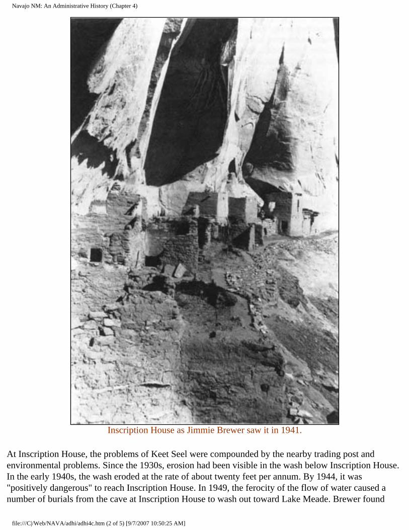
Navajo NM: An Administrative History (Chapter 4)
Inscription House as Jimmie Brewer saw it in 1941.
At Inscription House, the problems of Keet Seel were compounded by the nearby trading post and environmental problems. Since the 1930s, erosion had been visible in the wash below Inscription House. In the early 1940s, the wash eroded at the rate of about twenty feet per annum. By 1944, it was "positively dangerous" to reach Inscription House. In 1949, the ferocity of the flow of water caused a number of burials from the cave at Inscription House to wash out toward Lake Meade. Brewer found
file:///C|/Web/NAVA/adhi/adhi4c.htm (2 of 5) [9/7/2007 10:50:25 AM]

Navajo NM: An Administrative History (Chapter 4)
bones and high quality pottery in the wash after a heavy spring rain, prompting him to call for better protective measures against creeping erosion. In addition, vandalism became more common at Inscription House in the early 1950s. Unauthorized visitors sometimes dug in the ruins. Local schoolchildren repeatedly scratched initials in the soft adobe walls. [16] Clearly the Park Service had to take action.
But without an allocation of resources, any changes enacted remained largely cosmetic. Aubuchon optimistically concluded that the arduous trek to the outliers "precludes the person who has a mania for destruction," but vandalism was an endemic problem. The best mechanisms the regional office could offer were passive. Regional Director Tillotson advocated "a tightening of control over these isolated sections of the monument," but no allocation to support those sentiments followed. Tillotson reiterated his longstanding opposition to directional signs for the trails to Keet Seel and Inscription House. He approved the idea that visitors should be required to register with the Park Service before they were allowed to proceed to either of the backcountry areas. [17] But in the face of the declining condition of the two ruins, such remedies fell short of solving critical problems.
Visitors continued to come, and Navajo topped the 1,000-visitor mark for the first time in 1949-50. In comparison to other southwestern parks, this number seemed small, but it reflected a doubling of the numbers typical of the pre-war era. The small contact station and residence built in 1939 continued to be the only permanent structures at the park. They had to serve numerous functions. Besides being home to the superintendent and his family, the residence also served as an office. Jimmie Brewer set up a desk in one corner of the living room, and most of the official business conducted at Navajo occurred there. The contact station became the focus of formal interpretation at the monument. The one-room structure included a museum in a corner that displayed aspects of prehistoric and historic life in the vicinity of the monument.
file:///C|/Web/NAVA/adhi/adhi4c.htm (3 of 5) [9/7/2007 10:50:25 AM]
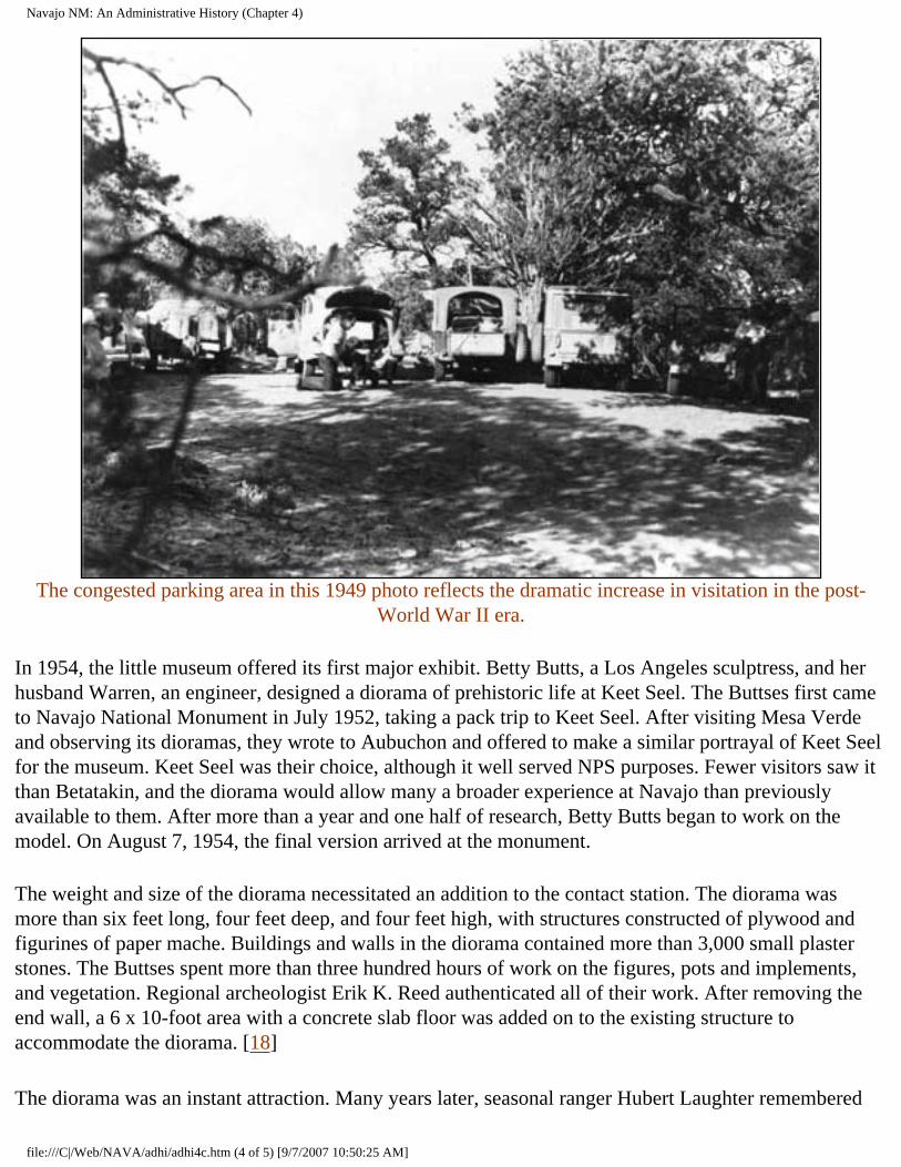
Navajo NM: An Administrative History (Chapter 4)
The congested parking area in this 1949 photo reflects the dramatic increase in visitation in the post-
World War II era.
In 1954, the little museum offered its first major exhibit. Betty Butts, a Los Angeles sculptress, and her husband Warren, an engineer, designed a diorama of prehistoric life at Keet Seel. The Buttses first came to Navajo National Monument in July 1952, taking a pack trip to Keet Seel. After visiting Mesa Verde and observing its dioramas, they wrote to Aubuchon and offered to make a similar portrayal of Keet Seel for the museum. Keet Seel was their choice, although it well served NPS purposes. Fewer visitors saw it than Betatakin, and the diorama would allow many a broader experience at Navajo than previously available to them. After more than a year and one half of research, Betty Butts began to work on the model. On August 7, 1954, the final version arrived at the monument.
The weight and size of the diorama necessitated an addition to the contact station. The diorama was more than six feet long, four feet deep, and four feet high, with structures constructed of plywood and figurines of paper mache. Buildings and walls in the diorama contained more than 3,000 small plaster stones. The Buttses spent more than three hundred hours of work on the figures, pots and implements, and vegetation. Regional archeologist Erik K. Reed authenticated all of their work. After removing the end wall, a 6 x 10-foot area with a concrete slab floor was added on to the existing structure to accommodate the diorama. [18]
The diorama was an instant attraction. Many years later, seasonal ranger Hubert Laughter remembered
file:///C|/Web/NAVA/adhi/adhi4c.htm (4 of 5) [9/7/2007 10:50:25 AM]
Navajo NM: An Administrative History (Chapter 4)
his first glimpse of the diorama, and a photograph captured the moment. In it, Laughter regarded the diorama with a bemused and impressed look. It was indeed new, and a genuine asset for the museum and the monument. [19]
CONTINUE >>>
nava/adhi/adhi4c.htm Last Updated: 22-Jan-2001
file:///C|/Web/NAVA/adhi/adhi4c.htm (5 of 5) [9/7/2007 10:50:25 AM]
Navajo NM: An Administrative History (Chapter 4)
Navajo
Administrative History
CHAPTER IV: "LAND-BOUND:" 1938-1962 (continued)
But despite such improvements in the interpretation scheme, Navajo National Monument lacked the primary perquisite of Park Service programming. Unlike most of the other archeological monuments in the Southwest, there was no visitor center at Navajo. The makeshift contact station and its added diorama had to suffice. As late as the middle of the 1950s, Navajo still lacked the basic resources that other park areas took for granted when they began to devise their programming.
But a combination of factors converged that began to change the situation at the monument. The increase in visitation had taken a toll on the park system. Designed to handle about 25 million visits per annum, the system served more than 50 million visitors in 1955. Beginning that year, NPS officials devised a broad master plan for the system they envisioned in 1966. This would be capable of serving eighty million visitors each year. Congress supported the plan at a level not seen since the New Deal, appropriating $49 million for capital improvements in 1956 and continuing to increase the amount to almost $80 million in 1959. Conrad L. Wirth recalled later that it seemed that individual congressional representatives engaged in a form of one-upmanship, allocating even more than NPS officials requested. The ten-year plan, entitled "MISSION 66," rejuvenated the physical plant of the park system. The investment of more than $700 million built more than 2,000 miles of roads as well as modern visitor centers that replaced those built during the New Deal. Officials at many parks that had never had visitor centers looked expectantly to MISSION 66 to provide the resources for construction. [20]
At the end of the Second World War, infrastructure was the great need of the Navajo reservation. Road building was one of the top priorities. Most of the roads on the reservation were more appropriately labeled trails. The Navajo/Hopi Rehabilitation Act of 1950 set aside $38 million for road construction, $10 million of which was designated for improvement of secondary roads on the reservation. The Atomic Energy Commission also built roads to facilitate the extraction of uranium. Its first rudimentary road stretched from Teec Nos Pos to Kayenta; additional roads stretched from Kayenta to Monument Valley and later to Tuba City. These dirt highways were critical to the development of an infrastructure on the reservation. [21]
file:///C|/Web/NAVA/adhi/adhi4d.htm (1 of 4) [9/7/2007 10:50:26 AM]
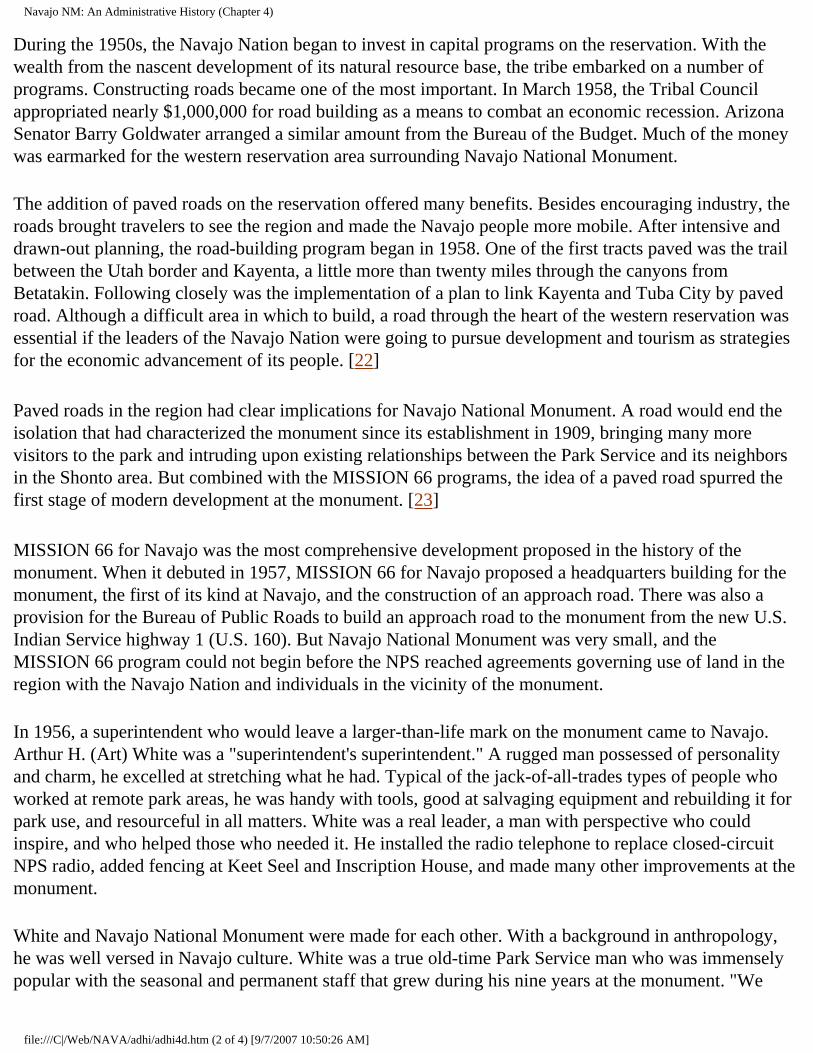
Navajo NM: An Administrative History (Chapter 4)
During the 1950s, the Navajo Nation began to invest in capital programs on the reservation. With the wealth from the nascent development of its natural resource base, the tribe embarked on a number of programs. Constructing roads became one of the most important. In March 1958, the Tribal Council appropriated nearly $1,000,000 for road building as a means to combat an economic recession. Arizona Senator Barry Goldwater arranged a similar amount from the Bureau of the Budget. Much of the money was earmarked for the western reservation area surrounding Navajo National Monument.
The addition of paved roads on the reservation offered many benefits. Besides encouraging industry, the roads brought travelers to see the region and made the Navajo people more mobile. After intensive and drawn-out planning, the road-building program began in 1958. One of the first tracts paved was the trail between the Utah border and Kayenta, a little more than twenty miles through the canyons from Betatakin. Following closely was the implementation of a plan to link Kayenta and Tuba City by paved road. Although a difficult area in which to build, a road through the heart of the western reservation was essential if the leaders of the Navajo Nation were going to pursue development and tourism as strategies for the economic advancement of its people. [22]
Paved roads in the region had clear implications for Navajo National Monument. A road would end the isolation that had characterized the monument since its establishment in 1909, bringing many more visitors to the park and intruding upon existing relationships between the Park Service and its neighbors in the Shonto area. But combined with the MISSION 66 programs, the idea of a paved road spurred the first stage of modern development at the monument. [23]
MISSION 66 for Navajo was the most comprehensive development proposed in the history of the monument. When it debuted in 1957, MISSION 66 for Navajo proposed a headquarters building for the monument, the first of its kind at Navajo, and the construction of an approach road. There was also a provision for the Bureau of Public Roads to build an approach road to the monument from the new U.S. Indian Service highway 1 (U.S. 160). But Navajo National Monument was very small, and the MISSION 66 program could not begin before the NPS reached agreements governing use of land in the region with the Navajo Nation and individuals in the vicinity of the monument.
In 1956, a superintendent who would leave a larger-than-life mark on the monument came to Navajo. Arthur H. (Art) White was a "superintendent's superintendent." A rugged man possessed of personality and charm, he excelled at stretching what he had. Typical of the jack-of-all-trades types of people who worked at remote park areas, he was handy with tools, good at salvaging equipment and rebuilding it for park use, and resourceful in all matters. White was a real leader, a man with perspective who could inspire, and who helped those who needed it. He installed the radio telephone to replace closed-circuit NPS radio, added fencing at Keet Seel and Inscription House, and made many other improvements at the monument.
White and Navajo National Monument were made for each other. With a background in anthropology, he was well versed in Navajo culture. White was a true old-time Park Service man who was immensely popular with the seasonal and permanent staff that grew during his nine years at the monument. "We
file:///C|/Web/NAVA/adhi/adhi4d.htm (2 of 4) [9/7/2007 10:50:26 AM]
Navajo NM: An Administrative History (Chapter 4)
work fourteen to sixteen hours a day out here," he told Ranger Bud Martin when the latter arrived in 1962. White was under a diesel front-end loader at the time. [24]
This kind of commitment characterized the Park Service in the days before the rigid enforcement of federal regulations. Most park personnel thought nothing of working unpaid overtime or performing whatever task came along, no matter what their job description. These iconoclasts invested themselves in the park system, albeit in a sometimes unorthodox fashion. Yet their actions created an esprit de corps that made those who worked the long and often lonely hours at remote areas into a close-knit clan that recognized the common ground they shared.
Park Service people at Navajo faced a life of real privation. When Emery C. (Smokey) Lehnert arrived as the second permanent employee in 1958, the only available housing was an 8' x 32' foot house trailer. The Lehnerts added a baby boy to their family in July 1959, making a minute living space even smaller. Because inclement weather for as much as six months each year limited access to the outdoors, the trailer became oppressive. The Lehnerts suffered from an advanced case of "cabin fever" in the winter of 1959-60, with Mrs. Lehnert affected so thoroughly that, under physician's orders, she left the park in the spring for an extended vacation. Isolated in inadequate quarters, far from family and friends, and trapped by snowfall for extended periods, life could be miserable for park rangers and their families. Later the Lehnerts received permanent housing, alleviating a symptom but not necessarily the cause of some of their discontent. [25]
White came to Navajo at precisely the correct moment to utilize his talents. With his experience, perspective, and saltiness, he provided the leadership necessary to administer growth and attendant change. White gave his staff "enough rope to hang yourself with or do something with it," Martin recalled, leading by example and expecting his staff to follow. During his tenure, there was little left undone at Navajo. [26]
White also developed close relationships with Navajos in the area, building on the tradition of Hosteen John Wetherill and laying a foundation for future superintendents. White learned Navajo silversmithing while at the monument, an art for which he became renowned. He also extended a helping hand to many of the neighbors of the park, providing an informal road grading service outside park boundaries. He and Bob Black became close friends, both speaking fondly of their memories of each other almost thirty years later. Bob Black recalled with a twinkle that after White used the road grader, Black would have to go smooth out the squiggles and rough spots left in the road. White remembered Black as one of the best people he had ever met. [27]
file:///C|/Web/NAVA/adhi/adhi4d.htm (3 of 4) [9/7/2007 10:50:26 AM]
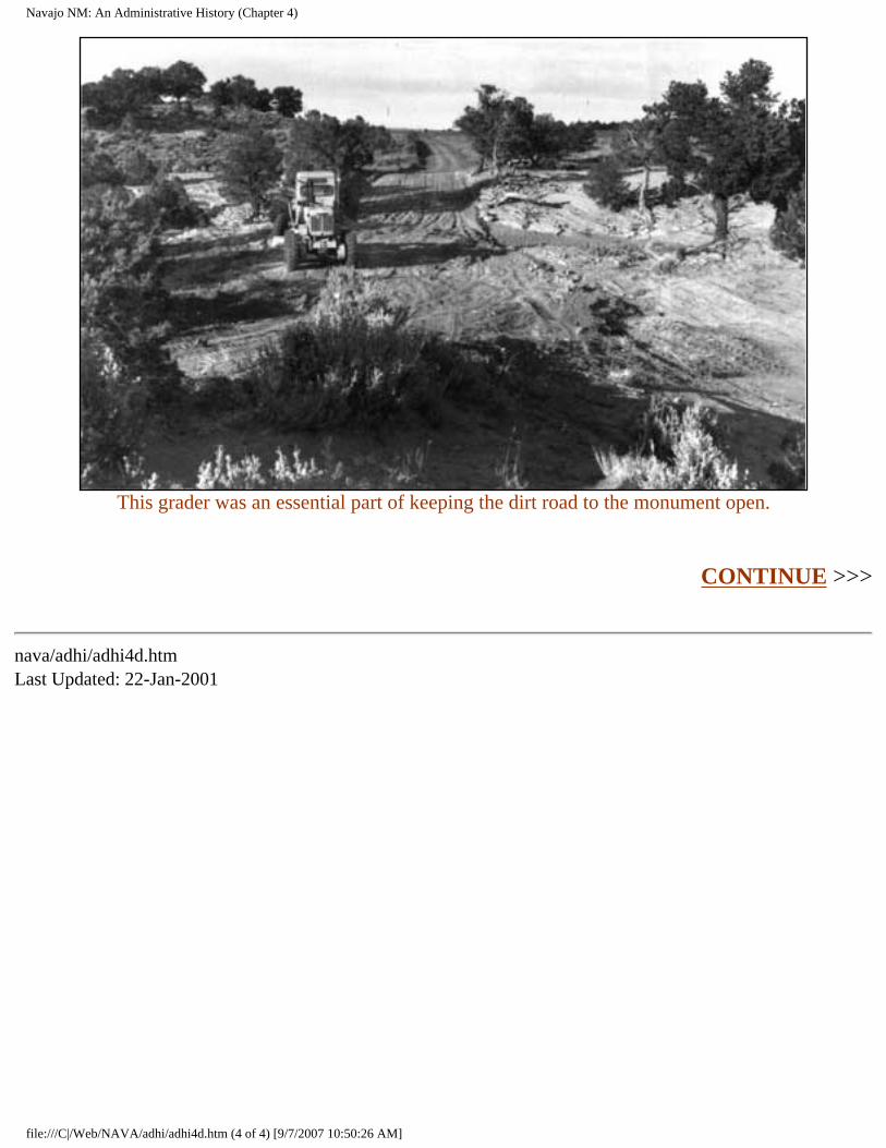
Navajo NM: An Administrative History (Chapter 4)
This grader was an essential part of keeping the dirt road to the monument open.
CONTINUE >>>
nava/adhi/adhi4d.htm Last Updated: 22-Jan-2001
file:///C|/Web/NAVA/adhi/adhi4d.htm (4 of 4) [9/7/2007 10:50:26 AM]
Navajo NM: An Administrative History (Chapter 4)
Navajo
Administrative History
CHAPTER IV: "LAND-BOUND:" 1938-1962 (continued)
The coming of the paved road became a critical step in the gradual elimination of the obstacles that hindered the growth and development of Navajo National Monument. When the MISSION 66 program for the monument debuted, it was low on the list of agency priorities. Regional Director Hugh Miller regarded the plan for a $179,000 visitor center at Betatakin as "startling even with improved roads and increasing travel." He required some evidence that the level of visitation would increase enough to merit such a program. But as Superintendent White announced in one of his monthly reports, the monument was "land-bound," for it lacked a a surrounding area sufficiently large to implement a substantive capital development program. [28]
The boundaries of Navajo were minuscule in comparison to other similar monuments in the Southwest. The Betatakin section was a mere 160 acres. It encompassed the canyon area; only a very small area on one of the rims was inside monument boundaries. During his tenure, James W. Brewer privately speculated that even the ranger cabin built in 1939 might be outside park boundaries. Keet Seel was the same size, while Inscription House was only 40 acres. When its officials cut the monument down to avoid conflict with grazing interests in 1912, the GLO permanently limited growth. Before any capital improvement plan could be implemented, more land was necessary. [29]
Yet the combination of MISSION 66 for the park system and the road-building program of the Navajo Nation generated momentum that made the development of Navajo National Monument a possibility. The forces of modern civilization were beginning to act on the western reservation in a comprehensive manner. The leaders of the Navajo Nation, Paul Jones, who served as chairman of the tribe from 1954 to 1962, and his successor Raymond Nakai, implemented new services and encouraged economic development projects. [30] To meld its holdings into this changing world, the Park Service had to further similar programs.
Only one way to get more land existed. Some kind of arrangement had to be struck with the Navajo Nation, the Shonto Chapter, and the individuals in the region. "We must either get the land or permission to build off the monument," White insisted in July 1958. [31] But despite the interdependent nature of
file:///C|/Web/NAVA/adhi/adhi4e.htm (1 of 5) [9/7/2007 10:50:28 AM]
Navajo NM: An Administrative History (Chapter 4)
life in the region, NPS officials recognized that a lease, purchase, or other form of acquisition would limit the autonomy to which agency officials were accustomed. As foreign supplicants in the Navajo homeland, the NPS needed to be prepared to compromise.
The long and complicated process of orchestrating an agreement began in 1958. Regional Director Hugh Miller instructed White to begin informal, low-level discussions about acquiring land. The land on the rim of Betatakin Canyon belonged to Bob Black, who had almost twenty-five years of service at the monument. White and Black reached an accord, circumventing the need for approval at the chapter level. Subsequently, the Park Service convened a meeting with a number of Navajo leaders. Prior to the meeting, White and Leslie P. Arnberger, assistant regional director of the Southwest Region, discussed the issue. White wanted to acquire an entire 640-acre section for the monument. Buildings at the monument were already on reservation land, and White wanted to assure that the monument could grow if needed. Arnberger disagreed, and the two compromised on forty acres. [32]
At the meeting in the superintendent's house at the monument, Art White, Regional Director Hugh Miller, Les Arnberger, Navajo tribal representative Sam Day III, Frank Bradley Jr., and tribal employee Jim McNee met to work out an agreement. Day proposed an exchange: twenty monument acres for twenty Navajo acres and the tribe would grant twenty more. After viewing the land, Day was willing to forgo the exchange. He told the Park Service to just ask for the land. The Navajo Nation would not be interested in an exchange for such visibly unproductive land.
But the idea of an exchange was unsuccessful, and throughout the rest of the 1950s, little progress occurred. After giving up on the idea of an outright exchange, the Park Service subsequently sought some form of agreement to use land adjacent to the monument. But acquisition remained the paramount goal for the NPS, and when the chances of acquiring some portion of adjacent land seemed good, NPS interest in an agreement for use declined. When agency officials found avenues of acquisition blocked, they sought an agreement. From the perspective of the Navajo Nation, acquisition at the monument was linked to the transfer of some other land to the tribe. Antelope Point and the Page area were both suggested during negotiations, but no consensus emerged. The result was a stalemate. Yet from regional director to superintendent, everyone recognized that Navajo National Monument needed additional area. [33]
The response of the staff was a mixture of excitement and trepidation. In July 1958, when Smokey Lehnert came to the monument, he and Art White became a formidable duo. They responded to the impending changes in colorful and descriptive fashion. With the increase in paved roads, the monument area "will have had it," White remarked. Nonetheless, the process continued. In 1959, crews began to pave the section of road between Tuba City and Kayenta. By the time it was completed, it left only one section of dirt road to the monument: the tract from the main highway through Shonto and on to Betatakin. [34] As it became easier to reach the monument and the number of travelers on the newly paved roads of Navajoland increased, White and his staff had to prepare for significant changes at Navajo.
file:///C|/Web/NAVA/adhi/adhi4e.htm (2 of 5) [9/7/2007 10:50:28 AM]
Navajo NM: An Administrative History (Chapter 4)
The impact of increased visitation posed one major issue. Since its establishment in 1909, Navajo had been protected largely by its remote location. Easy access would clearly alter existing patterns of visitation. Visitors who previously would not have tackled almost 100 miles of dirt road told White and Lehnert that the increasingly small unpaved sections only spurred them forward. For staff members, increased visitation was clearly a mixed blessing. Superintendent Art White seemed to dread the arrival of the "beer can and kleenex" crowd, the sedentary traveling public, unappreciative and unwilling to make a sacrifice to understand the place on its own terms. "God or MISSION 66 help this monument" if the Tuba City-Kayenta road was paved, White caustically remarked in March 1958. NPS personnel recognized that the roads would change the character of the monument as well as the experience of visitors there. They were also cognizant that the past as they had known it was already gone. By the early 1960s, time was running out. [35]
Negotiations between NPS and the Navajo Nation were the clear solution to the lack of land and facilities faced by the Park Service. After a strong beginning, the negotiations stalled in 1958, and relations deteriorated. Issues of land transfer and rights of way for potential entrance roads slowed progress toward an agreement. The NPS and the Navajo Nation had different goals, and as economic development began in earnest on the reservation, the Navajo Tribal Council under Paul Jones expressed resentment towards the Park Service.
But the NPS had much to offer the Navajo people. As the Navajo Nation tried to attract entities with economic potential, it found obstacles. The virtue of the reservation most easily converted into dollars was its spectacular scenery, history, and prehistory. The desire to develop resources for visitors pushed the Navajo Nation into simultaneous cooperation and competition with the Park Service. Late in the 1950s, the Navajo Tribal Park system became an important lure for visitors. Monument Valley, the location of numerous John Ford and John Wayne westerns, became a major attraction for visitors. Yet opening a tribal park and serving finicky American visitors were two separate and distinct functions. The Navajos needed the expertise that the Park Service developed during nearly fifty years of visitor service. NPS officials offered training for tribal rangers as one measure to improve relations and installed an exhibit at the annual tribal fair. Navajo leaders also eyed Canyon de Chelly in particular, with lesser emphasis directed toward Navajo, Wupatki, and Sunset Crater national monuments as possible additions to their fledgling park system. [36]
In addition, the process of negotiating an agreement strengthened the relations between Navajos and the Park Service. In November 1959, Maxwell Yazzie, one of the most distinguished Navajo attorneys, spent four days at the monument in an effort to secure the agreement. Yazzie helped convince local Navajos of the value of the visitor center and its road, secured rights-of-way from individual land holders, and offered his opinion on the chances of the proposal. It was a learning experience for both sides that helped smooth out the differences in perspective. [37]
The Park Service also revived an old concept that had major implications for the region. The debut of the "Golden Circle" of national park areas, including Glen Canyon National Recreation Area, Rainbow Bridge, and Navajo, was the direct result of the southwestern strategy pursued by Stephen T. Mather and
file:///C|/Web/NAVA/adhi/adhi4e.htm (3 of 5) [9/7/2007 10:50:28 AM]
Navajo NM: An Administrative History (Chapter 4)
Horace Albright in the 1920s. The concept linked numerous park areas in this largely undeveloped region into a comprehensive package designed to attract visitors. The Park Service had utilized a convenient monument-to-park strategy to bring Grand Canyon, Zion, and Bryce Canyon to national park status in an effort to make the Southwest the focus of American travelers. This focus provided the Navajo Nation with a ready supply of visitors and encouraged the rapid development of support facilities.
It also pushed the NPS and the Navajo Nation towards an agreement at Navajo National Monument. Both sides had something to offer each other, and with much at stake--a potential anchor for economic development on the reservation for the Navajo Nation and the ability to develop and protect an important prehistoric resource for the Park Service--the two sides moved towards a solution. With the opening of the first Navajo Tribal Park at Monument Valley in 1960, the ties strengthened. Yet protracted negotiations were necessary, and the process of arranging a final accord lasted more than three years.
NPS officials found the process frustrating. By September 1960, the Southwest Regional Office had drawn up an agreement to which Tribal attorneys agreed in principle. In March 1961, White chafed at the slow pace. Recognizing the need for facilities to handle the increase in visitation, he pressed for the acquisition of land. The following May, the Advisory Committee of the Tribal Council approved the draft of a memorandum of agreement for interim use of an area adjacent to the Betatakin section. NPS officials sent a final version of the memorandum for the Navajo Nation and BIA to sign and awaited a reply. More than a year later, no word had come from the tribe. In November 1961, Art White began a countdown. "We still have ten months grace here until we are really overrun," he informed his superiors. When the Navajo Nation finally responded, significant portions of the memorandum had been changed. NPS officials determined that they could live with the changes, for an interim agreement to use land increased the chances to implement MISSION 66 programs at the monument. [38]
The result was the Memorandum of Agreement, signed on May 8, 1962, a compromise designed to further the interests of both the Navajo Nation and the Park Service. In reality, no one got exactly what they wanted. The NPS received the right to use 240 acres on the rim of Betatakin Canyon from which to manage the monument. In return, the Park Service agreed to help the Navajos acquire Antelope Point, near the Glen Canyon Dam project, for development purposes. NPS officials were to use their influence to get the area ceded to the Navajo, and in return, Navajos would give up land at the monument in "fee title." This proposed program did not work. The Navajo Nation was reluctant to give up any land, the cessation of Antelope Point stalled, and agreement across cultures was very difficult to reach. In the final cession, secured by the Memorandum of Agreement, the land was "loaned" to NPS as an interim arrangement to allow development to proceed before formal exchange could be enacted. NPS officials accepted this proposal because they feared that legislation enlarging the monument would remain beyond their reach. In the late 1960s, NPS management documents identified acquisition of fee title to the 240-acre Memorandum of Agreement tract as a serious potential problem. By 1990, no change in the status of the land had been accomplished.
The agreement happened just in time. In the summer of 1962, paving continued on the last stretch of the
file:///C|/Web/NAVA/adhi/adhi4e.htm (4 of 5) [9/7/2007 10:50:28 AM]
Navajo NM: An Administrative History (Chapter 4)
Kayenta-Tuba City road. A dedication of the road was planned for September 15. When finished, the road eliminated the last section of unpaved arterial highway in the western reservation. It was a "red-letter day for this part of the country," Art White remarked. But to face the implications of the road, the Park Service needed the memorandum. [39]
The Memorandum of Agreement formalized the long-standing interdependent relationship between the park and the Navajo people who lived nearby. By 1962, visitation at the monument rose to 6,603. The park needed more seasonal workers, greater quantities of materials, and more help with services such as the horse trips to Keet Seel. Navajo people perceived an economic opportunity in the development. Under the terms of the agreement, the NPS was obliged to provide a room for Navajos to sell crafts at the planned visitor center. Regional Director Thomas Allen had resisted this idea, arguing that a more typical concession arrangement was better for the Park Service. The Navajo Tribal Council had introduced the idea and refused to relent. Recognizing that the agreement potentially unlocked vast amounts of money for the monument, regional officials accepted the provision. The park and its neighbors were closely bound in a relationship that benefited both. The agreement made interdependence into a de jure rather than de facto reality.
CONTINUE >>>
nava/adhi/adhi4e.htm Last Updated: 22-Jan-2001
file:///C|/Web/NAVA/adhi/adhi4e.htm (5 of 5) [9/7/2007 10:50:28 AM]
Navajo NM: An Administrative History (Chapter 4)
Navajo
Administrative History
CHAPTER IV: "LAND-BOUND:" 1938-1962 (continued)
Yet there were problems that remained from the Memorandum of Agreement. It was only a temporary measure, designed to allow the NPS to develop Navajo before final resolution could be reached. But a permanent transfer of land remained elusive. Throughout the 1960s, efforts to solve numerous land and development issues surrounding Glen Canyon National Recreation Area, Rainbow Bridge National Monument, and Navajo National Monument continued. By 1966, an impasse had been reached. The Navajo Nation did not want to give up any more of its land, while the Park Service could not give away its holdings without getting something in return. In 1966, the NPS offered a three-for-one swap of land at Betatakin and Rainbow Bridge for a much larger tract of federal land at Antelope Point that the tribe coveted. The Navajos rejected the exchange. "If the Tribe had its way," exasperated Regional Director Daniel Beard wrote NPS Director George Hartzog, Jr., "the 'exchange' would be one-way--all take and no give." If the Park Service backed down unconditionally, offering to take less or give more, Beard thought the Navajos might take it as a sign of weakness. This could be a prelude to further demands that Beard felt were unreasonable. [40] Park Service officials were at a loss. They felt they made more than generous offers that were rejected out of hand. But a cultural awakening had occurred, clearly changing the climate in the region in a less than decade.
During that time, the Park Service became frustrated by its dealings with the Navajo Nation. The Navajo Nation sought NPS land and the right to develop visitor services for places like Glen Canyon National Recreation Area, while the Park Service still wanted clear title to the land at Navajo as part of an elaborate system of exchange. A four-year effort to resolve the use of lands near Glen Canyon became an interminable burden. In one instance in 1969, an agreement "almost made it," as Regional Director Frank Kowski was informed, but was rejected by Tribal Chairman Raymond Nakai as not being sufficiently favorable to the Navajo. Only when Regional Director Frank Kowski threatened to withdraw NPS support for an economic development by the Navajo aimed at serving NPS visitors did any sort of agreement become reality. On March 6, 1970, Kowski, Solicitor Gayle E. Manges, and Nakai met in Window Rock to work out the details. The result was an agreement that allowed the Navajo to develop the south shore of Lake Powell. [41] But because of the difficulty in reaching a solution, resolving issues at Navajo National Monument was forgotten.
file:///C|/Web/NAVA/adhi/adhi4f.htm (1 of 2) [9/7/2007 10:50:30 AM]
Navajo NM: An Administrative History (Chapter 4)
By 1970, the Navajo had become far less likely to permanently cede any tract of land to a federal agency than they had a decade before. The late 1960s awakened the Navajo people and their political structure to two realities: their identity was threatened by encroaching mainstream culture and the land they held was their only cultural and economic protection. Demand for energy exploration of the reservation had increased, although in more than one instance, the Navajo felt that they were exploited. They looked warily at the outside world, including the Park Service. Despite a number of cooperative agreements with the Park Service that allowed the Navajo to offer concession services to visitors at a variety of parks, the NPS could not wrest free the 240 acres at Betatakin covered in the Memorandum of Agreement. As the obstacles mounted, the idea of outright acquisition faded, and the temporary agreement took on a semblance of permanence.
That temporary agreement had lasting effect. By 1962, Navajo National Monument had been transformed. The most serious obstacle to its development, the lack of roads and easy access, had been eliminated, and the monument was on the list for the ample funds derived from MISSION 66. The cocoon that had been the monument, the narrow world in which NPS people and their neighbors previously lived, had been opened up to the mass of Americans. The very values that attracted archeologists, park people, and visitors to the monument were in danger of being overwhelmed.
Between 1938 and 1962, Navajo caught up to the rest of the park system. It faced the same problems, compounded by its non-contiguous nature and its location as an outpost in Navajoland. Although the park was well managed, park staff recognized their limitations as the world around them, already beyond their control, changed rapidly. The need for more land was paramount; efforts at expanding the monument reflected this reality.
Before the Memorandum of Agreement, the agency regarded MISSION 66 for Navajo as a long-range plan rather than a program to be implemented. At higher levels, officials recognized the unique limited position of the monument and were not prepared to commit resources. MISSION 66 was aimed at parks with higher levels of visitation. Growth at the monument had to wait until the acquisition of land on which to build visitor facilities.
This made an already dire situation even more urgent. Navajo lagged behind the rest of the park system, and the development of roads and other facilities in the area around the monument accentuated the gap. By the time development occurred, it could only bring the monument up to current demand. Planning for the future would have to wait.
<<< CHAPTER 3 TABLE OF CONTENTS CHAPTER 5 >>>
nava/adhi/adhi4f.htm Last Updated: 22-Jan-2001
file:///C|/Web/NAVA/adhi/adhi4f.htm (2 of 2) [9/7/2007 10:50:30 AM]

Navajo NM: An Administrative History (Chapter 5)
Navajo
Administrative History
CHAPTER V: THE MODERN ERA (continued)
One major construction project was a trail from the visitor center to Betatakin Canyon. This move sought to accommodate the rash of visitors, many of whom wanted access to the ruins that was as easy as reaching the monument. Since the construction of the road from Shonto in the 1930s, Tsegi Point had been the primary route to the canyon floor. But the nearly two-mile trek from the visitor center discouraged many visitors. The new cross-canyon approach alleviated that problem, for visitors could walk out of the visitor center and instantaneously be on the trail. Navajo day laborers who "were really great with their stonework," as Robert Holden recalled, built the trail, which was funded out of the Accelerated Public Works (APW) program. Yet the new trail created hazards of its own. Robert Holden recalled that it "seemed rather dangerous" even as it was being constructed. [13]
The construction of the cross-canyon trail reflected one of the most crucial historical problems of the monument. The original park facilities had been located across the canyon from the ruin because it was the only place on the rim to which the NPS had any claim. Most of the few visitors of that era thought little of a strenuous trek. But the road and the visitor center brought people unaccustomed to rigor. They sought a convenient way to the canyon. As the visitor center went up across the canyon from Betatakin, park officials knew they needed a more accessible way to the bottom: the construction of the cross-canyon trail followed.
This suggested that despite all of the advantages of the Memorandum of Agreement, land itself was not enough for Navajo. More specifically, the NPS needed the right tract of land on the rim, which the construction of the new trail revealed was not the 240 acres in the memorandum. Hamstrung by historical precedent, the NPS selected the most available tract. Access to the ruins that was too difficult for a large percentage of visitors was one consequence.
The real transformation of the monument had only begun. The opening of the road increased the pace and scale of change in the operations of the monument. In 1965, visitation topped 20,000 for the first time. By 1969 there were major differences in the level and type of visitation. That year, 75,812 people, of whom fewer than 5,000 made the trip to Betatakin or Keet Seel, visited the monument. Most of the visitors never left the visitor center, increasing the importance of programs and decreasing that of the
file:///C|/Web/NAVA/adhi/adhi5b.htm (1 of 3) [9/7/2007 10:50:31 AM]
Navajo NM: An Administrative History (Chapter 5)
ruins. The increase in visitation forced Park Service leaders to reevaluate their plans for Navajo. [14]
Almost everything associated with the monument changed as a result of MISSION 66. The facilities changed the nature of the responsibilities of park personnel. Prior to paved roads and the MISSION 66 development, most of the visitors who came to Navajo were specifically interested in the ruins of the region. There was no other reason to hire a pack trip from John Wetherill or travel the uneven, dusty roads to the Shonto trading post. Signs had even been a problem. As late as the end of the 1930s, visitors traveling from Shonto to Betatakin had to guess the correct direction. As a result, those who came needed little interpretation from park staff. Many knew more about the ruins than did NPS personnel stationed at Navajo. Prior to the 1960s, casual visitors simply did not appear at the contact station.
But easier access meant new responsibilities for park staff. As Navajo ceased to be an out-of-the-way place, more typical visitors came to the monument. They had their two weeks in the summer and sought the spiritual enlightenment and cultural iconography of the national parks. Many of these came to Navajo because it was in the park system. They expected to see a statue or some other type of monument and were rarely adventurous enough to make the long trek from the contact station to the canyon bottom or take the horse trip to Keet Seel. When they recognized the difficulty involved in reaching Betatakin, they felt disappointed. After all, they had driven nine miles out of their way on the approach road. More numerous sedentary visitors forced park staff to reconsider its method of managing and interpreting the ruins.
For the first time, guided tours for visitors could not provide a sufficient level of interpretation. With slightly more than five percent of visitors taking such tours, the Park Service had to provide other means of interpretation. As a result of the New Deal and MISSION 66, visitors had developed high levels of expectation about the service they would receive. Most expected all the amenities of home when they saw a Park Service uniform. That included a short and easy walk to the object of their interest. With a visitor center atop the mesa and the ruins nearly 600 feet below in the canyon bottom, that easy walk was impossible at Navajo.
The visitor center provided the opportunity to broaden the scope and depth of interpretation at the monument. By the late 1960s, Americans were well on the way to becoming a nation of spectators. As an institution, the visitor center was equipped to meet those kinds of expectations. With a gallery, auditorium, gift shop area, and the adjacent Navajo craft store, Navajo National Monument seemed, to the most callous, an Indian mini-mall. It also reflected the kind of accommodation necessary to reach the typical American traveler.
The opening of the visitor center added new dimensions to the presentation of Navajo culture at the monument. Within three years of the dedication of the visitor center, Superintendent William G. Binnewies initiated a program in which a Navajo rug weaver in traditional dress worked near the hogan exhibit. This was the first instance in which the monument included live activities. Shortly after, this program was followed by live Navajo fry bread demonstrations at the campfire circle by Park Aid Rosilyn Smith and her family. Douglas Hubbard, deputy director of the Harpers Ferry Center, remarked
file:///C|/Web/NAVA/adhi/adhi5b.htm (2 of 3) [9/7/2007 10:50:31 AM]
Navajo NM: An Administrative History (Chapter 5)
that the program had everything: "action, the sharing of human experience, [and] communication in the form of talk and taste . . . . We are not surprised it is a hit with visitors and want to add our applause to theirs." [15]
The major consequence of increased access was increased impact on each of the three sections of the park from the exponentially larger number of visitors. The percentage increases were similar, but because Keet Seel and Inscription House had far smaller totals prior to the advent of MISSION 66, the numbers remained small. But more visitors meant more impact; particularly on fragile resources such as Keet Seel and Inscription House.
In the aftermath of MISSION 66 and in no small part as a result of the escalation of the Vietnam conflict and the inflation it spawned, the resources available to the Park Service began to level off. For Navajo in particular, this had grave implications. The new developments and better access meant that the cost of maintenance, interpretation, and management was certain to increase. But after the construction of the MISSION 66 facilities there, many in the NPS turned their attention elsewhere. Without commitment of resources to manage the new facilities, the staff at the monument faced severe limitations.
Difficult policy choices resulted from the situation. After the great commitment of resources in the early 1960s, agency emphasis shifted away from Navajo. Park personnel no longer found quick and comprehensive responses to their needs. In one instance in January 1968, the Western Planning and Service Center in San Francisco informed the park that the badly needed master plan for Navajo was not on its "priority list or work schedule." [16]
CONTINUE >>>
nava/adhi/adhi5b.htm Last Updated: 22-Jan-2001
file:///C|/Web/NAVA/adhi/adhi5b.htm (3 of 3) [9/7/2007 10:50:31 AM]
Navajo NM: An Administrative History (Chapter 5)
Navajo
Administrative History
CHAPTER V: THE MODERN ERA (continued)
Among the three sections of the monument, Inscription House faced the most serious circumstances. The least visited, least protected of the ruins in the monument, it had survived because it was inaccessible. Prior to MISSION 66, few visitors made it to the site, and occasional patrols, signs, and a register constituted the NPS presence. But the road-building program brought greater numbers of people to the vicinity of Inscription House. One of the major roads built on the reservation passed by Inscription House Trading Post on its way to Page. As travel increased in this remote area, many more potential visitors were in the proximity of Inscription House. The limited protective measures of the past became inadequate.
For the monument staff, there were problems of adjustment. During the early 1960s, there had been almost a complete turnover of park personnel. Many of the people who worked at Navajo before the MISSION 66 development had chosen the place precisely because it was remote. The changes made it less appealing. Following the departure of Superintendent Art White in March 1965, the last of the original generation made plans to leave the park. From White to Bud Martin to Robert Holden, all expressed a measure of sadness about the changes they recognized as imminent. [17] Nevertheless, their replacements had to learn to manage at an entirely new level of responsibility and accountability.
But as the impact of visitation and the leveling off of funding hit simultaneously, the park staff was left to fend for itself. Park personnel decided that curtailing services, particularly at Inscription House, was the best response to the changes they faced. The reports of patrols throughout 1966-67 showed that conditions at the site were rapidly worsening. Self-guiding trail markers had been uprooted and tossed aside, picnic fires had been built, vandals had rolled large boulders through the protective fence, and a number of the prehistoric ceiling beams were used for campfire fuel.
The initial response of the NPS reflected a desire to keep the ruin open to visitors. In an effort to avoid more depredation, the NPS removed a number of the signs and roadside guide posts announcing the site. In essence, the Park Service sought to keep the ruin open by increasing the degree of difficulty associated with traveling there. Officials initially hoped that this would keep visitation from rising. To prevent visitors from strewing garbage around the area, the Park Service added a picnic table. But such
file:///C|/Web/NAVA/adhi/adhi5c.htm (1 of 2) [9/7/2007 10:50:32 AM]
Navajo NM: An Administrative History (Chapter 5)
measures presumed that outsiders were responsible for the depredations. This approach did not take the culpability of local people into account. Damage to the site suggested that more comprehensive measures would be necessary.
Late in July of 1968, park staff made a crucial decision. As of August 1, Inscription House ruin would no longer be open to the public. Two factors necessitated the closing. The cancellation of the ruins stabilization program and the lack of workpower to do an adequate job for such a fragile ruin made visitation impossible. Remaining signs guiding the way to Inscription House were removed, as the Park Service decided that the merits of visitation to this outpost of the system were less important than providing adequate protection for a fragile and damaged prehistoric site. Rather than offer the twin benefits of increased popularity and greater enjoyment and understanding for visitors to Inscription House, increased access that resulted from paved roads led to exponentially greater impact on delicate resources. [18]
Inscription House was not the only portion of the monument affected by these changes. In the winter of 1968-69, Superintendent Binnewies announced that during the winter, the monument would offer reduced operations, services, and hours. Even after the completion of the approach road, visitation decreased dramatically in the winters. Pack trips to Keet Seel were impossible because of bad weather, and even Betatakin was hard to reach. Curtailed services saved money, and less contact with the public allowed more time for stabilization, repair, and other maintenance activities. [19]
The problems at Inscription House compounded the lack of funding for park programs. Since the turn of the century, erosion had threatened cultural resources along the wash. The bottom of the canyon was permeable, which meant that any standing puddle of water eventually seeped to the level of the arroyo and undercut the surface. Eventually this caused the surface to collapse, widening the existing arroyo and making greater erosion a certainty. By the middle of the 1960s, a number of archeologists had commented on the problem, but little had been done. In 1968, Archeologist Albert Ward, who worked there with George J. Gumerman in 1966, pushed for action. By the early 1970s, work was again underway at Inscription House. [20]
CONTINUE >>>
nava/adhi/adhi5c.htm Last Updated: 22-Jan-2001
file:///C|/Web/NAVA/adhi/adhi5c.htm (2 of 2) [9/7/2007 10:50:32 AM]
Navajo NM: An Administrative History (Chapter 5)
Navajo
Administrative History
CHAPTER V: THE MODERN ERA (continued)
New patterns of administration also followed the approach road to Navajo National Monument. One primary change was the transfer of responsibility for Rainbow Bridge National Monument to the Glen Canyon National Recreation Area in 1964. Since 1909, Rainbow Bridge had been the responsibility of the custodian or superintendent of Navajo National Monument. This resulted from John Wetherill's position as the ostensible "discoverer" of both places. As an inveterate traveler and the sole outfitter in the region, he was an excellent choice. Until the 1930s, few people visited either Navajo or Rainbow Bridge without John Wetherill. But after the construction of the hogans for visitors at Shonto, Wetherill's control ended. In effect, Shonto opened the monument to others, limiting Wetherill's effectiveness as a custodian of two places. But because of the historical precedents, Rainbow Bridge remained under the jurisdiction of Navajo. Custodians and superintendents from James W. Brewer to Art White and their rangers made a semi-annual trip to Rainbow Bridge.
Most of the time their trip was an overnight stay, during which they performed rudimentary maintenance. Most visits consisted of some minor trail work and replacement of the visitors' register with a new one. Visitation remained low; in 1952, 552 people visited the bridge, 394 of whom came by boat, 124 by horse, and 34 on foot. [21] Without resources and labor, the position of Rainbow Bridge was even worse than that of Navajo. Only its remote location protected it from depredation and misuse.
But changes in the demands on the park system and the response of Congress and Park Service made the existing system impractical. Along with an aggressive program to dam western rivers, the Glen Canyon National Recreation Area was authorized in 1958. The construction of the dam led to the creation of a large recreational lake. The new administrative entity, Glen Canyon NRA, had its own headquarters, superintendent, and staff, all of which were closer to Rainbow Bridge than Navajo.
Rainbow Bridge was also part of a number of proposals to include it in a national park that would encompass a large part of the area. In support of this project, Secretary of the Interior Stewart L. Udall and his entourage visited Rainbow Bridge. The group came in a helicopter, offering a spectacular view of the bridge and the surrounding country. Rainbow Bridge had become a constant issue. Navajo lacked the resources to adequately administer another monument, and the same forces that spurred changes at
file:///C|/Web/NAVA/adhi/adhi5d.htm (1 of 4) [9/7/2007 10:50:34 AM]
Navajo NM: An Administrative History (Chapter 5)
other remote parks affected Rainbow Bridge. Clearly something had to be done. A change in responsibility seemed imminent. [22]
The point was driven home to the staff at Navajo in a dramatic fashion. During one inspection trip in the early 1960s, Art White and Bud Martin went beyond the bridge and met a crew from Glen Canyon NRA there to sink anchors for a floating marina on the new lake. The water level had not yet risen, yet there was a symbolic quality to this figurative moment of transfer. "If it's going to have water under it," Martin recalled White opining, "it might as well be managed by the boating rangers." Later, at a dedication for Rainbow Bridge, Mike's Boy, who took the Cummings party in 1909, was brought back to the bridge. Old and frail, he had to be carried in. It was emotional moment that spanned six decades. [23]
Another administrative innovation of the era was initiation of the Navajo Lands Group, a support entity for the parks in Navajoland, in 1968. During the 1960s, the Park Service sought to link numerous small areas in administrative groupings that centralized some responsibilities and added an additional layer of management between individual parks and the regional. Following a concept first developed by Frank Pinkley with the Southwestern National Monuments group and followed with a similar group in the Southeast headed by Herbert Kahler, the Navajo Lands Group was designed to provide archeological, interpretive, and maintenance support for the parks in and near the Navajo reservation. Included in the group were Navajo, Canyon de Chelly, Chaco Canyon, El Morro, Hubbell Trading Post, and other areas. John Cook, a former ranger at Navajo and superintendent at Canyon de Chelly, became the first general superintendent of the group; Art White succeeded Cook. Charles B. Voll recalled that he "presided over the demise" of the group in the 1980s. Each of the general superintendents had vast experience with the Navajo Nation, and provided strong leadership. Located in Chinle, Arizona, from 1967 to 1970, and then moved to Farmington, New Mexico, the Navajo Lands Group augmented the regular budget of park areas by pooling resources for joint administration of many of the functions of the parks in the region. It centralized skilled people in a number of specialized fields, making these resources available to more than one park or monument. [24]
In its fourteen years of existence, the Navajo Lands Group provided a range of services to a number of park areas. Because most of the parks in the region had small staffs, the Navajo Lands Group developed specialized functions that parks could not fulfill. For Navajo National Monument, archeological stabilization programs, for many years headed by Charlie Voll, provided essential service. The group also had equipment for use in a range of projects. It also provided periodic inspections of the various parks and analysis of situations.
One of these inspections in 1969 led to the development of new administrative practices at the monument. In December 1969, an appraisal team headed by Charlie Voll and including John Cook, Richard B. Hardin, Albert Schroeder, and Rodney E. Collins visited the monument. While generally impressed with the condition of the monument, they recognized a number of problems. In the view of the team, the park was "misstaffed." Navajo had too many staff members with high General Schedule (GS) ratings, and an insufficient number to perform technical and non-professional duties. The need for
file:///C|/Web/NAVA/adhi/adhi5d.htm (2 of 4) [9/7/2007 10:50:34 AM]
Navajo NM: An Administrative History (Chapter 5)
a "competent" administrative assistant was also apparent. At the time of the visit, the superintendent handled much of the routine paperwork that could have been done by a lower grade employee. The master plan for the monument was outdated, while public relations were "just adequate." Although the team did not perceive these problems as insurmountable, they suggested ways to rectify the situation. [25]
The appraisal team had recognized major problems associated with the rapid transformation of the monument. As a result of the approach road and the MISSION 66 development, Navajo had become an easily reached modern park area. The new responsibilities associated with more comprehensive management altered the pattern of staff activities. There were many more clerical-type functions that had to be accomplished, and most of the personnel at the monument were rangers with a penchant for the outdoors. Clearly a modern monument required more attention to administrative detail. A superintendent could no longer mimic Art White's tactic of making noises into the telephone receiver to convince superiors that there was so much static on the line that orders could not be understood. [26]
In part as a consequence of the presence of the Navajo Lands Group, a more comprehensive planning process emerged. With guidance from Farmington, the maintenance staff at the monument learned to handle minor ruins rehabilitation. Navajo National Monument also received the kind of planning documents that became the basis for growth in the park system. A backcountry management plan for the monument was approved in 1974, followed by a statement for management the following year. Navajo developed the infrastructure and support typical of park areas.
Despite the many advantages it offered, the Navajo Lands Group had inherent limitations. If fully implemented, it required major changes in the structural management of park areas. It created a level of management between a park and the regional office, and sometimes it seemed to park officials that the Regional Director never heard their thoughts. Some park superintendents resisted the program, and as long as the regional director supported the idea, it worked well. If he did not, the program floundered, as superintendents tried to circumvent it by taking their issues directly to the regional office. One former general superintendent recalled that the weakest superintendents, the ones perceived as not doing their job, resisted the group most vehemently. Under the administrations of regional directors Frank F. Kowski and John Cook, the program fared well. Under others, it was not as successful. [27]
For Superintendent Frank Hastings, the group was a mixed blessing. The access to a support network was critical for Navajo. Hastings could summon a working maintenance specialist who understood how to get funding out of the regional office, an archeologist, an administrative officer, and a general superintendent who had some influence on local Navajos. "The Group did some really great things," Hastings remembered. But there were drawbacks. The administrative officer of NALA was an extremely important person to each of the parks in the group. Some administrative officers played favorites, capriciously advocating the programs of their friends regardless of merit or justification. The group meant more paperwork within a shorter time, as every piece of work had to be reviewed at the NALA level before it went to the regional office, and to Hastings it sometimes seemed an indirect way to address issues. [28]
file:///C|/Web/NAVA/adhi/adhi5d.htm (3 of 4) [9/7/2007 10:50:34 AM]
Navajo NM: An Administrative History (Chapter 5)
Navajo returned to direct relations with the Southwest Regional Office following the termination of the Navajo Lands Group in 1982. This gave the monument a kind of parity with other parks in the Southwest Region. No longer did Farmington filter the needs of the monument. Superintendents could present their case directly to the regional office. But conversely, Navajo and the other parks in the group lost much of their infrastructural support. Again they had to provide all their own services, a strain on the budget that caused much duplication from park to park.
Early in its tenure, Navajo superintendent Bill Binnewies offered a fitting epitaph for the Navajo Lands Group. It offered a genuine benefit, he remarked, for it absorbed a significant portion of the administrative workload as well as the management of maintenance of the ruins and helped address any emergency situations that occurred at the park. This allowed a park with a small staff to concentrate on its visitor service. Subsequent superintendents agreed, and a close relationship with Navajo National Monument was the rule throughout the existence of the Navajo Lands Group. [29]
CONTINUE >>>
nava/adhi/adhi5d.htm Last Updated: 22-Jan-2001
file:///C|/Web/NAVA/adhi/adhi5d.htm (4 of 4) [9/7/2007 10:50:34 AM]
Navajo NM: An Administrative History (Chapter 5)
Navajo
Administrative History
CHAPTER V: THE MODERN ERA (continued)
New management studies in the mid-1970s showed that the monument had a number of administrative issues that still needed resolution. The constituency of Navajo National Monument had changed significantly since the completion of the approach road. Not only did more people come to the visitor center, even the small percentage of those that visited Betatakin or Keet Seel represented an exponential increase in the number of people who used the backcountry at Navajo. By the mid-1970s, even more visitors sought the experience. Park officials needed a strategy to assess and manage the increased impact.
The formalization of restrictions on trips to Betatakin and Keet Seel followed. A ceiling of 20,400 visitors per annum was established for Betatakin ruin. These were to be divided into groups of twenty, of which no more than one group would be allowed into the ruin each hour. This effort was designed to mitigate both the ecological and psychological carrying capacity of the ruin--the tolerance of people for people--and help keep the feeling of solitude that early visitors to the canyon expressed. [30]
At Keet Seel, there were similar problems. In 1972, 1,404 people visited the backcountry ruin, and officials expected that had not weather and water conditions held visitation to artificially low levels, the total would have been much higher. But Keet Seel was a fragile, unique place, much of which remained in pristine condition. Stabilizing it for larger numbers of visitors meant compromising its character to promote visitation. Park Service officials determined that the visitation total must not exceed the carrying capacity of the ruin. A firm limit of 1,500 per annum, divided up as fifteen per day, was instituted.
Reservation systems seemed the best solution to the problems posed by limits on visitation. For Keet Seel, prenumbered permits were issued on a first-come, first-served basis until 4:30 P.M. the day prior to departure. Any combination of horse riders and hikers was acceptable, but the limit was firm. For Betatakin, a limit of six tours of up to twenty visitors per instance during the summers became the norm. In spring and fall, the number of trips was reduced to four. But because of the frequency of tours during the summer, it was easier to accommodate those who wanted to go to Betatakin. They could generally
file:///C|/Web/NAVA/adhi/adhi5e.htm (1 of 3) [9/7/2007 10:50:35 AM]
Navajo NM: An Administrative History (Chapter 5)
get a travel permit on the day of their departure. [31]
Even more telling, Navajo remained anomalous among park areas because of the lack of the Park Service administrative control over the land on which facilities were located. In the 1970s, the move to charge entrance fees at all park areas gained momentum. In 1978, every unit in the system was surveyed. Navajo could not charge, Superintendent Hastings insisted, for the Park Service did not own the land on which the visitor center stood, had no arrangement with the Navajo Nation that would allow the agency to charge a fee, and could not enforce its rules as long as area Navajos used the road to the visitor center as a thruway. At the dawn of the 1980s, when Secretary of the Interior James Watt sought to put the park system on a paying basis, the inherent restrictions on Navajo moved it further away from the administrative focus of the Department of the Interior. [32]
By the early 1980s, the management problems of the monument had become consistent. The lease of the land on which the development stood remained a leading concern for park staff, growing numbers of visitors sought to experience the monument, and some management and interpretation programs had become dated. The slide and tape presentation needed improvement, for both the materials and the content were lacking. But as Dan Murphy, writer/editor for the Division of Interpretation and Visitor Services of the Southwest Region, noted, the hike to Keet Seel was "one of the best reasons for the existence of the [Park] Service." [33]
Management style at the monument also underwent a transformation. Since the arrival of James L. Brewer in 1939, Navajo had been administered by a generation of "old-style" Park Service men. These people were a unique breed. They had grown up with the agency, shaped by the difficulties inherent in the management of parks far from the mainstream. What characterized this group was a commitment to service and a lack of a sense of boundaries. Park people of this generation were Park Service through and through. The Park Service was a way of life that extended beyond the work day and in some circumstances beyond park boundaries. [34]
Frank Hastings, superintendent of the monument from 1972 to 1980, fit this mold. Under Hastings, Navajo became a self-motivated world where you did what it took. Nor was service limited to the park itself and visitors. The Informal Navajo Assistance program, as Hastings referred to it, continued. It included pulling pickups out of the sand or snow, donations of food during periods of heavy snow, and a system of support for individuals or families that needed care. In some instances, families stayed with members of the monument staff during difficult times. [35]
This ethic was communicated to everyone on the staff. "If a Navajo came up to the monument and said: `stuck down the road,' remembered ranger John Loliet, "we'd go and pull 'em out--no cost." Staff members did what each job required, often without noticing if they worked beyond quitting time or on activities that might not technically have been construed as park business. [36]
Nor was Hastings' approach new. For Brewer, John Aubuchon, Foy Young, Art White, Bill Binnewies, and others, the park was much more than a job. It and its relationship to the people of the region was an
file:///C|/Web/NAVA/adhi/adhi5e.htm (2 of 3) [9/7/2007 10:50:35 AM]
Navajo NM: An Administrative History (Chapter 5)
expression of themselves. In many instances, the informal relationships improved the status of the park in the region. Local people felt close ties to the monument, promoting interdependence in a park that needed its neighbors.
But by the 1980s, the old-style Park Service was becoming a memory. The insistence of upper echelon officials that park employees had to be protected against uninsured injury, compounded by the need for protection from liability for off-hours use of federal property, led to more stringent reporting. Rather than work "off the clock," as NPS people referred to the practice, supervisors insisted that rangers and other employees clock in their overtime. Parks with small budgets--such as Navajo--had to discourage employees from recording extra hours. There was no way to compensate them, but if they did not report hours worked, they left themselves uninsured and open to sanction if something went awry. The informal relationships of the era before 1980 had to become more formalized. Significant changes in the way park employees worked and ultimately in how they felt about the park system followed.
CONTINUE >>>
nava/adhi/adhi5e.htm Last Updated: 22-Jan-2001
file:///C|/Web/NAVA/adhi/adhi5e.htm (3 of 3) [9/7/2007 10:50:35 AM]
Navajo NM: An Administrative History (Chapter 5)
Navajo
Administrative History
CHAPTER V: THE MODERN ERA (continued)
The 1980s were not an easy decade for the Park Service. Until the ascent of Russell Dickenson in 1980, the Park Service had suffered under nearly a decade of short-term directors. Its strong historic leadership seemed to have disappeared. Like much of the federal bureaucracy, the Park Service was full. Many people in their forties and fifties had reached positions of leadership at mid-career. But those who followed them, including many of the rank and file rangers, had little opportunity for upward mobility. Attrition in the NPS grew, as talented people left the agency for other opportunities. [37]
At Navajo, a new superintendent helped to smooth the move to the modern agency ideal. In 1980, Stephen T. Miller arrived at Navajo as Hastings' replacement. He brought a style of management suited to the 1980s. Miller managed in a more aggressive, more comprehensive manner than his predecessors, instituting the values of the new Park Service. Yet he was extremely popular with his staff, and was regarded as the "best superintendent [one could] ever work for." Miller accelerated the pace of activities at the monument, successfully delegated responsibility to his staff, kept on top of many topics, and cared for individual employees. Considered patient and fair by his staff and his superiors, Miller received high marks. Miller also worked to make Navajo more inclusive. He appointed John Laughter, one of the many Laughters who worked at the park, as maintenance foreman. Laughter was the first Navajo to become the head of a department at Navajo National Monument. It was a moment of pride for Navajo people in the region, and it accentuated the strong ties that followed the Memorandum of Agreement. Communication among the staff was good during Miller's tenure, and morale remained high. [38]
After a six-year stint, Miller was succeeded by Clarence N. Gorman, the first Navajo superintendent at Navajo National Monument. Gorman was a veteran of more than twenty years in the Park Service. He had begun as a seasonal ranger at Canyon de Chelly National Monument after serving in the Korean Conflict and attending Arizona State College in Flagstaff. He spent the summer of 1964 at Navajo National Monument as a seasonal, and progressed up the NPS ladder until he became superintendent of the monument. A native of Chinle, about sixty miles from the monument, Gorman's appointment was something of a homecoming. [39]
file:///C|/Web/NAVA/adhi/adhi5f.htm (1 of 4) [9/7/2007 10:50:37 AM]
Navajo NM: An Administrative History (Chapter 5)
For area Navajos, Gorman's appointment was a milestone. "It's good to have a superintendent who speaks Navajo," remarked Bob Black, the most senior of the retired park employees in the region, and others concurred. Despite designation as a prehistoric site, Navajo National Monument had long addressed Navajo themes and issues in interpretation. Since the 1950s, individual Navajos had been interpreters at the monument. A number of seasonal interpretive rangers had been Navajo, and after Gorman became superintendent, emphasis on Navajo culture became stronger. In addition, the park became even more deeply entwined in the local community. Gorman and John Laughter attended local chapter meetings as representatives of the park and became a presence in local and regional tribal activities. Gorman served as Navajo-speaking coordinator for other park superintendents in Navajoland. He contributed to making the Park Service presence more visible to Navajo people in the area. [40]
As the region became more interdependent, the impact of the monument grew. The modern road added measurably to the importance of the monument, as did the growing number of permanent and seasonal positions at the monument filled by Navajo people. The number of Navajos living in the vicinity of the park grew following completion of the road, for it became a magnet that provided a lifeline for people in the area. The increase in use was so dramatic that the NPS requested that chapter presidents in the area inform members that they too created an impact on the road and that their cooperation in the maintenance and care of the road would increase its longevity. [41]
With the growth in population, the visitor center parking area became a thruway. Numerous local Navajos passed through one section against the flow of traffic. They saw the road as a thoroughfare. The Park Service response was typical of professional traffic control managers. Speed bumps and curbed islands were installed, pedestrian crosswalks restriped, and more comprehensive directional signs were placed in the area. The result was a measure of compliance, but at the end of the 1980s, Superintendent Gorman envisioned another road constructed as a loop around the parking area to accommodate local Navajo needs. [42]
Under Gorman, the Park Service retained strong ties in the area. The monument continued to serve as a center for the region, a place for area Navajos to go to get their problem solved. With a Navajo as superintendent in addition to seven of the other ten permanent employees, the monument and the dollars it generated were an integral part of life in the vicinity.
In a major cultural and behavioral change, Navajo visitors to the monument became increasingly common in the 1980s. Despite cultural prohibitions that historically kept them away from Anasazi ruins and anything associated with death, more Navajos began to express curiosity about the ruins. Many were as interested in the interpretation of Navajo culture as in prehistory, and a number expressed appreciation at the interpretation as well as the number of Navajo faces in NPS uniforms. [43]
Managing each of the individual units of the monument posed unique problems. Located adjacent to the tract containing the Visitor Center, Betatakin's issues generally reflected access and visitation. The cross-canyon trail that had opened in 1963 had significant dangers. Winter moisture caused a consistent pattern of rockfall just above the half-tunnel on the trail. In 1978 and 1981, inspectors concurred with
file:///C|/Web/NAVA/adhi/adhi5f.htm (2 of 4) [9/7/2007 10:50:37 AM]
Navajo NM: An Administrative History (Chapter 5)
park officials that the overhang on the trail presented a significant hazard. Between March 18 and 25, 1982, a major fall occurred. As much as nine and one half tons of sandstone toppled on the trail, while more fell all the way to the canyon bottom. The pattern of falls indicated that the spring was the most likely time for such an occurrence, but the NPS could not afford to take any chances. The threat of injuries to visitors on the trail was real indeed.
The situation led to closure of the trail at the beginning of the 1982 visitation season. Charles B. Voll, the acting general superintendent of the Navajo Lands Group, and Superintendent Miller reviewed the findings of United States Geological Survey geologist Frank Osterwald and agreed that the trail could not be kept open. Repairing, securing, and reopening the trail required, in Voll's words, "a sizeable chunk of money," and the park had to explore other ways to get visitors to the canyon bottom. [44]
The Tsegi Point route was the logical alternative. The initial approach to the monument after the opening of the Shonto road, it had much to recommend it. Yet there were disadvantages. The departure point to the canyon bottom was a little more than one and one half miles from the visitor center, but it was not easily accessible. There was no auto road to Tsegi Point, nor any facilities at the departure point. Nor did the Park Service administer the land on that side of the rim. There were a number of fence gates that had to be opened and closed on the route. This made a difficult walk into one largely impossible for the average visitor. Most were not tuned to the cultural sensitivities on which they intruded. The closure of the cross-canyon trail represented a setback for access at Navajo National Monument.
To counter this setback, the Park Service took extreme measures. The Tsegi Point route was opened, with school busses employed to carry visitors the one and one-half miles to the point. The busses averaged only four miles to the gallon, making this an expensive way to convey visitors to the ruins trail. The safety of passengers in large awkward busses on a narrow trail was also questionable. The grade to the point was steep in numerous places, and the trail barely merited the label "road." Nor were bus gears and brakes designed for such conditions. While the bus trip to Tsegi Point eliminated the danger of falling rock, it had drawbacks of its own. [45]
The result was an effort to use the resources of the monument to make the Tsegi Point trail more accessible. In 1989, the park expanded the parking area for cars near the trailhead for Tsegi Point. While this made for a longer hike, it allowed for greater contact between interpretive rangers and the public. For the monument, the expanded parking area eliminated the high cost and questionable safety of busses on the narrow road.
By the late 1980s, guided walking trips had again become the primary means through which visitors reached Betatakin. Yet beginning in 1990 and continuing in 1991, budget limitations curtailed the number of tours to two a day. The monument simply did not have enough money to permit more. The implications for Navajo were vast. An evident decline in visitation numbers from 70,932 in 1989 to 64,275 in 1990 seemed to result from the inability of visitors to sign up for a tour on the following day. With only forty-eight people per day permitted into the canyon, the sign-up que for the tour always involved waiting. Campfire programs were another casualty. At the campfire circle, one of the essential
file:///C|/Web/NAVA/adhi/adhi5f.htm (3 of 4) [9/7/2007 10:50:37 AM]
Navajo NM: An Administrative History (Chapter 5)
Park Service interpretation activities took place. At Navajo in the late 1980s, the stones remained cold to the touch. "It's hurting us," remarked Superintendent Gorman as he pondered the funding situation. [46]
At Betatakin itself, the overall conditions remained good. The closing of the cross-canyon trail limited visitation even further below the limit established by the NPS. While curtailing the use portion of the Park Service mandate, this situation had a healthy positive influence on the preservation side of the equation. Fewer people meant a generally smaller adverse impact, but a number of ecological issues related to use existed. Park Service inspectors recognized a need for a use plan that balanced visitor safety and use.
CONTINUE >>>
nava/adhi/adhi5f.htm Last Updated: 22-Jan-2001
file:///C|/Web/NAVA/adhi/adhi5f.htm (4 of 4) [9/7/2007 10:50:37 AM]
Navajo NM: An Administrative History (Chapter 5)
Navajo
Administrative History
CHAPTER V: THE MODERN ERA (continued)
By the early 1990s, the two principal problems of the ruin had been with the monument for a long time. As elsewhere in the region, erosion of the canyon bottom posed a primary threat. Widening of the creek at Betatakin similar to that at either Keet Seel or Inscription House could have disastrous consequences. While the ruin remained in very good condition, the threat of falling sandstone presented the possibility of damage to the ruin and harm to unfortunate visitors. Both of these perennial problems required vigilance and constant attention.
Managing the two outliers posed additional problems. Despite its closing, Inscription House was the most vulnerable to unauthorized visitation, the elements, and ecological conditions. Without a constant NPS presence and easily accessible from Arizona Highway 98, the ruin suffered from a range of depredations. Some were typical vandalism: name-scratching, destruction of fences, and general callous behavior directed at the site. Others were long-term management concerns, such as the continual erosion of the wash in Nitsin Canyon that began to encroach upon the approach to the fragile adobe-construction ruin and the lack of a consistent source of funds for stabilization in the aftermath of the demise of the Navajo Lands Group. [47]
Efforts to address such problems dated from before 1968. The closure of the ruin to the public resulted from the inability to protect Inscription House from these two threats. After 1968, attempts to add land for a contact station began. In 1976, Archeologist David J. Breternitz received a contract for stabilization and excavation.
The project led to recognition of the need for a ranger station at Inscription House, and in 1978, the Park Service made a serious effort to acquire additional land. Officials planned to re-open the area to the public in 1979 on a reservations-only basis with a live-in seasonal ranger in the new contact station. An Environmental Assessment was completed, and permission from the landowner, a Navajo named Frank Reed, was secured. The Advisory Council on Historic Preservation accepted the assessment of the Park Service that no adverse impact would occur as a result of the project, but Brewster Lindner of the NPS pointed out that the people who made the lease agreement had no authority to do so. In addition, the lease did not include enough land for sewage and water, and local people regarded the construction of a
file:///C|/Web/NAVA/adhi/adhi5g.htm (1 of 3) [9/7/2007 10:50:38 AM]
Navajo NM: An Administrative History (Chapter 5)
permanent ranger station as a threat and an intrusion. Flawed in this fashion, the proposal died. The structure was not built and the plan was never implemented.
At the dawn of the 1990s, park staff recognized the precarious position of the 40-acre Inscription House tract. In 1988, the Park Service removed the last vestiges of its presence at Inscription House. Interpretation signs, the visitor log, and other basic features were collected and brought back to the Betatakin unit. Even logs wired in place as a bridge across the ever-deepening wash were taken away. Inscription House had no real protection but evidence of frequent trespassing was clear. One off-duty ranger recounted meeting people on the trail into the ruin, and on occasion running into people inside the Park Service fence there. Vandalism was endemic, and the rapid rate of erosion compounded other problems. The only money for stabilization came from the regional office special projects fund, but there were no guarantees that the support would be annual. Inscription House reflected an aggravated version of the situation of most detached units in the park system. [48]
Facing many similar problems, Keet Seel fared better. Erosion of the Keet Seel Wash presented a major threat. It had doubled in size and depth since 1940, and recent fences put up have slumped into the wash. The 160-acre section was victim to the land practices of the people around it. Livestock grazing continued nearby, exacerbating existing erosion and possibly leading to changes in the micro-environment. Yet there were positive dimensions to the situation at Keet Seel. The installation of a ranger at the site during the summer that began in the early 1960s curbed vandalism. [49] In no small part as a result, the ruin was the best preserved of the three major ones in the monument, and at the beginning of the 1990s, few threats to the ruin itself were evident. Besides erosion, only the lack of funds to keep a ranger in the canyon threatened Keet Seel ruin.
The modern era had also transformed interpretation at the monument. Despite its archeological mandate, the park had a long history of interpreting both the prehistoric and historic pasts of the western reservation area. Both Anasazi and Navajo culture had long been represented in the programs of the monument. John Wetherill began the process, and sympathetic superintendents and rangers from Art White to Clarence Gorman helped make a place for Navajo culture in the interpretation plan of the monument. The location of the monument in the heart of the reservation, the number of Navajo laborers who worked there, and such obvious Navajo features as the construction of the pink hogan reinforced the two-pronged approach. In the 1960s, the exhibit plan for the visitor center codified this dual perspective when it emphasized both Navajo and Pueblo themes for the monument.
For visitors this added measurably to their experience. The name of the monument piqued their interest in the Navajo as well as the Anasazi. Summer crafts programs, exhibits, interpretation, and the Navajo-owned and managed gift shop all contributed to furthering that interest. Visitors could find a multi-layered cultural experience when they visited Navajo.
Individual Navajos in interpretation found themselves in a choice position to convey their culture to visitors--if they wanted to. According to former park rangers, interpretation required unusual personality characteristics for Navajo people. To interpret, an outgoing nature and an outward enthusiasm generally
file:///C|/Web/NAVA/adhi/adhi5g.htm (2 of 3) [9/7/2007 10:50:38 AM]
Navajo NM: An Administrative History (Chapter 5)
inconsistent with Navajo culture and uncommon among Navajos was essential. Some younger Navajos possessed these traits; Shonto (Wilson) Begay, a fixture in interpretation early in the 1980s, "had people eating out of his hand," one of his peers recalled. He could convey information to visitors in a fashion to which Anglos responded. Many others had difficulty overcoming this cultural barrier. [50]
Yet some features of the interpretation scheme at Navajo were rare in the modern park system. Navajo offered old-style NPS interpretation in the modern era. The guided tours essential for the protection of the ruins had been the signatory practice of Frank Pinkley's Southwestern National Monuments group in the 1930s. By the mid-1960s, most park areas had given it up as impractical and too expensive in the face of large numbers of visitors. But the unique circumstances at Navajo rendered strictly economic and numerical considerations moot. As a result of the fragility of the resource and its distance from visitor services, in the 1990s, Navajo maintained a guided tours-only policy reminiscent of the early days of the agency.
In the early 1990s, Navajo National Monument remained a place in transition. In many ways, it had became a modern park area staffed by a modern professional staff. In others, it remained an outlier, a place out of the mainstream, faced with local concerns and needs. Its position within the Southwest Region enhanced its paradoxical state. Navajo fared well under the Navajo Lands Group, but less well after the return of direct Southwest Regional Office management. [51] In the group, the weaknesses of a small park were protected. As one of many parks in the region, the park lacked the obvious institutional support provided by the group as well as the commonality of interests with other parks that the group structure provided. As money within the system became less available and the demands on the monument increased, the paradox of modernity and remote character continued to plague the monument.
Yet this situation at the monument allowed for a closer relationship to the people of the immediate area than was possible at most park areas. "Sometimes we did not feel there was a boundary" between the park and the people around it, one park ranger recalled, and his peers supported this point of view. [52] Navajo National Monument was in a unique position. An important piece of the local economy, it was as dependent on the Navajo people in the vicinity as they were on it. This interdependence meant that a complicated relationship critical to the park had to be fostered, nurtured, and preserved. While increasing integration of Navajos in leadership roles at the monument was an important step, the situation always remained tenuous, dependent on cross-cultural perceptions.
<<< CHAPTER 4 TABLE OF CONTENTS CHAPTER 6 >>>
nava/adhi/adhi5g.htm Last Updated: 22-Jan-2001
file:///C|/Web/NAVA/adhi/adhi5g.htm (3 of 3) [9/7/2007 10:50:38 AM]
Navajo NM: An Administrative History (Chapter 6)
Navajo
Administrative History
CHAPTER VI: PARTNERS IN THE PARK: RELATIONS WITH THE NAVAJO (continued)
Changes in the demography of employment at the monument only reflected the changing cultural climate outside its boundaries. By the early 1970s, the western reservation had begun to undergo comprehensive transformation. The people of the region had a long and proud history. Navajos had begun to settle in the area in an effort to avoid the forced confinement at the Bosque Redondo near Fort Sumner in the 1860s. Fleeing the American military, they found the area around Navajo Mountain far enough from the reach of the cavalry. The result was a regional culture intentionally isolated from the encroaching industrial world and its material by-products, less receptive to Anglo-Americans than other parts of the reservation. Trading posts came later and were fewer and farther between on the western reservation. Nor was their influence as pervasive before the stock reductions of the 1930s. [13]
As late as the early 1970s, the western reservation seemed lost in time. Nearly a decade after paved roads crossed the region, the most common form of transportation for Navajo families in the area was the classic orange and green Studebaker horse-drawn wagon. Bill Binnewies recalled that during his tenure as superintendent of Navajo in the early 1970s, the pick-up truck era began in the Shonto vicinity. About the same time, Navajo families began to travel to other places, a practice uncommon prior to that time. Yet these symbols of greater exposure to the outside world were the harbinger of a revolution in lifestyle for the people of the western reservation. [14]
Before the Visitor Center and the paved approach road, park personnel and their neighbors had an interdependent relationship. The park was the long arm of an industrial society. Its needs were supplied from elsewhere. But in the remote backcountry of Arizona, the people who ran the park had to rely on their neighbors in many instances. Area Navajos could also benefit materially from their relationship with the park. Besides employment, the park could offer communications, transportation, support, and medical facilities unavailable to most of the people in the region. In addition, both the Park Service and the Navajo had to battle the often inclement climate of the area.
The interdependence produced a number of close personal relationships between park personnel and
file:///C|/Web/NAVA/adhi/adhi6b.htm (1 of 5) [9/7/2007 10:50:40 AM]
Navajo NM: An Administrative History (Chapter 6)
their neighbors. Neighbors and often friends, the staff and area Navajos looked out for each other. This solidified existing relationships in instances such as a major snowstorm in the late 1960s, when Superintendent Bill Binnewies left his home on horseback in thigh-deep snow, loaded with canned goods for the nearby Austin family. On the way, he met E. K. "Edd" Austin, Sr., the patriarch of the family, coming toward him with a side of beef in case the park was out of food. These concomitant gestures of personal concern suggested the feeling of community that transcended cultural and institutional lines at the monument. [15]
The empowerment of the Navajo began before the 1960s. By the late 1940s, Navajos in the vicinity of the monument had become avid workers in a range of programs. Wage scales had been standardized, and Navajo laborers were paid a sum equal to that of laborers in different parts of the country. In 1947, this rate of $1.15 per hour put laborers dangerously close to the hourly wage that could be factored out of the custodian's annual salary. Park Service standards for wages were set in Washington, D. C., and exceeded even the rates paid by the U.S. Indian Service. As park budgets were limited, the high cost of wages limited the number of workers and length of time for which they could be employed. [16]
Federal regulations and policy bound the department. Even in 1947, when discrimination in wages was the rule in the U.S., the Park Service insisted on paying its Navajo laborers the same rate as non-Indian workers. This practice, which clearly frustrated some who perceived that the standard wage on the reservation should be lower than elsewhere because of the large available pool of labor, was in part testimony to the commitment of the Park Service to support local constituencies. It was also part of the process of empowering the Navajo people, particularly in their own land. [17]
By the middle of the 1950s, the Navajo had taken a more aggressive approach towards activities on the Navajo reservation that did not use Navajo labor. Preferential hiring clauses were instituted, requiring that off-reservation construction companies employ Navajos. This attitude affected the Park Service as well. When looking for labor, the NPS was required to select a fixed percentage of Navajo workers. When they did not, even in exempted activities, there could be consequences. In 1958, Tribal Council member Paul Begay threatened to close down a stabilization project at Inscription House because it employed no Navajos. [18] The incident reflected a growing militancy among Navajos that came to the fore in the 1960s.
That decade saw the culmination of major changes in the cultural history of the U.S. The civil rights movement served as the starting point; the effort to achieve the attributes of citizenship for American blacks inspired a panoply of other reform-oriented activities. A student protest against the war in Vietnam was one major ramification. The emergence of Hispano, Indian, and other movements that sought to extend the advantages of the modern world to groups that previously had been left out was another. There was a growing sense of empowerment among these groups, most of whom had previously been relegated to peripheral positions in American life.
In the late 1960s and early 1970s, Navajo people began to exert influence on state and local government, education, and other institutions and processes that affected their lives. In Chinle and Window Rock,
file:///C|/Web/NAVA/adhi/adhi6b.htm (2 of 5) [9/7/2007 10:50:40 AM]
Navajo NM: An Administrative History (Chapter 6)
Navajos gained the majority on the school boards; in other places Navajos swarmed the polls, voting in unprecedented numbers. In southern Apache County, Anglos feared a Navajo majority and unsuccessfully sought a separate Navajo County. Despite these and other efforts to curb their growing power, Navajos showed that they were on the verge of becoming a force in regional politics.
Navajo politics were generally pragmatic and issue-oriented. Concerned with basic civil rights and economic and social issues, the Navajo people were generally far removed from the political radicalism most evident on college campuses and in the anti-war movement. Although the cultural revolution that swept the nation helped fuel a Navajo awakening, the Navajo themselves looked to solve the problems of their world. Despite the emergence of "red power" as a philosophy and the militance of Indian organizations such as AIM, the American Indian Movement, the Navajos remained largely apart from efforts to destroy the modern world and rebuild it anew.
Organizations such as AIM had a complicated impact on the Navajo. Some people embraced these empowerment movements wholeheartedly, defining themselves in opposition to mainstream American society. Many of the people who became enthusiastic about these changes were urban Navajos, who felt caught between both worlds, neither wholly Indian nor white. Others, predominantly more traditional Navajos such as many of the "longhairs" in the vicinity of the monument, were much more ambivalent toward radical Indians. Closer to traditional culture and the way of life expressed through it, they did not value recognition from the white world as much as the spirituality and sentience of the Navajo way. The more traditional Navajos were less tied to the Anglo world. As a result they felt less oppressed by it and had little need to express their anger towards it.
Within the Navajo Nation, empowerment led to the formation of numerous support organizations. Among these was a legal aid society called Dinebeiina Nahiilna Be Agaditahe (DNA), which was supposed to help poorer Navajos who had problems with the legal system. During Peter McDonald's first administration, DNA made impressive gains for Navajos, filing a class action suit against trading post operators seeking fairer trade practices and winning an affirmation of the right of individual Navajos to be exempt from state income tax on wages earned within the boundaries of the Navajo Nation. DNA had two tiers, one made up of lawyers--most of whom were not Navajos--and another of advocates, Navajos who could explain the legal system to other Navajos. In the climate of the 1960s and early 1970s, there was a powerful political dimension to the activities of DNA, and the organization was often embroiled in controversy. [19]
One DNA advocate, Golden Eagle, who had previously been known as Leroy Austin, brought the influence of the outside to the remote world of Navajo National Monument. A son of E. K. Austin, who ran the guided horse tours to Keet Seel, Leroy Austin had been away from the area for a long time. In an unusual series of events one summer weekend in 1973, he terrorized visitors and a ranger at Keet Seel, threatening them in an abusive manner while intoxicated. In the fashion of the time, he regarded the Park Service as an occupying power on Navajo land. In search of assistance, the park ranger left Keet Seel for headquarters. In the interim, the incident came to a tragic end when one of Leroy Austin's brothers shot and severely wounded him. But the incident itself revealed that with the access of the paved road came
file:///C|/Web/NAVA/adhi/adhi6b.htm (3 of 5) [9/7/2007 10:50:40 AM]
Navajo NM: An Administrative History (Chapter 6)
every attribute, good or bad, of modern society. [20]
The incident was more typical of the era than of relations between the park and its neighbors at Navajo National Monument. There was an extreme tone to the late 1960s and early 1970s, an all-or-nothing, for-or-against feeling that, at its most outlandish, suggested that the monument was a symbol of oppression. The instigator himself had become an outsider. He had not been back home for a long period prior to the incident and the prisms through which he viewed the relationships of Tsegi wash were more those of urban America than the Colorado Plateau. Yet influenced by the furor of the time, he expropriated the ideals of a social movement for individual purposes and seized on the NPS as a symbol of perceived oppression. Ironically, many of the Navajos of the Shonto area were appalled by his behavior.
No good resulted from such an incident, but it served to further enunciate that the remote character of the monument that insulated it for so long had ceased to exist. It also offered insight into the complicated web of relationships that predated the Memorandum of Agreement and that the agreement did not erase. Ultimately this culminated in threatening and violent expression in an era of emphasis on identity and fidelity to cultural ideals of mythic proportions.
There were other smaller incidents that reflected the changes in cultural attitude of the Navajo and caused the Park Service to be aware. In 1974, a medicine man display in the Visitor Center attracted negative attention. The collection, comprised of the parts of a Navajo medicine man's kit, had been purchased by the park from a Shonto man named Bert Barlow in 1971. This was a relatively frequent occurrence, as a similar purchase occurred from some unnamed Navajos the following May. An exhibit featuring these articles was displayed beginning in May 1971. In December 1973, a number of Navajos who claimed to be from the family to which the kit belonged came to the park and sought to buy it back. They returned on at least one other occasion, but never made contact with the superintendent. Yet the possession loomed as an issue. "It makes my heart sad to think of [the collection] imprisoned," one of the Navajo told a park technician. [21]
The response of the park was complicated. In the early 1970s, repatriation of Indian artifacts and remains had not yet become an issue. Recognizing the interdependence that characterized their existence, park officials knew that they had to proceed carefully. The artifacts had been purchased legitimately, park staff reasoned, and some had doubts about the people involved. Superintendent Hastings had "no inclination or authority to sell or give it back to these people because they only wish to resell it for a better price." The specter of DNA advocacy appeared, and Hastings feared pressure. Although no further developments occurred at that time, again the impact of the 1960s reached the park. [22]
CONTINUE >>>
nava/adhi/adhi6b.htm
file:///C|/Web/NAVA/adhi/adhi6b.htm (4 of 5) [9/7/2007 10:50:40 AM]

Navajo NM: An Administrative History (Chapter 6)
Last Updated: 22-Jan-2001
file:///C|/Web/NAVA/adhi/adhi6b.htm (5 of 5) [9/7/2007 10:50:40 AM]
Navajo NM: An Administrative History (Chapter 6)
Navajo
Administrative History
CHAPTER VI: PARTNERS IN THE PARK: RELATIONS WITH THE NAVAJO (continued)
But situations like the Golden Eagle incident were an extraordinary exception to the general pattern of relations between local Navajos and the park. The web of relationships created genuine economic, cultural, and personal interdependence, spawning close friendships among people of different cultural backgrounds. Park officials tried to be good neighbors, offering area Navajos as many of the benefits of the modern facilities as they could. These were both institutional and cultural. According to Bill Binnewies, individuals rather than a Park Service uniform made these relationships work. Park personnel who sought camaraderie and mutual respect made the NPS green a friendly sight for area Navajos. [23]
This closeness dated back to the days of Hosteen John Wetherill and was a characteristic feature of the people who worked at the monument. There had been what one former superintendent characterized as the "informal Navajo Assistance program," a comprehensive effort by the Park Service to be good neighbors. Art White made it a point to grade the road all the way to Shonto, clearing what had become a lifeline for the people of the vicinity. He also allowed Navajos to fill their fifty-five gallon water barrels at the park, loaned his neighbors tools, and generally worked to promote harmonious relations. Binneweis encouraged a young Navajo woman who worked as a seasonal ranger at the park to go back to school to get a teaching certificate. She became the first Navajo with credentials to teach in the Shonto district. Frank Hastings recalled pulling pick-ups out of sand and snow, feeding people in times of heavy snow, taking in local Navajos in need of temporary care, and serving as a communications center for the people of the region. [24]
Other kinds of ties bound the people of the park and their neighbors together. Bud Martin, P. J. Ryan, and other rangers developed an affinity with their Navajo neighbors based on the similarities in their personalities. Private people who enjoyed the solitude of the monument and did not particularly care for intrusions, the staff found that they had common ground with their Navajo neighbors. Ryan later remarked that he found the constant questioning of Navajos by the anthropologists to be an intrusion. On one occasion, he told a number of Navajo workers about an Irish folktale that equated the appearance of
file:///C|/Web/NAVA/adhi/adhi6c.htm (1 of 6) [9/7/2007 10:50:42 AM]
Navajo NM: An Administrative History (Chapter 6)
a raven overhead with impending death. When asked by anthropologists to recount their folklore, the Navajos who heard Ryan's story responded by repeating it as if it were a Navajo folktale. The anthropologists later asked Ryan if he had any more Irish stories for them. This comic incident underscored how close people of different backgrounds could become. Ryan's ability to communicate with Navajos and his respect for their privacy helped build a close relationship. [25]
The increase in the number of Navajos who worked at the park also contributed to the establishment of close ties. As the facilities at Navajo National Monument were built, the need for labor grew. Other activities that improved visitor service, such as the construction of the cross-canyon trail, brought more Navajos to the park. Some, such as Delbert Smallcanyon, began as temporary laborers and made careers out of working at the park. Park officials were pleased with the developments. At chapter meetings, they had supporting and explanatory voices, advocates with an investment in the park and its policies. [26]
A number of families were well represented at the monument. Bob Black was the patriarch of Navajo employees; his granddaughter Rose James worked at the monument in the 1980s and 1990s. Hubert, Floyd, Robert, and John Laughter all worked at the park, as did Seth and Akee Bigman. The Begishies were well represented among park employees. Many other relatives of these and other families also worked at the monument, adding a familial dimension to the workplace.
The park also broadened its base of visitors in the 1980s. For the first time, Navajos became frequent visitors to the park. Many had long shied away as a result of cultural taboos concerning Anasazi places, but as they became more exposed to Anglo ways of living, Navajos too came to visit. Clearly children were a major influence. Visitation by Navajos increased after the beginning of a Navajo Nation program to place teenagers in summer positions at the monument. The young people returned home and brought their parents back to visit with them. Even the most traditional Navajos who came to the park--those who refused to go to the ruins themselves--still walked the Sandal Trail to the Betatakin overlook. [27]
file:///C|/Web/NAVA/adhi/adhi6c.htm (2 of 6) [9/7/2007 10:50:42 AM]
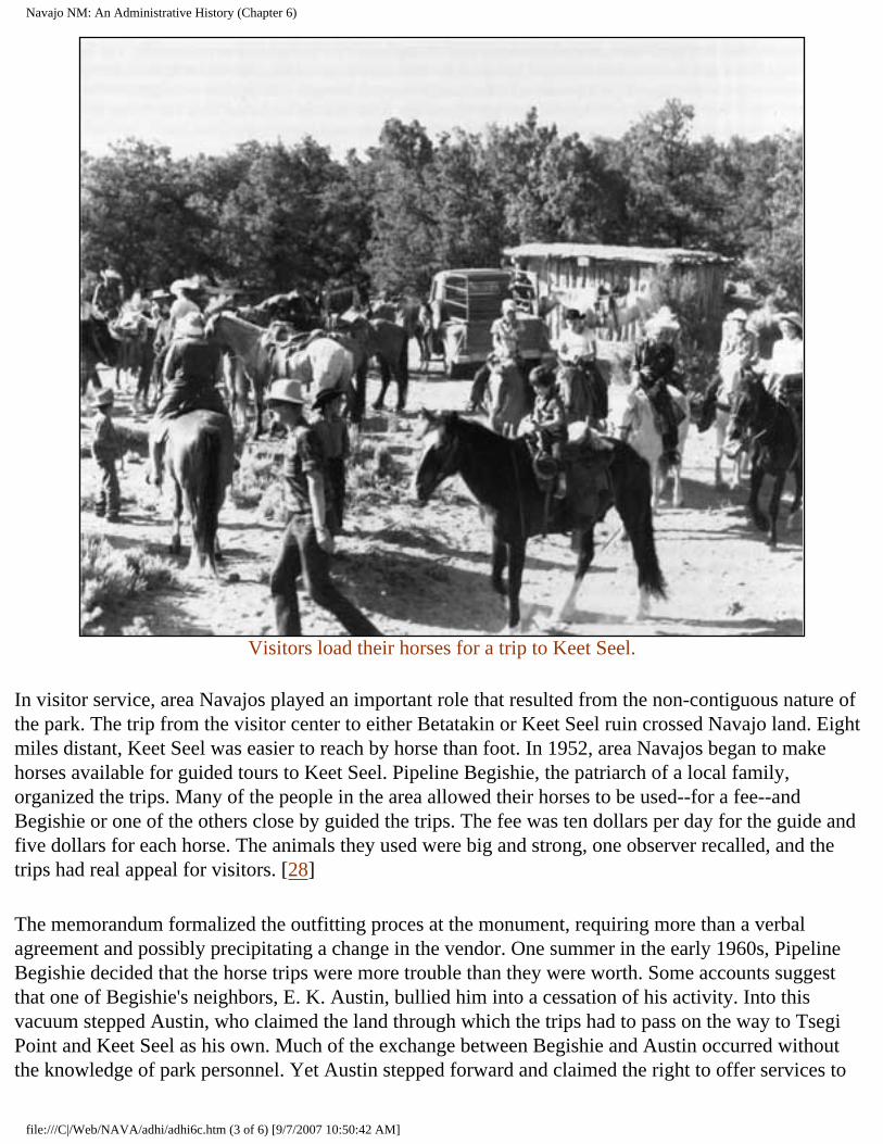
Navajo NM: An Administrative History (Chapter 6)
Visitors load their horses for a trip to Keet Seel.
In visitor service, area Navajos played an important role that resulted from the non-contiguous nature of the park. The trip from the visitor center to either Betatakin or Keet Seel ruin crossed Navajo land. Eight miles distant, Keet Seel was easier to reach by horse than foot. In 1952, area Navajos began to make horses available for guided tours to Keet Seel. Pipeline Begishie, the patriarch of a local family, organized the trips. Many of the people in the area allowed their horses to be used--for a fee--and Begishie or one of the others close by guided the trips. The fee was ten dollars per day for the guide and five dollars for each horse. The animals they used were big and strong, one observer recalled, and the trips had real appeal for visitors. [28]
The memorandum formalized the outfitting proces at the monument, requiring more than a verbal agreement and possibly precipitating a change in the vendor. One summer in the early 1960s, Pipeline Begishie decided that the horse trips were more trouble than they were worth. Some accounts suggest that one of Begishie's neighbors, E. K. Austin, bullied him into a cessation of his activity. Into this vacuum stepped Austin, who claimed the land through which the trips had to pass on the way to Tsegi Point and Keet Seel as his own. Much of the exchange between Begishie and Austin occurred without the knowledge of park personnel. Yet Austin stepped forward and claimed the right to offer services to
file:///C|/Web/NAVA/adhi/adhi6c.htm (3 of 6) [9/7/2007 10:50:42 AM]
Navajo NM: An Administrative History (Chapter 6)
Keet Seel. In exchange for the right of passage across Navajo lands, the Park Service agreed to let the Austin family offer guided horse trips to the outlying section.
E. K. Austin related a different version of the transfer. He claimed to have taken pack trips to the ruins since the days of John Wetherill. In his view, Begishie was an interloper, crossing on Austin's land. The monument was located in the district of the Shonto Chapter, but Austin was enrolled in the Kayenta chapter. He believed this accounted for Begishie's presence. The disagreement became serious in the early 1960s, and both Art White and his successor Jack Williams tried to mediate. They were unsuccessful, and both Austin and Begishie were called to Window Rock. There, Austin claimed, he was vindicated and offered the service that was rightly his.
Austin's privilege to offer horse trips was not exclusive, although he worked to make it a monopoly. As late as 1966, Jack Williams noted that Begishie's permit to carry people to Keet Seel was valid, but he would not do so as long as the Austins did. The transfer may have been done by force or by intimidation, but the result was the same. E. K. Austin had control of the horse trips to Keet Seel. [29]
This was a less than optimal arrangement for the Park Service. Since Stephen T. Mather's day, the agency prided itself on the sophisticated and comprehensive level of service that it could offer visitors. The Park Service built its national constituency by making affluent Americans comfortable in the national parks. MISSION 66 sought to broaden the appeal of the park system to the post-war traveling middle-class. It created facilities for auto travelers and their families, including accommodations, interpretation, and the range of other necessary accouterments. Generally the right to offer concessions in park areas were the subject of a bid process. The competition was fierce, and sometimes the profits were limited by NPS regulation. But under the strict control of the Park Service, service in the park system was generally first-rate. [30]
But the Park Service had little control over neighboring landholders who owned the land between the detached sections of Navajo National Monument. The superintendent and staff could only hope for the best. Service to visitors was spotty. In some cases the tours went well, but generally they did not. One staff member remembered the Austins as "good capitalists." They delivered people to and from Keet Seel in safety, but it was not the "trip of a lifetime." But the Park Service had little more than spectator status. [31]
The Memorandum of Agreement gave the Park Service greater influence over the activities of the guided tour operation. The cooperative nature of the agreement enabled the Park Service to extend a helping hand to the Austins. The Park Service "loaned" horses to assure higher quality animals for visitors, took reservations, and in general sought to improve the quality of service whenever possible. But much of the change was cosmetic in nature, and the improvement in the quality of the tours was minimal.
The new level of Park Service involvement was a mixed blessing. By taking reservations and supplying horses, the staff at the monument exerted at least a little influence over the operation. But conversely,
file:///C|/Web/NAVA/adhi/adhi6c.htm (4 of 6) [9/7/2007 10:50:42 AM]
Navajo NM: An Administrative History (Chapter 6)
because the Park Service took reservations, visitors assumed that the agency had control over the operation. Used to the high quality of visitor service, they often found the Keet Seel horse trip lacking. Many were angry about what they considered a lapse in responsibility by the Park Service.
Throughout the 1960s and early 1970s, complaints about the horse operation increased. E. K. Austin was a "rough customer," unpopular with his neighbors, one who knew him recalled, and others remembered him in a similar fashion. One former employee called him the "bully of the canyon," another acquired the habit of calling him "Edd the Pirate," and recalled that he had to separate Austin and visitors on more than one occasion. One former superintendent recalled members of the Austin family getting into a fight with each other during a meeting with park rangers.
Visitors were often dissatisfied with their trip with the Austins. "Half starved" horses, poor service, sullen guides, and drunkenness headed the list of complaints. Many people came to the Park Service to express their dismay, in the hope that an agency that had built its reputation on service could act to stop what many regarded as a blemish on its record. The Park Service had a standard reply that frustrated both NPS people and visitors: because the Park Service did not control the Austins' land, it had little control over the horse operation. "Things here on the Navajo Reservation are not like other places," Jack Williams wrote in response to one complaint. "We are faced with jurisdictional and political problems that only the Navajo Tribal Council can alleviate." [32] Combined with the growing number of visitors who wished to go to Keet Seel, the Park Service recognized that it had a potentially major problem.
By the early 1970s, a consistent pattern was evident. The NPS had few options. Because Navajo National Monument was essentially an inholding on the Navajo reservation, the kind of control to which NPS officials were accustomed was elusive. Without any direct authority over private land and unable to reach one portion of the monument without the use of the Austin's land, the agency had to deal with a difficult situation. The best management alternative was to co-opt the Austins: show them the potential economic and cultural advantages of the Park Service approach to visitor service.
The cultural difference between the Austins and Park Service was vast. The Austins spoke only Navajo, and while some communication in English certainly occurred, for a topic as important as this, it was imperative to find someone who could communicate in the Navajo language. In April 1973, Clarence N. Gorman, then superintendent at Wupatki National Monument and later superintendent at Navajo National Monument, was called to Navajo to help bridge the gap. Chief Ranger Harold Timmons presented Gorman with a four-page list of topics he wanted covered with the Austins. Issues such as the treatment of visitors, courtesy, safety, promptness, and communications with Park Service were paramount. At a meeting, really a visitor service seminar conducted in the Navajo language, Gorman tried to convey techniques that would result in better service and fewer complaints. In the aftermath of Gorman's visit, conditions improved and the number of unhappy visitors declined. [33]
But a gulf remained. Navajo guides and Anglo visitors had different perceptions of the trip. Navajos saw themselves as guides rather than interpreters. They perceived their responsibility as limited to the safe delivery of visitors to the ruin and back. With a more instrumental than romantic approach to their
file:///C|/Web/NAVA/adhi/adhi6c.htm (5 of 6) [9/7/2007 10:50:42 AM]
Navajo NM: An Administrative History (Chapter 6)
animals, the guides often seemed uninterested and cruel in the eyes of their customers. A constant stream of complaints continued, reflecting a difference between expectation and actuality that characterized cross-cultural relations. The Park Service still had little ability to exercise substantive oversight. Ironically, for many visitors, riding horses with Indians on their trip to the ruins had significant cultural meaning. Despite any shortcomings, the Austins were part of the monument, their horse business an important component for visitors who sought a sense of being in the wild. [34]
CONTINUE >>>
nava/adhi/adhi6c.htm Last Updated: 22-Jan-2001
file:///C|/Web/NAVA/adhi/adhi6c.htm (6 of 6) [9/7/2007 10:50:42 AM]
Navajo NM: An Administrative History (Chapter 6)
Navajo
Administrative History
CHAPTER VI: PARTNERS IN THE PARK: RELATIONS WITH THE NAVAJO (continued)
The gift and craft shop authorized under the Memorandum of Agreement involved a different kind of relationship. Again the shop was independent of the park, although it was physically attached to the Visitor Center. The gift and craft shop was designed to expose visitors to Navajo crafts, increasing their visibility and showing Navajo craft work to the public. The Navajo Guild initially operated the shop, opening for business in April 1966 under its first manager, Ben Gilmore. When the travel season ended in October, the shop had grossed more than $13,000. Generally the shop was open for visitors, although closures usually happened on the weekends, when traffic was at a peak. The guild had a brief tenure at the monument. As a result of an administrative problem with the Tribal Council in Window Rock, the guild folded, and the shop became a private enterprise. Throughout the 1970s, Fannie Etcitty managed the shop, which by all accounts functioned well. In 1978, Superintendent Hastings complimented Etcitty on her operation, remarking that the "shop is always clean, your sales people do an excellent job, and the merchandise is of the best quality." Under Etcitty's management, the shop had become an asset for Navajos, park visitors, and the Park Service. It seemed a model of successful cooperation. [35]
A locally inspired powerplay forced a change in management. In 1980, Elsie Salt, a woman from the Shonto vicinity, acquired a lease from the Navajo Arts and Crafts Association to run the shop. Fannie Etcitty also had an agreement. Art White, by then general superintendent of the Navajo Lands Group, needed to know who was authorized to operate the store. On May 14, 1980, the Advisory Council of the Navajo Tribal Council granted Elsie Salt permission to run the store. She had been selected over Etcitty because she was from the Shonto area. Feeling wronged, Etcitty had to be threatened with eviction by the Tribal Council before she would leave her store. [36]
Under Salt, relations were sometimes strained between the park and the craft shop. NPS officials were less than impressed with her operation. One management team that reviewed the park regarded the entire craft shop operation as "highly unusual." Intermittent tension ensued, sometimes involving personality conflicts. [37]
file:///C|/Web/NAVA/adhi/adhi6d.htm (1 of 3) [9/7/2007 10:50:43 AM]
Navajo NM: An Administrative History (Chapter 6)
More troublesome was a pattern of irresponsibility of which superintendents took notice. The store functioned on its own schedule, opening erratically and frequently closing after an hour or two. In 1988, Salt lacked a valid lease, the necessary insurance, and an adequate plan of operation to secure a permit from the Kayenta Regional Business Office for Accelerated Navajo Development. In the summer of 1988, the Tribal Council was not anxious to renew her lease. Salt was enrolled in the Kayenta Chapter, but technically the shop was in the domain of the Shonto Chapter. She needed approval of the Shonto Chapter to run the shop, but a number of its members wanted their chance at the operation. The Park Service also felt the need for greater control over the shop. Clarence Gorman believed that the circumstances were far too favorable toward Salt. "With Elsie having no lease, not paying rent, and operating out of a space in the Visitor Center," he told Regional Director John Cook on September 9, 1988, "I would say she has it made." [38]
While the Park Service sought to determine a strategy to resolve the problems with the gift shop, tragedy struck. In a one-car accident on May 31, 1990, Elsie Salt died. For the 1991 season, her sister, Sally Martinez was selected to manage the store. After renaming the shop "Ledge House Ruin Crafts," Martinez prepared to open for the 1991 season.
Like the horse trips, the gift shop had a cultural meaning that far exceeded the obvious. The direct interaction with Indians appealed to the traveling public in an overwhelming way. The gift shop allowed visitors to participate in the past in a way that purchasing books and other educational materials from the SPMA display in the visitor center did not.
The activities of the Austin family highlighted the differences between the two different kinds of economic relationships Navajos had with the park. The Austins had strictly economic motives, but nearly complete control over their interaction with the Park Service. Those who worked for the Park Service were mostly bound to its rules, regulations, and expectations. One group had greater autonomy; the other, greater security. Despite the potential for envy and conflict between the two groups, no evidence of rivalry appeared.
Relations with the pack trip operation and the gift shop revealed the give-and-take relationship between the park and the Navajo Nation following the Memorandum of Agreement. The agreement gave the Navajo a new hold on the park. The lease of the land through a semi-permanent interim agreement afforded Navajos a greater measure of control over their activities within the park than was previously available. What resulted was a series of compromises that eroded the measure of control that the Park Service previously enjoyed, but conversely was absolutely necessary to conduct the affairs of the monument. The greater the participation and sense of entitlement and belonging of the Navajo people, the harder it became to run Navajo National Monument like the rest of the system. The monument had always been unique, and the Memorandum of Agreement reinforced that perception. The agreement gave the Navajo certain rights and privileges that were not always within the bounds of ordinary NPS policy. The interdependence of the area further affirmed the need for a compromise-oriented agency posture.
file:///C|/Web/NAVA/adhi/adhi6d.htm (2 of 3) [9/7/2007 10:50:43 AM]
Navajo NM: An Administrative History (Chapter 6)
CONTINUE >>>
nava/adhi/adhi6d.htm Last Updated: 22-Jan-2001
file:///C|/Web/NAVA/adhi/adhi6d.htm (3 of 3) [9/7/2007 10:50:43 AM]
Navajo NM: An Administrative History (Chapter 6)
Navajo
Administrative History
CHAPTER VI: PARTNERS IN THE PARK: RELATIONS WITH THE NAVAJO (continued)
By the mid-1980s, the pattern of attending to the needs of the area as well as of the park was firmly ingrained at Navajo National Monument. There were efforts by the Navajo to tie into the electricity and sewer systems of the monument. Because of the limited capacity of both, at the end of the 1980s such requests had not been filled. But the trend had been established, at least to a certain degree. The amenities and advantages of the park would be available to some of the Navajo some of the time.
The appointment of Clarence N. Gorman as superintendent in 1986 inaugurated a new era. A Navajo, Gorman once worked as a seasonal ranger at the monument. More than twenty years later, he returned as the head person at the park. Gorman's appointment reflected the importance of close relations with local people. Many of the Navajo employees felt a stronger feeling that they belonged after Gorman's appointment, knowing that they would return to work each day with other Navajos, speak the language, and experience a certain feeling of accomplishment. There was a stronger pride in working for the park for Navajos working for a Navajo superintendent. "It's good to see your own people working here," Delbert Smallcanyon said in the Navajo language. There was a measure of freedom that Navajos did not experience working for industries such as the railroad. [39]
To the people of the region, the presence of Navajo leadership also inferred a gradual transfer of the monument to the de facto custodianship of the Navajo people. In the fall of 1990, Gorman arranged for the return to the Barlow family of the very medicine bundle that had been the subject of controversy in the early 1970s. Even though the bundle--called a jish--had been purchased from the family, the Park Service did not request reimbursement. Another jish was given to Navajo Community College near Chinle for its "lending library" designed to help teach the practices of Navajo medicine men to new generations of the Dine. These gestures, of a piece with an emerging enlightenment in the scientific community regarding prehistoric and historic artifacts, typified the heightened level of concern for Navajo sensitivities.
Yet the growing presence of Navajo people did not indicate a dislike of previous Anglo superintendents.
file:///C|/Web/NAVA/adhi/adhi6e.htm (1 of 3) [9/7/2007 10:50:44 AM]
Navajo NM: An Administrative History (Chapter 6)
Most of the past Park Service officials were fondly remembered by many of the Navajo in the area. Art White particularly was revered by area people, as were others who sought to build a relationship with people in the region. Only one was mentioned in an unfavorable light, ironically by both Navajos and Anglos who worked for him. According to accounts, he had a textbook view of Indians and had difficulty adjusting to living among real ones. [40]
Gorman's appointment had symbolic overtones. It reflected two decades of growing empowerment of the Navajo and American Indians in general and the overwhelming desire of the Park Service and federal agencies to operate in a more inclusive fashion. A career Park Service professional who worked his way up the ladder, Gorman's position as the highest GS-rated official at the park spoke volumes about inclusiveness to the people of the region. Some of the sub-surface tension about NPS presence was mitigated by having a Navajo in a position of leadership.
Gorman's presence also widened the role of Navajos at the park. Because of its unique geographic position in relationship to the location of labor, the park could hire area Navajos without going through standard federal employment procedures. Support programs that included Navajos also grew, and Navajo history and culture played a growing role in the interpretation. Efforts to include high school students from the area in summer activities at the park followed. In the summer of 1988, five young Navajos from the Shonto Chapter worked at the monument.
The Navajo Nation also became increasingly aware of cultural resources in and around the reservation. This resulted in legislation designed to protect the interests of the Navajo people. One such law, the Navajo Nation Cultural Resources Protection Act, seemed inapplicable to NPS activities. The Park Service chose to respond to it on a case-by-case basis, preferring such a tactic to an open challenge. But passage of the act reflected the fundamental changes in Navajo-park relations that followed the Memorandum of Agreement in 1962. In 1909, the Navajo people had yet to adapt their leadership structure to the realities of outside encroachment on reservation life. The Navajos exerted little if any influence on the park or the Park Service. By 1988, with a governmental and legal structure in place and a clear sense of their identity and rights, the Navajo Nation was a force with which the Park Service had to contend. The Park Service moved carefully in Navajoland, not wishing to alter the pattern of good relations that had lasted more than three generations. [41]
But the Navajo Nation was powerless to slow the pace of change for many of the Navajo people. By the 1980s, Navajos on the western reservation were a people in transition. The roads that crossed this previously isolated area had brought the cultural impact of the modern world, and the traditional ways of living that had lasted in the remote parts of the reservation began to change. Younger people began to lose their ties to traditional culture, although not at the rate that occurred among more urbanized Navajos. Yet many of the younger people moved away in order to find work, settled in Flagstaff, Phoenix, Los Angeles, or some similar place, and began the transition to urban status. Even the most traditional people were involved in the modern economy. Hubert Laughter, who worked at the park, became a Navajo Tribal Police officer, served on the tribal council, was later drove heavy equipment for the Peabody Coal Company, and also a medicine man. A man packing squash and gourds to the
file:///C|/Web/NAVA/adhi/adhi6e.htm (2 of 3) [9/7/2007 10:50:44 AM]
Navajo NM: An Administrative History (Chapter 6)
Inscription House Trading Post that Bill Binnewies met in the early 1970s typified the duality. When not engaged in such subsistence economic activities, he was a technician for a guided missile system. Clearly this was a harbinger of a complicated future. [42]
These contradictions characterized the future predicament of the Navajo people. Caught with a foot in two distinctly different worlds, they will have to fight to retain cultural individuality. A recent trip to the Farmington Mall revealed scores of young Navajos in the classic garb of the generic teenager: unlaced tennis shoes with the tongues hanging out and heavy metal T-shirts of popular groups. The demands of the modern world have an overwhelming character. They hegemonize indiscriminately.
Ironically, when young urban Navajos seek to rediscover their own culture, places like Navajo National Monument have the potential to play an important role. As the monument fused more and more with its surroundings, it became a haven for Navajos who sought to remain Navajo but have many of the material advantages of the modern world. In the early 1990s, the character of the workforce of the monument was Navajo--very traditional Navajo. Even younger Navajo members were attuned to their unique and protected position as employees of the park. By providing the benefits of mainstream American life without many of its drawbacks, the monument insulated the people of the region from the worst effects of change. In addition, interpreting Navajo culture at the monument was on the upswing, and the growing number of Navajos in the work force at the monument assured greater future presence. The bits of Navajo culture preserved in places like Navajo National Monument can provide a visible guidepost for young Navajos as they seek to reattain what they earlier shunned for the perceived advantages of "civilization."
<<< CHAPTER 5 TABLE OF CONTENTS CHAPTER 7 >>>
nava/adhi/adhi6e.htm Last Updated: 22-Jan-2001
file:///C|/Web/NAVA/adhi/adhi6e.htm (3 of 3) [9/7/2007 10:50:44 AM]
Navajo NM: An Administrative History (Chapter 7)
Navajo
Administrative History
CHAPTER VII: ARCHEOLOGY AT NAVAJO (continued)
For Navajo National Monument, these efforts initiated new approaches to the story of the park. The monument benefited both from the attention focused on southwestern archeology as well as the new information that helped explain the past. A systematic approach offered much to the Park Service and the Southwestern National Monuments Group as Frank Pinkley sought to interpret prehistory for the public.
Archeological work in Navajo National Monument predated the beginning of a systematic approach to archeology. It preceded the founding of the monument by more than a decade, reflecting the earliest trends in the history of southwestern archeology. In January 1895, Richard Wetherill, Alfred Wetherill, and Charlie Mason found Keet Seel. They began to explore the area, inspecting the trash midden, making an extensive collection of pottery, and describing the ruin. Wetherill counted 115 rooms on his first trip, informing his partners--the Hyde brothers--that Keet Seel was "the best place to get a collection I ever saw." [15]
That sentiment spurred Wetherill's return in 1897, when he again excavated in the ruin, this time to quench his sponsor Teddy Whitmore's desire for a collection. On this trip, Wetherill diagramed the floor plan of Keet Seel and measured its dimensions. The party also dug in numerous places in the ruin in search of artifacts. [16]
Wetherill's sentiments typified the character of excavation in his era. Late in the 1890s, the uproar concerning his activities remained muted. Federal officials had yet to take umbrage at his actions. Wetherill was merely a well-positioned competitor in the hunt for artifacts that dominated the horizons of the archeological community. He and his party collected artifacts and did some preliminary excavation. Wetherill himself made field notes of the activities.
In the decade that ensued, the climate in the archeological profession changed. Wetherill was labeled a pot-hunter by federal officials and academic and government scientists alike, and the GLO made serious if sometimes misguided efforts to protect important ruins. A permit system was established, although its
file:///C|/Web/NAVA/adhi/adhi7b.htm (1 of 3) [9/7/2007 10:50:45 AM]
Navajo NM: An Administrative History (Chapter 7)
creator, Edgar L. Hewett, used it as a license to hoard a large piece of archeological turf for himself and his friends. But by 1909, when William B. Douglass recommended the establishment of Navajo National Monument, a different set of assumptions governed both his efforts and those of other federal officials.
The attempts to use federal power to halt the previously authorized excavation of Byron L. Cummings in the summer of 1909 reflected the changes. Cummings fit the profile of the first generation of American archeologists. Self-trained in archeology but possessing other academic credentials, Cummings found his position at the University of Utah to be an opportunity to be part of the growth of an exciting new field. Protected by Hewett's permit, he seemingly had every right to excavate in Tsegi Canyon in 1909. But much of the power of the Smithsonian Institution, the General Land Office, and the Department of the Interior joined to prevent his actions. [17]
Yet Cummings managed to excavate within the monument not only in 1909, but, with an important two-year exception, in nearly every year that followed through 1930. Most of his field work had the emphasis on collections typical of the era. Any publications that resulted were descriptive in character. Cummings and his party set up camp at Keet Seel in the summer of 1909, working there until July. A trip to Nitsin Canyon made them the first official party of Anglo-Americans to see Inscription House. On their return, they were directed to Betatakin, which they investigated for the better part of an hour before Cummings headed off in search of his real objective that summer: the location of Rainbow Bridge. As a result, most of their activities that first summer were preparatory in nature, reconnaissances designed to prepare for future work. [18]
There was also a cavalier dimension to such work, particularly in the eyes of federally affiliated scientists and bureaucrats. With his overriding interest in Rainbow Bridge, Cummings seemed to fashion himself as much an explorer as an archeologist. To those who questioned the integrity of western academics, he seemed the epitome of a man in search of the limelight. Perennially in search of a new discovery, Cummings appeared to lack the ability to see a project through to fruition.
With this feeling foremost in their thinking, Frederick Webb Hodge of the Bureau of American Ethnology and Charles D. Walcott of the Smithsonian Institution sent J. Walter Fewkes to Navajo National Monument to make a preliminary, if permanent, assessment of the attributes of its ruins. The monument had yet to be reduced to its final size and did not then include Inscription House. As a result, the Fewkes party visited Betatakin, Keet Seel, and a number of smaller ruins within the general area. At each site, Fewkes compiled intricate descriptions of archeological and architectural features, creating the kind of record of which a society that sought to document its past could be proud. [19]
There were differences in character between Fewkes' two trips and the summers that Cummings spent in the region. Fewkes represented the federal government and was not bound by the demands upon either academics or museums. Fewkes and the Bureau of American Ethnology regarded the monument as the property of the public. Documentation rather than excavation appeared to be their objective. Cummings used the ruins in a time-honored archeological fashion. He brought students with him to train, including Neil Judd and more than two decades later, the distinguished Americanist Gordon R. Willey; made
file:///C|/Web/NAVA/adhi/adhi7b.htm (2 of 3) [9/7/2007 10:50:45 AM]
Navajo NM: An Administrative History (Chapter 7)
collections; and generally behaved in what federal officials regarded as a proprietary manner. A contest between generations of the archeological profession was underway.
Changing realities in the region did not deter Cummings. He returned to dig Betatakin even as Fewkes approached. But the results of the excavation provided ammunition to those who sought to restrict access to the ruins. Forced to leave in haste by approaching bad weather, the Cummings party left a number of artifacts hidden in the ruin. They were never again seen.
Cummings' foray in the fall of 1909 was his last in the area until Fewkes departed. Only in 1912, after Fewkes was gone, did Cummings return to Betatakin. He continued his practice of taking students with his parties as trainees in the summers, excavating Inscription House in the summer of 1914. But after the Fewkes survey, Cummings became less important as the objectives of government-sanctioned science took hold.
CONTINUE >>>
nava/adhi/adhi7b.htm Last Updated: 22-Jan-2001
file:///C|/Web/NAVA/adhi/adhi7b.htm (3 of 3) [9/7/2007 10:50:45 AM]
Navajo NM: An Administrative History (Chapter 7)
Navajo
Administrative History
CHAPTER VII: ARCHEOLOGY AT NAVAJO (continued)
Almost a decade after the creation of the monument, Congress finally invested in the upkeep of its national monument. An appropriation in 1916 allocated $3,000 for the preservation and repair of the ruins in the monument. The Smithsonian Institution was designated to administer the funds. Cummings' student and nephew Neil Judd had gone to work for the National Museum, a branch of the Smithsonian, in 1911. He served as an excellent compromise candidate to lead the party. Cummings himself wanted the opportunity and pressed for it through his congressmen and senators. BAE and the Smithsonian wanted someone over whom they held sway. Judd was acceptable to Cummings as well. In March 1917, Judd was named head of the field party and he headed West. [20]
On his arrival he realized the scope of the problems at the monument and made an important decision. With only a small appropriation, he could not do everything and chose to confine his efforts to Betatakin. One objective was to protect the ruins that had been previously excavated; Judd and his crew repaired Betatakin, reconstructing walls with mortar he replicated from prehistoric mortar that outlasted the sandstone building blocks of the Anasazi. Another was to collect artifacts and inventory architectural details, such as the lateral depressions "pecked with stone hammers" that allowed the Anasazi to have a seating on which to build their walls. [21]
The appropriation for repair was a figurative drop in the bucket. Each of the ruins had problems that required attention, but the money and workpower were not sufficient to solve them all. Nor did Judd have much time. His party arrived at Betatakin at the end of March and the federal budget expired at the end of June. The U.S. entered the First World War a few days after Judd's arrival, assuring that any money left at the end of the year would have to be returned to the federal treasury. The project progressed in a hurry, accomplishing what it could in the hope that more money would be forthcoming. [22]
But the establishment of the National Park Service created an entity responsible for Navajo National Monument, and no further direct funding for the monument followed. At its inception, the Park Service had few resources and many responsibilities. It was involved in a struggle for survival as a federal
file:///C|/Web/NAVA/adhi/adhi7c.htm (1 of 4) [9/7/2007 10:50:47 AM]
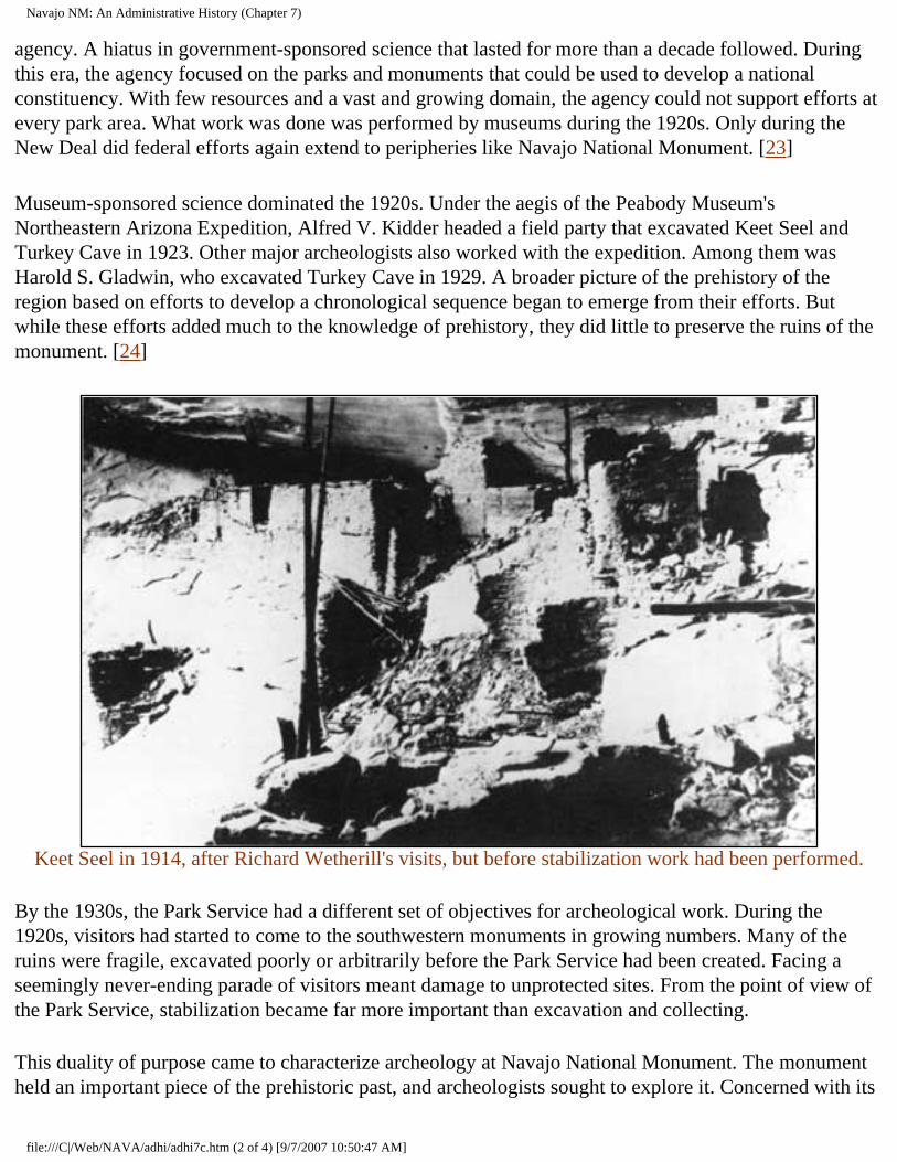
Navajo NM: An Administrative History (Chapter 7)
agency. A hiatus in government-sponsored science that lasted for more than a decade followed. During this era, the agency focused on the parks and monuments that could be used to develop a national constituency. With few resources and a vast and growing domain, the agency could not support efforts at every park area. What work was done was performed by museums during the 1920s. Only during the New Deal did federal efforts again extend to peripheries like Navajo National Monument. [23]
Museum-sponsored science dominated the 1920s. Under the aegis of the Peabody Museum's Northeastern Arizona Expedition, Alfred V. Kidder headed a field party that excavated Keet Seel and Turkey Cave in 1923. Other major archeologists also worked with the expedition. Among them was Harold S. Gladwin, who excavated Turkey Cave in 1929. A broader picture of the prehistory of the region based on efforts to develop a chronological sequence began to emerge from their efforts. But while these efforts added much to the knowledge of prehistory, they did little to preserve the ruins of the monument. [24]
Keet Seel in 1914, after Richard Wetherill's visits, but before stabilization work had been performed.
By the 1930s, the Park Service had a different set of objectives for archeological work. During the 1920s, visitors had started to come to the southwestern monuments in growing numbers. Many of the ruins were fragile, excavated poorly or arbitrarily before the Park Service had been created. Facing a seemingly never-ending parade of visitors meant damage to unprotected sites. From the point of view of the Park Service, stabilization became far more important than excavation and collecting.
This duality of purpose came to characterize archeology at Navajo National Monument. The monument held an important piece of the prehistoric past, and archeologists sought to explore it. Concerned with its
file:///C|/Web/NAVA/adhi/adhi7c.htm (2 of 4) [9/7/2007 10:50:47 AM]
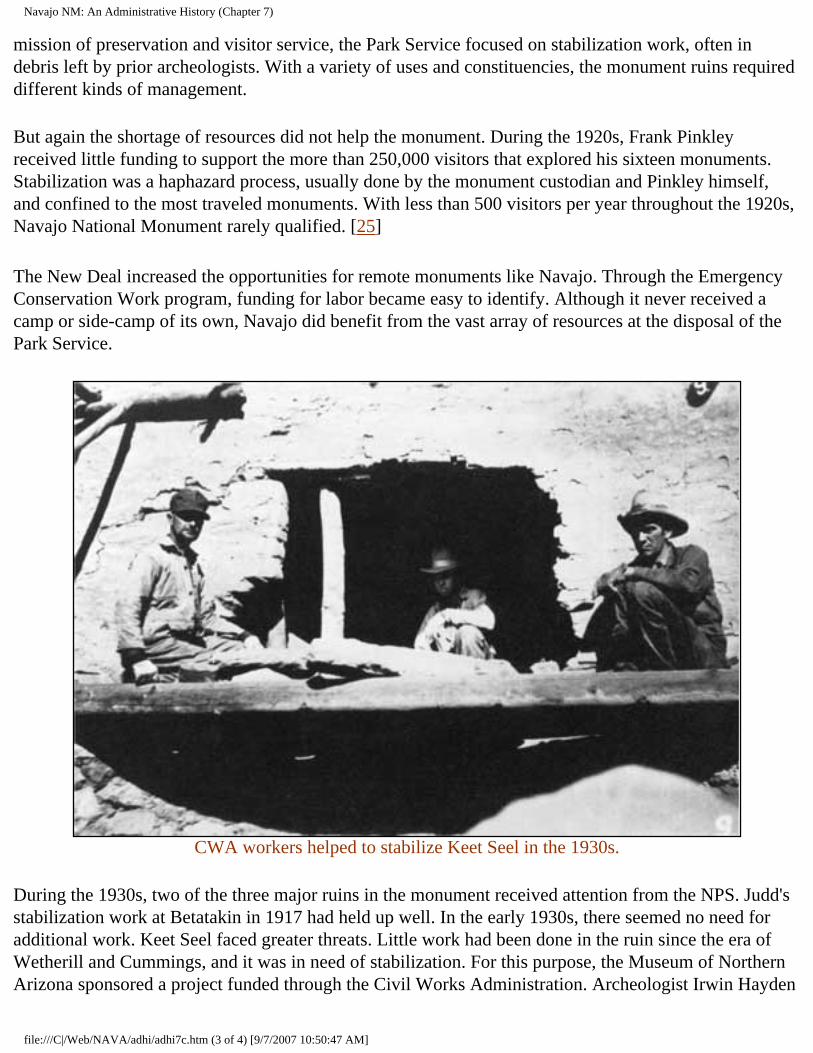
Navajo NM: An Administrative History (Chapter 7)
mission of preservation and visitor service, the Park Service focused on stabilization work, often in debris left by prior archeologists. With a variety of uses and constituencies, the monument ruins required different kinds of management.
But again the shortage of resources did not help the monument. During the 1920s, Frank Pinkley received little funding to support the more than 250,000 visitors that explored his sixteen monuments. Stabilization was a haphazard process, usually done by the monument custodian and Pinkley himself, and confined to the most traveled monuments. With less than 500 visitors per year throughout the 1920s, Navajo National Monument rarely qualified. [25]
The New Deal increased the opportunities for remote monuments like Navajo. Through the Emergency Conservation Work program, funding for labor became easy to identify. Although it never received a camp or side-camp of its own, Navajo did benefit from the vast array of resources at the disposal of the Park Service.
CWA workers helped to stabilize Keet Seel in the 1930s.
During the 1930s, two of the three major ruins in the monument received attention from the NPS. Judd's stabilization work at Betatakin in 1917 had held up well. In the early 1930s, there seemed no need for additional work. Keet Seel faced greater threats. Little work had been done in the ruin since the era of Wetherill and Cummings, and it was in need of stabilization. For this purpose, the Museum of Northern Arizona sponsored a project funded through the Civil Works Administration. Archeologist Irwin Hayden
file:///C|/Web/NAVA/adhi/adhi7c.htm (3 of 4) [9/7/2007 10:50:47 AM]
Navajo NM: An Administrative History (Chapter 7)
took charge of the project, which worked at Keet Seel and Turkey Cave in 1933 and 1934. [26]
Hayden's CWA project performed work similar in character to Judd's project in 1917. At Keet Seel, Hayden's crew cleared unexamined areas, removed the dirt from backfilled ruins, recorded architectural details, and rebuilt collapsed walls. Hayden also re-excavated and stabilized two kivas in Turkey Cave, according to John Wetherill, finding much that Kidder had overlooked in 1923. The work was done well, earning Keet Seel the reputation as one of the best-preserved ruins in the Southwest. [27]
Keet Seel also yielded some interesting discoveries. Early in 1934, Irwin Hayden and Milton Wetherill uncovered the skeleton of a child in a trash midden at Keet Seel. With the skeleton were two pieces of Pueblo II type pottery, far older than the ruin itself. Other finds followed, including what appeared to be the skeleton of a parrot. Such unexpected results showed that the "down-and-dirty" emphasis of nineteenth- and early twentieth-century archeologists on collecting left many hidden treasures. [28]
In 1939, Inscription House received attention from the Park Service for the first time. Charlie Steen, a veteran archeologist and Park Service man, headed the project. Steen's objectives were similar to those of Judd at Betatakin and Hayden at Keet Seel. Steen was more concerned with architectural documentation than reconstruction. He recorded room configurations, structural features, and construction characteristics, and took numerous photographs. Most of the rooms were not disturbed. Some mortar was patched, some bricks replaced, and a roof was repaired. [29]
The efforts of the 1930s reiterated the difference between the approach of the Park Service and previous excavators. NPS efforts were directed at restoration, stabilization, and preserving ruins rather than at making collections. Turkey Cave, with little value as visitor attraction, was a prime interest of archeologists. Keet Seel, Betatakin, and Inscription House, the large and visible surface pueblo remains, were the primary focus of government and NPS efforts.
CONTINUE >>>
nava/adhi/adhi7c.htm Last Updated: 22-Jan-2001
file:///C|/Web/NAVA/adhi/adhi7c.htm (4 of 4) [9/7/2007 10:50:47 AM]
Navajo NM: An Administrative History (Chapter 7)
Navajo
Administrative History
CHAPTER VII: ARCHEOLOGY AT NAVAJO (continued)
While Park Service efforts were directed at making the ruins usable for the growing number of visitors, the Rainbow Bridge-Monument Valley expeditions sought to add to the base of knowledge. Among the places the survey worked was Navajo National Monument. [30] For the Park Service, this had many advantages. The agency could acquire additional information from the work of these archeologists, while focusing on its imperative: the protection and preservation of the ruins of the monument.
But the work of the Rainbow Bridge-Monument Valley Expedition created a controversy at Navajo National Monument. In the late 1920s, A. E. Douglass, the founder of dendrochronology, had taken core samples from the timber at Keet Seel, carefully plugging his holes. Neil Judd also took core samples, leaving the holes unplugged. But according to Irwin Hayden, in 1934, Lyndon Hargrave of the Rainbow Bridge-Monument Valley expedition and his party engaged in a "sort of sophomoric sawing spree," cutting the ends off of many of the timbers at Keet Seel.
A fracas ensued that disrupted the CWA stabilization program at the monument. Enraged, Hayden quit the project, walking the twenty-five miles to Kayenta. Julian Hayden replaced his father. But Irwin Hayden was not through. He took Hargrave to task with Harold Colton, director of the Museum of Northern Arizona, and Frank Pinkley, ever protective of the archeological resources of his domain, took Hayden's side. Colton sided with Hargrave. He and Pinkley exchanged heated arguments on the topic. Dendrochronology was a new science, and A. E. Douglass best understood it. Standards for use of the technique had not yet been developed. Until archeologists got together to work out the details, there was little chance of resolution. [31]
Repercussions continued. Jesse Nusbaum, by then director of the Laboratory of Anthropology in Santa Fe and former superintendent of Mesa Verde National Park, was distraught, as was Frank A. Kittredge, the chief engineer of the Park Service. "So many of the ancient logs had been sawed in two that it was most depressing," he conveyed to Arno B. Cammerer, director of the Park Service. Despite the advances in knowledge that stemmed from the work of archeologists, NPS goals of preservation and the objectives of the archeological community were not compatible. [32]
file:///C|/Web/NAVA/adhi/adhi7d.htm (1 of 3) [9/7/2007 10:50:48 AM]
Navajo NM: An Administrative History (Chapter 7)
The end of the New Deal and the beginning of World War II halted most archeological work at the monument and in the vicinity. Federal funding for archeology dried up, and gasoline and rubber rationing curtailed opportunities for survey work. Park Service headquarters was moved to Chicago to make room for war-related agencies in Washington, D. C., and most park projects were postponed. The problems of Navajo National Monument did not merit a look during the war.
During the 1950s, scientific institutions re-entered the region. The Smithsonian Institution sponsored the Pueblo Ecology Study, while the Glen Canyon Project surveyed archeological resources in the vicinity of the Glen Canyon Dam. Preserved and protected, Navajo National Monument received some attention from these projects. The Glen Canyon project in particular had implications for the monument, investigating sites near its boundaries and with ramifications for its story.
Concomitant effort within the Park Service followed as the agency faced a dramatic increase in park visitation throughout the Southwest. The Southwestern National Monuments Ruins Stabilization program was established to assess maintenance needs of prehistoric and historic areas. As part of this program, Gordon R. Vivian examined Betatakin, Keet Seel, and Inscription House. While lack of protection loomed as an issue, he found the three ruins in good condition. His recommendations for future work led to Roland Richert's stabilization efforts at the monument in 1958. Richert's plan went beyond Vivian's recommendations, becoming a program for comprehensive stabilization and assessment. The result was a more thorough understanding of stabilization needs, a safer environment for visitors, and with the advent of Portland cement as a mortar for reconstruction, a presumed solution for the structural problems of stabilization. [32]
But the new material later caused many woes. Portland cement was harder and more durable than the material that it was supposed to preserve. It did not contract as it froze and thawed. Softer materials that the cement embraced--sandstone, limestone, and adobe--could not expand and contract with temperature fluctuation. As a result, the softer materials that Portland cement was supposed to preserve cracked and crumbled under the stress. Portland cement became the bane of stabilization. [33]
The stabilization work performed by Richert and his crew in 1958 was a watershed. At Betatakin, no stabilization had occurred since 1917; at Keet Seel, the ill-fated Hayden CWA project in 1933-34 had been the most recent effort, while at Inscription House, the stabilization was the first activity since Charlie Steen's work in 1939. Richert detailed the stabilization work, providing a comprehensive record of activities in all three ruins. At Keet Seel, forty-four rooms were stabilized. Wall foundations were shored up, roofs were patched and repaired, and stones were reset and jacal walls replastered. Even with the new Portland cement mortars available, Richert and his crew used a natural mud mortar. At Betatakin, the work was minor but widespread, occurring in twenty-five rooms. At Inscription House, another twenty rooms were repaired. [34]
CONTINUE >>>
file:///C|/Web/NAVA/adhi/adhi7d.htm (2 of 3) [9/7/2007 10:50:48 AM]
Navajo NM: An Administrative History (Chapter 7)
nava/adhi/adhi7d.htm Last Updated: 22-Jan-2001
file:///C|/Web/NAVA/adhi/adhi7d.htm (3 of 3) [9/7/2007 10:50:48 AM]
Navajo NM: An Administrative History (Chapter 7)
Navajo
Administrative History
CHAPTER VII: ARCHEOLOGY AT NAVAJO (continued)
This effort, major in comparison to previous endeavors, foreshadowed changes in the immediate future of the monument. MISSION 66 made the Park Service affluent. Throughout the park system, much long-needed work finally occurred. At Navajo, the encroaching pavement meant a greater need for constant maintenance of ruins in the monument. Visitation levels had begun to climb, and the plans for a visitor center and a paved approach road meant that the number would increase exponentially.
The archeological discipline had entered a new phase as well. In response to the rapid infrastructural and industrial development sweeping the Southwest after World War II, archeologists had begun to conceive of saving some information from ruins in the path of progress. Destruction could not always be prevented, but archeologists could perform surveys and excavations before the bulldozers arrived, collecting artifacts and making records for the future. Labeled salvage archeology, this proactive response came to dominate the field. [35]
Because of the authorization of the Glen Canyon Dam by the Colorado River Storage Project, much of the salvage archeology work focused on the area near Navajo National Monument. Work both in the area to be flooded and in the surrounding highlands added measurably to the base of knowledge for the monument. It also influenced the approach of the Park Service to the ruins of the monument. [36]
In the 1960s, NPS sponsored similar archeological studies within the monument boundaries. The new work ended a thirty-year hiatus in excavation within the boundaries of the monument. The prospect of greatly increased visitation made this work necessary, as the NPS geared up to fulfill its dual mission. The construction of the Kayenta-Tuba City highway, the approach road to the monument, and later the new road through Marsh Pass signaled the end of an era of isolation. No longer would remote character be a guarantee of protection. Nor would above-ground structures be immune to depredation. Greater preservation efforts were necessary as was more comprehensive research to support interpretation.
Two distinct kinds of work were performed at Navajo. Examinations to address concern for the resource comprised one category of work. In the 1960s, the monument embarked on a program of stabilization
file:///C|/Web/NAVA/adhi/adhi7e.htm (1 of 5) [9/7/2007 10:50:50 AM]
Navajo NM: An Administrative History (Chapter 7)
for the smaller ruins within the monument. Examples of these include the stabilization efforts of Charles B. Voll and an eight-man Navajo crew at Betatakin and Kiva Cave in 1964, test excavations of David Breternitz at Turkey Cave, those of Keith Anderson at Betatakin and Keet Seel, and the salvage operations of George J. Gumerman and Albert Ward of the Museum of Northern Arizona at Inscription House. Three others moved toward an understanding of the archeology of the monument: Jeffrey S. Dean's chronological analysis of Tsegi Phase sites, Polly Schaafsma's survey of rock art, and Keith Anderson's examination of Tsegi Phase technology, which became his doctoral dissertation. These efforts led to better understanding of Anasazi life in the ruins that composed the monument. The two different directions of archeology at Navajo National Monument had been fused.
Dean's work had particular importance for the archeology of the monument. During the early 1960s, he conducted his research at Navajo under the auspices of the Laboratory of Tree-Ring Research at the University of Arizona. The Park Service funded his research, as did the Arizona State Museum, and the work resulted in "Chronological Analysis of Tsegi Phase Sites in Northeastern Arizona." This effort, published in 1969 as a revision of Dean's doctoral dissertation, revised the chronology for occupation of the archeological sites within the monument. [37]
In his highly acclaimed study, Dean asserted that the Tsegi Phase Kayenta people did not move into the area in a comprehensive manner until about 1250 A.D., almost fifty years later than prior estimates. They found timber and other resources, and proceeded to make use of them, leading to a process of deforestation as trees were cut for construction. Dean discerned that the people who came to the Tsegi drainage had come from the Klethla Valley, Laguna Creek Valley, and Monument Valley areas, which had been nearly abandoned by 1250 A.D. The major factor that compelled their arrival was also what hastened their departure. Arroyo cutting as a result of their land practices made them search out Tsegi Canyon; the condition followed them, again forcing them to the south less than one hundred years later. [38]
More than twenty years after his research, Dean suggested a compelling reason for the construction of pueblos like Keet Seel and Betatakin under the ledges of caves. His own experience living in a pueblo convinced him that the primary reason was to limit the need for maintenance. Exposed, a pueblo required constant work. Wind, rain, and other elements made upkeep a struggle. The great ledges under which so many ruins were located protected them from much of the impact of weather, creating surplus time to devote to the necessities and amenities of prehistoric life. [39]
One of the most significant results of the explosion of archeological work that began at Navajo in the 1960s was a revision of the presumed age of the date on the wall at Inscription House. After extensive study, Albert E. Ward concluded that the year incised in the wall was more likely 1861 than 1661. He believed that members of a party of Mormons, who came to retrieve the body of a friend who had been killed by Navajos the previous year, carved the date. This reevaluation indicated that some changes in the historic chronology of the monument and possibly in the name of Inscription House site were appropriate. [40]
file:///C|/Web/NAVA/adhi/adhi7e.htm (2 of 5) [9/7/2007 10:50:50 AM]
Navajo NM: An Administrative History (Chapter 7)
The Dean, Anderson, and Schaafsma studies laid the groundwork for the direction of archeological work at the monument. Stabilization and restoration remained critical features of NPS work at the monument, but broader knowledge was required to develop a more complete understanding of life at the monument.
During the 1960s, archeologists benefited from strong leadership at Navajo National Monument. Superintendent Art White and his successor Jack Williams were interested in the work of the archeologists and made sure that they received ample opportunity to do their research. "When I was in the archeology department, I did ranger work," White later remarked of his career as a park archeologist, "I didn't do any archeological work." He assigned ranger work to rangers, and let Keith Anderson function as an archeologist. Others on the staff sometimes resented this distribution of responsibility, but White deemed it necessary. [41] This luxury of workpower was a function of the affluence of the era, the unprecedented availability of resources that resulted from the MISSION 66 program. The increase in visitation compelled better research, protection, and interpretation. Superintendents who understood the need for new and different research helped lay the basis for the boom in archeology in the 1960s. Fortunately it occurred during MISSION 66, when the NPS had resources to spread around.
Protection also improved as a result of the activities of archeologists. Dean worked first at Betatakin, then spent two seasons at Keet Seel. White set up a camp at the outlier for Dean and regarded him as an additional ranger there, "with no salary and at no cost," White later recalled. [42] Someone in residence at Keet Seel, particularly a professional archeologist like Dean, meant that visitors and others were better supervised and educated there than they had been in the past.
The 1970s were dominated by efforts to maintain preservation, largely by controlling the number of visitors to the ruins. These reactive techniques were part of the first comprehensive program for resource management implemented at the monument. Efforts to determine a genuine carrying capacity for both Keet Seel and Betatakin figured prominently in the plans of the monument. The impact had to be considered from more than one perspective. Not only did the park need to find a maximum number of annual visitors, it also needed an individual trip and daily estimate of the number of visitors that could visit without having a significant negative impact on the ruins. Superintendent Frank Hastings undertook the project, regarding it as one of "greatest methods of protecting resources that could have been done." [43]
After the opening of the paved approach road, increased usage made stabilization a constant for administrators at Navajo. Natural wear and tear, human impact, and the need to present the resource to growing numbers of visitors meant an increase in stabilization efforts. Stabilization was carried out at Inscription House in 1977, 1981, and 1984; at Betatakin in 1975, 1981, 1982, and 1984; and at Keet Seel in 1975, 1981, 1982, and 1984. This pattern became an integral part of the process of managing the ruins at Navajo, although the elimination of the Navajo Lands Group limited the monument's access to stabilization resources. By the late 1980s, the only funds available for stabilization was special projects money from the Regional Office. Many parks requested such funding, and there was no guarantee of success for any individual park area.
file:///C|/Web/NAVA/adhi/adhi7e.htm (3 of 5) [9/7/2007 10:50:50 AM]
Navajo NM: An Administrative History (Chapter 7)
After the mid-1970s, cultural resource management became increasingly proactive. The Park Service faced a growing demand for its services, and greater development of Navajo land and changes in law assured an increasing amount of archeological work in the Kayenta area. The extensive salvage work performed on Black Mesa typified the nature of such work. Called the "most massive archeological undertaking ever conducted in the region," the Black Mesa Archeological Project had implications for the interpretation of early inhabitation within the monument. [44] At the same time, NPS efforts were directed toward an integrated management plan that addressed preservation issues as well as a host of newer concerns that stemmed from higher levels of visitation, better technology to support collections, and changing perceptions of the function of the park. As yet, no consensus among priorities has been reached.
Yet the integrated approach has had an impact on the direction of NPS preservation efforts. Richard Ambler's archeological assessment of the monument, published in 1985, built on earlier studies and efforts and synthesized them to provide sound management recommendations. Ambler's primary recommendation was the initiation of an intensive archeological survey of the three units of the monument and the 240-acre agreement area. [45]
In the summer of 1988, Scott E. Travis of the Southwest Regional Office undertook the first comprehensive site survey of Navajo National Monument. The survey was designed to rectify prior omissions in the study of the archeology of the monument. Previously unexcavated and unknown sites from the prehistoric and historic periods were located and recorded, providing the kind of baseline data so critical to park management in the 1990s.
The collection of this information represented a major step forward for archeological knowledge and ultimately interpretation at Navajo National Monument. Clearly proactive rather than reactive, Travis's work provided a wide range of information that could become a beginning point. With a broader and comprehensive knowledge of the resources of the monument, the development of management strategies and planning documents took on an immediacy and an importance previously hidden. Finally, the Park Service had the beginning of information with which to create a future for Navajo National Monument.
By the early 1990s, the cultural resources of the monument had a long history that reflected the changing concerns of the Park Service and the archeological profession. Changing authorities and their different concerns affected the disposition of the resources of the monument. From the earliest excavations, museum-sponsored archeologists had a different reason for digging than did the Park Service or other government-sponsored excavators. The NPS in particular was most interested in the structures and the knowledge of them that could be gained from exploration. In contrast, the earliest museum-backed expeditions sought artifacts for collections. With the advent of broader surveys, outside excavators began to ask questions that had implications for interpretation. As visitation increased, its impact became an issue, and when resources became available, the NPS began to perform its own work to support interpretation. This began the process that led to a comprehensive and integrated approach to management of archeology at Navajo National Monument.
file:///C|/Web/NAVA/adhi/adhi7e.htm (4 of 5) [9/7/2007 10:50:50 AM]
Navajo NM: An Administrative History (Chapter 7)
<<< CHAPTER 6 TABLE OF CONTENTS CHAPTER 8 >>>
nava/adhi/adhi7e.htm Last Updated: 22-Jan-2001
file:///C|/Web/NAVA/adhi/adhi7e.htm (5 of 5) [9/7/2007 10:50:50 AM]
Navajo NM: An Administrative History (Chapter 8)
Navajo
Administrative History
CHAPTER VIII: THREATS TO THE PARK (continued)
The slurry pointed out one kind of possible encroachment, but there were many other kinds of potential threats. Other industries in the vicinity of the reservation but far from the park had the potential to affect the monument. One of the most evident of these was the Four Corners Power Plant, a coal-fired generating plant near Shiprock, New Mexico, more than 150 miles from the monument. Fueled by coal mined on the Navajo Reservation, the plant constantly belched black smoke. Between 1963 and 1980, the plant caused a significant decrease in visibility in the area, and measured pollutants attributed to it were detected as much as 200 miles away. Under certain weather conditions, a smoke plume from the plant became visible at the visitor center at Navajo National Monument. [15]
As the air around Navajo became less pristine, visibility became a focus of the advocates of clean air in the late 1960s and early 1970s. The passage of the Clean Air Act of 1970 was a major step toward bringing the issue to public attention, but many found the law inadequate. Following passage of the act, the Sierra Club argued that the law required programs to prevent degradation of air quality as well as improvement of the quality of polluted air. The basis for new, more comprehensive air quality legislation developed out of a subsequent court battle between the Environmental Protection Agency and the Sierra Club. The 1977 Clean Air Act included a policy to prevent the degradation of air quality. A provision in the act also helped protect visibility in national park areas and an amendment required the EPA to define visibility standards for national parks. [16]
Air quality in park areas was extremely vulnerable and equally difficult to protect. By the time the Park Service began to fashion a response, pollution and marred visibility had become a problem for some southwestern parks. But again there were few options for the agency. Different priorities were difficult to resolve, particularly when the source of the problem and the location of the impact were separated by more than one hundred miles.
As the Park Service sought ways to respond to external threats, the problem became even more evident. In 1979, as Superintendent Hastings compiled the threats to the integrity of the monument that he perceived, he experienced an inversion that impeded the view to the east. A plume from the Four
file:///C|/Web/NAVA/adhi/adhi8b.htm (1 of 3) [9/7/2007 10:50:51 AM]
Navajo NM: An Administrative History (Chapter 8)
Corners Power Plant was the cause. Hastings noted that the monument was "losing the pristine air quality that has been the norm in this area." [17]
Power plant emissions could have had a number of potential effects on the park. Acid rain generated by the plants seemed likely to have a negative effect on park vegetation, and archeological ruins were also vulnerable. Preserved in part by the constant low humidity in the region, fragile ruins could be damaged by the increase in chemicals in the air. [18]
Air quality monitoring for Navajo and other parks in the region became standard operating procedure. Prior to the formal assessment of threats by the monument late in 1979, the Park Service had selected Navajo National Monument as one of eight park areas where monitoring in compliance with the Clean Air Act of 1977 would take place. Park personnel would monitor air quality on a regular basis and file monthly reports with the Division of Natural Resources in the Southwest Regional Office in Santa Fe. Navajo was equipped with a four-wavelength teleradiometer and a 35 MM camera, although unlike many other park areas, it did not receive a stacked-filter, dichotomous particulate sampler. [19]
After nearly five years of accumulating data, a number of preliminary findings emerged. Park Service scientists took the data collected from twenty-seven western parks and began to draw conclusions. Generally, during the winter, visibility improved, while the converse occurred in warmer weather. Between 1978 and 1981, visibility and air quality decreased throughout the West, but a slight improvement followed in 1982. The data from 1984 showed that air quality in the southwestern parks area was better than everywhere in the West except northern Nevada, northern Utah, and southern Idaho. [20] Despite the reassuring nature of the information, vigilance remained a key for the Park Service.
The threat of the construction of additional power plants in the four corners region added to the fears of degradation of air quality. The Navajo Generating Plant near Page, Arizona, and the Four Corners Power Plant were major contributors to the increase in pollution. Proposals for seven new plants in the late 1970s and early 1980s seemed a prescription for disaster for the vistas of the area.
But again the Park Service found itself in a precarious position. Despite their impact on air and water quality, the power plants and development of other natural resources meant a sizable infusion of capital on the reservation. Many in the Navajo Nation opposed rapacious development in principle, but recognized that anything that provided an economic lifeline, particularly in the more remote parts of the reservation, had to be considered. In the aftermath of the 1930s and 1940s, the livestock-based economy of many Navajos ceased to be a viable form of survival. Clearly new opportunities to develop employment had to be pursued. In many cases, economic growth and environmental quality seemed to be mutually exclusive.
This sort of incommensurable comparison had historically been an issue for the Park Service in the West. In many instances, its desire for preservation was in distinct contrast to economic needs of surrounding communities and people. In a number of cases, the Park Service was able to work with local constituencies opposed to economic development that had potential to damage the environment to slow,
file:///C|/Web/NAVA/adhi/adhi8b.htm (2 of 3) [9/7/2007 10:50:51 AM]
Navajo NM: An Administrative History (Chapter 8)
alter, or altogether prevent uses of land that could impact park areas. In the late 1960s, support from Navajo Lands Group General Superintendent John Cook played an important role in the establishment of a trading post at the junction of the Tuba City-Kayenta highway, the approach road to the monument, and the new road to Black Mesa. The development "actually fit into the needs of the Monument," Cook informed Regional Director Frank F. Kowski. "We intend to encourage it." As an effort to help Indians derive tangible economic gain from NPS activities, Cook believed the program fit the policies of the Department of the Interior. "We have no business trying to stop this development, only an environmental awareness obligation to try and influence its integrity," Cook continued. [21] In many similar instances, local need overcame protectionist sentiment.
At Navajo this problem had also occurred, but had been resolved by the creation of employment at the park for many local Navajos. MISSION 66 began at a time when economic growth was at its nadir on the western reservation. The increase in permanent staff at the monument and the need for temporary workers helped alleviate the crisis for Navajo people in the immediate vicinity. But in this instance, the park was far from the source of its potential problems and had no way to affect behavior. As a result, the NPS response at Navajo was mostly reactive.
CONTINUE >>>
nava/adhi/adhi8b.htm Last Updated: 22-Jan-2001
file:///C|/Web/NAVA/adhi/adhi8b.htm (3 of 3) [9/7/2007 10:50:51 AM]
Navajo NM: An Administrative History (Chapter 8)
Navajo
Administrative History
CHAPTER VIII: THREATS TO THE PARK (continued)
Other threats to the monument were perennial problems. Of these, grazing-induced erosion was the most imminent. Serious concern about the impact of erosion dated from the early 1930s. In 1934, Frank A. Kittredge, the chief engineer of the National Park Service, noted that the small depression in front of Keet Seel had become a seventy-foot-deep gash that obliterated an earlier wagon road. Overgrazing was clearly a contributing cause, but as lands that were both sparsely grazed and heavily grazed showed the characteristic channel-cut features of southwestern erosion, it was hard to blame livestock alone. [22]
Following the 1930s, erosion remained a major threat to the resources of the monument. Efforts to retard or reverse erosion, such as check dams, failed, and gullying became a constant problem. Betatakin was the least affected of the three major ruins, while Inscription House suffered the most damage. By the 1940s, it was nearly impossible to reach as its wash grew wider and wider. By the 1970s, the gully had become a threat to the approach to the ruins.
file:///C|/Web/NAVA/adhi/adhi8c.htm (1 of 3) [9/7/2007 10:50:52 AM]
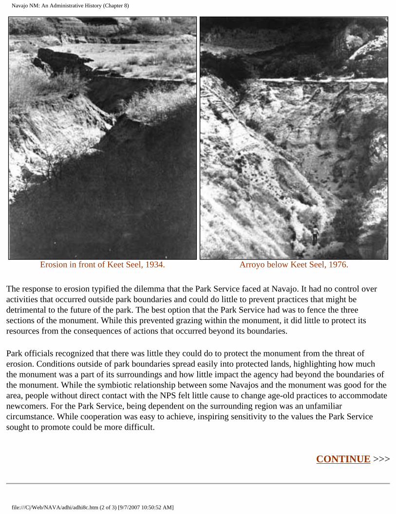
Navajo NM: An Administrative History (Chapter 8)
Erosion in front of Keet Seel, 1934.
Arroyo below Keet Seel, 1976.
The response to erosion typified the dilemma that the Park Service faced at Navajo. It had no control over activities that occurred outside park boundaries and could do little to prevent practices that might be detrimental to the future of the park. The best option that the Park Service had was to fence the three sections of the monument. While this prevented grazing within the monument, it did little to protect its resources from the consequences of actions that occurred beyond its boundaries.
Park officials recognized that there was little they could do to protect the monument from the threat of erosion. Conditions outside of park boundaries spread easily into protected lands, highlighting how much the monument was a part of its surroundings and how little impact the agency had beyond the boundaries of the monument. While the symbiotic relationship between some Navajos and the monument was good for the area, people without direct contact with the NPS felt little cause to change age-old practices to accommodate newcomers. For the Park Service, being dependent on the surrounding region was an unfamiliar circumstance. While cooperation was easy to achieve, inspiring sensitivity to the values the Park Service sought to promote could be more difficult.
CONTINUE >>>
file:///C|/Web/NAVA/adhi/adhi8c.htm (2 of 3) [9/7/2007 10:50:52 AM]
Navajo NM: An Administrative History (Chapter 8)
nava/adhi/adhi8c.htm Last Updated: 22-Jan-2001
file:///C|/Web/NAVA/adhi/adhi8c.htm (3 of 3) [9/7/2007 10:50:52 AM]
Navajo NM: An Administrative History (Chapter 8)
Navajo
Administrative History
CHAPTER VIII: THREATS TO THE PARK (continued)
Other natural resource management issues faced the monument. Although in essence, the monument was a biogeographic island, too small to sustain diversity without similar programs of management on surrounding land, there were unique natural features of the monument that merited saving. Two among the threatened species, Navajo Sedge (Carex Specuicola), a plant growing in the cracks of the canyon walls, and the Mexican subspecies of the Spotted Owl (Strix Occidentalis Lucida) were the subject of programs. In both cases, the research to support the program came from interested people outside the agency, suggesting a pattern of reaction in natural resource management at Navajo.
The interests and objectives of the Navajo Nation could also pose a threat to the values the NPS sought to protect. The prospect of a dam at the mouth of Tsegi Canyon with a permanent pool of 4,500 surface acres that would back into the Tsegi Tribal Park provided one example. The consequences of a human-made lake surrounding Betatakin and Keet Seel were vast. The increase in humidity from evaporation had the potential to accelerate the disintegration of surface ruins. Even informal discussion of such a proposal merited Park Service attention. [23]
But perhaps the greatest threat to the monument in the late 1980s and early 1990s was the lack of funding available for park programs. Higher visitation totals assured greater exposure in the 1980s, and the number of people who came up the approach road continued to grow. For Navajo National Monument, popularity had always been a mixed blessing. Visitors meant attention and support, but they also intruded on a delicate physical and archeological environment. In the fragile Tsegi area, even footsteps left a persistent imprint.
The pattern of underfunding was not new. Until MISSION 66, Navajo National Monument had largely been ignored by the Park Service. In the 1970s, when Frank Hastings arrived as superintendent, he found the perennial dilemma of funding to be his first and primary concern. Increases in visitation made funding for seasonals insufficient even before it was received, and during his tenure, the park received a steady but slow increase in outlay for ruins maintenance. Yet Hastings recalled, "it took a concentrated effort by the division chiefs and myself to increase funding to a reasonable level." [24]
file:///C|/Web/NAVA/adhi/adhi8d.htm (1 of 3) [9/7/2007 10:50:54 AM]
Navajo NM: An Administrative History (Chapter 8)
During the 1980s, little occurred to alleviate the strain on the budget. Superintendents Miller and Gorman found themselves facing increasing demand for services with relatively constant staff and funding levels. New programs were nearly impossible to initiate for a lack of resources, and in some cases, existing programs were scrutinized to see if there was any room for further cuts. Over time, this eroded morale and made the park staff feel increasingly beleaguered.
The realities of the 1990s suggested that the situation would worsen significantly before it got better. In the aftermath of the savings and loan scandals and with a federal budget deficit approaching $300 billion, nearly every federal agency expected to be asked to do more with less. Navajo National Monument faced a more difficult reality than many park areas. Never developed with the emphasis on comprehensive visitor service characteristic of the major national parks and monuments, Navajo lacked a self-contained, self-supporting infrastructure capable of weathering an extended era of limited funding. It was as dependent on the Navajo reservation that surrounded it as was the reverse, and its position remained as precarious as it had ever been. Growing interest in Indians and cultural resources meant that the stream of visitors would continue to increase at precisely the time that the ability to serve them remained constant or in the most extreme of circumstances, decreased.
Growth compelled new arrangements, particularly with area Navajo people. Protection of three unconnected areas in a time of increasing traffic meant either greater vigilance or more complex arrangements with local landholders. The Memorandum of Agreement had been an interim step that over time had become a permanent agreement. It formalized a relationship appropriate for the 1960s, but at the dawn of the 1990s, NPS officials expected that it would require revision. Local Navajos were an important influence on the monument. Closer working arrangements could provide one answer to some of the problems of the monument.
At the dawn of the 1990s, Navajo National Monument faced a difficult situation likely to become more so. Individually, the threats to the park were not considered grave, but cumulatively they represented an obstacle to the fulfillment of the paradoxical preservation/use mandate of the Park Service. Park managers faced the problem of balancing greater demands and pressures with relatively constant levels of resources in an environment in which the Park Service lacked control of its destiny. By 1990, Navajo National Monument had become an island under stress.
The historic situation of the monument had changed. It was no longer isolated, protected by its remote nature and a difficult approach. The problems of Navajo National Monument were those of the rest of the park system, but the small size of the monument and its comparatively low visitation totals limited the support it received from agency coffers. Management of the monument was complicated by the logistical realities of the administration of three unconnected areas. The monument had nearly three times the protection needs of similar areas, but a similar level of resources for such duties. At Navajo, the Park Service was spread more thinly than at other similar areas.
This set of issues loomed large. In the 1990s, Navajo National Monument would continue to become more accessible. The leadership of the Park Service recognized that it could not rely on the remote
file:///C|/Web/NAVA/adhi/adhi8d.htm (2 of 3) [9/7/2007 10:50:54 AM]
Navajo NM: An Administrative History (Chapter 8)
nature of the park to protect it from depredation. As the number of visitors in the Southwest grows, visitors to the monument will also increase. Managing the impact of those people and the growth of extractive and industrial development on the reservation will play a major role in the future of the monument.
<<< CHAPTER 7 TABLE OF CONTENTS
nava/adhi/adhi8d.htm Last Updated: 22-Jan-2001
file:///C|/Web/NAVA/adhi/adhi8d.htm (3 of 3) [9/7/2007 10:50:54 AM]