naval recommendations for dma's prototype tactical terrain ... · naval recommendations for...
TRANSCRIPT

SP 019:351:89 July 1989
Naval Recommendations for DMA'sPrototype Tactical Terrain DataSponsored by the Oceanographer of the Navy, CNO OP-096
John L. BreckenridgeJames E. BraudMapping, Charting, and Geodesy Division
Ocean Science Directorate j'' '" ' V
Approved for public ikca.c, distribution is unlimited
Naval Ocean Research and Development ActivityStennis Space Center, Mississippi 39529-5004
89 11 07 065

Naval Recommendations for DMA's
Prototype Tactical Terrain Data (TTD)
Table of Contents:
I. Executive Summary ........................................ 1
II. Background Information ................................... 1
III. Test-Bed Environment ................................... 2Program NamePoints of ContactHardware/Software DescriptionLevel of Effort
IV. Description of Target Systems ........................... 3
V. Major Evaluation Aspects ................................. 3AccuracyResolutionContentStructure
VI. Applications ............................................. 9Intended UsesApplications Matrix
VII. Transformations ......................................... 10
VIII. Concerns ................................................ 10
IX. Recommendations ......................................... 11
X. Phase II Evaluation ..................................... 11
XI. Conclusion .............................................. 12
XII. Appendix A .............................................. 13
Accession For
NTIS G2A:I
Just ific-t lon
ByDi str 5 1it A onl/__
AvailnbIlity Codes
Awil and/or
iio
Naval Recommendations for DMA'sPrototype Tactical Terrain Data (TTD)
Executive Summary:
The Tactical Terrain Data (TTD) will be utilized by the U. S. Navyand the U. S. Marine Corps to support various tactical terrainsystems and applications, including Mission Planning for StrikeWarfare, Amphibious Area Land Management, Communications fcrCommand and Control, Intelligence Data Fusion, and Maneuvering andFire Support for Command and Control. The Marine Corps will dependdirectly upon TTD for enhancement of intelligence information tosupport battlefield operations. The Navy will utilize the TTD forsupport of amphibious and near-shore operations, as well asfacilities engineering and management.
The Navy and the Marine Corps are committed to using TTD in supportof naval operations involving amphibious and near-shore tacticalsupport. The capability of this data to provide reliable digitalterrain information in a format that is usable for naval operationsdepends greatly upon the Navy's ability to define its long-rangeterrain data requirements. This naval evaluation of TTD is intendedto specify these requirements, to identify deficiencies within theprototype product, and to make formal recommendations to theDefense Mapping Agency -ADMA+-on data product improvements, whichwill ensure optimum support of naval requirements. This reportconcentrates upon examination of the TTD for its data content,accuracy, resolution, and structure with reference to statedNavy/Marine Corps digital terrain information requirements. TheNavy's evaluation of TTD is being conducted by the Naval DigitalMapping, Charting, and Geodesy Analysis Program (DMAP) located atthe Naval Ocean Research and Development Activity (NORDA), and issponsored by the Oceanographer of the Navy, Chief of NavalOperations, CNO OP-096 under PE 63704N Project R1987. This paperhas been approved for public release.
Background Information :
The Naval DMAP is conducting its examination of the TacticalTerrain Data within two phases of evaluation. Phase I has beencompleted and was designed to identify Navy and Marine Corpsrequirements for TTD, and to manually examine the initial TTD dataspecification. Phase II is intended to concentrate more onutilizing digital analysis techniques to determine TTD'seffectiveness at addressirg the applications identified withinPhase I. Phase I of the Naval DMAP evaluation was begun in October1988 with an initial review of the prototype product specification.Recommendations were presented to U. S. Army Engineer TopographicLaboratories (ETL) in an interim report submitted in January 1989.

The primary purpose of the phase I evaluation was to familiarizeNaval Commands with the TTD data set and to assist them inidentifying their long-term requirements for digital terraininformation (DTI). The results of this phase I evaluation indicatedthat the Navy and the Marine Corps do have substantial requirementsfor DTI and that the TTD prototype demonstrates an adequate levelof support for these information requirements. Although DMAP'sPhase II evaluation began in January 1989, no major digitalmanipulation of TTD by DMAP has occurred. At present, DMAP iscompleting efforts to implement TTD within NORDA computerenvironments and will begin an in-depth technical digitalevaluation of the data set as soon as these efforts are completed.The Naval DMAP has acquired both the Geographic ResourcesInformation Support System (GRASS) and Air Land BattlefieldEnvironment System (ALBE) Geographic Information System (GIS)packages to support these efforts.
Test-Bed Environment:
Program NameNaval Digital Mapping, Charting and Geodesy AnalysisProgram (DMAP)
Assisted by:Naval Civil Engineering Laboratory (NCEL)Port Hueneme, California
U. S. Marine Corps Research and Development AcquisitionCommand (MCRDAC)Quantico, Virginia
Points of ContactJohn BreckenridgeNORDA Code 351Stennis Space Center, MS 39529-5004Ph. (601) 688-5224, AV 485-5224
Karol M. ScottTim MinorNCEL Code L74Port Hueneme, CA 93043Ph. (805) 982-3115, AV 360-3115
CWO-4 Anthony MontoyaMCRDACQuantico, VA 22134Ph. (703) 640-268i, AV 278-25E!
2

Hardware/Software DescriptionVAX 11/780-VMS 4.7Tektronix 4208 Graphics MonitorsAir Land Battlefield Environment System (ALBE) software
Macintosh II A/UX-UNIX 1.1E-Machines 1024 x 808 High Resolution MonitorGRASS GIS
Sun 1/360-UnixHigh Resolution Color Graphics MonitorGRASS GIS software
Level of EffortNORDA-One DMAP person, allocated 1/4 man-year
Description of Target Systems:
Amphibious Objective Area Land Management System (AOAMS)Assists in site selection and development, trafficability,and mobility analysis for tactical amphibious operationsCurrently fielded:TTD required by FY92, usable if delivered sooner.
Tactical Intelligence Management System (TIMS) supportsintelligence Data Fusion for tactical combatoperations.Under development (FY 90 operational):TTD by FY 92, usable if delivered sooner.
Other applications:Communications for Command and ControlManeuvering and Fire Support for Command and ControlMission Planning for Strike Warfare
Major Evaluation Aspects:To date, only nonautomated examinations of the TTD data set havebeen conducted by the Naval DMAP. DMAP is currently working tobring the TTD up in three separate environments: Zenith Z-248,Macintosh II/GRASS GIS, and the VAX 11/780/ALBE-MOSS/MAPS GIS.Once operational within these environments, DMAP will continue itsevaluation of TTD relative to Navy and Marine Corps requirementsfor digital terrain information.
AccuracyThe 1:50,000 scale topographic line map (TLM) of Fort Hood, Texas,was used as a collection base in the manual compilation of theprototype data set. Subsequently, all data layers stored within
3

the integrated TTD data set are based upon this scale. Review ofNavy and Marine Corps applications for TTD indicates that theproduct's base scale of 1:50,000 adequately supports most navaloutput requirements for digital terrain information. However,there are specialized applications which could greatly benefit froma higher level of accuracy. These applications includetrafficability and mobility analysis-type operations.
TTD has a stated vertical accuracy of ±20m at 90% linear error toMean Sea Level. This accuracy also appears to be adequate for mostnaval applications of digital terrain information. However, itseems that in the case of applications that rely upon the DigitalTerrain Elevation Data (DTED) Level II data stored within TTD, thevertical accuracy of TTD must be stated in direct relation to thevertical accuracy of the DTF) Level II used within the prototypedata set. DTED Level II has a stated vertical accuracy of +30mwith 90% assurance. This level of vertical accuracy may not befully adequate in relation to the stated applications.
Horizontal accuracy for TTD is stated as +50m at 90% circularerror. This accuracy adequately supports most applications ofdigital terrain analysis, including trafficability, mobilityanalysis, and site selection. For some applications of firesupport and targeting information, greater accuracies could proveto be of benefit. At present the Navy and the Marine Corps havenot identified any TTD applications that would require a horizontalaccuracy greater than +50m. Targeting and fire supportapplications, which require a greater level of accuracy, would relyupon other data sets designed to directly support theseapplications.
Resolution
The data density of TTD varies with the actual density of depictedfeatures. Normally the resolution is comparable to that portrayedat 1:50,000 scale on topographic line maps, terrain analysis factoroverlays, and combat charts that are digitized to comprise the TTDfeature information. Since much of the data stored within TTD iscenter-line, both the presence and absence of information must beconsidered to comprise the overall data resolution. Thus, theresolution of the DTED Level II information can be used toillustrate the overall resolution of TTD. If used as rasterinformation, TTD can be displayed at DTED Level II-type resolutionsof 30m. However, this type of rasterization of the data baseeliminates the usefulness of the MiniTopo data structure and maynot be appropriate for some applications. These types of dataoperations are discussed further within the data structures sectionof this report. At present, the current resolution of the TTDfeature data sets seems to be sufficient for naval applications.
4

Content
The Tactical Terrain Data contains three-dimensional feature datathat depicts the elevation, or "z" values, of the individualfeatures. In addition to a DTED Level II data cell, whichaccompanies each data file, TTD consists of eight individuallydigitized feature layers that include surface configuration(slope), surface materials, vegetation, obstacles, specialfeatures, transportation, surface drainage, and urban areas. Thesedata layers are then combined to form an integrated TTD data set.The content level of TTD must be reviewed on an individualapplication basis to determine if the feature data contained withinTTD is adequate to support Navy and Marine Corps requirements. Indoing so DMAP has determined that the TTD data content is adequateto meet the base-line requirements of support to all presentlyidentified naval applications. It is noted that amphibiousapplications would be better served by TTD that contains bothshoreline and shallow water bathymetry data. DMAP also notes thatthe content of TTD is further facilitated by the option of value-added data that can be input at the user level.
Navy's primary concerns for TTD data content currently lie withinthe area of the Feature Attribute Coding Standard (FACS). Atpresent, the FACS does not adequately support the definition ofbeachfront and shoreline characteristics. Although the Navy hasemphasized this requirement for some time, it has also experiencedsome difficulty in reaching agreement as to how these featuresshould be entered into a digital format. One commonly accepteddefinition for these features is as follows. Beaches can bedivided into three major regions: nearshore, foreshore, andbackshore (Schwartz, Maurice L., Encyclopedia of Beaches andCoastal Environments, Hutchinson Ross Publishing Co., Stroudsburg,PA, 1982, pp. 528-529). In addition to the lack of an adequatedefinition for shoreline, the FACS also does not support theadequate representation of other coastal features, such as a berm,beach ridge, and washover fan. In order for the TTD to adequatelydisplay coastal zone information to support tactical amphibiousnaval operations, the FACS must be updated to support thisinformation.
In addition to the lack of beach information, the location of thecurrent TTD prototype does not offer a true representation ofdigital tactical terrain information encountered in tacticalamphibious naval operations. The lack of coastal features withinthe Fort Hood area leaves a serious void in the prototype dataset's capability for fully demonstrating digital terrain dataanalysis requirements of the Navy.
In review of the overall content of TTD relative to navalapplications, the Naval DMAP submitted the TTD Content OverviewMatrix (Micro Level), developed by U. S. Army ETL, to each
5

evaluation participant. All TTD data themes were found to havesome naval significance. The following comments are included tofurther describe the significance of the data content of TTD andto emphasize that these elements should remain in the data set.
Slope: Slope Polygon Ranges of >15 and < or = 98% are usefulin determining cross-country mobility models. Although thisinformation is excessive from the naval civil engineeringstandpoint, it is viewed as significant to mobility analysisand troop-movement scenarios.
Surface Material: Tree spacing and predominant vegetationheight ranges are critical to tactical terrain operations.The greater precision data currently available in TTD willsupport mobility models and more intense visibility and line-of-sight models.
Surface Drainage: Needed for trafficability models
Vegetation: Data specifying vegetation type, ground coverand obstacles are significant to trafficability models.
Transportation: Road conditions and categories furthersupport trafficability analyses. Load classes are alsosignificant to mobility models.
Obstacles: Significant utility for cross-country mobilityanalysis.
Urban Areas: Significant utility for mission planning.
Special Features: Many features within aircraft facilitiesseem to be redundant (i.e., helipad). Many urban specialfeatures (i.e., drive-in theater, parking lot, etc.) can beuseful for tactical operations, such as a helipad. Thisinformation is good to have and should be maintained.
Structure
Integrated/Non-integrated TTD Product Justification: The useof an integrated TTD product will require a substantial amount ofoverhead for data handling and processing operations within mostnaval applications. All applications currently identified by Navyand Marine Corps utilize specialized software and data processingsubsystems that are not designed to handle the intensity orcomplexity of spatial data provided within the integrated versionof TTD. In addition, public domain GIS software currently beingused to support naval applications is oriented to handling spatialdata on a thematic basis. Many of the query routines within thesesystems are designed to extract information relative to the mannerin which that particular system has overlayed the data, and furthersupport merging the data layers within a data handling subsystem.
6
The delivery of TTD as an integrated data set will most oftenrestrict the way in which these systems can utilize the terraininformation.
In addition, many naval applications utilize a low-end computerenvironment (i. e., IBM AT compatible) for their operationalplatform. The integration of this data set would also placeadditional time and memory constraints on these systems. In manyinstances, the applications may require a minimal level of supportfrom TTD, and the overhead of handling the integrated data wouldthus require substantial transformation of the TTD data set to meetthese system requirements. In most system scenarios, only a fewof the eight TTD data themes may be required to produce a desiredoutput product. By providing the TTD within the non-integratedformat, the user will be able to more readily extract only theinformation with which he is directly concerned.
MiniTopo: Advantages/Disadvantages - The Naval DMAP hasreviewed the data structure specifications for TTD to determineits ability to adequately support naval processing of digitalterrain information. The MiniTopo data structure is designed toserve as DMA's internal data structure for transferringcartographic and digital spatial information within the Mark 90production environment. Some features of the structure may not beadvantageous to a spatial data analysis environment. DMAP'sevaluation of the TTD data structure examines factors relative todata's storage, spatial relationships or topology, and dataexchange formats. Each of these factors are examined below.
Data storage: A spatial data structure must be capable ofstoring both descriptive and geometric cartographic information.The MiniTopo appears to offer an effective means of doing so.Although some elements appear redundant, the overall structureoffers a systematic approach to handling both of these elements.
Topology: An important concept to maintain within thestructure is the capability to selectively utilize the topologywithin the structure. Most naval systems currently do not have thesoftware capability to handle these items. Designing the datastructure in a manner that allows these elements to be easilystripped off facilitates the data's use within these systems, aswell as more complex, topologically oriented GIS environments.
Digital Exchange Standard: The development of digitalcartographic data standards is viewed by many as an effective meansof enhancing the capability of geographic information systems andspecialized tactical information systems to share and utilize themyriad digital data resources available. Through attribute coding-standards and common topological data structures, these systems areable to exchange data in a form that is more readily manageable.The use of these standards in conjunction with digital media
7

standards, such as those for the Compact Disk-Read Only Memory (CD-ROM), offers substantially improved methods of exchanging digitalMapping Charting & Geodesy information.
The Naval DMAP recognizes substantial benefit in the developmentof these standards and applauds the efforts of such groups as theFederal Interagency Coordinating Committee on Digital Cartography(FICCDC) and the National Committee on Digital Cartographic DataStandards (NCDCDS) for encouraging their standards development.However, it is also recognized that the overall benefits to boththe data producer and user must be weighed when determining thefeasibility of using these standards.
The TTD prototype and future production versions of the data setare being delivered within the constraints of the ISO-8211 andSpatial Data Transfer Specification (SDTS). Together, thesedescriptive specifications are designed to offer a concise andimproved mechanism of transferring digital spatial data betweencomput-r system environments of differing types. In its entirety,this exchange mechanism is designed to provide an environment inwhich digital data can be fully described and formatted with recordidentifiers and tagged field delimiters. This mechanism shouldgreatly benefit the data recipient who may have very limitedknowledge of the characteristics of a transferred data set. TheIS0-8211 and SDTS are intended to provide this flexibility of datatransfer by offering a way to readily describe the individualcartographic and spatial features of a digital data set. Theintent of this data specification is to provide the data recipientswith a "dictionary" that describes the features and informationbeing transferred to them, thus improving the usability of thisdata and eliminating most of the need for additional contact withthe data sender.
Although the intended concepts of ISO-8211 are commendable, theNaval DMAP has recognized no substantial benefits to the DoD usercommunity from DMA's use of these transfer specifications indelivering the TTD prototype. In fact, its use within this contextappears to intensify the work required by the data recipient priorto actually utilizing the data product. Two primary factors haveadversely influenced DMAP's attitude on delivering TTD within theconstraints of ISO-8211:
A complete specification of the data product isalready provided by DMA and is designed to fully describethe data elements and structure of the data, and
Current use of ISO-8211 does not support direct accessof the data and, in fact, sacrifices the optimum use ofCD-ROM digital transfer media.
The present use of ISO-8211 for delivering TTD requires that the
data user become knowledgeable of both the prototype data
8

specification and ISO-8211/SDTS: When the data set is importedfrom the ISO-8211 environment, the data are not restored to theiroriginal form, so the user must decide either to utilize theadditional information provided by the transfer specification, orto develop additional input software that removes this extrainformation: only then can the data be accessed according to theoriginal data specification. In its current form, the use of ISO-8211 eliminates the CD-ROM as a direct access media. Since theIS0-8211 data files must be imported using a routine that writesa new data file, the user is forced to use other storage media tohold the imported data files. For many low-end systems, i.e.,Zenith Z-248, this represents a tremendous waste of this media.
An additional frustration of the current prototype is that the dataare delivered entirely as ALCII character data. Although thisfeature may improve the user's visualization of the data, it isconsiderably more demanding of bcth storage space and i/oprocessing than the transfer of binary data files. If IS0/8211were used to transfer a highly compressed, very difficult to readdata format, it would have some redeeming qualities. All of thecurrent DMA databases are being developed with ease of readabilityand data transfer as an important factor and have already greatlysacrificed efficiency in terms of storage space, ease of directuse, and speed of access.
Applications:
Intended UsesAs indicated, TTD will serve the U. S. Navy and the U. S. MarineCorps as a tactical planning data base in support of navalamphibious operations. The intended uses of TTD within navalapplications will be to provide mission planning and operationalsupport to naval forces in executing amphibious warfare operations.TTD will support naval command, in determining optimum landingzones for tactical amphibious landings, and will be used to planand implement tactical naval warfare strategies for operations forbeach zones and terrain within 3-5 km range of a amphibious beach-landing zone. It is feasible that TTD could be installed on navalvessels and within marine command posts to develop and supporttactical decision aids for all phases of naval amphibious warfare.
The type of system and hardware that will utilize the TTD may varyconsiderably depending upon its intended use and output. Mostsystems will not fully utilize the entire TTD data set; however,it is expected that a limited tactical amphibious GIS will beestablished to take advantage of the myriad information storedwithin TTD.
9

Applications MatrixAttachment 1, Naval TTD Applications Matrix, was developed usingresponses from NCEL and MCRDAC representatives.
Transformations:
At present, no specific transformations have been identified asnecessary for any Navy or Marine Corps systems to utilize the TTD.This identification will be a focus of DMAP's Phase II TTDevaluation. However, MCRDAC has identified the potential for somedata transformations to support specialized systems. Thesepotential transformations are not identifiable at this time, butare expected to become more apparent as MCRDAC uses the prototypemore extensively. Transformations will remain a major focus ofDMAP's continued evaluation and use of the TTD.
Concerns:
The Naval DMAP has direct concerns over the use of ISO-8211 as theexchange mechanism for TTD. Given our past experiences with thistransfer specification, we feel that in its current form ISO-8211is an inappropriate mechanism in which to deliver the TTD data setto the end user. It is understood that DMA has elected thisenvironment as an internal exchange format to accompany its Mark90 internal data structure, MiniTopo. DMAP recognizes theadvantages such a transfer specification can provide to a large-scale data production facility; however, it is felt the end-userrequirements should be the driving force in determining how DMAdata bases are to be transferred.
An additional concern in using any transfer mechanism that doesnot support direct access of TTD according to its original dataspecification is that the CD-ROM media loses its potential as anon-line direct access media. Data provision within its originalstructure, i. e., MiniTopo, would provide an excellent means ofutilizing this large capacity media for direct access.Additionally, the current practice of transferring TTD within anASCII character format, as opposed to a binary data format,increases the amount of storage required for the data. Since theASCII format is intended to facilitate visualization of the datafile, ASCII dump routines could be included with a binary data setto eliminate a sizable portion of the data file size. Directorystructures and programs to access the data directly in its binaryor compressed format would be more beneficial to the DoD user thanthe use of ISO-8211.
The TTD data set is an extremely large data base. The integratedprototype alone comprises over 40 megabytes of storage for ageographic area of 15 minutes latitude x 15 minutes longitude.
10

Many TTD applications could require data sets that cover muchgreater areas. The current size will be a continued limitation tohow big an area of interest an application system can work with ata given time. The use of data compression routines similar tothose being utilized for the World Vector Shoreline and otherstandard data products could assist in greatly decreasing the sizeof a TTD data set.
DMAP also recognizes many potential end-user difficulties in usingthe TTD as an integrated data set. The use of a compressed dataset, and the provision of indexing and read routines to access onlythe desired features might eliminate many of the problemsencountered with using the integrated data set. The advantages ofan integrated data set would not be fully utilized by the majorityof DoD systems, and would most often force users to develop work-around software that would be both time and resource consuming.The provision of non-integrated separate data layers offers theuser more direct access to feature information by subject. Sincecurrent public domain GIS software utilizes this approach oflayering spatial data, the non-integrated TTD is more readilyusable within these requirements.
Recommendations:
1) The Naval DMAP recommends that DMA conduct an in-depthevaluation of the feasibility of transferring TTD within the ISO-8211 exchange specification. This evaluation should examine thebenefits and disadvantages such a transfer mechanism offers to thegeneral DoD user. If transfer continues in its present form, DMAPrecommends that subsequent prototype and production data setsinclude a copy of the original non-ISO-8211 data files or genericsoftware routines which allow the user to recover the data to itsoriginal specification form. This latter option was recentlyutilized in the delivery of a World Vector Shoreline Prototype andhas proven to be of great value to naval applications.
2) DMAP recommends that DMA investigate methods of data compressionof the TTD to facilitate data handling and access. Many navalapplications for TTD will utilize a low-end platform, i. e., Z-248,and will be severely limited by TTD's current size. Use ofcompression routines to decrease file sizes would support increasedaccess times, as well as other data handling operations. Inaddition, an examination of the benefits of transferring TTD asbinary data could further support the optimization of this product.
3) DMAP recommends that DMA deliver the TTD in the non-integratedformat to facilitate user access of the data by decreasing theamount of overhead data the user is required to handle. Currently,no naval systems are capable of utilizing the integrated data, andall applications would require development of additional querysoftware to either bypass or make use of this integration.
11

Phase II Evaluation:
The Naval DMAP will continue its evaluation of the TTD prototypethroughout Phase II of ETL's evaluation process. DMAP will workclosely with other Navy Laboratories and U. S. Marine Corps toinsure that full Naval requirements for this tactical data productare fully identified and properly addressed.
DMAP support will be provided to this effort through continuedparticipation in Technical Exchange Meetings and DoD symposia, i.e., DMASC Symposium. DMAP will continue to implement TTD withinNORDA's specified computer environments and will also offerassistance to the Marine Corps and Navy Labs who utilize the data.Once the data are implemented within these environments, DMAP willassist MCRDAC and NCEL in determining the TTD capability formeeting naval digital terrain information requirements. DMAP willdevelop visual demonstration routines that show ways to use TTDfor naval applications and to aid in determining its effectivenessand deficiencies. These routines will be made available to otherlabs and to DMA's Warrior Support Center to further publicize navalrequirements of the TTD.
Conclusion:
The U. S. Navy and the U. S. Marine Corps are dedicated toutilizing the TTD in support of naval requirements for digitalterrain information. The coordinated development and evaluationof this standard digital MC&G product by DMA and the Services isto be commended. This unified approach to evaluating the TTDprototype is providing valuable information necessary to ensure theServices' optimum use of this product. Likewise, the efforts ofthe U. S. Army, ETL, Concepts and Analysis Division to coordinatethe Services' examination of TTD are to be commended. The ideaspresented by these organizations are serving to improve theusability of this product, and to ultimately increase the Services'ability to utilize digital MC&G information to complete theirrespective missions.
The Navy and the Marine Corps have identified and stated directrequirements for the TTD, and have specified improvements neededto increase the products usability for naval terrain analysisapplications. The Naval DMAP believes that the recommendationsmade within this report will greatly improve the Navy'sutilization of this digital product. We fully recognize DMA'smission to provide a TTD product that most closely supports theneeds and requirements of all the services. DMAP will continue tosupport these efforts by insuring that the digital terraininformation needs of the Navy and Marine Corps have been properlyidentified and addressed.
12

Appendix A: TTD Applications Matrix
13
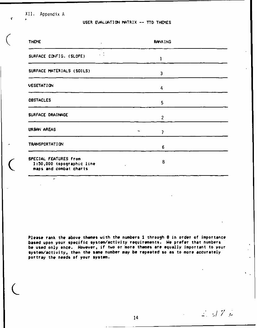
XII. Appendix AUSER EVALUATION MATRIX -- "'D THEMES
THDIE RANKING
SURFACE CONFIG. (SLOPE) 1
SURFACE MATERIALS (SOILS) 3
VEGETATION 4
OBSTACLES 5
SURFACE DRAINAGE 2
URBAN AREAS 7
TRASPORTATION 6
SPECIAL FEATURES from1:50,000 topographic line 8maps and combat charts
Please rank the above themes with the numbers I through 8 in order of importancebased upon your specific system/activity requirements. We prefer that numbersbe used only once. However, if two or more themes are equally important to yoursystem/activity, then the same number may be repeated so as to more accuratelyportray the needs of your system.
14

Form ApprovedREPORT DOCUMENTATION PAGE OMB No. 0704-0188
Public reporting burden tor this collection of information Is estimated to average 1 hour per response, Including the time for reviewing nstnctinns. serchIng existing data sources.gathering and maintaining the data needed, and completing and reviewing the collection o, information. Seno comme.,, regarding this burden estmate or any Other aspect ofthis collection of Information, including suggestions for reducing this burden, to Washington HeadQuaflers Services, Difectorate for Information Operations and Reports. 1215 JeffersonDavis Highway, Suite 1204. Arlington, VA 22202-4302. and to the Office of Management end Budget, Paperwork ReduCtion Project (0704-0188), Washington, DC 20503
1. Agency Use Only (Leave blank). 2. Report Date. 3. Report Type and Dates Covered.
July 1989 _
4. Title and Subtitle. 5. Funding Numbers.
Naval Recommendations for DMA's Prototype Tactical "mram Element No 63704NTerrain Data
Project NO 019876. Author(s). Task No 300J. L. Breckenridge and J. E. Braud
N=,,o o DN257086
7. Performing Organization Name(s) and Address(es). 8. Performing Organization
Naval Ocean Research and Development Activity Report Number.
Ocean Science DirectorateStennis Space Center, Mississippi 39529-5004 SP 019:351:89
9. SponsoringlMontorlng Agency Name(s) and Address(es). 10. SponsoringlMonltoring Agency
Oceanographer of the Navy, (0P-096) Report Number.
Chief of Naval Operations, (0P-096)Washington, DC 20390-1800 SP 019:351:89
11. Supplementary Notes.
12a. Distribution/Availability Statement. 12b. Distribution Code.
Approved for public release; distribution is unlimited.
13. Abstract (Maximurn 200 words).
The Tactical Terrain Data (TTD) will be utilized by the U.S. Navy and theU.S. Marine Corps to support various tactical terrain systems and applications,including Mission Planning for Strike Warfare, Amphibious Area Land Management,Communications for Command and Control, Intelligence Data Fusion, and Maneuver-ing and Fire Support for Command and Control. The Marine Corps will depend directlyupon TTD for enhancement of intelligence information to support battlefieldoperations. The Navy will utilize the TTD for support of amphibious and near-shore operations, as well as facilities engineering and management.
This report concentrates upon examination of the TTD for its data content,accuracy, resolution, and structure with reference to stated Navy/Marine Corpsdigital terrain information requirements.
14. Subject Terms. 15. Number of Pages.
requirements, data bases, mapping, WVS, TTD, ADRG 1716. Price Code.
17. Security Classification 18. Security ClassifiCation 19. Security Classification 20. Limitation of Abstract.
of Report. of This Page. of Abstract.
Unclassified Unclassified Unclassified SARNSN 7540-01-280-5500 Standard Form 296 ile, 2-89,
Pini" tc"ee ANlSI si Z39-i8?9. f02