nc water/sewer geographic data content standard · the original geographic data content standard...
TRANSCRIPT

1
Adopted by the North Carolina
Geographic Information Coordinating Council
December 4, 1997
Geographic Data Content Standard for
Water Distribution Systems and
Sanitary Sewer Systems
VERSION 3.1
State of North Carolina
Center for Geographic Information & Analysis
301 North Wilmington Street, Suite 700
Raleigh, NC 27601-2825
April 1997
Updated September 2011
PREFACE (1997)
The use of geographic information systems (GIS) and related technology to manage vital
information about our communities and regions of the state has clearly become more
commonplace. Perhaps no other recent effort than the development of this document and the
related project to inventory and characterize the water distribution and sanitary sewer systems
in rural North Carolina is testament to the growing use of GIS. Through this project, numerous
elected officials, town managers, and others from non-urban regions of the state have been
exposed to the value of using GIS for managing and understanding large and complex amounts
of detailed information. Many are now beginning to use GIS data to help maintain future safe
drinking water supplies and to develop environmentally responsible waste treatment plans in
hopes to spur or ensure continued economic growth in their communities.
This standard is primarily intended to serve as a specification for the statewide water and sewer
inventory project conducted by the North Carolina Rural Economic Development Center and the
Western Piedmont Council of Governments. It is anticipated that the standard will be used to

2
provide a basis for continued maintenance of the inventory and by others that develop and
manage data about water and sewer infrastructures.
The development of this standard evolved over many months and its content reflects "in the field"
experiences of staff from the Rural Center, McGill & Associates, and the Western Piedmont
Council of Governments. The experiences shared from the field were important and significantly
improved the document from its first draft.
We expect that many will consider and use the standard as developed and we certainly anticipate
that they also will provide their insights and requirements back to us so that subsequent versions
of the document are valuable to the community at large.
Zsolt Nagy,
North Carolina Center for Geographic Information and Analysis
John Soles,
North Carolina Rural Development Council
Rural Economic Development Center, Inc.
Francine Stephenson
North Carolina Office of State Planning
ACKNOWLEDGMENTS (1997)
Many served to launch this initiative and provided feedback on specific aspects of this document.
The following is a list of key project participants the authors wish to recognize.
DeWitt Blackwell, Western Piedmont Council of Governments
Billy Ray Hall, NC Rural Economic Development Center
Kenneth Flowers, NC Rural Development Council
Karen Siderelis, Center for Geographic Information and Analysis
Dana Bolden, McGill & Associates
Faith Hege, Western Piedmont Council of Governments
Mike Williams, Western Piedmont Council of Governments
Neil Thomas, Resource Data, Inc.
David Giordano, Center for Geographic Information and Analysis
Cathy Bock, Rural Economic Development Center, Inc.
Eddie Staley, Hobbs, Upchurch and Associates
Funding and support provided by the
Western Piedmont Council of Governments and the
North Carolina Rural Economic Development Center, Inc.
Research and Demonstration Grants Program.
3
Preface to Update (2011)
The Lumber River Council of Governments led a review of the standard in 2010 and identified
additional or updated attributes for water and sewer systems to reflect current practices in local
facility management, regional planning, and data management. The review team specified
additional data layers that are common in facility management and practical to represent as
geospatial data at larger mapping scales than applied in the 1997 efforts. The review included a
set of recommendations for applying GIS software to add value to datasets. Those
recommendations are contained in a separate document intended to serve as a guide to best
practices in developing geospatial data for water and sewer systems.
North Carolina Center for Geographic Information and Analysis
Tim Johnson, Director
Jeff Brown, Coordination Program Manager
David Giordano, Database Administrator and staff to the Statewide Mapping Advisory
Committee
Acknowledgements (2011)
This update relied on the following key participants and their respective organizations:
Jim Perry, Executive Director, Lumber River Council of Governments
James Armstrong, GIS Director, Richmond County and member of the Statewide Mapping
Advisory Committee
Julie Haigler Cubeta, Senior Director, Physical Infrastructure, NC Rural Economic Development
Center
Anne Payne, Chair, Statewide Mapping Advisory Committee

4
TABLE OF CONTENTS
Section 1: Introduction
Background 5
Objective 5
Geographic Information Coordinating Council 6
NC OneMap 6
Section 2: Content Standards - General
Methodology 7
Document 7
Participants 7
Section 3: Content Standards - Water Distribution Systems
Definition 9
Geometric Representation 10
Geographic Coordinate System, Datum, and Unit of Measurement 10
Annotation 10
Metadata 10
Symbology 11
Attributes 11
Summary of Attributes 11
Definition of Attribute Fields 15
Section 4: Content Standards - Sanitary Sewer Systems
Definition 34
Geometric Representation 35
Geographic Coordinate System, Datum, and Unit of Measurement 35
Annotation 35
Metadata 35
Symbology 35
Attributes 36
Summary of Attributes 36
Definition of Attribute Fields 40
Section 5: Content Standards - Supplementary Owner Information 60
Lists
List 1 - Summary of Water Distribution Systems Attribute Fields 11
List 2 - Summary of Sanitary Sewer Systems Attribute Fields 36
List 3 - Summary of Supplementary System Owner Information 60
Tables
Table 1 - Definitions of Attribute Fields for Water Distribution Systems 15
Table 2 - Definitions of Attribute Fields for Sanitary Sewer Systems 40
Table 3 - Definitions of Attribute Fields for Owners 61
Glossary of Terms 64

5
SECTION 1: INTRODUCTION
Background
The availability of safe drinking water supplies and the ability to economically treat, process,
sanitize, and return treated sewerage into the state's rivers and lakes are critical issues for citizens
of North Carolina as we approach the next millennium. Thorough knowledge about the location,
condition, and capacity of water distribution and sanitary sewer systems and information about
the projected need for these systems throughout the state is vital. Federal, state and local
officials, planners, and engineers are in need of reliable and comprehensive information that can
be used to manage the current infrastructure and plan for the future.
In response to this need, the Rural Economic Development Center conducted a detailed
inventory of all water and sewer systems in North Carolina and an assessment of needs for
expansion and development of new systems (late 1990s). Information collected in that project
has been stored and maintained in the North Carolina OneMap Database, a collection of strategic
geographic information.
Two agencies, the Western Piedmont Council of Government, and the North Carolina Rural
Economic Development Center, agreed to cooperate with the North Carolina Center for
Geographic Information and Analysis (CGIA) on the development of this water distribution and
sanitary sewer systems geographic data content standard. This document was used in the project
as the data content specifications for the statewide geographic data layer on water and sewer
systems.
The information is accessible through the use of geographic information systems technology.
Geographic information systems (GIS) are now widely used by public and private organizations
to manage information, analyze, predict, and assist with human and natural activities on the
earth. GIS is now being used by all 100 counties in North Carolina, as well as lead regional
organizations, state departments, federal organizations, and private businesses and utilities.
Since the 1990s, mapping of water and sewer projects is much more common by municipalities
and counties and their service providers. In addition, a second statewide project by the Rural
Economic Development Center, Water 2030, completed in 2007, developed a statewide
representation of service areas (not facilities) that was consistent with this set of standards.
Additional data items collected for water and sewer systems for Water 2030, beyond items in this
set of standards, are included in a best practices document.
Objective
The objective of this effort is to develop a geographic data content standard for use in the
development of a statewide geographic dataset for water distribution and sanitary sewer systems
in rural North Carolina. With the guidance and oversight of the Geographic Information
Coordinating Council, North Carolina has implemented a strategic plan to guide the growth of

6
geographic information systems, geographic information, and related technologies. An
important aspect of the strategic plan is the development of data and technology standards.
The original geographic data content standard was intended to be the basis for the development
of a statewide data layer, as a component of the NC OneMap Database, for water distribution and
sanitary sewer systems. The updated standard adds facility detail intended to enhance water and
sewer asset management. The standard is intended to represent the minimum requirements of
data content for all organizations planning, building, and/or maintaining geographic data about
water distribution and sanitary sewer systems. The fields specified in this standard enable visual
display and analysis of patterns within local systems and across systems. Additional fields
related to costs, contractors, facility conditions, and system maintenance, though not specified in
the standard, would add value to a database linked to mapped facilities. Modern database
software enables multiple related tables that may be linked to map features by a unique identifier.
Geographic Information Coordinating Council
Established by Executive Order Number 16 in May 1993 and mandated by the General
Assembly in 2001 (North Carolina General Statutes Article 76, Sections 143-735 through 143-
727), the North Carolina Geographic Information Coordinating Council (GICC) is responsible
for the oversight and cost-effective development, management, and utilization of geographic
information, geographic information systems and other related technologies in the state. The
GICC is specifically responsible for (a) strategic planning, (b) resolution of policy and
technology issues, (c) coordination, direction and oversight, and (d) advising the Governor and
the Legislature as to the needed directions, responsibilities, and funding regarding geographic
information.
Statewide initiatives to coordinate the growth and use of geographic information systems and the
sharing of geospatial data involves the cooperation of state, federal, and local government
agencies; academic institutions; and the private sector. Initiatives are intended to improve the
quality, access, and utility of North Carolina's geographic information and to promote
geographic information as a strategic resource in the state.
NC OneMap Database
The NC OneMap Database is a statewide strategic resource containing an abundant supply of
information about North Carolina. For example, the content of the NC OneMap Database
includes information about North Carolina's cultural resources, surface waters, topography,
jurisdictional boundaries, environmental regulations, land cover, streets and highways,
demographics, and natural resources. Each category of data is geo-referenced, described, and
managed in data layers and online services. The data layers and services are produced,
maintained, accessed, distributed, hosted, and otherwise used by government and private
organizations for a number of purposes. Water and sewer datasets are among the priorities for
the GICC and NC OneMap. See www.nconemap.com for more information.

7
SECTION 2: Content Standards
Methodology (1997) Development of the data content standard has occurred in several phases.
Phase one activity consisted of an assessment of information needs through an informal survey
and through two facilitated workshops. Information needs were identified by a variety of
potential data users, including public officials, resource managers, and professional engineers.
Phase two activity consisted of the collection and assessment of other water and sewer systems
standards and an assessment of existing geographic data files containing features pertaining to
water and sewer systems. Phase three activity was an implementation of the standard by two
organizations in the state. The working content standard was used in the development of
geographic data files by the Rural Economic Development Center and the Western Piedmont
Council of Government. Reaction to the standard in the field by both organizations was an
important aspect of the development and refinement of the document.
An update phase occurred in 2010, led by the Lumber River Council of Governments, the NC
Rural Economic Development Center, Richmond County, the Statewide Mapping Advisory
Committee, the Local Government Committee, and a utilities working group. The purpose of
this effort was to update the standard to be consistent with current mapping needs and to
supplement the standard with recommended practices that take advantage of current technology.
Document (1997) This document was prepared under a research and demonstration grant provided to the Western
Piedmont Council of Governments by the Rural Economic Development Center, Inc. in support
of the collaborative efforts with the NC Rural Development Council, the US Department of
Agriculture, and the Office of the Governor's "NC Water and Sewer Inventory and Needs
Assessment Project."
The document has been prepared for immediate use by all organizations that plan to implement
digital geographic water and sewer inventory projects in the state. This document was revised in
2011 with the intention of making the standard consistent with current geospatial data
development needs.
Participants (1997) An advisory committee consisting of state, regional, and local representatives familiar with the
delivery and management of water and sanitary sewer systems were assembled for two
information requirement sessions. The advisory committee also included several members who
were very familiar with the operations and management of data using geographic information
systems and related technologies.
Advisory Committee Members (1997) E.H. Alexander, REDC Board of Directors, Infrastructure Committee
E. Lee Armour, Centralina Council of Governments
DeWitt Blackwell, Western Piedmont Council of Governments
Bobby Blowe, NC Division of Environmental Management
Steven Dear, NC Rural Assistance Project, Inc.
Bill Gibson, Southwestern NC Planning and Economic Development Commission

8
Ronald Goswick, Kerr-Tar Regional Council
Wayne Jenkins, Northampton County Public Works
Buck Kennedy, The Wooten Company
Al Leonard, Town of Tabor City
Herman Little, Anson County Commissioner
Rose Ann Mack, Cape Fear Council of Governments
Gary McGill, McGill Associates, P.A.
David Muse, City of New Bern
Lynn Norton, Alexander Water Corporation
Jerry Perkins, NC Division of Environmental Health
Ed Regan, NC Association of County Commissioners
Bob Schley, NC Rural Water Association
Edgar R. Shuller, NC Department of Transportation
Karen Siderelis, NC Center for Geographic Information and Analysis
Paula Thomas, NC League of Municipalities
Bobby White, Burke County
Zettie Williams, Duplin County Commissioner
Participants in the 2011 Update to the Standard
Lumber River Council of Governments
The NC Rural Economic Development Center
Local Government Committee (LGC)
Statewide Mapping Advisory Committee (SMAC)
Anne Payne, Chair, Wake County
Utilities Working Group:
Chris Butts, Moore County
Jeff Cooke, City of Goldsboro
Ray Kurtiak, City of Gastonia
Rob Bailey, City of Charlotte
Mike Mull, Town of Cary
Sarah Sheldon, Town of Wake Forest
Kathryn Brewer, MSD of Buncombe County
Trey Cleaton, City of Salisbury
James Armstrong, Richmond County
NC Center for Geographic Information and Analysis (CGIA)
CGIA received helpful comments on draft revisions from SMAC members as well as
Julie Haigler Cubeta of the NC Rural Economic Development Center, Bliss Kite of the
NC Public Utilities Commission, Jessica Godreau of the NC Public Water Supply
Section, and Wayne Francisco, GHD.

9
SECTION 3: Content Standard - Water Distribution
Systems
Definition The Water Distribution Systems (WDS) dataset includes information about the primary facilities,
mechanical components, and distribution lines that serve as a delivery system for drinking water.
The WDS dataset includes a delineation of the service area boundary of each water distribution
system. It also contains features of the locations of important mechanical components for the
delivery of drinking water from a drinking water supply source to the curbside valve for
customers in the system. The database contains attributes that describe all or portions of each
component of the system.
Three types of water distribution systems exist for the digital water distribution system
inventory: Type A, Type B, and Type P. Type A systems are generally considered large systems
and are represented in the dataset as a service area with a variety of components. The
components included in Type A systems are: water distribution pipes, groundwater wells, surface
water intakes, water tanks, pumping stations, treatment plants, and master meters.
Type B systems are generally smaller and are represented in the dataset as a service area. Type
B systems will be delineated by boundaries and stored as polygonal features. Pipes and
components are not required for the Type B systems.
Type P systems represent "proposed" expansion areas or "proposed" new systems. Type P
systems will be delineated by boundaries and stored as polygonal features. Pipes and mechanical
components are not included in the mapping for Type P systems.
Type A, B, and P systems are defined as follows:
Type A Water System Water Systems defined as public "Community Water Systems" by the NC Department of
Environment, Health, and Natural Resources are classified as Type A Water Systems.
Type A Water Systems are existing systems for provision to the public of piped water for
human consumption which serve fifteen (15) or more connections or which regularly
serve at least 25 year-round residents.
Type B Water System Type B Water Systems are existing systems defined as public "Community Water
Systems", which generally represent small private, mobile home, multi-family housing or
single subdivision systems and have very limited potential future economic development
impact.
Type P Water System Type P Water Systems are planned or proposed public community water system service
areas where public systems do not currently exist and are outside of current service area
boundaries. Type P system are areas which have been identified as having sufficient

10
need and population density to support viable public systems and which have an existing
minimum potential user density of 20 existing potential connections per mile of
waterline.
The dataset for the water distribution system contains a large amount of descriptive information
about each component and the service area. The descriptive information is contained in attribute
tables that are linked to each geographic feature in the database. The attribute contents of the
water distribution systems geographic dataset are listed in the Attribute Listing for Water
Distribution Systems beginning on page 9. Attribute data field names and domain values are
itemized for the Water Distribution Systems dataset in Table 1 beginning on page 12. Additional
system owner information is stored in a table described in Section 5 on page 38.
Geometric Representation Water Distribution System (Type A, Type B and P) service areas are to be delineated by
boundaries and in the geometric form of one or more contiguous or non-contiguous polygons.
Type A, B, and P systems will be stored in separate geographic data files. In circumstances
where systems are small and can only be delineated by a point, a polygon is to be generated
using a radius of 50 feet.
Mechanical components of the Water Distribution System - Type A are to be delineated as either
lines or points. Pipelines will be collected and stored as lines in one geographic data file.
Facilities/devices will be collected and stored as points in a separate geographic data file for each
facility/device type.
All geographic data files are to be topological.
Geographic Coordinate System, Datum, and Unit of Measure The water distribution systems datasets will be geo-referenced using the NC State Plane
Coordinate System (NAD83).
The unit of measurement will be metric or English.
Annotation Specifications for annotation of facilities and pipes for this dataset are not included in the
standard. All relevant information for each feature is assumed to be recorded as an attribute in
the database. Annotation, if desired, should be considered as an optional specification for
consideration at the time of data collection or maintenance.
Metadata Metadata, or data about data, are required for each geographic dataset. Beginning January 1995,
all federal organizations involved in the development of geographic data must comply with the
Federal Geographic Data Committee's (FGDC) Content Standards for Digital Geospatial
Metadata. The FGDC Standard has been adopted by the North Carolina Geographic Information
Coordinating Council and is required for all data submitted to the NC OneMap Database. The
Center for Geographic Information and Analysis has implemented the Federal Content Standard
for Digital Geospatial Metadata for all datasets currently in the NC OneMap Database and will

11
assist in the development of complete metadata for data layers.
Symbology Graphic symbols of facilities and pipes for this data layer are not included in the standard.
Symbology is considered a product generation standard and not a content issue. However, all
relevant information pertaining to symbology is presumed to be recorded as an attribute in the
database. Symbology should be considered as an optional specification for consideration at the
time of product generation.
Attributes Physical characteristics and descriptive information about each system and component are
contained within the attribute table of each data file. Geometric features such as polygons, lines,
nodes, and points identify the location or boundary of a feature in the dataset. An attribute or a
set of attributes describe each feature in the dataset. Attribute field names, data type, field
domain, and additional comments are described in Table 1 - Attribute Names, Field Definitions,
and Supplementary Data Definitions for Water Distribution System Features. A list of all
descriptive information for the Water Distribution Systems Dataset follows:
List 1 - Summary of Water Distribution Systems Attribute Fields
Water Distribution Systems - Type A System Identification Number
Name of System
Owner Identification Number
Part Indicator
Total Parts
Water Pressure Zones Original Construction Year
Description of Service Area
Supply Sources
Customer Connections - Residential
Customer Connections - Non-Residential
Customer Connections - Bulk Purchasers
Maximum Daily Usage
Average Daily Usage
User Charges - Residential
User Charges - Non-Residential
User Charges - Bulk Purchasers
Average Monthly Usage Per Customer -
Residential
Average Monthly Usage Per Customer -
Non-Residential
Average Monthly Usage Per Customer -
Bulk Purchasers
Inter Basin Transfer
Problems and Needs
Recommendations
Improvement Cost
Expansion Indicator
Maximum Daily Usage - Current Year
Maximum Daily Usage - Plus 10 Years
Maximum Daily Usage - Plus 20 Years
Average Daily Usage - Current Year
Average Daily Usage - Plus 10 Years
Average Daily Usage - Plus 20 Years
Contact Person
Contact Telephone
Contact Person Email
Water Distribution System - Type B
Service Areas System Identification Number
Name of System
Population Served
Contact Person
Contact Telephone
Contact Person Email

12
Water Distribution System - Type P
Service Areas System Identification Number
Parent ID
New Cost
Water Distribution System Pipes System Identification Number
Original Construction Year
Renovation Year - Most Recent
Material
Diameter
Elevations
Casing
Service Status
Date Created in GIS
Created By (Person)
Date of Last Update
Edited By (Person)
Expected Life of Asset
Source of Data
Data Collector
Equipment/Device Manufacturer
Year of Installation
Wells, Groundwater Intakes Groundwater Intake Well Identification
Number
Original Construction Year
Renovation - Most Recent
Safe Yield
Service Status
Date Created in GIS
Created By (Person)
Date of Last Update
Edited By (Person)
Expected Life of Asset
Source of Data
Data Collector
X Coordinate
Y Coordinate
Z Coordinate
Picture of Asset
Equipment/Device Manufacturer
Year of Installation
Intakes, Surface Water Surface Water Intake - ID
Surface Water Intake - Year of Original
Installation
Surface Water Intake - Year of Most Recent
Renovation
Surface Water Intake Flow Capacity
Service Status
Date Created in GIS
Created By (Person)
Date of Last Update
Edited By (Person)
Expected Life of Asset
Source of Data
Data Collector
X Coordinate
Y Coordinate
Z Coordinate
Picture of Asset
Equipment/Device Manufacturer
Year of Installation

13
Water Storage Tanks Water Storage Tank - ID
Water Storage Tank Location Descriptor
Water Storage Tank Year of Original
Construction
Water Storage Tank Year of Most Recent
Renovation
Water Storage Tank Type
Water Storage Tank Utilization
Water Storage Tank Material
Water Storage Tank Bottom Elevation
Water Storage Tank Overflow Elevation
Water Storage Tank Storage Capacity
Service Status
Date Created in GIS
Created By (Person)
Date of Last Update
Edited By (Person)
Expected Life of Asset
Source of Data
Data Collector
X Coordinate
Y Coordinate
Z Coordinate
Picture of Asset
Equipment/Device Manufacturer
Year of Installation
Water Pumping Stations Water Pumping Station ID
Water Pumping Station Location Descriptor
Water Pumping Station Year of Original
Construction
Water Pumping Station Year of Most Recent
Renovation
Water Pumping Station Pumping Capacity
Service Status
Date Created in GIS
Created By (Person)
Date of Last Update
Edited By (Person)
Expected Life of Asset
Source of Data
Data Collector
X Coordinate
Y Coordinate
Z Coordinate
Picture of Asset
Equipment/Device Manufacturer
Year of Installation
Water Treatment Plants Water Treatment Plant ID
Water Treatment Plant Year of Original
Construction
Water Treatment Plant Year of Most Recent
Renovation
Water Treatment Plant Permitted Plant
Capacity
Water Treatment Plant Maximum Daily
Production
Water Treatment Plant Average Daily
Production
Water Treatment Plant Type of Water
Treatment Technology
Water Treatment Plant Estimated Area
Service Status
Date Created in GIS
Created By (Person)
Date of Last Update
Edited By (Person)
Expected Life of Asset
Source of Data
Data Collector
X Coordinate
Y Coordinate
Z Coordinate
Picture of Asset
Equipment/Device Manufacturer
Year of Installation

14
Water Master Meters Master Meter ID
Master Meter Year of Original Construction
Master Meter Year of Most Recent
Renovation
Master Meter Size
Master Meter Maximum Available for
Purchase Daily
InterSystem Connection
Service Status
Date Created in GIS
Created By (Person)
Date of Last Update
Edited By (Person)
Expected Life of Asset
Source of Data
Data Collector
X Coordinate
Y Coordinate
Z Coordinate
Picture of Asset
Equipment/Device Manufacturer
Year of Installation
Water Hydrants
ID, Hydrant
Original Construction Year
Renovation – Most Recent
Static Pressure
Residual Flow
Service Status
Date Created in GIS
Created By (Person)
Date of Last Update
Edited By (Person)
Expected Life of Asset
Source of Data
Data Collector
X Coordinate
Y Coordinate
Z Coordinate
Picture of Asset
Equipment/Device Manufacturer
Year of Installation
Model Name
Nozzle Size
Nozzle Type
Water Service Meters
ID, Service Meter
Original Construction Year
Renovation – Most Recent
Size of Meter
Service Account
Type
Service Status
Date Created in GIS
Created By (Person)
Date of Last Update
Edited By (Person)
Expected Life of Asset
Source of Data
Data Collector
X Coordinate
Y Coordinate
Z Coordinate
Picture of Asset
Equipment/Device Manufacturer
Year of Installation

15
In the following tables, new data fields added in 2011 are indicated by bold font.
Table 1- Definitions of Attribute Fields for Water
Distribution Systems
Water System - Type A -
(POLYGON
ATTRIBUTES)
Boundary of legally defined service area, including additional
areas being served. Exclude outside areas for which service is
planned; these are P systems. Exclude area surrounding intake
mains where no customers exist.
Data Field
Name Attribute (Alias) Data Type
Domain and
Units Comments
WASYID System ID Text 7 characters Water System Number (retain
leading zero(s))
WASYNAME Name of System Text 50 characters
WSSYOW1 Owner ID (One) Text 00000 - 99999
Assign unique number for each
within state. Owner ID may be
same for both a water and sewer
system. Use supplementary table
'TOWNER' for additional
information about system owners.
WSSYOW2 Owner ID (Second,
if applicable) Text 00000 - 99999
Additional Owner ID, if multiple
owners
WSSYOW3 Owner ID (Third,
if applicable) Text 00000 - 99999
Additional Owner ID, if multiple
owners
WSSYOW4 Owner ID (Fourth,
if applicable) Text 00000 - 99999
Additional Owner ID, if multiple
owners
WSSYOW5 Owner ID (Fifth, if
applicable) Text 00000 - 99999
Additional Owner ID, if multiple
owners
WASYPART Part Indicator Integer 1,2,3,4,5,6,7,8,or 9
If the information for any field in
polygon attributes has possible
multiple values (for different parts
of the whole), then the system
must be characterized as separate
systems that form parts of the
whole and each part makes
separate record(s).
WASYTOPT Total Parts Integer 1,2,3,4,5,6,7,8,or 9 Total parts in entire system. See
Part Indicator.
WAPRESZN Water Pressure
Zones Text Names of water pressure zones.
WASYCSTR Original
Construction Year Integer 4 digits
Exclusive of pipes. Use closest
decade if exact year is unknown
(e.g., if the original construction
year was sometime between 1965
and 1970, specify "1970"; likewise
if you believe it to be sometime
between 1960 and 1964, specify
"1960").

16
Data Field
Name Attribute (Alias) Data Type
Domain and
Units Comments
WASYDESC Description of
Service Area Text 50 characters
Brief description of extent of
service area. Must cover area for
which permit is issued.
WASYSUPP Supply Sources Text 50 characters Brief list of all supply sources by
name, separated by commas.
WASYCCR
Customer
Connections -
Residential
Integer 000000 - 999999
Number of residential customer
connections for finished water,
most recent June 30th. "0" if none,
"999999" if unknown.
WASYCCNR
Customer
Connections - Non-
Residential
Integer 000000 - 999999
Number of non-residential
customer connections for finished
water, most recent June 30th. "0" if
none, "999999" if unknown.
WASYCCBP
Customer
Connections - Bulk
Purchasers
Integer 000000 - 999999
Number of bulk purchaser
connections for finished water,
most recent June 30th. "0" if none,
"999999" if unknown.
WASYMAXD Maximum Daily
Usage Numeric
000.000 - 999.999
millions of gallons
per day
Maximum daily usage during
fiscal year ending most recent June
30. "0" if none, "999.999" if
unknown.
WASYAVGD Average Daily
Usage Numeric
000.000 - 999.999
millions of gallons
per day
Average daily usage during fiscal
year ending most recent June 30.
"0" if none, "999.999" if unknown
WASYCGR User Charges -
Residential Numeric
000.00 - 999.99
dollars
Average monthly charge per
customer for fiscal year ending last
June 30. Average of 12 months,
each calculated as total monthly
charges divided by monthly
number of customers. Omit dollar
sign. "0" if none, "999.99" if
unknown.
WASYCGNR User Charges -
Non-Residential Numeric
9999999.99
dollars
Average monthly charge per
customer for fiscal year ending last
June 30. Average of 12 months,
each calculated as total monthly
charges divided by monthly
number of customers. "0" if none,
"9999999.99" if unknown.
WASYCGBP User Charges -
Bulk Purchaser Numeric
9999999.99
dollars
Average monthly charge per bulk
purchaser connection for fiscal
year ending last June 30. Average
of 12 months, each calculated as
total monthly charges divided by
monthly number of bulk purchaser
connections. "0" if none,
"9999999.99" if unknown.
17
Data Field
Name Attribute (Alias) Data Type
Domain and
Units Comments
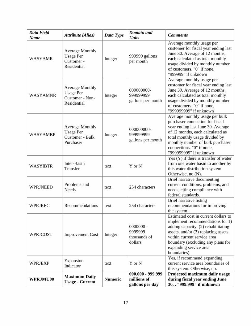
WASYAMR
Average Monthly
Usage Per
Customer -
Residential
Integer 999999 gallons
per month
Average monthly usage per
customer for fiscal year ending last
June 30. Average of 12 months,
each calculated as total monthly
usage divided by monthly number
of customers. "0" if none,
"999999" if unknown
WASYAMNR
Average Monthly
Usage Per
Customer - Non-
Residential
Integer
000000000-
999999999
gallons per month
Average monthly usage per
customer for fiscal year ending last
June 30. Average of 12 months,
each calculated as total monthly
usage divided by monthly number
of customers. "0" if none,
"999999999" if unknown
WASYAMBP
Average Monthly
Usage Per
Customer - Bulk
Purchaser
Integer
000000000-
999999999
gallons per month
Average monthly usage per bulk
purchaser connection for fiscal
year ending last June 30. Average
of 12 months, each calculated as
total monthly usage divided by
monthly number of bulk purchaser
connections. "0" if none,
"999999999" if unknown
WASYIBTR Inter-Basin
Transfer text Y or N
Yes (Y) if there is transfer of water
from one water basin to another by
this water distribution system.
Otherwise, no (N).
WPRJNEED Problems and
Needs text 254 characters
Brief narrative documenting
current conditions, problems, and
needs, citing compliance with
federal standards.
WPRJREC Recommendations text 254 characters
Brief narrative listing
recommendations for improving
the system.
WPRJCOST Improvement Cost Integer
0000000 -
9999999
thousands of
dollars
Estimated cost in current dollars to
implement recommendations for 1)
adding capacity, (2) rehabilitating
assets, and/or (3) replacing assets
within current service area
boundary (excluding any plans for
expanding service area
boundaries).
WPRJEXP Expansion
Indicator text Y or N
Yes, if recommend expanding
current service area boundaries of
this system. Otherwise, no.
WPRJMU00 Maximum Daily
Usage - Current Numeric
000.000 - 999.999
millions of
gallons per day
Projected maximum daily usage
during fiscal year ending June
30, . "999.999" if unknown

18
Data Field
Name Attribute (Alias) Data Type
Domain and
Units Comments
WPRJMU10 Maximum Daily
Usage - Plus 10 Numeric
000.000 - 999.999
millions of
gallons per day
Projected maximum daily usage
during fiscal year ending June
30 plus 10 years. "999.999" if
unknown
WPRJMU20 Maximum Daily
Usage - Plus 20 Numeric
000.000 - 999.999
millions of
gallons per day
Projected maximum daily usage
during fiscal year ending June
30 plus 20 years. "999.999" if
unknown
WPRJAU00 Average Daily
Usage - Current Numeric
000.000 - 999.999
millions of
gallons per day
Projected maximum daily usage
during fiscal year ending June
30, "999.999" if unknown
WPRJAU10 Average Daily
Usage - Plus 10 Numeric
000.000 - 999.999
millions of
gallons per day
Projected maximum daily usage
during fiscal year ending June
30 plus 10 years. "999.999" if
unknown
WPRJAU20 Average Daily
Usage - Plus 20 Numeric
000.000 - 999.999
millions of
gallons per day
Projected maximum daily usage
during fiscal year ending June
30 plus 20 years. "999.999" if
unknown
WSYCONT Contact Person Text 25 characters First name and last name, no
titles or middle names.
WSYPHON Contact
Telephone Text xxx-xxx-xxxx
WSEMAIL Contact Person
Email hyperlink email address
Water System - Type B -
(POLYGON
ATTRIBUTES)
All Type B systems will be recorded as polygons, regardless of size.
Systems too small to outline should be represented as a circle with a
50 foot radius.
Data Field
Name Attribute (Alias) Data Type
Domain and
Units Comments
WBSYID System ID Text 7 characters Water System Number
WBSYNAME Name of System Text 50 characters
WBSYPOP Population Served Integer 000000 - 999999
persons Estimate if unknown
WBSYCONT Contact Person Text 25 characters First name and last name, no titles
or middle names.
WBSYPHON Contact Telephone Text xxx-xxx-xxxx
WSEMAIL Contact Person
Email hyperlink email address

19
Water System - Type P -
(POLYGON ATTRIBUTES)
Boundary determined by current need and viability. Includes
contiguous areas (outside any current water system service area)
that average at least 20 existing potential connections per linear
highway/street mile. May or may not abut existing system(s).
Data Field Name Attribute (Alias) Data
Type
Domain and
Units Comments
WPSYID System ID Text 7 characters
First digit is a “9”, the next three
are county FIPS code (primary
county if crosses counties), and
the final three set as desired, to
avoid duplicating an existing
system ID. Initial “9” indicates
"new" or "P" system.
WPSYPAR Parent ID Text 7 characters
ID of parent system, if this is a
proposed expansion outside
service area of a current system.
Otherwise blank.
WPSYCOST New Cost Numeric
000000.0 -
999999.9 in
thousands of
dollars
Cost in current dollars to put
proposed system in place.
Customer pool for driving cost
estimates is to be derived from
projections of population growth
rates since 1970.
Water Pipes (Line Attributes) A new pipe segment is designated each time any pipe attribute
changes. A segment of pipe may include many vertices.
Data Field Name Attribute (Alias) Data
Type
Domain and
Units Comments
WASYID System ID Text 7 characters Water System Number (retain
leading zero(s))
WAPICSTR Original
Construction Year Integer 4 digits
Use closest decade if exact year is
unknown (e.g., if the original
construction year was sometime
between 1965 and 1970, specify
"1970"; likewise if you believe it
to be sometime between 1960 and
1964, specify "1960"). "9999" if
unknown.
WAPIRENV
Renovation or
Renewal - Most
Recent
Integer 4 digits
Estimate of the year (or decade) of
the most recent renovation or
renewal, defined as replacement or
substantial repair / rehabilitation
of at least 400 linear ft. Data
management may require
additional line segments. "0" if
none, "9999" if unknown.

20
Data Field Name Attribute (Alias) Data
Type
Domain and
Units Comments
WAPIMATR Material Text
asbestos cement,
cast iron, concrete,
copper, ductile
iron, galvanized
steel, polystyrene,
polyvinyl
chloride, steel,
unknown, other.
25 characters
Material currently in place.
Declare one material type, exactly
as shown
WAPIDIAM Diameter Integer 00 - 99 inches
All pipes two (2) inches in
diameter and larger must be
reported. Smaller diameter pipes
may be reported. "99" if unknown.
WAPIPELEV Elevations Text Above Ground,
Below Ground
WACASE Casing Text Yes, No Indicator if pipe is within a
protective casing
SERVSTAT Service Status Text
In Services, Out
of Service,
Planned, Future,
In Construction,
Abandoned
Note: planned service is ready
to be funded and put in place;
future service is anticipated or
projected without specific plans.
CREATDAT Date Created in
GIS Date
CREATBY Created By
(Person) Text
A domain of person allowed to
edit should be created for this
attribute.
UPDTON Date of Last
Update Date
UPDTBY Edited By (Person) Text
A domain of person allowed to
edit should be created for this
attribute.
LIFECYC Expected Life of
Asset Text
Number of years that asset is
expected to be in use before
being renewed.
DATASOURCE Source of Data Text
GPS, Paper
Maps, Digital
Maps
DATACOLL Data Collector Text Name of person or firm
collecting the field data
MANUFACT Equipment/Device
Manufacturer Text Current asset
INSTALL_YR Year of
Installation Integer Current asset

21
Ground Water Intakes, Wells
(Point Attributes)
Data Field Name Attribute (Alias) Data
Type
Domain and
Units Comments
WAWEID ID, Groundwater
Well Text 13 characters
First three digits are FIPS county
code; next 7 digits are water
system ID, last 3 digits are
assigned to be unique within
county.
WAWECSTR Original
Construction Year Integer 4 digits
Use closest decade if exact year is
unknown (e.g., if the original
construction year was sometime
between 1965 and 1970, specify
"1970"; likewise if you believe it
to be sometime between 1960 and
1964, specify "1960"). "9999" if
unknown
WAWERENV Renovation - Most
Recent Integer 4 digits
Estimate of the year (or decade) of
the most recent renovation. "0" if
none, "9999" if unknown
WAWEYELD Safe Yield Numeric 000.000 - 999.999
mgd
If water is purchased, there may be
no well data and no safe yield. "0"
if none, "999.999" if unknown
SERVSTAT Service Status Text
In Services, Out
of Service,
Planned, Future,
In Construction,
Abandoned
Note: planned service is ready to
be funded and put in place;
future service is anticipated or
projected without specific plans.
CREATDAT Date Created in
GIS Date
CREATBY Created By
(Person) Text
A domain of person allowed to
edit should be created for this
attribute.
UPDTON Date of Last
Update Date
UPDTBY Edited By (Person) Text
A domain of person allowed to
edit should be created for this
attribute.
LIFECYC Expected Life of
Asset Text
Number of years that asset is
expected to be in use before
being renewed.
DATASOURCE Source of Data Text
GPS, Paper
Maps, Digital
Maps
DATACOLL Data Collector Text Name of person or firm
collecting the field data
XCOORD X coordinate Double GPS collected X Coordinate
YCOORD Y coordinate Double GPS collected Y Coordinate
ZCOORD Z coordinate Double GPS collected Z Coordinate

22
Data Field Name Attribute (Alias) Data
Type
Domain and
Units Comments
ASSETPIC Picture of Asset URL A link to an image of the asset.
MANUFACT Equipment/Device
Manufacturer Text Current asset
INSTALL_YR Year of
Installation Integer
Current asset
Surface Water Intakes (Point
Attributes)
Data Field Name Attribute (Alias) Data
Type
Domain and
Units Comments
WAINID ID, Surface Water
Intakes Text 13 characters
First three digits are FIPS county
code; next 7 digits are water
system ID, last 3 digits are
assigned to be unique within
county.
WAINCSTR Original
Construction Year Integer 4 digits
Use closest decade if exact year is
unknown (e.g., if the original
construction year was sometime
between 1965 and 1970, specify
"1970"; likewise if you believe it
to be sometime between 1960 and
1964, specify "1960"). "9999" if
unknown
WAINRENV Renovation - Most
Recent Integer 4 digits
Estimate of the year (or decade) of
the most recent renovation. "0" if
none, "9999" if unknown
WAINFLOW Flow Capacity Numeric 000.000 - 999.999
mgd
7 day/10 year low flow in million
gallons per day
SERVSTAT Service Status Text
In Services, Out
of Service,
Planned, Future,
In Construction,
Abandoned
Note: planned service is ready
to be funded and put in place;
future service is anticipated or
projected without specific plans.
CREATDAT Date Created in
GIS Date
CREATBY Created By
(Person) Text
A domain of person allowed to
edit should be created for this
attribute.
UPDTON Date of Last
Update Date
UPDTBY Edited By (Person) Text
A domain of person allowed to
edit should be created for this
attribute.
LIFECYC Expected Life of
Asset Text
Number of years that asset is
expected to be in use before
being renewed.

23
Data Field Name Attribute (Alias) Data
Type
Domain and
Units Comments
DATASOURCE Source of Data Text
GPS, Paper
Maps, Digital
Maps
DATACOLL Data Collector Text Name of person or firm
collecting the field data
XCOORD X coordinate Double GPS collected X Coordinate
YCOORD Y coordinate Double GPS collected Y Coordinate
ZCOORD Z coordinate Double GPS collected Z Coordinate
ASSETPIC Picture of Asset URL A link to an image of the asset.
MANUFACT Equipment/Device
Manufacturer Text Current asset
INSTALL_YR Year of
Installation Integer Current asset
Water Storage Tanks (Point
Attributes)
Data Field Name Attribute (Alias) Data
Type
Domain and
Units Comments
WATKID ID, Water Tanks Text 13 characters
First three digits are FIPS county
code; next 7 digits are water
system ID, last 3 digits are
assigned to be unique within
county.
WATKLOC Location Descriptor Text 20 characters Name of area of location.
WATKCSTR Original
Construction Year Integer 4 digits
Use closest decade if exact year is
unknown (e.g., if the original
construction year was sometime
between 1965 and 1970, specify
"1970"; likewise if you believe it
to be sometime between 1960 and
1964, specify "1960"). "9999" if
unknown
WATKRENV Renovation - Most
Recent Integer 4 digits
Estimate of the year (or decade) of
the most recent renovation. "0" if
none, "9999" if unknown
WATKTYPE Type Text
elevated, hydro-
pneumatic, ground
storage, other,
unknown. 25
characters
Use one option for type, exactly as
shown
WATKUTIL Utilization Text
raw water,
finished water. 25
characters
Use one option for type, exactly as
shown

24
Data Field Name Attribute (Alias) Data
Type
Domain and
Units Comments
WATKMATR Construction
Material Text
metal, concrete,
pond, lake,
reservoir, other,
unknown. 15
characters
Use one option for type, exactly as
shown
WATKEBOT Elevation, Bottom Numeric
00000.0 - 99999.9
feet above mean
sea level
"99999.9" if unknown. Use 0.0 if
WATKTYPE is hydropneumatic.
WATKEOFL Elevation,
Overflow Numeric
00000.0 - 99999.9
feet above mean
sea level
“99999.9” if unknown. Use 0.0 if
WATKTYPE is hydropneumatic.
WATKCPTY Storage Capacity Numeric 000.000 - 999.999
millions of gallons “999.999” if unknown
SERVSTAT Service Status Text
In Services, Out
of Service,
Planned, Future,
In Construction,
Abandoned
Note: planned service is ready
to be funded and put in place;
future service is anticipated or
projected without specific plans.
CREATDAT Date Created in
GIS Date
CREATBY Created By
(Person) Text
A domain of person allowed to
edit should be created for this
attribute.
UPDTON Date of Last
Update Date
UPDTBY Edited By (Person) Text
A domain of person allowed to
edit should be created for this
attribute.
LIFECYC Expected Life of
Asset Text
Number of years that asset is
expected to be in use before
being renewed.
DATASOURCE Source of Data Text
GPS, Paper
Maps, Digital
Maps
DATACOLL Data Collector Text Name of person or firm
collecting the field data
XCOORD X coordinate Double GPS collected X Coordinate
YCOORD Y coordinate Double GPS collected Y Coordinate
ZCOORD Z coordinate Double GPS collected Z Coordinate
ASSETPIC Picture of Asset URL A link to an image of the asset.
MANUFACT Equipment/Device
Manufacturer Text Current asset
INSTALL_YR Year of
Installation Integer Current asset

25
Water Pumping Stations
(Point Attributes)
Data Field Name Attribute (Alias) Data
Type
Domain and
Units Comments
WAPSID ID, Pumping
Stations Text 13 characters
First three digits are FIPS county
code; next 7 digits are water
system ID, last 3 digits are
assigned to be unique within
county.
WAPSLOC Location Descriptor Text 50 characters Name of area of location.
WAPSCSTR Original
Construction Year Integer 4 digits
Use closest decade if exact year is
unknown (e.g., if the original
construction year was sometime
between 1965 and 1970, specify
"1970"; likewise if you believe it
to be sometime between 1960 and
1964, specify "1960"). "9999" if
unknown
WAPSRENV Renovation - Most
Recent Integer 4 digits
Estimate of the year (or decade) of
the most recent renovation. "0" if
none, "9999" if unknown
WAPSCPTY Pumping Capacity Numeric
000000.0 -
999999.9 gallons
per minute
"999999.9" if unknown
SERVSTAT Service Status Text
In Services, Out
of Service,
Planned, Future,
In Construction,
Abandoned
Note: planned service is ready
to be funded and put in place;
future service is anticipated or
projected without specific plans.
CREATDAT Date Created in
GIS Date
CREATBY Created By
(Person) Text
A domain of person allowed to
edit should be created for this
attribute.
UPDTON Date of Last
Update Date
UPDTBY Edited By (Person) Text
A domain of person allowed to
edit should be created for this
attribute.
LIFECYC Expected Life of
Asset Text
Number of years that asset is
expected to be in use before
being renewed.
DATASOURCE Source of Data Text
GPS, Paper
Maps, Digital
Maps
DATACOLL Data Collector Text Name of person or firm
collecting the field data
XCOORD X coordinate Double GPS collected X Coordinate
YCOORD Y coordinate Double GPS collected Y Coordinate

26
Data Field Name Attribute (Alias) Data
Type
Domain and
Units Comments
ZCOORD Z coordinate Double GPS collected Z Coordinate
ASSETPIC Picture of Asset URL A link to an image of the asset.
MANUFACT Equipment/Device
Manufacturer Text Current asset
INSTALL_YR Year of
Installation Integer Current asset
Water Treatment Plant
(Point Attributes)
Data Field Name Attribute (Alias) Data
Type
Domain and
Units Comments
WATPID ID, Treatment
Plants Text 13 characters
First three digits are FIPS county
code; next 7 digits are water
system ID, last 3 digits are
assigned to be unique within
county.
WATPCSTR Original
Construction Year Integer 4 digits
Use closest decade if exact year is
unknown (e.g., if the original
construction year was sometime
between 1965 and 1970, specify
"1970"; likewise if you believe it
to be sometime between 1960 and
1964, specify "1960"). "9999" if
unknown
WATPRENV Renovation - Most
Recent Integer 4 digits
Estimate of the year (or decade) of
the most recent renovation. "0" if
none, "9999" if unknown.
WATPCPTY Permitted Plant
Capacity Numeric
000.000 - 999.999
millions of gallons
per day
"999.999” if unknown
WATPMDP Maximum Daily
Production Numeric
000.000 - 999.999
millions of gallons
per day
“999.999” if unknown
WATPADP Average Daily
Production Numeric
000.000 - 999.999
millions of gallons
per day
“999.999” if unknown

27
Data Field Name Attribute (Alias) Data
Type
Domain and
Units Comments
WATPTRMT
Type of Water
Treatment
Technology
Text
Ground water w.
disinfection,
ground water w.
reverse osmosis,
ground water w.
softener, ground
water w. iron
remover, ground
water w. softener
and iron removal,
surface water w.
direct filter,
surface water w.
coagulation,
sedimentation and
filter, other
Description of treatment type up to
100 characters. Use one or more
options, exactly as shown. Also,
use "unknown" if unknown.
WATPAREA Estimated Area Numeric 00000.00 -
99999.99 acres
Estimate of area of water
treatment plant. "99999.99" if
unknown.
SERVSTAT Service Status Text
In Services, Out
of Service,
Planned, Future,
In Construction,
Abandoned
Note: planned service is ready
to be funded and put in place;
future service is anticipated or
projected without specific plans.
CREATDAT Date Created in
GIS Date
CREATBY Created By
(Person) Text
A domain of person allowed to
edit should be created for this
attribute.
UPDTON Date of Last
Update Date
UPDTBY Edited By (Person) Text
A domain of person allowed to
edit should be created for this
attribute.
LIFECYC Expected Life of
Asset Text
Number of years that asset is
expected to be in use before
being renewed.
DATASOURCE Source of Data Text
GPS, Paper
Maps, Digital
Maps
DATACOLL Data Collector Text Name of person or firm
collecting the field data
XCOORD X coordinate Double GPS collected X Coordinate
YCOORD Y coordinate Double GPS collected Y Coordinate
ZCOORD Z coordinate Double GPS collected Z Coordinate
ASSETPIC Picture of Asset URL A link to an image of the asset.

28
Data Field Name Attribute (Alias) Data
Type
Domain and
Units Comments
MANUFACT Equipment/Device
Manufacturer Text Current asset
INSTALL_YR Year of
Installation Integer Current asset
Water Master Meters
(System) (Point Attributes)
Data Field Name Attribute (Alias) Data
Type
Domain and
Units Comments
WAMMID ID, Master Meters Text 13 characters
First three digits are FIPS county
code; next 7 digits are water
system ID, last 3 digits are
assigned to be unique within
county.
WAMMCSTR Original
Construction Year Integer 4 digits
Use closest decade if exact year is
unknown (e.g., if the original
construction year was sometime
between 1965 and 1970, specify
"1970"; likewise if you believe it
to be sometime between 1960 and
1964, specify "1960"). "9999" if
unknown.
WAMMRENV Renovation - Most
Recent Integer 4 digits
Estimate of the year (or decade) of
the most recent renovation. "0" if
none, "9999" if unknown.
WAMMSIZE Size Integer 00-99 inches
WAMMMAAV Max. Available for
Purchase, Daily Numeric
000.000 - 999.999
million gallons per
day
Maximum daily amount of water
available for purchase at this meter
site. "999.999” if unknown.
WAMMCON InterSystem
Connection Text 13 characters
System to which connection is
being made. First three digits
are FIPS county code; next 7
digits are water system ID, last 3
digits are assigned to be unique
within county.
SERVSTAT Service Status Text
In Services, Out
of Service,
Planned, Future,
In Construction,
Abandoned
Note: planned service is ready
to be funded and put in place;
future service is anticipated or
projected without specific plans.
CREATDAT Date Created in
GIS Date
CREATBY Created By
(Person) Text
A domain of person allowed to
edit should be created for this
attribute.

29
Data Field Name Attribute (Alias) Data
Type
Domain and
Units Comments
UPDTON Date of Last
Update Date
UPDTBY Edited By (Person) Text
A domain of person allowed to
edit should be created for this
attribute.
LIFECYC Expected Life of
Asset Text
Number of years that asset is
expected to be in use before
being renewed.
DATASOURCE Source of Data Text
GPS, Paper
Maps, Digital
Maps
DATACOLL Data Collector Text Name of person or firm
collecting the field data
XCOORD X coordinate Double GPS collected X Coordinate
YCOORD Y coordinate Double GPS collected Y Coordinate
ZCOORD Z coordinate Double GPS collected Z Coordinate
ASSETPIC Picture of Asset URL A link to an image of the asset.
MANUFACT Equipment/Device
Manufacturer Text Current asset
INSTALL_YR Year of
Installation Integer Current asset
Water Hydrants (Point
Attributes)
Data Field Name Attribute (Alias) Data
Type
Domain and
Units Comments
WAHYID ID, Hydrant Text 15 characters
First three digits are FIPS
county code; next 7 digits are
water system ID, last 5 digits are
assigned to be unique within
county.
WAHYCSTR Original
Construction Year Date 4 digits
Use closest decade if exact year
is unknown (e.g., if the original
construction year was sometime
between 1965 and 1970, specify
"1970"; likewise if you believe it
to be sometime between 1960
and 1964, specify "1960").
"9999" if unknown.
WAHYRENV Renovation - Most
Recent Date 4 digits
Estimate of the year (or decade)
of the most recent renovation.
"0" if none, "9999" if unknown.
WAHYSTATIC Static Pressure Integer Static Pressure as measured at
Hydrant
WAHYRESID Residual Flow Residual Flow as measured at
Hydrant

30
Data Field Name Attribute (Alias) Data
Type
Domain and
Units Comments
SERVSTAT Service Status Text
In Services, Out
of Service,
Planned, Future,
In Construction,
Abandoned
Note: planned service is ready
to be funded and put in place;
future service is anticipated or
projected without specific plans.
CREATDAT Date Created in
GIS Date
CREATBY Created By
(Person) Text
A domain of person allowed to
edit should be created for this
attribute.
UPDTON Date of Last
Update Date
UPDTBY Edited By (Person) Text
A domain of person allowed to
edit should be created for this
attribute.
LIFECYC Expected Life of
Asset Text
Number of years that asset is
expected to be in use before
being renewed.
DATASOURCE Source of Data Text
GPS, Paper
Maps, Digital
Maps
DATACOLL Data Collector Text Name of person or firm
collecting the field data
XCOORD X coordinate Double GPS collected X Coordinate
YCOORD Y coordinate Double GPS collected Y Coordinate
ZCOORD Z coordinate Double GPS collected Z Coordinate
ASSETPIC Picture of Asset URL A link to an image of the asset.
MANUFACT Equipment/Device
Manufacturer Text Current asset
INSTALL_YR Year of
Installation Integer Current asset

31
Water Service Meters (Point
Attributes)
WASMID ID, Service Meter Text 25 characters
First three digits are FIPS
county code; next 7 digits are
water system ID, last 15 digits
are assigned to be unique within
county.
WASMCSTR Original
Construction Year Date 4 digits
Use closest decade if exact year
is unknown (e.g., if the original
construction year was sometime
between 1965 and 1970, specify
"1970"; likewise if you believe it
to be sometime between 1960
and 1964, specify "1960").
"9999" if unknown.
WASMRENV Renovation - Most
Recent Date 4 digits
Estimate of the year (or decade)
of the most recent renovation.
"0" if none, "9999" if unknown.
WASMSIZE Size of Meter Integer Size of meter service.
WASMACCT Service Account Text /
Integer
Service Account from billing
data base associated with
Service meter
WASMTYPE Type Text
Residential,
Commercial,
Industrial,
Irrigation
Type of service meter is
providing.
SERVSTAT Service Status Text
In Services, Out
of Service,
Planned, Future,
In Construction,
Abandoned
Note: planned service is ready
to be funded and put in place;
future service is anticipated or
projected without specific plans.
CREATDAT Date Created in
GIS Date
CREATBY Created By
(Person) Text
A domain of person allowed to
edit should be created for this
attribute.
UPDTON Date of Last
Update Date
UPDTBY Edited By (Person) Text
A domain of person allowed to
edit should be created for this
attribute.
LIFECYC Expected Life of
Asset Text
Number of years that asset is
expected to be in use before
being renewed.
DATASOURCE Source of Data Text
GPS, Paper
Maps, Digital
Maps
DATACOLL Data Collector Text Name of person or firm
collecting the field data

32
Data Field Name Attribute (Alias) Data
Type
Domain and
Units Comments
XCOORD X coordinate Double GPS collected X Coordinate
YCOORD Y coordinate Double GPS collected Y Coordinate
ZCOORD Z coordinate Double GPS collected Z Coordinate
ASSETPIC Picture of Asset URL A link to an image of the asset.
MANUFACT Equipment/Device
Manufacturer Text Current asset
INSTALL_YR Year of
Installation Integer Current asset
Water Valves (Point
Attributes)
Data Field Name Attribute (Alias) Data
Type
Domain and
Units Comments
WAWVALID ID, Water Valve Text 25 characters
First three digits are FIPS
county code; next 7 digits are
water system ID, last 15 digits
are assigned to be unique within
county.
WAWVACSTR Original
Construction Year Date 4 digits
Use closest decade if exact year
is unknown (e.g., if the original
construction year was sometime
between 1965 and 1970, specify
"1970"; likewise if you believe it
to be sometime between 1960
and 1964, specify "1960").
"9999" if unknown.
WAWVARENV Renovation - Most
Recent Date 4 digits
Estimate of the year (or decade)
of the most recent renovation.
"0" if none, "9999" if unknown.
SERVSTAT Service Status Text
In Services, Out
of Service,
Planned, Future,
In Construction,
Abandoned
Note: planned service is ready
to be funded and put in place;
future service is anticipated or
projected without specific plans.
CREATDAT Date Created in
GIS Date
CREATBY Created By
(Person) Text
A domain of person allowed to
edit should be created for this
attribute.

33
Data Field Name Attribute (Alias) Data
Type
Domain and
Units Comments
UPDATON Date of Last
Update Date
UPDATBY Edited By
(Person) Text
A domain of person allowed to
edit should be created for this
attribute.
LIFECYC Expected Life of
Asset Text
Number of years that asset is
expected to be in use before
being renewed.
DATASOURCE Source of Data Text
GPS, Paper
Maps, Digital
Maps
DATACOLL Data Collector Text Name of person or firm
collecting the field data.
XCOORD X coordinate Double GPS collected X Coordinate
YCOORD Y coordinate Double GPS collected Y Coordinate
ZCOORD Z coordinate Double GPS collected Z Coordinate
ASSETPIC Picture of Asset URL A link to an image of the asset.
MANUFACT Equipment/Device
Manufacturer Text Current asset
INSTALL_YR Year of
Installation Integer Current asset
ASSETNAME Name of the Asset Text
VALVETYPE Type of Valve Text

34
SECTION 4: Content Standard - Sanitary Sewer Systems
Definition The Sanitary Sewer Systems (SSS) dataset includes information about the primary facilities,
mechanical components, and collection lines that function as a discharge and treatment system
for sewerage. The SSS dataset includes a delineation of the service area boundary of each
sanitary sewer system. It also contains features of the locations of important mechanical
components for the delivery and treatment of sewerage from the curbside connection point to the
site where treated sewerage is released back into the natural environment. The database contains
attributes that describe all or portions of each component of the system.
Three types of sanitary sewer systems exist for the digital sanitary sewer system inventory: Type
A, Type B, and Type P. Type A systems are generally considered large systems and are
represented in the dataset by a service area with a variety of system components. The
components included in Type A systems are: sewer pipes, pumping stations, treatment plants,
discharges, and land application areas.
Type B systems are generally smaller and are represented in the dataset as a service area. Type
B systems will be delineated by boundaries and stored as polygonal features. Pipes and
components are not required for the Type B systems.
Type P systems represent "proposed" expansion areas or "proposed" new systems. Type P
systems will be delineated by boundaries and stored as polygonal features. Pipes and mechanical
components are not included in the mapping for Type P systems.
Type A, B, and P systems are defined as follows:
Type A Sewerage Systems Existing community sanitary sewer systems including collection lines, transport lines or
pumping and treatment facilities which serve the general public and accept domestic
wastewater are classified as Type A Sewerage Systems.
Type B Sewerage Systems Type B Sewerage Systems are existing community sanitary sewer systems which serve
the general public and accept domestic wastewater, but generally represent small, private,
business, industrial, mobile home, multi-family housing or single subdivision systems
which have very limited potential future economic development impact.
Type P Sewerage Systems Type P Sewerage Systems are planned or proposed public community sanitary sewer
system service areas, outside of current service area boundaries, where public systems do
not currently exist. Type P systems are areas which have been identified as having
sufficient need and population density to support viable public systems and which have
an existing minimum potential user density of 40 existing potential connections per mile
of wastewater collection line.

35
The dataset for the sanitary sewer system contains a large amount of descriptive information
about each component and the service area. The descriptive information is contained in attribute
tables that are linked to each geographic feature in the database. The attribute contents of the
sanitary sewer systems geographic dataset are listed in the Attribute Listing for Sanitary Sewer
System beginning on page 26. Attribute data field names and domain values are itemized for the
Sanitary Sewer System dataset in Table 2 beginning on page 28. Additional system owner
information is stored in a table described in Section 5 on page 38.
Geometric Representation Sanitary Sewer Systems (Type A, Type B and Type P) service areas are to be delineated by
boundaries and in the geometric form of one or more contiguous or non-contiguous polygons.
Type A, B, and P systems will be stored in separate geographic data files. In circumstances
where systems are small and can only be delineated by a point, a polygon is to be generated
using a radius of 50 feet.
Mechanical components of the Sanitary Sewer System - Type A are to be delineated as either
lines or points. Pipelines will be collected and stored as lines in one geographic data file.
Facilities/devices will be collected and stored as points in a separate geographic data file for each
facility/device type.
All geographic data files will be topological.
Geographic Coordinate System, Datum, and Unit of Measurement The sanitary sewer systems data sets will be geo-referenced using the NC State Plane Coordinate
System (NAD83).
The unit of measurement will be metric or English.
Annotation Specifications for annotation of facilities and pipes for this dataset are not included in the
standard. All relevant information for each feature is assumed to be recorded as an attribute in
the database. Annotation, if desired, should be considered as an optional specification for
consideration at the time of data collection or modification.
Metadata Metadata, or data about data, are required for each geographic dataset. Beginning January 1995,
all federal organizations involved in the development of geographic data must comply with the
Federal Geographic Data Committee's (FGDC) Content Standards for Digital Geospatial
Metadata. The FGDC Standard has been adopted by the North Carolina Geographic Information
Coordinating Council and is now required for all data submitted to the NC OneMap Database.
The Center for Geographic Information & Analysis has implemented the Federal Content
Standard for Digital Geospatial Metadata for all datasets currently in the NC OneMap Database
and will assist in the development of complete metadata for corporate data layers.
Symbology Graphic symbols of facilities and pipes for this data layer are not included in the standard.
Symbology is considered as a product generation standard and not a content issue. However, all
relevant information pertaining to symbology is presumed to be recorded as an attribute in the

36
database. Symbology should be treated as an optional specification for consideration at the time
of product generation.
Attributes Physical characteristics and descriptive information about components are contained within the
attribute table of each data set. Polygons, lines, areas, nodes, and points identify the location or
boundary of a feature in the dataset. An attribute or a set of attributes describe each feature in
the dataset. Attribute field names, data type, field domain, and additional comments are
described in Table 2 - Attribute Names, Field Definitions, and Supplementary Data Definitions
for Sanitary Sewer System Features. A list of all descriptive information for the Sanitary Sewer
Systems Dataset follows:
List 2 - Summary of Sanitary Sewer Systems Attribute Fields
Sanitary Sewer System - Type A System Identification Number
Name of System
Owner Identification Number
Part Indicator
Total Parts
Original Construction Year
Description of Service Area
Customer Connections - Residential
Customer Connections - Non-Residential
Customer Connections - Bulk Purchaser
Maximum Daily Flow
Average Daily Flow
User Charges - Residential
User Charges - Non-Residential
User Charges - Bulk Purchasers
Average Monthly Flow Per Customer -
Residential
Average Monthly Flow Per Customer - Non-
Residential
Average Monthly Flow Per Customer - Bulk
Purchaser
Inter Basin Transfer Amount
Problems and Needs
Recommendations
Improvement Cost
Expansion Indicator
Maximum Daily Flow Current Year
Maximum Daily Flow Plus 10 Years
Maximum Daily Flow Plus 20 Years
Average Daily Flow Current Year
Average Daily Flow Plus 10 Years
Average Daily Flow Plus 20 Years
Contact Person
Contact Telephone
Contact Person Email
Sanitary Sewer System - Type B Service
Areas System Identification Number
Name of System
Population Served
Contact Person
Contact Telephone
Contact Person Email
Sanitary Sewer System - Type P Service
Areas System Identification Number
Parent System ID
New Cost
Land Application Areas Land Application Area - ID
Land Application Area Year of Original
Construction
Land Application Area Year of Most Recent
Renovation
Land Application Area - Permit Expiration
Date
Land Application Area - Estimated Area

37
Sanitary Sewer System Pipes System Identification Number
Original Construction Year
Renovation Year - Most Recent
Material
Diameter
Type - Pressure, Gravity, Vacuum
Utilization Type - Interceptor, Outfall,
Collection
Elevations
Slope
Casing
Service Status
Date Created in GIS
Created By (Person)
Date of Last Update
Edited By (Person)
Expected Life of Asset
Source of Data
Data Collector
Equipment/Device Manufacturer
Year of Installation
Pumping Stations Pumping Station - ID
Pumping Station Location Descriptor
Pumping Station Year of Original
Construction
Pumping Station Year of Most Recent
Renovation
Pumping Station Capacity
Service Status
Date Created in GIS
Created By (Person)
Date of Last Update
Edited By (Person)
Expected Life of Asset
Source of Data
Data Collector
X Coordinate
Y Coordinate
Z Coordinate
Picture of Asset
Equipment/Device Manufacturer
Year of Installation
Treatment Plants Treatment Plant - ID
Treatment Plant Location Descriptor
Treatment Plant Year of Original
Installation
Treatment Plant Year of Most Recent
Renovation
Treatment Plant Permitted Flow Capacity
Treatment Plant Maximum Daily Flow
Treatment Plant Average Daily Flow
Treatment Plant Type of Treatment
Technology
Treatment Plant Sludge Disposal
Technology
Treatment Plant Infiltration/Inflow
Treatment Plant Estimated Area
Service Status
Date Created in GIS
Created By (Person)
Date of Last Update
Edited By (Person)
Expected Life of Asset
Source of Data
Data Collector
X Coordinate
Y Coordinate
Z Coordinate
Picture of Asset
Equipment/Device Manufacturer
Year of Installation

38
Discharge Points Discharge -ID
Discharge Location Descriptor
Discharge Year of Original Construction
Discharge Year of Most Recent Renovation
Service Status
Date Created in GIS
Created By (Person)
Date of Last Update
Edited By (Person)
Expected Life of Asset
Source of Data
Data Collector
X Coordinate
Y Coordinate
Z Coordinate
Picture of Asset
Equipment/Device Manufacturer
Year of Installation
Sewer Manholes
ID, Manhole
Location Descriptor
Original Construction Year
Renovation – Most Recent
Top Elevation
Invert Out
Invert 1
Invert 2
Invert 3
Service Status
Date Created in GIS
Created By (Person)
Date of Last Update
Edited By (Person)
Expected Life of Asset
Source of Data
Data Collector
X Coordinate
Y Coordinate
Z Coordinate
Picture of Asset
Equipment/Device Manufacturer
Year of Installation
Sewer Valves
ID, Valve
Location Descriptor
Original Construction Year
Renovation – Most Recent
Pipe Connection
Service Status
Date Created in GIS
Created By (Person)
Date of Last Update
Edited By (Person)
Expected Life of Asset
Source of Data
Data Collector
X Coordinate
Y Coordinate
Z Coordinate
Picture of Asset
Equipment/Device Manufacturer
Year of Installation
Sewer Cleanouts
ID, Cleanout
Location Descriptor
Original Construction Year
Renovation – Most Recent
Pipe Connection
Service Status
Date Created in GIS
Created By (Person)
Date of Last Update
Edited By (Person)
Expected Life of Asset
Source of Data
Data Collector
X Coordinate
Y Coordinate
Z Coordinate
Picture of Asset
Equipment/Device Manufacturer
Year of Installation

39
Sewer Stream Crossings
ID, Crossing
Location Descriptor
Original Construction Year
Renovation – Most Recent
Name of Stream
Service Status
Date Created in GIS
Created By (Person)
Date of Last Update
Edited By (Person)
Expected Life of Asset
Source of Data
Data Collector
X Coordinate
Y Coordinate
Z Coordinate
Picture of Asset
Equipment/Device Manufacturer
Year of Installation

40
In the following tables, data fields added in 2011 are indicated by bold font.
Table 2 - Definitions of Attribute Fields for Sanitary Sewer
Systems
Sanitary Sewer System - Type
A (Polygon Attribute)
Boundary of legally defined service area, including additional
areas being served. Exclude outside areas for which service is
planned; these are P systems. Exclude area surrounding intake
mains where no customers exist.
Data Field Name Attribute (Alias) Data
Type
Domain and
Units Comments
SSSYID System ID Text 7 characters
First three digits are FIPS county
code (primary co. of location), next
4 digits are unique identifier. Note:
cannot use permit number for
discharge due to multiple
discharges.
SSSYNAME Name of System Text 50 characters
SSSYOW1 Owner ID (One) Text 00000 - 99999
Assign unique number for each
within state. Owner ID may be
same for both a water and sewer
system. Use supplementary table
'TOWNER' for additional
information about system owners.
SSSYOW2
Owner ID (Second,
if applicable) Text 00000 - 99999
Additional Owner ID, if multiple
owners.
SSSYOW3
Owner ID (Third, if
applicable) Text 00000 - 99999
Additional Owner ID, if multiple
owners.
SSSYOW4
Owner ID (Fourth,
if applicable) Text 00000 - 99999
Additional Owner ID, if multiple
owners.
SSSYOW5
Owner ID (Fifth, if
applicable) Text 00000 - 99999
Additional Owner ID, if multiple
owners.
SSSYPART Part Indicator Integer
1,2,3,4,5,6,7,8, or
9
If the information for any field in
polygon attributes table has possible
multiple values (for different parts
of the whole), then the system must
be characterized as separate systems
that form parts of the whole and
each part makes separate record(s).
SSSYTOPT Total Parts Integer
1,2,3,4,5,6,7,8, or
9
Total parts in entire system. See
Part Indicator.

41
Data Field Name Attribute (Alias) Data
Type
Domain and
Units Comments
SSSYCSTR
Original
Construction Year Integer 4 digits
Exclusive of pipes. Use closest
decade if exact year is unknown
(e.g., if the original construction
year was sometime between 1965
and 1970, specify "1970"). "9999"
if unknown.
SSSYDESC
Description of
Service Area Text 50 characters
Brief description of service area.
Must cover area for which permit is
issued.
SSSYCCR
Customer
Connections -
Residential Integer 000000 - 999999
Number of residential customer
connections for sanitary sewer,
most recent June 30th. "0" if none,
"999999" if unknown.
SSSYCCNR
Customer
Connections - Non-
Residential Integer 000000 - 999999
Number of non-residential customer
connections for sanitary sewer,
most recent June 30th. "0" if none,
"999999" if unknown.
SSSYCCBP
Customer
Connections - Bulk
Purchasers Integer 00000 - 99999
Number of bulk purchaser
connections for sanitary sewer,
most recent June 30th. "0" if none,
"99999" if unknown.
SSSYMAXF
Maximum Daily
Flow Numeric
000.000 - 999.999
millions of gallons
per day
Maximum daily flow during fiscal
year ending most recent June 30.
"999.999" if unknown.
SSSYADGD
Average Daily
Flow Numeric
000.000 - 999.999
millions of gallons
per day
Average daily flow during fiscal
year ending most recent June 30.
"999.999" if unknown.
SSSYCGR
User Charges -
Residential Numeric
000.00 - 999.99
dollars
Average monthly charge per
customer for fiscal year ending last
June 30. Average of 12 months,
each calculated as total monthly
charges divided by monthly number
of customers. "0" if none, "999.99"
if unknown.
SSSYCGNR
User Charges -
Non-Residential Numeric
0.00 - 9999999.99
dollars
Average monthly charge per
customer for fiscal year ending last
June 30. Average of 12 months,
each calculated as total monthly
charges divided by monthly number
of customers. "0" if none,
"9999999.99" if unknown.
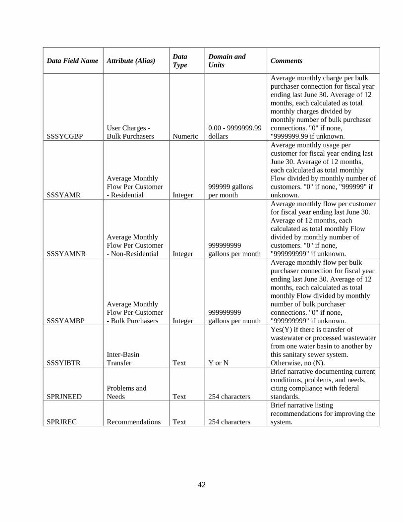
42
Data Field Name Attribute (Alias) Data
Type
Domain and
Units Comments
SSSYCGBP
User Charges -
Bulk Purchasers Numeric
0.00 - 9999999.99
dollars
Average monthly charge per bulk
purchaser connection for fiscal year
ending last June 30. Average of 12
months, each calculated as total
monthly charges divided by
monthly number of bulk purchaser
connections. "0" if none,
"9999999.99 if unknown.
SSSYAMR
Average Monthly
Flow Per Customer
- Residential Integer
999999 gallons
per month
Average monthly usage per
customer for fiscal year ending last
June 30. Average of 12 months,
each calculated as total monthly
Flow divided by monthly number of
customers. "0" if none, "999999" if
unknown.
SSSYAMNR
Average Monthly
Flow Per Customer
- Non-Residential Integer
999999999
gallons per month
Average monthly flow per customer
for fiscal year ending last June 30.
Average of 12 months, each
calculated as total monthly Flow
divided by monthly number of
customers. "0" if none,
"999999999" if unknown.
SSSYAMBP
Average Monthly
Flow Per Customer
- Bulk Purchasers Integer
999999999
gallons per month
Average monthly flow per bulk
purchaser connection for fiscal year
ending last June 30. Average of 12
months, each calculated as total
monthly Flow divided by monthly
number of bulk purchaser
connections. "0" if none,
"999999999" if unknown.
SSSYIBTR
Inter-Basin
Transfer Text Y or N
Yes(Y) if there is transfer of
wastewater or processed wastewater
from one water basin to another by
this sanitary sewer system.
Otherwise, no (N).
SPRJNEED
Problems and
Needs Text 254 characters
Brief narrative documenting current
conditions, problems, and needs,
citing compliance with federal
standards.
SPRJREC Recommendations Text 254 characters
Brief narrative listing
recommendations for improving the
system.

43
Data Field Name Attribute (Alias) Data
Type
Domain and
Units Comments
SPRJCOST Improvement Cost Integer
0000000 -
9999999
thousands of
dollars
Estimated cost in current dollars to
implement recommendations for
improving the system including
expansion within current service
area boundary (excluding any plans
for expanding service area
boundaries).
SPRJEXP Expansion Indicator Text Y or N
Yes, if recommend expanding
current service area boundaries of
this system. Otherwise, no.
SPRJMF00
Maximum Daily
Flow - Current Numeric
000.000 - 999.999
millions of
gallons per day
Projected maximum daily usage
during fiscal year ending June 30,
"999.999" if unknown.
SPRJMF10
Maximum Daily
Flow - Plus 10
Years Numeric
000.000 - 999.999
millions of
gallons per day
Projected maximum daily usage
during fiscal year ending June 30
plus 10 years. "999.999" if
unknown.
SPRJMF20
Maximum Daily
Flow - Plus 20
Years Numeric
000.000 - 999.999
millions of
gallons per day
Projected maximum daily usage
during fiscal year ending June 30
plus 20 years. "999.999" if
unknown.
SPRJAF00
Average Daily
Flow - Current Numeric
000.000 - 999.999
millions of
gallons per day
Projected maximum daily usage
during fiscal year ending June 30,
"999.999" if unknown.
SPRJAF10
Average Daily
Flow - Plus 10
Years Numeric
000.000 - 999.999
millions of
gallons per day
Projected maximum daily usage
during fiscal year ending June 30
plus 10 years. "999.999" if
unknown.
SPRJAF20
Average Daily
Flow - Plus 20
Years Numeric
000.000 - 999.999
millions of
gallons per day
Projected maximum daily usage
during fiscal year ending June 30
plus 20 years. "999.999" if
unknown.
SSYCONT Contact Person Text 25 characters First name and last name, no
titles or middle names.
SSYPHON Contact Telephone Text xxx-xxx-xxxx
SSEMAIL Contact Person
hyperlin
k email address

44
Sanitary Sewer System - Type
B (Polygon Attribute)
All type B systems will be recorded as polygons, regardless of
size. Systems too small to outline should be represented as a
circle with a 50 foot radius.
Data Field Name Attribute (Alias) Data Type Domain and
Units Comments
SBSYID System ID Text 7 characters
First three digits are FIPS county
code (primary co. of location), next
4 digits are unique identifier.
SBSYNAME Name of System Text 50 characters
SBSYPOP Population Served Integer
000000 - 999999
persons
If unknown, provide best estimate
of population.
SBSYCONT Contact Person Text 25 characters
First name and last name, no titles
or middle names.
SBSYPHON Contact Telephone Text xxx-xxx-xxxx
SBSEMAIL
Contact Person
Email hyperlink email address
Sanitary Sewer System - Type
P (Polygon Attribute)
Boundary determined by current need and viability. Includes
contiguous areas (outside any current sewer system service
area) that average at least 40 existing potential connections per
linear highway/street mile. May or may not abut existing
system(s).
Data Field Name Attribute (Alias) Data
Type Domain and Units Comments
SPSYID System ID Text 7 characters
First digit is a “9”, the next three
are county FIPS code, and the final
three set as desired, to avoid
duplicating an existing system ID.
Initial “9” indicates "new" or "P"
system.
SPSYPAR Parent ID Text 7 characters
ID of parent system, if this is a
proposed expansion outside service
area of a current system. Otherwise
blank.
SPSYCOST New Cost Numeric
000000.0 -
999999.9 in
thousands of
dollars
Cost in current dollars to put
proposed system in place. Customer
pool for driving cost estimates is to
be derived from projections of
population growth rates since 1970.

45
Land Application Areas
(Polygon Attribute)
Data Field Name Attribute (Alias) Data
Type
Domain and
Units Comments
SSTPLAID ID, Land
Application Areas Text 11 characters
Nine digits: seven digit Land
Application Number (exclude 'WQ')
and two digits for unique identifier.
SSLACSTR Original
Construction Year Integer 4 digits
Use closest decade if exact year is
unknown (e.g., if the original
construction year was sometime
between 1965 and 1970, specify
"1970"; likewise if you believe it to
be sometime between 1960 and
1964, specify "1960"). "9999" if
unknown.
SSLARENV Renovation - Most
Recent Integer 4 digits
Estimate of the year (or decade) of
the most recent renovation. "0" if
none, "9999" if unknown.
SSLADATE Permit Expiration
Date Date YYMMDD
SSLAAREA Estimated Area Numeric 000000.00 -
999999.99 acres
Estimate of area. "999999.99" if
unknown.

46
Sewer Pipes (Line Attribute) A new pipe segment is designated each time any pipe attribute
changes. A segment of pipe may include many vertices.
Data Field Name Attribute (Alias) Data
Type
Domain and
Units Comments
SSSYID System ID Text 7 characters
First three digits are FIPS county
code (primary co. of location), next
4 digits are unique identifier. Note:
cannot use permit number for
discharge due to multiple
discharges.
SSPICSTR Original
Construction Year Integer 4 digits
Use closest decade if exact year is
unknown (e.g., if the original
construction year was sometime
between 1965 and 1970, specify
"1970"; likewise if you believe it to
be sometime between 1960 and
1964, specify "1960"). "9999" if
unknown.
SSPIRENV Renovation - Most
Recent Integer 4 digits
Estimate of the year (or decade) of
the most recent renovation. "0" if
none, "9999" if unknown.
SSPIMATR Material Text
ABS, asbestos
cement, brick, cast
iron, concrete,
corrugated metal,
ductile iron,
fiberglass,
galvanized steel,
polystyrene,
polyvinyl
chloride, steel,
vitrified clay,
unknown,
other.25.
Material currently in place. Declare
one type, exactly as shown.
SSPIDIAM Diameter Integer 00 - 99 inches
For gravity systems, all interceptors
and forced mains must be reported,
as well as all collection lines 8 in.
and larger. For low pressure and
other systems, all lines 2 in. and
greater must be reported. Smaller
pipes may be reported. "99" if
unknown.
SSPITYPGV Type - Pressure,
Gravity, Vacuum Text
pressure, gravity,
vacuum, other,
unknown. 15
characters.
Negative pressure implies a
vacuum.

47
Data Field Name Attribute (Alias) Data
Type
Domain and
Units Comments
SSTYIOC
Utilization Type -
Interceptor, Outfall,
Collection
Text
interceptor,
outfall, collection,
other, unknown.
15 characters.
State one option, exactly as shown.
SSPIPELEV Elevations Text Above Ground,
Below Ground
SSSLOPE Slope Integer Slope of Sewer Line
SSCASE Casing Text Yes, No Indicator if pipe is within a
protective casing
SERVSTAT Service Status Text
In Services, Out
of Service,
Planned, Future,
In Construction,
Abandoned
Note: planned service is ready to
be funded and put in place; future
service is anticipated or projected
without specific plans.
CREATDAT Date Created in
GIS Date
CREATBY Created By
(Person) Text
A domain of person allowed to
edit should be created for this
attribute.
UPDTON Date of Last
Update Date
UPDTBY Edited By
(Person) Text
A domain of person allowed to
edit should be created for this
attribute.
LIFECYC Expected Life of
Asset Text
Number of years that asset is
expected to be in use without
repair.
DATASOURCE Source of Data Text
GPS, Paper
Maps, Digital
Maps
DATACOLL Data Collector Text Name of person or firm collecting
the field data
MANUFACT Equipment/Device
Manufacturer Text Current asset
INSTALL_YR Year of
Installation Integer Current asset

48
Sewer Pumping Stations
(Point Attributes)
Data Field Name Attribute (Alias) Data
Type
Domain and
Units Comments
SSPSID ID, Pumping
Station Text 11 characters
First 7 digits are same as those of
sewer system ID, last 4 digits are
unique identifying code within
system. Note fewer digits in last
segment may be practical.
SSPSLOC Location
Descriptor Text 30 characters Name of area of location.
SSPSCSTR Original
Construction Year Integer 4 digits
Use closest decade if exact year is
unknown (e.g., if the original
construction year was sometime
between 1965 and 1970, specify
"1970"; likewise if you believe it to
be sometime between 1960 and
1964, specify "1960"). "9999" if
unknown.
SSPSRENV Renovation - Most
Recent Integer 4 digits
Estimate of the year (or decade) of
the most recent renovation. "0" if
none, "9999" if unknown.
SSPSCPTY Capacity Integer 000000 - 999999
gallons per minute "999999" if unknown.
SERVSTAT Service Status Text
In Services, Out
of Service,
Planned, Future,
In Construction,
Abandoned
Note: planned service is ready to
be funded and put in place;
future service is anticipated or
projected without specific plans.
CREATDAT Date Created in
GIS Date
CREATBY Created By
(Person) Text
A domain of person allowed to
edit should be created for this
attribute.
UPDTON Date of Last
Update Date
UPDTBY Edited By
(Person) Text
A domain of person allowed to
edit should be created for this
attribute.

49
Data Field Name Attribute (Alias) Data
Type
Domain and
Units Comments
LIFECYC Expected Life of
Asset Text
Number of years that asset is
expected to be in use before being
renewed.
DATASOURCE Source of Data Text
GPS, Paper
Maps, Digital
Maps
DATACOLL Data Collector Text Name of person or firm collecting
the field data.
XCOORD X coordinate Double GPS collected X Coordinate
YCOORD Y coordinate Double GPS collected Y Coordinate
ZCOORD Z coordinate Double GPS collected Z Coordinate
ASSETPIC Picture of Asset URL A link to an image of the asset.
MANUFACT Equipment/Device
Manufacturer Text Current asset
INSTALL_YR Year of
Installation Integer Current asset
Sewer Treatment Plant
(Point Attributes)
Data Field Name Attribute (Alias) Data
Type
Domain and
Units Comments
SSTPID ID, Treatment Plant Text 7 characters
National Pollutant Discharge
Elimination System Identification
Number assigned by NC Div. of
Environmental Management
(Exclude "NC").
SSTPLOC Location
Descriptor Text 20 characters Name of area of location.
SSTPCSTR Original
Construction Year Integer 4 digits
Use closest decade if exact year is
unknown (e.g., if the original
construction year was sometime
between 1965 and 1970, specify
"1970"; likewise if you believe it to
be sometime between 1960 and
1964, specify "1960"). "9999" if
unknown.
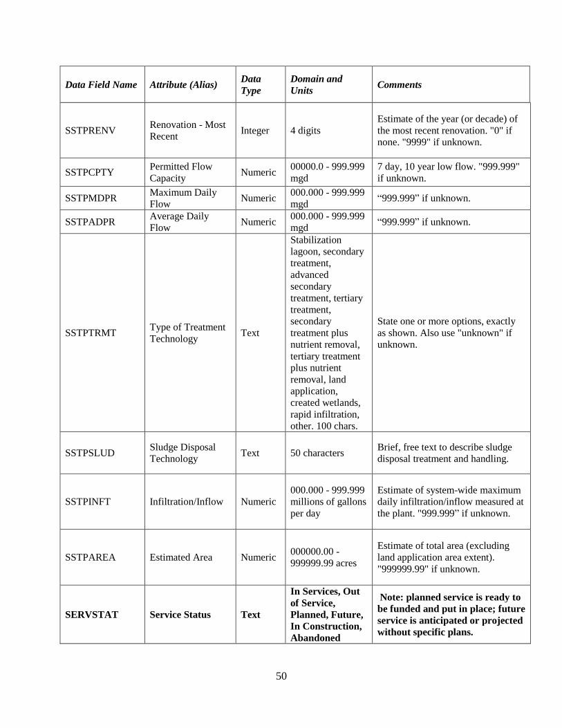
50
Data Field Name Attribute (Alias) Data
Type
Domain and
Units Comments
SSTPRENV Renovation - Most
Recent Integer 4 digits
Estimate of the year (or decade) of
the most recent renovation. "0" if
none. "9999" if unknown.
SSTPCPTY Permitted Flow
Capacity Numeric
00000.0 - 999.999
mgd
7 day, 10 year low flow. "999.999"
if unknown.
SSTPMDPR Maximum Daily
Flow Numeric
000.000 - 999.999
mgd “999.999” if unknown.
SSTPADPR Average Daily
Flow Numeric
000.000 - 999.999
mgd “999.999” if unknown.
SSTPTRMT Type of Treatment
Technology Text
Stabilization
lagoon, secondary
treatment,
advanced
secondary
treatment, tertiary
treatment,
secondary
treatment plus
nutrient removal,
tertiary treatment
plus nutrient
removal, land
application,
created wetlands,
rapid infiltration,
other. 100 chars.
State one or more options, exactly
as shown. Also use "unknown" if
unknown.
SSTPSLUD Sludge Disposal
Technology Text 50 characters
Brief, free text to describe sludge
disposal treatment and handling.
SSTPINFT Infiltration/Inflow Numeric
000.000 - 999.999
millions of gallons
per day
Estimate of system-wide maximum
daily infiltration/inflow measured at
the plant. "999.999” if unknown.
SSTPAREA Estimated Area Numeric 000000.00 -
999999.99 acres
Estimate of total area (excluding
land application area extent).
"999999.99" if unknown.
SERVSTAT Service Status Text
In Services, Out
of Service,
Planned, Future,
In Construction,
Abandoned
Note: planned service is ready to
be funded and put in place; future
service is anticipated or projected
without specific plans.

51
Data Field Name Attribute (Alias) Data
Type
Domain and
Units Comments
CREATDAT Date Created in
GIS Date
CREATBY Created By
(Person) Text
A domain of person allowed to
edit should be created for this
attribute.
UPDTON Date of Last
Update Date
UPDTBY Edited By
(Person) Text
A domain of person allowed to
edit should be created for this
attribute.
LIFECYC Expected Life of
Asset Text
Number of years that asset is
expected to be in use before being
renewed.
DATASOURCE Source of Data Text
GPS, Paper
Maps, Digital
Maps
DATACOLL Data Collector Text Name of person or firm collecting
the field data.
XCOORD X coordinate Double GPS collected X Coordinate
YCOORD Y coordinate Double GPS collected Y Coordinate
ZCOORD Z coordinate Double GPS collected Z Coordinate
ASSETPIC Picture of Asset URL A link to an image of the asset.
MANUFACT Equipment/Device
Manufacturer Text Current asset
INSTALL_YR Year of
Installation Integer Current asset

52
Sewer Discharge Outlets
(Point Attributes)
Data Field Name Attribute (Alias) Data
Type
Domain and
Units Comments
SSTPDCID ID, Discharges Text 10 characters
7 digits from the Treatment Plant ID
(National Pollutant Discharge
Elimination System Identification
Number) and the 3 digit outfall
code.
SSDCLOC Location
Descriptor Text 30 characters
Name of area of location. Include
name of stream in location
descriptor.
SSDCCSTR Original
Construction Year Integer 4 digits
Use closest decade if exact year is
unknown (e.g., if the original
construction year was sometime
between 1965 and 1970, specify
"1970"; likewise if you believe it to
be sometime between 1960 and
1964, specify "1960"). "9999" if
unknown.
SSDCRENV Renovation - Most
Recent Integer 4 digits
Estimate of the year (or decade) of
the most recent renovation. "0" if
none, "9999" if unknown.
SERVSTAT Service Status Text
In Services, Out
of Service,
Planned, Future,
In Construction,
Abandoned
Note: planned service is ready to
be funded and put in place; future
service is anticipated or projected
without specific plans.
CREATDAT Date Created in
GIS Date
CREATBY Created By
(Person) Text
A domain of person allowed to
edit should be created for this
attribute.
UPDTON Date of Last
Update Date
UPDTBY Edited By
(Person) Text
A domain of person allowed to
edit should be created for this
attribute.
LIFECYC Expected Life of
Asset Text
Number of years that asset is
expected to be in use before being
renewed.

53
Data Field Name Attribute (Alias) Data
Type
Domain and
Units Comments
DATASOURCE Source of Data Text
GPS, Paper
Maps, Digital
Maps
DATACOLL Data Collector Text Name of person or firm collecting
the field data.
XCOORD X coordinate Double GPS collected X Coordinate
YCOORD Y coordinate Double GPS collected Y Coordinate
ZCOORD Z coordinate Double GPS collected Z Coordinate
ASSETPIC Picture of Asset URL A link to an image of the asset.
MANUFACT Equipment/Device
Manufacturer Text Current asset
INSTALL_YR Year of
Installation Integer Current asset
Sewer Manholes (Point
Attributes)
Data Field Name Attribute (Alias) Data
Type
Domain and
Units Comments
SSMHID ID, Manhole Text 11 characters
First 7 digits are same as those of
sewer system ID, last 4 digits are
unique identifying code within
system. Note fewer digits in last
segment may be practical.
SSMHLOC Location
Descriptor Text 30 characters
Name of area of location. Include
name of stream in location
descriptor.
SSMHCSTR Original
Construction Year Integer 4 digits
Use closest decade if exact year is
unknown (e.g., if the original
construction year was sometime
between 1965 and 1970, specify
"1970"; likewise if you believe it
to be sometime between 1960 and
1964, specify "1960"). "9999" if
unknown.

54
Data Field Name Attribute (Alias) Data
Type
Domain and
Units Comments
SSMHRENV Renovation - Most
Recent Integer 4 digits
Estimate of the year (or decade)
of the most recent renovation. "0"
if none, "9999" if unknown.
SSMHTOP Top Elevation Double Top of Rim Elevation.
SSMHOUT Invert Out Double Elevation of Invert Out
SSMHINVERT1 Invert 1 Double Elevation of Invert 1 going
Clockwise from North.
SSMHINVERT2 Invert 2 Double Elevation of Invert 2 going
Clockwise from North.
SSMHINVERT3 Invert 3 Double Elevation of Invert 3 going
Clockwise from North.
SERVSTAT Service Status Text
In Services, Out
of Service,
Planned, Future,
In Construction,
Abandoned
Note: planned service is ready to
be funded and put in place; future
service is anticipated or projected
without specific plans.
CREATDAT Date Created in
GIS Date
CREATBY Created By
(Person) Text
A domain of person allowed to
edit should be created for this
attribute.
UPDTON Date of Last
Update Date
UPDTBY Edited By
(Person) Text
A domain of person allowed to
edit should be created for this
attribute.
LIFECYC Expected Life of
Asset Text
Number of years that asset is
expected to be in use before being
renewed.
DATASOURCE Source of Data Text
GPS, Paper
Maps, Digital
Maps
DATACOLL Data Collector Text Name of person or firm collecting
the field data.
XCOORD X coordinate Double GPS collected X Coordinate
YCOORD Y coordinate Double GPS collected Y Coordinate

55
Data Field Name Attribute (Alias) Data
Type
Domain and
Units Comments
ZCOORD Z coordinate Double GPS collected Z Coordinate
ASSETPIC Picture of Asset URL A link to an image of the asset.
MANUFACT Equipment/Device
Manufacturer Text Current asset
INSTALL_YR Year of
Installation Integer Current asset
Sewer Valves (Point
Attributes)
Data Field Name Attribute (Alias) Data
Type
Domain and
Units Comments
SSVID ID, Valve (or
fitting) Text 11 characters
First 7 digits are same as those of
sewer system ID, last 4 digits are
unique identifying code within
system. Note fewer digits in last
segment may be practical.
SSVLOC Location
Descriptor Text 30 characters
Name of area of location. Include
name of stream in location
descriptor.
SSVCSTR Original
Construction Year Integer 4 digits
Use closest decade if exact year is
unknown (e.g., if the original
construction year was sometime
between 1965 and 1970, specify
"1970"; likewise if you believe it
to be sometime between 1960 and
1964, specify "1960"). "9999" if
unknown.
SSVRENV Renovation - Most
Recent Integer 4 digits
Estimate of the year (or decade)
of the most recent renovation. "0"
if none, "9999" if unknown.
SSVPIPE Pipe Connection Text Sewer Pipe (force) to which valve
is connected.

56
Data Field Name Attribute (Alias) Data
Type
Domain and
Units Comments
SERVSTAT Service Status Text
In Services, Out
of Service,
Planned, Future,
In Construction,
Abandoned
Note: planned service is ready to
be funded and put in place;
future service is anticipated or
projected without specific plans.
CREATDAT Date Created in
GIS Date
CREATBY Created By
(Person) Text
A domain of person allowed to
edit should be created for this
attribute.
UPDTON Date of Last
Update Date
UPDTBY Edited By
(Person) Text
A domain of person allowed to
edit should be created for this
attribute.
LIFECYC Expected Life of
Asset Text
Number of years that asset is
expected to be in use before being
renewed.
DATASOURCE Source of Data Text
GPS, Paper
Maps, Digital
Maps
DATACOLL Data Collector Text Name of person or firm collecting
the field data
XCOORD X coordinate Double GPS collected X Coordinate
YCOORD Y coordinate Double GPS collected Y Coordinate
ZCOORD Z coordinate Double GPS collected Z Coordinate
ASSETPIC Picture of Asset URL A link to an image of the asset.
MANUFACT Equipment/Device
Manufacturer Text Current asset
INSTALL_YR Year of
Installation Integer Current asset

57
Sewer Cleanouts (Point
Attributes)
Data Field Name Attribute (Alias) Data
Type Domain and Units Comments
SSCOID ID, Cleanout Text 11 characters
First 7 digits are same as those of
sewer system ID, last 4 digits are
unique identifying code within
system. Note fewer digits in last
segment may be practical.
SSCOLOC Location
Descriptor Text 30 characters
Name of area of location. Include
name of stream in location
descriptor.
SSCOCSTR Original
Construction Year Integer 4 digits
Use closest decade if exact year is
unknown (e.g., if the original
construction year was sometime
between 1965 and 1970, specify
"1970"; likewise if you believe it
to be sometime between 1960 and
1964, specify "1960"). "9999" if
unknown.
SSCORENV Renovation - Most
Recent Integer 4 digits
Estimate of the year (or decade)
of the most recent renovation. "0"
if none, "9999" if unknown.
SSCOPIPE Pipe Connection Text Sewer Pipe (force) to which valve
is connected.
SERVSTAT Service Status Text
In Services, Out
of Service,
Planned, Future,
In Construction,
Abandoned
Note: planned service is ready to
be funded and put in place; future
service is anticipated or projected
without specific plans.
CREATDAT Date Created in
GIS Date
CREATBY Created By
(Person) Text
A domain of person allowed to
edit should be created for this
attribute.
UPDTON Date of Last
Update Date
UPDTBY Edited By
(Person) Text
A domain of person allowed to
edit should be created for this
attribute.

58
Data Field Name Attribute (Alias) Data
Type Domain and Units Comments
LIFECYC Expected Life of
Asset Text
Number of years that asset is
expected to be in use before being
renewed.
DATASOURCE Source of Data Text
GPS, Paper
Maps, Digital
Maps
DATACOLL Data Collector Text Name of person or firm collecting
the field data
XCOORD X coordinate Double GPS collected X Coordinate
YCOORD Y coordinate Double GPS collected Y Coordinate
ZCOORD Z coordinate Double GPS collected Z Coordinate
ASSETPIC Picture of Asset URL A link to an image of the asset.
MANUFACT Equipment/Device
Manufacturer Text Current asset
INSTALL_YR Year of
Installation Integer Current asset
Sewer Stream Crossings
(Point Attributes)
Data Field Name Attribute (Alias) Data
Type Domain and Units Comments
SSSTRID ID, Crossing Text 11 characters
First 7 digits are same as those of
sewer system ID, last 4 digits are
unique identifying code within
system. Note fewer digits in last
segment may be practical.
SSSTRLOC Location
Descriptor Text 30 characters
Name of area of location. Include
name of stream in location
descriptor.
SSSTRCSTR Original
Construction Year Integer 4 digits
Use closest decade if exact year is
unknown (e.g., if the original
construction year was sometime
between 1965 and 1970, specify
"1970"; likewise if you believe it
to be sometime between 1960 and
1964, specify "1960"). "9999" if
unknown.

59
Data Field Name Attribute (Alias) Data
Type Domain and Units Comments
SSSTRRENV Renovation - Most
Recent Integer 4 digits
Estimate of the year (or decade)
of the most recent renovation. "0"
if none, "9999" if unknown
SSSTRNAME Name of Stream Text Names of Stream that sewer
crosses.
SERVSTAT Service Status Text
In Services, Out
of Service,
Planned, Future,
In Construction,
Abandoned
Note: planned service is ready to
be funded and put in place; future
service is anticipated or projected
without specific plans.
CREATDAT Date Created in
GIS Date
CREATBY Created By
(Person) Text
A domain of person allowed to
edit should be created for this
attribute.
UPDTON Date of Last
Update Date
UPDTBY Edited By
(Person) Text
A domain of person allowed to
edit should be created for this
attribute.
LIFECYC Expected Life of
Asset Text
Number of years that asset is
expected to be in use before being
renewed.
DATASOURCE Source of Data Text
GPS, Paper
Maps, Digital
Maps
DATACOLL Data Collector Text Name of person or firm collecting
the field data.
XCOORD X coordinate Double GPS collected X Coordinate
YCOORD Y coordinate Double GPS collected Y Coordinate
ZCOORD Z coordinate Double GPS collected Z Coordinate
ASSETPIC Picture of Asset URL A link to an image of the asset.
MANUFACT Equipment/Device
Manufacturer Text Current asset
INSTALL_YR Year of
Installation Integer Current asset

60
SECTION 5: Content Standard - Supplementary Owner Information
Additional Information about Water Distribution and Sewer System Owners are stored as a data
table in the dataset. The data is linked to the systems data files through the owner identification
number.
List 3 - Supplementary System Owner Information
Owner ID
Owner Name
Owner Type
County of Owner
Bond Rating, NC Municipal Council
Capital Improvement Plan Availability
Cash Reserves
Outstanding Indebtedness - Water
Outstanding Indebtedness - Sewer

61
Table 3- Definitions of Attribute Fields for Owners
Supplemental Table:
TOWNER
Data Field Name Attribute (Alias) Data
Type Domain and Units Comments
WSSYOWID Owner ID Text 00000 - 99999 Assign unique numbers
statewide.
WSSYOWNM Owner Name Text 50 characters
Assign unique numbers
statewide. May have same owner
ID for a water and sewer system.
WSSYOWTP Owner Type Text
town, city,
county, water
dst, sewer dst,
wat & sew dst,
metro wat dst,
metro sew dst,
metro wat&sew
dst, wat auth,
sew auth,
wat&sew auth,
sanitary dst,
state, fed, non-
profit, profit
corp, private,
special purpose
dst, home owner
assoc., other. 50
chars.
Also use "unknown" if unknown.
WSCOFIPS County of Owner Text 001 - 199 FIPS Code. County of Business
Address of System Owner.
WSSYOWRA
Bond Rating, NC
Municipal
Council
Text
000 - 100, or
"NR" for No
Rating, or
"NSR" for Not
Subject to
Rating.
Use North Carolina Municipal
Council, Inc. Ratings of
Counties, Cities, and Towns.
Latest Available Publication.
WSSYOWCI
Capital
Improvement
Plan Availability
Text Y or N

62
Data Field Name Attribute (Alias) Data
Type Domain and Units Comments
WSSYOWCR Cash Reserves Numeric
0000000.0 -
9999999.9
thousands of
dollars
Based on latest audit. Omit
dollar sign.
WSSYOWIW
Outstanding
Indebtedness -
Water
Numeric
0000000.0 -
9999999.9
thousands of
dollars
Based on latest audit. Omit
dollar sign.
WSSYOWIS
Outstanding
Indebtedness -
Sewer
Numeric
0000000.0 -
9999999.9
thousands of
dollars
Based on latest audit. Omit
dollar sign.

63
Glossary
Component Any natural or man-made entity that is a categorical part of a water distribution or a sanitary
sewer system. Examples of components may include water tanks, sewer pipes, and fire hydrants.
Discharge Point
The location where treated wastewater is released into a receiving stream or body of water.
Feature The unique segment or part of a system that is spatially represented by a geometric figure, such
as a polygon, line, point, or node.
Wells, Ground Water Intake The location at which raw water is drawn into the water system from an underground source.
Hydrant An upright pipe with a nozzle or spout for drawing water from a water main.
Intake, Surface Water The location at which raw water is drawn into the water system from a surface water source.
Land Application Area An area on which treated wastewater or sludge is applied to be absorbed into the soil.
Manhole
A chamber built upon a sewer line to facilitate inspection and cleaning.
Master Meter A device generally used to measure the volume of water flow to bulk purchasers whereby the
water is intended for resale to users within the purchaser's system.
Sanitary Sewer Pumping Station Any device or facility used to force wastewater from one elevation or location to another within
a wastewater system.
Sanitary Sewer System All facilities used to collect, treat, pump, and dispose of sewerage. The boundaries comprising
the sanitary sewer system may or may not be coincident with the water distribution system.
Sanitary Sewer System - Type A Existing community sanitary sewer systems including collection lines, transport lines or pumping
and treatment facilities which serve the general public and accept domestic wastewater are
classified as Type A Sewerage Systems.

64
Sanitary Sewer System - Type B Type B Sewerage Systems are existing community sanitary sewer systems which serve the
general public and accept domestic wastewater, but generally represent small, private, business,
industrial, mobile home, multi-family housing or single subdivision systems which have very
limited potential future economic development impact.
Sanitary Sewer System - Type P Type P Sewerage Systems are planned or proposed public community sanitary sewer system
service areas, outside of current service area boundaries, where public systems do not currently
exist. Type P systems are areas which have been identified as having sufficient need and
population density to support viable public systems and which have an existing minimum
potential user density of 40 existing potential connections per mile of wastewater collection line.
Sanitary Sewer Treatment Plant A facility used to treat wastewater and the related appurtenant works.
Sewer Cleanout
A small chamber, not intended for a person, usually located on a system line (such as a lateral)
for cleaning purposes.
Sewer Pipe A pipe that is used to carry wastewater from one location in the system to another.
Sewer Stream Crossing
The location where a sewer pipe crosses a stream.
Sewer Valve
A movable device by which the flow of wastewater is started, stopped, or regulated.
Water Pipe A pipe that is used to carry water from one location to another in a water supply or distribution
system.
Water Distribution System All facilities used to supply, treat, store, and distribute water. The boundaries comprising the
water system may or may not be coincident with the Sanitary Sewer System.
Water Distribution System - Type A
Water Systems defined as public "Community Water Systems" by the NC Department of
Environment, Health, and Natural Resources are classified as Type A Water Systems. Type A
Water Systems are existing systems for provision to the public of piped water for human
consumption which serve fifteen (15) or more connections or which regularly serve at least 25
year- round residents.
Water Distribution System - Type B Type B Water Systems are existing systems defined as public "Community Water Systems",

65
which generally represent small private, mobile home, multi-family housing or single
subdivision systems and have very limited potential future economic development impact.
Water Distribution System - Type P Type P Water Systems are planned or proposed public community water system service areas
where public systems do not currently exist and are outside of current service area boundaries.
Type P system are areas which have been identified as having sufficient need and population
density to support viable public systems and which have an existing minimum potential user
density of 20 existing potential connections per mile of waterline.
Water Pumping Station A device or facility used to force water from one elevation or location to another within the
water supply or distribution system.
Water Service Meter
A device that measures the flow of water to a customer for billing purposes.
Water Storage Tank A natural or manmade facility where water is stored for the water system.
Water Treatment Plant A facility where raw water is treated and purified for human consumption.