neighborhood plan congress park - denver by: neighborhood residents and businesses city agencies...
TRANSCRIPT
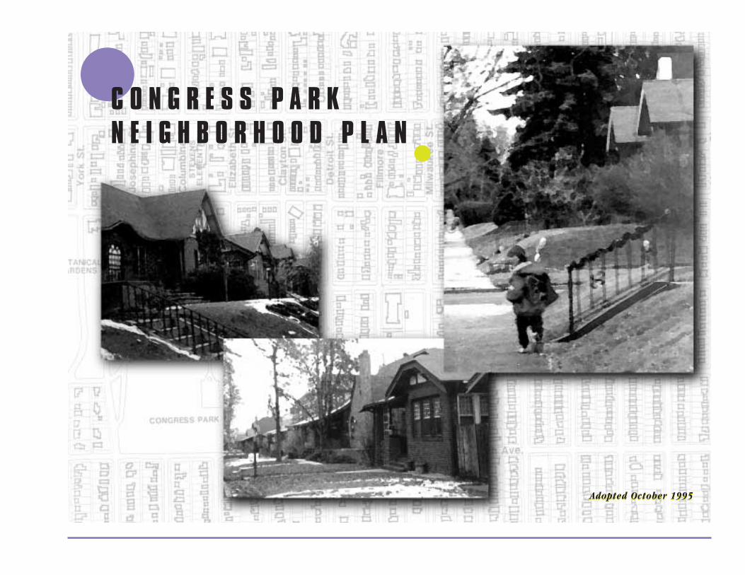
●C O N G R E S S P A R KN E I G H B O R H O O D P L A N
●
Adopted October 1995Adopted October 1995

◗T A B L E O F C O N T E N T S
PrefacePurpose of the Plan. . . . . . . . . . . . . . . . . . . . . . . . . . . . . . . . . . . . . . . . . 5The Planning Process . . . . . . . . . . . . . . . . . . . . . . . . . . . . . . . . . . . . . . . 5Plan Organization . . . . . . . . . . . . . . . . . . . . . . . . . . . . . . . . . . . . . . . . . . 8Acknowledgements (General - see Appendix E for team members) . . . . . . . . . . . 9
IntroductionNeighborhood Location and Description. . . . . . . . . . . . . . . . . . . . . . . . . . . 12Vision Statement. . . . . . . . . . . . . . . . . . . . . . . . . . . . . . . . . . . . . . . . . . 12Neighborhood History . . . . . . . . . . . . . . . . . . . . . . . . . . . . . . . . . . . . . . 12Demographic/Economic Profile . . . . . . . . . . . . . . . . . . . . . . . . . . . . . . . . 15Community Facilities and Services. . . . . . . . . . . . . . . . . . . . . . . . . . . . . . . 21
Community OutreachOverview . . . . . . . . . . . . . . . . . . . . . . . . . . . . . . . . . . . . . . . . . . . . . . 25Goal . . . . . . . . . . . . . . . . . . . . . . . . . . . . . . . . . . . . . . . . . . . . . . . . . 25Action Recommendations . . . . . . . . . . . . . . . . . . . . . . . . . . . . . . . . . . . . 25
Safety and Crime PreventionOverview . . . . . . . . . . . . . . . . . . . . . . . . . . . . . . . . . . . . . . . . . . . . . . 29Goal . . . . . . . . . . . . . . . . . . . . . . . . . . . . . . . . . . . . . . . . . . . . . . . . . 29Action Recommendations . . . . . . . . . . . . . . . . . . . . . . . . . . . . . . . . . . . . 29
Land UseUrban Design. . . . . . . . . . . . . . . . . . . . . . . . . . . . . . . . . . . . . . . . . . . . 33
Overview . . . . . . . . . . . . . . . . . . . . . . . . . . . . . . . . . . . . . . . . . . 33Goals . . . . . . . . . . . . . . . . . . . . . . . . . . . . . . . . . . . . . . . . . . . . . 33Action Recommendations . . . . . . . . . . . . . . . . . . . . . . . . . . . . . . . . 33
Zoning . . . . . . . . . . . . . . . . . . . . . . . . . . . . . . . . . . . . . . . . . . . . . . . . 37Overview . . . . . . . . . . . . . . . . . . . . . . . . . . . . . . . . . . . . . . . . . . 37Residential Land Uses . . . . . . . . . . . . . . . . . . . . . . . . . . . . . . . . . . . 37Special Residential Land Uses . . . . . . . . . . . . . . . . . . . . . . . . . . . . . . 38Commercial Land Uses . . . . . . . . . . . . . . . . . . . . . . . . . . . . . . . . . . 38Hospital Districts . . . . . . . . . . . . . . . . . . . . . . . . . . . . . . . . . . . . . 38Vacant Land . . . . . . . . . . . . . . . . . . . . . . . . . . . . . . . . . . . . . . . . . 39Parks and Open Space . . . . . . . . . . . . . . . . . . . . . . . . . . . . . . . . . . 39Schools. . . . . . . . . . . . . . . . . . . . . . . . . . . . . . . . . . . . . . . . . . . . 39
T A B L E O F C O N T E N T S
2

C O N G R E S S P A R K N E I G H B O R H O O D P L A N
Goals . . . . . . . . . . . . . . . . . . . . . . . . . . . . . . . . . . . . . . . . . . . . . . . . . 40Action Reccommendations . . . . . . . . . . . . . . . . . . . . . . . . . . . . . . . . . . . 40
Traffic and TransportationOverview . . . . . . . . . . . . . . . . . . . . . . . . . . . . . . . . . . . . . . . . . . . . . . 46Mass Transit . . . . . . . . . . . . . . . . . . . . . . . . . . . . . . . . . . . . . . . . . . . . . 46Bike Routes . . . . . . . . . . . . . . . . . . . . . . . . . . . . . . . . . . . . . . . . . . . . . 46Issues . . . . . . . . . . . . . . . . . . . . . . . . . . . . . . . . . . . . . . . . . . . . . . . . 47Goals . . . . . . . . . . . . . . . . . . . . . . . . . . . . . . . . . . . . . . . . . . . . . . . . . 48Action Recommendations . . . . . . . . . . . . . . . . . . . . . . . . . . . . . . . . . . . . 48
Economic DevelopmentOverview . . . . . . . . . . . . . . . . . . . . . . . . . . . . . . . . . . . . . . . . . . . . . . 57Issues and Goals . . . . . . . . . . . . . . . . . . . . . . . . . . . . . . . . . . . . . . . . . . 58Action Recommendations . . . . . . . . . . . . . . . . . . . . . . . . . . . . . . . . . . . . 59
AppendicesNeighborhood Survey . . . . . . . . . . . . . . . . . . . . . . . . . . . . . . . . . . . . . . 66Aesthetic Guidelines . . . . . . . . . . . . . . . . . . . . . . . . . . . . . . . . . . . . . . . 71Congress Park Neighbors, Inc. . . . . . . . . . . . . . . . . . . . . . . . . . . . . . . . . . 75Key Regulations of Zone Districts in Congress Park . . . . . . . . . . . . . . . . . . . . 76Acknowledgements . . . . . . . . . . . . . . . . . . . . . . . . . . . . . . . . . . . . . . . . 77Adoption Ordinance . . . . . . . . . . . . . . . . . . . . . . . . . . . . . . . . . . . . . . . 80
3

P R E F A C E
●P R E F A C E●
4

C O N G R E S S P A R K N E I G H B O R H O O D P L A N
◗T H E P U R P O S E O F T H E P L A N
The plan serves as an official city guide to the physical development and improvement of the CongressPark neighborhood.A city approved plan serves as a guide for making decisions about theneighborhood. It is the responsibility of the neighborhood organization(s) and assigned city staff toprioritize recommendations as time, energy and resources allow.The plan becomes an officialamendment to the City’s Comprehensive Plan. City departments use the plan to guide recommendationsand decisions based on consensus prioritization.
This plan is not an official zone map nor does it imply or deny any implicit rights to a particular zone.Zone changes that may be proposed by property owners as part of any plan must be initiated underseparate procedures established by the City and County of Denver Municipal Code.
This plan is intended to promote patterns of desired neighborhood improvements, urban design,housing, business types, traffic and public services which encourage and contribute to the economic,social, and physical health, safety and welfare of the people who live and work in Congress Park.
◗T H E P L A N N I N G P R O C E S S
The following diagram is an illustration of the plan process.As can be seen, the process is typicallyinitiated by changing conditions in and around the neighborhood.
In August 1992, Congress Park Neighbors, Inc. requested the assistance of the City in preparing aneighborhood plan.The request came because of concerns that a number of neighborhood issues werebeing addressed independently of each other.These included changes in the nature of the commercialuses along 12th Avenue, re-use of Stevens School, a shelter for homeless women proposed in theneighborhood, development pressures created by hospital expansion, and others.The Congress ParkNeighbors board of directors expressed concern that the many changes taking place concurrentlythreatened the stability of the neighborhood and could undermine its future identity.The board asked forhelp in addressing the interrelated nature of the issues and planning for positive change.
5
P R E F A C E
Grassroots efforts to organize the neighborhood on a block by block basis were launched by CongressPark Neighbors in the Fall of 1992.A survey was distributed which asked neighbors to list the top threethings they valued about the neighborhood and the first issues they would like to see addressed.Thesurvey and its results can be found in Appendix A.
On January 12, 1993, a community meeting was held at Teller Elementary School. Congress ParkNeighbors, Inc. leadership and Community Planning and Development Agency staff facilitated themeeting.Although it was snowing heavily, over 200 neighbors attended. Issues of most concern wereidentified and prioritized.A Steering Committee composed of representatives from Congress Park as wellas Capitol Hill United Neighbors, Inc., Denver East Central Civic Association, and Colfax at the Park wasformed. Six issues committees were also organized as follows:
◗ 1) Crime Prevention;
◗ 2) Traffic and Transportation;
◗ 3) Zoning and Development;
◗ 4) City Services;
◗ 5) Business and Economic Development; and
◗ 6) Community Outreach.
Over a period of 3-4 months, issues and concerns were divided into short-term and long-term goals. Shortterm goals were identified as those requiring little or no monies from the City, and that could be resolvedin a relatively short period of time. These were also referred to as “guerilla tactics.”Long-term issues andconcerns were also addressed. Realistic goals and monies were identified for future implementation oflonger-term projects.
On April 21, 1993, the Steering Committee met with the Planning Board to present mid-wayaccomplishments and to receive feedback from the Board.The Steering Committee then set up a generalassembly with the neighborhood on May 4, 1993 to receive feedback on draft ideas.A statement ofexisting conditions, issues, and an action plan for each priority issue was developed. From this document,the Steering Committee generated the narrative which, through many iterations over the course of thenext few months, became the draft Plan. In January 1994, the neighborhood reviewed the draft plan.
6

C O N G R E S S P A R K N E I G H B O R H O O D P L A N
7
NEIGHBORHOOD PLANNING PROCESSNeighborhood
Planner
Researches
NeighborhoodProfile (Data)
NeighborhoodMeeting
Describes
PlanningProcess
ExistingConditions
ComprehensivePlan
Develops
Resource:Research
NeighborhoodPlanning Team
Resource:People
Land Use PublicFacilities Circulation
Analysis/Plan Based Decision By:
Neighborhood Residents and Businesses
City Agencies Publish Acceptance
City Council
Mayor
Transmitted
Planning Board
Planning Board
Approval
Revise if Necessary and Present
Community
Presents
City AgencyReview
Requests
Planning &CommunityDevelopment
Review
Presentation
NeighborhoodAnalysis/Plan
Cha
ngin
gC
ondi
tion
s
Develops
Publicizes
Other Issues
Meets andDiscusses
•
•

P R E F A C E
The Steering Committee met twice a month from February through May 1994 to review and edit theneighborhood plan.Each chapter was reviewed for content and format.During the summer of 1994, thePlanning Office and other city personnel had the opportunity to review and comment. Comments werebrought back to the Steering Committee for discussion. By Fall 1994, Steering Committee revisions hadbeen completed and the plan draft was again routed to City Agencies for review, comment and editing.Any changes to plan recommendations were taken back to the Steering Committee for further discussionand resolution.
In early 1995,members of the Steering Committee, along with Planning Staff,met with various City agenciesto ensure that the vision and goals for the neighborhood, as defined by the Plan recommendations,wouldnot be lost in further revisions.By working towards consensus on the specific items contested, the planmeets this goal. The final draft, completed in April 1995, and presented to the Planning Board and to thecommunity in May 1995,has had the benefit of countless hours of citizen involvement.
After adoption as an amendment to Denver’s Comprehensive Plan, the Congress Park Neighborhood Planwill not be published only to be shelved as a community planning exercise. It will be implemented.This willoccur through the short and long-range actions of neighbors,businesses, and the City - working jointly toachieve the stated vision of the neighborhood.
◗P L A N O R G A N I Z A T I O N
The plan first contains descriptive information on the neighborhood - its history, demographics, andcurrent facilities. Next, issues are discussed in an overview statement, followed by goals to beachieved and then recommendations of actions to be taken to reach these goals.The actionrecommendations are classified by subject category, e.g., Community Outreach ActionRecommendations = CO-1 through CO-10.The action recommendations have been divided intoshort term and long term. Short term recommendations can be started immediately with little or nomoney. Long term recommendations will take longer to accomplish and will require funding.
These action recommendations are accompanied by a vital component, the listing of implementinggroups. It will be these groups who will be the agents of attainment of the neighborhood vision.
8

C O N G R E S S P A R K N E I G H B O R H O O D P L A N
9
◗A C K N O W L E D G E M E N T S
A historically large number of neighbors were involved in the creation of the Congress ParkNeighborhood Plan, as were a number of representatives of the City. Their work is gratefullyacknowledged. Their names appear in Appendix E.
I N T R O D U C T I O N
10
●I N T R O D U C T I O N●

C O N G R E S S P A R K N E I G H B O R H O O D P L A N
11
Colfax Ave.
13th Ave.
14th Ave.
12th Ave.
11th Ave.
10th Ave.
9th Ave.
8th Ave.
7th Ave. Pkwy.
6th Ave.
Congress Park
York
St.
Jose
phin
e S
t.
Col
umbi
ne S
t.
Eliz
abet
h S
t.
Cla
yton
St.
Det
roit
St.
Fill
mor
e S
t.
Milw
auke
e S
t.
St.
Pau
l St.
Ste
ele
St.
Ada
ms
St.
Coo
k S
t.
Mad
ison
St.
Mon
roe
St.
Gar
field
St.,
Jack
son
St.
Har
rison
St.
Col
orad
o B
lvd.
◗ C o n g r e s s P a r k
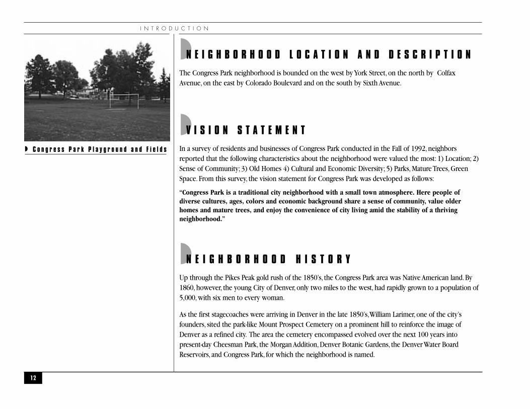
◗N E I G H B O R H O O D L O C A T I O N A N D D E S C R I P T I O N
The Congress Park neighborhood is bounded on the west by York Street, on the north by ColfaxAvenue, on the east by Colorado Boulevard and on the south by Sixth Avenue.
◗V I S I O N S T A T E M E N T
In a survey of residents and businesses of Congress Park conducted in the Fall of 1992, neighborsreported that the following characteristics about the neighborhood were valued the most: 1) Location; 2)Sense of Community; 3) Old Homes 4) Cultural and Economic Diversity; 5) Parks, Mature Trees, GreenSpace. From this survey, the vision statement for Congress Park was developed as follows:
“Congress Park is a traditional city neighborhood with a small town atmosphere. Here people ofdiverse cultures, ages, colors and economic background share a sense of community, value olderhomes and mature trees, and enjoy the convenience of city living amid the stability of a thrivingneighborhood.”
◗N E I G H B O R H O O D H I S T O R Y
Up through the Pikes Peak gold rush of the 1850’s, the Congress Park area was Native American land. By1860, however, the young City of Denver, only two miles to the west, had rapidly grown to a population of5,000, with six men to every woman.
As the first stagecoaches were arriving in Denver in the late 1850’s,William Larimer, one of the city’sfounders, sited the park-like Mount Prospect Cemetery on a prominent hill to reinforce the image ofDenver as a refined city. The area the cemetery encompassed evolved over the next 100 years intopresent-day Cheesman Park, the Morgan Addition, Denver Botanic Gardens, the Denver Water BoardReservoirs, and Congress Park, for which the neighborhood is named.
I N T R O D U C T I O N
12
◗ C o n g r e s s P a r k P l a y g r o u n d a n d F i e l d s

C O N G R E S S P A R K N E I G H B O R H O O D P L A N
13
.
Mount Prospect orCity Cemetery1858 - 1890
Congress Park 1902 - 1910
CHEESMANPARK1910
8
7
6
Odd Fell
ows
Grave
s
Societ yGraves
Masonic
Grave
s
Chinese Graves
HU
NT
ST.
9 t h A V E N U E
1 1 t h A V E N U E
1 2 t h A V E N U E
1 3 t h A V E N U E
HU
MB
OL
DT
S
T
FR
AN
KL
IN
ST
GIL
PIN
S
T.
WIL
IAM
S
ST
.
HIG
H
ST
.
RA
CE
S
T.
VIN
E
ST
.
YO
RK
S
T.
CO
LU
MB
INE
S
T.
JO
SE
PH
INE
S
T.
GA
YL
OR
D
ST
.
BOTANIC GARDENS
Catholic Cemetery1858 -1950
Samue B.MorganSubdivis on
Historic Map of the Vicinity ofThe Denver Botanic Gardens
Drawn by Jullia Andrews-Jones
BOWLES AVENUE 8 t h A V E N U E
Congress Park1930
CHILDRENSGARDEN BASIN #3
1956BASIN #2
1906BASIN
#11899
Hebrew Cemetery1858 -1910
City Nursery
DENVER WAT R BOARD
PARKING
li
REBUILT1946
Denver UnionWater Co.
E
L
CL
AY
TO
N
ST
.
EL
IZA
BE
TH
S
T.
4
2
35
Potter’s�Field
◗ C o n g r e s s P a r k , H i s t o r i c M a p

I N T R O D U C T I O N
The coming of the railroad through Denver in 1870 paralleled another sudden surge in growth. Between1880 and 1890 the city’s population boomed from over 35,000 to nearly 107,000.Through the 1880’s,Denver’s air was so polluted because of unpaved roads, coal and wood furnaces, smelting and otherindustries that wealthy residents looked to the outskirts of Denver, such as Capitol Hill, for cleaner air andreclaimed mountain views.With the expansion of public transit, including cable cars, to Colfax Avenue inthe late 1880’s and early 1890’s, the eastern reaches of Capitol Hill became more accessible to the middleclass. Because Colfax was the main route downtown, homes were first built along its corridor to the north(now City Park South neighborhood) and to the south (now Congress Park neighborhood). Between 1887and 1888, the neighborhood was completely platted into more than ten subdivisions of various sizes. OnMarch 11, 1889, the area was incorporated into Denver as part of a larger annexation by the city.
Many of the neighborhood’s historic structures were built in the next decade. Examples are: StevensSchool (built as George W. Clayton School in 1900), Fire Station #15 (circa 1903) at the southeast corner of11th Avenue and Clayton Street (now a private residence) and the Capitol Heights Presbyterian Church,built at the intersection of 11th Avenue and Fillmore Street in 1911. In 1917, old Gove Elementary, whosesite is now playing fields, tennis courts and a community garden, was one of the City’s first schoolconversions from elementary to middle school. During World War I and into the 1920’s, the park was thehome of the City Nursery and had the largest VICTORY Garden in the City.A portion of the park wasconverted to playing fields during the 1930’s through a WPA project which also built the terraced wallsand planted the trees. It was known as Victory Park up until its rededication as Congress Park in 1949.Alandmark to the neighborhood, the 1939 candy-striped smokestack at “Signal Hill”north of the park was aprimary structure at Denver’s emergency alert system facilities which expanded in 1993 to become thecity’s Combined Communication Center.
Congress Park’s neighborhood commercial centers, always convenient to the neighborhood pedestrian,have also evolved over the years not only in response to the growth of the neighborhood but also due tothe changes in modes of mass transportation. Horse-drawn streetcars carried downtown commuters alongboth Colfax and 12th Avenues in the 1900’s.Around street car stops such as 12th and Madison, merchants’small businesses flourished and these centers are still thriving, although the horses have been replacedover time by trolleys (1920-30), then electric buses (1940’s) and today’s (starting in 1956) diesel buses.
Congress Park’s continued prosperity as a residential neighborhood is tied directly to its ability to maintainthe very factors that created its stable history: a close-in neighborhood of quiet tree-lined streets, parks,stable housing stock and pedestrian-oriented neighborhood shopping.
14
◗ S t r e e t R a i l w a y s , D e n v e r R a i l w a y C o .
C O N G R E S S P A R K N E I G H B O R H O O D P L A N
◗DEMOGRAPH IC/ ECONOMIC PROF I L E
◗ Population and Households
15
0
2,000
4,000
6,000
8,000
10,000
12,000
14,00012,752
13,341
11,003
*Population figures represent total population for the area, which includes groupquarters (e.g....group homes, adult correctional facilities, communal living).Source: U.S. Census** Denver Regional Council of Governments
1960 1970 1980 1990 1996**
9,636 9,663
POPULAT ION*
0
50
100
150
200
250
300
350
400
450
1959 1969 1979 1989 1996**
424
94
The average household size has decreased, which is consistent with the downsizingtrend since 1989 for a majority of Denver's neighborhoods.Source: U.S. Census** Denver Regional Council of Governments
287
136 131
POPULAT ION IN GROUP QUARTERS
HOUSEHOLDS
1960 1970 1980 1990
Average Household S ize
2.64 2.35 1.98 1.89
Housing Uni ts
4,967 6,076 6,071 5,952
Households*
12,328 13,054 10,909 9,500
*Household figures do notinclude group quarters. Basedon the figures listed above,population in group quartersdecreased between 1959–1979and increased slightly in 1989.
I N T R O D U C T I O N
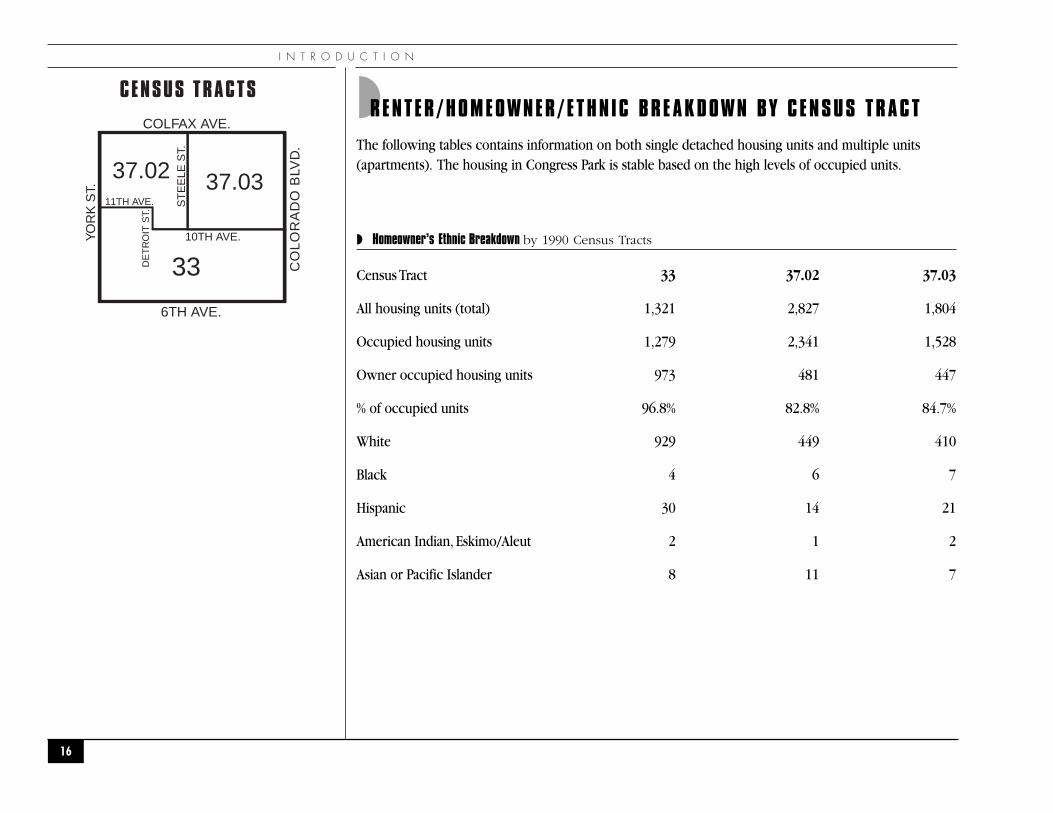
◗RENTER/HOMEOWNER/ETHN IC BREAKDOWN BY C ENSUS TRACT
The following tables contains information on both single detached housing units and multiple units(apartments). The housing in Congress Park is stable based on the high levels of occupied units.
◗ Homeowner’s Ethnic Breakdown by 1990 Census Tracts
Census Tract 33 37.02 37.03
All housing units (total) 1,321 2,827 1,804
Occupied housing units 1,279 2,341 1,528
Owner occupied housing units 973 481 447
% of occupied units 96.8% 82.8% 84.7%
White 929 449 410
Black 4 6 7
Hispanic 30 14 21
American Indian, Eskimo/Aleut 2 1 2
Asian or Pacific Islander 8 11 7
16
COLFAX AVE.
CO
LO
RA
DO
BLV
D.
6TH AVE.
YO
RK
ST.
10TH AVE.
ST
EE
LE S
T.
11TH AVE.
DE
TR
OIT
ST.
33
37.02 37.03
CENSUS TRACTS
C O N G R E S S P A R K N E I G H B O R H O O D P L A N
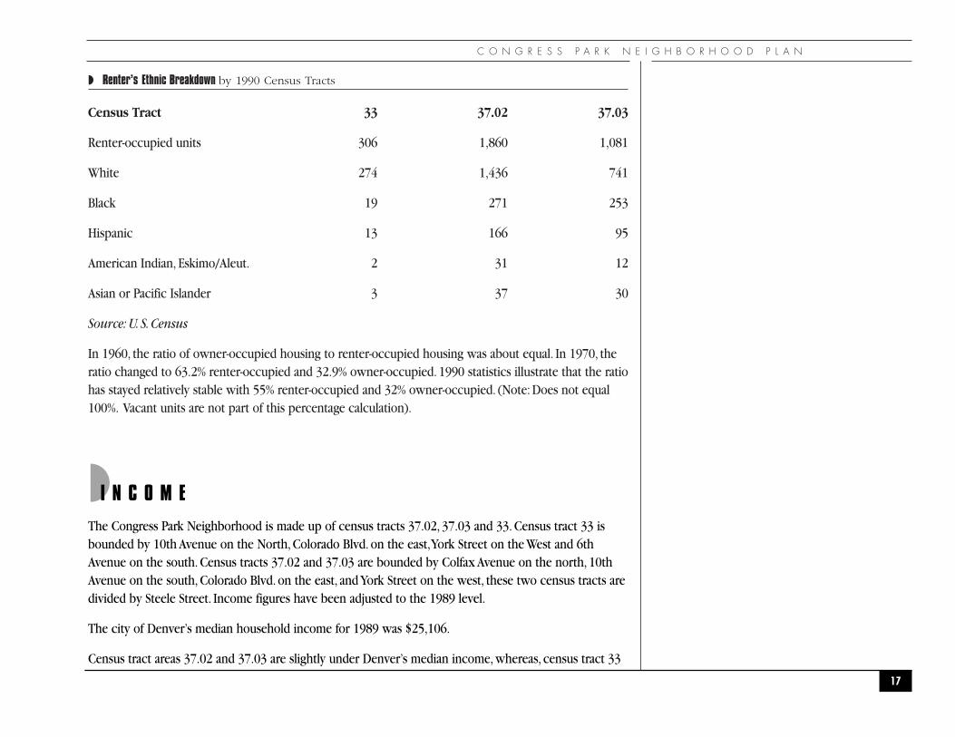
◗ Renter’s Ethnic Breakdown by 1990 Census Tracts
Census Tract 33 37.02 37.03
Renter-occupied units 306 1,860 1,081
White 274 1,436 741
Black 19 271 253
Hispanic 13 166 95
American Indian, Eskimo/Aleut. 2 31 12
Asian or Pacific Islander 3 37 30
Source: U. S. Census
In 1960, the ratio of owner-occupied housing to renter-occupied housing was about equal. In 1970, theratio changed to 63.2% renter-occupied and 32.9% owner-occupied. 1990 statistics illustrate that the ratiohas stayed relatively stable with 55% renter-occupied and 32% owner-occupied. (Note: Does not equal100%. Vacant units are not part of this percentage calculation).
◗I N C O M E
The Congress Park Neighborhood is made up of census tracts 37.02, 37.03 and 33. Census tract 33 isbounded by 10th Avenue on the North, Colorado Blvd. on the east,York Street on the West and 6thAvenue on the south. Census tracts 37.02 and 37.03 are bounded by Colfax Avenue on the north, 10thAvenue on the south, Colorado Blvd. on the east, and York Street on the west, these two census tracts aredivided by Steele Street. Income figures have been adjusted to the 1989 level.
The city of Denver’s median household income for 1989 was $25,106.
Census tract areas 37.02 and 37.03 are slightly under Denver’s median income, whereas, census tract 33
17

I N T R O D U C T I O N
surpasses Denver’s median income by 80%.The figures listed above show a decline in buying power between1969 and 1989 for all three census tracts, although Census Tract 33 has maintained the most stability.
◗M E D I A N A G E by Census Tracts
In 1989 the median age for census tract 33 was 37.7 years; census tract 37.02 was 33.8 years and censustract 37.03 was 32.9 years. Census tract 37.03 has the youngest median age group.
18
0
10,000
20,000
40,000
30,000
50,000
60,000
48,115
32,18029,770
38,581
20,852 21,683
45,054
20,63722,813
1969
C.T. 33
*Figures adjusted to 1989 level
C.T. 37.02 C.T. 37.03
1979 1989
HOUSEHOLD INCOME BY CENSUS TRACTS*
C O N G R E S S P A R K N E I G H B O R H O O D P L A N
19
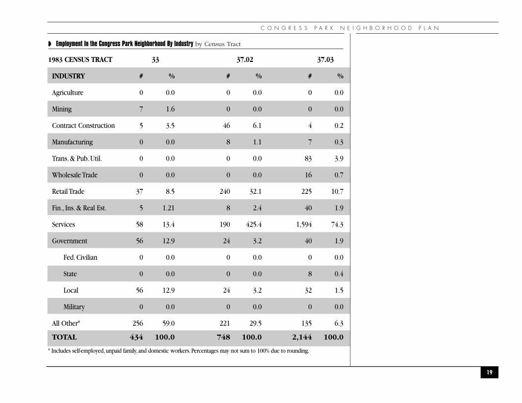
◗ Employment In the Congress Park Neighborhood By Industry by Census Tract
1983 CENSUS TRACT 33 37.02 37.03
INDUSTRY # % # % # %
Agriculture 0 0.0 0 0.0 0 0.0
Mining 7 1.6 0 0.0 0 0.0
Contract Construction 5 3.5 46 6.1 4 0.2
Manufacturing 0 0.0 8 1.1 7 0.3
Trans. & Pub. Util. 0 0.0 0 0.0 83 3.9
Wholesale Trade 0 0.0 0 0.0 16 0.7
Retail Trade 37 8.5 240 32.1 225 10.7
Fin., Ins. & Real Est. 5 1.21 8 2.4 40 1.9
Services 58 13.4 190 425.4 1,594 74.3
Government 56 12.9 24 3.2 40 1.9
Fed. Civilian 0 0.0 0 0.0 0 0.0
State 0 0.0 0 0.0 8 0.4
Local 56 12.9 24 3.2 32 1.5
Military 0 0.0 0 0.0 0 0.0
All Other* 256 59.0 221 29.5 135 6.3
TOTAL 434 100.0 748 100.0 2,144 100.0
* Includes self-employed,unpaid family, and domestic workers.Percentages may not sum to 100% due to rounding.

I N T R O D U C T I O N
◗ Employment In the Congress Park Neighborhood By Industry by Census Tract
1988 CENSUS TRACT 33 37.02 37.03
INDUSTRY # % # % # %
Agriculture 0 0.0 5 0.6 0 0.0
Mining 0 0.0 0 0.0 0 0.0
Contract Construction 32 5.3 12 1.3 13 0.9
Manufacturing 7 1.2 57 6.4 23 1.5
Trans. & Pub. Util. 17 2.8 17 1.9 0 0.0
Wholesale Trade 0 0.0 16 1.8 13 0.9
Retail Trade 103 17.1 230 25.7 89 5.8
Fin., Ins. & Real Est. 35 5.8 63 7.0 74 4.9
Services 95 15.8 251 28.0 1,086 71.3
Government 48 8.0 26 2.9 94 6.2
Fed. Civilian 0 0.0 0 0.0 0 0.0
State 0 0.0 0 0.0 9 0.6
Local 48 8.0 26 2.9 85 5.6
Military 0 0.0 0 0.0 0 0.0
All Other* 266 44.1 218 24.4 132 8.7
TOTAL 603 100.0 895 100.0 1,524 100.0
* Includes self-employed,unpaid family, and domestic workers.Percentages may not sum to 100% due to rounding.B-3 c Community Facilities.
20
C O N G R E S S P A R K N E I G H B O R H O O D P L A N
◗C O M M U N I T Y F A C I L I T I E S A N D S E R V I C E S
◗ Parks, Recreation, and Open SpaceCongress Park is located at 8th Avenue and Josephine Street.The total acreage is 17.10 and the parkcontains seven tennis courts, a swimming pool, ball fields, soccer fields, sheltered picnic area and anewly constructed children’s playground. Immediately to the north are play fields located on top ofa Denver Water Department Reservoir.These fields are generally only available to organized sportssuch as youth soccer.
The Botanic Gardens and Cheesman Park across York Street offer additional open space for theneighborhood. Other parks outside of the neighborhood that are used by the residents are City Park,Lindsley Park and Bromwell Park.
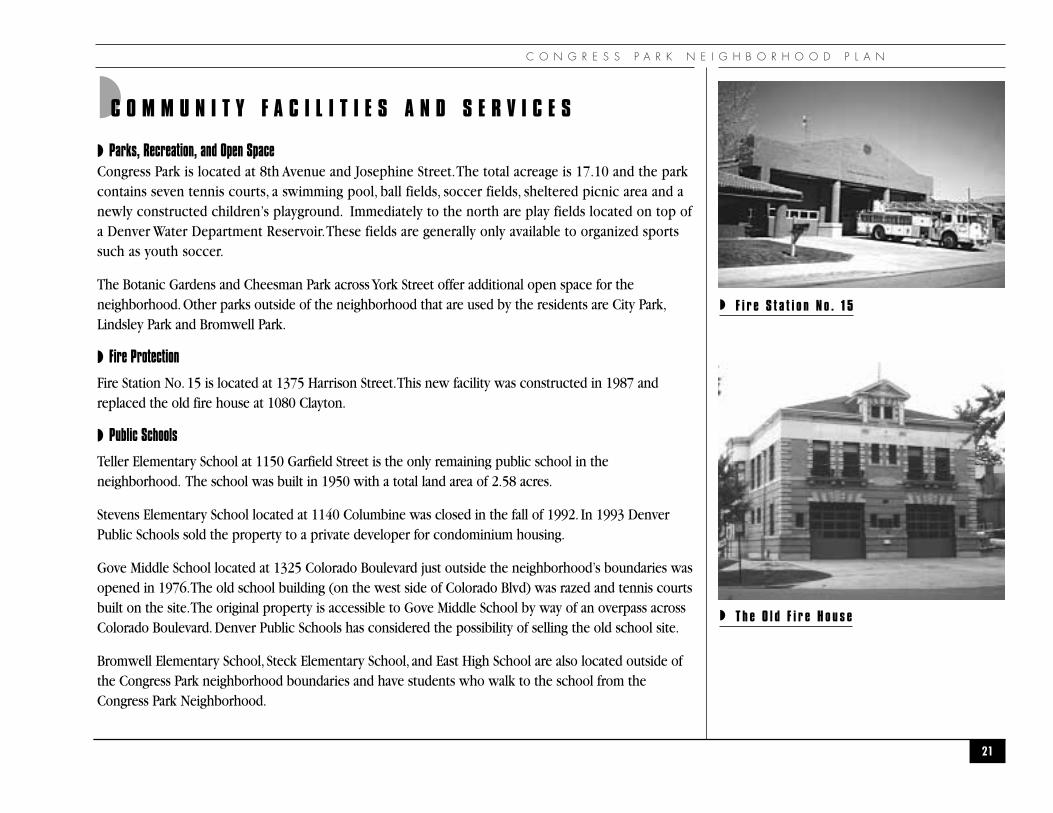
◗ Fire Protection
Fire Station No. 15 is located at 1375 Harrison Street.This new facility was constructed in 1987 andreplaced the old fire house at 1080 Clayton.
◗ Public Schools
Teller Elementary School at 1150 Garfield Street is the only remaining public school in theneighborhood. The school was built in 1950 with a total land area of 2.58 acres.
Stevens Elementary School located at 1140 Columbine was closed in the fall of 1992. In 1993 DenverPublic Schools sold the property to a private developer for condominium housing.
Gove Middle School located at 1325 Colorado Boulevard just outside the neighborhood’s boundaries wasopened in 1976.The old school building (on the west side of Colorado Blvd) was razed and tennis courtsbuilt on the site.The original property is accessible to Gove Middle School by way of an overpass acrossColorado Boulevard. Denver Public Schools has considered the possibility of selling the old school site.
Bromwell Elementary School, Steck Elementary School, and East High School are also located outside ofthe Congress Park neighborhood boundaries and have students who walk to the school from theCongress Park Neighborhood.
21
◗ F i r e S t a t i o n N o . 1 5
◗ T h e O l d F i r e H o u s e
I N T R O D U C T I O N
◗ Library
The closest libraries to the neighborhood are the Main Library at 1357 Broadway, Ross-Cherry Creek, abranch library at 305 Milwaukee, and Park Hill Branch at Montview and Dexter Street.
◗ Police
Congress Park is served by Police District Station #3 located at 1625 S. University Boulevard.The CongressPark Neighborhood was ranked 30th of the 68 neighborhoods in the 1992 Neighborhood CrimeRankings for total offenses by crime rate. In 1994, the ranking had improved to 41st of 72 neighborhoods,illustrating how the Congress Park neighborhood is showing a major improvement in safety for itsresidences and businesses.
◗ Medical Care
The National Jewish Center for Immunology and Respiratory Medicine (National Jewish Center) islocated within the boundaries of Congress Park.The location is bordered by Colfax on the north,Colorado Blvd. on the east, 14th Avenue on the south and Garfield on the west.
The University of Colorado Health Sciences Center, University Hospital, Rose Medical Center, and theVeterans Administration Medical Center - Denver are located in the Hale Neighborhood across ColoradoBlvd., primarily between 8th and 11th Avenues.
◗ Churches
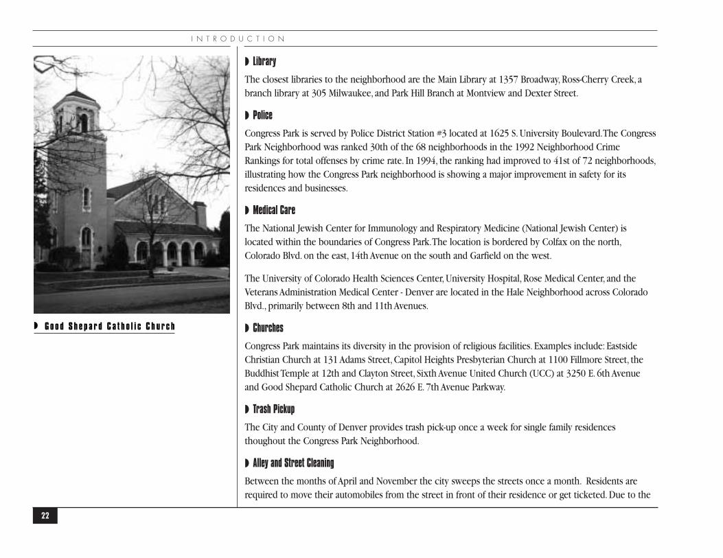
Congress Park maintains its diversity in the provision of religious facilities. Examples include: EastsideChristian Church at 131 Adams Street, Capitol Heights Presbyterian Church at 1100 Fillmore Street, theBuddhist Temple at 12th and Clayton Street, Sixth Avenue United Church (UCC) at 3250 E. 6th Avenueand Good Shepard Catholic Church at 2626 E. 7th Avenue Parkway.
◗ Trash Pickup
The City and County of Denver provides trash pick-up once a week for single family residencesthoughout the Congress Park Neighborhood.
◗ Alley and Street Cleaning
Between the months of April and November the city sweeps the streets once a month. Residents arerequired to move their automobiles from the street in front of their residence or get ticketed. Due to the
22
◗ G o o d S h e p a r d C a t h o l i c C h u r c h

C O N G R E S S P A R K N E I G H B O R H O O D P L A N
high volumes of traffic, Colorado Boulevard is swept at night, between midnight and 7 a.m.Alleys areswept during the summer between May and October, once a month.
◗ Animal Control
The Zoning Department is responsible for enforcing the City’s ordinance for regulating the number ofanimals per household. Up to three dogs and five cats are permitted, but the number cannot exceed atotal of five animals.The Office of Animal Control for the City and County of Denver located at 660 S.Jason Street is responsible for enforcing the leash law, which requires owners to leash their dog.Anothervital ordinance to the neighborhood is one which requires animal owners walking their pets to removeanimal wastes from other’s properties, at the time of deposit.
◗ Snow Removal
Residents and property owners are responsible for removing snow from sidewalks adjacent to theirproperty within 24 hours of each snow fall. During snow falls, the City plows and applies salt and sandto the following avenues and streets: 6th, 8th, 12th, 13th, 14th, Colfax,York, Josephine and ColoradoBoulevard.
23
●C O M M U N I T Y O U T R E A C H●
24
C O M M U N I T Y O U T R E A C H

C O N G R E S S P A R K N E I G H B O R H O O D P L A N
25
◗ Overview
Congress Park is a neighborhood within a city of nearly 500,000 people and a metropolitan area of over2 million. Many of its residents leave the neighborhood daily for work, entertainment, shopping, and abroad range of other activities.
The neighborhood also experiences the common phenomenon of changing population, whereindividuals and families move often to follow jobs or to meet changing housing desires.
This transience, in both the daily mobility and the rapid turnover of the population, challenges theneighborhood’s ability to nurture a sense of community among its residents.
◗ Goal
To create and nurture a small town atmosphere in Congress Park and instill community pride in theneighborhood; to educate and inform neighbors about issues of common concern.
◗ Action Recommendations
In order to accomplish this goal, the following action recommendations were developed. Therecommendations have been divided into short term and long term. Short term recommendations canbe started immediately with little or no money. Long term recommendations will take longer toaccomplish and will require funding.
CO-1 Establish a standing community outreach committee within the neighborhood organization tocollect and disseminate information in areas such as meeting information, city, business andprivate sector plans, public and private schools and people with special needs and other issuesthat impact the day to day lives in Congress Park.
Implementing groups: Neighborhood Organizations
Short Term
CO-2 Sponsor annual events (e.g. ice cream social, children’s art show, parade, cultural, sporting, otherexcursions) that will involve a cross-section of the neighborhood.
Implementing groups: Neighborhood Organizations
Short Term
C O M M U N I T Y O U T R E A C H
CO-3 Compile a calendar of events relevant to the neighborhood for publication in the neighborhoodnewsletter.
Implementing groups: Neighborhood Organizations
Short Term
CO-4 Continue to produce and distribute a quarterly newsletter by and for all residents andbusinesses.
Implementing groups: Neighborhood Organizations
Short Term
CO-5 Contact new members of Congress Park Neighbors each month to encourage their participationand increased activity in the neighborhood organization and its activities.
Implementing groups: Neighborhood Organizations
Short Term
CO-6 Produce and distribute a neighborhood resource directory to all residents and businesses.
Implementing groups: Neighborhood Organizations
Short Term
CO-7 Produce and distribute a “Welcome Package” for new residents moving into the neighborhood.
Implementing groups: Neighborhood Organizations
Short Term
CO-8 Install and manage information kiosk and community information bulletin boards at highpedestrian traffic areas.
Implementing groups: Neighborhood Organizations
Short Term
26
◗ C o m m u n i t y B u l l e t i n B o a r d o n 1 2 t h A v e n u e

C O N G R E S S P A R K N E I G H B O R H O O D P L A N
CO-9 Preserve and encourage gathering places, physical amenities and programs within theneighborhood that foster neighborhood communication.
Implementing groups: Neighborhood Organizations,
Community Planning and Development Agency
Short Term
CO-10 Study the feasibility of developing a community center in the neighborhood.
Implementing groups: Neighborhood Organizations,
Community Planning and Development Agency
Long Term
27

S A F E T Y A N D C R I M E P R E V E N T I O N
●S A F E T Y & C R I M E P R E V E N T I O N●
28
C O N G R E S S P A R K N E I G H B O R H O O D P L A N
◗ Overview
In the 1992 survey*, crime prevention was identified as the number one priority of area residents.As inmost city neighborhoods, areas with higher population density have a higher incidence of crime.Residents and businesses must, in some instances, contend with the impacts of such problems as: highcrime rate apartment buildings; prostitution; drug-related crimes; and gang presence and disturbances.Burglary and auto-related crimes are the most frequently reported and this is the fastest increasingreporting category, according to police department statistics.
Congress Park struggles with graffiti, insufficient mid-block street lighting, unreported crimes and ageneral lack of awareness and, more importantly, a lack of interest/involvement by some propertyowners and managers, most especially, absentee owners and managers.
*Survey results can be found in Appendix A.
◗ Goal
To reduce crime and make the neighborhood a safer place to live.
◗ Action Recommendations
The action recommendations have been divided into short term and long term. Short termrecommendations can be started immediately with little or no money. Long term recommendations willtake longer to accomplish and will require funding.
Implementation efforts to achieve this purpose include, but are not limited to the following:
SCP-1 Encourage the city to implement stronger neighborhood -based policing, in which each officercovers a smaller area, and gets more intimately involved with the area’s problems.
Implementing groups: Denver Police Department
Short Term
SCP-2 Encourage the city to develop and implement more resources to help neighborhoodsfight crime.
Implementing groups: Denver Police Department
Short Term
29
S A F E T Y A N D C R I M E P R E V E N T I O N
SCP-3 Establish a volunteer committee to deal with crime and safety issues. Such a committee isneeded to keep residents informed about serious crime problems, and to perform manyconstructive tasks.
Implementing groups: Neighborhood Organizations
Short Term
◗ Achieve 100% participation of all blocks in the Neighborhood Watch Program.
Implementing groups: Neighborhood Organizations
Short Term
◗ Hold regular open meetings to: 1) provide neighbors with a forum to bring forth problems anddiscuss tactics, and 2) inform and educate residents on crime issues.
Implementing groups: Neighborhood Organizations
Short Term
◗ Network with city, police officials and other neighborhood groups to learn about currentresources available to residents, and to lobby the city for support deemed appropriate.Implementing groups: Neighborhood Organizations
Short Term
◗ Identify and inventory the problem areas, such as apartment buildings with frequent reports ofcrimes.Work with owners, managers, police and other city agencies to deal with such concerns.Encourage 100% participation by all apartment managers in Police Department “ManagementTraining Program”Implementing groups: Neighborhood Organizations
Short Term
◗ Provide the neighborhood with current crime statistics.
Implementing groups: Neighborhood Organizations,
Denver Police Department
Short Term
30

C O N G R E S S P A R K N E I G H B O R H O O D P L A N
31
◗ Develop effective programs to prevent and to remove graffiti.
Implementing groups: Neighborhood Organizations
Long Term
◗ Develop effective communication with all businesses in Congress Park regarding crime andsafety issues.
Implementing groups: Neighborhood Organizations,
Neighborhood Business Organizations
Short Term
◗ Act as an advocate for Congress Park in dealing with the city on crime and safety issues.
Implementing groups: Neighborhood Organizations
Short Term
◗ Encourage the installation of mid-block street and alley lights
Implementing groups: Neighborhood Organizations,
Department of Public Works
Short Term

L A N D U S E
●L A N D U S E●
32
C O N G R E S S P A R K N E I G H B O R H O O D P L A N
◗U R B A N D E S I G N
◗ Overview
The Congress Park neighborhood is fully developed.As changes occur, it is important that these changesremain consistent and complementary with the existing neighborhood character.
Congress Park’s residential qualities and sense of community are expressed by the neighborhood streetimage.The older homes, the diversity of housing stock and apartment types, the neighborhoodcommercial services, mature street trees, sidewalks, and front porch detailing all contribute to thecommunity’s unique character and “pedestrian friendly”atmosphere that the residents value.
◗ Goals
◗ Promote and enhance the existing neighborhood character and preserve the historic sense ofthe community for future generations to enjoy.
◗ Preserve and maintain a high standard for parks, open space, boulevards, parkways,streetscaping, traffic circulation, special improvement and historic districts within its boundariesas they pertain to the neighborhood’s urban design.
◗ Preserve and enhance the pedestrian friendly atmosphere.
◗ Development should enhance the fabric of the neighborhood. Large scale development thatcould harm the residential, historic character of the community shall be discouraged.
◗ Action Recommendations
The action recommendations that follow this section make reference to “Aesthetic Guidelines”.Theguidelines are provided as recommendations to property owners to serve as a tool in maintaining theexisting neighborhood character.They are not proposed as an overlay district, nor as a covenant, nor toreplace existing zoning laws. Recommendations have been divided into short term and long term. Shortterm recommendations can be started immediately with little or no money. Long term recommendationswill take longer to accomplish and will require funding.
33
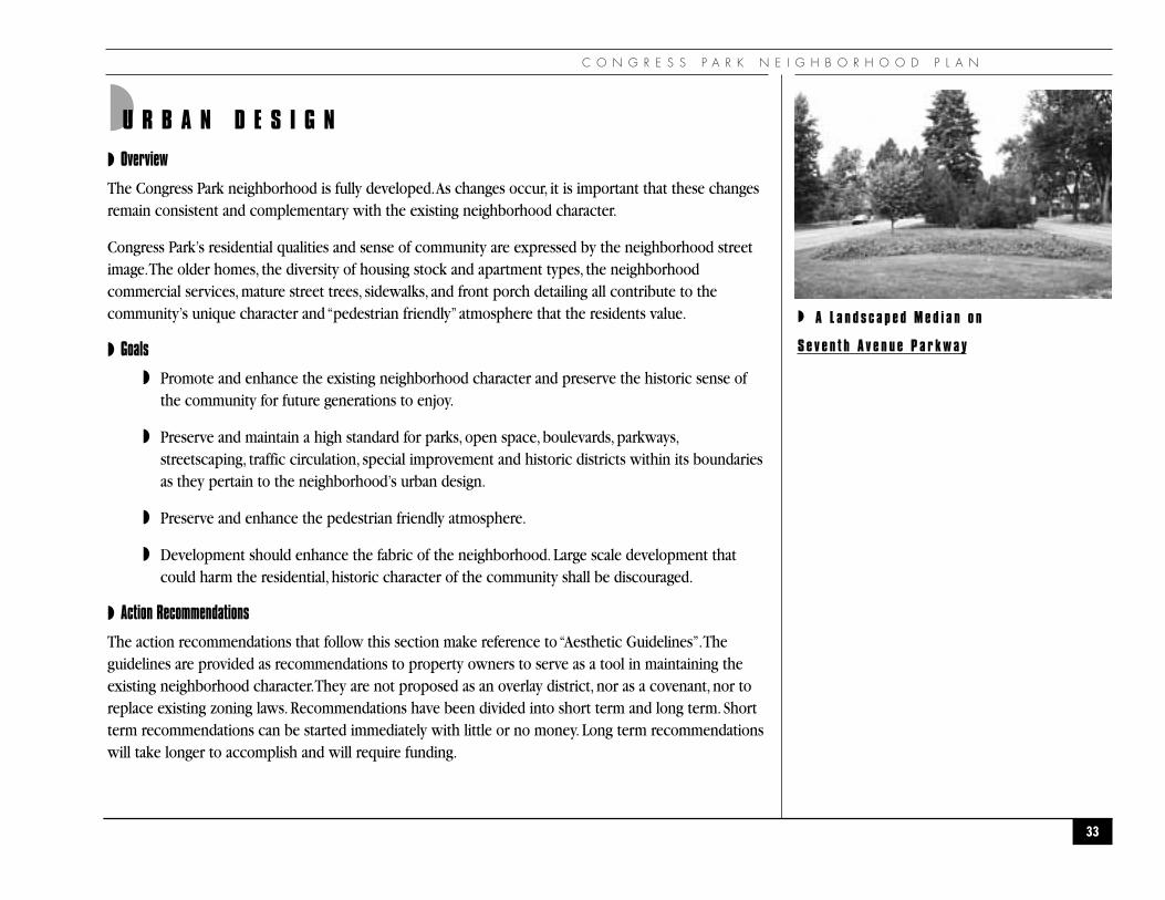
◗ A L a n d s c a p e d M e d i a n o n
S e v e n t h A v e n u e P a r k w a y

L A N D U S E
UD-1 Implement the “Aesthetic Guidelines”as outlined in Appendix B.The committee tasks shall include:
◗ Application of guidelines as building changes occur, through the variance, zone change, andpermitting processes.Implementing groups: Neighborhood Organizations
Short Term
◗ Provide technical assistance upon request to property owners or developers during the designphase of their projects (e.g. an aesthetics checklist of design considerations, a forum for feedbackearly in the Planning process).Implementing groups: Neighborhood Organizations
Short Term
◗ Develop and apply a neighborhood process for continuous review of parks and open space,boulevards and parkways, streetscaping, traffic circulation, special improvement and historicdistricts within its boundaries (e.g. historic preservation, commercial districts, and hospitaldistricts) as they pertain to the neighborhood’s urban design.
Implementing groups: Neighborhood Organizations,
Parks and Recreation Department,
Community Planning and Development Agency
Short Term
◗ All garage access and parking areas should be limited to alley access only. To preserve the“pedestrian friendly”concept of the neighborhood the blocks should not be cut up with accessdrives.All parking areas should be screened from street view with a combination of transparentfencing and landscaping. Large pen parking areas should be discouraged and should be designedto minimize the visual impact and to define the existing street lines as to not create a void in thestreet imagery.
Implementing groups: Community Planning and Development Agency,
Department of Public Works, Traffic and Transportation Division
Short Term
34
◗ Pedestr ian-Fr iend ly Streetscape Complements
the H istor ic Resident ia l Ne ighborhood

C O N G R E S S P A R K N E I G H B O R H O O D P L A N
UD-2 Create and reinforce buffers along the neighborhood borders and between residential andcommercial areas. Specifically:Community Planning and Development Agency,Department of Public Works, Traffic and Transportation Division
Long Term
◗ Encourage landscaped visual buffers of parking areas within the neighborhood.Community Planning and Development Agency,
Department of Public Works, Traffic and Transportation Division
Long Term
◗ Support the creation of cul-de-sac parking on Colfax (see graphic).Community Planning and Development Agency,
Department of Public Works, Traffic and Transportation Division
Long Term
UD-3 Special districts—develop designated areas within or adjacent to areas that need specialdesign consideration.
Community Planning and Development Agency, Neighborhood Organizations
Long Term
◗ 12th Avenue Business District: The enhancement of the street imagery and making this area apedestrian destination should be a high priority.Through specific street landscaping, furnishings,lighting, and brick paved intersections, we can create two individual pockets of pedestrianactivity as well as cut down on 12th Avenue through traffic. Specific design guidelines should beprovided to create a high degree of visual interest, pleasing scale, and inviting spaces. Storefrontsand signs should be subordinate to and integrated with each building facade and choice ofmaterials and detailing should be compatible with the adjacent structures.
Community Planning and Development Agency,
Department of Public Works, Traffic and Transportation Division
Neighborhood Business Organizations, Neighborhood Organizations
Long Term
35
Business
Residential Residential
Business
Colfax Ave.
Removable Bollards

L A N D U S E
◗ Colfax Commercial District: The entire Colfax “strip”should be reviewed as a separate study toultimately provide design guidelines for this district. However, we must address the issue ofcommercial/residential buffers.We fully endorse the concept of converting every other side streetinto a cul-de-sac to the residential side and to additional parking to the commercial side, withprovisions to allow access to emergency vehicles. This transition should take place at he zone lineand should be heavily landscaped to provide a visual barrier to the commercial street beyond.
Zoning Administration,
Neighborhood Organizations
Long Term
◗ Colorado Boulevard Commercial District:The entire Colorado Boulevard area should be reviewedas a separate study to ultimately provide design guidelines for this district.This study should notonly address the boulevard frontage and its mixture of higher density residential and commercialbut should also address the transition to the adjacent lower density residential area.
Zoning Administration,
Neighborhood Organizations
Long Term
◗ Hospital District:New structures should respect their old neighbors in terms of materials, scale,proportions,and detailing.Care should be taken to create structures that are “pedestrian friendly.’’
Through the use of landscaping, and attention to scale and structural detail at the pedestrian level, there should be created a sense of comfort, to reduce the impact of the large scale of the overall structure.
Zoning Administration,
Neighborhood Organizations
Long Term
UD-4 Remove all billboards and discourage any new billboard sites in the neighborhood (includes bothsides of Colfax Avenue).
Community Planning and Development Agency, Zoning Administration
Long Term
36
◗ E a s t C o l f a x A v e n u e
C O N G R E S S P A R K N E I G H B O R H O O D P L A N
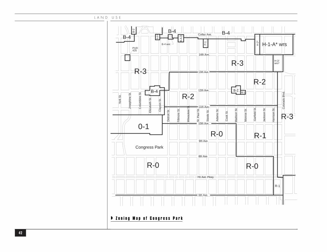
◗Z O N I N G
◗ Overview
The neighborhood is predominantly residential with commercial uses along Colfax Avenue, ColoradoBoulevard, and two commercial nodes along 12th Avenue.The largest land use is residential.The secondlargest land use is parks and open space (Congress Park and 7th Avenue Parkway), followed bycommercial land uses.
The zone districts specifically applicable to Congress Park are R-0, R-1, R-2, R-3, B-1, B-2, and B-A-3, H-1-A,H-2, O-1, and P-1 and are shown on the attached map following this chapter.Their general purposes,descriptions and key regulations are provided in Appendix E.
◗ Residential Land Uses
The Congress Park neighborhood has a total land area of 660 acres:88% is zoned for residential (47% forsingle-family,41% for multi-family).
The R-0 zone south of 10th Avenue,which continues to Sixth Avenue, is a stable residential area.Theresidents in 1968 initiated a rezoning which resulted in a change from R-1 to the present zone.
The low density residential area zoned R-1, to the south of 11th Avenue,has a number of legal non-conforming duplexes that were in existence prior to 1925 when zoning was instituted in the City.
The medium density residential area,zoned R-2,has developed almost identically to the R-1 zone.Thenumber of single family units to multi-family units in the R-2 zone is 55% to 45%.Any action to decreasedensity by changing the zone district to a lower density designation could lead to a number of non-conforming uses.
The higher density residential area,zoned R-3,a high-rise apartment zone between 13th and Colfax Avenue, isunderdeveloped by definition.Single-family units and duplexes predominate here as well. In 1992, the Cityand County of Denver instituted the H-1-A and H-2 Hospital District Zones, taking hospitals from the R-3zone districts as a use by right.Due to the subsequent zone changes for National Jewish Center, thepercentage of multi-unit residential zoning in the neighborhood has been reduced by 13 acres or 3%.
In 1960, the ratio of owner-occupied housing and renter-occupied housing was about equal. In 1970, the
37
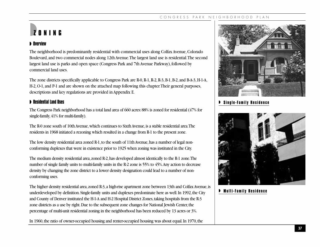
◗ S i n g l e - F a m i l y R e s i d e n c e
◗ M u l t i - F a m i l y R e s i d e n c e

L A N D U S E
ratio changed to 63.2% renter-occupied and 32.9% owner-occupied.1990 statistics illustrate that the ratio hasstayed relatively stable with 55% renter-occupied and 32% owner-occupied. (Note:Does not equal 100% ,vacant units are not part of this percentage calculation).
In short,Congress Park has developed a housing density mix that accommodates a variety of lifestyles anddisplays a diverse urban landscape.
◗ Special Residential Land Uses
The neighborhood presently accommodates six group homes, one adult correctional facility and onespecial care home within its boundaries.These facilities are presently located in the higher-density area,or R-3 zone, of the neighborhood. A recent city ordinance now limits, in an area, the location of thesefacilities, based on their proximity to each other.
◗ Commercial Land Uses
Commercial uses zoned B-4 are concentrated along the East Colfax Avenue corridor, along with twoareas of B-A-3 that have remained stable over the years.Two smaller nodes of commercial uses, zonedB-1 and B-2, are located at 12th Avenue and Clayton, and 12th Avenue and Madison. ColoradoBoulevard, 8th Avenue and 6th Avenue (zoned B-2), along with the two nodes mentioned above on12th Avenue, have businesses which provide services to the surrounding neighborhood. MadisonSquare (12th and Madison) has some vacancies and some businesses for the larger community (eyebank, metal plating). For the purpose of this plan, both sides of East Colfax and 6th Avenues have beenincluded in the narrative.
◗ Hospital Districts
National Jewish Center occupies approximately two blocks in the northeast corner of the neighborhood.A portion of the hospital campus is also located on the east side of Colorado Boulevard in the Haleneighborhood.Although not in the Congress Park neighborhood, University Hospital and University ofColorado Health Sciences Center (UCHSC) border on the east. UCHSC also utilizes one block in theneighborhood zoned R-1/R-3 for a parking lot and offices.
38
Colfax Ave.
13th Ave.
14th Ave.
12th Ave.
11th Ave.
10th Ave.
9th Ave.
8th Ave.
7th Ave. Pkwy.
6th Ave.
Congress Park
York
St.
Jose
phin
e S
t.
Col
umbi
ne S
t.
Eliz
abet
h S
t.
Cla
yton
St.
Det
roit
St.
Fill
mor
e S
t.
Milw
auke
e S
t.
St.
Pau
l St.
Ste
ele
St.
Ada
ms
St.
Coo
k S
t.
Mad
ison
St.
Mon
roe
St.
Gar
field
St.,
Jack
son
St.
Har
rison
St.
Col
orad
o B
lvd.
◗ G r o u p H o m e L o c a t i o n s

C O N G R E S S P A R K N E I G H B O R H O O D P L A N
◗ Vacant Land
There are approximately three acres of vacant land.The former Golden Ox restaurant, at one time aprominent Colfax Avenue landmark for Denver residents, has been demolished. Between 14th and Colfaxon Steele Street in the R-3 zoned area are three to four parcels of land that are also vacant.
◗ Parks and Open Space
Congress Park is located at 8th Avenue and Josephine Street.The total acreage is 17.10 and the area iszoned O-1. It contains tennis courts, a playground, an outdoor swimming pool area, playing fields,picnic shelters, and a restroom.Additionally, there is the grassed-over area covering two of the CapitolHeights reservoirs for use as playing fields for team sports.This area offers three more acres of activerecreational space.
Seventh Avenue Parkway provides additional green space and is frequently used for jogging and walkingby the residents of Congress Park.
Tennis courts, Gove Middle School playfields and a Community Garden located between 13th and 14thAvenue on Harrison on DPS property (formerly the location of the school), also serve as open space forthe neighborhood.
The Denver Botanic Gardens at 10th Avenue and York Street and Cheesman Park directly east offeradditional recreational and other open space for the neighborhood. Other parks outside of theneighborhood used by the residents are City Park (north of 17th Avenue, between Colorado Boulevardand York Street), Lindsley Park (11th Avenue and Dahlia Street), and Bromwell Park (4th Avenue andJosephine Street).
◗ Schools
Teller Elementary School at 1150 Garfield and Good Shepherd Catholic Elementary at 940 Fillmore andGood Shepherd Catholic Middle School at 620 Elizabeth are located within the Congress Parkneighborhood boundaries.
39
◗ Te l l e r E l e m e n t a r y S c h o o l

L A N D U S E
◗ Goals
◗ To maintain the existing integrity of the residential character of Congress Park.
◗ To oppose hospital expansion outside the areas currently zoned for hospital uses west ofColorado Boulevard.
◗ To maintain the small scale residential character of the 12th Avenue business areas and foster thedevelopment of a “Main Street” type imagery.
◗ To preserve the existing parks and open space that are available to the neighborhood.
◗ To minimize the visual impact of commercial structures to their adjacent residential neighbors.
◗ Preserve the areas of historical significance through historic districts or historic landmarkdesignation.
◗ To maintain and enhance the viability of high density residential and commercial land uses onColorado Boulevard.
◗ Action Recommendations
The action recommendations have been divided into short term and long term. Short termrecommendations can be started immediately with little or no money. Long term recommendations willtake longer to accomplish and will require funding.
ZG-1 Encourage the city-wide dispersal of group homes.
Implementing groups: Zoning Administration,
Denver Comprehensive Plan,
Community Planning and Development Agency
Short Term
40
C O N G R E S S P A R K N E I G H B O R H O O D P L A N
ZG-2 Contain all hospital development and related uses to and within currently zoned hospitaldistricts only. Oppose additional hospital zoning and related uses including parking in adjacentresidential areas. Eliminate noncomforming hospital and parking uses.
Implementing groups: Hospitals,
Neighborhood Organizations,
Parking Management,
Community Planning and Development Agency
Short Term
ZG-3 Discourage any expansion or new construction of any non-park related facilities on existingpark land.
Implementing groups: Department of Parks and Recreation,
Neighborhood Organizations,
Parking Management,
Community Planning and Development Agency
Short Term
ZG-4 Preserve mountain view from Congress Park by moving the point of origin to the top of theCongress Park reservoir.
Implementing groups: Community Planning and Development Agency
Short Term
ZG-5 Establish a standing neighborhood zoning committee to monitor, review and recommend usepermits within the neighborhood.
Implementing groups: Neighborhood Organizations
Short Term
41
L A N D U S E
42
B-1B-2
R-2
R-3R-3
R-3
H-1-A* wrs
B-4B-4B-4
B-4
R-2
R-1R-0
R-0 R-0
0-1
H-2
*
P-1
B-A
-3
B-2
B-A
-3
H-2/wrs*
R-1
B-4 wvr.
PUD425
Colfax Ave.
13th Ave.
14th Ave.
12th Ave.
11th Ave.
10th Ave.
9th Ave.
8th Ave.
7th Ave. Pkwy.
6th Ave.
Congress Park
York
St.
Jose
phin
e S
t.
Col
umbi
ne S
t.
Eliz
abet
h S
t.
Cla
yton
St.
Det
roit
St.
Fill
mor
e S
t.
Milw
auke
e S
t.
St.
Pau
l St.
Ste
ele
St.
Ada
ms
St.
Coo
k S
t.
Mad
ison
St.
Mon
roe
St.
Gar
field
St.,
Jack
son
St.
Har
rison
St. C
olor
ado
Blv
d.
◗ Z o n i n g M a p o f C o n g r e s s P a r k
C O N G R E S S P A R K N E I G H B O R H O O D P L A N
43
ZG-6 Initiate zoning amendments and policies to protect the single family residential character withinCongress Park. Specifically:
◗ Identify and extend R-2 zoning to those areas zoned R-3, but currently meeting R-2 criteria.
Zoning Administration,
Community Planning and Development Agency,
Neighborhood Organizations
Short Term
◗ Strongly oppose additional commercial and institutional zoning by other than the PUD process.
Zoning Administration,
Community Planning and Development Agency,
Neighborhood Organizations
Short Term
◗ Discourage zone changes that would result in higher residential densities by other than thePUD process.
Zoning Administration,
Community Planning and Development Agency,
Neighborhood Organizations
Short Term

●T R A F F I C & T R A N S P O R TAT I O N●
T R A F F I C & T R A N S P O R T A T I O N
44

◗ S t r e e t U s a g e
C O N G R E S S P A R K N E I G H B O R H O O D P L A N
45
Colfax Ave.
13th Ave.
14th Ave.
12th Ave.
11th Ave.
10th Ave.
9th Ave.
8th Ave.
7th Ave. Pkwy.
6th Ave.
Congress Park
Col
orad
o B
lvd.
York
St.
Jose
phin
e S
t.
Col
umbi
ne S
t.
Eliz
abet
h S
t.
Cla
yton
St.
Det
roit
St.
Fill
mor
e S
t.
Milw
auke
e S
t.
St.
Pau
l St.
Ste
ele
St.
Ada
ms
St.
Coo
k S
t.
Mad
ison
St.
Mon
roe
St.
Gar
field
St.
Jack
son
St.
Har
rison
St.
ARTERIALCOLLECTORLOCALBIKE ROUTE
T R A F F I C & T R A N S P O R T A T I O N
◗ Overview
The Congress Park Neighborhood is a community that has several modes of transportation at its disposal.The primary mode of transportation is the automobile.There are three designations used by the City inclassifying streets: arterial, collectors, and local streets.
◗ Arterial streets have the function of permitting rapid and relatively unimpeded traffic movementthrough the city and serving as a primary link between communities and major land useelements. A number of major arterial are designed as state highways. Arterial typically carry up to50,000 vehicles per day. Colorado Boulevard carries between 53,000 - 63,200 vehicles per day.
◗ Collector streets have the function of collecting and distributing traffic having an origin ordestination between arterial and local streets within the community, and linking neighborhoodresidential areas, shopping and service facilities, and employment areas. Collectors typically carryup to 15,000 vehicles per day (i.e...12th Avenue and 7th Avenue Parkway).
◗ Local streets have the function of providing direct access to adjacent properties.They carry lowvolumes of traffic (less than 5000 vehicles per day) with an origin or destination within theneighborhood.
◗ Mass Transit
Congress Park is served by several Regional Transportation District Routes. Routes (6) East 6thAvenue/North Pecos, (10) East 10th Avenue runs along 12th Avenue, (15)(15 Ltd) East Colfax and EastColfax limited, (24) University Crosstown and (40) Colorado Boulevard Crosstown.These routes providefor adequate neighborhood geographic coverage based on walking distance to bus stops.
◗ Bike Routes
Congress Park neighborhood is served by the city-wide bikeway system.The present bike routeseast/west are 7th Avenue Parkway and 12th Avenue; routes north/south are Steele/St. Paul Street from 7thAvenue Parkway to City Park. Columbine Street and Elizabeth Street also connect 12th Avenue to CityPark and to downtown Denver (west along 16th Avenue).
46

C O N G R E S S P A R K N E I G H B O R H O O D P L A N
◗ Issues
The Traffic and Transportation category was selected as focus issue #2 by the neighborhood surveyconducted at the beginning of the planning process.The neighborhood is experiencing increased trafficthrough the neighborhood. Based on available traffic counts, the residential one-way arterial streets carryin excess of 100,000 vehicles per day; maximum volumes are: 6th Avenue (21,400); 8th Avenue (16,300);14th Avenue (17,200); York Street (15,100): and Josephine Street (15,900).This has created a number ofissues, including:
◗ Motorists diverting from arterial streets via collector and local streets through theneighborhood to get to their destinations across town.
◗ Off-street parking continues to be a major problem due to large volumes of traffic andinadequate off-street parking at the hospitals, the Colfax and Colorado Boulevard corridorbusinesses and the Botanic Gardens.
◗ Motorists, bus drivers and other commercial drivers do not comply with speed limits
◗ Properties and residences along arterial and collectors have experienced traffic related vibrationand noise problems as well as pollution due to street sanding/sweeping practices.
◗ There is not consideration apparent for the residents directly adjacent to the arterial whenscheduling repair, construction and maintenance operations in pre-dawn hours.
◗ The one-way streets function as a chute through the neighborhood, making 6th, 8th, 13th, 14th,Josephine and York dangerous crossing for pedestrians and bicyclists.
◗ 13th and 14th Avenues have poor visibility for the motorist and need major aestheticimprovement.
An imbalance exists between the need to maintain and improve the residential integrity of the one-waystreets versus the accommodation of an ever-increasing level of traffic.
47

T R A F F I C & T R A N S P O R T A T I O N
◗ Goals
◗ Mitigate impact to adjacent land uses and development from neighborhood traffic and reducethrough traffic.
◗ Reduce speeding traffic through the neighborhood to a level consistent with posted speed limitsand compatible with the neighborhood’s land uses to preserve the residential quality of life.
◗ Provide an increase in alternative modes of transportation, other than the automobile, byencouraging bus, bicycle and pedestrian travel.
◗ Discourage non-resident on street parking on local streets throughout the neighborhood,especially near adjacent hospitals and Botanic Gardens.
◗ Protect and maintain the quality of life enjoyed by residents of Congress Park, especially those onarterial and collector streets, by enforcing speed limits, improving road conditions, addressingaesthetic issues and the appropriate timing of maintenance and repair operations.
◗ Action Recommendations
The action recommendations have been divided into short term and long term. Short termrecommendations can be started immediately with little or no money. Long term recommendations willtake longer to accomplish and will require funding.
TT-1 Enforce existing parking limits throughout the neighborhood.Work with Police and ParkingManagement for better service.
Implementing groups: Parking Management,
Neighborhood Organizations,
Police Department
Short Term
48
C O N G R E S S P A R K N E I G H B O R H O O D P L A N
TT-2 Enforce speed limits with particular emphasis on all one-way and collector streets.
Implementing groups: Police Department
Short Term
TT-3 Improve street surfaces and/or reconstruct streets to adequately support traffic weight andvolumes and enhance maintenance/sanding/sweeping practices.
Implementing groups: Department of Public Works,
Street Maintenance and Traffic and Transportation Divisions
Long Term
TT-4 Enhance the use of alternative modes (walking, bicycling, and transit) through the following: theimprovement of landscaping along arterial/collector street rights-of-way, the installation of citystandard bicycle racks in neighborhood commercial areas, the construction of city standardsidewalks along arterial/collector streets (with pedestrian ramps at intersections), the provisionof shelters, benches or hard surface waiting areas at bus stops.
Implementing groups: Department of Public Works, Transportation Division
Long Term
TT-5 Evaluate existing traffic signage, signal timing and related traffic controls to discourage cut-through traffic on local streets.
Implementing groups: Department of Public Works, Transportation Division
Long Term
TT-6 To enhance the residential and pedestrian environment, where appropriate consider physicallyor visually narrowing local and collector streets, and install additional stop signs.
Implementing groups: Department of Public Works, Transportation Division
Long Term
49

T R A F F I C & T R A N S P O R T A T I O N
TT-7 Stripe crosswalks at all 4-way stops within the neighborhood.
Implementing groups: Department of Public Works,
Transportation Division and Street Maintenance Division
Long Term
TT-8 In addition to the actions specified above, implement street-by-street recommendations as follows:
◗ Sixth Avenue - Assess the adequacy of pedestrian crossing accommodations (safety andconvenience) throughout the corridor, with particular attention on activity around the school,churches and neighborhood commercial areas located along the street. Evaluate the left turnarrow from Sixth Avenue eastbound to Colorado Boulevard northbound to eliminate bottleneck,consider a second left turn lane. Maintain as one-way.
◗ Seventh Avenue - Install bike path signs. Construct gateway to Seventh Avenue westbound atColorado Boulevard. Investigate timing of light for Colorado Boulevard northbound turning toEighth Avenue westbound to discourage alternate turn patterns from Colorado Boulevardnorthbound to Seventh Avenue westbound.
Implementing groups: Department of Public Works, Transportation Division
Long Term
◗ Eight Avenue - In order to enhance the residential character for adjacent homes, provide a“buffer” from moving traffic lanes adjacent to Congress Park ballfields, and to shorten crossingwidth for pedestrians, consider establishment of a full time parking lane along with two travellanes, similar to 13th Avenue. Construct sidewalk along Congress Park, adjacent to 8th Avenue.
Replace mid-block signal which has been removed between Colorado Boulevard and SteeleStreet to provide more gaps for pedestrians. Implement more effective speed limit enforcement.Streetscape public right-of-way. Maintain as one-way.
Implementing groups: Department of Public Works, Transportation Division,
Police Department,
Community Planning and Development Agency
Long Term
50

C O N G R E S S P A R K N E I G H B O R H O O D P L A N
◗ Twelfth Avenue - In order to improve safety and delineate pedestrian activity areas associatedwith neighborhood business/shopping nodes, install 4-way stops and stripe crosswalks atTwelfth and Madison, and Twelfth and Clayton.Add 4-way stop at Twelfth and Jackson adjacentto Teller School at the striped crosswalk (see graphic). Reduce speed limit to 25 m.p.h. andenforce. Improve street construction and maintenance to mitigate noise and vibration fromtraffic.
Implementing groups: Department of Public Works, Transportation Division,
Community Planning and Development Agency
Long Term
◗ Thirteenth Avenue - End parking lanes farther back from intersections with local streets. Fixcurbs and gutters and install handicapped access ramps. Streetscape public right-of-way.
Implementing groups: Department of Public Works, Transportation Division,
Planning and Development Office
Long Term
◗ Fourteenth Avenue - Enforce speed limits. Streetscape public right-of-way.
Implementing groups: Police Department
Community Planning and Development Agency,
Long Term
51
Twelfth AvenueMadison StreetClayton Street
Brick/Concretepavers
T R A F F I C & T R A N S P O R T A T I O N
◗ Colfax Avenue - Install street lamps, streetscape public right-of-way. Design and implement cul-de-sac parking as illustrated in the economic development section. Explore the concept of adesignated area parking lot to cut down side-street parking and congestion.
Implementing groups: Community Planning and Development Agency,
Department of Public Works, Transportation Division
Long Term
◗ Colorado Boulevard - Establish liaison with hospitals to increase awareness of neighborhoodtraffic and parking concerns, and encourage them to inform their employees and clientele and tosolicit cooperation.
Implementing groups: Hospital Representatives,
Neighborhood Organizations
Short Term
◗ In order to enhance pedestrian safety and use, reconstruct sidewalks to minimum City standards; improve cross-walk signage and markings, and maintain all improvements.
Implementing groups: Department of Public Works, Transportation Division
Street Maintenance Division
Short Term
◗ Repair streets to reduce noise and vibration from traffic. Insure that arterial street repair and maintenance occurs at an hour which accommodates the residents adjacent to the street rather than accommodating traffic.
Implementing groups: Department of Public Works, Street Maintenance Division
Short Term
52

C O N G R E S S P A R K N E I G H B O R H O O D P L A N
◗ Enforce speed limits. Study signal timing, lane channelization, and other traffic flow modifications to discourage traffic short cuts through the neighborhood. Study traffic movement on north/south arterial for smoothest flow alternatives.
Implementing groups: Police Department,
Department of Public Works, Transportation Division
Short Term
◗ Research, design and construct locations for bus “pull-out”pads to improve the flow of through traffic on Colorado Blvd. (e.g.: between 13th and 14th Avenues- southbound;between 9th and 11th Avenues-northbound).
Implementing groups: Department of Public Works, Transportation Division,
Regional Transportation District
Long Term
◗ Josephine/York- Establish liaison with Botanic Gardens to increase awareness of neighborhoodtraffic and parking concerns, and encourage them to inform their employees and clientele andto solicit cooperation.
Implementing groups: Botanic Gardens Representatives,
Neighborhood Organizations
Short Term
◗ Encourage pedestrian traffic through improvements to sidewalks, crosswalks and maintenance of said improvements.
Implementing groups: Department of Public Works, Transportation Division
Property/Business Owners
Long Term
53

T R A F F I C & T R A N S P O R T A T I O N
◗ Repair streets to reduce noise and vibration from traffic. Insure that arterial street repair and maintenance occurs at an hour which accommodates the residents adjacent to the street rather than accommodating traffic.
Implementing groups: Department of Public Works, Street Maintenance Division
Short Term
◗ Enforce speed limits. Discourage cutting through the neighborhood. Study signal timing and traffic flow modifications to help insure compliance with posted speed limits, improve pedestrian safety and discourage short-cutting through the neighborhood. Study traffic movement on north/south arterial for smoothest flow alternatives.
Implementing groups: Police Department,
Department of Public Works, Transportation Division
Short Term (enforcement)
Long Term
54

C O N G R E S S P A R K N E I G H B O R H O O D P L A N
●E C O N O M I C D E V E L O P M E N T●
55

E C O N O M I C D E V E L O P M E N T
56
Colfax Ave.
13th Ave.
14th Ave.
12th Ave.
11th Ave.
10th Ave.
9th Ave.
8th Ave.
7th Ave. Pkwy.
6th Ave.
Congress Park
York
St.
Jose
phin
e S
t.
Col
umbi
ne S
t.
Eliz
abet
h S
t.
Cla
yton
St.
Det
roit
St.
Fill
mor
e S
t.
Milw
auke
e S
t.
St.
Pau
l St.
Ste
ele
St.
Ada
ms
St.
Coo
k S
t.
Mad
ison
St.
Mon
roe
St.
Gar
field
St.,
Jack
son
St.
Har
rison
St.
Col
orad
o B
lvd.
Sub-area 1a“GREEK TOWN”�
Sub-area 1
Sub-area 3
Sub-area 2
◗ S u b - A r e a s

C O N G R E S S P A R K N E I G H B O R H O O D P L A N
◗ Overview
Commercial uses comprise 2.7% of the area of Congress Park Neighborhood.This plan groups thecommercial areas into nodes and corridors for clarity of definition.Although not a part of Congress ParkNeighborhood, and not included in the 2.7% figure above, the north side of East Colfax Avenue betweenYork Street and Colorado Boulevard is included in its narrative and recommendations.
◗ Colfax Avenue Business Corridor (Sub-area 1)
Sub-area 1 is comprised of the East Colfax corridor from York Street to Colorado Boulevard.Colfax Avenue is in many ways the “Main Street”of not only the neighborhood but also of Denver’s metropolitan region with more than 2 million people. Stretching from the foothills of Golden to the high plains of Adams and Arapahoe County on the east, Colfax Avenue is the longest commercial street in North America. It is also U.S. Route 40, which was the principle highwaylink between Denver and Kansas City until the construction of Interstate Highway 70. From east to west,Colfax Avenue functions as a type of linear mall for shopping and services.
Merchants and residents along the Colfax Corridor struggle with a negative image caused by thegenerally-held, largely false perception that the area is one of prostitution and high crime. Denver,Lakewood, and Aurora are continuing efforts to make Colfax a safe and attractive place through lawenforcement, streetscape “beautification”projects, economic development strategies, and a new “LifeBegins on U.S. 40”promotional campaign.
The Avenue is lined with many established businesses and institutions such as Collins Bicycles,Goodfriends Restaurant, Rosen-Novak Ford and National Jewish Center which serve people from theentire Metropolitan area. Reasonable rental rates and land prices have also made this business district anattractive location for new businesses.
◗ Colfax Avenue “Greek Town” (Sub-area 1a)
Located along both sides of Colfax between Elizabeth Street and St. Paul Street is an area identified by itsmany Greek restaurants and bakeries.“Greek Town”recently received recognition by Denver’s CityCouncil through a resolution acknowledging the naming of the area.
57

E C O N O M I C D E V E L O P M E N T
◗ Colorado Boulevard Business Corridor (Sub-area 2)
This is a small business area along the west side of Colorado Boulevard between 7th Avenue and 9thAvenue which serves not only the neighborhood but the Hospital District as well.This area is zoned forbusiness use B-2 and high density residential R-3 and abuts a lower density residential R-2 and R-1 zone.
◗ 12th Avenue Shopping Nodes (Sub-area 3)
Two neighborhood shopping nodes located along 12th Avenue—the first between Clayton and Elizabethand the second between Monroe Street and Cook Street—are comprised of businesses which, generally,serve the neighborhood. Established businesses such as 12th Avenue Ace Hardware and Pantry Thriftwayare in the first node while Capitol Heights Pharmacy and OK Antique Plating are examples of businessesin the second node. 12th Avenue, unlike Colfax, is a local “Collector” street for mostly local traffic.
◗ Issues/Goals
The major goal of economic development is to sustain Congress Park Neighborhood by attracting,stimulating and preserving small businesses to serve the neighborhood residents.The purpose of thissection is to ensure the stability of the businesses in the Shopping Nodes and to promote the health ofthose enterprises along the Colfax and Colorado Boulevard Corridors.
At issue, specifically, is the aesthetic nature of the neighborhood which, if enhanced, will offer asignificant contribution to the welfare of commercial ventures which, in turn, help to maintain theneighborhood. Congress Park Neighbors is concerned about the large number of vacant buildings andvacant lots within business zones and the need to find suitable uses for those properties while preventingfurther deterioration. In recognizing that problems, such as parking, can be fairly resolved only by strong,cooperative organizations and, often, by financial assistance from government programs, Congress ParkNeighbors hopes to stimulate business organizations and to heighten awareness of economic programswhich might be available.
The following are goals for the business areas within Congress Park:
◗ Colfax Avenue Business Corridor (Sub-area 1)
To create a stable, safe, attractive, well-lit retail street with a mix of offices, neighborhood businesses, anddestination businesses that attract customers from out of the geographic area, with anchor tenants toincrease traffic for other businesses.
58
◗ 1 2 t h A v e n u e S h o p p i n g N o d e
C O N G R E S S P A R K N E I G H B O R H O O D P L A N
59
◗ Colfax Avenue “Greek Town” (Sub-area 1a)
To support the merchants in the development of “Greek Town”on Colfax Avenue between Elizabeth andSt. Paul Street in their aim to create a positive identity and attract people citywide to the area.
◗ Colorado Boulevard Business Corridor (Sub-area 2)
To encourage stable, attractive uses that serve the University Hospital community and the neighborhoodand do not detract from the residential character of the neighborhood.
◗ 12th Avenue Shopping Nodes (Sub-area 3)
To maintain the quiet, charming, low-traffic character of businesses, with an emphasis on services andretail establishments that serve as amenities to Congress Park residents, such as drug stores, restaurants,hardware stores, and laundries.
◗A C T I O N R E C O M M E N D A T I O N SThe action recommendations have been divided into short term and long term. Short termrecommendations can be started immediately with little or no money. Long term recommendations willtake longer to accomplish and will require funding.
ED-1 Economic Development
◗ Apply to become a Neighborhood Business Revitalization District (NBR) in order to participatein Federal economic program granted through city government.
Implementing groups: Neighborhood Business Associations,
Mayor’s Office of Economic Development
Long Term
◗ Inventory and evaluate vacant properties within the business corridors and nodes in order torecruit business development.
Implementing groups: Neighborhood Business Associations
Short Term

E C O N O M I C D E V E L O P M E N T
◗ Help the Colfax at the Park Association to become an Urban Enterprise Zone to take advantageof various tax incentives offered by this state of Colorado /MOED program.
Implementing groups: Neighborhood Business Associations,
Mayor’s Office of Economic Development
Long Term
◗ Develop vacant land in a way that is compatible with the character and density of thesurrounding businesses and neighborhoods.
Implementing groups: Property Owners,
Planning and Development Office
Long Term
ED-2 Market/Identity
◗ Market Colfax’s identity as a positive shopping environment.
Implementing groups: Business Owners,
Neighborhood Business Associations
Long Term
◗ Encourage conversion of businesses that create a negative image, such as adult book stores andcan banks, to more appropriate uses.
Implementing groups: Business Owners,
Neighborhood Business Associations
Long Term
60

C O N G R E S S P A R K N E I G H B O R H O O D P L A N
ED-3 Parking
◗ Study cul-de-sac parking for East Colfax businesses on alternating streets to accommodatebusiness parking requirements and to create a buffer between the neighborhoods andbusinesses.
Implementing groups: Department of Public Works, Traffic and Transportation Division,
Business Associations,
Neighborhood Organizations,
Community Planning and Development Agency
Long Term
◗ Encourage shared parking with retail establishments.
Implementing groups: Business Associations,
Neighborhood Organizations
Short Term
ED-4 Aesthetics
◗ Support streetscaping, lighting, facade improvements, trees, flowers, and other aestheticenhancements for businesses.
Implementing groups: Business Associations,
Neighborhood Organizations,
Community Planning and Development Agency
Short Term
◗ Encourage removal of graffiti and trash by appropriate parties.
Implementing groups: Business Associations,
Neighborhood Organizations,
Department of Public Works, Keep Denver Beautiful Office
Short Term
61
Business
Residential Residential
Business
Colfax Ave.
Removable Bollards
E C O N O M I C D E V E L O P M E N T
◗ Eliminate billboards on Colfax Avenue.
Implementing groups: Zoning Administration
Long Term
ED-5 Health and Safety
◗ Secure additional police patrols of neighborhood business districts.
Implementing groups: Police Department
Long Term
◗ Aid in the formation of neighborhood/ business “watch”programs.
Implementing groups: Business Associations,
Police Department
Short Term
◗ Enforce code compliance by owners of vacant land and buildings.
Implementing groups: Neighborhood Inspection Services
Short Term
ED-6 Business Organizations
◗ Strengthen and stimulate membership in neighborhood business organizations such as Colfax atthe Park and the Twelfth Avenue Merchants Association. Foster cooperation between theseorganizations, and with Congress Park Neighbors Inc.
Implementing groups: Business Associations,
Neighborhood Organizations
Short Term
62
C O N G R E S S P A R K N E I G H B O R H O O D P L A N
ED-7 Business/Resident Relations
◗ Encourage neighbors to patronize Colfax Avenue, 12th Avenue and Colorado Boulevardneighborhood businesses.
Implementing groups: Business Associations,
Business Owners,
Neighborhood Organizations
Short Term
◗ Preserve current zoning and development scale and require business development to remainwithin these boundaries.
Implementing groups: Business Associations,
Business Owners,
Neighborhood Organizations,
Community Planning and Development Agency
Short Term
◗ Closely monitor all liquor license applications and notify neighbors of hearings.
Implementing groups: Department of Excise and Licenses,
Neighborhood Organizations
Short Term
◗ Support the current position of the Congress Park Neighbors, Inc. in opposing any new packageliquor store licenses and to evaluate all other liquor licenses on a case by case basis.
Implementing groups: Department of Excise and Licenses,
Neighborhood Organizations
Short Term
63

E C O N O M I C D E V E L O P M E N T
◗ Work with city and state to establish more appropriate licensing procedures, such as liquorlicenses that are owner-specific and not attached to the property, regardless of ownership.
Implementing groups: Department of Excise and Licenses,
Neighborhood Organizations,
State Legislature
Long Term
64
C O N G R E S S P A R K N E I G H B O R H O O D P L A N
●A P P E N D I C E S●
65

◗APPENDIX A: 1992 NEIGHBORHOOD SURVEY
◗ The Three Things I Value Most About Our Neighborhood:
Answer: # of Responses Total # of Responses
Close to Downtown 23Convenience to shopping/culture/dining 17Location 15Convenience to Cherry Creek 6Conveniences 5TOTAL 66—LOCATION
Neighbors 20Sense of community 18Friendliness 8TOTAL 46—SENSE OF COMMUNITY
Old homes/architecture 33Well maintained properties 13TOTAL 46—ARCHITECTURE
Cultural, economic diversity 29TOTAL 29—CULTURE
Parks/proximity to parks 27Trees/mature landscaping 207th Avenue Parkway 11Quiet and/or quieter than Capitol Hill 13TOTAL 71—PARKS
A P P E N D I C E S
66

C O N G R E S S P A R K N E I G H B O R H O O D P L A N
Answer: # of Responses Total # of Responses
Neighborhood school 10City living in residential neighborhood 8Small businesses 7Single family homes 6Families 5Feels safe/secure 5Botanic Gardens 4Real estate appreciation/ property values 4Stability 3Good Shepherd School 2City services 2Beauty 2Sidewalks 2Character 2Integrity 2Group homes 2TOTAL 2—VOTES EACH
Lighting 1Parking off alleys 1Grew up here 1Recreation (parks?) 1Areas of renewal 1Scale 1University Hospital 1Senior Citizens 1TOTAL 1—VOTE EACH
67

A P P E N D I C E S
◗ The Three Problems I Want Solved First In Our Neighborhood Are:
Answer: # of Responses Total # of Responses
Crime 30Break-ins/robberies 5Gangs/loitering/graffiti/vandalism 24Lack of police presence 12Police visits to apartments 1TOTAL 72—CRIME
Traffic 23Speeding 7Cars/parking 6One way streets 2TOTAL 38—TRAFFIC
Noise/ambulance 4Hospital traffic 1Med center parking 1Hospital encroachment 7TOTAL 13—HOSPITAL
Poorly maintained property 11Run-down rentals 3Irresponsible landlords/tenants 4Snow removal 2Sidewalks need repair 1Shrubs covering sidewalks 2Shrubs/cars covering alley 1Tree replacement 3Litter 3Too much new wiring in alleys 1TOTAL 31—AESTHETICS
68
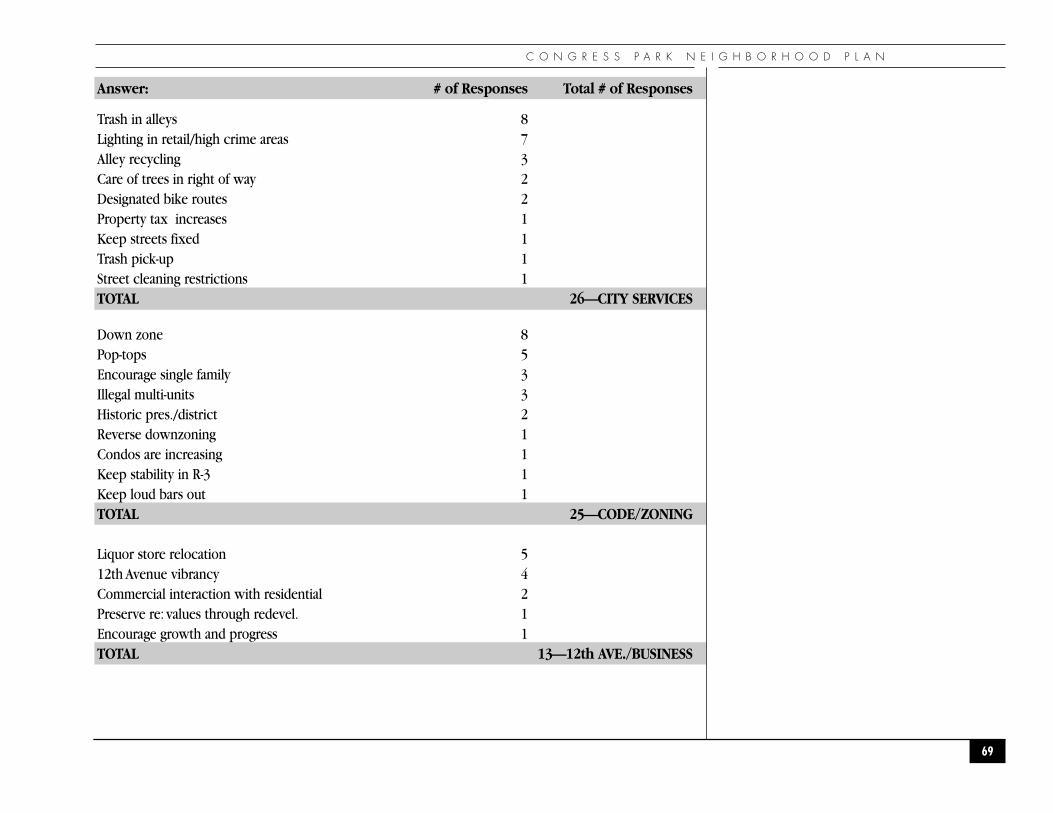
C O N G R E S S P A R K N E I G H B O R H O O D P L A N
Answer: # of Responses Total # of Responses
Trash in alleys 8Lighting in retail/high crime areas 7Alley recycling 3Care of trees in right of way 2Designated bike routes 2Property tax increases 1Keep streets fixed 1Trash pick-up 1Street cleaning restrictions 1TOTAL 26—CITY SERVICES
Down zone 8Pop-tops 5Encourage single family 3Illegal multi-units 3Historic pres./district 2Reverse downzoning 1Condos are increasing 1Keep stability in R-3 1Keep loud bars out 1TOTAL 25—CODE/ZONING
Liquor store relocation 512th Avenue vibrancy 4Commercial interaction with residential 2Preserve re: values through redevel. 1Encourage growth and progress 1TOTAL 13—12th AVE./BUSINESS
69

A P P E N D I C E S
Answer: # of Responses Total # of Responses
Colfax 12Group Homes 12No shelter ever 1Stevens vacancy/re-use 10Dog problems (poop, barking, running loose) 10Hatred increasing, Elitism,Don’t exclude,Diversity, Be organized without being reactionary, response to homelessness 6 (one vote each)Quality of schools 5Busing 2Encourage young people/ families to move in 3TOTAL 10 FAMILIES/SCHOOLS
Neighborhood identity, sense of community,manage change, need guidelines/plan 1 vote each No problems 3Transient residents 2Joggers going wrong way on Parkway 1Solicitations 1Loss of community gardens at Botanic Gardens 1Botanic Gardens 1Invasion of privacy 1Neighborhood committees 1Do-gooders 1People putting flyers on my door 1
Other Comments:◗ Hold neighborhood meetings in the afternoons so senior citizens can attend.◗ Give prizes for the most attractive alley/backyard.◗ Set up a designated dog area in Congress park, except during soccer and baseball season.
70
C O N G R E S S P A R K N E I G H B O R H O O D P L A N
◗APPENDIX B: AESTHETIC GUIDEL INES
These guidelines are provided as recommendations to property owners to serve as a tool in maintainingthe existing neighborhood character. They are not proposed as an overlay district, nor as a covenant, norto replace existing zoning laws.
◗ E x t e r i o r F i n i s h e s◗ Sense of Community
The materials of the individual structures create a unified element that provides a backdrop to theneighborhood. Use of any new material should reflect the existing materials of brick, stucco, paintedwood, etc. and be represented in their historic context. Inappropriate materials such as natural wood,metal, large glass areas, etc. should be discouraged.
◗ Architectural Integrity
The exterior materials should provide the unifying element in the design. From level to level and fromporches to fencing, the materials should blend to provide a level of continuity.
◗ Rental Maintenance
The neighborhood as a group should encourage landlords to maintain their properties consistent withthe exterior level of quality reflected in owner occupied structures.
◗ R e n o v a t i o n s◗ Physical
Each property should be reviewed on a case by case basis for their impact on adjacent neighbors andwith regard to the overall street imagery.
◗ Sense of Community
The design of the addition should reflect the imagery of the existing structure (front porches, strongroof lines, dormers, etc). The addition should not turn its back to the street and should not be used as abarrier to the street.
◗ Architectural Integrity
All additions should be designed with the idea in mind that the integration between the new and oldshould be natural, with a strong respect to the context of the existing design elements.
71

A P P E N D I C E S
◗ Landscaping
All fencing, street trees, and miscellaneous plantings should be reviewed in context with its streetimagery and not just as an individual project. All fencing fronting on the street shall be limited in height(4’-0”max.) and should have a feeling of “transparency,” so as to not be seen as a barrier.
◗ Lighting
All exterior lighting should be kept to a low level to enhance the structure of landscaping, but not toimpact adjacent neighbors.
◗ N e w C o n s t r u c t i o n – S i n g l e F a m i l y◗ Zoning/Physical
Each property should be reviewed on a case by case basis for its impact on adjacent neighbors and withregard to the overall street imagery and in context with the existing scale of surrounding structures.Over-building with respect to lot size should be discouraged.
◗ Sense of Community
When providing a design concept for an “infill” lot there should be respect for the historic character ofthe community, not from the standpoint of preservation, but from the aspect of compatibility.
◗ Architectural Integrity
New structures should respect their old neighbors in terms of materials, scale, proportions, and detailing.Care should be taken as to not have a “hodge-podge”of styles that will deteriorate the fabric of theexisting neighborhood.
◗ Landscaping
All fencing, street trees, and miscellaneous plantings should be reviewed in context with its streetimagery and not just as an individual project. All fencing fronting on the street should be limited inheight (4’-0”max.) and should have a feeling of “transparency,” so as to not be seen as a barrier.
◗ Lighting
All exterior lighting should be kept to a low level to enhance the structure or landscaping, but not toimpact adjacent neighbors.
◗ Parking
All garage access and parking areas should be limited to alley access only. To preserve the pedestrianfriendly concept of the neighborhood the blocks should not be cut up with vehicular driveways, norshould the street imagery be cluttered with garage doors.
72
C O N G R E S S P A R K N E I G H B O R H O O D P L A N
◗ N e w C o n s t r u c t i o n – M u l t i f a m i l y◗ Zoning/Physical
Each property should be reviewed on a case by case basis for its impact on adjacent neighbors and withregard to the overall street imagery and in context with the existing scale of surrounding structures.Over-building with respect to lot size should be discouraged.
◗ Sense of Community
When providing a design concept for an “infill” lot there must be respect for the historic character of thecommunity, not from the standpoint of preservation, but from the aspect of compatibility.
◗ Architectural Integrity
New structures should respect their old neighbors in terms of materials, scale, proportions, and detailing.Care should be taken to create structures that are “pedestrian friendly.” Through the use of landscaping,and attention to scale and detail at the pedestrian level there should be a sense of comfort, as to takeaway from the large scale of the overall structure.
◗ Landscaping
All fencing, street trees, and misc. plantings should be reviewed in context with its street imagery andnot just as an individual project.
◗ Lighting
All exterior lighting should be kept to a low level to enhance the structure or landscaping, but not toimpact adjacent neighbors.
◗ Parking
All garage access and parking areas should be limited to alley access. To preserve the “pedestrianfriendly”concept of the neighborhood the blocks should not be cut up with vehicular driveways. Allparking areas should be screened from street views with a combination of transparent fencing andlandscaping. Large open parking areas should be discouraged and should be designed to minimize thevisual impact to define the existing street lines so as not to create a “void” in the street imagery.
73

A P P E N D I C E S
◗ S t r e e t I m a g e r y◗ Traffic and Parking
All new improvements should encourage off street parking that should screen vehicles from thestreet view.
◗ Parks and Recreation
The parks and tree lined streets are our most valuable asset and care should be taken to maintain andbuild upon this imagery.
◗ Signage
No signs, billboards, or graphics should be displayed on any residential site, with the exception of theoccupants’ name and house number. Multifamily units and commercial sites may provide “low-impact”signage that conforms with all local codes and is compatible with adjacent uses.
◗ Landscaping
The area between the street curb and front setback of the building provides that aesthetic continuity thatblends individual properties into a single street image. With that in mind, any evaluation of landscapingimprovements should be seen in the context of how it will effect the existing street imagery.
74

C O N G R E S S P A R K N E I G H B O R H O O D P L A N
◗APPENDIX C: CONGRESS PARK NEIGHBORS, INC.
Congress Park Neighbors, Inc. is a neighborhood association registered with the City of Denver as a501 C (3) non-profit corporation. It was formed in 1978 to represent the neighborhood with thefollowing purposes:
◗ To coordinate and improve community and resident involvement, cooperation, pride andawareness.
◗ To work for better cultural, recreational, educational, safety and civic programs.
◗ To disseminate information about issues which affect the community and its residents.
◗ To promote cooperation and coordination between the community, residents, public agencies,private agencies and businesses.
The Board meets monthly. In 1994, there were 250 paid members. Standing committees areMembership, Outreach, Crime Action, and Business Development. CPN also has strong liaisons with theColorado Boulevard Health Care District membership, the University of Colorado Health Sciences Center,Denver Botanic Gardens, Denver Public Schools, the city of Denver and adjacent neighborhoodorganizations. The organization publishes and distributes the quarterly “Congress Park Newsletter.”CPN is a member of Capitol Hill United Neighborhoods (CHUN) and the Inter-NeighborhoodCooperation (INC), and is eligible to send delegates to both these umbrella organizations.
75
A P P E N D I C E S
◗APPENDIX D: ZONING
◗ K e y R e g u l a t i o n s o f Z o n e D i s t r i c t s i n C o n g r e s s P a r k
Zoning is the traditional legal tool of cities to regulate the use of all of the land within the jurisdictionand control the impact that its use has on adjacent properties and the city as a whole. Denver has hadzoning regulations since 1926, after most of the Congress Park neighborhood was developed.
Zoning directly regulates the land uses allowed for properties, basic requirements for construction (e.g.the minimum size allowed for a lot, setbacks from property lines to buildings, the height and bulk ofbuildings, etc.), requirements for off-street parking, open space, and location and size of signs.
Since zoning regulations change from time to time, the latest information is always available from theZoning Administration.
◗R-0 Single-Unit Detached Dwellings, Low Density. Foster family care and day care allowed as homeoccupations by permit. Minimum of 6,000 square feet of land required for each dwelling unit. MaximumDensity = 7.3 dwelling units/acre.
◗R-1 Single-Unit Detached Dwellings, Low Density. Same as R-0 except that home occupations androom-renting to one or two persons are allowed upon application and issuance of a permit. MaximumDensity = 7.3 dwelling units/acre.
◗R-2 Multi-Unit Dwellings, Low Density. Typically duplexes and triplexes. Home occupations areallowed by permit only. Minimum of 6,000 square feet required for each duplex structure with anadditional 3,000 square feet required for every unit over 2. Maximum Density = 14.5 housing units/acre.
◗R-3 High-Density Apartment District. Building size is controlled by limited bulk standards, off-streetparking and open space requirements. Building floor area cannot exceed three times the site area. Thiszone should not be used as a buffer zone. Maximum density is not specified and is determined by thesize of the individual units and the factors mentioned above.
◗H-1, H-2 Hospital Zone Districts. Contact Zoning Administration for up-to-date information onzoning ordinances.
76

C O N G R E S S P A R K N E I G H B O R H O O D P L A N
◗APPENDIX E : ACKNOWLEDGEMENTS
◗Mayor of Denver Honorable Wellington E.Webb
◗Denver Planning Board
Ruth Falkenberg, Chair Thomas Foster
Bernie Jones Jim Daniels
Peggy Montano Daniel R. Guimond
Marilyn Stokes Gilbert F. McNeish
Mary Beth Susman, Ph.D.
◗Congress Park Neighborhood Plan Steering Committee
Mary Ferrell, Co-Chair John Yonushewski, Co-Chair
DeAnne Minner, President CPN Judith Spiegel
Margie Boshouwers Tom Johnson
Carol Johnson Frank Scalise
Kelly Tynan Paula Machlin
Tom O’Neill Julie Bell
Brian Tooley Kathy Fay
Charlotte Redden Don and Terry McCullough
Eric Price
◗Crime Prevention Committee
Richard Moody, Chair Dave Quinlivan
Kelly Bitner Monique Coustry
Gerry Armstrong DeVonna Johnson
Jean Griffin Claudia Goodman
Mary Zidanick Bruce and Lois Feinstein
Charlotte Bentley Kathi Anderson
77
A P P E N D I C E S
◗Outreach and Community Pride Committee
Kathy Kurtz, Chair LuAnn Curtis
Michael Curtis Stephen Humphrey
Jennifer and Tracy Vermeyen Shirlee Wreed
Terry McCullough Warren Banman
Jan Oen Buffy Naake
Peg Higgins Jay Nelsen
Eric Price
◗Traffic and Transportation Committee
Joanne Malisani, Chair Kelly Tynan
Alin Rasmussen April Montgomery
Tom Eidsmoe Becky Gay
◗Zoning Committee
Bob Robertson Matthew Lancaster
Peggy Mahoney Edgar Neel
Kathy Fay Debbie Baldwin
John Yonushewski Steven Humphrey
Bryan Aumiller Linda Childs
Becky D. Laurilla Patrick K. Shannon
Tim and Judy Panther Susan Fisher
Ronda Ballard
78
C O N G R E S S P A R K N E I G H B O R H O O D P L A N
◗Economic Development Committee
Barbara Wright Charlotte Redden
Ron Kienzle Alan Eisenberg
Cindy Chase Jeffrey Joyce
Cathy Kuykendall Pete and Jim Dadiotis
Tito Collins Maureen Sherlock
Bobby Lutrell
◗Denver Community Planning and Development Agency
Jennifer T. Moulton, Director of Planning and Development
Harriet R. Hogue, Planning Manager, Neighborhood Planning
Lupe Herrera, Senior City Planner
Theresa Lucero, Senior City Planner
Kiersten Faulkner, Associate City Planner
Jim Ottenstein, Graphics
Julie Connor, Graphics
Ken Barkema, Graphics
Carl Haberman, Graphics
Daniel Michael, Graphics
79

A P P E N D I C E S
●A D O P T I O N O R D I N A N C E●
80

C O N G R E S S P A R K N E I G H B O R H O O D P L A N
◗O R D I N A N C E N O . 8 0 6 S E R I E S O F 1 9 9 5
For an ordinance approving a neighborhood plan for the Congress Park neighborhood, which plan shall become a part of the Comprehensive Plan for the City and County of Denverpursuant to the provisions of Section 41-18 (c) of the Revised Municipal Code and ofOrdinance No. 617, Series of 1989.
◗Whereas, pursuant to the provisions of Section 41-18 (c) of the Revised Municipal Code, and byOrdinance No. 617, Series of 1989, there has been approved a Comprehensive Plan for the City andCounty of Denver; and
◗Whereas, said section of the Revised Municipal Code provides for the amendment of said Plan; and
◗Whereas, Ordinance No. 617, Series of 1989, provides for the incorporation of “Neighborhood Plans” intothe Comprehensive Plan; and
◗Whereas, as a proposed part of the Comprehensive Plan, the Planning Director has transmitted to theMayor and Council for acceptance a proposed neighborhood plan for the orderly and harmoniousdevelopment of the Congress Park neighborhood in the City and County of Denver; and
◗Whereas, the Mayor has approved the same; and
◗Whereas, the Planning Board has approved the same; and
◗Whereas, the Neighborhood Plan was prepared with significant involvement of the residents andrepresentatives of the various interests of the Congress Park neighborhood and adjacent neighborhoodsand has been approved by the same; and
◗Whereas, a member of City Council in whose council district the neighborhood plan is situated hasmonitored the process whereby said plan was formulated.
81

I N T R O D U C T I O N
Now, Therefore, Be It Enacted By The City And County Of Denver:
◗Section 1. That the proposed neighborhood plan for the harmonious development of the Congress ParkNeighborhood, consisting of a document entitled “Congress Park Neighborhood Plan”, filed with the CityClerk, Ex-Officio Clerk of the City and County of Denver, on the 20th day of September, 1995, as CityClerk’s filing No. 95-867, is hereby approved as part of the Comprehensive Plan, pursuant to Section 41-18 (c) of the Revised Municipal Code, Ordinance No. 617, Series of 1989.
◗Section 2. That the approval of the Congress Park Neighborhood Plan, and any subsequent amendmentthereto, is intended to establish the same, in conjunction with the Comprehensive Plan, as the officialguide for officials of the City and County of Denver and private citizens when making decisions affectingthe future character of the Congress Park neighborhood of the City and County of Denver; provided,however, that such approval shall not preempt the decision making powers vested by law or theadministrative directive of the Mayor, the Council or any other official of the City and County of Denverwith respect to, but not limited to, a zoning map amendment, a zoning language amendment, a dedicationor vacation of a street, alley or other public way, a designation of a park, the issuance of a revocablepermit, a conveyance or the acquisition of real property by the City and County of Denver, of anappropriation for or construction of a capital improvement; and provided, further, that it is expresslyunderstood that judgement must be exercised in the application of the Congress Park Neighborhood Planrecommendations in the decision making process of the Mayor, Council and other officials of the City andCounty of Denver.
Passed by the Council October 2, 1995
Deborah L. Ortega, President
Approved: Wellington E. Webb, Mayor, October 3, 1995
Attest: Elba Wedgeworth, Clerk and RecorderEx-Officio Clerk of the City and County of Denver
Published in the Daily Journal September 27, 1995 and October 6, 1995
82