neotectonics of a complex plate boundary zone: indentation ... 2013 newsletter.pdf · volume 43...
TRANSCRIPT
Volume 43 Number 9 May 2013 Page 1
Neotectonics of a Complex Plate Boundary Zone: Indentation, Rotation, and Escape in Alaska
Wes Wallace Geophysical Institute / Department of Geology & Geophysics, UAF
AGS Luncheon
Date & Time: May 16th, 11:30 am – 1:00 pm
Program: Neotectonics of a Complex Plate Boundary Zone: Indenta-tion, Rotation, and Escape in Alaska
Speaker(s): Wes Wallace, UAF
Place: BP Energy Center
Reservations: Make your reservation before noon Tuesday, May 14th, 2013.
Cost: Seminar only, no meal: Free Reserve a box lunch: $15 Reserve a hot lunch: $20 Lunch with no reservation: On an “as-available” basis only
E-mail reservations: [email protected] or phone (907) 564-4028
For more information: visit: www.alaskageology.org
Convergence of thick crust of the Yakutat block with the southern margin of Alaska is widely recognized as a domi-nant influence on the tectonics of Alaska since at least late Miocene time. It is less clear how this convergence relates to the distribution, type, and orientation of geologic struc-tures, and to the boundaries between the tectonic provinces that they define. We propose that convergence of Yakutat block includes two distinct components that influence defor-mation and topography in different ways:
1) The crust of the exposed, southern Yakutat block is too thick to subduct, which has caused the collisional St. Elias orogen. Detachment of the upper part of the mafic base-ment allows delamination and sinking of the remaining mafic crust and lithospheric mantle. The collisional orogen drives rigid counterclockwise rotation of the southern Alaska block south of the arcuate, right-lateral Denali fault. The western boundary of this block is a zone of distributed contraction in the western Alaska Range and Cook Inlet. (continued)
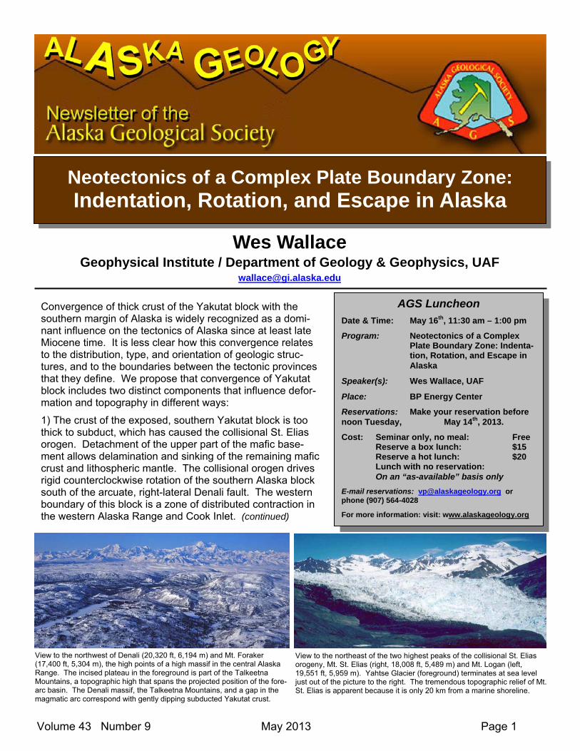
View to the northwest of Denali (20,320 ft, 6,194 m) and Mt. Foraker (17,400 ft, 5,304 m), the high points of a high massif in the central Alaska Range. The incised plateau in the foreground is part of the Talkeetna Mountains, a topographic high that spans the projected position of the fore-arc basin. The Denali massif, the Talkeetna Mountains, and a gap in the magmatic arc correspond with gently dipping subducted Yakutat crust.
View to the northeast of the two highest peaks of the collisional St. Elias orogeny, Mt. St. Elias (right, 18,008 ft, 5,489 m) and Mt. Logan (left, 19,551 ft, 5,959 m). Yahtse Glacier (foreground) terminates at sea level just out of the picture to the right. The tremendous topographic relief of Mt. St. Elias is apparent because it is only 20 km from a marine shoreline.

Volume 43 Number 9 May 2013 Page 2
About the Speaker: Wes Wallace has worked on the structural geology and tectonics of Alaska since 1975, when he began his Ph.D. project on the Border Ranges fault east of the Trans-Alaska Pipeline. He worked with ARCO in An-chorage (1981-1985) on the regional tectonic framework and evolution of Alaska, with emphasis on south-western Alaska and the Brooks Range. In 1985, he moved to the University of Alaska Fairbanks, where his focus has been on fold-and-thrust structures, mainly in the Brooks Range. In recent years, he and his stu-dents have worked on the young tectonics of the northern Alaska Range and the Fairbanks area. In this talk, Wes summarizes an interpretation of the young tectonic framework of Alaska that he has developed over the years that he has worked throughout Alaska and taught a graduate class on the geologic evolution of Alaska.
2) The northern part of the Yakutat block is thin enough to subduct but thick and buoyant enough to cause localized flat-slab subduction orthogonal to rotation of the southern Alaska block. Consequences include the gently antiformal Talkeetna Mountains that span the forearc basin, a gap in the magmatic arc, and a base-ment-involved fold-and-thrust belt in the northern Alaska Range. An arcuate oroclinal hinge from southern Alaska to the northeastern Brooks Range reflects indentation since at least Paleocene time. Traction above the subducted Yakutat block along the southern part of this hinge drives current indentation. North of the subducted Yakutat block, indentation is reflected by left-lateral block rotation that accommodates shortening between the Denali and Tintina faults and by contraction farther north along the northern edge of the arcuate northeastern Brooks Range.
Western Alaska accommodates both northward indentation and westward convergence of the southern Alas-ka block by right-lateral block rotation and tectonic escape related to local left-lateral faults. Farther west, slow clockwise rigid rotation of the extensive Bering block accommodates escape and is separated from sta-ble northwestern Alaska by a zone of extension.
These tectonic provinces are defined by mapped structures and by the distribution and focal mechanisms of earthquakes. Structures are generally consistent with stress orientations determined from earthquakes, but local discrepancies between observed structures and those predicted from the stress determinations suggest that reactivation of older structures is important.
Interpretive map of Neogene faults and basins of mainland Alas-ka and northwestern Canada. Fault colors indicate knowledge of Neogene activity: Yellow: known; red: suspect; blue: un-known, but active some time between Late Cretaceous and pre-sent. Orange indicates Eocene and younger basins. CSE: Chugach-St. Elias. Based on Neotectonic Map of Alaska (Plafker et al., 1994) and other published sources.
Relation of Yakutat block collision and subduction to faults and magmatic arcs in south-central Alaska. Contours: light blue: depth to Wadati-Benioff zones; red: thickness of Yakutat crust (from Worthington et al., 2012, JGR).
Abstract from: Wallace, W.K., and Ruppert, N., 2012, Young tectonics of a complex plate boundary zone: Indentation, rotation, and escape in Alaska: American Geophysical Union fall meeting, San Francisco, CA, Abstract T14A-08, 3 December, 2012.

Volume 43 Number 9 May 2013 Page 3
Scholarship Update
Experimental insights into the formation of amphibole reaction rims: Texture, mineralogy, and processes of formation (Partial Funding: Alaska Geological Society Scholarship)
Sarah Henton, University of Alaska Fairbanks Amphibole is an important mineral present in many calc-alkaline volcanic deposits. A hydrous phase, volcanic amphibole is only stable at pressures greater than ~100 MPa (approx. 4 km) and in melts containing at least 4 wt % H2O. When removed from their thermal and barometric stability field, am-phiboles decompose to form aggregate rims of anhydrous minerals. Reaction rim thicknesses have been used to estimate timescales and rates of magma ascent, an important parameter in determin-ing eruptive style. However, the process of reaction rim formation is complex; numerous magmatic properties exert a control on the reaction process (e.g. magma compositions and viscosities) and multiple forcing factors may be responsible for their formation (e.g. heating, decompression, or changes in magma chemistry). Due to a lack of experimental work, amphibole reaction rims are a poorly understood and commonly misused source of information of magmatic processes. This experimental study at the University of Alaska Fairbanks, funded in part through the generosity of the Alaska Geological Society, presents one of the first in-depth, systematic, and quantitative in-vestigations of reaction rim textures and mineralogy. During a series of experiments, amphiboles were subjected to differing degrees of thermal or barometric instability, over different time scales, ranging from 3 – 144 hours. The resulting reaction rims were analyzed using a variety of analytical imaging and X-ray mapping techniques. The results of this study, which are currently being prepared for publication, show that a range of different processes can contribute to the formation of amphibole reaction rims. A key result is that the mineralogical and textural features of many experimental heat-ing-induced amphibole reaction rims are indistinguishable from natural reaction rims attributed by past studies to decompression (and subsequently used to infer magma ascent rates).
Composite X-Ray maps of experimental amphibole reaction rims. Reactions depicted were all formed at a temperature of 900oC and at a pressure of 140 MPa. Successive images reflect increasing experiment durations: A) 3 hours; B) 6 hours; C) 12 hours; D) 24 hours; E) 36 hours; F) 48 hours. Different colors depict different minerals. Exact shading varies between images but in general: blue = glass; purple = plagioclase; red = magnetite; yellow = ilmenite; ‘olive’ green = amphibole; green = orthopyroxene; yellow/green = clino-pyroxene. Images show how amphibole reaction rims increase in width and also in textural and minerological complexity as heating duration is increased.

Volume 43 Number 9 May 2013 Page 4
ALASKA FOSSIL OF THE MONTH
SAPELNIKOVIELLA SANTUCCII – A NEW ALASKAN SILURIAN BRACHIOPOD GENUS AND SPECIES IS BORN
Robert B. Blodgett (Consulting Geologist, Anchorage, Alaska)
This month’s selection for the Alaska Fossil of the Month is a newly described brachiopod Sapelnikoviella san-tuccii Blodgett, Baranov, Boucot, and Rohr, 2013 (see Figure 1) from the upper Silurian Willoughby Limestone on Drake Island in Glacier Bay, Southeast Alaska (see Blodgett et al., 2013a for the formal taxonomic naming paper).
The genus name is in honor of Vadim P. Sapelnikov (1930-2004) of Ekaterinburg, Russia, a leading scholar of Ordovician-Devonian brachiopods, and an expert in particular on the Suborder Pentameridina to which the new genus belongs. The species name is in honor of Vincent L. Santucci, geologist/paleontologist with the US National Park Service, in recognition of his strong support for paleontological work being conducted on National Park Ser-vice lands and for being the ‘father’ of National Fossil Day. National Fossil Day is a partnership to promote the sci-entific and educational values of fossils. Over 230 partner museums, scientific and educational organizations, fos-sil sites, agencies and amateur groups collectively host fossil events and activities in all 50 states, making Nation-al Fossil Day a nation-wide celebration.
The fossil locality (11RB16) where the new fossil was found is situated on the southwest side of Drake Island (Fig. 2) in Glacier Bay. Both sides of Glacier Bay consist primarily of spectacular exposures of Paleozoic age for-mations (i.e., Willoughby Limestone, Tidal Formation, Pyramid Peak Limestone, etc.) (see Fig. 3 for generalized columnar section of the rock units exposed here). The basic stratigraphic framework geology of the region was provided by Rossman (1963) and Seitz (1959). Documenting such new and biostratigraphically significant fossils is important to Alaskan geological studies, as very few Paleozoic age fossils have been described from the State, despite over 100+ years of active field work. Documenting these fossils is obviously most critical in providing fos-sil age control, but also provide invaluable information on the ecologic setting in which the host strata were depos-ited, and also in providing paleobiogeographic signals needed in our terrane-bound rocks to determinate original sites of origin and possible wandering paths prior to accretion.
I was invited by the staff at Glacier Bay National Park & Preserve to undertake a paleontological assessment of the fossil resources throughout the entire areal extent of the park, the results of which are now partially published (Blodgett et al., 2010a, 2012), and a large Excel spreadsheet was also provided to the park showing all previously known and reported fossil occurrences therein. This work in part overlapped with collaborative studies with other colleagues on the fossil fauna from Glacier Bay (Rohr and Blodgett, 2003; Rohr et al., 2003) and also to the south on northeast Chichagof Island where similar faunas and facies are found: Kříž et al., 2013; Boucot et al., 2012; Rohr et al., 2011). One emerging facet of the study is the overwhelming faunal evidence which indicates that the Alexander terrane faunas of Silurian and Devonian age are most similar to those found in Northeast Asia (Kolyma region), suggesting a rift origin of the Alexander terrane ultimately from that region (Blodgett et al., 2010b, 2013b). Overall lithofacies similarities and some new emerging detrital zircon ages are also concordant with that view.
Sapelnikoviella santuccii occurs in a small-pocket like accumulation of brachiopods (predominantly this species and the genus Septatrypa), allong with high-spired murchisoniid gastropods (see Fig. 4) which occur within mas-sive microbial reefs that appear to have occurred on the seaward edge of the Willoughby Limestone platform edge (see Fig. 5 for view of locality). An new interesting aspect of our regional study in Glacier Bay is that the classical view of Rossman (1963) of the deeper-water Tidal Formation (in places bearing graptolites) succeeding the Willoughby Limestone is now suspect. Our work indicates that these two units rather represent facies equivalents of one another, with the upper Silurian Willoughby Limestone occurring primarily on the west side of Glacier Bay (with the exception of the exposures at Gloomy Knob), and the age equivalent Tidal Formation restricted areally to exposures to the east. In Tidal Inlet, one can even observe large olistoliths blocks seeming derived from the Willoughby Limestone reef edge (Rohr et al., 2013). The overall Silurian facies pattern expressed in Glacier Bay continues to the southeast onto northeast part of Chichagof Island, where the Willoughby Limestone is represent-ed the Kennel Creek Limestone (shallow-water carbonate platform) and the Tidal Formation is represented by the lower part of the Cedar Cove Formation. One amazing fact about the Silurian age succession in Glacier Bay is that in overall thickness it is one of the thickest succession of rocks of such age in North America, and in fact, in much of the world.

Volume 43 Number 9 May 2013 Page 5
REFERENCES
Blodgett, R.B., Baranov, V.V., Boucot, A.J., and Rohr, D.M., 2013b. The Karheen Formation of the Alexander terrane of Southeast Alaska: Its age reinterpretation (late Silurian) and faunal alliance with other equivalent red bed successions in Northeast Asia (Kolyma region). 2013 Pacific Sec-tion AAPG Abstracts, Monterey, CA, April 19-25, 2013. Abstracts volume, p. 6.
Blodgett, R.B., Boucot, A.J., Baranov, V.V., and Rohr, D.M., 2013a. Sapelnikoviella santuccii, a new gypidulinid brachiopod genus and species from the upper Silurian of Glacier Bay National Park & Preserve, Southeast Alaska. Memoirs of the Association of Australasian Palaeontologists, v. 44, p. 65-72.
Blodgett, R. B., Boucot, A. J., Rohr, D. M., and Pedder, A.E.H., 2010b, The Alexander terrane – A displaced fragment of northeast Russia? Evidence from Silurian-Middle Devonian megafossils and stratigraphy: Memoirs of the Association of Australasian Palaeontologists, v. 39, p. 325-341.
Blodgett, R.B., Rohr, D.M., Santucci, V.L., and Sharman, Lewis, 2010a, A paleontologic resource assessment of Glacier Bay National Park and Pre-serve, Southeast Alaska: Geological Society of America Abstracts with Programs, v. 42, no. 5, p. 564.
Blodgett, R.B., Santucci, V.L., and Sharman, L., 2012. An inventory of paleontological resources from Glacier Bay National Park and Preserve, Alaska, p. 43-47, in Weber, Samantha, ed., Rethinking Protected Areas in a Changing World: Proceedings of the 2011 George Wright Biennial Conference on Parks, Protected Areas, and Cultural Sites. Hancock, Michigan. The Geological Wright Society.
Boucot, A.J., Blodgett, R.B., and Rohr, D.M., 2012. Strophatrypa, a new genus of Brachiopoda (Atrypidae), from Upper Silurian strata of the Alexander terrane, northeast Chichagof Island, Southeast Alaska. Bulletin of Geosciences, v. 87(2), p. 261-267.
Kříž, J., Blodgett, R.B., and Rohr, D.M.. 2011. Silurian Bivalvia from the Chichagof Island, Southeast Alaska (Alexander terrane). Bulletin of Geoscienc-es 86(2), p. 241-258.
Rohr, D.M., and Blodgett, R.B. 2003. Kirkospira, a new Silurian gastropod from Glacier Bay, southeast Alaska, p. 117-125, in Galloway, J.P., ed., Stud-ies in Alaska by the U.S. Geological Survey, 2001. U.S. Geological Survey Professional Paper 1678, p. 117-125.
Rohr, D.M., Blodgett, R.B., and Frýda, J.. 2003. New Silurian murchisoniid gastropods from Alaska and a review of the genus Coelocaulus, p. 87-93, in Clautice, K.H., and Davis, K.H., eds., Short notes on Alaska Geology, 2003. Alaska Division of Geological & Geophysical Surveys Professional Report 120.
Rohr, D.M., Blodgett, R.B., Boucot, A.J., and Skaflestad, J. 2011. Upper Silurian facies and fauna of northeast Chichagof Island, Southeast Alaska [abstract]. Pacific Section, American Association of Petroleum Geologists Meeting, Anchorage, Alaska, May 9-11, 2011. Abstract Volume, p. 82.
Rohr, D.M., Blodgett, R.B., Santucci, V., and Slavik, L., 2013 (in press). Shallow and deep water origins of Silurian rocks at Glacier Bay, Alaska. Alaska Park Science (issue slated to appear in June 2013).
Rossman, D.L. 1963. Geology of the eastern part of the Mount Fairweather quadrangle, Glacier Bay, Alaska. U.S. Geological Survey Bulletin, 1121-K, p. K1-K57, 2 map sheets, scale 1:63,360.
Seitz, J., 1959. Geology of Geikie Inlet area, Glacier Bay, Alaska. U.S. Geological Survey Bulletin 1058-C, p. C61-C120, 1 map sheet, scale 1:62,500.
Figure 1. Sapelnikoviella santuccii Blodgett et al., 2013a , Willough-by Limestone (Ludlow, or upper Silurian), locality 11RB16, Drake Island, Glacier Bay, Southeast Alaska. Four specimens are shown on this plate.
Figure 2. Index map of the northern part of Southeast Alas-ka showing the location of some of the geographic features referred to in the text (Drake Island, Willoughby Island, Chichagof Island).

Volume 43 Number 9 May 2013 Page 6
Figure 3. Generalized columnar section of Paleozoic rocks in Glacier Bay (modified from Rossman 1963, fig. 2).
Figure 4. Photograph of pocket-like accumulation of brachiopods (Septatrypa, Sapelnikoviella santuccii) and high-spired murchisoniid gastropods at locality 11RB16 on the southwest shore of Drake Island. Note presence of spiralia in Septatrypa. Coin 24 mm.diameter.
Figure 5. View of fossil locality 11RB16 in microbial limestone buildups in the Willoughby Limestone on the west side of Drake Island, Glacier Bay, Southeast Alaska. Vincent L. Santucci (NPS) standing near fossil site. View to the NNW.
Figure 6. Large limestone olistolith block (white colored) derived from platform edge of Willoughby Limestone and deposited in the coeval basinal equivalent beds of the Tidal Formation on the south side of Tidal Inlet. Vincent L. Santucci (left) and David M. Rohr (right).
GSA & AGS
Annual Spring Picnic Wednesday, May 29, 2013; 5-8:30 pm
Kincaid Park, picnic pavilion $12 per individual and $30 for family (in advance)
$20 per individual and $40 for family (at event)

Volume 43 Number 9 May 2013 Page 7
My Pet Rock Photomicrograph of Beluga sandstone consisting largely of argillaceous sedimentary rock fragments (srf) and oc-casional monocrystalline (Qm) and polycrystalline (Qp) quartz grains. A meas-ured porosity of 27.8% sug-gests that microporosity con-tributes significantly to the overall pore system. Upon deep burial and compaction, this rock would begin to re-semble a sandy-silty shale; in essence a “diagenetic” shale created by the com-paction-induced ductile grain deformation of a sandstone. Beluga sandstones comprise important gas reservoirs in Cook Inlet. Sample is from a measured section at Fritz Creek on the northwest shore of Kachemak Bay; collected by Jake Mongrain. Send me a photo of your pet rock at: [email protected]
Kenneth P. Helmold Alaska Division of Oil & Gas
Enhanced Alaska Digital Well Log Data Since 1989
OCS, 95 out of 100 Alaska OCS wells. Mud logs for some. North Aleutian Basin wells, onshore and offshore. North Slope, 556 wildcats and key field wells. Kuparuk River Field, first 567 wells drilled (pre-1985). Southern Alaska, 1063 wells including all wildcats and many field wells. Directional surveys for most.
All digital log files Are depth shifted to match resistivity curves. Have core data rendered as a depth-shifted well log curve. Have SP both in original form and as a straightened curve. Have standardized mnemonics. Have Volume of Shale curves, derived from gamma ray for North Slope, derived from SP for Cook Inlet. Allow you to specify your own choice of mnemonics before delivery. Are updated periodically with new wildcat wells. Are delivered in LAS 2.0 format. Contact Dan Shier: 303-278-1261 [email protected] www.rockypine.com
srf
srf
Qp
Qm

Volume 43 Number 9 May 2013 Page 8
Earl E. Brabb—USGS Geologist
Earl E. Brabb, a geologist and internationally noted expert on the hazards of landslides and earth-quakes, died Sept. 14,2012 after a brief illness. He was 83.
Earl was born in Detroit, majored in geology at Dartmouth College and received his master's degree at the University of Michigan. He earned his doctorate at Stanford, where his work mapping Santa Cruz mountain geology and biostratigraphy set the stage for his entire career.
Earl was a leading scientist at the U.S. Geological Survey in Menlo Park for 52 years. Early in his career he spent several years in the wilderness of eastern Alaska mapping the Charley River and Black River quadrangles. During his Alaska period, Earl collected fossils of extinct animals, includ-ing four newly discovered species that were later named for him.
Later in his career at the USGS ,Earl traveled throughout the United States to lead a nationwide as-sessment of landslide hazards and damage. He also founded the International Landslide Research Group, whose members study the impact of landslides in more than 100 nations.
During his career, he received Meritorious and Distinguished awards from the Department of the Interior, and a medal from the European Geophysical Society for his exceptional contributions to natural hazards research.

Volume 43 Number 9 May 2013 Page 9
PRA
3601 C Street, Suite 822
Anchorage, AK 99503
The Alaska Geological Society, Inc. P.O. Box 101288
Anchorage AK 99510 On the web at: h p://www.alaskageology.org
The Alaska Geological Society is an organiza on which seeks to promote inter-est in and understanding of Geology and the related Earth Sciences, and to provide a common organiza on for those individuals interested in geology and the related Earth Sciences.
This newsle er is the monthly (September-May) publica on of the Alaska Geological Society, Inc. Number of newsle ers/month: ~300
EDITOR Ken Helmold
Alaska Geological Society, Inc. P. O. Box 101288
Anchorage, AK 99510 e-mail: ken.helmold at alaska.gov
(907) 269-8673 (office)
MEMBERSHIP INFORMATION
AGS annual memberships expire November 1. The annual membership fee is $20/year. You may download a membership applica on from the AGS website and return it at a luncheon mee ng, or mail it to the address above.
Contact membership coordinator Ken Helmold with changes or updates (e-mail: ken.helmold at alaska.gov; phone: 907-269-8673)
All AGS publica ons are now available for on-line purchase on our website. Check to see the complete catalogue:
h p://www.alaskageology.org/publica ons
ADVERTISING RATES
Adver sements may be purchased at the following rates: 1/10 Page--$190/9mo, $75/1mo; size=1.8 x 3.5 inch
1/4 Page--$375/9mo, $95/1mo; size=4.5 x 3.5 or 2.2 x 7.5 inch 1/3 Page- $470/9mo, $105/1mo; size=7.0 x 3.5 or 3.0 x 7.5 inch 1/2 Page--$655/9mo, $125/1mo; size=9.0 x 3.5 or 4.5 x 7.5 inch
Full Page--$1000/9mo, $165/1mo; size=7.5 x 9.0 inch 1mo rate=(9mo rate/9)+$50 (rounded up).
Contact Keith Torrance (614) 264-4506 for adver sing informa on.
Volume 43 Number 9 May 2013 Page 10
AGS Denali Field Trip 2013 – June 21-23 The Denali National Park & Preserve area provides one of the few opportunities in Alaska for road-side ac-cess to good rock outcrops. The rocks and surficial deposits exposed in the Denali area span from the early Paleozoic to the Quaternary. It is a structurally complex area that records evidence of numerous episodes of deformation and metamorphism in the Mesozoic, Tertiary, and present day. The region is the site of ac-tive faulting along one of the largest intra-continental fault systems, the Denali Fault system, which was the locus of a 7.9 M earthquake as recent as 2002. Rock units visited will include poly-deformed Devonian to Mississippian schist (that record rifting along the North American margin); Triassic greenstone diabase, and pillow basalt (another rifting episode); Triassic deep-water shales; Late Jurassic to Early Cretaceous marine flysch (formed during accretion of most of southern Alaska); Devonian limestone olistostromal blocks; Late Cretaceous fluvial conglomerate and sandstone (containing dinosaur tracks); early Tertiary fluvial and la-custrine conglomerate, sandstone, and shale (that record the uplift of the Alaska Range); and numerous glacial deposits formed during the last ice-age.
June 21 – Leave Anchorage 5:30 pm The field trip will start from Anchorage at 5:30 pm on June 21. We will drive directly to the McKinley Park area and stay at the Denali Education Center (estimate 5 hours driving time).
June 22 – Geologic tour of Denali National Park & Preserve road On the morning of June 22 breakfast will be provided at the Denali Education Center, and a sack lunch will be provided. We will depart at 8:30 am for a geologic tour of the Denali National Park & Preserve road as far as the Eielson Visitor Center (estimate 9 hours driving time). Dinner will be on your own.
June 23 – Geologic tour of the Parks Highway from Healy to Cantwell On Sunday June 23, we will depart the Denali Education Center at 8:00 and stop at a local restaurant for breakfast. We will then drive to Healy where we will start a geologic tour of the Parks Highway between Healy and Cantwell (stopping for lunch along the way). After the end of the tour we will drive back to An-chorage.
Trip Leaders: Chad Hults; US Geological Survey and Denny Capps; Denali Park Geologist, NPS
Due to vehicle restrictions on the Denali Park Road, only one 15 passenger van can be used, so the field trip is limited to the first 12 people that sign up.
Sign up for this trip on the AGS website: http://www.alaskageology.org/fieldtrips_denali_June2013.htm
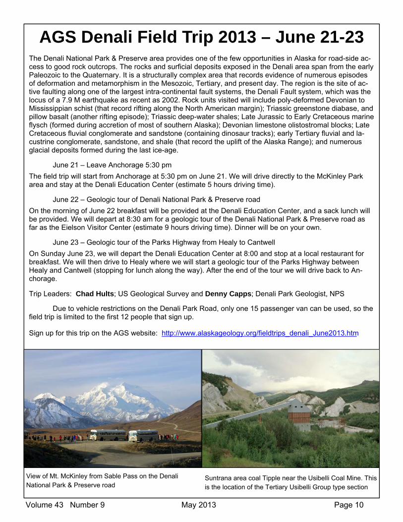
View of Mt. McKinley from Sable Pass on the Denali National Park & Preserve road
Suntrana area coal Tipple near the Usibelli Coal Mine. This is the location of the Tertiary Usibelli Group type section

Volume 43 Number 9 May 2013 Page 11
Alaska Geological Society
May 2013 Election Ballot for Officers, Board Members, AAPG Delegate, and Proposed Amendment
AGS Officers
President Elect - Keith Torrance (President for 2014-2015)
Vice President - Monte Mabry
Secretary - Eric Cannon
Treasurer - Al Hunter
Write-in Candidate(s) _________________
Position and Name
2013-2015 Board Members (vote for three)
Board Member - Tom Morahan Board Member - Jim Brown Board Member - Richard Lease
Write-in Candidate(s) _________________
Name
2013-2015 AAPG Delegate (only Active AAPG members may vote for the AAPG delegate)
AAPG Delegate - Marwan Wartes Write-in Candidate
_________________ Name
Proposed amendment to the bylaws in bold italics & underlined:
Old: Article X. Fiscal Management SECTION 6. Expenditures. All expenditures over $500 for any one item or purpose must be approved by a majority of the Board present at any regu-lar or special meeting of the Board of Directors. All expenditures over $5000 for any one item or purpose must be approved by a majority of the mem-bers present at any regular or special meeting of the Society.
SECTION 7. Contracts. The Board of Directors may authorize any officer or officers, agent or agents of the Society, in addition to officers expressly authorized by these Bylaws, to enter into any contract or execute and deliver any instrument of and on behalf of the Society, and such authority may be general or confined to specific purposes.
SECTION 8. Checks, drafts. All checks, drafts, or orders for the payment of money, notes, or other evidences of indebtedness issued in the name of the Society, shall be signed by two Officers of the Society, and in a manner determined by resolution of the Board of Directors.
New: Article X. Fiscal Management SECTION 6. Expenditures. All expenditures over $1000 for any one item or purpose must be approved by a majority of the Board present at any reg-ular or special meeting of the Board of Directors. All expenditures over $5000 for any one item or purpose must be approved by a majority of the mem-bers present at any regular or special meeting of the Society.
SECTION 7. Contracts. The Board of Directors may authorize any officer or officers, agent or agents of the Society, in addition to officers expressly authorized by these Bylaws, to enter into any contract or execute and deliver any instrument of and on behalf of the Society, and such authority may be general or confined to specific purposes.
SECTION 8. Checks, drafts. All checks, drafts, or orders for the payment of money, notes, or other evidences of indebtedness issued in the name of the Society, if under $500, can be signed by the Treasurer and all board members notified with the date and the amount of the transaction by email at the time the transaction was completed. All other checks, greater than $500 shall be signed by two Officers of the Society, and in a manner determined by resolution of the Board of Directors.
There shall be one debit card, retained by the Treasurer and available to the President, Vice President and Secretary with a limit of $300 for making deposits, obtaining petty cash to make change at meetings and for paying fees and other charges requiring electronic payment.
Shall the AGS amend the bylaws of the organization with the changes approved by a vote of the Alaska Geological Society Board of Directors?
Approve
Disapprove
Please mail your ballot by May 18th to: Alaska Geological Society PO Box 101288 Anchorage, AK 99510
Ballots will also be available at the May 16th luncheon

Volume 43 Number 9 May 2013 Page 12
Alaska Geological Society, Inc. P. O. Box 101288 Anchorage, AK 99510
2012 ‐ 2013 Alaska Geological Society Board
Commi ees and Delegates
Phone e-mail Workplace President Art Banet banetak at gci.net BLM emeritus Past-President Ken Helmold 269-8673 Ken.helmold at alaska.gov AK DOG President-Elect Matt Frankforter 777-8376 Mfrankforter at hilcorp.com Hilcorp Alaska, LLC Vice-President Monte Mabry 564-4028 Monte.mabry at bp.com BP Treasurer Al Hunter 777-8324 Paleoman at mac.com Secretary Eric Cannon 344-6001 Eccannon at gmail.com Golder Associate Inc. Director 12-2014 Chad Hults 786-7417 Chults at usgs.gov USGS Director 12-2014 Trystan Herriott 451-5011 trystan.herriott at alaska.gov DGGS Director 12-2014 Kirk Sherwood 334-5337 Kirk.Sherwood at boem.gov BOEM Director 11-2013 Tom Homza 770-3701 Thomas.Homza at shell.com Shell Director 11-2013 Tom Morahan 230-1672 tmorahan at petroak.com ConocoPhillips (PRA) Director 11-2013 Jim Brown 276-2675 Jbrown at alaskapacific.edu Alaska Pacific University
AAPG Delegate & David Hite 258-9059 Hitelamb at alaska.net Geological Consultant Advertising Keith Torrance 264-4506 Ktorrance at apcservicesllc.com APC Services LLC Com. Ed./Science Fair Jana DaSilva Lage 677-7883 Jldasilva5 at hotmail.com AeroMetric Field Trips Chad Hults 786-7417 Chults at usgs.gov USGS Bylaws Sue Karl 786-7428 Skarl at usgs.gov USGS Memberships Ken Helmold 269-8673 Ken.helmold at alaska.gov AK DOG Newsletter Editor Ken Helmold 269-8673 Ken.helmold at alaska.gov AK DOG Publications Peter Johnson 334-5329 Peter.Johnson at boem.gov BOEM Scholarship Sue Karl 786-7428 Skarl at usgs.gov USGS Website Jan Hazen Jan at homestead-graphics.com Consultant Fundraising Sunny Foster 269-8707 Sunny.Remmy at Alaska.gov DNR / DOG
Phone e-mail Workplace